1953 Procedure of Jehovah's Witnesses Under Selective Service, 1953

APPLICATIONS OF GEOLOGY TO HIGHWAY ENGINEERING IN KENTUCKY
by
1. E. G regg, Assistant Director of Research
and
James H. Havens, Research Chemist
Kentucky Department of Highw�s
(For Annual Symposium on Geology A� Applied to Highw� Engineering, Morris Harvey College, Charleston�, W. Va., February 20, 1953)
Kentucky, too, is a state where geology abounds. Little credit
for this, however, lies with the highway field, because such a prosaic
subject is frequently overshadowed by such features as Mammoth Cave, Sky
Bridge, Cumberland Falls, Pine Mountain, and extensive underground mineral
deposits. Nevertheless; the influence of geology in the highway industry
is growing, and it is obvious that some potential contributions have not
yet been realized.
General applications of geology to highways have actually been
in practice several years. Probably the most tangible of these pertains
to the development of aggregates. Almost all evaluations of natural ag-
gregates - sand, gravel, or stone - which are proposed for highway con-
struction are made under the direction of a graduate geologist in the
Highway Department's Division of Materials. These are not limited just
to the usual application of acceptance tests, but involves classification
of materials - sometimes on a petrologic or a chemical basis, and always
with a view toward the intended use. For example, every producing quarry
in the state is included in the Department's Annual Quarry Report (1);

- 2
which is, in effect, an inventory and rating of quarry materials, ledge
by ledge. So far as the annual report itself is concerned, there are no
specific geologic interpretations identifying the formations as time units.
such information would prove superfluous to quarry operators and to highway
engineers in general. However, stratigraphic identification has been a
part of the work, and these identifications are ultimately published by the
KentuckY Geological Survey for the good of those who are in a position to
use them (2) (3).
Prior to the time that the .annual inventory was developed, many
quarries were worked somewhat haphazardly with little or no geologic or
mineralogic correlation between ledges. This, of course, led to expensive
operations in some ledges before there was any evidence from physical test
and chemical analyses to show whether all the stone was acceptable for use,
Correlation of ledges greatly reduced the chances of producing large quantities
of unsound aggregate, and put aggregate production on a more scientific
basis.
In some cases, quarries had to be abandoned because there was
not sufficient material of high quality to justify continued operation.
At one location, a surface quarry was abandoned, and a shaft was opened
to a 30-foot ledge of high-quality limestone laying 240 feet beneath the
surface. It is interesting too that a similar operation, but in a drift
mine running laterally from the face of an entrenched river valley, was
already producing high-quality aggregate from precisely the same forma-
tion at a location 20 miles away. Geologic knowledge of the forma-
tions - their continuity and their uniformity - was a basis for

- 3
confidence in an expensive undertaking of this sort. Core-drill records,
logging the desired ledge, naturally provided final confirmation.
Formative research in aggregate development has involved more
specific uses of geologic and petrologic approaches. For example, there
have been numerous instances, not only in Kentucky but in practically
all states, where current test procedures indicated that an aggregate
had dependable qualities, yet service experience has ult�nately proven
it unsound. In other words, the test-criteria failed to detect these
faulty characteristics, and it took several years of service experience
to reveal them. One instance of this is illustrated by Fig. 1. The
concrete pavement shown there, was built with an aggregate which then
showed no apparent signs of weakness. It was hard, resistant to abra
sion, had low absorption values, held up well in soundness tests, and
seemed well sui ted for the use intended. After a service period of about
14 years, the pavement suffered very extensive cracking. It was obvious
that the aggregate had "grown", thus exerting a tremendous pressure with
in the concrete. Ultimately, pieces of coarse aggregate at the surface
began to split or "pop" out in fractured sections.
At that time a comprehensive aggregate study (4) was in pro
gress, and one of its objectives was to determine what possible com
ponent of stone - limestone in this case - might have caused the destruc
tive expansion. Some indications of the ledge or ledges at fault were
revealed in weathered quarry tailings, such as the disintegrated block
in Fig. 2. During the course of the study, the face of the quarry was
sampled foot by foot, and numerous tests were made. In addition to

Fig. l. Failure of concrete pavement which began after 1.4 years of service under moderate traffic,
Fig. 2.. ·'Heathered quarry tailings such as these offered a clue to the ledge causing the failure.

- 4
those normally used for engineering purposes, thin sections were prepared
for observation of gross structure; and other tests such as porosity,
insoluble residue, and clay mineral identification by x-ray diffraction
were included. Concrete specimens were made in the laboratory, and
tested by prolonged exposure to water and by alternating freeze-and-thaw
temperatures. The freeze-and-thaw test, within the limits usually applied,
did not have the severe effect anticipated, However, after a n e xtended
period of combined exposure in the durability test, deterioration such as
that shown by the specimens in Fig, 3, closely resembled that observed
on the concrete pavement.
Another application of geologic techniques - this again having
to do with aggregates - was fundamental to the development of sandstone
as a useable paving material. The sandstones and shales of Pennsylvanian
origin, which are so prevalent in West Virginia, also blarucet the entire
eastern portion of Kentucky. As shown by Fig. 4, this region represents
almost one-fifth the area of the State,
Deep in the heart of this eastern region, where the distance to
sources of service-tested aggregate are great, the shipping cost of im
porting these materials sometimes reaches almost twice the cost of the
material itself. Under this stimulus, highway engineers have long been
- interested in possibilities for utilizing local sandstone. In 1949, a
program of development was started in earnest, with the Division of Main
tenance prepared to staff and implement quarry and plant operations as
well as hot-mix bituminous plant and paving operations for a 34�ile test

Fig. 3. Concrete specimens after prolonged freezeand-thaw weathering.

"""01' KENTUCKY
N
t I I
'
0
'
•
'
�
0
•
� • • • • • • • •
Fig. 4. Map showing Pennsylvanian Sandstone regions and location of test road.

- 5
road project. In its formative stage the program was, to a large extent,
dependent upon the success of the Research Division in establishing
fundamental engineering design data applicable to sandstones and to locate
the most promising quarry sites. Geologic considerations came to the
forefront, not only in the field surveys and in sampling the outcrops,
but also in the laborato�' tests for intrinsic properties.
From the beginning, evaluations were based on the premise that
the utility of sandstone would be determined largely by the degree of
strength imparted to the stone by the cementing media. This general
principle was augmented by physical tests for properties such as per
meability, porosity, and voids; chemical tests for soluble silicates
and basic salts; and optical determinations for roundness of grains,
size and frequency of grain distribution, degree of grain-interlocking,
type of cementing material, percentage of cement, and mineralogical
composition (5). As expected, composition was extremely variable with
major minerals consisting principally of quartz. Minor companion minerals
were plagioclase feldspar, muscovite, calcite, biotite, sericite, and
chlorite. Predominant constituents of the interstitial or cementing ma
terials were sericite, quartz, chlorite, calcite and various iron oxides.
Fig. 5 shows a typical specimen as viewed through crossed nicols on the
petrographic microscope at about 80 x magnification. Quartz, of course,
predominates. The interstitial material in this case is largely sericite
and quartz, but iron oxides, chlorite, and calcite contribute prominently
to the cementing action,
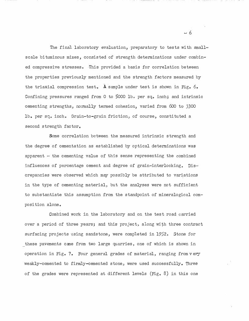
The final laboratory evaluation, preparatory to tests with small�
scale bituminous mixes, consisted of strength determinations under combin
ed compressive stresses" ·This provided a basis for correlation between
the properties previously mentioned and the strength factors measured by
the triaxial compression test" A sample under test is shown in Fig. 6.
Confining pressures ranged from 0 to 5000 lb. per sq. inch; and intrinsic
cementing strengths, normally termed cohesion, varied from 600 to 3300
lb. per sq. inch. Grain-to-grain friction" of course, constituted a
second strength factor.
Some correlation between the measured intrinsic strength and
the degree of cementation as established by optical determinations was
apparent � the cementing value of this sense representing the combined
influences of percentage cement and degree of grain-interlocking" Dis<"'
crepancies were observed which may possibly be attributed to variations
in the type of cementing material, but the analyses were not sufficient
to substantiate this assumption from the standpoint of mineralogical com
position alone.
Combined work in the laboratory and on the test road carried
over a period of three years.: and this project, along with three contract
surfacing projects using sandstone, were completed in 1952. Stone for
these pavements came from two large quarries, one of which is shown in
operation in Fig. 7. Four general grades of material, ranging from v ery
weakly-cemented to finnly-cemented stone, were used successfully. Three
of the grades were represented at different levels (Fig. 8) in this one

Fig. 5. Photomicrograph of sandstone thin-section, crossed. Nicols, 80Xmagnification
Fig, 6. Triaxial pressure cell used for testing inherent strength of sandstones.

Fig. 7. Sandstone Quarry at Quicksand.
Fig. 8. Generalized Section of the Quicksand Quarry,

- 7
quarry. The entire research project definitely established the fact that
even though sandstones are extremely variable, a wide variance in compo
sition and physical characteristics are tolerable when the material is
used as a plant�ix bituminous paving aggregate (6),
Contrary to the impression conveyed thus far, applications of
geology to highway engineering in Kentucky have not been limited entirely
to aggregate investigations, The role of geology in classifying soils
according to origin is., of course, well established and requires no
particular mention here. In Kentucky there has been no deliberate effort
in the highway field to catalogue and map soils according to the peda-
logic or geologic approaches, yet all the soil s arnples taken a t least
, for research purposes - are classified by these systems, where possible.
This information now serves as a guide for correlation among samples,
and it may ultimately provide a basis for a comprehensive project relating
origin and engineering properties of soils throughout the state.
Studies in clay mineralogy and on the influence of different
types of clay on soil properties have utilized a number of techniques
familiar to the geologist (7). These have, in general, been methods for
mineralogical analysis which, in their most practical sense, are simply
the means by which the desired information is obtained; that is, infor
mation that will in some way enhance the understanding of these otherwise
obscure soil constituents. One of the most interesting aspects of these
studies is illustrated by Fig. 9. Certainly a knowledge of mineralogical
composition is essential to any rational approach to soil chemistry and
soil physics, Ultimately, and quite logically, mineralogical composition
may be interpreted in terms of geologic origin - not on the basis of

Fig. 9. Electromnicov,raph of a "shadowed" IlliteKaolinite clay mixture extracted from soil. Particle size: -lu, Magnification: 22,700 times.

quartz sands and silts which occQ� almost universally but rather on the
basis of clays and other complex silicate minerals. At least, there is
a suggestion of this possibility from the present data (8) (9).
Physiographic features and subsurface conditions in different
regions of' the state have an important bearing on a drainage research
project which is progress at the time of this writing. The objective
in this program is to correlate rainfall and runoff on small drainage
areas, and to develop hydrologic criteria for designing the hydraulic
capacity of drainage pipe or culverts, The system now used is obviously
obsolete, but it is treated in such a way that the design is always on
the safe side - sometimes toward opening that are 3 to 4 times the size
required for a so-called 2)··"year storm,
The work principally involves the analysis of long-time rain
fall records to determine storm intensities and storm frequencies and
mea.surements of rainfall and runoff relationships on specific areas
stratigically located throughout the state, One such area, equipped
with stream flow recorder and automatic rain gauges, is outlined on the
aerial photograph listed as Fig. 10, Several areas under study, either
with these elaborate recorders or with more limited facilities such as
staff gauges or peak stage indicators, are included in the project,
The important point, at the moment, is the fact that geologic divisions
seem to provide a reasonable basis for zoning the state according to
runoff characteristics. This does not mean necessarily that the Missis
sippian regions are set apart. from t.he Silurian regions·' for exa mple,
nor that. zoning according to similarities in rock type or structure is

Fig. 10.
L!;lCAT!1lN >- K�, <110, !iMilu B t <:>r l1M�•"•m,.
OViLET - itlple 14 t !0 fl {;. C�l•tcl qn DO• Shw L,ll,
OflttiNME ARE,JI - l, 31 Squq•f M<ln
Airphoto layout of a drainage test area.

- 9
a foregone conclusion. It does mean, however, that runoff on the Car
bonaceous Devonian Shales in the Knob Region (bordering the Blue Grass)
is distinctive; and that, for similar sizes and shapes of drainage areas,
runoff under a given storm intensity can be predicted with reasonable
accuracy. For other regions the relationships may not be so definite,
but it seems logical that such a grouping can be made within the general
limits mentioned.
A rather serious manifestation of another type of drainage
problem is illustrated by the severe corrosive action of highly acid
mineral waters on concrete bridge piers. An example of this is shown
in Fig. 11, Here, the relationship to geology in this problem is better
defined, Damage of this type, even on small drainage structures and
culverts has resulted·,in intolerable maintenance costs. Because of
this, a survey was made throughout the state, not only to determine. the
extent of damage already. sustained, but also to detemine where condi
t ions producing such damage were most prevalent.
In the field survey, certain tell-tale features such as the pre
sence of iron stains or the absence of vegetation were easily recognized,
Water samples were analyzed and rated conductometrically as an indica
tion cif their corrosivity. From the earliest inception of the project,
a general knowledge of geology, physiographic features, and mineralogi
cal composition of underlying strata offered a general criteria from
which to judge the corrosivity of waters in the principal areas of the
state. To a large extent, the results of the field survey simply pro
vided factual confirmation of these guiding generalities. This

Fig. 11. Bridge pier damaged by exposure to highly acid mine drainage.

- 10
relationship to geology may be more fully realized from the generalized
cross-section of the state, included here as Fig. 12. Sulfur-bearing
coals and shales interbedded with the sandstones characterizing the
eastern and western parts of the state provided the principal sources
of corrosive solutes; but, of course, the limestone areas of the Blue
Grass and Pennyroyal were particularly free from these acid-producing
minerals, These structural and mineralogical aspects are naturally
correlative with the principal physiographic regions of the state (Fig.
13); and the areas where high acidity prevailsare shown by the boundaries
of the Eastern and Western Coal Fields, Several mineral springs and
wells originating in sulfur-bearing shales within the Knob Region have
had some historical significiance but have now fallen into obscurity.
Field data from this area indicated a much milder degree of acidity
than was generally found for the coal fields.· This type of information,
combined with about 17,000 inspections on in-service drainage structures
(10), provided a reliable basis for the selection of corrosion-resistant
materials for use within these critical areas.
These applications described are, of course, typically selected
cases and possibly represent instances of personal association; but even
this seems particularily appropriate since neither of the authors is a
trained geologist - at least, in the academic sense,

-
J !
J
J
I ..
ll � .
�� ·I
J
I I
I.L 0
z · g
5 w en ch � 0:: "'
0 rl
•
bO
0 �
§ @ (!)
0 IJJ
� IJJ
�

IMP OF
KENTUCKY
SHOWING
PHYSIOGRAPHIC REGIONS
Fig., 13 .. Approximat-e Boundaries of Physiographic Regions of Kentucky.

REFERENCES
1. Annual Report of Quaries; Kentucky Department of Highways, Division of Materials, Frankfort, Kentucky (1947-52) (Unpublished).
2. Stokely, John A.; "Industrial Limestones of Kentucky," Report of Investigations No. 2, Kentucky Geological Survey, 1949.
3. Stokely, John A. and McFarlan, A. C.; "Industrial Limestones of Kentucky, No. 2," Report of Investigations No. 4, Kentucky Geological Survey and Agricultural and Industrial Development Board of Kentucky, 1952.
4. Young, J. L., Jr.; Havens, J. H.; Gregg, L. E.; 11A Laboratory Investigation of Mineralogical, Chemical and Physical Properties of Limestone Aggregates;•i Highway Research Board Abstracts, Vol. 19, June, 1949.
5. i•A Study of Cementation and Inherent Crushing Strength of Sandstone," Unpublished Thesis by William Pryor Ringo, Jr.; University of Kentucky, 1951.
6. Williams, Ellis G., "Report No. 1 on a Test Road for the Evaluation of Sandstone as an Aggregate in Plant-Mix Bituminous Pavements," Kentucky Department of Highways Research Laboratory, 1952 (Unpublished).
7. Havens, J. H.; Young, J, L., Jr.; and Baker, R. F.;. "Separation, Fractionation and Mineralogy of Clays in Soils." Preceedings, Highway Research Board, Vol. 28, 1948.
8. Havens, J. H.; Young, J. L., Jr.; and Drake, W. B.; "Some Chemical Physical and Mineralogical Features of Soil Colloids, n Proceedings Highway Research Board., Vol. 29, 1949 •
9. Havens, J ... H. biliz ation," Department of
and Goodwin, W. A.; "Clay Mineralogy Highway Materials Research Laboratory, Highways, 1951 (Unpublished) •
and Soil StaKentucky
10. Havens, J. H.; "A Survey of Acidity in Drainage Waters and the Condition of Highway Drainage Installations,'' Kentucky Department of Highways Research Laboratory, December 1952, (Unpublished).