A Redevelopment Plan - Indiana
68
MERCHANTS’ SQUARE Carmel, Indiana A Redevelopment Plan Submitted November 5, 2012 Speck & Associates LLC AECOM Cripe Architects + Engineers DRAFT
Transcript of A Redevelopment Plan - Indiana

MERCHANTS’ SQUARECarmel, IndianaA Redevelopment Plan
Submitted November 5, 2012
Speck & Associates LLC
AECOM
Cripe Architects + Engineers
DR
AFT

I SPECK/AECOM/CRIPEMerchants' Square, Carmel, IN
DR
AFT

TABLE OF CONTENTS
I. Introduction .............................................................1
II. Existing Conditions ..................................................4
III. Design Principles ...................................................10
IV. Design Strategy and Process ................................14
V. The Illustrative Plan: Short Term ............................24
VI. The Illustrative Plan: Long Term ............................32
VII. Plan Capacity ........................................................36
VIII. Beyond Merchants' Square ...................................42
IX. The Regulating Plan and Street Sections..............48
X. The Design Regulations ............................ Appendix
SPECK/AECOM/CRIPE IIMerchants' Square, Carmel, IN
DR
AFT

III SPECK/AECOM/CRIPEMerchants' Square, Carmel, IN
DR
AFT

1SPECK/AECOM/CRIPE Merchants' Square, Carmel, INPage
INTRODUCTION
The transformation of Merchants’ Square holds the potential to be a demonstration project of lasting signifi cance. The challenge presented by America’s suburban commercial centers, in some ways epitomized by Merchants’ Square, is to re-develop a somewhat viable but auto-centric envi-ronment into a pedestrian-friendly place of civic life, while limiting negative impacts on existing businesses and residents. We believe that such a transformation is possible at Merchants’ Square, and that this site’s evolution can serve as a model for literally hundreds of similar sites across the country.
Merchants’ Square is currently characterized by single-story retail buildings enfronted by large parking lots.
These images, from Galina Tachieva’s Sprawl Repair Manual, show how automotive urbanism can be shaped into walk-able urbanism through the transformation of arterials and parking lots into a network of smaller streets and blocks. (Tachieva 115)
The Type
The phenomenon of the large suburban shopping center is well described in the Sprawl Repair Man-ual, by Galina Tachieva:
"Stores are necessary and valuable components of neighborhoods and cities when they are wo-ven into the urban fabric and easily accessible. Indeed, shop fronts are among the most inter-
esting elements of a street. But when they are conceived in high concentrations, isolated from residences and workplaces, they contribute to [car-dependent] sprawl. The repair of such sprawl elements remediates the lack of a block structure and connectivity to the surrounding context, the over-scaled parking lots at the front of buildings, the lack of civic and green space, and, most im-portantly, the full dominance of a single use. "Following the exodus of residents from urban ar-eas, shopping centers multiplied and fl ourished in the decades of federal incentives between 1954 and the Tax Reform act of 1986. In hopes of stimulating the economy, the federal government granted tax breaks to cheap, new construction through accelerated depreciation. Most commer-cial development in suburbia was fi nanced as a seven- to 15-year asset class, meaning that de-velopers built cheaply and with no concern to the long-term viability of their projects. . . "According to the ICSC, there are 23.1 square feet
of retail space per person in the U.S., amounting to 7 billion feet of gross leasable area. It is diffi -cult to imagine the retail industry growing any time soon, especially after the meltdown of 2007-2009, when the largest players in the business suffered tremendous losses and bankruptcies. The image of boarded-up, dilapidated storefronts in shop-ping centers has become a common sight in the suburbs. . . "Distressed retail properties have potential for re-development for less than the cost of new con-struction, and, if they have good location, at im-portant intersections, relative integration within communities, and not too much competition at close vicinity, such repairs can be successful. . . "The repair of shopping centers has a range of social benefi ts. By introducing apartments above commercial premises, it provides affordable hous-ing for workers and senior citizens, who will be able to walk to their daily needs and continue liv-ing independently. The area will be inhabited 24
DR
AFT

2
INTRODUCTION
SPECK/AECOM/CRIPEMerchants' Square, Carmel, INPage
hours a day, which will increase safety through continuous informal supervision. Less parking will be necessary because parking will serve commer-cial and residential users at different times. Less driving will be required because more trips will be taken on foot." (Tachieva, Galina. Sprawl Repair Manual. Island Press, Washington, 2010, p. 112)
Since the mid-1980s, a handful of shopping cen-ters and malls have been replaced with more walkable mixed-use environments. The best-known of these, like Mizner Park in Boca Raton, FL, and Bel Mar in Lakewood, CO, have involved the replacement of a dead mall with a completely new neighborhood center. But others, like Mash-pee Commons—the earliest, from 1986—have introduced walkable urbanism while retaining a signifi cant amount of the existing retail structures. One such example is the former Winter Park Mall, near Orlando, where both anchors were retained as the rest of the facility was replaced with a walkable main street of high quality. Examples like these, along with Carmel’s strong economic demographics, give us confi dence that a similar redevelopment is possible at Merchants’ Square.
Merchants’ Square Now
The Merchants’ Square shopping center contains more than 350,000 square feet of retail space. Most of this space is located in a large central structure that includes a successful Marsh super-market at its southwestern corner, but three ad-ditional retail strips and about a dozen individual pad sites also offer products and services. While some shops are thriving, others struggle, and more than a quarter of the leasable space is cur-
The sidewalk experience of the former Winter Park Mall.
While Merchants’ Square was once the best of its class—especially when it fi rst opened in 1971—it has in recent years had many of its tenants and customers poached by newer shopping centers like Clay Terrace. This process is the norm for auto-oriented retail in America, where only mixed-use, walkable neighborhoods have shown the ca-pacity to retain retail viability over the long term. In the absence of the greater economic and cul-tural value that accrues to real neighborhoods, retail centers are only able to compete based on convenience and novelty, criteria that tend to fa-vor new places over old in an unending cycle of investment and abandonment.
Unless it is remade dramatically, Merchants’ Square has no reason but to expect a contin-ued slow decline. This remaking can principal-ly take one of two forms: an upscale shopping center or a mixed-use neighborhood center. Of those choices, the fi rst would be as cannibalistic as the younger developments that stole away its
The Winter Park Mall was transformed into a main street confi guration while retaining its anchor buildings.
rently vacant, most notably the 50,000-square-foot former Hobby Lobby at the north of the main structure.
DR
AFT

3
INTRODUCTION
SPECK/AECOM/CRIPE Merchants' Square, Carmel, INPage
Merchants’ Square seen from the northeast. Merchants’ Pointe is visible at left.
customers in the fi rst place. It could succeed by making other places fail—a questionable planning strategy—and moreover would require the attrac-tion of retail anchors that are not likely available in today’s economy.
The second strategy would take advantage of the development’s location along major transporta-tion infrastructure to introduce residential and of-fi ce uses in a way that complemented a less am-bitious amount of retail space, in order to form a more balanced and complete community. By in-tegrating these uses into a walkable framework of streets, blocks, and squares, this strategy could create a true urban neighborhood of the type that allows for continual evolution while retaining its value over time.
This study addresses both Merchants’ Square and the larger area that surrounds it. It makes short-term and long-term proposals for the site and—importantly—its long-term proposals grow out of the short-term ones. It illustrates and discusses the capacity of one ideal redevelopment scheme, and presents a regulating plan and code that, if made law, will ensure that any ultimate scheme corresponds to best practices in urban design. This study is intended to allow and encourage the redevelopment of Merchants’ Square in a way that gives it a long-term life beyond the quick cycles of retail asset depreciation, and makes it, more than just a shopping center, a place of character and community. D
RA
FT

4 SPECK/AECOM/CRIPEMerchants' Square, Carmel, INPage
EXISTING CONDITIONS
The study area.
Boundaries
While the focus of this study is on Merchants’ Square proper, its boundaries have been extend-ed to allow the integration of the shopping center with its surrounding area, and to spur the redesign of some key nearby parcels that are either cur-rently undergoing redevelopment or in need of it.
As can be seen in the accompanying image, Mer-chants’ Square itself is bounded by Keystone Parkway to its east, AAA Way to its west, 116th Street to its south, and, to its north, by Station Drive, the ring road that separates it from Carmel Drive. Because Carmel Drive is such an important east-west corridor, these interstitial properties—an array of a dozen pad sites—also merit our long-term attention. One additional site across Carmel Drive, currently containing the Fountains catering hall, is currently undergoing redesign and should therefore also be considered.
Keystone W
ay
Keystone W
ay
Keystone WayKeystone Way
Keystone P
kwy
Keystone P
kwy
Medic
al D
r.
Medic
al D
r.
Medical Dr.
Medical Dr.
Keystone W
ay
Keystone W
ay
Keystone W
ay E
Keystone W
ay E
Range L
ine R
dRange L
ine R
d
Carmel Dr.Carmel Dr.
116th St116th St
Pointe PkwyPointe Pkwy
AAA W
ay
AAA W
ay Keystone Way EKeystone Way E
Merch. Sq. Dr
Merch. Sq. Dr
Station Dr.Station Dr.
DR
AFT

5
EXISTING CONDITIONS
SPECK/AECOM/CRIPE Merchants' Square, Carmel, INPage
Merchants’ Pointe includes several failed businesses, in-cluding its bookstore anchor to the southeast.
This strip center south of the Post Offi ce has a history of high vacancy.
The majority of the study area is organized as independent pods and is not able to receive a connective street network without major condemnation.
Across 116th Street to the south is Merchants’ Pointe, a relatively new collection of commercial sites that, despite its limited size, fails to provide any sense of continuity among its scattered build-ings. For this reason among others, both its Bor-ders bookstore and Longhorn Steakhouse have failed, and other space remains empty. It is hoped that a limited redesign of this site, along with a better connection to Merchants’ Square, might al-low it to succeed.
Merchants’ Square is Range Line Road, more than a half-mile away. This corridor already bene-fi ts from its own planning overlay, which has been successful in causing new construction to meet superior urban design criteria. Several important sites on the west side of Range Line Road are cur-rently undergoing redesign, and so they are also considered here: the Party Time site north of Car-mel Drive, and the large shopping center north of 116th Street.
As the principal east-west connections within this area, Carmel Drive and 116th Street both warrant consideration. However, what on earth is to be done with the square of land pictured at right, the rectangle bounded by Carmel Drive, 116th Street, Range Line Road, and Merchants' Square? This large sector, the size of perhaps ten standard city blocks, is bisected only by Medical Drive. Built according to now discredited car-centric develop-ment patterns, it contains a large amount of as-phalt but almost none of it connects to anything else. Dead-ends, loop roads, gates, and an ab-
sence of urban design criteria all contribute to an environment of individual addresses lacking any sense of cohesion. All the elements of city-mak-ing are here—homes, shops, offi ces, and civic in-stitutions in signifi cant number—but these pieces don’t add up to any sort of larger community, be-cause walking between them is inconvenient and unpleasant, where it is not impossible.While unsuccessful as walkable urbanism, this area is not unsuccessful by other measures. It performs acceptably economically, and none of it is blighted or hazardous. While it no doubt gener-ates more automobile trips than any other type of urbanism, this alone is not a reason for its aban-donment. By its own planning criteria, this area “ain’t broke,” so why fi x it?
Just west of Merchants’ Square and south of the post offi ce sits another strip shopping center that has historically failed to attract a healthy tenant mix, perhaps because it enjoys neither pedestrian connectivity to the Marsh supermarket nor visibil-ity from any major thoroughfare. This site and its surroundings also merit study.
The fi rst main north-south thoroughfare west of DR
AFT

6
EXISTING CONDITIONS
SPECK/AECOM/CRIPEMerchants' Square, Carmel, INPage
More to the point, how to fi x it? Thanks to its gi-gantic block structure and fundamentally unwalk-able organizational patterns, making it something different would require a level of condemnation and replacement that is not justifi ed by its cur-rent stable condition. For that reason, this study presumes that this sector has essentially reached its ultimate development condition and does not warrant further consideration.
Because of their independent nature, the addition-al sites along Range Line Road shall receive their own section of this report. The principal discus-sion that follows will address the area surround-ing Merchants’ Square only. The paragraphs that follow will describe this sector further in terms of buildings, thoroughfares, and landscape.
Buildings
The goal of this study was to propose the small-est short-term intervention that would be impact-ful enough to fundamentally change the nature of Merchants’ Square from drivable to walkable. (A longer-term proposal will refl ect more dramat-ic changes over time, but that plan presumes a greater amount of demolition than seems cur-rently possible.) An early step in the process, then, was to determine which buildings might be expendable in the short run and, further, which buildings would have to be removed if real change were to be possible. It was hoped that these two lists could overlap entirely.
The greatest challenge to redeveloping subur-ban sites is the multiplicity of property owner-ship. When an entire site belongs to a single en-tity, then it is easy to imagine a single negotiation
yielding that site for reconstruction. In the case of Merchants’ Square, there is good news and bad news. The good news is that a majority of the property is owned by a single entity, the Ramco-Gershenson Properties Trust (hereafter referred to as “Ramco”), which is prepared to dispose of its holdings at a reasonable price. The bad news is that almost all the other businesses on site are the fee-simple properties of individual companies, ev-ery single one of which would have to participate if a global redevelopment were desired.
The site analysis shown on the next page de-scribes the land-use (by color) and the names of key businesses. Within that map, the smaller diagram shown at right indicates which properties are under Ramco ownership and which are owned by individual entities. A fi rst tactic of this plan-ning effort was to acknowledge the greater viabil-ity to focus development on the property owned by Ramco.
As seen in the illustration, the Ramco properties constitute the heart of Merchants’ Square, with the exception of the Marsh supermarket. Given its current success and its value to a future neigh-borhood on this site, this supermarket and its front parking lot were considered off the table for short-term redevelopment.
Within the main Ramco building, it is important to note the southern half of the structure is largely leased up while the northern half is largely vacant. Ramco acknowledges that this southern piece is more valuable than the northern piece, due largely to its visibility from 116th Street. While it con-tinues to look for tenants for the northern piece,
Ramco-owned properties are shown here in grey.
DR
AFT

7
EXISTING CONDITIONS
SPECK/AECOM/CRIPE Merchants' Square, Carmel, INPage
The site analysis describes building use and names key businesses. Note: Parcel Ownership numbers are only listed in key for commercial properties.
DR
AFT

8
EXISTING CONDITIONS
SPECK/AECOM/CRIPEMerchants' Square, Carmel, INPage
Ramco understands that a redevelopment of the site that eliminates the northern half of the main building may be a reasonable outcome.
To the east of this building are two additional Ramco-owned retail strips. These are largely leased and should not be slated for demolition un-less necessary. To the west of the main building is the historically struggling retail structure already discussed, whose challenges make it a prime candidate for redevelopment. Between the main building and 116th Street are six pad sites (one double), some but not all of which are owned by Ramco. These generally valuable high-visibility sites should be slated for redevelopment only as necessary to achieve a successful outcome.
A similar approach should be applied to Mer-chants’ Pointe, each parcel of which is under separate ownership. To the degree that a building must be removed to ensure a proper connection to Merchants’ Square and a walkable internal lay-out, such an outcome should be proposed. But all of the buildings in this development are fairly new, so demolition should be avoided where pos-sible.
Finally, to the east and north of Merchants’ Square, reaching to the Keystone Parkway and to Carm-el Drive, sit more than 15 buildings under inde-pendent ownership. While the potential for their long-term redevelopment should not be ignored, any viable short term plan would not suggest that many of them be acquired, given the likely com-plexity of such an effort.
Thoroughfares
As discussed, the Merchants’ Square property is surrounded by Carmel Drive to its north, 116th Street to its south, and the Keystone Parkway to its east. The Parkway is effectively a barrier, pro-viding access to the site only indirectly. This ac-cess occurs from both of the other two streets, as well as via a southbound access road reached via the Carmel Drive “peanut” roundabout. Cars exit-ing the Parkway at Carmel Drive can loop directly onto this access road in order to enter Merchants’ Square near its north-south midpoint.
As they connect Keystone Parkway to Range Line Road, both Carmel Drive and 116th Street pass by Merchants’ Square in the form of 4-lane arte-rials with center turn lanes at key intersections. Each handles about 20,000 cars per day, with major pulses during rush hours. All the remaining streets within this area handle fairly low amounts of traffi c, although that traffi c sometimes backs up at parking lot pinch-points, most notably at the southeast corner of the main building.
Within Merchants’ Square, the central area is sur-rounded by a loop road that is named Station Drive to the north and Keystone Way East to the east and south, where it separates the main front park-ing lots from the pad development along 116th Street. To the east, this road seems redundant with the Keystone Parkway access road, except that it provides two-way travel while the access road only heads south. Like many loop roads, this one contains two wide lanes, the occasional left-turn lane, and no parallel parking. A second road, also called Keystone Way (not “East”), runs along the south front of the main building and then loops north along the eastern strip, ultimately reaching to Carmel Drive. North of Station Drive, this street
is designed as a loop road. South of that point, it is essentially a parking-lot drive lane.
To the south, Merchants’ Pointe is served by a single broad avenue, holding no parking, that seems oversized for the amount of real estate it serves. Interestingly, alternative east-west access
Within Merchants’ Square and Merchants’ Pointe, loop roads and parking lot access lanes create a network of large blocks.
Keystone P
kwy
Keystone P
kwy
Medic
al D
r.
Medic
al D
r.
Keystone W
ay
Keystone W
ay
Keystone W
ay E
Keystone W
ay E
Carmel Dr.Carmel Dr.
116th St116th St
Pointe PkwyPointe Pkwy
AAA W
ay
AAA W
ay Keystone Way eKeystone Way e
Merch. Sq. Dr
Merch. Sq. Dr
Station Dr.Station Dr.
Keystone W
ay
Keystone W
ay
Keystone WayKeystone Way
DR
AFT

9
EXISTING CONDITIONS
SPECK/AECOM/CRIPE Merchants' Square, Carmel, INPage
is provided within the fi rst lane of the long parking lot that sits immediately to its south.
Landscape
As is common with the car-centric planning mod-el, the entire Merchants’ Square area contains not a single civic open space of any quality. The small amount of green area provided takes the form of a fenced detention basin (to the east of the Post Offi ce) and of a few over-wide road shoulders, for example where Merchants’ Square Drive meets Medical Drive. None of this scant green space is programmed or landscaped in a way that invites human activity.
DR
AFT

10 SPECK/AECOM/CRIPEMerchants' Square, Carmel, INPage
DESIGN PRINCIPLES
The central objective of the plan was to create, to the greatest extent possible, a truly walkable urban environment. Achieving this outcome re-quired that the design be based upon a full under-standing of the various environmental factors that contribute to walkability. While there are many harsh environments in which people are physi-cally able to walk, there are few in which they ac-tively choose to walk, especially when the option of driving is available. The following four sections provide a hierarchy of conditions that the rede-velopment must satisfy if the average person is going to make that choice. Each is necessary but not alone suffi cient. They are:
- A reason to walk;
- A safe walk;
- A comfortable walk; and
- An interesting walk.
A Reason to Walk
As Jane Jacobs noted, “Almost nobody travels willingly from sameness to sameness. . . even if the physical effort required is trivial.” For people to choose to walk, the walk must serve some pur-pose. In planning terms, that goal is achieved through mixed use. Or, more accurately, placing the proper balance of the greatest number of uses all within walking distance of each other. This ef-fort must be coupled with an identifi cation of key anchors, including parking lots, so that special at-tention can be paid to the paths between them.
While the market may suggest a higher demand for one type of land use over another, any large plan must resist the temptation to provide only
those activities that seem most immediately via-ble. While plans can and should avoid committing developers to a set amount and location of specif-ic uses, they should commit to a healthy balance of housing, offi ce space, and retail activity.
It could be said that Merchants’ Square is current-ly experiencing the legacy of its original sin, which is to have been laid out as an area that excluded all but one land use (retail). A tiny amount of of-fi ce space is located within walking distance, and the nearest residential development, Governor Square, fails to provide any attractive pedestrian access to it. After dinner, Merchants’ Square is deserted.
As already suggested, it is likely that the future of Merchants’ Square will include less retail square footage than is currently present. In the place of
this eliminated retail should be buildings contain-ing housing and offi ce space. In accordance with New Urban best practices, the allocation of space between these two uses should be fl exible, with the caveat that housing and offi ce should be prox-imate so that they can share parking areas around the clock, since their parking loads are compli-mentary. Eventually, structured parking lots may allow a further densifi cation of the site with yet more housing and offi ces. Where additional re-tail square footage can be justifi ed—perhaps by the increased population—these buildings should contain shops on their ground fl oors.
A Safe Walk
While crime is always a concern, most people who avoid walking do so because the walk feels dangerous due to the very real threat of vehicles
Automobile-oriented development (left) isolates different land uses on large properties at signifi cant distance, connected by few broad streets. Walkable development (right) integrates different land uses into compact areas connected by many small streets.
DR
AFT

11
DESIGN PRINCIPLES
SPECK/AECOM/CRIPE Merchants' Square, Carmel, INPage
moving at high speed near the sidewalk. Statisti-cally, automobiles are much more dangerous to pedestrians than crime, and the key to making a street safe is to keep automobiles at reasonable speeds and to protect pedestrians from them. This is achieved by meeting the following eight criteria: • A network of many small streets. Generally,
the most walkable places are those with the smallest blocks, because many small blocks allow for many small streets. Because traffi c is dispersed among so many streets, no one street is required to handle a great amount of traffi c, and that traffi c does not reach a vol-ume or speed that is noxious to the pedes-trian. The challenge for this plan is to create a delicate small-block network to the greatest degree possible, given the economic impedi-ments to tearing down viable structures.
• The appropriate number of lanes. Oversized streets are more diffi cult to cross, and cause speeding. For this reason, only Carmel Drive and 116th Street should contain a four-lane confi guration, and these should not be wid-ened further in the future. No other street within the study area should provide more than a single lane in each direction.
Streets of many lanes make crossings tougher and in-vite higher speeds.
• Lanes of the proper width. Different-width traffi c lanes correspond to different trav-el speeds. A typical urban lane width is 10 feet, which comfortably supports speeds of 30 MPH. A typical highway lane width is 12 feet, which comfortably supports speeds of 60 MPH or more. Drivers instinctively under-stand the correlation between lane width and driving speed, and speed up when presented with wider lanes, even in urban locations. The pedestrian-oriented streets within this plan should all be sized for urban speeds, which in many cases means replacing 12-foot lanes with 10-foot lanes.
• Limiting curb cuts. Every time a driveway crosses a sidewalk, pedestrians are endan-gered. Front parking lots, drive-throughs, and porte-cocheres are suburban solutions that are not appropriate to walkable environments. Any parking lots or drive-throughs should be accessed off of rear alleys, and front drop-offs can be accomplished by reserving a few on-street parking spaces for that use.
• Continuous on-street parking. On-street park-ing provides a barrier of steel between the roadway and the sidewalk that is necessary if pedestrians are to feel fully at ease. It also causes drivers to slow down out of concern for possible confl icts with cars parking or pulling out. Every pedestrian-oriented street should be designed for continuous parking against sidewalks, in stark contrast to the cur-rent no-parking condition. This mandate per-tains even to 116th Street in locations where retail activity is placed along the sidewalk. As retail expert Robert Gibbs notes, few shops can survive without curb parking out in front.
Parked cars and street trees slow traffi c and protect pedestrians.
• Continuous street trees. In the context of pedestrian safety, street trees are similar to parked cars in the way that they protect the sidewalks from the cars moving beyond them. They also create a perceptual narrowing of the street that lowers driving speeds. Closely-spaced street trees should be provided along every pedestrian-oriented street in the study area.
• Avoiding swooping geometries. Pedestrian-centric environments can be characterized by their rectilinear and angled geometries and tight curb radii. Wherever suburban swoop-ing geometries are introduced—as where AAA Way curves—cars speed up, and pedestrians feel unsafe. The road network for the rede-velopment should not be shaped around any minimum design speed, but rather should be restricted only by the turning motions of the largest vehicles that will be using it on a daily basis.
DR
AFT

12
DESIGN PRINCIPLES
SPECK/AECOM/CRIPEMerchants' Square, Carmel, INPage
• Bicycle Network. In addition to be a mandate in their own right, cyclists make streets safer for pedestrians by slowing cars down as they mix with traffi c. The study area is of such a size that its redesign needs to consider how bicyclists will traverse it. In slower, two-lane streets, bicycles can simply occupy the travel lanes. But larger streets of regional signifi -cance must include dedicated cycle facili-ties. It should be noted that Carmel Drive and 116th Streets already function fairly well in this regard, since their sidewalks attract so few pedestrians that they effectively serve as bike paths. No similar north-south trajectory yet exists, and AAA way has been identifi ed by the City as a prime candidate for bike lanes.
The above eight criteria lead directly to the street designs that are included in the redevelopment’s Regulating Plan.
A Comfortable Walk
Evolutionary psychologists tell us how all animals seek two things: prospect and refuge. The fi rst allows you to see your prey and predators. The second allows you to know that your fl anks are protected from attack. That need for refuge, deep in our DNA from millennia of survival, has led us to feel most comfortable in spaces with well defi ned edges. This is accomplished in several ways:
• Streets Shaped by Buildings. Streets lined by parking lots provide an inadequate sense of refuge and do not attract walking. Instead, street spaces should be shaped by the edg-es of buildings that pull up to the sidewalk. These buildings need to be of adequate height so that a 1:6 height-to-width ratio is not vio-lated, ideally approaching 1:1. All pedestrian-oriented streets within the redevelopment,
Compared to traditional tighter corners, large curb radii at intersections broaden crossing distances and encourage speeding.
need to be fl anked by substantial buildings located at or near the sidewalk edge.
• Avoiding Object Buildings. In the tradi-tional, walkable town, buildings take rectan-gular or other nondescript shapes in order to give shape to the spaces they surround – the streets and squares. In the modernist city of the automobile, buildings stand apart as sculptural objects. As a result, the space between them – the public realm – becomes residual and poorly formed. The buildings in this redevelopment must be shaped to make spaces, not as objects in their own right.
People are drawn to places that are well shaped by fi rm edges.
An Interesting Walk
Finally, even if a walk is useful, safe, and comfort-able, people will not choose to go on foot unless it is also at least moderately entertaining. There needs to be something interesting to look at.
Humans are among the social primates, and noth-ing interests us more than other people. The goal of all of the designers who make our communities must be to create urban environments that invite,
DR
AFT

13
DESIGN PRINCIPLES
SPECK/AECOM/CRIPE Merchants' Square, Carmel, INPage
Only a narrow building is needed to hide a large parking garage from the sidewalk.
and communicate the likely presence, of human ac-tivity. This is accomplished by placing “eyes on the street,”—windows and doors that open—and avoid-ing all forms of blank walls. These include the edges of structured parking lots, which must be shielded by a habitable building edge, at least at ground level. Communities that support walkability do not allow any new parking structures to break this rule.
The human presence is also made palpable by a va-riety in the architecture lining a trajectory. The build-ings that surround a route should communicate the presence of many hands at work. This means that the same buildings should not be repeated block af-ter block, and that buildings should appear to have been created by different designers. Such an ap-proach is quite distinct from suggesting a variety of architectural styles—the most beautiful places in the world tend to be just one style—nor does it suggest that buildings should have complicated facades or be broken up into false segments (unless they are unusually large). Rather, the goal should be to cre-
ate a street of simple buildings that do not appear to have been built as a single “project.”
DR
AFT

14 SPECK/AECOM/CRIPEMerchants' Square, Carmel, INPage
DESIGN STRATEGY AND PROCESS
Urban Triage
The principal design strategy brought to bear on the site was the concept of urban triage. This term refers to embracing the reality that not every street in a given area can be designed around the needs of the pedestrian. While it is possible to create new neighborhoods from scratch that are walkable throughout, this outcome is much more diffi cult to achieve in an existing area. Some thor-oughfares may already be principally automobile-oriented—such as Carmel Drive and 116th Street. Others thoroughfares must be conscripted to per-form a service function for the streets nearby. The need for utility sites and parking lots, combined with a desire for smaller blocks, can make it diffi -cult, if not impossible, to line every block face with pedestrian-friendly building fronts.
This situation calls for a design strategy that al-locates more- and less-walkable streets into dis-tinctive networks so that, while every street is not walkable, those that are walkable all connect into a network of continuous excellence. A commu-nity made up of “front streets” and “back streets” is only a problem if one cannot stay on the former while avoiding the latter. Urban triage is the care-ful assignment of a more- or less-walkable sta-tus to each of the trajectories within the plan, and then ensuring that the excellent trajectories are not degraded by any of the anti-pedestrian forces that discourage walking. The useful, safe, com-fortable, and interesting walk is thus protected by allowing for its alternative elsewhere.
Primary Network of Walkability
It can be said with some confi dence that there in not a single location within Merchants’ Square or Merchants’ Pointe that satisfi es the collective criteria of walkability described above. One spot comes close: the pinch point at the southeast cor-ner of the main building, where one is briefl y held between the corners of two buildings in a space that feels almost street-like. Otherwise, the de-velopment’s gigantic blocks, preponderance of parking lots, wide travel lanes, swooping geom-etries, and its complete absence of curb parking, street trees, and bicycle facilities all contribute to an anti-pedestrian environment.
Establishing a network of walkability within this bleak tableau is a challenge. Such a network, to be both meaningful and viable, should adhere to the following design criteria:
• It should be large enough to provide a critical mass of walkable streets and spaces. Ideally, it should take the form of a loop, so that one can walk its full length without doubling back.
• It should run along the front of existing stores that are to be retained, turning their front park-ing lots into streets and public spaces, typi-cally lined by buildings on both sides.
• It should present an attractive and walkable face to 116th Street, from which it will draw most of its customers.
• It should connect Merchants’ Square seam-lessly to Merchants’ Pointe, increasing the lat-ter’s customer base.
• It should include small civic spaces at key lo-cations in order to create meaningful destina-tions encouraging outdoor activity.
• It should require the demolition of as little ex-isting properties as possible, focused princi-pally on the northern half of the main Ramco property.
Applying the above six criteria to Merchants’ Square and Merchants’ Pointe led to the following design process.
DR
AFT

Keystone P
kwy
Keystone P
kwy
Medic
al D
r.
Medic
al D
r.
Keystone W
ay
Keystone W
ay
Keystone W
ay E
Keystone W
ay E
Carmel Dr.Carmel Dr.
116th St116th St
Pointe PkwyPointe Pkwy
AAA W
ay
AAA W
ay
Keystone Way EKeystone Way E
Merchants
MerchantsSquare Dr
Square Dr
Station Dr.Station Dr.
0 500 1000
Keystone P
kwy
Keystone P
kwy
Medic
al D
r.
Medic
al D
r.
Keystone W
ay
Keystone W
ay
Keystone W
ay E
Keystone W
ay E
Carmel Dr.Carmel Dr.
116th St116th St
Pointe PkwyPointe Pkwy
AAA W
ay
AAA W
ay
Keystone Way EKeystone Way E
Merch. Sq. Drive
Merch. Sq. Drive
Station Dr.Station Dr.
15
DESIGN STRATEGY AND PROCESS
SPECK/AECOM/CRIPE Merchants' Square, Carmel, INPage
DemolitionNew/Reconfigured StreetNew building
The study area is currently “built out,” in the sense that it has used all of its available land area for buildings and parking. Adding signifi cant new uses to the site will require both structured parking and the demolition of buildings. For this reason, the plan begins with a determination to remove the northern half of the main Ramco Property. In order to connect Merchants’ Square properly to Merchants’ Pointe, and to allow both properties to frame 116th Street properly, it is also necessary to remove fi ve pad sites (three to the north of 116th and two to the south) fl anking the central entrance into Merchants’ Square. Finally, it is proposed that the non-performing strip center south of the post offi ce be removed so that its site may support a more appropriate use.
The best way to create a development that brings life to both Merchants’ Square and Merchants’ Pointe is to unify them across 116th Street by turning that thoroughfare into a civic space of the highest quality. This is accomplished by splitting the four lanes of traffi c around a central open space that functions as an elongated roundabout but looks and feels like a town square, including parallel parking along all curbs to protect the sidewalk. Key to the walkability of any public space is its surrounding building fronts, so every new street or square—especially this one—must be lined by buildings to the greatest degree possible.
1. Demolition 2. The 116th Street Square
KEY
Current Condition Keystone P
kwy
Keystone P
kwy
Medic
al D
r.
Medic
al D
r.
Keystone W
ay
Keystone W
ay
Keystone W
ay E
Keystone W
ay E
Carmel Dr.Carmel Dr.
116th St116th St
Pointe PkwyPointe Pkwy
AAA W
ay
AAA W
ay
Keystone Way EKeystone Way E
Station Dr.Station Dr.
Merch. Sq. Drive
Merch. Sq. Drive
Keystone W
ay
Keystone W
ay
Keystone WayKeystone Way
Keystone W
ay
Keystone W
ay
Keystone WayKeystone Way
DR
AFT
Keystone P
kwy
Medic
al D
r.
Keystone W
ay
Keystone W
ay E
Carmel Dr.
116th St
Pointe Pkwy
AAA W
ay
Keystone Way E
MerchantsSquare Dr
Station Dr.
Keystone P
kwy
Keystone P
kwy
Medic
al D
r.
Medic
al D
r.
Keystone W
ay
Keystone W
ay
Keystone W
ay E
Keystone W
ay E
Carmel Dr.Carmel Dr.
116th Stv116th Stv
Pointe PkwyPointe Pkwy
AAA W
ay
AAA W
ay
Station Dr.Station Dr.
PPPkwyyyyyyyyyy
Keys
Keys
Keys
Keys
Keys
Keys
Key
Keys
KKeys
Key
Keys
KKeys
KKey
Keys
Key
Keys
KKeys
Key
KKey
Keys
Keys
Keys
Keys
Keys
Keys
KKKe
KKeys
Keys
KKeys
Keeys
eeys
ey
eys
eys
eeeys
ey
eys
yyys
yyyssston
tone
to
tone
to
ton
tone
tone
tone
tone
tone
ton
tttone
tone
to
tone
ton
ttttone
tone
tone
ton
ton
tttttone
tttone
ttoone
one
oone
one
one
on
oone
one
oooon
on
oone
on
onne
nnnnnnnnneee
Pk
Pkw
Pkw
PPkw
Pk
Pkw
Pkw
Pkw
Pkw
Pkw
PPkw
Pkw
Pkw
Pkw
PPPkw
Pkw
Pk
Pkw
Pk
Pkw
Pk
PPkw
PPk
Pk
PPPkw
Pkw
Pkw
kw
kkw
kkkw
kw
kw
kkw
kw
kkkkw
kwwwwwwwwwwwwwyyyyyyyyyyyyyyyyyyyyyyyyyyyyyyyyyyyy
MMallll
Me
Me
Medi
Medi
Medi
MMe
Med
Med
Medi
MMe
MMed
Medi
Med
Mee
MMe
Me
Medi
Medi
eM
eM
ed
Medi
MMMMMMMMedi
Medi
Me
MMe
Me
Me
Me
Meeeeeeeeeeeeedi
dddi
ddcal
cal
cal
cal
cal
cal
cal
ca
ca
cal
ccal
ccca
ca
ca
caaaaaaal
aaaal
al
Dr.
Dr.
Dr.
Dr.
Dr.
DDr
DDDDDDr
DDr
Dr
DDDr
Dr
DDDDr
DDDDDDr.
DDr.
DDDDr
DDDDDr.
Dr.
Drrrrr.
rrrrrrrrrrrrr
WWay
Wayyyy
es
Ke
KKe
Ke
KKe
Keys
KKey
Ke
Key
KKey
Key
KKey
Key
Key
Key
Keys
Key
KKKeys
KKeys
KKeys
Keys
Keys
Keys
KKe
KKeys
Key
Keys
Keys
Keys
KKKey
Key
KKe
KKeys
KKeys
Keys
Key
Key
Keys
eys
eys
eys
eys
eys
eys
eeys
eys
eys
eeey
eeeeeeys
eys
eys
eyys
yys
yyyys
yyys
yys
ys
ys
ysssssssstone
tone
tton
tone
ton
tone
ton
tone
ton
ton
tone
tone
to
ton
tone
to
ton
tto
to
ton
ton
tton
tto
ton
tone
ton
tone
ton
tone
ton
tone
ton
tone
tone
ton
tooon
one
on
oooooonn
oon
one
ooooooon
oooone
nnne
ne
nnnnnne
nnnnnnnnne
neeeeeeeeee
Way
Way
Way
Way
Way
Way
Wa
Way
Way
Way
WWay
Way
Way
Way
Way
Way
WWay
Way
WWWay
Way
Way
ay
Way
Way
WWay
Way
WWay
Way
WWWWWWWWWWWWWWWWWWWWWay
ay
ay
aaaay
aay
ay
ay
ay
ayyyyyyyyyyyyy
yWWWW
ayyyyyyyy
KKeys
Keys
KKe
Ke
Ke
KKey
KKe
KKKeys
Keys
KKKe
KKKeys
Ke
KKKe
Keys
Keys
KKe
KKKKKeys
Keys
KKKKe
Ke
Key
Keys
ys
Ke
Keys
Ke
Key
Key
KKeys
ey
KKeys
Keys
Keys
eeys
ey
eeeey
ey
eys
ey
eeey
eeeys
yys
yys
ys
ys
yys
yyys
yyysstone
to
tone
to
to
tone
tone
tone
tone
tone
ttone
ton
tone
ttone
ton
tone
tone
ton
tone
tttone
ton
tttone
to
ton
on
on
on
on
oon
ooon
ooone
oone
ne
nne
ne
nnnnneeeeeeee
WWWWay
Way
Wa
Way
Way
WWay
Way
Way
WWWay
Way
WWWay
Way
Way
Wa
WWWay
Wa
WWa
WWWay
WWWWay
WWay
WWWay
Way
Wa
WWWWWWWWay
Way
Way
WWa
WWWWa
Way
Way
WWaaaaaaay
ay
aay
ayyyyyyyyyyyy
EEEEEEEEEEEEEEEEEEEEEEEEEEEEEEEEEEEEEEEEEEEEEE
lllllllllllllllllCarmCCC mCarmrmarCarmCarmCarmCarmarmrmCarmCarmCarmrrrarmarmmrrCarmarmCCaCarmCarCarmCarmarmarmarmCarmCarCarmCarmrmrmrmCCarmCarmarmarmCarmCarmarrrCarmrmmCCCarmCarmarmarrrmmmCCaCarCCarmrmrmrrrCCCCCarmarCCarmaarmararmrrrmCarmCarmCaaCarmarmrmrrrrrmrmmmCarmCCarmrmmCCarCCCCCCarmCCCCCCCCCCC el Del Del Dl Del DDDl DDelel DDDDel Del Del Dl Del DDel DDeel Del Delel Dell Dl DDeeleeeeeleleeeeeeell Dl DDDee Del DDDeeelelll Del Del Delel Deel Del Deel Dll Del Del Del Dl Delelel Dlellel Del Dl rrrrrrrrrrr.r.rrrrrrrrrrrrrrr.rrr.rrr.r.rrr.rrrrrrrrrrrr.rrrr.r.r.rr.
1111111111111 tSttSt11611611611161116t16t16t1161666t116t16t116t16t16t116t1116t6t116t16tt6t1116161616ttttt116t116t16t16t16t616t116t116t6t16t6t116t1116t1116t166t66116t6616116t6t116t6116t6116t SSSh Sh Sth Sth Sth StStStttSSSh SSh SSSSSSh Sh SSth Sth Sthh Shhhh SSSh Sth Sth Sthh Shhhhh Sh StStthh Sh Sh SSh Sthhh Sh Sth StStStSh Sh StStt Sth Sth Sth
PPPPPPPPPPPPPPPPPPPP yyyyywyyyywywywywywyywy
PPPPPoPoPoPoPoPoinPoinPoPoinPoinoPoinPoioiPoinPoinPPPPPoPoinPoinPoinPPoinPPPoinnPPoPPoinPoiinPoPPPoinoininoinPoinninPoinPoPoinPoPoinPoiPoinPoinPPoinPoinoinPPoiPoiPoinPoPooinoiniPPoinPoinPoioiniioiinnPoinPoinoooioooiniiPPoiooinnooiiPoiniioiinnnnnnnnnnnnte Pte Pte Ptette Pte PPPte Peteete Pte Ptete Pe Pte Pte Pte Ptete Ptetette Pttte Pte Ptttt Pte Pte Ptt Pte Pte Ptte Pttte Pe Pte Pttte Pe Peeete Pe PPPe PPeeee Pe PPPee PPPPPPPPPPPkwykwykwywykwykwkwywkwykwykwyykwykwykwykwywkwykwykwykwykwykwkwykkwykkwkwykkwykwykkkwyyyykwykkkkwwwwyyykwyykkwykkwykkkwwwwyyyyyykwkwwwy
AA
AAA
AAA
AAAAAA
AAA
AAA
AAA
AAAA
AAA
AA
AAA
AA
AAAAAA
AAAAAAAAAA
Way
Way
Way
Way
Way
WWWyyy
AAA
AAA
AAAA
AAA
AAA
AAA
AAA
AAAA
AAAAA
AAA
AAA
AAA
AAAAA
AAAA
AAA
AAAAAAA
AAA
AAAAAAAA
AAAA
AAAAAAAA
AAAAA
AAA
AA
AAAA
AAA
AAA
AAAAA
AAA
AAAA
AAAA
AAA
AA
AAAAA
AAA
AAAA
AAA
AAA
AAAA
AAA
AAA
AAA
AAAA
AAAAAAAAAAAAAAAAAAAAAAAAAAAA
Way
Way
Way
Way
Way
Way
WWay
Wa
Wa
WWWWWWay
WWa
WWa
WWay
WWWay
WWWa
Wa
Wa
Wa
Wa
Way
Way
Wa
WWay
Waaaaay
ay
aaay
ayyyyy
KeysKeysKeKeKeKeysysKeyKeysKeysKeysKeyseeysKeeysysyKeyseyKeyeyseyyyyKeysKeysKeysyyKeeyKeysKKeyyseyKeysKKeyKeyseyseysyyssKeysKeysKeysKKeysKKeKeKeKKeyeyssKKKeKeyKKKeeyeyysKKeyeyysyKKK ssKKKeeysysssssssssyyssssssstontontontontoontontontonotontonontonntont nnnnnntontonttontontontonnonnnnontotototonnnntonnntontonnnnnononnnnnnntontooooooonnnnnnttonooooonoononnnn
MMaaaaaannn
MMercMercMMMMercMercMMercrrMercrcMercrcMercrcercercMercMMMMMercercercercMMMMMMeMercMMerMMMMe cMeMercercMercMeeercercercMerMMercercMMeMercMercMeMeereMMMMMMercMerMMMMeercercercrcMerMeMeercercerccM
rrrM
rcrercerereeeeee crrcrchanthanthantanthanthanthantantthanthanthantnthanthahanthanthanthanthanthanthanthanthanthanthanthantaantanhanthanthanthantantanthahahantannnnthanthantnah naaaantnaanntantnantnaanna tantaantantnttantnntttnttttnttntttttssssssssssssssssssssssssssssssssssssssssssssssssssssss
quaaaaaDe DDDe DD
SqSquaquaSSqSqSqSquauququaqSquaSquaquaquauaSquaqSquaSqSqSquaquauaquaquaquuuaSquaquaquaSqqquaquauauSquaSSquSquaSquaaquaqS
aquaaSquaSquaSquauquaquaSquaSquaqquaSqSquaqquaSquaquaSSquaSquaSSSquaSSSquaquaqquaSquaSSSS
uquaSquauqSquaSqSSquaSquqqqquSquaSquaSquaSqSqqSquSquSquaSSquauaququaqquauqquq auauaaaaaare D
rrrre Drere Dre Dere Dere Dre Dre Dre De Dre De Dre Dre Dre Drre Dre Dre Dre Dre Dr
Dre Dre Dre Drrrrrere Drre Drre Drere Dre Dere Dre Dre Dre Dre Drrrre Dre Dre Dereree erree Drrrrere Drrrre Deee DDre Dere De Dre Drr
DDrre DDDrr
De DDDee De De DDDDDDDrrrrrrrrrrrrrrrrrrrrrrrrrrrrrrrrrrrrrrrrrrrrrrrrrrrrrrr
ttStatStatStatSStaStaSStatStatatStattaStaStStattatattataatStatStattattatatStattatStattaSStatSStataSttatStatattatStatStatStatStatSStatSStatStaStttaStaStttataaStataaaatttatStatSSSSStattaaattttSSStatS ataatStattSSSStaSSStattttStattaaaaatttStatSStSStttaataatStatStatttStattSSStatStatttttaatStatStatSSSStatSSttatStatSttattatSStatSSttatatStatStttttt ionionononononooononionionnononiiionoononoonooniioononononniionoonnnniionionnnnionion ion oonnnnnnion nnnnnnnniiononnnnnnniononnnnnnnnnoonnnnnnnonnnooooonn DrDrDDr.DrDrDrDrDrrDDrDr.Dr.DrDrDrDDrDr.DrDr.DDrDDr.DDDDrDr.r.Dr.rDDDDDrr.rrrDDDDDDDr.rrrrrDDDrrrrrDr.DDr.rrrrrrrDr.Dr.DDDr.rrrrrrDrDrDDDrDDr.rrrrrDrDrDr.DDDrrrDDrDr.
Merch. Sq. Drive
Merch. Sq. Drive
16
DESIGN STRATEGY AND PROCESS
SPECK/AECOM/CRIPEMerchants' Square, Carmel, INPage
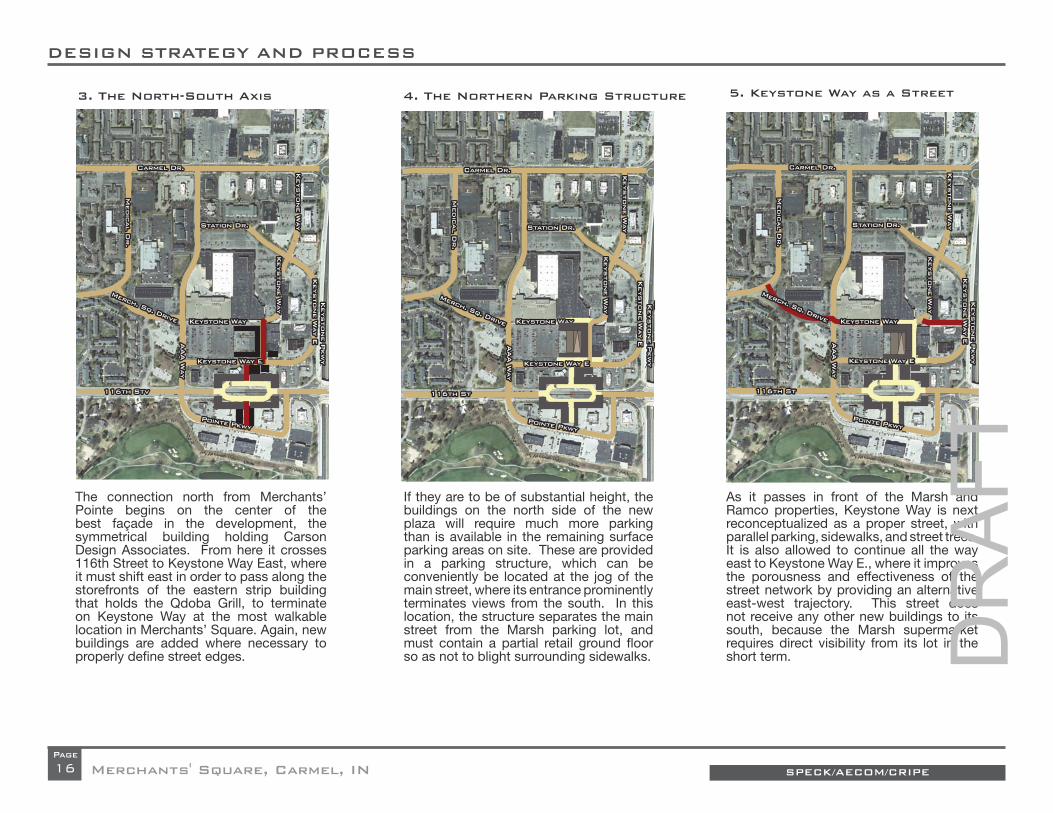
The connection north from Merchants’ Pointe begins on the center of the best façade in the development, the symmetrical building holding Carson Design Associates. From here it crosses 116th Street to Keystone Way East, where it must shift east in order to pass along the storefronts of the eastern strip building that holds the Qdoba Grill, to terminate on Keystone Way at the most walkable location in Merchants’ Square. Again, new buildings are added where necessary to properly defi ne street edges.
If they are to be of substantial height, the buildings on the north side of the new plaza will require much more parking than is available in the remaining surface parking areas on site. These are provided in a parking structure, which can be conveniently be located at the jog of the main street, where its entrance prominently terminates views from the south. In this location, the structure separates the main street from the Marsh parking lot, and must contain a partial retail ground fl oor so as not to blight surrounding sidewalks.
5. Keystone Way as a Street
As it passes in front of the Marsh and Ramco properties, Keystone Way is next reconceptualized as a proper street, with parallel parking, sidewalks, and street trees. It is also allowed to continue all the way east to Keystone Way E., where it improves the porousness and effectiveness of the street network by providing an alternative east-west trajectory. This street does not receive any other new buildings to its south, because the Marsh supermarket requires direct visibility from its lot in the short term.
3. The North-South Axis 4. The Northern Parking Structure
Keystone Way EKeystone Way E
Keystone W
ay
Keystone W
ay
Keystone WayKeystone Way
Keystone P
kwy
Keystone P
kwy
Medic
al D
r.
Medic
al D
r.
Keystone W
ay
Keystone W
ay
Keystone W
ay E
Keystone W
ay E
Carmel Dr.Carmel Dr.
116th St116th St
Pointe PkwyPointe Pkwy
AAA W
ay
AAA W
ay
Keystone Way EKeystone Way E
Station Dr.Station Dr.
Merch. Sq. Drive
Merch. Sq. Drive
Merch. Sq. Drive
Merch. Sq. Drive
Keystone P
kwy
Keystone P
kwy
Medic
al D
r.
Medic
al D
r.
Keystone W
ay
Keystone W
ay
Keystone W
ay E
Keystone W
ay E
Carmel Dr.Carmel Dr.
116th St116th St
Pointe PkwyPointe Pkwy
AAA W
ay
AAA W
ay
Keystone Way EKeystone Way E
Station Dr.Station Dr.
Keystone W
ay
Keystone W
ay
Keystone WayKeystone Way
Keystone W
ay
Keystone W
ay
Keystone WayKeystone Way
DR
AFT

17
DESIGN STRATEGY AND PROCESS
SPECK/AECOM/CRIPE Merchants' Square, Carmel, INPage
6. The Linear Square 7. The Walkable Loop 8. The Reconfigured Swoop
The removal of the northern half of the main Ramco building provides ample room for the inclusion of a new walkable street that can reach around the back of the Marsh site in order to then turn south along AAA Way, to connect back to its front. This street angles slightly north to intersect AAA Way at a right angle, providing a more interesting series of vistas. If properly provided with parking, buildings along this street could serve a variety of uses, but it is likely that the retail component of the redevelopment will not continue north or west of the Linear Square, given the limited demand for new shopping in this area.
In addition to communicating an automotive environment, the swoop in AAA way currently brings it alongside the bleak fl ank of the Marsh supermarket. As has been achieved in other similar schemes, the trajectory of the street is reconfi gured at a cleaner angle to create a long and narrow building site against the Marsh building, which can place proper doors on its sidewalk.
Freed of much of its demand by the adjacent demolition, the parking lot to the east of the Ramco building can be transformed into a proper public square, as befi ts its fairly ideal 150-foot width. Well-bounded to the south and east, this square also requires a proper building edge to its north and west.
Keystone P
kwy
Keystone P
kwy
Medic
al D
r.
Medic
al D
r.
Keystone W
ay
Keystone W
ay
Keystone W
ay E
Keystone W
ay E
Carmel Dr.Carmel Dr.
116th St116th St
Pointe PkwyPointe Pkwy
AAA W
ay
AAA W
ay
Keystone Way EKeystone Way E
Station Dr.Station Dr.
Keystone P
kwy
Keystone P
kwy
Medic
al D
r.
Medic
al D
r.
Keystone W
ay
Keystone W
ay
Keystone W
ay E
Keystone W
ay E
Carmel Dr.Carmel Dr.
116th St116th St
Pointe PkwyPointe Pkwy
AAA W
ay
AAA W
ay
Keystone Way EKeystone Way E
Station Dr.Station Dr.
Keystone P
kwy
Keystone P
kwy
Medic
al D
r.
Medic
al D
r.
Keystone W
ay
Keystone W
ay
Keystone W
ay E
Keystone W
ay E
Carmel Dr.Carmel Dr.
116th St116th St
Pointe PkwyPointe Pkwy
AAA W
ay
AAA W
ay
Keystone Way EKeystone Way E
Station Dr.Station Dr.
Merch. Sq. Drive
Merch. Sq. Drive
Merch. Sq. Drive
Merch. Sq. Drive
Merch. Sq. Drive
Merch. Sq. Drive
Keystone W
ay
Keystone W
ay
Keystone WayKeystone Way
Keystone W
ay
Keystone W
ay
Keystone WayKeystone Way
Keystone W
ay
Keystone W
ay
Keystone WayKeystone Way
DR
AFT

18
DESIGN STRATEGY AND PROCESS
SPECK/AECOM/CRIPEMerchants' Square, Carmel, INPage
10. THE MERCHANTS' POINTE SHIFT9. URBANIZING THE WESTERN STREETS 11. THE SOUTHERN PARKING STRUCTURE
As mentioned, the main boulevard in Merchants’ Pointe is redundant with one of its parking lots, which can be reconceptualized as a commercial street lined by head-in parking. Removing this redundancy frees up more than an acre of land for additional parking, increasing the capacity of the site. It also provides the benefi t of placing the development’s building fronts directly against its main street, rather than behind a parking lot as is currently the case. The insertion of thin “lot-liner” buildings here as well protects the new street from much of its parking, providing a continuous walkable axis across the property from east to west.
In order to remove current swoops and to make better use of leftover green space, Merchants’ Square Drive and Medical Drive are reshaped. This redesign creates a large triangular green that gives value to surrounding properties and can be programmed as a neighborhood amenity. These reconfi gured streets and spaces are properly lined by buildings that place doors against the sidewalk. The plan also proposes replacing one key building in Governor Square with a larger structure that faces its front rather than its rear to Merchants’ Square Drive. Additionally, to its east, a number of parking spaces are placed within garages that can hold apartments above, better shaping the streets.
If the buildings surrounding the new square on 116th Street are to achieve an adequate height, the available parking area must be supplemented by an additional structure within Merchants’ Pointe. The best location for this structure is to the southeast, where it must be integrated into the buildings that frame the new square and main street, placing retail ground-fl oor uses against most of its street fronts and a habitable upstairs edge against the square.
Keystone P
kwy
Keystone P
kwy
Medic
al D
r.
Medic
al D
r.
Keystone W
ay
Keystone W
ay
Keystone W
ay E
Keystone W
ay E
Carmel Dr.Carmel Dr.
116th St116th St
Pointe PkwyPointe Pkwy
AAA W
ay
AAA W
ay
Keystone Way EKeystone Way E
Station Dr.Station Dr.
Keystone P
kwy
Keystone P
kwy
Medic
al D
r.
Medic
al D
r.
Keystone W
ay
Keystone W
ay
Keystone W
ay E
Keystone W
ay E
Carmel Dr.Carmel Dr.
116th St116th St
Pointe PkwyPointe Pkwy
AAA W
ay
AAA W
ay
Keystone Way EKeystone Way E
Station Dr.Station Dr.
Keystone P
kwy
Keystone P
kwy
Medic
al D
r.
Medic
al D
r.
Keystone W
ay
Keystone W
ay
Keystone W
ay E
Keystone W
ay E
Carmel Dr.Carmel Dr.
116th St116th St
Pointe PkwyPointe Pkwy
AAA W
ay
AAA W
ay
Keystone Way EKeystone Way E
Station Dr.Station Dr.
Merch. Sq. Drive
Merch. Sq. Drive
Merch. Sq. Drive
Merch. Sq. Drive
Merch. Sq. Drive
Merch. Sq. Drive
Keystone W
ay
Keystone W
ay
Keystone WayKeystone Way
Keystone W
ay
Keystone W
ay
Keystone WayKeystone Way
Keystone W
ay
Keystone W
ay
Keystone WayKeystone Way
DR
AFT

Keystone P
kwy
Keystone P
kwy
Keystone P
kwy
Keystone P
kwy
19SPECK/AECOM/CRIPE Merchants' Square, Carmel, INPage
13. THE AAA WAY ROUNDABOUT12. POCKET PLAZAS AND PARKS 14. THE WESTERN ENTRY
In order to further smooth traffi c fl ow on 116th, and to ease entry into Merchants’ Pointe from all directions, a roundabout is placed at the intersection of 116th Street and AAA Way. This feature is not necessary, but is certainly recommended.
Finally, key locations within the current plan are amenitized with additional small green spaces and plazas, providing a greater sense of place and reason to walk. These include a triangular green along the southern edge of the southern parking structure, a small corner pocket park across the street, a decorative green by the eastern entry to Merchants’ Pointe, a deeper sidewalk at the corner of the northern parking garage, a miniature turbine green at the southwest corner of Marsh, a tiny pocket park to its west, and a larger pocket park just east of where the rear loop meets AAA Way.
The above 12 steps complete the short-term redesign of the area. The longer-term plan includes the following additional steps:
It is possible to expand the network of walkability to include AAA Way by properly shaping the space of 116th Street from the new main square west to the AAA Way intersection. This effort requires the demolition and replacement of the westernmost pad sites in both Merchants’ Square and Merchants’ Pointe. Further, the western entry into Merchants’ Pointe can be added to the network of walkability by placing two additional Lot-Liner buildings along it as well.
SH
OR
T-T
ER
M P
LA
N
LO
NG
-TE
RM
PL
AN
AAA W
ay
AAA W
ay
Keystone P
kwy
Keystone P
kwy
Keystone W
ay
Keystone W
ay
Keystone W
ay E
Keystone W
ay E
Keystone Way EKeystone Way E
Station Dr.Station Dr.
116th St116th St
Pointe PkwyPointe Pkwy
Medic
al D
r.
Medic
al D
r.
Carmel Dr.Carmel Dr.
Pointe PkwyPointe Pkwy
Medic
al D
r.
Medic
al D
r.
Keystone W
ay
Keystone W
ay
Keystone W
ay E
Keystone W
ay E
Carmel Dr.Carmel Dr.
116th St116th St
Keystone Way EKeystone Way E
Station Dr.Station Dr.
Pointe PkwyPointe Pkwy
Medic
al D
r.
Medic
al D
r.
Keystone W
ay
Keystone W
ay
Keystone W
ay E
Keystone W
ay E
Carmel Dr.Carmel Dr.
116th St116th St
Keystone Way EKeystone Way E
Station Dr.Station Dr.
Merch. Sq. Drive
Merch. Sq. Drive
Merch. Sq. Drive
Merch. Sq. Drive
Merch. Sq. Drive
Merch. Sq. Drive
AAA W
ay
AAA W
ay
AAA W
ay
AAA W
ay
Keystone W
ay
Keystone W
ay
Keystone WayKeystone Way
Keystone W
ay
Keystone W
ay
Keystone WayKeystone Way
Keystone W
ay
Keystone W
ay
Keystone WayKeystone Way
DR
AFT

Keystone P
kwy
Keystone P
kwy
Keystone P
kwy
Keystone P
kwy
Keystone P
kwy
Keystone P
kwy
Medic
al D
r.
Medic
al D
r.
20
DESIGN STRATEGY AND PROCESS
SPECK/AECOM/CRIPEMerchants' Square, Carmel, INPage
15. THE NEW MARSH 17. NORTHERN DEMOLITION
If completed as planned, the reconstruction of Merchants’ Square will pave the way for a more lucrative reuse of its one-story retail spaces. With Marsh moved, it will become attractive to redevelop its footprint, and the remaining box next door, as taller mixed-use blocks. As shown, the use of a “Texas Donut” model allows two full blocks to be built, hiding central parking structures and interior courtyards.
Eventually, Marsh will want to replace its existing facility with a new store. Current trends suggest that this building can be slightly smaller, with parking underground and/or on its roof. Such a structure fi ts well in the existing Marsh parking lot, with room to spare for AAA Way to be properly shaped by a new building along its eastern edge. Together, this building can complete the southern network of walkability, turning Keystone Way into a proper main street, with storefronts on both sides.
As the neighborhood grows, the underutilized land to its north may also warrant redevelopment. While the lucrative pad sites against Carmel Drive are less likely to welcome demolition, the interior parcels along Station Drive provide a natural expansion of earlier phases. Additionally, it makes sense to remove the two pad sites fl anking AAA Way at Carmel Drive, in order to make a walkable connection from there to the redeveloped neighborhood. All told, eight buildings and their parking lots must be removed to complete the northern part of the plan.
16. REPLACEMENT OF THE BIG BOX
Pointe PkwyPointe Pkwy
AAA W
ay
AAA W
ay
Keystone W
ay
Keystone W
ay
Keystone W
ay E
Keystone W
ay E
Carmel Dr.Carmel Dr.
116th St116th St
Keystone Way EKeystone Way E
Station Dr.Station Dr.
Pointe PkwyPointe Pkwy
AAA W
ay
AAA W
ay
Medic
al D
r.
Medic
al D
r.
Keystone W
ay
Keystone W
ay
Keystone W
ay E
Keystone W
ay E
Carmel Dr.Carmel Dr.
116th St116th St
Keystone Way EKeystone Way E
Station Dr.Station Dr.
Medic
al D
r.
Medic
al D
r.
Keystone W
ay
Keystone W
ay
Keystone W
ay E
Keystone W
ay E
Carmel Dr.Carmel Dr.
116th St116th St
Pointe PkwyPointe Pkwy
Keystone Way EKeystone Way E
Station Dr.Station Dr.
Merch. Sq. Drive
Merch. Sq. Drive
Merch. Sq. Drive
Merch. Sq. Drive
Merch. Sq. Drive
Merch. Sq. Drive
Keystone W
ay
Keystone W
ay
Keystone WayKeystone Way
Keystone W
ay
Keystone W
ay
Keystone WayKeystone Way
Keystone W
ay
Keystone W
ay
Keystone WayKeystone Way
AAA W
ay
AAA W
ay
DR
AFT

AAA W
ay
AAA W
ay
Keystone P
kwy
Keystone P
kwy
Keystone P
kwy
Keystone P
kwy
Keystone P
kwy
Keystone P
kwy
21SPECK/AECOM/CRIPE Merchants' Square, Carmel, INPage
18. NORTHERN CONNECTION 20. EASTERN FLANK
The successful redevelopment of Merchants’ Square could also spur replacement of the six pad sites wrapped by Keystone Way East, and the northeastern pad within Merchants’ Pointe. Indeed, these steps (19 and 20) could happen before or simultaneous with steps 17 and 18 above. Eliminating the northern six buildings allows for the creation of new buildings facing Keystone Way East, presenting an attractive face to the development when seen from the Keystone Parkway. The single demolition within Merchants’ Pointe allows the eastern entry into that development to become walkable as well.
Their structures gone, these northern sites can now be redeveloped with buildings along street edges in order to frame a walkable environment along Station Drive and northern AAA Way. As already planned by the City, an additional roundabout is shown where AAA Way meets Carmel Drive, which will continue north into the redeveloped Gramercy site. While Carmel Drive is imagined as a principally automotive corridor in the near future, AAA Way is well poised (despite its name) to provide a continuous walkable and bikeable connection all the way from Merchants’ Pointe to 126th Street.
Again, the use and size of this redevelopment will depend on its parking provision, but this one-sided street facing away from the neighborhood does not seem appropriate for retail. The street is connected back to the Linear Square via the eastern extension of Keystone Way, which must properly lined by building fronts (Lot-Liners are recommended here). The east-west path on Keystone Way East is also protected from its southern parking lot by an edge of Lot Liners. That parking lot also receives a new building to its south, lining 116th Street across from Merchants’ Pointe, where two new buildings to the east frame the eastern entry.
19. EASTERN DEMOLITION
Pointe PkwyPointe Pkwy
AAA W
ay
AAA W
ay
Medic
al D
r.
Medic
al D
r.
Keystone W
ay
Keystone W
ay
Keystone W
ay E
Keystone W
ay E
Carmel Dr.Carmel Dr.
116th St116th St
Keystone Way EKeystone Way E
Station Dr.Station Dr.
Pointe PkwyPointe Pkwy
Medic
al D
r.
Medic
al D
r.
Keystone W
ay
Keystone W
ay
Keystone W
ay E
Keystone W
ay E
Carmel Dr.Carmel Dr.
116th St116th St
Keystone Way EKeystone Way E
Station Dr.Station Dr.
AAA W
ay
AAA W
ay
Medic
al D
r.
Medic
al D
r.
Keystone W
ay
Keystone W
ay
Keystone W
ay E
Keystone W
ay E
Carmel Dr.Carmel Dr.
116th St116th St
Keystone Way EKeystone Way E
Station Dr.Station Dr.
Pointe PkwyPointe Pkwy
Merch. Sq. Drive
Merch. Sq. Drive
Merch. Sq. Drive
Merch. Sq. Drive
Merch. Sq. Drive
Merch. Sq. Drive
Keystone W
ay
Keystone W
ay
Keystone WayKeystone Way
Keystone W
ay
Keystone W
ay
Keystone WayKeystone Way
Keystone W
ay
Keystone W
ay
Keystone WayKeystone Way
DR
AFT

22
DESIGN STRATEGY AND PROCESS
SPECK/AECOM/CRIPEMerchants' Square, Carmel, INPage
The above twenty steps constitute the foreseeable long-term redevelopment of Merchants’ Square and Merchants’ Pointe. By any measure, the plan is ambitious, and some might even consider it overreaching, which is why it is divided into short- and long-term phases. Only the fi rst of these phases (steps 1 – 12) must occur to fundamentally transform Merchants’ Square and Merchants’ Pointe into a walkable place.
However, even the long-term plan does not redevelop the entirety of these properties. While it would be easy to draw a plan that obliterates and replaces everything between Carmel Drive and 116th Street, such a plan is neither necessary nor at all realistic. It is unnecessary because even the most walkable places still contain large areas of non-walkability; they function fi ne nonetheless as long as a continuously walkable network of critical mass is achieved. And it is far from realistic because an urban redevelopment beyond the scale of the long-term plan would require more growth than can be expected before many years have passed—enough time to require a second generation of planning based on new conditions on site.
This diagrammatic exercise, refi ned, produces the Illustrative Plans that follow.
These short- and long-term plans are perhaps best understood in terms of the already-mentioned concept of Urban Triage. Referring back to the short-term plan, it can be seen how the strategy has been to connect the depths of Merchants’ Pointe back to Merchants Square, and then to create a single walkable loop within Merchants’ Square, which is extended west to take advantage of the redevelopment of the defunct western strip
center. This is the Primary Network of Walkability, colored red in the Urban Triage diagram.
The Secondary Network of Walkability, shown in yellow, refl ects the long-term goals of making AAA Way walkable for its entire length, expanding the street network one block north and east, and breaking up the oversize block of the remaining big boxes. While not essential, this plan shows what a larger walkable neighborhood should look like on this site.
The principally automotive streets are shown in grey, and include all of the thoroughfares not previously discussed as well as designated service streets within the plan. Until the Secondary Network of Walkability is built, its streets shall remain principally automotive as well.
URBAN TRIAGE ANALYSIS
URBAN TRIAGE ANALYSIS Primary Network of Walkability
Secondary Network of Walkability
Principally Automotive Network
Phase 1 buildings
phase 2 buildings
DR
AFT

23SPECK/AECOM/CRIPE Merchants' Square, Carmel, INPage
DR
AFT

24 SPECK/AECOM/CRIPEMerchants' Square, Carmel, INPage
THE ILLUSTRATIVE PLAN: SHORT TERM
Medical Dr.
Carmel
Dr.
116th S
t
Keystone Way
AAA Way
DR
AFT
25
THE ILLUSTRATIVE PLAN: SHORT TERM
SPECK/AECOM/CRIPE Merchants' Square, Carmel, INPage
As with most similar exercises, this effort produced both an Illustrative Plan and Reg-ulating Plan. Only the latter will eventually have the force of law, but the former repre-sents the ideal build-out of the site, and thus contains a greater amount of detail about what is imagined. The Regulating Plan en-sures that the ultimate outcome will achieve its urban objectives, but is less specifi c about those things that matter less, such as the footprints of the buildings, the divisions among lots, the design of parking, and the distribution of land uses that are shown or implied by the Illustrative Plan. In describ-ing the Illustrative Plan, we will endeavor to make clear which aspects of its design are required and which are not. Any questions in this regard can be answered by reviewing the Regulating Plan and Design Regulations included in this report.
The paragraphs that follow walk through the Illustrative Plan, highlighting its key features
and explaining its recommendations. We fi rst discuss the short-term illustrative plan before turning to its long-term version. The short-term plan is broken down into four geographic sub-areas:
• The 116th St. Square and Merchants’ Pointe;
• Merchants’ Square South and East;• Merchants’ Square North and West; and• The Western Flank.
DR
AFT

26
THE ILLUSTRATIVE PLAN: SHORT TERM
SPECK/AECOM/CRIPEMerchants' Square, Carmel, INPage
116th Street Square and Merchants' Pointe.
The 116th Street Square and Merchants’ Pointe
The extended roundabout of 116th Street Square creates a central green about 90 feet wide, fl anked by two streets, each containing two lanes of one-way traffi c and two lanes of parallel park-ing protected by bulb-outs. While only 28 park-ing spaces are provided, these are essential for protecting sidewalks and also providing teaser parking for retail establishments surrounding the square in multi-story mixed-use buildings. While upstairs uses could include residences, hotel, or offi ces, ground-fl oor businesses should prob-ably focus on dining and entertainment in order to make use of the Square’s great visibility and deep sidewalks, especially at its corners.
Key to the Square’s success as a commercial mixed-use environment will be its design details. Despite its smooth roundabout geometry, it needs to feel more like a traditional square than a traf-fi c device. This objective will be achieved in part by the Square’s amenities, which should include
some form of vertical fountain at each end, and by a central open-air structure such as an archway. While the centers, edges, and ends should be paved, the two interstitial spaces should be grass lawns welcoming a full range of uses.
The Square will also benefi t by the fi rm spatial defi nition provided by its surrounding building fronts. These must reach tightly to their corners as shown, with only one pedestrian-passage gap (or “paseo”) on each quadrant, each carefully aligned to provide framed vistas of an end foun-tain. Importantly, where they frame 116th Street
at its two Square entries, the surrounding build-ings cover the sidewalk with pedestrian arcades below habitable interior space, to further pinch the street vista.
The simple buildings that surround the Square and its bisecting north-south main street are sup-plemented in two ways. To the northeast, an ad-ditional small building is located to receive views from the new main street to the north (see Mer-chants’ Square South ahead). And to the south-east, the buildings reach further south and east to attach to the parking structure planned for that location.
Surrounded by the tallest buildings in the plan, 116th Street Square provides Carmel with a new public space of truly urban dimensions.
DR
AFT

27
THE ILLUSTRATIVE PLAN: SHORT TERM
SPECK/AECOM/CRIPE Merchants' Square, Carmel, INPage
Like most new thoroughfares in the development, the new north-south main street maintains an in-timate scale, with two travel lanes fl anked by two parking lanes and treed sidewalks. Buildings pull right up to the sidewalk edge, so that opposing storefronts are typically only 60 feet apart.
This Lot Liner building, designed by DPZ, allows a parking lot to give a friendly face to the street.
Shifted south to enfront the existing southern buildings, Pointe Parkway is fl anked by head-in parking on both sides. Where needed, it is also lined by the only other new buildings recom-mended for this phase: thin Lot Liners that contain apartments above garages placed within parking
lots. As advanced by Duany Plater-Zyberk & Co., this building type provides an opportunity for at-tainable market-rate housing to protect sidewalks from adjacent parking.
The proposed parking structure, perhaps fi ve sto-ries tall, is wrapped by habitable buildings to its north, west, and south. At ground level, the north-ern and western fl anks contain retail to a conven-tional depth, and the southern edge is hidden behind one-sided rowhouses, perhaps three sto-ries tall. The deck contains a central ramping bay fl anked by two fl at bays, allowing it to look like a habitable building where exposed and to better integrate into the building to its north, which faces the main square with an inhabited edge against a single-loaded corridor on the upper stories.
Merchants’ Square South and East
The new main street heads north from the 116th Street Square to terminate on the northern park-ing structure, which presents an attractively fe-nestrated front to the south while receiving visitors prominently on axis. Here, the main street shifts east, along a broadened sidewalk whose south-east exposure makes it a good location for a café. To the east, the street is shaped by a small new building that extends the existing eastern strip southward. While the old strip can remain a one-story building—keeping its arcade—this addition-al structure should be three stories tall or more to balance the height of the parking deck. Like the southern parking structure, this one contains a central ramping bay fl anked by two fl at bays. On the ground fl oor, its eastern bay must hold retail rather than parking, and extends eastward beyond the garage footprint to embrace the nar-rower sidewalk as it heads north.
DR
AFT
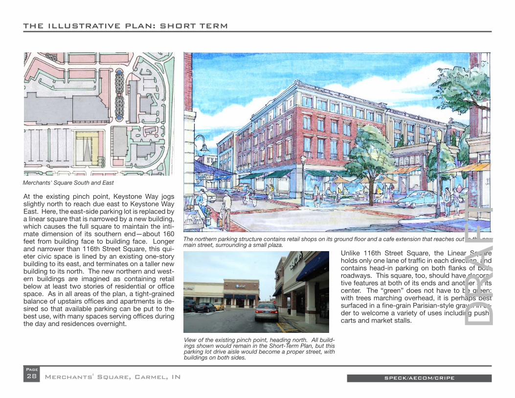
28
THE ILLUSTRATIVE PLAN: SHORT TERM
SPECK/AECOM/CRIPEMerchants' Square, Carmel, INPage
At the existing pinch point, Keystone Way jogs slightly north to reach due east to Keystone Way East. Here, the east-side parking lot is replaced by a linear square that is narrowed by a new building, which causes the full square to maintain the inti-mate dimension of its southern end—about 160 feet from building face to building face. Longer and narrower than 116th Street Square, this qui-eter civic space is lined by an existing one-story building to its east, and terminates on a taller new building to its north. The new northern and west-ern buildings are imagined as containing retail below at least two stories of residential or offi ce space. As in all areas of the plan, a tight-grained balance of upstairs offi ces and apartments is de-sired so that available parking can be put to the best use, with many spaces serving offi ces during the day and residences overnight.
Unlike 116th Street Square, the Linear Square holds only one lane of traffi c in each direction, and contains head-in parking on both fl anks of both roadways. This square, too, should have decora-tive features at both of its ends and another at its center. The “green” does not have to be green: with trees marching overhead, it is perhaps best surfaced in a fi ne-grain Parisian-style gravel in or-der to welcome a variety of uses including push-carts and market stalls.
The northern parking structure contains retail shops on its ground fl oor and a cafe extension that reaches out to the new main street, surrounding a small plaza.
Merchants' Square South and East
View of the existing pinch point, heading north. All build-ings shown would remain in the Short-Term Plan, but this parking lot drive aisle would become a proper street, with buildings on both sides.
DR
AFT

29
THE ILLUSTRATIVE PLAN: SHORT TERM
SPECK/AECOM/CRIPE Merchants' Square, Carmel, INPage
The Northern and Western Loop.
Merchants’ Square North and West
The demolition of the northern half of the cen-tral big box building allows the top of the Linear Square to connect back west to AAA Way. The new east-west thoroughfare is placed a proper distance north of the remaining big boxes to allow them an ample service court while also providing rear parking for new buildings on the south side of the street. Buildings on the north side of the street take advantage of the existing large parking lot to their rear. New buildings hug the street with
short setbacks in order to create another com-fortable 2-lane-plus-parking thoroughfare, and an L-shaped building to the northwest surrounds a small pocket park against the street.
As previously discussed, the swooping segment of AAA Way is reconfi gured into a slower-speed angled geometry to better invite pedestrians. This street is currently over-wide yet lacking in paral-lel parking and street trees, and its resulting need for rebuilding helps to justify slightly altering its path. This street is also designated as a future bi-
cycle corridor, and its planned extension through the Gramercy community north of Carmel Drive includes a separated cycle lane. Such a facility should be included through Merchants’ Square as well.
To the west of AAA Way sits a detention basin serv-ing the Post Offi ce behind it. While it will never be an ideal public amenity, this site can be improved by replacing its chain link fence with something more attractive, and by placing a vertical statue or other architectural feature at its northeastern cor-ner, where it receives framed views from the east. A more ambitious plan would propose a more dramatic reconstruction of this site, perhaps as a pastoral water feature.
Such a solution is not recommended here, primar-ily because the presence of the Post Offi ce park-ing lot to its west, currently off limits to redevel-opment, precludes the opportunity to give proper edges to this space.
The Linear Square contains a versatile Paris-style gravel surface suitable for both casual sitting and for farmers markets.
DR
AFT

30
THE ILLUSTRATIVE PLAN: SHORT TERM
SPECK/AECOM/CRIPEMerchants' Square, Carmel, INPage
The current confi guration of AAA Way swoops south along the Marsh fl ank without parallel parking or street trees.
The new trajectory of AAA Way brings it further west of the Marsh than is currently the case, allow-ing for the insertion of a thin liner building against its blank western wall. This building could hold small shops, but given its lack of visibility from the shopping center, it is probably best used for attainable market-rate housing. This use would match the proposed new use across the street (see ahead), and is best provided in one-sided rowhouses, as already proposed against the Mer-chants’ Pointe parking deck.
The Western Flank
The need to redevelop the mostly empty strip center west of Marsh brings with it the opportu-nity to reconfi gure its surrounding thoroughfares in a more walkable confi guration. Currently, these swooping, treeless streets communicate an automotive environment, an impression that is reinforced by the lack of building fronts along the sidewalks. Rationalizing the current network into a simple geometric pattern of straight streets transforms its oddly-shaped, leftover lawns into a proper triangular square, which can then be prop-erly lined by buildings.
This new confi guration also allows for narrower roadways: functioning as a partial turbine, the square’s north and south sides can hold one-way traffi c only, resulting in a larger open space. This space can be programmed in a variety of ways. Given a low fence, it would make a good-sized tot lot.
With the roads reshaped, there is room for a new small building to the north of the square, which
Merchants’ Square Drive curves into Medical drive (fore-ground) creating two large areas of unused lawn.
The angle in the northern loop road allows one of its fl anking buildings to receive a triangular pocket park at its front.
DR
AFT

31
THE ILLUSTRATIVE PLAN: SHORT TERM
SPECK/AECOM/CRIPE Merchants' Square, Carmel, INPage
would help to give it shape. To its east, another building on the Post Offi ce property would per-form the same function. More importantly, it is hoped that one building in Governor Square can be replaced to give the square a proper southern edge. While all other buildings in this complex face internal parking lots and turn their backs to surrounding streets, this one larger building would be principally parked to its rear, but would face its front door to the square.
The plan for the Western Flank creates a triangular square to amenitize surrounding residential uses, including apart-ments in place of the empty strip center.
Two Lot-Liners surrounding an existing tree create a small park along Merchants' Square Drive
Between the new square and the Marsh is the site of the western strip center, which is well shaped to place a U of buildings facing surrounding streets, with a parking lot hidden midblock. Meanwhile, a number of small parking areas on the southern side of the street would benefi t from Lot-Liner buildings enfronting the sidewalk. One proposed such building, shaped like an L, enlarges its sur-rounding parking in order to terminate eastward views on a tiny pocket park around a healthy tree.It is worth noting that, in certain locations, this
plan benefi ts heavily from the use of Lot-Liner buildings. While not unprecedented, these build-ings are unusual enough to require further advo-cacy. Stick-built over conventional garages, they are not expensive to construct, but their uncon-ventional nature suggests that they will only be provided if the City creates a specifi c program to encourage them.
Such an undertaking is well worth the effort be-cause, in addition to providing much-needed workforce housing, these buildings could be used in several other locations in Carmel to make key
streets more walkable, most notably on the east side of Veterans Way between City Hall and City Center. This important stretch, from Carmel’s gov-ernmental hub to its cultural hub, currently fails as a pedestrian trajectory due largely to its continu-ous edge of parking lots. Placing about 55 park-ing spaces along this trajectory within Lot-Liner buildings would fundamentally alter walkability in this key area.
DR
AFT

32 SPECK/AECOM/CRIPEMerchants' Square, Carmel, INPage
THE ILLUSTRATIVE PLAN: LONG TERM
Medical Dr.
Carmel
Dr.
116th S
t
Keystone Way
AAA Way
DR
AFT

33
THE ILLUSTRATIVE PLAN: LONG TERM
SPECK/AECOM/CRIPE Merchants' Square, Carmel, INPage
The redevelopment plan for Merchants’ Square is carefully crafted to provide dramatic changes in the short term, if implemented. Indeed, the short-term plan discussed above will be enough to transform Merchants’ Square from a principally automotive environment to a principally walkable one. No further redevelopment will be necessary for this effort to have achieved its goals.
However, this fi rst phase, if successful, can be ex-pected to impact on-site property values to such an extent that a more comprehensive redevelop-ment, previously unjustifi ed, will begin to make economic sense. A desire to put the land to its highest and best use will potentially lead to the de-molition and replacement of many more buildings on site, including the current Marsh supermarket, its adjacent big-box building, and perhaps as many as twenty other small pad developments in Merchants’ Square and Merchants’ Pointe. Given this possibility, it is important to have a long-term plan that shows how this redevelopment can take the most effi cacious form, both for its own suc-cess as a place and for the ideal functionality of the surrounding area. This plan is broken down into four quadrants: southwest, central, north, and east.
Southwest Quadrant
The walkability of Merchants’ Square does not de-pend on the creation of a roundabout at the corner of 116th Street and AAA Way, but that transfor-mation is justifi ed from a traffi c-fl ow perspective, and is in keeping with the City’s general strategy of placing roundabouts at signifi cant intersections whenever possible. Such a change will also ease passage from AAA Way into Merchants’ Pointe, helping its revival.
The eventual desire of Marsh to replace its super-market with a more up-to-date facility will create the opportunity to provide AAA Way with a proper street edge, allowing it to join the network of walk-ability. Current trends suggest that the new Marsh will be somewhat smaller and incorporate parking underground and/or on its roof. This confi gura-tion will allow the market to pull back from AAA Way, which can then receive a proper edge of new buildings—likely offi ce and/or residential—with a full bay of surface parking behind. This scheme retains Keystone Way East as a service street, making it the best location for supermarket load-ing docks. East of the new market, the plan re-tains one bay of parking against the new parking structure, but this bay could also be used for ad-ditional buildings and/or structured parking if de-sired.
To properly shape the new roundabout and to invite pedestrians across 116th Street, the two remaining pad sites will have to be replaced by proper sidewalk-facing buildings on the round-about’s two eastern corners. Finally, two Lot-Lin-er buildings will be necessary to invite pedestrians all the way into Merchants’ Pointe. These trans-formations result in a AAA Way that is thoroughly walkable from Merchants’ Pointe all the way to the new northern loop road.
Making AAA Way walkable can be accomplished by re-placing the Marsh parking lot and pad sites along 116th Street with buildings against the sidewalk.
DR
AFT

34
THE ILLUSTRATIVE PLAN: LONG TERM
SPECK/AECOM/CRIPEMerchants' Square, Carmel, INPage
Currently strictly automotive, Station Drive would maintain its current trajectory, but be remade as a walkable street.
As shown, new taller buildings to the south, south-east, and southwest complete the block structure that has already been introduced to the north, and two central buildings—potentially lines of one-sid-ed rowhouses—create a new north-south street. This street can be designed as an intimate Eu-ropean-scale thoroughfare, which has been laid out at a slight angle to provide memorable vistas through it. It is expected that the new southern buildings will contain offi ces or apartments (or hotel) over retail, while the two central buildings
are ideal for residential use. As shown, the inter-stitial courtyards between these blocks’ perimeter buildings and parking decks offer ample room for pool decks and other amenities.
North Quadrant
While the entire area between Merchants’ Square and Carmel Drive would benefi t from redevel-opment, what is most important from a regional standpoint is that a walkable/bikeable corridor be established in this location and beyond. As it heads north from Carmel Drive, AAA Way has been designated as just such a corridor, and this plan continues that trajectory to its terminus in Mer-chants’ Pointe. For that reason, even this long-term plan does not see the need for—or the like-lihood of—additional redevelopment in this area beyond establishing a single corridor of the high-est quality. This corridor is planned to embrace Carmel Drive and then continue north through The Fountains’ property into the Gramercy parcel, cur-rently under redevelopment.
In accordance with City policy, AAA Way meets Carmel Drive at a roundabout, which is surround-ed at all four corners by properly-shaped devel-opment. The plan for The Fountains, not a part of this study, refl ects the leading proposal currently under consideration by the property owner. While not providing a high level of walkability due to the intense parking demands of The Fountains meet-ing facility, this plan is organized to allow for later walkable infi ll if that building is replaced. In its current condition, it would also benefi t from the inclusion of Lot-Liners along the full trajectory of AAA Way.
If properly rebuilt and shaped by buildings, AAA Way can bring walkability north to Carmel Drive and beyond.
As it heads south into Merchants’ Square, AAA Way is fl anked by new buildings with their parking located behind. To the east, the completion of this part of the plan recreates Station Drive along its current trajectory as a street with parallel parking, ample sidewalks, and street trees. This street, too, must be lined by multistory buildings on both sides. While buildings against Carmel Drive will probably support retail activity, the remainder are imagined as residential or offi ce use. The foot-
Central Quadrant
As discussed above, the relocation of the Marsh will allow its block to be redeveloped into a more intensive use, including the remaining big-box structure to its east. A “Texas Donut” typology allows for two small blocks to fi t here, each with a hidden central parking structure. A less intensive use would wrap buildings around the perimeter of a single large block with parking at its center, but such a moderate-density solution is not as likely to justify the site’s redevelopment, nor is it as like-ly to encourage walking.
The relocated Marsh and its big-box neighbor can be re-placed by two properly sized urban blocks.
DR
AFT

35
THE ILLUSTRATIVE PLAN: LONG TERM
SPECK/AECOM/CRIPE Merchants' Square, Carmel, INPage
Development of the eastern fl ank gives the development a better face to Keystone Parkway and improves the entry into Merchants’ Pointe.
print and height of these buildings will depend on whether rear parking is surface or structured. As imagined in the Illustrative Plan, only the buildings to the south of Station Drive receive a parking structure, which seems necessary, as these new buildings displace surface parking serving the new buildings to their south.
East Quadrant
The eastward completion of the plan replaces the half-dozen pad sites between the development and Keystone Parkway with a proper block struc-ture of streets lined by buildings. To the north, Keystone Way East is recognized as the most vis-ible face of the development. Even though it is one-sided and against a highway, and will there-fore never attract pedestrians in great number, the removal of its pad sites will allow it to overlook the parkway with the noble facades of a hous-ing or offi ce development. As always, the height and number of these buildings will determine their need for surface or structured parking. As shown here, a healthy mix of housing and offi ce makes the most use of a surface parking lot located at midblock.
This portion of the plan makes use of Lot-Liners on both east-west connections to hide parked cars from view. The presence of fl at-fronted buildings against the curve of Keystone Way East results in the creation of three small pocket parks, which amenitize the real estate. It is recommend-ed that the berm separating Keystone Way East from the Keystone Parkway be heavily planted not only with street trees but with a thick evergreen understory to give it a sense of protection from the highway.
Further south, the removal of Merchants’ Pointe’s northeastern pad building will eventually allow that development’s eastern entrance to achieve a more walkable quality. This is accomplished by the narrowing of Pointe Parkway near 116th (removing the median of this right-in-right-out ac-cess way) and the addition of three buildings: one north of 116th Street, and two alongside Pointe Parkway. The two buildings fl anking 116th Street are shown with their eastern facades aligned, pro-viding a fi rm entry point to the redevelopment.
DR
AFT

36 SPECK/AECOM/CRIPEMerchants' Square, Carmel, INPage
The capacity of the plan is primarily dependent on the impacts of parking. The following four factors will determine how many square feet of building is constructed on site:
• Surface or structure: If parking is placed in structures, the plan's capacity grows multifold. Given the cost of these facilities, the Illustra-tive Plan imagines only two such structures in the short term, and fi ve in the long term. The removal of these structures or the addition of others would result in signifi cantly different numbers.
• Complementary Loads: Many parking spaces that are used by residents overnight can often be used by workers during the day. As a result, the capacity of the plan grows signifi cantly as a result of placing residential and offi ce uses in close proximity. Parking regulations must take opportunities for shared capacity into account.
• Reduced auto-dependency: Over time, the successful development of a pedestrian-friendly environment will allow a portion of car trips to be replaced by walking, biking, and transit. Residents in particular will fi nd reason to own fewer cars and to often leave their cars at home. This factor as well must be allowed to impact parking requirements.
• On-street parking: All of the new streets in the plan have considerable curbside parking capacity, which will also reduce the demand placed upon off-street lots. Parking requirements must con-sider on-street spaces to be interchangeable with off-street spaces.
116th Street NorthThe estimates that follow attempt to make reason-able assumptions about the impact of the above factors on building sizes. In all cases, I have been less aggressive than the Code (ahead) allows, expecting that developers will be fairly conserva-tive in their parking requirements. While the Code requires 1.5 parking spaces per residential unit and 3 spaces per 1000 square feet of commercial space, the following calculations instead use ra-tios of 2:1000 for residential and 4:1000 for com-mercial.
THE SHORT-TERM PLAN
In order to determine the capacity of the Short-Term Plan, it is most useful to re-divide it slightly, so that buildings can be considered hand in hand with their parking provision. We will look at the Plan in the following four sections:
• 116th Street North• 116th Street South• Linear Square and Northern Loop• The Western Flank.
PLAN CAPACITY
North of 116th Street, new buildings total 50,000 square feet (SF) per fl oor, plus 28,000 SF in the base of the parking structure. The parking struc-ture holds approximately 60 spaces at grade and about 150 spaces for each subsequent fl oor, such that a 5-story garage would hold 660 spaces. 160 spaces in surface lots and 50 more on-street bring the cumulative total to 870.
If all new ground-fl oor space is retail (totaling 77,000 SF), providing parking at 4:1000 would re-sult in 560 spaces still available for upstairs uses. 5-story buildings would result in 200,000 square feet of upstairs space, which if shared between residential, offi ce, and potentially hotel use, would be well served by 560 spaces.
Retail: 77,000 SFMixed Use: 200,000 SFTOTAL: 277,000 SF
DR
AFT

37
PLAN CAPACITY
SPECK/AECOM/CRIPE Merchants' Square, Carmel, INPage
Parking: Structured: 660 spaces Surface: 160 On-Street: 50 TOTAL: 870 spaces.
116th Street South
South of 116th Street, new buildings to the west total 27,000 SF per fl oor. To the east, the parking structure and its surrounding block holds 28,000 SF at grade and 18,000 SF for each subsequent fl oor. The parking structure holds approximate-ly 70 spaces at grade and about 150 spaces for each subsequent fl oor, such that a 5-story garage would hold 670 spaces. On street and in surface lots, the redevelopment results in a net gain of about 30 spaces, placing the total parking in sup-port of new construction at 700 spaces.
If all new ground-fl oor space is retail (totaling 55,000 SF), providing parking at 4:1000 would re-sult in 480 spaces still available for upstairs uses. 5-story buildings would result in 180,000 of up-stairs space, which if shared between residential, offi ce, and potentially hotel use—and 18 Lot-Liner apartments—would be well served by 480 spac-
es.
Retail: 55,000 SFMixed Use: 180,000 SFLot-Liners* 13,000 SFTOTAL: 248,000 SF
Parking: Structured: 670 spaces Other net: 30 TOTAL: 700 spaces.
(* Lot-Liners are estimated at 750 SF each.)
Linear Square and the Northern Loop
New retail on the Linear Square adds up to 28,000 SF of space. Each fl oor of non-retail use above shops adds another 28,000 SF. To the west of the Linear Square, new non-retail buildings total 60,000 SF per fl oor. Parking lots hold 410 spac-es, supplemented by 100 new spaces on-street. New retail, parked at 4:1000, would use up 110 spaces, leaving 400 spaces for other uses. Build-ing the entirety of this area at three stories would
result in 230,000 SF of non-retail use. If principal-ly residential mixed with some offi ce space, this would be adequately served by its parking.
Note: In situations like this one, the optimal mix of uses for conserving parking supply is a hous-ing/offi ce square-footage ratio of perhaps fi ve to one. At this ratio, the offi ce demand is so low that it can be easily satisfi ed by the large num-ber of residential parking spaces that are vacant during work hours, and therefore the parking can be sized based on the residential load alone. For example, if the above 230,000 SF were to include 180,000 SF of housing and 50,000 SF of offi ce, both uses could be served by 360 spaces at the residential ratio of 2:1000. The offi ce space, if parked at 4:1000, would make use of 200 of these spaces during work hours, when most residents are away.
Retail: 28,000 SFMixed Use: 230,000 SFTOTAL: 258,000 SF
Parking: Surface: 410 On-Street: 100 TOTAL: 510 spaces.
DR
AFT

38
PLAN CAPACITY
SPECK/AECOM/CRIPEMerchants' Square, Carmel, INPage
The Western Flank
West of the Marsh, the new housing on the de-funct strip center totals as much as 40,000 SF per fl oor. Across the street, the replacement building within Governor Square is as large as 15,000 per fl oor, adding perhaps 10,000 SF more area than the old structure. This is supplemented by 10 Lot-Liners and also what will probably be 10 one-sid-ed rowhouses against the Marsh west wall.
100 new parking spaces are provided on street, and 75 in the new residential lot. Perhaps 25 of these would serve the new rowhouses and the enlargement of the Governor Square building, leaving 150 spaces for the main housing cluster. Parking 40,000 SF at 2:1000 would allow these buildings to be two stories tall.
These outcomes are the result of avoiding addi-tional parking structures (including underground
parking) in this area. As is the case throughout the plan, providing more structured parking in this location would increase its capacity signifi cantly.
Mixed Use: 90,000 SFRowhouses*: 15,000 SFLot-Liners: 7,500 SFTOTAL: 112,500 SF
Parking: Surface: 75 On-Street: 100 TOTAL: 175 spaces.
(* Rowhouses are estimated at 1500 SF each.)
Totals
Totaling all of the above, the Short-Term Plan can be summarized cumulatively as follows:
Retail: 160,000 SFMixed Use: 700,000 SFRowhouses: 15,000 SFLot-Liners: 20,500 SFTOTAL: 895,500 SF
Parking: Structured: 1,330 spaces Surface (net): 675 On-Street: 250 TOTAL: 2,255 spaces.
THE LONG-TERM PLAN
As with the Short-Term Plan, determining the ca-pacity of the Long-Term Plan is made easier by re-dividing it slightly. We will look at the Plan in
the following four sections:
• East and West 116th Street• The New Marsh and its Old Site• The Northern Extension• The Eastern Flank.
East and West 116th Street
The long-term redevelopment surrounding 116th street supplements the short-term plan by add-ing buildings at all four corners. To the northwest, two more buildings against the roundabout con-tribute 15,000 SF more per fl oor of construction, parked in 50 additional lot spaces plus 5 more on-street spaces. To the southwest, a new building against the roundabout contributes 10,000 SF per fl oor of construction, parked in 50 more lot spaces (including garages within Lot-liner buildings). The limited amount of parking provision suggests that all of these new structures should both be either one story tall if commercial or two stories tall if residential. Given their excellent visibility, they are most likely to be retail.
West 116th Street
DR
AFT

39
PLAN CAPACITY
SPECK/AECOM/CRIPE Merchants' Square, Carmel, INPage
To the northeast, a new building reaching toward the Keystone Parkway roundabout adds about 10,000 SF per fl oor while removing 30 spaces from the planned parking lot. If this structure is to be built at all, let alone achieve more than one story, the buildings surrounding the main square will have to be scaled back slightly from their proposed fi ve stories, so that they can be served completely by the new parking structure and not rely on that lot.
A similar condition occurs to the southeast as well. The proposed long-term eastern addition to Merchants’ Pointe contributes as much as 20,000 SF more per fl oor, but does not increase the park-ing provision beyond the prior amount. Since one 7000 SF pad-site building has been removed, all but 7,000 SF of this new building volume will have to fi nd parking in the new garage across the street.
Therefore, if it is anticipated that such a long-term eastern addition is likely, either north or south of 116th Street, the buildings surrounding the main square may have to average a height closer to 4.5 stories rather than the 5 stories already counted. For that reason, neither of these eastern additions are included in the calculation of long-term square footages.
Retail: 25,000 SFTOTAL: 25,000 SF*
Parking: Surface: 100 spaces On-street: 5 TOTAL: 105 spaces.
(* Limited as noted above.)
The New Marsh and Its Old Site
Rebuilding the Marsh on its old parking lot as shown gives it a footprint of 50,000 SF. As per the new urban supermarket standard, it fi nds park-ing in its basement and on its roof, totaling about 220 spaces. Replacing the Marsh and its adja-cent big box with mixed-use buildings provides another 40,000 SF of retail on the ground fl oor, which is parked in about 100 new on-street spac-es (including the head-in bay just east of the new Marsh. This provision is a little light, but could easily be supplemented by additional spaces (and vacancies) in the two new residential lots planned midblock to the north.East 116th Street
DR
AFT

40
PLAN CAPACITY
SPECK/AECOM/CRIPEMerchants' Square, Carmel, INPage
The non-retail fl oors of these new mixed-use buildings would each provide about 57,000 SF of habitable space. Midblock, the two new park-ing structures would replace 90 surface spaces with as many as 780 spaces in 5-story garages, for a net gain of 690 spaces. This large supply of parking would allow these buildings to provide four full stories of residential above their shops. The western fl ank of this complex would probably be entirely residential rather than including a retail ground fl oor, adding another 12,000 SF of housing to the mix. As a result, new non-retail use here would total about 240,000, requiring less parking than provided, and suggesting either smaller park-ing structures or a signifi cant offi ce component.
This redevelopment would also eliminate the ten rowhouses on the west fl ank of the current Marsh, but replace them with about twenty rowhouses along the new north-west street, lining the parking structures. These could be parked in the struc-tures and also in about 20 spaces on that narrow street.
Retail: 90,000 SFMixed Use: 240,000 SFRowhouse (net): 15,000 SFTOTAL: 345,000 SF
Parking: Structured: 1,000 spaces Surface (net) (90) On-Street: 120 TOTAL: 1,030 spaces.
The Northern Extension
Redeveloping both sides of Station Drive and AAA Way north to Carmel Drive contributes a total new building area of 160,000 SF per fl oor. Perhaps 20,000 SF of this would be retail against Carm-el Drive, and the remainder would be principally residential. This is parked by 625 spaces in sur-face lots plus an additional 100 on-street. (The new 280-space parking structure to the south of Station Drive is proposed as a way to park the buildings to its south, which currently park on the surface lot that would be mostly redeveloped in the Long-Term Plan.) Serving a 160,000 SF foot-print in 725 spaces suggests a two-story redevel-opment if buildings are mostly residential with a limited offi ce component. Again, additional park-ing structures would support a much grander out-come.
Retail: 20,000 SFMixed Use: 280,000 SFTOTAL: 300,000 SFParking: Structured: 280 spaces* Surface (net): 355* On-Street: 100 TOTAL: 735 spaces.
(*A 280-space structured lot and other amenities replace 270 surface spaces.)
DR
AFT

41
PLAN CAPACITY
SPECK/AECOM/CRIPE Merchants' Square, Carmel, INPage
The Eastern Flank
Finally, the arc of new buildings proposed against Keystone Parkway, in addition to the 8 Lot-Lin-er units to their south, would contribute about 40,000 SF of interior space per fl oor, served by
170 lot spaces and 100 on-street spaces. This parking supply would support three-story apart-ment buildings, which should also be encouraged to contain a limited offi ce component. This fl ank could also be developed entirely as two-story of-fi ce villas on a slightly smaller footprint, but such a single use is less ideal.
Mixed Use: 120,000 SFTOTAL: 120,000 SF
Parking: Surface 170 On-Street: 100 TOTAL: 270 spaces.
Totals
Totaling all of the above, the additional develop-ment of the Long-Term Plan can be summarized cumulatively as follows:
Retail: 135,000 SFMixed Use: 640,000 SFRowhouses: 15,000 SFTOTAL: 790,000 SF
Parking: Structured: 1,280 spaces Surface (net): 535 On-Street: 325 TOTAL: 2,140 spaces.
Grand Totals
Combining these numbers with the Short-Term Plan, the entire redevelopment shown in the Illus-
trative plan is as follows:Retail: 295,000 SFMixed Use: 1,340,000 SFRowhouses: 30,000 SFLot-Liners: 20,500 SFTOTAL: 1,685,500 SF
Parking: Structured: 2,610 spaces Surface (net): 1,210 On-Street: 575 TOTAL: 4,395 spaces.
DR
AFT

42 SPECK/AECOM/CRIPEMerchants' Square, Carmel, INPage
BEYOND MERCHANTS' SQUARE
Although focused on Merchants’ Square for the reasons already noted, this study also ad-dresses the design of its two main east-west corridors, and pays more careful attention to several important sites on the west side of Range Line Road that are currently undergoing redesign: the Party Time site just north of Car-mel Drive, and the large shopping center north of 116th Street.
116th Street
not suggest any further investment in pedestri-an-friendly urban design west of AAA Way, for three main reasons:
• As it heads west, 116th street is already de-veloped exclusively with roadside proper-ties that do not support walkability. These include principally single-family houses to the south and, to the north, a combination of the backs of buildings and surface park-ing lots. A wholesale redevelopment of this area would be needed to make it marginally pedestrian friendly.
• It doesn’t connect to walkability elsewhere. Unlike Carmel Drive, 116th Street does not eventually arrive in a part of the city that is going to support significant pedestrian ac-tivity anytime soon.
• Given it’s high volume of relatively high-speed traffic and its importance to the re-gional road network, 116th Street would require an excessive investment to make it also inviting to pedestrians.
For these reason, this plan does not propose any modifications to 116th Street beyond the ones proposed between Keystone Parkway and AAA Way.
That said, it is worth noting that the street’s at-tractiveness and safety as a vehicular corridor would be enhanced by the planting of continu-ous street trees alongside the roadway and in all medians. The same approach is appropriate for dozens of main streets in Carmel that cur-rently lack consistent tree cover. But if the goal
is to support walkability, such an investment should be made first in streets that are more likely to attract pedestrians for other reasons.
Flanked by surface parking lots, building rears, and other edges that don’t attract walking, 116th Street has little hope of becoming a pedestrian axis.
Carmel Drive has greater potential as a pedestrian corridor.
As it approaches downtown Carmel from Key-stone Parkway, 116th Street receives a gate-way embrace by Merchants' Square and Mer-chants’ Pointe. This plan proposes a dramatic entry feature in the form of its main square, and further suggests that this specific area take on more walkable characteristics between Key-stone Parkway and AAA Way. However, it does
We should finally note that 116th Street is a favored path for many cyclists to reach the Monon Greenway, and for this reason its side-walks must be maintained at a width that sup-ports cycling. Given the limited amount of pedestrian activity on these sidewalks, this condition does not create the conflict that it might elsewhere.
Carmel Drive
Unlike 116th Street, Carmel Drive has some potential for attracting pedestrians. While hardly surrounded by uses or buildings that are considerably more likely to generate pedestri-an traffic, the street has a number of charac-teristics that make walking and biking along it more likely:
DR
AFT

43
BEYOND MERCHANTS' SQUARE
SPECK/AECOM/CRIPE Merchants' Square, Carmel, INPage
• Along much of its trajectory west of AAA Way it has a 4-lane section rather than a 5-lane section, making the traffic along it less threatening to pedestrians.
• It enjoys better tree cover than 116th Street, especially in a few key stretches where healthy street trees protect the side-walk from traffic.
• It connects to a location along Range Line Road that is currently undergoing redevel-opment according to a more walkable de-sign framework and is also quite close to City Hall, which is in turn developing more walkable connections northward to City Center and eventually to Main Street.
For these reasons, this study recommends that Carmel Drive again be considered for the sort of pro-walkability design overlay that is gradu-ally transforming Range Line Road into a corri-dor that is more attractive for both pedestrians and drivers. As being implemented on Range Line, such an overlay requires that new build-ings pull up to the sidewalk, place their parking to the rear, and include a significant amount of second-story space.
Expansion of the Carmel Drive - Range Line Road Overlay Zone to East Carmel Drive has already been proposed, but has not yet been enacted. The long-term connectivity of Car-mel’s most walkable neighborhoods to each other will require that this corridor eventually take on an overlay of this nature.
The Party Time Site
At the northwest corner of Carmel Drive and Range Line Road is a very large site that cur-rently contains a Party Time store and an Ar-by’s. Because plans are underway for its rede-velopment, this effort was expanded to include this site and also the site immediately to its north, which is capable of being put to more productive use.
The Party Time site. To its north, one property separates it from Civic Square, the parking street that reaches to City Hall.
The current proposal for the Party Time site.
At the time of this study, the latest plan for the site was as shown below. It includes a double-loaded apartment building enfronting Carmel Drive, Range Line Road, and a new street to its north, and townhouses enfronting a new segment of Veterans Way to its west. From a strict urban perspective, this plan gets the basics right, concealing its very large parking lot at the center of the block (along with a pool deck). This parking lot is located a full story below the grade of Range Line Road, due to the sloping site. Each Range Line Road inter-section receives a roundabout.
DR
AFT

44
BEYOND MERCHANTS' SQUARE
SPECK/AECOM/CRIPEMerchants' Square, Carmel, INPage
The concerns presented by this plan are a bit sub-tler:
• The resulting block is much larger than a stan-dard urban block, and could better enhance area walkability if broken into two smaller blocks.
• Unless handled very carefully, the extremely long facades threaten to become monoto-nous, especially against Range Line road.
• Unless doors are placed regularly along side-walks from ground-fl oor units, there will be limited activity on the surrounding sidewalks.
• Several of the sidewalks seem to locate street trees on the inboard rather than the outboard edge, where they are needed to protect pe-destrians.
Recognizing the successful qualities of the cur-rent plan, the redesign below changes the design as little as possible in an attempt to address the above concerns.
This proposal introduces a central mews that be-gins on Range Line Road, cascades down into the heart of the block, and terminates on a community pool, with its clubhouse located against Veteran’s Way to the west. It includes the following features:
• The parking is split between two lots that con-nect through a narrow road across the pedes-trian mews. This road receives a speed table so that the mews axis is dominant across it.
• The cascading stair includes a cascading fountain that leads to a linear water feature through the mews. This axis is punctuated by a central fountain surrounded by benches and terminates with a virtual waterfall into the pool. This is clearly not necessary, but would be exciting. One way to build this feature cheaply and to code would be to run water down a central channel that is only depressed 1” below the surrounding pavement, thus not presenting a walking or wheelchair impedi-ment.
• Veterans Way and the street to the north are confi gured within a 60-foot right of way, with 5-foot sidewalks, 8-foot tree strips, 7-foot parking lanes, and 10-foot travel lanes.
• As before, rowhouses face west but, in keep-ing with tradition, they do not stagger. They have stoops occupying a 6-foot setback. The clubhouse sits between two groups of seven rowhouses, with no setback. It is imagined as a tall one-story building with a long gable fac-ing east-west.
• A pool is shown with both leisure and lap sec-tions. A tot lot is placed in the northwest cor-ner of the site, and could be supplemented by play equipment across the street.
• Conceptually, the very large main building is split into several smaller “buildings” by creat-ing truly distinct elevations on different areas. The version shown suggests a central “build-ing” fl anked by two other large “buildings” that reach to the corners. These would then
The revised proposal. It is drawn without trees, but would require street trees spaced continuously at approx. 30-feet-on-center on all streets, mews, and parking medians. The massing of the eastern elevation is shown to the right. At the bottom is a section cut through the central mews
DR
AFT

45
BEYOND MERCHANTS' SQUARE
SPECK/AECOM/CRIPE Merchants' Square, Carmel, INPage
be fl anked by elevations conceptualized as repetitive rowhouses, with doors and stoops serving each lower unit. This scheme does not propose a change to the fl oor plans, but merely a breaking-up of the elevations. For this elevation fi ction to work, each section must truly look like a unique structure. The central “building” presents a symmetrical composition framing the entry cascade into the mews.
• The location of on-street parking on the surrounding streets has been expanded somewhat based on current best practices.
• This proposal makes use of six Lot-Liner apartment buildings along the central mews. As shown in the drawing, they are about 75 feet long, each containing a one-bedroom and a two-bedroom apartment atop 7 park-ing spaces. To the parking lot, this structure presents a garage with a building atop it. To the other side, it presents a two-story building with small unglazed windows downstairs and an entryway that leads to the stairs. Above, the apartments can receive large windows and also balconies facing the front. These upstairs apartments can also contain an ad-ditional bedroom in the roof, if desired.
This proposal provides parking as follows: Standard Lot Spaces: 152 Lot-Liner Garage Spaces: 42 Tandem Spaces: 93 On-Street Spaces: 95TOTAL: 382
The new scheme within its future context.
This number represents a slight increase over the 354 spaces of the previous scheme, which should allow the fl oor area of the apartment building to become a bit larger.
Also important to this scheme is how it integrates into its surrounding neighborhood. The drawing above, completed subsequently, shows how the roundabouts are limited in size to not overly dis-tort the shape of the block, and Range Line Road receives a continuous median. As in the previous scheme, Veterans Way curves north to reach City Hall. Alongside, the underutilized site has been redeveloped with a building that provides proper fronts to surrounding streets. Given the presence of the new east-west street from the roundabout, Civic Square is demoted from its current street status to that of a parking lot.
This large site represents an important knuckle in the future network of walkability connecting City Hall and City Center to Carmel Drive and Mer-chants’ Square. If properly executed, it will have a strong positive infl uence on its surroundings.
The Remade Strip
One fi nal site undergoing redevelopment is the strip center at the northwest corner of the inter-section of Range Line Road and 116th Streets. If it is to be remade in any signifi cant way, it will need to follow the prescriptions of the Range Line Road Overlay District. Given the cost of replacing most of the buildings on site, the property owners will need to be convinced that a new confi guration in accordance to that zoning has the potential to increase their profi ts.
As is appropriate to encouraging walkability, the Range Line Road Overlay District requires that new buildings sit up against the sidewalks rather than behind parking lots, and that they contain a second fl oor for at least half of their cumulative
DR
AFT

46
BEYOND MERCHANTS' SQUARE
SPECK/AECOM/CRIPEMerchants' Square, Carmel, INPage
The current layout of the strip center, with buildings entirely set back behind parking.
The proposed redevelopment brings multistory wings up to Range Line Road, framing an entry green.
footprint. Rebuilding the strip center in this way, if it is to be favored, must create an outcome that increases the yield of the property while providing a superior shopping environment with suffi cient parking.
The current strip center design includes approxi-mately 85,000 SF of retail space and provides parking for approximately 325 cars. It has a large central market of about 20,000 SF, two shallower wings totaling 60,000 SF, and a single 5,000 SF pad building. It contains no signifi cant green space of any quality. Assisting in its potential for benefi cial redesign is the fact that its parking lot is extremely ineffi cient, using a very large area of pavement for the number of parking spaces pro-vided.
The proposed redevelopment keeps the existing market in its current location while moving its two wings up to the street, framing a small green in front of the market. This green can serve as an entry feature, site amenity, and drainage facility. The market is then fl anked by two shallow retail liners facing side parking lots. The parking drive-aisles, reoriented north-south, provide a much higher parking yield.
In all, this new design provides a slight uptick in ground-fl oor retail, which reaches 88,000 SF. Placing a second fl oor of offi ce on half of the new street-front retail adds 31,000 SF of additional space. All of this is easily parked in a new lot hold-ing approximately 475 spaces and in an additional 30 spaces at the curb. This amount of parking, at a ratio of 4:1000, would actually allow 38,000 SF of upstairs space. If that space included an
DR
AFT

47
BEYOND MERCHANTS' SQUARE
SPECK/AECOM/CRIPE Merchants' Square, Carmel, INPage
appropriate amount of residential square footage, it would be possible to make the entirety of both new wings two stories tall (62,000 SF).
In all, this scheme increases the rentable area of the property by almost 50 percent, and by as much as 75% if it contains a greater mix of uses. It also provides a welcoming central green and an improved shopping environment that could be expected to attract higher rents than the current conventional strip center layout.
This scheme was shared with the property owners during their design process, and they have elect-ed to move forward with a less comprehensive renovation which does not evoke the requirement of the Range Line Road Overlay. One hopes that, eventually, the promise of a higher cash fl ow will justify the site's redevelopment in a manner simi-lar to the one illustrated here.
DR
AFT
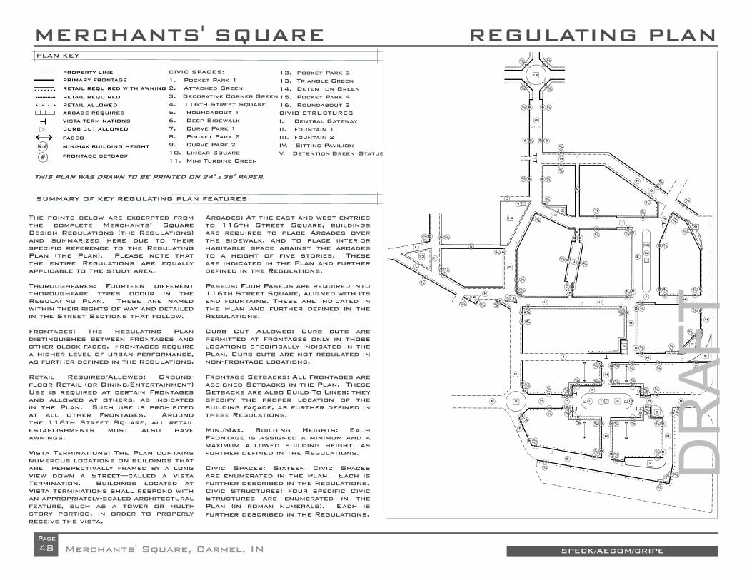
48 SPECK/AECOM/CRIPEMerchants' Square, Carmel, INPage
#/#
2525
RETAIL REQUIRED WITH AWNING
RETAIL REQUIRED
RETAIL ALLOWED
ARCADE REQUIRED
VISTA TERMINATIONS
CURB CUT ALLOWED
PASEO
MIN/MAX BUILDING HEIGHT
FRONTAGE SETBACK
PRIMARY FRONTAGE
PROPERTY LINE
0
#
0
MERCHANTS' SQUARE
The points below are excerpted from the complete Merchants’ Square Design Regulations (the Regulations) and summarized here due to their specific reference to the Regulating Plan (the Plan). Please note that the entire Regulations are equally applicable to the study area.
Thoroughfares: Fourteen different thoroughfare types occur in the Regulating Plan. These are named within their rights of way and detailed in the Street Sections that follow.
Frontages: The Regulating Plan distinguishes between Frontages and other block faces. Frontages require a higher level of urban performance, as further defined in the Regulations.
Retail Required/Allowed: Ground-floor Retail (or Dining/Entertainment) Use is required at certain Frontages and allowed at others, as indicated in the Plan. Such use is prohibited at all other Frontages. Around the 116th Street Square, all retail establishments must also have awnings.
Vista Terminations: The Plan contains numerous locations on buildings that are perspectivally framed by a long view down a Street—called a Vista Termination. Buildings located at Vista Terminations shall respond with an appropriately-scaled architectural feature, such as a tower or multi-story portico, in order to properly receive the vista.
Arcades: At the east and west entries to 116th Street Square, buildings are required to place Arcades over the sidewalk, and to place interior habitable space against the arcades to a height of five stories. These are indicated in the Plan and further defined in the Regulations.
Paseos: Four Paseos are required into 116th Street Square, aligned with its end fountains. These are indicated in the Plan and further defined in the Regulations.
Curb Cut Allowed: Curb cuts are permitted at Frontages only in those locations specifically indicated in the Plan. Curb cuts are not regulated in non-Frontage locations.
Frontage Setbacks: All Frontages are assigned Setbacks in the Plan. These Setbacks are also Build-To Lines: they specify the proper location of the building façade, as further defined in these Regulations.
Min./Max. Building Heights: Each Frontage is assigned a minimum and a maximum allowed building height, as further defined in the Regulations.
Civic Spaces: Sixteen Civic Spaces are enumerated in the Plan. Each is further described in the Regulations.Civic Structures: Four specific Civic Structures are enumerated in the Plan (in roman numerals). Each is further described in the Regulations.
12. Pocket Park 313. Triangle Green14. Detention Green15. Pocket Park 416. Roundabout 2 CIVIC STRUCTURESI. Central GatewayII. Fountain 1III. Fountain 2IV. Sitting PavilionV. Detention Green Statue
CIVIC SPACES:1. Pocket Park 12. Attached Green 3. Decorative Corner Green4. 116th Street Square5. Roundabout 16. Deep Sidewalk 7. Curve Park 18. Pocket Park 29. Curve Park 210. Linear Square11. Mini Turbine Green
SUMMARY OF KEY REGULATING PLAN FEATURES
PLAN KEY
REGULATING PLAN
THIS PLAN WAS DRAWN TO BE PRINTED ON 24" THIS PLAN WAS DRAWN TO BE PRINTED ON 24" X X 36" PAPER.36" PAPER.
0
2525
25 25
25 25
2525
25 25
25
25
25
35
25
25
25
15 15
15
15
58
58
25
25
58 58 5858
58
58
3535
25
25
25
35
58 58 5858
5858 25
35
3525
25
25
25
35
25
25
25
25
2323
23 23
23
2525
2535
23
23
23
3535
25
25
2535
25
25
3
V
IV
II I III5
12
13
11
16
9
14
6
10
6
4
2
1
7
8
15
H
H
H
G
I
G
G
C
F
B BD
E
D
A
H
L
L
H
H
H
H
H
H H
E
N
n
O
K
K
J
H
H HM
H
IH
0
0
0
0
0
0
0
0
0
0 0
000
0
0
00
0
0 0
0
0
0
0
00
0
0
0
00
0
0
0
0
0
0
0
000
0
0
0
0
0
0 0
35
25
25
6
6
6
66
66
66
6
6
6
66
6
6
6
00
6
6
6
6
6
6
6
6
00 0
06
00
0
66
6
6
VAR.VAR.
VAR.
0
0
6
0
0
06
6
0
VAR.
VAR.
0
0
00
00
DR
AFT

49
REGULATING PLAN
SPECK/AECOM/CRIPE Merchants' Square, Carmel, INPage
As discussed, the Regulating Plan distills the General Plan into those aspects of the design that are necessary to ensure the urban performance of the redevelopment. It works hand-in-hand with the Design Regulations that follow this narrative.
Comparing the Regulating Plan with the Illustra-tive Plan, it becomes clear how certain features of the Illustrative Plan are not considered essential to the redevelopment’s success. For example, the blocks are shown to their full buildable extent, without noting building footprints or parking con-fi gurations.
But, as further delineated within the Plan and Regulations themselves, the Regulating Plan is quite precise in describing the following eleven types of requirements:
Thoroughfares: Fourteen different thoroughfare types occur in the Regulating Plan. These are la-beled within their rights of way and detailed in the Street Sections that follow.
Civic Spaces: Sixteen public spaces are indicat-ed in the plan, and their basic design is described in the Code that follows. These are:
• The Pocket Park and Attached Green in the southeast corner of Merchants’ Pointe;
• The Decorative Corner Green at the eastern entrance to Merchants’ Pointe;
• The 116th Street Square;• The two Roundabouts at either end of AAA
Way;• The Deep Sidewalk one block north of 116th
Street Square;
• The Pocket Park and two Curve Parks at the eastern edge of Merchants’ Square;
• The Linear Square within Merchants’ Square;• The pocket park on the northern loop, just
east of AAA Way;• The Mini Turbine at the southwest corner of
the Marsh;• The Detention Green just east of the Post Of-
fi ce; • A small Pocket Park at the corner of Mer-
chants’ Square Drive and Century Drive; and• The large Triangle Green where Merchant's
Square Drive meets AAA Way.
Civic Structures: Five specifi c Civic Structures are required by the Regulating Plan. These are:
• The Central Gateway in 116th Street Square;• The two Fountains in 116th Street Square;• The Sitting Pavilion in the Linear Square;• The Statue in the Detention Green. Frontages: The Frontage Lines indicated in the Regulating Plan ensure that buildings walls will be properly located to provide successful edges to public spaces.
Frontage Setbacks: Each Frontage is marked in the Regulating Plan with an assigned setback dis-tance. This setback is also a build-to line.
Building Heights: Behind its Frontage Line, each building edge is also marked with a minimum and a maximum allowed building height. These height ranges are a function of the desired spatial qual-ity of the enfronting streets, and are tallest in the Plan’s most urban areas.
Retail: Ground-fl oor Retail (or Dining/Entertain-ment) Use is required at certain Frontages, al-lowed at others, and prohibited in the remainder of the plan. These restrictions allow retail to suc-ceed by being properly limited and consolidated at the best locations. The plan also requires all establishments facing 116th Square to have aw-nings, for a cohesive look.
Vista Terminations: The Plan contains numerous locations where the walls along a street frame a perspectival view of a building – called a vista ter-mination. Buildings located at vista terminations are required to respond with a building element of appropriate size and impact to terminate the vista meaningfully.
Arcades: To give a better sense of enclosure to 116th Square, the buildings that fl ank its east and west entrances are required to pull up to the curb and place two-story Arcades below them. This unique circumstance will probably require a modi-fi cation to existing ordinances regarding the pres-ence of buildings above rights of way, since the sidewalk is part of the ROW.
Paseos: To ease the passage from parking to shopping, four Paseos pass from 116th Street Square to parking areas behind.
Curb Cuts: Because they undermine sidewalk safety, curb cuts are allowed along frontage lines only in those places specifi cally indicated in the Plan. They are not regulated in non-Frontage loca-tions, which are less pedestrian-oriented.
DR
AFT

50 SPECK/AECOM/CRIPEMerchants' Square, Carmel, INPage
A typical block from the Regulating Plan is shown here, including the graphic indicators described above. Note the circled numbers indicating set-backs and min/max building heights, the more and less dense dotted lines indicating required and optional retail frontage, the thin line indicating a required awning, the arcade required to the north, the numbered civic spaces, and the location of a Paseo through the block. The surrounding streets include the names of street types and the location of potential curb cuts and vista terminations.
5858
58
35
25
25
253
III4
2
1
BD
H H
0 0
0
0
0
00
0
0
00
25
25
VAR.VAR.
VAR.
0
0
0
A typical block from the Regulating Plan.
DR
AFT

51
REGULATING PLAN
SPECK/AECOM/CRIPE Merchants' Square, Carmel, INPage
DR
AFT

52
REGULATING PLAN
SPECK/AECOM/CRIPEMerchants' Square, Carmel, INPage
The Street Sections
The Regulating Plan is keyed to the fifteen Street Sections that follow. As described in the earlier discussion of pedestrian safety, the street con-
figurations and dimensions are key to encouraging the driving behaviors that befit a walkable community. For this reason, the drawings that follow are
careful to clearly indicate the location and dimension of all travel lanes, parking lanes, sidewalks, and planting facilities.
D. 116th-70
15'
15'
10'
10'
10'
10'
E. SQ-160
14'
15'
14'
C. 116th-84
B. 116th Approach-85
10'
10'
10'
10'
10'
10'
10'
10'
8'
8'
7'
7'
8'
8'
17'
17'
12'
12'
60'
A. SQ-190
10'
10'
10'
10'
8'
8'
8'
8'
F. ST-44
12'
12'
10'
10'
12'
17'
13'
17'
12'
18'
12'
17'
13'
17'
12'
DR
AFT

53
STREET SECTIONS
SPECK/AECOM/CRIPE Merchants' Square, Carmel, INPage
STREET SECTIONS
H. ST-58
12'
7'
7'
12'
10'
10'
G. ST-62 I. ST-44
10'
10'
7'
7'
7'
5'
5'
10'
10'
8'
3'
12'
12'
J. ST-50 L. ST-50-OW
10'
12'
12'
12'
12'
12'
12'
20'
12'
7' 7'
7'
7'
7'
7'
10'
8'
8'
K. ST-26 M. ST-88
8'
8'
5'
5'
N. ST-24
24'
DR
AFT

THE DESIGN REGULATIONS
MERCHANTS’ SQUARE DESIGN REGULATIONSTABLE OF CONTENTS:
I. Defi nitions .........................................................Page X.1
II. Civic Spaces .....................................................Page X.2
III. Civic Structures ................................................Page X.3
IV. Thoroughfare Design ........................................Page X.3
V. Parking ..............................................................Page X.4
VI. Parking Design .................................................Page X.5
VII. Building Uses ...................................................Page X.6
VIII: General Building Design ...................................Page X.6
IX. Heights .............................................................Page X.6
X. Building Fronts .................................................Page X.7
XI. Building Attachments .......................................Page X.8
XII. Openings ..........................................................Page X.8
XIII. Roofs ................................................................Page X.9
XIV. Retail Design ....................................................Page X.9
XV. Retail Signage ..................................................Page X.9
XVI. Details ..............................................................Page X.10
XVII. Existing Buildings and Uses .............................Page X.10
SPECK/AECOM/CRIPEMerchants' Square, Carmel, IN
DR
AFT

THE DESIGN REGULATIONS
SPECK/AECOM/CRIPE Merchants' Square, Carmel, IN
I. DEFINITIONS
Block: An area surrounded by Streets. Note that Streets are distinct from Rear Lanes, which occur in the middle of Blocks.
Bulbout: An area where the sidewalk expands to include the width of the parking lane in order to narrow a Street’s crossing distance.
Civic Space: An open space in the Plan that is neither a right of way nor a platted private property. Civic Spaces may ultimately belong to the City of Carmel, a homeowners’ association, or another association identifi ed by the City.
Civic Structures: A structure specifi cally built to enhance the public realm. Such a structure may stand alone or may constitute part of a public or pri-vate building.
Curb Cut: A location where a private drive or driveway crosses a sidewalk along a Frontage.
Frontage: An edge of a property that faces a public space such as a Street or square. Edges along Rear Lanes, for example, are not Frontages. Front-ages are marked in the Regulating Plan with Frontage Lines.
Frontage Line: As indicated in the Regulating Plan, a Frontage Line desig-nates the location of a building edge.
Lot-Liner: A thin building containing principally parking spaces at the ground level and apartments above that is used to hide parking lots from sidewalks.
Paseo: A principally paved passageway between buildings that connects a rear parking lot to a front sidewalk.
Rear Lane: A public service thoroughfare that provides vehicular access to the rears of properties and the centers of Blocks.
Rear Lane Opening: The corner where a Rear Lane opens onto a Street.
Redevelopment Area: The site proposed for redevelopment, whose bound-aries are indicated by the extent of the Merchants’ Square Regulating Plan. This Plan explicitly describes only those features that are recommended for redevelopment. For example, Frontages are drawn only where new build-ings are recommended.
Regulating Plan: The Merchants' Square Regulating Plan, which applies the details of these Regulations to the Redevelopment Area.
Regulations: When capitalized, the Merchants’ Square Design Regula-tions—this document.
Retail: As used in this document, Retail refers to retail, dining, entertain-ment, or similar uses.
Rowhouse: A single-family house that is attached on one or both sides to another similar house.
Setback: The distance of a building’s primary façade from its front property line.
Street: A public thoroughfare typically handling vehicular, bicycle, and pe-destrian traffi c, characterized by its location at the fronts of properties. For the purposes of these Regulations, the Rear Lane is not a Street.
Street Wall: A freestanding masonry wall located along a Frontage Line where no building wall is present.
Vista Termination: As indicated on the Regulating Plan, a location on a building that is perspectively framed by a long view down a Street, and re-quired to receive an appropriately-scaled architectural feature.
X.1
DR
AFT

THE DESIGN REGULATIONS
SPECK/AECOM/CRIPEMerchants' Square, Carmel, IN
II. CIVIC SPACES
Fifteen Civic Spaces are indicated in the Regulating Plan, shown in the most basic schematic design, including the locations of trees and paths. These designs are to be respected, elaborated upon—and/or potentially replaced by something better with City approval. They include the following:
1. Pocket Park 1: This small decorative park fi lls the space be-tween a curving street and a square corner. It maintains a 5-foot-deep sidewalk on its south and east, lined by shade trees locat-ed approximately 30-feet-on-center. The center green need not be habitable, and can be either grass or a decorative groundcover.
2. Attached Green: This long green in the southeast corner of Mer-chants’ Pointe creates an amenity for the buildings to its north. It maintains a 5-foot-deep sidewalk on its northern edge, lined by shade trees located approximately 30-feet-on-center, in coordina-tion with the adjacent street trees. The center green shall be grass.
3. Decorative Corner Green: This green at the eastern entrance into Mer-chants’ Pointe is not intended to be inhabited. It shall be entirely surfaced in groundcover and planted with one tree of a species that grows very large.
4. 116th Street Square: This new central square is the principal land-scape amenity of the redevelopment, and must be designed and built to the highest standard, and in a way that communicates a pedestrian presence more than an automotive one. For example, the wishbones that occur in the roadway at the eastern and western entrances, rath-er than being raised dividers, shall take the form of cobble inserts in the roadway. As further detailed in the Street Sections that follow, the travel lanes that enter the end half-roundabouts at 12 feet wide nar-row to 10 feet wide once in the square, where they are fl anked on both the inboard and outboard sides with 8-foot-wide parallel parking aisles protected by Bulbouts. The perimeter, two ends, and center of the central green are principally paved, while the remainder is surfaced in grass. Each row of street trees in the perimeter sidewalk is paired with a second parallel allee within the green, approximately 15 feet fur-
ther inboard. On the outer edges of the roadway, the sidewalk broad-ens at the four corners of the square, where a single (eventually) large tree shall be planted to supplement the street trees along the roadway.
5. Roundabout 1: This two-lane Roundabout replaces the current inter-section of 116th Street and AAA Way. While its center is entirely decora-tive and not meant for visiting, it shall hold a ring of ginkgo biloba trees.
6. Deep Sidewalk: At the northwest corner of the intersection of the new north-south main street with Keystone Way East, the building foot-print steps slightly westward to add 30 feet to the sidewalk depth. This area, entirely paved, shall be planted with street trees at approxi-mately 30-feet-on-center, in coordination with the adjacent street trees.
7. Curve Park 1: As Keystone Way East curves northward along the Keystone Parkway, its building lots angle at 45 degrees, creat-ing a narrow front green. A 5-foot sidewalk abuts the property line, creating a green area against the street. The sidewalk is lined by shade trees located approximately 30-feet-on-center, in coordina-tion with the adjacent street trees. The center green shall be grass.
8. Pocket Park 2: This small park maintains a 5-foot-deep sidewalk against the fronts of the buildings to its south. This sidewalk heads due north at the eastern end of this row, to reach the street. The presence of this sidewalk eliminates the need for one along the curving street edge. Street trees shall be planted in the green against the street edge at ap-proximately 30-feet-on-center in the standard fashion. The green itself need not be habitable, and can be either grass or a decorative ground-cover.
9. Curve Park 2: This park is designed as a mirror image to Curve Park 1.
10. Linear Square: This square is surrounded on both fl anks by cars parked head-in at a 60-degree angle, embraced by 90-degree Bulbouts at its northern and southern ends. These ends are paved and each include a fountain or similar feature. The center area (halfway north-south) is also paved, and contains a sitting pavilion. The remainder of the square is
X.2
DR
AFT

THE DESIGN REGULATIONS
SPECK/AECOM/CRIPE Merchants' Square, Carmel, IN
surfaced in a light-color pea gravel, from curb to curb, and furnished with movable metal chairs and tables of the Bryant Park variety. In two rows approximately 3 feet from the curb, a double allee of street trees is planted approximately 30-feet-on-center. The hoods of parked cars are hidden from the squares center by a continuous evergreen hip-height hedge.
11. Mini Turbine Green: As AAA Way intersects Merchants’ Square Drive at the southeast corner of the Marsh, it angles west to avoid the new liner building against the Marsh’s west fl ank. This transition is handled by a small stretched roundabout, whose center Island is about 30 feet across and as long as anticipated truck motions will al-low. It contains street trees located approximately 30 feet on center.
12. Pocket Park 3: The plan slightly reconfi gures the parking lots at the corner of Merchants’ Square Drive and Century Drive to em-brace a corner tree with two Lot-Liner buildings. The resulting small square shall include paved paths reaching to the front doors of these two buildings, and shall maintain the lawn around the tree.
13. Triangle Green: The intersection of Merchants’ Square Drive and Medical Drive is reconfi gured to create a triangular green of signifi -cant size. Lined by its street trees, this green contains a central open area that shall be programmed with a public use such as a tot lot.
14. Detention Green: The drainage green to the east of the Post Offi ce is already lined by a good screen of evergreens. As the street edge is re-built in the reconstruction of AAA Way, the chain link fence along this edge shall be replaced by something more attractive. The northeast cor-ner sidewalk shall be broadened to receive the Detention Green Statue.
15. Pocket Park 4: An L-shaped building lot just east of the corner of AAA Way and the new northern loop road creates a small triangular park at its front. This park shall be lined with a 5-foot-wide sidewalk along its north-ern and eastern edges, located 6 feet from the building front. Its center shall be surfaced in ground cover. Street trees located approximately 30-feet-on-center should be planted to the south of the northern sidewalk.
16. Roundabout 2: This two-lane Roundabout replaces the current inter-section of AAA Way with Carmel Drive. It shall be landscaped identically to Roundabout 1.
III. CIVIC STRUCTURES
The Regulating Plan designates 6 distinct Civic Structures designed to play important placemaking roles within the community. They are as follows:
1. Central Gateway: The location where the new main street crosses the 116th Street Square is an extremely important spot in the redevelopment, as pe-destrians need to feel welcomed across the Square from one side of 116th Street to the other. The north-south path shall be framed with an archway or other such pavilion of signifi cant size that provides shade and places to sit.
2. Fountain 1: Views along 116th Street into the new Square shall be terminated on a vertical fountain surrounded by bench-es in this location. Note that this fountain is also located so that it is framed by views through Paseos to the north and south.
3. Fountain 2: This fountain is designed as a mirror image to Fountain 1.
4. Sitting Pavilion: This structure within the linear square shall provided a shaded place for shoppers to sit on benches.
5. Detention Green Statue: A vertical feature such as a sculpture on a pedestal shall be placed at the green’s northeast corner where it termi-nates vistas from the new street to its east. Ideally, this feature shall be a memorial of some sort.
IV. THOROUGHFARE DESIGN
Curbs: Curbs shall be vertical without horizontal lips (no gutter pans). Roll-over or rounded curbs are only permitted where required to facilitate truck motions.
X.3
DR
AFT

THE DESIGN REGULATIONS
SPECK/AECOM/CRIPEMerchants' Square, Carmel, IN
Crosswalk Materials: Crosswalks shall be located to continue all sidewalk trajectories across all intersections and shall be surfaced in a material that contrasts with the Street surface.
Left Hand Turn Lanes: Left hand turn lanes shall be limited to the shortest length deemed reasonable to handle peak turning demands.
Bulbouts: Bulbouts surround parallel parking only along 116th Street, Car-mel Drive, and at the exits of roundabouts. They surround head-in parking at all corner locations and additionally where appropriate to receive cross-walks.
Curb Radii: The curb return radius at Street corners shall be 10 feet at cor-ners without Bulbouts and 15 feet at corners with Bulbouts (with exceptions surrounding the Roundabouts). The curb return radius at Rear Lane ends shall be 5 feet. If such radii are not adequate to provide for the turning mo-tions of trucks—with the truck allowed to swerve temporarily into the oppos-ing lane—then they may be increased by only as much as is necessary to make such turning motions possible.
Curb Cuts: Curb Cuts are permitted at Frontages only in those locations specifi cally indicated in the Plan. Standard Curb Cuts may not exceed 18 feet in width, plus 3 feet corner curb radii where necessary. Residential Curb Cuts, also indicated, may not exceed 12 feet in width, plus 1 foot corner curb radii where necessary. Curb cuts are not regulated in non-Frontage locations.
Street Planting: The street-tree pattern shall be spaced consistently at the approximate distances described in the Thoroughfare Types above. Street trees shall be located at corners as described ahead, and then spaced regu-larly from corner to corner. At corners, the corner tree’s distance from the intersection shall be 10 feet further from the intersection than the edge of the intersecting right-of-way. Tree Type/Quality: Each Street shall have a single consistent tree type for its entire length. Street trees shall have a minimum height of 10 feet and a minimum caliper of 3 inches at time of planting.
Lighting: Street lights shall be located at the outer edge of all sidewalks, shall be 10 feet to 15 feet tall, and shall be spaced regularly. The light spac-ing distance on a given Street shall range from 20 feet on-center in retail locations to 50 feet on-center in residential locations, to be further docu-mented in a street lighting plan.
Lighting Standards: Street lighting standards shall be sized appropriately to their low height, and shall use an energy-effi cient L.E.D. lamps. Lights shall not be sized and located around the goal of providing uniform coverage, as varying lighting levels are more attractive to pedestrians.
Sidewalk Objects: Any fi re hydrants, mailboxes, parking meters, bicycle racks, or other impediments to foot traffi c shall be located in the planting zone towards the curb. Benches shall be provided at retail Frontages at a minimum of one per Block face. Benches shall be located facing the Street with their backs against the building fronts. Benches built into building fa-cades are encouraged and may encroach upon the sidewalk to a max. depth of 2 feet. Bicycle Racks are required at a minimum of one per 200 linear feet of sidewalk edge on all streets.
Arcade Edges: Where new streets are built against existing arcades, these streets shall locate their curbs 12 to 18 inches from the outer arcade edge.
Rear Lanes: Wherever possible, Rear Lanes shall be the principal location of utilities such as water, sewer, electricity, gas, cable television, and trash pickup. Rear Lanes may be used for large commercial deliveries but not for mail or package service. Rear Lanes shall have a reverse crown, with French drains where necessary. Transformers, lift stations, traffi c-control boxes, utility meters, HVAC equipment, and other such machinery shall not be located at Frontages or where they are readily visible at Frontages, but shall instead be located in Rear Lanes and parking lots.
V. PARKING
General Approach: Parking demand in mixed-use development functions differently from parking demand in conventional suburban development, for several reasons:
X.4
DR
AFT

THE DESIGN REGULATIONS
SPECK/AECOM/CRIPE Merchants' Square, Carmel, IN
• A pedestrian-friendly environment allows people to walk rather than drive such that, for example, a resident or offi ce worker does not need a parking space at a nearby store or restaurant.
• Large amounts of on-street parking contribute to the number of spaces available.
• A collective parking supply (rather than site-by-site) allows the system to function and be regulated as an integrated organism.
• Complementary uses surrounding the collective parking supply allow spaces to serve different functions around the clock, such that, for ex-ample, a single space can serve an offi ce worker during the day and a resident at night.
These four factors—a park-once environment, on-street parking, collective supply, and complimentary loads—all impact the off-street parking require-ments, as follows:
Park-Once Environment: Effi ciencies due to increased pedestrian activity lead to the following general requirements:
• All Residential uses shall provide a minimum of 1.5 spaces per unit, on or off site.
• All other uses shall provide a minimum of 3 spaces per 1000 interior square feet, on or off-site. Sidewalk dining is encouraged and thus shall not count towards this total.
On-Street Parking: Parking supply calculations shall include adjacent on-street parking spaces as the full equivalent of off-street parking spaces.
Collective Parking Supply: Parking calculations may be made comprehen-sively across multi-Block areas. If not otherwise assigned, any spot within a 3-minute walk (1000 feet) of its use may be counted towards that use.
Complimentary Loads: The minimum required quantity of parking may be reduced when shared parking is used. The following share factors shall be
used to determine the reductions due to shared parking:
• Residential and Offi ce: 1.4• Residential and Retail: 1.2• Residential and Lodging: 1.1• Offi ce and Retail: 1.3• Offi ce and Lodging: 1.7• Retail and Lodging: 1.3
To determine the Shared Parking Factor, divide the sum of the parking re-quirements for two functions by the applicable ratio to arrive at the total number of required spaces. For example, a combination of 10,000 square feet of retail and 40 apartments would be required to provide on- and off-street parking totaling ((10 * 3) + (40 * 1.5)) / 1.2 = (30 + 60) / 1.2 = 75 spaces.
Shared parking, to qualify as such, shall be located within 500 feet of each use.
VI. PARKING DESIGN
Structured Parking: In all locations, the ground fl oors of parking structures shall contain a habitable edge at Frontages. Where garage upper stories face Frontages, these shall be detailed to resemble habitable buildings. Along the 116th Street square, any parking structures shall be hidden be-hind a habitable edge for their full height. Entries into structured parking lots shall be no wider than necessary to provide required access, and never wider than 30 feet across.
Recommended Structure Location: Although not required, large parking structures are recommended for the block located one block north of 116th Street Square and the block to the southeast of this Square.
Building Orientation: Buildings that abut Rear Lanes or parking lots at their rears shall allow only secondary access from these edges, maintaining prin-cipal orientation towards their Frontages. Specifi cally:
• Retail uses may provide one rear door (or double-door) for use by em-
X.5
DR
AFT

THE DESIGN REGULATIONS
SPECK/AECOM/CRIPEMerchants' Square, Carmel, IN
ployees and suppliers. Supermarkets and other businesses from which the typical buyer leaves with a heavy burden of products may also allow customers to use this door.
• Offi ce and residential uses may have a single rear door (or double-door), but this door shall be clearly hierarchically inferior to the front door.
In both of the above cases, the Frontage door must be located in a place that appears appropriate to a front-loaded business, and must be kept unlocked whenever any other access doors are unlocked.
Paseos: Four Paseos are required into 116th Street Square, aligned with its end fountains. Paseos shall maintain a minimum width of 10 feet, and may be either uncovered or located underneath a continuous upstairs story. Paseo edges are considered Frontages for the purposes of the Regulations. When buildings separate rear parking from front sidewalks, additional Pas-eos are required such that no more than 400 feet of continuous building edge ever separates rear parking from front sidewalk.
VII. BUILDING USES
Mixed Use: This plan is intended to include a healthy mix of a wide range of uses, including Retail, Residential, Offi ce, Lodging, Institutional, and other non-nuisance uses.
Offi ce: While not required, it is recommended that limited amounts of of-fi ce be located nearby large areas of housing in order to make use of empty daytime parking spaces.
Retail Required/Allowed: Ground-fl oor Retail (or Dining/Entertainment) use is required at certain Frontages and allowed at others, as indicated in the Plan. Such use is prohibited at all other Frontages.
Lodging: While not required, it is recommended that a hotel be included in the development. An ideal location is at the southeast corner of 116th Street Square.
Location for Shared Parking: Any large offi ce development shall locate
its parking to be shared with a large amount of adjacent residential or hotel units.
Cycle Parking: All multifamily structures with more than 5 units shall provide a conveniently located shared space for the parking of resident bicycles, at a ratio of one rack-space per unit.
VIII: GENERAL BUILDING DESIGN
Rowhouse Requirements: Single-sided Rowhouses are anticipated against the left fl ank of the Marsh and also potentially against new parking structures if the Marsh site is redeveloped. All such Rowhouses on a given Block seg-ment shall be attached into a single group. In other words, gaps between Rowhouses shall only occur at streets and drives. Rowhouses shall be be-tween 12 feet and 25 feet in width.
Lot-Liners: These buildings, designed to hide parking lots from view, must line sidewalks with small punched openings at the ground level. These can be glazed or unglazed depending on whether the parking spaces are en-closed by garage doors or open-air. Above the parking are located upstairs apartments, with each pair of apartments separated by a staircase that leads to a front door (or opening) against the sidewalk. These apartments may be one or two stories tall, with any second story typically (but not necessarily) located in the roof, lit by dormers. Balconies overlooking the sidewalk are recommended but not required.
IX. HEIGHTS
Building Heights: Each Frontage is assigned a minimum and a maximum allowed building height, as further defi ned in the Regulations. When two different height requirements meet at a corner, the taller requirement takes precedence around the corner to a distance of at least 30 feet but no more than 80 feet from the Frontage Line. Heights are measured in reference to the sidewalk at the center of the front façade.
Attics: Buildings may contain an additional story in the roof if the fl oor of said story is no more than 3 feet below the eave line.
Towers: To encourage an interesting skyline, building areas with a footprint
X.6
DR
AFT
THE DESIGN REGULATIONS
SPECK/AECOM/CRIPE Merchants' Square, Carmel, IN
of less that 200 square feet shall have no height limit.
Story Heights: Retail spaces shall have a minimum ceiling height of 12 feet, but 18 feet is recommended. Offi ce spaces shall have a minimum ceiling height of 10 feet. Residential spaces shall have a minimum ceiling height of 8 feet for upper stories and 9 feet for the fi rst fl oor.
Ground Floor Heights: All retail spaces shall be located on a ground fl oor placed at grade. Buildings with residential fi rst fl oors shall locate all fi rst-fl oor residences a minimum of 18 inches above adjacent sidewalk grade. Handicapped access, when provided on a building with an elevated fi rst fl oor, shall be located in non-Frontage locations whenever possible.
Tall Frontages: One-story commercial buildings, where permitted, shall maintain a minimum 20 foot parapet height at the Frontage Line.
X. FRONTS
Frontages: The Regulating Plan distinguishes between Frontages and other block faces. Frontages require a higher level of urban performance, as fur-ther defi ned in the Regulations.
Frontage Setbacks: All Frontages are assigned Setbacks in the Plan. These Setbacks are also Build-To Lines: they specify the proper location of the building façade, as further defi ned in these Regulations.
Percent Frontages: All buildings shall place a building edge along no less than 75% of their Frontage Lines. The small gaps in Frontage allowed by that percentage shall not occur at building corners, with the exception that corners may be rounded or chamfered. Street Walls: With the exception of freestanding single-family houses, all buildings shall place a Street Wall along those portions of the Frontage Line where no building is present. (Where a portion of a building is set back from the Frontage Line, such a wall is not required.) Said wall shall be between 18 inches and 3 feet in height. Street Walls at Frontages may contain gates for pedestrian access, and openings for vehicular access in locations where Curb Cuts are explicitly allowed.
Sight Triangles: While they improve visibility, sight triangles increase vehicle speeds and can undermine pedestrian safety. Any requirements pertaining to sight triangles in currently enforced codes shall be waived when in confl ict with the Frontage Lines in the Regulating Plan, or with these Regulations’ tree-planting requirements.
Rear Lane Openings: To limit views into Rear Lanes, all buildings at Rear Lane entrance corners shall maintain a 0-foot setback from the Rear Lane at the corner.
Vista Terminations: The Plan contains numerous locations on buildings that are perspectivally framed by a long view down a Street—called a Vista Ter-mination. Buildings located at Vista Terminations shall respond with a build-ing element of appropriate size and impact to terminate the vista meaning-fully. These shall be aligned properly to be framed symmetrically in the vista. Proper Vista Terminations include large bay windows, prominent gables, grouped window compositions, towers, and cupolas.
Materials: Building materials shall be used in a manner appropriate to their intrinsic formal properties, including their structural capacities as demon-strated in openings and spans. Metal elements shall be natural colored galvanized steel, stainless steel, anodized or electrostatic plated aluminum, marine-grade aluminum, copper, or bronze. Wood elements shall be painted or sealed with an opaque or semi-solid stain, except walking surfaces, which may be left natural. Siding shall be wood or cementitious (Hardie Board or equivalent) and present 8 inches maximum siding width to the weather. All stucco shall be steel troweled with no evidence of the mark of the trowel. Sand cement render shall be applied without control joints. Corner beads are prohibited. Exterior trim shall be indistinguishable from wood when painted and shall be sized appropriately to its location.
Wall Confi gurations: Each building façade shall contain at most two differ-ent wall materials (not counting foundation walls and trim). Building walls shall be one color per material used (excluding trim). Materials may only transition across horizontal lines, for example, between building stories, and not across vertical lines, except in the case of attachments such as bay windows. When two materials are stacked horizontally, the heavier-looking
X.7
DR
AFT

THE DESIGN REGULATIONS
SPECK/AECOM/CRIPEMerchants' Square, Carmel, IN
material shall sit below the lighter-looking material, such as brick below Har-die-board or stone below stucco. When a material transition occurs around a corner, the transition shall occur at a distance from the corner that is ap-propriate for the materials represented, for example 12 or 16 inches for brick. Expansion joints shall be a rational part of the wall composition and shall be colored to match the wall. Trim, except at stucco, is required where there is a change in material or plane. Trim around lights, outlets, vents, meters, etc. shall match the wall color, not the object color.
Style: Buildings shall not present a historical pastiche. Buildings designed in a traditional style shall limit themselves to that style alone and shall em-body that style convincingly. Keystones, quoins, and superimposed multiple gables (one gable overlapping another) are prohibited. Double front doors are prohibited on single-family homes.
XI. ATTACHMENTS
Arcades: At the east and west entries to 116th Street Square, buildings are required to place Arcades over the sidewalk, and to place interior habitable space against the Arcades to a height of fi ve stories minimum. These Ar-cades shall maintain a height of the fi rst two stories of their buildings. New Arcades are not allowed elsewhere in the plan.
Awnings: Awnings are required on all buildings surrounding 116th Square, and allowed elsewhere. Awnings shall be a minimum of 6 feet deep and shall be metal with colored fabric or glass. Fabric awnings shall have a metal structure covered with canvas or synthetic canvas, and be rectangular in shape with straight edges and no side panels or soffi t. Awnings shall not be backlit or used as signs, except for a possible single inscription on the fl ap, not to exceed 6 inches in height. All awnings on a single shop shall have the same depth, material, and color. Fabric awnings are not permitted on residential buildings.
Location: Any attachments such as bay windows, balconies, porches, stoops, awnings, and eaves shall extend forward of the line of the building front. Single-family houses shall provide either a stoop or a porch at the front door. All other buildings shall provide some form of shelter from rain at
the front door.
Encroachments: Awnings and Arcades, are the only fi rst-fl oor attachments allowed to occupy the public right-of-way. On the second fl oor and above, balconies, bay windows, eaves, lights, and signs may occupy the public right-of-way, as shall the upper stories above the Arcades on 116th Street Square. No attachment may extend above a vehicular roadbed at a height of less than 15 feet, or above a sidewalk at a height of less than 7 feet. Attachments other than roof eaves may not extend over adjacent private properties.
Attachment Dimensions: Bay windows and balconies shall be no more than 3 feet deep; stoops shall be 3 feet to 6 feet deep; porches shall be be-tween 6 feet and 10 feet deep.
Limited Balconies: Balconies, porches, and loggias shall not constitute more than 50% of any facade.
Railings: Railings shall have top and bottom rails. The openings between spindles or balusters may not exceed 4 inches. Bottom rails shall clear the fl oor.
Postal Number: Every building shall have a postal number applied within 5 feet of the entrance area. This may not be taller than six inches, unless con-structed as a signature sculptural element.
XII. OPENINGS
Fenestration Ratio: The ratio of fenestration to area of the building façade shall be between 25% and 75%, except for retail Frontages where it shall be 60% to 95%. Retail establishments shall place windows regularly at all Frontages. Each facade shall be measured independently.
Blank Walls: Walls at Frontages may not be blank, and shall have at least one window per structural bay per fl oor, in a pattern that suggests habitation.
Window Materials: Windows shall have clear (not tinted) glass.
X.8
DR
AFT

THE DESIGN REGULATIONS
SPECK/AECOM/CRIPE Merchants' Square, Carmel, IN
Window Panes: Each building façade shall be composed of windows that are all constructed from the same size or proportion of window pane, with the exception of a single custom window used in one or several special lo-cations.
Mullions: Mullions, if used, shall either be true divided lights or be affi xed to the exterior surface of the window to cast a shadow line. Mullions are recommended for residential windows where stylistically appropriate, and discouraged for retail windows.
Shutters: Vertically hinged shutters, when provided, shall coincide in size to the opening with which they are associated, such that closing them would cover the window area.
Grouped Windows: When two or more windows occur in a single opening or dormer, they shall be separated by a 4”x4” post.
XIII. ROOFS
Rooftop Equipment: The screening of rooftop mechanical equipment is re-quired. All rooftop mechanical equipment shall be screened from view from all directions, and from all elevations of equal height or lower, to minimize the negative aesthetic impact upon the view from neighboring buildings and from street level. Said screening shall be consistent with the architecture of the building.
Dormers: Dormers shall be habitable and sized no larger than necessary to hold window(s) and framing.
Skylights: Bubble skylights shall not be visible at Frontages. Flush sky-lights, where visible at Primary Frontages, shall be organized into a com-posed pattern.
XIV. RETAIL DESIGN
No Malls: All retail spaces shall give direct access to a public sidewalk. No retail space may exist above the ground fl oor except as a mezzanine within
a space that faces a ground-fl oor sidewalk.
Awnings: Retail Frontages shall contain awnings for a minimum of 50% of the total retail Frontage.
Kneewall: Front glazing on retail establishments shall begin above a knee-wall located 12 inches to 18 inches above sidewalk grade.
Blocked Windows: Drug stores and other commercial tenants shall not place inner partitions in windows that signifi cantly block views into the store.
Interior Lighting: All retail establishments shall be lit in the incandescent (warmer) spectrum, whatever technology is used. Small spotlights are rec-ommended rather than a uniform wash of light.
Sidewalk extension: All retail uses shall pave any Setbacks to match the adjoining sidewalk.
Alcove: All retail uses shall locate their primary entrances within a small ad-ditional Setback between 30 and 100 square feet in size, paved to match the sidewalk.
Sidewalk Use: Retail establishments are encouraged to place tables, chairs, and temporary displays on the public sidewalk as long as a 5-foot-wide clear corridor is maintained for pedestrians. Rails and other barriers separating tables from the pedestrian fl ow are not permitted (unless state law requires said rails for alcohol sale), nor is any permanent construction in the public sidewalk. Outdoors, restaurants shall use ceramic, glass, metal and cloth for plates, glasses, silverware, tablecloths and napkins, rather than paper and plastic products.
XV. RETAIL SIGNAGE
Limitations: The shop-front door, signage and lighting shall be designed as a unifi ed design. There are four types of signage permitted on businesses: a) a spandrel panel, b) a pedestrian blade sign, c) a window logo, and d) an awning band. These are further limited as follows:
Spandrel Panel: Each building may have a single sign band 60% maximum
X.9
DR
AFT

THE DESIGN REGULATIONS
SPECK/AECOM/CRIPEMerchants' Square, Carmel, IN
of the width of the building Frontage, with a height not to exceed eighteen inches. If a building holds multiple tenants, the use of the sign band width shall be divided among tenants on a pro-rata basis determined by their ground-fl oor square footage. The sign shall be integrally designed with the building or the associated storefronts in material and color. The sign band may not be internally lit.
Blade Sign: One two-sided blade sign is permitted for each business with a door on the sidewalk level. The blade sign shall be securely affi xed to the facade or storefront and may project over the sidewalk so long as it does not interfere with pedestrian fl ow. The blade sign may not exceed 4 square feet (including mounting hardware) in area in any shape and may not be translucent.
Logo: A logo inscribed on the storefront glass is permitted (one per business per building face), or the name of the store in permanently-affi xed cutout let-tering. Logos shall not exceed 1 foot in height and lettering shall not exceed 6 inches in height. Upstairs businesses are also allowed logos with the same limitations.
Other Signage: Billboards and other freestanding advertisements are pro-hibited, as are rooftop, fl ashing, moving, or intermittently illuminated signs. No sign shall be attached above the second story of any structure.
XVI. DETAILS
Consistency: Streets, squares, and other public spaces shall be designed with a common vocabulary of paving, curbing, fencing and walls, landscap-ing, signage, and lighting. This does not mean that all details will be con-sistent, but rather that all details will be understood to belong to the same family and/or era of design.
Block Variety: The appearance of a “project” or of “megabuildings” shall be avoided by not allowing the same exterior design to be used on block after block of buildings. While even smaller units of design are encouraged, no more than 250 feet of continuous Street Frontage may appear to have been designed by a single architect.
Building Variety: Buildings used repeatedly in the plan, such as apartment houses, may be repeated with similar facades only to the degree that such repetition adds up to a total front footage of 300 feet or less. For example, a 60-foot-wide apartment building may be repeated only 5 times. Beyond this point, a truly distinct façade shall be introduced, as if a different architect was responsible.
Eyesores: Antennas, radar dishes, chain link fencing, Vinyl fencing, barbed wire, razor wire, and chicken wire shall not be permitted where visible from Primary Frontages. Dumpsters and trash shall be screened behind enclo-sures built for that purpose, and said enclosures shall not occur at Primary Frontages.
XVII. EXISTING BUILDINGS AND USES
General: In many locations on the Regulating Plan, requirements are shown for properties containing existing buildings and uses. While these require-ments pertain to the replacement of existing buildings and uses with new ones, they do not mandate such replacement, and such redevelopment can occur only with the owner’s consent. Existing uses are thus “grandfathered” in. However, when existing buildings and uses are replaced, they shall be replaced according to the requirements of these Regulations.
X.10
DR
AFT