A Quantitative Analysis of Fire History at National Parks...
138
A Quantitative Analysis of Fire History at National Parks in the Great Plains Final Report for: USGS – NRPP (06-3255-0205Guyette) Cooperating Institutions: National Park Service, US Geological Survey, the Missouri Cooperative Fish and Wildlife Research Unit, and the University of Missouri-Columbia Prepared by: Richard P. Guyette, Michael C. Stambaugh, Joseph M. Marschall Missouri Tree-Ring Laboratory Department of Forestry, University of Missouri-Columbia In cooperation with: Gary D. Willson Great Plains Cooperative Ecosystems Study Unit December 31, 2010
Transcript of A Quantitative Analysis of Fire History at National Parks...

A Quantitative Analysis of Fire History at
National Parks in the Great Plains
Final Report for: USGS – NRPP (06-3255-0205Guyette)
Cooperating Institutions: National Park Service, US Geological Survey, the Missouri
Cooperative Fish and Wildlife Research Unit, and the University of Missouri-Columbia
Prepared by:
Richard P. Guyette, Michael C. Stambaugh, Joseph M. Marschall
Missouri Tree-Ring Laboratory
Department of Forestry, University of Missouri-Columbia
In cooperation with:
Gary D. Willson
Great Plains Cooperative Ecosystems Study Unit
December 31, 2010

A quantitative analysis of fire history at national parks in the Great Plains
Prepared by:
Richard P. Guyette
Research Professor, 203 ABNR Building, Department of Forestry, University of Missouri-
Columbia, Columbia, MO 65211,USA; Tel: (573)-882-7741; Email: [email protected]
Michael C. Stambaugh
Research Associate, 203 ABNR Building, Department of Forestry, University of Missouri-
Columbia, Columbia, MO 65211, USA; Tel:(573)-882-8841, Email: [email protected]
Joseph M. Marschall
Research Specialist, 203 ABNR Building, Department of Forestry, University of Missouri-
Columbia, Columbia, MO 65211, USA; Tel:(573)-882-8841, Email: [email protected]
Suggested citation:
Guyette, R.P., M.C. Stambaugh, and J.M. Marschall. 2011. A quantitative analysis of fire
history at national parks in the Great Plains. A report prepared for the Great Plains Cooperative
Ecosystem Studies Unit and National Park Service. 78 pp.

Acknowledgements
We are grateful to many people and agencies that provided assistance and permissions for access
and collections related to this research. These include:
The staff of the Missouri River Recreation Area for facilitating access to potential study sites.
Laurie Richardson and staff at Theodore Roosevelt National Park for assisting in providing
information, maps, and access. Staff at Chickasaw National Recreation areas provided field
support for surveying potential for fire history studies at the park. Caleb Stotts graciously
provided permission to access and sample trees at the privately owned Lazy S-B Ranch. Caleb
also provided lodging at the ranch and information concerning the history, ecology, and land
management of the ranch and greater Chautauqua Hills region. Tom Bragg (University of
Nebraska-Omaha) provided fire scarred cross-sections from the Niobrara Valley Preserve for
dendrochronological analysis. Rana Tucker (Nebraska State Wildlife) provided access guidance
in the Pine Ridge region (Nebraska). Greg Schenbeck provided permission to access state lands
in the Pine Ridge region. John Ortmann assisted in providing access and lodging at The Nature
Conservancy’s Niobrara Valley Preserve. Staff of the Tallgrass Prairie Preserve (Kansas)
provided access, maps, and internal fire reports. The Eberts, Eichman, and Obermeyer families
(east central Kansas) allowed us to survey their properties for fire history potential. Mary Lata
(USFS) provided valuable information concerning grasslands fire data, potential study sites, and
contacts in the northern Great Plains region. Peter Brown provided information concerning the
potential for fire history in the Pine Ridge region. Carla Loop, Diana McGinn, Roger Keepers,
and Charles Marsh (Nebraska National Forest) provided permission and direction concerning
sampling in the Pine Ridge region (Nebraska). The Hampton family provided permission to
access and sample trees at Carter Canyon Ranch in the Wildcat Hills (Nebraska). Kate
Crosthwaite provided access and guidance to potential fire history sites at Fort Wolters (Texas).
Dave Stahle provided information concerning the ecology of the Cross Timbers – southern plains
including potential fire history sites and contacts via the Cross Timbers Consortium. The staff at
Wildcat Hills and Fort Robinson State Parks (Nebraska) allowed us to survey the parks for fire
history potential. The Kansas Forest Service facilitated locating potential fire history sites.
Friends of Wildcat State Park (Iowa) facilitated collection of samples from a settlement cabin
whose timbers contained fire scars. Cecil Frost (University of North Carolina) provided
extensive help with research at the Charles M. Russell National Wildlife Refuge (Montana)
including field guidance, sample transportation, and data analysis. Bob Skinner (Charles M.
Russell National Wildlife Refuge) provided support and permission for sampling at the refuge.
Jim Cheatham and Cody Wienk (NPS) provided field assistance at Devils Tower National
Monument (Wyoming). Chip Kimball and Ralph Godfrey (Wichita Mountains National Wildlife
Refuge) provided permission and support for sampling at the Wichita Mountains National
Wildlife Refuge (Oklahoma). In addition, Ralph Godfrey provided information concerning fire
and management and technical support for a publication published in the journal Fire Ecology.
Jeff Sparks (Texas Parks and Wildlife Department) provided access and field assistance at Purtis
Creek State Park (Texas) and helped prepare a manuscript describing the fire history study. We
thank Erin Abadir, Adam Bale, and Phil Stambaugh for fieldwork assistance.
.

Table of Contents Page
Chapter 1. Introduction 1
Objectives 1
Chapter 2. Great Plains fire history from fire scars 2
Methods 2
Results 3
Fire scar history site descriptions 6
Chapter 3. Fire interval modeling 34
Chapter 4. Descriptions of historic fire frequency at National Park 42
Service Units of the Great Plains
Chapter 5. Conclusions 73
Chapter 6. Literature Cited 75
Appendix 1. Published article: “Six centuries of fire history at Devils
Tower National Monument with comments on a region-wide
temperature influence”
Appendix 2. Published article: “Fire, drought, and human history near
the western terminus of the Cross Timbers, Wichita Mountains,
Oklahoma”
Appendix 3. Article in press: “Fire history of a relict oak woodland in
northeast Texas”
Appendix 4. Great Plains fire references
Appendix 5. Locations of tree samples used in fire scar history studies

1
Chapter 1. Introduction
Quantitative fire history and disturbance information underlies many of our land management
decisions, natural resource policies, and understanding of ecosystem processes. This is
especially true in national park units that are charged with maintaining and restoring species and
landscapes. Science-based fire plans are now required for most federal lands. The National Park
Service’s Director’s Order # 18 states that all parks with vegetation capable of sustaining fire
must develop a Fire Management Plan (FMP).
Fire regime reference conditions based on historical archives are often a basis for fire
management plans. Knowledge of fire regime dynamics over long time scales (e.g., centuries) is
needed because factors influencing fire (e.g., climate, ignitions, suppression) have varied through
time. Fire scar histories are one of the best archives of reference conditions because they are
precise, can span centuries, and have proven useful for describing fire, climate, and vegetation
dynamics. Fire histories from dated fire scars are commonly used to describe fire frequency,
extent, severity, and seasonality.
Fire regime characterization is enhanced by obtaining site-specific information. High between-
site variability can exist in fire regimes at relatively small extents due to factors such as
elevation, aspect, and ignition rates. Spatial and temporal properties of the between-site
variability often can lead to better understanding the factors that control fire regimes and site-
specific fire ecology and management.
The goal of this project was to quantify fire regimes at national park units within the Great Plains
from new and existing fire history studies and to use this information to develop a quantitative
model for estimating fire regime parameters in Park Units lacking fire history data.
Objectives
The specific objectives of the study were:
1) to estimate the potential for fire scarred trees to occur in the 25 national park units in the Great
Plains and to summarize existing fire history information in and near the units,
2) based on the results of objective 1, to select up to 9 national park units where chronologies of
fire events could be developed from fire scars,
3) to summarize the occurrence, frequency, and seasonality of past fires at these sites, and
4) to develop estimates of the historic fire frequency at Great Plain’s national park units utilizing
empirical data and a modeling approach

2
Chapter 2. Great Plains fire history from fire scars
Methods
Literature search
We conducted a literature search for the purpose of understanding regional fire ecology, gaining
fire frequency data for model development, and comparing our findings. Literature databases
included Current Contents, Biological Abstracts, Agricola, and others. Library searches were
also conducted that assisted in identifying relevant books, government documents, and theses/
dissertations. Searches included both local and regional fire information, specific national park
units, and topics related to fire regimes such as human history and population density. In
addition, when we visited sites we attempted to collect relevant literature concerning fire history
from park files such as research reports or fire management plans.
Study site selection
Fire history study sites were selected from the 25 national park units within the Great Plains
region. Boundaries of the region were defined using Bailey‟s ecoregions (Bailey 1998). We
visited most park units within the region including all units that had potential for fire scar history
studies (e.g., presence of trees or wood that extended sufficiently back in time to pre-
EuroAmerican settlement). Based on the study scope this was estimated to be limited to
conducting studies at seven to nine park units. However, after visiting and assessing the fire scar
history potential of parks this number was less. We then began identifying locations outside of
park boundaries that had potential for fire history studies and that were geographically near and
comparable to park units with respect to fire environment conditions (topography, fuels, climate,
vegetation). It was our expectation that these sites would represent the proximal and relevant fire
histories for parks on the basis of constructing fire scar records. A total of 14 new fire scar
history sites were established. Overall, the total number of study sites exceeded that proposed.
We believe some sites, though seemingly distant from a park unit, make significant contributions
towards quantifying and revealing the historic fire frequency trends within the larger Great
Plains region.
Fire scar history data collection
Fire scar histories were generated primarily from dead remnant trees (stumps, standing snags)
and to lesser extent living trees. Tree species were primarily ponderosa pine (Pinus ponderosa)
and oak (Quercus spp) that exhibited both presence of fire scars and age. At each site twenty to
fifty sample trees were collected usually within a 1 km2 area. Attempts were made to sample
trees of various sizes and ages. Cross-sections up to 30 cm thick were cut from trees at or near
ground level. Cross-sections were oriented as to slope and cardinal direction. All sample
locations were geographically referenced using a GPS unit (Appendix 5). Cross-sections were
dried and then surfaced with sandpaper so to reveal cellular detail of the annual rings. Samples
were sanded to a high polish (e.g., ANSI 600 grit sandpaper). Annual rings on samples were
measured to an accuracy of 0.01 mm using a moving stage with an electronic transducer and
binocular microscope. Tree-ring measurements were plotted and visually crossdated. Digital

3
measurement files were also imported to COFECHA (Holmes et al. 1986), a program that checks
the accuracy of dating and aids in quality control of measurements. Visual matching of ring-
width series plots were supplemented by statistical analysis of dating precision. Absolute dating
of sample ring-width patterns utilized new or existing chronologies developed at the Missouri
Tree-Ring Laboratory or existing chronologies available from the International Tree-Ring Data
Bank (http://www.ngdc.noaa.gov/paleo/ftp-treering.html).
Tree-ring series of sample trees were cross-dated using standard dendrochronological methods
(Stokes and Smiley 1968, Baillie 1982). Once annual rings were absolutely dated then fire scars
were assigned to the calendar year of the first growth response to the fire injury (e.g., callus
tissue, cambial death). If possible, fire scars were dated to the season of occurrence based on
scar position within the annual ring (Kaye and Swetnam 1999). Using FHX2 software (Grissino-
Mayer 1996), we developed the fire scar chronology and analyzed fire scar event years. Mean
fire return intervals (MFI) and descriptive statistics were computed for both the composite and
individual tree mean fire intervals. For each site we constructed a composite graph of fire
scarring years.
Results
Overall Great Plains fire statistics
We developed 14 fire histories from sites located on national park, state, federal, and private
lands (Figure 2.1). Fire histories were constructed from fire scars using three tree species: post
oak (Quercus stellata, 3 sites), ponderosa pine (Pinus ponderosa, 9 sites), and eastern redcedar
(Juniperus virginiana, 1 site). Fire histories ranged in length from 248 years (Lazy S-B Ranch,
Chautauquah Hills, Kansas) to 691 years (Devils Tower National Monument, Wyoming). The
mean length of fire scar records was 360 years. Combined, all sites represented a total of about
5,000 years of record.
A total of 418 trees were sampled at all sites. A total of 370 fires were recorded from 996 fire
scars. About 15 percent of the trees sampled had no scars. Of the trees with scars, the average
number of scars per tree was about 2.8. The highest percentage of trees scarred occurred at a
ponderosa pine parkland (Lost Creek, Charles M. Russell National Wildlife Refuge, MT, 88
percent of trees scarred in 1882). For all sites mean fire intervals (MFIs) during the pre-
EuroAmerican period (approximately pre-1850) averaged 13.2 years and ranged from 4.8 to over
28 years. Longer intervals likely occurred in the Great Plains, particularly at sites in the cooler
northern regions and sites with topographic features that inhibited fire spread and fuel production
(e.g., badlands).
Individual site MFIs do not provide large-scale spatially averaged mean fire intervals for the
Great Plains because of variable local controls. Thus, we spatially averaged the climate modeled
MFIs (see Chapter 3) for the Great Plains (see study region map below and mapped pre-
EuroAmerican period MFI estimates (Figure 3.4, Chapter 3). The spatial average of MFIs for
the entire Great Plains was 9.5 years. The model estimated that about 86 percent of the Great
Plains had MFIs that averaged between 3 and 13 years.

4
Figure 2.1. Map of fire scar history research sites in the Great Plains region of the U.S.
Red circles correspond to locations of study sites that were conducted for this project.
Three letter codes correspond to sites descriptions below. Other fire scar history data in the
Great Plains region (yellow circles) and beyond (not shown) were incorporated into the
Great Plains PC2FM (fire frequency) model (see Chapter 3).

5
Less than 1 percent of the Great Plains
had MFIs shorter than three years while
13 percent of the Great Plains had
MFIs longer than 13 years. Modeled
estimates are based on climate controls
(see Chapter 3).
At the Great Plains region scale we
found climate conditions (temperature,
precipitation) as the most important
variables explaining fire frequency.
Climate affects many factors that are
known to control fires such as
vegetation type, fuel production,
growing season length, and fuel
moisture. Temperature was the most
important variable explaining
differences in fire frequency among the
study sites (Figure 2.2) (Stambaugh et
al. 2008). In the Great Plains the
primary driver of mean annual
temperature differences is the north-
south distribution of the angle of solar
irradiance. Precipitation also had a
complex but important relationship to
pre-EuroAmerican fire frequency
(Figure 2.3). More detailed modeling
results and discussion of these two
climate variables and their interactions
is presented in Chapter 3.
Mean maximum temperature (0C)
8 10 12 14 16 18 20 22 24 26
Mea
n fire
inte
rval (y
ea
rs)
0
10
20
30
Tall grass
Short & mixed grass
Eastern woodlands
Regression line
95 % prediction interval
Figure 2.2. Mean fire intervals of grassland and
woodland sites in the Great Plains region (includes
some eastern U.S. tallgrass data) plotted by annual
mean maximum temperature (PRISM data; Daly et
al. 2004).
Figure 1. Mean fire interval (years)
0 5 10 15 20 25 30
An
nu
al p
recip
ita
tio
n (
cm
)
20
40
60
80
100
120
Figure 2.3. The complex relationship between pre-
EuroAmerican period mean fire intervals (MFI) and
annual precipitation. The 2nd
-order polynomial line
is shown to illustrated this relationship where
changes in precipitation can either increase or
decrease fire frequency at a given site temperature
(see Chapter 3 for details).

6
Fire scar history site descriptions
Note: Interpreting fire history data
It is important to have a familiarity of the methods and details of fire scar history data for
interpreting their analyses and results. Fire scar history records may or may not be ideal records
of fire events. Factors influencing the accuracy of fire scar records include: numbers and species
of trees sampled, area sampled, fire severity, fire intensity, tree size, tree growth rate, fuel type,
and fuel accumulation rates, etc. Sample depths of fire scar records change through time for
several reasons. Primary reasons are: 1) older and older trees are increasingly difficult to locate
and therefore their abundance decreases with age and 2) trees regenerate and die through time.
Many factors are important for determining whether or not a tree gets scarred in a fire event.
Often it is not possible to standardize the factors influencing tree scarring. These factors include
but are not limited to: bole size, fuel, slope, fetch, presence of open existing wound(s). Some
trees and species can be highly resistant to fire scarring. Because of these factors the composite
fire event record (shown at the bottom of all fire history charts) is the likely the best estimate of
the occurrence of fire at the study site.
At each of the sites described below the area searched and sampled was not larger than 1 km2.
All historic fire event years were determined from crossdated tree-ring chronologies, therefore
fire event years are absolute calendar year dates. Dates are assigned to year of cambial response
to the injury. Fire scar seasonality was based on the position of the fire scar within the tree ring.
When seasonality was not determinable then a “U” (unknown) code was used. Otherwise fire
scar seasons were noted. Fire scar seasonality was based on the timing of cambial growth which,
for the Great Plains region, varies from northern to southern extremities. This is important to
note because the timing of seasons is not perfectly aligned among all sites (e.g., earlywood
development in oaks in Texas may not be the same timing of earlywood development of
ponderosa pine in Montana). For fires occurring during the dormant season the actual calendar
dates can cross two years (fall to spring of next calendar year). In this case, dormant season fires
were dated to the next growing season (calendar year) since this is the first period of cambial
response. Tree-ring chronologies were developed for all sites. Some ring-width chronologies
were permanently archived at the International Tree-Ring Databank and are publicly available
(http://www.ncdc.noaa.gov/paleo/treering.html). For some sites we presented both fire scar and
other injuries, however only fire event years were shown at the bottom of all fire scar charts.

7
Lost Creek, Charles M. Russell National Wildlife Refuge, Montana (LST)
Lost Creek is located on the Charles M. Russell National Wildlife Refuge, Montana (Figure 2.4).
Thirty-two ponderosa pine trees (live and dead) were sampled in an approximately 1 km2 area.
Fire scar dates ranged from years 1702 to 2001. The majority of trees sampled were killed
during a wildfire in 2006. Based on the percentage of trees scarred during fire events there is
evidence for high to low severity fire events. Of these, high severity events appear to be less
frequent. Five severe fires (i.e., fires that scarred nearly all trees sampled; 1702, 1834, 1882,
1982, 2006) occurred in the record between 1700 and 2006. Based on pith dates (see legend of
Figure 2.5) there is evidence for ponderosa pine cohort establishment circa 1770s, 1840s, and
perhaps 1920-30s. More detailed analysis is needed to determine what conditions are associated
with these cohorts (e.g., fire, climate) (Brown 2006). Based on seasonality fire events were
during the summer (i.e., latewood) or after (i.e., dormant). A long fire-free period occurred
between 1717 and 1815. Compared to some other sites sampled for this project, the progression
of fire events does not show dramatic changes coinciding with EuroAmerican expansion. We
speculate that this site may have undergone relatively minor changes in the fire regime with
regard to human influence.
Figure 2.4. The landscape of the Lost Creek fire scar history site. Ponderosa pines are
shown occupying what are primarily gently rolling upper slope positions. A few kilometers
beyond the horizon is rugged topography associated with the Missouri River breaks. Fuels
are continuous across the site and dominated by grass.

8
Fig
ure
2.5
. F
ire
scar
his
tory
char
t fr
om
the
Lost
Cre
ek w
ater
shed
, C
har
les
M. R
uss
ell
Nat
ional
Wil
dli
fe R
efuge,
wes
tcen
tral
Monta
na.
Eac
h h
ori
zonta
l li
ne
repre
sents
the
length
of
the
tree
-rin
g r
ecord
of
a ponder
osa
pin
e sa
mp
le t
ree.
Bold
ver
tica
l bar
s
repre
sent
the
yea
r of
a fi
re s
car
wit
h t
he
seas
on o
f th
e in
jury
coded
abov
e ea
ch b
ar (
D =
Dorm
ant
seas
on s
car,
U =
Und
eter
min
ed
seas
on s
car,
E =
Ear
lyw
ood s
car,
M =
Mid
dle
ear
lyw
ood s
car,
L =
Lat
e ea
rlyw
ood s
car,
A =
Lat
ewo
od s
car)
. H
oll
ow
ver
tica
l bar
s
are
non-f
ire
inju
ries
. T
he
com
posi
te f
ire
scar
chro
nolo
gy w
ith a
ll f
ire
scar
dat
es i
s sh
ow
n a
t th
e bott
om
of
the
figure
.
Cal
end
ar Y
ear

9
Sand Creek (SND) and Soda Creek (SOD), Charles M. Russell National Wildlife Refuge
The Sand Creek and Soda Creek fire scar history sites are located in the western portion of the
Charles M. Russell National Wildlife Refuge (Figure 2.6). Compared to the fire scar chronology
of the Lost Creek site (above) there appears to be a lack of higher severity fires (i.e., those that
scarred a high percentage of trees during a single event). With respect to fire propagation the
exposed soil surface at these sites is likely an important fire barrier mitigating fire spread,
effects, and, based on the fire history data, the long-term frequency (Figure 2.7, 2.8). At both
sites samples were collected from mid- to upper-slope positions in a matrix of ponderosa pine –
Douglas fir - grasslands. In addition to fire scars this site contained evidence of porcupine
damage on the boles and branches of trees. Fewer fire scars were found on trees compared to
injuries caused by porcupines.
Figure 2.6. Foreground is a portion of the Sand Creek fire history site. Ponderosa pine and, to
a lesser extent, Douglas fir occupies midslope positions. Large areas of exposed soil are
common at these sites (grey-brown surface in foreground forest, arrows).
Calendar Year

10
Fig
ure
2.7
. F
ire
scar
his
tory
char
t fr
om
the
San
d C
reek
wat
ersh
ed, C
har
les
M. R
uss
ell
Nat
ional
Wil
dli
fe R
efuge,
wes
tcen
tral
Monta
na.
Eac
h h
ori
zonta
l li
ne
repre
sents
the
length
of
the
tree
-rin
g r
ecord
of
a ponder
osa
pin
e sa
mp
le t
ree.
Bold
ver
tica
l bar
s
repre
sent
the
yea
r of
a fi
re s
car
(soli
d)
or
oth
er i
nju
ry (
holl
ow
) w
ith t
he
seas
on o
f th
e in
jury
coded
above
each
bar
(D
= D
orm
ant
seas
on s
car,
U =
Und
eter
min
ed s
easo
n s
car,
E =
Ear
lyw
ood s
car,
M =
Mid
dle
ear
lyw
oo
d s
car,
L =
Lat
e ea
rlyw
ood s
car,
A =
Lat
ewo
od s
car)
(se
e le
gen
d).
T
he
com
posi
te f
ire
scar
ch
ronolo
gy w
ith a
ll f
ire
scar
dat
es i
s sh
ow
n a
t th
e bott
om
of
the
figure
.
Ca
lend
ar
Ye
ar

11
Fig
ure
2.8
. F
ire
scar
his
tory
char
t fr
om
the
Soda
Cre
ek f
ire
his
tory
sit
e at
the
Char
les
M. R
uss
ell
Nat
ional
Wil
dli
fe R
efuge,
wes
tcen
tral
Mon
tana.
Eac
h h
ori
zonta
l li
ne
repre
sents
the
length
of
the
tree
-rin
g r
ecord
of
a pond
erosa
pin
e sa
mple
tre
e. B
old
ver
tica
l bar
s re
pre
sent
the
yea
r o
f a
fire
sca
r (s
oli
d)
or
oth
er i
nju
ry (
holl
ow
) w
ith t
he
seas
on o
f th
e in
jury
coded
abov
e ea
ch b
ar (
D =
Dorm
ant
seas
on s
car,
U =
Undet
erm
ined
sea
son s
car,
E =
Ear
lyw
ood s
car,
M =
Mid
dle
ear
lyw
ood s
car,
L =
Lat
e ea
rlyw
ood s
car,
A
= L
atew
ood s
car)
(se
e le
gen
d).
T
he
com
posi
te f
ire
scar
chro
nolo
gy w
ith a
ll f
ire
scar
dat
es i
s sh
ow
n a
t th
e bott
om
of
the
figure
.
Ca
lend
ar
Ye
ar

12
Devils Tower National Monument, Wyoming (DET)
See published article (Appendix 1): Stambaugh, M.C., R.P. Guyette, E.R. McMurry, J.M.
Marschall and G. Willson. 2008. Six centuries of fire history at Devils Tower National
Monument with comments on region-wide temperature influence. Great Plains Research 18:
177-187.
The 691-year tree-ring chronology is based on 37 ponderosa pine trees collected at the
monument (Figure 2.9, 2.10). The period of tree-ring record ranged in calendar years from 1312
to 2002 and fire scar dates (n = 129) ranged from 1330 to 1995. The mean fire interval (MFI) for
the entire record was 24.6 years, and intervals for individual trees ranged from 4 to 119 years. A
period of increased fire frequency (MFI = 5.7 years) occurred from about 1860 to 1880,
corresponding to the period of EuroAmerican exploration and settlement of the region.
Figure 2.9. The Devils Tower fire scar history site is located in the northern portion of the
monument. Sections of ponderosa pine stumps and dead trees were collected from steep to
gentle slopes and in locations ranging from closed canopy forest to open parkland
conditions. Away from the monolithic dome (i.e., Devils Tower) fuels are relatively
continuous across the study area. In small areas there exist rock shelves and dry creek beds.

13
Fig
ure
2.1
0. F
ire
scar
his
tory
char
t fr
om
Dev
ils
Tow
er N
atio
nal
Mon
um
ent,
Wyom
ing. E
ach h
ori
zonta
l li
ne
repre
sents
the
length
of
the
tree
-rin
g r
ecord
of
a ponder
osa
pin
e sa
mple
tre
e. B
old
ver
tica
l b
ars
repre
sent
the
yea
r of
a fi
re s
car
(soli
d)
wit
h t
he
seas
on o
f
the
inju
ry c
oded
abov
e ea
ch b
ar (
D =
Dorm
ant
seas
on s
car,
U =
Und
eter
min
ed s
easo
n s
car,
E =
Ear
lyw
ood s
car,
M =
Mid
dle
earl
yw
ood s
car,
L =
Lat
e ea
rlyw
ood s
car,
A =
Lat
ewood s
car)
(se
e le
gen
d).
T
he
com
posi
te f
ire
scar
chro
nolo
gy w
ith a
ll f
ire
scar
dat
es i
s sh
ow
n a
t th
e bott
om
of
the
figure
. F
or
det
ails
of
the
site
and f
ire
his
tory
see
Sta
mbau
gh e
t al
. 2008 m
anusc
ript
(Appen
dix
1).
Ca
lend
ar
Ye
ar

14
Wichita Mountains National Wildlife Refuge, Oklahoma (WCH)
See published article (Appendix 2): Stambaugh, M.C., R.P. Guyette, R. Godfrey, E.R. McMurry,
and J.M. Marschall. 2009. Fire, drought, and human history near the western terminus of the
Cross Timbers, Wichita Mountains, Oklahoma. Fire Ecology 5(2):51-65.
This fire history site is located in a post oak woodland located in the lower elevation gentle
plains terrain within the Wichita Mountains complex (Figure 2.11, Figure 2 in Appendix 2).
Fuels are comprised of grasses and forbs and, to a lesser extent, leaf litter. Trees used in the fire
history reconstruction were killed in a 2006 prescribed fire. Sixty fire events occurred within the
period 1712 to 2006 (294 years) (Figure 2.12). The mean fire interval (MFI) was 4.4 years for a
pre-EuroAmerican settlement period (pre-1901) and increased to a MFI of 5.2 years after 1901.
During the period between 1855 and 1880, which corresponds with the prolonged severe Civil
War drought and the establishment of a fort, the mean fire interval was 1.7 years. Twentieth-
century fire frequency has been only slightly decreased and severity of fires appears to be
lessened due to alterations to the fire environment through grazing and fire exclusion. Eastern
redcedar (Juniperus virginiana L.) expansion now poses significant challenges to forest and
range management, particularly its control through prescribed fire (Appendix 2).
Figure 2.11. View to north from the Wichita Mountains fire history
site. American Bison are shown grazing the grasslands.

15
Fig
ure
2.1
2. F
ire
scar
his
tory
char
t fr
om
the
Wic
hit
a M
ounta
ins
Nat
ional
Wil
dli
fe R
efuge,
Okla
ho
ma.
Eac
h h
ori
zonta
l li
ne
repre
sents
the
length
of
the
tree
-rin
g r
ecord
of
a p
ost
oak
sam
ple
tre
e. B
old
ver
tica
l b
ars
repre
sent
the
yea
r o
f a
fire
sca
r (s
oli
d)
wit
h
the
seas
on o
f th
e in
jury
co
ded
above
each
bar
(D
= D
orm
ant
seas
on s
car,
U =
Undet
erm
ined
sea
son s
car,
E =
Ear
lyw
ood s
car,
M =
Mid
dle
ear
lyw
ood s
car,
L =
Lat
e ea
rlyw
ood s
car,
A =
Lat
ewood s
car)
(se
e le
gen
d).
T
he
com
posi
te f
ire
scar
chro
nolo
gy w
ith a
ll
fire
sca
r dat
es i
s sh
ow
n a
t th
e bott
om
of
the
figure
. F
or
det
ails
of
the
site
fir
e his
tory
see
App
endix
2.
Ca
lend
ar
Ye
ar

16
Purtis Creek State Park, Texas (PRC)
See article in press (Appendix 3): Stambaugh, M.C., J. Sparks, R.P. Guyette, and G. Willson.
Fire history of a relict oak woodland in northeast Texas. Rangeland Ecology and Management.
The Purtis Creek fire history site is located in a former post oak woodland-savanna (Figure 2.13).
Recent and widespread mortality of overstory post oak trees exists. All trees used in the fire scar
history research had recently died due to unknown causes. The terrain of the site is flat to gently
sloping. Tree rings and fire scar injuries show three centuries of fire regime changes with an
overall trend of decreasing fire occurrence through time. Thirty different fire events occurred
between 1690 and 2007 of which twenty-six occurred prior to 1856 (Figure 2.14). All fires
occurred while trees were dormant. From 1690 to 1820, the mean fire interval was 6.7 years. A
50-yr period without fire occurred in the latter 19th
century (1855-1905) and coincided with the
establishment of an oak cohort. A second extended period (80 yrs) without fire characterized
most of the 20th
century and has resulted in canopy closure, the establishment of fire-intolerant
vines, shrubs, and trees, and likely the decline of fire-dependent plant species.
Figure 2.13. Dead post oak snag being cut to
obtain cross-sections for fire scar analysis.
Calendar Year

17
Fig
ure
2.1
4. F
ire
scar
his
tory
char
t fr
om
Purt
is C
reek
Sta
te P
ark, T
exas
. E
ach h
ori
zonta
l li
ne
repre
sents
the
length
of
the
tree
-rin
g
reco
rd o
f a
post
oak
sam
ple
tre
e. B
old
ver
tica
l bar
s re
pre
sent
the
yea
r of
a fi
re s
car
(soli
d)
wit
h t
he
seas
on o
f th
e in
jury
cod
ed a
bove
each
bar
(D
= D
orm
ant
seas
on s
car,
U =
Undet
erm
ined
sea
son s
car,
E =
Ear
lyw
ood s
car,
M =
Mid
dle
ear
lyw
ood s
car,
L =
Lat
e
earl
yw
ood s
car,
A =
Lat
ewood s
car)
(se
e le
gen
d).
T
he
com
posi
te f
ire
scar
chro
nolo
gy w
ith a
ll f
ire
scar
dat
es i
s sh
ow
n a
t th
e
bott
om
of
the
figure
. F
or
det
ails
of
the
site
fir
e his
tory
see
the
Sta
mbau
gh e
t al
. m
anusc
ript
in p
ress
(A
ppen
dix
3).
Ca
lend
ar
Ye
ar

18
Chautauquah Hills, Lazy S-B Ranch, Kansas (LSB)
The Chautauquah Hills fire history site is located on the Lazy S-B Ranch in an post oak gallery
forest-woodland adjacent to an expansive area of tallgrass prairie (Figure 2.15). The site is
considered the northern portion of the Cross Timbers forest region. Characteristic of Cross
Timbers forests, the primary tree species are post and blackjack oak. Some juniper
encroachment is occurring in the forested areas. Ranching operations during the last year have
included both cattle grazing and frequent prescribed fire. The site is flat to gently sloping. Soils
are shallow to a sandstone substrate that occasionally is exposed at the site. This fire scar record
does not extend back in time to describe the pre-EuroAmerican settlement fire occurrence with a
well replicated sample depth. Fires were dominantly dormant season events. In this region of
Kansas, in particular the Flint Hills, prescribed fire is actively utilized in range management.
Compared to other sites in this report, this site has the most frequent fire in the 20th
century. We
hypothesize that fire is perhaps more frequent in the 20th
century than in recent preceding
centuries based on comparisons to pre-EuroAmerican settlement records from other comparable
sites (Clark et al. 2007, Stambaugh et al. 2009, DeSantis et al. 2010). The 249 year tree-ring
record spanned the period 1758 to 2006 and fire-scar dates ranged in calendar years from 1765 to
2004 (Figure 2.16). The composite fire chronology indicates that this site was capable of
supporting fire frequencies (MFI) of 2.2 years (1900 to 2004) or less given frequent
anthropogenic ignitions. Mean fire intervals ranged in length from 1 to >10 years, and the MFI
for the total record was 3.98 years. The MFI for the portion 1850 to 1900 was 5.14 years. Three
periods of more frequent burning occurred around 1900, 1950, and 2000 (MFI = 2.0).
Figure 2.15. Fire history samples were collected in the forested
area in the left portion of the photograph. This terrain generally
continues sloping downward to an intermittent drainage.

19
Fig
ure
2.1
6. F
ire
scar
his
tory
char
t fr
om
the
Laz
y S
-B R
anch
, C
hau
tauquah
Hil
ls, K
ansa
s. E
ach h
ori
zonta
l li
ne
repre
sents
the
length
of
the
tree
-rin
g r
ecord
of
a post
oak
sam
ple
tre
e. B
old
ver
tica
l b
ars
repre
sent
the
yea
r o
f a
fire
sca
r (s
oli
d)
wit
h t
he
seas
on o
f
the
inju
ry c
oded
abov
e ea
ch b
ar (
D =
Dorm
ant
seas
on s
car,
U =
Und
eter
min
ed s
easo
n s
car,
E =
Ear
lyw
ood s
car,
M =
Mid
dle
earl
yw
ood s
car,
L =
Lat
e ea
rlyw
ood s
car,
A =
Lat
ewood s
car)
(se
e le
gen
d).
T
he
com
posi
te f
ire
scar
chro
nolo
gy w
ith a
ll f
ire
scar
dat
es i
s at
the
bott
om
of
the
figure
.
Ca
lend
ar
Ye
ar

20
Deep Gulch, Theodore Roosevelt National Park (TRS)
The fire history site at Theodore Roosevelt National Park is located in the South Unit (Figure
2.17). Seven dead juniper trees with fire scars and charcoal were located in the upper portion of
a small, steep gulch (Figure 2.18). Throughout the park it appears that few trees have external
fire scars and that fire scar history methods may not be appropriate for describing the history of
fire events. Both local and large topographic features control fuel production and continuity near
this site and in the Park. The spread of fire from both human and lightning ignitions is greatly
reduced due to natural fire breaks, particularly badlands. This site‟s fire frequency cannot be
extrapolated to the larger topographic region and is comparable to another fire scar frequency
estimate in the Park (Brown 1996).
Figure 2.17. View of grasslands and badlands at the South Unit. Dark green vegetation on
slopes in background is primarily juniper.

21
Fig
ure
2.1
8. F
ire
scar
his
tory
char
t fr
om
Dee
p G
ulc
h s
ite
in T
heo
dore
Ro
ose
vel
t N
atio
nal
Par
k, N
ort
h D
akota
. E
ach h
ori
zonta
l
line
repre
sents
the
length
of
the
tree
-rin
g r
ecord
of
a ju
nip
er s
ample
tre
e. B
old
ver
tica
l b
ars
repre
sen
t th
e yea
r of
a fi
re s
car
(soli
d)
wit
h t
he
seas
on o
f th
e in
jury
coded
abo
ve
each
bar
(D
= D
orm
ant
seas
on s
car,
U =
Undet
erm
ined
sea
son s
car,
E =
Ear
lyw
oo
d s
car,
M =
Mid
dle
ear
lyw
ood s
car,
L =
Lat
e ea
rlyw
ood s
car,
A =
Lat
ewood s
car)
(se
e le
gen
d).
T
he
com
posi
te f
ire
scar
chro
nolo
gy
wit
h
all
fire
sca
r dat
es i
s sh
ow
n a
t th
e bott
om
of
the
figure
.
Ca
lend
ar
Ye
ar

22
Wildcat Hills, Carter Canyon Ranch, Nebraska (CCR)
The Wildcat Hills fire history site is located on the Carter Canyon Ranch in a topographically
complex region (Figure 2.19). The site is part of the Wildcat Hills and lies on a north facing
slope approximately 15 km south of Scotts Bluff National Monument. The terrain ranges from
gentle slopes to steep, dissected canyons. Areas of badlands with exposed soil are common and
break the continuity of surface fuels particularly in and adjacent to canyons and steep shoulder
slopes (Figure 2.19). Vegetation communities consist of ponderosa pine, juniper, grasslands, and
sparsely vegetated badlands. Fuels consist of grass and litter associated with forest patches.
Many non-fire injuries were found on samples and are shown in the fire history chart as hollow
bars (Figure 2.20). Compared to other fire history sites sampled by the investigators there is a
lack of charcoal on tree boles. Trees with open scarfaces also lack charcoal. Each of these are
general evidence for the lack of recent fires (e.g., last century) occurring at the site. In contrast
to the absence of fire at the site in recent centuries, a period of relatively frequent fire occurred
during the 16th
century (Figure 2.20).
Figure 2.19. View to the north from the Carter Canyon Ranch fire history site.

23
Fig
ure
2.2
0. F
ire
scar
his
tory
char
t fr
om
the
Wil
dca
t H
ills
, C
arte
r C
anyon R
anch
, N
ebra
ska.
Eac
h h
ori
zonta
l li
ne
repre
sents
the
length
of
the
tree
-rin
g r
ecord
of
a ponder
osa
pin
e sa
mple
tre
e. B
old
ver
tica
l bar
s re
pre
sent
the
yea
r o
f a
fire
sca
r (s
oli
d)
wit
h t
he
seas
on o
f th
e in
jury
cod
ed a
bove
each
bar
(D
= D
orm
ant
seas
on s
car,
U =
Undet
erm
ined
sea
son s
car,
E =
Ear
lyw
ood s
car,
M =
Mid
dle
ear
lyw
ood s
car,
L =
Lat
e ea
rlyw
ood s
car,
A =
Lat
ewood s
car)
(se
e le
gen
d).
T
he
com
posi
te f
ire
scar
chro
nolo
gy w
ith a
ll
fire
sca
r d
ates
is
show
n a
t th
e b
ott
om
of
the
figure
.
Ca
lend
ar
Ye
ar

24
Niobrara Valley Preserve, Nebraska (NVP) (south side of river)
Samples for this site were previously collected from the south side of the Niobrara River by Tom
Bragg (University of Nebraska-Omaha) and others (Figure 2.21). In general, few fires occurred
during the 20th
century as compared to the 19th
century (Figure 2.22). The fire in 1926 appeared
to be the most severe based on the percentage of trees scarred. Interestingly, fire seasonality
appears to have a higher proportion of dormant season fire events than other sites in the Great
Plains using ponderosa pine. Fire frequency generally increased in the early 19th
century
coincident with EuroAmerican expansion and settlement in this region. This increased
frequency of fire appears to have persisted until about the beginning of the 20th
century. An
increase in fire frequency is also evident at the Niobrara River Breaks site on the opposite side of
the river (see next pages) albeit it appears to have occurred a few decades earlier. In addition,
increases in fire frequency during this period coincide with that documented along the Missouri
River near the Great Plains margin (Stambaugh et al. 2006) and in the Pine Ridge region to the
west (Figure 2.25).
Figure 2.21. View to the south overlooking the Niobrara Valley Preserve. Near the
horizon is the Sand Hills region. The site is located on The Nature Conservancy lands on
the south side of the river (background). Cross sections were collected from live and dead
ponderosa pine trees and stumps at varying landscape positions between the river and the
larger grass dominated upland plains. Fuels generally consist of prairie vegetation with
patches of forest litter and woody fuels.

25
Fig
ure
2.2
2. F
ire
scar
his
tory
char
t fr
om
the
Nio
bra
ra V
alle
y P
rese
rve,
Neb
rask
a. E
ach h
ori
zonta
l li
ne
repre
sents
the
length
of
the
tree
-rin
g r
eco
rd o
f a
pon
der
osa
pin
e sa
mple
tre
e. B
old
ver
tica
l bar
s re
pre
sent
the
yea
r o
f a
fire
sca
r (s
oli
d)
wit
h t
he
seas
on o
f th
e
inju
ry c
oded
above
each
bar
(D
= D
orm
ant
seas
on
sca
r, U
= U
ndet
erm
ined
sea
son s
car,
E =
Ear
lyw
ood s
car,
M =
Mid
dle
earl
yw
ood s
car,
L =
Lat
e ea
rlyw
ood s
car,
A =
Lat
ewood s
car)
(se
e le
gen
d).
T
he
com
posi
te f
ire
scar
chro
nolo
gy w
ith a
ll f
ire
scar
dat
es i
s sh
ow
n a
t th
e bott
om
of
the
figure
.
Calendar Year
Ca
lend
ar
Ye
ar

26
Niobrara River Breaks, Nebraska (NRB) (north side of river)
This site is located on the north side of the Niobrara River approximately 3 km from the
Niobrara Valley Preserve site (see preceding site description). Similar to the Niobrara Valley
Preserve site the fire scar record shows increased fire frequency during the mid-19th
century
albeit somewhat earlier in time and suggesting potential for higher fire frequency (periods of
annual burning) (Figure 2.23). Fire events do not contain as large of a proportion of dormant
season events as the Niobrara Valley Preserve site. This may indicate either different timing in
fires between the sites or different timing in tree ring formation between the sites. Multiple fire
event years are shared between the opposite sides of the Niobrara River suggesting that the river
is not always a barrier to fire spread.

27
Fig
ure
2.2
3. F
ire
scar
his
tory
char
t fr
om
the
Nio
bra
ra R
iver
Bre
aks,
Neb
rask
a. E
ach h
ori
zonta
l li
ne
repre
sents
the
length
of
the
tree
-rin
g r
eco
rd o
f a
pon
der
osa
pin
e sa
mple
tre
e. B
old
ver
tica
l bar
s re
pre
sent
the
yea
r o
f a
fire
sca
r (s
oli
d)
wit
h t
he
seas
on o
f th
e
inju
ry c
oded
above
each
bar
(D
= D
orm
ant
seas
on
sca
r, U
= U
ndet
erm
ined
sea
son s
car,
E =
Ear
lyw
ood s
car,
M =
Mid
dle
earl
yw
oo
d s
car,
L =
Lat
e ea
rlyw
ood s
car,
A =
Lat
ewood s
car)
(se
e le
gen
d).
T
he
com
posi
te f
ire
scar
chro
nolo
gy w
ith a
ll f
ire
scar
dat
es i
s sh
ow
n a
t th
e bott
om
of
the
figure
.
Ca
lend
ar
Ye
ar

28
Pine Ridge, West Ash Creek, Nebraska (WAC)
West Ash Creek flows westward from the Pine Ridge formation and opens onto an area of vast
unbroken plains (Figure 2.24). Hence, the West Ash Creek Basin may be a catchment of fires
from a very large area (100,000 km2+) and the fire history information may be applicable to a
broad geographic region of the Great Plains. Prior to 1800 the fire scar record appears to have
similar features to the Lost Creek fire history in Montana (Figure 2.5) in that there exists a mix
of high to low severity fires as documented by the number of trees scarred in individual years
and distinct establishment periods of tree cohorts. A prominent feature of the historic fire regime
is that fires became about 4 to 5 times more frequent from 1830 to 1900 than from 1600 to 1830
(Figure 2.25). Groupings of pith dates suggest three periods of pine recruitment may have
occurred around 1575, 1725, and 1780. A period of recruitment also occurred at the Lost Creek
site circa 1780. The last fire recorded at the site occurred in 1915. Although our sample depth is
lower during the 1900s we surmise that the lack of fire is accurately portrayed based on the
abundance of young ponderosa pine and the lack of fire scars on small trees. (Note: we believe
that the 1678 and 1777 fire scars of undetermined seasonality were likely positioned in the
latewood of the previous ring. Rotted wood obscured viewing this and making a seasonality
determination, however, if they did occur in previous ring‟s latewood then their dates would be
1677 and 1776, respectively.)
Figure 2.24. The basin of West Ash Creek showing the transition from low elevation
plains and grasslands to upper slopes consisting of ponderosa pine woodlands and
forests. Vertical cliffs typical of the „badlands‟ erosion features occur on the upper
slopes. Potential fire history trees were searched throughout the basin and found in the
lower and upper reaches effectively forming two separate fire history sites, West Ash
Creek and Upper West Ash Creek, separated by approximately 3 km.

29
Fig
ure
2.2
5. F
ire
scar
his
tory
char
t fr
om
Wes
t A
sh C
reek
, P
ine
Rid
ge,
Neb
rask
a. E
ach h
ori
zonta
l li
ne
repre
sents
the
length
of
the
tree
-rin
g r
eco
rd o
f a
pon
der
osa
pin
e sa
mple
tre
e. B
old
ver
tica
l bar
s re
pre
sent
the
yea
r o
f a
fire
sca
r (s
oli
d)
wit
h t
he
seas
on o
f th
e
inju
ry c
oded
above
each
bar
(D
= D
orm
ant
seas
on
sca
r, U
= U
ndet
erm
ined
sea
son s
car,
E =
Ear
lyw
ood s
car,
M =
Mid
dle
earl
yw
ood s
car,
L =
Lat
e ea
rlyw
ood s
car,
A =
Lat
ewood s
car)
(se
e le
gen
d).
T
he
com
posi
te f
ire
scar
chro
nolo
gy w
ith a
ll f
ire
scar
dat
es i
s sh
ow
n a
t th
e bott
om
of
the
figure
.
Ca
lend
ar
Ye
ar

30
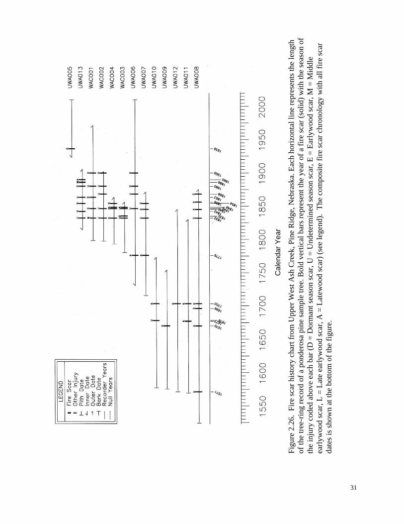
Pine Ridge, Upper West Ash Creek, Nebraska (UWA)
This site data was separated from the West Ash Creek site because the area covered by all trees
sampled in the watershed would encompass a site area much larger than the other sites reported.
The additional site in close proximity allows for opportunities to compare the records and
frequencies. Nearly all fires that occurred at the Upper West Ash Creek site also in the lower
elevation West Ash Creek Site (Figure 2.26). Between 1600 and 1900, 15 of 20 fires that
occurred at Upper West Ash Creek also occurred at West Ash Creek indicating 75 percent of the
fires were greater than 5 km2 in size.
31
Fig
ure
2.2
6. F
ire
scar
his
tory
char
t fr
om
Upper
Wes
t A
sh C
reek
, P
ine
Rid
ge,
Neb
rask
a. E
ach h
ori
zonta
l li
ne
repre
sents
the
length
of
the
tree
-rin
g r
ecord
of
a ponder
osa
pin
e sa
mple
tre
e. B
old
ver
tica
l b
ars
repre
sent
the
yea
r of
a fi
re s
car
(soli
d)
wit
h t
he
seas
on o
f
the
inju
ry c
oded
abov
e ea
ch b
ar (
D =
Dorm
ant
seas
on s
car,
U =
Und
eter
min
ed s
easo
n s
car,
E =
Ear
lyw
ood s
car,
M =
Mid
dle
earl
yw
ood s
car,
L =
Lat
e ea
rlyw
ood s
car,
A =
Lat
ewood s
car)
(se
e le
gen
d).
T
he
com
posi
te f
ire
scar
chro
nolo
gy w
ith a
ll f
ire
scar
dat
es i
s sh
ow
n a
t th
e bott
om
of
the
figure
.
Ca
lend
ar
Ye
ar

32
Mississippi River Hills, Iowa (log cabin timbers with fire scars) (NYE)
This cabin was historically located on the slopes just above the Mississippi River floodplain in
central Iowa (near town of Muscatine). The ends of the oak cabin wall logs showed to have
numerous fire scars (Figure 2.27). Log end flare indicated that these logs were cut close to the
ground level. Twenty cabin log ends were sampled and tree-ring dated using existing regional
master chronologies. The log end samples spanned the time period 1700 to 1850 (Figure 2.28).
Fire events spanned the period 1714 to 1810. This record of fire occurrence is particularly
unique since it is the first record of pre-EuroAmerican settlement fire frequency in Iowa.
Figure 2.27. The end of a white oak log from a deconstructed 1860‟s era cabin
shows fire scars from the 18th
and early 19th
centuries (arrows). Log ends are
known to be from near the ground level (where fire scars occur) because log
ends show flare in the wood.

33
Fig
ure
2.2
8. F
ire
scar
his
tory
char
t fr
om
the
pra
irie
par
kla
nd a
long
Mis
siss
ippi
Riv
er H
ills
, Io
wa.
Eac
h h
ori
zonta
l li
ne
repre
sents
the
length
of
the
tree
-rin
g r
ecord
of
a w
hit
e o
ak s
ample
tre
e. B
old
ver
tica
l b
ars
rep
rese
nt
the
yea
r o
f a
fire
sca
r (s
oli
d)
wit
h t
he
seas
on o
f th
e in
jury
cod
ed a
bove
each
bar
(D
= D
orm
ant
seas
on s
car,
U =
Undet
erm
ined
sea
son s
car,
E =
Ear
lyw
ood s
car,
M =
Mid
dle
ear
lyw
ood s
car,
L =
Lat
e ea
rlyw
ood s
car,
A =
Lat
ewood s
car)
(se
e le
gen
d).
T
he
com
posi
te f
ire
scar
chro
nolo
gy w
ith a
ll
fire
sca
r dat
es i
s sh
ow
n a
t th
e bott
om
of
the
figure
.
Ca
lend
ar
Ye
ar

34
Chapter 3. Fire interval modeling
We used principles of physical chemistry and ecology to develop, calibrate, and validate a model
equation describing pre-EuroAmerican period (~1650-1850) fire frequency in the Great Plains.
The logic of the Physical Chemistry Fire Frequency Model (PC2FM) approach and its form was
inspired by the Arrhenius equation– a fundamental equation predicting rate constants (Figure 3.1,
Equation 1). Our approach combines the mechanistic components of the Arrhenius equation and
deterministic components of statistical model calibration and validation. The mechanistic
component of the PC2FM is represented by using the physical chemistry parameters and form of
the Arrhenius equation as the basis for describing climate controlled rates of fire. One important
facet of mechanistic models is that causal inference can enable predictions outside the domain of
the model and data. Thus, the PC2FM‘s representation of climate influences on landscape fire
frequency need not be dependent on a geographic distribution of the empirical data, but rather on
data representing a wide range of ecosystem conditions that affect the Arrhenius components
Figure 3.1. Conceptual diagram illustrating the relationship of climate to the reaction rates
influencing fire occurrence (fuel production, fuel decay, and combustion reactions) and the
Physical Chemistry Fire Frequency Model (PC2FM). Reaction rates (k) are conceptualized
here by the parameters of the Arrhenius equation whereby: Ao (molecular collisions and
concentration of reactants) represents the landscape-scale distances between fuels, their
structure, and quality; Ea (activation energy, the energy required to begin a reaction)
represents the influence of moisture on fuels and the energy required for ignitions; T
(temperature of the reactants) represents fuel and air temperatures. Arrow width represents
the relative contribution of climate to the rates of the three processes in fire regimes.

35
such as temperature, activation energy, and reactant concentrations (fuel and oxygen). The
deterministic components of the PC2FM consist of an ecologic component (PTrc, Figure 3.2),
statistical calibrations, and validation of model parameters and predictions. The calibration and
validation of the PC2FM are done using fire history datasets from both within (n=30) and outside
(n=140) of the Great Plains region. The most important component of the PC2FM follows the
form of the Arrhenius equation:
k= Aoe-Ea/RT
(Equation 1)
where: k is a rate constant,
Ao = the molecular collision frequency based on reactant properties,
Ea = the reaction activation energy,
R = the universal gas constant, and
T = temperature in degrees Kelvin
The Arrhenius equation, developed at the molecular-scale, is the foundation for the landscape-
scale PC2FM. We used regression analysis to translate the Arrhenius equation and its
components to the landscape-scale. This is necessary because the molecular dimensions,
molecular species, numeric complexity, and the reactant concentrations are unknown for many
important reactions in ecosystems. Multiple regression analysis was used to develop parameters
and models thereby forming the ―bridge‖ with the PC2FM between the Arrhenius equation and
simple ecosystems metrics. Regression coefficients were translated from the relatively fine-scale
units of the Arrhenius equation (i.e., kJ -1
mol-1
, molecular reactions per second, and partial
pressure of oxygen) to the landscape-scale fire frequency (MFIs) of the PC2FM. In the
translation, k, the rate constant of reactions per second in the Arrhenius equation, is replaced by
number of fires per year or the commonly used metric; mean fire interval (MFI, the average
number of years between fires).
Understanding the translation from the Arrhenius rate constant (k) to the PC2FM‘s fire
frequency rate (MFI) is of critical importance. Both rates, k and MFI, are serial rates of reactions
but scale in opposite directions. Both rates are dependent upon series of reactions that occur at
the molecular reaction scale (e.g., C6H12O6 + O2). Reactions per second and fires per year
(1/MFI) are both rate estimates with only unit differences (e.g., 1/MFI = 1/
(60sec*60min*24hrs*365days*MFI). The negative sign in the exponential term is removed
because of this difference in rate metrics.
Research documenting multi-century fire frequency (i.e., MFIs) is well established as a
critical component for understanding fire regimes (Swetnam et al. 1999), but less well
quantitatively documented in the Great Plains compared to other parts of North America.
Development and calibration of the PC2FM for the Great Plains utilizes MFI data from
throughout North American including the Great Plains. Eighteen percent of the fire history data
used in this analysis was from the Great Plains region. MFI data represent time periods prior to
widespread industrial influences. Industrialization significantly altered fire regimes through
increased ignitions, fire suppression, changes in native and domestic grazing regimes,
agricultural technologies, and other land use activities that modified or fragmented ecosystems
and fuels (Pyne et al. 1996). By using MFI data prior to industrialization, we expect to minimize
its effects on MFIs and maximize our accuracy and ability in calibrating and parameterizing the
PC2FM. Thus far, the continental extent of observations of MFI, temperature, and precipitation

36
has facilitated the detection of spatial patterns in MFIs beyond the constraints typically described
by local variation in vegetation and topography. Our current PC2FM database includes fire
history study sites across North America that range in annual mean maximum temperatures from
-12 to 32 0C, annual mean precipitation from 8 to 456 cm, and MFIs from 1 to > 400 years.
Temperature and precipitation vary among sites due to elevation, latitude, oceanic and
continental influence, and other climate controls. Annually averaged temperature and
precipitation provide the most meaningful climate data for this extensive data base because they
are closely related to the biological and physical constraints of annual fuel production and decay.
In addition, analyses of long-term fire rates representing diverse climates and fire seasons are
comparable only at an annual scale or longer.
PC2FM parameters (Figure 3.3) have been selected and developed based on literature and
knowledge of both physical chemistry laws and ecosystem fire ecology. PC2FM parameters
have been tested and chosen based on mechanistic and ecological relevance, statistical
significance and explanatory power, and, to a lesser extent, ability to be mapped using a
geographic information system (GIS). Currently the PC2FM utilizes three covariates of MFIs:
annual mean maximum temperature (maxt), mean annual precipitation (P), and the estimated
partial pressure of oxygen. The partial pressure of O2 is estimated from elevation (Figure 3.3,
ppO2). The climate covariates represent averages for the 1971-2000 (30 yr) period. Two other
climate variables have been tested for significance using correlation analysis but are not used—
mean minimum temperature and mean temperature. It is possible that mean temperature could
be substituted for maxt; however, maxt has consistently explained a greater percentage of
variance during diagnostic tests (Figure 3.3, 3.4). The maxt data used for calibration is a ‗proxy‘
in the sense that the model period
(~ 1650-1850) is different than
the climate data period (1971-
2000). We maintain that errors
caused by this difference in time
period are minimal because the
temporal variability in
temperature is small (temperature
increase of approx. 0.4 oC from
1750 to 1970), particularly
compared to the spatial
variability that exists among sites
(26 oC). We subtracted 0.4
oC
from annual mean maximum
temperatures (Mann et al. 1998)
to correct for recent warming and
the temporal displacement of the
temperature data from the MFI
data. We converted temperatures
from Celsius to Kelvin units to
more closely follow the
Arrhenius equation. Kelvin units
are used because the Arrhenius
equation temperature parameter
Figure 3.2. Relationship between observed fire
frequency (MFI) and the PC2FM moisture index
parameter (PTrc).

37
is based on thermodynamic and kinetic theories that start with molecular forces that begin at
absolute zero that occur in the Great Plains as elsewhere.
A fundamental ecological model parameter for characterizing climate-fire interactions is
a simple moisture index (PTrc) (Figure 3.2). This parameter was developed through iterations of
regression modeling and visualizations of model-generated maps of MFIcf (climate forced MFI).
The mechanisms of this parameter in the PC2FM are related to the activation energy (Ea)
required for initiating combustion. The function of the PTrc parameter is to switch the direction
of influence of moisture with respect to MFI (Figure 3.2) during the transition from wetter to
drier climates. This parameter is sensitive to small differences in precipitation at very low levels
(e.g., annual precipitation of 10 to 40 cm). For example, there are only small differences
between the PTrc of deserts (unburnable) and semi-arid grasslands, suggesting that in these types
of environments slight differences in annual precipitation can result in large differences in fire
intervals given sufficient continuity and accumulation of fuels.
Mapping
PC2FM estimates of MFIcf (MFI climate forced) were mapped using ESRI®ArcGIS
™ software
(ESRI 2005). Grid data mean maximum temperature and mean annual precipitation data
(PRISM data, Daly et al. 2004) were applied to Equation 1 to produce grid estimates of MFIs for
the pre-Euro American settlement period (~1650 to 1850 A.D.).
Results
The PC2FM results appear in several sections of this report. In Chapter 4, the PC2FM MFIcf
estimates are given in the data tables for each of the parks. Here and in other sections of this
report we give broad scale results based on the model estimates, model parameters, qualitative
documentation, and mapping. For instance, the ‗ridge‘ pattern of PC2FM emanating from the
MFIcf = 0.545 + 4.165-27
(ARt) + 49.8(PTrc), (Equation 2) Where: MFIcf is climate forced mean fire interval (years),
ARt = Aoexp(Ea/(RT))
; is the Arrhenius term,
Ao = (P2.017
)(ppO2); is estimated reactants concentration,
Ea = 133 kJ mol-1
(P(P/T)0.0000375)
); is estimated activation energy term,
R = 0.0083 kJ -1
mol-1
; is the Universal Gas constant,
T = mean max temperature in oK is degrees Kelvin (1970-2000),
(adjusted -0.4°C for warming);
Exp; is 2.718,
P = annual precipitation (cm); is 30 year mean precipitation (1970-2000),
ppO2 = partial pressure of oxygen; is based on: (0.2095) exp(-0.12*elevation(in km)
,
PTrc = 1/(P2/T); is the moisture index.
Figure 3.3. Great Plains PC2FM components, their details, and explanations of their units.
This model explains 76 percent of the variance in fire frequency (MFI) at 36 sites in and
adjacent to the Great Plains. The model is based on two predictor variables ARt and PTrc that
are significant (p < 0.001) and 168 observations.

38
southern Great Plains northward (Figure 3.4) is the result of the positive and negative effects of
precipitation on fire frequency. This is a large-scale feature and, to some extent, an unique
feature of the Great Plains that is discussed in detail in the text below.
Precipitation effects in the Great Plains
Precipitation has two important, but counteracting influences on fire regimes, especially in the
Great Plains. The primary influence is on fuel production and decay and the secondary influence
pertains to the activation energy needed for fuel ignition. Using the principles of physical
chemistry both of these influences are integrated into the PC2FM. We applied the PC2FM to
three temperature scenarios, and a range of precipitation values to illustrate the value of this
empirically validated model output for understanding relationships between precipitation and fire
frequency (Figure 3.5) in the Great Plains. An important contribution that this type of analysis
can provide includes the identification of threshold climate conditions for fire regimes in the
Great Plains ecosystem. The PC2FM output quantifies an ecological principle, ‗the law of
limits‘ concerning temperature and precipitation in the ecosystem‘s climate responses to fire
occurrence. Some ecosystems, particularly those in the Great Plains, have climate conditions
near thresholds that have the potential to ‗cross over‘ and change their directional fire frequency
climate response.
The bidirectional effects of precipitation on reactions are described in the PC2FM
equation and in the Arrhenius equation as activation energy (Ea, fuel moisture) and reactant
concentration (Ao, fuel density). Model results (Figure 3.5) predict where and to what degree
changes in precipitation affect fire frequency. In Figure 3.6, the blue lines follow the 62 cm (25
inch) annual precipitation threshold for the positive versus the negative effects of precipitation
on fire frequency. Increased precipitation will increase potential fire frequency west of the blue
threshold line and slightly decrease potential fire east of the line. Decreased precipitation will
decrease potential fire frequency west of the blue threshold line and slightly increase potential
fire frequency east of the line.
Temperature effects in the Great Plains
Model results indicate that temperature differences result in varied response of MFIs to
precipitation and that changes in MFIs due to temperature will be increasingly greater in regions
with more precipitation (Figures 3.5, 3.6). Climate forcing of fire frequency can be bidirectional
based on precipitation and temperature changes along the 25 inch precipitation line in the Great
Plains. In a scenario where mean maximum temperatures homogeneously increase, the model
suggests decreases in fire frequency west of the 25 inch annual precipitation line by reducing
fuel loading. Oppositely, increases in temperature east of the 25 inch annual precipitation line is
expected to cause slightly increased fire frequency.

39
Figure 3.4. Map of estimated pre-EuroAmerican period (~1650-1850) mean fire intervals
(MFIcf) in the Great Plains calculated from climate variables and the PC2FM (Equation 2).
National Parks are shown in black. The model 95 % confidence interval is +/- 2.3 years for
the mean and +/- 27 years for prediction.

40
Figure 3.5. PC2FM estimates of fire intervals for
three different temperature scenarios. The inflection
points (lowest regions of the curves) represent
thresholds where directional (+/-) changes occur for
the influence of precipitation on fire frequency
(MFI). We hypothesize that thresholds indicate a
process change from the dominant factor (fuel
production versus moisture effects on fuels, ignitions,
and reactions). A second ecosystem response
predicted by the model is the difference in
temperature effects on the two sides of the threshold
values. On the left side of the graph (dry
ecosystems) the model predicts little change in fire
frequency due to temperature and large changes in
fire frequency due precipitation. On the right side of
the graph (wet ecosystems) the model predicts large
changes in fire frequency due to temperature and
small changes in fire frequency due precipitation.

41
Figure 3.6. PRISM estimates of U.S. mean annual precipitation (Daly et al. 2004). Blue
lines indicate the approximate location of the 25 inch isohyet in the Great Plains. Based on
the PC2FM equation to the west of these lines in the Great Plains there exists a positive
response (increased fuel, Ao) of fire frequency to increased precipitation. Conversely, a
negative response (increased fuel moisture, Ea) of fire frequency to increased precipitation
exists in the region of the Great Plains to the east of the blue lines.

42
Chapter 4. Descriptions of historic fire frequency at National Park Service Units of the
Great Plains
Considerations for interpreting fire history information
The following pages describe historic fire regime characteristics, particularly historic fire
frequency, for each National Park Service Unit in the Great Plains region. Units include
monuments, recreation areas, historic sites and parks, and national parks. Historic fire regime
descriptions are for fire regime conditions during a time period prior to major EuroAmerican
influence. EuroAmerican settlement generally coincided with major changes that dramatically
influenced the frequency of fire including anthropogenic ignitions, death and/ or displacement of
Native Americans, dramatic declines in numbers of bison and other fauna, increased livestock
grazing, cutting of forests, fire suppression, and changes in land use. The timing of large scale
EuroAmerican influence is not precise because it was a gradual process that varied spatially and
with new technologies. Pre-EuroAmerican fire influence is here defined as process that had
large landscape scale effects on fuels or ignitions.
Fire regime characteristics here generally pertain to the period AD 1650-1850. For fire
scar history studies the temporal depth of records is highly dependent on the longevity of the tree
species used and decomposition rates of the wood. Fire regime conditions are not static through
time because of the changing factors that influence them (e.g., climate, vegetation, ignitions).
Depending on the site fire scar history data and descriptions typically represent a 100 to 400 year
time period prior to EuroAmerican settlement. It was not possible or necessary to conduct fire
scar history studies at all of the park units. Reasons include: lack of trees or fire scarred trees,
fire history information already existed, or destructive sampling (i.e., cutting of trees) methods
were inappropriate. In addition, fire scars may have limited utility for determining fire intervals
in ecosystems with stand replacement fires, or describing very long intervals as is the case in
areas of badlands within the Great Plains (e.g., Badlands NP, Theodore Roosevelt NP). In
addition, the overall project scope and budget limited our overall efforts to prioritized parks with
high need / research potential (see Chapter 1). Consequently, some park units have further
potential to have fire history research conducted in the vicinity or in a similar ecosystem that
would likely aid in understanding the historic role of fire at the park unit (e.g., Fort Union,
Lyndon Johnson).
For each NPS unit we describe the major fire regime characteristics that would have
controlled the frequency of fire. Descriptions of fire regime characteristics include vegetation,
topography, climate, ignitions (human/ lightning/ other), the nearest quantitative fire history data
(fire scar or other), and a table of the historic fire frequency, either based on fire scars or the
PC2FM. Vegetation descriptions are intended to reflect the native vegetation that would have
occurred during the pre-EuroAmerican time period. Topography descriptions are intended to
describe fire’s potential to burn both into and across the park unit. Climate descriptions reflect
late twentieth century (1971-2000) mean conditions found to be important through the PC2FM
development. Human ignitions descriptions are qualitative. Fire frequency statistics are given
based on empirical data (if obtained) or utilizing the PC2FM (see model details in Chapter 3). In
addition, the nearest-most relevant empirical data that existed at the time of this report are given
for each park.

43
Qualitative ignition adjustment for PC2FM estimates of park mean fire intervals
At smaller spatial scales such as those of Great Plains National Parks, variables other than
climate such as topography, ignitions, and vegetation may be very important factors influencing
fire frequency. For example, the focus of many parks is human history. Thus, a park like
Pipestone National Monument that has a known source of human ignitions that can vary greatly
from the climate based averages of the region. Since the PC2FM considers only climate
variables; we developed a method of adjusting the mean fire interval output of the PC2FM using
qualitative estimates of fire variables. These estimates are for ignitions (human and lightning),
natural fire spread (topographic roughness and non fuel landscapes), and fuel moisture variables
(aspect and vegetation type). Each of these variables is rated on a plus or minus point scale.
Human ignition frequency is rated as high (-2), middle (0), or low (+2) based on human
population. Lightning ignition frequency is rated as high (-1), middle (0), or low (+1) based on
the regional frequency of lightning fires (Schroeder and Buck 1970). Fire spread and breaks are
rated by topographic roughness as rough (>3), rolling (0), or smooth (-1) based on changes in
slope (Stambaugh and Guyette 2008). Roughness and non fuel landscapes can have extreme
effects so values can be much greater than 3. The drying time of fuels is rated by fuel types
prairie (-2), savanna (-1), and forest (0). These ratings are added together in an Ignition
Adjustment Index (IAI) that is used to calculate an adjusted mean fire interval (MFIa):
(IAI/MFIc)*MFIc + (MFIc) = MFIa
Where: IAI = the Ignition Adjustment Index,
MFIc = the climate modeled mean fire interval,
MFIa = the ignition adjusted MFIc.
Below, PC2FM adjusted mean fire intervals (MFIa) for each park are given in the right hand
column of the fire frequency tables. Differences between the MFIc and MFIa indicate the
estimated degree of non-climatic variability in the park’s fire regime. This is due to the number
of ignitions as controlled by humans, vegetation, unburnable surfaces (no fuel) (e.g., bedrock,
sand, water, sediment), and the inhibition of the spread of fire by topographic characteristics.
Most parks vary little between MFIc and MFIa. However some parks, such as Pipestone NM and
Knife River Indian Villages, likely had Native American populations and human ignitions that
increased the frequency of fire. Conversely, PC2FM estimated MFIs are potentially greatly
lengthened in parks with high proportions of unburnable surfaces (Badlands, Theodore
Roosevelt) due to lack of fuel, topographic roughness, and low human population density.

44
Agate Fossil Beds National Monument (AGFO)
Native vegetation: Mixed-grass prairie;
extensive wetlands and with sparse trees
associated with the Niobrara River.
Topography: The rolling gentle topography
of this region has only a marginal probability
of inhibiting the spread for fire, particularly in
grasslands. Wetlands and riparian zones
along the Niobrara River may have slowed
fire spread, particularly during wetter
conditions and during the growing season. If
the Niobrara River historically prohibited the spread of fire then the site lies in a unique position
within a fire compartment that extends primarily to the north. During extremely dry conditions
fires ignited from great distances likely had potential to reach this site. Furthermore, during
these conditions the Niobrara may not have been effective at slowing fire spread, particularly
during conditions of dry, cured fuels.
Climate: Mean annual precipitation: 36 cm (14.2 in), Mean maximum temperature: 16.7° C (62° F) (PRISM data: Daly et al. 2004)
Human population/ ignition: Little is known concerning human ignitions at this site. As a major
(> 400 km) eastward flowing river into the Missouri River, the Niobrara was likely an important
travel corridor that historically attracted humans. Relative to other portions of North America,
Native American population circa 1500 was estimated as low (0.011-0.035 humans / km2; Driver
and Massey 1957).
Lightning ignition: This site is located in a region of relatively low frequency of lightning
caused fires (0.00075 fires/km2/yr; Schroeder and Buck 1970).
Nearest-most relevant quantitative fire history data: 1) West Ash Creek, NE; Citation:
unpublished data, Figures 2.23, 2.24, 2) Perryman and Laycock 2000, 3) Additional fire scar
history data are available for the Black Hills (see Brown 2006).
Photo: NPS

45
Agate Fossil Beds National Monument Historic Fire Frequency
Fire regime variables Nearest similar fire sites Agate Fossil Beds NM
Variable source West Ash Creek (WAC)
(Figure 2.23)
PC2FM estimate
(climate) MFIc
PC2FM
estimate MFIa
(adjusted)
Mean fire interval
(site area: 1 km2)
(period of estimate)
10.7 years (1658-1894)
40.0 years (1703-1753)
19.3 years (1658-1832)
5.2 years (1832-1894)
12 years, pre Euro
American influence
13 years, pre
Euro American
influence
Interval range, 95%
confidence interval
1-22 years CI +/- 2.3 yrs mean
CI +/- 27.8 yrs predict
Niobrara Valley Preserve
(Figures 2.20, 2,21)
Mean fire interval
(site area: 1 km2)
(period of estimate)
6.0 years (1687-1891)
7.6 years (1687-1832)
Interval range 1-23 years

46
Alibates Flint Quarries National Monument (ALFL)
Native vegetation: Site vegetation consists of
a mix of shrublands and shortgrass prairie
(NatureServe 2005). Limited areas of
perennial herbaceous vegetation and
woodlands (juniperus, populus) exist.
Topography: Fire breaks largely consist of
sparsely vegetated areas that are fuel limited.
Additional breaks by gypsum outcrops and
features associated with the Canadian River
(e.g., sand bars, seasonal wetlands). The
Canadian River lies immediately to the west of the monument and would have been a major fire
break of fires moving eastward.
Climate: Mean annual precipitation: 52 cm (20.5 in), Mean maximum temperature: 22°C (71.6° F) (PRISM data: Daly et al. 2004)
Human population/ ignition: Humans are thought to have occupied the flint quarries for
approximately 13,000 years. Populations are thought to have declined circa the late 15th
century
and quarries were abandoned circa 1870s likely corresponding with a decrease in the numbers of
human ignitions. Relative to other portions of North America, Native American population circa
1500 was estimated as low (0.011-0.035 humans / km2; Driver and Massey 1957).
Lightning ignition: This site is located in a region of relatively low frequency of lightning
caused fires (0.00075 fires/km2/yr; Schroeder and Buck 1970).
Nearest-most relevant quantitative fire history data: There is very little quantitative information
concerning long-term fire history of semi-arid shrublands / shortgrass prairie. Nearest
information: 1) Wichita Mountains, OK (300 km to east); Citation: Stambaugh et al. 2009.
Alibates Flint Quarries National Monument Historic Fire Frequency
Fire regime variables Nearest fire site Alibates Flint Quarries NM
Variable source Wichita Mountains NWR
(Figure 2.10)
PC2FM estimate
(climate) MFIc
PC2FM estimate
(adjusted) MFIa
Mean fire interval
(site area: 1 km2)
(period of estimate)
5.6 years (1771-1861)
7 years, pre Euro
American influence
5 years, pre Euro
American
influence
Interval range, 95 %
confidence intervals
1-13 yrs CI +/- 2.3 yrs mean
CI +/27.8 yrs predict
Photo: NPS

47
Badlands National Park (BADL)
Native vegetation: Mixed grass prairie broken
by a complex of sharply eroded buttes.
Occasional woodlands in riparian zones and
trees in protected sites.
Topography: The rolling gentle topography of
this site has only a marginal probability of
inhibiting the spread for fire.
Climate: Mean annual precipitation: 44 cm (17.3
in), Mean maximum temperature: 15.5 – 17.4 °
C (60 – 63 ° F) (PRISM data: Daly et al. 2004)
Human population/ ignition: Relative to other portions of North America, Native American
population circa 1500 was estimated as low (0.011-0.035 humans / km2; Driver and Massey
1957).
Lightning ignition: This site is located in a region of relatively low frequency of lightning
caused fires (0.00075 fires/km2/yr; Schroeder and Buck 1970).
Nearest-most relevant quantitative fire history data: 1) West Ash Creek, NE (80 km south);
Citation: unpublished, Figures 2.23, 2.24; 2) Additional fire scar history data are available from
the Black Hills (70 km to west) (Brown 2006) (see IMPD;
http://www.ncdc.noaa.gov/paleo/impd/paleofire.html).
Badlands National Park Historic Fire Frequency
Fire regime variables Nearest similar fire site Badlands National Park
Variable source West Ash Creek (WAC)
(Figure 2.23)
PC2FM estimate
(climate) MFIc
PC2FM
estimate
(adjusted) MFIa
Mean fire interval
(site area: 1 km2)
(period of estimate)
10.7 years (1658-1894)
40 years (1703-1753)
19.3 years (1658-1832)
5.2 years (1832-1894)
9-11 years, pre Euro
American influence
12-14 years, pre
Euro American
influence
Interval range, 95 %
confidence intervals
1-55 yrs CI +/- 2.3 yrs mean
CI +/- 27.8 yrs predict
Photo: M. Stambaugh

48
Bent’s Old Fort National Historic Site (BEOL)
Native vegetation: Vegetation consists of
shortgrass prairie and marshlands / riparian
zones associated with the Arkansas River.
Topography: The gentle topography of this
site has a low probability of inhibiting the
spread of fire. Considering the expansive
surrounding plains the fire compartment
associated with this site is large (e.g.,
100,000+ km2). The Arkansas River may
have been an important fire break
historically, however a wildfire in 2002
jumped the river.
Climate: Mean annual precipitation: 30 cm (11.8 in), Mean maximum temperature: 20.8° C
(69.4° F) (PRISM data: Daly et al. 2004)
Human population/ ignition: Considering the attraction of this area for establishing a fort, the
area along the Arkansas River was likely used by humans more so than the other types of areas
throughout the expansive Great Plains region. Riverways were historically preferred travel
corridors. Relative to other portions of North America, Native American population circa 1500
was estimated as low (0.011-0.035 humans / km2; Driver and Massey 1957).
Lightning ignition: This site is located in a region of relatively low frequency of lightning
caused fires (0.00075 fires/km2/yr; Schroeder and Buck 1970).
Nearest-most relevant quantitative fire history data: There is no quantitative information
concerning long-term fire history of the central Great Plains shortgrass prairie. Nearest
information: 1) Capulin Volcano National Monument, NM (150 km to south). Citation: Guyette
et al. 2006, 2) Additional fire scar history data are available from higher elevation Rocky
Mountain forests (see IMPD; http://www.ncdc.noaa.gov/paleo/impd/paleofire.html).
Bent’s Old Fort National Historic Site Historic Fire Frequency
Fire regime variables Nearest fire site Bent’s Old Fort NHS
Variable source Capulin Volcano NM
(Guyette et al. 2006)
PC2FM estimate
(climate) MFIc
PC2FM
estimate
(adjusted) MFIa
Mean fire interval
(site area: < 0.5 km2)
(period)
10.5 years (1702-1860)
8.7 years (1601-1860)
16-17 years, pre Euro
American influence
16-17 years, pre
Euro American
influence
Interval range, 95 %
confidence intervals
1-23 yrs CI +/- 2.3 yrs mean
CI +/- 27.8 yrs predict
Photo: NPS

49
Capulin Volcano National Monument (CAVO)
Native vegetation: The dominant vegetation
associations at CVNM are Plains-Mesa Grassland
and Pinyon-Juniper Woodlands (NPS 2004).
Topography: Gentle topography along volcano
base, extremely rough basaltic lava fields, steep
topography on cone.
Climate: Mean annual precipitation: 47 cm (18.5
in), Mean maximum temperature: 16.9° C (62.4°
F) (PRISM data: Daly et al. 2004)
Human population/ ignition: Relative to other portions of North America, Native American
population circa 1500 was estimated as low (0.011-0.035 humans / km2; Driver and Massey
1957). However, archeological evidence of recent occupation near the site indicates that local
population density was greater than estimated by coarse scale maps.
Lightning ignition: Frequent lightning strikes and high winds are characteristic features of the
upper slopes and rim of Capulin and vicinity (Wagner et al. 2006). This site is located in a region
of relatively low frequency of lightning caused fires (0.002 to 0.0035 fires/km2/yr; Schroeder and
Buck 1970).
Nearest-most relevant quantitative fire history data: 1) On-site and 5 km to west; citation
Guyette et al. 2006.
Capulin Volcano National Monument Historic Fire Frequency
Fire regime variables Nearest fire site Capulin Volcano NM
Variable source Capulin Volcano NM
(Guyette et al. 2006)
PC2FM estimate
(climate) MFIc
PC2FM
estimate
(adjusted) MFIa
Mean fire interval
(site area: < 0.5 km2)
(period)
10.5 years (1702-1860)
8.7 years (1601-1860)
9-11 years, pre Euro
American influence
8-10 years, pre
Euro American
influence
Interval range, 95 %
confidence intervals
1-23 yrs CI +/- 2.3 yrs mean
CI +/- 27.8 yrs predict
Photo: M. Stambaugh
Photo: M. Stambaugh

50
Chickasaw National Recreation Area (CHIC)
Native vegetation: The site lies at the edge of the eastern
deciduous forest and Great Plains. Consequently,
vegetation consists of a mosaic of woodland to open
tallgrass and mixed grass prairie (Hoagland and Johnson
2001).
Topography: The rolling gentle topography of this site has
only a marginal probability of inhibiting the spread of fire.
The multiple confluences of wet creeks (Guy Sandy, Rock,
Buckhorn) likely slowed the propagation of past fires.
Further away, to the south and west, the Washita River and
Arbuckle Mountains may have been important fire barriers.
At a landscape scale this area lies in a fire compartment
that extends primarily to the north and west.
Climate: Mean annual precipitation: 102 cm (40.2 in),
Mean maximum temperature: 22.5°C (72.5° F) (PRISM
data: Daly et al. 2004).
Human population/ ignition: Relative to other portions of North America, Native American
population circa 1500 was estimated as moderate (0.036-0.085 humans / km2; Driver and Massey
1957). However, the water and resources of riparian landscape have always attracted humans.
Lightning ignition: This site is located in a region of relatively low frequency of lightning
caused fires (0.00075 fires/km2/yr; Schroeder and Buck 1970).
Nearest-most relevant quantitative fire history data: 1) Wichita Mountains, OK (150 km west),
Stambaugh et al. 2009; Okmulgee State Wildlife Management area (160 km to north), DeSantis
et al. 2010; Keystone Preserve, OK (220 km to north), Clark et al. 2007; Purtis Creek State Park,
TX (250 km south), Stambaugh et al. in review.
Chickasaw National Recreation Area Historic Fire Frequency
Fire regime variables Nearest fire site Chickasaw National Recreation Area
Variable source Wichita Mountains
NWR (Figure 2.10)
PC2FM estimate
(climate) MFIc
PC2FM estimate
(adjusted) MFIa
Mean fire interval
(site area: 1 km2)
(period of estimate)
5.6 years (1771-1861)
5-6 years, pre Euro
American influence
5-6 years, pre Euro
American
influence
Interval range, 95 %
confidence intervals
1-13 yrs CI +/- 2.3 yrs mean
CI +/- 27.8 yrs predict
Photo: M. Stambaugh

51
Chimney Rock National Historic Site (CHRO)
Native vegetation: Mixed-grass prairie
interspersed with juniper in protected sites /
steep topography.
Topography: steep slopes, bluffs and badlands;
gentle topography on lower slopes.
Climate: Mean annual precipitation: 40 cm
(15.7 in), Mean maximum temperature: 17.5° C
(63.5° F) (PRISM data: Daly et al. 2004)
Human population/ ignition: Relative to other
portions of North America, Native American population circa 1500 was estimated as low (0.011-
0.035 humans / km2; Driver and Massey 1957).
Lightning ignition: This site is located in a region of relatively low frequency of lightning
caused fires (0.00075 fires/km2/yr; Schroeder and Buck 1970).
Nearest-most relevant quantitative fire history data: 1) Carter Canyon Ranch (14 km to south),
Figure 2.18; 2) West Ash Creek, NE (100 km northeast); Citation: unpublished, Figures 2.23,
2.24.
Chimney Rock National Historic Site Historic Fire Frequency
Fire regime variables Nearest similar fire site Chimney Rock NHS
Variable source West Ash Creek (WAC)
(Figure 2.23)
PC2FM estimate
(climate) MFIc
PC2FM
estimate
(adjusted) MFIa
Mean fire interval
(site area: 1 km2)
(period of estimate)
10.7 years (1658-1894)
40 years (1703-1753)
19.3 years (1658-1832)
5.2 years (1832-1894)
10-12 years, pre Euro
American influence
10-12 years, pre
Euro American
influence
Interval range, 95 %
confidence intervals
1-55 yrs CI +/- 2.3 yrs mean
CI +/- 27.8 yrs predict
Photo: NPS

52
Devils Tower National Monument (DETO)
Native vegetation: Mosaic of ponderosa pine
woodlands, forests, and mixed grass
prairie.
Topography: Steep topography associated with
the tower landform; rolling topography
associated with plains
Climate: Mean annual precipitation: 44 cm (17.3
in), Mean maximum temperature: 14.3° C (57.7°
F) (PRISM data: Daly et al. 2004)
Human population/ ignition: Several Native American tribes are known to have periodically
inhabited the vicinity throughout the historic period, including the Eastern Shoshone, Crow,
Kiowa, Cheyenne, Arapaho, and Lakota (Hanson and Chirinos 1997). Relative to other portions
of North America, Native American population circa 1500 was estimated as low (0.011-0.035
humans / km2; Driver and Massey 1957).
Lightning ignition: Records of lightning-caused fires at Devils Tower from 1951 to 1979 show a
total of 35 fires, with the highest frequency in June, July, and August; however, more recent
records indicate only one lightning fire occurred between 1993 and 2002, burning two acres.
Lightning strike frequency and flash density (1 to 3+ flashes km-2 yr-1) are highest in
northeastern Wyoming and increase from the Palouse Dry Steppe grasslands to the Black Hills
(Curtis and Grimes 2004). This site is located in a region of relatively low frequency of lightning
caused fires (0.00075 fires/km2/yr; Schroeder and Buck 1970).
Nearest-most relevant quantitative fire history data: 1) onsite (Figure 2.8, Appendix 1);
Citations: Stambaugh et al. 2008, Fisher et al. 1987.
Devils Tower National Monument Historic Fire Frequency
Fire regime variables Nearest fire site Devils Tower NM
Variable source Devils Tower NM
(Stambaugh et al. 2008)
(Figure 2.8)
PC2FM estimate
(climate) MFIc
PC2FM
estimate
(adjusted) MFIa
Mean fire interval
(site area: ~ 3 km2)
(period of estimate)
18.4 years (1491-1835)
24.6 years (1312-2002)
10 years, pre Euro
American influence
12 years, pre
Euro American
influence
Interval range, 95 %
confidence intervals
1-39 years CI +/- 2.3 yrs mean
CI +/- 27.8 yrs predict
Photo: M. Stambaugh

53
Fort Laramie National Historic Site (FOLA)
Native vegetation: Mixed-grass prairie with
deciduous woodlands associated with riparian
zone
Topography: The rolling gentle topography of
this site has low probability of inhibiting the
spread for fire.
Climate: Mean annual precipitation: 33 cm (13
in), Mean maximum temperature: 18.1° C (64.6°
F) (PRISM data: Daly et al. 2004)
Human population/ ignition: Relative to other portions of North America, Native American
population circa 1500 was estimated as low (0.011-0.035 humans / km2; Driver and Massey
1957).
Lightning ignition: This site is located in a region of relatively low frequency of lightning
caused fires (0.00075 fires/km2/yr; Schroeder and Buck 1970).
Nearest-most relevant quantitative fire history data: 1) West Ash Creek, NE (120 km east);
Citation: unpublished, Figures 2.23, 2.24; 2) Thunder Basin National Grasslands (Perryman and
Laycock 2000)
Fort Laramie National Historic Site Historic Fire Frequency
Fire regime variables Nearest similar fire site Fort Laramie NHS
Variable source West Ash Creek (WAC)
(Figure 2.23)
PC2FM estimate
(climate) MFIc
PC2FM
estimate
(adjusted) MFIa
Mean fire interval
(site area: 1 km2)
(period of estimate)
10.7 years (1658-1894)
40 years (1703-1753)
19.3 years (1658-1832)
5.2 years (1832-1894)
13 years, pre Euro
American influence
13 years, pre
Euro American
influence
Interval range, 95 %
confidence intervals
1-55 yrs CI +/- 2.3 yrs mean
CI +/- 27.8 yrs predict
Photo: NPS
54
Fort Larned National Historic Site (FOLS)
Native vegetation: Vegetation consists largely of
tallgrass prairie remnants and perennial herbs
associated with riparian areas (Cogan et al. 2006).
Topography: The gentle topography of this site
likely had a low probability of inhibiting the spread
for fire. Although the Pawnee River occurs here its
channel is somewhat narrow with respect to being
an effective fire break. The area lies in a
potentially very expansive fire compartment
(100,000+ km2). Large fires from the south may have been inhibited by the Arkansas River
located approximately 70 km away.
Climate: Mean annual precipitation: 62 cm (24.4 in), Mean maximum temperature: 20° C (68°
F) (PRISM data: Daly et al. 2004)
Human population / ignition: Considering the attraction of this area for establishing a fort, the
area along the Pawnee River was likely used by humans more so than the other types of areas
throughout the expansive Great Plains region. Riverways were historically preferred travel
corridors. Relative to other portions of North America, Native American population circa 1500
was estimated as low (0.011-0.035 humans / km2; Driver and Massey 1957).
Lightning ignition: This site is located in a region of relatively low frequency of lightning
caused fires (0.00025 – 0.00075 fires/km2/yr; Schroeder and Buck 1970).
Nearest-most relevant quantitative fire history data: There is very little quantitative information
concerning long-term fire history of the central Kansas tallgrass prairie. Nearest information: 1)
Lazy S-B Ranch, Chatauqua Hills, KS (300 km to southeast), unpublished data (Figure 2.14), 2)
Konza Prairie (250 km to northeast (Abrams 1985).
Fort Larned National Historic Site Historic Fire Frequency
Fire regime variables Nearest similar fire site Fort Larned NHS
Variable source Northeast Kansas
(temporally different)
PC2FM estimate
(climate) MFIc
PC2FM
estimate
(adjusted) MFIa
Mean fire interval
(site area: unknown)
(period of estimate)
< 11.2 years (1862-1983)
(Abrams 1985)
6 years, pre Euro
American influence
6 years, pre
Euro American
influence
Interval range, 95 %
confidence intervals
CI +/- 2.3 yrs mean
CI +/- 27.8 yrs predict
Photo: NPS

55
Fort Union Trading Post National Historic Site (FOUS)
Native vegetation: The vegetation is largely
comprised of shortgrass prairie / sage
vegetation (Muldavin et al. 2004).
Topography: The gentle topography of this
site has only a marginal probability of
inhibiting the spread for fire. Conversely,
the surrounding topography is complex and
consists of nearby Wolf Creek (a tributary
of the Mora River), Black Mesa, and the
forested Turkey Mountains.
Climate: The climate is semi-arid with the majority of the precipitation (70%) falling during the
summer “monsoon” rainy season (May through September). Mean annual precipitation: 35 cm
(13.8 in), Mean maximum temperature: 12.7° C (69.3°F) (PRISM data: Daly et al. 2004)
Human population/ ignition: Relative to other portions of North America, Native American
population circa 1500 was estimated as high (0.21-0.75 humans / km2; Driver and Massey 1957).
Lightning ignition: This site is located in a region of relatively low frequency of lightning caused
fires (0.00375 – 0.0075 fires/km2/yr; Schroeder and Buck 1970).
Nearest-most relevant quantitative fire history data: There is very little quantitative information
concerning long-term fire history of the shortgrass prairie in eastern New Mexico. Nearest
information: 1) Capulin Volcano National Monument, NM (130 km to northeast). Citation:
Guyette et al. 2006, 2) Additional fire scar history data are available from higher elevation
Sangre de Cristo Mountains forests (see IMPD;
http://www.ncdc.noaa.gov/paleo/impd/paleofire.html) and El Mapais National Monument (280
km southwest; Grissino-Mayer and Swetnam 2000).
Fort Union Trading Post National Historic Site Historic Fire Frequency
Fire regime variables Nearest similar fire site Fort Union Trading Post NHS
Variable source Capulin Volcano NM
(Guyette et al. 2006)
PC2FM estimate
(climate) MFIc
PC2FM
estimate
(adjusted) MFIa
Mean fire interval
(site area: < 0.5)
(period of estimate)
10.5 years (1702-1860)
8.7 years (1601-1860)
8 years, pre Euro
American influence
8 years, pre
Euro American
influence
Interval range, 95 %
confidence intervals
1-23 CI +/- 2.3 yrs mean
CI +/- 27.8 yrs predict
Photo: NPS

56
Homestead National Monument of America (HOME)
Native vegetation: Vegetation consists of a
bur oak riparian forest surrounded by
tallgrass prairie. Though no cores or cross
sections were taken from bur oaks these
trees likely exceed 250 years in age -
evidence they were growing before and
during Euro American settlement.
Topography: The rolling gentle
topography of this region has only a
marginal probability of inhibiting the
spread for fire, particularly in grasslands.
Cub Creek and the Big Blue River (and the
fuels associated with the riparian forest)
likely slowed fire during wetter conditions.
Due to the low topographic variability and few fire breaks this site lies in an extensive fire
compartment (100,000+ km2). During extremely dry conditions fires ignited from great
distances likely had potential to reach this site, particularly during conditions of dry, cured fuels.
Fallen oak leaves, particularly bur oak leaves, present a more pyrogenic surface fuel than occurs
in most deciduous riparian forests. It is assumed that fire frequency at the park was 5-10 yrs
(http://www.nps.gov/home/naturescience/fireregime.htm).
Climate: Mean annual precipitation: 78 cm (30.7 in), Mean maximum temperature: 17.9° C
(64.2° F) (PRISM data: Daly et al. 2004)
Human population/ ignition: Relative to other portions of North America, Native American
population circa 1500 was estimated as moderate (0.036-0.085 humans / km2; Driver and Massey
1957).
Lightning ignition: This site is located in a region of relatively low frequency of lightning
caused fires (0.00025 – 0.00075 fires/km2/yr; Schroeder and Buck 1970).
Nearest-most relevant quantitative fire history data: Brickyard Hills Conservation Area, Loess
Hills, Missouri (~100 km to east), citation: Stambaugh et al. 2006.
Homestead National Monument of America Historic Fire Frequency
Fire regime variables Nearest similar fire site Homestead NM of America
Variable source Loess Hills Missouri
(Stambaugh et al. 2006)
PC2FM estimate
(climate) MFIc
PC2FM
estimate
(adjusted) MFIa
Mean fire interval
(site area: 1.5 km2)
(period of estimate)
6.6 years (1671-1820)
5.4 years (1671-2004)
8 years, pre Euro
American influence
8 years, pre
Euro American
influence
Interval range, 95 %
confidence intervals
1 -13 years CI +/- 2.3 yrs mean
CI +/- 27.8 yrs predict
Photo: R. Guyette

57
Jewell Cave National Monument (JECA)
Native vegetation: ponderosa pine forests and
woodlands
Topography: Rolling to steep terrain, canyons
Climate: Mean annual precipitation: 47 cm (20.5
in), Mean maximum temperature: 13.3°C (55.9° F)
(PRISM data: Daly et al. 2004)
Human population/ ignition: Relative to other
portions of North America, Native American
population circa 1500 was estimated as low (0.011-
0.035 humans / km2; Driver and Massey 1957).
Lightning ignition: This site is located in a region of relatively low frequency of lightning
caused fires (0.00075 fires/km2/yr; Schroeder and Buck 1970).
Nearest-most relevant quantitative fire history data: Jewell Cave NM (Brown and Sieg 1996)
Jewell Cave National Monument Historic Fire Frequency
Fire regime variables Nearest fire sites Jewell Cave NM
Variable source Jewell Cave NM
(Brown & Sieg 1996)
PC2FM estimate
(climate) MFIc
PC2FM estimate
(adjusted) MFIa
Mean fire interval
(site area: ~1 km2)
(period of estimate)
22 years (1388-1890)
13 years (1591-1890)
16 years (1576-1890)
11 years, pre Euro
American influence
11 years, pre Euro
American
influence
Interval range, 95 %
confidence intervals
na CI +/- 2.3 yrs mean
CI +/- 27.8 yrs predict
Photo: NPS

58
Knife River Indian Villages (KNRI)
Native vegetation: Vegetation is largely mixed grass
prairie with bottomlands being forested in areas.
Topography: The rolling gentle topography of this site
has likely inhibited the spread of fire. The Missouri
River lies immediately east of the park and, combined
with the Knife River, these waterways were potentially
important fire barriers. For an extensive topographic
description consult the Knife River Fire Management
Plan
(http://www.nps.gov/knri/parkmgmt/upload/KNRI%20F
MP%2008%20revised%2001_08_2008.pdf)
Climate: Mean annual precipitation: 42cm (16.5 in),
Mean maximum temperature: 11.5°C (53°F) (PRISM data: Daly et al. 2004)
Human population/ ignition: This park unit is located at a historic Native American village site.
Higher local populations would likely have resulted in an increased ignition potential. Increased
ignitions would have led to increased local fire frequency in a region with otherwise low human
population density.
Lightning ignition: This area lies in a relatively low lightning ignition frequency zone (0.00025
– 0.00075 fires/km2/yr; Schroeder and Buck 1970).
Nearest-most relevant quantitative fire history data: There is very little quantitative information
concerning long-term fire history of the mixed grass prairie in North Dakota. Nearest
information: 1) Charles M. Russell National Wildlife Refuge (450 km to west) unpublished data
(Figure 2.3), 2) Additional fire scar history data are available from Black Hills (380 km to
south)(Brown 2006) (see IMPD; http://www.ncdc.noaa.gov/paleo/impd/paleofire.html). General
trends in regional fire are described from charcoal analysis of lake sediments (Umbanhowar
1996).
Knife River Indian Villages Historic Fire Frequency
Fire regime variables Nearest fire sites Knife River Indian Villages
Variable source Jewell Cave NM
(Brown & Sieg 1996)
PC2FM estimate
(climate) MFIc
PC2FM estimate
(adjusted) MFIa
Mean fire interval
(site area: ~1 km2)
(period of estimate)
22 years (1388-1890)
13 years (1591-1890)
16 years (1576-1890)
13 years, pre Euro
American influence
10 years, pre Euro
American
influence
Interval range, 95 %
confidence intervals
CI +/- 2.3 yrs mean
CI +/- 27.8 yrs predict
Photo: NPS

59
Lake Meredith National Recreation Area (LAMR)
Native vegetation: Site vegetation consists of
a mix of shrublands and shortgrass prairie
(NatureServe 2005). Limited areas of
perennial herbaceous vegetation and
woodlands (juniperus, populus) exist in
association with the Canadian River and
ravines.
Topography: Breaks topography associated
with the Canadian River. Transitions from
relatively level (riparian zone, rolling
uplands) to steep slopes.
Climate: Mean annual precipitation: 51 cm
(20.1 in), Mean maximum temperature: 22°C (72°F) (PRISM data: Daly et al. 2004)
Human population/ ignition: This site lies immediately adjacent to Alibates Flint Quarries (see
description, pg. 43) and was probably higher in human population density than the surrounding
region. Relative to other portions of North America, Native American population circa 1500 was
estimated as low (0.011-0.035 humans / km2; Driver and Massey 1957).
Lightning ignition: This site is located in a region of relatively low frequency of lightning
caused fires (0.00075 fires/km2/yr; Schroeder and Buck 1970).
Nearest-most relevant quantitative fire history data: There is very little quantitative information
concerning long-term fire history of semi-arid shrublands / shortgrass prairie. Nearest
information: 1) Capulin Volcano National Monument, NM (250 km to northwest); Citation:
Guyette et al. 2006, 2) Wichita Mountains, OK (280 km to east); Citation: Stambaugh et al.
2009.
Lake Meredith National Recreation Area Historic Fire Frequency
Fire regime variables Nearest fire site Lake Meredith National NRA
Variable source Capulin Volcano NM
(Guyette et al. 2006)
PC2FM estimate
(climate) MFIc
PC2FM estimate
(adjusted) MFIa
Mean fire interval
(site area: 1 km2)
(period of estimate)
10.5 years (1702-1860)
8.7 years (1601-1860)
6-8 years, pre Euro
American influence
4-6 years, pre
Euro American
influence
Interval range, 95 %
confidence intervals
1-23 CI +/- 2.3 yrs mean
CI +/- 27.8 yrs predict
Photo: NPS

60
Little Bighorn Battlefield National Monument (LIBI)
Native vegetation: Primarily mixed-grass prairie in uplands
(Bock and Bock 2006) with trees associated with forested
riparian zones.
Topography: Rolling to gentle topography with “breaks”
associated with the Little Bighorn River.
Climate: Mean annual precipitation: 39 cm (15.3 in), Mean
maximum temperature:15.7°C (60°F) (PRISM data: Daly et
al. 2004)
Human population/ ignition: Relative to other portions of
North America, Native American population circa 1500
was estimated as low (0.011-0.035 humans / km2; Driver
and Massey 1957).
Lightning ignition: This site is located in a region of relatively low frequency of lightning
caused fires (0.00075 fires/km2/yr; Schroeder and Buck 1970).
Nearest-most relevant quantitative fire history data: There is very little quantitative information
concerning long-term fire history of the mixed grass prairie in Montana. Nearest information: 1)
Charles M. Russell National Wildlife Refuge (250 km to north) unpublished data (Figure 2.3).
Little Bighorn Battlefield National Monument Historic Fire Frequency
Fire regime variables Nearest fire site Little Bighorn Battlefield NM
Variable source Charles Russell NWR
(Figure 2.23)
PC2FM estimate
(climate) MFIc
PC2FM estimate
(adjusted) MFIa
Mean fire interval
(site area: 1 km2)
(period of estimate)
23 years (1702-1862)
14-18 years, pre Euro
American influence
12-16 years, pre
Euro American
influence
Interval range, 95 %
confidence intervals
7 -98 years CI +/- 2.3 yrs mean
CI +/- 27.8 yrs predict
Photo: NPS

61
Lyndon B. Johnson National Historical Park (LYJO)
Native vegetation: Based on Cogan (2007b) we speculate that historically this area was tallgrass
prairie – and woodlands. This is speculative because of the history and high degree of
agricultural manipulation and anthropogenic disturbance.
Topography: The park unit is located in the Pedernales River Valley and surrounded by rough
uplands of the Llano uplift (Cogan 2007b).
Climate: Mean annual precipitation: 81 cm (31.9 in), Mean maximum temperature: 25.7°C
(78.3°F) (PRISM data: Daly et al. 2004)
Human population/ ignition: Relative to other portions of North America, Native American
population circa 1500 was estimated as low (0.011-0.035 humans / km2; Driver and Massey
1957).
Lightning ignition: This site is located in a region of relatively low frequency of lightning
caused fires (0.00075 fires/km2/yr; Schroeder and Buck 1970).
Nearest-most relevant quantitative fire history data: 1) Purtis Creek State Park, TX (340 km
north east), Citation: Stambaugh et al. in review (Figure 2.12, Appendix 3).
Lyndon B. Johnson National Historical Park Historic Fire Frequency
Fire regime variables Nearest fire site Lyndon B. Johnson NHP
Variable source Purtis Creek State Park
(Figure 2.12)
PC2FM estimate
(climate) MFIc
PC2FM estimate
(adjusted) MFIa
Mean fire interval
(site area: 1 km2)
(period of estimate)
6.7 years (1690-1820)
> 30 years (1855-2006)
4 years, pre Euro
American influence
4 years, pre Euro
American
influence
Interval range, 95 %
confidence intervals
2-14 yrs (before 1855) CI +/- 2.3 yrs mean
CI +/- 27.8 yrs predict

62
Missouri National Recreational River (MNRR)
Native vegetation: Varying stages of floodplain
vegetation succession, floodplain forests, upland oak-
dominated woodlands.
Topography: Rolling to steep topography associated
with loess hills, flat to gentle topography associated with
alluvial plain, Missouri river is an effective fire break.
Climate: Mean annual precipitation: 59-68 cm (23-27
in), Mean maximum temperature: 15-16°C (59-61° F)
(PRISM data: Daly et al. 2004)
Human population/ ignition: Relative to other portions of North America, Native American
population circa 1500 was estimated as moderate (0.036-0.085 humans / km2; Driver and Massey
1957).
Lightning ignition: This site is located in a region of relatively low frequency of lightning
caused fires (0.00025 – 0.00075 fires/km2/yr; Schroeder and Buck 1970).
Nearest-most relevant quantitative fire history data: 1) Brickyard Hills Conservation Area,
Loess Hills, Missouri (~240 km to south), citation: Stambaugh et al. 2006. 2) Niobrara Valley
Preserve, unpublished data, (~250 km to west) (Figures 2.20, 2.21).
Missouri National Recreational River Historic Fire Frequency
Fire regime variables Nearest similar fire site Missouri National Recreational River
Variable source Loess Hills Missouri
(Stambaugh et al. 2006)
PC2FM estimate
(climate) MFIc
PC2FM
estimate
(adjusted) MFIa
Mean fire interval
(site area: 1.5 km2)
(period of estimate)
6.6 years (1671-1820)
5.4 years (1671-2004)
8-11 years, pre Euro
American influence
7-10 years, pre
Euro American
influence
Interval range, 95 %
confidence intervals
1-13 years CI +/- 2.3 yrs mean
CI +/- 27.8 yrs predict
Photo: NPS

63
Mount Rushmore National Memorial (MORU)
Native vegetation: ponderosa pine dominated
woodlands with grass; meadows
Topography: mountainous ridges and valleys,
granitic domes
Climate: Mean annual precipitation: 54 cm
(21.3 in), Mean maximum temperature:
12.7°C (54.9°F) (PRISM data: Daly et al.
2004)
Human population/ ignition: Relative to other
portions of North America, Native American
population circa 1500 was estimated as low (0.011-0.035 humans / km2; Driver and Massey
1957).
Lightning ignition: This site is located in a region of relatively low frequency of lightning
caused fires (0.00075 fires/km2/yr; Schroeder and Buck 1970).
Nearest-most relevant quantitative fire history data: On site, citation: Brown et al. 2008
Mount Rushmore National Memorial Historic Fire Frequency
Fire regime variables Nearest fire site Mount Rushmore NM
Variable source Mount Rushmore NM
(Brown et al. 2008)
PC2FM estimate
(climate) MFIc
PC2FM
estimate
(adjusted) MFIa
Mean fire interval
(area: C7, 0.20 km2)
(period of estimate)
28.7 years (1580-1867)
10 years, pre Euro
American influence
15 years, pre
Euro American
influence
Interval range, 95 %
confidence intervals
3 -39 years CI +/- 2.3 yrs mean
CI +/- 27.8 yrs predict
Photo: NPS

64
Niobrara National Scenic River (NIOB)
Native vegetation: Tallgrass prairie in uplands
transitioning to forests (including Ponderosa
Pine) associated with Niobrara River breaks.
Topography: Niobrara River and breaks
afford highly dissected topography and steep
slopes transitioning to gentle topography in
adjacent plains.
Climate: Mean annual precipitation: 50-60 cm
(20-24 in), Mean maximum temperature:
15.5°C (60°F) (PRISM data: Daly et al. 2004)
Human population/ ignition: Relative to other portions of North America, Native American
population circa 1500 was estimated as moderate (0.036-0.085 humans / km2; Driver and Massey
1957).
Lightning ignition: This site is located in a region of relatively low frequency of lightning
caused fires (0.00075 fires/km2/yr; Schroeder and Buck 1970).
Nearest-most relevant quantitative fire history data: 1) On site at the Niobrara Valley Preserve
(Figures 2.20, 2.21). Portions of the Niobrara Valley Preserve (owned by The Nature
Conservancy) fall within the boundary of the Niobrara National Scenic River
Niobrara Valley Preserve Historic Fire Frequency
Fire regime variables Nearest fire site Niobrara River NSR
Variable source Niobrara Valley Preserve
(Figure 2.21)
PC2FM estimate
(climate) MFIc
PC2FM
estimate MFIa
(adjusted)
Mean fire interval
(site area: 1 km2)
(period of estimate)
7.6 years (1687-1832)
6.0 years (1687-1891)
8-10 years, pre Euro
American influence
7-9 years, pre
Euro American
influence
Interval range, 95%
confidence interval
1-23 years CI +/- 2.3 yrs mean
CI +/- 27.8 yrs predict
Photo: M. Stambaugh

65
Pipestone National Monument (PIPE)
Native vegetation: Tallgrass prairie with bur oak
woodland.
Topography: Rolling gentle topography. Due to
the low topographic variability and few fire breaks
this site is influenced by exposed to the spread of
fires from a large area (100,000+ km2).
Climate: Mean annual precipitation: 65 cm (25.6
in), Mean maximum temperature: 12.2°C (53.9°F)
(PRISM data: Daly et al. 2004)
Human population/ ignition: This mining site was seasonally occupied by Native Americans
(Catlin 1932) and had a much larger human population density than the surrounding region.
Regional Native American population circa 1500 was estimated as low (0.011-0.035 humans /
km2; Driver and Massey 1957). Because of the known Native American occupancy the fire
frequency at this site varied greatly from the climate estimated.
Lightning ignition: This site is located in a region of relatively low frequency of lightning
caused fires (0.00025 – 0.00075 fires/km2/yr; Schroeder and Buck 1970).
Nearest-most relevant quantitative fire history data: There are no fire history sites nearby (< 300
km) with like climate, vegetation, and topography. Distant sites include: Niobrara Valley
Preserve, unpublished data, (~350 km to west), (Figures 2.20, 2.21); 2) Itasca State Park (~350
km to north), citation: Frissell 1973; 3) Brickyard Hills Conservation Area, Loess Hills, Missouri
(~390 km to south), citation: Stambaugh et al. 2006.
Pipestone National Monument Historic Fire Frequency
Fire regime variables Nearest similar fire site Pipestone NM
Variable source none
PC2FM estimate
(climate) MFIc
PC2FM
estimate
(adjusted) MFIa
Mean fire interval
(site area: xx km2)
(period of estimate)
none 12 years, pre Euro
American influence
6 years, pre
Euro American
influence
Interval range, 95%
confidence interval
none CI +/- 2.3 yrs mean
CI +/- 27.8 yrs predict
Photo: NPS

66
Site Description: Sand Creek Massacre National Historic Site (SAND)
Native vegetation: Mixed grass prairie, shortgrass
prairie, wetlands
Topography: Flat to gently rolling
Climate: Mean annual precipitation: 37 cm (14.6 in),
Mean maximum temperature: 19.3°C (66.7°F) (PRISM
data: Daly et al. 2004)
Human population/ ignition: Relative to other portions
of North America, Native American population circa
1500 was estimated as low (0.011-0.035 humans / km2;
Driver and Massey 1957).
Lightning ignition: This site is located in a region of relatively low frequency of lightning
caused fires (0.00075 fires/km2/yr; Schroeder and Buck 1970).
Nearest-most relevant quantitative fire history data: 1) Capulin Volcano National Monument,
NM (230 km to southwest); Citation: Guyette et al. 2006.
Sand Creek Massacre National Historic Site Historic Fire Frequency
Fire regime
variables
Nearest similar fire site Sand Creek Massacre NHS
Variable source Capulin Volcano NM
(Guyette et al. 2006)
PC2FM estimate
(climate) MFIc
PC2FM estimate
(adjusted) MFIa
Mean fire interval
(site area: xx km2)
(period of estimate)
10.5 years (1702-1860)
8.7 years (1601-1860)
11-13 years, pre Euro
American influence
11-13 years, pre
Euro American
influence
Interval range, 95%
confidence interval
1-23 CI +/- 2.3 yrs mean
CI +/- 27.8 yrs predict
Photo: NPS

67
Scotts Bluff National Monument (SCBL)
Vegetation: Mixed-grass prairie interspersed with pine-
juniper in protected sites / steep topography; forest
vegetation associated with the North Platte River floodplain.
Topography: steep slopes, bluffs and badlands; gently
rolling topography on lower slopes.
Climate: Mean annual precipitation: 38 cm (15 in), Mean
maximum temperature: 16.9°C (62.4° F) (PRISM data: Daly
et al. 2004)
Human population/ ignition: Relative to other portions of
North America, Native American population circa 1500 was
estimated as low (0.011-0.035 humans / km2; Driver and
Massey 1957).
Lightning ignition: This site is located in a region of relatively low frequency of lightning
caused fires (0.00075 fires/km2/yr; Schroeder and Buck 1970).
Nearest-most relevant quantitative fire history data: 1) Carter Canyon Ranch (14 km to south)
(Figure 2.18); 2) West Ash Creek, NE (100 km northeast); Citation: unpublished, (Figures 2.23,
2.24).
Scotts Bluff National Monument Historic Fire Frequency
Fire regime variables Nearest similar fire site Scotts Bluff NM
Variable source West Ash Creek (WAC)
(Figure 2.23)
PC2FM estimate
(climate) MFIc
PC2FM
estimate
(adjusted) MFIa
Mean fire interval
(site area: 1 km2)
(period of estimate)
10.7 years (1658-1894)
40 years (1703-1753)
19.3 years (1658-1832)
5.2 years (1832-1894)
11-13 years, pre
Euro American
influence
11-13 years, pre
Euro American
influence
Interval range, 95 %
confidence intervals
1-55 yrs CI +/- 2.3 yrs mean
CI +/- 27.8 yrs
predict
Photo: J. Marschall

68
Tallgrass Prairie National Preserve (TAPR)
Vegetation: Tallgrass prairie with gallery forests
associated with riparian zones
Topography: Rolling, gentle topography.
Considering the expansive surrounding plains the
fire compartment associated with this site is large
(e.g., 100,000+ km2).
Climate: Mean annual precipitation: 88 cm (34.6 in),
Mean maximum temperature: 18.8°C (65.8° F)
(PRISM data: Daly et al. 2004)
Human population/ ignition: Relative to other portions of North America, Native American
population circa 1500 was estimated as moderate (0.036-0.085 humans / km2; Driver and Massey
1957).
Lightning ignition: This site is located in a region of relatively low frequency of lightning
caused fires (0.00025 – 0.00075 fires/km2/yr; Schroeder and Buck 1970).
Nearest-most relevant quantitative fire history data: 1) Lazy S-B Ranch, KS (100 km south),
unpublished data (Figure 2.14); 2) Konza Prairie, KS (75 km north, Abrams 1985)
Tallgrass Prairie National Preserve Historic Fire Frequency
Fire regime variables Nearest similar fire site Tallgrass Prairie NP
Variable source Northeast Kansas
(temporally different)
PC2FM estimate
(climate) MFIc
PC2FM
estimate
(adjusted) MFIa
Mean fire interval
(site area: unknown)
(period of estimate)
< 11.2 years (1862-1983)
(Abrams 1985)
7 years, pre Euro
American influence
7 years, pre
Euro American
influence
Interval range, 95 %
confidence intervals
CI +/- 2.3 yrs mean
CI +/- 27.8 yrs predict
Photo: J. Marschall

69
Theodore Roosevelt National Park (THRO)
Vegetation: The many diverse vegetation
communities in this park are intertwined with
the topographic features that controlled both
fuels and fire regimes.
Topography: The rough and barren
topography of this park is the major control
of the fire regime. The spread of fire, fuel
production, ignitions, and fuel structure are
all strongly controlled by the geology and
topography of the park. Such diversity in
landscape makes overall conclusions on the
park’s fire history beyond the scope of this
large scale project.
Climate: Mean annual precipitation: 38 cm (15 in), Mean maximum temperature: 13.5°C (56° F)
(PRISM data: Daly et al. 2004)
Human population/ ignition: Relative to other portions of North America, Native American
population circa 1500 was estimated as low to moderate (0.011-0.085 humans / km2; Driver and
Massey 1957). Human ignitions in this park were probably rare because of the low population
density coupled with the abundance of natural fire breaks. Ignitions along the Little Missouri
may have been more abundant since this floodplain region was probably a travel corridor as well
as a seasonal encampment with access to game and water.
Lightning ignition: This site is located in a region of relatively low frequency of lightning
caused fires (0.00075 fires/km2/yr; Schroeder and Buck 1970).
Other ignition: Potential exists in the region for ignitions to originate from burning coal veins.
Deep Gulch Site and model estimates of fire frequency: The Park region is modeled at a mean
fire interval of 24 to 28 years. This mean fire interval has a 95 % confidence at plus or minus
about 10 years. Our data from the Park near Deep Gulch showed a 24 year mean fire interval for
the prairie edge on the north road of the southern unit between 1575 and 1965. This mean fire
interval may be too long because of the low number of samples. Early work by Brown (1996)
showed a 17 year fire interval between 1816 and 1936. All of these MFI estimates are for larger
prairies in the Park with contiguous fuels and were located in the far eastern part of the southern
Park unit.
Long fire intervals in topographically isolated landscapes: The Park has many fuel patches
isolated by barren rock and soil and these have much longer mean fire intervals. We cored trees
in two locations (Scoria Point Overlook, and Paddock Creek’s near Halliday Well). The ages of
trees at the two coring sites show how old some of the tree are and infer that many of the patch
juniper sites burned very infrequently. The Paddock Creek Site had inside ring dates of 1651,
Photo: R. Guyette

70
1790, and 1461 (mean tree age over 375 years). No charcoal or fire scars were found at this site.
The Scoria Point Sites has junipers with inside ring dates of 1795, 1628, 1720, and 1670 (mean
tree age over 305). No charcoal and no fire scars were found at this site. Both sites had century
old find and large juniper wood fuels indicating no fire in recent centuries. The sites also had
abundant barren fuel-soil fire breaks. Thus, fire intervals at many sites in the TRNP that are
surrounded by natural fire breaks probably have mean fire intervals between 150 and 400 years
in length.
Theodore Roosevelt National Park Historic Fire Frequency
Fire regime variables Nearest fire site Theodore Roosevelt NP
Variable source Charles Russell NWR
(Figure 2.3)
PC2FM estimate
(climate) MFIc
PC2FM estimate
(adjusted) MFIa
Mean fire interval
(site area: 1 km2)
(period of estimate)
23 years (1702-1862)
12-14 years, pre Euro
American influence
16- to >24 years,
pre Euro
American
influence
Interval range, 95 %
confidence intervals
7 -98 years CI +/- 2.3 yrs mean
CI +/- 27.8 yrs predict
Theodore Roosevelt NP
(Figure 2.16)
Mean fire interval
(site area: < 0.2 km2)
(period of estimate)
24 years (1576-1819)
Interval range, 95 %
confidence intervals
3-66 year

71
Washita Battlefield National Historic Site (WABA)
Native vegetation: Tallgrass and midgrass prairie
with riparian forests associated with the Washita
River (Cogan 2007a).
Topography: Flat to gentle topography largely
within the Washita River floodplain.
Climate: Mean annual precipitation: 59 cm (23.2 in),
Mean maximum temperature: 21.8°C (71° F)
(PRISM data: Daly et al. 2004)
Human population/ ignition: Relative to other
portions of North America, Native American population circa 1500 was estimated as low (0.011-
0.035 humans / km2; Driver and Massey 1957).
Lightning ignition: This site is located in a region of relatively low frequency of lightning
caused fires (0.00075 fires/km2/yr; Schroeder and Buck 1970).
Nearest-most relevant quantitative fire history data: There is very little quantitative information
concerning long-term fire history of semi-arid shrublands / shortgrass prairie. Nearest
information: 1) Wichita Mountains, OK (135 km to southeast); Citation: Stambaugh et al. 2009
(Appendix 2).
Washita Battlefield National Historic Site Historic Fire Frequency
Fire regime variables Nearest fire site Washita Battlefield NHS
Variable source Wichita Mountains
NWR
(Figure 2.10)
PC2FM estimate
(climate) MFIc
PC2FM estimate
(adjusted) MFIa
Mean fire interval
(site area: 1 km2)
(period of estimate)
5.6 years (1771-
1861)
5 years, pre Euro
American influence
5 years, pre Euro
American
influence
Interval range, 95 %
confidence intervals
1-13 yrs CI +/- 2.3 yrs mean
CI +/- 27.8 yrs predict
Photo: NPS

72
Wind Cave National Park (WICA)
Native vegetation: Ponderosa pine woodlands
and forests, mixed grass prairie
Topography: rolling to moderate to steep slopes
Climate: Mean annual precipitation: 47 cm (18.5
in), Mean maximum temperature: 14.8-15.9 ° C
(59-61° F) (PRISM data: Daly et al. 2004)
Human population/ ignition: Relative to other
portions of North America, Native American
population circa 1500 was estimated as low
(0.011-0.035 humans / km2; Driver and Massey 1957).
Lightning ignition: This site is located in a region of relatively low frequency of lightning
caused fires (0.00075 fires/km2/yr; Schroeder and Buck 1970).
Nearest-most relevant quantitative fire history data: On site, Citation: Brown and Sieg 1999.
Wind Cave National Park Historic Fire Frequency
Fire regime variables Nearest fire site Wind Cave NP
Variable source Prairie Ecotone, Black
Hills (Brown & Sieg
1999)
PC2FM estimate
(climate) MFIc
PC2FM
estimate
(adjusted)MFIa
Mean fire interval
(site area: < 1 km2)
(period of estimate)
8-12 years
9-11 years, pre Euro
American influence
9-11 years, pre
Euro American
influence
Interval range, 95 %
confidence intervals
1-63 years CI +/- 2.3 yrs mean
CI +/- 27.8 yrs predict
Photo: NPS

73
Chapter 5. Conclusions
Variability in pre-EuroAmerican period fire frequency in the Great Plains
Prior to major EuroAmerican settlement influences (circa 1850) the Great Plains region as a
whole had more frequent fire events compared to other large biomes in the continental U.S (e.g.,
deserts, boreal forests, broadleaf forests). Our fire scar results suggest that mean fire intervals
for a period of two or more centuries, ranged from about 3 to over 25 years.
Years of past fire events and the temporal variability in fire frequency was not consistent
throughout the region. This is suggested by few common fire years between sites in the region
and differences in the timing of major increases / decreases in fire frequency. Annual burning
(fires in subsequent years) occurred occasionally at some sites, but in general sites burned much
less frequently. This finding may contradict previous notions of how frequently grassland
biomes historically burned. Our data suggest that some very rugged and barren locations (e.g.,
badlands) fires were relatively infrequent (fire intervals > 50 years).
Each site appeared to have its own unique fire history with regard to frequency, seasonality, and
severity. The timing of changes in these characteristics differed among sites as well. In Texas,
reductions in fire frequency appeared to have occurred relatively early (circa 1850) while in the
Flint Hills fire events were most frequent in recent decades. Increased fire frequency coincided
with arrival of EuroAmericans at multiple locations (e.g., Devils Tower, Wichita Mountains) and
the timing of their arrival differed among sites. The remote Lost Creek site (Charles M. Russell
National Wildlife Refuge, MT) was relatively “unsettled” and similarly the fire scar record
appears to reflect this also as no major changes in fire frequency were observed. Fire events at
the West Ash Creek (NE) site were temporally variable and may be linked to Native American
activity, conflict and reservations. Fire frequency at the Niobrara Valley Preserve increased with
population density in the state of Nebraska.
It is not possible to develop annual precision fire history records for all sites in the Great Plains
due limits of effort needed and available historic resources and archives. For these reasons
models, particularly those developed from empirical evidence, are useful for estimating fire
frequencies. Our data, analysis, and PC2FM suggested two major regional trends in fire
frequency existed prior to EuroAmerican settlement. First, the length of mean fire intervals
showed an increase with latitude (south to north). This trend is due to the effects of climate;
specifically the controls and interaction of temperature and precipitation (see Chapter 3).
Second, within the Great Plains exists a unique pyro-geographic threshold caused by the effects
of climate (precipitation and temperature) on the fire environment. The threshold divides the
Great Plains into east and west fire regime regions along an approximately 25 inch annual
precipitation isohyet (generally runs north-south). From west to east, crossing the 25 inch

74
isohyet corresponds with a change in the influence of precipitation on fire frequency (MFI) from
positive to negative. Specifically, on the western and drier side precipitation is positively related
to fire frequency because the limiting factor is the reactant concentration (fuel production /
continuity). On the eastern and wetter side, reactant concentration (fuel production / continuity)
is not limited. Here, precipitation is negatively related to fire frequency because of the limiting
factor is moisture effects on fuels and activation energy.
Fire management
Our analysis suggests that historic fire frequency of the Great Plains includes a high degree of
variability; both spatially and temporally. For developing fire management plans of small
landscapes it would be advantageous to have fire history information from as close proximity as
possible considering the between site differences we observed. Mean fire interval predictions
from our PC2FM are likely valuable to long-term and regional planning efforts, however caution
should be used for applying model predictions at finer scales since this model only represents the
effects of climate on fire frequency and does not consider the local effects of topography,
vegetation, and ignitions. Historically, past human influences (ignitions, suppression) are
particularly important to consider for some regions (parks) in the Great Plains, particularly those
parks with a human focus (e.g., Pipestone, Homestead). Depending on time period, human
ignitions were likely important to fire events at somewhat local extents, but at the Great Plains
biome scale the long-term variability of fire frequency appears to be mostly a function of climate
conditions.

75
Chapter 6. Literature Cited
Abrams, M.D. 1985. Fire history of oak gallery forests in a northeast Kansas tallgrass Prairie.
American Midlands Naturalist 114(1): 188-191.
Bailey, R.G. 1998. Ecoregions: The Ecosystem Geography of the Oceans and Continents.
Springer-Verlag, New York, NY.
Bock, J.H. and C.E. Bock. 2006. A survey of the vascular plants and birds of Little Bighorn
National Battlefield. Final report for the National Park Service. 44 pp. Available online:
http://www.friendslittlebighorn.com/LIBIFinalReportplantsbirds.pdf
Brown, P. 1996. Feasibility study for fire history of the North Dakota Badlands. Report for the
Theodore Roosevelt Nature and History Association and Theodore Roosevelt National Park.
Brown, P.M. 2006. Climate effects on fire regimes and tree recruitment in Black Hills ponderosa
pine forests. Ecology 87: 2500-2510.
Brown, P.M. and C.H. Sieg. 1996. Fire history in interior ponderosa pine communities of the
Black Hills, South Dakota, USA. International Journal of Wildland Fire 6(3): 97-105.
Brown, P.M. and C.H. Sieg. 1999. Historical variability in fire at the ponderosa pine – northern
Great Plains ecotone, southeastern Black Hills, South Dakota. Ecoscience 6(4): 539-547.
Brown, P.M., C.L. Wienk, A.J. Symstad. 2008. Fire and forest history at Mount Rushmore.
Ecological Applications 18(8): 1984-1999.
Clark, S.L., S.W. Hallgren, D.M. Engle, and D.W. Stahle. 2007. The historic fire regime on the
edge of the prairie: a case study from the Cross Timbers of Oklahoma. Proceedings of the Tall
Timbers Fire Ecology Conference 23: 40-49.
Cogan, D. 2007a. Vegetation Classification and Mapping Project Report, Washita Battlefield
National Historic Site. Natural Resource Technical Report NPS/SOPN/NRTR—2007/075. 124
pp. Available online: http://biology.usgs.gov/npsveg/waba/wabarpt.pdf
Cogan, D. 2007b. Vegetation Classification and Mapping Project Report, Lyndon B. Johnson
National Historic Park. Natural Resource Technical Report NPS/SOPN/NRTR—2007/073. 114
pp. Available online: http://biology.usgs.gov/npsveg/lyjo/lyjorpt.pdf
Cogan, D., D. Salas, L.Walker, H. Loring and J Delisle. 2006 Fort Larned National Historic Site
Vegetation Classification and Mapping Project Natural Resource Report
NPS/MWR/HTLN/NRR—2006/001. National Park Service, Johnson City, Texas.
Curtis, J., and K. Grimes. 2004. Wyoming Climate Atlas. Office of the Wyoming State
Climatologist, 100 E. University Ave., Laramie, WY 82071, 328 pp. plus data CD. Available
online at: http://www.wrds.uwyo.edu/wrds/wsc/climateatlas/title_page.html.

76
Daly, C., W.P. Gibson, M. Doggett, J. Smith, and G. Taylor. 2004. Up-to-date monthly climate
maps for the conterminous United States. Proceedings of the 14th
American Meteorological
Society Conference on Applied Climatology; January 13-16, 2004; Seattle WA: American
Meteorological Society.
DeSantis, R.D, S.W. Hallgren, and D.W. Stahle. 2010. Historic fire regime of an upland oak
forest in south-central North America. Fire Ecology 6: 45-61.
Driver, H.E. and W.C. Massey. 1957. Comparative studies of North American Indians.
Transactions of the American Philosophical Society 47: 165-465.
Frissell, S.S. 1973. The importance of fire as a natural ecological factor in Itasca State Park,
Minnesota. Quaternary Research 3: 397-407.
Grissino-Mayer, H.D. and T.W. Swetnam. 2000. Century-scale climate forcing of fire regimes in
the American Southwest. Holocene 10(2): 213-220.
Guyette, R.P. and E.A. McGinnes. 1982. Fire history of an Ozark Glade. Transactions, Missouri
Academy of Science 16:85-93.
Guyette, R.P., M.C. Stambaugh, R. Muzika and E.R. McMurry. 2006. Fire history at the
southwestern Great Plains margin, Capulin Volcano National Monument. Great Plains Research
16: 161-172.
Guyette, R.P., R. Muzika, and D.C. Dey. 2002. Dynamics of an anthropogenic fire regime.
Ecosystems. 5(5): 472-486.
Hanson, J.R., and S. Chirinos. 1997. Ethnographic overview and assessment of Devils Tower
National Monument, Wyoming. Cultural Resources Selections No. 9. U.S. Department of the
Interior, National Park Service, Intermountain Region, Denver, CO.
Hoagland, B.W. and F.L. Johnson. 2001. Vascular Flora of the Chickasaw National Recreation
Area, Murray County, Oklahoma. Castanea 66(4): 383-400.
Kaye, M.W. and T.W. Swetnam. 1999. An assessmentof fire, climate, and Apache history in the
Sacramento Mountains, New Mexico. Physical Geography 20: 305-330.
Mann, M., Bradley, R.S., and Hughes, M.K. 1998. Global scale temperature patterns and climate
forcing over the last six centuries. Nature 392: 779-787.
Moir, W.H. 1982. A fire history of the High Chisos, Big Bend National Park, Texas. The
Southwestern Naturalist 27:87-98.
Muldavin, E., Y. Chauvin, A. Browder, and T. Neville. 2004. A vegetation survey and map of
Fort Union National Monument Park, New Mexico. 24 pp. A Report for the USGS-NPS
77
Vegetation Mapping Program. Available online:
http://biology.usgs.gov/npsveg/foun/founrpt.pdf
National Park Service (NPS). 2004. Fire Management Plan: Environmental Assessment/
Assessment of Effect. Capulin Volcano National Monument, New Mexico.
NatureServe. 2005. Vegetation Classification at Lake Meredith NRA and Alibates Flint Quarries
NM. A Report for the USGS-NPS Vegetation Mapping Program. Available online:
http://biology.usgs.gov/npsveg/lamr_alfl/lamr_alflappend.pdf.
Poulos, H.M., R.G. Gatewood, and A.E. Camp. 2009. Fire regimes of the piñon-juniper
woodlands of Big Bend National Park and the Davis Mountains, west Texas, USA. Canadian
Journal of Forest Research 39:1236-1246.
Perryman, B.L., and W.A. Laycock. 2000. Fire history of the Rochelle Hills Thunder Basin
National Grasslands. Journal of Range Management 53:660-65.
Pyne, S.J., 1996. Andrews, P.L., and Laven, R.D. Introduction to Wildland Fire. John Wiley &
Sons. New York. Pp 769.
Schroeder, M.J., and C.C. Buck. 1970. Fire weather, USDA Forest Service, Agricultural
Handbook 360. 288 pp.
Stambaugh, M.C. and R.P. Guyette. 2008. Predicting spatio-temporal variability in fire return
intervals using a topographic roughness index. Forest Ecology and Management. 254:463-473.
Stambaugh, M.C., R.P. Guyette, E.R. McMurry, and D.C. Dey. 2006. Fire history at the eastern
Great Plains margin, Missouri River loess hills. Great Plains Research 16: 149-159.
Stambaugh, M.C., R.P. Guyette, R. Godfrey, E.R. McMurry, and J.M. Marschall. 2009. Fire,
drought, and human history near the western terminus of the Crosstimbers, Wichita Mountains,
Oklahoma, USA. Fire Ecology 5:51-65.
Stambaugh, M.C., J. Sparks, R.P. Guyette, and G. Willson (in review) Fire history of a relict oak
woodland in northeast Texas. Rangeland Ecology and Management.
Swetnam, T.W., C.D. Allen, and J.L. Betancourt .1999. Applied historical ecology: using the
past to manage for the future. Ecological Applications 9(4):1189-1206.
Umbanhowar, C.E. Jr. 1996. Recent fire history of the northern Great Plains. American Midlands
Naturalist 135: 115-121.
Wagner, G.A., H.E. Fuelberg, D. Kann, R. Wynne, and S. Cobb. 2006. A GIS-based approach to
lightning studies for west Texas and New Mexico. Poster presentation at the Second Conference
on Meteorological Applications of Lightning Data, Atlanta, GA, American Meteorological
Society.

78
Wishart, D.J. 2004. Encyclopedia of the Great Plains. University of Nebraska Press. Lincoln.
USA.

Appendices: The attached articles are included with permission of Great Plains Research and Fire
Ecology.
Appendix 1. Article published in Great Plains Research describing the fire history results from Devils
Tower National Monument.

Manuscript received for review, February 2008; accepted for publication, May 2008.
SIX CENTURIES OF FIRE HISTORY AT DEVILS TOWER NATIONAL MONUMENT WITH COMMENTS ON
REGIONWIDE TEMPERATURE INFLUENCE
Michael C. Stambaugh, Richard P. Guyette, Erin R. McMurry,and Joseph M. Marschall
Department of Forestry, 203 ABNR BuildingUniversity of Missouri–Columbia
Columbia, MO [email protected]
and
Gary WillsonGreat Plains CESU, 515 Hardin Hall
University of Nebraska–Lincoln3310 Holdrege, Lincoln, NE 68583-0985
ABSTRACT—This study documents over six centuries of historic fire events at Devils Tower National Monu-ment in northeast Wyoming, USA. The 691-year tree-ring chronology is based on 37 ponderosa pine (Pinus pon-derosa C. Lawson) trees collected at the monument. The period of tree-ring record ranged in calendar years from 1312 to 2002 and fire scar dates (n = 129) ranged from 1330 to 1995. The mean fire interval (MFI) for the entire record was 24.6 years, and intervals for individual trees ranged from 4 to 119 years. A period of increased fire frequency (MFI = 5.7 years) occurred from about 1860 to 1880, corresponding to the period of Euro-American exploration and settlement of the region. Comparisons of fire–climate relationships derived from Devils Tower, the Black Hills, and other Great Plains sites suggest that Devils Tower presettlement fire events were more simi-lar to those of grasslands. Despite this, current fire intervals and vegetation assessments suggest that conditions are departed from historical conditions. In the Great Plains, temperature appears to be a strong regional-scale determinant of fire frequency, which may become more evident considering global warming predictions.
Key Words: Devils Tower, drought, fire history, Great Plains, ponderosa pine
IntroductIon
Long-term information about fire history is sorely lacking in Great Plains grasslands compared to the western United States. Studies of charcoal and historic documents have provided much of the information to date, while studies based on tree rings have been largely underrepresented. Tree-ring studies are arguably one of the best sources of information about the historic fire environment (Bowman 2007) and likely have much infor-mation to bear on the history of Great Plains fire. The lack of information is partly due to the difficulty in procuring evidence of past fire events, limited areas with trees, and a lack of research efforts.
The Great Plains currently faces some important fire-related issues and questions that are in need of immediate attention. Of particular concern is whether fire severity and frequency will increase in response to climate change (Guyette et al. 2006a; Westerling et al. 2006) and whether or not information about the past fire environment is relevant to the future. Specific issues include deviation from the historic range of variability (e.g., fire frequency, size, seasonality), increased risk to lives and property (e.g., 2006 Texas panhandle fires), woody encroachment (Coppedge et al. 2007), response of ecosystems to cli-mate change, and past importance of grazing on the his-toric fire environment (Bachelet et al. 2000). In the Great Plains many of these issues have yet to be addressed.
177
Great Plains Research 18 (Fall 2008):177-87© 2008 Copyright by the Center for Great Plains Studies, University of Nebraska–Lincoln

Great Plains Research Vol. 18 No. 2, 2008178
© 2008 Center for Great Plains Studies, University of Nebraska–Lincoln
In this paper we use tree-ring-dated fire scars to describe the historic fire frequency at Devils Tower Na-tional Monument, Wyoming. Two previous studies have examined the history of fire occurrence at Devils Tower (Thompson 1983; Fisher et al. 1987), but the present study expands the available information with a much longer chronology, is based on more samples, and utilizes new analytical techniques. The extended length of this record is important because it provides more fire event informa-tion over a greater range of climate events and length of time prior to Euro-American influences. Finally, during meta-analysis of this and other fire history studies we have found a relationship between fire frequency and temperature that in the future will likely provide addi-tional information about the major forcing factors of fire in the Great Plains.
Methods
study site
The 545-hectare Devils Tower National Monument is located in Crook County, northeastern Wyoming (44°35´N 104°42´W), at the edge of the Great Plains–Palouse Dry Steppe and Black Hills forest provinces (Bailey 1998) (Fig. 1). Average annual precipitation (1970-2001) is 44 cm and the mean maximum temperature is 14.3°C. A monolithic igneous intrusion, Devils Tower rises 386 m above the west side of the Belle Fourche River (National Park Service 2001). Compared to the surrounding re-gion, the landscape of the monument is topographically rough due to the river valley and volcanic intrusions. To the south, west, and north are expansive plains and grasslands (elev. 1200-1300 m) including portions of the Thunder Basin National Grassland at about 1280 m eleva-tion. To the east are the Bear Lodge Mountains and Black Hills, which are densely forested and eventually rise to over 2,200 m. Currently the vegetation at Devils Tower consists of a mosaic of ponderosa pine woodlands, forests, and mixed-grass prairie. Ponderosa pine woodlands and forests currently cover about 62% of the monument. The current management plan at Devils Tower employs prescribed fire as a means to achieve desired future conditions in-cluding reduced fuel loads, open canopy conditions, and increased native grass and forb cover (National Park Ser-vice 2004). While prescribed fire, fuels reduction, and fire suppression are the primary forms of fire management at Devils Tower, occasional wildfires do occur at the monu-ment. Records of lightning-caused fires at Devils Tower
from 1951 to 1979 show a total of 35 fires, with the high-est frequency in June, July, and August; however, more recent records indicate only one lightning fire occurred between 1993 and 2002, burning two acres. Lightning strike frequency and flash density (1 to 3+ flashes km-2 yr-1) are highest in northeastern Wyoming and increase from the Palouse Dry Steppe grasslands to the Black Hills (Curtis and Grimes 2004).
site history
Devils Tower represents a historically important landmark in the northern Great Plains. Several Native American tribes are known to have periodically inhabited the vicinity throughout the historic period, including the Eastern Shoshone, Crow, Kiowa, Cheyenne, Arapaho, and Lakota (Hanson and Chirinos 1997). The tower is represented in the legends and cultural narratives of each of these tribes, and is still revered and utilized as a sacred site. The Fort Laramie Treaty of 1868 guaranteed the land would remain free of white settlement, but enforcement of the treaty was short-lived. A period of rapid change in the area began with Euro-American exploration and settlement in the 1870s. A report of an 1874 expedition mentions widespread evidence of extensive fires and lightning-scarred trees in the pine forests of the Black Hills and Devils Tower region (Gartner and Thompson 1972). The Lakota were forced to cede the Black Hills following the Great Sioux War of 1876-77, during which both the Lakota and the U.S. military used fire tactically and defensively (Brauneis 2004). In addition to political changes, the bison population of the Black Hills region had been eliminated by the mid-1870s (Brown and Sieg 1996). By the early 1880s the Belle Fourche Valley was considered safe for settlement by farmers and ranchers (Mattison 1955). Perhaps due to the high visibility of the tower and proximity of railroads, the land around Devils Tower was set aside as a forest reserve as early as 1891, and the area eventually became the nation’s first national monument in 1906 (Mattison 1955).
sample collection
In September 2006, an exhaustive search was con-ducted for ponderosa pine remnants (i.e., dead trees) at Devils Tower that exhibited both numerous tree rings and fire scar evidence. Cross-sections were cut at or near ground level using a chainsaw, and the location of each sample was recorded using a GPS unit. Several cross-sec-tions were obtained from stumps left by a recent thinning

Six Centuries of Fire History at Devils Tower National Monument • Michael C. Stambaugh et al. 179
© 2008 Center for Great Plains Studies, University of Nebraska–Lincoln
operation; however, the majority was from dead trees and fragments standing and lying on the ground. A total of 50 cross-sections were collected from the northern, northeastern, and southwestern portions of Devils Tower at elevations ranging from 1,230 to 1,330 m (Fig. 1).
dendrochronology
Cross-sections were prepared for tree-ring measure-ment by planing and sanding (orbital electric sander) with progressively finer sandpaper (80 to 1,200 grit) to reveal the cellular detail of annual rings and fire scar injuries
(Fig. 2). A radius (pith-to-bark) of each cross-section with the least amount of ring-width variability due to fire injuries was chosen for tree-ring width measurement. All rings were measured to 0.01 mm precision using a binoc-ular microscope and a moving stage fixed to an electronic transducer. Tree ring-width series from each sample were visually crossdated using ring-width plots (Stokes and Smiley 1968). The computer program COFECHA (Gris-sino-Mayer 2001a) was used to ensure accurate dating of samples and facilitated identification of false and missing rings, which were identified on multiple samples. Sample ring-width measurements and dates were verified by
Figure 1. Location and topographic map of Devils Tower National Monument, Wyoming.
devils

Great Plains Research Vol. 18 No. 2, 2008180
© 2008 Center for Great Plains Studies, University of Nebraska–Lincoln
crossdating with a South Dakota ponderosa pine chro-nology archived in the International Tree-Ring Database (Meko and Sieg 1996). A master ring-width chronology from Devils Tower (Stambaugh and Marschall 2008) was submitted to the International Tree-Ring Databank and is available online (National Climatic Data Center 2008). Fire scars were identified by the presence of callus tissue, charcoal, traumatic resin canals, liquefaction of resin, and cambial injury. Fire scar dates were assigned to the year and, where possible, season of response to cam-bial injury (Kaye and Swetnam 1999; Smith and Suther-land 1999). For purposes of analysis, we grouped fire scars in three instances based on the assumption that they likely were formed during one fire event. For example, one latewood scar was dated to 1687 while four dormant scars were dated to 1688. The four dormant scars were moved to 1687 and analysis was performed assuming this was one fire event. This affected fire years at 1687/1688, 1762/1763, and 1859/1860. Between-tree differences in the position of the scar within the ring could be due to several factors such as differences in tree growth periods (e.g., one tree is dormant while another is growing) or a fire event with a long duration (e.g., fires that smolder then flare up). We used FHX2 software (Grissino-Mayer 2001b) to construct the fire chronology, analyze fire
scar years, and graph individual tree and composite fire intervals. Mean fire intervals and descriptive statistics were computed for both the composite and individual trees. Kolmogorov-Smirnov Goodness-of-Fit (K-S) tests conducted on the frequency distribution of fire intervals were used to determine whether a Weibull distribution modeled the interval data better than a normal distribu-tion. Weibull median fire intervals were recorded. Superposed epoch analysis (SEA) was conducted to determine the degree, strength, and influence of regional climate to fire events (Stephens et al. 2003; Fulé et al. 2005). Four climate reconstructions spanning different periods were used in the SEA: (1) reconstructed summer season Palmer Drought Severity Indices [PDSI (average of gridpoints 129, 130), 818-2003 (Cook et al. 2004)] for east-central Wyoming, (2) Southern Oscillation Index [SOI, 1706-1977 (Stahle et al. 1988)], (3) Niño3 SST [1408-1978 (Cook 2000)], and (4) Pacific Decadal Oscil-lation [PDO, 1661-1991 (Biondi et al. 2001)]. The data were bootstrapped for 1,000 simulated events in order to derive confidence limits. Fire event data were compared to climate parameters to determine if climate was signifi-cantly different from average during the six years preced-ing and four years succeeding fire events. We limited the SEA analysis period to AD 1450 to 1900, a period when
Figure 2. Cross-section of a tree that died in 1998 (sample DET042) showing the annual rings, fire scar injuries, and their associ-ated dates.

Six Centuries of Fire History at Devils Tower National Monument • Michael C. Stambaugh et al. 181
© 2008 Center for Great Plains Studies, University of Nebraska–Lincoln
at least five trees were represented in the fire history and synchrony and replication of fire events appeared high. We chose climate data and analyses that were similar to those done in the Black Hills (Brown 2006) so that results could be compared.
resuLts
The tree-ring record spanned the period AD 1312 to 2002. A total of 8,718 years (tree rings) were analyzed on 37 samples. Thirteen samples were excluded due to lack of fire scar injuries, poor sample quality, or difficulty in tree-ring dating. We identified and dated 129 fire scars that occurred from 28 different fire events. Fire scar dates ranged in calendar years from 1330 to 1995 (Fig. 3). Pre-scribed fires that occurred since 2004 were not captured by our chronology.
For the entire period of record, the mean fire interval (MFI) was 24.6 years (Table 1). The lengths of presettle-ment (pre-1850) fire intervals were remarkably consistent for the majority of this time span. A brief period of in-creased fire frequency occurred from about 1850 to 1880. During this period, the MFI decreased dramatically to 5.7 years. Fire intervals for the entire period of record ranged from a minimum of 4 years to a maximum of 119 years, the latter of which occurred from 1876 to 1995. Fire severity (percentage of trees scarred) was tem-porally variable at Devils Tower, with severity increasing after about 1700 (Table 1). Analysis of fire severity was conducted only for fire years where sample depth was at least three trees. Prior to 1700, mean percentage of trees scarred in fire events was 25.6%. After 1700, mean percentage of trees scarred increased to 40.4%. The most severe fire years at Devils Tower were 1762 (57% scarred)
Figure 3. The Devils Tower National Monument fire history diagram. Each horizontal line represents the length of the tree-ring record of a ponderosa pine remnant sample. Bold vertical bars represent the year of a fire scar with the season of the injury coded above each bar (D = dormant season scar, U = undetermined season scar, E = earlywood scar, M = middle earlywood scar, L = late earlywood scar, A = latewood scar). The composite fire scar chronology with all fire scar dates is shown at the bottom of the figure.

Great Plains Research Vol. 18 No. 2, 2008182
© 2008 Center for Great Plains Studies, University of Nebraska–Lincoln
and 1785 (69% scarred). With respect to regional drought these years were moderately wet (PDSI = 1.6) and near normal (PDSI = -0.8), respectively. Percentage of trees scarred was not significantly correlated with PDSI, but more fire events occurred in drier than normal condi-tions (n = 16) than wetter (n = 11). Fire scars were nearly exclusively positioned in the latewood or dormant ring position. Latewood fire scar positions likely correspond to mid- to late summer season (July to September) while dormant positions are likely later in the year. Historic dormant season fires are more likely to have occurred in the early portion of the dormant season (e.g., August to October) than the latter (e.g., November to May), consid-ering the timing of (1) lightning ignitions, (2) decreased precipitation in late summer, (3) production and curing of fuels, and (4) snow and persistence of snowpack. Fire scar positions suggest that nearly all historic fires oc-curred in this period of the year. In addition, fire scar positions suggest that seasonality changed during the mid-19th century from primarily dormant season to growing season (Table 2). Prior to about 1850, 47 of 71 fire scars (66.2%) identifiable to a season occurred during the dormant season. After 1850, 11 of 16 fire scars (68.8%) occurred in the growing season. Superposed epoch analy-sis showed little evidence for fire being related to climate parameters. Conditions two years prior to fire events were significantly dry (Fig. 4).
TABLE 1SUMMARy OF FIRE HISTORy ANALySIS
Number of samples 37
Period of record 1312-2002
Length of record (yrs) 691
Total number of tree rings 8718
Number fire scars 129
Number fire years 28
MFI (yrs) 1312-2002 24.6
MFI (yrs) 1850-1880 5.7
Weibull (yrs) 1312-2002 20.2
Weibull (yrs) 1850-1880 5.8
Percentage of trees scarred 1373-1700 25.6
Percentage of trees scarred 1700-1876 40.4
Notes: MFI = mean fire interval, Weibull = Weibull median fire interval. Percentage of trees scarred is calculated for years where sample depth was at least three trees.
dIscussIon
The general patterns of historic fire (e.g. fire frequen-cy, fire severity, fire seasonality, temporal variability) at Devils Tower are comparable to those found at other fire history study sites both in the Black Hills region (Brown and Sieg 1996, 1999; Brown et al. 2000) and in the northern Great Plains (Umbanhowar 1996). The pattern of longer fire return intervals in the era prior to Euro-American settlement, a period of increased fire frequency in the late 19th century, and subsequently reduced fire frequency following settlement corresponds to patterns found at other sites in the Black Hills (Brown and Sieg 1996, 1999; Wienk et al. 2004). The post-1850 increase in fire frequency followed by dramatically decreased fire in the 20th century also corresponds to records of char-coal in lake sediments across the northern Great Plains (Umbanhowar 1996). The scale of this pattern suggests anthropogenic causes because (1) the timing of changes corresponds with known historical events, and (2) the pattern transcends the important biophysical differences between different locations throughout the region such as elevation, temperature, precipitation, vegetation, and topography. Similarities in fire regimes existing before Euro-American settlement (pre-1850) typically reflect simi-larities in topography, climate, human occupation, and weather. The mean fire intervals at Devils Tower prior to 1850 were relatively stable, particularly from the late 15th to early 18th centuries (range of 11-32 yr). We attribute the brief increase in fire frequency in the latter half of the 19th century to a combination of factors, particularly increased ignitions by settlers and explorers and conflicts between the Sioux and Euro-American settlers (Umbanhowar 1996; Brown and Sieg 1999). Following the late 19th-century period of frequent fire an unprecedented 119-year fire-free interval (4× the long-term mean) occurred at Devils Tower. Although fewer trees are represented in the record during the 20th century, previous reports found similar results (Thompson 1983; Fisher et al. 1987). The decrease in fire during the 20th century combined with the elimination of bison grazing led to important biophysical changes in the region such as increased forest density and fuel loading and decreased areas of grassland (Brown and Sieg 1999); however, less is known about changes of the grasslands of the Palouse Dry Steppe. Rea-sons for the longer fire intervals since the initial period of settlement include the advent of fire suppression policies, reduced fine fuel loads due to livestock grazing, logging, and fragmentation (Brown and Sieg 1996, 1999).

Six Centuries of Fire History at Devils Tower National Monument • Michael C. Stambaugh et al. 183
© 2008 Center for Great Plains Studies, University of Nebraska–Lincoln
Fire severity is an important descriptor of fire regimes because of the effects on vegetation, tree mortality, seed sources, and vegetation structure. The most severe fire year (measured as the highest percentage of trees scarred) at Devils Tower (1785) was also a major fire year at sev-eral locations throughout the Black Hills (Brown and Sieg 1996, 1999; Brown et al. 2000; Wienk et al. 2004), but not at a location about 150 km to the southwest in the Rochelle Hills (Perryman and Laycock 2000). Interest-ingly, none of the samples collected in the southwestern portion of the monument were scarred during 1785. Only two fires years (1591 and 1785) at Devils Tower corre-sponded to the 18 regional presettlement (pre-1850) fires reported in the Black Hills by Brown (2006). (Five of 16 pre-1850 fire events at Jewell Cave National Monument [Brown and Sieg 1996], located approximately 160 km to southwest, were shared with Devils Tower.) Contrary to the Black Hills (Brown 2006), we found little evidence for a significant relationship between climate parameters and fire events at Devils Tower prior to Euro-American settlement. This was surprising considering (1) the length of the fire chronology allowed for multiple climate-fire comparisons, and (2) the multiple climate parameters (i.e., drought, atmospheric circulation patterns) related to fire years in the Black Hills (Brown 2006). These differ-ences suggest an important control on the fire environ-ment is dissimilar between the Black Hills and Devils Tower so that fire frequencies may be similarly recorded, but fire events occur in different years. Further analysis shows that mean climate conditions during fire years at Devils Tower were near normal for all climate parameters (Fig. 5). Similar results were also obtained in the eastern Great Plains on loess hills (Stambaugh et al. 2006), in the southwestern Great Plains on the Palouse Dry Steppe (Guyette et al. 2006b), and from a preliminary analysis of presettlement fire years listed in Perryman and Laycock (2000) for the Rochelle Hills (Thunder Basin National
TABLE 2SUMMARy OF FIRE SCAR POSITIONS FOR TWO PERIODS OF INTEREST AND ALL yEARS
Period DormantEarly early-
woodMiddle early-
woodLate early-
wood Latewood Undetermined Total
1312-1850 47 0 1 0 23 40 111
1850-2002 5 1 0 2 8 2 18
1312-2002(all years) 52 1 1 2 31 42 129
Figure 4. Superposed epoch analysis (SEA) of mean climate parameters and fire events: (a) reconstructed summer season Palmer Drought Severity Indices [PDSI (average of gridpoint 129, 130); 818-2003 (Cook et al. 2004)] for east-central Wyo-ming; (b) Southern Oscillation Index [SOI; 1706-1977 (Stahle et al. 1988)]; (c) Niño3 SST [1408-1978 (Cook 2000)]; and (d) Pacific Decadal Oscillation [PDO; 1661-1991 (Biondi et al. 2001)]. All climate parameters are available from the National Climatic Data Center (http://www.ncdc.noaa.gov/paleo/treering.html). Bars represent deviation from normal condi-tions based on 1,000 simulations. Confidence limits are 90% (dotted line), 95% (dashed line), and 99% (solid line).

Great Plains Research Vol. 18 No. 2, 2008184
© 2008 Center for Great Plains Studies, University of Nebraska–Lincoln
Grasslands, Wy). From this comparison it appears that the Devils Tower historic fire regime has characteristics more common to grassland than forest ecosystems (i.e., Black Hills). Grasslands fire events can occur during wetter years because the fine fuels dry quickly compared to forests with typically heavier fuels and longer fuel moisture time lags. Optimum conditions for grassland fires may correspond to normal climate conditions be-cause drier than normal conditions limit fuel production and continuity, while wetter than normal conditions limit ignition potential and fire spread. Within this relation-ship landscape topographic roughness (Stambaugh and Guyette 2008) likely accentuates the differences between grasslands and forests with respect to drought and fuels. Grasslands are commonly on topographically smooth landscapes with minimal differences in aspect, which fa-cilitates increased homogeneity in fuel moisture. In com-parison, forests on topographically rough landscapes may have fuel moisture contents that are more heterogeneous (due to fetch, slope, and aspect) and require drier condi-tions to facilitate burning (i.e., ignition, fire spread). An apparent tree establishment event (clustering of pith dates) in the early 1600s, possibly precipitated by a 1591 fire, was also observed at Jewel Cave National Monument in the interior Black Hills (Brown and Sieg 1996). Studies of ponderosa pine establishment patterns in the Black Hills show abundant recruitment occurred
in the late 1700s during a prolonged wet period (Stockton and Meko 1983; Brown and Cook 2006); they also note that their cohorts match those in the Bighorns and Little Belt Mountains to the west. It is unclear whether the lengthened fire intervals at Devils Tower during the 18th century led to increases in ponderosa pine establishment at the monument. It is plausible that the lengthened fire intervals during this century resulted in the concomi-tant increase in percentage of trees scarred during fire events due to increased fuel accumulation. Considering the effects of decreased fire events in the last century (e.g., increased tree density, fuel accumulation), it is also plausible that a future wildfire event could be severe and have historically unprecedented fire effects. Seemingly uncharacteristic fire effects have recently been observed in the northern Great Plains (e.g., 2006 fire at Charles M. Russell National Wildlife Refuge).
Future Fire and climate change
Today, as lightning fires are commonly extinguished and prescribed fires become the norm, the role and values of humans and policies are becoming increasingly important in influencing fire regimes. Fire surrogates such as fuel treatments are used to maintain historic fire-mediated communities and mimic fire effects (severity, intensity) within the historic range of variability (Dillon et al. 2005). Based on the recent lengthening of fire inter-vals and the LANDFIRE Fire Regime Condition Class departure index (Hann et al. 2004), the conditions at the study area have departed from historic range of variabil-ity. Recently, prescribed burning and fuels reduction have been undertaken at Devils Tower in order to mitigate the severity of effects and risks of the next wildfire event. Currently, and in the future, influences such as cli-mate change, invasive species, and land use changes will significantly impact ecosystems and possibly determine a future range of variability. Of these factors, climate changes are likely to be most widespread and influential on U.S. fire regimes. Despite the differences between Devils Tower and fire history sites in the Black Hills (e.g., geographic, topographic, elevational), the overall fire fre-quency at Devils Tower was similar and fits into a larger-scale temperature-fire trend (Fig. 6). Recent analyses using multiple (>100) fire history sources have illuminat-ed a continental-scale trend of increasing fire frequency with temperature (Guyette et al. 2006a). The tempera-ture-fire frequency relationship in the Great Plains shows historic mean fire intervals decrease in length by approxi-mately two years with each 1°C increase in annual mean
Figure 5. Scatterplots of the percentage of trees during preset-tlement (pre-1850) fire events by climate parameters. Vertical lines signify the mean climate condition for all fire events. See Figure 4 caption for climate parameter descriptions.

Six Centuries of Fire History at Devils Tower National Monument • Michael C. Stambaugh et al. 185
© 2008 Center for Great Plains Studies, University of Nebraska–Lincoln
maximum temperature (Fig. 6). These analyses utilize only fire frequency information prior to Euro-American settlement in order to reduce the influences of known anthropogenic factors (e.g., warfare, domestic grazing, population density, agriculture). Temperature is likely related to fire frequency because increased temperatures can (1) cause a lengthening of the fire season, (2) shorten drying times of fuels, (3) decrease snowpack and dura-tion, and (4) directly influence the rate of combustion (via the Arrhenius equation). The frequency of fire at Devils Tower is well predicted based on the relationship devel-oped using multiple fire history sites in the Great Plains (Fig. 6). Based on this temperature-fire frequency rela-tionship it is reasonable to expect increased fire frequency with global temperature increases, all else being equal. Presently, warmer and earlier springs are attributed to increased wildfire activity and areas such as the Black Hills region may be particularly vulnerable (Westerling et al. 2006). Further information about changes in fuel characteristics, vegetation communities, and moisture regimes in response to global warming would further the utilization of the temperature-fire relationship.
AcknowLedgMents
The authors thank Jim Cheatham, Chief of Resource Management (NPS), and Cody Wienk, Fire Ecologist (NPS), for assistance in locating study sites, sample col-lection, and providing meaningful information about the ecology of the Devils Tower National Monument and vicinity. We thank Adam Bale for his assistance with laboratory analysis. Funding for this study was provided by the USGS Central Ecosystem Study Unit and the Na-tional Park Service.
reFerences
Bachelet, D., J.M. Lenihan, C. Daly, and R.P. Neilson. 2000. Interactions between fire, grazing, and climate change at Wind Cave National Park, SD. Ecological Modeling 134:229-44.
Bailey, R.G. 1998. Ecoregions: The Ecosystem Geogra-phy of the Oceans and Continents. Springer-Verlag, New york, Ny.
Biondi, F., A. Gershunov, and D.R. Cayan. 2001. North Pacific decadal climate variability since AD 1661. Journal of Climate 14:5-10.
Bowman, D.M.J.S. 2007. Fire ecology. Progress in Physi-cal Geography 31:523-32.
Bragg, T.B. 1985. A preliminary fire history of the oak/pine bluff forest of north central Nebraska. In Proceedings, 95th Annual Meeting of the Nebraska Academy of Sciences, Lincoln, NE. (On file with the U.S. Department of Agriculture, Forest Service, Intermountain Research Station, Fire Sciences Laboratory, Missoula, MT.)
Brauneis, K. 2004. Fire use during the Great Sioux War. Fire Management Today 64(3):4-9.
Brown, P.M. 1996. Feasibility Study for Fire History of the North Dakota Badlands. Final report to Theo-dore Roosevelt Nature and History Association and Theodore Roosevelt National Park. Rocky Moun-tain Station Tree-Ring Laboratory, Fort Collins, CO. 22 pp.
Brown, P.M. 2003. Fire, climate, and forest structure in Black Hills ponderosa pine forests. PhD diss., Colo-rado State University, Fort Collins, CO.
Brown, P.M. 2006. Climate effects on fire regimes and tree recruitment in Black Hills ponderosa pine for-ests. Ecology 87:2500-2510.
Brown, P.M., and B. Cook. 2006. Early settlement forest structure in Black Hills ponderosa pine forests. For-est Ecology and Management 223:284-90.
Figure 6. Scatterplot of mean fire intervals, prior to Euro-Ameri-can settlement, by annual mean maximum temperature (Daly et al. 2002, available online at http://www.prism.oregonstate.edu/). Mean fire intervals were previously developed by mul-tiple investigators using tree-ring based fire history methods in shortgrass and tallgrass ecosystems primarily in the Great Plains region (1 = Frissell 1973; 2 = Clark 1990; 3 = Spurr 1954; 4 = Brown 2003; 5 = Brown and Sieg 1996; 6 = Stambaugh and Frost (in prep.); 7 = Brown 2003; 8 = Brown 1996; 9 = Perryman and Laycock 2000; 10 = Bragg 1985; Guyette et al. (in prep.); 11 = Stambaugh et al. 2006; 12, 13 = Guyette et al. 2006b; 14 = Guyette and McGinnes 1982; 15, 17, 20 = Sakulich 2004; 16, 18 = Camp et al. 2006, 19 = Clark 2003).

Great Plains Research Vol. 18 No. 2, 2008186
© 2008 Center for Great Plains Studies, University of Nebraska–Lincoln
Brown, P.M., M.G. Ryan, and T.G. Andrews. 2000. His-torical fire frequency in ponderosa pine stand in re-search natural areas, central Rocky Mountains and Black Hills, US. Natural Areas Journal 20:133-39.
Brown, P., and C.H. Sieg. 1996. Fire history in interior ponderosa pine communities of the Black Hills, South Dakota, USA. International Journal of Wild-land Fire 6(3):97-105.
Brown, P.M, and C.H. Sieg. 1999. Historical variability in fire at the ponderosa pine–northern Great Plains prairie ecotone, southeastern Black Hills, South Dakota. Écoscience 6:539-47.
Camp, A., H. Mills, R. Gatewood, J. Sirotnak, and J. Karges. 2006. Assessment of top down and bot-tom up controls on fire regimes and vegetation abundance distribution patterns in the Chihuahuan Desert Borderlands. Final Report to the Joint Fire Science Program, Project #03-3-3-13.
Clark, J.S. 1990. Fire and climate change during the last 750 yr in northwestern Minnesota. Ecological Monographs 60(2):135-59.
Clark, S.L. 2003. Stand dynamics of an old-growth oak forest in the cross timbers of Oklahoma. PhD diss., Oklahoma State University, Stillwater, OK.
Cook, E.R. 2000. Niño3 index reconstruction. Interna-tional Tree-Ring Data Bank. IGBP PAGES/World Data Center-A, NGDC Paleoclimatology Program, Boulder, CO.
Cook, E.R., D.M. Meko, D.W. Stahle, and M.K. Cleave-land. 2004. North American summer PDSI recon-structions. IGBP PAGES/World Data Center for Paleoclimatology Data Contribution Series #2004-045. NOAA/NGDC Paleoclimatology Program, Boulder, CO.
Coppedge, B.R., D.M. Engle, and S.D. Fuhlendorf. 2007. Markov models of land cover dynamics in a south-ern Great Plains grassland region. Landscape Ecol-ogy 22:1383-93.
Curtis, J., and K. Grimes. 2004. Wyoming Climate Atlas. Office of the Wyoming State Climatologist, 100 E. University Ave., Laramie, Wy 82071, 328 pp. plus data CD. Available online at: http://www.wrds.uwyo.edu/wrds/wsc/climateatlas/title_page.html.
Daly, C., W.P. Gibson, G.H. Taylor, G.L. Johnson, and P. Pasteris. 2002. A knowledge-based approach to the statistical mapping of climate. Climate Research 22:99-113.
Dillon, G.K., D.H. Knight, and C.B. Meyer. 2005. His-toric range of variability for upland vegetation in the Medicine Bow National Forest, Wyoming. General
Technical Report RMRS-GTR-139. U.S. Department of Agriculture, Forest Service, Fort Collins, CO.
Fisher, R.F., M.J. Jenkins, and W.F. Fisher. 1987. Fire and the prairie-forest mosaic of Devils Tower Na-tional Monument. American Midland Naturalist 117:250-57.
Frissell, S.S. 1973. The importance of fire as a natural ecological factor in Itasca State Park, Minnesota. Quaternary Research 3:397-407.
Fulé, P.Z., J. Villanueva-Diaz, and M. Ramos-Gomez. 2005. Fire regime in a conservation reserve in Chihuahua, Mexico. Canadian Journal of Forest Research 35:320-30.
Gartner, F.R., and W.W. Thompson. 1972. Fire in the Black Hills forest-grass ecotone. Proceedings of the Tall Timber Fire Ecology Conference 12:37-68.
Grissino-Mayer, H.D. 2001a. Evaluating crossdating ac-curacy: A manual and tutorial for the computer pro-gram COFECHA. Tree-Ring Research 57:205-21.
Grissino-Mayer, H.D. 2001b. FHX2-Software for analyz-ing temporal and spatial patterns in fire regimes from tree rings. Tree-Ring Research 57:115-24.
Guyette, R.P., D.C. Dey, M.C. Stambaugh, and R. Muzi-ka. 2006a. Fire scars reveal variability and dynam-ics of eastern fire regimes. In Fire in Eastern Oak Forests: Delivering Science to Land Managers, ed. M.B. Dickinson, 20-39. General Technical Report NRS-P-1. U.S. Department of Agriculture, Forest Service, Newtown Square, PA.
Guyette, R.P., and E.A. McGinnes. 1982. Fire history of an Ozark Glade. Transactions, Missouri Academy of Science 16:85-93.
Guyette, R.P., M.C. Stambaugh, and T.B. Bragg. In preparation. Fire History on the Niobrara River, Niobrara Valley Preserve, Nebraska. Report for the National Park Service.
Guyette, R.P., M.C. Stambaugh, R. Muzika, and E.R. McMurry. 2006b. Fire history at the southwestern Great Plains margin, Capulin Volcano National Monument. Great Plains Research 16:161-72.
Hann, W., A. Shlisky, D. Havlina, K. Schon, S. Barrett, T. DeMeo, K. Pohl, J. Menakis, D. Hamilton, J. Jones, M. Levesque, C. Frame. 2004. Interagency Fire Regime Condition Class Guidebook (last updated October 2007: version 1.3). USDA Forest Service, U.S. Department of the Interior, The Nature Con-servancy, and Systems for Environmental Manage-ment, http://www.frcc.gov.
Hanson, J.R., and S. Chirinos. 1997. Ethnographic over-view and assessment of Devils Tower National Mon-

Six Centuries of Fire History at Devils Tower National Monument • Michael C. Stambaugh et al. 187
© 2008 Center for Great Plains Studies, University of Nebraska–Lincoln
ument, Wyoming. Cultural Resources Selections No. 9. U.S. Department of the Interior, National Park Service, Intermountain Region, Denver, CO.
Kaye, M.W., and T.W. Swetnam. 1999. An assessment of fire, climate, and Apache history in the Sacramento Mountains, New Mexico. Physical Geography 20:305-30.
Mattison, R.H. 1955. Our first fifty years. National Park Service publication, http://www.nps.gov/archive/DevilsTower/first50.htm.
Meko, D., and C.H. Sieg. 1996. Tree Ring Data, Reno Gulch, South Dakota. International Tree-Ring Data Bank. IGBP PAGES/World Data Center for Paleocli-matology Data Contribution Series #SD017. NOAA/NGC Paleoclimatology Program, Boulder, CO.
National Climatic Data Center. 2008. http://www.ncdc.noaa.gov/paleo/treering.html.
National Park Service. 2001. Devils Tower National Monument, General Management Plan and Envi-ronmental Impact Statement, http://www.nps.gov/archive/DevilsTower/gmp_final/index.htm.
National Park Service. 2004. http://www.nps.gov/ngpfire/Documents/DevilsTower_FMP_04.pdf
Perryman, B.L., and W.A. Laycock. 2000. Fire history of the Rochelle Hills Thunder Basin National Grass-lands. Journal of Range Management 53:660-65.
Sakulich, J.B. 2004. Fire regimes and forest dynamics of mixed conifer forests in Guadalupe Mountains Na-tional Park, Texas. MS Thesis. Pennsylvania State University, University Park, PA.
Smith, K., and E. K. Sutherland 1999. Fire scar formation and compartmentalization in oak. Canadian Jour-nal of Forest Research 29:166-171.
Spurr, S.H. 1954. The forests of Itasca in the nineteenth century as related to fire. Ecology 35:21-5.
Stahle, D.W., R.D. D’Arrigo, P.J. Krusic, M.K. Cleave-land, E.R. Cook, R.J. Allan, J.E. Cole, R.B. Dun-bar, M.D. Therrell, D.A. Gay, M.D. Moore, M.A. Stokes, B.T. Burns, J. Villanueva-Diaz, and L.G. Thompson. 1998. Experimental dendroclimatic re-construction of the Southern Oscillation. Bulletin of the American Meteorological Society 79:2137-52.
Stambaugh, M.C., and C. Frost. In preparation. Tree-ring based fire histories at Charles Russell National Wildlife Refuge, Montana.
Stambaugh, M.C., and R.P. Guyette. 2008. Predicting spatio-temporal variability in fire return intervals using a topographic roughness index. Forest Ecol-ogy and Management 254:463-73.
Stambaugh, M.C., R.P. Guyette, and E.R. McMurry. 2006. Fire history at the Eastern Great Plains Margin, Missouri River Loess Hills. Great Plains Research 16:149-59.
Stambaugh, M.C., and J.M. Marschall. 2008. Tree-ring data, Ponderosa pine. Devils Tower National Monu-ment (Wy034). International Tree-Ring Data Bank. IGBP PAGES/World Data Center for Paleoclimatol-ogy Data Contribution Series #2008-0—. NOAA/NGC Paleoclimatology Program, Boulder, CO.
Stephens, S.L., C.N. Skinner, and S.J. Gill. 2003. Dendrochronology-based fire history of Jeffrey pine–mixed conifer forests in the Sierra San Pedro Martir, Mexico. Canadian Journal of Forest Re-search 33:1090-1101.
Stockton, C.W., and D.M. Meko. 1983. Drought recur-rence in the Great Plains as reconstructed from long-term tree-ring records. Journal of Climate and Applied Meteorology 22:17-29.
Stokes, M.A., and T.L. Smiley. 1968. Introduction to Tree-ring Dating. University of Chicago Press, Chicago, IL.
Thompson, M.A. 1983. Fire Scar Dates from Devils Tow-er National Monument, Wyoming. Report prepared for The Devils Tower Natural History Association. Laboratory of Tree-Ring Research, University of Arizona, Tucson.
Umbanhowar, C.E. Jr. 1996. Recent fire history of the northern Great Plains. American Midland Natural-ist 135(1):115-21.
Westerling, A.L., H.G. Hidalgo, D.R. Cayan, and T.W. Swetnam. 2006. Warming and earlier spring in-creases western USA forest wildfire activity. Sci-ence 313:940-43.
Wienk, C.L., C.H. Sieg, and G.R. McPherson. 2004. Evaluating the role of cutting treatments, fire and soil seed banks in an experimental framework in ponderosa pine forests of the Black Hills, South Da-kota. Forest Ecology and Management 192:375-93.

Appendix 2. Article published in Fire Ecology describing the fire history results from the Wichita
Mountains, Oklahoma.

Fire EcologyVol. 5, No. 2, 2009
Stambaugh et al.: Fire, drought, and human history of the Wichita MountainsPage 51
ReseaRch aRticle
FIRE, DROUGHT, AND HUMAN HISTORY NEAR THE WESTERN TERMINUS OF THE CROSS TIMBERS, WICHITA MOUNTAINS, OKLAHOMA, USA
Michael C. Stambaugh1*, Richard P. Guyette1, Ralph Godfrey2, E.R. McMurry1, and J.M. Marschall1
1Missouri Tree-Ring Laboratory, 203 ABNR Building, Deptartment of Forestry, University of Missouri-Columbia, Columbia, Missouri 65211, USA
2Wichita Mountains National Wildlife Refuge, US Fish and Wildlife Service, 32 Refuge Headquarters, Indiahoma, Oklahoma 73552, USA
*Corresponding author: Tel.: 001-573-882-8841; e-mail: [email protected]
ABSTRACT
Dendrochronological methods were applied to reconstruct the historic occurrence of fires at a Cross Timbers forest-grassland transition site within the Wichita Mountains of south-western Oklahoma, USA. Sixty fire events occurred within the period 1712 to 2006 (294 years). The mean fire interval (MFI) was 4.4 years for a pre-Euro-American settlement period (pre-1901) and increased to a MFI of 5.2 years after 1901. During the period be-tween 1855 and 1880, which corresponds with the prolonged severe drought called the Civil War drought, the mean fire interval was 1.7 years. Although twentieth century fire frequency has not been significantly decreased, the severity of fires appears to be lessened due to alterations to the fire environment through grazing and fire exclusion. Eastern red-cedar (Juniperus virginiana L.) expansion now poses significant challenges to forest and range management, particularly its control through prescribed fire. In the future, fire man-agers throughout the Cross Timbers region are likely to face similar challenges and look toward quantitative and science-based information about the historic fire regime for guid-ance.
Keywords: drought, fire history, Great Plains, post oak, Wichita Mountains
Citation: Stambaugh, M.C., R.P. Guyette, R. Godfrey, E.R. McMurry, and J.M. Marschall. 2009. Fire, drought, and human history near the western terminus of the Cross Timbers, Wichita Moun-tains, Oklahoma, USA. Fire Ecology 5(2): 51-65.
INTRODUCTION
The Great Plains is a grass (Poaceae)-dom-inated biome that occupies roughly one tenth of North America (Licht 1997). Although ge-ology and water availability distinguish broad-scale vegetation patterns (Braun 1947, Axelrod
1985), grazing and fire historically defined fin-er-scale variability of ecological processes and vegetation communities. For grazing, limited prehistoric information is recoverable; howev-er, it is widely accepted that grazing by herbi-vores, particularly American bison (Bison bi-son), had important and selective effects on

Fire EcologyVol. 5, No. 2, 2009
Stambaugh et al.: Fire, drought, and human history of the Wichita MountainsPage 52
grassland vegetation success and patterning (Larson 1940, Coppedge et al. 1998). Much greater potential exists for obtaining paleofire data—information that can be used to develop fire management goals, assess fire risk, and weigh the concomitant role of grazing.
Fires in grasslands are thought to have been historically very frequent (Wright and Bailey 1982) and, depending on grazing and climate, possibly annual (Anderson 1990, Bond and van Wilgen 1996). Although annual burning of grasslands is possible across broad regions, no strong quantitative evidence exists to support that such a frequency occurred over long time periods, and questions remain about the historic range of variability of grassland fire regimes and the scale-dependence of fire frequency estimates. For example, prior to Euro-American settlement, it is improbable that the entire Great Plains region burned on the same day every year (a true annual fire fre-quency). Instead, fires burned heterogeneous landscapes with varied timing determined by many factors (e.g., weather, vegetation, graz-ing, time since last fire, topography) and, therefore, it is logical that characterizations of fire regimes and the resulting landscape pat-terns and ecological processes are scale-depen-dent (Falk et al. 2007, Kerby et al. 2007).
The objective of this study was to docu-ment long-term changes of a fire regime within the southern Great Plains. In particular, we wanted to add to the relatively sparse body of quantitative fire history studies that represent grassland fire dynamics. We assumed that a site with savanna or woodland characteristics that was surrounded by a grassland expanse would represent grassland fire regime charac-teristics. In savannas and woodlands, herba-ceous fuels constitute the major surface fuel type, and it is possible that changes in fire re-gimes have occurred and fire-scar records could be used to characterize grassland fire dy-namics. We hypothesized that: 1) temporal changes in fire frequency coincided with
changes in population and cultures, 2) historic fires were primarily dormant-season events, 3) severe fire events were associated with droughts, and 4) twentieth century fire regime attributes (i.e., frequency, severity, seasonality) were different from those of the pre-Euro-American settlement period.
Fire Scar History of the Great Plains and Cross Timbers
Though broadly characterized as grassland biome, forested areas occur within the Great Plains region and provide potential for recov-ering multi-century fire history data from fire scars on trees. Forested areas occur at higher elevations, on unique landforms, and in vicini-ties of fire breaks such as rivers and canyons. Large forested areas include ponderosa pine (Pinus ponderosa C. Lawson) forests in the Black Hills and oak (Quercus spp. L.)-domi-nated woodlands in the southern plains (e.g., Cross Timbers, post oak [Quercus stellata Wangenh.] savanna). From these areas and others, fire scar history studies have provided evidence for long-term climate forcing of fire (Brown 2006, Stambaugh et al. 2008a), spatio-temporal variability in fire frequency (Perry-man and Laycock 2000; Guyette et al. 2006a, b; Clark et al. 2007; Stambaugh et al. 2008a), and the importance of fire for maintaining veg-etation communities and forest structures (Brown and Sieg 1999, Clark 2003, Stam-baugh et al. 2006).
The Cross Timbers is a large forest region within the southern plains of the US that is characterized as a transition zone between for-est and grassland. The region extends north to south from southeastern Kansas to central Tex-as and west to east from western Oklahoma to western Arkansas (Küchler 1964, Francaviglia 2000) (Figure 1). In addition to their occur-rence within a grassland biome, forests of the region are unique because of their widespread area of old-growth forest conditions (Therrell

Fire EcologyVol. 5, No. 2, 2009
Stambaugh et al.: Fire, drought, and human history of the Wichita MountainsPage 53
and Stahle 1998, Clark et al. 2005) and associ-ated floral and faunal diversity (Hoagland et al. 1999, Masters 2000). Cross Timbers for-ests are commonly dominated by post oak and blackjack oak (Quercus marilandica Münchh.), but can also include significant components of other tree species (e.g., eastern redcedar [Juni-perus virginiana L.], black hickory [Carya texana Buckley], winged elm [Ulmus alata Michx.], and sumac [Rhus glabra L.] depend-ing on site location and region.
Francaviglia (2000) suggested that prairie fires burned along the edges of Cross Timbers and may have extinguished in their interior due to a lack of fuels. In contrast, Engle et al. (1996) emphasized that fire is needed to pro-mote and restore native plant and animal spe-cies and reduce woody encroachment. Fire scar history studies have shown that fires were common to Cross Timbers forests, both histor-
ically and recently. Clark et al. (2007) report-ed a median fire return interval of 2.0 years (period: 1772 to 2002) for an old-growth Cross Timbers forest north of Tulsa, Oklahoma. Here, fires burned more frequently since settle-ment than before. In a 20 ha area within the Chautauqua Hills of southern Kansas, fire scars also indicated historically frequent fire (median fire interval = 2.1 years, period: 1850 to 2005; M.C. Stambaugh, University of Mis-souri-Columbia, unpublished data). At the Tallgrass Prairie Preserve in central Oklahoma, fire scars indicated near-annual burning during the late twentieth century (median fire interval = 1.4 years, period: 1947 to 1992; Shirakura 2006). More information is needed that de-scribes the historic importance of fire to the Cross Timbers and how it relates to the grass-dominated areas of the southern Great Plains. Descriptions of the historic fire regime would
Figure 1. Topographic map of the Wichita Mountains National Wildlife refuge (black line) and vicinity. Cluster of circles represents the locations of trees and extent of area sampled for fire history. Inset: circle represents the location of the Wichita Mountains within the Cross Timbers forest region (black polygon, Küchler 1964).

Fire EcologyVol. 5, No. 2, 2009
Stambaugh et al.: Fire, drought, and human history of the Wichita MountainsPage 54
aid in designing fire treatments to mimic his-toric conditions and measuring the effective-ness of prescribed burning treatments used to restore vegetation composition and structure.
METHODS
Study Site
The study site was located in the Wichita Mountains (34˚45’N, 98˚38’W) of southeast-ern Oklahoma (Figure 1). The Wichita Moun-tains are an igneous mountain range of rugged and barren peaks with elevations ranging be-tween 420 m and 730 m. The mountains are one of the drier portions of the Cross Timbers with an average annual precipitation of ap-proximately 78.2 cm (period: 1914-2008; NCDC 1999). Less than 5 cm of precipitation occurs each month during the winter (Novem-ber through February). Parent materials of the
mountains are primarily igneous in the form of gabbro and granite (Chase et al. 1956) and soil types are cobbly colluvial and rough stony soils. The site is currently owned and managed by the US Fish and Wildlife Service, Wichita Mountains Wildlife Refuge.
The mountains represent the western edge of the Cross Timbers where oak communities abruptly transition to mixed-grass prairie (Küchler 1964) to the west. Eskew (1938) de-scribed the Wichita Mountains as an area con-sisting of groves of mixed-oaks surrounded by hundreds of kilometers of treeless prairie. Mixed-grass prairie and dry oak forests are the largest plant associations (Figure 2), and with-in forests the most important herbs and forbs include big bluestem (Andropogon gerardii Vitman), silver bluestem (Bothriochloa sac-charoides [Sw.] Rydb.), little bluestem (Schizachyrium scoparium [Michx.] Nash), Cuman ragweed (Ambrosia psilostachya DC.),
Figure 2. Photograph from the study site representing the typical conditions of post oak (Quercus stellata Wangenh.) tree density and grass cover.

Fire EcologyVol. 5, No. 2, 2009
Stambaugh et al.: Fire, drought, and human history of the Wichita MountainsPage 55
purpletop tridens (Tridens flavus [L.] Hitchc.), and tall dropseed (Sporobolus asper [P. Beauv.] Kunth) (Buck 1964). Buck (1964) listed the most common tree species as post oak and blackjack oak (Quercus marilandica Münchh.) with inclusions of eastern redcedar, Arizona walnut (Juglans major [Torr.] A. Heller), and netleaf hackberry (Celtis laevigata Willd. var. reticulata [Torr.] L.D. Benson), with closed forest basal areas ranging from 20.6 m2 ha-1 to 25.3 m2 ha-1 (90 ft2 ac-1 to 110 ft2 ac-1). Eastern redcedar is encroaching into grasslands and forests throughout the refuge (Buck 1964, Dooley 1983) and, based on locations of old trees (>200 years), we speculate that this spe-cies was historically limited to granitic out-crops and sites protected from fires.
Fire is a critical ecological component of the Wichita Mountains and an important man-agement tool. The frequency of fire is believed to have undergone many changes during his-toric periods and is generally thought to be de-creased from the pre-Euro-American period. From about 1938 to 2005, a mean of 880 ha burned annually (wildfires and prescribed fires combined), resulting in an overall fire rotation period (i.e., duration of time until total area of refuge is burned considering mean rate) of 27 years (R. Wood, US Fish and Wildlife Service, unpublished report).
Sample Collection
We chose the Wichita Mountains Wildlife Refuge as a potential study site because there was a lack of fire history information available from the western Cross Timbers and southern Great Plains. In November 2007, we sampled 55 post oak trees to reconstruct the history of fire events from tree-ring dated fire scars. Fire history samples were collected from recently dead trees in a prescribed burn unit located ap-proximately 1 km east of refuge headquarters (N34°43’43”, W98°42’13”) and immediately north of French Lake, a reservoir constructed
on West Cache Creek in the 1930s by the Ci-vilian Conservation Corps. Samples were lo-cated within a 1 km2 area and consisted of cross-sections cut with chainsaws from the bases of trees killed by a prescribed fire in 2006 (Figure 3). Trees were first sounded us-ing a hammer to determine whether the tree was hollow or rotten and were rejected if sig-nificant decay was suspected. Tree height and diameter at breast height (dbh) were measured for all trees that had unbroken crowns, and all tree locations were documented using a global positioning system (GPS) unit. In the labora-tory, all cross-sections were sanded using pro-gressively finer sandpaper (80 grit to 1200 grit) to reveal the cellular detail of annual rings.
Analysis
All tree rings were measured to 0.01 mm precision, and ring-width patterns were visual-ly crossdated using ring-width plots (Stokes and Smiley 1968). Sample ring-width mea-surements and dates were verified by crossdat-ing with a post oak master ring-width chronol-
Figure 3. Lower surface of basal cross section of a post oak sample (WCH044). White lines and num-bers indicate the locations and calendar years of fire scars. Inset shows the entire section with the area inside the dashed line representing the area of the enlarged photo. The pith of the tree is 1771, the same year as a severe fire. Scars on the sample not indicated were in 1786, 1838, 1864, 1869, and 1958. These scars were either represented on the upper side or as microscopic cell anomalies.

Fire EcologyVol. 5, No. 2, 2009
Stambaugh et al.: Fire, drought, and human history of the Wichita MountainsPage 56
ogy archived in the International Tree-Ring Data bank (ITRDB) (Quanna Mountain: Stahle et al. 1982). Computer program COFECHA (Holmes 1983) was used to ensure accurate dating of samples. A master chronology from the site was developed and archived in the ITRDB (Stambaugh et al. 2008b). We used program ARSTAN (Cook 1985) to detrend and standardize ring-width series and develop a mean indexed chronology.
Fire scars were identified by the presence of callus tissue, charcoal, barrier zones, and cambial injury (Figure 3). Fire scar dates were assigned to the year and, where possible, sea-son of response to cambial injury (Smith and Sutherland 1999). We used FHX2 software (Grissino-Mayer 2001) to construct the fire chronology, analyze fire scar years, and graph individual tree and composite fire intervals. Fire scar intervals were summarized for a pre- and post-1901 period associated with transi-tion to Euro-American settlement of the re-gion. Mean and median fire intervals and de-scriptive statistics were computed for both the composite and individual trees. Kolmogorov-Smirnov Goodness-of-Fit (K-S) tests were used to determine whether a Weibull distribu-tion described the fire interval data better than a normal distribution. A t-test of sample means (α = 0.05) was conducted to determine whether fire intervals were significantly different be-tween the pre- and post-Euro-American settle-ment periods. Fire severity was defined as the percentage of trees scarred in fire events where sample depth was at least three trees.
Superposed epoch analysis (SEA) was conducted to determine the influence of re-gional drought on fire events (Fulé et al. 2005). Annual drought data were reconstructed Palm-er Drought Severity Indices (Cook et al. 2004) for southwestern Oklahoma. Data were boot-strapped for 1000 simulated events to derive confidence limits. Fire event years were com-pared to climate parameters to determine if drought was significantly different from aver-
age during the six years preceding and four years succeeding fire events. In addition to SEA, we used Pearson correlations to deter-mine whether percent trees scarred and drought were related.
For wind-driven fires (i.e., downwind-burning fire movement), the flame heights, residence time and stem heating are increased on the leeward side of the tree bole (Gill 1974, Gutsell and Johnson 1996) and, therefore, could be an indicator of fire movement direc-tion. For the three most severe fire years, we assumed wind-driven fire events and plotted the bearing (degrees) of the fire scars on the tree boles in order to characterize the direction of fire movement. Fire scars were assigned a bearing that represented the direction of the middle of the arc of killed cambium. In addi-tion to fire directions, we used maps of tree lo-cations to compare dates and locations of known prescribed burns and wildfires to events recorded by fire scars.
RESULTS
The tree-ring record spanned a period of 294 years (1712 to 2006) (Figure 4). One sample was excluded due to extensive rot and few numbers of tree rings. Post oak trees ranged in age from 100 years to 294 years. Based on pith dates, a period of post oak tree establishment occurred circa 1890 and, based on tree growth, many of the trees exhibited a growth release around 1904 (Figure 5).
We identified and dated 122 fire scars that occurred from 60 different fire events (20.4 percent of years had fire). Fire-scar events ranged in calendar years from 1722 to 2001 (Figure 4). Ninety-seven percent of fire scars occurred in the dormant-season ring position indicating that the fires burned, approximately, between September and March. For the entire period of record, the mean fire interval was 4.7 years. The MFI was 4.4 years for a pre-Euro-American settlement period (pre-1901) and
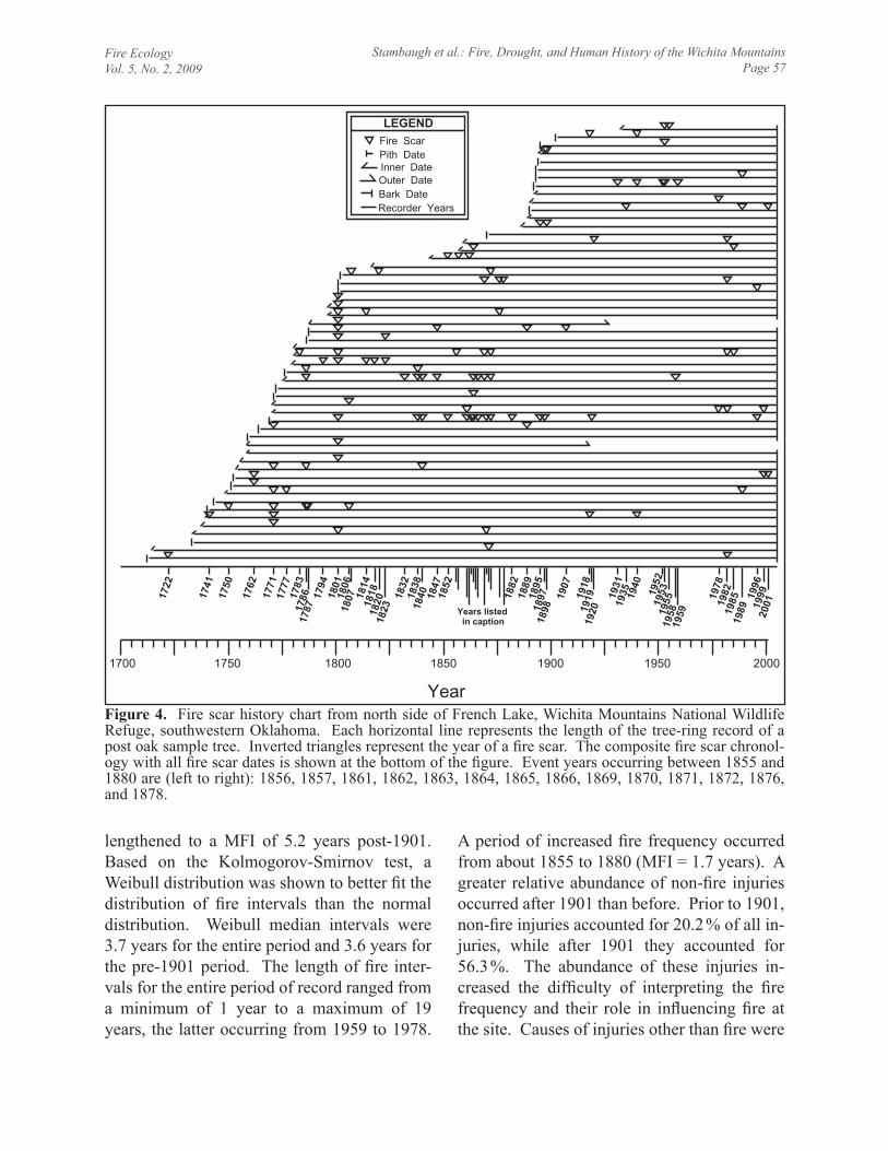
Fire EcologyVol. 5, No. 2, 2009
Stambaugh et al.: Fire, drought, and human history of the Wichita MountainsPage 57
LEGENDFire ScarPith DateInner DateOuter DateBark DateRecorder Years
1900 1950 20001850180017501700
Year
1722
1741
1750
1762
1771
1777
1783
1786
1787
1794
1801
1806
1807 18
1418
1818
2018
2318
3218
3818
40 1847
1852
1882
1889
1895
1897
1898
1907
1918
1919
1920
1931
1935 19
4019
5219
5319
5519
5819
59
1978
1982
1985
1989
1996
1999
2001
Years listed in caption
Figure 4. Fire scar history chart from north side of French Lake, Wichita Mountains National Wildlife Refuge, southwestern Oklahoma. Each horizontal line represents the length of the tree-ring record of a post oak sample tree. Inverted triangles represent the year of a fire scar. The composite fire scar chronol-ogy with all fire scar dates is shown at the bottom of the figure. Event years occurring between 1855 and 1880 are (left to right): 1856, 1857, 1861, 1862, 1863, 1864, 1865, 1866, 1869, 1870, 1871, 1872, 1876, and 1878.
lengthened to a MFI of 5.2 years post-1901. Based on the Kolmogorov-Smirnov test, a Weibull distribution was shown to better fit the distribution of fire intervals than the normal distribution. Weibull median intervals were 3.7 years for the entire period and 3.6 years for the pre-1901 period. The length of fire inter-vals for the entire period of record ranged from a minimum of 1 year to a maximum of 19 years, the latter occurring from 1959 to 1978.
A period of increased fire frequency occurred from about 1855 to 1880 (MFI = 1.7 years). A greater relative abundance of non-fire injuries occurred after 1901 than before. Prior to 1901, non-fire injuries accounted for 20.2 % of all in-juries, while after 1901 they accounted for 56.3 %. The abundance of these injuries in-creased the difficulty of interpreting the fire frequency and their role in influencing fire at the site. Causes of injuries other than fire were

Fire EcologyVol. 5, No. 2, 2009
Stambaugh et al.: Fire, drought, and human history of the Wichita MountainsPage 58
insects, spring frosts, and other unidentifiable causes possibly associated with land use activ-ities (e.g., grazing).
Fire severity (percentage of trees scarred) was temporally variable, with the most severe fires (except for the 2006 fire that killed the sample trees) occurring prior to 1901 (i.e., Euro-American settlement). The three most
severe fire years prior to 1901 occurred in a 30 year time span: 1771 (30 % scarred), 1786 (15 % scarred) and 1801 (36 % scarred). With respect to drought, 1785 and 1801 were ex-treme (Palmer Drought Severity Index [PDSI] < -4.0) (Figure 5). For the three most severe fire years, the average bearings of fire scars (i.e., assumed fire movement direction) on the
Figure 5. Timelines depicting changes in the fire environment at the Wichita Mountains. (A) bar graph of the number of fires per decade, (B) reconstructed Palmer Drought Severity Index (PDSI) (Cook et al. 2004) for southwestern Oklahoma (grey line) and a 7-point moving average (black line) emphasizing the lower frequency variability in drought. Triangles indicate fire event years at the study site, (C) timeline of chang-ing cultures and events during the period of fire history, (D) standardized ring-width index chronology of post oak trees (black line), chronology sample depth (grey bars), and pith dates of solid trees (n = 24).
Fire EcologyVol. 5, No. 2, 2009
Stambaugh et al.: Fire, drought, and human history of the Wichita MountainsPage 59
tree boles were 287° (1771, n = 7), 250° (1786, n = 4), and 357° (1801, n = 11), and suggest that all were west-to-north moving fires. After 1901, the most severe fire year was 1982 (10 % scarred), and fire events occurred during severe to extreme drought conditions (PDSI = <-2.99) in 1952 and 1953. Prolonged periods of drought corresponded with periods of annual to near-annual burning (e.g., 1856 to 1865 and the early 1950s). Percent of trees scarred was not significantly correlated with drought (PDSI), but more fire events occurred in drier conditions (n = 16) than wetter (n = 11). Al-though two of the three most severe fire years corresponded with severe droughts, the results of superposed epoch analysis suggested that no significant relationship between fire event years and drought conditions (including lagged conditions) existed when the full period of re-cord was considered.
Comparisons between refuge fire records since 1975 and those recorded by tree rings showed good, but not perfect, agreement. The 1978 fire scar was unverifiable due to an alter-ation in the fire notes (i.e., fire records indicate an event occurred either in 1975, 1978, or both). The 1982 dormant-season fire scar cor-responded to a February 1982 wildfire of un-known cause. The 1989 fire event correspond-ed to a January 1989 wildfire caused by vehi-cle sparks. A February 1993 prescribed fire event occurring throughout the study site was undetected through fire scars. The 1996 and 1999 fire scars were unverified by fire records. These scars were small, only represented by a partial scar on one sample, but we were unable to discount as fire events based on physical features and callus growth that mimicked those of fire scars. The 2001 dormant-season fire scar corresponded to a September 2000 wild-fire.
DISCUSSION
An abundance of fire scars were found that extended fire event information into the early
eighteenth century. In the Cross Timbers, only Clark et al. (2007) has used comparable meth-ods to quantify the pre-Euro-American period fire regime, and they found a similarly frequent fire occurrence. The two studies are similar in their pre-settlement period mean fire intervals (3.4 years and 4.4 years), but differ with re-spect to changes in fire frequency during the twentieth century. Although Clark et al. (2007) found fire intervals to be significantly short-ened; we found fire intervals to be relatively unchanged. Both studies found twentieth cen-tury fires to be less severe than those that oc-curred prior to Euro-American settlement. Clark et al. (2007) strongly implicated humans for the increased twentieth century burning. Burning of increased frequency, and some-times annual burning, continues to be a com-mon practice of ranchers managing grasslands. The fact that increased burning during the twentieth century did not occur at the Wichita Mountains site may be related to differences in land management and federal ownership.
Since 1901, the majority of the mountain-ous area has been under federal ownership; first as a forest reserve, then, in 1935, as part of the Wichita Mountains Wildlife Refuge, which currently encompasses 23 884 ha. Dur-ing the early twentieth century, refuge manag-ers used severe grazing of grasslands to re-move fuel in order to prevent wildfires (F. Rush, Wichita Mountains Wildlife Refuge, un-published report). Surveys from the early 1900s show that much of the area of the Wich-ita Mountains Wildlife Refuge was heavily grazed (F. Rose, Wichita Mountains Wildlife Refuge, unpublished report; Bruner 1931). In addition to bison and Rocky Mountain elk (Cervus elaphus), domestic cattle and horse grazing occurred at the preserve until 1937 (McCoy 1985). Currently, major herbivores include American bison, Texas longhorns (Bos taurus), white-tailed deer (Odocoileus virgin-ianus), and Rocky Mountain elk. In addition, a limited area in the central valley of the ref-uge consists of black-tailed prairie dog (Cyno-
Fire EcologyVol. 5, No. 2, 2009
Stambaugh et al.: Fire, drought, and human history of the Wichita MountainsPage 60
mys ludovicianus) towns with relatively sparse vegetation. In light of historic association of humans with fire, particularly in the midwest-ern USA (Guyette et al. 2002), it is highly likely that the fire regime experienced anthro-pogenic influences well before the establish-ment of the refuge.
Humans have occupied the Wichita Moun-tains for thousands of years (Wittry 1961). From 1550 to 1869, the area of the Wichita Mountains was inhabited first by Wichita and other Caddoan groups, eventually displaced by occupation of plains tribes such as Comanche, Kiowa, and Kiowa-Apache (Wittry 1961). By the 1830s the Kiowa had arrived in the region from the Black Hills and, with their Comanche allies, controlled a large portion of the south-ern plains (Schnell 2000). Beginning in 1836, the region was designated as Indian Territory by the US government, and Euro-American settlement was forbidden, although conflicts persisted throughout the nineteenth century. In 1869, Fort Sill was established in the south-eastern portion of the Wichita Mountains, while Kiowa, Comanche, and Plains Apache allotments were located throughout the moun-tain range. The area was one of the last of the Indian Territory to be opened to American set-tlement in 1901 (Schnell 2000).
Because of a lack of detailed human popu-lation information for the area, it is difficult to determine how humans and other related fac-tors such as climate may have differentially in-fluenced the fire regime. An example of this is the 1856-to-1865 period of increased fire fre-quency that corresponds to the Civil War drought and arrival of military parties that led to the eventual establishment of Fort Sill in 1869. The 1856-to-1865 Civil War drought af-fected much of the Great Plains and was one of the longest and most extreme droughts in at least the past 300 years, rivaling the Dust Bowl (Fye et al. 2003). The Civil War drought was associated with persistently colder than normal tropical Pacific Ocean sea surface temperatures
(la Niña conditions), suggesting that long-term variability in fire frequency was, at least in part, related to oceanic temperatures. In-creased human population density and con-flicts with occupying Native Americans also likely contributed to the increased frequency of fire events during this period—a feature of fire histories throughout the US. Though the Wichita Mountains area was not officially opened to non-Native Americans until 1901, much conflict occurred throughout the nine-teenth century as pressure mounted for the military to subdue Native Americans (Fran-caviglia 2000). Native Americans burned the prairie to drive away unwelcome parties and eliminate forage needed for their animals to graze (Courtwright 2007). The human contri-bution to more frequent fire during this period is further supported by the continuation of fre-quent fire events well after the Civil War drought ended.
Interestingly, tree growth was significantly decreased beginning with the Civil War drought, but the reduced growth rates persisted until about 1904. Many trees show a growth release circa 1904, which could be related to the establishment of the forest reserve (that later became the Wichita Mountains Wildlife Refuge) (Figure 5). Based on the pith dates of sample trees, a period of post oak tree recruit-ment appears to have occurred around 1890 to 1895. This cohort established following ap-proximately 20 years of frequent burning, and during a grazing transition from native herbi-vore to domestic animals. From a broad tem-poral perspective, the period of tree establish-ment represents a transition to less frequent fires compared to the previous century, plausi-bly with intervals long enough to allow trees to attain fire-resistant sizes. In the Great Plains, forest communities commonly relate to a gradient of species fire tolerance and forest density, whereby areas with more frequent fire are more likely to be dominated by fire toler-ant species and open forest structure (Ander-

Fire EcologyVol. 5, No. 2, 2009
Stambaugh et al.: Fire, drought, and human history of the Wichita MountainsPage 61
son 1990, Batek et al. 1999). The establish-ment and occurrence of post oak suggests a range of fire frequencies that may be relatively frequent (e.g., 4 yr to 20 yr) over a long period. Similarly, the establishment, encroachment rate, and extent of eastern redcedar is also a general clue to an even further decreased fre-quency or severity of fires as the species is very fire intolerant.
Fire Management
Although the specific role of humans in the historic fire regime may never be fully under-stood, the importance of humans to the future fire regime is certain. The fire history at Wich-ita Mountains demonstrates that relatively fre-quent fires have had a long-term presence. Maintaining historic fire frequencies will ne-cessitate a continued and active human role. The information from this study provides many clues about the historic fire regime that can be used to guide future fire management. The long-term presence of post oak at the study site suggests that no stand replacement fires have occurred in the vicinity over the last three centuries. This is not to say that stand replacement fires did not occur on more ex-posed sites during severe fire years. Very se-vere fires did historically occur as indicated by high percentages of trees scarred; however, these events appear to be limited in representa-tion to the pre-Euro-American settlement peri-od. In general, fires at the study site were typi-cally lower in severity with only minor injuries to trees. In fact, monitoring the extent of tree stem damage from prescribed fires is one method for comparing current fire severities to the historic. Fire severity is governed by many variables of the fire environment and its effects can be the result of infinite combinations of fire environment conditions. For example, a very fast moving wildfire through grassy fuels may be less severe in terms of scarring com-pared to a slower moving and longer duration fire burning leaf-litter and woody fuels.
Some historic fire regime characteristics may not be attainable through prescribed burn-ing. For example, historic severe fires com-monly occurred during extreme drought condi-tions. Burning during extreme drought condi-tions is not within most fire prescriptions; there-fore, attaining the severity and effects of these fires on vegetation may not be feasible. Histor-ic fires in extreme drought years were likely broad in their geographic extent. Additional fire history studies would be useful for under-standing historic fire sizes and the rotation in-tervals for the refuge. In addition, replicated sites would put these findings in better context and aid in understanding the ranges of historic fire frequency for the Cross Timbers region.
It is possible that all fires were not record-ed by the sample trees. Certainly, trees may not be perfect recorders of all fires, particularly fires of low intensity and patchy burn cover-age. The ability of a tree to record a fire de-pends on many tree and fire characteristics. Tree characteristics include physical character-istics (bark thickness), time of year (moisture content), time since last scar, tree size, age, growth rate (Guyette and Stambaugh 2004), and landscape position. Fire characteristics in-clude fuel type, load and condition, fire inten-sity, time of year, and the fire pattern. Despite many factors being important for scarring of post oak trees, they likely still have the poten-tial to very accurately record true fire frequen-cies. When many trees are used, they can even document extended periods of annual burning (Guyette and Stambaugh 2005, Shirakura 2006).
The 2006 prescribed fire was a severe event, killing a high proportion of mature trees in the study area. The event is an important example of the future of fire management in light of eastern redcedar encroachment. Due to years of fire suppression activities, and per-haps other less well-known conditions (e.g., altered moisture and grazing regime), redce-dars had been steadily encroaching throughout the site during the twentieth century (F. Rose,

Fire EcologyVol. 5, No. 2, 2009
Stambaugh et al.: Fire, drought, and human history of the Wichita MountainsPage 62
unpublished report; Gray 1998, Donnelly and Kimball 2005). Additionally, in the last 20 years, it appears that the site has experienced several of the wettest years of the last three centuries (Figure 5), perhaps leading to even more extensive redcedar encroachment. Prior to the 2006 fire event, mechanical operations were undertaken to kill redcedars, which,
when, burned resulted in a high intensity and high severity fire event that resulted in effects likely unprecedented at the site. In the future, fire managers are likely to be faced with simi-lar challenges that ultimately necessitate a phase of restoration followed by a phase of fire maintenance that uses fire history to mimic historic fire regimes.
ACKNOWLEDGEMENTS
This research was conducted as part of a Great Plains fire history study funded by the Nation-al Park Service through the Great Plains Cooperative Ecosystem Studies Unit (CESU). We thank Gary Willson (National Park Service) for aiding in identifying and assessing potential study sites within the southern plains. We thank Joe Kimball (retired) of the Wichita Mountains National Wildlife Refuge for his assistance in locating study sites, sample collection, and providing mean-ingful information about the ecology and history of the Wichita Mountains. We thank Kellen Harper for his assistance with tree-ring analysis, and Dan Dey, Stacy Clark, and one anonymous reviewer for providing editorial comments. The findings and conclusions in this article are those of the authors and do not necessarily represent the views of the US Fish and Wildlife Service.
LITERATURE CITED
Anderson, R.C. 1990. The historic role of fire in the North American grassland. Pages 8-18 in: S.L. Collins, and L.L. Wallace, editors. Fire in North American tallgrass prairies. University of Oklahoma Press, Norman, USA.
Axelrod, D.I. 1985. Rise of the grassland biome, central North America. Botanical Review 51(2): 163-201.
Batek, M.J., A.J. Rebertus, W.A. Schroeder, T.L. Haithcoat, E. Compas, and R.P. Guyette. 1999. Reconstruction of early nineteenth-century vegetation and fire regimes in the Missouri Ozarks. Journal of Biogeography 26: 397-412.
Bond, W.J., and B.W. van Wilgen. 1996. Fire and plants. Chapman and Hall, London.Braun, E.L. 1947. Development of the deciduous forests of eastern North America. Ecological
Monographs 17(2): 211-219.Brown, P.M. 2006. Climate effects on fire regimes and tree recruitment in Black Hills ponderosa
pine forests. Ecology 87: 2500-2510.Brown, P.M., and C.H. Sieg. 1999. Historical variability in fire at the ponderosa pine-northern
Great Plains prairie ecotone, southeastern Black Hills, South Dakota. Écoscience 6: 539-547.Bruner, W.E. 1931. The vegetation of Oklahoma. Ecological Monographs 1(2): 100-188.Buck, P. 1964. Relationships of the woody vegetation of the Wichita Mountains Wildlife Refuge
to geological formations and soil types. Ecology 45: 336-344.Chase, G.W., E.A. Frederickson, and W.E. Ham. 1956. Resumé of the geology of the Wichita
Mountains, Oklahoma. Pages 36-55 in: Ardmore Geological Society. Petroleum geology of southern Oklahoma. American Association of Petroleum Geologists.

Fire EcologyVol. 5, No. 2, 2009
Stambaugh et al.: Fire, drought, and human history of the Wichita MountainsPage 63
Clark, S.L. 2003. Stand dynamics of an old-growth in the Cross Timbers of Oklahoma. Disser-tation, Oklahoma State University, Stillwater, USA.
Clark, S.L., S.W. Hallgren, D.W. Stahle, and T. Lynch. 2005. Characteristics of the Keystone Ancient Forest Preserve, an old-growth forest in the Cross Timbers of Oklahoma. Natural Areas Journal 25: 165-175.
Clark, S.L., S.W. Hallgren, D.M. Engle, and D.W. Stahle. 2007. The historic fire regime on the edge of the prairie: a case study from the Cross Timbers of Oklahoma. Proceedings of the Tall Timbers Fire Ecology Conference 23: 40-49.
Cook, E.R. 1985. A time series analysis approach to tree ring standardization. Dissertation, Uni-versity of Arizona, Tucson, USA.
Cook, E.R., D.M. Meko, D.W. Stahle, and M.K. Cleaveland. 2004. North American summer PDSI reconstructions. World Data Center for Paleoclimatology Data Contribution Series #2004-045. <http://www.ncdc.noaa.gov/paleo/newpdsi.html>. Accessed 28 May 2009.
Coppedge, B.R., D.M. Engle, C.S. Toepfer, and J.H. Shaw. 1998. Effects of seasonal fire, bison grazing and climatic variation on tallgrass prairie vegetation. Plant Ecology 139: 235-246.
Courtwright, J.R. 2007. Taming the red buffalo: prairie fire on the Great Plains. Dissertation, University of Arkansas, Fayetteville, USA.
Donnelly, P., and C. Kimball. 2005. Wichita Mountains Wildlife Refuge: woodland canopy den-sity and extent monitoring 1942 to 2002. US Fish and Wildlife Service, Albuquerque, New Mexico, USA.
Dooley, K. 1983. Description and dynamics of some western oak forests in Oklahoma. Disser-tation, University of Oklahoma, Norman, USA.
Engle, D.M., T.G. Bidwell, and R.E. Masters. 1996. Restoring Cross Timbers ecosystems with fire. Transactions of the 61st North American Wildlife and Natural Resources Conference 61: 190-199.
Eskew, C.T. 1938. The flowering plants of the Wichita Mountains Wildlife Refuge. American Midland Naturalist 20: 695-703.
Falk, D.A., C. Miller, D. McKenzie, and A.E. Black. 2007. Cross-scale analysis of fire regimes. Ecosystems 10: 809-823.
Francaviglia, R.V. 2000. The cast iron forest: a natural and cultural history of the North Ameri-can Cross Timbers. University of Texas Press, Austin, USA.
Fulé, P.Z., J. Villanueva-Diaz, and M. Ramos-Gomez. 2005. Fire regime in a conservation re-serve in Chihuahua, Mexico. Canadian Journal of Forest Research 35: 320-330.
Fye, F.K., D.W. Stahle, and E.R. Cook. 2003. Paleoclimate analogs to twentieth-century mois-ture regimes across the United States. Bulletin of the American Meteorological Society 84(7): 901-909.
Gill, A.M. 1974. Towards an understanding of fire scar formation: field observation and labora-tory simulation. Forest Science 20: 198-205.
Gray, S.T. 1998. Woody plant expansion in mixed-grass prairies. Thesis, University of Oklaho-ma, Norman, USA.
Grissino-Mayer, H.D. 2001. FHX2-Software for analyzing temporal and spatial patterns in fire regimes from tree rings. Tree-Ring Research 57: 115-124.
Gutsell, S.L., and E.A. Johnson. 1996. How fire scars are formed: coupling a disturbance pro-cess to its ecological effect. Canadian Journal of Forest Research 26: 166-174.
Guyette, R.P., R. Muzika, and D.C. Dey. 2002. Dynamics of an anthropogenic fire regime. Eco-systems 5: 472-486.

Fire EcologyVol. 5, No. 2, 2009
Stambaugh et al.: Fire, drought, and human history of the Wichita MountainsPage 64
Guyette, R.P., M.A. Spetich, and M.C. Stambaugh. 2006a. Historic fire regime dynamics and forcing factors in the Boston Mountains, Arkansas, USA. Forest Ecology and Management 234: 293-304.
Guyette, R.P., and M.C. Stambaugh. 2004. Post oak fire scars as a function of diameter, growth, and tree age. Forest Ecology and Management 198: 183-192.
Guyette, R.P., and M.C. Stambaugh. 2005. Historic barrens forest structure and fire regimes as-sessment—interim report II. Missouri Tree-Ring Laboratory, University of Missouri, Colum-bia, USA.
Guyette, R.P., M.C. Stambaugh, R. Muzika, and E.R. McMurry. 2006b. Fire history at the south-western Great Plains margin, Capulin Volcano National Monument. Great Plains Research 16: 161-172.
Hoagland, B.W., I.H. Butler, and F.L. Johnson. 1999. The Cross Timbers. Pages 231-245 in: R.C. Anderson, J. Fralish, and J. Baskin, editors. The savanna, barren, and rock outcrop com-munities of North America. Cambridge University Press, New York, New York, USA.
Holmes, R.L. 1983. Computer-assisted quality control in tree-ring dating and measurements. Tree-Ring Bulletin 43: 69-78.
Kerby, J.D., S.D. Fuhlendorf, and D.M. Engle. 2007. Landscape heterogeneity and fire behavior: scale-dependent feedback between fire and grazing process. Landscape Ecology 22: 507-516.
Küchler, A.W. 1964. Potential natural vegetation of the conterminous United States. American Geographical Society, Special Publication 36.
Larson, F. 1940. The role of the bison in maintaining the short grass plains. Ecology 21: 113-121.
Licht, D.S. 1997. Ecology and economics of the Great Plains. University of Nebraska Press, Lincoln, USA.
Masters, R.E. 2000. Assessment of wildlife potential on the Canadian River Ranch. Blue Moun-tain Forestry and Wildlife Consulting, Fort Collins, Colorado, USA.
McCoy, W. 1985. Grassland management plan. Wichita Mountains Wildlife Refuge, Indiahoma, Oklahoma, USA.
National Climate Data Center [NCDC]. 1999. Monthly surface data. National Climate Data Center, Asheville, North Carolina, USA. <http://www.ncdc/noaa.gov/ http://cdo.ncdc.noaa.gov/climatenormals/clim81/OKnorm.pdf>. Accessed 28 May 2009.
Perryman, B.L., and W.A. Laycock. 2000. Fire history of the Rochelle Hills, Thunder Basin Na-tional Grasslands. Journal of Range Management 53: 660-665.
Schnell, S.M. 2000. The Kiowa homeland in Oklahoma. The Geographical Review 90(2): 155-176.
Shirakura, F. 2006. Tornado damage and fire history in the Cross Timbers of the Tallgrass Prairie Preserve, Oklahoma. Dissertation, Oklahoma State University, Stillwater, USA.
Smith, K.T., and E.K. Sutherland. 1999. Fire-scar formation and compartmentalization in oak. Canadian Journal of Forest Research 29: 166-171.
Stahle, D.W., J.G. Hehr, and G.G. Hawks, Jr. 1982. The development of modern tree-ring chro-nologies in the midwest: Arkansas, north Texas, Oklahoma, Kansas, and Missouri. Depart-ment of Geography, University of Arkansas, Fayetteville, USA.
Stambaugh, M.C., R.P. Guyette, E.R. McMurry, and D.C. Dey. 2006. Fire history at the eastern Great Plains margin, Missouri River loess hills. Great Plains Research 16: 149-159.

Fire EcologyVol. 5, No. 2, 2009
Stambaugh et al.: Fire, drought, and human history of the Wichita MountainsPage 65
Stambaugh, M.C., R.P. Guyette, E.R. McMurry, and J.M. Marschall. 2008a. Six centuries of fire history at Devils Tower National Monument with comments on a region-wide temperature influence. Great Plains Research 18: 177-187.
Stambaugh, M.C., K. Harper, J.M. Marschall, and R.P. Guyette. 2008b. Tree ring data, post oak. French Lake, Wichita Mountains, OK (OK032). International Tree-Ring Data Bank. <http://www.ncdc.noaa.gov/paleo/treering.html>. Accessed 28 May 2009.
Stokes, M.A., and T.L. Smiley. 1968. Introduction to tree-ring dating. University of Chicago Press, Illinois, USA.
Therrell, M.D., and D.W. Stahle. 1998. A predictive model to locate ancient forests in the Cross Timbers of Osage County, Oklahoma. Journal of Biogeography 25: 847-854.
Wittry, W.L. 1961. Review: an archeological survey of the Ft. Sill military reservation, Oklaho-ma, OASP Paper No. 18. American Antiquity 27(2): 254-255.
Wright, H.A., and A.W. Bailey. 1982. Fire ecology: United States and southern Canada. John Wiley & Sons, New York, New York, USA.

Appendix 3. This research note is in press with the journal Rangeland Ecology and Management
Fire History of a Relict Oak Woodland in Northeast Texas
Michael C. Stambaugh1, Jeff Sparks
2, Richard P. Guyette
3, and Gary Willson
4
Authors are 1Research Associate and
3Research Professor, Forestry Dept., University of
Missouri, Columbia, MO 65211, USA and 2State Parks Wildland Fire Program Manager, Texas
Parks and Wildlife Dept., Tyler, TX 75707, USA; 4 Great Plains CESU, 515 Hardin Hall,
University of Nebraska-Lincoln, Lincoln, NE 68583, USA.

ABSTRACT
Empirical data generated from fire scars are a foundation for understanding fire regimes,
designing land management objectives, and addressing long-term land use and climate change
effects. We derived precise dates of historic fires from fire scar injuries occurring on trees
growing in a relict post oak woodland in northeastern Texas. The fire event chronology shows
the last three centuries were marked with human influence with an overall trend of decreasing
fire occurrence through time. Thirty different fire events occurred between 1690 and 2007 of
which twenty six occurred prior to 1856. All fires occurred while trees were dormant. From
1690 to 1820, the mean fire interval was 6.7 years. A 50-yr period without fire occurred in the
latter 19th
century (1855-1905) and coincided with the establishment of an oak cohort. A second
extended period (80 yrs) without fire characterized most of the 20th
century. We hypothesize
that the absence of fire during much of the last century has resulted in increased tree density and
canopy closure, the establishment of fire-intolerant vines, shrubs, and trees, and likely the
decline of fire-dependent plant species. Information describing long-term changes of fire
regimes in oak woodlands in this region could aid in determining fire management objectives
with respect to prescribed fire implementation and community restoration.
KEY WORDS
dendrochronology; fire regime; fire frequency; fire suppression; fire scars; Caddo

INTRODUCTION
Dendrochronological (tree-ring) based records of fire occurrence are widely used for
characterizing historic fire regimes throughout the world. Their precision and accuracy make
them well suited for applications combining other high precision data such as vegetation,
climate, or historical records. In Texas, historic fire regimes have gone largely unquantified and
are currently limited to conifer forests in mountainous regions on the western border of the state
(Moir 1982; Sakulich and Taylor 2007; Poulos et al. 2009). In the southern Great Plains only a
few fire scar records are available (Clark et al. 2007, Stambaugh et al. 2009, DeSantis 2010),
however all describe a somewhat frequent fire regime (5-7 year) occurring in oak-grassland
ecosystems prior to EuroAmerican settlement. The value of these records pertains not just to
describing fire regimes, but also towards understanding long-term vegetation change, drought-
fire interactions, and the historical context for wildland and prescribed fire use in present day
natural resource management. The objective of this study was to reconstruct the long-term
changes in fire occurrence from fire scar injuries on trees at a relict oak woodland located in
northeastern Texas.
METHODS
Study Site
The study site was located at Purtis Creek State Park (lat 32° 21’ N, long 96° 00’ W) in
Henderson and Van Zandt Counties, Texas. Land for the 640-ha park began to be acquired in
the late 1970s and the park opened in 1988. The park lies in the Oak Woodlands Natural
Subregion of northeastern Texas (Arnold 1978) where the terrain is flat to rolling and elevation
is approximately 100 m a.s.l. The park is surrounded by private lands that consist of primarily
grasslands interspersed with forests. No major fire barriers (e.g., large rivers, rugged
topography, barren soils) exist nearby. Potential major fire barriers include the Trinity River and
Cedar Creek drainages located approximately 25 and 15 km to the southwest, respectively.
Climate is considered humid subtropical (Peel et al. 2007) and average annual precipitation is
106 cm (National Climate Data Center 2002).
The study site consists of an approximately 0.5-km2 area of rare old-growth post oak (Quercus
stellata Wangenh.) - sand post oak (Q. margaretta Ashe ex Small) savannah-woodland that has
recently experienced extensive mortality due to undetermined causes. Younger trees have
become established among the older dominant oaks and include Carya texana Buckl., Q.
marilandica Münchh., Ulmus alata Michx, and Juniperus virginiana L. Herbaceous and
understory vegetation ranges from sparse grass and sedge growth under dense canopy cover to
thick woody shrub and vine growth under more open canopy conditions (Keith 2009). The
abundance, presence, and sizes of fire sensitive species and a lack of external fire scars on trees
suggest that no fires have occurred at the site for at least several decades.
The location of the study site at the western edge of the Oak Woodlands and nearly adjacent to
the Blackland Prairie subregion provides a unique opportunity to describe the fire history in a
grassland-woodland transition zone at the southern periphery of the tallgrass prairie ecosystem.
Some information (based on expert opinions) regarding the natural role of fire is available for the
Blackland Prairie subregion, though no quantitative fire history descriptions exist. The pre-
EuroAmerican settlement period fire frequency of the Blackland Prairie was probably

comparable to more northern tallgrass prairie regions (~3 to 5 years, Wright and Bailey 1982)
though higher temperatures and a longer growing season may have led to some climate-induced
differences (Smeins 1972).
Field and Laboratory Methods
In February 2009, fire scarred trees were located by surveying the entire study area. Prior to
cutting the boles of trees were “sounded” using a hammer to assess the degree of solid-hollow
wood. Forty-nine cross-sections were cut from near the ground level of only dead oaks. All
sample locations were recorded using a GPS. Slope, aspect, and orientation were written on each
cross-section. In the laboratory, cross-sections were surfaced with an electric hand planer and
sanded to reveal the annual rings and fire scars. We measured the radius (pith-to-bark ring
series) of each cross-section that had the least amount of ring-width variability due to reaction
wood, injury, or callus tissue. The radius measurement location was also chosen to maximize the
number of rings measured. Ring-width plots were used for visual cross-matching of ring-width
signature years. Visual matching of ring-width patterns allows the weighing of important
"signature years" over years with low common variability among trees. Plots and matching of
known frost ring years (Stahle 1999) aided in ensuring accurate dating. COFECHA, software for
quality control and crossdating of tree-ring measurements (Holmes et al. 1986), was also used to
ensure the accuracy of both relative and absolute dating of the samples by correlation analysis.
Absolute dating was accomplished by crossdating with cores collected from live trees. The
master ring-width chronology was compared with other nearby oak chronologies (Stahle et al.
1982).
Fire scars were identified by the presence of callus tissue, charcoal, barrier zones, and cambial
injury. Fire scar dates were assigned to the year. If possible to view, the season of the fire event
was recorded based on the position of the cambial response to injury either within the ring (early
to late growing season) or between rings (dormant season) (Kaye and Swetnam 1999). Fire scar
data were summarized from the composite fire chronology – a compilation of all fire years
recorded at the site. Fire scar data analysis software, FHX2, (Grissino-Mayer 2001) was used to
plot the fire scar data and for performing statistical analysis of fire events. Composite fire
chronologies are commonly used to describe fire regimes because statistics describing events are
based on many samples leading to a more accurate representation of the presence of fire at a
particular site than would be obtained from single trees. Not all trees may be scarred in a fire
because of the variation in fire behavior, fuels, and tree characteristics (e.g., size, bark thickness),
thus several trees at a site are combined to give a better estimate of fire frequency. Furthermore,
it should be noted that very low intensity fires may not leave scars on trees therefore fire
intervals represent maximum intervals for the period of record.
RESULTS
The post oak tree-ring record spanned the period 1681 to 2007 (327 years) (Figure 1). Post oak
tree ages ranged from 66 to 321 years. Ages of trees suggested a bimodal age distribution with
trees of approximately 315 and 140 years in age. The older cohort of trees established circa 1690
and lived through a century of repeated and likely low severity fires. The younger cohort of trees
established at the beginning of a 50-yr period without fire that began in 1855 (Figure 1).

Eighty-three fire scars were identified and dated between 1690 and 1924 resulting in 30
different fire events. Based on the timing of cambial response to fire injuries, all fire scars with a
determinable seasonality showed to occur during the dormant growth season. Based on the
percentage of trees scarred in a given year, the most severe fire occurred in 1704, when 7 of 19
trees were fire scarred (37%). The full period (1690-1924) mean fire interval was 8.1 years, but
ranged from 2 to more than 50 years. Prior to 1820 (estimated beginning of major
EuroAmerican land settlement), the mean fire interval was 6.7 years. A 50-yr period without fire
occurred in the second half of the 19th
century (1855-1905). The longest period without fire
occurred from 1924 to 2007 (the end year of the tree growth record). Immediately after the study
site was sampled, however, the area was treated with prescribed fire with the objectives of
reducing fuel loads, controlling invasive woody species, and increasing herbaceous species
richness and cover.
DISCUSSION
It is nearly impossible to positively identify causes of prehistoric fire events (natural vs.
anthropogenic). Often the relative importance of ignition sources from modern observations and
information on historic cultural fire use are used to infer importance of past ignition sources.
From long-term fire scar history studies of oak woodlands in the Ozarks and Cross Timbers,
temporal changes of fire events (e.g., frequency, severity, seasonality) have been shown to
coincide with changes in culture and population (Guyette et al. 2002, Clark et al. 2007,
Stambaugh et al. 2009). Perhaps less well known is the historic importance of lightning
ignitions. Specifically, an estimate is needed of the numbers of lightning ignitions that would be
required to maintain historic burning frequencies considering the vegetation conditions, potential
of fire sizes, and fire compartment sizes in the plains.
The majority of historic fires recorded at Purtis Creek occurred during the Historic Caddoan
period (AD 1680-1860), a period of increasing trade and cultural exchange among Hasinai
Caddo and Europeans in the region (Perttula 1992). The use of fire by Caddo groups is relatively
unknown. Pollen evidence from nearby Upshur County, Texas has been used to suggest that the
Caddo manipulated their environment through burning (Albert 2007). Fire scars from central
Louisiana also associates Caddo occupation with very frequently burned longleaf pine (Pinus
palustris) (Stambaugh et al. in review). In addition to the Caddo, eastern Native American tribes
(Cherokee, Shawnee, Delaware, and Kickapoo) migrated to the northeastern Texas region circa
1820 until they were forced further west in 1839. These eastern Native American tribes have a
more well-documented history of intentional burning of land (Pyne 1983, DeVivo 1991, Guyette
et al. 2002, Guyette et al. 2006b), and likely influenced the rate of ignitions during this period.
Concerning the fire history record prior to settlement at Purtis Creek, though it may be
impossible to more closely decipher the degree to which fires were of natural or anthropogenic
origin, the overall decrease in fire post-1850’s compared to before strongly implicates cultural
changes as a significant influence on the fire regime.
Following the earliest Euro-American settlement in the area in 1839, a period of about 15 years
occurred when fires still burned at regular intervals. Not much information is available about
these earliest years of settlement, though settlement occurred relatively slowly in the beginning.
The four original land grantees of the current Purtis Creek State Park lands were most likely
absentee landowners and never actually lived on or cultivated their lands (McNatt et al. 1998).
Beginning in the 1850’s expansion of agriculture and population centers began in earnest,

synchronous with the beginning of the 50-year fire free period at Purtis Creek. This period
without fire appears to correspond to the period of greatest economic and agricultural expansion.
Roads were constructed in the 1850’s, the last Caddo were relocated in 1859, and the arrival of
railroads by 1880 caused an immediate increase in population and settlements (McNatt et al.
1998).
The topography and surrounding landscape of the study site also likely influenced fire
occurrence throughout the period of record. The area is bounded to the south and east by a
perennial creek and bottomland forest, which may have acted as a break for fires approaching
from the south. Sometime after settlement the land immediately north of the study area was used
as agricultural field and, depending on land use and season, could have restricted fires from
reaching the study site.
Four fire events occurred in the early 20th
century and despite being relatively recent, no
records have been found that indicate the origin or extent of these fires. Changes in land
ownership may be one possible explanation for this cluster of fire events.
Overall, the fire frequency at Purtis Creek prior to EuroAmerican settlement was very close to
previously published fire frequency estimates for the region. Frost (1998) suggested historic fire
frequency ranged from four to six years based on fire history studies, landforms, and vegetation
characteristics. Guyette et al. (2006a) estimated a fire frequency of four to five years based on
coarse-scale climate conditions and human population density estimates. Despite both of these
sources being coarse-scale estimates, our fire scar evidence supports that their ranges of
estimates are plausible for this region.
MANAGEMENT IMPLICATIONS
Quantitative fire history information, such as fire frequency, seasonality, and severity can guide
prescribed burning programs and help managers develop specific fire effects goals. The fire
history of Purtis Creek may also provide insight to the potential fire regime characteristics of
other oak savanna-woodland communities in Texas and southern Great Plains- a region where
relatively frequent fire was likely a significant ecological influence. Purtis Creek State Park is
representative of many public lands where managers face challenges in restoring or maintaining
natural communities following decades of fire suppression. Accumulations of fine fuel loads and
dense woody understories have increased the risk of wildfires and prescribed fires having
relatively severe effects. As a result of decades without fire invasive fire-sensitive plant
populations (e.g. eastern redcedar, Smilax sp., yaupon) have expanded while populations of fire-
dependent plant species (e.g. Yucca freemanii) are increasingly rare (Keith 2009). Park
managers seek to convert old fields to savannahs or woodlands and restore native forb and grass
diversity (Keith 2009).
LITERATURE CITED
Albert, B.M. 2007. Climate, fire, and land-use history in the oak-pine-hickory forests of
northeast Texas during the past 3500 years. Castanea 72:82-91.
Arnold, K. 1978. Preserving Texas’ natural heritage. LBJ School of Public Affairs Policy
Research Project Report 31. Austin, TX, USA: University of Texas Press.

Clark, S.L., S.W. Hallgren, D.M. Engle, and D.W. Stahle. 2007. The historic fire regime on the
edge of the prairie: a case study from the Cross Timbers of Oklahoma. Proceedings of the Tall
Timbers Fire Ecology Conference 23: 40-49.
DeSantis, R.D. 2010. Effects of fire and climate on compositional and structural changes in
upland oak forests of Oklahoma. PhD Dissertation, Oklahoma State University. 135 pp.
DeVivo, M.S. 1991. Indian use of fire and land clearance in the southern Appalachians. In: S.C.
Nodvin and T.A. Waldrop (eds.). Fire and the Environment: ecological and cultural perspectives.
Proceedings of an International symposium. USDA For. Serv. Gen. Tech. Rep. SE-69. Asheville,
NC. pp. 306-310.
Frost, C.C. 1998. Presettlement fire frequency regimes of the United States: a first
approximation. In: T.L. Pruden and L.A. Brennan (EDS.). Fire in ecosystem management:
shifting the paradigm from suppression to prescription. Tall Timbers Fire Ecology Conference
Proceedings, No. 20. Tallahassee, FL, USA: Tall Timbers Research Station. p. 70-81.
Grissino-Mayer, H.D. 2001. FHX2-Software for analyzing temporal and spatial patterns in fire
regimes from tree rings. Tree-Ring Research 57:115-24.
Guyette, R.P., D.C. Dey, M.C. Stambaugh, and R. Muzika. 2006a. Fire scars reveal variability
and dynamics of eastern fire regimes. In: M.B. Dickinson (ED.) Fire in eastern oak forests:
delivering science to land managers, proceedings of a conference; 15-27 November 2005;
Columbus, OH, USA. Newtown Square, PA, USA: U.S. Department of Agriculture, Forest
Service, GTR-NRS-P-1. p. 20-39.
Guyette, R.P., Muzika, R.M., and D.C. Dey. 2002. Dynamics of an anthropogenic fire regime.
Ecosystems 5:472-486.
Guyette, R.P., M.A. Spetich, and M.C. Stambaugh. 2006b. Historic fire regime dynamics and
forcing factors in the Boston Mountains, Arkansas, USA. Forest Ecology and Management
234:293-304.
Holmes, R.L., H.K. Adams, and H. Fritts. 1986. Quality control crossdating and measuring.
Tucson, AZ, USA: Laboratory of Tree-Ring Research, University of Arizona.
Kaye, M.W. and T.W. Swetnam. 1999. An assessment of fire, climate, and Apache history in the
Sacramento Mountains, New Mexico, USA. Physical Geography 20(4):305-330.
Keith, E. 2009. Plant community, fuel model, and rare species assessment for Purtis Creek State
Park. Huntsville, TX, USA: Raven Environmental Services. 10 p.
McNatt, L., M. Howard, S.E. Kirtland, T. Myers, E. Morley, and P. Schuchert. 1998.
Archeological survey and history of Purtis Creek State Park, Henderson and Van Zandt counties,
Texas. Texas Parks and Wildlife Department Cultural Resources Program, Austin, TX. 123 pp.

Moir, W.H. 1982. A fire history of the High Chisos, Big Bend National Park, Texas. The
Southwestern Naturalist 27:87-98.
National Climate Data Center [NCDC]. 2002. Monthly surface data. Available at:
http://cdo.ncdc.noaa.gov/climatenormals/clim81/TXnorm.pdf. Accessed June 2010.
Peel, M. C., B.L. Finlayson, and T.A. McMahon. (2007). Updated world map of the Köppen-
Geiger climate classification. Hydrology and Earth System Sciences 11:1633-1644.
Perttula, T.K. 1992. The Caddo nation: archaeological and ethnohistoric perspectives. Austin,
TX, USA: University of Texas Press. 326 p.
Poulos, H.M., R.G. Gatewood, and A.E. Camp. 2009. Fire regimes of the piñon-juniper
woodlands of Big Bend National Park and the Davis Mountains, west Texas, USA. Canadian
Journal of Forest Research 39:1236-1246.
Pyne, S. 1983. Indian fires: the fire practices of North American Indians transformed large areas
from forest to grassland. Natural History 92:6-11.
Sakulich, J. and A.H. Taylor. 2007. Fire regimes and forest structure in a sky island mixed
conifer forest, Guadalupe Mountains National Park, Texas, USA. Forest Ecology and
Management 241:62-73.
Smeins, F. E. 1972. Influence of fire and mowing on vegetation of the Blackland Prairie of
Texas. Pages 4-7 in Hulbert, L.C. (ed.) Third Midwest Prairie Conference Proceedings.
Manhattan, KS.
Stahle, D.W. 1999. The tree-ring record of false spring in the southcentral USA [dissertation].
Tempe, AZ, USA: Arizona State University. 272 p.
Stahle, D.W., J.G. Hehr, and G.G. Hawks, Jr. 1982. The development of modern tree-ring
chronologies in the Midwest: Arkansas, North Texas, Oklahoma, Kansas, and Missouri.
Washington, D.C., USA: National Science Foundation, Final Technical Report submitted to the
Climate Dynamics Program.
Stambaugh, M.C., R.P. Guyette, R. Godfrey, E.R. McMurry, and J.M. Marschall. 2009. Fire,
drought, and human history near the western terminus of the Cross Timbers, Wichita Mountains,
Oklahoma, USA. Fire Ecology 5(2): 51-65.
Stambaugh, M.C., R.P. Guyette, and J.M. Marschall. In review. Longleaf pine (Pinus palustris
Mill.) fire scars reveal new details of a frequent fire regime. Journal of Vegetation Science.
Wright, H.A. and A.W. Bailey. 1982. Fire ecology. New York, NY, USA: John Wiley and Sons.
501 p.

Figure 1. Fire scar history chart of Purtis Creek State Park, Texas. Each horizontal line
indicates the tree-ring record of an individual tree. The left ends of horizontal lines are capped
with either a vertical line that indicates the pith of tree or a diagonal line that indicates the
innermost ring (in case where tree center is hollow or rotten). The right ends of horizontal lines
are capped with either a vertical line that indicates the bark year or a diagonal line that indicates
the outermost ring (in case where outer wood is rotten or removed). Bold vertical ticks along
horizontal lines represent fire years based on fire scars. All fire scar dates are included in the x-
axis composite (bottom of chart).

Appendix 4. Great Plains fire references
(additional references are listed in Chapter 5. Literature Cited and references of articles)
Climate and Fire
Anderson, R. C. (1982). An evolutionary model summarizing the roles of fire, climate, and grazing
animals in the origin and maintenance of grasslands: an end paper. Grasses and grasslands:
systematics and ecology. J. R. Estes, R. J. Tyrl and J. N. Brunken. Norman, Oklahoma,
University of Oklahoma Press: 297-308.
Barry, R. G. (1983). Climatic environment of the Great Plains, past and present. Man and the
changing environments in the Great Plains, a special issue of the Transactions of the Nebraska
Academy of Sciences. W. W. Caldwell, C. B. Schultz and T. M. Stout. 11 (Special Issue): 45-55.
Benson, R. P. and M. P. Murphy (2003). Wildland fire in the Black Hills. 2nd International Wildland
Fire Ecology and Fire Management Congress and 5th Symposium on Fire and Forest
Meteorology, Orlando, FL, American Meteorological Society, Boston.
Brown, P. M. (2003). Fire, climate, and forest structure in ponderosa pine forests of the Black Hills.
Forest, Rangeland, and Watershed Stewardship. Fort Collins, Colorado State University. PhD.
Brown, P. M. (2006). "Climate effects on fire regimes and tree recruitment in Black Hills ponderosa
pine forests." Ecology 87(10): 2500-2510.
Brown, P. M. and B. Cook (2006). "Early settlement forest structure in Black Hills ponderosa pine
forests." Forest ecology and management 223: 284-290.
Brown, P. M. and R. Wu (2005). "Climate and disturbance forcing of episodic tree recruitment in a
southwestern ponderosa pine landscape." Ecology 86(11): 3030-3038.
Chang, F. C. and E. A. Smith (2001). "Hydrological and dynamical characteristics of summertime
droughts over U.S. Great Plains." Journal of Climate 14: 2296-2316.
Clark, J. S., E. C. Grimm, et al. (2002). "Drought cycles and landscape responses to past aridity on
prairies of the northern Great Plains, USA." Ecology 83(3): 595-601.
Clark, J. S., E. C. Grimm, et al. (2001). "Effects of Holocene climate change on the C4 grassland/
woodland boundary in the northern plains, USA." Ecology 82(3): 620-636.
Higgins, K. F. (1984). "Lightning fires in North Dakota grasslands and in pine-savanna lands of
South Dakota and Montana." Journal of Range Management 37(2): 100-103.
Hogg, E. H. (1994). "Climate and the southern limit of the western Canadian boreal forest." Canadian
Journal of Forest Research 24(9): 1835-1845.
Laird, K. R., S. C. Fritz, et al. (1996). "Century-scale paleoclimatic reconstruction from Moon Lake,
a closed-basin lake in the northern Great Plains." Limnology and Oceanography 41(5): 890-902.
Laird, K. R., S. C. Fritz, et al. (1996). "Greater drought intensity and frequency before AD 1200 in
the northern Great Plains, USA." Nature 384: 552-554.
Meko, D. M. (1995). Dendroclimatic evidence from the Great Plains of the United States. Climate
since A.D. 1500. R. S. Bradley and P. D. Jones. New York, Routledge: 312-330.
Miao, X., J. A. Mason, et al. (2005). "Loess record of dry climate and aeolian activity in the early- to
mid-Holocene, central Great Plains, North America." The Holocene 15(3): 339-346.
Shapley, M. D., W. C. Johnson, et al. (2005). "Late-Holocene flooding and drought in the Northern
Great Plains, USA, reconstructed from tree rings, lake sediments and ancient shorelines." The
Holocene 15(1): 29-41.
Sieg, C. H., D. M. Meko, et al. (1995). An analysis of drought in the northern Great Plains: summary
of progress. Interior West Global Change Workshop. Fort Collins, CO, USDA Forest Service,
Rocky Mountain Forest and Range Experiment Station: 20-22.

Sieg, C. H., D. M. Meko, et al. (1996). Dendroclimatic potential in the northern Great Plains. Tree
Rings, Environment, and Humanity, Tucson, AZ, Radiocarbon.
Stahle, D. W. and M. K. Cleaveland (1988). "Texas drought history reconstructed and analyzed from
1698 to 1980." Journal of Climate 1(1): 59-74.
Stahle, D. W. and J. G. Hehr (1984). "Dendroclimatic relationships of post oak across a precipitation
gradient in the southcentral United States." Annals of the Association of American Geographers
74(4): 561-573.
Stockton, C. W. and D. M. Meko (1983). "Drought recurrence in the Great Plains as reconstructed
from long-term tree-ring records." Journal of Climate and Applied Meteorology 22: 17-29.
Touchan, R., C. D. Allen, et al. (1996). Fire history and climatic patterns in ponderosa pine and
mixed-conifer forests of the Jemez Mountains, northern New Mexico. Fire effects in
southwestern forests: proceedings of the second La Mesa Fire symposium, Los Alamos, NM,
USDA-Rocky Mountain Forest and Range Experiment Station.
Swetnam, T. W. and C. H. Baisan (1996). Historical fire regime patterns in the southwestern United
States since AD 1700. Fire effects in southwestern forests, proceedings of the second La Mesa
fire symposium. C. D. Allen. Los Alamos, NM, USDA Forest Service, Rocky Mountain Forest
and Range Experiment Station: 11-32.
Swetnam, T. W. and J. L. Betancourt (1998). "Mesoscale disturbance and ecological response to
decadal climatic variability in the American southwest." Journal of Climate 11: 3128-3147.
Umbanhowar, C. E., Jr. (2004). "Interactions of climate and fire at two sites in the northern Great
Plains, USA." Palaeogeography, Palaeoclimatology, Palaeoecology 208: 141-152.
Valero-Garces, B. L. and K. R. Laird (1997). "Holocene climate in the northern Great Plains inferred
from sediment stratigraphy, stable isotopes, carbonate geochemistry, diatoms, and pollen at
Moon Lake, North Dakota." Quaternary Research 48: 359-369.
Weakly, H. E. (1943). "A tree-ring record of precipitation in western Nebraska." Journal of Forestry
41: 816-819.
Vegetation and Fire
Abrams, M. D. (1988). "Effects of prescribed fire on woody vegetation in a gallery forest understory
in northeastern Kansas." Transactions of the Kansas Academy of Science 91(3-4): 63-70.
Ahlstrand, G. M. (1979). Memorandum on Capulin Mountain National Monument to the National
Park Service. Texas Tech University, Lubbock, Cooperative Park Studies Unit, Dept. of Range
and wildlife management: 4.
Anderson, H. G. and A. W. Bailey (1980). "Effects of annual burning on grassland in the aspen
parkland of east-central Alberta." Canadian Journal of Botany 58(8): 985-996.
Anderson, K. L. (1965). "Time of burning as it affects soil moisture in an ordinary upland bluestem
prairie in the Flint Hills." Journal of Range Management 18(6): 311-316.
Anderson, R. C. and L. E. Brown (1983). "Comparative effects of fire on trees in a midwestern
savannah and an adjacent forest." Bulletin of the Torrey Botanical Club 110(1): 87-90.
Anderson, R. C. and L. E. Brown (1986). "Stability and instability in plant communities following
fire." American Journal of Botany 73(3): 364-368.
Ansley, R. J. and M. J. Castellano (2006). "Strategies for Savanna Restoration in the Southern Great
Plains: Effects of Fire and Herbicides." Restoration Ecology 14(3): 420-428.
Arno, S. F., J. H. Scott, et al. (1995). Age-class structure of old growth ponderosa pine/douglas-fir
stands and its relationship to fire history. Research Paper, USDA Forest Service, Intermountain
Research Station.

Baker, W. L. (2006). "Fire and restoration of sagebrush ecosystems." Wildlife Society Bulletin 34(1):
177-185.
Baker, W. L. and D. J. Shinneman (2004). "Fire and restoration of pinon-juniper woodlands in the
western United States: a review." Forest ecology and management 189: 1-21.
Biswell, H. H. (1972). "Fire ecology in ponderosa pine-grassland." Proceedings Tall Timbers Fire
Ecology Conference 12: 69-96.
Bjugstad, A. J. and M. M. Girard (1985). Wooded draws in rangelands of the northern Great Plains.
Guidelines for Increasing Wildlife on Farms and Ranches. F. R. Henderson. Manhattan, KS,
Great Plains Agricultural Council Wildlife Resources Committee and Cooperative Extension
Service Kansas State University: 27-36.
Bock, J. H. and C. E. Bock (1984). "Effect of fire on woody vegetation in the pine-grassland ecotone
of the southern Black Hills." American Midland Naturalist 112(1): 35-42.
Boldt, C. E., R. R. Alexander, et al. (1983). Interior ponderosa pine in the Black Hills. Silvicultural
systems for the major forest types of the United States. Agricultural Handbook 445. Washington,
D.C., U.S. Department of Agriculture: 80-83.
Bonnet, V. H., A. W. Schoettle, et al. (2005). "Postfire environmental conditions influence the spatial
pattern of regeneration for pinus ponderosa." Canadian Journal of Forest Research 35: 37-47.
Bork, E. W., R. J. Hudson, et al. (1997). "Upland plant community classification in Elk Island
national park, Alberta, Canada, using disturbance history and physical site factors." Plant
Ecology 130: 171-190.
Brown, R. W. (1971). "Distribution of plant communities in southeastern Montana Badlands."
American Midland Naturalist 85(2): 458-477.
Briggs, J. M., A. K. Knapp, et al. (2002). "Expansion of woody plants in tallgrass prairie: a fifteen-
year study of fire and fire-grazing interactions." American Midland Naturalist 147: 287-294.
Brown, J. K. and J. K. Smith, Eds. (2000). Wildland fire in ecosystems: effects of fire on flora.
General Technical Report RMRS-GTR-42-vol.2. Ogden, UT, USDA Forest Service, Rocky
Mountain Research Station.
Butler, J., H. Goetz, et al. (1986). "Vegetation and soil-landscape relationships in the North Dakota
Badlands." American Midland Naturalist 116(2): 378-386.
Churchill, S. P., C. C. Freeman, et al. (1988). "The vascular flora of the Niobrara Valley Preserve and
adjacent areas in Nebraska." Transactions of the Nebraska Academy of Sciences 16: 1-15.
Clark, S. L. (2003). Stand dynamics of an old-growth oak forest in the Cross Timbers of Oklahoma.
Plant Science. Stillwater, Oklahoma State University. PhD dissertation: 193.
Collins, S. L. (1990). Introduction: Fire as a natural disturbance in tallgrass prairie ecosystems. Fire
in North American tallgrass prairies. S. L. Collins and L. L. Wallace. Norman and London,
University of Oklahoma Press: 3-7.
Crow, T. R., W. C. Johnson, et al. (1994). "Fire and recruitment of Quercus in a postagricultural
field." American Midland Naturalist 131: 84-97.
Diamond, D. D., G. A. Rowell, et al. (1995). "Conservation of Ashe Juniper (Juniperus ashei
Buchholz) woodlands of the central Texas Hill Country." Natural Areas Journal 15(2): 189-197.
Engle, D. M. and T. G. Bidwell (2001). "The response of central North American prairies to seasonal
fire." Journal of Range Management 54: 2-10.
Grant, T. A. and R. K. Murphy (2005). "Changes in woodland cover in prairie refuges in North
Dakota, USA." Natural Areas Journal 25(4): 359-368.
Guthery, F. S. and F. A. Stormer (1982). "Brush, brush control, and wildlife in Texas." Proceedings-
Great Plains Agricultural Council: 1-6.

Hadley, E. B. (1970). "Net productivity and burning responses of native eastern North Dakota prairie
communities." American Midland Naturalist 84(1): 121-135.
Hall, S. and S. Valastro (1995). "Grassland Vegetation in the Southern Great Plains during the Last
Glacial Maximum." Quaternary Research 44(2): 237-245.
Harrell, W. C., S. D. Fuhlendorf, et al. (2001). "Effects of prescribed fire on sand shinnery oak
communities." Journal of Range Management 54: 685-690.
Hoy, J. F. and T. D. Isern (1995). "Bluestem and tussock: fire and pastoralism in the Flint Hills of
Kansas and the tussock grasslands of New Zealand." Great plains quarterly 15: 169-184.
Hutcheson, A., J. T. Baccus, et al. (1989). "Response of herbaceous vegetation to prescribed burning
in the Hill Country of Texas." Texas Journal of Agriculture and Natural Resources 3: 42-47.
Kaul, R. B., G. E. Kantak, et al. (1988). "The Niobrara River Valley, a postglacial migration corridor
and refugium of forest plants and animals in the grasslands of central North America." The
Botanical Review 54(1): 44-81.
Lundquist, J. E. and J. F. Negron (2000). "Endemic forest disturbances and stand structure of
ponderosa pine (Pinus ponderosa) in the Upper Pine Creek Research Natural Area, South
Dakota, USA." Natural Areas Journal 20(2): 126-132.
Miller, R. F. and R. J. Tausch (2001). The role of fire in juniper and pinyon woodlands: a descriptive
analysis. Proceedings of the Invasive Species Workshop: the Role of Fire in the Control and
Spread of Invasive Species. Fire Conference 2000: the first national congress on fire ecology,
prevention, and management. K. E. M. Galley and T. P. Wilson. Tallahassee, FL, Tall Timbers
Research Station. Miscellaneous Publication No. 11: 15-30.
Morgan, T. A., C. E. Fiedler, et al. (2002). "Characteristics of dry site old-growth ponderosa pine in
the Bull Mountains of Montana, USA." Natural Areas Journal 22(1): 11-19.
Shay, J., D. Kunec, et al. (2001). "Short-term effects of fire frequency on vegetation composition and
biomass in mixed prairie in south-western Manitoba." Plant Ecology 155: 157-167.
Sparks, J. C. and R. E. Masters (1996). "Fire seasonality effects on vegetation in mixed-, tall- and
southeastern pine-grassland communities: a review." Transactions of the 61st North American
Wildlife and Natural Resources Conference 61: 246-255.
Steuter, A. A., B. Jasch, et al. (1990). "Woodland/grassland boundary changes in the middle Niobrara
Valley of Nebraska identified by delta 13C values of soil organic matter." American Midland
Naturalist 124(2): 301-308.
Trlica, M. J., Jr. and J. L. Schuster (1969). "Effects of fire on grasses of the Texas High Plains."
Journal of Range Management 22(2): 329-333.
Wells, P. V. (1970). "Postglacial vegetational history of the Great Plains." Science 167(3925): 1574-
1582.
Wells, P. V. (1983). "Late quaternary vegetation of the Great Plains." Transactions of the Nebraska
Academy of Sciences XI (Special Issue): 83-89.
Grazing and Fire
Antos, J. A., B. McCune, et al. (1983). "The effect of fire on an ungrazed western Montana
grassland." American Midland Naturalist 110(2): 354-364.
Bachelet, D., J. M. Lenihan, et al. (2000). "Interactions between fire, grazing and climate change at
Wind Cave National Park, SD." Ecological Modelling 134: 229-244.
Baisan, C. H. and T. W. Swetnam (1997). Interactions of fire regimes and land use in the central Rio
Grande Valley, USDA Forest Service, Rocky Mountain Forest and Range Experiment Station.

Bragg, T. B. and L. C. Hulbert (1976). "Woody plant invasion of unburned Kansas bluestem prairie."
Journal of Range Management 29(1): 19-29.
Pfeiffer, K. E. and A. A. Steuter (1994). "Preliminary response of sandhills prairie to fire and bison
grazing." Journal of Range Management 47: 395-397.
Savage, M. (1991). "Structural dynamics of a southwestern pine forest under chronic human
influence." Annals of the Association of American Geographers 81(2): 271-289.
Touchan, R., T. W. Swetnam, et al. (1995). Effects of livestock grazing on pre-settlement fire
regimes in New Mexico. Symposium on fire in wilderness and park management, Missoula, MT,
USDA Forest Service, Intermountain Research Station, Ogden, UT.
Valone, T. J. and D. A. Kelt (1999). "Fire and grazing in a shrub-invaded arid grassland community:
independent or interactive ecological effects?" Journal of Arid Environments 42: 15-28.
Willms, W. D., J. F. Dormaar, et al. (2002). "Response of the mixed prairie to protection from
grazing." Journal of Range Management 55(3): 210-216.
Ecology and Fire
Bailey, A. W. (1978). Use of fire to manage grasslands of the Great Plains: northern Great Plains and
adjacent forests. 1st international rangeland congress, Denver, CO, Society for Range
Management.
Bailey, R. G. (1998). Ecoregions: the ecosystem geography of the oceans and continents. New York,
NY, Springer-Verlag, Inc.
Cheney, N. P. and J. S. Gould (1995). "Fire growth in grassland fuels." International Journal of
Wildland Fire 5(4): 237-247.
Daubenmire, R. (1968). "Ecology of fire in grasslands." Advances in Ecological Research 5: 209-
266.
Dieterich, J. H. and T. W. Swetnam (1984). "Dendrochronology of a fire-scarred ponderosa pine."
Forest Science 30(1): 238-247.
Dix, R. L. (1960). "The effects of burning on the mulch structure and species composition of
grasslands in western North Dakota." Ecology 41(1): 49-56.
Fischer, W. F. and B. D. Clayton (1983). Fire ecology of Montana forest habitat types east of the
Continental Divide. GTR-INT-141. Ogden, UT, USDA Forest Service, Intermountain Forest and
Range Experiment Station.
Fritts, H. C. (1983). Tree-ring dating and reconstructed variations in central Plains climate. Man and
the changing environments in the Great Plains, a special issue of the Transactions of the
Nebraska Academy of Sciences. W. W. Caldwell, C. B. Schultz and T. M. Stout. 11 (Special
Issue): 37-41.
Heisler, J. L., J. M. Briggs, et al. (2003). "Long-term patterns of shrub expansion in a C4-dominated
grassland: fire frequency and the dynamics of shrub cover and abundance." American Journal of
Botany 90(3): 423-428.
Higgins, K. F., A. D. Kruse, et al. (1989). Effects of fire in the Northern Great Plains. Brookings, SD,
Cooperative Extension Service, University of South Dakota: 49.
Hulbert, L. C. (1969). "Fire and litter effects in undisturbed bluestem prairie in Kansas." Ecology
50(5): 874-877.
Hurt, R. D. (2001). "The Great Plains: agriculture and the environment in the late twentieth century."
Agricultural History 75(4): 395-405.
Kaib, M., C. H. Baisan, et al. (1996). Fire history in the gallery pine-oak forests and adjacent
grasslands of the Chiricahua Mountains of Arizona. Effects of fire on Madrean province

ecosystems, a symposium proceedings. P. F. Ffolliott, L. F. DeBano, M. B. Baker, Jr.et al,
USDA Forest Service: 253-264.
Kucera, C. L. (1978). Grasslands and fire. Fire Regimes and Ecosystem Properties, Honolulu,
Hawaii, USDA Forest Service.
Lentile, L. B., F. W. Smith, et al. (2005). "Patch structure, fire-scar formation, and tree regeneration
in a large mixed-severity fire in the South Dakota Black Hills, USA." Canadian Journal of Forest
Research 35: 2875-2885.
Li, C., H. Barclay, et al. (2005). "Simulation of historical and current fire regimes in central
Saskatchewan." Forest ecology and management 208: 319-329.
McPherson, G. R. (2006). Fire ecology and management in grasslands of the American Southwest.
RMRS-P-40. X. Basurto and D. Hadley, USDA Forest Service: 26-40.
Muhs, D. and V. Holliday (1995). "Evidence of Active Dune Sand on the Great Plains in the 19th
Century from Accounts of Early Explorers." Quaternary Research 43(2): 198-208.
Norwine, J. (1978). "Twentieth-century semi-arid climates and climatic fluctuations in Texas and
northeastern Mexico." Journal of Arid Environments 1(4): 313-325.
Parrish, J. B., D. J. Herman, et al. (1996). A century of change in Black Hills forest and riparian
ecosystems. Brookings, SD, U.S. Forest Service, South Dakota Agricultural Experiment Station,
South Dakota State University: 20.
Penfound, W. T. (1968). "Influence of wildfire in the Wichita Mountains Wildlife Refuge,
Oklahoma." Ecology 49(5): 1003-1006.
Reich, R. M., J. E. Lundquist, et al. (2004). "Spatial models for estimating fuel loads in the Black
Hills, South Dakota, USA." International Journal of Wildland Fire 13(1): 119-129.
Rice, E. L. and W. T. Penfound (1959). "The upland forests of Oklahoma." Ecology 40(4): 593-608.
Rumble, M. M., C. H. Sieg, et al. (1998). Native woodlands and birds of South Dakota: past and
present. Research Paper. Fort Collins, CO, USDA Forest Service.
Samson, F. B., F. L. Knopf, et al. (2004). "Great Plains ecosystems: past, present, and future."
Wildlife Society Bulletin 32(1): 6-15.
Schroeder, W. A. (1981). Presettlement prairie of Missouri. Natural History Series No. 2. M. J.
Hunzeker and R. H. Thom. Jefferson City, MO, Missouri Department of Conservation.
Shinneman, D. J. and W. L. Baker (1997). "Nonequilibrium dynamics between catastrophic
disturbances and old-growth forests in ponderosa pine landscapes of the Black Hills."
Conservation Biology 11(6): 1276-1288.
Sieg, C. H. (1995). The role of fire in managing for biological diversity on native rangelands of the
northern Great Plains. Symposium on Conserving Biodiversity on Native Rangelands, Fort
Robinson State Park, Nebraska, USDA Forest Service, Rocky Mountain Forest and Range
Experiment Station.
Smith, E. F. and C. E. Owensby (1972). "Effects of fire on true prairie grasslands." Proceedings Tall
Timbers Fire Ecology Conference 12: 9-22.
Steinauer, E. M. and T. B. Bragg (1987). "Ponderosa pine (Pinus ponderosa) invasion of Nebraska
Sandhills Prairie." American Midland Naturalist 118: 358-365.
Vinton, M. A., D. C. Hartnett, et al. (1993). "Interactive effects of fire, bison (Bison bison) grazing
and plant community composition in tallgrass prairie." American Midland Naturalist 129(1): 10-
18.
Wells, P. V. (1965). "Scarp woodlands, transported grassland soils, and concept of grassland climate
in the Great Plains region." Science 148(3667): 246-249.

Wienk, C. L., C. H. Sieg, et al. (2004). "Evaluating the role of cutting treatments, fire and soil seed
banks in an experimental framework in ponderosa pine forests of the Black Hills, South Dakota."
Forest ecology and management 192: 375-393.
Humans and Fire
Brauneis, K. (2004). "Fire use during the Great Sioux War." Fire Management Today 64: 4-9.
Boyd, M. (2002). "Identification of anthropogenic burning in the paleoecological record of the
northern prairies: a new approach." Annals of the Association of American Geographers 92(3):
471-487.
Condie, C. J. and C. Raish (2002). Indigenous and traditional use of fire in southwestern grassland,
woodland, and forest ecosystems. Human Dimensions Research and the National Fire Plan,
Ninth International Symposium on Society and Resource Management, Bloomington, US
Department of Agriculture, Forest Service, North Central Research Station, Gen.Tech. Rep. St.
Paul, MN.
Cooper, C. F. (1960). "Changes in vegetation, structure, and growth of southwestern pine forest since
white settlement." Ecological Monographs 30: 129-164.
Covington, W. W. and M. M. Moore (1994). "Southwestern ponderosa pine forest structure: changes
since Euro-American settlement." Journal of Forestry 92: 39-47.
Donnegan, J., T. T. Veblen, et al. (2001). "Climatic and human influences on fire history in Pike
National Forest, central Colorado." Canadian Journal of Forest Research 31: 1526-1539.
Greene, J. A. (2002). "Sutlers, post traders, and the Fort Laramie experience, 1850s-1860s." Journal
of the West 41(3): 17-25.
Gruell, G. E. (1983). Indian fires in the interior west: a widespread influence. Symposium and
Workshop on Wilderness Fire, Missoula, MT, USDA Forest Service, Intermountain Forest and
Range Experiment Station.
Guyette, R. P., D. C. Dey, et al. (2003). "Fire and human history of a barren-forest mosaic in southern
Indiana." American Midland Naturalist 149: 21-34.
Guyette, R. P., R. Muzika, et al. (2002). "Dynamics of an anthropogenic fire regime." Ecosystems 5:
472-486.
Guyette, R. P. and M. A. Spetich (2003). "Fire history in the lower Boston Mountains." Forest
ecology and management 180: 463-474.
Guyette, R. P. and M. A. Spetich (2003). "Fire history of oak-pine forests in the Lower Boston
Mountains, Arkansas, USA." Forest Ecology and Management 180: 463-474.
Jones, B. A. (1999). Archeological overview and assessment for Tallgrass Prairie National Preserve,
Chase County, Kansas Lincoln, NE, Midwest Archeological Center: 68.
Kaye, M. W. and T. W. Swetnam (1999). "An assessment of fire, climate, and Apache history in the
Sacramento Mountains, New Mexico." Physical Geography 20(4): 305-330.
Wendland, W. M. (1980). Holocene climatic reconstructions on the prairie peninsula. The Cherokee
Excavations: Holocene Ecology and Human Adaptations in Northwestern Iowa. D. C. Anderson
and J. Semken, H.A. New York, Academic Press: 139-148.
Veblen, T. T., T. Kitzberger, et al. (2000). "Climatic and human influences on fire regimes in
ponderosa pine forests in the Colorado Front Range." Ecological Applications 10(4): 1178-1195.
Management and Fire
Ball, J. J. and P. R. Schaefer (2000). "Case No. 1: One hundred years of forest management." Journal
of Forestry 98(1): 4-10.

Bonar, R. L., H. Lougheed, et al. (2003). "Natural disturbance and old-forest management in the
Alberta foothills." Forestry Chronicle 79(3): 455-461.
Brauneis, K. (2004). "Fire use during the Great Sioux War." Fire Management Today 64: 4-9.
Heirman, A. L. and H. A. Wright (1973). "Fire in medium fuels of West Texas." Journal of Range
Management 26(5): 331-335.
Hulbert, L. C. (1972). Management of Konza Prairie to approximate pre-white-man fire influences.
Third Midwest Prairie Conference, Manhattan, KS.
Ortmann, J., J. Stubbendieck, et al. (1998). "Efficacy and costs of controlling eastern redcedar."
Journal of Range Management 51(2): 158-163.
Sauer, C. O. (1950). "Grassland climax, fire, and man." Journal of Range Management 3: 16-21.
Sieg, C. H. and K. E. Severson (1996). Managing habitats for white-tailed deer. General Technical
Report RM-GTR-274. Fort Collins, CO, United States Department of Agriculture, Forest
Service: 24.
Steuter, A. A. and C. M. Britton (1983). "Fire-induced mortality of redberry juniper [Juniperus
pinchotii Sudw.]." Journal of Range Management 36(3): 343-345.
History of Fire
Abrams, M. D. (1985). "Fire history of oak gallery forests in a northeast Kansas tallgrass prairie."
American Midland Naturalist 114(1): 188-191.
Alexander, M. E. and D. V. Sandberg (1976). Fire ecology and historical fire occurrence in the forest
and range ecosystems of Colorado: a bibliography. Fort Collins, Colorado State University: 17.
Anderson, R. C. (1990). The historic role of fire in the North American grassland. Fire in North
American tallgrass prairies. S. L. Collins and L. L. Wallace. Norman and London, University of
Oklahoma Press: 8-18.
Anderson, R. C. (1998). "Overview of midwestern oak savanna." Transactions of the Wisconsin
Academy of Sciences 86: 1-18.
Arno, S. F. and G. E. Gruell (1983). "Fire history at the forest-grassland ecotone in southwestern
Montana." Journal of Range Management 36(3): 332-336.
Baker, W. L. and D. S. Ehle (2001). "Uncertainty in surface-fire history: the case of ponderosa pine
forests in the western United States." Canadian Journal of Forest Research 31: 1205-1226.
Brown, P. M., M. R. Kaufmann, et al. (1999). "Long-term, landscape patterns of past fire events in a
montane ponderosa pine forest of central Colorado." Landscape Ecology 14: 513-532.
Brown, P. M., M. W. Kaye, et al. (2001). "Fire history along environmental gradients in the
Sacramento Mountains, New Mexico: influences of local patterns and regional processes."
Ecoscience 8(1): 115-126.
Brown, P. M., M. G. Ryan, et al. (2000). "Historical surface fire frequency in ponderosa pine stands
in research natural areas, central Rocky Mountains and Black Hills, USA." Natural Areas Journal
20(2): 133-139.
Brown, P. M. and C. H. Sieg (1996). "Fire history in interior ponderosa pine forests of the Black
Hills, South Dakota, USA." International Journal of Wildland Fire 6(3): 97-105.
Brown, P. M. and C. H. Sieg (1999). "Historical variability in fire at the ponderosa pine-northern
Great Plains ecotone, southeastern Black Hills, South Dakota." Ecoscience 6: 539-547.
Delisle, G. P. and R. J. Hall (1987). Forest fire history maps of Alberta, 1931 to 1983. Edmonton,
Alberta, Canadian Forestry Service, Northern Forestry Centre.
Dieterich, J. H. (1980). Chimney Spring forest fire history. RP-RM-220. Fort Collins, CO, USDA
Forest Service, Rocky Mountain Forest and Range Experiment Station.

Earls, P. (2006). Prairie fire history of the Tallgrass Prairie National Preserve and the Flint Hills,
Kansas, Thesis, Oklahoma State University.
Fisher, R. F., M. J. Jenkins, et al. (1986). "Fire and the prairie-forest mosaic of Devils Tower
National Monument." American Midland Naturalist 117(2): 250-257.
Floyd, M. L., D. D. Hanna, et al. (2004). "Historical and recent fire regimes in pinon-juniper
woodlands on Mesa Verde, Colorado, USA." Forest ecology and management 198: 269-289.
Floyd, M. L., W. H. Romme, et al. (2000). "Fire history and vegetation pattern in Mesa Verde
National Park, Colorado, USA." Ecological Applications 10(6): 1666-1680.
Ford, R., H. D. Grissino-Mayer, et al. (1992). Fire and climate interactions in Left Hand Canyon,
Colorado.
Franklin, R., M. Grant, et al. (1994). Historical overview and inventory of the Niobrara/Missouri
National Scenic Riverways, Nebraska/South Dakota, National Park Service.
Gartner, F. R. and W. W. Thompson (1972). "Fire in the Black Hills forest-grass ecotone."
Proceedings Tall Timbers Fire Ecology Conference 12: 37-68.
Heyerdahl, E. K., R. F. Miller, et al. (2006). "History of fire and douglas-fir establishment in a
savanna and sagebrush-grassland mosaic, southwestern Montana, USA." Forest ecology and
management 230: 107-118.
Higgins, K. F. (1986). Interpretation and compendium of historical fire accounts in the northern Great
Plains. Washington, D.C., U. S. Fish and Wildlife Service Publication.
Kipfmueller, K. F. and W. L. Baker (2000). "A fire history of a subalpine forest in south-eastern
Wyoming, USA." Journal of Biogeography 27: 71-85.
Madany, M. H., T. W. Swetnam, et al. (1982). "Comparison of two approaches for determining fire
dates from tree scars." Forest Science 28(4): 856-861.
Moir, W. H. (1982). "A fire history of the High Chisos, Big Bend National Park, Texas."
Southwestern Naturalist 27(1): 87-98.
Perryman, B. L. and W. A. Laycock (2000). "Fire history of the Rochelle Hills Thunder Basin
National Grasslands." Journal of Range Management 53: 660-665.
Thompson, M. A. (1983). Fire scar dates from Devils Tower National Monument, Wyoming. Tucson,
AZ, Laboratory of Tree-Ring Research, University of Arizona.
Umbanhowar, C. E., Jr. (1996). "Recent fire history of the northern Great Plains." American Midland
Naturalist 135(1): 115-121.
Wendtland, K. and J. L. Dodd (1992). Fire history of Scotts Bluff National Monument. Twelfth North
American Prairie Conference, University of Northern Iowa, Cedar Falls, Iowa.
Wieder, W. R. and N. W. Bower (2004). "Fire history of the Aiken Canyon grassland-woodland
ecotone in the southern foothills of the Colorado Front Range." Southwestern Naturalist 49(2):
239-243.
Van Wagner, C. E. (1988). "The historical pattern of annual burned area in Canada." Forestry
Chronicle 64: 182-185, 319.

Appendix 5. Locations of tree samples used in fire scar history studies.
Sample ID Northing Easting
(Coordinate Unit: Decimal degrees, Datum: NAD83)
Wildcat Hills, Carter Canyon Ranch, Nebraska
CCR014 41.75247 103.81974
CCR015 41.75223 103.81984
CCR016 41.75225 103.81979
CCR017 41.75205 103.81975
CCR018 41.75237 103.81961
CCR019 41.75232 103.81944
CCR020 41.75273 103.81979
CCR021 41.75287 103.81969
CCR022 41.75351 103.81954
CCR023 41.75369 103.81915
CCR024 41.75406 103.81945
CCR025 41.75403 103.81944
CCR026 41.75407 103.81949
CCR027 41.75433 103.81968
CCR028 41.75431 103.81971
CCR029 41.75434 103.81976
CCR030 41.75447 103.81986
CCR031 41.75445 103.81984
CCR032 41.75452 103.81987
CCR033 41.75447 103.81987
CCR034 41.75461 103.82009
CCR035 41.75458 103.82009
CCR036 41.75464 103.82005
CCR037 41.75464 103.81999
CCR038 41.75494 103.82014
CCR040 41.75486 103.81996
CCR041 41.75489 103.81993
CCR042 41.75486 103.81985
CCR043 41.75480 103.81976
CCR044 41.75422 103.81943
CCR045 41.75431 103.81945
CCR046 41.75496 103.81900
CCR047 41.75497 103.81895
CCR049 41.75501 103.81889
CCR050 41.75507 103.81886
CCR051 41.75514 103.81885
CCR052 41.75523 103.81899
CCR053 41.75517 103.81896

CCR054 41.75443 103.82005
CCR055 41.75443 103.82012
CCR038 41.75483 103.82017
Devil's Tower National Monument, Wyoming
DETO001 44.59428 104.71782
DETO002 44.59464 104.71822
DETO003 44.59437 104.71700
DETO004 44.59525 104.71609
DETO005 44.59545 104.71660
DETO006 44.59527 104.71632
DETO007 44.59538 104.71530
DETO008 44.59540 104.71480
DETO009 44.59495 104.71292
DETO010 44.59448 104.71355
DETO011 44.59422 104.71289
DETO012 44.59397 104.71230
DETO013 44.59367 104.71246
DETO014 44.59349 104.71237
DETO015 44.59288 104.71166
DETO016 44.59206 104.71142
DETO017 44.59163 104.70950
DETO018 44.59226 104.70802
DETO019 44.59239 104.70796
DETO020 44.59299 104.70763
DETO021 44.59302 104.70918
DETO022 44.59355 104.70952
DETO023 44.59347 104.70974
DETO024 44.59589 104.71725
DETO025 44.59998 104.72360
DETO027 44.60077 104.72101
DETO028 44.59837 104.71606
DETO029 44.59748 104.71654
DETO030 44.59724 104.71653
DETO031 44.59831 104.71564
DETO032 44.59831 104.71563
DETO033 44.59831 104.71560
DETO034 44.59793 104.71505
DETO035 44.59815 104.71518
DETO036 44.59816 104.71534
DETO037 44.59844 104.71512
DETO038 44.59845 104.71513
DETO039 44.59846 104.71506
DETO004 44.58177 104.72728

DETO040 44.60028 104.71249
DETO041 44.60083 104.71271
DETO042 44.60002 104.71122
DETO043 44.59923 104.71178
DETO044 44.59928 104.71177
DETO045 44.60071 104.71755
DETO046 44.58244 104.72744
DETO047 44.57999 104.72609
DETO048 44.57912 104.72600
DETO049 44.58129 104.72482
Chautauquah Hills, Lazy S-B Ranch, Kansas
LSB001 37.49107 95.96975
LSB011 37.49183 95.96935
LSB002 37.49112 95.96971
LSB003 37.49097 95.96977
LSB004 37.49146 95.97040
LSB005 37.49148 95.97030
LSB006 37.49154 95.97040
LSB007 37.49158 95.96988
LSB008 37.49230 95.96957
LSB009 37.49244 95.96966
LSB010 37.49202 95.96961
LSB012 37.49183 95.96891
LSB013 37.49179 95.96849
LSB014 37.49198 95.96809
LSB015 37.49014 95.96735
LSB016 37.49067 95.96803
LSB017 37.49038 95.96873
LSB018 37.49028 95.96905
LSB019 37.49041 95.96920
LSB020 37.49075 95.96890
LSB021 37.49088 95.96894
LSB022 37.49080 95.96987
LSB023 37.49042 95.96982
LSB024 37.49002 95.96995
LSB025 37.49233 95.96740
LSB026 37.49228 95.96716
LSB027 37.49226 95.96679
LSB028 37.49212 95.96650
LSB029 37.49247 95.96659
LSB030 37.49247 95.96631
LSB031 37.49191 95.96592
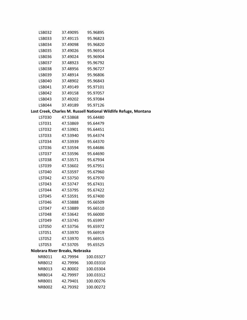
LSB032 37.49095 95.96895
LSB033 37.49115 95.96823
LSB034 37.49098 95.96820
LSB035 37.49026 95.96914
LSB036 37.49024 95.96904
LSB037 37.48923 95.96792
LSB038 37.48956 95.96727
LSB039 37.48914 95.96806
LSB040 37.48902 95.96843
LSB041 37.49149 95.97101
LSB042 37.49158 95.97057
LSB043 37.49202 95.97084
LSB044 37.49189 95.97126
Lost Creek, Charles M. Russell National Wildlife Refuge, Montana
LST030 47.53868 95.64480
LST031 47.53869 95.64479
LST032 47.53901 95.64451
LST033 47.53940 95.64374
LST034 47.53939 95.64370
LST036 47.53594 95.64686
LST037 47.53596 95.64690
LST038 47.53571 95.67934
LST039 47.53602 95.67951
LST040 47.53597 95.67960
LST042 47.53750 95.67970
LST043 47.53747 95.67431
LST044 47.53795 95.67422
LST045 47.53591 95.67400
LST046 47.53888 95.66509
LST047 47.53889 95.66510
LST048 47.53642 95.66000
LST049 47.53745 95.65997
LST050 47.53756 95.65972
LST051 47.53970 95.66919
LST052 47.53970 95.66915
LST053 47.53705 95.65525
Niobrara River Breaks, Nebraska
NRB011 42.79994 100.03327
NRB012 42.79996 100.03310
NRB013 42.80002 100.03304
NRB014 42.79997 100.03312
NRB001 42.79401 100.00276
NRB002 42.79392 100.00272

NRB003 42.80127 100.03561
NRB004 42.80125 100.03538
NRB005 42.80134 100.03550
NRB006 42.80026 100.03377
NRB007 42.80021 100.03374
NRB008 42.80028 100.03378
NRB009 42.79996 100.03350
NRB010 42.79983 100.03363
NRB015 42.79968 100.03308
NRB016 42.79953 100.03106
NRB017 42.79955 100.03096
NRB018 42.79952 100.03100
NRB019 42.79961 100.03107
NRB020 42.79946 100.03074
NRB021 42.79818 100.02842
NRB022 42.79805 100.02833
NRB023 42.79814 100.02814
NRB024 42.79774 100.02803
NRB025 42.79765 100.02824
NRB026 42.79766 100.02822
NRB027 42.79635 100.01895
NRB028 42.79728 100.00452
Purtis Creek State Park, Texas
PRC001 32.36548 96.00174
PRC002 32.36569 96.00137
PRC003 32.36577 96.00095
PRC004 32.36585 96.00081
PRC005 32.36564 96.00071
PRC006 32.36568 96.00075
PRC007 32.36607 96.00077
PRC008 32.36674 96.00096
PRC009 32.36685 96.00159
PRC010 32.36822 96.00091
PRC011 32.36797 96.00103
PRC012 32.36762 96.00069
PRC013 32.36770 96.00024
PRC014 32.36777 96.00002
PRC015 32.36773 95.99874
PRC016 32.36722 95.99907
PRC017 32.36651 95.99944
PRC018 32.36627 95.99986
PRC019 32.36687 95.99818
PRC020 32.36688 95.99798

PRC021 32.36700 95.99739
PRC022 32.36716 95.99704
PRC023 32.36732 95.99657
PRC024 32.36717 95.99682
PRC025 32.36672 95.99729
PRC026 32.36599 95.99764
PRC027 32.36580 95.99732
PRC028 32.36530 95.99729
PRC029 32.36479 95.99812
PRC030 32.36325 95.99918
PRC031 32.36345 95.99919
PRC032 32.36330 95.99921
PRC033 32.36359 95.99902
PRC034 32.36320 95.99945
PRC035 32.36373 95.99975
PRC036 32.36297 95.99905
PRC037 32.36253 95.99828
PRC038 32.36250 95.99817
PRC039 32.36384 95.99779
PRC040 32.36747 95.99714
PRC041 32.36761 95.99709
PRC042 32.36739 95.99725
PRC043 32.36759 95.99817
PRC044 32.36745 95.99855
PRC045 32.36735 95.99864
PRC046 32.36741 96.00075
Sand Creek and Soda Creek, Charles M. Russell National Wildlife Refuge, Montana
SC009 47.50095 107.93278
SC010 47.50042 107.93412
SC011 47.49932 107.93583
SC014 47.50058 107.93598
SC015 47.50062 107.93542
SC016 47.50085 107.93512
SC017 47.50168 107.93343
SC018 47.50183 107.93358
SC019 47.50225 107.93443
SC020 47.49990 107.94027
SC021 47.50015 107.94010
SC022 47.50088 107.93950
SC024 47.50185 107.94038
SC025 47.50297 107.93848
SND030 47.59255 96.58858
SND031 47.59313 96.58841

SND032 47.59303 96.58886
SND033 47.59359 96.58851
SND035 47.59398 96.58843
SND036 47.59401 96.58844
SND037 47.59678 96.58885
SND038 47.59793 96.58812
SND039 47.59794 96.58823
SND040 47.59856 96.58842
SND041 47.59797 96.58615
SND043 47.59737 96.58290
SND044 47.59764 96.58271
SND045 47.59768 96.58402
SOD001 47.50336 95.92384
SOD002 47.50312 95.92466
SOD003 47.50265 95.92842
SOD004 47.50261 95.92857
SOD005 47.50200 95.92965
SOD006 47.50248 95.92952
Deep Gulch, Theodore Roosevelt National Park, North Dakota
TRS001 46.97371 91.43227
TRS003 46.97310 91.43293
TRS004 46.97303 91.43300
TRS005 46.97382 91.43357
TRS006 46.97391 91.43356
TRS007 46.97393 91.43359
TRS008 46.97247 91.43026
TRS009 46.97240 91.42992
TRS010 46.97282 91.43005
Pine Ridge, Upper West Ash Creek, Nebraska National Forest, Nebraska
UWA005 42.63172 103.24543
UWA006 42.63218 103.24688
UWA007 42.63197 103.24704
UWA008 42.63242 103.24758
UWA009 42.63131 103.24761
UWA010 42.63205 103.25251
UWA011 42.63155 103.25063
UWA012 42.63225 103.24945
Pine Ridge, West Ash Creek, Nebraska National Forest, Nebraska
WAC001 42.62677 103.24338
WAC002 42.62630 103.24366
WAC003 42.62621 103.24344
WAC004 42.62687 103.24329

WAC005 42.65455 103.24525
WAC006 42.65460 103.24538
WAC007 42.65360 103.24640
WAC008 42.65408 103.24507
WAC009 42.65304 103.24280
WAC010 42.65040 103.24363
WAC011 42.65058 103.24375
WAC012 42.65134 103.25125
WAC013 42.65134 103.25135
WAC014 42.65132 103.25138
WAC015 42.65098 103.25032
WAC016 42.65084 103.25037
WAC017 42.65085 103.25028
WAC018 42.65100 103.25041
WAC019 42.65076 103.25113
WAC020 42.65093 103.25125
WAC021 42.65092 103.25122
WAC022 42.65048 103.25013
WAC023 42.65064 103.24908
WAC024 42.65073 103.24921
WAC025 42.65046 103.24835
WAC026 42.64873 103.24794
WAC027 42.64852 103.24809
WAC028 42.64823 103.24817
WAC029 42.64852 103.24811
WAC030 42.64872 103.24788
WAC031 42.64847 103.24785
WAC032 42.64861 103.24420
WAC033 42.65201 103.24159
WAC034 42.65207 103.24198
WAC035 42.65209 103.24207
WAC036 42.65163 103.24695
WAC037 42.65040 103.24858
WAC038 42.65040 103.24852
WAC039 42.65612 103.25192
WAC040 42.65700 103.25152
WAC041 42.65638 103.25015
WAC042 42.65685 103.24750
WAC043 42.65532 103.24631
WAC044 42.65341 103.24429
WAC045 42.65366 103.24335
WAC046 42.65342 103.24342
WAC047 42.65329 103.24333

WAC048 42.65318 103.24376
Wichita Mountains National Wildlife Refuge, Oklahoma
WCH001 34.73245 98.70626
WCH002 34.73207 98.70722
WCH003 34.73212 98.70722
WCH004 34.73193 98.70754
WCH005 34.73051 98.70744
WCH006 34.73037 98.70750
WCH007 34.72813 98.70574
WCH008 34.72894 98.70552
WCH009 34.72930 98.70461
WCH010 34.72936 98.70416
WCH011 34.72977 98.70442
WCH012 34.72997 98.70439
WCH013 34.72994 98.70456
WCH014 34.73054 98.70400
WCH015 34.73104 98.70355
WCH016 34.73071 98.70350
WCH017 34.73061 98.70354
WCH018 34.73029 98.70333
WCH019 34.73018 98.70325
WCH020 34.73024 98.70355
WCH021 34.72996 98.70376
WCH022 34.72933 98.70330
WCH023 34.72870 98.70376
WCH024 34.72870 98.70369
WCH025 34.72718 98.70304
WCH026 34.72520 98.69391
WCH027 34.73031 98.70219
WCH028 34.73047 98.70260
WCH029 34.73020 98.70328
WCH030 34.73024 98.70328
WCH031 34.73048 98.70437
WCH032 34.72990 98.70461
WCH033 34.72958 98.70464
WCH034 34.73002 98.70646
WCH035 34.73038 98.70673
WCH036 34.73032 98.70661
WCH037 34.73267 98.70593
WCH038 34.73223 98.70588
WCH039 34.73217 98.70582
WCH040 34.73237 98.70623
WCH041 34.73200 98.70755

WCH042 34.73179 98.70817
WCH043 34.73166 98.70856
WCH044 34.73168 98.70842
WCH045 34.73177 98.70863
WCH046 34.73146 98.70864
WCH047 34.73153 98.70840
WCH048 34.73224 98.70975
WCH049 34.73225 98.70978
WCH050 34.73053 98.70772
WCH051 34.73033 98.70776
WCH052 34.73034 98.70776
WCH053 34.73020 98.70778
WCH054 34.73035 98.70772
WCH055 34.73050 98.70806
Mississippi River Hills, Iowa (log cabin timbers with fire scars)
NYE002 41.44266 90.91307
NYE004 41.44266 90.91307
NYE006 41.44266 90.91307
NYE007 41.44266 90.91307
NYE008 41.44266 90.91307
NYE009 41.44266 90.91307
NYE010 41.44266 90.91307
NYE011 41.44266 90.91307
NYE015 41.44266 90.91307
NYE016 41.44266 90.91307
NYE017 41.44266 90.91307
NYE018 41.44266 90.91307
NYE019 41.44266 90.91307
NYE020 41.44266 90.91307
NYE021 41.44266 90.91307
NYE022 41.44266 90.91307
NYE023 41.44266 90.91307
NYE025 41.44266 90.91307
NYE026 41.44266 90.91307
NYE027 41.44266 90.91307