A Publication of the Indian Coast Guard · A Publication of the Indian Coast Guard Biannual Jan...
28
A Publication of the Indian Coast Guard Biannual Jan 2016 Vol XVII Issue 1 A Publication of the Indian Coast Guard
-
Upload
truongngoc -
Category
Documents
-
view
213 -
download
0
Transcript of A Publication of the Indian Coast Guard · A Publication of the Indian Coast Guard Biannual Jan...

A Publication of the Indian Coast Guard
Biannual Jan 2016 Vol XVII Issue 1
A Publication of the Indian Coast Guard

From the Director General’s Desk
It is indeed heartening to note that there has been no major oil pollution incident in Indian waters over the pastmonths. The Coast Guard, however, continues in its relentless pursuit of measures for the protection and preservationof the marine environment.
The Coast Guard has significantly strengthened its oil spill response capability with the commissioning of ICGSSamudra Pavak, the third in the series of indigenously built Pollution Control Vessels. The oil pollution responseinventory onboard Samudra Pavak includes state-of-the-art Hi Sprint booms, River booms, Weir Skimmer, Discand Brush skimmer, Side Sweeping arm system, Side spill spray system, Aerial Spray System, Inflatable barges,Hydraulic drum compactor, ORO system and Dispersant tank which will hold 10 tons of dispersant at all times.We may be rest assured that ICGS Samudra Pavak will play a key role in the fulfillment of its national mandateduring any oil spill contingency.
I can proudly say that besides commissioning the pollution control vessel, the Indian Coast Guard continues toaugment its inventory to which, in the recent past, it has added ocean boom, near-shore boom, oil skimmers,dispersant spray systems, etc. As Chairman NOSDCP, I sincerely hope that all stakeholders too will continue toaugment their individual tier-1 capability.
I am also happy to note that nearly twenty thousand volunteers across all the coastal states participated in theInternational Coastal Cleanup day, coordinated by the Coast Guard on 19 Sep 2015 as a part of “Swachh BharatAbhiyaan”, under the aegis of the South Asia Co-operative Environment Programme.
Recognizing the importance of maintaining the NOSDCP which guides all our actions for oil pollution preparednessand response updated at all times, we have issued Amendment No.2 into the Jan 16 revised NOSDCP 2015. Anotable feature of the amendment is the inclusion of the Indian Council of Agricultural Research as a resourceagency under the NOSDCP. To supplement the national plan, Chairman NOSDCP Circulars have been issuedfrom time to time. The prompt response and positive feedback on the Circulars is particularly encouraging.
Two other initiatives expected to fructify shortly also merit a mention. We have made a proposal to the INCOISfor developing a Fishing Avoidance Zone advisory to fishermen, which will be an integration of the existing OnlineOil Spill Advisory and Potential Fishing Zone advisory and are working closely with the INCOIS for its development.Secondly, the revised edition of the Coast Guard website is slated for release on 01 February 2016 and will,notably, serve as a single point repository and tool for management of all oil pollution contingency plans. Allstakeholders are requested to comply with Chairman NOSDCP Circular, which will be issued upon its launch.
I am confident that, with frequent interaction and cooperation amongst the stakeholders, we will be able toachieve much better results in our collective endeavour for sustainable development of our marine environmentand attain enhanced levels of operational readiness, duly supported by legal powers to ensure total marineenvironmental security in Indian waters.
“Jai Hind”.
(HCS Bisht)Vice AdmiralDirector GeneralIndian Coast Guard
01 Feb 16New Delhi

Jan 2016 Vol XVII Issue 1
Editorial
ARTICLES
Rescue operation of Pilot Whales 3
Sub-sea Well Capping: Experiences 4of India and Challenges Ahead
Oil Spills in Mangroves 7
Oil Spill Trajectory Prediction System 10
Marine Fisheries : Experiences and 12Expectations
Conservation of Marine Living Resources 15under LOSC 1982 : An Indian Perspective
Principles on Compensating Economic 16Losses in Marine Pollution Incidents
EVENTS
SACEP Regional Training and Exercise 18at Colombo
International Coastal Cleanup Day 2015 18
Operation Olivia 2015-16 19
NEWS
IMO - International Seabed Authority : 20Agreement of Co-operation
Marine geoengineering Study 20
Gas and low-flashpoint fuels code adopted 20
Project of low-carbon maritime future 21launched in Singapore
United Nations adopts Sustainable 22Development Goals
REPORTS
INDIA WATCH
Mass Stranding of Pilot Whales 22in Thoothukudi
WORLD WATCH
M.V. Flinterstar Oil Spill 25
M.V. Global Gold Oil Spill 25
Oil Spill at Bayonne, U.S. 26
BP evacuated Valhall Field 26
INFORMATION
Annual Calender of Pollution 27Response Training and Exercises: 2016
CONTENTS
Publication of the Blue Waters is a continuingeffort on part of the Coast Guard to keep ourcommunity apprised of developments on the nationalfront and the international arena. It also serves toinform the stakeholders of our collective efforts tostrengthen capacity and capability for marine oil spillresponse.
This issue of Blue Waters lends assuringperspectives on the strengths of stakeholders to thenational plan. The highlights are a very lucid write-upon sub-sea well capping capabilities of the ONGC,role of the Mangrove Society of India in the protectionof mangroves, the critical support provided by INCOISthrough its online oil spill trajectory prediction systemand valuable contribution of CMFRI.
Two other articles discuss conservation of marineliving resources under the law of the sea conventionand elucidate the principles of compensatingeconomic losses in marine pollution incidents.
The events section covers the SACEP regionalworkshop at Colombo at which India made a proactivecontribution to the review of the Regional ContingencyPlan besides conduct of International Coastal CleanupDay.
India Watch ponders on the causes of massstranding of whales on the Thoothukudi coast. Theefforts of the District Administration, in particular theDistrict Forest Officer who tirelessly worked over threedays to save over seventy of the hundred fifty oddstranded whales are truly laudable.
We thank all contributors to this edition of “BlueWaters” and solicit continued cooperation forenhancing commitment of the newsletter to marineenvironment protection.
Happy reading!
(AA Hebbar)DIGPrincipal Director (FE)
Website : www.indiancoastguard.nic.in

ARTICLES
3
Rescue Operation of Pilot Whales
Deepak Bilgi, IFS*
It was at around 9.00 PM on 11.01.2016 that the
news of whales stranding on the beaches of Kallamozhi
and Manapad villages in Tuticorin District was received
by Forest officials.
Fig 1. Mass Stranded Whales
Fig 2. Fishermen Helping in Rescue Operation
maintained and they survive until complete rescue
operation could be launched. Meanwhile, District
Collector of Tuticorin was alerted so as to get the
required help from the Coast Guard and the Fisheries
Departments.
The staffs, who had rushed to the spot just to know
the facts of stranding, had to remain at the site and
keep on the rescue operations because of the reason
that most of fishes were alive and were struggling to
survive. Any time lost would have resulted in precious
lives lost. The staffs at the site were not prepared with
any equipment except the vehicle, for their mobility. The
fishes were pushed back into the sea and made to
remain within the water. By the mid night of 11.01.2016,
they had pushed around 10 animals into the sea. The
exercise continued in the morning of 12.01.2016, by
which many more animals were pushed back into the
sea. However, the animals which were pushed into
the sea waters were not responding well; they were
struggling to swim on their own, against the wave action
in the deep sea waters. Realizing the fact that many
whales were not responding, it was decided to further
pull back the animal deep into sea waters, to a distance
where there was less wave action, so that they could
stabilize and start swimming back to deep waters on
* Wildlife Warden, Mannar Marine National Park, Ramanathapuram
Jan 2016 Vol XVII Issue 1
The Forest Guard of Tuticorin Range, Gulf
of Mannar Marine National Park was alerted
immediately of the incident to inspect the area and
report the fact of the information received. The Forest
Guard along with a few Anti-poaching Watchers
(who were stationed at Tuticorin around 70 Km away)
rushed to the spot immediately. Around 11.30 PM, they
informed me that the stranded fish were bigger than
Dolphins and smaller than whales. However, it was for
sure that the species of concern would find a place
under the protected species under the Wildlife
Protection Act, 1972. The Forest Guard was instructed
that, additional Anti-poaching Watchers may be required
and the live animals stranded on the sandy beach
should be pulled back to the sea. The prime intention
was to keep the stranded wild animals under water, so
that the body temperature of the animals could be

4
Fig 3. Animal being pushed & retained in water
their own. The staffs, who had just rushed to the spot,
had no equipment with them. The assistance from the
fishermen had to be sought. Local fishermen spared
their boats and ropes to pull the animal deep into the
water. The animals were tied by their caudal fin and
pulled deeper into the sea beyond the wave actions.
By the end of 12.01.2016, around 36 whales were
rescued and around 45 were found dead.
The area of Manapad is characterized by the
presence of a small lagoon and the animals which were
pushed far away from the beach but nearer to the
lagoon were pushed into it, so that they could be within
waters. These were later taken into deep waters
during the subsequent high tide through the mouth of
the lagoon.
It was actually a knee jerk reaction to the incident
and we, from the forest department were poorly
equipped during the emergency operation. We didn’t
have our own boats at the location, had no sufficient
ropes, belts etc, to launch a full-fledged operation.
We had to rely on the facilities available with the
fishermen, especially for boats and ropes. The
authorities of the Gulf of Mannar Marine National Park
have their operational presence only upto Tuticorin and
not down south. The current location was 70 Km away
and posed difficulties in organizing the timely logistic
support. The high power boats that could operate at
shallow depth of sea waters, was lacking at the rescue
site. Also, the strength of the rescue team was
inadequate; with only 12-15 no. of watchers against
the need of at least 25-30 people in the rescue
team, so that they could work on rotation. Though the
fishermen supported later in the rescue operation
but it was not possible to retain them for the entire day.
After the rescue operation, it was felt that any support
from the communities could only be for a short and
immediate period and will not last when the operation
prolongs beyond 4-6 hrs since they start engaging
themselves in their routine livelihood work. We actually
had pinned hopes of greater support from the
Coast Guard and their boats, but it was in vain, since
we realized later that their boats could not operate in
shallow waters.
To summarize to the experiences of the incident and
the rescue operation, it is evident that any operation of
rescue in coastal and marine environments needs large
number of people in rescue team. Limited numbers of
rescue people soon get fatigued and their energy needs
to be replenished frequently. During such operations,
there needs to be a back up team for assistance, along
with all support systems. Such large scale rescue
operation definitely needs a well coordinated support
from various line departments like, Fisheries, Fire &
Rescue, Local Bodies, Revenue and Police departments.
Jan 2016 Vol XVII Issue 1
Subsea Well Capping: Experiences ofIndia and Challenges Ahead
Sanjay Bhatt*
Introduction to Subsea well capping
A “capping stack” is a piece of equipment that is
placed over the blowing well as a “cap.” Its purpose is
to stop or redirect the flow of hydrocarbons and to gain
time for engineers to permanently seal the well. Subsea
capping stack is a massive equipment and can weigh
as much as 50 to 100 tons. The basic operational need
of the stack is to attach and seal on a well during a
* Head, Regional Crisis Management Team, ONGC, Mumbai

5
heave compensated crane or from the stem of an anchor
handling vessel using the A-frame or from to drill rig
using a drill pipe. The capping stack is installed on the
well bore and interconnected using connector and
additional subsea equipment. The process of containing
the well starts either by shutting or by diverting the flow
depending on type, volume and pressure of the well.
All controls on the stack to operate the connector,
BOPs, valves etc. are hydraulically operated by ROV
stab or operated by ROV torque tool. Once all gate
valves on the outlets and the BOP are shut in, the well
is considered capped. It is an industry-recommended
practice that two barriers exist between hydrocarbons
and the environment. Once the well is capped further
decision on killing and plugged abandonment of the well
by various methods are followed on case to case basis.
India’s experience
In India only one subsea blow out has occurred till
date viz. in one of the well G-1-9 located 15 km from
the Amalapuram Coast in KG Offshore Basin in Bay of
Bengal, at water depth of 252m in August 2012. On
8th August 2012, an ONGC drillship reported continuous
foam forming 1.5 nm south from her anchored location,
nearby OSV in the field also reported gas bubbles
coming from under the sea creating a big bubble plume.
A helicopter survey was carried out and area of gas /
water plume was reported approximate 500m in
diameter. ROV survey of the field was also carried out
Fig 4. Basic capping Stack Components
Jan 2016 Vol XVII Issue 1
blowout and shut the well safely. To achieve this, first a
mandrel or hub profile must be exposed (either at the
wellhead or on top of the BOP or on top of subsea
tree). During installation of capping stack in deep water
on a high flow rate blowout well, the stack is positioned
over the plume and when it approaches the wellhead
interface, a water post-effect occurs allowing stability
and centralization of the stack in relation to the wellhead.
Water post-effect, as explained above can be
understood by Bernoulli’s principle.
The design of capping stack is decided after
thoroughly visual inspection and analysing the inputs
of blowing well. In a subsea blowout, dynamically
positioned support vessel equipped with work class
remotely operated vehicle (ROV) plays a vital role in
mitigation of blowout. Based on ROV inspection of the
blowing seabed site engineers zero in on precisely what
equipment is needed. Every blowout is unique and each
blowout scenario has to be analysed to determine what
will handle the flow best.
While preparing capping stack and finalising on
deployment technique, other operations like debris
removal, arrangements for containment of oil spill, etc
are also taken up simultaneously. Various methods can
be adopted to lower the capping stack on a blowing
well like on a wire, off the side of the vessel using a
Fig 5. G-1-9 Subsea Blowout

6
and it was found well G-1-9 in East coast area of ONGC
is Blowing Gas from well head hub of horizontal subsea
X-mas tree. The probable cause of blowout was failure
of retrievable bridge plugs used for temporary
abandonment of the well.
To cap the blowing well, a capping stack was
designed indigenously using in-house available
equipment by ONGC’s crisis management team.
6.8 m high and 4 m wide structure weighing 35MT was
assembled at the company owned MSV Samudra
Sevak having a robust 100MT crane. The capping
stack was assembled using a 13 inch double Ram
BOP interconnecting H4 connector at bottom and
H4 mandrel on top by various change over spools and
Fig 6. Capping Stack
Fig 7. Max use of standard existing vessels and equipment
India’s national capability
The decision making process, Capping Stack design
and lowering strategy paved the way for the successful
and incident-free execution of a Subsea Capping
operation in the blowing gas well in the Bay of Bengal.
The three and half month project employed a DP II ROV
Vessel with two 150 HP work class Remotely Operated
Vehicle (ROV), DP anchor handling boats and diving
vessel to successfully lower a 35 Ton uniquely fabricated
subsea capping stack having modified surface BOP for
safely abandonment of the well in 250 m of water depth.
Jan 2016 Vol XVII Issue 1
hub clamps. The outer frame was designed as a
guide for subsea tree guide post and allowing smooth
landing of H4 connector on mandrel of subsea tree.
Hydraulic piston and cylinders were part of frame for
soft landing.
The capping stack was shifted by crane on winches
of two DP offshore supply vessels. Two work class ROV
were used to position capping stack on blowing well.
SIMOPS and Capping Execution was done using two
ROV vessels and 5 DP vessels including capping stack
carrier vessels. Lowering operation was done during
favorable sea conditions.Fig 8. Position of Vessels for Capping Operations
ONGC’s Crisis Management Team and Subsea

7
Fig 9. Triton XLX 34 Well G-1-9
engineers conceptualised the Sub Sea Capping
operations utilizing resources available within ONGC.
Parallel action was also initiated to have contingency
in place. The objective was to cap the blowing well as
soon as possible to avoid any potential HSE issue
considering oil reservoir below gas zone and vulnerable
sea conditions in Bay of Bengal.
The industry’s first unparalleled subsea capping
operation was successfully executed addressing
numerous technical challenges in designing capping
stack using surface BOP, lowering methodology &
execution and finally abandonment of the subsea well,
while averting any potential catastrophic HSE incident.
Challenges Ahead
In Indian E&P sector, production from subsea well
has started recently and very few subsea producing wells
are in operation. Resources like DP II ROV Vessel with
work class Remotely Operated Vehicle (ROV) are not
readily available, although vessel can be hired from south
Asian countries. However, mobilisation time of the ROV,
have so ever short, could be an ever of concern.
Since each blowout is unique in type and nature, a
particular equipment used for capping a well may not
be suitable for the next blowout. The capping stack and
its lowering methodology has to be designed after
thoroughly analysing the incident. As the subsea drilling
industry in India continues to evolve, ONGC’s Crisis
Management Team is geared and keeps it resources
ready to handle any offshore oil and gas industry’s
emergency situation.
Jan 2016 Vol XVII Issue 1
Oil Spills in Mangroves
Arvind G. Untawale & Narayan B Bhosle *
What is a Mangrove?
Mangroves are trees and shrubs that inhabit coastal
intertidal zone of tropical and sub-tropical environments.
These plants survive the variable flooding and salinity
stress conditions imposed by the coastal environment.
Mangroves are widely spread along the Indian coastline.
Largest mangrove formation is located in the Gangetic
Sunderbans of West Bengal along the east coast of
India. Andaman and Nicobar group of Islands and
deltaic areas of Mahanadi, Godavari, Krishna,
Pichavaram and Muthupet on the east coast also
account for large formation of mangroves. In contrast,
coastal areas of Gujarat, Maharashtra, Goa, Karnataka,
and Kerala along the west coast of India have limited
formation of mangroves.
* Mangrove Society of India, Mapusa, Goa
Why are mangroves important?
Located along the coastline, mangroves play a very
important role in soil formation, shoreline protection, and
The complexity of the operation was underscored
with the designing, fabrication and lowering of an
unprecedented subsea capping operation with the
resources available within country. Practically, a ROV
friendly Subsea capping stack was fabricated to perform
all the functions including connectivity from surface to
extend kill and choke lines for killing from surface.
ONGC is having dedicated crisis management team
for handling any well control and blowout control
operation. Capping operation in blowing oil/gas well is
not new to Indian industry. In onland and offshore
surface operation dozens of capping operation on
blowing wells have been performed successfully by the
ONGC crisis management team. This team provides
services to private operators as well.

8
Fig 10. On December 12, three days after a cargo vessel collidedwith a tanker, oil reaches mangrove environment and coatsmangrove trees in the Sundarbans region of Bangladesh causingextensive damage to the trees (From National Geographic, 2014)
stabilization. Mangroves absorb and reduce the impacts
of the strong winds, tides, and floods thereby protecting
uplands from more severe damage. Mangrove
environment is highly productive and provides both
habitat and food for a diverse biological community that
inhabits both the forest interior and the adjacent coastal
waters. Some animals depend on the mangrove
environment during their entire lives while others utilize
mangroves only during specific life stages, usually
reproductive and juvenile stages. Tropical mangrove
forests are carbon-rich, and play important role in carbon
sequestration. The total global mangrove above-ground
biomass is about 2,83 billion tones. It is estimated that
these mangrove forests bury 31–34 million tons of
carbon per year. Mangroves are also an attractive
tourist destination mostly because of the birds and
crocodiles that inhabit these forests. As mangroves
inhabit coastal areas, they are subjected to several
pollutants including oil spills. Oil is transported from one
place to other using sea routes. During transport oil
tankers may involve in accidents releasing oil in the
environment. Spilled oil can damage mangrove
ecosystems.
Oil Toxicity and Effects on Mangroves
Oil is a complex mixture of many kinds of chemicals.
Oils released into the environment are subjected to
weathering processes that immediately alter its original
physical and chemical characteristics. Lighter oils are
more acutely toxic to mangroves than are heavier oils.
Increased weathering generally lowers oil toxicity.
Mangroves are highly susceptible to oil exposure.
Oiling may kill them within a few weeks to several
months. Oil-impacted mangroves may show yellowed
and curled leaves, defoliation, and failed biological
processes. Other responses include branching of
pneumatophores, interference in salt exchange,
germination failure, decreased canopy cover, increased
rate of mutation, and sensitivity to other stresses.
Mangrove-associated invertebrates and plants recover
more quickly from oiling than do the mangroves
themselves. Under severe oiling conditions, mangrove
impacts may continue for years to decades, resulting
in permanent habitat loss.
Mangrove Community Impacts
In extreme cases a massive die-off of plants and
animals attached to the mangrove roots will follow the
initial release of oil spill. Five years after the spill,
epibiotic bivalves will reduce in oiled areas compared
to unoiled reference areas. After 29 years, oysters and
snails in the oiled site will decline. Residual oil remaining
on mangrove sediments will increase the ambient soil
temperatures affecting germination and growth of
plants. Decomposition of the mangrove root mass
following large-scale mortality will cause significant
erosion. Even if oiling does not result in tree death, the
surviving trees can become weakened and vulnerable
to drought, flooding, and storms.
Oil Spill Response and Cleanup Options forOiled Mangroves
The objective of spill response is to minimize the
damage caused by the released oil to mangroves.
Mechanical recovery of spilled oil using booms and
skimmers is the initial clean up technique. Dispersant
application or in situ burning of oil on water may
significantly reduce the risk of oil reaching mangroves.
If mangrove shorelines are oiled, extreme caution must
Jan 2016 Vol XVII Issue 1

9
be exercised in selecting cleanup activities. In some
cases it is appropriate to do nothing. Response
techniques including passive collection, flushing, and use
of barriers, chemical cleaners, and addition of nutrients
can be used to remove oil from mangrove environments.
Indian Scenario
Over 50 oil spills have been reported in Indian
waters. Fortunately, these oil spills have not impacted
Indian mangroves to any great extent. However, on
December 9, 2014 an oil tanker Southern Star VII collided
with a cargo vessel and released about 350,000 litres
of furnace oil in the Sunderbans, Bangladesh which
is a UNESCO World Heritage site located about
100 kilometers from Kolkata Port. By December 17, the
oil had spread over a 350 km2 area affecting protected
mangroves. The spill caused extensive damage to
mangroves and other biological communities. This
event caused great concern in India. The oil spill,
however, did not reach Indian part of the Sunderbans.
MSI can help in assessing the damage to the oiled
mangroves and suggest some remedial measures to
restore mangroves.
P.S. The MSI has been incorporated as a resource agency for oil
spill preparedness and response in the revised NOSDCP 2015.
Jan 2016 Vol XVII Issue 1
Fig 11. Cleanup oiled mangroves off Sikka and Sarmat
Mangrove Society of India
The mangroves South of India (MSI) is a registered
NGO. Its members and network are spread throughout
the Indian coastal belt. The society acts as a watchdog
for mangrove wellbeing. It arranges various programs
and publishes literature to create awareness about
mangroves and their importance in protecting and
maintaining our environment. In the event of oil spills
The Sunderbans National Park, West BengalDy Comdt Sumit Rawat *
Spread over 2,585 sq.km, the Sunderbans National Parkin West Bengal, is the world’s biggest estuarine mangroveforest delta and declared a UNESCO World Heritage site in1987. The park is home to a wide variety of plant life in additionto an amazing variety of wildlife. Endangered species likeOlive Ridley turtles, Gangetic Dolphins, the fishing cat, RiverTerrapin, etc. find a home here. The park is known as themain habitat of the endangered Royal Bengal tiger too whichnumber more than 200. The Tiger Reserve is undoubtedlythe most popular draw in Sunderbans National Park. Thetigers have adapted themselves to the unique eco-systemof the region and are excellent swimmers who eat fish. Junglecats, wild boars, rhesus monkeys, fishing cats, chitals,dolphins, snakes, king cobras and estuarine crocodiles aresome of the inhabitants of the park. Crocodiles are bred atCrocodile Sanctuary at Bhagabatpur. The Sajnekhali BirdSanctuary, home to birds such as spotted-billed pelicans,white ibis, eagles, ospreys, falcons, Caspian terns and open-billed herons, to name a few. A Mangrove InterpretationCentre helps to create awareness about the need forconservation of forests and marine life.
Fig 12. Royal Bengal Tiger being released in the Sunderbans
Further Reading
1. Dhargalkar, V.K., R. D’Souza, D. P. Kavlekar, A. G. Untawale.2014. Mangroves of Goa. Published by Department of Forest, Govt.of Goa
2. NOAA. 2014. Oil spills in Mangroves: Planning and responseconsideration. Available at: http://www.noaa.gov/features/climate/sealevelchanges.html
* Commanding Officer, ICGS C-149

10
Oil Spill Trajectory Prediction System
Introduction
At the heart of the oil spill trajectory prediction
system is the GNOME trajectory model. Details of the
oil spilled, location, date and time of the spill, quantity
and type of oil spilled are provided as inputs to the model.
The forcing parameters which cause movement/drift of
the pollutant parcel are, predicted wind forcing & current
forcing. These forcings obtained from the Ocean State
Forecast Laboratory of INCOIS are used to drive the
GNOME model. To get the overall movement the u (east-
west) and v (north-south) velocity components from
currents, wind and other movers are added together at
each time-step, i, using a forward Euler scheme. The
generated trajectory is layered on a Web map, so that
the nearby zones that are likely to be affected are
known. Various case studies were executed for oil spill
incidents that occurred after 2010 and the predictions
were compared with the observation of oil slicks
obtained from radar datasets.
High Resolution Trajectory Prediction for theWest Coast
S.J. Prasad, T.M. Balakrishnan Nair,P.A. Francis & S.S.C Shenoi *
* Indian National Centre for Ocean Information Services,ESSO-MoES, Hyderabad.
ESSO-INCOIS has set up a High resolution
Operational Ocean Forecast and reanalysis System
(HOOFS) of resolution 1/48º for the west coast of India.
Ocean currents from HOOFS are used for forcing
GNOME. The m.v. Rak Carrier sank on 04 Aug 2011
due to water ingress. Oil spill was reported from
05 Aug 2011 till 16 Aug 2011. GNOME was forced with
ocean currents of 1/8º and 1/48º. The predicted oil spill
trajectories were compared with the oil spill signature
obtained from ENVISAT- ASAR data on 09 Aug 2011.
The predicted trajectory obtained while forcing with
1/48º ocean currents was found to be more accurate
Jan 2016 Vol XVII Issue 1
Fig 13. Trajectory with High resolution currents (Left) Oil slickfrom ENVISAT - ASAR data (Right)
i.e has followed the path of the observed oil slick, than
the trajectory obtained while forcing with 1/8º currents.
Figure 13 shows the trajectory with high resolution
currents and the oil spill signature from ENVISAT data.
Figure 14 shows the comparison between the predicted
and observed trajectory.
Fig 14. Comparison between the predicted and observedtrajectory of MV Rak spill, Aug 2011
Advisory issued to Indian Coast Guardduring Exercise “Pradhushan-2015”
A level -II pollution response exercise was conducted
at Mumbai from 15 Oct 2015 to 16 Oct 2015. Table top
exercise and deployment of pollution response
equipment was also conducted, assuming a hypothetical
11
Fig 15. Trajectory issued during EXERCISE“PRADHUSHAN-2015”
Online version of the Oil Spill TrajectoryPrediction System
Setting up a local model, soon after an oil spill will
be typically difficult. In order to trigger the trajectory
model during emergency situations, the diagnostic
mode of GNOME is operationalised. This Online Oil
Spill Advisory (OOSA) system will be triggered
automatically when the user submits the details of the
spill through a web interface. OOSA enables the user
to obtain the trajectory without interacting with
INCOIS officials. This set up is capable of predicting
the trajectory for both continuous and instantaneous
spills. The trajectory of the pollutants such as
gasoline, kerosene/jet fuels, diesel, fuel oil No. 4,
medium crude, and fuel oil No. 6 can be predicted
by OOSA. The generated trajectory will be layered
Jan 2016 Vol XVII Issue 1
oil spill incident from an oil tanker which was anchored
at 19.25º N, 72.3830º E on 15 Oct 2015, 0600 hrs. Oil
spill trajectory prediction was requested by Coast Guard
for deploying the pollution response equipment against
the oil drift. The predicted oil spill trajectory was
disseminated from INCOIS to Coast Guard Region
(West) on 14 Oct 2015. The deployment of the pollution
response equipments were carried out accordingly.
Figure 15 shows the predicted oil spill trajectory during
the exercise - Pradhusan 2015.
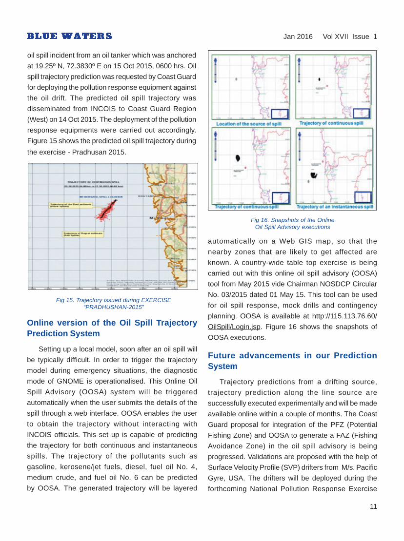
Fig 16. Snapshots of the OnlineOil Spill Advisory executions
automatically on a Web GIS map, so that the
nearby zones that are likely to get affected are
known. A country-wide table top exercise is being
carried out with this online oil spill advisory (OOSA)
tool from May 2015 vide Chairman NOSDCP Circular
No. 03/2015 dated 01 May 15. This tool can be used
for oil spill response, mock drills and contingency
planning. OOSA is available at http://115.113.76.60/
OilSpill/Login.jsp. Figure 16 shows the snapshots of
OOSA executions.
Future advancements in our PredictionSystem
Trajectory predictions from a drifting source,
trajectory prediction along the line source are
successfully executed experimentally and will be made
available online within a couple of months. The Coast
Guard proposal for integration of the PFZ (Potential
Fishing Zone) and OOSA to generate a FAZ (Fishing
Avoidance Zone) in the oil spill advisory is being
progressed. Validations are proposed with the help of
Surface Velocity Profile (SVP) drifters from M/s. Pacific
Gyre, USA. The drifters will be deployed during the
forthcoming National Pollution Response Exercise

12
(NATPOLREX) conducted by Indian Coast Guard. The
track obtained from SVP drifters will be compared with
the trajectory obtained from the model executions.
Figure 17 shows an SVP -Drifter. Advancements made
in our system will be updated in the NOSDCP meetings
periodically.
Fig 17. SVP drifter
Jan 2016 Vol XVII Issue 1
Marine Fishers : Experiences andExpectations
India is the second largest producer of fish in the
world, contributing to 5.68% of global fish production.
India accounts for 2.5% of the global fish market and
the fisheries sector is a source of livelihood for over
1.44 crore people. During the 11th five year plan, the
fisheries sector contributed 1.1% to the GDP.
Contribution to agricultural GDP in the year 2014-15
was 5.3%.Total production during 2013-14 is at 9.58
Million Metric Tonnes (MMT), (Marine- 3.44 MMT and
Inland- 6.14 MMT). Overall growth in fish production in
2013-14 was 5.9% (Marine- 3.7% and Inland- 7.3%).
Fisheries is one of the major forex earners with revenue
reaching Rs.18,856 crore in 2012-13, accounting for
about 18% of agricultural exports. During 2013-14 the
volume of fish and fish products exported was 9.8 lakh
tones, worth Rs.30213.26 crores. The sector began
Dr. Gopalakrishnan A. & Grinson George*
* Central Marine Fisheries Research Institute (CMFRI)
playing a vital role in the Indian economy through its
consistent contributions to the GDP, besides becoming
a vital source of livelihood for about four million people
including 1.6 million active fishermen. Indian marine
fisheries research sector is catering to the needs of a
variety of stakeholders. These stakeholders include
fishermen; mariculture farmers; seafood exporters,
wholesalers, retailers and vendors in domestic
marketing; self-help groups; developmental department
for fisheries in 9 maritime states and 4 UT’s; Department
of Animal Husbandry Dairying and Fisheries; financial
institutions; researchers and academicians; policy
planners; conservationists and all associated fraternities
contributing to the better cause of marine fisheries in
the country. The Central Marine Fisheries Research
Institute (CMFRI) established in 1947 has been foraying
into the research and development activities in marine
fisheries sector supporting all these stakeholders in
different capacities directly or indirectly. This article is
looking into our past experiences, futuristic plans and
research support provided to these stakeholders.
Over a period of time, the marine fisheries sector of
the country changed tremendously. The fishing fleet
became larger and more energy-intensive, and the
catch and trade of marine fishes increased substantially.
However, conflicts in sharing the limited resources
intensified within and with other sectors and this, in turn,
had high economic, social and environmental costs. In
‘business-as-usual’ scenario, fish catches in the tropics
are expected to decline, and since most of the seafood
comes from wild capture, such a situation will be
detrimental to our food security. We have to change
this situation by reducing our dependence on wild
capture and instead, promote mariculture.
Mariculture, the farming and husbandry of marine
plants and animals in the marine environment, is the
fastest growing subsector of aquaculture. Over a period
of time, the proportion of production from coastal and
marine aquaculture should be aimed at 40% and in
terms of value, at 70%. Any planned sectoral
development needs appropriate policies, legislations

13
and acts. As the existing policies are inadequate to meet
the anticipated challenges in the sector, it is important
to develop effective new policies. In the case of
mariculture, as it is an emerging sector, there is need
for developing leasing policies and other regulations.
However, the current operating environment in
marine fisheries is focused on short-term profits and
livelihood instead of long-term sustainability and
profitability. This ‘business’ environment is harmful to
the oceans, fishermen, traders, consumers, and the
coastal communities. Fishermen need predictable and
stable access to fisheries and a flexible management
regime that allows them to improve their financial
security while safeguarding the invaluable marine
ecosystems. India being very rich in marine biodiversity,
there are opportunities for providing monetary benefits
to the coastal communities through benefit sharing from
biodiversity conservation. The profit should motivate the
community to conserve biodiversity. A consortium of
biodiversity conservationists, biotechnologists and
communities will change the operating environment of
the sector from solely fishery dependent activities to
“earning from biodiversity conservation”.
Jan 2016 Vol XVII Issue 1
Fig 18. Open Sea cage fish farming
On the down side, increasing marginalization or
even complete disappearance of traditional fishing
communities and small-scale fishermen is likely. The
changes in species composition, distribution and
abundance of fish stocks due to climate change impacts
are likely to alter the fishing types, costs and benefits.
As these changes will be beneficial to larger boats with
greater mobility, small-scale fishermen may find fishing
unviable. With the anticipated addition of Marine
Protected Areas, marine sanctuaries and no-fishing
zones, a large number of fishing communities are likely
to be displaced. As a result, we are likely to see an
outflow of skilled human labour (fishing communities)
seeking a non-risky and sustainable livelihood
option and inflow of un-skilled migrant labourers from
non-coastal States into marine fisheries. Increased
mechanization and correspondingly increased
dependence on fossil fuels will occur. Thus the operating
environment in the capture fisheries sector would see
an increasing cost of fishing coupled with scarcity of
skilled manpower. Consequently, the government
agencies will have to either increase financial flow or
attract funds in to the sector to meet the requirements
(labour, capital and infrastructure) of the transformed
industrialized marine fishing sector.
Along with all the changes in the capture fisheries
sector, a progressive shift towards fish farming is also
anticipated to change the operating environment.
Development of an entirely new set of technological
interventions and infrastructure such as state-of-the-
art hatcheries, feed mills and ancillary facilities will be
seen with changes in the entrepreneurship, trade and
societal responses. All the changes envisaged in the
operating environment will result in a broader scale
of operation with change in the composition of
stakeholders. The anticipated open trade of fish and
fish products will add another dimension to the sector
which warrants an increase in India’s competitiveness
and bargaining power in international trade.
Until the time seed production techniques are
standardized, Capture-based Aquaculture (CBA) or the
practice of collecting seed material from the wild is an
option to address seed scarcity for mariculture. Large-

Research institutions, governments and non-
governmental organizations looking for achieving the
vision of Seafood for all and forever should consider
a suite of appropriate approaches that will rebuild
fisheries and ecosystems that can create incentives
for stakeholders and lead to environmentally and
economically sustainable fisheries and mariculture.
To support and meet the goals, a strategic plan for
each approach listed in ‘Way Forward’ is needed. The
framework for the strategy of preparation and
implementation of plans should be characterized by
participation of a large number of national research
and development organizations, consultations with
regional and global organizations, and stakeholders
such as fishermen associations, traders, processors,
environmentalists, conservationists etc.
Collaboration with survey agencies for information
and infrastructure support, fishing industry for skilled
human resource for exploration and harnessing of
offshore resources is important. For integration of
remote sensing in fisheries and spatial management,
collaboration with the space research agencies,
oceanographic laboratories and numerical modelling
groups are needed. To operationalize the domestic fish
marketing grid collaboration with regional fisheries
research, education and developmental organizations
are necessary. Policy formulation and implementation
support from government agencies are essential to
meet the goals.
Resource management can succeed only with the
involvement and participation of all the stakeholders in
the sector as well those from relevant non-fishery
sectors. This involves developing vital links with all
stakeholders.The contribution of fisheries to nutritional
security, economic growth and livelihoods is often
ignored. The priority is in convincing governments that
the sector has an important role to play in the national
development process by contributing to growth process
in a substantive manner; and include fisheries and
aquaculture in national development agenda.
14
scale collection and conditioning of wild collected seed
and establishment of seed banks are urgently required.
This will facilitate the farmers and entrepreneurs to get
the required seed. On a global level, marine ornamental
fish trade has emerged as a multi-million dollar
enterprise. Establishment of small-scale ornamental fish
hatcheries can lead to income generation for rural
communities.
An overhaul of the domestic fish marketing
system is envisaged for better returns to the fishermen
and continued economic viability of the sector.
A Sophisticated Market intelligence and Information
System using a combination of real time data and ICT
needs to be established. A domestic fish marketing grid
will help the fishers to receive the maximum share of
consumer’s rupee. The advanced market intelligence
system ensured by the fish marketing grid will pave the
way for profitable vertical and horizontal market
integration.
The fisher’s households do not get a sustained
income throughout the year due to various factors such
as closed seasons, natural calamities such as cyclones
and other related factors, which affect their livelihood
seriously. Hence, a supporting income through any
alternate livelihood options (ALO’s) is very much
essential. Mariculture or sea cage farming including
sea weed farming, repairing of crafts and gears are a
few areas of ALO’s which have proved successful. The
ALO’s will be successful only when it is linked with
sustained market potential. Biodiversity conservation
and the benefits arising out of that such as mariculture
of non-conventional species (sponges, holothurians,
gastropods etc.) could be developed as an alternate
livelihood option for affected coastal communities. Bio
prospecting from the marine ecosystems on a public-
private partnership with active involvement of local
communities is also another viable option. Developing
successful rehabilitation models for launching any
capital intensive labour displacement (alternate
livelihood) is also essential.
Jan 2016 Vol XVII Issue 1

Conservation of Marine LivingResources under LOSC 1982 :
An Indian Perspective
The Law of the Sea Convention 1982 provides,
inter-alia, the basic legal framework for conservation
of marine living resources. This entire framework
principally is governed by two approaches; the zonal
management approach and species specific approach.
In addition the concepts of allowable catch and
maximum sustainable yield are reflected in order to
achieve sustainable exploitation of these resources.
However, on a closer scrutiny of convention text, it
emerges that the convention provides generic
guidelines (e.g. Art. 117, 118) and leaves enough
latitude for the State Parties to the convention both
of interpretation as well as implementation of
provisions which actually is one of the reasons for non-
implementation of domestic and international
legislations resulting in dwindling living resources.
resources as limitations of maritime zones created
by LOSC 82 may be entirely different than the
ecologically prevalent boundaries. More so, the highly
migratory species including anadromous and
catadromous species pose a significant challenge for
operation of legal provisions given somewhat loosely
identified obligations, guidelines and mechanisms
available for the State parties (e.g. Art. 63, 64, 65, 66,
67) making it difficult to identify breach of treaty
obligations. In addition, disputes related to conservation
of marine living resources are exempted from the
compulsory settlement procedures enshrined in Part XV
of the convention.
Given some of the above identified difficulties, the
overall sentiment of treating marine living resources as
bounties of the oceans and even the conflicting
ideologies of Res Communis versus Res Nullious, much
progress has been made by humankind in form of
already existing numerous and efficiently operating
treaties and agreements which are principally governed
by regional approaches to management of living
resources. As the global population increases, the need
for protein also increases. A bigger question thus arises
as to who owns this planet and resources on it? The
best connotation would be that we have inherited the
planet from our predecessors and hold it as custodian
for the future generations. By degrading the planet
and its resources we are creating a net negative
intergeneration equity.
In context of India, the issues pertaining to
conservation of marine living resources attain a distinct
and complex proportion because of two main factors;
huge population and the enormity of marine spaces
under considerations. Until 1950s, the coastal waters
of India were predominantly fished by traditional
fisherfolk, principally by using sailing and rowing boats.
By 1963 the fisheries became a business sector and
saw use of mechanized fishing trawlers which saw clash
between subsistence fishing and fishing for business.
Comdt Rajesh Mittal *
15* Officer-in-Charge, Coast Guard Training Centre, Kochi
Fig 19. Pink Coral Conservation
One may talk about sustainable development and
include the issues pertaining to marine living resources
in the same ambit; however, these issues are inherently
much more complex than management of land-based
Source: in.search.yahoo.com
Jan 2016 Vol XVII Issue 1

Several coastal states enacted fishing regulations act
demarcating the areas for protection of traditional fisher
folk. However, the central question remained as to how
to achieve sustainability yet achieving growth? Most
modern writers support the view that only growth can
provide sufficient revenues for the provision of education
and good health for the masses.
Global instruments like LOSC 82 may not be able
to provide for all the answers. According to Tanaka
(2012), the existing rules of international law concerning
conservation of marine living resources comprise many
limitations, yet represent a paradigm shift from the
lasses-faire system of freedom of fishing to conservation
of marine living resources.
It may thus be concluded that conservation of marine
living resources is an important aspect of national policy
which is inherently intertwined with social, economical,
political and international aspects and needs focused
and participatory approach by the stakeholders.
Principles on CompensatingEconomic Losses in
Marine Pollution Incidents
Introduction
Incidents of pollution may result in damage to third
parties who are not generally associated with the
transactions involving the substances that pollute the
environment. Third parties often become the victims of
pollution incidents where they suffer damage which
involves economic losses. Compensating the damage
suffered by the victims is a widely debated subject.
Many principles have also evolved over a period of
time, for determining the compensable damage suffered
by the victims.
In the marine pollution incidents, the victims are
generally the fishermen, aquaculture industries etc.
Even the coastal states also become the victims who
may have to take actions necessary for restoring the
environment to the original state it was before the
pollution incidents. Legally, the marine pollution incidents
form part of Maritime Torts. Tort is a civil wrong in which
Comdt P Rajesh*
16
* Commanding Officer, ICGS Aadesh
Jan 2016 Vol XVII Issue 1
Fig 20. Marine Living resources
Source: in.search.yahoo.com
Indian policy on conservation of marine living
resources thus manifested into regional bilateral
and multilateral treaties like Indian Ocean Tuna
Commission, Asia-Pacific Fishery Commission,
Bay of Bengal Programme - Inter Governmental
Organisation, Environmental Organizations - Bay
of Bengal Large Marine Ecosystem, Coastal Oceans
Research and Development in the Indian Ocean
(CORDIO) etc. The role of National Fisheries
Development Board was redefined in addition
to enhancement of central and state government’s
roles. Domestic legislation was also repackaged
to achieve monitoring and implementation of laws at
sea in form of various acts including The Wild Life
(Protection) Act, The Merchant Shipping Act, The
Coastal Aquaculture Authority Act, The Environment
(Protection) Act, The Maritime Zones of India
(Regulation of Fishing by Foreign Vessels) Act, The
Coast Guard Act, The Marine Products Export
Development Authority (MPEDA) Act etc.

the victim can take legal remedies and seek monetary
compensations. The compensations are awarded
based on the causation of the damage, proximity
of the pollution incident in relation to the damage
suffered by the victim and the remoteness of the cause
with respect to the cause of damage. In other words
damage suffered by direct impact or by proximity of
the pollution incidents are likely to be compensated than
the damage occurred due to an indirect or remote
impact of the pollution incident. This principle is followed
primarily to avoid opening of floodgates of remote
claims.
Compensating Economic Losses
Under law of torts in common law system, a
defendant may be liable for compensating the
foreseeable damage suffered by the plaintiff due to
negligence. Courts have generally favoured the losses
out of physical damage to the property, i.e. CEL but
PEL are considered remote for compensation. This
practice is quite wide in UK and USA.
In civil law States, approach has been different. PEL
concept has been recognised and such practices are
seen in Nordic States. If the plaintiff’s proprietary
interests have been affected, then claim may be
admitted by the courts. And example is the French
system. However, difficulty in proving a PEL is an issue
and the plaintiff may result in securing less
compensation.
The International Oil Pollution Compensatory
(IOPC) Fund recognises PEL within certain limitations.
Loss of profit as a result due to the impairment of
environment is also recognised as pollution damage as
per the convention, but limited to the cost of reasonable
measures of reinstatement of environment actually
undertaken or to be taken. Cost for preventive measures
or further damage or loss caused by preventive
measures are also considered as pollution damage.
Bibliography
Anderson, C. D. (2009). Shipping and the Environment. London:Informa.
Gauci, G. (1997). Pollution at Sea, Civil Liability and Compensationfor Damage. West Sussex: John Wiley & sons Ltd.
IOPC. (2008). International oil Pollution Compensation Fund ManualLondon: IOPC Fund 1992.
IOPC. (2011). Liability and Compensation for Pollution DamageTexts of The 1992 Civil Liability Convention, the 1992 FundConvention. London: IOPC.
Lefebvre, P. K. (n.d.). Fishermen and Oil Pollution Damage: Regimesof Compensation. In J-L Chaumel[ed] Labour developmentsin Fishing Industries, Pg 73.
17
Jan 2016 Vol XVII Issue 1
Fig 21. Fish killed in the polluted waters following HurricaneRita in Gulf of Mexico 2005
Source: http://response.restoration.noaa.gov/
Categorisation of Economic Losses
The claims for compensation generally arise out
of Consequential Economic Loss (CEL) or Pure
Economical Loss (PEL). CEL occurs due to the
direct impact of the pollution, whereas PEL are due
to the indirect impact of the pollution. Fishermen
loosing livelihood due to oiling of fishing net as a
result of oil spill can be categorised as CEL. But hotel
industry losing business due to low turnover of tourist
as a result of polluted beach is a PEL.

EVENTS
18
Jan 2016 Vol XVII Issue 1
SACEP Regional Training andExercise at Colombo
The Oil Spill Preparedness and Response under
‘Enhancing Regional Cooperation Mechanisms on
Marine Pollution Preparedness and Response in the
SACEP Region’ was held from 02-06 November at
Colombo, Sri Lanka.
Five South Asian countries namely Bangladesh,
India, Maldives, Pakistan and Sri Lanka are part of the
South Asian Seas Programme. With a view to protect
the marine environment in the region, South Asia Co-
operative Environment Programme (SACEP) and the
International Maritime Organisation (IMO) undertook a
jointly funded project to assist the region in developing
a South Asian Regional Oil Spill Contingency Plan in
1989. The purpose of the Contingency Plan is to
establish a mechanism for mutual assistance, under
which the national Authorities of Bangladesh, India,
Maldives, Pakistan and Sri Lanka co-operate towards
an integrated response to the marine pollution incidents
either affecting or likely to affect the territorial sea,
coasts and related interests of one or more of these
countries, or to incidents beyond the available response
capacity of each of these countries alone. SACEP held
national workshops in each of the five member
countries, in collaboration with IMO and with the
financial assistance of NORAD. The regional training
and exercise at Colombo constituted the next phase of
the project.
Fig 22. Indian delegation with SACEP team
The national presentations covered overview of
the contingency planning elements, risk assessment,
response strategy, response options, mobilization,
coordination, management and demobilization of
overseas resources, claims and compensation,
and case studies including the Prestige and Hebei
Spirit.
In the course of discussions it was brought out that
India is already engaged in bilateral and multi-lateral
cooperation with countries in the region, including for
oil spill response and, therefore, the regional plan was
merely a formalization of ongoing initiatives.
The representative of the IMO will update the plan
as discussed during the exercise and workshop.
Member States will individually review the updated plan
and render information as obliged by the Regional
Contingency Plan or simply provide a web-link to their
National Plan as is the case with India. The SACEP
secretariat will apprise the SACEP governing Council
of the updated regional plan.
Fig 23. Group photograph with the Minister for Megapolis andUrban Development, Sri Lanka during SACEP regional training
and exercise at Colombo
International CoastalCleanup Day- 2015
International Coastal Cleanup-2015 (ICC-2015)
day was organised across all coastal states by the
Coast Guard on 19 September 2015. The International
Coastal Cleanup day is conducted in various parts of
the world in September every year under the aegis of

19
Jan 2016 Vol XVII Issue 1
United Nations Environment Programme (UNEP) and
South Asia Co-operative Environment Programme
(SACEP) in the South Asian Region. The Coast Guard
has been involved in this activity since 2006.
Nationwide, about twenty thousand volunteers
participated in the ICC-2015 campaign conducted by
the Coast Guard. Various Govt. and civil agencies
including NCC cadets, NSS, school and college
students formed the largest proportion of volunteers.
Mumbai, Chennai and New Mangalore witnessed the
highest participation of volunteers.
The nationwide campaign resulted in the collection
of having seventy tons of marine litter.
Birla beach, Veraval Krishnapatnam beach,
Bakkhali beach, Frazerganj Muthu Nagar beach, Tuticorin
Fig 25. Panorama of ICC 2015 across India
Juhu beach, Mumbai Elliots beach, Chennai
Rushikonda beach, Vizag Marine Drive, Haldia
Fig 24. Panorama of ICC 2015 across India
National Cadet Corps cadets, National Service
Scheme, school and college students formed the major
proportion of the volunteers. Apart from the armed
forces, ICC-2015 received good support from the civil
authorities, central and state government organisations,
municipal corporations, NGOs, ports, oil agencies and
other private enterprises. Chief Guests for ICC-2015
included a Hon’ble Chief Minister, Mayor, Deputy
Commissioner Customs, Deputy Chairman Port Trust,
Additional Collector and Sub-Divisional Officers in
smaller locations.
Overall, the participation was in proportion to the
local population. Adequate support was received from
all quarters for conduct of international coastal cleanup
day. The event was well covered by the local print and
electronic media.
Operation Olivia 2015-16
The Coast Guard has been protecting and
safeguarding the Olive Ridley turtles during their nesting
season by strict enforcement of the provisions of the
Wildlife Protection Act and the Orissa Marine Fisheries
Regulation Act in the Gahirmata Marine Wildlife
Sanctuary since 1997.
‘Operation Olivia 2015-16’ was launched by Coast
Guard District Headquarters No. 7 at Paradip on
24 Nov 15 for coordinated operations with the Orissa
State Forest Department.
Enforcement operations by the Coast Guard has
resulted in apprehension of 296 boats since inception
of the programme.

20
IMO - International Seabed Authority:Agreement of Cooperation
NEWS
The International Seabed Authority (ISA) Assembly
meeting in Kingston, Jamaica (21-22 July) approved
the proposed IMO/ISA Agreement of Cooperation,
which details how the two organizations could cooperate
across a number of areas, particularly offshore
exploration and exploration activities and the impact of
these activities on the safety of navigation and the
marine environment. The agreement will be endorsed
by the IMO Assembly later in 2016.
geoengineering, except for those activities listed in an
annex. Currently, the annex only contains ocean
fertilization activity. This may be considered for a permit,
if it is assessed as constituting legitimate scientific
research taking into account a specific placement
assessment framework. The assessment framework
provides criteria for an initial assessment of a proposal
and detailed steps for completion of an environmental
assessment, including risk management and
monitoring. Importantly, it does not contain a threshold
below which experiments would be exempt from its
assessment provisions. Every experiment, regardless
of size or scale, should be assessed in accordance
with the entire assessment framework. The anticipated
report from the GESAMP Working group could assist
London Protocol Parties to identify other marine
geoengineering techniques that could be considered
for a permit.
Marine geoengineering study
An international experts’ working group has recently
been established to explore the possible environmental
impacts of marine geoengineering activities, such as
those which involve the deliberate introduction of certain
elements into the sea in order to stimulate CO2 uptake.
Working Group 41 of the Joint Group of Experts on
the Scientific Aspects of Marine Environmental Protection
(GESAMP), will work with relevant organizations with a
view to producing a study aimed at providing a better
understanding of the potential ecological and social
impacts of different approaches to marine geoengineering.
Marine geoengineering is defined as “a deliberate
intervention in the marine environment to manipulate
natural processes, including to counteract anthropogenic
climate change and/ or its impacts, and that has the
potential to result in deleterious effects, especially where
those effects may be widespread, long-lasting or
severe”. An example of such activity is “ocean
fertilization”, which involves the introduction of iron,
nitrogen or phosphorus compounds into the ocean with
the aim of stimulating CO2 uptake by the oceans.
An amendment to the London Protocol adopted in
2013 prohibits the dumping of material for marine
Jan 2016 Vol XVII Issue 1
At its recent annual meeting, GESAMP noted
that many proposed marine geoengineering techniques
or activities are often little more than concepts, but
most of them involve potentially large-scale interventions
in the ocean with the potential for significant impacts
on the marine environment. In addition, many of these
activities would likely take place on the high seas,
beyond national jurisdictions, and therefore may
raise international concerns. While a number of
reviews of geoengineering to date have considered a
small number of such techniques, mainly for their
efficacy, none has reviewed the wider range of marine
geoengineering techniques for their marine
environmental impacts.
Gas and low-flashpoint fuelscode adopted
The MSC adopted a new mandatory code for ships
fuelled by gases or other low-flashpoint fuels (the IGF
Code), along with amendments to make the code

21
mandatory under the International Convention for the
Safety of Life at Sea (SOLAS).
The use of gas as fuel, particularly liquefied
natural gas (LNG), has increased in recent years
due to its having lower sulphur and particulate emissions
than fuel oil or marine diesel oil. But gas and other
low-flashpoint fuels pose their own set of safety
challenges, which need to be properly managed. The
IGF Code aims to minimize the risk to the ship, its
crew and the environment, having regard to the nature
of the fuels involved.
The amendments to SOLAS chapter II-1
(Construction- structure, subdivision and stability,
machinery and electrical installations), include
amendments to Part F Alternative design and
arrangements, to provide a methodology for alternative
design and arrangements for machinery, electrical
installations and low- flashpoint fuel storage and
distribution systems; and a new Part G Ships using
low-flashpoint fuels, to add new regulations to
require ships constructed after the expected date of
entry into force of 1 January 2017 to comply with
the requirements of the IGF Code, together with
related amendments to chapter II-2 and Appendix
(Certificates).
The IGF Code contains mandatory provisions for
the arrangement, installation, control and monitoring
of machinery, equipment and systems using low-
flashpoint fuels, focusing initially on LNG.
The code addresses all areas that need special
consideration for the usage of low-flashpoint fuels,
taking a goal-based approach, with goals and functional
requirements specified for each section forming the
basis for the design, construction and operation of ships
using this type of fuel.
The MSC also adopted related amendments to the
International Convention on Standards of Training,
Certification, Watchkeeping for Seafarers (STCW),
STCW Code, to include new mandatory minimum
requirements for the training and qualifications of
masters, officers ratings and other personnel on ships
subject to the IGF Code. The amendments also have
an entry into force date of 1 January 2017, in line with
the SOLAS amendments related to the IGF Code.
Project of low-carbon maritime futurelaunched in Singapore
The Global Maritime Energy Efficiency Partnership
Project (GloMEEP), which aims to support increased
uptake and implementation of energy-efficiency
measures for shipping, was formally launched on 28
September 2015 in Singapore, at the IMO-Singapore
Future Ready Shipping conference.
The project, formally designated “Transforming the
Global Maritime Transport industry towards a Low
Carbon Future through Improved Energy Efficiency”,
will focus in particular on building capacity to implement
technical and operational measures in developing
countries, where shipping is increasingly concentrated.
The aim is promote a low-carbon maritime sector,
in order to minimize the adverse impacts of shipping
emissions on climate change, ocean acidification and
local air quality.
A particularly interesting aspect of the project is its
expected role in catalyzing an innovative public-private
sector partnership within the project framework, though
a new Global Industry Alliance (GIA) for maritime energy
efficiency. Participation is anticipated from leading
private sector companies, including classification
societies, ship builders, ship owners, ship operators,
marine equipment suppliers, port operators, and marine
consultancy and management system providers.
India is amongst the ten IMO Member States that
have signed up to the GloMEEP project as lead pilot
countries. The lead pilot countries will be supported in
taking a fast-track approach to pursuing relevant legal,
policy and institutional reforms, driving national and
regional government action and industry innovation to
Jan 2016 Vol XVII Issue 1

22
support the effective implementation of IMO’s energy
efficiency requirements.
IMO, the Global Environment Facility (GEF) and the
United Nations Development Programme (UNDP)
have allocated US$ 2.0 million to the project. Other
funds will be mobilized in the form of in-kind and
financial donations, to a projected total of some US$
13.8 million.
United Nations adoptsSustainable Development Goals
The United Nations Sustainable Development
Summit adopted the 17 Sustainable Development Goals
and 169 targets on 25 September 2015, to follow
on from and build on the millennium development
goals (MDGs), which were agreed by governments in
2001.
The SDGs are intended to be integrated and
indivisible and to balance the three dimensions of
sustainable development: the economic, social and
environmental. The SDGs form part of the 2030 Agenda
for Sustainable Development, a plan of action for people,
planet and prosperity which seeks to strengthen
universal peace in large freedom.
Goals 7, 9 and 14 of the SDGs have particular
resonance for IMO:
Goal 7 is to ensure access to affordable reliable
sustainable and modern energy for all. Goal 9 is to build
resilient infrastructure, promote inclusive and
sustainable industrialization and foster innovation and
Goal 14 is to conserve and sustainably use the
oceans, seas and marine resources for sustainable
development.
IMO has developed the concept of a sustainable
maritime transportation system (SMTS), which identifies
the various ‘imperatives’ that must be met to implement
an SMTS, and the activities that will need to be
undertaken to achieve them.
Jan 2016 Vol XVII Issue 1
REPORTS
INDIA WATCH
Mass Stranding ofPilot Whales in Thoothukudi
The Incident
About 100-150 short-finned pilot whales were
stranded from 11-13 January 2016, along a 15-
kilometer stretch, on the beaches of Alanthalai and
Manappadu, south of Thoothukudi in Tamil Nadu, and
at least 60 died. Each whale measured about four
metres in length, and weighed about 1,000 to 1,500
kilograms. Fishermen had never sighted whales within
40 kilometers of the shore. However, 147 pilot whales
were spotted at the same place on 14 January 1973,
DIG Anish A Hebbar, TM *
Fig 26. Coast Guard Official inspecting dead whale
with many of them perishing. At that time too, no one
knew why. The first recorded beaching of short-finned
pilot whales was in 1852 near Kolkata.
Community and Government Response
Over 30 whales were spotted on the Kallamozhi
shores at night, on 11 January 2016 and the fishermen
succeeded in getting 21 whales back into the sea.
However, more whales were found along the Manapad
* Principal Director (Environment), Coast Guard Headquarters, New Delhi

23
beach in the morning on 12 January 2016. The
fishermen tied a few whales to their fiber boats and
pulled them back into the sea. But the whales kept
getting washed back to the beach.
On receipt of first information, the local police, the
fisheries department, revenue department and forest
department of Tuticorin district visited the beach on
12 January 2015 to try and ascertain the cause. A team
comprising three officers assisted in the rescue efforts
of the Wildlife department and district administration
in taking the whales to deep sea. The District Forest
Officer was personally involved in the rescue operation.
The Coast Guard offered its assistance to the district
administration and Wildlife department. Around
50 whales were rescued on 12 January 2016. Fishing
boats were deployed for taking the whales into deeper
waters.
Fig 27. Whale buried by earth-moving machines
Source: www.thehindu.com
Jan 2016 Vol XVII Issue 1
Navigation by Whales
Toothed whales use echo-location, like bats. They
throw sound waves through the water — and when the
waves hit a prey, vessel or barrier, the whales’ brains
process the echo to determine the location, size, shape
and texture of the object.
Baleen whales migrate over huge distances without
deviating off-course for more than a single degree.
Researchers have concluded no established models
of directional orientation — magnetic or solar — can
explain their extreme navigational precision.
The short-finned pilot whales stranded at Tuticorin
are inhabitants of deep, warm waters in the Indian,
Pacific and Atlantic Oceans, and yet known for frequent
stranding. Their pods of up to 50 mammals form ranks
that can stretch over a kilometre. This may explain how
dozens of animals beach themselves across several
kilometres, but it is not clear why they approach shallow
waters in the first place.
Plausible Cause of Stranding
Marine scientists opine that it is an unusual mortality
incident. Common reasons for whale beaching include
pollution, changes in weather and parasites affecting
internal navigation mechanism. Also, when one of the
mammals becomes sick and stranded, it lets out
distress calls which could cause the entire pod to
respond. When they beach, the whales often die due
to dehydration.
Mass beaching has baffled humans for centuries.
Aristotle asserted in 300 BC that, “it happens when the
fancy takes them and without any apparent reason.”
Centuries later, Romans thought stranding was
punishment for offending Neptune, the god of the seas.
Whales live in large social groups and an entire
pod can follow a disoriented leader into shallow waters
and beach themselves. One fisherman blamed the hot
water released into the sea from the Koodangulam
nuclear plant in neighbouring Tirunelveli district. Another
fisherman, from Manappadu, attributed it to changes
Marine biology experts are carrying out a detailed
study into the large-scale beaching. The Veterinary
department of the Government of Tamil Nadu has taken
tissue samples of the whales for laboratory analysis.
Government officials deployed earth-moving
machines for pushing the whales to one end of the
beach, for burial. Local fishermen requested the officials
to bury the whales further away from their village.
Sadly, hordes of tragedy tourists were taking
photographs with the whales in the background.

24
in water current. The Assistant Director Fisheries
suspected that the whales had come by mistake. The
Head of Marine Ecology and Conservation Department
of a college in Thoothukudi suggested that the whales
may have become disoriented due to sonar interference
or may have been hit by a large vessel. Temperature
fluctuation on account of heavy rains is yet another
suspect. That there might have been changes in the
currents in the deep ocean which the whales might have
followed is another reason going around. However,
intoxication, or any poison was ruled out as a cause of
death because other fish would have also died due to
the same reason.
Toothed, rather than Baleen whales, are more
susceptible to stranding. Following prey-rich currents
might draw whales towards land, or they might end up
panicking at the presence of a mega predator such as
a killer whale. Gently-sloping shorelines can deceive
whales dependent on echolocation for navigation.
There’s also climate change or unnatural weather
phenomena.
The immense pressure of manmade sonar waves
can cause internal bleeding in the ear and brain tissues,
killing or disorienting whales. Some scientists argue that
whales may interpret sonar as an approaching predator,
triggering panic and subsequent beaching. Incidentally,
the last mass whale stranding in Tuticorin occurred not
Fig 28. Scientist taking sample for study
Source: www.me.kolkata24x7.com
Jan 2016 Vol XVII Issue 1
long after the 1971 war that might have necessitated
intense and prolonged scanning of these waters. The
sonar aspect was probably not covered in the studies
that followed the 1973 stranding of 147 whales.
Repeated beaching in one area may suggest a flat
slope or currents unique to the shoreline. One study
suggested that a gently sloping beach would not supply
a coherent reflection to sonar. Another concluded that
a gently sloping beach posed major problems for echo-
navigation. The Manappadu beach is even flatter — from
zero to 5-17 m over 3 kilometers. But Indian scientists
are of the view that further studies would be required to
conclude whether beach slope resulted in the mass
stranding.
ReferencesNadar, Ganesh A. (2016, January 12). Why did 100 whales get
beached in Tuticorin?. Rediff.com(www.rediff.com)
Yazhiniyan. (2016, January 13). Thoothukudi’s Beaches Awashwith 100 Whales. The Indian Express(www.newindianexpress.com)
(2016, January 14). 10 more whales die at Tiruchendur beach.News Today (newstodaynet.com )
(2016, January 14). Express Explained: Why beaching of whalesstill baffles science. The Indian Express(indianexpress.com)
Whales are indeed being spotted at regular intervalsnear the coast either dead or alive which is a matter ofconcern. On 03 February 2016, forest officials rescued a40 foot long Blue whale off Dapoli, 200 km South ofMumbai. A 25 foot dead Bryde’s whale, weighing around4 tonnes washed ashore at Juhu Beach, Mumbai on28 January 2016.
Fig 29. 40 ft Blue whale being rescued off Dapoli.Inset: Dead Bryde’s whale, Juhu beach
Source: http://timesofindia.indiatimes.com(inset) https://in.images.search.yahoo.com

25
WORLD WATCH
M.V. Flinterstar Oil Spill
The 9,000 ton, 130 meter Netherlands flagged
cargo vessel ‘Flinterstar’ collided with Marshall Islands
flagged gas tanker 7 nm northwest of Zeebrugge,
Belgium on 06 October 15, had around 427 tons of
heavy fuel oil and 125 tons diesel at the time of the
incident. resulting in leakage of oil into the North Sea,
the Flinterstar which was loaded with steel plates bound
for Spain. Although the gas tanker suffered serious
damages, then no water ingress or gas leak.
Fig 30. The M.V. Flinterster
Source: http://deredactie.be/cm/
rescue vessel Offshore Beaver performing the
cleanup of any leaked oil.
Vessels operated by Multraship and Smit ship
worked to remove fuel oil from the Flinterstar’s tanks
before safe removal of the vessel was considered.
Belgian authorities had taken charge to remove the
wreck in accordance with to Belgian law, which provide
that owners of the two vessels will contribute the
maximum amounts to the costs of the wreck removal.
Strong winds and adverse sea state made the oil
removal too dangerous for the divers and salvage
teams to continue their work. The divers then drilled
holes in the vessel’s intact fuel tanks as Flinterstar was
pinned on the sandbank, and increased wave height
endangered divers and any floating salvage vessel near
the wreck.
Jan 2016 Vol XVII Issue 1
M.V. Global Gold Oil Spill
After the collision Flinterstar was partially sunk and
reportedly resting on bottom. The Flinterstar
continuously leaked oil which caused a visible mile l
ong trail of oil in the sea. Though, the oil was not
heading for the coast, still the fire and civilian protection
service checked beaches for oil. The spill was
tackled by Belgian authorities and HFO and remaining
heavy fuel oil was removed from the Flinterstar.
The amount of fuel and oil, which leaked into the
North Sea could not be determined. Dutch salvage
and towage companies removing of heavy fuel oil
and diesel oil from the vessel commenced on
10 October 15. The oil was pumped to the specialised
offshore supply ship Vos Sympathy, with the salvage
Fig 31. Containment of spill in progress
Source: https://worldmaritimenews.com
Panamanian-flagged, 33,562 dwt, bulk carrier
m.v. Global Gold sustained hull damage of about
4’/ 8" gash in the above the waterline and leaked diesel
oil on alliding with pier in the Port of Astoria, Oregon on
02 October 2015.
After investigations by the Incident Management
Division from Coast Guard Sector Columbia River, the

26
Oil Spill at Bayonne, U.S.
recovery operations. The U.S. Coast Guard pollution
responders as well as IMTT crew members deployed
more than 2,500 feet of containment boom for securing
the source of the oil. A Coast Guard Dolphin helicopter
was also launched for responding the oil spills.
Fig 32. Laying containment boom
Source: https://worldmaritimenews.com
Jan 2016 Vol XVII Issue 1
Fig 33. Valhall oil field, North Sea
Source: http://www.offshoreenergytoday.com
vessel’s engineer and Coast Guard crews determined
that a maximum 4164 ltrs had spilled after securing the
hole. The Clean Rivers Cooperative was mobilized by
the vessel agents and deployed boom around the vessel
and pier. The vessel’s crew also applied oil-absorbent
pads to a small area of land affected by the spill at the
end of the pier. The US Coast Guard coordinated with
agencies; the shipping agent and Clean Rivers
Cooperative for clean up the spill while securing the
source. The spill was contained within the boom
surrounding the vessel and pier. Protective booming
was maintained for cleanup was completed. The quick
response and notification prevented the spill from
becoming a much more serious situation to marine
environment.
The cause of the damage is not known. No damage
to marine species was reported.
BP evacuated Valhall fieldin North Sea
On 31 December 15, stormy weather with waves at
10-15 m high, caused 109.7 m long and 45 m wide
Eide Barge 33, owned by Eide Marine Services to
break its anchor and head toward the rigs owned
operated by BP in the Valhall field in Southern
Norwegian North Sea. The imminent danger of
collision resulted in an emergency evacuation around
150 workers through airlift, as precautionary measure
ordered by BP.
Valhall, discovered in 1975 is a giant oil field began
its production from 1982 in the southern Norwegian
North Sea, which currently has eight operation offshore
platforms. The oil field is operated by BP and co-owned
by Hess, producing at a rate of about 50,000 barrels
per day and has a depth of around 2,400 m.
BP restored its oil production from the rig, after
24 hours on confirmation that danger is over.
On 04 August 2015 a tug boat collided with a fuel
terminal pier at the International Matex Tank terminal
(IMTT), Bayonne, New Jersey. The collision resulted in
3780 liters of oil leakage into the sea.
The U.S. Coast Guard launched Pollution Response
Team New York Sector to investigate and monitor oil

Indian Coast GuardAnnual Calendar of Pollution Response Training and Exercise: 2016
Date Venue Event Coordinator
20-21 Jan Tuticorin Mock Drill ICGS Tuticorin
09 Feb Goa Level I Exercise Coast Guard Dist. Headquarters-11, Goa
10-11 Feb Chennai Level I Exercise Coast Guard Dist. Headquarters-5, Chennai
22-26 Feb Chennai Level II Course AMET University/Pollution Response Team (East)
15 Mar Murud Janjira Mock Drill ICGS Murud Janjira
15-18 Mar Vadinar Level I Course ICGS Vadinar
17 Mar Vadinar Mock Drill ICGS Vadinar
28 Mar– 01Apr Chennai Level I Course Pollution Response Team (East)
07 Apr Ratnagiri Level I Exercise ICGS Ratnagiri
11-15 Apr Port Blair Level I Course Pollution Response Team (A&N)
25-29 Apr Mumbai Level I Course Pollution Response Team (West)
27-28 Apr Vizag Level II Exercise Coast Guard Dist. Headquarters-6, Vizag
04-05 May Haldia Seminar & Training Coast Guard Dist. Headquarters-8, Haldia
06 May Beypore Mock Drill ICGS Beypore
09-13 May Chennai Level I Course Pollution Response Team (East)
18-19 May Karaikal Mock Drill ICGS Karaikal/ Puducherry
11-15 Jul Chennai Level I Course Pollution Response Team (East)
20-21 Jul Kakinada Level I Exercise ICGS Kakinada
22-26 Aug Port Blair Level I Course Pollution Response Team (A&N)
29 Aug–02 Sep Chennai Level II Course AMET university/ Pollution Response Team (East)
07-08 Sep Krishnapatnam Mock Drill ICGS Krishnapatnam
15-16 Sep Kochi Level II Exercise Coast Guard Dist. Headquarters-4, Kochi
03-07 Oct Mumbai Level I Course Pollution Response Team (West)
04-07 Oct Vadinar Level I Course ICGS Vadinar
06 Oct Vadinar Mock Drill ICGS Vadinar
18 Oct New Mangalore Level I Exercise Coast Guard Dist. Headquarters-3, New Mangalore
Oct/Nov Port Blair PR Demonstration Pollution Response Team (A&N)
16-17 Nov Paradip Seminar & Training Coast Guard Dist. Headquarters-7, Paradip
17 Nov Kavaratti Level I Exercise Coast Guard Dist. Headquarters-12, Kavaratti
08 Dec Vizhinjam Mock Drill ICGS Vizhinjam
19-23 Dec Chennai Level I Course Pollution Response Team (East)
Editorial Office : Directorate of Fisheries & Environment
Coast Guard Headquarters, National Stadium Complex, New Delhi 110 001, India
Tel : (+91)(11) 23388668 Fax: (+91)(11) 23074131
E-Mail: [email protected]
Website : www.indiancoastguard.nic.in