A Primer on Hydrologic Measurement Systems: Data ...A Primer on Hydrologic Measurement Systems: Data...
56
INDIA: Support for Real-Time Hydrologic Systems (for India HP II) Consultancy for Real-time Hydrologic Information Systems A Primer on Hydrologic Measurement Systems: Data Acquisition and Real-time Telemetry December 2009
Transcript of A Primer on Hydrologic Measurement Systems: Data ...A Primer on Hydrologic Measurement Systems: Data...

INDIA: Support for Real-Time Hydrologic Systems (for India HP II) Consultancy for Real-time Hydrologic Information Systems A Primer on Hydrologic Measurement Systems: Data Acquisition and Real-time Telemetry December 2009

Contents Contents i Glossary iv 1. Introduction 1-1 2. Hydrometric Sensors 2-1 3. Common Methods to Relay Data in Real-Time 3-1 4. Data Sharing, Dissemination and Visualization 4-1 5. Concept of Sustainability 5-1 6. Summary and Conclusions 6-1 7. References 7-1
i

Figures Figure 2-1 Typical stilling well gauge 2-3 Figure 2-2 Shaft encoder used to convert float height to digital signals 2-3 Figure 2-3 Staff gauge in two sections 2-5 Figure 2-4 Gas-purge system (bubbler) with orifice line 2-7 Figure 2-5 Gas compressor system and non-submersible transducer 2-8 Figure 2-6 Typical submersible pressure transducer installation 2-9 Figure 2-7 Typical submersible pressure transducers 2-9 Figure 2-8 Ultrasonic sensor with boom mount 2-10 Figure 2-9 Ultrasonic sensor boom mount in-situ 2-11 Figure 2-10 Ultrasonic sensor bridge mount in-situ 2-11 Figure 2-11 Radar sensor with bridge mount 2-12 Figure 2-12 Radar sensor with bridge mount in-situ 2-13 Figure 2-13 Stage-discharge plot 2-15 Figure 2-14 Upward looking ADCP 2-17 Figure 2-15 Side-looking ADCP application 2-17 Figure 2-16 Down-looking Doppler radar schematic 2-18 Figure 2-17 Typical tipping bucket rain gauge 2-19 Figure 2-18 Tipping bucket rain gauge with siphon system 2-20 Figure 2-19 NOAH III series precipitation gauge 2-21 Figure 2-20 Geonor T200B precipitation gauge 2-22 Figure 2-21 Ott Pluvio 2 precipitation gauge 2-22
ii

Figure 2-22 Judd ultrasonic snow depth sensor 2-23 Figure 2-23 Snow measurement station 2-24 Figure 3-1 Various telemetry links 3-2 Figure 3-2 GSM coverage in India 3-4 Figure 3-3 Meteorburst technology 3-6 Figure 3-4 Iridium coverage map 3-7 Figure 3-5 Orbcomm coverage map 3-7 Figure 3-6 INMARSAT coverage map 3-8 Figure 3-7 INSAT area of coverage 3-9 Figure 3-8 INSAT data relay 3-10
iii

Tables Table 2-1 Comparison chart of stage measurement sensors 2-13 Table 3-1 Translation from availability to corresponding amount of time a
system would be unavailable per year, month, and week 3-11
Table 3-2 Relative performance of various real-time telemetry solutions 3-14
iv

Glossary ALERT Automated Local Evaluation in Real-Time CDMA Code Division Multiple Access CWC Central Water Commission EXTRANET An INTRANET that is extended to users outside the company GPS Geographical Positioning System DAS Data Acquisition System GPRS General Packet Radio System GSM Global System for Mobile communications HF High Frequency IMD India Meteorological Department INSAT Indian National Satellite System INTERNET A global system of interconnected computer networks INTRANET A private system of interconnected computer networks IP INTERNET Protocol LEO Low Earth Orbit ISDN Integrated Services Digital Network RANET RAdio InterNET SCADA Supervisory Control and Data Acquisition SMS Short Message Service TCP/IP Transmission Control Protocol/Internet Protocol UHF Ultra High Frequency VHF Very High Frequency VSAT Very Small Aperture Terminal WMO World Meteorological Organization
v

1. Introduction and Background Hydrometric observations are gaining a greater appreciation in the decision making process with the application of real-time hydrologic monitoring systems. Knowledge of water resources help planners make up-to-date and informed decisions for flood forecasting, water supply management, irrigation, hydro generation, as well as environmental monitoring and planning. Hydrometric observations coupled with real-time telemetry provide the basis for an objective analysis of water resources. The telemetry and real-time DSS brings the data to life. This allows operators to consider numerous operating criteria and the impact of any decision, rapidly, efficiently, and consistently. The purpose of this primer is to provide guidance on the application of real-time telemetry for hydrometric measurement. The planning and selection of most appropriate telemetric solution is reviewed along with the advantages and disadvantages of each solution. Real-time data relay attributes such as availability, cooperation and economies of scale, initial cost, data distribution, latency, maintenance, privacy, recurring cost and sustainability are examined. Vendors of real-time data-relay solutions are identified, along with the approximate costs of various solutions. An international review of technologies associated with real-time hydrologic monitoring, including specifications and an assessment of strengths and weaknesses (including performance, capital and maintenance costs, comparisons, and institutional capacity and training requirements) is provided and a primary objective of this primer. This primer has been written from the perspective of actual experience in the operation of a real-time hydrologic monitoring network for water supply, flood forecasting and general hydrologic environmental monitoring. This experience included managing the design, development, installation, and operation and maintenance of one of the very first web portals for the dissemination of water resource management information over the INTERNET, which occurred in 1994 as part of the State of California, Division of Flood Management, California Data Exchange Center (http://cdec.water.ca.gov). This web portal continues to serve the State of California and the numerous agencies that operate within that State.
1- 1

2. Hydrometric Sensors Sustainable and accurate water measurement is a goal of every entity involved in the collection of surface water data, not only in India, but around the world. The success of any given water measurement network rests in understanding the main factors which influence the selection of the most appropriate technology. The main factors to be considered include:
• Accuracy requirements • Cost • Range of flow rates • Adaptability to site conditions • Adaptability to variable operating conditions • Type of measurement and records needed • Ability to survive sediment and debris • Longevity of the device for a given environment • Maintenance requirements • Construction and installation requirements • Calibration • Field verification • Troubleshooting and repair • Acceptance of new methods • Vandalism • Impact on the environment
These factors together define the sustainability of any water measurement solution. This study will examine common and emerging technologies in surface water measure measurement. The proper application of the technology and trade-offs inherent with the various solutions will be presented It is expected that this information will provide guidance to World Bank projects with the implementation of water resource management projects requiring automatic data collection as well as real-time data collection. Stage Measurement The selection of the most appropriate technology to measure water level and flow in open channels is presented in this section. The selection of the proper technology depends a great deal on the section of open channel that either stage or flow is desired. The very first task at hand is finding stable cross-sections, otherwise known as a control. The following guidelines are taken from the Guide to Hydrological Practices (WMO, 1994).
• The general course of the stream is straight for about 100 meters upstream and downstream from the gauge site;
• The total flow is confined to one channel at all stages and no flow bypasses the site as sub-surface flow;
• The stream bed is not subject to scour and fill and is free of aquatic growth; • Banks are permanent, high enough to contain floods, and are free from brush;
2-1

• Unchanging natural controls are present in the form of a bedrock outcrop or other stable riffle during low flow, and a channel constriction for high flow, or a fall or cascade that is unsubmerged at all stages to provide a stable relationship between stage and discharge. If no satisfactory natural low-water control exists, then installation of an artificial control should be considered;
• A site is available, just upstream of the control, for housing the DAS where the potential for damage by water-borne debris is minimal during flood stages. The elevation of the DAS should be above any flood likely to occur during the life of the station;
• The gauge site is far enough upstream from the confluence with another stream of from tidal effect to avoid any variable influences which the other stream or the tide may have on the stage at the gauge site;
• A satisfactory reach for measuring discharge at all stages is available within reasonable proximity of the gauge site. It is not necessary that low and high flows be measured at the same stream cross-section;
• The site is readily accessible for ease in the installation and operation of the gauging station
• Facilities for telemetry or satellite relay can be made available, if required; and; • If ice conditions might occur, it will still be possible to record stage and measure
discharge. In many instances, it may be impossible for meet all of these criteria. Judgment is then required to select the most suitable site for the gauge. In developing any stage gauging station it is important to determine the datum for the site. An example of a datum is level of water above mean sea-level. Another datum could be the level of water above some minimum point, such as a stream bed or minimum level in the reservoir. Datum’s usually are determined differently in different parts of the world, or sometimes in different parts of a single county. The very first consideration in developing a gauging station is the datum to be used. There are several common methods to measure water level. Each method has advantages and disadvantages, along with a cost for purchase, operation, and maintenance. Stilling Well with Float and Encoder Gauge The most common method of measuring water level is a stilling well equipped with a float and shaft encoder. The components of this type of gauge include a stilling well, inlet pipes from the water, float, tape, wheel, and shaft encoder which electronically sends signals to the data collection platform. A sample of this station is offered in Figure 2-1 with the shaft encoder shown in Figure 2-2.
2-2

Figure 2-1. Typical Stilling Well Gauge Equipped with Float, and Shaft Encoder
Figure 2-2. Example of a shaft encoder used to convert changes of water elevation to digital signals The civil works for this type of station is among the most expensive, while the sensor and associated equipment is among the least expensive sensor solutions. The stilling well requires occasional flushing to remove sediments that may have collected at the bottom of the stilling well. If left unchecked, the sediments could eventually block the
2-3

inlet/outlet pipes. This sensor never needs to be calibrated, but only checked and reset to an outside staff gauge. A staff gauge that covers the entire range of water levels is necessary to check the measurements of the shaft-encoder. The staff gauge is basically a ruler that is placed permanently along the shore, or on some other structure. The staff gauge is used to compare to the reading of the shaft encoder, allowing the operator to correct the shaft encoder to the staff gauge. A visual comparison between the staff gauge reading and the data collected by the data collection platform is made during every visit to the gauge station, and recorded in a log book which should be placed at every gauging house. A staff gauge is shown in Figure 2-3. The staff gauge shown actually has two sections, conveniently placed for easy readings and easy installation. Some staff gauges that are in river or reservoirs may have numerous sections to cover a larger range of water levels. Staff gauges are often damaged during flood flows, but fortunately are relatively inexpensive to purchase and place in the water. Staff gauges should be surveyed after high flows to assure debris has not damaged the staff gauge or otherwise altered the indication of water level.
Figure 2-3. Staff Gauge in two sections.
2-4

Gas-Purge System Another common method of stage measurement is the bubbler system equipped with a non-submersible pressure sensor. This is also known as a gas-purge system. A small quantity of air or inert gas (e.g. nitrogen) is allowed to bleed through a pipe or tubing to an orifice in the stream. The pressure of the gas that displaces the liquid in the orifice is then measured by a pressure sensor. The main advantages to a gas purge system are that this technology does not require a stilling well and the large associated cost of installation. Another advantage is the sensor is not in contact with the water, which means any debris in the water won’t cause damage to the most expensive part of the bubbler system, which is the pressure transducer and compressor. Many manufacturers now produce compressors with tanks to store the compressed air for the gradual release of air into the orifice line. The equipment can conveniently operate with a small 12V battery that is charged by solar power. The main disadvantage of this system is the cost of the pressure transducer and gas compressor storage system. The desiccating system that is normally needed to keep water out of the compressor system is a recurring maintenance item. Large capacity desiccating systems are highly desirable in warm humid climates where the air can hold a great deal of water. There are two general types of bubbler systems, one that operates continuously and the other that operates just prior and during measurement (non-continuous system). The non-continuous bubble system allows water to feed back up the orifice line, which will need to be expelled and the pressure line stabilized prior to measurement. Continuous bubble systems keep the orifice line under pressure by producing approximately one bubble per second. If rapidly changing river conditions occur and long orifice line lengths exist, this bubble rate should be increased. Continuous bubble systems will process a greater volume of air, thus the desiccating system will need to be replaced at a more frequent interval. This is one of the key advantages to the continuous bubble system, in that the orifice line needs no time to stabilize, since the orifice line remains continuously under pressure. This assures a more stable measurement and for this reason is a more desirable system. During recent discussions with CWC a measurement interval less than 15 minutes was desired and possibly 5 minutes or less. There is no reason why a good bubbler system can not perform measurements every 5 minutes, or even every two minutes. It was suggested that some vendors do not recommend measurement intervals short in duration, which is likely more reflective of the inability of their equipment to perform such measurements, and is certainly a significant challenge for a non-continuous bubbler. Non-continuous bubblers require the orifice line to be purged of water, and then the line needs to be stabilized. This takes time, and in some cases it could take the line minutes to be stabilized from the pneumatic disturbances occurring during the start-up of the compressor on a non-continuous bubbler system. My preference is to use continuous bubbler systems in all applications where a bubbler is warranted.
2-5

Other common features of top of the line bubbler systems is automatic and manual line purge to clear debris from gathering over the bubbler orifice. These purge capabilities are extremely handy and should be made part of the specification for bubbler systems. Bubbler systems work well in open channels as well as reservoirs. With reservoir systems that have a wide range of elevations (> 20 m) the concept of a manifold system utilizing several orifice lines covering 20 meters of range each can be staggered at a single location. For instance, in a reservoir that has 80 m or total elevation changes, one could employ a series of five orifice lines. Orifice lines would be 0-20m, 15-35m, 30-50m, 45-65m, and 60-80m. The orifice line that matches the actual water elevation of the reservoir would be used. As the reservoir elevation moves into a different range, the orifice line connected to the non-submersible sensor would be changed. Of course the operator would need to keep changing the datum for the sensor as the orifice lines are changed. The use of a manifold system allows for the use of a lower range (higher precision) sensor while being able to measure over the entire range of reservoir elevations. Figure 2-4 shows an example of gas-purge system with orifice line and non-submersible pressure transducer which is located in the gauge house.
Figure 2-4. Gas-purge System with Orifice Line and Bubble Rate of 60 bubbles/min
2-6

Figure 2-5. Gas compressor system (left) that produces a continuous bubble rate. Non-submersible pressure transducer (right) measures the pressure in the orifice line. Submersible Pressure Transducer Another method to measure water level is to use a submersible transducer. In this instance a transducer is installed in a pipe below the minimum water line. The pressure exerted on the sensor by the head of water above the sensor is converted to depth. The main advantages of a submersible pressure transducer is that the sensor requires the simplest installation, as the sensor only needs to be run down a pipe to some level that is lower than the expected minimum water level. The submersible pressure transducer is also one of the lowest cost sensors for water level measurement. The main disadvantage is the sensor is in contact with the water and all debris in the water. In the event of a flood event the debris in the river can sweep the sensor away. These sensors are also more susceptible to damage caused by lightning striking the water and also require calibration that usually requires the sensor to be sent back to the factory. A submersible transducer should be avoided in open channels, and is more appropriately used in wells to measure ground water, or in lakes where the occurrence of damaging debris or toxic water is not an issue. A common problem with submersible transducers is evident when installing the sensors in lakes. Lightening that strikes the lake can damage the sensor if the sensor is not properly protected. There are manufacturers that warranty their sensors for the life of the sensor to lightning strikes if you employ the proper grounding techniques that they provide. Figure 2-6 shows a conceptual image of the submersible pressure transducer in operation and Figure 2-7 provides pictures of typical submersible transducers.
2-7

Figure 2-6 Submersible Pressure Transducer Installation
Figure 2-7. Submersible pressure transducers Down Looking Ultrasonic/RADAR Sensors
2-8

A more modern approach to stage measurement has been introduced with ultrasonic and radar distance measurement sensors. The ultrasonic distance measuring sensors is very inexpensive with units starting less than $500 USD. The sensor measures the distance of target objects (water surface) by sending pulsed ultrasound waves at the object and then measuring the time for the sound echo to return. Knowing the speed of sound, the sensor can determine the distance to the object. The operator needs to know the exact elevation of the sensor, and then subtracts the distance to the water from the elevation of the sensor to arrive at stage. The ultrasonic measurement of water level is one of the most sustainable approaches to measuring water level. It is a non-contact method of water level measurement, which means that what flows in the water and any water pollution will not interfere or otherwise foul the sensor. The limitation of this measurement is that you need to make this measurement directly over the body of water being measured, which is not practical in reservoirs or rivers that have shallow slopes. The ultrasonic measurement is also a narrow range sensor, limited to 10 m in most applications. It is more ideally suited for canal measurements. Figure 2-8 provides a conceptual rendering of an ultrasonic sensor being mounted on a boom over a canal.
Figure 2-8. Ultrasonic Sensor with Boom Mount
2-9

Figure 2-9. Example of ultrasonic sensor being used to measure water elevation in the Rio Bogota of Colombia
Figure 2-10. Another use of an ultrasonic sensor being used to measure water elevation using a bridge mount. This demonstrates how ultrasonic sensors can be placed to discourage tampering or vandalism The advantage to the sensor is obviously the price, but also the non-contact method of measurement. The measurement is generally unaffected by the transparency, reflectivity, opacity or color of the target. Objects can be measured from .5 cm to 15 meters from the sensor. Disadvantages are that you need some structure to mount the sensor (bridge railing or boom) and the measurement is not as accurate or precise as other measurement
2-10

techniques, usually being within .1 % of full scale. This accuracy is generally sufficient on small bodies of water such as creeks and small canals. In the event a larger distance needs to be measured or greater accuracy is desired, a radar sensor is available. The radar sensor improves the accuracy to approximately 0.03% of full scale and has a maximum range of 22 meters to the target. Figure 2-11 shows an example of radar mounted to the side of a bridge.
Figure 2-11. RADAR Sensor with Bridge Mount
2-11

Figure 2-12. Down-looking Radar sensor for the measurement of water level The advantage of using radar is the non-contact nature of the measurement along with high accuracy along with the extended range of measurement over the ultrasonic. The radar is also relatively easy to install. The disadvantages include the high cost of radar, which can easily exceed $3,000 USD along with the need for something to mount the radar to, such as a bridge structure Table 2-1 provides an indication of how the sensors compare with each other by general specification. Stilling Well Gas-Purge Submersible Transducer Ultrasonic RADAR Accuracy + + 0 - + Range + + + - 0 Non-Contact 0 0 - + + Installation - 0 0 + + Calibration + 0 0 + + Maintenance 0 0 + + Cost - 0 + + 0 Large River + + + - - Small River + + + + + Canal - 0 0 + + Reservoir - + + - - + positive attribute 0 neutral attribute - negative attribute Table 2-1 Comparison Chart of Stage Measurement Sensors The best solution is dependent on the measurement environment, so there isn’t any one solution that should be used in all cases of water level measurement.
2-12

My personal preference when installing a new gauging station is to use either a Gas-
low Measurement
od of measuring discharge is one of the oldest and most
he advantage to this method of determining discharge is that it provides the only
igure 2-13 provides an example of a stage-discharge plot which is made up from
Purge system for open channel and reservoir applications, or an ultrasonic sensor for canals and bodies of water that are not subject to large changes in surface area with changing stages. FStage-Discharge MethodThe stage-discharge methestablished methods of determining discharge and remains the most popular method. The stage-discharge method starts with measuring the stage or water level. Several times a year a physical measurement is made to determine discharge with the use of a current meter or some equivalent method. The discharge is then plotted against the corresponding stage. Stage-discharge pairs need to be collected over the entire range of discharge for a given reach of river. In this way an interpolation can be used for determining flow from the stage. The result is a stage-discharge table where the discharge can be determined for any given stage. Treasonable method of determining discharge where fast moving debris such as logs may occur. Many other methods to determine flow require contact with the water, such as ADCPs. The disadvantage to this method is that it does require frequent stream gauging measurements where a hydrologic technician will need to measure the flow at different stages. For normal situations where there is not a great degree of scouring, about 8 measurements per year, dispersed throughout the year where changing water levels occur, are needed. For extremely stable cross-sections, this number can be considerably reduced. If the cross-section is unstable, like what would be found in a delta or some other sandy bottomed cross-section subject to scour, stream gauging measurements as frequently as every two weeks have been performed. This is why it is very important to perform an in-depth site analysis prior to establishing a discharge station. The cross-section should be examined carefully as discussed in Section 3. Fsuccessive measurements over the range of values.
2-13

Figure 2-13. Stage-discharge plot Acoustic Doppler Sensors A relatively new and exciting approach to measuring discharge has been developed that allows for the measurement of discharge without the need of a stage-discharge curve. The ADCP rely on SONAR which uses sound waves to determine the distance to targets. The Doppler Effect is used to resolve the speed of the targets. There are many different acoustic Doppler systems and careful attention must be applied to use the system that is correct for the measurement application. Doppler systems are the only way to measure discharge in reaches where there is backwater or some other phenomena that prevents the typical stage-discharge relationship from working. Acoustic Doppler is especially effective in tidal areas or in the ocean to measure current, where current changes even though the water level stays the same. Though many acoustic Doppler devices are very rugged, the approach relies on the sensor being in contact with the water. This is not a suitable solution for streams where debris such as logs moving rocks can dislodge and possibly damage this expensive sensor. The Acoustic Doppler is optimally suited for canals, estuaries, river deltas, and river reaches that experience backwater that can be protected from debris moving in the current. An
2-14

increasing number of Acoustic Doppler systems are being installed in open channels since it removes the effort associated with obtaining the stage-discharge points. There are several in-water applications for the permanent placement of an ADCP to measure current, or discharge. The first application is for an upward looking ADCP where the ADCP is placed at the bottom of the channel. This is a good application in a canal where the water is generally free from sediment and debris. In a open channel application, the ADCP deployed is usually side-looking which reduces the chance for sediment covering the sensor and keeps the sensor out of the way of the quickest current which also carries debris that could eventually destroy a bottom mounted ADCP. There is a great desire to use the ADCP to achieve instantaneous discharge measurements in all applications of stream-flow measurement. This desire must be tempered with the prospect of potential damage of the sensor in open channel measurements. The ADCP is a very expensive piece of equipment, which can cost between $8,000 USD for a very simple fresh water canal application to $40,000 USD for a side-looking system. Very careful consideration must be made prior to placing an ADCP in an open channel evaluating the chance of damaging debris and shifting rocks, as this could lead to damage of the sensor. The appreciation of the ADCP and instantaneous measurements of discharge is certainly earned. The ADCP operates by determining the velocity of water across the cross-section. A permanently fixed ADCP will however not be able to determine instantaneous changes in most open channel cross-sections, which is required with velocity to arrive at total discharge. Scouring can occur in areas not visible to the side-looking ADCP, and of course an upward looking ADCP would be a misapplication of technology in a river reach that experiences scour. Though there is great promise with an ADCP, the challenges of open channel measurements that can experience flood flows carrying debris such as trees and tumbling rocks is certainly greater than what the ADCP can be expected to survive. The traditional current meter measurements and subsequent development of a stage-discharge relationship remains to be the technology of choice in river reaches where measurement conditions would not only challenge the measurements of the ADCP but the survival of the ADCP. Figure 2-14 provides a conceptual image of the application of an acoustic Doppler system that is placed at the bottom of the channel and looking upward. This installation is ideal for a canal application where sedimentation and damaging in-stream debris in non-existent. Figure 2-15 illustrates how the side-looking ADCP is deployed with the Radar beams used for the determination of water velocity along the cross section of the channel.
2-15

Figure 2-14. Application of upward looking ADCP.
Figure 2-15. Application of side-looking ADCP In summary, for the ADCP system to derive discharge the channel will need to be defined through an accurate survey which defines the channel boundaries. The ADCP will not render good results if the channel is changing from scour or erosion. Down Looking Doppler radar Method A down-looking Doppler radar sensor to measure water surface velocity is combined with a down-looking ultrasonic sensor to measure water depth, which provides an excellent non-contact solution for measuring discharge. Traditionally, this is the system of choice in measuring instantaneous discharge in polluted water where contact with the
2-16

fluid is prohibited. Figure 2-16 provides a schematic of a down-looking Doppler radar system which is integrated with an ultrasonic depth sensor in order to resolve the elevation of the water.
Figure 2-16. Down-looking Doppler radar measurement of surface velocity combined with ultrasonic depth of water Since the surface velocity is measured an empirical flow calculation is made using the known channel cross-section and estimated difference in velocity with depth. The principal of operation is to measure the surface speed of the water and then use a relationship to relate the surface speed to mean velocity for the channel. Instantaneous discharge measurements are only valid if the channel cross-section is stable. The concept used to determine discharge is very similar to the float method of discharge measurement. Instead of using floats, the velocity of the surface water is measured by using the Doppler Effect. These sensors start at about $10,000 USD. These sensors have similar limitations to the down-looking radar and ultrasonic measurements, as the sensor must be suspended over the water. The measurement is ideal for canals that have a defined boundary. Measuring surface speed is not as accurate as the ADCP measurement of velocity over the stream cross section described earlier, and of course a bridge or some other mounting structure is required to place the instrument in a position to measure the surface velocity from above. Precipitation A great deal of work has been performed to improve precipitation measurements. The most favored solutions continue to be tipping bucket rain-gages for rain-only precipitation measurements. Storage gauges which include antifreeze are common for precipitation measurement areas that experience both frozen and liquid forms of precipitation. Most stations in a real-time network are required to run on battery power with solar charging due to the fact that stations are often located in areas of hydrologic significance, which is often in the headwaters of the basin. Precipitation gauges,
2-17

especially precipitation gauges used to measure frozen precipitation must be able to run on very little power, which essentially prohibits the use of heating type precipitation gauges. A tipping bucket rain gauge as shown in Figure 2-17 can come with different orifice sizes and different bucket volumes. A larger catch orifice is desired to improve catch efficiency. A smaller bucket is needed if the operator would like to resolve precipitation in smaller increments. Tipping bucket rain gauges can typically measure precipitation in .2, .5, or 1 mm increments, and is determined at the time of specification.
Figure 2-17. Typical rain tipping bucket rain gauge. The tipping action of the bucket activates circuitry that produces a switch-closure which can be measured by data loggers Not all tipping bucket rain gauges are created equally. Better gauges employ highly corrosion resistant powder coated metal or stainless steel. Tipping buckets themselves may have greater resistance to movement causing irregularities during the tipping moment. Some tipping bucket rain gauges come equipment with rainfall intensity correction factors which take into account the over measurement of precipitation during light events and overestimating of precipitation during heavy precipitation events. One such system is a siphon system used by Hydrologic Services of Australia. The siphon system creates a more standard flow of precipitation, which adversely impacts rain intensities of very short duration, but does a much better job with determining total accumulation of precipitation. The rain gauge is the TB3 and is one of the better tipping bucket rain gauges on the market. This rain gauge is shown in Figure 2-18.
2-18

Figure 2-18. Tipping bucket type rain gauge that uses a siphon system for the correction of rain fall accumulation errors caused by varying intensities of rain fall Tipping bucket rain gauges need maintenance and calibration. The funnel must be kept clear of debris, and insects need to be kept out of the gauge body. Calibration is easily performed, and should be done on at least an annual basis, as indicated by the measurement environment.. Tipping bucket rain gauges are relatively inexpensive, usually being less that $1,000 USD. Frozen precipitation, as mentioned earlier, is usually measured by what is called a storage gauge where the precipitation is collected in a catch-can and weighed with a pressure transducer, such as a load cell or strain gauge. I have noticed specifications for frozen precipitation gauges where precipitation falls into the catch-can and then overflows into a tipping bucket mechanism, or other weighing/level detecting mechanism. This type of precipitation gauge simplifies the measurement of precipitation, though it does it rather unreliably. The principle of operation of these types of precipitation relies on both the weight and volume of the fluid in the catch can. Due to fluid expansion and contraction in the catch-can, false indications of precipitation are prevalent when the fluid is expanding due to ambient temperature increases. During ambient temperature decreases, the volume can decrease, causing the onset of precipitation to be missed at the start of event. Fluid contraction can cause delays in precipitation measurement for 15 hours or more. Precipitation gauges that use an overflow method for precipitation measurement should be avoided. A more accurate method of precipitation measurement is the use of storage cans where the weight of the fluid is measured, thus removing uncertainties introduced by volume expansion and contraction. Other measurement errors in frozen precipitation measurement include snow bridging, or otherwise collecting on a portion of the gauge
2-19

that is not weighed. This manufacturer’s have minimized errors due to snow bridging by measuring the weight of the entire catch-can. Snow bridging occurs when snow sticks to the side of the inner orifice and/or catch-can. If the orifice is small, there is a very good chance that the snow will bridge all the way across the orifice, preventing the collection of fresh fallen snow. At some point, during warmer weather, the bridge will collapse and the snow will fall into the catch-can. This will result in a false indication of the timing of precipitation, and create more serious problems on deriving daily or storm totals. Popular frozen precipitation gauges are shown in Figures 2-19, 2-20, and 2-21.
Figure 2-19. The NOAH series precipitation gauge with up to 1500 mm capacity. This precipitation gauge is manufactured by Electronic Techniques Inc, in the USA, and is used world wide. The NOAH series precipitation gauges were one of the first implementation of a load cell/strain gauge sensor. The gauge was initially developed in the 1980’s and has undergone continuous improvement over the last 25 years.
2-20

Figure 2-20. The T200-B precipitation gauge with up to 1500 mm capacity. This precipitation gauge is manufactured by Geonor in Norway
Figure 2-21. Ott Pluvio 2. The smaller orifice on top, total capacity of 1500 mm is more suitable of liquid measurement. The larger orifice below, total capacity of 750 mm is more suitable for frozen precipitation. The gauge is manufactured by OTT in Germany When expecting to encounter frozen precipitation, all of these precipitation gauges require the addition of antifreeze to the catch-can to help keep precipitation in the fluid form. The antifreeze that is added reduces the total capacity of catch by 25% or more, depending on the ambient temperatures expected. The antifreeze mixture commonly used is a propylene glycol mixture with alcohol. The propylene glycol is harmless in the
2-21

environment, and is a significant improvement of the legacy antifreeze used, which was ethylene glycol. The measurement of frozen precipitation remains to be a challenge though a field comparison of rainfall intensity gauges was recently conducted by Vuerich, Monesi, Lanza, Stagi, and Lanzinger (2009) which was reported to the WMO. The selection of precipitation gauges used in the intercomparison appeared to exclude some very common and popular tipping bucket and storage gauge systems. The main focus of the study was to test precipitation gauges for the measurement of precipitation intensity. The Ott Pluvio 2 did very well in tests of precipitation gauges for precipitation intensity determination and certainly deserves strong consideration in any hydrologic measurement networks requiring the measurement of frozen precipitation. There in fact are many precipitation gauges capable of measuring frozen precipitation, though operating principals vary greatly, as well as the accuracy of the measurement being taken. Frozen precipitation continues to be one of the most difficult measurements to make accurately and consistently. Snow Depth Snow depth measurements are a relatively new automated measurement, benefitting from the development of the ultrasonic distance measuring sensors, similar to the sensors used for water level measurement. Over the range of snow depths experienced, the ultrasonic sensor is an affordable and practical solution in determining snow depth. Snow depth, of course, is only one factor used in snow melt monitoring, as the snow-water equivalent of the snow combined with the snow depth will result in the mean snow density. The mean snow density is important because snow melt will occur once the snow density is approximately 40%, and eventually reach a maximum of 50%. Ultrasonic snow depth sensors operate best when temperature compensation is applied. The sensors are very easy to mount and require little maintenance. Figure 2-22 shows a Judd Communication snow depth sensor which is specifically designed for use in measuring snow pack. The sensor is equipped with temperature compensation. The sensor enclosure is designed to shed snow that comes to rest on the sensor body.
2-22

Figure 2-22. Judd Communication snow depth sensor showing the temperature compensation device on the lower right and the ultrasonic sensor to the left of the temperature compensation device Figure 2-23 shows a snow measurement station, complete with an instrument shelter, precipitation gauge (attached to instrument shelter), ultrasonic snow depth sensor (mounted on pole), and a snow pillow. The snow pillow is covered with gravel and can be seen as an open space with no vegetation goring on it. The gravel is placed to hide the snow pillows and provide a more natural look to the grounds. Also seen in the picture is a tower where solar panels and radio telemetry antenna are mounted.
Figure 2-23. Snow measurement station. Precipitation, temperature, snow depth, and snow pack water equivalent sensors are used at this station.
2-23

Ground Water Ground water measurement is a much more static observation than observations of the atmosphere or surface water. Hydrologic monitoring systems usually depend on submersible pressure transducers to monitor ground water depth. Capacitance devices are also used in the determination of level, but aren’t nearly as popular as the simple submersible pressure transducer. The type of pressure transducer used is identical to that described in the surface water measurement section, so there reader is referred there for more information. Submersible transducers can be easily connected to hydrologic data loggers, and with the use of a radio system, the data can be relayed in real-time. Submersible transducers come in many different sizes and operating ranges, which are much smaller than the instruments acquired during the HP-I implementation. Climate Climate stations, which were once entirely manually operated, are undergoing a transition from traditional manual observations to a partially or fully automated system. The WMO has considered this transition and reported to the WMO Secretariat in an article titled “Implementation and Use of Automatic Weather Stations”. This correspondence was developed by the Atmospheric Observation Panel for Climate in April of 2009. It was recognized that the transition from manual to automated observations can lead to a discontinuity in a climate record or a change in scope of a meteorological variable if the process is not managed carefully. With the growing importance of climate records in managing the environment a thoughtful process in changing any measurement processes must be carefully considered. The benefits of automated systems include the cost effectiveness, high frequency of data, better ability to detect extremes, deployment in hostile locations, faster access to data, consistency and objectiveness in measurement and the ability to perform automatic quality monitoring. Automation of climate stations and weather stations in general, can result in data losses, inadequate change management, and the loss of visual observations. The climate community has been proactive in identifying ten guiding principles for long-term sustainable climate monitoring. These guidelines have been used in guiding National Meteorological Services, and should be applied to any agency involved in operating a climate stations. These 10 guiding principles for long-term sustainable climate monitoring have been identified and described by Karl et al. (1995).
1. Management of Network Change: Assess how and the extent to which a proposed change could influence the existing and future climatology obtainable from the system, particularly with respect to climate variability and change. Changes in observing times will adversely affect time series. Without adequate
2-24

transfer functions, spatial changes and spatially dependent changes will adversely affect the mapping of climatic elements.
2. Parallel Testing: Operate the old system simultaneously with the replacement
system over a sufficiently long time period to observe the behavior of the two systems over the full range of variation of the climate variable observed. This testing should allow the derivation of transfer function to convert between climatic data taken before and after the change. When the observing system is of sufficient scope and importance, the results of parallel testing should be documented in peer-reviewed literature.
3. Meta Data: Fully document each observing system and its operating procedures.
This is particularly important immediately prior to and following any contemplated change. Relevant information includes: instruments, instrument sampling time, calibration, validation, station location, exposure, local environmental conditions, and other platform specifics that could influence the data history. The recording should be a mandatory part of the observing routine and should be archived with the original data. Algorithms used to process observations need proper documentation. Documentation of changes and improvements in the algorithms should be carried along with the data throughout the date archiving process.
4. Data Quality and Continuity: Assess data quality and homogeneity as part of
routine operating procedures. This assessment should focus on the requirements for measuring climate variability and change, including routine evaluation of the long-term, high resolution data capable of revealing and documenting important extreme weather events.
5. Integrated Environmental Assessment: Anticipate the use of data in the
development of environmental assessments, particularly those pertaining to climate variability and change, as part of a climate observing system’s strategic plan. National climate assessments and international assessments are critical to evaluating and maintaining overall consistency of climate data sets. A system’s participation in an integrated environmental monitoring program can also be quite beneficial for maintaining climate relevancy. Time series of data achieve value only with regular scientific analysis.
6. Historical Significance: Maintain operation of observing systems that have
provided homogeneous data sets over a period of many decades to a century or more. A list of protected sites within each major observing system should be developed, based on their prioritized contribution to documenting the long-term climate record.
7. Complementary Data: Give the highest priority in the design and
implementation of new sites or instrumentation within a observing system to data poor regions, poorly observed variables, regions sensitive to change, and key
2-25

measurements with inadequate temporal resolution. Data sets archived in non-electronic format should be converted for efficient electronic requirements.
8. Climate Requirements: Give network designers, operators, and instrument
engineer’s climate monitoring requirements at the outset of the network design. Instruments must have adequate accuracy with biases sufficiently small to resolve climate variations and changes or primary interest. Modeling and theoretical studies must identify spatial and temporal resolution requirements.
9. Continuity of Purpose: Maintain a stable, long-term commitment to these
observations, and develop a clear transition plan from serving research needs to serving operational purposes.
10. Data and Meta Data Access: Develop data management systems that facilitate
access, use, and interpretation of data and data products by users. Freedom of access, low cost mechanisms that facilitate use (directories, catalogues, browse capabilities, availability of metadata on station histories, algorithm accessibility and documentation, etc.), and quality control should be an integral part of data management. International cooperation is critical for successful data management.
The sensors for automating climate stations are available from all suppliers of meteorological equipment, though the sensors do represent a different measurement technique than that used for manual measurements. The guideline above provides greater detail of the considerations that must be made in designing, deploying, and operating a real-time climate network.
2-26

3. Real-time Data Relay This period in history may be remembered as the time when the way we communicate has changed the way we live more than any time in history. Over the past 15 years we have seen the INTERNET and mobile communications lead the charge. Only now are hydrometric systems beginning to benefit from the new technologies in communication. It is quite probable that over the next 5 to 10 years the advancements in telecommunications will gradually make their way to field of meteorological and hydrometric data relay. The very early systems that utilized data relay relied on land lines. For those with enough capital, solutions in a mixture of LOS radio solutions were used. LOS technology still works rather well in the absence of terrain, but where the terrain is complex, the use of LOS radio becomes prohibitively expensive. LOS radio frequencies as well as nearly the entire radio frequency spectrum are under pressure to provide the capacity to drive rapidly expanding telecommunication industries, such as the mobile phone industry. LOS radio systems were the workhorse of hydrometric telecommunications over the past 40 years. Land line telecommunications offered a quick and easy alternative to installing a terrestrial radio system. Land lines had a share of problems too. Land lines were publically shared, and the high use of the telephony system by the public could disrupt data relay. It is often these times when hydrometric data is most important, like in the even of floods. Another problem with land lines is that under the situation of extreme weather events the land lines themselves sustained damage, making data unavailable for up to weeks at a time. There are two general methods of relaying data in real-time today. One method is terrestrial-based data relay solutions, while the other is satellite-based. Each system has relative advantages and disadvantages. Terrestrial-based systems are a bit more common, while satellite-based systems have shown considerable growth over the last 20 years. The primary reason satellite communications has grown so much is because satellite-based data relay systems provide communications from remote regions where terrestrial-based system are either not available or not as feasible. This is especially the case in mountainous regions there the terrain obstructs many terrestrial-based solutions. The 1970s was the dawn of satellite telecommunications for hydrometric data relay, though the concept did not begin to really gain popularity until the early 1990s. Such systems as the GOES satellite now provides data relay for 25,000 stations in North, Central and South America. The INSAT satellite, which is very similar to the GOES satellite system has served India since 1983. Other satellite technologies also provided a solution for data relay, such as IRIDIUM, INMARSAT, and ORBCOMM, which are commercial interests. Another quasi-commercial interest is offered by METEORBURST which is used to reflect signals off the ionosphere to provide data relay.
3-1

The following is an explanation of each of these technologies, and the relative advantages of disadvantages of each of the technologies for hydrometric data relay.
Figure 3-1. Example of various telemetry solutions for the relay or real-time hydrologic information. In this example, from the upper part of the figure to the lower part, INSAT telemetry, LOS radio telemetry, and mobile phone network data relay technology are shown TERRESTRIAL-BASED SOLUTIONS ALERT Radio ALERT radio is a one way radio communication system where the remote station reports data in real-time. The data system is programmed to transmit sensor readings based on changes in sensor measurements exceeding programmed limits. For instance, an ALERT system can transmit data every 1 mm of precipitation and/or if the water level rises .2 m in 15 meters, or whatever conditions the operator would like to program. The ALERT protocol was developed in the late 1970’s and is now used throughout the world. The ALERT protocol is an open standard which means numerous vendors are able to provide equipment and software. The ALERT system transmits over VHF frequencies, usually being less than 180 MHz. VHF frequencies are desirable because the signal can be transmitted and received without being line-of-sight. The ALERT system is primarily used for flood warning, and is
INSAT Satellite
Internet
Decision Support Center
3-2

usually bundled with decision support software to help in making decisive action. The ALERT system requires approval of radio frequency use from the Telecom Regulatory Authority of India. The advantage of this system is that there are numerous suppliers of ALERT transmitters and the ALERT DSS is very advanced. Another distinct advantage is the radio frequencies are not shared with the public so there is no concern for incidental interference. In the past ALERT has been used in community flood warning systems, but have been adapted to use in mountainous terrain with the addition of mountain-top repeaters. Real-Time data sharing is much easier with ALERT than it is with the Interrogated Radio as discussed below. More on ALERT radio systems and ALERT system suppliers can be found at http://www.alertsystems.org/. Interrogated Radio Interrogated radio systems are bi-directional communication systems where the stations are polled at an interval of the users choosing. The radio propagation is very similar to the ALERT system, though there is not the wealth of software as there is for ALERT, and what software that is there is more proprietary than that available with ALERT. The frequencies for interrogated radio are usually in the VHF range being less than 180 MHz. The advantage of using an interrogated system is similar to that of ALERT. The radio frequencies are not shared with the public, which means during emergencies the public can not interfere with data collection. Again, the Telecom Regulatory Authority of India will need to provide permission to use radio frequencies. Data is usually collected by developing a polling cycle for all stations in the network. If the network is large, the amount of time for the polling cycle and be long. Interrogated radio is not used often for environmental data collection. GSM/GPRS GSM/GPRS technology is gaining wide acceptance for the transport of hydrometric data in India as well as other countries. The lure of GSM coverage makes GSM telecommunication a popular choice, though there are several very important factors a hydrologic system operator must consider when choosing a telecommunication medium to relay hydrologic data. Figure 3-2 shows the GSM coverage in India as of 2009.
3-3

Fig. 3-2 GSM Coverage in India (taken from GSM World Coverage 2009) Today’s mobile networks (i.e. GSM/GPRS) are notoriously unreliable, when compared to the high availability requirements for public safety telecommunication requirements such as flood warning networks and emergency management. Real-time hydrologic systems that can miss periods of data collection, such as well monitoring, or reservoir elevation, which is fairly static over time, are more suitable candidates to employ GSM/GPRS based technology. GSM/GPRS systems can work by sending text messages with data, or by establishing a network connection, which makes the data logger a device on the INTERNET, addressable like any other device on the INTERNET. This allows two-way communication, with the ability to change program settings, download data, or just query for the most recent measurements. The only issue with the INTERNET connection is the power requirements, which fortunately, with the advancements in technology, are becoming more power efficient with time. The SMS text messaging represents a one-way transfer of data, with the field station sending in text messages that contain recent hydrologic measurements. Another significant concern with GSM/GPRS networks is that the agency operating the real-time hydrologic system is not in control of the network. Complaints of lack of
3-4

availability or other such problems will need to be taken up with the mobile network provider, who may or may not act on remedies as the agency operating the hydrologic network desires. This concern is coupled with the concern that the GSM/GPRS network is shared with the public, and the possibility that the public can possibly overwhelm the network, which may cause delays to the collection of real-time hydrologic. If an emergency occurs, the likelihood is great that the GSM/GPRS bandwidth could be consumed by the public. In extreme emergencies and disasters such as weather related events, GSM/GPRS networks have been known to entirely fail. The operational characteristics and policy of repair during outages must be well understood between the agency in charge of the network and the mobile network provider. I have not been able to identify the statistics for system availability using GSM/GPRS, but this should certainly be a consideration in the design and selection of a real-time network. Further investigations are needed in India to determine the availability mobile networks, and whether availability varies by mobile network provider and/or region. These are all very important considerations. Nonetheless, the use of GSM/GPRS has become a new and important technology that will advance real-time hydrologic systems as related to field instrumentation. The concept of private GSM/GPRS networks is now being considered to assure that the real-time requirements and availability are in more control of the user, rather than a mobile network provider that may have operational characteristics that are not in the best interest of the real-time hydrologic system operator. The GSM/GPRS implementations for hydrologic systems are possibly the quickest technology to implement, requiring only a service agreement with the mobile network provider. GSM/GPRS is widely available throughout India. Though it is a pay-per-use system, the charges for service do not appear that great, though over the long term these fees can add up. METEORBURST Radio The Meteorburst technology relies upon the reflection of radio waves off of the ionosphere. It is somewhat between a terrestrial and satellite radio system. The main use of METEORBURST is for extremely remote locations. It is used a great deal for remote snowpack measurements. The transmitting station sends a radio signal to the upper atmosphere and the data is collected by a ground receive station. The ground receive stations are often operated by a company that the customer would pay to collect and relay the signals back to the customer by way of the INTERNET. There are a very limited number of companies that provide METEORBURST capabilities, and there is only one actual manufacturer of the radio. This is usually an indication that the competition is not present probably because there is no wide use of this technology.
3-5

Figure 3-3. Depiction of METEORURST Technology METEORBURST requires Master Collection Stations, which are run on a fee basis. Customers can acquire their own collection stations, but these collection stations are very expensive. This is a good alternative to very remote operating stations where INSAT is otherwise unfeasible. The maximum range between transmitter and the Master Collection stations is approximately 1800 km, which has a maximum range second to only INSAT. SATELLITE-BASED SOLUTIONS ORBCOMM, IRIDIUM and INMARSAT, Radio ORBCOMM, IRIDIUM and INMARSAT offer are fee based systems. The radios to communicate with these systems are provided by several hydrometric equipment vendors. The strength of these technologies is the capability to provide communication in very remote areas, where even geostationary satellites like INSAT do not provide coverage. ORBCOMM and IRIDIUM incorporate LEO satellite configurations, while INMARSAT is based on an array of 4 geostationary satellites that are located above the equator at various locations around the world to provide near global coverage. IRIDIUM uses a constellation of 66 satellites and ORBCOMM uses 36 satellites. Both IRIDIUM and ORBCOMM have been through bankruptcy over the past 10 years, and the future of these satellite systems is still somewhat fuzzy. These satellite systems provide hydrometric communications, and are especially valuable if the INSAT data collection system is not available.
3-6

Figure 3-4. IRIDIUM coverage map
Figure 3-5. ORBCOMM coverage map
3-7

Figure 3-6. INMARSAT coverage map Though these satellite systems provide coverage throughout the world, including complete coverage of India, the primary purpose of these services are for mobile communications as that required on maritime vessels. These technologies have hydrometric applications, but only in instances where no other communication path is possible. The high cost of these fee based service make this technology prohibitive, especially when a system like INSAT can deliver this same information at relative little cost to the user. These satellites often support bi-directional communication, though bi-directional communication is not generally a requirement of hydrometric monitoring stations. INSAT Radio INSAT is operated by the government of India to provide support to real-time environmental monitoring. The INSAT transponder is one of many capabilities provided by INSAT. INSAT is likely more well known for providing satellite pictures depicting the weather. The INSAT is somewhat related to other telecommunication satellites throughout the world which offer hydrometric data relay at no cost to the user. The European Union supports two METEOSAT systems to relay data from Europe and Africa. INSAT provides data relay over INDIA. MTSAT, operated by the Japan Meteorological Agency, offers data relay over the Far East, and the United States operates two GOES satellites, completing the ring of geostationary satellites located above the equator. The only difference is that INSAT was specifically put into operation to address the needs of India, while the other systems serve larger regional, multinational users. Each satellite is prepared to support the relay of data from thousands of stations. For instance the two GOES satellites operating over the America’s provide data relay for
3-8

approximately 25,000 stations, with a total capacity estimated to be about 100,000 stations.
Figure 3-7. INSAT area of coverage The INSAT system is will suited for remote hydrometric data collection as well as data sharing. Data sharing is implicit in the method that INSAT employs to collect and relay data. Anyone in view of the satellite can collect all hydrometric data, including data collected by IMD and CWC, who recently have been modernizing their networks with capabilities or real-time data collection. The cost of an INSAT ground receive station is rather high, but there are technologies being employed by both EUMET (EU) and NESDIS (USA) that has allowed all data to be received via both secondary satellite relay and simultaneously through the INTERNET which has resulted in significant reduction in the cost to receive INSAT data while allowing for a significant expansion in real-time hydrometric data through satellite-based data relay systems, such as INSAT. One of the great advantages of INSAT is that the satellite is not affected by local weather events that can often disrupt terrestrial-based communications, such as GSM/GPRS. The
3-9

reliability and implicit distribution sharing of data makes INSAT a data collection solution that every hydrometric real-time requirement should consider. Figure 3-8 below shows the communication path for INSAT, and the direct relay concept that results in very little latency.
Figure 3-8. INSAT data relay. Choosing the Most Appropriate Data Relay Method The collection of hydrometric data in real-time, whether it be surface water or ground water provides numerous advantages for the operator. Data collected in real-time from a hydrometric network can be used to develop an understanding of current conditions, so decisions can be made with this benefit. There are several other reasons to have real-time data though. For instance, a real-time data feed will provide the quickest indication of whether a hydrometric station is still in operation. Also, real-time data, especially when made public in real-time (i.e. over the INTERNET), brings positive attention to the implementing agency and is generally associated with an agency being forward thinking and modernized and encourages cooperation. It is important that the user of hydrometric data not only specify the most appropriate sensors for measurement, but a suitable data collection platform. An importance
3-10

consideration when purchasing a data collection platform, such as a data logger, is to make certain there is expandability to use common telecommunication radios. Low priced data collection platforms, though very affordable, usually do not support a wide variety of data relay solutions. The most advanced data collection platforms can support numerous real-time data relay solutions, and can often support multiple-path solutions, such as GSM and Satellite radios simultaneously. If these considerations are adhered to, then the application of real-time data relay is greatly simplified. In choosing the most appropriate real-time data relay solution the user must consider the importance of the various features of each solution. A summary of these features are as follows: Availability Availability has to do with an inherent system design that ensures a certain degree of operational continuity over a given period. Disruptions of the data stream lead to loss of data. These disruptions often occur during events of hydrological significance, thus interrupting data flow when it is most needed. High availability solutions include satellite-based relay systems, such as INSAT, where the relay is not contingent upon any event, such as an extreme weather event, which may disrupt communications. GSM/GPRS is an example of a lower availability system. Quite often in extreme weather events mobile phone communications can suffer from extended outages where there is an entire loss of availability. GSM/GPRS is also shared by the public, so in emergencies, these services can have availability issues because of the increased use and load placed on mobile phone networks by the public. Availability is usually measured as a percentage of time the system can be expected to operate over a given amount of time. The following table shows the translations from a given availability percentage to the corresponding amount of time a system would be unavailable per year, month, or week.
Availability % Downtime per year Downtime per month* Downtime per week90% 36.5 days 72 hours 16.8 hours 95% 18.25 days 36 hours 8.4 hours 98% 7.30 days 14.4 hours 3.36 hours 99% 3.65 days 7.20 hours 1.68 hours 99.5% 1.83 days 3.60 hours 50.4 minutes 99.8% 17.52 hours 86.23 minutes 20.16 minutes 99.9% ("three nines") 8.76 hours 43.2 minutes 10.1 minutes 99.95% 4.38 hours 21.56 minutes 5.04 minutes 99.99% ("four nines") 52.6 minutes 4.32 minutes 1.01 minutes 99.999% ("five nines") 5.26 minutes 25.9 seconds 6.05 seconds 99.9999% ("six nines") 31.5 seconds 2.59 seconds 0.605 seconds * For monthly calculations, a 30 day month is used Table 3-1. Translation from a Given Availability to the Corresponding Amount of Time a System Would be Unavailable per year, month, or week
3-11

There is an increased cost to achieve increasing availability. Higher system availability can also be achieved by providing backup communications. Some users, such as those that have a public safety mission, usually have requirements for the highest availability. Cooperation and Economy of Scale This is a very important consideration. If there are cooperators that are using a given technology, this may sway the user to also employing this technology. Rather than replicating networks, various agencies can use each others network and save significant resources. For instance, in the Himachal Pradesh, BBMB has decided to use INSAT for real-time data relay. This selection was easy because the Himachal Pradesh is located in very complex terrain making any other solution prohibitive in both cost and support. In addition, IMD has decided to install 81 automatic rainfall stations that also will relay real-time data through INSAT. This is a blessing for both BBMB and IMD, as now they will be able to share each others data in real-time, even though their strategic missions differ greatly. Soon, the CWC will also be using INSAT for real-time data relay which is also of great interest to BBMB. This is an excellent example of a technology being properly utilized to save resources and encourage data sharing. In addition, with multiple cooperators sharing a given technology means that there is a built-in support system amongst the users of the data. In the case of the project in the Himachal Pradesh, BBMB, IMD, and CWC technicians can work together in solving telecommunication problems, and using the experiences of each to enhance the robustness of the network. This is not an insignificant consideration. Cost (Initial purchase) The initial cost of the installation of a real-time data collection system can vary greatly by solution. This is one of the main attractions to using the mobile phone network (GSM/GPRS). The initial cost is relatively small, provided there is infrastructure (mobile phone network) available. Examples of systems that have very high initial costs include the use of any terrestrial radio systems in mountainous terrain where numerous communication towers need to be put in place. INSAT can also be very expensive if the user must purchase an INSAT ground station, which can be in excess of $100,000 USD. Data Distribution It is often an advantage to employ a real-time data relay system that inherently provides data distribution through the method it uses to provide data relay. An example of this is INSAT, where data from all users is transmitted from space to all points in India. All one needs is a satellite ground station. An example of a system that doesn’t provide data distribution is generally limited to terrestrial based radio system, and GSM/GPRS. Latency Latency in hydrometric data systems has to do with the delay from the time the data is measured to the time it is received by the user. Institutions that have a public safety mission generally require the least latency, as increased latency reduces the lead time to react to a given situation. Institutions that are tasked to monitor flash floods, tsunami, or
3-12

other natural threats to the population and industry are examples of systems that require low latency. Most hydrometric data relay solutions have very little delay from the time of data collection to reception by the user. This is still a very important question to ask vendors and a critical specification element. Maintenance Some hydrometric systems have greater exposure to substantial maintenance issues. An example of this is a terrestrial radio system that relies upon a series of radio towers where equipment is mounted to help relay data. An example of a low maintenance solution is inherent in mobile phone networks and the INSAT data collection system. In each case the equipment is maintained as part of the service. Privacy In some instances the monitoring agency may want to keep hydrometric information private. This is not typically the case of most agencies operating hydrometric systems, as data is shared to avoid duplication of effort. In the event that the hydrometric information needs to be kept private, the most effective solution is a fee service. Recurring Cost (Use Fees) There is an initial cost to installing equipment, and a recurring cost of operating the equipment. Some solutions have user fees, while others do not. For instance, users employing the mobile phone network must pay for the use of the network. These expenses can be quite high, or even worse, out of the control of the user. Changing telecommunication methods after the initial installation of equipment can be great, so it is incumbent upon the user to consider recurring fees and the uncertainty of the cost of the technology in the future. INSAT has no use fees, thus no recurring costs for the real-time data relay component of the hydrometric network operations. Sustainability Sustainability has a great deal to do with the complexity of the solution that is being utilized. If a given user is the only one using a certain technology, then the challenges for sustained operations are more of a challenge. If on the other hand the real-time telemetry solution is shared among many cooperating agencies, then this leads to a much greater chance of sustainability. Another element of sustainability is the control a user has over the technological solution being used. For instance, IRIDIUM and ORBCOMM have suffered bankruptcies in the recent past. The unsettling past of these solution providers would draw one to be more hesitant to employ either of these communication options. On the other hand, a technology such as ALERT is mostly under the control of the user. This generally leads to a more sustainable solution. INSAT is also an example of a highly sustainable solution because of the commitment of IMD to fund this important component of the INSAT services. There are also likely hundreds if not thousands of platforms transmitting over INSAT, which will assure there will be pressure to keep the
3-13

data relay transponder in operation. The following is a table that compares the features of each of the real-time data relay solutions described previously.
ALER
T
GSM
/GPR
S
INSA
T
Interrogated Radio
METEO
RB
UR
ST
OR
BC
OM
M/IN
MA
RSA
T/IRID
IUM
Availability High Medium High High Medium Medium Cooperation & EC Low Medium High Low Low Low Cost (Initial) Low Low Medium Low Low Low Data Distribution Medium Medium High Low Medium Medium Latency Low Low Low Low Medium Low Maintenance Medium Low Low High High High Privacy High High Low High High High Recurring Cost Low Medium Low Low High High Sustainability High Medium High Low Low Low Table 3-2. Relative performance of various real-time telemetry solutions The determination of which real-time data relay technology is correct for you is based on the importance of each one of the performance factors. Leading Providers of Real-Time Data Relay Solutions Campbell Scientific (USA) http://www.campbellsci.ca/Index_India.html (India Distribution) Design Analysis (USA) http://www.waterlog.com/ Electronic Techniques Incorporated (USA) http://www.etisensors.com/ GEONOR http://www.geonor.com/ (Norway)
3-14
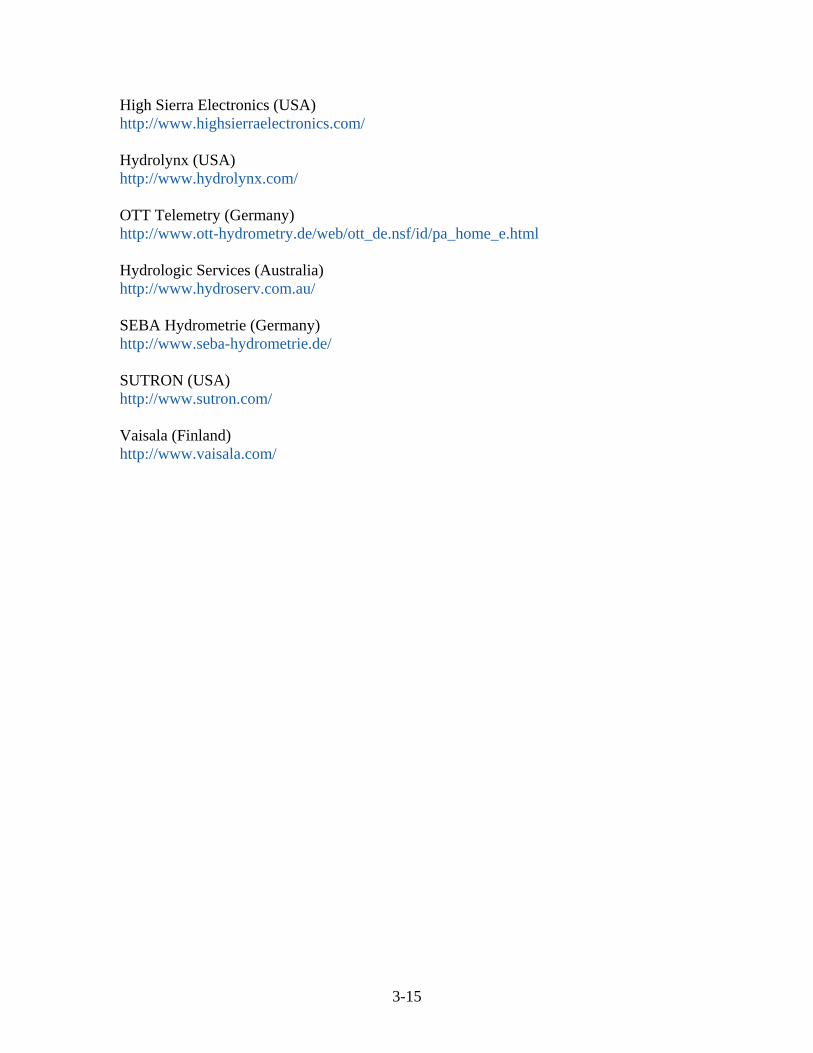
High Sierra Electronics (USA) http://www.highsierraelectronics.com/ Hydrolynx (USA) http://www.hydrolynx.com/ OTT Telemetry (Germany) http://www.ott-hydrometry.de/web/ott_de.nsf/id/pa_home_e.html Hydrologic Services (Australia) http://www.hydroserv.com.au/ SEBA Hydrometrie (Germany) http://www.seba-hydrometrie.de/ SUTRON (USA) http://www.sutron.com/ Vaisala (Finland) http://www.vaisala.com/
3-15

4. Data Sharing and Visualization Data sharing and cooperation is one of the greatest methods to reduce the price of a real-time hydrologic monitoring network for any given organization. Cooperative agreements, though possibly time consuming to construct, will pay enormous dividends during the period of operation of any real-time hydrologic network. For instance, CWC and IMD operate extensive networks in India. These stations are perfect examples of data that can be shared with any organization, provided a cooperative agreement put in place. Provided data is freely shared with all organizations, capital costs of equipment and especially recurring maintenance can be drastically reduced. Even if the maintenance of existing network is shared, the cost will certainly be reduced by taking on maintenance of a large network by a single organization. Unfortunately, the concept of data and network sharing, and even operating entirely cooperative networks is easier contemplated than it is to implement. Even if agreements to share data and even stations within a network there is a challenge to assure the measurements and timeliness of real-time data flow meets the needs of the most demanding partner. This is a certain challenge, but it has been overcome in other regions in the world and often times with the participation of the executive staff of the respective organizations. The collection and transmission of real-time hydrologic data is only the first step in the eventual use of the data. There are an increasing number of subsystems being built that store the data into a data base and produce the information from a web browser type interface. The data can either be distributed via the INTERNET or more securely, made available through and INTRANET. An INTRANET is a private computer network that uses the INTERNET Protocol technologies to securely share information within an organization’s internal website. Most simply put, an INTRANET is a private version of the INTERNET. If the organization plans to make the information available to the public, this commonly performed through a network gateway with a firewall. If properly implemented, the organization will be shielded from unauthorized external access. A third for of network access is an EXTRANET which may be accessed by approved parties. Open source software products have now matured enough to be utilized in current offerings of hydrologic data base and visualization products. PostgreSQL is now used by large agencies around the world, thus trimming the cost of purchase and ongoing costs. When selecting visualization software, it is important to keep in mind the recurring expense for software licensing, including licensing of a proprietary data base which can easily overwhelm the budgets of an agency and cause problems with sustainability. Data visualization is quite often coupled and can also be considered to be an important component of any DSS. Common visualization tools include the ability to produce plots of a single or combination of parameters either measured or calculated with time. Another product often produced by visualization programs are data tables, or data that is organized in daily, monthly, or annual summaries. Visualization programs often have the
4-1

capability to plot your data on maps, such as Google Maps, or some other widely familiar interface. Many visualization programs can also include products from deterministic tools, such as weather forecasts, flood forecasts, or other products that the organization may need to assist in the decision making process. Data visualization programs have an extremely wide range of pricing. Software can be acquired for as little as $5,000 USD that will provide graphing and table functions, along with displaying the station data on a map. This also includes real-time alerts and alarms. Similar software can be well over $100,000 USD. A well thought out needs assessment prior to purchase could well save a particular organization hundreds of thousands of dollars over the course of the real-time hydrologic project.
4-2
5. Concept of Sustainability Sustainability was touched on in Section 3, but deserves much greater consideration and will be further addressed in this section. A review of recent projects in India indicates that large hydrology projects, such as water resource monitoring automation projects, failed soon after implementation. In order to avoid this in future projects, an understanding of sustainability must be better understood. In this way, the HP II projects can be properly scoped scaled so that the project can adequately serve the agency in years to come, and up until the expected lifetime of the technology. Sustainability should be carefully considered at the outset of the project. The following are key considerations which must be evaluated before starting any real-time hydrologic system, and essentially any hydrologic monitoring system, whether it is real-time or not.
a. The move to real-time hydrologic systems should be carefully scaled to fit the resources required to operate and maintain such a system. Quite often the understanding of operations and maintenance is simply overlooked. Thus large complex systems are designed which have little or no chance of being sustained. The agency will receive a wealth of real-time information, but this comes at a price, which is the operation and maintenance of the real-time hydrologic system. The initial cost of implementing real-time hydrologic systems are high, but these costs will be dwarfed by the total cost of operation and maintenance over the lifetime of the hydrologic system. It is not uncommon to spend over 10 times the cost of the equipment in subsequent operation and maintenance activity, especially if the agency wishes to collect meaningful information.
b. A success of a real-time hydrologic system is tied to the staff chosen to oversee
the operation of the system. This group must have the unwavering support of management and must also develop a sense of ownership of the system. Though the equipment is very high technology, it will take the development of an in-house group of experts to manage such a system, whether the agency is responsible for maintenance or not.
c. Training and the development of key in-house personnel will also help sustain a
complex measurement system. The agency should develop a group of in-house experts to manage the network. Training should occur from the first year, and every year thereafter. The staff should be permitted to attend vendor exhibitions and be part of training workshops that are held by the equipment manufacturers. This group of in-house highly trained experts would go a long way to assuring a long lasting and sustainable solution. Lack of training, and on-going training and development is likely the single most critical factor that leads to the premature demise of hydrologic networks, and is at least a major culprit in the recent failures of automation projects that have been implemented in India over the last 10 years.
5-1

d. Maintenance and a well thought out maintenance plan are of paramount importance in developing sustainability into a real-time hydrologic information system. There is a strong desire in India to out-source maintenance. This most certainly will come to higher cost to the agency, and potentially less flexibility, depending on how the maintenance contract is written. Regardless of whether the agency out-sources maintenance or has the maintenance performed in house, the agency should of core competencies and even expertise in hydrologic measurement, including real-time automatic methods. There are several options to performing maintenance, with come with features unique to each maintenance option.
i. If the agency performs maintenance in house then there is flexibility in
changing to scope of maintenance operations without involving contract modifications or even worse, contract disputes. The primary disadvantage of in-house maintenance is the potential lack of flexibility in dealing with personnel. Changing a person’s position within an agency is likely more difficult than cancelling an out-sourced contract.
ii. If the agency has the supplier perform maintenance, then the agency is assured that the supplier will have the most up-to-date information with regard to equipment operation and maintenance. The agency still needs to have expertise in the system, as the maintenance activities that are out-sourced still need to be audited by the agency. An agency expert will also be able to recommend equipment that the supplier may not necessarily be aware of because it is not part of their product offerings. Suppliers will sell what they can most easily acquire and not necessarily what is the best solution for the agency.
iii. A third method of acquiring maintenance help is to out-source the supply of people to perform the maintenance. These workers can be trained by either the supplier, but even better, by the in-house experts. This will most certainly reduce the cost of maintenance over having the supplier perform the maintenance, and will provide the flexibility to remove non-productive workers easily. This method is used in Maharashtra and appears to be working very well. This will require a strong in-house expertise and management of these people. It the in-house staff is trained well, the agency could be involved directly in the training of the maintenance staff, being that the supplier may not be the group that provides the maintenance personnel.
In summary, to achieve sustainability of the real-time hydrologic information system, a considerable effort will need to be applied by the agency over the entire life-span of the network. Just because the information gathering is automated and telemetered in real-time doesn’t mean that sensors will not need to be calibrated and measurements checked. A very well written maintenance manual will need to be part of the program that is written particularly for the respective network taking into account local conditions, and the equipment that was selected. The maintenance manual should include audit
5-2

procedures whereby someone other than the maintenance team will be auditing the operation and calibration of the sensors. This is necessary to assess the performance of the maintenance and make changes to maintenance procedures as necessary. It is not only necessary to assure the equipment is operating, but also that the equipment is operating within specifications. Real-time data that is shuttling poor quality information will lead to errors in decision making. Together, these considerations will harmonize the data collection effort and extend the life of the network to 15 years which should be considered as the upper limit of any real-time hydrologic information system.
5-3

6. Summary and Conclusions When setting up a hydrometric monitoring network the utmost consideration must be made in choosing quality equipment. Experience indicates that buying equipment from well established companies will save a great deal of time and effort over the life of the equipment. The larger companies will stay current with the latest technologies as these entities serve not only customers in India, but customers all over the world. Hydrometric monitoring equipment should be expected to last at least 10 years, but not more than 15 years. Beyond 10 years technology evolves to the point that operation and maintenance would benefit from purchasing new equipment, and the cost of the new equipment will be small compared to the cost of maintaining aged equipment. In addition, communications, and specifically real-time data relay methods are expected to change considerably over the next 10 years. Better solutions will be available at lower costs in time. If you invest in good quality hydrometric equipment that is properly designed for the measurement and measurement environment you are faced with, then you can expect a hydrometric network to provide service for many years with little maintenance. The initial purchase of new equipment from the leading vendors may seem high, but often purchasing inferior equipment leads to a greater cost during the operation and maintenance phase of the real-time hydrologic monitoring network. Usually, those that budget for equipment would also like to see the costs more up-front, rather than to have to increase budgets after the initial installation. Generally, the maintenance of equipment will overwhelm the initial purchase price over the course of equipment operation. If you ever get in a cooperative relationship where you have the choice of purchasing the equipment or maintaining the equipment, always choose the former, you will save a great deal of money. My preferred telecommunications is almost always a space-based real-time data collection system, such as INSAT. It is very well suited for the relay of hydrometric data. The users are not charged for data relay as long as the data being collected serves the purpose of monitoring the environment. IMD and CWC are increasing their use of INSAT which means these two entities will be able to share real-time data very easily as their data will be available to anyone else who chooses to use INSAT. This is what the INSAT data collection system was intended. Nonetheless, GSM/GPRS is one of the more rapidly growing real-time data relay solutions in India. This is likely because of the low initial cost of GSM/GPRS hydrometric systems. I generally try to avoid real-time solutions that share bandwidth with the general public, especially if the purpose of the hydrometric data collection has a public safety component. The potential interference of increased public use of mobile phones, which is usually what happens in the midst of an emergency, can cause a significant conflict with any hydrometric measurement program. If the data being relayed does not have a public safety objective and outages in the real-time data stream do not cause significant problems, then GSM/GPRS is a reasonable solution.
6-1

The lure of operating a network over TCP/IP is certainly significant, and quite possibly a solution that combines TCP/IP over a private mobile network will evolve to be a solution to be considered in the years to come. The ALERT system is also a good solution provided that the area of the monitoring network is relatively small (~400 km2). Area’s larger than this may require radio repeaters and associated radio towers which can increase the initial cost of the network, and also add an incremental maintenance obligation. There are numerous vendors of ALERT radios, and the DSS software is off-the-shelf, and very advanced.
6-2

7. References Karl, T.R., V.E. Derr, D.R. Easterling, C.K. Folland, D.J. Hoffman, S. Levitus, N. Nicholls, D.E. Parker, and G.W. Withee, 1995: Critical issues for long-term climate monitoring. Climatic Change, 31, 185-221 Rantz, S.E., 1982: Measurement and Computation of Streamflow: Volume 1. Measurement of Stage and Discharge. United States Geological Survey, Geological Survey Water-Supply Paper 2175. Street, R.B., Allsopp, D, Durocher, Y. 2007: Guidelines for managing changes in climate observing programs. WCDMP-No. 62, WMO-TD No. 1378. 24pp Terakawa, A., Hydrologic Data Management: Present state and trends. World Meteorological Organization, Operational Hydrology Report No. 48, WMO-No. 964, Geneva, Switzerland United States Department of the Interior, Bureau of Reclamation, 2001: Water Measurement Manual Vuerich, Monesi, Lanza, Stagi, and Lanzinger (2009): WMO Field Intercomparison of Rainfall Intensity Gauges. World Meteorological Organization, Instruments and Observing Methods, Report No. 66, WMO/TD-No. 1504, 96pp World Meteorological Organization, 2009: Implementation and use of Automatic Weather Stations (AWSs), World Meteorological Organization, Doc 6.2a, 9pp World Meteorological Organization, 2008: Guide to Meteorological Instruments and Methods of Observation, WMO-No. 8 World Meteorological Organization. 2001: Guide to Climatological Practices. Commission for Climatology World Meteorological Organization, 1983: Guide to Climatological Practices. WMO-No. 100, Geneva, Switzerland World Meteorological Organization, 1994: Guide to Hydrological Practices: Data Acquistion and Processing, Analysis, Forecasting and other Applications. WMO-No. 168
7-1