Distributed Spatiotemporal Trajectory Query Processing in SQL

A Novel Spatiotemporal Trajectory PatternRecognition with Nature Inspired Early DestinationPrediction Algorithm Using Intelligent SensorDevices for Secure Wireless CommunicationD. Prabhakaran ( [email protected] )
Mahendra Engineering CollegeT. Jesudas
Mahendra Engineering College
Research Article
Keywords: Nature Inspired algorithm, Secure communication, Saptio GPS, Trajectory Pattern Recognition,Intelligent Sensor Devices
Posted Date: October 26th, 2021
DOI: https://doi.org/10.21203/rs.3.rs-996481/v1
License: This work is licensed under a Creative Commons Attribution 4.0 International License. Read Full License

A novel Spatiotemporal Trajectory Pattern Recognition with nature inspired early
destination prediction algorithm using Intelligent Sensor Devices for secure wireless
communication
D. Prabhakaran1, *
, T. Jesudas1
1Mahendra Engineering College (Autonomous), Namakkal, Tamil Nadu – 637 503
*Corresponding author mail id: [email protected]
Abstract
This research work focused mainly on early prediction of destination and emergency-oriented
procedure to recognize trajectory patterns from intelligent sensor devices by analyzing GPS data.
As an option in contrast to the customary two essential methodologies with direction following
that limit the hopefuls regarding the excursion advance, and Next Place Prediction that surmises
the future area of a client from client propensities, we proposed here another model dependent on
both ordinary models. The benefit of this research work is, it definitely limits the goal hopefuls
productively at the beginning time of a trek, inferable from the staying data got from the NPP
approach. In spite of the straightforwardness of our model, the proposed strategy gives enhanced
execution contrasted with traditional methodologies dependent on the test results utilizing the
GPS logs of 1,546 genuine clients from the business administrations. To assess the proposed
strategy and techniques, consecutive direction informational indexes originate from the GeoLife
venture alongside human circulation logs from cell phone application EMAPP are used. Goal
expectation (e.g., anticipating a future area) can be connected to different down to earth
applications. A case of goal expectation is customized GIS administrations, which are relied
upon to give backup courses of action to empower clients to maintain a strategic distance from
clogged streets in future applications. At long last, we show the capability of managing area data
for advancing crisis the executives.
Keywords
Nature Inspired algorithm, Secure communication, Saptio GPS, Trajectory Pattern Recognition,
Intelligent Sensor Devices
1. Introduction
With the sensational advancement of situating gear like the base station, cell phone, RFID,
reconnaissance camera and GPS apparatus, people's portability directions are consistently caught
labeled with time stamp. In the meantime, one can move around the city as the activity street and
open transportation turn out to be increasingly accessible, which create a vast assortment of

position logs unavoidably [1-5]. These direction information fill in as a critical establishment for
understanding activity condition and people's portability conduct. Since movement logs amass,
human periodical personal conduct standards are effortlessly perceived dependent on information
mining innovation. On the other hand, these discoveries can be connected to anticipate the
movement clog and the spots where individuals like to travel. Spatiotemporal direction
examination has been connected to numerous angles, for example, driving decision,
transportation the executives, business proposal, urban arranging, the travel industry benefit,
criminal examination and so on. With the advancement of multi-sensor information combination,
it turns out to be a lot less demanding to coordinate assortments of multi-scale spatiotemporal
information. Making sense of the qualities of human development example and gathering
conduct can be to a great degree valuable for ordinary and crisis conditions. Taking an extensive
scale movement for instance, hundreds to thousands individuals will gathering into a little zone
at specific time. Generally, camera systems are utilized to on location staff observation. In the
interim, the encompassing ongoing activity conditions are caught by on-board GPS in vehicle.
By incorporating these information, the groups can be determined. It is important to take
countermeasures to oversee and control the surge of individuals, for example, segregating the
group, and ensure the encompassing movement are under control. On the off chance that human
development and dissemination can't be related to high effectiveness, crisis basic leadership can
be postponed and the safeguard asset can't touch base on time, which cause the rush and
movement loss of motion effortlessly [6-8].
By joining client conduct forecast, it is conceivable to enable clients to spare time by setting up
the administrations to be given ahead of time dependent on their inclinations and schedules. In
concentrated on the holding up time to utilize a versatile application and examined the planning
of an application previously utilizing a calculation that anticipated the following application to
be utilized and when. Okoshi et al. considered the issue that cell phones require client exertion to
pick when and where to get push notices, and examined anticipating a decent time for clients to
get warnings. Anticipating the future area of clients (e.g., goals) is a standout amongst the most
critical points in client conduct expectation and has pulled in much enthusiasm among analysts.
By foreseeing goal, it is conceivable to prescribe a reroute without sitting tight for an inquiry
from the client [9, 10]. For instance, when a train is postponed, give notices and pursuit words as
per the goal, and recommend news articles to peruse or recordings to watch while in transit to the
goal. For instance, T-associate gives operator benefits that send activity data, climate at the goal,
and so on, without being given the goal, yet anticipating it dependent on the movement history,
day of the week, and time of day once the vehicle motor begins. Google Now gives data
important to a client dependent on area history, checkout history, and timetable. In the goal
forecast issue, there is an exchange off between expectation exactness and timing. Specifically,
there is an exchange off between the level of excursions finished and the exactness of goal
expectation. In this unique situation, we allude to a trek as the development starting with one
area then onto the next. For goal expectation in the beginning time of an outing, it is important to

utilize just data that can generally be alluded to (e.g., beginning area, day of the week, and time
of day). Be that as it may, it is likewise important to foresee the goal with high precision and in
this manner, alter the forecast by considering the measure of data that increments as the outing
advances, for example, data on the course that has been taken [11, 12]. For this application, it is
pointless to give the bypass course after the client has experienced a blocked street. In this way,
it is important to limit the goal with high precision in the beginning period of the outing. Course
direction for a visually impaired man is another case of applying goal expectation. For this
application, if early expectation is preposterous, it may compel the client to take the long
incorrect way. POI suggestions for voyagers while in transit to a goal could likewise be
considered. For this application, in the event that goal expectation is postponed, the chance to
prescribe a POI that the client might be keen on is lost [13-16].
As opposed to goal expectation from GPS follows, an assortment of work on early
acknowledgment in PC vision has been effectively investigated. M. S. Ryoo handled early
acknowledgment frameworks in human action acknowledgment from spilling recordings since
movement acknowledgment is required before completely executing the action. Early
expectation of feeling is additionally one of the testing undertakings. For instance, early
expectation of understudy dissatisfaction gives the chance to enhance the learning condition. Be
that as it may, in goal expectation examine there just are a couple of studies concentrating on this
exchange off relationship. In this investigation, we deliver another way to deal with precisely
anticipate goal in the beginning time of an outing, which we call early goal forecast with
enhanced direction following [17, 18].
In the interim, it is critical to uncover the human development design amid life-compromise
circumstances. As related investigation advanced, a few specialists propose that the challenges
were not obstinate as formally assumed. Lu et al., recommend that both the movement
separations and the span of individuals' development direction are fundamentally more
unsurprising than past idea amid serious calamity. Brockmann et al., infer that human travel on
geological scale is an undecided and viably overly diffusive process. In the field of crisis the
executives, the direction acknowledgment issue dependably contain the dispersion of the
unfortunate casualties after seismic tremor, clearing course decision after sea tempest and
hurricane, departure limit assurance after unstable mishap or harmful exhaust spillage, human
versatility designs alongside the irresistible infection, and transportation conditions after fear
monger assault. So as to handle these testing issues, multi-source astute sensor gadgets are
essential to gather fiasco related spatiotemporal information. Area based data, for example, the
haven dissemination and the ongoing improvement of debacle can advance the clearing work. At
the point when a man is under a calamity situation, it is earnest to drive crisis data to him/her
dependent on the improvement of catastrophe. Crisis the executives includes the safeguard asset
circulation, crisis calculated administration, decide the quantity of exploited people should be
cleared, and empty unfortunate casualties to wellbeing crisis covers. In this paper, we expect to

divulge the crisis situated direction design dependent on direction information. Perceiving the
human conveyance change can comprehend the development of debacle elements. The
commitment of this paper can be condensed as pursues [19, 20].
We give a general direction information preparing strategy intended for crisis the board solely.
We structure a PDA application, which fit for adjusting to various fiasco situation. Framework
design is delineated and concentrated capacities are outlined. Alongside spatiotemporal data, we
coordinate the rising online life work into EMAPP to give a complete comprehension of
catastrophe improvement. The rest of this article is sorted out as pursues. To start with, we give
an outline of the present condition of human area and direction examination. At that point, the
diagram of the system of our methodology is exhibited. Depictions on information preprocessing
models development and semantic direction design acknowledgment are shown. Trial structure
and comparing results are accounted for a while later. At long last, we reach determinations and
offer future work.
2. Related work
As per the plans of information obtaining, advancements for chronicle human appropriation and
direction can be isolated into three classifications. Coordinate Method, which gathers position
information specifically by sensor gadgets including cell phone base stations, GPS, and circle
finders out and about and so forth. These gadgets are utilized in various circumstances relying
upon the kinds of information archives. Be that as it may, position exactness and the extent of
utilization are very extraordinary by utilizing this strategy. The incorrectness dependably caused
by hardware blunder or changes in ecological conditions. The information gathered from direct
strategy require cleaning. With the improvement of Internet of Things, all astute sensor gadgets
can associate with the Internet. Mining area data from the Internet with the help of equipment
hardware is called Indirect Method [20-22]. These gadgets, for example, advanced mobile
phones, PDAs, and PCs, continually interfacing with the World Wide Web. With the
multiplication of web based life applications, individuals connect with one another from the
internet, which results in the development of online network. In the meantime, pervasive area
information are mined from these rising zones. This strategy adjusts for the trouble of flag
inspecting and deliberate mistake. For instance, geographic area information joined with
presenting time are capable on be gathered from microblog API. Geo-labeled photographs
transferred to Flickr can plan spatial directions. Twitter clients can add their area to their tweets.
So as to get the precise situating information, a few scientists utilize web based life registration
information. Furthermore, put proposals are given by Foursquare dependent on identifying a
client's area. Contrast and Direct and Indirect technique, there is an unmistakable strategy by
thinking in consistent and sensible ways. Deduction Method, which implies inducing dormant
area information from existing important techniques [23-25]. For example, breaking down the
flow of monetary certificates to give a quantitative appraisal of human voyaging measurements,

multi-office in situ sensor information joining for giving continuous spatial data, and dissecting
interconnecting camcorder information to tally indoor territory people and remake direction
development. Surmising technique made the information, which appear to be immaterial, viably
utilized. In the meantime, profundity information mining from huge assortments of potential
sources can give continuous data to crisis the executives and make up the insufficiencies of
direct strategy and roundabout technique.
In spite of the fact that few investigations on setting mindful course based goal expectation have
been analyzed in the writing, Ziebart et al., shows a spearheading work for this issue utilizing
reverse fortification learning. The model introduced in offers vigorous goal forecast in a brought
together way, nonetheless, the intricacy of this methodology is inclined to challenges in highlight
plan because of the idea of backwards support learning. As opposed to the unpredictable
methodology for setting mindful course expectation, our work depends on two regular structures,
the direction following model and the following spot forecast show [26].
Forecast dependent on direction following
Direction following, which predicts the future direction from chronicled client direction, is every
now and again utilized for goal expectation for canny vehicle route undertakings. This
methodology makes it conceivable to alter the forecast as a trek advances. Essentially, this
methodology depends on the Markov models of a client trip from one area to the next area,
Krumm and Horvitz enhance the Markov-put together model by centering with respect to client
arrive types and the course effectiveness [27]. Since this methodology is painstakingly planned
with course forecast as opposed to goal expectation, it experiences issues in acquiring exact goal
expectation at the beginning period of a trek because of the constrained direction Information.
Our work makes up for the impediments of this methodology by utilizing client settings
notwithstanding directions.
Next Place Prediction (NPP)
NPP has been as of late investigated in the omnipresent figuring network on account of the
accessibility of cell phone area logs. This model concentrates client area propensities by utilizing
client settings, for example, the timeframe and day of the week, and after that predicts one's area
from the utilized client settings. Because of utilization of client settings, the forecast precision
accomplishes dependable execution at the beginning time of an outing. In the writing, client
settings, for example, the day of the week, and time of day are oftentimes utilized for a precise
forecast from past excursion designs. Notwithstanding the client settings referenced over, the
present client current and the length of remain at the present area are utilized for enhancing the
exactness [28]. Calculated relapse and choice trees are frequently utilized for this errand. To
explain the low forecast execution because of the lack of the outing designs from the logs of a

solitary client, McInerney et al. propose a probabilistic model called, LocHDP (various leveled
Dirichlet forms reaching out to client area displaying), which shares the propensities for every
client. In any case, NPP couldn't make up for the misclassified forecast result regardless of
whether the client direction was given gradually regard to the advancement of an excursion.
Our work makes up for the weaknesses of NPP by giving hearty goal forecast to unforeseen
directions against client settings. In this article, we built up a cell phone application, which
coordinate the conceptual diagram display alongside interpersonal organization, connected to
crisis situation. We feature the systems for information preprocessing and show development.
The application is connected into utilization, which indicates fulfilling execution.
3. Module framework
Crisis the executives profits by continuous securing of spatial data. Thinking about the intricate
circumstance amid debacle reaction, heterogeneous information, for example, human circulation
and development, movement arrange, and geographic data require combination. An advanced
cell application, named EMAPP, has been utilized to gather clients' position data with the
authorization of its clients. The application contains four modules, in particular Geo-database
Module, Expectation Module, Information Release Module, Scenario and Social Network
Module. The GPS logs alongside recorded datasets are put away on a system server remotely.
4. Proposed approach
Joined with geographic data like urban structures, developments and movement organize
topology, the web server comprises the Geo-database Module. Crisis reaction requires a
popularity of ongoing data connection. In this manner, the application is intended to contain a
Prediction Module. Human development expectation, noteworthy area distinguishing proof, and
activity forecast made up the fundamental capacity in the Prediction Module. The application is
dedicated to offer continuous observation and populace checking, particularly amid huge scale
exercises. Human conveyances, crisis data and area based administration are given to action
panel and the members [29]. Amid crisis situation, clients can build up fleeting interpersonal
organization with one another. In the interim, they can transfer catastrophe data rely upon the
improvement of crises. Diverse situation data are put away on another web server. The
framework engineering and modules are delineated in the underneath Figure 1.

Figure 1 Overall proposed method
4.1 System definition for Prediction and database module
The application is intended to adjust to various crisis situations. It is important to catch multi-
source information as the calamity type is evolving. With GIS innovation, huge assortment of
area information are put away with scope and longitude, for example, movement system and
structures. Basically, EMAPP goes about as a canny sensor. An extraordinary volume of ongoing
spatial information are created by the clients' day by day utilization. After information gathering,
spatiotemporal information handling includes commotion decrease, spatial information
stockpiling and portrayal. In any case, putting away a wide range of disconnected repetition
information create a weight to the storage room and decrease transmission effectiveness.
For direction information, anomalies should be distinguished and commotion require expelled.
Then, pack direction information can spare storage room. Yan and Chakraborty, depict two
delegate pressure calculations, the Douglas-Peucker expansions with the use of Synchronized
Euclidian Distance, and STTrace. Amid an expansive scale movement, a great many people
heading for an explicit place, observing and observation the area of these individuals are not
quite the same as chronicle their day by day areas. To deal with the huge volume of area
refreshes in the following framework effectively, Liu et al., posture and utilize overwhelming
way design in the moving article following framework to diminish generally speaking area
refreshes between moving items and the server [29, 30]. To handle the trouble of information
repetition, three sorts of spatiotemporal information, which incorporate client direction, vehicle

position, and activity condition, are coordinated in this article. The coordinating of such basic
information can encourage constant departure process. For cutting edge semantic example
acknowledgments, direction divisions are removed. With the cleaned information from the Geo-
database module, EMAPP can see crisis and make valuable forecast before peril develops into
calamity. Simultaneously, forecast module contains loads of geographic data handling dependent
on diagram hypothesis. By grouping GPS information into important areas, Ashbrook and
Starner, fuse area information to foresee development over different employments. Like
Ashbrook's activity, we bunch GPS information to accomplish basic place securing. Aside from
human development and strange grouping, movement blockage additionally considered in this
module
Expectation modules
Development expectation gives rich area and setting data, which encourage for adjusting to
future areas. Correspondingly, clients' developments and versatility designs are investigated
dependent on their day by day utilization of EMAPP. Subsequently, clearing course and the
closest asylum can be prescribed to the unfortunate casualties amid crisis situation. By bunching
directions, comparative development examples can be recognized. In the meantime, warm guide
showed in EMAPP delineates the populace appropriation dependent on the online clients'
number and their geographic areas [31]. Amid a vast scale movement, when the number and
thickness of members surpass a predefined edge, it winds up important to caution the clients to
leave the high-chance territory. By computing direction succession, when the moving velocity of
a client as per a vehicle. Then, the client's area is situated on the activity path. Hence, it is
assumed that the advanced mobile phone is inside the vehicle. In this manner, person on foot
jammed issue is changed into a movement blockage issue. The systems of person on foot
swarmed and activity blockage are comparative.
Data Modules
Exploited people need to realize how to take measures under the fiasco risk. Moreover,
continuous circumstance and protect data are required. In the forecast module, we utilize the
cleaned information from geo-database module. The change from information handling to the
online message sending is finished in this module.
Human appropriation is dependably begin and end of their everyday travel. Long time
development forecast can't be accomplished without knowing the individual every day
circulation. Plainly, individuals with various professions working and living in better places. The
attributes between their driving and periodical examples are differing. At the point when the
volume of dispersion information, which gathered from wise sensor gadgets, turns into a city-
scale, the human day by day dissemination can be recognized by joining Movement Prediction

with Significant Location Identification [32]. Decide human day by day dispersion will cultivate
every day transportation administrations, and designation of catastrophe alleviation supplies.
Crisis data originates from numerous assets.
EMAPP is planned with an episode detailing interface. At the point when surprising dangers
occurred, for example, _re or fear monger assault, clients are moved toward becoming data
sending sources. They can convenient report by transferring situation picture labeled with
spatiotemporal data with brief depiction content. All data require sifting, dissecting, and
afterward sending to different exploited people by the neighborhood crisis organization [33].
These new worldview of debacle recognition can encourage common help and cultivate crisis
protect which resembles publicly supporting really. Social affair spatial related catastrophe
reaction information like the areas of the sanctuaries and crisis therapeutic administrations are
advantageous to the city inhabitants. Such data will enable the evacuees to settle on right choices
amid crisis, which decline the departure time under the introduction of hazard.
EMAPP stretched out by coupling the static data with online correspondence implies, for
example, internet based life and SMS instant message, can communicate a valuable notice to
caution the evacuees.
4.2 Data pre-preparing utilizing molecule separating
Clever sensors gather human direction and conveyance information at sporadic time interims.
For every period, the perception of the GPS readings are unavoidably impacted by the client's
genuine area, development, encompassing condition and hardware deserts. At the point when the
client ventures into a building, the GPS readings of indoor position are never again exact. The
application, which introduced on the cell phone, will lost area information when the client close
it down. Regardless of these errors, the area information are communicated as three-tuples time
arrangements with longitude and scope.
The initial step subsequent to getting the direction information is commotion separating. Much
direction information have clamor particularly when the client change transportation mode. GPS
situating mistake dependably caused by the equipment gear, clients' development, and the
impedance of encompassing structures. GPS signals are normally hindered by the indoor or
underground situation [34, 35]. GPS gadgets may disturb close tall structures and consistently
gathering GPS information may diminish gadget's vitality rapidly. In the interim, low battery will
no uncertainty lessen the situating exactness. GPS situating can't be utilized inside tall structures,
the blunder in the tallness may cause a few stories misconception. In this section, an adaptation
of consecutive Monte Carlo strategy, called molecule separating, is connected to incorporate
position information sifting and estimation.

Existing strategies in blunder decrease incorporate mean sifting, middle separating, Lancoz
sifting, Wiener separating, Kalman sifting, and Bayesian separating and so forth. The sifting
issue comprises of not just evaluating exact qualities upon chronicled information when halfway
perceptions are made, yet additionally the future area expectation in the dynamic framework. Be
that as it may, the previously mentioned strategies exceed expectations in preparing the current
information as opposed to making travel position forecast. The systems of the SMC strategy are
delineated in above figure.
Where X 0:m indicates the geographic position of a GPS transporter at time t 0:m
Correspondingly, Y 0:m is the forecast position at time determined. The implications of every
bolt's bearing are delineated as pursues.
𝑋𝑖 → 𝑋𝑖+1 Equation 1
Where it tells that GPS carrier movement form time
𝑌𝑖 → 𝑌𝑖+1 Equation 2
Where it tells that prediction position from state transition from time
𝑌𝑖+1 → 𝑋𝑖+1 Equation 3
(Strategy developed to replace low weight particles)
𝑌𝑖 → 𝑋𝑖+1 Equation 4
(For position prediction of Y)
SMC strategy is the technique of consecutive particles refreshing with resampling dependent on
significance factors (examining significance resampling, SIR). Yi is make up of particles, which
delivered by a two-dimensional Gaussian dispersion
𝑌𝑖~𝑚(𝛽1, 𝛽2, 𝛾12, 𝛾22, 𝛿) Equation 5
Where (𝛽1, 𝛽2, 𝛾12, 𝛾22, 𝛿) – geographic position information
The arrangement changing of Yi is the Markov procedure, which implies that a molecule just has
association with the previous one. The progress of expectation position from time t i to t (i+1) is
meant underneath.
𝑌𝑖+1 = 𝑌𝑖 + (𝑋𝑖−𝑋𝑖−1)(𝑡𝑖−𝑡𝑖−1) × (𝑡𝑖+1 − 𝑡𝑖) Equation 6
The weight conversely relative to the separation between anticipate area and genuine area.
Through standardization, the low weight particles will be supplanted slowly.
𝛼(�̅�)𝛾 1√2𝜋𝛼 𝑒𝑥𝑝 (−𝑑 (𝑌𝑖+1,𝑋𝑖+1)×22𝑋2 ) Equation 7
In information preprocessing strategy, the fundamental work is delineate the direction
information onto the movement street precisely. Quickly, versatility direction related to basic
area data require removed and remade. We got swarm elements by chronicle the area data from
city occupants here. This can be down just through plentiful and point by point tests of the group.
4.3 Early Destination Prediction with Spatio-Temporal User-Behavior Patterns
This segment exhibits our proposed model which seeks after early goal forecast. Because of the
straightforwardness of our detailing, the model comprises of the two methodologies referenced
beneath (that is, goal expectation with direction following and NPP). We additionally portray the
models utilized in our proposed model for goal expectation with direction following and NPP.
Factorizing goal expectation with directions and client settings into two methodologies
Attributable to the way that the abuse of both client settings and directions is required to enhance
the precision of the goal expectation at a beginning period of a trek, this segment shows how to
utilize all the data deliberately. For instance of one of the guileless methodologies, we just look
for the greatest a posteriori of goal hopefuls among the models. In particular, the model can be
detailed as:
𝑞(𝑥/𝑦𝑙1:𝑡) = 𝑚𝑎𝑥(𝑥/𝑦), 𝑞(𝑦/𝑙1:𝑡) Equation 8
Notwithstanding, this model just chooses directions or client settings dependent on the likelihood
of each model, that is, this model can't consider both the client directions and settings in the
meantime, and thus the issue for early goal forecast stays unsolved. By utilizing the connection
among joint and contingent likelihood we settle this issue and the model can be factorized into
two components as:
𝑞(𝑥/𝑦𝑙1:𝑡) = 𝑞(𝑥𝑙1:𝑡/𝑦)𝑞(𝑙1:𝑡) Equation 9

On account of this suspicion, the likelihood can be factorized into two customary methodologies:
direction based goal forecast, and NPP. Subjectively, the model delivers a solid outcome by
utilizing the NPP approach when direction data is constrained at the beginning time of an outing
while it likewise creates a dependable outcome at the last phase of an excursion.
4.4 Prediction by NPP: Multi-class strategic relapse utilizing staying data as highlight
Review of multi-class calculated relapse with client settings. As the NPP technique is used in our
model, we utilize multi-class strategic relapse utilizing client settings, for example, the day of the
week, time of day, and beginning area separated from the utilization log. For this situation, the
forecast technique is defined as,
In the proposed technique, we got forecasts utilizing the Markov display. Give N A chance to
add up to be the L × L lattice speaking to the progress likelihood from state to state. In this
unique situation, states are discretized areas. At that point, N Total is communicated utilizing
underneath condition by utilizing q i→j to speak to the change is pursued as, 𝑁𝑡𝑜𝑡𝑎𝑙 = [𝑞1→𝑙 𝑞1→𝑗 𝑞1→𝑙𝑞𝑖→1 𝑞𝑖→𝑗 𝑞𝑖→𝑙𝑞𝑙→1 𝑞𝑙→𝑗 𝑞𝑙→𝑙 ] Equation 10
We the upgrade change lattice N Total by utilizing the SubSynE calculation. This calculation
advances the progress network of the Markov show worked from the GPS follows. The SubSynE
calculation decreases the estimation cost of the SubSynE calculation [34, 35]. The Markov
demonstrate expectation depends on a past course and shows an information meager condition
issue. In the SubSynE calculation, the progress lattice M between adjoining states is first made
from halfway directions gotten by isolating one finish course. By utilizing M, the progress
framework M Total including all change probabilities starting with one state then onto the next
state is made. This calculation does not enhance each total course but instead halfway directions,
and thusly takes care of the information meager condition issue.
5. Result and discussion
So as to discover that the proposed technique is progressively reasonable for early goal forecast
with direction following than the present best in class goal expectation, we contrast the execution
of our model and the direction following methodology and NPP models, as the proposed strategy
consolidates these two expectation strategies. Notwithstanding assessing the expectation
execution as far as precision, the computational expense of our model is additionally assessed
from the application viewpoint.

To assess the execution of the models productively, we utilize the exactness versus the
proportion of a finished outing as the essential assessment metric.
Assessment measures
To determine the execution quantitatively, we utilize the two after measurements as the
expectation exactness measures regarding the part.
Exactness
This measure mirrors the exactness of the expectation execution got from (6) regarding the
portion. The execution is wanted to be exceedingly precise notwithstanding when the portion
achieves a little dimension.
Percentile of best k genuine goals
From an application point of view, for example, online ad, and the suggestions identified with
the goal territories, we likewise utilize top-k genuine exactness for the assessment metric. This
measurement is roused by data recovery. In particular, this measure illuminates the exactness of
the best k competitors of a goal. In the event that the ground truth goal is incorporated into the
best k competitors, the model precisely predicts the goal. As opposed to fundamental exactness,
the best k metric shows the limit of each model to limit the goal regarding the parts.
Figure 2 Trajectory and traffic road – map matching

Figure 3 Case study map - china
We got a GPS dataset from an application structured by Yahoo! JAPAN. The GPS information
included client ID, scope, and longitude, time stamp (JST), speed, and GPS precision. For this
examination, we utilized client ID, scope, longitude, and time stamp. We gathered the GPS
information acquired from 1,546 clients living around Tokyo from June 1, 2015 to July 30, 2017.
For this examination, we characterized the zone around Tokyo as that inside the northern scope
34.5 – 34.9 degrees and east longitude 129.2 – 129.95 degrees in the above figure. In this setting,
we at first picked 1,590 clients who had finish GPS information, and we rejected clients who did
not have enough excursions for preparing. In particular, we avoided clients whose number of
outings was under five. At long last, 1,546 clients were removed.

Figure 4 Tokyo area
As a preprocessing step, we discretize the crude GPS follows from the dataset by utilizing
grouping systems. In spite of the fact that bunching systems for GPS follows have been
completely investigated in the writing. An agent area estimation of a genuine vehicle course is
appeared in Figure 5. The red line delineates the genuine direction and the blue cross shows the
foresee position. Driving course is from east to west. The aggregate driving separation is 17
kilometers and time term is 965 seconds. Five thousand particles, which obey two-dimensional
Gaussian conveyance, are created encompassing the current direction focuses. In view of a few
previous focuses, back to back focuses' areas are refreshed. Also, particles are resampled by
computing the weight between the foresee areas and the genuine directions. With the expectation
procedure going, just the particles with high weight are saved.

Figure 5 agent area estimation of a genuine vehicle course
We additionally directed an examination to analyze the precision of goal expectation dependent
on the excursion rate consummation by utilizing five-overlay cross approval for every client.
Since the GPS information where the client stayed for over 20 minutes were named as
"remaining". We disregarded treks where the beginning area and the goal coordinate in light of
the fact that the SubSynE calculation does not work for them. For preparing information, we led
matrix based information complementation to tackle the issue where GPS information was
obtained at one of a kind interims. In particular, in a two-dimensional space with the scope as the
vertical hub and longitude as the even hub, we considered frameworks that passed the line
portion between the GPS information at steps as those that went through on this outing and chose
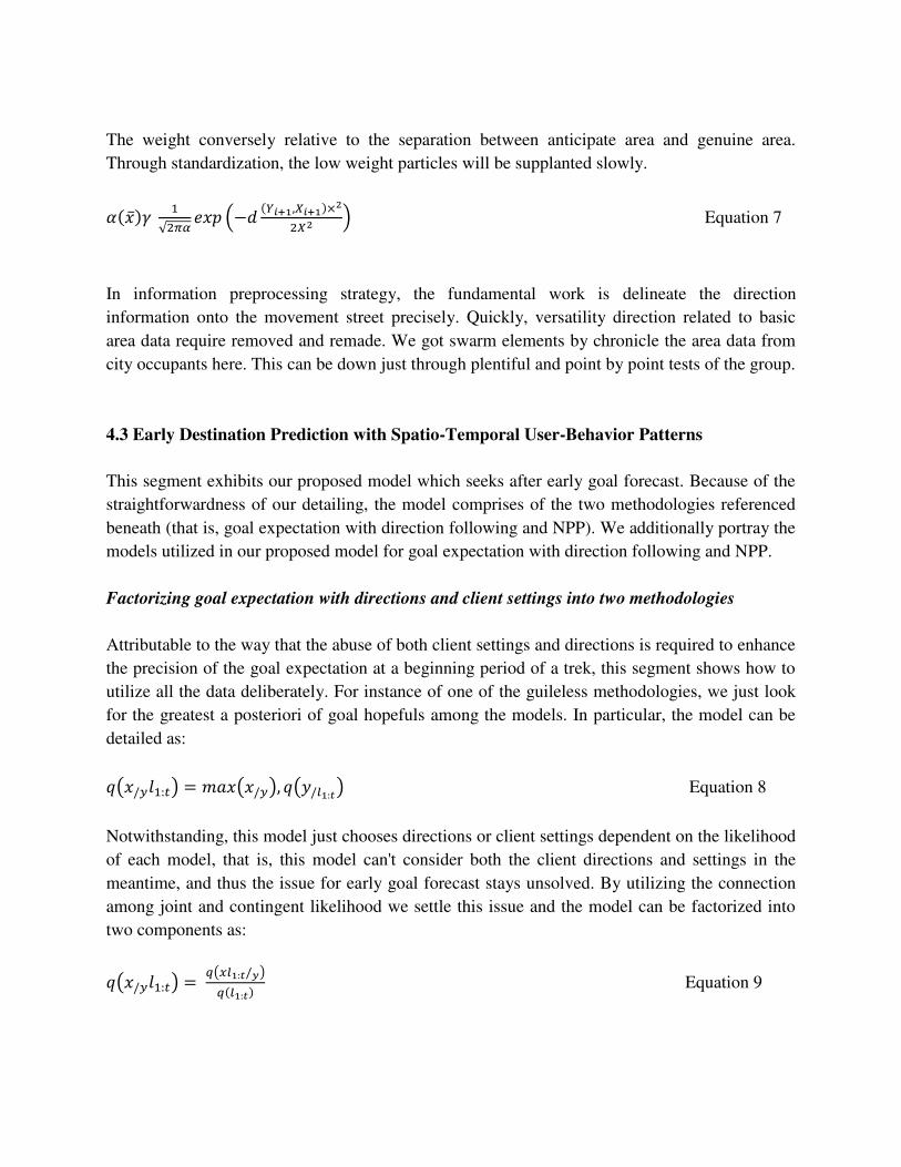
that the dataset ought to incorporate these GPS networks. Fig. 6 demonstrates a case of this
information complementation. The number in the upper left corner of a cell is the mark number
for that cell, the bolts are the bearing of outing, the dark specks are the GPS information in the
dataset, and the white spots are the supplemented GPS information. Fig. 7 demonstrates the
measurements of the progression length per trip for all clients previously information
consummation. The measurable pattern of the progression length dataset shows that clients will
in general attempt short separation trips more every now and again than voyaging long
separations.
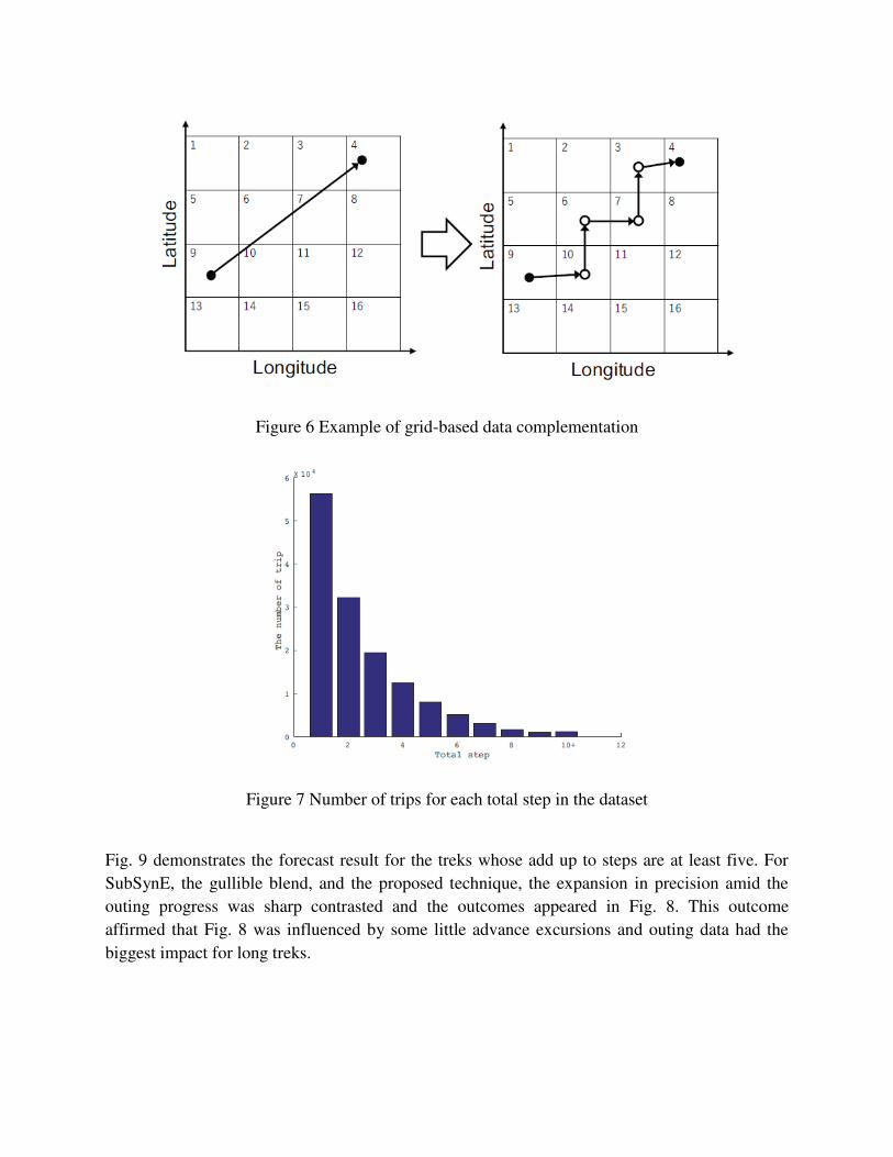
Figure 6 Example of grid-based data complementation
Figure 7 Number of trips for each total step in the dataset
Fig. 9 demonstrates the forecast result for the treks whose add up to steps are at least five. For
SubSynE, the gullible blend, and the proposed technique, the expansion in precision amid the
outing progress was sharp contrasted and the outcomes appeared in Fig. 8. This outcome
affirmed that Fig. 8 was influenced by some little advance excursions and outing data had the
biggest impact for long treks.

Figure 8 Accuracy results
Figure 9 Accuracy results (total step ≥ 5)
6. Conclusion
In this paper, another conduct forecast plot for early destination prediction with trajectory
tracking is introduced. Essentially, our proposed model completely use client setting to
determine the goal competitors at a beginning time of an outing while directions are additionally

utilized to limit the applicants of the goal. In this article, we mean to coordinate heterogeneous
information to adapt to the mind boggling circumstance amid crisis the board. Diverse advances
for chronicle human appropriation and directions are thought about. To enhance the capacity of
continuous data procurement, a cell phone application EMAPP is created which acts well as a
sensor gadget. To streamline the model, we numerically factorize this mind boggling errand into
the two fundamental models: goal expectation with direction following and the Next Place
Prediction undertaking. In the trial utilizing 1.6 K client area logs, we contrasted our model and
the regular models as far as expectation execution as for the division of treks. As indicated by the
outcome, our model accomplishes preferable execution over the traditional ones at any phase of
the outing. What's more, we quantified the calculation time of the proposed strategy and affirmed
that this calculation time is useful from the application point of view. The restriction of our work
is the preprocessing step when we make an arrangement of goal competitors. In particular, the
present investigation use a sort of bunching method of the crude GPS follows to make an
arrangement of hopefuls. Be that as it may, the hopefuls ought not to be chosen from the crude
GPS hints of a predetermined number of clients. Goal forecast with a boundless number of goal
hopefuls ought to be managed as an open issue of this space.
References
1. K. Alsabti, S. Ranka, and V. Singh. An efficient k-means clustering algorithm. In Proc.
of High Prerformance Data Mining 1998 Workshop IPPS/SPDP.
2. N. Beckmann, H.-P. Kriegel, R. Schneider, and B. Seeger. The R*-tree: An efficient and
robust access method for points and rectangles. In Proc. of SIGMOD International
Conference on Management of Data 1990, pages 332–331.
3. J. Duchi and Y. Singer. Efficient online and batch learning using forward backward
splitting. J. of Machine Learning Research, pages 2899–2934, 2009.
4. B. D.Ziebart, A. L.Maas, J. Bagnell, and A. K. Dey. Maximum entropy inverse
reinforcement learning. In Proc. of AAAI 2008, pages 1433–1438.
5. B. D.Ziebart, A. L.Maas, A. K. Dey, and J. Bagnell. Navigate like a cabbie: Probabilistic
reasoning from observed context-aware behavior. In Proc. of Ubicomp 2008, pages 322–331.
6. M. Ester, H.-P. Kriegel, J. Sander, and X. Xu. Density-based algorithm for discovering
clusters in large spatial databases with noise. In Proc. of KDD 1996, pages 226–231.
7. H. Gao, J. Tang, and H. Liu. Mobile location prediction in spatio-temporal context. In
Proc. of Pervasive Computing 2012 Workshop Nokia Mobile Data Challenge.

8. S.-S. Ho and S. Ruan. Differential privacy for location pattern mining. In Proc of
SPRINGL 2011, pages 17–24.
9. W. Huang, M. Li, and W. Hu. Hierarchical destination prediction based on GPS history.
In Proc. of FSKD 2013, pages 972–977.
10. T. Konishi, M. Maruyama, K. Tsubouchi, and M. Shimosaka. Cityprophet: city-scale
irregularity prediction using transit app logs. In Proceedings of the 2016 ACM
International Joint Conference on Pervasive and Ubiquitous Computing, pages 752–757.
ACM, 2016.
11. J. Krumm and E. Horvitz. Predestination: Infferring destinations from partial trajectories.
In Proc. of UbiComp 2006, pages 243–260.
12. S. Levine, Z. Popovic, and V. Koltun. Feature construction for inverse reinforcement
learning. In Advances in Neural Information Processing Systems, pages 1342–1350,
2010.
13. C. Manasseh and R. Sengupta. Predicting driver destination using machine learning
techniques. In Proc. of ITSC 2013, pages 142–147.
14. J. McInerney, J. Zheng, A. Rogers, and N. R. Jennings. Modelling heterogeneous
location habits in human populations for location prediction under data sparsity. In Proc.
of UbiComp 2013, pages 469–478.
15. S. McQuiggan, S. Lee, and J. Lester. Early prediction of student frustration. J. of ACII
2007, pages 698–709.
16. X. Lu, L. Bengtsson, and P. Holme, ``Predictability of population displacement after the
2010 Haiti earthquake,'' Proc. Nat. Acad. Sci USA, vol. 109, pp. 11576_11581, Jul. 2012.
17. D. Brockmann, L. Hufnagel, and T. Geisel, ``The scaling laws of human travel,'' Nature,
vol. 439, pp. 462_465, Jan. 2006.
18. M. Lin andW.-J. Hsu, ``Mining GPS data for mobility patterns: A survey,'' Pervas.
Mobile Comput., vol. 12, pp. 1_16, Jun. 2014.
19. Z. Xu, H. Zhang, V. Sugumaran, K. R. Choo, L. Mei, and Y. Zhu, ``Participatory
sensing-based semantic and spatial analysis of urban emergency events using mobile
social media,'' EURASIP J. Wireless Commun. Netw., vol. 44, pp. 1_9, Dec. 2016.
20. S. Zhang, Y. Wang, S. Zhang, and G. Zhu, ``Building associated semantic representation
model for the ultra-short microblog text jumping in big data,'' Cluster Comput., vol. 19,
no. 3, pp. 1399_1410, 2016.

21. F. Alamdar, M. Kalantari, and A. Rajabifard, ``Towards multi-agency sensor information
integration for disaster management,'' Comput., Environ. Urban Syst., vol. 56, pp. 68_85,
Mar. 2016.
22. J. A. Long and T. A. Nelson, ``A review of quantitative methods for movement data,'' Int.
J. Geograph. Inf. Sci., vol. 27, no. 2, pp. 292_318, 2013.
23. J. Steenbruggen, E. Tranos, and P. Nijkamp, ``Data from mobile phone operators: A tool
for smarter cities?'' Telecommun. Policy, vol. 39, nos. 3_4, pp. 335_346, May 2015.
24. J. Cranshaw, E. Toch, J. Hong, A. Kittur, and N. Sadeh, ``Bridging the gap between
physical location and online social networks,'' in Proc. 12th ACM Int. Conf. Ubiquitous
Comput., Copenhagen, Denmark, 2010, pp. 119_128.
25. D. J. Crandall, L. Backstrom, D. Cosley, S. Suri, D. Huttenlocher, and J. Kleinberg,
``Inferring social ties from geographic coincidences,'' Proc. Nat. Acad. Sci. USA, vol.
107, pp. 22436_22441, Dec. 2010.
26. J. P. Bagrow, D. Wang, and A. L. Barabási, ``Collective response of human populations
to large-scale emergencies,'' PLoS ONE, vol. 6, no. 3, p. e17680, 2011.
27. T. Yabe, K. Tsubouchi, A. Sudo, and Y. Sekimoto, ``Estimating evacuation hotspots
using GPS data: What happened after the large earthquake in Kumamoto, Japan?" in
Proc. 5th Int. Workshop Urban Comput. (URB- COMP), 2016.
28. X. Song, Q. Zhang, Y. Sekimoto, T. Horanont, S. Ueyama, and R. Shibasaki, ``Modeling
and probabilistic reasoning of population evacuation during large-scale disaster,'' in Proc.
KDD, Chicago, IL, USA, 2013, pp. 1231_1239.
29. Z. Xu et al., ``Building knowledge base of urban emergency events based on
crowdsourcing of social media,'' Concurrency Comput.-Practice Exper., vol. 28, no. 15,
pp. 4038_4052, 2016.
30. J. Fry and J. M. Binner, ``Elementary modelling and behavioural analysis for emergency
evacuations using social media,'' Eur. J. Oper. Res., vol. 249, pp. 1014_1023, Mar. 2016.
31. Q. Deng, Y. Liu, H. Zhang, X. Deng, and Y. Ma, ``A new crowdsourcing model to assess
disaster using microblog data in typhoon Haiyan,'' Natural Hazards, vol. 84, no. 2, pp.
1241_1256, 2016.
32. Z. Yan and D. Chakraborty, Semantics in Mobile Sensing. San Mateo, CA, USA: Morgan
& Claypool, 2014, pp. 28_29.
33. K. Liu, Z. Ding, M. Li, K. Deng, and X. Zhou, ``Pattern-based moving object tracking,''
in Proc. TDMA, Beijing, China, 2011, pp. 5_14.

34. D. Ashbrook and T. Starner, ``Using GPS to learn signi_cant locations and predict
movement across multiple users,'' Pers. Ubiquitous Comput., vol. 7, no. 5, pp. 275_286,
2003.
35. N. Eagle, A. S. Pentland, and D. Lazer, ``Inferring friendship network structure by using
mobile phone data,'' Proc. Nat. Acad. Sci. USA, vol. 106, no. 36, pp. 15274_15278, 2009.