A NEWSLETTER OF THE OKLAHOMA GEOLOGICAL SURVEY The ...
12
Dr. Randy Keller, Director of the Oklahoma Geological Survey welcomed the attendees and provided introductory remarks to initiate the workshop. Eight invited talks were given by Michael Ming, Secretary of Energy for the State of Oklahoma (shown below, right, along with Carl Sondergeld, left); Mr. Richard Newhart, team leader for the East Texas-Louisiana region of EnCana; Mr. Craig Caldwell, geologist for Cimarex Energy Co.; Mr. Neil Volume 71, No. 3 • 2011 A NEWSLETTER OF THE OKLAHOMA GEOLOGICAL SURVEY The University of Oklahoma MEWBOURNE COLLEGE OF EARTH & ENERGY Volume 71 Volume 7 Shales Moving Forward: OGS Workshop Highlights Challenges Faced Exploiting Unconventional Gas Shales The thematic OGS shale workshop was held in Norman on July 21, 2011. This was the third in a series of workshops focusing on shales. Attendance was in excess of 250 people representing academic and industry demographics. The workshop was coordinated and hosted by Ms. Michelle Summers and the Oklahoma Geological Survey staff (Tammie Creel-Williams, Sue Britton Crites and Jane Weber) at the Moore-Norman Technology Center. Prof. Carl H. Sondergeld from the Mewbourne School of Petroleum and Geological Engineering coordinated and organized the technical agenda. Two vendors set up displays and demonstrations of their latest technologies. The vendors were FEI, the manufacturer of high end dual beam Scanning Electron Microscope (SEM) imaging systems and FIT (Fluid Inclusions Technologies) who markets wellsite and laboratory hydrocarbon analysis of gas contained within fluid inclusions. Carl H. Sondergeld, OU Mewbourne School of Petroleum & Geological Engineering The Survey’s got a piece of the Rock, er, log... Many thanks to the gen- erosity of the Bill Dawson Family, who donated this beautiful petrified wood specimen (OGS geologist Rick Andrews for scale). Originally purchased by William N. Dawson from a collector in Tulsa, he then put it at his retirement home in Tulsa. OGS would also like to thank Cindy Dees, Williams Auction Co., and Dan Kissinger, OU Facilities Management, who were both instrumen- tal in helping make this donation and delivery of said two-ton (not exag- gerating, folks) donation happen.
Transcript of A NEWSLETTER OF THE OKLAHOMA GEOLOGICAL SURVEY The ...

Dr. Randy Keller, Director of the Oklahoma Geological Survey welcomed the attendees and provided introductory remarks to initiate the workshop. Eight invited talks were given by Michael Ming, Secretary of Energy for the State of Oklahoma (shown below, right, along with Carl Sondergeld, left); Mr. Richard Newhart, team leader for the East Texas-Louisiana region of EnCana; Mr. Craig Caldwell, geologist for Cimarex Energy Co.; Mr. Neil
Volume 71, No. 3 • 2011 A NEWSLETTER OF THE OKLAHOMA GEOLOGICAL SURVEYThe University of Oklahoma MEWBOURNE COLLEGE OF EARTH & ENERGY
Volume 71Volume 7
Shales Moving Forward: OGS Workshop Highlights Challenges Faced Exploiting Unconventional Gas Shales
The thematic OGS shale workshop was held in Norman on July 21, 2011. This was the third in a series of workshops focusing on shales. Attendance was in excess of 250 people representing academic and industry demographics. The workshop was coordinated and hosted by Ms. Michelle Summers and the Oklahoma Geological Survey staff (Tammie Creel-Williams, Sue Britton Crites and Jane Weber) at the Moore-Norman Technology Center. Prof. Carl H. Sondergeld from the Mewbourne School of Petroleum and Geological Engineering coordinated and organized the technical agenda. Two vendors set up displays and demonstrations of their latest technologies. The vendors were FEI, the manufacturer of high end dual beam Scanning Electron Microscope (SEM) imaging systems and FIT (Fluid Inclusions Technologies) who markets wellsite and laboratory hydrocarbon analysis of gas contained within fl uid inclusions.
Carl H. Sondergeld, OU Mewbourne School of Petroleum & Geological Engineering
The Survey’s got a piece of the Rock, er, log... Many thanks to the gen-erosity of the Bill Dawson Family, who donated this beautiful petrifi ed wood specimen (OGS geologist Rick Andrews for scale). Originally purchased by William N. Dawson from a collector in Tulsa, he then put it at his retirement home in Tulsa. OGS would also like to thank Cindy Dees, Williams Auction Co., and Dan Kissinger, OU Facilities Management, who were both instrumen-tal in helping make this donation and delivery of said two-ton (not exag-gerating, folks) donation happen.

Oklahoma Geology Notes • v. 71, No. 2 • 20112
OKLAHOMA GEOLOGY NOTES, ISSN 0030-1736, is published quarterly by the Oklahoma Geological Sur vey, 100 E. Boyd, Room N-131, Norman, OK 73019. Director: G. Randy Keller; Editor: Sue Britton CritesThis publication, printed by Oklahoma Geological Survey Printing, Nor-man, Okla homa, is issued by the Oklahoma Geological Survey as au-thorized by Title 70, Oklahoma Statutes 1981, Section 3310, and Title 74, Oklahoma Statutes 1981, Sections 231–238. 3,500 copies have been prepared for distri bution at a cost of $1,405 to the taxpayers of the State of Oklahoma. Copies have been deposited with the Pub lications Clearinghouse of the Oklahoma Department of Li braries.
In This Issue. . .
Shales Moving Forward: OGS Workshop Highlights Challenges Faced Exploiting Unconventional Gas shales 1 14th Anniversary of OGS STATEMAP Program 4OGS Participates in CO2 Sequestration Assessment Project 5OGS Geologists at OU’s New Field Camp – A 2011 Report 6 OGS Quarterly Earthquake Report 2011— 2nd Quarter 8Oklahoma Geological Survey Receives Grant for Data Preservation 1010th Annual OSAGE Oil & Gas Summit and Lease Sale 10GEM Launches Boy Scout Merit Badge Project 11
Stegent, Technology Manager with Pinnacle, a Halliburton Service; Mr. Jeff Noe, Chief Engineer with Microseismic Inc.; Mr. Rick Lewis, Petrophysical Technical Manager for Unconventional Resources at Schlumberger, OKC; Dr. Mark Curtis, postdoctoral researcher the Professor Mewbourne School of Petroleum and Geological Engineering; and Dr. Carl Sondergeld, Professor Mewbourne School of Petroleum and Geological Engineering.
Six graduate student posters were available for viewing during breaks and lunch. These covered cutting edge research including nanoindentation, shale permeability, NMR imbibition, and hydraulic fracturing.
The mix of speakers was designed to cover multiple aspects of shale resource plays, assess experiential learning to date and address challenges. Mr. Michael Ming lead off with a well received framing of the role and importance of natural gas, specifi cally unconventional shale gas, in the energy budget and economy of the US. He stressed approaching the problems as systems which could be framed as an optimization problem. It was clear that natural gas has enormous potential to decrease our dependence on foreign oil as well as address the pollution and environment concerns. There remain political, inertial, logistical and technical challenges before natural gas can play its ultimate role as a bridging fuel to the future.
Mr. Richard Newhart followed with a balance discussion of what we know and don’t know about the Haynesville shale play and a discussion of EnCana’s experience in exploiting the Haynesville shale play. The Haynesville play has overtaken the Barnett as the leading shale gas producing play. The deep, overpressured environment sets the Haynesville apart from other shale gas plays. Lateral placement, lateral length, stage spacing and water management above and below ground are areas being researched. Studies indicate more proppant leads to better stimulation and that sand proppants are preferred. Frac water fl owback is almost nonexistent. In fact shutting the wells in after fracture stimulation often leads to better performance.
Shales Moving Forward..., continued from p. 1
Mr. Craig Caldwell discussed a lithostratigraphic approach used by Cimarex in guiding the placement of laterals and in defi ning where in the deep Anadarko Woodford wells should be drilled. The approach uses logs calibrated with core data. The variables of importance in the lithostratigraphy scheme are quartz and clays. The approach stressed by Mr. Caldwell was to use the mechanical-lithology correlations to guide lateral steering and placement. The message which resonated was the more clay in Anadarko Woodford, the worse your well performance will be. He was defi ning, for those listening, a new and central role that geologists play in these resource plays.
Mr. Neil Stegent followed with a call to engineers to do more than look over the section line at what your neighbor is doing to drill and stimulate wells. He stressed going back to the basics of engineering when faced with decisions of proppant size, composition and frac design. You have to know something about your shale to make educated choices. Shale composition becomes a strong decision guiding factor. Good practices require some measure of performance. One tool available in analyzing stage performance is microseismic mapping. It also is used to evaluate frac containment.
Mr. Rick Lewis shared his vast experience in petrophysical analysis of shales. His perspective brought us down from the global view presented by Mr. Mike Ming, from the fi eld view presented by Mr. Newhart, from the geological layers perspective described Mr. Caldwell, to the nano-dimensions of the pores which control storage and delivery in shale gas systems as discussed by Dr. Mark Curtis. Rick would bring real dimensional perspective to the table; e.g. the permeability of shale lies somewhere between brick and concrete. Logs need fi ne sampling to deliver the variation in shale systems. Type logs reveal the similarities and differences between the major North American shale plays. Organic maturity is a critical parameter in shales plays but can only be obtained through core analysis. The role of gas adsorption becomes critical when one views the dimensions and surface areas revealed by SEM images of ion-milled surfaces. He stressed knowing the mechanical stress profi le within

3Oklahoma Geology Notes • v. 71, No. 2 • 2011
the shales when placing laterals and gave examples of production improvements when this was done correctly.
Mr. Jeff Noe reviewed the historical development of fracture mapping and the overwhelming shift to microseismic methods. There are basically two strategies to mapping hydrofractures: 1) downhole monitoring in available, not optimally located wellbores, and 2) surface monitoring with large arrays of multicomponent geophones. Each approach has advantages and disadvantages as Jeff noted. He is associated with a company that takes the surface array monitoring approach which allowed him to elaborate more on the progress and developments of this technology. Two major advances are the use of buried arrays to reduce noise and permanent buried arrays with multiarray stages whose placement are guaranteed for 10 years…. I believe this is what I heard. Data densities require the use of downhole optical fi bers rather the standard 7 conductor cables. Array such as these are in place in the Bakken and the Haynesville. They provide the ability to map hydrofarac and other event activity across the entire fi led. Remote reporting to a central site facilitates allows real-time monitoring.
Dr. Mark Curtis described the process of ion-milling and the integrated process of ion-milling and imaging which is referred to as “slice and view.” Slice and view enables volumetric rendering of the shale micro- and nano-structure. From these images, pore structure and connectivity can be evaluated as well. These images have over the last 5 years changed the conceptual role of organics from being passive adsorbers to active gas containers. Mark presented two and three dimensional renderings of various shales revealing the details of the complex microstructure, the relative importance of phyllosilicate and organic based porosity. Comparing and contrasting images from various shales, common features in organic rich shales were defi ned as well as contrasting microstructures which give rise to performance differences in various shale plays. Mark showed the complexity and surface area development within the kerogen from various shale plays. He concluded with even higher resolution STEM (Scanning Transmission Electron Microscopy) imaging showing the dimensions and complexity of the pore space between clay platelets in the Haynesville shale. Coupled milling and imaging capabilities are crucial to developing our understanding of shales.
Dr. Carl Sondergeld wrapped up the workshop with a description of SEM and microseismic studies of hydraulic fracturing laboratory experiments. Controlled laboratory experiments allow us to vary fi eld parameters, conditions and lithologies and examine the interactions when a hydrofracture is initiated. Using a high density
sensor array, acoustic emissions (lab scale microseisms) associated with the hydraulic fracturing were recorded, located and analyzed. Locations defi ne the fracture quite well and are consistent with the physical location of the visible fractures. Observations support the knowledge that fractures follow the maximum principal stress direction when applied stresses are large. The direction becomes unpredictable and the network more extensive when the applied stresses are low. Focal mechanism analysis indicated the fracturing is dominated by shear failure and not mode I tension cracking as assumed in current models. Coring the induced fractures revealed a complexity which parallels that observed in fi eld scale mine back experiments. Fractures are not planar but display numerous stair step offsets and jogs which are consistent with the shear failures interpreted from focal mechanism analysis. Visible damage decreases as does the width of the fracture with distance from the initiation site. Anisotropy and stresses change the initiation direction of hydraulic fractures.
The variety topics and considerations of various scales highlight the challenges we face in exploiting unconventional gas shales. Universal take-aways were:
1. all shales are not the same; therefore, knowledge of your shale is necessary for optimal exploitation
2. nanoscales are important because they control storage and delivery
3. we have taken the fi rst step in the 12 step program and openly admit we don’t know a lot about shale.
Scanning Electron Microscope (SEM) image of the complex fractures created during the hydraulic fracturing process.

Oklahoma Geology Notes • v. 71, No. 2 • 20114
This year marks the 14th anniver-sary of the Oklahoma Geological Survey’s STATEMAP program. To date, the OGS has completed over 41 detailed 7.5’ geologic maps at a scale of 1:24,000, and completed 16 reconnaissance geological maps at a scale of 1:100,000, available on our web site online, and in both hard copy and digital format upon request. The purpose of STATEMAP is two-fold: 1) detailed mapping at 1:24,000 scales in and around concentrated urban areas and their expanding suburbs; and 2) complete and make available to
the public geologic maps in areas that require modern, digital maps at 1:100,000 scale. These smaller scale geologic maps will also be used in ongoing compilation of the new 1:500,000-scale geologic map of Oklahoma.
For the past eight years, detailed mapping has concentrated in the Tulsa Metro Area, but this area is near complete. Plans are currently in the works to shift OGS map-ping endeavors to other parts of the State. Some of the proposed new mapping projects include: 1) detailed mapping around the
Thomas M. Stanley (PI STATEMAP) AND Julie M. Chang (OGS Geologist III)
OKC metro area 7.5’STATEMAP Project
Tulsa metro area 7.5’
STATEMAP Project
Northern Ouachita Mountains 7.5’ COGEOMAP
and STATEMAP Programs
Boise City Guymon Beaver Buffalo
FossReservoir Watonga
Anadarko
Lawton
Burkburnett
Woodward
Elk City
Altus
Vernon
Fairview
Alva
Figure 1. Index map showing status of 7.5’ and 1° geologic maps, starting from inception of theCOGEOMAP/STATEMAP program in Fy1985 and including the current year.
Completed 7.5’ quads and 1° sheetsto be published before 2012
7.5’ quads and 1° sheets to be completedand published before 2013
Areas in various stages of mappedcompleteness
EXPLANATION
0 50 Miles
0 50 Kilometers
North
103° 102° 101° 100° 99° 98° 97° 96° 95° 94°37°
36°
35°
34°
Ponca City
Enid
Pauls Valley
Gainesville
Ardmore
Completed and published 7.5’ quadsand 1° sheets Oklahoma City
North
Oklahoma CitySouth
Lawton Metro Area; 2) a series of detailed maps along the I-44 corridor between Tulsa and Okla-homa City; 3) detailed mapping of the Broken Bow area, southeast Ouachita Mountains; or 4) detailed mapping thin-section analysis of the sedimentary facies within the Ogallala aquifer of the Oklahoma Panhandle.
Reconnaissance mapping will continue as planned by complet-ing at least one, 1° sheet annually, moving from the northwest to the southeast across Oklahoma.
14th Anniversary of OGS STATEMAP Program
Created by the Oklahoma Territorial Legislature in 1890, the University of Oklahoma is a doctoral degree-granting research university serving the educational, cul-tural, economic and health-care needs of the state, region and nation. The Norman campus serves as home to all of the university’s academic programs except health-related fi elds. The OU Health Sciences Center, which is located in Oklahoma City, is one of only four comprehensive academic health centers in the nation with seven professional colleges. Both the Norman and Health Sciences Center colleges offer programs at the Schusterman Center, the site of OU-Tulsa. OU enrolls more than 30,000 students, has more than 2,400 full-time faculty members, and has 20 colleges offering 163 majors at the baccalaureate level, 166 majors at the master’s level, 81 majors at the doctoral level, 27 majors at the doctoral professional level, and 26 graduate certifi cates. The university’s annual operating budget is $1.5 billion. The University of Oklahoma is an equal opportunity institution.
5Oklahoma Geology Notes • v. 71, No. 2 • 2011
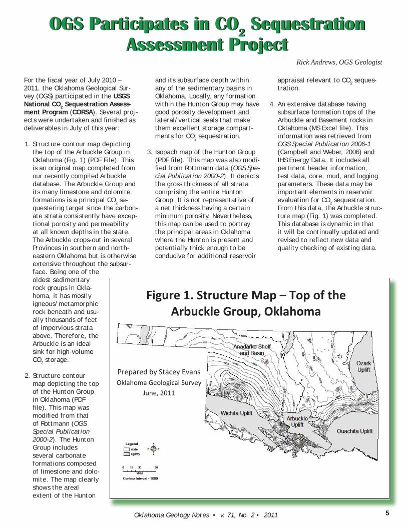
For the fi scal year of July 2010 – 2011, the Oklahoma Geological Sur-vey (OGS) participated in the USGS National CO2 Sequestration Assess-ment Program (CORSA). Several proj-ects were undertaken and fi nished as deliverables in July of this year:
1. Structure contour map depicting the top of the Arbuckle Group in Oklahoma (Fig. 1) (PDF File). This is an original map completed from our recently compiled Arbuckle database. The Arbuckle Group and its many limestone and dolomite formations is a principal CO2 se-questering target since the carbon-ate strata consistently have excep-tional porosity and permeability at all known depths in the state. The Arbuckle crops-out in several Provinces in southern and north-eastern Oklahoma but is otherwise extensive throughout the subsur-face. Being one of the oldest sedimentary rock groups in Okla-homa, it has mostly igneous/metamorphic rock beneath and usu-ally thousands of feet of impervious strata above. Therefore, the Arbuckle is an ideal sink for high-volume CO2 storage.
2. Structure contour map depicting the top of the Hunton Group in Oklahoma (PDF fi le). This map was modifi ed from that of Rottmann (OGS Special Publication 2000-2). The Hunton Group includes several carbonate formations composed of limestone and dolo-mite. The map clearly shows the areal extent of the Hunton
and its subsurface depth within any of the sedimentary basins in Oklahoma. Locally, any formation within the Hunton Group may have good porosity development and lateral/vertical seals that make them excellent storage compart-ments for CO2 sequestration.
3. Isopach map of the Hunton Group (PDF fi le). This map was also modi-fi ed from Rottmann data (OGS Spe-cial Publication 2000-2). It depicts the gross thickness of all strata comprising the entire Hunton Group. It is not representative of a net thickness having a certain minimum porosity. Nevertheless, this map can be used to portray the principal areas in Oklahoma where the Hunton is present and potentially thick enough to be conducive for additional reservoir
appraisal relevant to CO2 seques-tration.
4. An extensive database having subsurface formation tops of the Arbuckle and Basement rocks in Oklahoma (MS Excel fi le). This information was retrieved from OGS Special Publication 2006-1 (Campbell and Weber, 2006) and IHS Energy Data. It includes all pertinent header information, test data, core, mud, and logging parameters. These data may be important elements in reservoir evaluation for CO2 sequestration. From this data, the Arbuckle struc-ture map (Fig. 1) was completed. This database is dynamic in that it will be continually updated and revised to refl ect new data and quality checking of existing data.
OGS Participates in CO2 Sequestration Assessment Project
OGS Participates in CO2 Sequestration Assessment Project
Rick Andrews, OGS Geologist
Figure 1. Structure Map – Top of theArbuckle Group, Oklahoma
Prepared by Stacey EvansOklahoma Geological Survey
June, 2011
Oklahoma Geology Notes • v. 71, No. 2 • 20116
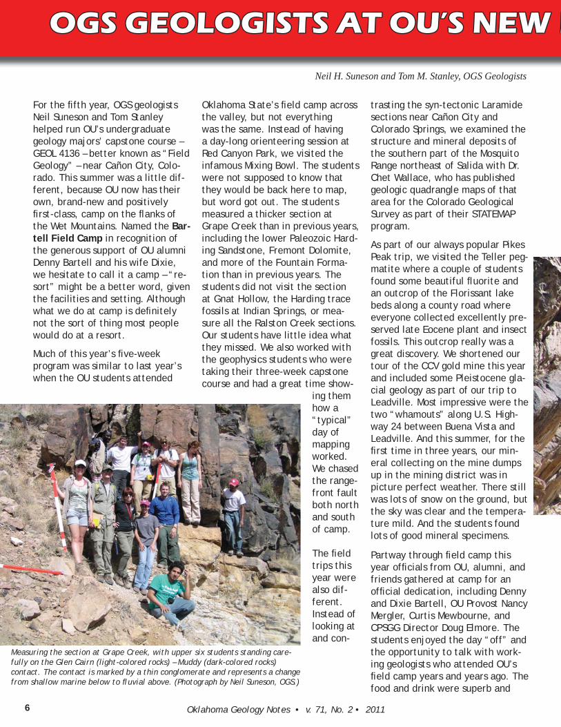
For the fi fth year, OGS geologists Neil Suneson and Tom Stanley helped run OU’s undergraduate geology majors’ capstone course – GEOL 4136 – better known as “Field Geology” – near Cañon City, Colo-rado. This summer was a little dif-ferent, because OU now has their own, brand-new and positively fi rst-class, camp on the fl anks of the Wet Mountains. Named the Bar-tell Field Camp in recognition of the generous support of OU alumni Denny Bartell and his wife Dixie, we hesitate to call it a camp – “re-sort” might be a better word, given the facilities and setting. Although what we do at camp is defi nitely not the sort of thing most people would do at a resort.
Much of this year’s fi ve-week program was similar to last year’s when the OU students attended
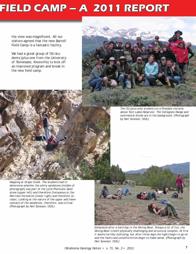
Oklahoma State’s fi eld camp across the valley, but not everything was the same. Instead of having a day-long orienteering session at Red Canyon Park, we visited the infamous Mixing Bowl. The students were not supposed to know that they would be back here to map, but word got out. The students measured a thicker section at Grape Creek than in previous years, including the lower Paleozoic Hard-ing Sandstone, Fremont Dolomite, and more of the Fountain Forma-tion than in previous years. The students did not visit the section at Gnat Hollow, the Harding trace fossils at Indian Springs, or mea-sure all the Ralston Creek sections. Our students have little idea what they missed. We also worked with the geophysics students who were taking their three-week capstone course and had a great time show-
ing them how a “typical” day of mapping worked. We chased the range-front fault both north and south of camp.
The fi eld trips this year were also dif-ferent. Instead of looking at and con-
trasting the syn-tectonic Laramide sections near Cañon City and Colorado Springs, we examined the structure and mineral deposits of the southern part of the Mosquito Range northeast of Salida with Dr. Chet Wallace, who has published geologic quadrangle maps of that area for the Colorado Geological Survey as part of their STATEMAP program.
As part of our always popular Pikes Peak trip, we visited the Teller peg-matite where a couple of students found some beautiful fl uorite and an outcrop of the Florissant lake beds along a county road where everyone collected excellently pre-served late Eocene plant and insect fossils. This outcrop really was a great discovery. We shortened our tour of the CCV gold mine this year and included some Pleistocene gla-cial geology as part of our trip to Leadville. Most impressive were the two “whamouts” along U.S. High-way 24 between Buena Vista and Leadville. And this summer, for the fi rst time in three years, our min-eral collecting on the mine dumps up in the mining district was in picture perfect weather. There still was lots of snow on the ground, but the sky was clear and the tempera-ture mild. And the students found lots of good mineral specimens.
Partway through fi eld camp this year offi cials from OU, alumni, and friends gathered at camp for an offi cial dedication, including Denny and Dixie Bartell, OU Provost Nancy Mergler, Curtis Mewbourne, and CPSGG Director Doug Elmore. The students enjoyed the day “off” and the opportunity to talk with work-ing geologists who attended OU’s fi eld camp years and years ago. The food and drink were superb and
OGS GEOLOGISTS AT OU’S NEW FIELD CAMP – A 2011 REPORTOGS GEOLOGISTS AT OU’S NEW F
Neil H. Suneson and Tom M. Stanley, OGS Geologists
Measuring the section at Grape Creek, with upper six students standing care-fully on the Glen Cairn (light-colored rocks) – Muddy (dark-colored rocks) contact. The contact is marked by a thin conglomerate and represents a change from shallow marine below to fl uvial above. (Photograph by Neil Suneson, OGS.)
7Oklahoma Geology Notes • v. 71, No. 2 • 2011
the view was magnifi cent. All our visitors agreed that the new Bartell Field Camp is a fantastic facility.
We had a great group of OU stu-dents (plus one from the University of Tennessee, Knoxville) to kick off an improved program and break in the new fi eld camp.
OGS GEOLOGISTS AT OU’S NEW FIELD CAMP – A 2011 REPORTFIELD CAMP – A 2011 REPORT
The OU (plus one) students on a Pinedale moraine above Twin Lakes Reservoir. The Collegiate Range and continental divide are in the background. (Photograph by Neil Suneson, OGS.)
Exhausted after a hard day in the Mixing Bowl. Always a lot of fun, the Mixing Bowl is both physically challenging and structural complex. At fi rst it seems terribly confusing, but after three days the lights begin to go on and the faults and unconformities begin to make sense. (Photograph by Neil Suneson, OGS.)
Mapping at Grape Creek. The students had to determine whether the white sandstone (middle of photograph) was part of the Lytle-Plainview Sand-stone (upper left) and therefore Cretaceous or the Morrison Formation (lower right) and therefore Ju-rassic. Looking at the nature of the upper and lower contacts of the sandstone, therefore, was critical. (Photograph by Neil Suneson, OGS.)
Oklahoma Geology Notes • v. 71, No. 2 • 20118
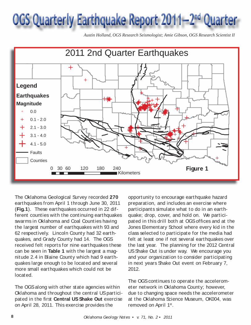
The Oklahoma Geological Survey recorded 270 earthquakes from April 1 through June 30, 2011 (Fig.1). These earthquakes occurred in 22 dif-ferent counties with the continuing earthquakes swarms in Oklahoma and Coal Counties having the largest number of earthquakes with 93 and 62 respectively. Lincoln County had 32 earth-quakes, and Grady County had 14. The OGS received felt reports for nine earthquakes these can be seen in Table 1 with the largest a mag-nitude 2.4 in Blaine County which had 9 earth-quakes large enough to be located and several more small earthquakes which could not be located.
The OGS along with other state agencies within Oklahoma and throughout the central US partici-pated in the fi rst Central US Shake Out exercise on April 28, 2011. This exercise provides the
Austin Holland, OGS Research Seismologist; Amie Gibson, OGS Research Scientist II
opportunity to encourage earthquake hazard preparation, and includes an exercise where participants simulate what to do in an earth-quake; drop, cover, and hold on. We partici-pated in this drill both at OGS offi ces and at the Jones Elementary School where every kid in the class selected to participate for the media had felt at least one if not several earthquakes over the last year. The planning for the 2012 Central US Shake Out is under way. We encourage you and your organization to consider participating in next years Shake Out event on February 7, 2012.
The OGS continues to operate the accelerom-eter network in Oklahoma County; however, due to changing space needs the accelerometer at the Oklahoma Science Museum, OK004, was removed on April 1st.
2011 2nd Quarter Earthquakes
0 60 120 180 24030Kilometers
LegendEarthquakesMagnitude
0.0
0.1 - 2.0
2.1 - 3.0
3.1 - 4.0
4.1 - 5.0
Faults
Counties
Figure 1

9Oklahoma Geology Notes • v. 71, No. 2 • 2011
Origin Time(UTC) Longitude Latitude
Depth(km)
Magnitude ModifiedMercalliIntensity CountyType
4/1/11 1:43 96.5311 35.4336 5 2 Md II Seminole
5/10/11 4:05 97.0261 35.4577 5 2.2 mbLg IIPottawatomie
5/10/11 6:00 97.3612 35.5655 3.7 1.9 Md III Oklahoma5/11/11 9:22 97.4323 35.7131 1.1 2.2 ML II Oklahoma5/15/11 5:55 96.5694 35.4368 5 2.3 mbLg III Okfuskee5/18/11 3:24 97.2877 35.5776 3.1 1.7 Md III Oklahoma6/7/11 22:59 98.3968 35.8314 5 2.4 mbLg III Blaine6/8/11 16:55 96.5961 35.3511 5 2.2 Md II Seminole
6/30/11 16:26 96.5426 35.3571 2 2.3 Md II Seminole
We supported several interviews and news stories with local news outlets. The Leonard Observatory gave three tours of the facilities and had three community service workers help-ing out. We presented two posters at the Seis-mological Society of America spring meeting in Memphis, TN, titled “Analysis of the Jones, Oklahoma, Earthquake Swarm” and “Incor-porating Near Real-Time Transportable Ar-ray Data into the Regional Oklahoma Seismic Network”. Austin Holland gave a talk at the Inter-Tribal Enviromental Council Meeting titled “Earthquakes and the possible link to Hy-draulic Fracturing in Oklahoma”. He also gave a talk at the Inter-Tribal Emergency Manage-ment Coalition summit titled “Oklahoma Earth-quakes Hazard and Resources for Emergency Managers”. Austin also gave a talk to the Tulsa Astronomy Club titled “Increase in Earthquake Recurrence Rates in Oklahoma”.
We also have an undergraduate student, Chris-topher Toth, working with us over the summer.
He is primarily working on seismic station instru-mentation and automatic calculation of ground motion parameters for an earthquake such as peak ground acceleration and spectral accelera-tion.
Download 2011 2nd Quarter Earthquake File (CSV):
http://www.okgeosurvey1.gov/media/quarter-lies/2011_qt2.csv
We encourage you to visit the Leonard Obser-vatory website where we have information on recent earthquakes in Oklahoma and around the Earth.
http://www.okgeosurvey1.gov/
Table 1 – Felt Earthquake Reports and Their Associated Modifi ed Mercalli Intensities as Reported to the OGS

Oklahoma Geology Notes • v. 71, No. 2 • 201110
The Oklahoma Geological Survey (OGS) recently received a grant award from the National Geological and Geo-physical Data Preservation Program (NGGDPP) administered by the U. S. Geological Survey (USGS). This marks the fourth year OGS has received funding under this program. The focus of the program is to assist in archiving geological and geophysical data and sample collections held by state geological surveys. In addition to providing fi nancial support on a cost-share basis, the USGS uses information derived from the data collections to populate its internet-based National Digital Catalog of archived material. The Catalog serves as a database, a web portal, and a set of web services that drive other applications.
OGS’s award for the August 2011–July 2012 period is being used to complete work on its collection of mud logs. As of this writing, OGS has inventoried 3,115 mud logs. Header information for these logs can be viewed at http://www.ogs.ou.edu/level3-databases.php. For last year’s project, OGS organized, cataloged in a database, and pre-pared metadata for mud logs from northeastern, southeastern, and southwestern Oklahoma. Project activities this year will involve entering mud logs from the northwestern and panhandle regions of Oklahoma into the system.
After samples are cataloged in a database, metadata (“descriptive information about data content”) for each item in the collection is generated according to protocols and standards established by the USGS. It is this meta-data that is submitted for inclusion in the National Digital Catalog.
Mud logs represent the second data set OGS will have contributed to the National Digital Catalog by means of a grant from the NGGDPP program. Three years ago we developed and submitted metadata describing 8,910 individ-ual rock core samples maintained by us. Because both rock core and mud log data involve much of the same type of borehole information, we were able to apply methodology developed for the previous rock core project to the current mud log project.
Oklahoma Geological Survey Receives Grant for Data Preservation
Jane Weber, OGS Staff
The 10th annual Osage Oil & Gas
Summit & Lease Sale will be held on Wednesday and Thursday, November
9-10, 2011, in the Hyatt Regency Tulsa. The event will begin on Wednesday morning with a continental breakfast at 8:00 a.m. There will be excellent
workshops for producers, and the Bureau of Indian Affairs will be conducting an oil and gas lease sale on Wednesday morning. There will also be plenty of exhibitors with new ideas and products that you won’t want to miss.
The program will include a variety of speakers and titles. The BIA will be conducting a workshop entitled “Moving
in & Rigging Up in the Osage”. Techni-cal papers with great speakers will include: “Exploitation of the Missis-
sippi Chat”, “Dewatering and Horizon-
tal Drilling in the Osage”, “3D Seismic
Antelope Shoot”, and many more. CEU and PDH credits will be available.
Some of our speakers will be Marginal Well Commissioner Jim Revard, Shane Matson, Jessie Crews, Randy Keller, Kurt Rottman, Mojan Kelphar, San Mazullo, Dennis Kerr, Brian Johnson and others. The keynote speaker for the luncheon on Wednesday will be the AAPG Executive Director, David Curtiss.
Registration is a bargain! Pre-regis-
tration is only $100 per person and
includes all meals, breaks and materi-
als. On-site registration is $150 per
person. [Registration form on back
page of this newsletter.] Brochures will be mailed out in October and will include a registration form as well. If you would like to stay in the hotel, room rates are great! A double is $81, and a triple-quad is $105. Be sure to mention that you are with the Osage Oil & Gas Summit if you use the hotel. The hotel number to call is 888-591-1234 or the local number is 918-582-9000.
If you need further information, con-tact:
• Registration Chairman, Reta
Lintner at (918) 358-5359 or
• Chairman, Joyce Whitewing
at (918) 885-2433 or jwopa@
valornet.com.
Joyce Whitewing, Summit Chairman
November 9 & 10, 2011

11Oklahoma Geology Notes • v. 71, No. 2 • 2011
Stan Krukowski, industrial minerals geolo-gist at the OGS, has been pe oning the Boy Scouts of America to reinstate the Mining Merit Badge since 2007. The eff ort is a project of the GEM (Government, Educa on, and Mining) Commi ee of the SME (Society for Mining, Metallurgy, and Explora on, Inc.). The project began in 2007 when SME members, who had a ained Eagle Scout status in their Scout-ing days, approached the GEM Commit-tee to endorse and sponsor the eff orts to reins tute the badge by providing fi nancial support and technical exper se. The GEM Commi ee agreed and later endorsed the Mining Merit Badge project.
The BSA last awarded a Mining Merit Badge in the 1940s. In 2007 SME member Eagle Scouts had proposed and submi ed a dra Mining Merit Badge handbook to the BSA; their submission was rejected due to low interest by the BSA Youth Innova- ons Commi ee. A second pe on for the
Mining Merit Badge was submi ed in 2010 with over a 50% favorability ra ng, but not enough to re-establish the Badge.
The BSA requires a proposal to explain the Mining Merit Badge requirements. Once that proposal is accepted, a core commi ee of volunteer experts will formulate, write, and review the Mining Merit Badge hand-book requirements. The following subjects will be included: sustainable develop-ment, mining health and safety, careers in mining, mining reclama on, everyday
minerals and their uses, and how society depends on the mining industry.
SME has since par cipated in the 2010 BSA Jamboree at the interna onal exhibits mid-way. Over 3,000 scouts visited the SME exhibit and par cipated in mine-related exercises and games. SME distributed a commemora ve patch celebra ng 100 years of Scou ng. Volunteers from various local chapter GEM commi ees as well as from the SME corporate offi ce shared in the Scou ng experience. The SME and the GEM Commi ee are looking forward to a ending the 2013 Jamboree at the new BSA Summit Bechtel Reserve in West Vir-ginia. Boy Scouts will test some of the re-quirements by taking part in Mining Merit Badge exercises, immediately providing GEM with valuable feedback.
SME’s drive to reins tute the Boy Scout Mining Merit Badge went into higher gear earlier this year star ng at its Annual Mee ng. The latest eff ort included a le er-wri ng campaign by SME members in sup-port of the badge. Execu ve Director Dave Kanagy collected over 60 le ers encourag-ing the BSA to reinstate the badge. Dave delivered the le ers to Mr. Bob Mazzuca, Chief Scou ng Execu ve, on June 24, 2011 at the Beartooth Lodge near the S llwater Mining Company’s (SMC) S llwater Mine in Montana.
The occasion was a luncheon program sponsored by SMC and its Chairman and Chief Execu ve Offi cer, Mr. Frank McAl-lister, where the guest of honor was Mr. Mazzuca. The event was to include a visit to the mine complex, above and under-ground. The program shared with Bob how mul faceted the mining profession has be-come. Over 25 mining professionals, most of whom had earned the rank of Eagle Scout, tes fi ed to the role that Scou ng had played in their lives. Other guests from State agencies and mining service compa-nies stated likewise.
Some of the a endees made presenta-
ons on health, safety, and environment pertaining to the mining industry, as well as technical talks on the geological and engineering aspects of mineral extrac- on. Stan Krukowski, who spearheads the
project as GEM’s Project Chair, made a case for the Mining Merit Badge with a power point presenta on about SME’s eff orts concerning reins tu ng the badge. All talks advocated the Mining Merit Badge, sugges ng requirements and goals to earn the badge. Mr. Lyle Knight, Chief Execu ve Offi cer and President of First Interstate BancSystems, was also in a endance in support of the Mining Merit Badge. Both Mr. McAllister and Mr. Knight sit on the BSA Na onal Council; Mr. Knight is head of the Youth Innova ons Commi ee, whose re-sponsibility is the promulga on of Scou ng merit badges.
Bob was certainly apprecia ve of the a en- on and eff ort of those contribu ng to the
day’s events. Of course, he shared his vi-sion of Scou ng and its future. Included in future Scou ng programs is the promo on of science and engineering. As the number of scien sts and engineers gradua ng from US universi es wanes, the BSA plans on doing its part to revitalize interest in these career paths. Agreeing in principal to the endorsement of a Mining Merit Badge, Bob talked about the use of the Internet in dis-semina ng informa on on BSA programs and the ease of publishing BSA handbooks in the immediate future. We discussed the future of the BSA Summit Bechtel Reserve in West Virginia and SME’s par cipa on there during the 2013 Jamboree. SME pro-posed exhibi ng heavy equipment used in mineral extrac on and hauling as a major component of any mining display.
Both Stan and Dave followed up with let-ters of apprecia on to Frank, Lyle, and Bob. Their hope now is that the BSA response is as posi ve as Bob’s outlook during the mee ng. As of this wri ng (September 12, 2011), the ball is now in the BSA court as we eagerly await a response from the BSA.
GEM Launches Boy Scout Merit Badge ProjectStan Krukowski, OGS Geologist

Oklahoma Geological SurveyTHE UNIVERSITY OF OKLAHOMAMEWBOURNE COLLEGE OF EARTH & ENERGY100 E. Boyd, Room N-131Norman, Oklahoma 73019-0628
A State Agency Serving the People of Oklahoma
Non-Profit OrganizationU.S.Postage
PAIDUniversity of Oklahoma
PREREGISTRATION FORM—Please make checks payable to “Osage Oil & Gas Summit”
Please print out form, detach, and return with check to: Osage Oil & Gas Summit, P.O. Box 305, Pawhuska, OK 74056
NAME: (Last) (First) (Initial)
AFFILIATION:
MAILING ADDRESS: PHONE:
CITY: STATE: ZIP: FAX:
E-MAIL:
Check must accompany this form. Use separate form for each registrant. CEU credit, check here. PDH credit, check here.
If you have a special disability, medical, or dietary needs, please check here.
This is the registration form for the Osage Oil & Gas Summit mentioned on page 10.
Please make checks payable to “Osage Oil & Gas Summit” and mail with completed form to:
Osage Oil & Gas SummitP.O. Box 305Pawhuska, OK 74056
If you need further information, please contact:
Registration Chairman, Reta Lintner at (918) 358-5359 or [email protected] or
Chairman, Joyce Whitewing at (918) 885-2433 or [email protected].