A NEW DIGITAL SEISMIC NETWORK IN ROMANIA WITH DENSE
10
1 First European Conference on Earthquake Engineering and Seismology (a joint event of the 13 th ECEE & 30 th General Assembly of the ESC) Geneva, Switzerland, 3-8 September 2006 Paper Number: 515 A NEW DIGITAL SEISMIC NETWORK IN ROMANIA WITH DENSE INSTRUMENTATION IN BUCHAREST Alexandru ALDEA 1 , Toshihide KASHIMA 2 , Natalia POIATA 3 and Toru KAJIWARA 4 SUMMARY The National Center for Seismic Risk Reduction (NCSRR, Bucharest, Romania) is implementing the Japan International Cooperation Agency Technical Cooperation (JICA) Project with Romania entitled "Seismic risk reduction for buildings and structures". Within the Project a new digital seismic network was installed. It contains three types of instrumentation: (i) free-field - outside the capital city Bucharest (9 accelerometers), (ii) building - in Bucharest (5 buildings), and (iii) free- field and borehole - in Bucharest (8 sites with free-field sensor and instrumented boreholes - 15 boreholes in total - with depths ranging from 24m to 153m). Since it's installation the NCSRR network recorded more than 130 seismic motions from 22 earthquakes with moment magnitudes ranging from 3.2 to 6.0. From these earthquakes 17 are from Vrancea subcrustal source (focal depth between 60 and 170 km), 2 are from Vrancea crustal source, 2 are from shallow sources in Bulgaria and 1 from North-Dobrogea shallow source. Data from the strongest event (Mw=6.0, h=99km) occurred on October 27, 2004 are also presented in the paper. 1. INTRODUCTION Romania is an earthquake prone country, its seismic activity being dominated by Vrancea intermediate depth source, and by several crustal sources (Banat, Fagaras, etc.). Vrancea source dominates seismic hazard not only in Romania but also in Republic of Moldova and also affects large areas in Bulgaria and Ukraine. Strong Vrancea earthquakes have been felt on areas of ~ 2 millions km 2 . Gutenberg & Richter [1954] classified Vrancea source as a separated seismic region inside the Division 8 “Alpine-Asian Arch” (region 51). Seismic instrumentation is essential for the proper establishment of input ground motion for design and for the seismic evaluation and retrofitting of existing buildings. United States of America and Japan are the major examples of countries understanding the need for a proper seismic instrumentation. The USA approach is self-explanatory [USGS, 1995]: "Strong-motion data collected by the USGS have contributed to the improvement of building codes over the decades. These improved codes have saved many lives and reduced damage in recent earthquakes. A growing network of instruments will provide even more extensive data in earthquakes to come. Using this information, scientists and engineers will be able to suggest further improvements to building codes. These improvements will help protect citizens of the United States from loss of life and property in future earthquakes”. In Japan not only that there are dense national seismic networks as Japan Meteorological Agency network and K-NET network (of National Research Institute for Earth Science and Disaster Prevention), but local authorities, education and research institutions, and companies also developed their own seismic networks. 1 National Center for Seismic Risk Reduction & Technical University of Civil Engineering, 124 Lacul Tei, Bucharest 020396, Romania Email : [email protected] 2 Building Research Institute, 1 Tatehara, Tsukuba, Ibaraki 305-0802, Japan Email: [email protected] 3 OYO Seismic Instrumentation Corp., 2-2-19 Daitakubo, Minami-ku, Saitama-shi, Saitama, 336-0015, Japan. Email: [email protected] 4 National Center for Seismic Risk Reduction, 266 Pantelimon Street, Bucharest 021652, Romania Email :[email protected]
Transcript of A NEW DIGITAL SEISMIC NETWORK IN ROMANIA WITH DENSE

1
First European Conference on Earthquake Engineering and Seismology (a joint event of the 13th ECEE & 30th General Assembly of the ESC)
Geneva, Switzerland, 3-8 September 2006 Paper Number: 515
A NEW DIGITAL SEISMIC NETWORK IN ROMANIA WITH DENSE INSTRUMENTATION IN BUCHAREST
Alexandru ALDEA1, Toshihide KASHIMA2, Natalia POIATA3 and Toru KAJIWARA4
SUMMARY
The National Center for Seismic Risk Reduction (NCSRR, Bucharest, Romania) is implementing the Japan International Cooperation Agency Technical Cooperation (JICA) Project with Romania entitled "Seismic risk reduction for buildings and structures". Within the Project a new digital seismic network was installed. It contains three types of instrumentation: (i) free-field - outside the capital city Bucharest (9 accelerometers), (ii) building - in Bucharest (5 buildings), and (iii) free-field and borehole - in Bucharest (8 sites with free-field sensor and instrumented boreholes - 15 boreholes in total - with depths ranging from 24m to 153m). Since it's installation the NCSRR network recorded more than 130 seismic motions from 22 earthquakes with moment magnitudes ranging from 3.2 to 6.0. From these earthquakes 17 are from Vrancea subcrustal source (focal depth between 60 and 170 km), 2 are from Vrancea crustal source, 2 are from shallow sources in Bulgaria and 1 from North-Dobrogea shallow source. Data from the strongest event (Mw=6.0, h=99km) occurred on October 27, 2004 are also presented in the paper.
1. INTRODUCTION Romania is an earthquake prone country, its seismic activity being dominated by Vrancea intermediate depth source, and by several crustal sources (Banat, Fagaras, etc.). Vrancea source dominates seismic hazard not only in Romania but also in Republic of Moldova and also affects large areas in Bulgaria and Ukraine. Strong Vrancea earthquakes have been felt on areas of ~ 2 millions km2. Gutenberg & Richter [1954] classified Vrancea source as a separated seismic region inside the Division 8 “Alpine-Asian Arch” (region 51). Seismic instrumentation is essential for the proper establishment of input ground motion for design and for the seismic evaluation and retrofitting of existing buildings. United States of America and Japan are the major examples of countries understanding the need for a proper seismic instrumentation. The USA approach is self-explanatory [USGS, 1995]: "Strong-motion data collected by the USGS have contributed to the improvement of building codes over the decades. These improved codes have saved many lives and reduced damage in recent earthquakes. A growing network of instruments will provide even more extensive data in earthquakes to come. Using this information, scientists and engineers will be able to suggest further improvements to building codes. These improvements will help protect citizens of the United States from loss of life and property in future earthquakes”. In Japan not only that there are dense national seismic networks as Japan Meteorological Agency network and K-NET network (of National Research Institute for Earth Science and Disaster Prevention), but local authorities, education and research institutions, and companies also developed their own seismic networks.
1 National Center for Seismic Risk Reduction & Technical University of Civil Engineering, 124 Lacul Tei, Bucharest 020396, Romania Email : [email protected] 2 Building Research Institute, 1 Tatehara, Tsukuba, Ibaraki 305-0802, Japan Email: [email protected] 3 OYO Seismic Instrumentation Corp., 2-2-19 Daitakubo, Minami-ku, Saitama-shi, Saitama, 336-0015, Japan. Email: [email protected] 4 National Center for Seismic Risk Reduction, 266 Pantelimon Street, Bucharest 021652, Romania Email :[email protected]

2
K-NET [Kyoshin Net] is one of the most impressive in the history of seismic instrumentation worldwide. After 1995 Great Hanshin Earthquake, 1000 free field stations were deployed all over Japan, with an average station to station distance of about 25km. Each station has a digital strong-motion seismograph, the soil conditions are known, the records are acquired at the control centre by telemetry. Data is available via Internet. In 1997 was held in Bucharest the First International Workshop on Vrancea Earthquakes [Wenzel and Lungu, 1999], and the working group "Strong Ground Motion" chaired by Professor B.Bolt made the following statement: "We recommend the establishment of a National Strong-Motion Program to provide an earthquake recording capability that is vital for earthquake risk reduction and public earthquake safety. The distribution of strong motion equipment should follow the main seismotectonic and geologic features, including local soil condition, and also focus on the instrumentation of representative buildings, industrial structures.” The development of seismic instrumentation, in terms of quantity and quality, represents a continuous concern and effort of Romanian and foreign institutions and/or projects.
2. NCSRR SEISMIC NETWORK
In 2002 the National Center for Seismic Risk Reduction (NCSRR, Bucharest, Romania) was created under the umbrella of Ministry of Transports, Construction and Tourism, in order to implement the Japan International Cooperation Agency Technical Cooperation (JICA) Project with Romania entitled "Seismic risk reduction for buildings and structures" [JICA, 2002]. For implementing the JICA project, NCSRR is cooperating with Technical University of Civil Engineering Bucharest (UTCB) and with National Building Research Institute (INCERC). Within the Project, JICA donated to NCSRR seismic equipment (Kinemetrics) that was installed in 2003 together with specialists from OYO Seismic Instrumentation Corp. In 2005-2006 the seismic network was enlarged with Romanian efforts/investment, and other sites were instrumented with Geosig equipment and technical support. The NCSRR seismic network [Aldea et al., 2004] contains three types of instrumentation: (i) free-field, (ii) building, and (iii) free-field and boreholes. 2.1 Free-field seismic stations for ground motion attenuation analysis Six (6) Kinemetrics ETNA stations were installed in 2003 on the SW direction starting from Vrancea epicentral area toward Bucharest, in order to obtain data for ground motion attenuation analysis. All of them are in buildings with 1 or 2 storeys, considered as a free field condition. Ground conditions are not known yet, soil investigations being underway. Three (3) Geosig IA-1 accelerometers were installed in 2006, on a perpendicular axis to the SW. Details about the free-field stations are given in Table 1, and their distribution in Figure 1.
Figure 1: NCSRR free-field seismic network in Romania

3
Table 1: NCSRR Seismic Network - Free-field stations in Romania
No. Site Station ID Sensor location Type of equipment 1 Giurgiu GRG Ground Floor of 2 storey bldg. 2 Ploiesti PLO GF of 2 storey bldg. 3 Focsani FOC GF of 1 storey bldg. 4 Buzau BUZ GF of 1 storey bldg. 5 Ramnicu Sarat RMS GF of 1 storey bldg. 6 Urziceni URZ GF of 1 storey bldg.
ETNA (Kinemetrics)
7 Brasov BRV GF of 1 storey bldg. 8 Constanta CST GF of 1 storey bldg. 9 Cernavoda CVD GF of 2 storey bldg.
IA-1 (Geosig)
2.2 Seismic stations for structural monitoring Two residential buildings of different structural systems located one near the other were instrumented in Central Bucharest. Two representative public buildings were also instrumented: The National Television Headquarters (that needs to be retrofitted) and the Headquarters of BRD-Société Générale Bank (a modern high-rise dual RC structure). These buildings were equipped in 2003 with Kinemetrics K2 seismic stations. In 2006 the Technical University of Civil Engineering Bucharest main building was instrumented with an IA-1 Geosig station. Details about building instrumentation are given in Table 2, and their location within the city in Figure 2.
Table 2: NCSRR seismic stations in buildings
No. Site Station ID
Station & sensor 1 location
Sensor 2
Sensor 3
Sensor 4
Bldg. data
Type of equipment
1 Stefan cel Mare (1) BLD1 11th floor 12th floor 5th floor 1st floor RC frame '80s 2 Stefan cel Mare (2) BLD2 Basement 7th floor 4th floor Free field RC frame '60s 3 National Television TVR 14th floor 15th half-floor Basement - RC frame '60s
4 BRD-SG Tower BRD roof (19th floor) 3rd basement - - RC dual 2003
K2 + Episensor
ES-T (Kine-
metrics)
5 UTCB Lacul Tei UTC5 roof (4th floor) - - - RC frame '60s IA-1
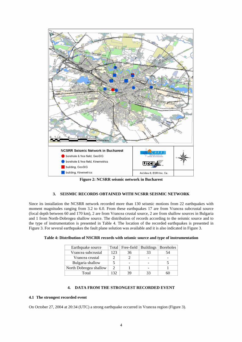
(Geosig) 2.3 Seismic stations for site effects assessment in Bucharest Inside Bucharest, NCSRR installed in 2003 seven (7) Kinemetrics K2 stations with sensors at ground surface (free-field conditions) and in boreholes at two levels of depth: the first at about 30m depth and the second between 50m and 153m depth, Table 3. In 2005 another site was instrumented with Geosig equipment (free-field and a 30m depth borehole). At all the stations the soil profile of the boreholes is known, and NCSRR and Tokyo Soil (Japan) performed down-hole tests, so the seismic velocities profiles are also known. A brief description of the instrumentation is given in Table 3 and their location within Bucharest in Figure 2.
Table 3: NCSRR free-field and borehole seismic stations in Bucharest
No. Site Station ID
Surface sensor location
Depth of sensor in shallow
borehole, m
Depth of sensor in deep borehole, m
Type of equipment
1 UTCB Tei UTC1 free field -28 -78 2 UTCB Pache UTC2 1 storey building -28 -66 3 NCSRR/INCERC INC 1 storey building -24 -153 4 Civil Protection Hdq. PRC 1 storey building -28 -68 5 Piata Victoriei VIC free field -28 -151 6 City Hall PRI free field -28 -52 7 Municipal Hospital SMU free field -30 -70
K2 + FBA-23DH
(Kinemetrics)
8 UTCB Plevnei UTC3 free field -30 GSR24+AC23 DH(Geosig)
4
Figure 2: NCSRR seismic network in Bucharest
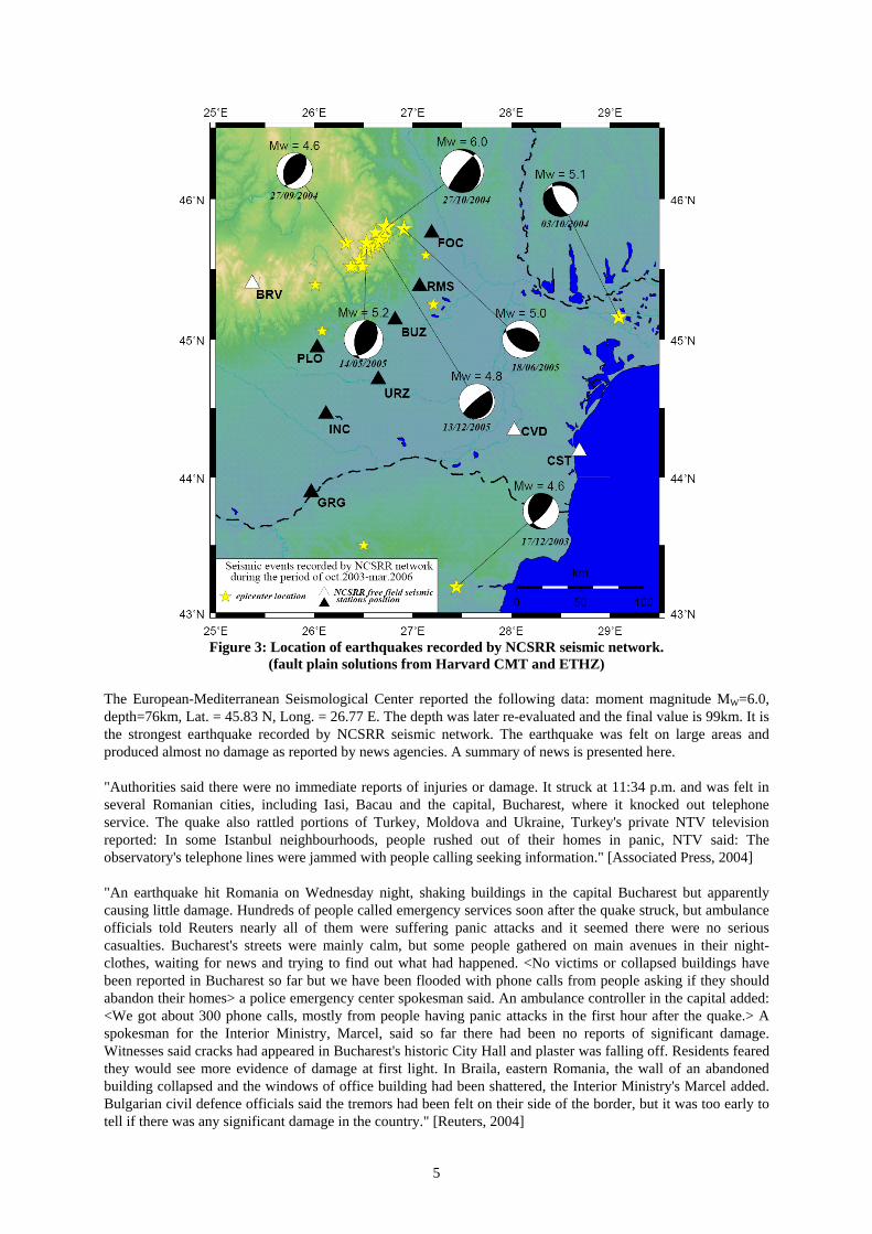
3. SEISMIC RECORDS OBTAINED WITH NCSRR SEISMIC NETWORK Since its installation the NCSRR network recorded more than 130 seismic motions from 22 earthquakes with moment magnitudes ranging from 3.2 to 6.0. From these earthquakes 17 are from Vrancea subcrustal source (focal depth between 60 and 170 km), 2 are from Vrancea crustal source, 2 are from shallow sources in Bulgaria and 1 from North-Dobrogea shallow source. The distribution of records according to the seismic source and to the type of instrumentation is presented in Table 4. The location of the recorded earthquakes is presented in Figure 3. For several earthquakes the fault plane solution was available and it is also indicated in Figure 3.
Table 4: Distribution of NSCRR records with seismic source and type of instrumentation
Earthquake source Total Free-field Buildings Boreholes Vrancea subcrustal 123 36 33 54
Vrancea crustal 2 2 - - Bulgaria shallow 5 - - 5
North Dobrogea shallow 2 1 - 1 Total 132 39 33 60
4. DATA FROM THE STRONGEST RECORDED EVENT 4.1 The strongest recorded event On October 27, 2004 at 20:34 (UTC) a strong earthquake occurred in Vrancea region (Figure 3).
5
Figure 3: Location of earthquakes recorded by NCSRR seismic network.
(fault plain solutions from Harvard CMT and ETHZ) The European-Mediterranean Seismological Center reported the following data: moment magnitude MW=6.0, depth=76km, Lat. = 45.83 N, Long. = 26.77 E. The depth was later re-evaluated and the final value is 99km. It is the strongest earthquake recorded by NCSRR seismic network. The earthquake was felt on large areas and produced almost no damage as reported by news agencies. A summary of news is presented here. "Authorities said there were no immediate reports of injuries or damage. It struck at 11:34 p.m. and was felt in several Romanian cities, including Iasi, Bacau and the capital, Bucharest, where it knocked out telephone service. The quake also rattled portions of Turkey, Moldova and Ukraine, Turkey's private NTV television reported: In some Istanbul neighbourhoods, people rushed out of their homes in panic, NTV said: The observatory's telephone lines were jammed with people calling seeking information." [Associated Press, 2004] "An earthquake hit Romania on Wednesday night, shaking buildings in the capital Bucharest but apparently causing little damage. Hundreds of people called emergency services soon after the quake struck, but ambulance officials told Reuters nearly all of them were suffering panic attacks and it seemed there were no serious casualties. Bucharest's streets were mainly calm, but some people gathered on main avenues in their night-clothes, waiting for news and trying to find out what had happened. <No victims or collapsed buildings have been reported in Bucharest so far but we have been flooded with phone calls from people asking if they should abandon their homes> a police emergency center spokesman said. An ambulance controller in the capital added: <We got about 300 phone calls, mostly from people having panic attacks in the first hour after the quake.> A spokesman for the Interior Ministry, Marcel, said so far there had been no reports of significant damage. Witnesses said cracks had appeared in Bucharest's historic City Hall and plaster was falling off. Residents feared they would see more evidence of damage at first light. In Braila, eastern Romania, the wall of an abandoned building collapsed and the windows of office building had been shattered, the Interior Ministry's Marcel added. Bulgarian civil defence officials said the tremors had been felt on their side of the border, but it was too early to tell if there was any significant damage in the country." [Reuters, 2004]

6
4.2 Free-field records outside Bucharest All the free-field stations outside Bucharest recorded the earthquake. The peak ground accelerations and the JMA seismic intensity (instrumental) are presented in Table 5. Visually, the evolution of the EW component of the records is presented in Figure 4. In all the paper, the processing of data was performed with ViewWave software, coded by T.Kashima (2001-2005), Building Research Institute, Tsukuba, Japan. Table 5: October 27, 2004 Vrancea earthquake - Peak Ground Acceleration at NCSRR free field stations
Peak ground acceleration PGA, cm/s2 No. Site
NS EW Vertical JMA
intensity 1 Focsani 62.9 64.6 82.2 3.9 2 Ramnicu Sarat 41.4 49.0 219.6 3.6 3 Buzau 67.9 86.0 80.8 3.6 4 Urziceni 33.7 44.3 38.9 3.4 5 Ploiesti 64.5 49.2 34.8 3.5 6 Giurgiu 22.9 30.6 15.3 2.8
Even JMA intensity quantifies the correlation between intensity and ground acceleration based on Japanese data, the values are good for a rough estimation of the seismic intensity. The JMA scale indicates for IJMA=4 "Many people are frightened. Some people try to escape from a danger. Most sleeping people awake.", and for IJMA =3 "Felt by most people in the building. Some people are frightened." Such descriptions correspond to a Modified Mercalli Intensity and/or a MSK intensity of V-VI, in agreement with the descriptions from the news. 4.3 Records in the instrumented buildings in Bucharest The peak accelerations recorded in the instrumented buildings in Bucharest are presented in Table 6.
Table 6: October 27, 2004 Vrancea earthquake - peak accelerations at NCSRR stations in buildings
No. Site PGA at sensors 1st floor 5th floor 11th floor 12th floor
EW NS V EW NS V EW NS V EW NS V 1 Stefan cel Mare
1st building (RC frame '80s) 26.1 22.3 21.7 67.6 38.2 26.3 85.0 43.7 40.3 93.8 59.0 42.7
Basement 4th floor 7th floor EW NS V EW NS V EW NS V 2
Stefan cel Mare 2nd building
(RC frame '60s) 27.8 27.6 17.5 46.4 41.3 30.0 78.3 67.3 30.2 Basement 14th floor 15th half-floor
EW NS V EW NS V EW NS V 3 National Television
(RC frame '60s) 29.1 25.6 22.6 35.2 22.0 30.5 55.0 30.7 31.3
3rd basement 19th floor EW NS V EW NS V 4
BRD-SG Tower
(RC dual 2003) 36.9 27.0 7.1 69.4 62.7 36.0
An example of building records is presented: the National Television building, an RC frame built in the 60's that has a basement, a ground floor, 13 storeys and a half-floor for technical purposes. In Figure 5 are presented the recorded horizontal motions at basement and at the top floor. The records allow the identification of the frequencies of vibration of the first two modes (Figure.6). The left-side graph in Figure 6 presents the Fourier amplitude spectra at top floor, and the right-side presents the transfer function (top/basement). In Table 7 are presented the identified frequencies (periods) for the first two modes of vibration, as extracted from Figure 6.
Table 7: Frequencies (periods) of vibration identified from TVR earthquake record (Oct.27, 2004 event)
Direction Method 1st mode 2nd mode Fourier spectrum 0.66 Hz (1.52s) 2.32 Hz (0.43s) Transversal Transfer function 0.65 Hz (1.54s) 2.26 Hz (0.44s) Fourier spectrum 0.88 Hz (1.14s) 2.73 Hz (0.37s) Longitudinal Transfer function 0.83 Hz (1.20s) 2.84 Hz (0.35s)

7
Figure 4: Oct. 27, 2004 Vrancea earthquake - recorded motions EW comp.
Acceleration
-100
0
100
Acc
. (cm
/s/s
)
20 30 40 50 60 70 80 90 100Time (sec)
EW (peak: 64.6 cm/s/s)
Acceleration
-100
0
100
Acc
. (cm
/s/s
)
20 30 40 50 60 70 80 90 100Time (sec)
EW (peak:- 49.0 cm/s/s)
Acceleration
-100
0
100
Acc
. (cm
/s/s
)
20 30 40 50 60 70 80 90 100Time (sec)
EW (peak: 86.0 cm/s/s)
Acceleration
-100
0
100
Acc
. (cm
/s/s
)
20 30 40 50 60 70 80 90 100Time (sec)
EW (peak: 49.2 cm/s/s)
Acceleration
-100
0
100
Acc
. (cm
/s/s
)
20 30 40 50 60 70 80 90 100Time (sec)
EW (peak:- 44.3 cm/s/s)
Acceleration
-100
0
100
Acc.
(cm
/s/s
)
20 30 40 50 60 70 80 90 100Time (sec)
EW (peak:- 30.6 cm/s/s)
Acceleration
-100
0
100A
cc. (
cm/s
/s)
20 30 40 50 60 70 80 90 100Time (sec)
SEW (peak: 40.9 cm/s/s)

8
Figure 5: Oct. 27, 2004 Vrancea earthquake - recorded motions at TVR station
Fourier Spectrum (Time:30-180s, Parzen:0.2Hz)
0.05
0.1
0.5
1
5
10
50
Four
ier A
mpl
itude
(cm
/s)
0.05 0.1 0.5 1 5 10Frequency (Hz)
Top transv.Top long.
Fourier Spectral Ratio (Time:30-180s, Parzen:0.2Hz)
0.2
0.5
1
5
10
20
Spe
ctra
l Rat
io
0.05 0.1 0.5 1 5 10Frequency (Hz)
Top transv./Basement transv.Top long./Basement long.
Figure 6: Identification of vibration modes from earthquake records at TVR building (Oct.27, 2004 event) 4.4 Free-field and borehole records in Bucharest In Bucharest all stations with boreholes recorded the earthquake except Piata Victoriei one (due to the absence of electric supply). The recorded peak ground accelerations are presented in Table 8. The JMA intensities computed from the surface records are in the range 3.0-3.4 that indicates a similar intensity as in the other cities.
Table 8: Oct. 27, 2004 Vrancea event - peak acceleration at NCSRR seismic stations in Bucharest
UTCB Tei UTCB Pache NCSRR/ INCERC
Civil Protection Hdq. City Hall Municipal
Hospital Station NS EW V NS EW V NS EW V NS EW V NS EW V NS EW V
Surface PGA 34.9 58.4 34.4 41.6 40.9 24.8 29.7 29.6 24.9 29.0 49.2 34.0 29.8 79.0 33.1 54.6 44.5 50.8Depth -28 m -28 m -24 m -28 m -28 m -30 m Shallow
sensor PGA 28.5 14.6 11.1 21.6 16.8 11.5 13.9 12.5 8.3 20.3 13.1 11.2 16.6 37.7 11.8 11.6 18.5 8.2Depth -78 m -66 m -153 m -68 m -52 m -70 m Deep
sensor PGA 16.5 23.1 9.8 15.6 23.5 7.0 11.3 11.4 6.7 12.7 19.4 8.8 13.2 22.2 9.6 12.6 18.1 8.9
Acceleration
-50
0
50
Acc.
(cm
/s/s
) Top transv. (peak:- 35.2 cm/s/s)
-50
0
50
Acc
. (cm
/s/s
)
40 60 80 100 120 140 160 180Time (sec)
Top long. (peak:- 22.0 cm/s/s)
Acceleration
-50
0
50
Acc
. (cm
/s/s
) Basement transv. (peak: 29.1 cm/s/s)
-50
0
50
Acc
. (cm
/s/s
)
40 60 80 100 120 140 160 180Time (sec)
Basement long. (peak: 25.6 cm/s/s)

9
A certain variability can be observed, with highest values in the vicinity of Dambovita river (City Hall and Municipal Hospital), and with the lowest value in eastern Bucharest (NCSRR/INCERC). The vertical component reached a level comparable with the one of the horizontal shaking, and an important amplification of vertical motion from boreholes to the surface can be observed, amplification larger than in the case of horizontal motion. The average amplification of horizontal PGA due to the last ~30m of soil was ~2(one station), ~2.2(two stations), ~2.6(two stations) and ~3.6(one station). In the case of the three stations with a deep borehole at a depth ~70m and a shallow one ~30m, the average amplification of horizontal PGA from the deeper depth to the shallower depth is almost the unit. It can be considered that the top 30m of soil had the most important contribution for the level of the horizontal PGA. In what concerns the amplification of the acceleration response spectra, the example from Figure 7 from NCSRR/INCERC station shows that in the low period range (<1s) the spectra in boreholes are quite similar, while in the long period range the spectra in the shallow borehole become closer to the spectra at surface. A similar phenomenon was also noticed for the other stations.
Acc. Response Spectrum (h=5%)
0.1
0.5
1
5
10
50
100
Acc
eler
atio
n R
espo
nse
(cm
/s/s
)
0.05 0.1 0.5 1 5Period (sec)
SNS (0m)B1NS (-24m)B2NS (-153m)
Acc. Response Spectrum (h=5%)
0.1
0.5
1
5
10
50
100
Acc
eler
atio
n R
espo
nse
(cm
/s/s
)
0.05 0.1 0.5 1 5Period (sec)
SEW (0m)B1EW (-24m)B2EW (-153m)
Figure 7: Acceleration response spectra at NCSRR/INCERC station (Oct. 27, 2004 event)
The estimation of predominant frequency of the ground vibration is strongly influenced by the considered thickness of soil. In Figure 8 are presented the transfer functions between surface and the shallow and deep borehole at NCSRR/INCERC station. The spectral ratio surface/shallow-borehole indicates a quite hard soil type/category, while the ratio surface/deep-borehole indicates a site with low predominant frequency. The 0.66Hz & 1.88Hz peaks in the ratio surface/deep-borehole are not present in the surface/shallow-borehole one.
Fourier Spectral Ratio (Time:20-100s, Parzen:0.2Hz)
0.1
0.5
1
5
10
Spe
ctra
l Rat
io
0.2 0.5 1 5Frequency (Hz)
SEW (0m)/B1EW (-24m)SEW (0m)/B2EW (-153m)
Fourier Spectral Ratio (Time:20-100s, Parzen:0.2Hz)
0.1
0.5
1
5
10
Spe
ctra
l Rat
io
0.2 0.5 1 5Frequency (Hz)
SEW/SVSNS/SV
Figure 8: Borehole transfer functions and H/V ratio at NCSRR/INCERC station (Oct.27, 2004 event)
The H/V spectral ratio [Lermo & Chavez-Garcia, 1993] also indicates low frequency peaks, Figure 8. The strong ground motion recorded at INCERC in 1977 indicated a predominant frequency of about 0.75Hz [Lungu et al., 2000, Aldea, 2001]. Such low frequencies of ground vibration show that the site category at INCERC site is not as hard as the consideration of the upper 30m of soil would indicate. In case of sites with deep sediments (as it is

10
the case in Bucharest), the site response and the site conditions should be analysed by considering the whole thickness of sediments until the bedrock, and not only the top 30m. It should be underlined that the frequencies identified from borehole transfer functions characterise only the elastic response of the considered soil column and not of the whole soil column until the bedrock.
5. CONCLUSIONS
The digital seismic network of NCSRR represents a positive achievement of the international and national efforts for the development of the Romanian network. The dense borehole instrumentation in Bucharest represents a unique case within the European capitals and can provide useful data for the assessment of site response.
6. ACKNOWLEDGEMENT
It is gratefully acknowledged the donation to NCSRR of seismic instrumentation by Japan International Cooperation Agency JICA, The authors and NCSRR acknowledge all the institutions that accepted the disposal of seismic stations in their locations: Technical University of Civil Engineering Bucharest (UTCB), National Building Research Institute (INCERC), Romanian Civil Protection, Bucharest Municipal Hospital, BRD-Société Générale, National Television, Bucharest City-Hall, Soconac S.A., Giurgiu City-Hall, Ploiesti City-Hall, Ramnicu Sarat City-Hall, Focsani City-Hall, Urziceni City-Hall, Conferic SRL Buzau. We acknowledge Prof.D.Lungu (UTCB) for his support in the instrumentation of the following sites: two residential buildings in Bucharest, Civil Protection, Bucharest Municipal Hospital and INCERC, and we acknowledge Prof.D.Lungu and Prof.T.Postelnicu (UTCB) for their support in the installation of the National Television station. Authors also acknowledge the support of Japanese experts and counter parts: Dr.S.Koyama, Dr.N.Furukawa, Dr.I.Okawa, I.Tojo, T.Kobayashi & T.Kanehira, and the support of NCSRR staff. Last but not least we acknowledge the financial efforts of the Romanian Ministry of Transports, Constructions and Tourism for developing the network. Some figures were drawn using GMT Ver.3.0 [Wessel and Smith, 1995], and earthquake records processing was done with ViewWave software coded by T.Kashima (2001-2005, Building Research Institute, Tsukuba, Japan).
7. REFERENCES Aldea, A. (2001), Assessment of Site Response in Eastern Bucharest, Romania, Bulletin of the International
Institute of Seismology and Earthquake Engineering IISEE, Vol. 36. Tsukuba, Japan, p.287-299 Aldea, A., Lungu, D., Vacareanu R., Arion, C. (2004), Development of strong ground motion network in
Romania and Bucharest instrumentation for site effects assessment, Proceedings of 13th World Conference on Earthquake Engineering, Vancouver, Canada, 15 p., CD
Aldea, A., Kashima, T., Lungu, D., Vacareanu, R., Koyama, S., Arion, C. (2004), Modern Urban Seismic Network in Bucharest, Romania, Proceedings of the First International Conference on Urban Earthquake Engineering, March 8-9, 2004, Tokyo Institute of Technology, Yokohama, Japan, 8p.
Associated Press (2004) web site, http://www.ap.org/ Gutenberg, B., Richter, C.F. (1954), Seismicity of the Earth and associated phenomena, Facsimile of the Edition
of 1954, Hafner Publishing Company, 1965, 130p. JICA Technical Cooperation Project "Reduction of Seismic Risk for Buildings and Structures" with Romania,
2002-2007, Ref.#7241011E0 Kyoshin Net web site, http://www.k-net.bosai.go.jp/ Lermo, J., F.J.Chavez-Garcia (1993), Site effect evaluation using spectral ratios with only one station, Bull.
Seism. Soc. Am., Vol.83, No.5, p.1574-1594 Lungu, D., Aldea, A., Arion, C., Demetriu, S., Cornea, T. (2000), Microzonage Sismique de la ville de Bucarest
- Roumanie, Cahier Technique de l’Association Française du Génie Parasismique AFPS, No.20, p.31-63 Reuters (2004) web site, http://today.reuters.com/ U.S. Geological Survey Fact Sheet 176-95/Online v1.0. Reducing Earthquake Losses Throughout the United
States. Saving Lives Through Better Design Standards. Wenzel, F., Lungu, D., Editors (1999), Vrancea Earthquakes. Tectonics, Hazard and Risk Mitigation,
Contributions from the First International Workshop on Vrancea Earthquakes, Bucharest, Romania, Nov.1-4, 1997, Kluwer Academic Publishers, 374 p.
Wessel, P. and W. H. F. Smith, (1995). New version of the Generic Mapping Tools released, EOS Trans. Am. Geophys. Union., 76, 329


![Two Seismic Events With Linear Sourcesdpa-www/sqm/msword/sqm_lanl.doc · Web viewileana@westongeophysical.com ABSTRACT. In 1984 Witten [1] proposed that an extremely dense form](https://static.fdocuments.us/doc/165x107/5e59f11abe05695ce2768e80/two-seismic-events-with-linear-dpa-wwwsqmmswordsqmlanldoc-web-view-ileanawestongeophysicalcom.jpg)