A methodology for the evaluation of wetlands on the … · A methodology for the evaluation of...
81
A methodology for the evaluation of wetlands on the Swan Coastal Plain, Western Australia A methodology for the evaluation of wetlands on the Swan Coastal Plain, Western Australia December 2017
Transcript of A methodology for the evaluation of wetlands on the … · A methodology for the evaluation of...
A methodology for the evaluation of wetlands on the Swan Coastal Plain, Western Australia
A methodology for the evaluation of wetlands on the Swan Coastal Plain,
Western Australia
December 2017
A methodology for the evaluation of wetlands on the Swan Coastal Plain, Western Australia
A methodology for the evaluation of wetlands on the Swan Coastal Plain, Western Australia
This work is copyright. You may download, display, print and reproduce this material in unaltered form only (retaining this notice) for your personal, non-commercial use or use within your organisation. Apart from any use as permitted under the Copyright Act 1968, all other rights are reserved. Requests and enquiries concerning reproduction and rights should be addressed to the Department of Biodiversity, Conservation and Attractions. Disclaimer While all reasonable care has been taken in the preparation of the material in this document, the Government of Western Australia and its officers accept no responsibility for any errors or omissions it may contain, whether caused by negligence or otherwise, or any loss, however caused, sustained by any person who relies on it. The recommended reference for this publication is: Department of Biodiversity, Conservation and Attractions 2017, A methodology for the evaluation of wetlands on the Swan Coastal Plain, draft prepared by the Wetlands Section of the Department of Biodiversity, Conservation and Attractions and the Urban Water Branch of the Department of Water and Environmental Regulation, Perth. Copies of this document can be viewed or downloaded from the Department of Biodiversity, Conservation and Attractions website at http://www.dpaw.wa.gov.au/management/wetlands/publications-and-links For further information please contact the Wetlands Section of the Department of Biodiversity, Conservation and Attractions on (08) 9219 9000.
A methodology for the evaluation of wetlands on the Swan Coastal Plain, Western Australia
Executive Summary The Swan Coastal Plain, Western Australia contains globally distinct and unique wetlands that support a
range of important ecological and cultural values. In 1996, wetlands occupied greater than 25 per cent of
the land surface on the Swan Coastal Plain, from Wedge Island to Dunsborough (Hill et al. 1996a).
Approximately, 73 per cent of wetlands currently mapped on the Swan Coastal Plain have been degraded
and have an assigned management category of Multiple Use. Only 21 per cent of wetlands are in a
relatively undisturbed condition and have an assigned management category of Conservation. An
analysis of Landsat satellite imagery from 1992-2012 indicated that approximately four ha of perennial
vegetation within wetlands was lost per day on the Swan Coastal Plain.
The Department of Biodiversity, Conservation and Attractions is the current custodian of the wetland
mapping dataset for the Swan Coastal Plain of Western Australia. Mapping including boundaries, types
and management categories for wetlands on the Swan Coastal Plain is publicly available through the
Geomorphic Wetlands Swan Coastal Plain dataset. This dataset as well as other wetland information can
be accessed through links provided at www.dpaw.wa.gov.au/management/wetlands.
A methodology for the evaluation of wetlands on the Swan Coastal Plain, Western Australia provides a
single, consistent method on how to evaluate wetlands across the Swan Coastal Plain. The outcome of
the evaluation process for each wetland is the identification of a wetland management category.
Wetland evaluation is the process of assessing a wetland’s values by considering information about its
attributes and functions. Wetland evaluation is a scientific assessment of wetland values and does not
consider the potential implications of the evaluation on current or future land uses. The process of
evaluation is independent of decisions about protection and management, which are the responsibility of
land managers and regulators, but does provide a description of values upon which subsequent decisions
on protection and management can be based.
The methodology on which this document is based has been endorsed by the WA Wetlands Coordinating
Committee and was distributed for public information and feedback in August 2013. The Wetlands
Coordinating Committee includes representatives of the Department of Biodiversity, Conservation and
Attractions; Department of Water and Environmental Regulation; Department of Primary Industries and
Regional Development; Department of Planning, Lands and Heritage; Western Australian Local
Government Association; the voluntary conservation movement and independent wetland scientists.
A methodology for the evaluation of wetlands on the Swan Coastal Plain, Western Australia
Contents
1 Introduction ------------------------------------------------------------------------------- 6
1.1 Wetland definitions --------------------------------------------------------------------------------------------- 6
1.2 Purpose and objectives of this document ------------------------------------------------------------- 6
1.3 Scope of application ------------------------------------------------------------------------------------------- 7
1.4 Who should use this document ---------------------------------------------------------------------------- 7
2 Background information ------------------------------------------------------------- 8
2.1 Regional context ------------------------------------------------------------------------------------------------ 8
2.2 Threats to wetlands ------------------------------------------------------------------------------------------ 10
2.3 Wetland mapping --------------------------------------------------------------------------------------------- 10
3 Wetland science ---------------------------------------------------------------------- 11
3.1 Classification of wetlands ---------------------------------------------------------------------------------- 11
3.2 Natural grouping of wetlands - consanguineous suites ---------------------------------------- 13
4 Wetland evaluation ------------------------------------------------------------------- 15
4.1 Attributes, functions and values ------------------------------------------------------------------------- 15
4.2 Wetland management categories ---------------------------------------------------------------------- 16
4.3 Information sources ------------------------------------------------------------------------------------------ 17
5 Evaluation process ------------------------------------------------------------------ 19
5.1 Considerations before deciding to evaluate a wetland ----------------------------------------- 19
5.2 Procedure for evaluating a wetland -------------------------------------------------------------------- 19
5.3 Evaluation of wetland portions --------------------------------------------------------------------------- 22
5.3.1 Extensive wetlands -------------------------------------------------------------------------------------------------------- 22
5.3.2 Other wetlands with varying areas of value ------------------------------------------------------------------------- 24
5.4 Preliminary evaluation scoring --------------------------------------------------------------------------- 27
5.4.1 Criteria ----------------------------------------------------------------------------------------------------------------------- 27
5.5 Secondary evaluation scoring --------------------------------------------------------------------------- 28
5.5.1 Criteria ----------------------------------------------------------------------------------------------------------------------- 29
5.5.2 Assigning a management category ------------------------------------------------------------------------------------ 34 6 Reporting requirements and mapping modifications -------------------- 35
7 Glossary ------------------------------------------------------------------------------36 8 References ------------------------------------------------------------------------------ 41 Appendix A Examples of applying the evaluation methodology ---------- 45
Appendix B Wetland information sources ---------------------------------------- 62 Appendix C Wetland evaluation desktop and site assessment form ---- 67 Appendix D Wetland statistics -------------------------------------------------------- 76
A methodology for the evaluation of wetlands on the Swan Coastal Plain, Western Australia
Figures
Figure 1 – The boundary of the Swan Coastal Plain
Figure 2 – Wetland types on the Swan Coastal Plain
Figure 3 – Wetland consanguineous suite mapping on the Swan Coastal Plain
Figure 4 – Wetland management categories across the Swan Coastal Plain
Figure 5 – Procedure for conducting a wetland evaluation
Figure 6 – An extensive palusplain system with areas of varying value located in a paddock
Figure 7 – An extensive palusplain system dissected by a railway with portions located in the railway reserve
Figure 8 – An intact wetland with a disturbed edge
Figure 9 – A wetland with varying areas of value and a linear disturbed area
Figure 10 – A wetland with varying areas of value associated with three different land uses
Tables
Table 1 – The classification of wetlands formed by combining hydrologic attributes and landform types
Table 2 – Wetland management categories and objectives applied to the Swan Coastal Plain
Table 3 – Preliminary evaluation criteria
Table 4 – Secondary evaluation criteria
Table 5 – Secondary evaluation criteria scores tally
Table 6 – Assignation of the wetland’s management category
Table 7 – Statistics from the Geomorphic Wetlands Swan Coastal Plain dataset indicating the percentage
by area of the management categories assigned to each wetland type on the Swan Coastal Plain
Table 8 – Statistics from the Geomorphic Wetlands Swan Coastal Plain dataset indicating the percentage
by area of all wetlands in each consanguineous suite assigned a Conservation management category
Table 9 – Statistics from the Geomorphic Wetlands Swan Coastal Plain dataset indicating the
percentage, by area, of each wetland type in each consanguineous suite assigned a Conservation
management category
A methodology for the evaluation of wetlands on the Swan Coastal Plain, Western Australia
1 Introduction
1.1 Wetland definitions
Wetlands can be described using various definitions. The Wetlands Conservation Policy for Western
Australia (Government of Western Australia 1997) has adopted the wetland definition used by the
Ramsar Convention on Wetlands (UNESCO 1971) which includes:
“areas of marsh, fen, peatland or water, whether natural or artificial, permanent or temporary, with water
that is static or flowing, fresh, brackish or salt, including areas of marine water the depth to which at low
tide does not exceed six metres.”
The Environmental Protection Act 1986 defines a wetland as:
“an area of seasonally, intermittently or permanently waterlogged or inundated land, whether natural or
otherwise, and includes a lake, swamp, marsh, spring, dampland, tidal flat or estuary.”
Waterways are defined by the Department of Water and Environmental Regulation (DWER) as:
“any river, creek, stream, or brook, including its floodplain and estuary. This includes systems that flow
permanently, for part of the year or occasionally; and parts of the waterway that have been artificially
modified”.
For the purposes of geomorphic wetland mapping and evaluation, and in this document, the term wetland
includes waterways, unless otherwise specified.
1.2 Purpose and objectives of this document
The purpose of this document is to describe a single methodology for evaluating wetlands on the Swan
Coastal Plain, Western Australia. The Department of Biodiversity, Conservation and Attractions (DBCA) is
currently the agency with custodianship of wetland inventory datasets, including evaluation, for most
wetland types (e.g. lake, sumpland, dampland, palusplain and paluslope), and DWER is the lead agency
for waterways (e.g. channel, floodplain and estuary).
For the purposes of wetland mapping on the Swan Coastal Plain, particularly as utilised by Western
Australian government agencies, this methodology supersedes previously used evaluation systems
including, Environmental Protection Authority Bulletin 686: A Guide to Wetland Management in the Perth
and Near Perth Swan Coastal Plain Area (Environmental Protection Authority 1993), Wetlands of the
Swan Coastal Plain Volume 2A: Wetland Mapping, Classification and Evaluation (Hill et al. 1996a) and
Evaluation of Wetlands on the Southern Swan Coastal Plain (V & C Semeniuk Research Group 1998).
This methodology has been developed by integrating the previous evaluation systems, to form a single
and comprehensive wetland evaluation methodology. The methodology has also been developed to be
consistent with Framework for mapping, classification and evaluation of wetlands in Western Australia
(Department of Environment and Conservation 2007). The overarching framework recognises that
wetland values need to be interpreted within a regional context; however, the overall evaluation principles
are consistent across Western Australia.
The classification and evaluation of wetlands contributes to an inventory of wetlands in the region. This
enables strategic planning, so that wetlands of high conservation significance can be identified and their
condition maintained or improved where possible through management and decision-making. The Swan
Coastal Plain region is subject to pressures from development and urbanisation, and the prioritisation of
areas for management is important for the protection of wetlands. In 2008, the Environmental Protection
Authority published Guidance Statement No. 33 Environmental guidance for planning and development
(Environmental Protection Authority 2008) to provide guidance to stakeholders on the considerations
relating to wetland conservation that can be taken into account in urban and regional planning. State
Planning Policy 2.9 Water Resources (Western Australian Planning Commission 2006) also provides
information and policy measures relating to the protection and management of wetlands.
A methodology for the evaluation of wetlands on the Swan Coastal Plain, Western Australia
Wetland values and areas can change, either through natural or anthropogenic processes. Where the
assigned management category for a wetland as shown in the Geomorphic Wetlands Swan Coastal Plain
dataset (herein ‘GWSCP dataset’) is considered to be inaccurate, a modification to the management
category for the wetland (or part thereof) can be requested. DBCA is the current custodian of the GWSCP
dataset and is responsible for maintaining and updating the dataset with new information (as it becomes
available) to reflect current wetland values. Requests to modify the management category of a wetland
within the GWSCP dataset should be accompanied by a documented evaluation of the wetland
undertaken using this evaluation methodology and be submitted to DBCA. Requests to modify the
geomorphic wetland boundary of a wetland within the GWSCP dataset should consider the guidance
provided in the information sheet Wetland identification and delineation: information for mapping and land
use planning on the Swan Coastal Plain (Department of Biodiversity Conservation and Attractions 2017)
available at www.dpaw.wa.gov.au/management/wetlands. DBCA obtains technical advice from DWER in
regard to modification requests involving waterway, floodplain and estuary type wetland areas.
In summary, the objectives of this document are to provide:
a single evaluation methodology for wetlands on the Swan Coastal Plain that supersedes the
previous evaluation systems
a transparent method to assign a wetland management category, as a basis for guiding the level of
wetland management and protection
additional guidance about the evaluation of wetlands in complex situations such as connected
wetland systems.
1.3 Scope of application
This methodology has been developed to provide a consistent approach to evaluation in consideration of
the range of environmental characteristics, and the high level of human induced disturbances that have
impacted many of the Swan Coastal Plain wetlands.
The evaluation method provides clear and justifiable criteria for the assessment of an individual wetland’s
attributes (biological, physical, social and cultural), functions and values. It requires the site-specific
collection of data on, and evaluation of, an individual wetland’s (or portion of an individual wetland’s)
attributes, functions and values. This approach is consistent with a Stage 3 assessment as outlined in
Framework for mapping, classification and evaluation of wetlands in Western Australia (Department of
Environment and Conservation 2007). A Stage 3 evaluation methodology should only be applied when
the area has been identified as wetland and a scientific delineation of the wetland boundary has been
undertaken (Department of Environment and Conservation 2007). The results can then be used as a
basis for decision making on wetland protection and management.
1.4 Who should use this document
This document provides technical guidance for environmental consultants, local government authorities,
state government agencies, non-government organisations including natural resource management
groups, community groups and industry.
Wetland assessments should be coordinated and led by professionals with specific expertise in wetland
processes, for example wetland ecology, hydrology and sedimentology. Specialised desktop, field, and
laboratory investigation skills are required to accurately complete an evaluation. An understanding of the
dynamic nature of wetlands and their response to seasonal conditions and longer term climate variability
is particularly important.
It is acknowledged that landowners, local government authorities, non-government organisations and
community groups may require assistance in completing the evaluation, particularly when wetland areas
of conservation value are identified. The Wetlands Section of DBCA can be contacted
([email protected]) to provide additional information to assist interpretation and effective use of
the methodology.
A methodology for the evaluation of wetlands on the Swan Coastal Plain, Western Australia
2 Background information
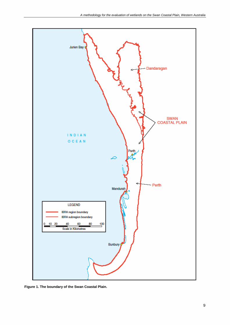
2.1 Regional context
Located in the south-west of Western Australia, the Swan Coastal Plain region is a low lying plain of
approximately 15,100 km2, including the city of Perth. Geographically, the Swan Coastal Plain stretches
from Jurien Bay in the north to Dunsborough in the south. It is bounded by the Indian Ocean to the west
and a series of scarps to the east (Gingin, Darling and Whicher Scarps). The region has a Mediterranean
climate characterised by hot dry summers, cool wet winters and an annual rainfall range of 500-900 mm.
The Interim Biogeographic Regionalisation of Australia (IBRA) divides Australia into natural regions of
similar geology, landform, vegetation, fauna and climate (Thackway and Cresswell 1995). The Swan
Coastal Plain IBRA region is divided into two subregions – the low lying coastal plain in the west (Swan
Coastal Plain subregion) and the higher plateau in the north east (Dandaragan Plateau subregion)
(Figure 1).
The Swan Coastal Plain is the most populous and developed region of Western Australia and as a result
has significant environmental issues (Environmental Protection Authority 2007). These issues are mainly
due to the growing population and the use of land for residential, industry and agriculture (Environmental
Protection Authority 2007).
The Swan Coastal Plain is situated in the South West Botanical Province of Western Australia which is
one of 34 global biodiversity hotspots (Conservation International 2007). The South West Botanical
Province supports forests, woodlands, shrublands and heath which are characterised by high endemism
among plants and reptiles. For example, the Western Swamp Tortoise is Australia’s most endangered
reptile and is endemic to two shallow seasonal claypan wetlands north of Perth. The South West
Botanical Province supports an estimated 8,000 taxa of vascular plants, representing two thirds of the
estimated plant taxa in Western Australia (Beard et al. 2000). It is estimated that approximately 80 per
cent of the plant taxa in the South West Botanical Province are endemic (Beard et al. 2000).
In a global context, the Swan Coastal Plain contains unique features due to its geology, geomorphology
and climate. As such, Semeniuk and Semeniuk (2001) have proposed that the wetlands on the Swan
Coastal Plain are globally distinct and unique in that their origin and features are not represented
elsewhere. This global importance should be recognised when making decisions about the protection and
management of wetlands on the Swan Coastal Plain.
A methodology for the evaluation of wetlands on the Swan Coastal Plain, Western Australia
9
Figure 1. The boundary of the Swan Coastal Plain.

A methodology for the evaluation of wetlands on the Swan Coastal Plain, Western Australia
10
2.2 Threats to wetlands
A large proportion of the wetlands on the Swan Coastal Plain have been lost or degraded due to human
activities (Hill et al. 1996a). An analysis of Landsat satellite imagery from 1992-2012 indicated that
approximately four ha of perennial vegetation within wetlands was lost per day on the Swan Coastal Plain
(Department of Parks and Wildlife 2013). The remaining wetlands are under increasing pressure from
land uses, predominantly urban development, agriculture and industry.
Examples of activities that have the potential to threaten wetlands on the Swan Coastal Plain include:
clearing, filling or draining
excavation, dredging, mining
introduction of exotic plants and animals
fire management
discharge of stormwater or effluent
abstraction of surface or groundwater
land and groundwater contamination
pollutants (e.g. herbicides and pesticides)
agricultural practices
recreational activities.
Climate change is a significant threat to wetlands in the south-west of Western Australia. Climate models
predict that the south-west will experience an increase in temperatures and evaporation rate, decline in
annual rainfall, and an increase in the frequency and/or severity of extreme weather events. The changes
are predicted to alter natural hydrological cycles, affecting species and ecosystems that are dependent on
surface water and groundwater, including wetlands and waterways. The south-west is already drying, with
higher average temperatures and reduced average winter rainfall and runoff, resulting in impacts to
wetlands (Environmental Protection Authority 2007). The impacts of current and future climate change
should be incorporated into water and wetland related planning and management.
2.3 Wetland mapping
Wetlands cover more than 25 per cent of the Swan Coastal Plain, with approximately three quarters of
these occurring as seasonally waterlogged flats or basins. The GWSCP dataset displays the location,
boundary, geomorphic type and management category of wetlands mapped on the Swan Coastal Plain
from Moore River to Dunsborough. The information contained within the GWSCP dataset was originally
digitised from Wetlands of the Swan Coastal Plain Volume 2B Wetland Mapping, Classification and
Evaluation: Wetland Atlas (Hill et al. 1996b) and Evaluation of Wetlands on the Southern Swan Coastal
Plain (V & C Semeniuk Research Group 1998), which were captured at a scale of 1:25,000. Wetland
mapping does not exist north of Moore River or in the south-east of the Swan Coastal Plain.
The use of the GWSCP dataset as a tool for planning and decision making has been endorsed by the
Wetlands Coordinating Committee, Environmental Protection Authority and the Department of Planning,
Lands and Heritage (DPLH) on the basis that it represents the most comprehensive record of wetland
mapping, classification and evaluation work available for the Swan Coastal Plain. The Wetlands
Coordinating Committee includes representatives from DBCA, DWER, DPLH, Department of Primary
Industries and Regional Development, Western Australian Local Government Association, voluntary
conservation organisations, and independent wetland scientists. The GWSCP dataset is used by the
Environmental Protection Authority and DPLH as a basis to guide planning and decision making.
DBCA is the current custodian of the Consanguineous suite dataset. The concept of consanguineous
suites (natural wetland groups) was developed by Semeniuk (1988) and refers to the grouping of
wetlands into assemblages based on their similarities.
The GWSCP dataset and the Consanguineous suite dataset are available for viewing via Landgate’s
public map viewer Locate and downloading via the WA government data portal.
A methodology for the evaluation of wetlands on the Swan Coastal Plain, Western Australia
3 Wetland science
3.1 Classification of wetlands
The geomorphic classification system developed by Semeniuk (1987) and Semeniuk and Semeniuk
(1995) has been adopted by the Wetlands Coordinating Committee as the primary classification system
for mapping wetlands in Western Australia. The geomorphic classification system classifies wetlands into
types based on the shape of the host landform and the water permanence of the hydrological regime.
Combining the landform types that are the basis to wetlands on the Swan Coastal Plain (e.g. basins, flats,
and slopes) with the various types of hydrological regime (e.g. permanently inundated, seasonally
inundated and seasonally waterlogged) provides the simple nomenclature of wetlands (Semeniuk 1987).
The major wetland types identified on the Swan Coastal Plain are lake, sumpland, dampland, palusplain,
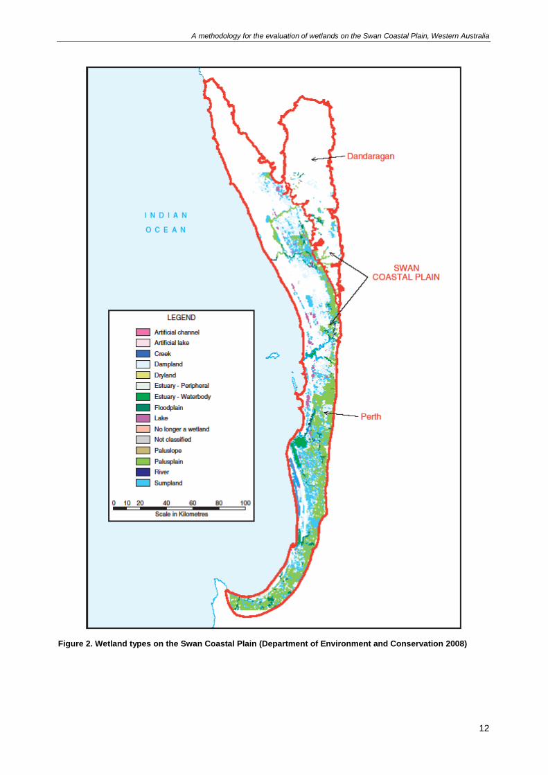
paluslope, creek, river, floodplain and estuary (Figure 2). For example, Table 1 demonstrates that
sumplands have a host landform of ‘basin’ and water permanence of ‘seasonal inundation’, and
palusplain areas have a host landform of ‘flat’ and water permanence of ‘seasonal waterlogging’. Further
differentiation between wetlands of the same classification is possible by the use of wetland descriptors
such as water quality, size, shape and vegetation (Hill et al. 1996a).
Table 1. The classification of wetlands formed by combining hydrological attributes and landform types (adapted from Semeniuk 1987).
Hydrology Host landform
Basin Flat Slope Highland Channel
Marine / tidal influence
Estuary - waterbody
Estuary - peripheral
Estuary -
waterbody
Permanent inundation
Lake River
Seasonal inundation
Sumpland Floodplain Creek
Intermittent inundation
Playa Barlkarra Wadi
Seasonal waterlogging
Dampland Palusplain Paluslope Palusmont Trough
A methodology for the evaluation of wetlands on the Swan Coastal Plain, Western Australia
12
Figure 2. Wetland types on the Swan Coastal Plain (Department of Environment and Conservation 2008)
A methodology for the evaluation of wetlands on the Swan Coastal Plain, Western Australia
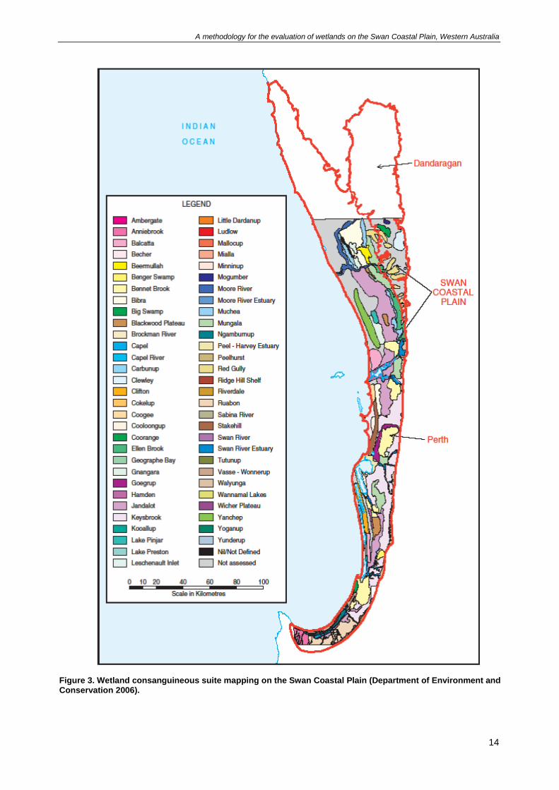
3.2 Natural grouping of wetlands - consanguineous suites
Wetlands on the Swan Coastal Plain vary in size, shape, hydrology, stratigraphy and vegetation. The
variation in wetlands can be attributed to physical setting and developmental processes. When regional
features such as geomorphic setting, origin and hydrology are common to groups of wetlands, similarities
are evident and wetlands can be seen to be related, or ‘consanguineous’ (Semeniuk 1988). For example,
the Spearwood Dunes are dominated by linear basin wetlands (lakes and sumplands); the Bassendean
Dunes by round to irregular basin wetlands (sumplands and damplands); and the Pinjarra Plain by flats
and channel wetlands (palusplains and creeks).
The theory of consanguineous suites was developed by Semeniuk (1988) and refers to the natural
grouping of wetlands. There are 62 recognised wetland consanguineous suites on the Swan Coastal
Plain (Department of Parks and Wildlife 2016). These suites (see Figure 3) have been identified using a
set of criteria based on the wetland’s classification, geometry, stratigraphy, inferred origin and hydrology
(Semeniuk 1988).
Where consanguineous suites occur in defined boundaries they are referred to as ‘consanguineous suite
domains’. On the Swan Coastal Plain, consanguineous suite domains can occur more than once (e.g.
Keysbrook), or in a single locality (e.g. Lake Pinjar). The Keysbrook consanguineous suite occurs on the
Pinjarra Plain in 11 domains whilst the Lake Pinjar consanguineous suite only occurs in one domain
which is located at Lake Pinjar on the Bassendean Dunes.
Wetlands of the same type can be found in different consanguineous suites and support visible
differences in characteristics. For example, sumplands in the Riverdale consanguineous suite vary in
size, shape, sediments, vegetation and hydrology compared to other sumplands occurring in other
consanguineous suites.
Consanguineous suites provide a valuable framework to assess the attributes of numerous wetlands in a
single suite by examining only one or two wetlands in the field. In a region where there are hundreds of
wetlands, this type of statistical sampling is useful. Comparative environmental studies benefit from the
consanguineous suites statistical sampling method to assess whether a wetland type occurring within a
geomorphic unit or region is common or unusual and so enabling the identification of a key wetland
(Semeniuk 1988). When assessing the representativeness of an individual wetland in a consanguineous
suite, regional significance can be determined by calculating the extent of the wetland type within the
suite retaining important values. For instance, only 1.3 per cent of the original extent of palusplain in the
Keysbrook consanguineous suite still supports a high level of values, attributes and functions
(Department of Parks and Wildlife 2016).
Consanguineous suites are also a means of identifying linked hydrological systems. The knowledge of
hydrological and hydrochemical processes identified for each suite of wetlands can be used to determine
rare processes that may predict unusual water chemistry.
Data on wetlands occurring in each consanguineous suite on the Swan Coastal Plain has been calculated
from the GWSCP and Consanguineous suite datasets. Additional information on consanguineous suites
is available in Appendix D and at www.dpaw.wa.gov.au/management/wetlands.
A methodology for the evaluation of wetlands on the Swan Coastal Plain, Western Australia
14
Figure 3. Wetland consanguineous suite mapping on the Swan Coastal Plain (Department of Environment and Conservation 2006).
A methodology for the evaluation of wetlands on the Swan Coastal Plain, Western Australia
4 Wetland evaluation
Wetland evaluation is the process of assessing a wetland’s values by considering information about its
attributes and functions. Wetland evaluation is a scientific assessment of wetland values and does not
consider the potential implications for current and future land uses. The process of evaluation is
independent of protection and management but does provide a description of values upon which
subsequent decisions on protection and management can be based.
4.1 Attributes, functions and values
Evaluation requires the assessment of attributes, functions and values. The attributes, functions and
values taken into consideration in this wetland evaluation methodology have been compiled through a
review of the existing systems of assessment and takes into consideration both biological/physical and
cultural/social characteristics. The evaluation terms attributes, functions and values have been adopted
for use in the framework (Department of Environment and Conservation 2007) and this methodology. It is
recognised that in other work, such as guidelines developed for the Ramsar Convention on Wetlands
(Department of the Environment, Water, Heritage and the Arts 2008), the terms ‘critical components’,
‘ecological processes’ and ‘benefits and services’ are applied. The definitions of attribute, function and
value applicable to this methodology are outlined below.
Attribute
Wetland attributes are a characteristic or a combination of characteristics or components which do not
necessarily support a use (adapted from Hill et al. 1996a). Wetland attributes may be divided into
ecosystem or human use and may include:
diversity of flora/fauna
habitat features
size of the wetland
area of open water
soil type.
Function
Wetland functions are the physical, hydrological/hydrogeological, chemical and biological processes
occurring within a wetland (adapted from Environmental Protection Authority 2008). Functions may
include:
water detention or conveyance
groundwater recharge
nutrient cycling
nutrient and pollution adsorption (improving water quality)
absorbing carbon (contributing to the mitigation of climate change)
supporting groundwater dependent ecosystems.
Value
A wetland value is a beneficial use of the environment (including social and economic values that derive
from the environment) or an ecosystem health condition. An ecosystem health condition is a condition of
the ecosystem that is relevant to the maintenance of ecological structure, functions or processes and
which requires protection from the effects of environmental harm (Environmental Protection Authority
2008). The environmental values of a wetland relate to its attributes and functions and can be divided into
values which benefit the ecosystem or human uses.
Environmental and ecosystem values:
flood mitigation
biological productivity
habitat for rare or threatened communities or species.
Human use values:
social, such as scenery, public amenity
A methodology for the evaluation of wetlands on the Swan Coastal Plain, Western Australia
16
recreational activities including swimming, canoeing, boating, fishing, bush-walking, nature
appreciation.
cultural, such as Aboriginal heritage protection
economic, such as water supply, commercial fishing, tourism opportunities.
Broad evaluation criteria
The wetland attributes, functions and values applicable to this methodology are assessed against three
broad evaluation criteria: representativeness, scarcity and naturalness. The criteria have been compiled
through a review of previous systems of wetland assessment on the Swan Coastal Plain.
Representativeness: refers to how characteristic the attributes, functions or values of a particular wetland
are of wetlands within a particular group such as its consanguineous suite.
Scarcity: refers to how rare or uncommon a wetland or wetland characteristic is in a defined area, such as
a consanguineous suite domain.
Naturalness: refers to the degree to which the wetland attributes, functions and values are in their natural
state and whether they have been altered or modified.
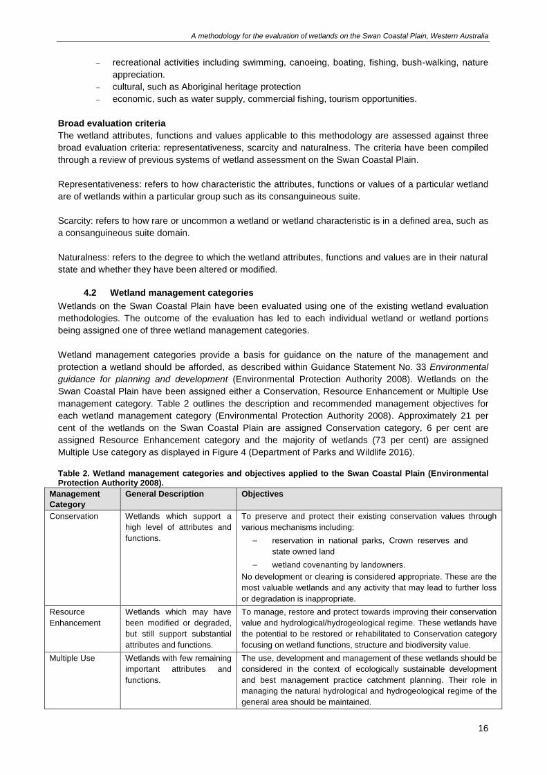
4.2 Wetland management categories
Wetlands on the Swan Coastal Plain have been evaluated using one of the existing wetland evaluation
methodologies. The outcome of the evaluation has led to each individual wetland or wetland portions
being assigned one of three wetland management categories.
Wetland management categories provide a basis for guidance on the nature of the management and
protection a wetland should be afforded, as described within Guidance Statement No. 33 Environmental
guidance for planning and development (Environmental Protection Authority 2008). Wetlands on the
Swan Coastal Plain have been assigned either a Conservation, Resource Enhancement or Multiple Use
management category. Table 2 outlines the description and recommended management objectives for
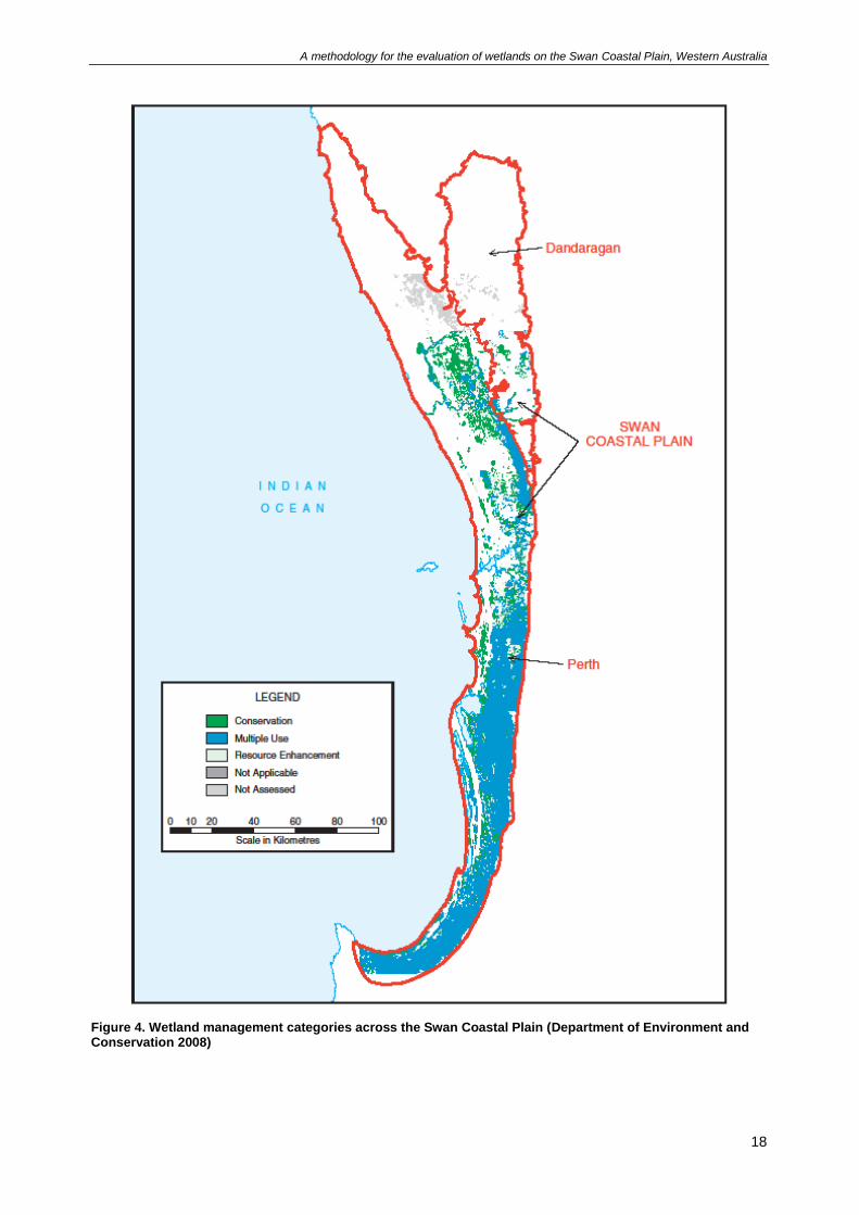
each wetland management category (Environmental Protection Authority 2008). Approximately 21 per
cent of the wetlands on the Swan Coastal Plain are assigned Conservation category, 6 per cent are
assigned Resource Enhancement category and the majority of wetlands (73 per cent) are assigned
Multiple Use category as displayed in Figure 4 (Department of Parks and Wildlife 2016).
Table 2. Wetland management categories and objectives applied to the Swan Coastal Plain (Environmental Protection Authority 2008).
Management
Category
General Description Objectives
Conservation Wetlands which support a
high level of attributes and
functions.
To preserve and protect their existing conservation values through
various mechanisms including:
reservation in national parks, Crown reserves and
state owned land
wetland covenanting by landowners.
No development or clearing is considered appropriate. These are the
most valuable wetlands and any activity that may lead to further loss
or degradation is inappropriate.
Resource
Enhancement
Wetlands which may have
been modified or degraded,
but still support substantial
attributes and functions.
To manage, restore and protect towards improving their conservation
value and hydrological/hydrogeological regime. These wetlands have
the potential to be restored or rehabilitated to Conservation category
focusing on wetland functions, structure and biodiversity value.
Multiple Use Wetlands with few remaining
important attributes and
functions.
The use, development and management of these wetlands should be
considered in the context of ecologically sustainable development
and best management practice catchment planning. Their role in
managing the natural hydrological and hydrogeological regime of the
general area should be maintained.
A methodology for the evaluation of wetlands on the Swan Coastal Plain, Western Australia
17
4.3 Information sources
Data collection provides the information necessary for an accurate evaluation of a wetland. Information
can be obtained from a variety of sources including literature reviews (e.g. reports, journal articles,
databases and maps), aerial photography and site visits. Consultation with landowners or community
members is also useful for obtaining information on the wetland.
New information may become available (e.g. new national or state environmental registers, agreements
or studies) and should be consulted to complete an evaluation. Potential information sources for the
wetland attributes, functions and values assessed in this evaluation methodology are outlined in Appendix
B.
A methodology for the evaluation of wetlands on the Swan Coastal Plain, Western Australia
18
Figure 4. Wetland management categories across the Swan Coastal Plain (Department of Environment and Conservation 2008)
A methodology for the evaluation of wetlands on the Swan Coastal Plain, Western Australia
5 Evaluation process
5.1 Considerations before deciding to evaluate a wetland
Landowners may consider undertaking a wetland evaluation with the aim of modifying the management
category of a wetland to enable land development. The evaluation methodology described in this
document is based on the wetland’s current attributes, functions and values, and does not take into
account any proposed development or land use change. Wetland evaluation can be time-consuming and
costly, so the decision to commission or undertake a wetland evaluation should be considered carefully.
Unless the current management category is obviously incorrect, the decision to undertake an evaluation
should be discussed with DBCA beforehand.
For waterways (i.e. channel, floodplain, estuary and estuary peripheral wetland types) and other wetlands
that are parts of waterways, wetland evaluation may not be the most appropriate process. Identifying and
establishing waterways foreshore areas (Department of Water 2012) indicates that the proponent of a
change in land use near a waterway will identify a foreshore area to protect and maintain its features,
functions and values. The management category of wetlands near a waterway is one of many criteria
considered for identifying a foreshore area. For example, a landowner may undertake a wetland
evaluation that results in a wetland’s management category being modified to Multiple Use. However, at
subsequent stages of land planning, this Multiple Use category wetland may also be included in the
foreshore area, perhaps as it is integral to the hydrology of the waterway. In such a case, the landowner
may have wasted time and resources undertaking a wetland evaluation that could have been better
allocated to identifying a foreshore area. When considering evaluation to change the management
category of a waterbody or wetland area that forms part of a waterway, users should refer to Determining
foreshore reserves (Water and Rivers Commission 2001) and Identifying and establishing waterways
foreshore areas (Department of Water 2012) or contact the relevant regional office (details available on
DWER’s website).
Users should be aware that requests for modifications to the management category of a wetland in the
dataset requires significant time to assess and process. To reduce the potential for delays, modification
requests should be submitted well before applications to develop, subdivide or rezone land, or any outline
development plan or structure plan.
Wetland conditions usually vary during the year. The collection of certain information (such as vegetation
condition, flora surveys, photographs and hydrology) should be undertaken after the main period of
rainfall. In some circumstances, a request may not be able to be processed until the appropriate season if
there is inadequate information based on a poorly timed field evaluation. Evaluators should be mindful of
seasonal variation when assessing and describing the condition of wetlands.
5.2 Procedure for evaluating a wetland
The wetland evaluation methodology for the Swan Coastal Plain is a two tiered approach. This approach
has been adopted to avoid detailed evaluations being undertaken where it may not be necessary. The
two tiers of evaluation are:
Preliminary evaluation – if any one of the preliminary evaluation criteria is met the wetland is
automatically assigned as Conservation category and no further evaluation is required. Failure to
meet the preliminary criteria does not preclude a wetland from being assigned Conservation
category in the secondary evaluation.
Secondary evaluation – if the wetland does not meet the preliminary evaluation criteria for automatic
assignment as Conservation category, the secondary evaluation should be conducted to determine
the management category.
A methodology for the evaluation of wetlands on the Swan Coastal Plain, Western Australia
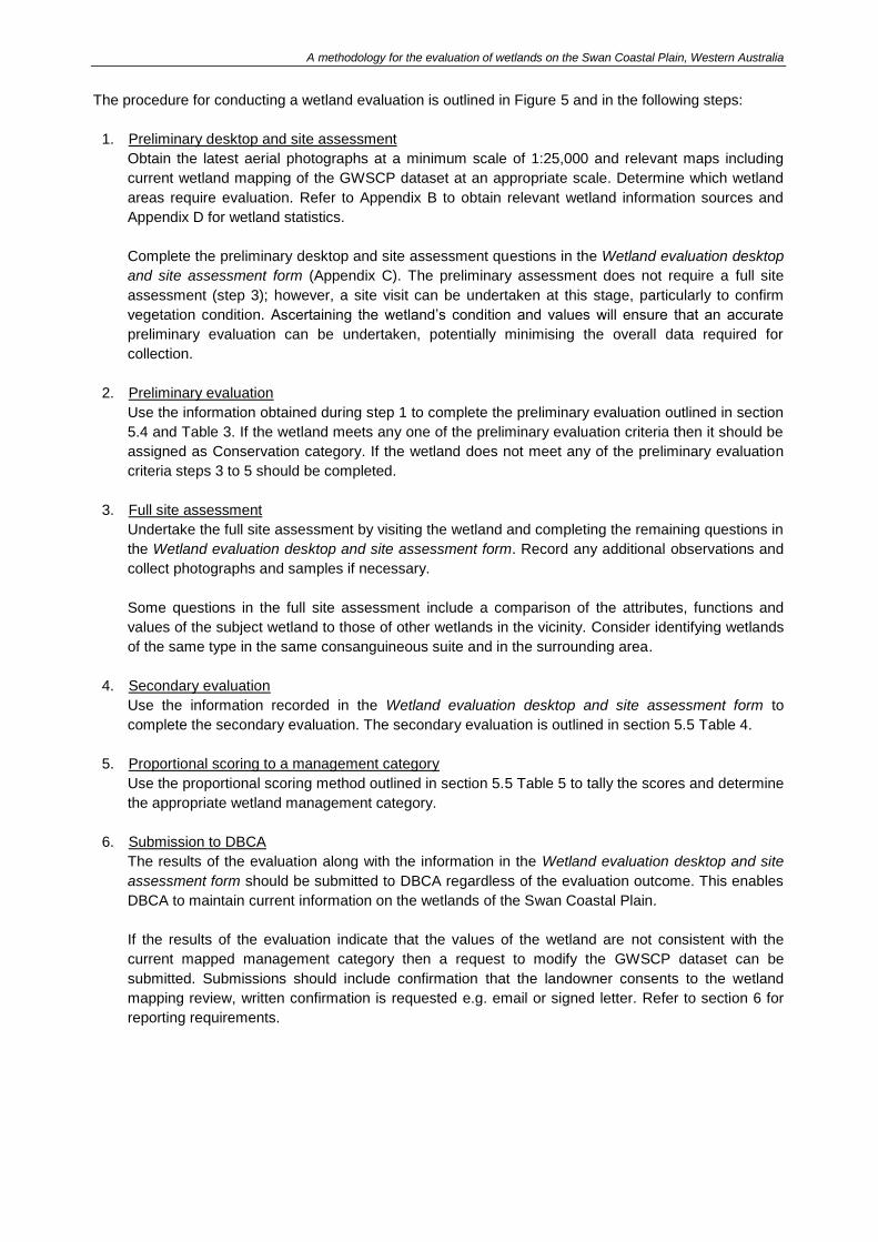
The procedure for conducting a wetland evaluation is outlined in Figure 5 and in the following steps:
1. Preliminary desktop and site assessment
Obtain the latest aerial photographs at a minimum scale of 1:25,000 and relevant maps including
current wetland mapping of the GWSCP dataset at an appropriate scale. Determine which wetland
areas require evaluation. Refer to Appendix B to obtain relevant wetland information sources and
Appendix D for wetland statistics.
Complete the preliminary desktop and site assessment questions in the Wetland evaluation desktop
and site assessment form (Appendix C). The preliminary assessment does not require a full site
assessment (step 3); however, a site visit can be undertaken at this stage, particularly to confirm
vegetation condition. Ascertaining the wetland’s condition and values will ensure that an accurate
preliminary evaluation can be undertaken, potentially minimising the overall data required for
collection.
2. Preliminary evaluation
Use the information obtained during step 1 to complete the preliminary evaluation outlined in section
5.4 and Table 3. If the wetland meets any one of the preliminary evaluation criteria then it should be
assigned as Conservation category. If the wetland does not meet any of the preliminary evaluation
criteria steps 3 to 5 should be completed.
3. Full site assessment
Undertake the full site assessment by visiting the wetland and completing the remaining questions in
the Wetland evaluation desktop and site assessment form. Record any additional observations and
collect photographs and samples if necessary.
Some questions in the full site assessment include a comparison of the attributes, functions and
values of the subject wetland to those of other wetlands in the vicinity. Consider identifying wetlands
of the same type in the same consanguineous suite and in the surrounding area.
4. Secondary evaluation
Use the information recorded in the Wetland evaluation desktop and site assessment form to
complete the secondary evaluation. The secondary evaluation is outlined in section 5.5 Table 4.
5. Proportional scoring to a management category
Use the proportional scoring method outlined in section 5.5 Table 5 to tally the scores and determine
the appropriate wetland management category.
6. Submission to DBCA
The results of the evaluation along with the information in the Wetland evaluation desktop and site
assessment form should be submitted to DBCA regardless of the evaluation outcome. This enables
DBCA to maintain current information on the wetlands of the Swan Coastal Plain.
If the results of the evaluation indicate that the values of the wetland are not consistent with the
current mapped management category then a request to modify the GWSCP dataset can be
submitted. Submissions should include confirmation that the landowner consents to the wetland
mapping review, written confirmation is requested e.g. email or signed letter. Refer to section 6 for
reporting requirements.
A methodology for the evaluation of wetlands on the Swan Coastal Plain, Western Australia
The following material should be submitted with the evaluation documentation:
• on-ground colour photographs of the wetland from all directions, including within the wetland
core, across the wetland boundary and across lot boundaries showing:
o all vegetation units throughout the wetland
o the range of vegetation condition across the wetland
o any other relevant features of the wetland, including any alterations to geomorphology
(e.g. drains, fill)
• a clear, recent (i.e. less than two years old, if available) colour aerial photograph/s of the area
(with the date noted), overlaid with the following:
o the current wetland mapping with the location and direction of photograph points
illustrated
o the current and proposed wetland mapping, including wetland boundaries and
management categories
• a description and map of the vegetation units and condition in accordance with a
reconnaissance survey (Environmental Protection Authority 2016).
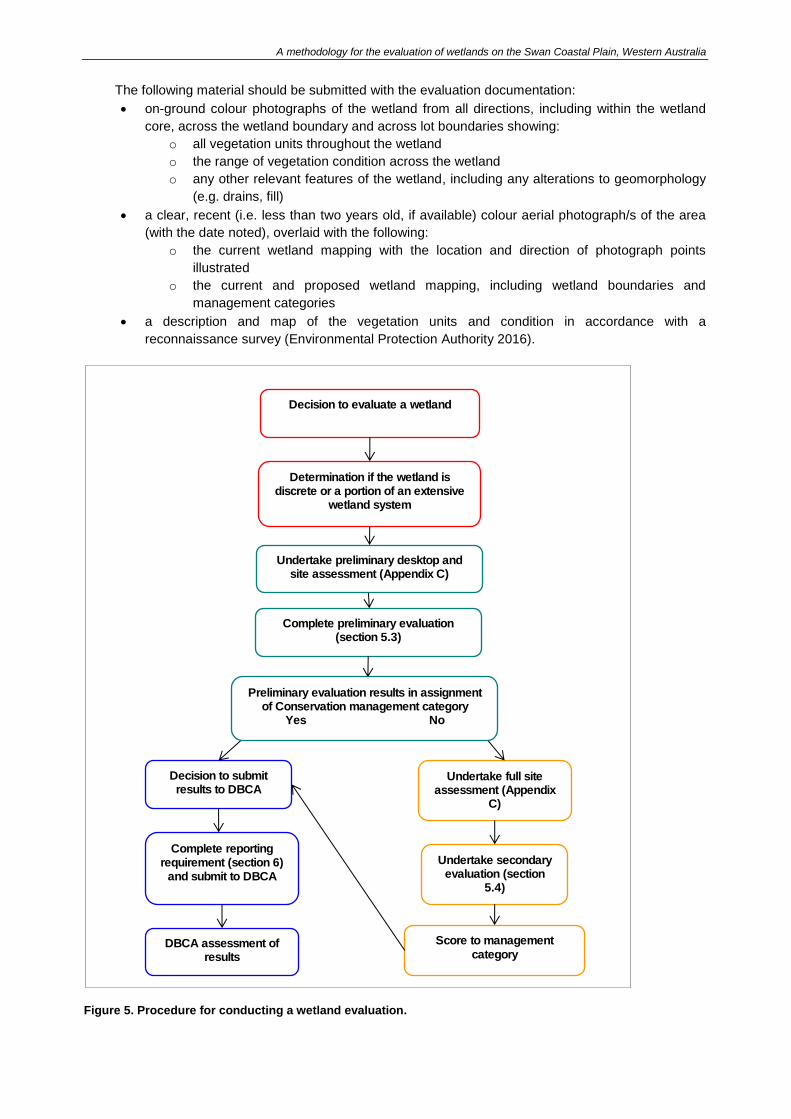
Figure 5. Procedure for conducting a wetland evaluation.
Decision to evaluate a wetland
Determination if the wetland is discrete or a portion of an extensive
wetland system
Undertake preliminary desktop and site assessment (Appendix C)
Complete preliminary evaluation (section 5.3)
Decision to submit results to DBCA
Undertake full site assessment (Appendix
C)
Undertake secondary evaluation (section
5.4)
Complete reporting requirement (section 6)
and submit to DBCA
Score to management
category DBCA assessment of
results
Preliminary evaluation results in assignment of Conservation management category
Yes No
A methodology for the evaluation of wetlands on the Swan Coastal Plain, Western Australia
5.3 Evaluation of wetland portions
The Swan Coastal Plain is a unique setting with an array of processes and landforms resulting in
wetlands with varying shapes and sizes. Some wetlands are discrete with distinct boundaries, but some
types, such as floodplain and palusplain wetlands, can cover large areas and include smaller areas of
other wetland types.
In many instances, only a portion of a wetland has been disturbed or modified. Where the undisturbed
portion of a wetland continues to support a high level of values, attributes and functions, the values of this
area should be recognised. Furthermore, disturbed portions may still support a variety of natural
functions, for example waterbirds may continue to use the wetland regardless of partial clearing. Wetland
vegetation is often resilient and if the wetland has not been significantly altered (e.g. filled or drained), the
vegetation within a disturbed portion of a wetland may naturally regenerate.
Wetland evaluation considers the inter-related values of a wetland and a management category should
ideally represent the entire geomorphic wetland without being constrained to cadastral boundaries or
changes in land uses. Previous evaluation systems (Hill et al. 1996a; V & C Semeniuk Research Group
1998) emphasised the need, where possible, for wetlands to be assigned one management category,
regardless of varying conditions in the wetland, as the wetland’s functions and processes are considered
inter-related.
The process of evaluating wetlands with such variability, coupled with the high level of disturbances on
the Swan Coastal Plain, means that this evaluation method is not always suitable. In recognition of the
high level of disturbances on the Swan Coastal Plain, wetlands with varying areas of value have
previously been evaluated and assigned multiple management categories. This methodology requires the
evaluation of a whole wetland as a single unit, rather than portions, except where the wetland meets the
criteria outlined in 5.2.1 and 5.2.2 below.
5.3.1 Extensive wetlands
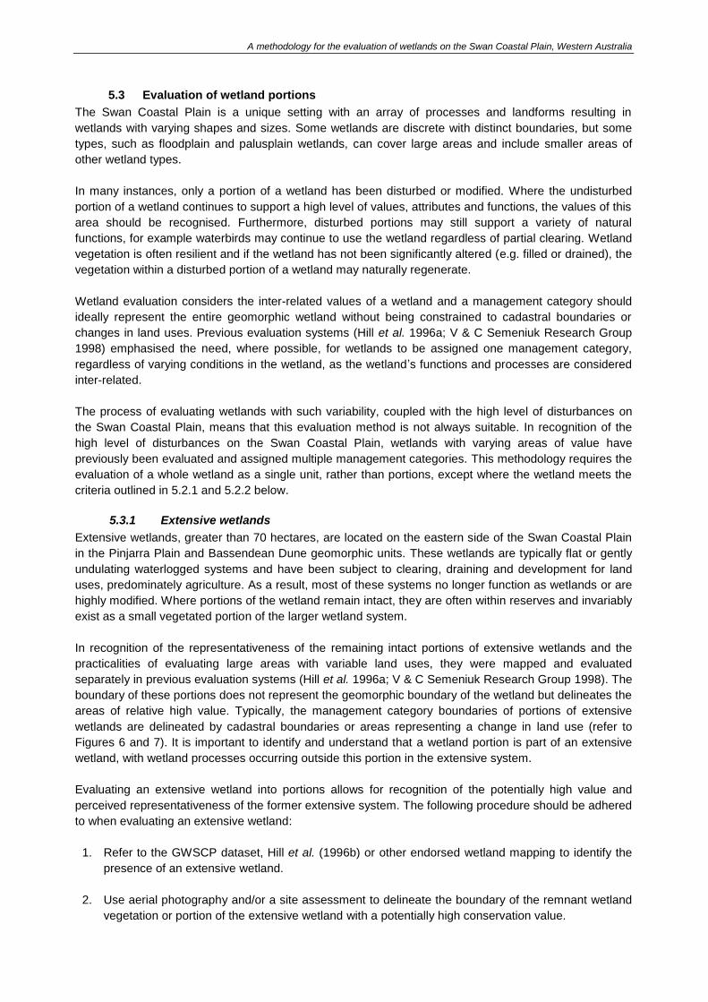
Extensive wetlands, greater than 70 hectares, are located on the eastern side of the Swan Coastal Plain
in the Pinjarra Plain and Bassendean Dune geomorphic units. These wetlands are typically flat or gently
undulating waterlogged systems and have been subject to clearing, draining and development for land
uses, predominately agriculture. As a result, most of these systems no longer function as wetlands or are
highly modified. Where portions of the wetland remain intact, they are often within reserves and invariably
exist as a small vegetated portion of the larger wetland system.
In recognition of the representativeness of the remaining intact portions of extensive wetlands and the
practicalities of evaluating large areas with variable land uses, they were mapped and evaluated
separately in previous evaluation systems (Hill et al. 1996a; V & C Semeniuk Research Group 1998). The
boundary of these portions does not represent the geomorphic boundary of the wetland but delineates the
areas of relative high value. Typically, the management category boundaries of portions of extensive
wetlands are delineated by cadastral boundaries or areas representing a change in land use (refer to
Figures 6 and 7). It is important to identify and understand that a wetland portion is part of an extensive
wetland, with wetland processes occurring outside this portion in the extensive system.
Evaluating an extensive wetland into portions allows for recognition of the potentially high value and
perceived representativeness of the former extensive system. The following procedure should be adhered
to when evaluating an extensive wetland:
1. Refer to the GWSCP dataset, Hill et al. (1996b) or other endorsed wetland mapping to identify the
presence of an extensive wetland.
2. Use aerial photography and/or a site assessment to delineate the boundary of the remnant wetland
vegetation or portion of the extensive wetland with a potentially high conservation value.
A methodology for the evaluation of wetlands on the Swan Coastal Plain, Western Australia
23
3. Complete steps 1 and 2 of this evaluation procedure which outlines that the preliminary site
assessment and desktop questions in the Wetland evaluation desktop and site assessment form
(Appendix C) should be completed prior to commencing the preliminary evaluation.
With reference to the preliminary evaluation, if a wetland supports vegetation in Good or better
condition using the vegetation condition scale outlined in Appendix B and ≤10 per cent of wetlands
with the same type are assigned Conservation management category within the Swan Coastal Plain
(by area) then it is automatically assigned a Conservation management category. For example, only
3.8 per cent of the palusplain area on the Swan Coastal Plain is currently assigned a Conservation
management category (Department of Parks and Wildlife 2016). As such, all remnant portions of
palusplain wetlands which support vegetation in a Good or better condition are valuable in terms of
their representativeness and should be assigned Conservation.
4. If the extensive wetland portion does not support vegetation in a Good or better condition using the
scale outlined in Appendix B then steps 3-6 of the evaluation procedure should be completed.
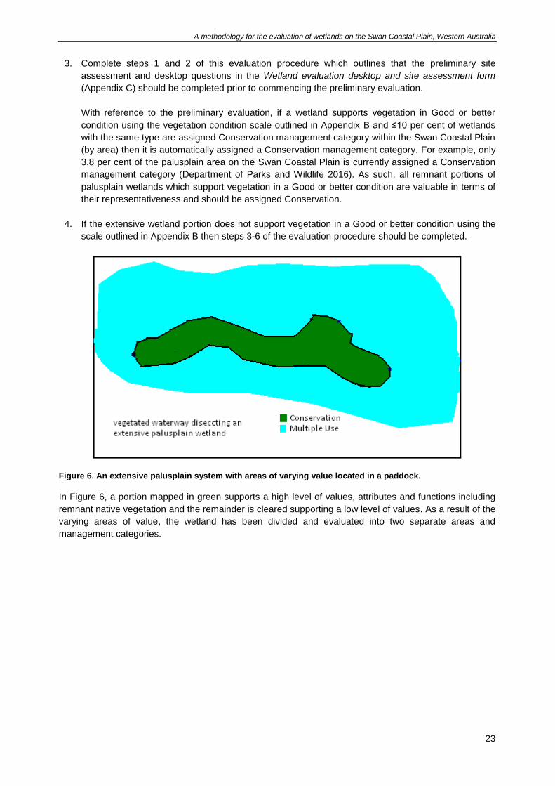
Figure 6. An extensive palusplain system with areas of varying value located in a paddock.
In Figure 6, a portion mapped in green supports a high level of values, attributes and functions including
remnant native vegetation and the remainder is cleared supporting a low level of values. As a result of the
varying areas of value, the wetland has been divided and evaluated into two separate areas and
management categories.
A methodology for the evaluation of wetlands on the Swan Coastal Plain, Western Australia
24
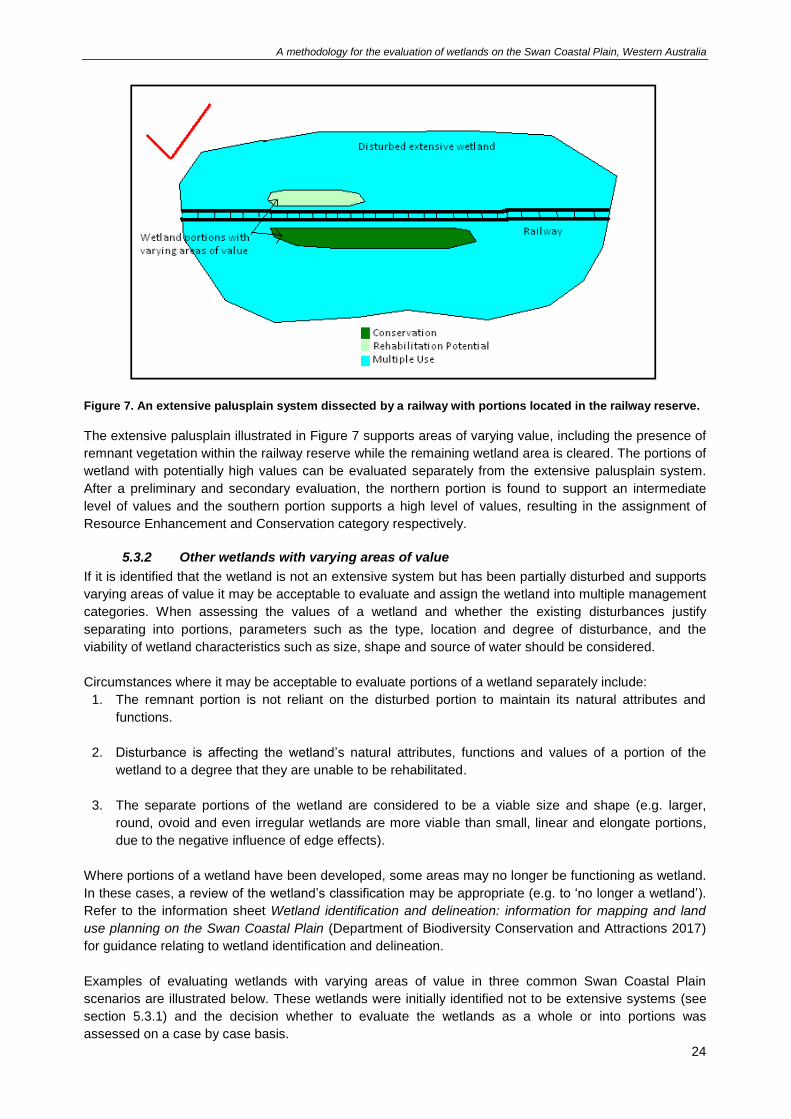
Figure 7. An extensive palusplain system dissected by a railway with portions located in the railway reserve.
The extensive palusplain illustrated in Figure 7 supports areas of varying value, including the presence of
remnant vegetation within the railway reserve while the remaining wetland area is cleared. The portions of
wetland with potentially high values can be evaluated separately from the extensive palusplain system.
After a preliminary and secondary evaluation, the northern portion is found to support an intermediate
level of values and the southern portion supports a high level of values, resulting in the assignment of
Resource Enhancement and Conservation category respectively.
5.3.2 Other wetlands with varying areas of value
If it is identified that the wetland is not an extensive system but has been partially disturbed and supports
varying areas of value it may be acceptable to evaluate and assign the wetland into multiple management
categories. When assessing the values of a wetland and whether the existing disturbances justify
separating into portions, parameters such as the type, location and degree of disturbance, and the
viability of wetland characteristics such as size, shape and source of water should be considered.
Circumstances where it may be acceptable to evaluate portions of a wetland separately include:
1. The remnant portion is not reliant on the disturbed portion to maintain its natural attributes and
functions.
2. Disturbance is affecting the wetland’s natural attributes, functions and values of a portion of the
wetland to a degree that they are unable to be rehabilitated.
3. The separate portions of the wetland are considered to be a viable size and shape (e.g. larger,
round, ovoid and even irregular wetlands are more viable than small, linear and elongate portions,
due to the negative influence of edge effects).
Where portions of a wetland have been developed, some areas may no longer be functioning as wetland.
In these cases, a review of the wetland’s classification may be appropriate (e.g. to ‘no longer a wetland’).
Refer to the information sheet Wetland identification and delineation: information for mapping and land
use planning on the Swan Coastal Plain (Department of Biodiversity Conservation and Attractions 2017)
for guidance relating to wetland identification and delineation.
Examples of evaluating wetlands with varying areas of value in three common Swan Coastal Plain
scenarios are illustrated below. These wetlands were initially identified not to be extensive systems (see
section 5.3.1) and the decision whether to evaluate the wetlands as a whole or into portions was
assessed on a case by case basis.
A methodology for the evaluation of wetlands on the Swan Coastal Plain, Western Australia
25
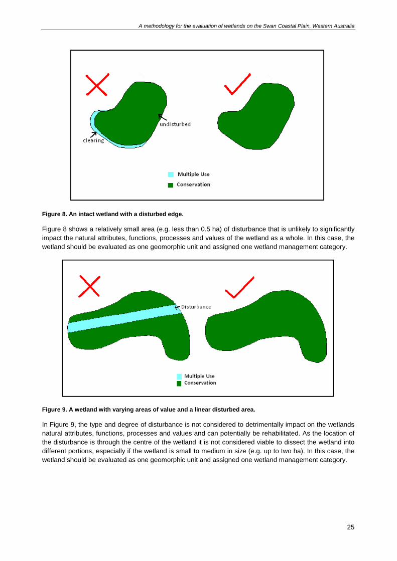
Figure 8. An intact wetland with a disturbed edge.
Figure 8 shows a relatively small area (e.g. less than 0.5 ha) of disturbance that is unlikely to significantly
impact the natural attributes, functions, processes and values of the wetland as a whole. In this case, the
wetland should be evaluated as one geomorphic unit and assigned one wetland management category.
Figure 9. A wetland with varying areas of value and a linear disturbed area.
In Figure 9, the type and degree of disturbance is not considered to detrimentally impact on the wetlands
natural attributes, functions, processes and values and can potentially be rehabilitated. As the location of
the disturbance is through the centre of the wetland it is not considered viable to dissect the wetland into
different portions, especially if the wetland is small to medium in size (e.g. up to two ha). In this case, the
wetland should be evaluated as one geomorphic unit and assigned one wetland management category.
A methodology for the evaluation of wetlands on the Swan Coastal Plain, Western Australia
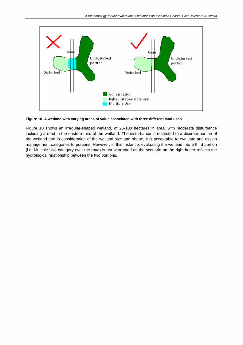
Figure 10. A wetland with varying areas of value associated with three different land uses.
Figure 10 shows an irregular-shaped wetland, of 25-100 hectares in area, with moderate disturbance
including a road in the eastern third of the wetland. The disturbance is restricted to a discrete portion of
the wetland and in consideration of the wetland size and shape, it is acceptable to evaluate and assign
management categories to portions. However, in this instance, evaluating the wetland into a third portion
(i.e. Multiple Use category over the road) is not warranted as the scenario on the right better reflects the
hydrological relationship between the two portions.
A methodology for the evaluation of wetlands on the Swan Coastal Plain, Western Australia
5.4 Preliminary evaluation scoring
The preliminary evaluation provides an initial assessment to determine if the individual wetland or wetland
portion is of high conservation value.
Using the information collected during step 1 of the evaluation procedure and on the Wetland evaluation
desktop and site assessment form, assess the wetland by answering a ‘yes’ or ‘no’ to each preliminary
evaluation criterion (Table 3). If a ‘yes’ can be answered to any one of the criteria then the wetland is
considered to support the highest level of values, attributes and functions. Wetlands supporting a high
level of values, attributes and functions are automatically assigned to Conservation management
category.
For wetlands that are assigned to a Conservation management category under the preliminary
evaluation, a secondary evaluation is not required; however, a full site assessment and secondary
evaluation is encouraged so additional information on the values of the wetland can be obtained. The
additional information may assist in management planning and monitoring of the wetland.
Failure to meet any one of the below preliminary evaluation criteria in no way precludes assignment of a
wetland to Conservation management category during the secondary evaluation.
5.4.1 Criteria
Answer ‘yes’ or ‘no’ in the right column to each criterion below. The criterion should be left blank if a ‘yes’
or ‘no’ answer cannot be determined.
Table 3. Preliminary evaluation criteria.
No. Criteria Y/N
1 The wetland is currently recognised as internationally or nationally significant for its natural values. Lists/registers include:
• The Ramsar Convention on Wetlands
• State government endorsed candidate sites for the Ramsar Convention on Wetlands
• Directory of Important Wetlands in Australia
• National Heritage List
• or equivalent.
2 The wetland is spatially dominated by vegetation in a good or better condition using the vegetation condition scale outlined in Appendix B and is identified as significant for its natural values under one or more of the following:
• Conservation Reserves for Western Australia Systems 1, 2, 3, 5
• Conservation Reserves for Western Australia, The Darling System – System 6
• A Systematic Overview of Environmental Values of the Wetlands, Rivers and Estuaries of the Busselton – Walpole Region
• The Environmental Significance of Wetlands in the Perth to Bunbury Region
• Bush Forever, Swan Bioplan (including Peel Regionally Significant Natural Areas) or equivalent.
3 The wetland supports a breeding, roosting, or refuge site or a critical feeding site for populations of fauna listed by the Australian Government (for example, Environment Protection and Biodiversity Conservation Act 1999, migratory bird agreements such as JAMBA, CAMBA and RoKAMBA) or the State (for example, threatened and specially protected fauna listed under the Wildlife

A methodology for the evaluation of wetlands on the Swan Coastal Plain, Western Australia
28
No. Criteria Y/N
Conservation Act 1950).
4 The wetland is spatially dominated by vegetation in a good or better condition using the vegetation condition scale outlined in Appendix B and supports one or more of the following:
• an occurrence of a threatened ecological community
• a confirmed occurrence of a priority 1 or priority 2 ecological community
• a confirmed occurrence of a declared rare (threatened) flora species.
5 Equal to or greater than 90% of the wetland supports vegetation in a good or better condition using the vegetation condition scale outlined in Appendix B.
6 The wetland is spatially dominated by vegetation in a good or better condition using the vegetation condition scale outlined in Appendix B and is known to support internationally, nationally or state-wide scientific values including geoheritage and geoconservation.
7 The wetland is spatially dominated by vegetation in a good or better condition using the vegetation condition scale outlined in Appendix B and meets one of the following:
• ≤ 10% of wetlands of the same type are assigned Conservation management category within the Swan Coastal Plain (by area)
• ≤ 10% of all wetlands in the same consanguineous suite are assigned Conservation management category (by area)
• ≤ 10% of wetlands of the same type in its consanguineous suite are assigned Conservation management category (by area)
• best representative of its type within its consanguineous suite domain.
Note: If a wetland does not satisfy any of the above preliminary evaluation criteria or, does satisfy the
preliminary evaluation criteria but is not considered be commensurate with the values of a Conservation
management category wetland then a secondary evaluation including a full site assessment, is required.
5.5 Secondary evaluation scoring
A secondary evaluation provides additional information on the wetland’s attributes, functions and values.
Using the information collected in steps 1-3 and on the Wetland evaluation desktop and site assessment
form, complete the secondary evaluation outlined in Table 4.
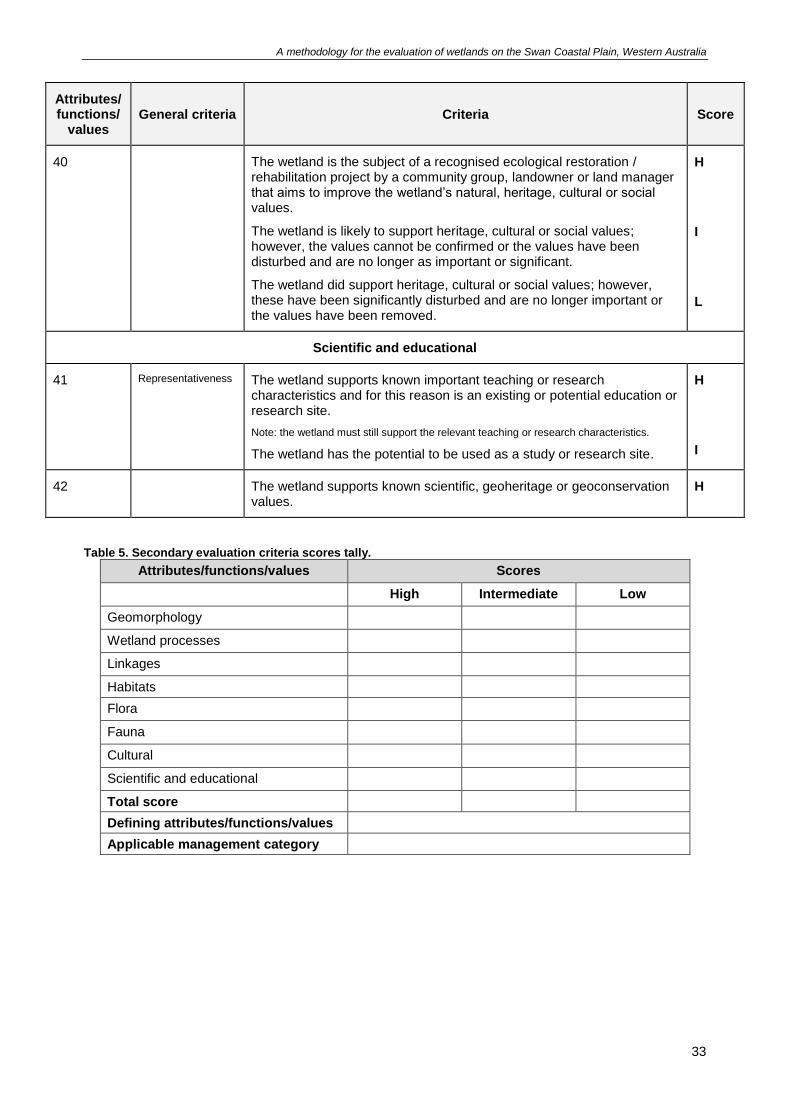
Assess the individual wetland by considering all the criteria listed under each attribute/function/value.
Criterion are scored as H = high value, I = intermediate value, L = low value. Note, at least one score (H, I
or L) should be recorded for each attribute/function/value with the exception of Scientific and Educational,
and Cultural. It is also possible for a wetland to meet more than one score in each attribute/function/value.
Criterion that only have a high score should not be changed to intermediate or low – if the high score is
not met, the criterion should not be scored. Scores can be tallied into Table 5.
It is important that scores are justified by providing the relevant information in the Wetland evaluation
desktop and site assessment form. In addition, comments can be added to the template under the
relevant criteria to emphasise or further demonstrate that the wetland meets the allocated score.
Refer to Appendix A for examples on how to apply the secondary evaluation.
A methodology for the evaluation of wetlands on the Swan Coastal Plain, Western Australia
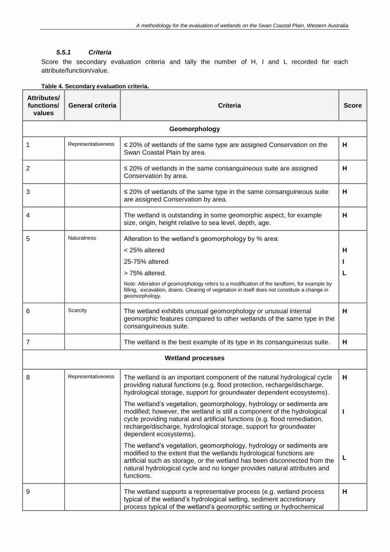
5.5.1 Criteria
Score the secondary evaluation criteria and tally the number of H, I and L recorded for each
attribute/function/value.
Table 4. Secondary evaluation criteria.
Attributes/ functions/
values General criteria Criteria Score
Geomorphology
1 Representativeness ≤ 20% of wetlands of the same type are assigned Conservation on the Swan Coastal Plain by area.
H
2 ≤ 20% of wetlands in the same consanguineous suite are assigned Conservation by area.
H
3 ≤ 20% of wetlands of the same type in the same consanguineous suite are assigned Conservation by area.
H
4 The wetland is outstanding in some geomorphic aspect, for example size, origin, height relative to sea level, depth, age.
H
5 Naturalness Alteration to the wetland’s geomorphology by % area:
< 25% altered
25-75% altered
> 75% altered.
Note: Alteration of geomorphology refers to a modification of the landform, for example by filling, excavation, drains. Clearing of vegetation in itself does not constitute a change in geomorphology.
H
I
L
6 Scarcity The wetland exhibits unusual geomorphology or unusual internal geomorphic features compared to other wetlands of the same type in the consanguineous suite.
H
7 The wetland is the best example of its type in its consanguineous suite. H
Wetland processes
8 Representativeness The wetland is an important component of the natural hydrological cycle providing natural functions (e.g. flood protection, recharge/discharge, hydrological storage, support for groundwater dependent ecosystems).
The wetland’s vegetation, geomorphology, hydrology or sediments are modified; however, the wetland is still a component of the hydrological cycle providing natural and artificial functions (e.g. flood remediation, recharge/discharge, hydrological storage, support for groundwater dependent ecosystems).
The wetland’s vegetation, geomorphology, hydrology or sediments are modified to the extent that the wetlands hydrological functions are artificial such as storage, or the wetland has been disconnected from the natural hydrological cycle and no longer provides natural attributes and functions.
H
I
L
9 The wetland supports a representative process (e.g. wetland process typical of the wetland’s hydrological setting, sediment accretionary process typical of the wetland’s geomorphic setting or hydrochemical
H
A methodology for the evaluation of wetlands on the Swan Coastal Plain, Western Australia
30
Attributes/ functions/
values General criteria Criteria Score
process typical of the wetland’s geological setting).
10 Naturalness The wetland is not subject to altered wetland processes or, is subject to altered wetland processes and the wetland’s natural attributes and functions are maintained.
The wetland is subject to altered wetland processes and the wetland’s natural attributes and functions have been changed; however, they have the potential to be rehabilitated.
The wetland is subject to altered wetland processes to the extent that the wetland no longer supports natural attributes and functions.
Note: processes to consider include hydrological, hydrogeological, sedimentological, chemical, biological.
H
I
L
11 Scarcity The wetland exhibits unusual processes compared to other wetlands of the same type in the consanguineous suite.
H
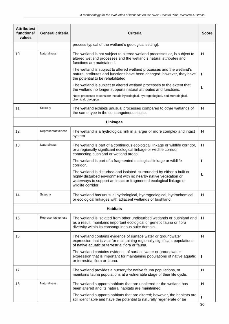
Linkages
12 Representativeness The wetland is a hydrological link in a larger or more complex and intact system.
H
13 Naturalness The wetland is part of a continuous ecological linkage or wildlife corridor, or a regionally significant ecological linkage or wildlife corridor connecting bushland or wetland areas.
The wetland is part of a fragmented ecological linkage or wildlife corridor.
The wetland is disturbed and isolated, surrounded by either a built or highly disturbed environment with no nearby native vegetation or waterways to support an intact or fragmented ecological linkage or wildlife corridor.
H
I
L
14 Scarcity The wetland has unusual hydrological, hydrogeological, hydrochemical or ecological linkages with adjacent wetlands or bushland.
H
Habitats
15 Representativeness The wetland is isolated from other undisturbed wetlands or bushland and as a result, maintains important ecological or genetic fauna or flora diversity within its consanguineous suite domain.
H
16 The wetland contains evidence of surface water or groundwater expression that is vital for maintaining regionally significant populations of native aquatic or terrestrial flora or fauna.
The wetland contains evidence of surface water or groundwater expression that is important for maintaining populations of native aquatic or terrestrial flora or fauna.
H
I
17 The wetland provides a nursery for native fauna populations, or maintains fauna populations at a vulnerable stage of their life cycle.
H
18 Naturalness The wetland supports habitats that are unaltered or the wetland has been altered and its natural habitats are maintained.
The wetland supports habitats that are altered; however, the habitats are still identifiable and have the potential to naturally regenerate or be
H
I
A methodology for the evaluation of wetlands on the Swan Coastal Plain, Western Australia
31
Attributes/ functions/
values General criteria Criteria Score
rehabilitated after weed control, if required.
The wetland is altered and as a result is no longer supporting natural habitats which can be rehabilitated.
L
19 Scarcity The wetland supports habitats that are unusual compared to other wetlands of the same type on the Swan Coastal Plain.
H
Flora
20 Representativeness The wetland’s current diversity of native flora is similar to what would be expected in an unaltered state.
The wetland supports a reduced diversity of native flora due to human induced disturbances.
The wetland supports a significantly reduced diversity of native flora species due to human induced disturbances.
H
I
L
21 The wetland is identified in a vegetation complex (Heddle et al. 1980) which is represented by:
≤ 30% of the pre-European extent
30-50% of the pre-European extent.
Note: statistics can be obtained from Local Biodiversity Program (2013) – to allow for vegetation type and extent mapping error due to the mapping scale used, the extent of remnant vegetation is considered an overestimate. The 30% and 10% thresholds are assessed at actual 40% and 15% levels.
H
I
22 Naturalness Using the vegetation condition scale outlined in Appendix B, the wetland’s vegetation condition by area is:
≥ 75% Good, Very Good, Excellent or Pristine
25-75% Good, Very Good, Excellent or Pristine
< 25% Good, Very Good, Excellent or Pristine.
H
I
L
23 The wetland or ≥ 50% of the wetland boundary is surrounded by land dominated by remnant native vegetation.
The wetland or 10-50% of the wetland boundary is surrounded by land dominated by remnant native vegetation.
The wetland or < 10% of the wetland boundary is surrounded by land dominated by remnant native vegetation.
H
I
L
24 Scarcity The wetland supports an occurrence of declared rare, priority 1, priority 2, priority 3 or priority 4 flora, or an occurrence of three or more significant flora taxa.
H
25 The wetland is likely to support declared rare, priority 1, priority 2, priority 3 or priority 4 flora; however, the occurrence cannot be located or its habitat has been altered and is no longer in a natural state.
I
26 The wetland supports an occurrence of a threatened ecological community, priority 1 or priority 2 ecological community.
H
27 The wetland supports an occurrence of a priority 3 or priority 4 ecological community.
I
A methodology for the evaluation of wetlands on the Swan Coastal Plain, Western Australia
32
Attributes/ functions/
values General criteria Criteria Score
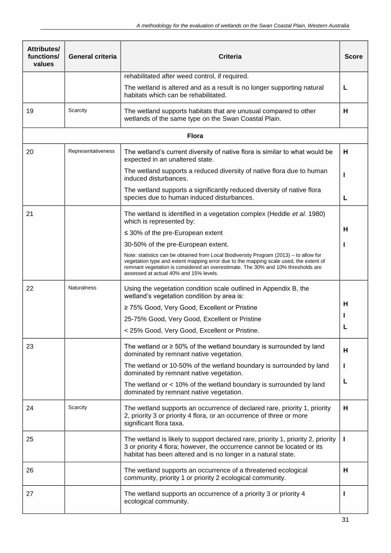
Fauna
28 Representativeness The wetland is an ecological refuge for regionally significant fauna species or fauna assemblages.
The wetland has the potential to be an ecological refuge but is disturbed and its attributes and functions require rehabilitation.
H
I
29 The wetland supports a permanent or seasonal feeding, breeding, roosting or watering site for regionally significant native fauna.
The wetland supports a permanent or seasonal feeding, breeding, roosting or watering site for regional or local fauna but only in association with other surrounding natural areas.
H
I
30 Naturalness The wetland’s current diversity of native fauna is similar to what would be expected in an unaltered state, or the wetland supports diverse fauna compared to other wetlands of the same type.
The wetland supports a reduced diversity of fauna compared to other wetlands of the same type.
The wetland supports limited attributes and functions for fauna populations due to human induced disturbances.
H
I
L
31 Scarcity The wetland is likely to support a breeding, roosting, refuge or feeding site for populations of fauna listed by the Australian Government (e.g. EPBC Act 1999, JAMBA, CAMBA, RoKAMBA Agreements) or the State (e.g. threatened or specially protected fauna listed under the Wildlife Conservation Act 1950).
H
32 The wetland supports a breeding, roosting, refuge or feeding site for priority 1, priority 2, priority 3 or priority 4 fauna.
H
33 The wetland supports an occurrence of a threatened ecological community, priority 1 or priority 2 ecological community.
H
34 The wetland supports an occurrence of a priority 3 or priority 4 ecological community or a breeding, roosting, refuge or feeding site for significant fauna.
I
Cultural
35 Representativeness The wetland or its immediate surrounds is identified for its natural values on a national or State heritage list or the wetland supports other known regional heritage values.
H
36 The wetland or its immediate surrounds is identified for its natural values on a municipal heritage list or the wetland supports other known local heritage values.
I
37 The wetland or its immediate surrounds is identified on a national, State or local list or register for its Aboriginal cultural value.
H
38 The wetland is important to the local community for its natural values. H
39 The wetland is or has the potential to be a site for public or private based recreation.
I
A methodology for the evaluation of wetlands on the Swan Coastal Plain, Western Australia
33
Attributes/ functions/
values General criteria Criteria Score
40 The wetland is the subject of a recognised ecological restoration / rehabilitation project by a community group, landowner or land manager that aims to improve the wetland’s natural, heritage, cultural or social values.
The wetland is likely to support heritage, cultural or social values; however, the values cannot be confirmed or the values have been disturbed and are no longer as important or significant.
The wetland did support heritage, cultural or social values; however, these have been significantly disturbed and are no longer important or the values have been removed.
H
I
L
Scientific and educational
41 Representativeness The wetland supports known important teaching or research characteristics and for this reason is an existing or potential education or research site.
Note: the wetland must still support the relevant teaching or research characteristics.
The wetland has the potential to be used as a study or research site.
H
I
42 The wetland supports known scientific, geoheritage or geoconservation values.
H
Table 5. Secondary evaluation criteria scores tally.
Attributes/functions/values Scores
High Intermediate Low
Geomorphology
Wetland processes
Linkages
Habitats
Flora
Fauna
Cultural
Scientific and educational
Total score
Defining attributes/functions/values
Applicable management category
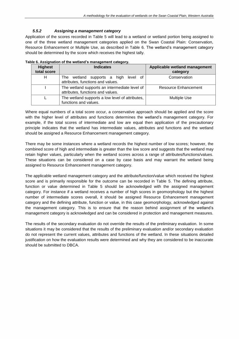
A methodology for the evaluation of wetlands on the Swan Coastal Plain, Western Australia
5.5.2 Assigning a management category
Application of the scores recorded in Table 5 will lead to a wetland or wetland portion being assigned to
one of the three wetland management categories applied on the Swan Coastal Plain: Conservation,
Resource Enhancement or Multiple Use, as described in Table 6. The wetland’s management category
should be determined by the score which receives the highest tally.
Table 6. Assignation of the wetland’s management category.
Highest total score
Indicates Applicable wetland management category
H The wetland supports a high level of attributes, functions and values.
Conservation
I The wetland supports an intermediate level of attributes, functions and values.
Resource Enhancement
L The wetland supports a low level of attributes, functions and values.
Multiple Use
Where equal numbers of a total score occur, a conservative approach should be applied and the score
with the higher level of attributes and functions determines the wetland’s management category. For
example, if the total scores of intermediate and low are equal then application of the precautionary
principle indicates that the wetland has intermediate values, attributes and functions and the wetland
should be assigned a Resource Enhancement management category.
There may be some instances where a wetland records the highest number of low scores; however, the
combined score of high and intermediate is greater than the low score and suggests that the wetland may
retain higher values, particularly when the wetland scores across a range of attributes/functions/values.
These situations can be considered on a case by case basis and may warrant the wetland being
assigned to Resource Enhancement management category.
The applicable wetland management category and the attribute/function/value which received the highest
score and is primarily responsible for the outcome can be recorded in Table 5. The defining attribute,
function or value determined in Table 5 should be acknowledged with the assigned management
category. For instance if a wetland receives a number of high scores in geomorphology but the highest
number of intermediate scores overall, it should be assigned Resource Enhancement management
category and the defining attribute, function or value, in this case geomorphology, acknowledged against
the management category. This is to ensure that the reason behind assignment of the wetland’s
management category is acknowledged and can be considered in protection and management measures.
The results of the secondary evaluation do not override the results of the preliminary evaluation. In some
situations it may be considered that the results of the preliminary evaluation and/or secondary evaluation
do not represent the current values, attributes and functions of the wetland. In these situations detailed
justification on how the evaluation results were determined and why they are considered to be inaccurate
should be submitted to DBCA.
A methodology for the evaluation of wetlands on the Swan Coastal Plain, Western Australia
6 Reporting requirements and mapping modifications The results of the preliminary and secondary evaluation along with the information in the Wetland
evaluation desktop and site assessment form should be submitted to the Wetlands Section of DBCA
regardless of the evaluation outcome. This will ensure that the most up to date information on Swan
Coastal Plain wetlands is maintained. The GWSCP dataset is updated every three months.
If the results of the preliminary or secondary evaluation indicate that the wetland’s mapped management
category is incorrect then a request to modify the GWSCP dataset can be submitted. Requests should be
submitted to the Principal Coordinator, DBCA Wetlands Section with detailed justification and
documentation consistent with this methodology (i.e. ‘Wetland evaluation desktop and site assessment
form’ and the evaluation criteria templates).
In assessing requests to modify a wetland’s management category DBCA and DWER will consider all
facets of the wetland’s functions and attributes and will not be confined to the scope of information
presented. Associated development proposals or future land uses will not be considered in the evaluation
process.
A methodology for the evaluation of wetlands on the Swan Coastal Plain, Western Australia
36
7 Glossary
Attribute: Wetland attributes are a characteristic or combination of characteristics which do not
necessarily support a use (adapted from Hill et al. 1996a).
Best representative: The most outstanding example of a particular wetland characteristic within a
defined area or setting. For example, a wetland may be the best representative example in the
consanguineous suite if it is the most intact of its type or if it is the only remaining example.
Bioregion; Interim Biogeographic Regionalisation for Australia (IBRA): A framework for conservation
planning and sustainable resource management. IBRA bioregions represent a landscape based approach
to classifying the land surface from a range of data on environmental attributes including climate and
geomorphology (Thackway and Cresswell 1995).
Biodiversity hotspots (global): Regions that contain a great diversity of endemic species and at the
same time have been significantly impacted and altered by human activities. The only Australian
Biodiversity Hotspot is the south-west of Western Australia (Mittermeier et al. 2005).
Bush Forever: Regionally significant areas of bushland within the Perth Metropolitan Region designated
for protection under Bush Forever (Government of Western Australia 2000b).
Bushland: Land on which there is vegetation which is either a remainder of the natural vegetation of the
land, or, if altered, is still representative of the structure and floristics of the natural vegetation, and
provides habitat for native fauna (Government of Western Australia 2000b).
CAMBA: The China-Australia Migratory Birds Agreement is an agreement between the Government of
Australia and the Government of the People’s Republic of China for the protection of migratory birds and
their environment (Commonwealth of Australia 1995b).
Catchment: The area around a wetland or waterway that contributes surface run-off or groundwater to
the wetland or waterway (Environmental Protection Authority 2008).
Community: Any grouping of populations of different species found living together; essentially, the
biological component of an ecosystem.
Consanguineous suite: Area/s defining a group of wetlands with common or interrelated features
(Semeniuk 1988).
Consanguineous suite domain: Discrete areas containing consanguineous, closely occurring wetlands
(Semeniuk 1988).
Declared rare flora: Flora species with protection under s23c of the Wildlife Conservation Act 1950.
Diversity: The relative number of different flora and/or fauna species or communities that occur in close
association in an area.
Ecological community: A naturally occurring biological assemblage that occurs in a particular type of
habitat. The scale at which ecological communities are defined will often depend on the level of detail in
the information source, therefore no particular scale is specified.
Ecological linkage: Part of a network of native vegetation that maintains some ecological functions of
natural areas and counters the effects of habitat fragmentation (Environmental Protection Authority 2008);
non-contiguous natural areas that connect larger natural areas by forming stepping stones that allow the
movement over time of organisms between these larger areas (Western Australian Local Government
A methodology for the evaluation of wetlands on the Swan Coastal Plain, Western Australia
37
Association and Perth Biodiversity Project 2004); natural corridors proposed as linkages between
declared public open spaces such as local, regional or national parks, stream reserves, wetlands and
beaches (Alan Tingay and Associates 1998).
Ecological refuge: Restricted environments that have been isolated for extended periods of time, or are
the last remnants of such areas. They may be of high significance for fauna species or faunal
assemblages with very restricted distributions, or support fauna species well outside their normal range
(Environmental Protection Authority 2008).
Edge effects: Adverse effects on the health of natural areas as a result of an interface with developed or
cleared areas. The edges of natural areas are prone to weed infestation, pests and diseases, altered
drainage and water regimes, trampling, rubbish and other impacts (Environmental Protection Authority
2008).
Environment: Living things, their physical, biological and social surroundings, and interactions between
all of these. The social surroundings are the aesthetic, cultural, economic and social surroundings to the
extent that those surroundings directly affect or are affected by the physical or biological surroundings
(Environmental Protection Authority 2008).
Environmentally sensitive area: Area of the State specified in a notice, or an area of the State of a
class specified in a notice, declared by the Minister for the Environment under s.51B of the Environmental
Protection Act 1986 to be an environmentally sensitive area. The exemptions for prescribed purposes
outlined in the Environmental Protection (Clearing of Native Vegetation) Regulations 2004 from the
requirement for a clearing permit do not apply in environmentally sensitive areas, and thus these areas
have a higher level of protection.
Evaluation: The process of assessing and documenting a wetland’s values by considering and collecting
information about its attributes and functions.
Extensive wetland: A wetland that is generally greater than 70 hectares in size (Hill et al. 1996a).
Fauna: Species belonging to the animal kingdom.
Fauna assemblage: A collection of animal species inhabiting a particular area.
Flora: All the vascular plant taxa (including species, subspecies, varieties, hybrids and ecotypes) in a
given area (Environmental Protection Authority 2016).
Floristic community type: Floristic assemblage as defined by Gibson et al. (1994). The presence or
absence of individual taxa in standard areas (plots, sites, quadrats) is used to define floristic groupings
based on shared species (Environmental Protection Authority 2003a).
Function: Wetland functions are the physical, chemical and biological processes occurring within a
wetland (adapted from Environmental Protection Authority 2008).
Geoconservation: Conservation of Earth science features (geological, geomorphological, pedological
and hydrological) that are of sufficient significance to warrant preservation for purposes of heritage,
science or education (Semeniuk and Semeniuk 2001).
Geoheritage: Globally, nationally, state-wide to local features of geology, at a scale that are intrinsically
important sites, or culturally important sites, that offer information or insights into the formation or
evolution of the Earth, or into the history of science, or that can be used for research, teaching or
reference (Brocx and Semeniuk 2007).
A methodology for the evaluation of wetlands on the Swan Coastal Plain, Western Australia
38
Geomorphology: Landscape features and shape, at various spatial scales.
Groundwater: Water under the land surface that occupies the pores and crevices of soil or rock
(Environmental Protection Authority 2008).
Habitat: The natural environment of an organism or a community, including all biotic and abiotic elements
(Environmental Protection Authority 2003a).
Hydric soil: Soil that has formed under conditions of saturation or inundation long enough to develop
anaerobic conditions in the upper part.
Hydrogeology: The hydrological and geological science concerned with the occurrence, distribution,
quality and movement of groundwater, especially relating to the distribution of aquifers, groundwater flow
and groundwater quality.
Hydrology: The movement of water into and within a wetland or waterway from the surrounding
landscape or catchment.
Impact (environmental): The effect that a human-caused or natural activity has on living organisms and
their non-living environment that can either be adverse or beneficial (Environmental Protection Authority
2008).
JAMBA: The Japan-Australia Migratory Birds Agreement is an agreement between the Government of
Japan and the Government of Australia for the protection of migratory birds in danger of extinction and
their environment (Commonwealth of Australia 1995a).
Landform: A combination of slope and elevation producing a particular shape and form of the land
surface (Environmental Protection Authority 2008).
Landscape: The appearance of the land whether natural or altered, including its shape, texture and
colours (Environmental Protection Authority 2008).
Land use: The active or passive use to which the land is put by its owner, lessee, manager or occupier
(Environmental Protection Authority 2008).
Native vegetation: Indigenous aquatic, wetland or terrestrial vegetation, including most dead vegetation,
but does not include vegetation in a plantation, nor, for the purposes of Division 2 Part V of the EP Act,
most vegetation that was intentionally sown, planted or propagated unless as required under the Act
(Environmental Protection Authority 2008).
Perth Metropolitan Region: Area on the Swan Coastal Plain as defined in the Perth Metropolitan Region
Scheme.
Population: The entire aggregation of components that are the subject of a study. This may be all the
individuals in a biological population, or a particular group or habitat, but it may equally relate to a non-
biological entity such as quadrats.
Precautionary principle: Principle applied to err on the side of caution when the prediction of
environmental impacts is uncertain (Environmental Protection Authority 2008).
Priority ecological community: Possible threatened ecological communities that do not meet survey
criteria are added to DBCA’s lists under priorities 1, 2 and 3. Ecological communities that are adequately
known, are rare but not threatened, or meet criteria for near threatened, or that have been recently
A methodology for the evaluation of wetlands on the Swan Coastal Plain, Western Australia
39
removed from the threatened list, are placed in priority 4. These ecological communities require regular
monitoring.
Priority fauna: Animal taxa, lists of which are maintained by DBCA, that are either under consideration
as threatened fauna but are in need of further survey to adequately determine their status, or are
adequately known but require monitoring to ensure that their conservation status does not decline, or are
dependent on ongoing conservation action.
Priority flora: Plant taxa, lists of which are maintained by DBCA, that are either under consideration as
threatened flora but are in need of further survey to adequately determine their status, or are adequately
known but require monitoring to ensure that their conservation status does not decline.
Ramsar Convention: The Convention on Wetlands of International Importance, signed in Ramsar (Iran)
in 1971, is an intergovernmental treaty that provides the framework for national action and international
cooperation for the conservation and wise use of wetlands and their resources.
RoKAMBA: The Republic of Korea-Australia Migratory Bird Agreement is an agreement between the
Government of Australia and the Government of the Republic of Korea for the protection of migratory
birds and their environment (Commonwealth of Australia 2007).
Rehabilitation: The return of the original characteristics of a natural area that has been disturbed.
Significant fauna: Include but are not necessarily limited to species protected by international
agreements or treaties, specially protected fauna, priority fauna, short range endemic species, species
with declining populations or declining distributions, species at the extremes of their range, isolated
outlying populations and undescribed species.
Significant flora: Includes but is not limited to flora with any of the following characteristics:
declared rare flora or priority flora
keystone role in a particular habitat for threatened species, or supporting large populations
representing a significant proportion of the local regional population of a species
relic status
anomalous features that indicate a potential new discovery
representative of the range of a species including the extremes of the range, recently discovered
range extensions, or isolated outliers of the main range
a restricted subspecies, variety or naturally occurring hybrid
local endemism or a restricted distribution.
Specially protected fauna: Animal species listed under the Wildlife Conservation Act 1950 including
threatened species and other species in need of special protection.
Stakeholder: Any organisation, government entity, group or individual that has an interest in a particular
issue.
Surface water: Water flowing or held in waterways and wetlands on the surface of the landscape.
Systems 1-12: Twelve geographic areas that cover Western Australia and which were identified by the
Conservation through Reserves Committee set up by the Environmental Protection Authority in the
1970s.
Threat: An occurrence, activity or institutional process or structure, that threatens, or may threaten, the
survival, abundance or evolutionary development of a native species or ecological community (ANZECC
2000).
A methodology for the evaluation of wetlands on the Swan Coastal Plain, Western Australia
40
Threatened ecological community: An ecological community which is found to fit into one of the
following categories; presumed totally destroyed, critically endangered, endangered or vulnerable.
Threatened species: All or any species whose conservation status is considered insecure, including
species in the ‘critically endangered’, ‘endangered’ and ‘vulnerable’ categories. Such species are listed as
‘specially protected’ under the Wildlife Conservation Act 1950 or as ‘threatened’ under the Environment
Protection and Biodiversity Conservation Act 1999.
Value: A beneficial use of the environment (including social and economic values that derive from the
environment); or an ecosystem health condition (Environmental Protection Authority 2008).
Vegetation: The combinations of plant species within a given area, and the nature and extent of each
combination.
Vegetation complex: A vegetation classification term used in Heddle et al. (1980) and based on the
pattern of vegetation at a regional scale as it reflects the underlying key determining factors of landforms,
soils and climate (Environmental Protection Authority 2003a).
Waterway: Any river, creek, stream or brook, including its floodplain or estuary. This includes systems
that flow permanently, for part of the year or occasionally, and parts of the waterway that have been
artificially modified (Department of Water 2012).
Water regime: The pattern of when, where and to what extent water is present in a wetland. The
components of water regime are the timing, duration, frequency, extent and depth, and variability of water
presence (Boulton and Brock 1999).
Wetland: See section 2.2 for definition. In the context of this document the term wetland is applied to
incorporate the entire geomorphic wetland area or any specific portion of a geomorphic wetland which
has been selected.
Wetland characteristic: Those properties of a wetland that describe the area in the simplest and most
objective possible terms e.g. wetland size, species present, soils and water quality. Functions, uses or
attributes of a wetland are the products of its characteristics, singly or in combination (Hill et al. 1996a).
Wetland management category: The management category assigned to a wetland based on the
evaluation of its attributes and functions. It provides guidance on the nature of management and
protection the wetland should be afforded. The categories that have been used on the Swan Coastal
Plain in Western Australia are Conservation, Resource Enhancement and Multiple Use.
Wetland processes: The dynamic physical, hydrological, chemical and biological processes occurring
within a wetland, including interactions between wetland organisms, within the physical/chemical
environment.
Wetland type: The result of applying the geomorphic classification system on a wetland, for example
dampland, palusplain, sumpland, lake.
Wetland vegetation: Vegetation which is adapted to inundated or waterlogged conditions that often form
overlapping zones along a gradient from the deepest part of a wetland.
Wildlife corridor: A strip of habitat connecting populations of fauna and flora separated from human
induced disturbances such as roads, buildings.
A methodology for the evaluation of wetlands on the Swan Coastal Plain, Western Australia
8 References Alan Tingay and Associates 1998, A Strategic Plan for Perth’s Greenways – Final Report. Prepared for
Environment Australia, Ministry for Planning, Department of Conservation and Land Management,
Western Australian Municipal Association, Department of Environmental Protection, Water and Rivers
Commission, Main Roads WA, Swan Catchment Centre, Conservation Council, Greening WA and
Australian Trust for Conservation Volunteers, Perth.
ANZECC 2000, Core Environmental Indicators for Reporting on the State of the Environment. ANZECC,
Canberra.
Beard JS, Chapman AR and Gioia P 2000, Species richness and endemism in the Western Australian
flora, Journal of Biogeography, vol 27, pp. 1257-68.
Boulton AJ and Brock MA 1999, Australian freshwater ecology: processes and management, Gleneagles
Publishing, Glen Osmond, South Australia.
Brocx M and Semeniuk V 2007, Geoheritage and geoconservation – history, definition, scope and scale,
Journal of the Royal Society of Western Australia, vol 90, pp 53-87.
Chinna N 2014, Swamp: Walking the wetlands of the Swan Coastal Plain, Fremantle Arts Centre Press,
Fremantle.
Coffey P 1990, Report on an Investigation into Scientific and Educational Values of Wetlands and Rivers
in the Perth-Bunbury Region, Western Australian Water Resources Council, Western Australia.
Commonwealth of Australia 1995a, Australian Treaty Series 1981 No. 6, Australian Government
Publishing Service, Canberra.
Commonwealth of Australia 1995b, Australian Treaty Series 1988 No. 22, Australian Government
Publishing Service, Canberra.
Commonwealth of Australia 2007, Australian Treaty Series [2007] ATS 24, Australian Government
Publishing Service, Canberra.
Conservation International 2007, ‘Southwest Australia, Biodiversity Hotspots, website, Washington,
viewed 12 June 2008, www.biodiversityhotspots.org.
Department of Biodiversity Conservation and Attractions 2017, Wetland identification and delineation:
information for mapping and land use planning on the Swan Coastal Plain, information sheet prepared by
the Department of Biodiversity, Conservation and Attractions,
www.dpaw.wa.gov.au/management/wetlands.
Department of Conservation and Environment 1976, Conservation Reserves for Western Australia
Systems 1, 2, 3, 5, Department of Conservation and Environment 1976, Perth.
Department of Conservation and Environment 1983, Conservation Reserves for Western Australia The
Darling System – System 6, Department of Conservation and Environment, Perth.
Department of Environment and Conservation 2006, Consanguineous suite dataset, Department of
Environment and Conservation, Perth.
Department of Environment and Conservation 2007, Framework for mapping, classification and
evaluation of wetlands in Western Australia, Department of Environment and Conservation, Perth.
A methodology for the evaluation of wetlands on the Swan Coastal Plain, Western Australia
42
Department of Environment and Conservation 2008, Geomorphic Wetlands Swan Coastal Plain dataset,
Department of Environment and Conservation, Perth.
Department of the Environment, Water, Heritage and the Arts 2008, National Framework and Guidance
for Describing the Ecological Character of Australia’s Ramsar Wetlands. Module 2 of the National
Guidelines for Ramsar Wetlands – Implementing the Ramsar Convention in Australia. Australian
Government Department of the Environment, Water, Heritage and the Arts, Canberra.
Department of Parks and Wildlife 2013, Vegetation Loss in Geomorphic Wetlands of the Swan Coastal
Plain from 1992 to 2012 using Satellite Imagery, unpublished report by GIS Section, Department of Parks
and Wildlife, Kensington.
Department of Parks and Wildlife 2016, Geomorphic Wetlands Swan Coastal Plain dataset, Department
of Parks and Wildlife, Perth.
Department of Water 2004-2007, Stormwater Management Manual for Western Australia, Department of
Water, Perth.
Department of Water 2012, Identifying and establishing waterways foreshore areas, Operational policy
4.3, Department of Water, Perth.
Department of Water 2016, Decision process for stormwater management in WA; draft for consultation,
Department of Water, Perth.
Environment Australia 2001, A Directory of Important Wetlands in Australia, Third Edition, Environment
Australia, Canberra.
Environmental Protection Authority 1993, A guide to Wetland Management in the Perth and Near Perth
Swan Coastal Plain Area, Bulletin 686, Environmental Protection Authority, Perth.
Environmental Protection Authority 2003a, Guidance for the Assessment of Environmental Factors –
Level of assessment for proposals affecting natural regions within the System 6 region and Swan Coastal
Plain portion of the System 1 region, Guidance Statement No. 10, Environmental Protection Authority,
Perth.
Environmental Protection Authority 2003b, Greater Bunbury Region Scheme: Report and
Recommendations of the EPA, Bulletin 1108, Environmental Protection Authority, Perth.
Environmental Protection Authority 2007, State of the Environment Report: Western Australia 2007,
website, Department of Environment and Conservation, Perth.
Environmental Protection Authority 2008, Environmental Guidance for Planning and Development,
Guidance Statement No. 33, Environmental Protection Authority, Perth.
Environmental Protection Authority 2010a, Environmental Protection Bulletin No. 12 – Swan Bioplan –
Peel Regionally Significant Natural Areas, Environmental Protection Authority, Perth.
Environmental Protection Authority 2010b, Technical Guide – Terrestrial Vertebrate Fauna Surveys for
Environmental Impact Assessment, Environmental Protection Authority, Perth.
Environmental Protection Authority 2016, Technical Guide – Flora and Vegetation Surveys for
Environmental Impact Assessment, Environmental Protection Authority, Perth.
A methodology for the evaluation of wetlands on the Swan Coastal Plain, Western Australia
43
Gibson N, Keighery BJ, Keighery GJ, Burbidge AH and Lyons MN 1994, A Floristic Survey of the
Southern Swan Coastal Plain. Unpublished Report for the Australian Heritage Commission prepared by
the Department of Conservation and Land Management and the Conservation Council of Western
Australia (Inc.). Perth.
Government of Western Australia 1997, Wetlands Conservation Policy for Western Australia. Department
of Conservation and Land Management and Water and Rivers Commission, Perth.
Government of Western Australia 2000a, Bush Forever Volume 1: Polices, Principles and Processes,
Department of Environmental Protection, Perth.
Government of Western Australia 2000b, Bush Forever Volume 2: Directory of Bush Forever Sites,
Department of Environmental Protection, Perth.
Heddle EM, Loneragan OW and Havell JJ 1980, ‘Vegetation of the Darling System’, in Atlas of Natural
Resources, Darling System, Western Australia, Department of Conservation and Environment, Perth.
Hill AL, Semeniuk CA, Semeniuk V and Del Marco A 1996a, Wetlands of the Swan Coastal Plain Volume
2A: Wetland Mapping Classification and Evaluation, Main Report, Department of Environmental
Protection and Water and Rivers Commission, Perth.
Hill AL, Semeniuk C A, Semeniuk V and Del Marco A 1996b, Wetlands of the Swan Coastal Plain Volume
2b Wetland Mapping, Classification and Evaluation – Wetland Atlas, Department of Environmental
Protection and Water and Rivers Commission, Perth.
Keighery BJ 1994, Bushland Plant Survey. A guide to plant community survey for the community,
Wildflower Society of WA, Nedlands.
Keighery BJ and Trudgen ME 1992, The Remnant Vegetation on the Alluvial Soils of the Eastern Side of
the Swan Coastal Plain. Unpublished report to the Department of Conservation and Land Management
for the National Estate Grants Program, Perth.
Le Provost, Semeniuk and Chalmer 1987, Environmental Significance of Wetlands in the Perth to
Bunbury Region. Western Australian Water Resources Council, Perth.
Local Biodiversity Program 2013, Native Vegetation extent by Vegetation complexes on the Swan
Coastal Plain south of Moore River, Western Australian Local Government Association, Perth.
Mittermeier RA, Gil PR, Hoffman M, Pilgrim J, Brooks T, Mittermeier CG, Lamoreux J, and da Fonseca
GAB 2005, Hotspots Revisited: Earth's Biologically Richest and Most Endangered Terrestrial Ecoregions.
Distributed for Conservation International.
O’Connor R, Quartermaine G and Bodney C 1989, Report on an Investigation into Aboriginal Significance
of Wetlands and Rivers in the Perth-Bunbury Region, Western Australian Water Resources Council,
Perth.
O’Connor R, Quartermaine G and Yates A 1995, An Investigation into the Aboriginal Significance of
Wetlands and Rivers in the Busselton-Walpole Region, Water Authority of Western Australia, Western
Australia.
Pen L 1997, A Systematic Overview of the Environmental Values of the Wetlands, Rivers and Estuaries
of the Busselton – Walpole Region, Water and Rivers Commission, Perth.
A methodology for the evaluation of wetlands on the Swan Coastal Plain, Western Australia
44
Seddon G 1972, Sense of Place: A Response to an Environment, the Swan Coastal Plain Western
Australia, University of Western Australia Press, Nedlands.
Semeniuk CA 1987, Wetlands of the Darling System - A geomorphic approach to habitat classification.
Journal of the Royal Society of Western Australia 69(3):95-112.
Semeniuk CA 1988, Consanguineous wetlands and their distribution in the Darling System, Southwestern
Australia. Journal of the Royal Society of Western Australia 70(3):69-87.
Semeniuk CA and Semeniuk V 1995, A geomorphic approach to global classification for inland wetlands.
Vegetatio 118:103-124.
Semeniuk V and Semeniuk CA 2001, Human impacts on geoheritage features of the Swan Coastal Plain
and coastal zone Southwestern Australia. In Gondwana to Greenhouse: Australian Environmental
Geoscience (ed) V. A. Gostin. Sydney: Australian Geological Society of Australia Incorporated.
Thackway R and Cresswell I 1995, An interim biogeographic regionalisation for Australia: a framework for
setting priorities in the national reserves system cooperative program, Australian Natural Conservation
Agency, Canberra.
UNESCO 1971, Article I Part I Convention on wetlands of international significance especially as
waterfowl habitats. Published in Australia 1976 for Department of Foreign Affairs by Australian
Government Publishing Service, Treaty Series 1975, No. 48.
V & C Semeniuk Research Group 1998, Evaluation of wetlands on the Southern Swan Coastal Plain,
Unpublished report to Water and Rivers Commission, Perth.
Water and Rivers Commission 2001, Determining foreshore reserves, River restoration report 16, Water
and Rivers Commission https://www.dwer.wa.gov.au/.
Western Australian Local Government Association and Perth Biodiversity Project 2004, Local
Government Biodiversity Planning Guidelines for the Perth Metropolitan Region, Western Australian Local
Government Association and Perth Biodiversity Project, Perth.
Western Australian Planning Commission 2006, State Planning Policy 2.9 Water Resources, Western
Australian Planning Commission, Perth.
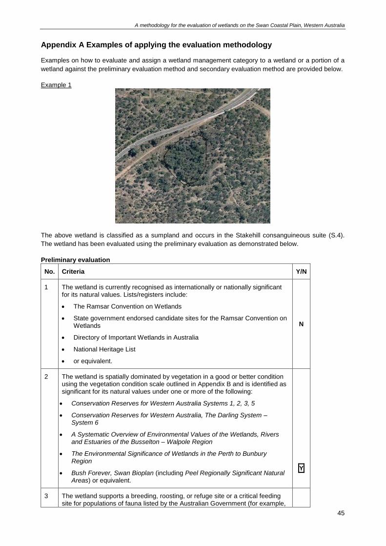
A methodology for the evaluation of wetlands on the Swan Coastal Plain, Western Australia
45
Appendix A Examples of applying the evaluation methodology Examples on how to evaluate and assign a wetland management category to a wetland or a portion of a
wetland against the preliminary evaluation method and secondary evaluation method are provided below.
Example 1
The above wetland is classified as a sumpland and occurs in the Stakehill consanguineous suite (S.4).
The wetland has been evaluated using the preliminary evaluation as demonstrated below.
Preliminary evaluation
No. Criteria Y/N
1 The wetland is currently recognised as internationally or nationally significant for its natural values. Lists/registers include:
• The Ramsar Convention on Wetlands
• State government endorsed candidate sites for the Ramsar Convention on Wetlands
• Directory of Important Wetlands in Australia
• National Heritage List
• or equivalent.
N
2 The wetland is spatially dominated by vegetation in a good or better condition using the vegetation condition scale outlined in Appendix B and is identified as significant for its natural values under one or more of the following:
• Conservation Reserves for Western Australia Systems 1, 2, 3, 5
• Conservation Reserves for Western Australia, The Darling System – System 6
• A Systematic Overview of Environmental Values of the Wetlands, Rivers and Estuaries of the Busselton – Walpole Region
• The Environmental Significance of Wetlands in the Perth to Bunbury Region
• Bush Forever, Swan Bioplan (including Peel Regionally Significant Natural Areas) or equivalent.
Y
3 The wetland supports a breeding, roosting, or refuge site or a critical feeding site for populations of fauna listed by the Australian Government (for example,
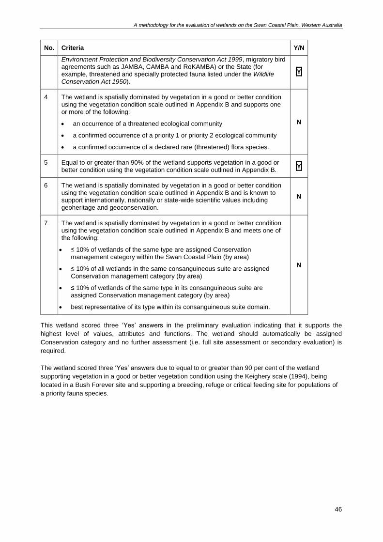
A methodology for the evaluation of wetlands on the Swan Coastal Plain, Western Australia
46
No. Criteria Y/N
Environment Protection and Biodiversity Conservation Act 1999, migratory bird agreements such as JAMBA, CAMBA and RoKAMBA) or the State (for example, threatened and specially protected fauna listed under the Wildlife Conservation Act 1950).
Y
4 The wetland is spatially dominated by vegetation in a good or better condition using the vegetation condition scale outlined in Appendix B and supports one or more of the following:
• an occurrence of a threatened ecological community
• a confirmed occurrence of a priority 1 or priority 2 ecological community
• a confirmed occurrence of a declared rare (threatened) flora species.
N
5 Equal to or greater than 90% of the wetland supports vegetation in a good or better condition using the vegetation condition scale outlined in Appendix B.
Y
6 The wetland is spatially dominated by vegetation in a good or better condition using the vegetation condition scale outlined in Appendix B and is known to support internationally, nationally or state-wide scientific values including geoheritage and geoconservation.
N
7 The wetland is spatially dominated by vegetation in a good or better condition using the vegetation condition scale outlined in Appendix B and meets one of the following:
• ≤ 10% of wetlands of the same type are assigned Conservation management category within the Swan Coastal Plain (by area)
• ≤ 10% of all wetlands in the same consanguineous suite are assigned Conservation management category (by area)
• ≤ 10% of wetlands of the same type in its consanguineous suite are assigned Conservation management category (by area)
• best representative of its type within its consanguineous suite domain.
N
This wetland scored three ‘Yes’ answers in the preliminary evaluation indicating that it supports the
highest level of values, attributes and functions. The wetland should automatically be assigned
Conservation category and no further assessment (i.e. full site assessment or secondary evaluation) is
required.
The wetland scored three ‘Yes’ answers due to equal to or greater than 90 per cent of the wetland
supporting vegetation in a good or better vegetation condition using the Keighery scale (1994), being
located in a Bush Forever site and supporting a breeding, refuge or critical feeding site for populations of
a priority fauna species.
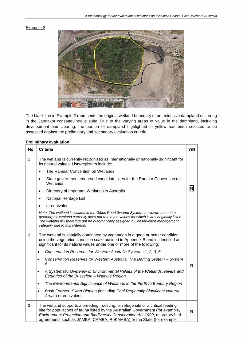
A methodology for the evaluation of wetlands on the Swan Coastal Plain, Western Australia
Example 2
The black line in Example 2 represents the original wetland boundary of an extensive dampland occurring
in the Jandakot consanguineous suite. Due to the varying areas of value in the dampland, including
development and clearing, the portion of dampland highlighted in yellow has been selected to be
assessed against the preliminary and secondary evaluation criteria.
Preliminary evaluation
No. Criteria Y/N
1 The wetland is currently recognised as internationally or nationally significant for its natural values. Lists/registers include:
• The Ramsar Convention on Wetlands
• State government endorsed candidate sites for the Ramsar Convention on Wetlands
• Directory of Important Wetlands in Australia
• National Heritage List
• or equivalent.
Note: The wetland is located in the Gibbs Road Swamp System; however, the entire geomorphic wetland currently does not retain the values for which it was originally listed. The wetland will therefore not be automatically assigned a Conservation management category due to this criterion.
N
2 The wetland is spatially dominated by vegetation in a good or better condition using the vegetation condition scale outlined in Appendix B and is identified as significant for its natural values under one or more of the following:
• Conservation Reserves for Western Australia Systems 1, 2, 3, 5
• Conservation Reserves for Western Australia, The Darling System – System 6
• A Systematic Overview of Environmental Values of the Wetlands, Rivers and Estuaries of the Busselton – Walpole Region
• The Environmental Significance of Wetlands in the Perth to Bunbury Region
• Bush Forever, Swan Bioplan (including Peel Regionally Significant Natural Areas) or equivalent.
N
3 The wetland supports a breeding, roosting, or refuge site or a critical feeding site for populations of fauna listed by the Australian Government (for example, Environment Protection and Biodiversity Conservation Act 1999, migratory bird agreements such as JAMBA, CAMBA, RoKAMBA) or the State (for example,
N
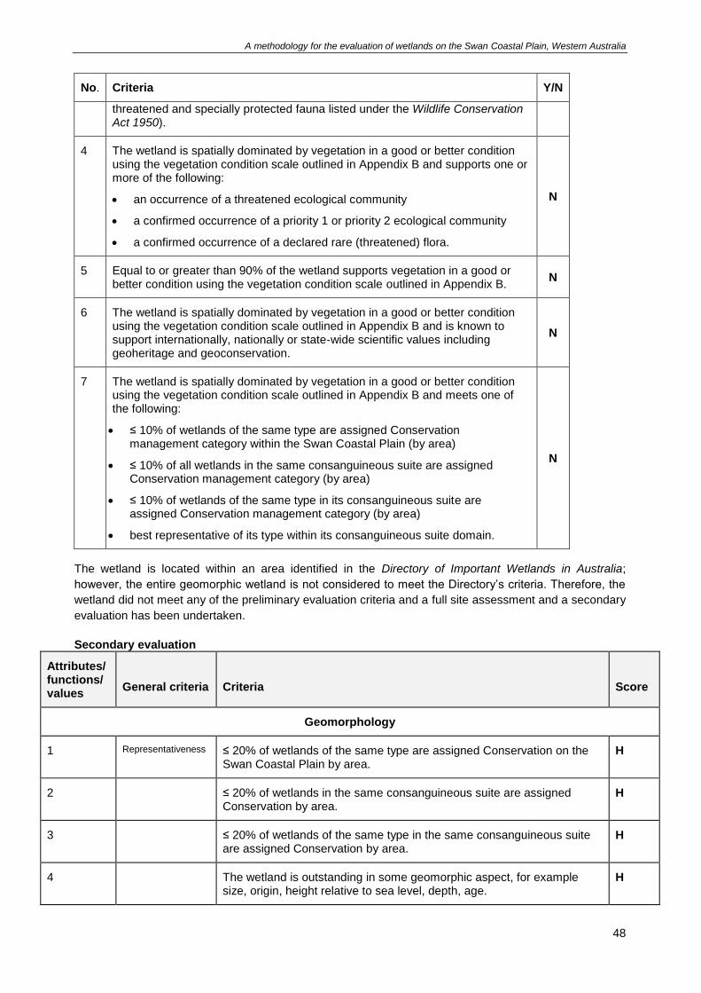
A methodology for the evaluation of wetlands on the Swan Coastal Plain, Western Australia
48
No. Criteria Y/N
threatened and specially protected fauna listed under the Wildlife Conservation Act 1950).
4 The wetland is spatially dominated by vegetation in a good or better condition using the vegetation condition scale outlined in Appendix B and supports one or more of the following:
• an occurrence of a threatened ecological community
• a confirmed occurrence of a priority 1 or priority 2 ecological community
• a confirmed occurrence of a declared rare (threatened) flora.
N
5 Equal to or greater than 90% of the wetland supports vegetation in a good or better condition using the vegetation condition scale outlined in Appendix B.
N
6 The wetland is spatially dominated by vegetation in a good or better condition using the vegetation condition scale outlined in Appendix B and is known to support internationally, nationally or state-wide scientific values including geoheritage and geoconservation.
N
7 The wetland is spatially dominated by vegetation in a good or better condition using the vegetation condition scale outlined in Appendix B and meets one of the following:
• ≤ 10% of wetlands of the same type are assigned Conservation management category within the Swan Coastal Plain (by area)
• ≤ 10% of all wetlands in the same consanguineous suite are assigned Conservation management category (by area)
• ≤ 10% of wetlands of the same type in its consanguineous suite are assigned Conservation management category (by area)
• best representative of its type within its consanguineous suite domain.
N
The wetland is located within an area identified in the Directory of Important Wetlands in Australia;
however, the entire geomorphic wetland is not considered to meet the Directory’s criteria. Therefore, the
wetland did not meet any of the preliminary evaluation criteria and a full site assessment and a secondary
evaluation has been undertaken.
Secondary evaluation
Attributes/ functions/ values
General criteria
Criteria
Score
Geomorphology
1 Representativeness ≤ 20% of wetlands of the same type are assigned Conservation on the Swan Coastal Plain by area.
H
2 ≤ 20% of wetlands in the same consanguineous suite are assigned Conservation by area.
H
3 ≤ 20% of wetlands of the same type in the same consanguineous suite are assigned Conservation by area.
H
4 The wetland is outstanding in some geomorphic aspect, for example size, origin, height relative to sea level, depth, age.
H
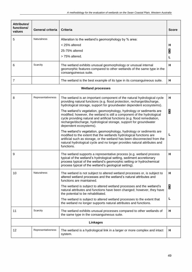
A methodology for the evaluation of wetlands on the Swan Coastal Plain, Western Australia
49
Attributes/ functions/ values
General criteria
Criteria
Score
5 Naturalness Alteration to the wetland’s geomorphology by % area:
< 25% altered
25-75% altered
> 75% altered.
H
I
L
6 Scarcity The wetland exhibits unusual geomorphology or unusual internal geomorphic features compared to other wetlands of the same type in the consanguineous suite.
H
7 The wetland is the best example of its type in its consanguineous suite. H
Wetland processes
8 Representativeness The wetland is an important component of the natural hydrological cycle providing natural functions (e.g. flood protection, recharge/discharge, hydrological storage, support for groundwater dependent ecosystems).
The wetland’s vegetation, geomorphology, hydrology or sediments are modified; however, the wetland is still a component of the hydrological cycle providing natural and artificial functions (e.g. flood remediation, recharge/discharge, hydrological storage, support for groundwater dependent ecosystems).
The wetland’s vegetation, geomorphology, hydrology or sediments are modified to the extent that the wetlands hydrological functions are artificial such as storage, or the wetland has been disconnected from the natural hydrological cycle and no longer provides natural attributes and functions.
H
I
L
9 The wetland supports a representative process (e.g. wetland process typical of the wetland’s hydrological setting, sediment accretionary process typical of the wetland’s geomorphic setting or hydrochemical process typical of the wetland’s geological setting).
H
10 Naturalness The wetland is not subject to altered wetland processes or, is subject to altered wetland processes and the wetland’s natural attributes and functions are maintained.
The wetland is subject to altered wetland processes and the wetland’s natural attributes and functions have been changed; however, they have the potential to be rehabilitated.
The wetland is subject to altered wetland processes to the extent that the wetland no longer supports natural attributes and functions.
H
I
L
11 Scarcity The wetland exhibits unusual processes compared to other wetlands of the same type in the consanguineous suite.
H
Linkages
12 Representativeness The wetland is a hydrological link in a larger or more complex and intact system.
H
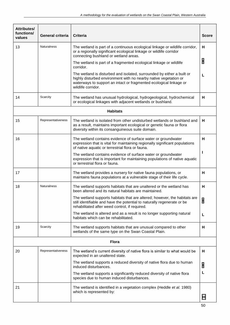
A methodology for the evaluation of wetlands on the Swan Coastal Plain, Western Australia
50
Attributes/ functions/ values
General criteria
Criteria
Score
13 Naturalness The wetland is part of a continuous ecological linkage or wildlife corridor, or a regionally significant ecological linkage or wildlife corridor connecting bushland or wetland areas.
The wetland is part of a fragmented ecological linkage or wildlife corridor.
The wetland is disturbed and isolated, surrounded by either a built or highly disturbed environment with no nearby native vegetation or waterways to support an intact or fragmented ecological linkage or wildlife corridor.
H
I
L
14 Scarcity The wetland has unusual hydrological, hydrogeological, hydrochemical or ecological linkages with adjacent wetlands or bushland.
H
Habitats
15 Representativeness The wetland is isolated from other undisturbed wetlands or bushland and as a result, maintains important ecological or genetic fauna or flora diversity within its consanguineous suite domain.
H
16 The wetland contains evidence of surface water or groundwater expression that is vital for maintaining regionally significant populations of native aquatic or terrestrial flora or fauna.
The wetland contains evidence of surface water or groundwater expression that is important for maintaining populations of native aquatic or terrestrial flora or fauna.
H
I
17 The wetland provides a nursery for native fauna populations, or maintains fauna populations at a vulnerable stage of their life cycle.
H
18 Naturalness The wetland supports habitats that are unaltered or the wetland has been altered and its natural habitats are maintained.
The wetland supports habitats that are altered; however, the habitats are still identifiable and have the potential to naturally regenerate or be rehabilitated after weed control, if required.
The wetland is altered and as a result is no longer supporting natural habitats which can be rehabilitated.
H
I
L
19 Scarcity The wetland supports habitats that are unusual compared to other wetlands of the same type on the Swan Coastal Plain.
H
Flora
20 Representativeness The wetland’s current diversity of native flora is similar to what would be expected in an unaltered state.
The wetland supports a reduced diversity of native flora due to human induced disturbances.
The wetland supports a significantly reduced diversity of native flora species due to human induced disturbances.
H
I
L
21 The wetland is identified in a vegetation complex (Heddle et al. 1980) which is represented by:
H
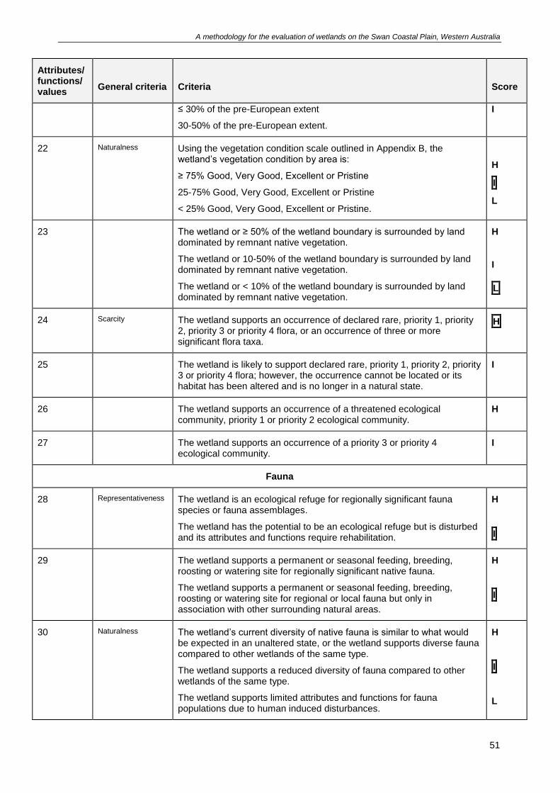
A methodology for the evaluation of wetlands on the Swan Coastal Plain, Western Australia
51
Attributes/ functions/ values
General criteria
Criteria
Score
≤ 30% of the pre-European extent
30-50% of the pre-European extent.
I
22 Naturalness Using the vegetation condition scale outlined in Appendix B, the wetland’s vegetation condition by area is:
≥ 75% Good, Very Good, Excellent or Pristine
25-75% Good, Very Good, Excellent or Pristine
< 25% Good, Very Good, Excellent or Pristine.
H
I
L
23 The wetland or ≥ 50% of the wetland boundary is surrounded by land dominated by remnant native vegetation.
The wetland or 10-50% of the wetland boundary is surrounded by land dominated by remnant native vegetation.
The wetland or < 10% of the wetland boundary is surrounded by land dominated by remnant native vegetation.
H
I
L
24 Scarcity The wetland supports an occurrence of declared rare, priority 1, priority 2, priority 3 or priority 4 flora, or an occurrence of three or more significant flora taxa.
H
25 The wetland is likely to support declared rare, priority 1, priority 2, priority 3 or priority 4 flora; however, the occurrence cannot be located or its habitat has been altered and is no longer in a natural state.
I
26 The wetland supports an occurrence of a threatened ecological community, priority 1 or priority 2 ecological community.
H
27 The wetland supports an occurrence of a priority 3 or priority 4 ecological community.
I
Fauna
28 Representativeness The wetland is an ecological refuge for regionally significant fauna species or fauna assemblages.
The wetland has the potential to be an ecological refuge but is disturbed and its attributes and functions require rehabilitation.
H
I
29 The wetland supports a permanent or seasonal feeding, breeding, roosting or watering site for regionally significant native fauna.
The wetland supports a permanent or seasonal feeding, breeding, roosting or watering site for regional or local fauna but only in association with other surrounding natural areas.
H
I
30 Naturalness The wetland’s current diversity of native fauna is similar to what would be expected in an unaltered state, or the wetland supports diverse fauna compared to other wetlands of the same type.
The wetland supports a reduced diversity of fauna compared to other wetlands of the same type.
The wetland supports limited attributes and functions for fauna populations due to human induced disturbances.
H
I
L
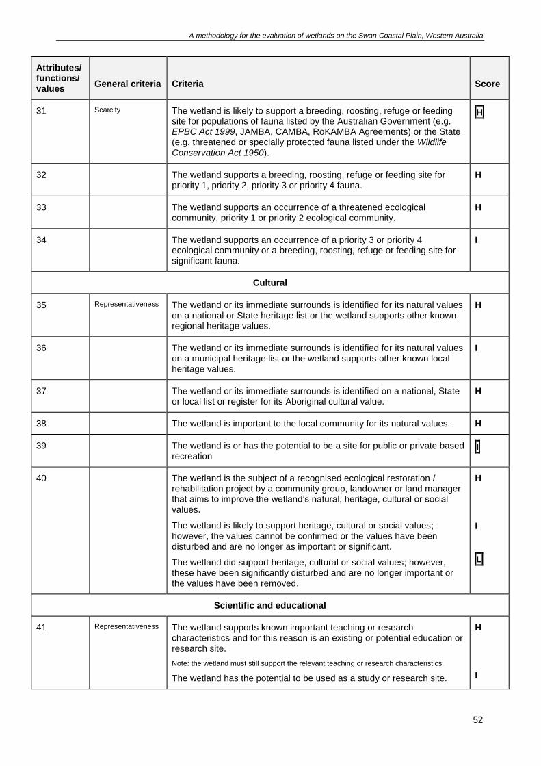
A methodology for the evaluation of wetlands on the Swan Coastal Plain, Western Australia
52
Attributes/ functions/ values
General criteria
Criteria
Score
31 Scarcity The wetland is likely to support a breeding, roosting, refuge or feeding site for populations of fauna listed by the Australian Government (e.g. EPBC Act 1999, JAMBA, CAMBA, RoKAMBA Agreements) or the State (e.g. threatened or specially protected fauna listed under the Wildlife Conservation Act 1950).
H
32 The wetland supports a breeding, roosting, refuge or feeding site for priority 1, priority 2, priority 3 or priority 4 fauna.
H
33 The wetland supports an occurrence of a threatened ecological community, priority 1 or priority 2 ecological community.
H
34 The wetland supports an occurrence of a priority 3 or priority 4 ecological community or a breeding, roosting, refuge or feeding site for significant fauna.
I
Cultural
35 Representativeness The wetland or its immediate surrounds is identified for its natural values on a national or State heritage list or the wetland supports other known regional heritage values.
H
36 The wetland or its immediate surrounds is identified for its natural values on a municipal heritage list or the wetland supports other known local heritage values.
I
37 The wetland or its immediate surrounds is identified on a national, State or local list or register for its Aboriginal cultural value.
H
38 The wetland is important to the local community for its natural values. H
39 The wetland is or has the potential to be a site for public or private based recreation
I
40 The wetland is the subject of a recognised ecological restoration / rehabilitation project by a community group, landowner or land manager that aims to improve the wetland’s natural, heritage, cultural or social values.
The wetland is likely to support heritage, cultural or social values; however, the values cannot be confirmed or the values have been disturbed and are no longer as important or significant.
The wetland did support heritage, cultural or social values; however, these have been significantly disturbed and are no longer important or the values have been removed.
H
I
L
Scientific and educational
41 Representativeness The wetland supports known important teaching or research characteristics and for this reason is an existing or potential education or research site.
Note: the wetland must still support the relevant teaching or research characteristics.
The wetland has the potential to be used as a study or research site.
H
I
A methodology for the evaluation of wetlands on the Swan Coastal Plain, Western Australia
53
Attributes/ functions/ values
General criteria
Criteria
Score
42 The wetland supports known scientific, geoheritage or geoconservation values.
H
Tally of the scores recorded during the secondary evaluation.
Attributes/functions/values Scores
High Intermediate Low
Geomorphology I
Wetland processes II
Linkages I
Habitats I
Flora II II I
Fauna I III
Cultural I I
Scientific and educational
Total score 3 11 2
Defining attributes/functions/values Flora and fauna
Applicable management category Resource Enhancement
Results from the secondary evaluation indicate that the wetland recorded the most intermediate scores
and therefore supports an intermediate level of attributes, functions and values. Accordingly, the wetland
should be assigned a Resource Enhancement management category - Flora.
The intermediate scores were dominant in the fauna attribute/function/value. Fauna combined with flora,
which received two high scores, are the recommended attributes/functions/values to focus on maintaining
through management practices.
Example 3
All of the land in the above example is classified as a palusplain and is identified in the Keysbrook
consanguineous suite. To evaluate this palusplain it has been divided into two portions to reflect the
varying areas of value, including the presence of remnant vegetation. The wetland portions have been
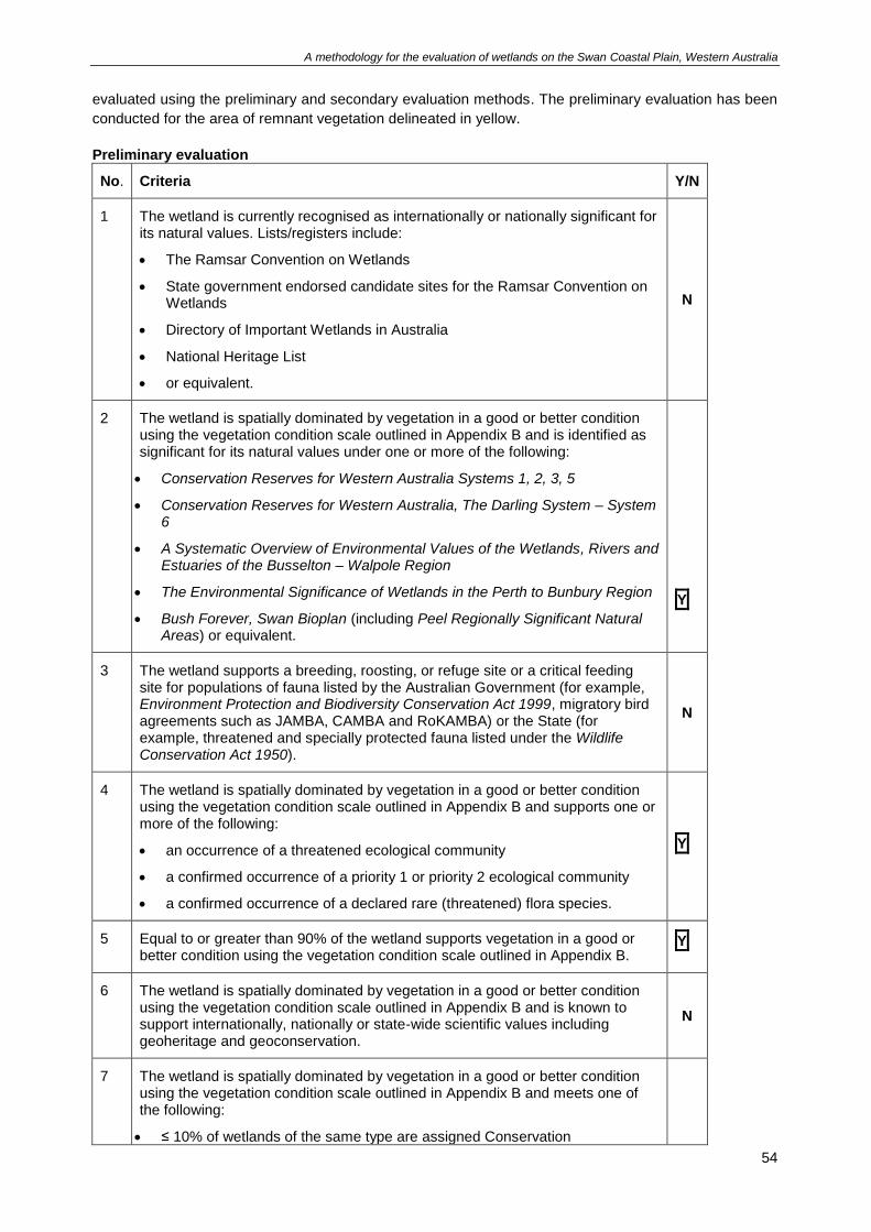
A methodology for the evaluation of wetlands on the Swan Coastal Plain, Western Australia
54
evaluated using the preliminary and secondary evaluation methods. The preliminary evaluation has been
conducted for the area of remnant vegetation delineated in yellow.
Preliminary evaluation
No. Criteria Y/N
1 The wetland is currently recognised as internationally or nationally significant for its natural values. Lists/registers include:
• The Ramsar Convention on Wetlands
• State government endorsed candidate sites for the Ramsar Convention on Wetlands
• Directory of Important Wetlands in Australia
• National Heritage List
• or equivalent.
N
2 The wetland is spatially dominated by vegetation in a good or better condition using the vegetation condition scale outlined in Appendix B and is identified as significant for its natural values under one or more of the following:
• Conservation Reserves for Western Australia Systems 1, 2, 3, 5
• Conservation Reserves for Western Australia, The Darling System – System 6
• A Systematic Overview of Environmental Values of the Wetlands, Rivers and Estuaries of the Busselton – Walpole Region
• The Environmental Significance of Wetlands in the Perth to Bunbury Region
• Bush Forever, Swan Bioplan (including Peel Regionally Significant Natural Areas) or equivalent.
Y
3 The wetland supports a breeding, roosting, or refuge site or a critical feeding site for populations of fauna listed by the Australian Government (for example, Environment Protection and Biodiversity Conservation Act 1999, migratory bird agreements such as JAMBA, CAMBA and RoKAMBA) or the State (for example, threatened and specially protected fauna listed under the Wildlife Conservation Act 1950).
N
4 The wetland is spatially dominated by vegetation in a good or better condition using the vegetation condition scale outlined in Appendix B and supports one or more of the following:
• an occurrence of a threatened ecological community
• a confirmed occurrence of a priority 1 or priority 2 ecological community
• a confirmed occurrence of a declared rare (threatened) flora species.
Y
5 Equal to or greater than 90% of the wetland supports vegetation in a good or better condition using the vegetation condition scale outlined in Appendix B.
Y
6 The wetland is spatially dominated by vegetation in a good or better condition using the vegetation condition scale outlined in Appendix B and is known to support internationally, nationally or state-wide scientific values including geoheritage and geoconservation.
N
7 The wetland is spatially dominated by vegetation in a good or better condition using the vegetation condition scale outlined in Appendix B and meets one of the following:
• ≤ 10% of wetlands of the same type are assigned Conservation
A methodology for the evaluation of wetlands on the Swan Coastal Plain, Western Australia
55
No. Criteria Y/N
management category within the Swan Coastal Plain (by area)
• ≤ 10% of all wetlands in the same consanguineous suite are assigned Conservation management category (by area)
• ≤ 10% of wetlands of the same type in its consanguineous suite are assigned Conservation management category (by area)
• best representative of its type within its consanguineous suite domain.
Y
Y
Y
N
The remnant vegetated portion of the wetland scored six ‘Yes’ answers. The remnant vegetated portion of
the wetland, which is delineated in yellow, supports a high level of attributes, functions and values and
should automatically be assigned a Conservation management category.
The remaining cleared area of wetland has also been evaluated using the preliminary evaluation method,
as follows.
Preliminary evaluation
No. Criteria Y/N
1 The wetland is currently recognised as internationally or nationally significant for its natural values. Lists/registers include:
• The Ramsar Convention on Wetlands
• State government endorsed candidate sites for the Ramsar Convention on Wetlands
• Directory of Important Wetlands in Australia
• National Heritage List
• or equivalent.
N
2 The wetland is spatially dominated by vegetation in a good or better condition using the vegetation condition scale outlined in Appendix B and is identified as significant for its natural values under one or more of the following:
• Conservation Reserves for Western Australia Systems 1, 2, 3, 5
• Conservation Reserves for Western Australia, The Darling System – System 6
• A Systematic Overview of Environmental Values of the Wetlands, Rivers and Estuaries of the Busselton – Walpole Region
• The Environmental Significance of Wetlands in the Perth to Bunbury Region
• Bush Forever, Swan Bioplan (including Peel Regionally Significant Natural Areas) or equivalent.
N
3 The wetland supports a breeding, roosting, or refuge site or a critical feeding site for populations of fauna listed by the Australian Government (for example, Environment Protection and Biodiversity Conservation Act 1999, migratory bird agreements such as JAMBA, CAMBA and RoKAMBA) or the State (for example, threatened and specially protected fauna listed under the Wildlife Conservation Act 1950).
N
4 The wetland is spatially dominated by vegetation in a good or better condition using the vegetation condition scale outlined in Appendix B and supports one or more of the following:
N
A methodology for the evaluation of wetlands on the Swan Coastal Plain, Western Australia
56
No. Criteria Y/N
• an occurrence of a threatened ecological community
• a confirmed occurrence of a priority 1 or priority 2 ecological community
• a confirmed occurrence of a declared rare (threatened) flora species.
5 Equal to or greater than 90% of the wetland supports vegetation in a good or better condition using the vegetation condition scale outlined in Appendix B.
N
6 The wetland is spatially dominated by vegetation in a good or better condition using the vegetation condition scale outlined in Appendix B and is known to support internationally, nationally or state-wide scientific values including geoheritage and geoconservation.
N
7 The wetland is spatially dominated by vegetation in a good or better condition using the vegetation condition scale outlined in Appendix B and meets one of the following:
• ≤ 10% of wetlands of the same type are assigned Conservation management category within the Swan Coastal Plain (by area)
• ≤ 10% of all wetlands in the same consanguineous suite are assigned Conservation management category (by area)
• ≤ 10% of wetlands of the same type in its consanguineous suite are assigned Conservation management category (by area)
• best representative of its type within its consanguineous suite domain.
N
The cleared portion of the palusplain scored all ‘No’ answers and therefore a secondary evaluation was
undertaken.
Secondary evaluation
Attributes/ functions/
values General criteria Criteria Score
Geomorphology
1 Representativeness ≤ 20% of wetlands of the same type are assigned Conservation on the Swan Coastal Plain by area.
H
2 ≤ 20% of wetlands in the same consanguineous suite are assigned Conservation by area.
H
3 ≤ 20% of wetlands of the same type in the same consanguineous suite are assigned Conservation by area.
H
4 The wetland is outstanding in some geomorphic aspect, for example size, origin, height relative to sea level, depth, age.
H
5 Naturalness Alteration to the wetland’s geomorphology by % area:
< 25% altered
25-75% altered
> 75% altered.
H
I
L
6 Scarcity The wetland exhibits unusual geomorphology or unusual internal geomorphic features compared to other wetlands of the same type in the
H
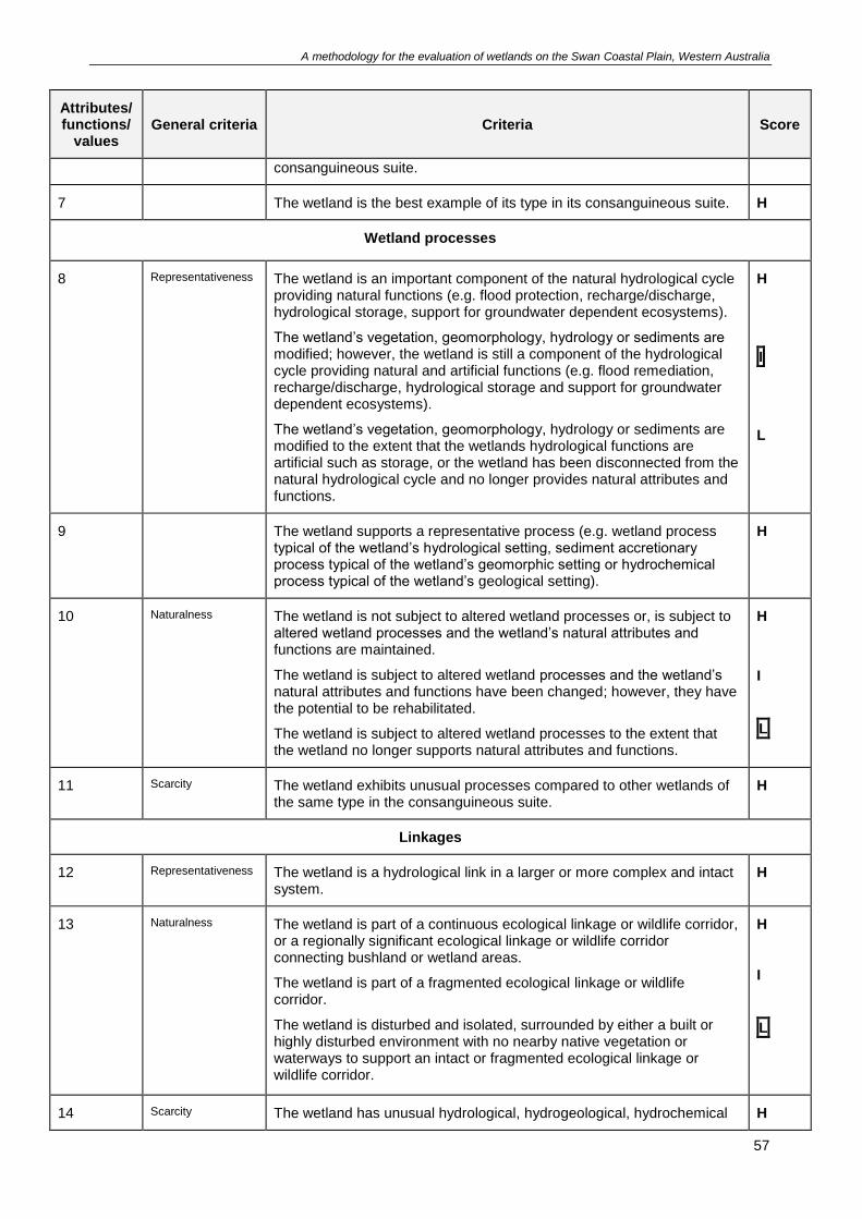
A methodology for the evaluation of wetlands on the Swan Coastal Plain, Western Australia
57
Attributes/ functions/
values General criteria Criteria Score
consanguineous suite.
7 The wetland is the best example of its type in its consanguineous suite. H
Wetland processes
8 Representativeness The wetland is an important component of the natural hydrological cycle providing natural functions (e.g. flood protection, recharge/discharge, hydrological storage, support for groundwater dependent ecosystems).
The wetland’s vegetation, geomorphology, hydrology or sediments are modified; however, the wetland is still a component of the hydrological cycle providing natural and artificial functions (e.g. flood remediation, recharge/discharge, hydrological storage and support for groundwater dependent ecosystems).
The wetland’s vegetation, geomorphology, hydrology or sediments are modified to the extent that the wetlands hydrological functions are artificial such as storage, or the wetland has been disconnected from the natural hydrological cycle and no longer provides natural attributes and functions.
H
I
L
9 The wetland supports a representative process (e.g. wetland process typical of the wetland’s hydrological setting, sediment accretionary process typical of the wetland’s geomorphic setting or hydrochemical process typical of the wetland’s geological setting).
H
10 Naturalness The wetland is not subject to altered wetland processes or, is subject to altered wetland processes and the wetland’s natural attributes and functions are maintained.
The wetland is subject to altered wetland processes and the wetland’s natural attributes and functions have been changed; however, they have the potential to be rehabilitated.
The wetland is subject to altered wetland processes to the extent that the wetland no longer supports natural attributes and functions.
H
I
L
11 Scarcity The wetland exhibits unusual processes compared to other wetlands of the same type in the consanguineous suite.
H
Linkages
12 Representativeness The wetland is a hydrological link in a larger or more complex and intact system.
H
13 Naturalness The wetland is part of a continuous ecological linkage or wildlife corridor, or a regionally significant ecological linkage or wildlife corridor connecting bushland or wetland areas.
The wetland is part of a fragmented ecological linkage or wildlife corridor.
The wetland is disturbed and isolated, surrounded by either a built or highly disturbed environment with no nearby native vegetation or waterways to support an intact or fragmented ecological linkage or wildlife corridor.
H
I
L
14 Scarcity The wetland has unusual hydrological, hydrogeological, hydrochemical H
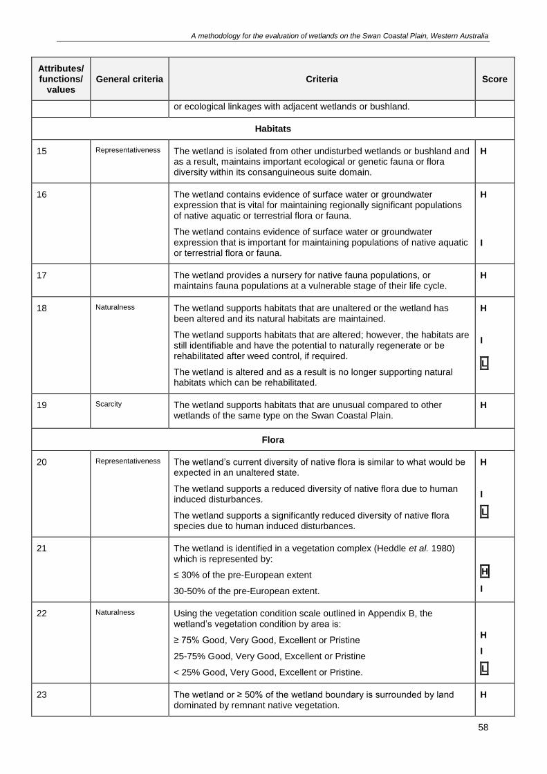
A methodology for the evaluation of wetlands on the Swan Coastal Plain, Western Australia
58
Attributes/ functions/
values General criteria Criteria Score
or ecological linkages with adjacent wetlands or bushland.
Habitats
15 Representativeness The wetland is isolated from other undisturbed wetlands or bushland and as a result, maintains important ecological or genetic fauna or flora diversity within its consanguineous suite domain.
H
16 The wetland contains evidence of surface water or groundwater expression that is vital for maintaining regionally significant populations of native aquatic or terrestrial flora or fauna.
The wetland contains evidence of surface water or groundwater expression that is important for maintaining populations of native aquatic or terrestrial flora or fauna.
H
I
17 The wetland provides a nursery for native fauna populations, or maintains fauna populations at a vulnerable stage of their life cycle.
H
18 Naturalness The wetland supports habitats that are unaltered or the wetland has been altered and its natural habitats are maintained.
The wetland supports habitats that are altered; however, the habitats are still identifiable and have the potential to naturally regenerate or be rehabilitated after weed control, if required.
The wetland is altered and as a result is no longer supporting natural habitats which can be rehabilitated.
H
I
L
19 Scarcity The wetland supports habitats that are unusual compared to other wetlands of the same type on the Swan Coastal Plain.
H
Flora
20 Representativeness The wetland’s current diversity of native flora is similar to what would be expected in an unaltered state.
The wetland supports a reduced diversity of native flora due to human induced disturbances.
The wetland supports a significantly reduced diversity of native flora species due to human induced disturbances.
H
I
L
21 The wetland is identified in a vegetation complex (Heddle et al. 1980) which is represented by:
≤ 30% of the pre-European extent
30-50% of the pre-European extent.
H
I
22 Naturalness Using the vegetation condition scale outlined in Appendix B, the wetland’s vegetation condition by area is:
≥ 75% Good, Very Good, Excellent or Pristine
25-75% Good, Very Good, Excellent or Pristine
< 25% Good, Very Good, Excellent or Pristine.
H
I
L
23 The wetland or ≥ 50% of the wetland boundary is surrounded by land dominated by remnant native vegetation.
H
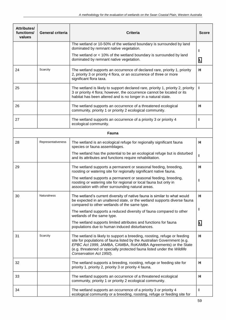
A methodology for the evaluation of wetlands on the Swan Coastal Plain, Western Australia
59
Attributes/ functions/
values General criteria Criteria Score
The wetland or 10-50% of the wetland boundary is surrounded by land dominated by remnant native vegetation.
The wetland or < 10% of the wetland boundary is surrounded by land dominated by remnant native vegetation.
I
L
24 Scarcity The wetland supports an occurrence of declared rare, priority 1, priority 2, priority 3 or priority 4 flora, or an occurrence of three or more significant flora taxa.
H
25 The wetland is likely to support declared rare, priority 1, priority 2, priority 3 or priority 4 flora; however, the occurrence cannot be located or its habitat has been altered and is no longer in a natural state.
I
26 The wetland supports an occurrence of a threatened ecological community, priority 1 or priority 2 ecological community.
H
27 The wetland supports an occurrence of a priority 3 or priority 4 ecological community.
I
Fauna
28 Representativeness The wetland is an ecological refuge for regionally significant fauna species or fauna assemblages.
The wetland has the potential to be an ecological refuge but is disturbed and its attributes and functions require rehabilitation.
H
I
29 The wetland supports a permanent or seasonal feeding, breeding, roosting or watering site for regionally significant native fauna.
The wetland supports a permanent or seasonal feeding, breeding, roosting or watering site for regional or local fauna but only in association with other surrounding natural areas.
H
I
30 Naturalness The wetland’s current diversity of native fauna is similar to what would be expected in an unaltered state, or the wetland supports diverse fauna compared to other wetlands of the same type.
The wetland supports a reduced diversity of fauna compared to other wetlands of the same type.
The wetland supports limited attributes and functions for fauna populations due to human induced disturbances.
H
I
L
31 Scarcity The wetland is likely to support a breeding, roosting, refuge or feeding site for populations of fauna listed by the Australian Government (e.g. EPBC Act 1999, JAMBA, CAMBA, RoKAMBA Agreements) or the State (e.g. threatened or specially protected fauna listed under the Wildlife Conservation Act 1950).
H
32 The wetland supports a breeding, roosting, refuge or feeding site for priority 1, priority 2, priority 3 or priority 4 fauna.
H
33 The wetland supports an occurrence of a threatened ecological community, priority 1 or priority 2 ecological community.
H
34 The wetland supports an occurrence of a priority 3 or priority 4 ecological community or a breeding, roosting, refuge or feeding site for
I

A methodology for the evaluation of wetlands on the Swan Coastal Plain, Western Australia
60
Attributes/ functions/
values General criteria Criteria Score
significant fauna.
Cultural
35 Representativeness The wetland or its immediate surrounds is identified for its natural values on a national or State heritage list or the wetland supports other known regional heritage values.
H
36 The wetland or its immediate surrounds is identified for its natural values on a municipal heritage list or the wetland supports other known local heritage values.
I
37 The wetland or its immediate surrounds is identified on a national, State or local list or register for its Aboriginal cultural value.
H
38 The wetland is important to the local community for its natural values. H
39 The wetland is or has the potential to be a site for public or private based recreation.
I
40 The wetland is the subject of a recognised ecological restoration / rehabilitation project by a community group, landowner or land manager that aims to improve the wetland’s natural, heritage, cultural or social values.
The wetland is likely to support heritage, cultural or social values; however, the values cannot be confirmed or the values have been disturbed and are no longer as important or significant.
The wetland did support heritage, cultural or social values; however, these have been significantly disturbed and are no longer important or the values have been removed.
H
I
L
Scientific and educational
41 Representativeness The wetland supports known important teaching or research characteristics and for this reason is an existing or potential education or research site.
Note: the wetland must still support the relevant teaching or research characteristics.
The wetland has the potential to be used as a study or research site.
H
I
42 The wetland supports known scientific, geoheritage or geoconservation values.
H
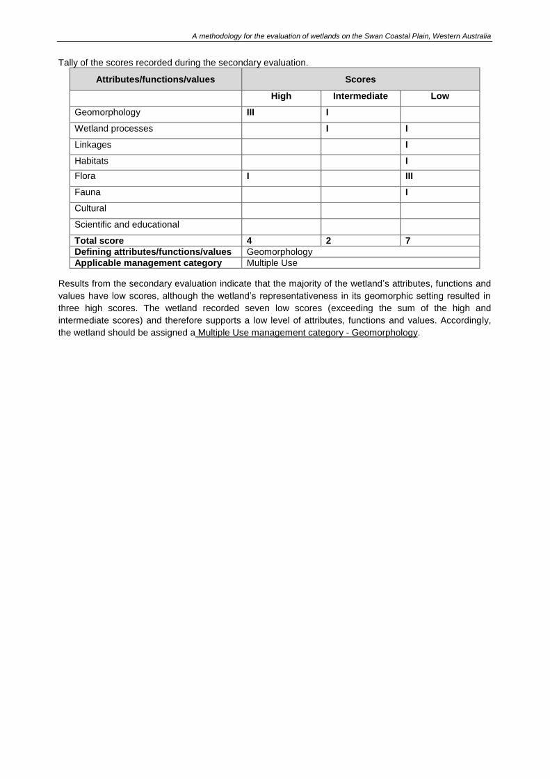
A methodology for the evaluation of wetlands on the Swan Coastal Plain, Western Australia
Tally of the scores recorded during the secondary evaluation.
Attributes/functions/values Scores
High Intermediate Low
Geomorphology III I
Wetland processes I I
Linkages I
Habitats I
Flora I III
Fauna I
Cultural
Scientific and educational
Total score 4 2 7
Defining attributes/functions/values Geomorphology
Applicable management category Multiple Use
Results from the secondary evaluation indicate that the majority of the wetland’s attributes, functions and
values have low scores, although the wetland’s representativeness in its geomorphic setting resulted in
three high scores. The wetland recorded seven low scores (exceeding the sum of the high and
intermediate scores) and therefore supports a low level of attributes, functions and values. Accordingly,
the wetland should be assigned a Multiple Use management category - Geomorphology.

A methodology for the evaluation of wetlands on the Swan Coastal Plain, Western Australia
62
Appendix B Wetland information sources Data collection and wetland information resources are necessary for an accurate evaluation of a wetland.
Information should be obtained from a variety of sources including literature reviews (e.g. reports, journal
articles, databases and maps), aerial photography and site visits. Consultation with landowners or
community members is also useful for obtaining information on the wetland.
New information may become available (e.g. national or state environmental registers, agreements or
studies) and should be consulted. Potential information sources for the wetland attributes, functions and
values assessed in this evaluation methodology are outlined below.
Wetland mapping
➢ Wetland mapping information including current locations, boundaries, classifications, management
categories and unique feature identifier numbers (UFI’s) are available on the GWSCP dataset, which
is available for viewing and downloading via Locate and data.wa.gov.au. The WA government data
portal also includes other relevant biological, physical and planning datasets that may assist in
completing a wetland evaluation.
➢ Original wetland mapping and systems of assessment for the Swan Coastal Plain can be obtained
from the following sources:
Wetlands of the Swan Coastal Plain Volume 2A: Wetland Mapping Classification and
Evaluation, Main Report (Hill et al. 1996a) and Wetlands of the Swan Coastal Plain Volume 2B
Wetland Mapping, Classification and Evaluation – Wetland Atlas (Hill et al. 1996b) available
from DBCA’s library DBCA Library.
Evaluation of Wetlands on the Southern Swan Coastal Plain (V & C Semeniuk Research Group
1998) available from DBCA’s library.
A Guide to Wetland Management in the Perth and Near Perth Swan Coastal Plain Area Bulletin
686 (Environmental Protection Authority 1993) available from www.epa.wa.gov.au.
International, national and regional significance
➢ Ramsar Convention: Wetlands identified in the Convention on Wetlands of International Importance
(UNESCO 1971) are of international significance. Information on Ramsar wetlands can be obtained
from www.ramsar.org.
Alternatively, the Department of the Environment and Energy website: www.environment.gov.au >
Databases and maps > Australian Wetlands Database, and DBCA’s website also contains
information on the Ramsar Convention www.dpaw.wa.gov.au/management/wetlands.
The WA government data portal includes Ramsar wetland mapping data.wa.gov.au.
➢ Directory of Important Wetlands in Australia: The Directory identifies and recognises Australia’s
nationally important wetlands. Information on the Directory as well as mapping displayed in the
electronic Australian Wetlands Database is available on the Department of the Environment and
Energy website www.environment.gov.au > Databases and maps > Australian Wetlands Database.
DBCA’s website also contains information on the Directory
www.dpaw.wa.gov.au/management/wetlands.
➢ Bush Forever outlines regionally significant areas of bushland and wetland. Volume 2 contains
information on flora, fauna, geomorphology and consanguineous suites for the Perth Metropolitan
Region. Volume 1 Policies, Principles and Processes (Government of Western Australia 2000a) and
Volume 2 Directory of Bush Forever Sites (Government of Western Australia 2000b) are available
from www.planning.wa.gov.au. Bush Forever mapping is also available on the WA government data
portal data.wa.gov.au.
A methodology for the evaluation of wetlands on the Swan Coastal Plain, Western Australia
63
Swan Bioplan identifies and describes regionally significant areas for the Swan Coastal Plain outside
of the Bush Forever study site. Environmental Protection Bulletin 12 - Swan Bioplan – Peel
Regionally Significant Natural Areas is available from http://www.epa.wa.gov.au.
➢ Conservation Reserves for Western Australia Systems 1, 2, 3, 5 (Department of Conservation and
Environment 1976) is available from DBCA’s library.
➢ Conservation Reserves for Western Australia, The Darling System – System 6 (Department of
Conservation and Environment 1983) is available from DBCA’s library.
➢ A Systematic Overview of Environmental Values of the Wetlands, Rivers and Estuaries of the
Busselton – Walpole Region (Pen 1997) is available from DBCA’s library.
➢ Environmental Significance of Wetlands in the Perth to Bunbury Region (Le Provost et al. 1987) is
available from DBCA’s library.
Geological information
➢ Atlas of Australian Soils for Western Australia is available from Department of Primary Industries and
Regional Development www.dpird.wa.gov.au.
➢ Information on geology, geoheritage and topography is available from the WA government data
portal data.wa.gov.au.
There is currently no system for formal recognition of geoheritage. The Geological Society of
Australia has identified approximately 150 significant geological sites in WA. Refer to the Geological
Society of Australia for up to date information on geoheritage sites in WA www.gsa.org.au.
➢ Reference article: Geoheritage and geoconservation – history, definition, scope and scale (Brocx
and Semeniuk 2007).
➢ Information on consanguineous suites is available on DBCA’s website
www.dpaw.wa.gov.au/management/wetlands. In addition consanguineous suite information can be
obtained from Hill et al. (1996a) and Bush Forever (Government of Western Australia). The
Consanguineous suite dataset (Department of Environment and Conservation 2006) is available to
view and download via the WA government data portal data.wa.gov.au.
Wetland processes
➢ Wetland processes can include any physical, hydrological, ecological or chemical processes
occurring in a wetland. Examples of processes which can occur in a wetland on the Swan Coastal
Plain include:
physical: weathering, erosion, sedimentation.
hydrological: recharge and discharge mechanisms, hydroperiod, upwelling, reserve flow at the
margin or between seasons.
ecological: food webs, nutrient cycling (e.g. O, N, P, K).
chemical: factors affecting water quality, water chemistry, salinity, acidity.
Waterways and hydrology
➢ Hydrological catchments and watercourse mapping is available on the WA government data portal
data.wa.gov.au.
➢ Information on groundwater and surface water can be obtained from the DWER’s Perth Groundwater
Atlas and Hydrogeological Atlas available from www.dwer.wa.gov.au.
A methodology for the evaluation of wetlands on the Swan Coastal Plain, Western Australia
64
➢ Reference material available at www.dwer.wa.gov.au (publications search):
Stormwater Management Manual for Western Australia (Department of Water 2004-2007)
Decision Process for Stormwater Management in WA: draft for consultation (Department of
Water 2016)
Identifying and establishing waterways foreshore areas (Department of Water 2012)
Determining foreshore reserves (Water and Rivers Commission 2001).
Linkages
➢ Information on ecological linkages and wildlife corridors for the Perth Metropolitan Region is
available in Bush Forever (Government of Western Australia 2000b) and Conservation Reserves for
Western Australia, The Darling System – System 6 (Department of Conservation and Environment
1983).
➢ The technical report South West Regional Ecological Linkages is produced by the Western
Australian Local Government Association available at www.walga.asn.au.
➢ Environmental Protection Authority (2003b) Bulletin 1108 Greater Bunbury Region Scheme available
from www.epa.wa.gov.au contains information on ecological linkages and wildlife corridors for the
Bunbury region.
➢ The electronic dataset Regional Ecological Linkages for the Perth Metropolitan Region is available
from the Western Australian Local Government Association www.walga.asn.au.
Flora
➢ Information on declared rare, priority and other significant flora and threatened and priority ecological
communities on the Swan Coastal Plain can be obtained from DBCA’s website
www.dbca.wa.gov.au.
➢ Guidance on undertaking flora surveys is available at www.epa.wa.gov.au:
Technical Guide – Flora and Vegetation Surveys for Environmental Impact Assessment
Guidance Statement No. 6 Rehabilitation of Terrestrial Ecosystems.
➢ Bush Forever (Government of Western Australia 2000b) includes specific information on flora and
vegetation communities for Bush Forever sites. The vegetation condition scale (Keighery 1994),
outlined below is also explained in Bush Forever (Government of Western Australia 2000b).
Vegetation condition scale (Keighery 1994)
Pristine Pristine or nearly so, no obvious signs of disturbance.
Excellent Vegetation structure intact, disturbance affecting individual species and
weeds are non-aggressive species.
Very Good Vegetation structure altered, obvious signs of disturbance. For example,
disturbance to vegetation structure caused by repeated fires, the presence
of some more aggressive weeds, dieback, logging and grazing
Good Vegetation structure significantly altered by very obvious signs of multiple
disturbances. Retains basic vegetation structure or ability to regenerate it.
For example, disturbance to vegetation structure caused by very frequent
fires, the presence of some very aggressive weeds at high density, partial
clearing, dieback and grazing.
Degraded Basic vegetation structure severely impacted by disturbance. Scope for
regeneration but not to a state approaching good condition without intensive
management. For example, disturbance to vegetation structure caused by
very frequent fires, the presence of very aggressive weeds, partial clearing,
dieback and grazing.

A methodology for the evaluation of wetlands on the Swan Coastal Plain, Western Australia
65
Completely
Degraded
The structure of the vegetation is no longer intact and the area is completely
or almost completely without native species. These areas are often
described as ‘parkland cleared’ with the flora comprising weed or crop
species with isolated native trees or shrubs.
➢ Information on native vegetation complexes and the pre-European vegetation extent is available
from the WA government data portal or the Local Biodiversity Program http://pbp.walga.asn.au.
➢ Reference material
A Floristic Survey of the Southern Swan Coastal Plain (Gibson et al. 1994).
Remnant vegetation on the Alluvial Soils of the Eastern Side of the Swan Coastal Plain
(Keighery and Trudgen 1992).
Local Government Biodiversity Planning Guidelines for the Perth Metropolitan Region (Western
Australian Local Government Association and Perth Biodiversity Project 2004).
Vegetation of the Darling System in Atlas of Natural Resources, Darling System, Western
Australia. (Heddle et al. 1980).
➢ Libraries
Specific area reports outlining the flora and vegetation of a particular site may also be found in
libraries including DBCA’s library. In addition, public libraries may have online catalogues listing
available reports or articles.
Fauna
➢ Information on threatened or specially protected and priority fauna, threatened and priority ecological
communities and migratory birds can be obtained from DBCA’s website www.dbca.wa.gov.au.
➢ Guidance on fauna surveys is available at www.epa.wa.gov.au:
Environmental Protection Authority (2010b), Technical Guide – Terrestrial Vertebrate Fauna Surveys
for Environmental Impact Assessment, Environmental Protection Authority, Perth.
➢ Information on fauna including migratory bird agreements is available on the Department of the
Environment and Energy website www.environment.gov.au.
➢ Migratory bird agreements
JAMBA: Agreement between the Australian Government and the Government of Japan for the
Protection of Migratory Birds in Danger of Extinction and their Environment (Commonwealth of
Australia 1995b) available at: www.austlii.edu.au/au/other/dfat/treaties/1981/6.html.
CAMBA: Agreement between the Australian Government and the Government of the People's
Republic of China for the Protection of Migratory Birds and their Environment (Commonwealth of
Australia 1995a) available at: www.austlii.edu.au/au/other/dfat/treaties/1988/22.html.
ROKAMBA: Agreement between the Australian Government and the Government of the Republic of
Korea on the Protection of Migratory Birds Canberra (Commonwealth of Australia 2007) available at:
www.austlii.edu.au/au/other/dfat/treaties/2007/24.html.
➢ Libraries
Specific area reports outlining the fauna of a particular site may also be found in libraries including
DBCA’s library. In addition, public libraries may have online catalogues listing available reports or
articles.
Cultural
➢ Information on Aboriginal cultural values can be obtained from the Department of Planning, Lands
and Heritage Aboriginal Heritage Inquiry System website www.dplh.wa.gov.au.
A methodology for the evaluation of wetlands on the Swan Coastal Plain, Western Australia
66
➢ Australian heritage places inventory lists heritage sites in the Commonwealth Heritage List, National
Heritage List, Register of the National Estate, WA Heritage Register and World Heritage List.
Available from www.dplh.wa.gov.au.
➢ A Municipal Inventory is a list of local cultural heritage significance in the local government. Local
governments are required under Section 45 of the Heritage of Western Australia Act 1990 to prepare
such lists and may be obtained from the relevant local government authority. The local government
authority may know of community groups that use or manage the wetland for social purposes.
➢ Reference material
Report on an Investigation into Aboriginal Significance of Wetlands and Rivers in the Perth-
Bunbury Region (O’Connor et al. 1989). Available from DBCA’s library.
An Investigation into the Aboriginal Significance of Wetlands and Rivers in the Busselton-
Walpole Region (O’Connor et al. 1995). Available from DBCA’s library.
Sense of Place: A Response to an Environment, the Swan Coastal Plain Western Australia
(Seddon 1972).
Swamp: Walking the wetlands of the Swan Coastal Plain (Chinna 2014).
➢ The WA government data portal data.wa.gov.au also contains a number of datasets to obtain
mapping for the above information.
Science and Education
➢ Nearby educational institutions may have information about wetland use for teaching or research
purposes. Educational signage and interpretative material may provide useful information.
➢ Reference material
Report on an Investigation into Scientific and Educational Values of Wetlands and Rivers in the
Perth-Bunbury Region (Coffey 1990). Available from DBCA’s library.
A methodology for the evaluation of wetlands on the Swan Coastal Plain, Western Australia
67
Appendix C Wetland evaluation desktop and site assessment form The Wetland evaluation desktop and site assessment form has been designed to simplify the collection and processing of information required to complete a wetland evaluation on the Swan Coastal Plain. The form includes a general information section and two questionnaires:
1) Preliminary desktop and site assessment questions: complete prior to commencement of the preliminary evaluation.
2) Full site assessment questions: complete if the preliminary evaluation indicates that a secondary
evaluation is required. The full site assessment questions should be completed before commencing the secondary evaluation. It is important that the information provided justifies the scoring of the selected evaluation criteria.
Information sources to assist in the collection of wetland data are outlined in Appendices B and D.
GENERAL INFORMATION Assessor details Name/s: Date/s of site visit: Agency/Company: Contact number: Email address: Weather during site visit: Land ownership and contact details Landowner: Land manager (if different to owner): Consultant (if applicable): Contact for site visit: Landowner permission received for site access: yes / no Landowner consent to a mapping review has been provided: email / letter
Property details Location (e.g. lot, street, suburb): Latitude and longitude/MGA: Wetland details Name: Unique feature identifier number/s: Hill et al. (1996) map sheet number and wetland identification number/s (WIN): Consanguineous suite:
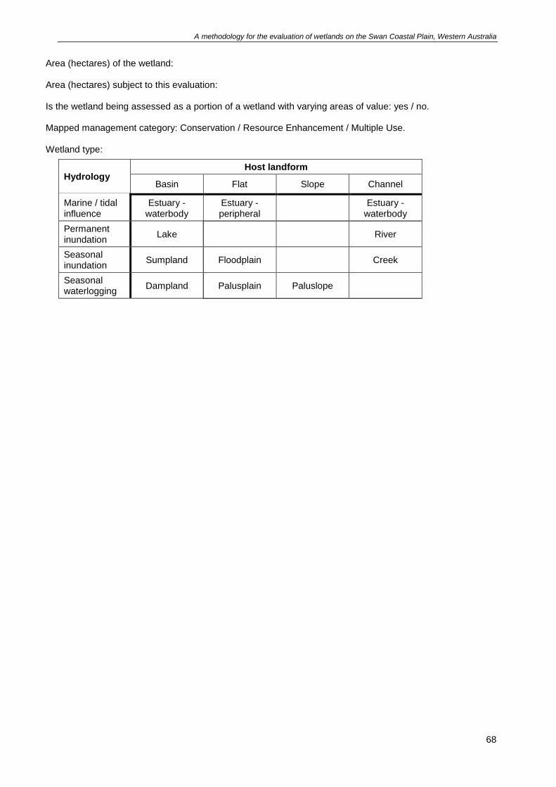
A methodology for the evaluation of wetlands on the Swan Coastal Plain, Western Australia
68
Area (hectares) of the wetland: Area (hectares) subject to this evaluation: Is the wetland being assessed as a portion of a wetland with varying areas of value: yes / no. Mapped management category: Conservation / Resource Enhancement / Multiple Use. Wetland type:
Hydrology Host landform
Basin Flat Slope Channel
Marine / tidal influence
Estuary - waterbody
Estuary - peripheral
Estuary -
waterbody
Permanent inundation
Lake River
Seasonal inundation
Sumpland Floodplain Creek
Seasonal waterlogging
Dampland Palusplain Paluslope
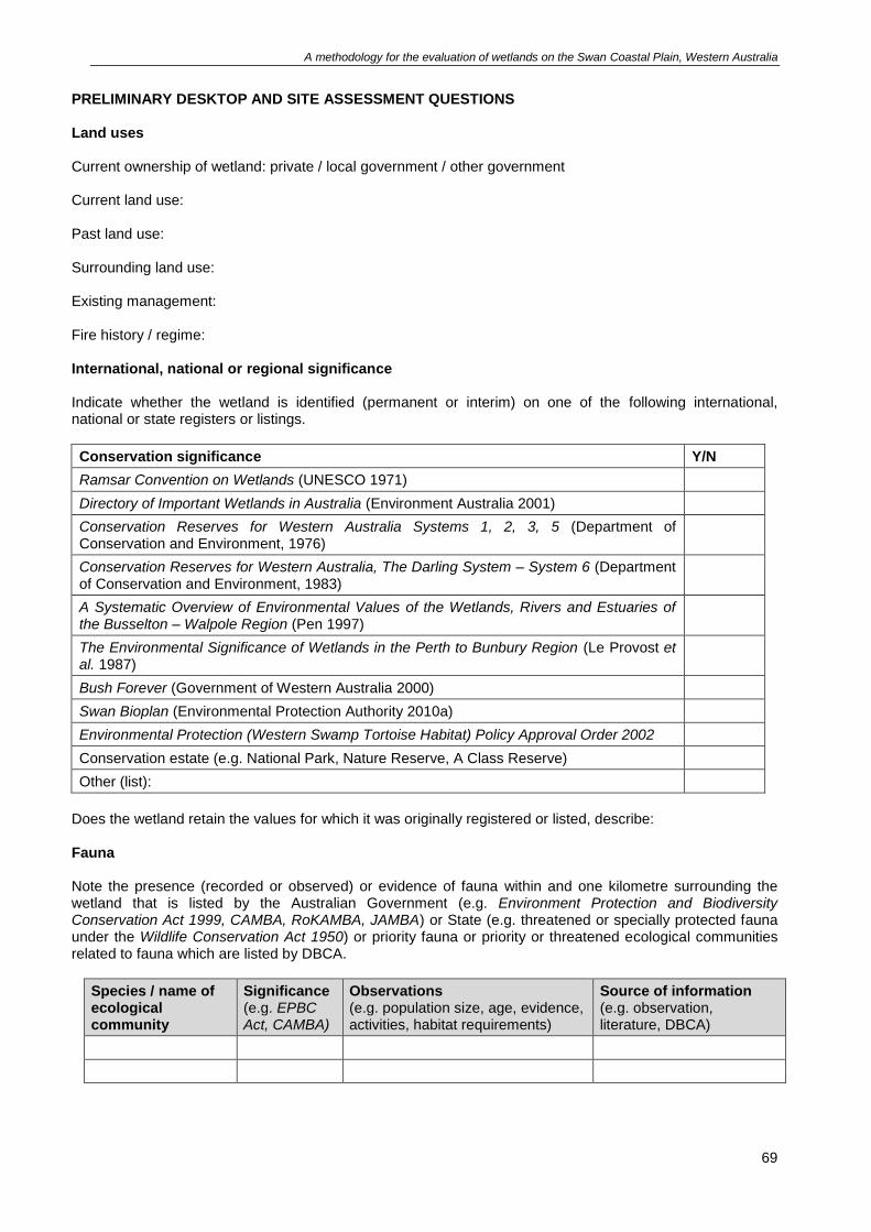
A methodology for the evaluation of wetlands on the Swan Coastal Plain, Western Australia
69
PRELIMINARY DESKTOP AND SITE ASSESSMENT QUESTIONS Land uses Current ownership of wetland: private / local government / other government Current land use: Past land use: Surrounding land use: Existing management: Fire history / regime: International, national or regional significance Indicate whether the wetland is identified (permanent or interim) on one of the following international, national or state registers or listings.
Conservation significance Y/N
Ramsar Convention on Wetlands (UNESCO 1971)
Directory of Important Wetlands in Australia (Environment Australia 2001)
Conservation Reserves for Western Australia Systems 1, 2, 3, 5 (Department of Conservation and Environment, 1976)
Conservation Reserves for Western Australia, The Darling System – System 6 (Department of Conservation and Environment, 1983)
A Systematic Overview of Environmental Values of the Wetlands, Rivers and Estuaries of the Busselton – Walpole Region (Pen 1997)
The Environmental Significance of Wetlands in the Perth to Bunbury Region (Le Provost et al. 1987)
Bush Forever (Government of Western Australia 2000)
Swan Bioplan (Environmental Protection Authority 2010a)
Environmental Protection (Western Swamp Tortoise Habitat) Policy Approval Order 2002
Conservation estate (e.g. National Park, Nature Reserve, A Class Reserve)
Other (list):
Does the wetland retain the values for which it was originally registered or listed, describe: Fauna Note the presence (recorded or observed) or evidence of fauna within and one kilometre surrounding the wetland that is listed by the Australian Government (e.g. Environment Protection and Biodiversity Conservation Act 1999, CAMBA, RoKAMBA, JAMBA) or State (e.g. threatened or specially protected fauna under the Wildlife Conservation Act 1950) or priority fauna or priority or threatened ecological communities related to fauna which are listed by DBCA.
Species / name of ecological community
Significance (e.g. EPBC Act, CAMBA)
Observations (e.g. population size, age, evidence, activities, habitat requirements)
Source of information (e.g. observation, literature, DBCA)
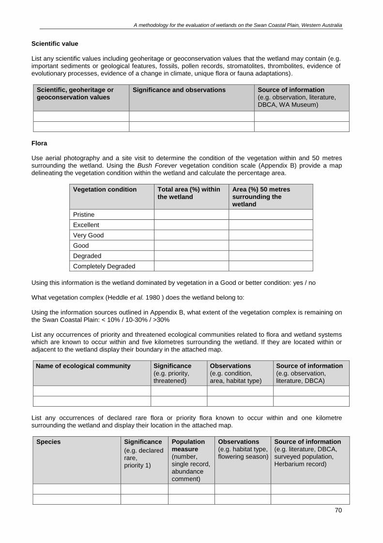
A methodology for the evaluation of wetlands on the Swan Coastal Plain, Western Australia
70
Scientific value List any scientific values including geoheritage or geoconservation values that the wetland may contain (e.g. important sediments or geological features, fossils, pollen records, stromatolites, thrombolites, evidence of evolutionary processes, evidence of a change in climate, unique flora or fauna adaptations).
Scientific, geoheritage or geoconservation values
Significance and observations Source of information (e.g. observation, literature, DBCA, WA Museum)
Flora Use aerial photography and a site visit to determine the condition of the vegetation within and 50 metres surrounding the wetland. Using the Bush Forever vegetation condition scale (Appendix B) provide a map delineating the vegetation condition within the wetland and calculate the percentage area.
Vegetation condition Total area (%) within the wetland
Area (%) 50 metres surrounding the wetland
Pristine
Excellent
Very Good
Good
Degraded
Completely Degraded
Using this information is the wetland dominated by vegetation in a Good or better condition: yes / no What vegetation complex (Heddle et al. 1980 ) does the wetland belong to: Using the information sources outlined in Appendix B, what extent of the vegetation complex is remaining on the Swan Coastal Plain: < 10% / 10-30% / >30% List any occurrences of priority and threatened ecological communities related to flora and wetland systems which are known to occur within and five kilometres surrounding the wetland. If they are located within or adjacent to the wetland display their boundary in the attached map.
Name of ecological community Significance (e.g. priority, threatened)
Observations (e.g. condition, area, habitat type)
Source of information (e.g. observation, literature, DBCA)
List any occurrences of declared rare flora or priority flora known to occur within and one kilometre surrounding the wetland and display their location in the attached map.
Species
Significance
(e.g. declared rare, priority 1)
Population measure (number, single record, abundance comment)
Observations (e.g. habitat type, flowering season)
Source of information (e.g. literature, DBCA, surveyed population, Herbarium record)
A methodology for the evaluation of wetlands on the Swan Coastal Plain, Western Australia
71
Representativeness Using the data in Appendix D record the corresponding area.
% area
What is the % area of wetlands with the same classification assigned a Conservation management category on the Swan Coastal Plain (Table 7)
What is the % area of wetlands in the same consanguineous suite assigned a Conservation management category (Table 8)
What is the % area of wetlands with the same classification in the same consanguineous suite assigned a conservation management category (Table 9)
Is the wetland rare? (e.g. only wetland in its consanguineous suite, best wetland example in its consanguineous suite or region, only Conservation management category wetland in the consanguineous suite or region, primary saline wetland within a consanguineous suite predominated by freshwater): Photographs and maps The following material should be submitted:
• on-ground colour photographs of the wetland from all directions, including within the wetland core, across the wetland boundary and across lot boundaries showing: o all vegetation units throughout the wetland o the range of vegetation condition across the wetland o any other relevant features of the wetland, including any alterations to geomorphology (e.g. drains, fill)
• a clear, recent (i.e. less than two years old, if available) colour aerial photograph/s of the area (with the date noted), overlaid with the following: o the current wetland mapping with the location and direction of photograph points illustrated o the current and proposed wetland mapping, including wetland boundaries and management
categories
• a description and map of the vegetation units and condition in accordance with a reconnaissance survey (Environmental Protection Authority 2016).
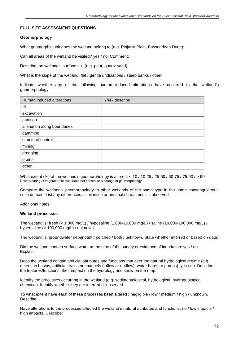
A methodology for the evaluation of wetlands on the Swan Coastal Plain, Western Australia
72
FULL SITE ASSESSMENT QUESTIONS Geomorphology What geomorphic unit does the wetland belong to (e.g. Pinjarra Plain, Bassendean Dune): Can all areas of the wetland be visited? yes / no. Comment: Describe the wetland’s surface soil (e.g. peat, quartz sand): What is the slope of the wetland: flat / gentle undulations / steep banks / other Indicate whether any of the following human induced alterations have occurred to the wetland’s geomorphology.
Human induced alterations Y/N - describe
fill
excavation
partition
alienation along boundaries
damming
structural control
mining
dredging
drains
other
What extent (%) of the wetland’s geomorphology is altered: < 10 / 10-25 / 25-50 / 50-75 / 75-90 / > 90 Note: clearing of vegetation in itself does not constitute a change in geomorphology.
Compare the wetland’s geomorphology to other wetlands of the same type in the same consanguineous suite domain. List any differences, similarities or unusual characteristics observed: Additional notes: Wetland processes The wetland is: fresh (< 1,000 mg/L) / hyposaline (1,000-10,000 mg/L) / saline (10,000-100,000 mg/L) / hypersaline (> 100,000 mg/L) / unknown The wetland is: groundwater dependant / perched / both / unknown. State whether inferred or based on data: Did the wetland contain surface water at the time of the survey or evidence of inundation: yes / no. Explain: Does the wetland contain artificial attributes and functions that alter the natural hydrological regime (e.g. detention basins, artificial drains or channels (inflow or outflow), water bores or pumps): yes / no. Describe the features/functions, their impact on the hydrology and show on the map: Identify the processes occurring in the wetland (e.g. sedimentological, hydrological, hydrogeological, chemical). Identify whether they are inferred or observed: To what extent have each of these processes been altered : negligible / low / medium / high / unknown. Describe: Have alterations to the processes affected the wetland’s natural attributes and functions: no / low impacts / high impacts. Describe:
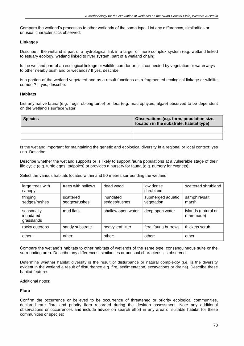
A methodology for the evaluation of wetlands on the Swan Coastal Plain, Western Australia
73
Compare the wetland’s processes to other wetlands of the same type. List any differences, similarities or unusual characteristics observed: Linkages
Describe if the wetland is part of a hydrological link in a larger or more complex system (e.g. wetland linked to estuary ecology, wetland linked to river system, part of a wetland chain): Is the wetland part of an ecological linkage or wildlife corridor or, is it connected by vegetation or waterways to other nearby bushland or wetlands? If yes, describe: Is a portion of the wetland vegetated and as a result functions as a fragmented ecological linkage or wildlife corridor? If yes, describe:
Habitats List any native fauna (e.g. frogs, oblong turtle) or flora (e.g. macrophytes, algae) observed to be dependent on the wetland’s surface water.
Species Observations (e.g. form, population size, location in the substrate, habitat type)
Is the wetland important for maintaining the genetic and ecological diversity in a regional or local context: yes / no. Describe: Describe whether the wetland supports or is likely to support fauna populations at a vulnerable stage of their life cycle (e.g. turtle eggs, tadpoles) or provides a nursery for fauna (e.g. nursery for cygnets): Select the various habitats located within and 50 metres surrounding the wetland.
large trees with canopy
trees with hollows dead wood low dense shrubland
scattered shrubland
fringing sedges/rushes
scattered sedges/rushes
inundated sedges/rushes
submerged aquatic vegetation
samphire/salt marsh
seasonally inundated grasslands
mud flats shallow open water deep open water islands (natural or man-made)
rocky outcrops sandy substrate heavy leaf litter feral fauna burrows thickets scrub
other: other: other: other: other:
Compare the wetland’s habitats to other habitats of wetlands of the same type, consanguineous suite or the surrounding area. Describe any differences, similarities or unusual characteristics observed: Determine whether habitat diversity is the result of disturbance or natural complexity (i.e. is the diversity evident in the wetland a result of disturbance e.g. fire, sedimentation, excavations or drains). Describe these habitat features: Additional notes:
Flora Confirm the occurrence or believed to be occurrence of threatened or priority ecological communities, declared rare flora and priority flora recorded during the desktop assessment. Note any additional observations or occurrences and include advice on search effort in any area of suitable habitat for these communities or species:
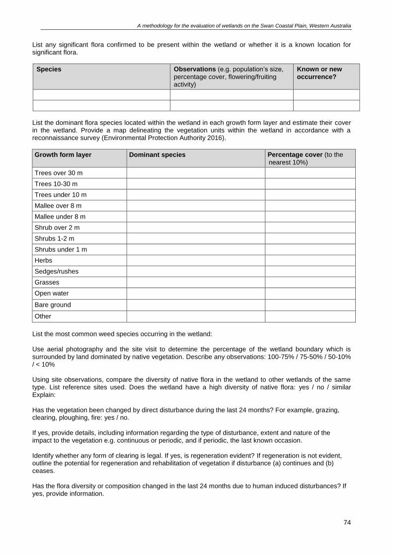
A methodology for the evaluation of wetlands on the Swan Coastal Plain, Western Australia
74
List any significant flora confirmed to be present within the wetland or whether it is a known location for significant flora.
Species Observations (e.g. population’s size, percentage cover, flowering/fruiting activity)
Known or new occurrence?
List the dominant flora species located within the wetland in each growth form layer and estimate their cover in the wetland. Provide a map delineating the vegetation units within the wetland in accordance with a reconnaissance survey (Environmental Protection Authority 2016).
Growth form layer Dominant species Percentage cover (to the nearest 10%)
Trees over 30 m
Trees 10-30 m
Trees under 10 m
Mallee over 8 m
Mallee under 8 m
Shrub over 2 m
Shrubs 1-2 m
Shrubs under 1 m
Herbs
Sedges/rushes
Grasses
Open water
Bare ground
Other
List the most common weed species occurring in the wetland: Use aerial photography and the site visit to determine the percentage of the wetland boundary which is surrounded by land dominated by native vegetation. Describe any observations: 100-75% / 75-50% / 50-10% / < 10% Using site observations, compare the diversity of native flora in the wetland to other wetlands of the same type. List reference sites used. Does the wetland have a high diversity of native flora: yes / no / similar Explain: Has the vegetation been changed by direct disturbance during the last 24 months? For example, grazing, clearing, ploughing, fire: yes / no. If yes, provide details, including information regarding the type of disturbance, extent and nature of the impact to the vegetation e.g. continuous or periodic, and if periodic, the last known occasion. Identify whether any form of clearing is legal. If yes, is regeneration evident? If regeneration is not evident, outline the potential for regeneration and rehabilitation of vegetation if disturbance (a) continues and (b) ceases. Has the flora diversity or composition changed in the last 24 months due to human induced disturbances? If yes, provide information.
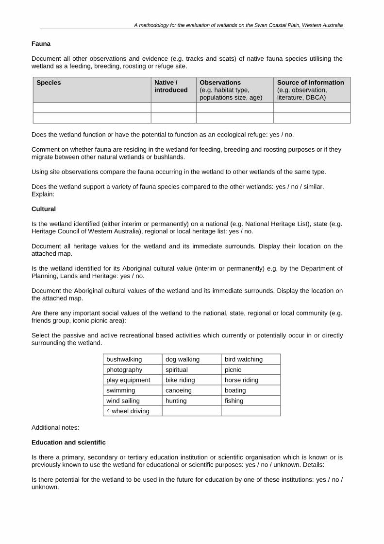
A methodology for the evaluation of wetlands on the Swan Coastal Plain, Western Australia
Fauna Document all other observations and evidence (e.g. tracks and scats) of native fauna species utilising the wetland as a feeding, breeding, roosting or refuge site.
Species Native / introduced
Observations (e.g. habitat type, populations size, age)
Source of information (e.g. observation, literature, DBCA)
Does the wetland function or have the potential to function as an ecological refuge: yes / no. Comment on whether fauna are residing in the wetland for feeding, breeding and roosting purposes or if they migrate between other natural wetlands or bushlands. Using site observations compare the fauna occurring in the wetland to other wetlands of the same type. Does the wetland support a variety of fauna species compared to the other wetlands: yes / no / similar. Explain: Cultural Is the wetland identified (either interim or permanently) on a national (e.g. National Heritage List), state (e.g. Heritage Council of Western Australia), regional or local heritage list: yes / no. Document all heritage values for the wetland and its immediate surrounds. Display their location on the attached map. Is the wetland identified for its Aboriginal cultural value (interim or permanently) e.g. by the Department of Planning, Lands and Heritage: yes / no. Document the Aboriginal cultural values of the wetland and its immediate surrounds. Display the location on the attached map. Are there any important social values of the wetland to the national, state, regional or local community (e.g. friends group, iconic picnic area): Select the passive and active recreational based activities which currently or potentially occur in or directly surrounding the wetland.
bushwalking dog walking bird watching
photography spiritual picnic
play equipment bike riding horse riding
swimming canoeing boating
wind sailing hunting fishing
4 wheel driving
Additional notes: Education and scientific Is there a primary, secondary or tertiary education institution or scientific organisation which is known or is previously known to use the wetland for educational or scientific purposes: yes / no / unknown. Details: Is there potential for the wetland to be used in the future for education by one of these institutions: yes / no / unknown.
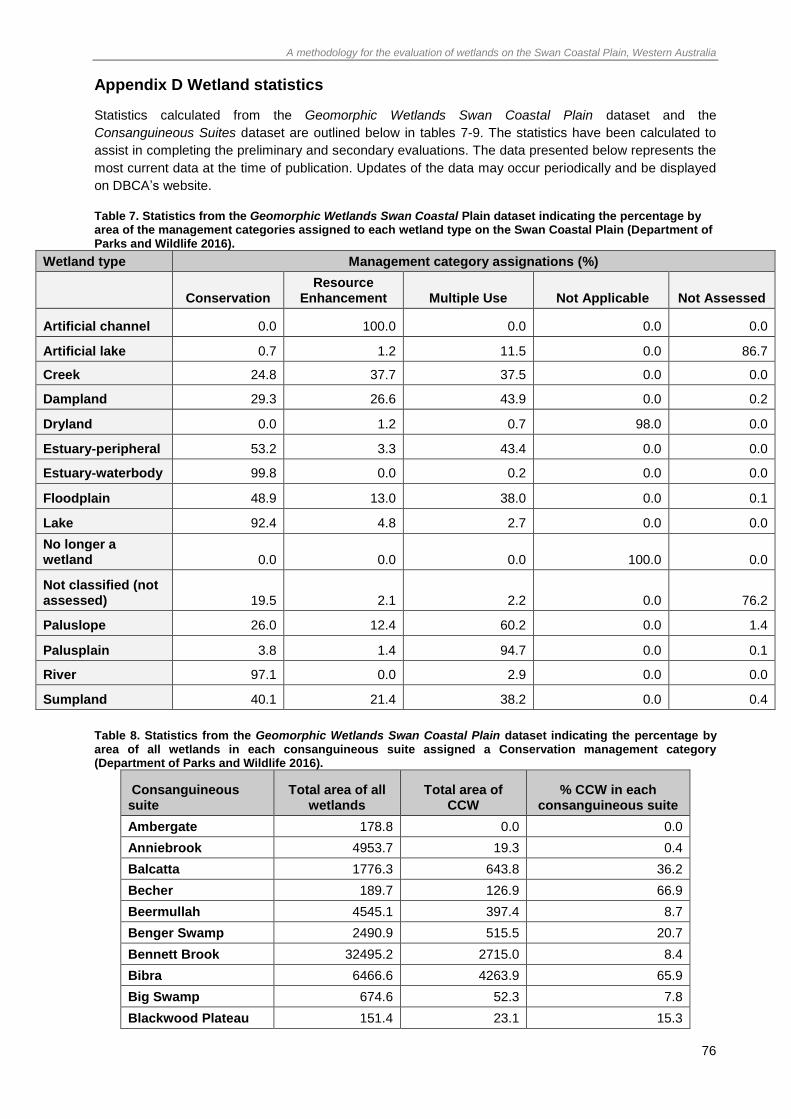
A methodology for the evaluation of wetlands on the Swan Coastal Plain, Western Australia
76
Appendix D Wetland statistics
Statistics calculated from the Geomorphic Wetlands Swan Coastal Plain dataset and the
Consanguineous Suites dataset are outlined below in tables 7-9. The statistics have been calculated to
assist in completing the preliminary and secondary evaluations. The data presented below represents the
most current data at the time of publication. Updates of the data may occur periodically and be displayed
on DBCA’s website.
Table 7. Statistics from the Geomorphic Wetlands Swan Coastal Plain dataset indicating the percentage by area of the management categories assigned to each wetland type on the Swan Coastal Plain (Department of Parks and Wildlife 2016).
Wetland type Management category assignations (%)
Conservation Resource
Enhancement Multiple Use Not Applicable Not Assessed
Artificial channel 0.0 100.0 0.0 0.0 0.0
Artificial lake 0.7 1.2 11.5 0.0 86.7
Creek 24.8 37.7 37.5 0.0 0.0
Dampland 29.3 26.6 43.9 0.0 0.2
Dryland 0.0 1.2 0.7 98.0 0.0
Estuary-peripheral 53.2 3.3 43.4 0.0 0.0
Estuary-waterbody 99.8 0.0 0.2 0.0 0.0
Floodplain 48.9 13.0 38.0 0.0 0.1
Lake 92.4 4.8 2.7 0.0 0.0
No longer a wetland 0.0 0.0 0.0 100.0 0.0
Not classified (not assessed) 19.5 2.1 2.2 0.0 76.2
Paluslope 26.0 12.4 60.2 0.0 1.4
Palusplain 3.8 1.4 94.7 0.0 0.1
River 97.1 0.0 2.9 0.0 0.0
Sumpland 40.1 21.4 38.2 0.0 0.4
Table 8. Statistics from the Geomorphic Wetlands Swan Coastal Plain dataset indicating the percentage by area of all wetlands in each consanguineous suite assigned a Conservation management category (Department of Parks and Wildlife 2016).
Consanguineous suite
Total area of all wetlands
Total area of CCW
% CCW in each consanguineous suite
Ambergate 178.8 0.0 0.0
Anniebrook 4953.7 19.3 0.4
Balcatta 1776.3 643.8 36.2
Becher 189.7 126.9 66.9
Beermullah 4545.1 397.4 8.7
Benger Swamp 2490.9 515.5 20.7
Bennett Brook 32495.2 2715.0 8.4
Bibra 6466.6 4263.9 65.9
Big Swamp 674.6 52.3 7.8
Blackwood Plateau 151.4 23.1 15.3
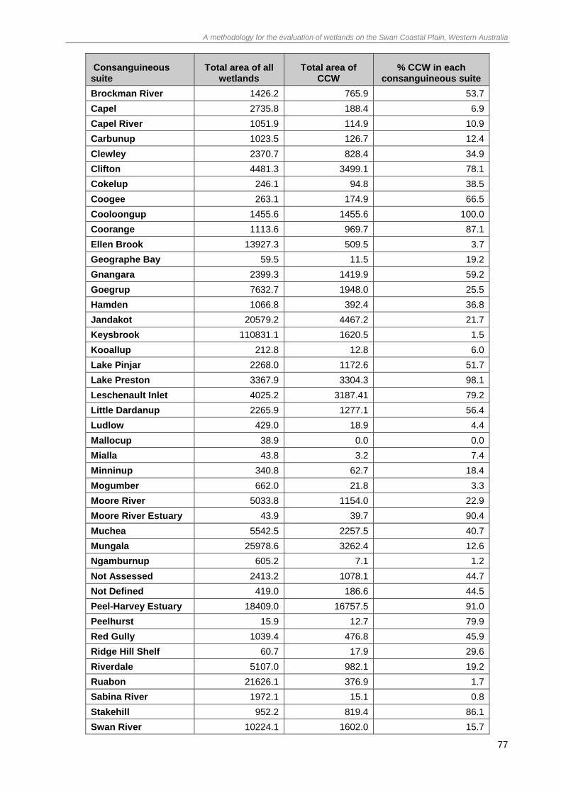
A methodology for the evaluation of wetlands on the Swan Coastal Plain, Western Australia
77
Consanguineous suite
Total area of all wetlands
Total area of CCW
% CCW in each consanguineous suite
Brockman River 1426.2 765.9 53.7
Capel 2735.8 188.4 6.9
Capel River 1051.9 114.9 10.9
Carbunup 1023.5 126.7 12.4
Clewley 2370.7 828.4 34.9
Clifton 4481.3 3499.1 78.1
Cokelup 246.1 94.8 38.5
Coogee 263.1 174.9 66.5
Cooloongup 1455.6 1455.6 100.0
Coorange 1113.6 969.7 87.1
Ellen Brook 13927.3 509.5 3.7
Geographe Bay 59.5 11.5 19.2
Gnangara 2399.3 1419.9 59.2
Goegrup 7632.7 1948.0 25.5
Hamden 1066.8 392.4 36.8
Jandakot 20579.2 4467.2 21.7
Keysbrook 110831.1 1620.5 1.5
Kooallup 212.8 12.8 6.0
Lake Pinjar 2268.0 1172.6 51.7
Lake Preston 3367.9 3304.3 98.1
Leschenault Inlet 4025.2 3187.41 79.2
Little Dardanup 2265.9 1277.1 56.4
Ludlow 429.0 18.9 4.4
Mallocup 38.9 0.0 0.0
Mialla 43.8 3.2 7.4
Minninup 340.8 62.7 18.4
Mogumber 662.0 21.8 3.3
Moore River 5033.8 1154.0 22.9
Moore River Estuary 43.9 39.7 90.4
Muchea 5542.5 2257.5 40.7
Mungala 25978.6 3262.4 12.6
Ngamburnup 605.2 7.1 1.2
Not Assessed 2413.2 1078.1 44.7
Not Defined 419.0 186.6 44.5
Peel-Harvey Estuary 18409.0 16757.5 91.0
Peelhurst 15.9 12.7 79.9
Red Gully 1039.4 476.8 45.9
Ridge Hill Shelf 60.7 17.9 29.6
Riverdale 5107.0 982.1 19.2
Ruabon 21626.1 376.9 1.7
Sabina River 1972.1 15.1 0.8
Stakehill 952.2 819.4 86.1
Swan River 10224.1 1602.0 15.7
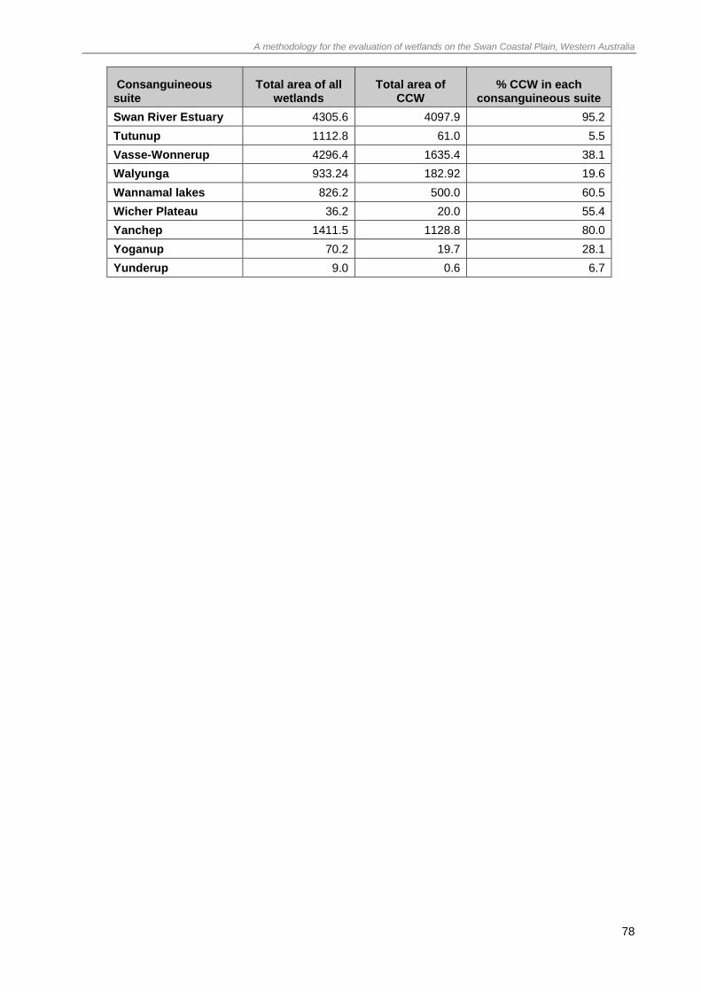
A methodology for the evaluation of wetlands on the Swan Coastal Plain, Western Australia
78
Consanguineous suite
Total area of all wetlands
Total area of CCW
% CCW in each consanguineous suite
Swan River Estuary 4305.6 4097.9 95.2
Tutunup 1112.8 61.0 5.5
Vasse-Wonnerup 4296.4 1635.4 38.1
Walyunga 933.24 182.92 19.6
Wannamal lakes 826.2 500.0 60.5
Wicher Plateau 36.2 20.0 55.4
Yanchep 1411.5 1128.8 80.0
Yoganup 70.2 19.7 28.1
Yunderup 9.0 0.6 6.7
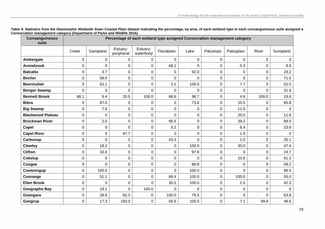
A methodology for the evaluation of wetlands on the Swan Coastal Plain, Western Australia
79
Table 9. Statistics from the Geomorphic Wetlands Swan Coastal Plain dataset indicating the percentage, by area, of each wetland type in each consanguineous suite assigned a Conservation management category (Department of Parks and Wildlife 2016).
Consanguineous suite
Percentage of each wetland type assigned Conservation management category
Creek Dampland Estuary-
peripheral Estuary-
waterbody Floodplain Lake Paluslope Palusplain River Sumpland
Ambergate 0 0 0 0 0 0 0 0 0 0
Anniebrook 0 0 0 0 68.1 0 0 0.3 0 8.9
Balcatta 0 3.7 0 0 0 92.0 0 0 0 24.2
Becher 0 58.0 0 0 0 0 0 0 0 71.5
Beermullah 0 62.1 0 0 3.2 100.0 0 7.7 0 52.0
Benger Swamp 0 0 0 0 0 0 0 0 0 31.6
Bennett Brook 68.1 9.4 20.5 100.0 68.6 98.7 0 4.6 100.0 19.6
Bibra 0 87.0 0 0 0 73.8 0 10.5 0 65.8
Big Swamp 0 7.6 0 0 0 0 0 11.5 0 0
Blackwood Plateau 0 0 0 0 0 0 0 20.0 0 11.6
Brockman River 0 2.5 0 0 95.5 0 0 39.2 0 89.0
Capel 0 0 0 0 5.2 0 0 6.4 0 23.8
Capel River 0 0 47.7 0 0 0 0 1.9 0 0
Carbunup 0 0 0 0 43.3 0 0 1.0 0 25.1
Clewley 0 18.2 0 0 0 100.0 0 30.0 0 47.4
Clifton 0 33.6 0 0 0 97.8 0 0 0 24.7
Cokelup 0 0 0 0 0 0 0 23.8 0 61.3
Coogee 0 0 0 0 0 86.8 0 0 0 59.2
Cooloongup 0 100.0 0 0 0 100.0 0 0 0 98.5
Coorange 0 51.1 0 0 68.4 100.0 0 100.0 0 55.0
Ellen Brook 0 0 0 0 35.5 100.0 0 2.5 0 42.3
Geographe Bay 0 19.1 0 100.0 0 0 0 0 0 0
Gnangara 0 28.9 82.3 0 100.0 79.5 0 0 0 63.8
Goegrup 0 17.3 100.0 0 56.9 100.0 0 7.1 99.9 48.6
A methodology for the evaluation of wetlands on the Swan Coastal Plain, Western Australia
80
Consanguineous suite
Percentage of each wetland type assigned Conservation management category
Creek Dampland
Estuary-peripheral
Estuary-waterbody
Floodplain Lake Paluslope Palusplain River Sumpland
Hamden 0 8.2 0 0 0 0 0 44.1 0 46.5
Jandakot 0 38.2 3.5 0 0 78.2 0 1.8 0 35.9
Keysbrook 0 5.4 94.3 0 36.8 6.7 0 1.3 0 9.1
Kooallup 0 0 100.0 0 0 100.0 0 0 0 36.1
Lake Pinjar 0 100.0 0 0 0 0 0 0 0 51.7
Lake Preston 0 0 0 0 0 99.8 0 0 0 66.6
Leschenault Inlet 0 0 62.4 99.0 100.0 26.4 0 2.1 0 4.2
Little Dardanup 28.2 51.9 0 0 92.8 0 31.6 32.8 0 58.7
Ludlow 0 0 6.9 0 0 0 0 0.3 0 0
Mallocup 0 0 0 0 0 0 0 0 0 0
Mialla 0 0 0 0 0 0 0 0 0 66.2
Minninup 0 0 0 0 0 100.0 0 0 0 12.6
Mogumber 0 2.6 0 0 0 0 0 0 0 7.0
Moore River 0 57.4 0 0 60.3 0 0 18.2 80.7 61.1
Moore River Estuary 0 0 0 0 91.1 0 0 0 89.0 0
Muchea 0 79.3 0 0 25.6 0 0 13.5 0 58.8
Mungala 0 11.6 100.0 100.0 56.4 61.2 0 4.1 0 29.3
Ngamburnup 0 2.0 100.0 0 0.1 0 0 0.4 0 13.9
Not Assessed 0 18.7 0 0 0 93.8 0 12.0 0 88.5
Not Defined 0 2.7 0 0 0 92.5 0 0 0 20.9
Peel-Harvey Estuary 0 99.0 70.8 99.9 63.3 89.9 0 4.0 87.1 69.2
Peelhurst 0 11.2 0 0 0 0 0 0 0 0
Red Gully 0 2.0 0 0 99.5 0 0.8 46.3 0 67.3
Ridge Hill Shelf 0 0 0 0 0 30.8 0 0 0 48.8
Riverdale 0 27.5 0 0 0 27.7 0 3.5 0 40.6
A methodology for the evaluation of wetlands on the Swan Coastal Plain, Western Australia
81
Consanguineous suite
Percentage of each wetland type assigned Conservation management category
Creek Dampland
Estuary-peripheral
Estuary-waterbody
Floodplain Lake Paluslope Palusplain River Sumpland
Ruabon 0 1.3 0 0 17.9 0 0 1.4 0 14.3
Sabina River 0 0 0 100.0 0 0 0 1.4 0 0
Stakehill 0 35.2 0 0 0 0 0 0 0 88.4
Swan River 0 2.4 28.9 100.0 43.2 83.7 0 7.1 97.6 27.7
Swan River Estuary 0 5.8 75.0 100.0 45.1 38.4 0 0 0 47.3
Tutunup 0 0 0 0 25.2 0 0 0 0 0
Vasse-Wonnerup 0 0 26.0 99.6 1.2 0 0 0.6 0 16.1
Walyunga 6.5 21.8 0 0 99.9 0 78.8 10.4 100.0 35.9
Wannamal lakes 0 100.0 0 0 0 100.0 0 9.1 0 79.8
Wicher Plateau 0 0 0 0 0 0 0 0 0 55.8
Yanchep 0 100.0 0 0 0 98.6 0 0 0 35.6
Yoganup 0 0 0 0 0 0 0 21.1 0 45.9
Yunderup 0 7.8 0 0 0 0 0 0 0 0