A hike to the headwaters of the Rivers Rhine, Reuss ...€¦ · Village House/Hut Food...
8
A hike to the headwaters of the Rivers Rhine, Reuss, Ticino and Rhone. Four Headwaters Trail through the St Gotthard Massif
Transcript of A hike to the headwaters of the Rivers Rhine, Reuss ...€¦ · Village House/Hut Food...

A hike to the headwaters of the Rivers Rhine, Reuss, Ticino and Rhone.
Four Headwaters Trailthrough the St Gotthard Massif

23
45
67
89
1011
121
km
1617
1819
2021
23
45
67
89
1011
1213
1415
1km
2
34
56
78
910
1112
1314
151
km
2500
m
1500
m
2000
m
2250
m
1750
m
2500
m
1500
m
2000
m
2250
m
1750
m
2500
m
2000
m
2250
m
2500
m
1500
m
2000
m
2250
m
1750
m
2500
m
1500
m
2000
m
2250
m
1750
m
1500
m
1750
m
1617
1819
23
45
67
89
1011
1213
1415
1km
2500
m
1500
m
2000
m
2250
m
1750
m
Sta
ge
1
2421
mM
aig
hel
Pas
s
2042
mVe
rmig
elH
ut
2314
mM
aig
hel
Hut
2044
m
Ob
eral
pP
ass
Sta
ge
2
2042
mVe
rmig
el
Hut
2701
mS
ella
Pas
s
2375
mS
umm
er-
mat
ten
2776
mG
iüb
in
Sta
ge
3
2091
mG
ott
hard
P
ass
2522
mLu
cend
ro
Pas
s
2128
mR
oss
o
di F
uori
2015
mR
i di
Cav
anna
1996
m
Ri d
i B
edre
tto
1938
mR
i di
Ro
nco
2182
mA
lpe
di
Luce
ndro
1982
mP
ians
ecco
Hut
SA
C
Sta
ge
4
2093
mN
ufen
enro
ad
2440
mN
ufen
enP
ass
2003
mA
lpe
di
Cru
ina
1925
mLa
dst
afel
17
62 m
Ho
sand
15
33 m
Kitt
bri
gg
1982
mP
ians
ecco
Hut
SA
C
1355
mO
ber
-g
este
ln
Sta
ge
5
1355
mO
ber
-g
este
ln
1368
mO
ber
-w
ald
1550
mS
t N
icho
las
chap
el
1757
mG
lets
ch(s
tatio
n st
eam
rai
lway
)
2170
mM
uttb
ach
stat
ion
2429
mF
urka
Pas
s
2271
mH
ote
l B
elvé
dèr
e
2256
mLa
ke
Sel
la
So
urce
of
the
Rho
neH
ead
wat
ers
of
the
Tic
ino
hrs.
/min
.
1/3
1 >
1/5
5 >
3
/25
>
4/
55 >
5/2
5 >
6/1
5 >
7/
00 >
hrs.
/min
.
1/3
5 >
2
/45
>
3/
35 >
4/3
5 >
5/3
0 >
5/50
>
7/3
0 >
hrs.
/min
.
0/4
0 >
1/2
0 >
3/0
5 >
4/45
>
5/4
5 >
7
/15
>
So
urce
of
the
Go
ttha
rd-R
euss
So
urce
of
the
Rhi
ne
hrs.
/min
.
1/1
9 >
2/4
0 >
4
/24
>
5
/15
>hr
s./m
in.
1
/50
>
2/
50 >
4/05
>
5/
20 >
2091
mG
ott
hard
Pas
s
162
34
56
78
910
1112
1314
151
km
2345
mLa
ke
Tom
a
Sta
ge
1
2421
mM
aig
hel
Pas
s
2042
mVe
rmig
elH
ut
2314
mM
aig
hel
Hut
Sta
ge
2 2701
mS
ella
Pas
s
2776
mG
iüb
in
Sta
ge
3
2522
mLu
cend
roP
ass
2015
mR
i di
Cav
anna
1996
m
Ri d
i B
edre
tto
2182
mA
lpe
di
Luce
ndro
1982
mP
ians
ecco
Hut
SA
C
Sta
ge
4
2440
mN
ufen
enro
ad
2003
mA
lpe
di
Cru
ina
1925
mLa
dst
afel
Sta
ge
5 13
68 m
Ob
er-
wal
d
1757
mG
lets
ch(s
team
rai
lway
)2429
mF
urka
Pas
s
2271
mH
ote
l B
elvé
dèr
e
2256
mLa
ke
Sel
la
So
urce
of
the
Rho
neH
ead
wat
ers
of
the
Tic
ino
So
urce
of
the
Go
ttha
rd-R
euss
So
urce
of
the
Rhi
ne
5 hr
s. 2
0 m
in.
14
.4 k
m >
5 hr
s. 1
5 m
in.
1
2.8
km >
7 hr
s. 3
0 m
in.
20.
6 km
>
7
hrs.
1
9.8
km
>
2091
mG
ott
hard
Pas
s
2345
mLa
keTo
ma
2044
m
Ob
eral
p
Pas
s
1355
mO
ber
-g
este
ln
7 hr
s.15
min
.
17 k
m >
1
2
34
5
6
71
2
3
45
67
12
3
4
6
5
7
8
12
3
4
65
12
43
56
7
8
3e_5
00cm
yk_LT_feb1
0
5
12
3
4
Cru
ina
All’
Acq
uaR
onc
oV
illa
Bed
rett
o
Luce
ndro
Pas
s
Go
ttha
rd P
ass A
iro
lo
Mai
ghe
ls P
ass
Ver
mig
elH
ut S
AC
Sid
elen
Hut
SA
C
Lake
To
ma
Ob
eral
p P
ass
And
erm
att
Ho
spen
tal
Pia
nsec
coH
ut S
AC
Ob
erg
este
ln
Ulr
iche
n
Mün
ster
Mai
ghe
lsH
ut S
AC
of
the
Rhi
neH
ead
wat
ers
Bel
véd
ère
Tie
fenb
ach
Fur
ka P
ass
Gle
tsch
Gri
mse
l Pas
s
Ob
erw
ald
Hea
dw
ater
s
Go
ttha
rd-R
euss
Gö
sche
nen
Sed
run
Val
Mai
ghe
lsTsc
ham
ut
ReussGotthard road tunnel
Fu
rka
mou
ntai
n se
ctio
n
(ste
am r
ailw
ay)
(Glacier-E
xpress)
Furka-B
ase tu
nnel
Mat
terh
orn
-Go
tth
ard
-
R
ailw
ay (
MG
B)
Gotthardrailway tunnel SBB
Tici
no
Rho
ne
Mat
terh
orn
-Go
tth
ard-
Bah
n (M
GB
)
R
hine
Lake
Ob
eraa
r
Lak
e G
rim
sel
Lak
e G
ösc
hen
eral
p
Lak
e T
ote
Lake Nalps
Lake
Ob
eral
p
Lak
eL
uce
nd
ro
Lak
e Sel
la
Lak
e G
ries
Rhone-
Glacier
Nuf
enen
Pas
s
Rea
lp
Rho
neS
our
ce o
f th
e
of
the
Tic
ino
of
the
Hea
dw
ater
s
INF
OR
MA
TIO
N A
BO
UT
S
TA
GE
S 1
-5E
FF
OR
T D
ista
nce:
85
km/T
ime:
ab
out 3
2 hr
s./
Asc
ent:
6,1
61 m
/Des
cent
: 5,9
32 m
DIF
FIC
UL
TY C
ontin
uous
, mos
tly h
ikin
g on
m
arke
d tr
ails
(SA
C r
atin
g: T
2/T3
)S
TA
RT
O
ber
alp
Pas
s F
INIS
H H
otel
Bel
véd
ère
DA
Y H
IKE
S S
tage
s ca
n al
so b
e d
one
as d
ay h
ikes
GE
TT
ING
TH
ER
E/A
WA
Y S
tart
ing
and
end
poi
nts
are
serv
iced
by
buse
s or
trai
ns
MA
PS S
witz
erla
nd n
atio
nal m
ap 1
:50,
000,
N
o. 5
001
“Got
thar
d”. E
xcer
pts
redu
ced
15 p
erce
nt (s
ee p
ages
10,
16,
22,
28,
34)
.IN
FO
RM
AT
ION
ww
w.fo
ur-h
ead
wat
ers-
trai
l.ch
Vill
age
Hou
se/H
utFo
odA
ccom
mod
atio
nB
usTr
ain
Sho
pp
ing
Dr.
Chr
isto
ph
Blo
cher
, fo
rmer
Fed
eral
Cou
ncilo
r
Pla
tinum
sponso
rs:
Support fro
m:
Four Headwaters Trail through the St Gottard Massif
A hike to the headwaters of the Rivers Rhine, Reuss, Ticino and Rhone.
Edited byFour Headwaters Trail through the St Gotthard Massif Foundation
Rep
rod
uced
by
per
mis
sion
of s
wis
stop
o (B
A120
056
)

All rights reserved© 2012 Four Headwaters Trail Foundation, Altdorf
CONTENT MAP AND TR AIL DESCRIPTIONS
Josef Arnold-Luzzani, Schattdorf
DESIGN AND L AYOUT
Armin Furrer, Furrer Graphic Design, Lucerne
EDITORIAL AND PRODUCTION
Edith Jörg, pr-work jörg, Lucerne
TR ANSL ATION
Tim Neville, www.timneville.net
PRODUCTION AND DISTRIBUTION
Gamma Druck + Verlag AG, Medien-Atelier, Altdorf
1st edition 2012Printed in Switzerland ISBN: 978-3-906200-49-1
5 Four Headwaters Trail through the St Gotthard Massif
7 Off to the headwaters!
8 From the Oberalp Pass to the Source of the Rhine Stage 1: Oberalp Pass – Lake Toma (Source of the Rhine) – Maighel Pass – Vermigel Hut
14 From the Vermigel Hut to the Gotthard Pass Stage 2: Vermigel Hut – Sella Pass – Piz Giübin – Lake Sella – Gotthard Pass
20 From the Gotthard Pass to the Source of the Reuss Stage 3: Gotthard Pass – Lake Lucendro – Source of the Reuss – Lucendro Pass – Piansecco Hut
26 From the Piansecco Hut to the headwaters of the Ticino Stage 4: Piansecco Hut – Headwaters of the Ticino – Nufenen Pass – Obergesteln
32 From the Upper Goms to the Source of the Rhone Stage 5: Obergesteln – Gletsch – Furka Pass – Rhone Glacier (source of the Rhone) – Hotel Belvédère 38 Rivers and Paths Shape Development The Gotthard Region – A cultural overview
52 Rich Diversity of Plants and Animals A natural history journey in five stages
60 How Mountains Grow and Recede A five-stage hike through geological history
70 Reservoirs of Water Power Harnessing water in the St Gotthard Massif
76 Practical Information
79 Appendix, bibliography and credits
80 Acknowledgements
Table of Contents

4 5
The Rhine, Reuss, Ticino and Rhone rivers all begin in the Gotthard region and that gave Paul Dubacher from Seed-orf the idea for the Four Headwaters Trail. He’s something of a specialist when it comes to hiking trails and was instrumental, for example, in forming routes like the “Swiss Path” around Lake Lucerne and the “Railway Trails” of the Gotthard region.
In 2009 Dubacher got to work once again. That same year the Four Head-waters Trail Foundation was founded with well-known people from the four cantons that make up the Gotthard re-gion (see page 78). The inauguration followed in 2012.
For more information please visit www.four-headwaters-trail.ch.
Mountain hiking in five stages The Four Headwaters Trail is a family-friendly trek of about 85 km through the alpine country where the Rhine, Reuss, Ticino and Rhone rivers begin. It is broken up into five segments, each of which with starting and end points that are serviced by public transport.
Hiking through portions of cantons Uri, Graubünden, Ticino and Valais takes you through unique landscapes
and highlights the central role that wa-ter has played for man, animals and plants.
Things to know about the GotthardThe hiking guidebook to the Four Headwaters Trail includes trail descrip-tions as well as fascinating background information on the region’s cultural his-tory, flora and fauna, geological phe-nomena, climate change and the har-nessing of water for hydropower.
In this way a hiker can make sense of and learn more about the area. The best bits of background information will become apparent: How have hu-mans throughout the ages impacted the Gotthard region; why mountains are never at ease; which plants are worth a closer look; and how important is it to turn the region’s water into power.
Four Headwaters Trail through the St Gottard Massif
Paul Dubacher, founder and project leader of the Four Headwaters Trail

6 7
Water and springs have a magical pow-er of attraction. Springing discretely from the depths and flowing eventually into the sea, water lends itself to a cross-cultural metaphor for the fate of us all: The lively, happy-go-lucky brook of youth matures into the wide ship-bearing current of adulthood before fading away into the infinity of the sea.
Water as a creative powerSprings are a reflection of the times: In moments of uncertainty the call to re-turn to our roots and where it all began rings loudly. In times of heady opti-mism it’s easy to forget origins and tra-dition. Springs are places of power, pu-rity and life. They were even the places where children came from, according to some old folk tales.
Water has the two faces of Janus: It can destroy with a flood and spawn life with a refreshing rain. Water shortages spark wars or create laws founded in peace. The Code of Hammurabi (1850 BC) includes stipulations over water rights.
Hiking lends wings to thoughts Glaciers have held stores of water for millennia and have become a symbol for security, hope and confidence. By contrast their disappearance triggers a fear of the future, but fear and hardship also foster human ingenuity. From that has sprung an environmentally friendly and sustainable art of engineering.
Water is a magical power: People have harnessed its force with mills and turned it into electricity. Water is a splendid artist: Its power has formed marvelous, often bizarre and savage landscapes, as well as fields that nour-ish people, plants and animals.
When you head to the four headwa-ters of the Gotthard massif, maybe keep this thoughts in mind. Over hills and down the dales, let yourself sepa-rate real everyday problems from those that are imagined. He who wanders sifts through his thoughts to find gold nuggets of insight here and there. Your body isn’t just the better for it. Your mind is, too. Now off to the source!Josef Arnold-Luzzani, Schattdorf
Off to the headwaters!
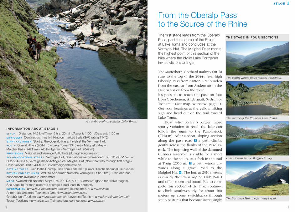
INFORMATION ABOUT STAGE 1
EFFORT Distance: 14.5 km/Time: 5 hrs. 20 min./Ascent: 1100m/Descent: 1100 m DIFFICULT Y Continuous, mostly hiking on marked trails (SAC rating T1/T2). START AND FINISH Start at the Oberalp Pass. Finish at the Vermigel Hut. ROUTE Oberalp Pass (2044 m) – Lake Toma (2345 m) – Maighel Valley – Maighel Pass (2421 m) – Alp Portgeren – Vermigel Hut (2042 m)PROVIS IONS Maighel and Vermigel SAC huts (during hiking season).ACCOMMODATIONS STAGE 1 Vermigel Hut, reservations recommended, Tel. 041-887-17-73 or 062-534-00-35, [email protected]. Maighel Hut (about halfway through first stage): Reservations: 081-949-15-51, [email protected] TING THERE Train to the Oberalp Pass from Andermatt (Uri) or Disentis Sedrun (Graubünden). RETURN FOR DAY HIKES Walk to Andermatt from the Vermigel Hut (2.5 hrs.). Train and bus connections available in Andermatt.MAPS Switzerland National Map: 1:50,000 No. 5001 “Gotthard” (good for all five stages). See page 10 for map excerpts of stage 1 (reduced 15 percent).INFORMATION www.four-headwaters-trail.ch;Tourist Info Uri: www.uri.info;Andermatt-Urserntal Tourismus GmbH:www.andermatt.ch;Graubünden Tourism:www.graubuenden.ch;Leventina Tourism: www.leventinaturismo.ch; Tessin Tourism: www.ticino.ch; Train and bus connections: www.sbb.ch
A worthy goal – the idyllic Lake Toma.
stage 1
The first stage leads from the Oberalp Pass, past the source of the Rhine at Lake Toma and concludes at the Vermigel Hut. The Maighel Pass marks the highest point of this section of the hike where the idyllic Lake Portgeren invites visitors to linger.
The Matterhorn-Gotthard Railway (MGB) runs to the top of the 2044-meter-high Oberalp Pass from canton Graubünden from the east or from Andermatt in the Ursern Valley from the west. It’s possible to reach the pass on foot from Göschenen, Andermatt, Sedrun or Tschamut (see map overview, page 1). Get your bearings at the yellow hiking sign and head out on the trail toward Lake Toma.
Those who prefer a longer, more sporty variation to reach the lake can follow the signs to the Pazolastock (2740 m). After a short, sloping section along the pass road 1 a path climbs gently across the flanks of the Pazolas-tock. The imposing wall of the dammed Curnera reservoir is visible for a short while to the south. At a fork in the trail at Trutg (2056 m) 2 a path winds up-wards along a gravel road to the Maighel Hut 6 . The hut, at 2310 meters, is run by the Swiss Alpine Club (SAC) and offers room and board. But to com-plete this section of the hike continue to climb southwesterly for about 300 meters up some switchbacks through steep pastures that become increasingly
The young Rhine flows toward Tschamut.
The source of the Rhine at Lake Toma.
Lake Urlaun in the Maighel Valley.
The Vermigel Hut, the first day’s goal.
THE STAGE IN FOUR SECTIONS
9
From the Oberalp Pass to the Source of the Rhine
8

Bild: 4_300cmyk_LT_feb10_HGoK_60.jpg
1
1
2
3
4
5 6
8
7
S TA G E 1 > Distance 14.5 km > Time 5 hrs. 20 min. > Ascent 1100 m > Descent 1100 m
2 3 4 5 6 7 8 9 10 11 121km 16 17 18 19 20 212 3 4 5 6 7 8 9 10 11 12 13 14 151km 2 3 4 5 6 7 8 9 10 11 12 13 14 151km
2500 m
1500 m
2000 m
2250 m
1750 m
2500 m
1500 m
2000 m
2250 m
1750 m
2500 m
2000 m
2250 m
2500 m
1500 m
2000 m
2250 m
1750 m
2500 m
1500 m
2000 m
2250 m
1750 m
1500 m
1750 m
16 17 18 192 3 4 5 6 7 8 9 10 11 12 13 14 151km
2500 m
1500 m
2000 m
2250 m
1750 m
Stage 1
2421 mMaighelPass
2042 mVermigel
Hut
2314 mMaighel
Hut
2044 m Oberalp
Pass
Stage 2
2042 mVermigel
Hut
2701 mSellaPass
2375 mSummer-matten
2776 mGiübin
Stage 3
2091 mGotthard
Pass
2522 mLucendro
Pass
2128 mRosso
di Fuori
2015 mRi di
Cavanna
1996 m Ri di
Bedretto
1938 mRi di
Ronco
2182 mAlpe di
Lucendro
1982 mPianseccoHut SAC
Stage 4
2093 mNufenen
road
2440 mNufenen
Pass
2003 mAlpe diCruina
1925 mLadstafel
1762 mHosand
1533 mKittbrigg
1982 mPianseccoHut SAC
1355 mOber-
gesteln
Stage 5
1355 mOber-
gesteln
1368 mOber-wald
1550 mSt Nicholas
chapel
1757 mGletsch
(station steam railway)
2170 mMuttbach
station
2429 mFurkaPass
2271 mHotel
Belvédère
2256 mLake Sella
Source ofthe Rhone
Headwaters of the Ticino
hrs./min. 1/31 > 1/55 > 3/25 > 4/55 > 5/25 > 6/15 > 7/00 >hrs./min. 1/35 > 2/45 > 3/35 > 4/35 > 5/30 > 5/50 > 7/30 > hrs./min. 0/40 > 1/20 > 3/05 > 4/45 > 5/45 > 7/15 >
Source of the Gotthard-Reuss
Source ofthe Rhine
hrs./min. 1/19 > 2/40 > 4/24 > 5/15 >hrs./min. 1/50 > 2/50 > 4/05 > 5/20 >
2091 mGotthard
Pass
162 3 4 5 6 7 8 9 10 11 12 13 14 151km
2345 mLake Toma
Stage 1
2421 mMaighelPass
2042 mVermigel
Hut
2314 mMaighel
Hut
Stage 2
2701 mSellaPass
2776 mGiübin
Stage 3
2522 mLucendro
Pass
2015 mRi di
Cavanna
1996 m Ri di
Bedretto
2182 mAlpe di
Lucendro
1982 mPianseccoHut SAC
Stage 4
2440 mNufenen
road
2003 mAlpe diCruina
1925 mLadstafel
Stage 5
1368 mOber-wald
1757 mGletsch
(steam railway)
2429 mFurkaPass
2271 mHotel
Belvédère
2256 mLake Sella
Source ofthe Rhone
Headwaters ofthe Ticino
Source of theGotthard-Reuss
Source ofthe Rhine
5 hrs. 20 min. 14.4 km >
5 hrs. 15 min. 12.8 km > 7 hrs. 30 min. 20.6 km > 7 hrs. 19.8 km >
2091 mGotthard
Pass
2345 mLakeToma
2044 m Oberalp
Pass
1355 mOber-
gesteln
7 hrs.15 min. 17 km >
1
2
34
5
6
7 1 2
3
45
6 7
1 2
3
4
6
5
7
8
12
3
4
65
1 2
435 6
7
8
FROM THE OBERALP PASS TO THE SOURCE OF THE RHINE stage 1
littered with large boulders and natural stone steps. Up here the invasive nois-es of civilization – namely motorcycle traffi c on the nearby pass road – fade into silence.
After this fi rst, steep ascent the bril-liant waters of a mountain lake tucked in a basin at the foot of the Badus begin to gleam: The Lai da Tuma or Lake To-ma (2345 m), the source of the Rhine 3 . The lake’s Rhaeto-Romansh name re-calls the lake’s features: it’s located be-hind a Tuma or hill – so Lake Hill, if you will.
Those who have the time, strength and will can opt to do an additional loop either along the lake or over the summit on the right to the Badus Hut (2503 m) at the foot of the Pazolastock. A refreshing plunge from a protruding boulder at the back of the lake into the chilly pool is only recommended for the hardiest of hikers.
After taking in a pleasant panoramic view of the upper Surselva and Calmot, behind which loom the Oberalpstock, Tödi and other imposing peaks, two small steps is all you need to cross the young Anterior Rhine which rumbles
through a narrow, steep trough down toward Tschamut through the Plaun Verdastch. (To read more on the name “Tschamut” and early settlements in the valley please see page 42.) Be careful crossing the stream: snow can last well into summer here.
Following a newly built path that re-places the rough descent to the dusty road leading to the Maighel Hut, the trail leads to a sunny saddle (2358 m) 4 above Lake Urlaun. The path then in-
THE “REAL” SOURCE OF THE RHINE
The source of a river is generally considered to be the highest or farthest point (along the river) from its mouth. In the high mountains many nameless streams from various direc-tions all converge in a small lake, which is why the word “headwaters” is often used. Lake Toma was dubbed the source of the Rhine by Placidus A. Spescha (1752-1833), a Benedictine father and a naturalist who made the fi rst ascent of the Badus. If you go by the point farthest from the Rhine’s outlet, the Medelser Rhine would actually be the river’s source since it fl ows through both the Cadlimo and Medel valleys and is a good 5 km longer than the Toma Rhine.
11

tersects the access road just mentioned (2263 m) 5 . A few meters beyond the intersection a trail branches off to the right toward Lolen Pass (Pass Tagliola, 2399 m), and a bit further to the south, a spur trail heads toward the manmade Curnera reservoir.
Stay on the access road that soon ends with a well-beaten, often mucky path that leads into the wide, flat area of the Maighel Valley and its many tad-pole-choked ponds. The valley boasts the typical flora and fauna of a wetland with cottongrass, sedges and yellow-or-ange blossoming saxifrage. The moors are green in summer and spring, yel-low and brown in autumn. In a few
places peat has formed over the centu-ries. (For more on the flora and fauna see page 53).
At the “Piogn Crap” (roughly trans-lated as “Bridge by the Rock”), behold a magnificent masterpiece of nature: a several-meter-deep gorge, narrow at the top, carved by centuries of water flow-ing down from the Maighel Glacier and the Bornengo Pass. It is so narrow at the top that one is almost lured into leaping over it. Later the trail crosses the terminal moraine that the eastern Maighel Glacier left behind after its last advance around 1850.
Soon the trail arrives at another fork at Plaunca Portgera (2374 m) and climbs to the right up to the Maighel Pass (2421 m) 7 , where the idyllic Lake Portgeren twinkles. North American lake trout, brown trout as well as rain-bow trout make this a popular place for anglers. The view spreads to the north with the Portgerenstock, to the south-west over the slopes of the Alp Wilden-matten and up to the Piz Giübin near the Sella Pass. The Maighel Pass marks the end of canton Graubünden and the Rhaeto-Romansh-speaking regions.
Traditionally five dialects of Rhaeto-Romansh are spoken and written in canton Graubünden of southeast Swit-zerland: Sursilvan (in the Anterior Rhine region), Sutsilvan (in portions of the Hinter Rhine region), Surmiran (in the Upper Engadine and Al bula val-leys), Puter (in the Upper Engadine) and Vallader (in the Lower Engadine). In order to create consistency out of the truly different dialects for bureau-cratic matters, a standard dialect called “Rumantsch Grishun” or “Romansh of
THE WAY OF THE RHINE
After a long, 1,230-km journey the Rhine flows into the North Sea near Rotterdam, Europe’s largest port. Along the way, many tributaries transform the feisty little stream at Lake Toma into a wide river that has become the most heavily used waterway in Europe. At Reichenau/Tamis the Anterior and Hinter Rhine join together to form the so-called Al-pine Rhine, which flows into Lake Constance. From there it becomes the High Rhine until Basel, with the Aare River flowing into it at Koblenz. After Basel, the river is known as the Upper Rhine, which runs to Bingen, Ger-many, and is joined by the Neckar and Main rivers along the way. From there the river be-comes the Middle Rhine until Bonn, a stretch joined by the Lahn and Mosel rivers that flows around the mythical Loreley cliff near St Goarshausen. Finally the wide and placid Lower Rhine begins after Bonn, flowing through the north German lowlands and forming the Rhine-Meuse Delta at the Ger-man-Dutch border. It then eases through a large natural region to spill into the North Sea near Rotterdam.
FROM THE OBERALP PASS TO THE SOURCE OF THE RHINE stage 1
Graubünden” was developed and has been used as the official dialect since 2001. On the way from the Oberalp Pass to the Maighel Pass, one can learn a few words of Sursilvan: plaunca (slope or flank), piogn (catwalk-like bridges often running along the sides of cliffs), trutg (mountain path), crap (rock or crag).
The route then zig-zags along a path (that’s also an official mountain bike trail) over alpine meadows, past ponds and down to a bridge over the Unteralp Reuss river (1978 m). A short but steep climb brings you to the goal for the day, the Vermigel Hut (2042 m) 8 . which can sleep 40 people. DAY HIK ING This section can be done as a day hike by wandering down through
the tranquil Unteralp Valley for a good 2.5 hours to reach Andermatt. Watch for chamois on the eastern slopes of the Gafallengrat and the Gurschenstöckli, particularly during mornings and eve-nings. On the right you’ll probably see marmots with their shrill whistles. To avoid bike and vehicular traffic, you can cross the Unteralp Reuss near Heu-plangg and wander through lonely meadows, passing a rest area, to reach the center of Andermatt directly. Save a little energy for a visit to the Mariahilf Chapel above the village. After a hard winter in 1720 the priest is said to have attached a picture of the Virgin Mary to a tree. The townspeople started to put their faith in this small wayside shrine and in 1724 build a chapel there.
Scheuchzers cottongrass, a common wetland plant.
Lake Toma, or Lai da Tuma in Rhaeto-Romansh, at the base of Piz Badus, means “lake behind the hill.”
Shy marmots are always around.
1312