Assessing Your Strengths 2013 Assessing Your Strengths 2013.

1
A Field Guide for Assessing the Passability of Man-Made River Structures by European EelsOctober 2018

2 3
IntroductionThere have been considerable declines (90-95% based on best available data) in European eel (Anguilla anguilla) recruitment across large extents of its geographical range since the 1980s. It is thought that barriers to upstream migration resulting in a reduction in accessible habitat are one of the threats that are preventing eel stocks from recovering.
It is important that the passability of structures is assessed so that any migration barriers can be eliminated and conservation benefits maximised. This guide aims to provide a simple way to do this and to facilitate information gathering about structures in rivers. This information can be used to feed into prioritisation exercises on a catchment-wide scale that would see the most significant barriers to eel migration addressed first.
Supported by
AcknowledgementsZSL would like to thank Disney Conservation Fund for funding the production of this field guide to assessing barriers to European eel migration. Our thanks go to Darryl Clifton-Dey of the Environment Agency for his advice and good humour throughout; to all those who attended the March 2018 workshop at ZSL London Zoo in spite of the snowy ‘Beast from the East’; to those who trialled the field guide; and to all those who provided feedback to help improve and shape the assessment tool. This includes our partners and contributors at the Environment Agency, University of Southampton, Institute of Fisheries Management, Westcountry Rivers Trust, Natural History Museum, Thames Estuary Partnership, The Rivers Trust, South East Rivers Trust, and Groundwork; and Kristen Steele, Adam Piper, Matthew Gollock and David Solomon.

4 5
How to Use this GuideHere a step-by-step guide is provided to help the user record basic parameters of a structure and its environment from the bankside that can be used to coarsely determine passability for eels. This field guide is designed to provide an eel-specific assessment methodology in an accessible format that can be used by NGOs, regulators and consultants alike.
The audience for the field guide is primarily based in England, for whom the relevant authority is the Environment Agency. The Environment Agency is responsible for implementing and enforcing the European Council Regulation No 1100/2007 and the Eels (England and Wales) Regulations 2009. The European Council Regulation sets targets for the recovery of European eel stocks and requires the development of management plans to improve eel stocks, and the Eels Regulations gives the Environment Agency the powers to take action. Although there is an England-focus, the guide has relevance across the UK and other eel-range countries and the appropriate authority for the area should be consulted accordingly. Early engagement with the relevant authority is recommended to avoid duplication of barrier assessments, or so that new assessments could take account of and build upon earlier ones.
This guide does not attempt to provide a detailed assessment of the degree of impact of each barrier and should not be used as an indicator of eel presence/absence upstream of a structure. It is instead a guide to assess likely passage difficulty and will help focus future resource allocation. Detailed notes, sketches and photographs can help reduce subjectivity and assist with future prioritisation exercises. It is also expected
that in determining any site-specific eel passage solution e.g. eel pass installation, further expert in-channel technical assessments would be carried out.
The assessment should take approximately 15 minutes per barrier to complete, depending on the complexity of the structure and site.
It is recommended that initial assessments are made during the period of upstream eel migration (March – September inclusive). Assessments should not be made during or after heavy rainfall. For tidal barriers, it is recommended that two assessments are carried out, one at low tide and one at high tide. Further assessments could be made during the autumn months to assess the structure during the period of downstream silver eel escapement.
The barrier assessment tool comprises a series of questions about the site and the structure, notably slope, length and velocity. The answers to these questions produce an overall score - the higher this score is, the more passable the structure is likely to be. To assist the user in their assessments, an overview of key aspects of eel ecology and behaviour in the freshwater environment is provided at the outset. Once the user has read these sections of the field guide, they should then systematically work through the assessment tool questions and complete their answers on the results form (available to download and print from zsl.org/eels). We recommend that the print-out results form is used to record answers, rather than the field guide itself, so that the user can print as many results forms as required (one form per barrier assessment) and continue to use the field guide for multiple sites.
The questions are orientated towards weirs; however, there is still the opportunity to capture key information about different types of barriers (e.g. culverts, bridge footings and sluices) such as slope, velocity and length of structure.
At the end of the field guide there is also a section that includes factors to consider that could inform future catchment-wide prioritisation exercises (such as distance from the tidal limit and the proximity of other barriers) as well as an options appraisal section for eel passage solutions.
Recommended Equipment• Copy of field guide and results form.
• Ranging pole (useful as a scale in photographs but not essential).
• Tape measure, stopwatch and suitable float, such as a piece of orange peel.If conditions (of both the site and the river) are appropriate, it may be possible to use the float method to provide a coarse indication of water speed.To do this, measure out a specific distance (5m for example) and record the time it takes for the float to travel this distance in the water. Ideally, this would be carried out over the slope of the structure itself where velocity would be at its maximum. Velocity immediately downstream of the structure would also be useful to measure too (the ‘approach

6 7
velocity’) if it is not possible to measure over the slope. Otherwise, if neither of the above are possible, measure velocity as close to the structure as you can. There is a section in the assessment table to note down where velocity is recorded from.Alternatively, it may be possible to assess the speed at which bubbles or another object in the river is moving through the water compared with the assessors walking/jogging pace.
• Camera or mobile phone (waterproof case).A minimum of three photographs of the obstacle with an upstream, a downstream, and a side view, and of any specific features of interest (such as crawling media) would be most useful. A record of the number of photographs and a clear reference label should be noted down for future reference. It is also helpful to include an item for scale in photographs, such as a ranging pole.
• First aid kit.
• Personal protective equipment such as lifejackets, throw ropes and suitable footwear.
• Weather-appropriate clothing and equipment, such as waterproofs, hat, and/or sun-cream.
• Provisions for basic biosecurity measures, such as boot brushes. Refer to nonnativespecies.org/checkcleandry for further information.
Health and Safety• Rivers and particularly modified systems
with structures such as weirs can present a significant health and safety risk.
• To minimise such risks, this guide has been specifically designed for bankside working only. It is not recommended that any user of this guide enter the watercourse.
• Before fieldwork, risks associated with the structure and site should be fully assessed and managed. Risks should continue to be assessed whilst at the site and if it is deemed not safe to continue work, the barrier assessment should be stopped.
• Users of the guide must not work alone, with assessments being made in at least pairs.
• It is important to not make observations of structures during or after periods of heavy rain which could raise river levels and obscure structures. This would not only increase the health and safety risks but could also distort assessments.
• Where a structure is located within private land, landowner permission should be sought before any site visit.
European Eels in FreshwaterGlass eels (yet to develop pigmentation) enter estuarine systems through both active and passive migration, and some actively move into freshwater habitats to mature. In the UK, this first period of active upstream migration into freshwater habitats is generally early spring to late summer, when water temperatures are warmer (10-15°C).
Some eels may continue to migrate within the freshwater environment over the course of their lives. After the first year or two, two behavioural strategies are apparent: home-range dwellers (establish in a given area for a number of months or years) and nomads (shift within and between water bodies, including fresh and saline environments).
Different sized eels are found in different areas of a river. You would typically find highest densities closer to the tidal limit and the population structure dominated by elvers and small eels but still a variety of sizes. As a general rule, the maximum elver (defined as eels in their first year from arrival on European coasts and estuaries, typically no larger than 120mm in length) range into freshwater rivers is 30km from the tidal limit. In the upper reaches of rivers, the majority of the population would be larger size classes (>300mm). Intertidal or estuarine barriers (at the interface between freshwater and marine environments) are considered a driver of density-dependent mortality in
Life stages of the European eel. A = glass eel, B = elver (pigmented), C = yellow eel and D = silver eel (source: A-C–Zoological Society of London, D–Chris Gardner, South East Rivers Trust)
A
C
B
D
8 9
juvenile life stages by restricting the amount of accessible habitat which leads to an accumulation of eels downstream.
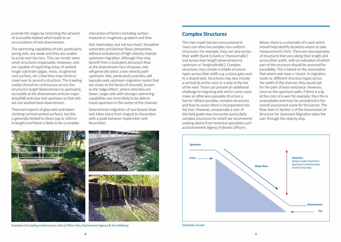
The swimming capabilities of eels, particularly young eels, are weak and they are unable to jump over barriers. This can render even small structures impassable. However, eels are capable of exploiting areas of wetted rough substrate (algae, moss, roughened rock surface, etc.) that they may climb or crawl over to ascend a structure. The crawling media should be continuous across the structure’s length (downstream to upstream), accessible at the downstream end (no major drop/fall) and clear exit upstream so that eels are not washed back downstream.
There are reports of glass eels and elvers climbing vertical wetted surfaces, but this is generally limited to elvers (up to 120mm in length) and there is likely to be a complex
interaction of factors including surface material or roughness, gradient and flow.
Eels need water, but not too much. Smoother substrates and laminar flows (streamline, without turbulence) of high velocity impede upstream migration. Although they may benefit from a turbulent attractant flow at the downstream face of passes, eels will generally select a low velocity path upstream. Eels, particularly juveniles, will typically seek upstream migration routes that are closer to the banks of channels, known as the ‘edge effect’, where velocities are lower. Larger eels with stronger swimming capabilities are more likely to be able to travel upstream in the centre of the channel.
Downstream migration of sea-bound silver eels takes place from August to December, with a peak between September and November.
Elver climbing a wetted vertical structure with some crawling substrate present, located at Knapp Mill, Hampshire Avon (source: Chris Gardner, South East Rivers Trust)
Examples of crawling media (source: Darryl Clifton-Dey, Environment Agency & Tom Bellamy)
Head loss (drop in water level from upstream to downstream at time of survey)Water flow
Downstream
Upstream
Crest
Toe
Complex StructuresThe man-made barriers encountered in rivers can often be complex non-uniform structures. For example, they can vary across their width (bank to bank or ‘transversally’) and across their length (downstream to upstream or ‘longitudinally’). Complex structures may contain multiple structure types across their width e.g. a sluice gate next to a sloped weir. Structures may also include a vertical lip at the crest or a step at the toe of the weir. These can present an additional challenge to migrating eels and in some cases make an otherwise passable structure a barrier. Where possible, complex structures and how to assess them is incorporated into the tool. However, occasionally a user of this field guide may encounter particularly complex structures for which we recommend seeking advice from technical specialists such as Environment Agency Fisheries Officers.
Below, there is a schematic of a weir which should help identify locations where to take measurements from. There are also examples of structures that vary along their length and across their width, with an indication of which part of the structure should be assessed for passability. This is based on the assumption that where eels have a ‘choice’ in migration route i.e. different structure types across the width of the channel, they would opt for the path of least resistance. However, once on this upstream path, if there is a lip at the crest of a weir for example, then this is unavoidable and must be considered in the overall assessment score for the barrier. The flow chart in Section 1 of the Assessment of Structure for Upstream Migration takes the user through this step by step.
Schematic of weir

10 11
Owner and purpose of structure (if known)
How is structure accessed
Photographs(Number of and reference)
Time of assessmentPlease be as accurate as possible as this information could be used later to determine the tidal state.
Is weir overtopped at high tide?
If a tidal barrier, indications of tidal state (Ebb/Flood/Slack Water)For example, rising or falling tailwater levels (water level downstream of structure) during assessment period.
Site Information
Name of site
Assessors’ names
Catchment
Date of assessment
Proximity to tidal limit (km)
National grid referenceAt least 8 figures e.g. SD 1234 5678.
Data Collection
Example of multiple structure types along the width of the River Lea
Assess this; slope rather than sluice gates
Example of multiple structure types along the width of the river (source: Darryl Clifton-Dey, Environment Agency)
Assess this; steps rather than sluice gates
Example of varying longitudinal slope. Note additional vertical drop (lip) at the crest of the weir

12 13
Structure Description
Notes
Plan of site
Consider whether there are any environmental conditions that may affect the results of the day’s assessment. For example, if it is not possible to survey during normal flow conditions for eel migration, record this here and how it might affect the assessment.
Type of man-made structure Tick all applicable options.
Answer
Weir
Dam
Culvert
Sluice
Ford
Tidal Flap
Bridge Footing
Structure material Tick all applicable options.
Answer
Concrete
Wood
Rock
Metal
Other Include a description here.
Estimates of dimensions (Estimate by eye from the bankside)
Answer
Width of channel immediately downstream of structure (metres)
Width of structure (metres)
Total wetted width (areas of water) at crest of structure (metres)
Depth of water over crest of structure (metres)
Head loss (difference in upstream to downstream water level) (metres)
Assessment of Structure for Upstream MigrationSection 1This flow chart is designed so that the least limiting transversal section of a structure (across the river’s width) is assessed but that the most limiting features on the longitudinal section of a structure (downstream to upstream) are assessed.
This assumes that where multiple structures exist across a river’s width (i.e. fixed crest weir next to sluice gate), eels migrating upstream would utilise the easiest path where possible. However, if a lip at the crest or step at the toe of a weir slope is encountered i.e. the slope does not meet the upstream and/or downstream water level because of another impediment, then this needs to be accounted for in the assessment as it presents a greater challenge for eels.
Are there multiple structures across the width of the river i.e. bank to bank?
Is there a slope that meets downstream water level?
Is there a step? Assess this part of the structure in Section 2
Assess this part of the structure in Section 2
Go to Section 2
Is there a gate? Assess this part of the structure in Section 2
What are the multiple structures? List below.Assess each structure type in turn in Section 2, and choose the highest scoring structure for your overall barrier assessment score
Yes
Yes
Yes
Yes
No
No
No
No
Notes

14 15
Is there a continous path of crawling media over the structure?
Crawling media is a wetted rough substrate (such as algae, moss, other vegetation, roughened rock, decaying wood, etc.) that eels can climb or crawl across. This crawling media must be uninterrupted across the structures length (downstream to upstream). Image source: Chris Gardner, South East Rivers Trust.
Yes No
3 0
If yes, assume barrier is passable to elver
What is the approximate slope of the structure?
<1 in 4 1 in 4 – 1 in 1 >1 in 1 Variable e.g. stepped, lip at crest or step at toe
4 2 1 1
Sub Total
Sub Total
Section 2Please circle the score for the most appropriate answer to each question
1 in 4 1 in 1 1 in 0
Stepped
Step at toe
Lip at Crest Example of stepped structure
What is the approximate length of the slope? This applies to the slope across the whole structure, downstream to upstream.
If it is stepped, count the number of steps and record as a note here:
0-2m >2-6m >6-9m ≥10m
4 3 2 1
Sub Total
Notes
Are there are any features of the structure that would obstruct downstream migration, such as pumps or mechanical features that could cause physical harm to eels? Does the flowing water fall onto a hard or rocky bed that could inflict physical damage on the eels and impede further downstream migration?
Escapement Potential – Passability Assessment for Downstream Migration
Score Range
10-15 Unlikely to represent a major barrier to upstream migration
05-09 Partial impact, obstacle may impede passage
<05 Likely to be a complete obstacle to eels migrating upstream
Is the structure assumed to be passable to elver, yes or no?
What is the total passability score?
What is the approximate velocity over the slope?
If using the float method
Very low (<0.5m/sec) Low (0.5m-1m/sec) Medium (>1m-2m/sec) High (>2m/sec)
If using the pacing method
Slow walk Walking Jogging Running Sub Total
4 2 1 0
Where is velocity recorded from?

16 17
Prioritisation: Catchment-Based ApproachOnce multiple structures have been assessed within a single catchment and if a number of structures are shown to present a barrier to eel migration, the following list of factors to consider will help prioritise and focus efforts on a catchment-wide scale. The more detailed the assessment of the structures in terms of passability, the more valuable the prioritisation exercise will be.
Factors to Consider NotesStructure overtopped at high tide Structures that are overtopped during high tides can still be a high priority,
if they do so infrequently
Distance from the tidal limit Highest priority to those impassable structures closest to the tidal limit
Habitat availability upstream of barrier Highest priority to those structures for which eel passage would open up larger amounts of upstream habitat
Structures in close proximity upstream or downstream of the barrier
Lower priority to barriers with other impassable barriers upstream and/or downstream nearby, unless there are plans in the foreseeable future to also put in eel passage facilities at those structures
Alternative routes around the structure Higher priority should be given to impassable structures for which alternative routes (channels) around the catchment do not exist
Original purpose and current use of the structure
For example, consideration should be given if it is a gauging weir
Next Steps: Eel Passage FacilitiesThe following sections provide the user of the field guide with some basic but key considerations for eel passage solutions, which should assist with the next steps after barrier assessment. If further technical support is required, links are provided at the end of the guide.
Design Fundamentals• From the perspective of migration facilitation and overall river health, removal of the
structure as a whole is likely to be the preferred option. It is advised that this option be considered first for all barriers to eel migration and if for unavoidable reasons this is not a feasible option, then alternative solutions to eel passage can be sought.
• The design of eel passage facilities is highly site-specific; there is not one solution that fits all. However, on the basis of the ecology and behaviour of eels in freshwater there are some basic design considerations to bear in mind. Special consideration will be required for gauging structures and those that impact flood management – this is likely to restrict the eel pass types that can be considered.
• The majority of upstream migration is observed in the spring and summer months, therefore any eel pass must be effective during typical spring and summer flows for the site. Knowledge of water level conditions is essential to avoid eel passes being left high and dry (perching).
• Within the eel pass itself, crawling media should be provided with a small amount of water flowing down it. A lateral slope will be required for most gravity-fed (rather than pumped) passes to encourage water to flow down it. However, the slope angle will need to not be so steep that it creates velocities too high for eel passage (see further comment below).
• The eel pass should be designed to accommodate the size(s) of eel most likely to use the facility; different sizes of eel will benefit from different media in terms of size and spacing. The most commonly encountered substrate type is bristle substrate; however these can be eroded by sediment/trash transport in gravity-fed passes. Where bristle boards are used, there should be no gaps where eels can become trapped. Eel Pass Tiles can allow passage of all size ranges and are relatively robust.
• The design should ensure that the pass runs from the downstream river bed up and over the crest of the barrier and then beyond it far enough i.e. bed to bed to prevent eels being immediately washed back downstream.
• The velocity within and on the approach to the pass is also critical. Whilst some attractant flow is beneficial, if the downstream end of the pass is in too turbulent water, then the eels will not be able to use it. Consider also when siting the pass that eels will exploit edge effects during upstream migration.
• The design will need to balance gradient of the pass (shallow to keep water velocity low) with length of the pass. Consider if there are jumps or steps in the weir, or if there would be under low or high flow conditions.
• Protection from predators, direct sunlight and winds is occasionally important. Although, the large majority of migrations occur in hours of darkness. If a cover is installed over the eel pass, hinges and perforations can make future inspections easier.
• Facilities to monitor the effectiveness of the pass and gather data about eel populations in the catchment could be incorporated into the pass where possible, for example through a trap. If a trap is included, the surveyor can release the eels upstream at a suitable location to prevent washing down. Note, advice and permit(s) should be sought from the relevant authority beforehand.

18 19
Schematic of a typical eel trap, supplied with water by gravity, used by Zoological Society of London in the citizen science eel monitoring project (source: Zoological Society of London)
Weir
Trap
Water supply pipeEel ‘ladder’ lined with bristle crawling media
Water flow
Photographs of eel trap (source: Environment Agency and Zoological Society of London)
Options AppraisalEel pass types could be:
• Open or covered
• Gravity-fed or pump-fed
• With bristle, stud or other media
• With or without lateral slope
• Made of a fabricated channel (aluminium for example) or in-situ channel (cast in concrete for example)
• With or without a monitoring facility
Here are three types of eel pass commonly used (which broadly fall into two categories – gravity-fed and pumped) to provide the field guide user with an idea of the options available for eel passage facilities. However, expert advice is essential and this is particularly in the case of complex sites with a variety of different obstructions and challenges for migrating eels.
• Future access and maintenance is a legal requirement (Eel Regulations 2009, Part 4, Regulation 15 (1) (2)). Simple, low maintenance yet robust designs are best; points where debris could snag should be avoided for example.
Type Pros ConsBasic climbing substrate attached to the weir
Source: Environment Agency
Low cost
Easy to fit
Can suffer from predation
Need to maintain sufficient flow over the substrate for the migration period

20 21
Type Pros ConsOpen conduit, filled with climbing substrate and fed from upstream under gravity
Source: Zoological Society of London. Eel pass designed by Fishtek Consulting Ltd
Sometimes these passes consist of eel substrate positioned vertically against a wall
Very useful for carrying eels over difficult lips/steep areas on a weir
Often don’t require much maintenance
Can be modular; constructed off-site and fitted in sections
Can have a V-shape profile to work in a variety of flow conditions
Very reliant on a flow of water from upstream, which can become blocked or can flood the pass under very high flows
Open conduit filled with climbing substrate and fed with water through a pump
Source: Environment Agency
The pump could be needed because either the pass is some distance away from the river, is on a section of the weir that does not have a permanent flow, or if the flow over the weir is being accurately gauged
Very useful for carrying eels over difficult lips/steep areas on a weir
Allow the pass to be built anywhere on, over or around the obstruction
As the pumped flow is constant, they operate across a very wide range of river conditions
Pumps are a high maintenance option that must run continuously, require regular checking and often repairs; should only be considered if the site is visited regularly. Use of gravity instead is a much more desirable and sustainable option where possible
Links for Further Technical SupportBelow are some key reference documents for technical support. A more comprehensive list of references for this field guide can be found in Appendix A.
• Environment Agency Eel Manual, Eel and Elver Passes: Manual for the Design and Implementation of Passage Solutions, and Monitoring Eel and Elver Populations Available online: gov.uk/government/publications/eel-and-elver-passes-design-and-build
• Manual for Provision of Upstream Migration Facilities for Eel (Solomon and Beach, 2004) (available online)
• River Weirs – Good Practice Guide by Charles Rickard, Rodney Day and Jeremy Purseglove (available online)
• Resources (including the Barrier Tracker App) available on the AMBER website: amber.international/about/
ContactIf as you read and use this field guide, you have queries or suggestions for improvement, please get in touch at [email protected] This field guide is a first edition and we hope to develop the eel barrier assessment tool in the future.
22 23
Appendix A: Evidence Base for the Field Guide Anwar, Z. (2018) Effect of substrate roughness, slope, and body size on climbing behaviour and performance of juvenile American eels (Anguilla rostrata). Environmental and Water Resources Engineering Masters Projects 1-31.
Baudoin, J. M., Burgun, V., Chanseau, M. , Larinier, M., Ovidio, M., Sremski, W., Steinbach, P. and Voegtle, B. (2014) The ICE Protocol for Ecological Continuity: Assessing the passage of obstacles by fish – concepts, design and application. ONEMA 1-200.
Bornarel, V., Lambert, P., Briand, C., Antunes, C., Belpaire, C., Ciccotti, E., Diaz, E., Diserud, O., Doherty, D. Domingos, I., Evans, D., de Graaf, M., O’Leary, C., Pedersen, M., Poole, R., Walker, A., Wickstrom, H., Beaulaton, L. and Drouineau, H. (2017) Modelling the recruitment of European eel (Anguilla anguilla) throughout its European range. ICES Journal of Marine Science 75(2): 541-552.
Environment Agency Elver and eel passes: A guide to the design and implementation of passage solutions at weirs, tidal gates and sluices. The Eel Manual – GEHO0211BTMV-E-E.
Feunteun, E., Laffaille, P., Robinet, T., Briand, C., Baisez, A., Olivier, J. M. and Acou, A. (2003) A review of upstream migration and movements in inland waters by Anguillid eels: toward a general theory. Chapter 14: Movements in Freshwater Habitats. In: Aida, K., Tsukamoto, K. and Yamauchi, K. eds. Eel Biology. Tokyo: Springer-Verlag, pp. 191–213.
Gardner, C. (2018) River Rother Catchment Eel Barrier Assessment Report (draft version). South East Rivers Trust.
Harrison, A. J., Walker, A. M., Pinder, A. C., Briand, C. and Aprahamian, M. W. (2014) A review of glass eel migratory behaviour, sampling techniques and abundance estimates in estuaries: implications for assessing recruitment, local production and exploitation. Reviews in Fish Biology and Fisheries DOI 10.1007/s11160-014-9356-8.
Jacoby, D. and Gollock, M. (2014) Anguilla anguilla. The IUCN Red List of Threatened Species 2014: e.T60344A45833138. http://dx.doi.org/10.2305/IUCN.UK.2014-1.RLTS.T60344A45833138.en. Downloaded on 14 May 2018.
Jellyman, P. G., Bauld, J. T. and Crow, S. K. (2017) The effect of ramp slope and surface type on the climbing success of shortfin eel (Anguilla australis) elvers. Marine and Freshwater Research 68: 1317-1324.
Kemp, P. S. and O’Hanley, J. R. (2010) Procedures for evaluating and prioritising the removal of fish passage barriers: a synthesis. Fisheries Management and Ecology 17(4): 297-322.
Kerr, J. R., Karageorgopoulos, P., and Kemp, P. S. (2015) Efficacy of a side-mounted vertically oriented bristle pass for improving upstream passage of European eel and river lamprey at an experimental crump weir. Ecological Engineering 85: 121-131.
Laffaille, P. , Caraguel, J. M. and Legault, A. (2007) Temporal patterns in the upstream migration of European eels (Anguilla anguilla) at the Couesnon estuarine dam. Estuarine, Coastal and Shelf Science 73: 81-90.
McCleave, J. D. (1980) Swimming performance of European eel (Anguilla anguilla (L.)) elvers. Journal of Fish Biology 16(4): 445-452.
Piper, A. and Wright, R. (2017) Evidence: Understanding fish and eel behaviour to improve protection and passage at river structures. Extended Summary – SC120061. Environment Agency.
Piper, A. T. (2013) Quantifying the movement and behaviour of migratory European eel (Anguilla anguilla) in relation to physical and hydrodynamic conditions associated with riverine structures. University of Southampton, Faculty of Engineering and the Environment, Doctoral Thesis, 231pp.
Piper, A. T., Wright, R. M. and Kemp, P. S. (2012) The influence of attraction flow on upstream passage of European eel (Anguilla anguilla) at intertidal barriers. Ecological Engineering 44: 329-336.
Porcher, J. P. (2002) Chapter 10: Fishways for Eels. Bulletin Francais de la Peche et de la Pisciculture 364: 147-155.
Rickard, C., Day, R. and Purseglove, J. (2003) River Weirs – Good Practice Guide. Published by the Environment Agency.
Quintella, B. R., Mateus, C. S., Costa, J. L., Domingos, I. and Almeida, P. R. (2010) Critical swimming speed of yellow- and silver-phase European eel (Anguilla anguilla, L.) Journal of Applied Ichthyology 26(3): 432-435.
Sandlund, O. T., Diserud, O. H., Poole, R., Bergesen, K., Dillane, M., Rogan, G., Durif, C., Thorstad, E. B. and Vollestad, L. A. (2017) Timing and pattern of annual silver eel migration in two European watersheds are determined by similar cues. Ecology and Evolution 7: 5956-5966.
SNIFFER (2010) WFD111 Phase 2a Coarse resolution rapid-assessment methodology to assess obstacles to fish migration 2010 [Manual].
Solomon, D. J. and Beach, M. H. (2004) Fish pass design for eel and elver (Anguilla anguilla). Environment Agency R&D Technical Report W2-070/TR.
Solomon, D. J. and Beach, M. H. (2004) Manual for provision of upstream migration facilities for eel and elver. Environment Agency Science Report SC020075/SR2.
Solomon, D. J. (2010) Fish passage on the River Wandle. Environment Agency Report, Thames Region.
Solomon, D. J. and Clifton-Dey, D. (2010) Passage of elvers and small eels in lower Thames tributaries. Environment Agency Report, Thames Region.

24
zsl.org