A decade of Wireless Sensor Network research - Are we...
33
A decade of Wireless Sensor Network research - Are we there yet? Prof. Sanjay Jha School of Computer Science and Engineering University Of New South Wales [email protected] http://www.cse.unsw.edu.au/~sanjay
Transcript of A decade of Wireless Sensor Network research - Are we...
A decade of Wireless Sensor Network research - Are we there yet?
Prof. Sanjay Jha School of Computer Science and Engineering
University Of New South Wales
[email protected] http://www.cse.unsw.edu.au/~sanjay

2
The Push: Technological Advances
• Moore’s law: # of transistors on a cost effective chip doubles every year or two – To continue for next 10/20 years
• Miniaturised energy capacity – In last 20 year AA Nickel Alkaline battery from
0.4 to 1.2 Ah with fast recharging
• System on a chip (SOC) integration – Computing, storage, communications, sensing
and energy storage on a cubic millimeter

History of WSN
• 1999: Kahn, Katz,Pister: Vision for Smart Dust
• 2002 Sensys CFP: Wireless Sensor Network research as being composed of ”distributed systems of numerous smart sensors and actuators connecting computational capabilities to the physical world have the potential to revolutionise a wide array of application areas by providing an unprecedented density and fidelity of instrumentation”.

ACM Sensys Word Cloud

What did we learn?
• Data: Do scientists need data aggregation? • Assumptions: All nodes and their operation
are not homogeneous? • How many deployments are random? • Can we provide a reliable network in the
wild? (We do have lots of reliable solutions in papers :)
What Next?
• Smart Dust or Smart Rock? • Battery Power – Still a problem. • Security: Can we take a clean slate
approach? • Update and Maintenance – non CS/EE
operators
7
The Pull: Applications
• Environment and habitat monitoring • Precision Agriculture • Indoor climate control • Military surveillance • Intelligent alarms • Structural Monitoring • Condition based equipment maintenance • Medical diagnostics • …………….

8
The Australian Context
Biodiversity Monitoring Bushfire management
Coastal monitoring
The Tyranny of Sparsity!

Sample Research Projects
• Monitoring • Localisation • Tracking • Participatory Network • Newer Areas:
– Flying Networks – Cluttered Environment (Oxford)
• Outreach • What next?

10
Experimental Research Focus
• Impossible to model real-world phenomena such as: – RF propagation vagaries (packet loss, channel
delays) – sensor calibration issues
• Measurements always difficult, but always necessary
• Building prototypes/doing experiments – often exposes limitations/serious deficiencies
with existing solutions – great source of new research problems!

11
Environmental Monitoring Study

12
Example: Cane Toad Monitoring
“Cane toads will progressively shell shock an unsuspecting Kakadu environment, in particular they will come close to wiping out native quoll populations, poison large masses of goannas and disturb the food supply of many native animals.”

13
Detecting Frogs by Their Calls • Acoustic features can be used to distinguish the
vocalizations of different amphibians. (call rate, call duration, amplitude-time envelope, waveform periodicity, pulse-repetition rate, frequency modulation, frequency and spectral patterns.) Frog 1
Frog 2
Frog 3 (Cane toad)
Waveform Figures of Three Different Frogs’ Calls

14
Results: Successful Detection
• Screenshots

15
REKF Localization: Localization Using Mobile Robots
Localizing static motes using mobile robots combining RSSI readings with acceleration measurements (~0.3m – 1m accuracy)
NICTA&UNSW

Narrowband Signal LFM Chirp Signal
Auto-Correlation
Frequency: 20kHz Time-period: 1sec
Frequency Span: 20-40kHz Time-period: 1sec
Adjacent Peaks have Nearly Equal Heights
Correct Peak Detection
Significant Sidelobe Reduction with respect to the Correlation Peak
Difficult Easy
Location Accuracy
Acoustic Chirp Based Localisation

17
Detection and Tracking

Tracking Results���

Wisec’08. Secure Multi-hop Network Programming with Multiple One-way key chains���
Secure Network Programming
Base station
2 2
2
1
1
1 1
1
2
M
M
M
M
M
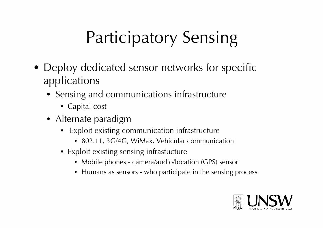
Participatory Sensing
• Deploy dedicated sensor networks for specific applications • Sensing and communications infrastructure
• Capital cost
• Alternate paradigm • Exploit existing communication infrastructure
• 802.11, 3G/4G, WiMax, Vehicular communication
• Exploit existing sensing infrastucture • Mobile phones - camera/audio/location (GPS) sensor • Humans as sensors - who participate in the sensing process

Research Challenges • How to effectively sample the environment to
reconstruct the ground truth • Quality of information
• Missing data/Sparse or insufficient data • Redundant data
• Legality and reliability of data • Security and privacy • System design

Example Application:���Consumer sharing of commodity prices

HazeWatch • Urban air pollution:
– Causes adverse health effects such as respiratory infections, lung cancer, heart disease
– Responsible for 2.3% of deaths in Australia each year, and costs NSW $4.7 billion per year
– Currently measured at only 12 locations in Sydney area
• Objective: – Map urban air pollution at fine
spatial resolution – Accurately estimate personal
exposures – Relate personal exposures to
health outcomes
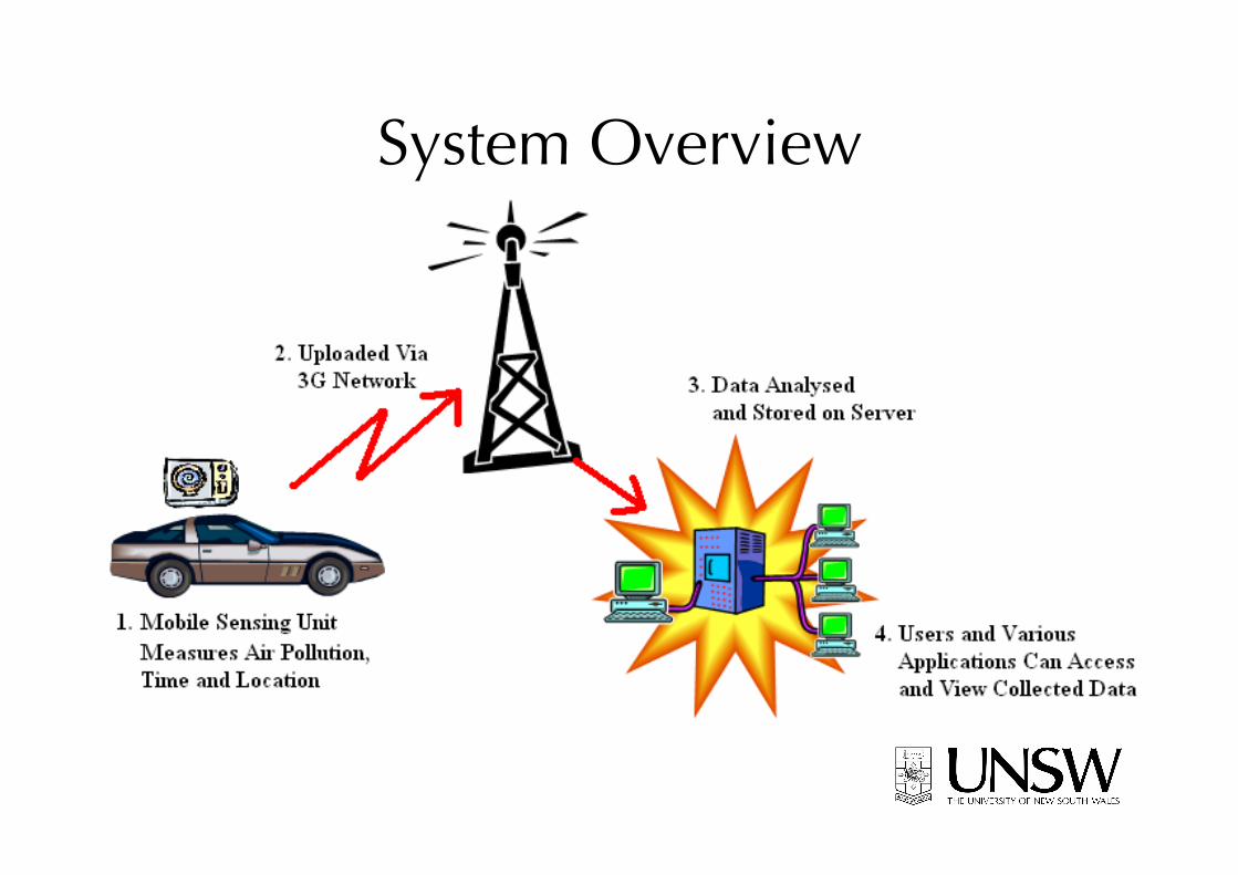
System Overview

Pollution Monitoring Hardware • Gas sensors: NO2, CO, O3 • Microcontroller: ADC, processing • Bluetooth: transmission to mobile phone • Mobile phone: time/geo-stamp pollution data,
upload to database server

Real-Time Pollution Map
Can be seen live at: http://pollution.ee.unsw.edu.au/

Personal Exposure Tool (iPhone) • Records your location as
you move about • Displays:
• Route • Plot of exposure to each
pollutant (and WHO level)
• Mean exposure to each pollutant
• Will aid medical study correlating exposure to health outcome
Flying Networks
• ARC Funded Project to start in 2011at UNSW (Jha, Kanhere and Welsh) – developing an understanding of the wireless
communication characteristics between mobile aerial vehicles
– exploiting multiple frequency channels for data collection and
– ensuring adequate energy efficient coverage of events being monitored.

Quadracopter Prototype • Various payload capacity (up to 500gm),
flying time, motor, wings (hexa..). – We plan to put our own sensor nodes as
payload for experiments – Collaboration with Harvad Robobees Project
(Welsh)

Underwater Robotic Network
Work done at Oxford by former PhD Student Sarfraz Nawaz et al

SEEDLING
• Showcase the use of information and communication technology such as wireless sensor networks (WSNs) to high school students, in order to increase their interest in the field of science and technology, using the left-over equipment from research projects at universities.
http://cgi.cse.unsw.edu.au/~sensar/seedling/Seedling.html

Outreach: Kings School Deployment
Prasant deploying Hop-2 Node
33
Acknowledgement
• Funding: ARC, CSIRO, DSTO, NICTA, SIT-CRC, UNSW
• Collaborators: Bulusu (PSU), Chou (UNSW), Corke (QUT), Hu (CSIRO), Kanhere (UNSW), Ostry (CSIRO), Pathirana (Deakin), Savkin & Sivaraman (EET/UNSW), Zic (CSIRO)
• Details on projects and publications can be found at http://www.nrl.cse.unsw.edu.au


![[PPT]PowerPoint Presentation - IEEEewh.ieee.org/r10/calcutta/comsoc/Lecture/200407/ppb.pps · Web viewAccurate field measurement should be made in urban area and the measured data](https://static.fdocuments.us/doc/165x107/5ac3f1d97f8b9a12608c8723/pptpowerpoint-presentation-viewaccurate-field-measurement-should-be-made-in.jpg)