› dataset › af2282ae-417a-4932-b450-d30bfaba21... · A l l e n124°20'0"E 124°17'30"E...
24
The depiction and use of boundaries, names and associated data shown here do not imply endorsement or Map focuses on Allen municipality. Each barangay is detailed for reference Please be advised that datasets may not be complete. ! ! Alejandro Village Bonifacio Cabacungan Calarayan Frederic Guin-Arawayan Imelda Jubasan Kinabranan Zone I Kinabranan Zone II Kinaguitman Lagundi Lipata Lo-Oc Londres Sabang Zone I Sabang Zone II Santa Rita Tasvilla Victoria Balicuatro Bani Barobaybay Caburihan Caragas Cataogan Chansvilla Datag Enriqueta Libas Libertad Macarthur Magsaysay Maravilla Ocad Sabong-Tabok Salvacion San Agustin San Agustin San Isidro San Jose San Juan San Miguel To-Og Urdaneta Villa Villahermosa Villahermosa Aguada Bantolinao Guindaulan Jamoog Ligaya Dalupirit Vinisitahan Ward I Acedillo Buenasuerte Buenos Aires Colab-Og Erenas Libertad Libertad Luisita Lungib Maxvilla Pasabuena San Lazaro San Miguel San Roman Zone I Zone II Zone III Lavezares Allen Allen Lavezares Rosario San Antonio Victoria 124°25'0"E 124°25'0"E 124°22'30"E 124°22'30"E 124°20'0"E 124°20'0"E 124°17'30"E 124°17'30"E 12°37'30"N 12°35'0"N 12°35'0"N 12°32'30"N 12°32'30"N 12°30'0"N 12°30'0"N 12°27'30"N 12°27'30"N ´ 0 1 2 Kilometres Created 20 Nov 2013 / 1600 Map Document MA508-NorthSamarBarangay Projection / Datum WGS 1984 UTM Zone 51N Glide Number TC-2013-000139-PHL UTC+08:00 Philippines Typhoon Haiyan (Yolanda) Northern Samar Reference Map (as of 20-Nov-2013) Produced by MapAction www.mapaction.org [email protected] Supported by: Situational data: none Boundaries: GADM Physical features: none Data sources Roads Trunk Primary Tertiary Other Allen Municipality: Allen Administrative Boundary Municipalities Barangays 1:67,500 Scale at A3 MA508 - Allen Northern Samar
Transcript of › dataset › af2282ae-417a-4932-b450-d30bfaba21... · A l l e n124°20'0"E 124°17'30"E...

The depiction and use of boundaries, names andassociated data shown here do not imply endorsement or
Map focuses on Allen municipality.Each barangay is detailed forreferencePlease be advised that datasetsmay not be complete.
!
!!
!
!
AlejandroVillage
Bonifacio
Cabacungan
Calarayan
Frederic
Guin-Arawayan
ImeldaJubasan
KinabrananZone I
KinabrananZone II
Kinaguitman
Lagundi
Lipata
Lo-Oc
Londres
SabangZone ISabang
Zone II
SantaRita
Tasvilla
Victoria
Balicuatro Bani
Barobaybay
CaburihanCaragas
Cataogan
Chansvilla
Datag
Enriqueta
LibasLibertad
Macarthur
Magsaysay
Maravilla
Ocad
Sabong-Tabok
Salvacion
SanAgustin
SanAgustin
SanIsidro
San Jose
San Juan
SanMiguel
To-Og
Urdaneta
Villa
Villahermosa
Villahermosa
Aguada
Bantolinao
Guindaulan
Jamoog
Ligaya
Dalupirit
Vinisitahan
Ward I Acedillo
Buenasuerte
BuenosAires
Colab-Og
Erenas
LibertadLibertad
LuisitaLungib
Maxvilla
Pasabuena
SanLazaro
SanMiguel
SanRoman
Zone IZone IIZone III
Lavezares
Allen A l l e n
L a v e z a r e s
R o s a r i o
S a n A n t o n i o
V i c t o r i a
124°25'0"E
124°25'0"E
124°22'30"E
124°22'30"E
124°20'0"E
124°20'0"E
124°17'30"E
124°17'30"E12
°37'3
0"N12
°35'0
"N
12°3
5'0"N
12°3
2'30"N
12°3
2'30"N
12°3
0'0"N
12°3
0'0"N
12°2
7'30"N
12°2
7'30"N
´0 1 2
Kilometres
Created 20 Nov 2013 / 1600Map Document MA508-NorthSamarBarangayProjection / Datum WGS 1984 UTM Zone 51NGlide Number TC-2013-000139-PHL
UTC+08:00
PhilippinesTyphoon Haiyan (Yolanda)
Northern SamarReference Map
(as of 20-Nov-2013) Produced by [email protected]
Supported by:Situational data: noneBoundaries: GADMPhysical features: none
Data sources
RoadsTrunkPrimaryTertiaryOther
Allen
Municipality: Allen
Administrative BoundaryMunicipalities Barangays 1:67,500Scale at A3
MA508 - Allen
NorthernSamar

The depiction and use of boundaries, names andassociated data shown here do not imply endorsement or
Map focuses on Biri municipality.Each barangay is detailed forreferencePlease be advised that datasetsmay not be complete.
!
Cabacungan
KauswaganKauswagan
Kauswagan
Kauswagan
Macarthur
Macarthur
Pio DelPilar
Poblacion
Poblacion
Poblacion
Poblacion
Poblacion
ProgressoProgresso
Progresso
SanAntonio
SanAntonio San
AntonioSan
Antonio
SanPedro
SanPedro
SantoNiño
BalicuatroBani
Magsaysay
Maravilla
SanIsidro
San Juan
Villa VillahermosaLigaya
Biri
A l l e n
B i r i
L a v e z a r e s
R o s a r i o124°27'30"E
124°27'30"E
124°25'0"E
124°25'0"E
124°22'30"E
124°22'30"E
124°20'0"E
124°20'0"E
124°17'30"E
124°17'30"E12
°47'3
0"N
12°4
7'30"N
12°4
5'0"N
12°4
5'0"N
12°4
2'30"N
12°4
2'30"N
12°4
0'0"N
12°4
0'0"N
12°3
7'30"N
12°3
7'30"N
12°3
5'0"N
12°3
5'0"N
´0 1 2 3
Kilometres
Created 20 Nov 2013 / 1600Map Document MA508-NorthSamarBarangayProjection / Datum WGS 1984 UTM Zone 51NGlide Number TC-2013-000139-PHL
UTC+08:00
PhilippinesTyphoon Haiyan (Yolanda)
Northern SamarReference Map
(as of 20-Nov-2013) Produced by [email protected]
Supported by:Situational data: noneBoundaries: GADMPhysical features: none
Data sources
RoadsOther
Biri
Municipality: Biri
Administrative BoundaryMunicipalities Barangays 1:77,500Scale at A3
MA508 - Biri
NorthernSamar

The depiction and use of boundaries, names andassociated data shown here do not imply endorsement or
Map focuses on Bobon municipality.Each barangay is detailed forreferencePlease be advised that datasetsmay not be complete.
!
!
!
!
Acerida
Arellano
Balat-Balud
Calantiao
Dancalan
E. Duran
Gen.Lucban
Jose AbadSantos
Jose P.Laurel
Magsaysay
Quezon
SalvacionSalvacion
SalvacionSan
IsidroSan Juan
SantaClara
Santander
Somoroy
Trojello
Aguinaldo
AirportVillage
Bocsol
Cabayhan
Cag-Abaca
Cal-Igang
Cervantes
Cularima
Daganas
Dalakit
Gebulwangan
GeneralMalvar
Guba
Ipil-Ipil
JoseAbad
SantosKasoy
Liberty
Libjo
Mabini
Mabolo
Macagtas
Molave
NewRizal
OldRizal
Paticua
Polangi
Quezon
Salvacion
SanJulian
SanPascual
SanPascual
Somoge
Trangue
Washington
Bayho
Bonifacio
Cag-Aguingay
Cagamesarag
Getigo
Henaronagan
Lopede Vega
LowerCaynaga
Maghipid
MagsaysayOsmeña
UpperCaynaga
Aguada
Bantolinao
BuenavistaBuenavista
Commonwealth
Guindaulan
Jamoog
Kailingan
Ligaya
Poblacion
Poblacion Salhag
SalhagSanLorenzo
HappyValley
Mabuhay
Palanit
Veriato
Aguadahan
Aguadahan
BagongSabang
BagongSabang
Balite
BarangayEast
BarangayNorth
BarangayNorth
BarangaySouth
BarangayWestBarangay
West
BarangayWest
BarangayWest
Bonglas
Da-O
Gengarog
Geratag
Layuhan
Mandugang
P. Tingzon P. Tingzon
SanLorenzo
Tubigdanao
Buenasuerte
Luisita
Pasabuena
BayoBugtongCag-AnahawCaglanipao
Sur
Dawo
Macatingog
Pilar
Roxas I
Tinaplacan
Rosario
SanJose
Bobon
B o b o n
C a t a r m a n
L o p e d e V e g a
R o s a r i o
S a n I s i d r o
S a n J o s e
V i c t o r i a
C a l b a y o g C i t y
124°37'30"E
124°37'30"E
124°35'0"E
124°35'0"E
124°32'30"E
124°32'30"E
124°30'0"E
124°30'0"E
124°27'30"E
124°27'30"E
124°25'0"E
124°25'0"E12
°32'3
0"N
12°3
2'30"N
12°3
0'0"N
12°3
0'0"N
12°2
7'30"N
12°2
7'30"N
12°2
5'0"N
12°2
5'0"N
12°2
2'30"N
12°2
2'30"N
12°2
0'0"N
12°2
0'0"N
12°1
7'30"N
12°1
7'30"N
´0 1 2 3 4
Kilometres
Created 20 Nov 2013 / 1600Map Document MA508-NorthSamarBarangayProjection / Datum WGS 1984 UTM Zone 51NGlide Number TC-2013-000139-PHL
UTC+08:00
PhilippinesTyphoon Haiyan (Yolanda)
Northern SamarReference Map
(as of 20-Nov-2013) Produced by [email protected]
Supported by:Situational data: noneBoundaries: GADMPhysical features: none
Data sources
RoadsTrunkPrimarySecondaryTertiaryOther
Bobon
Municipality: Bobon
Administrative BoundaryMunicipalities Barangays 1:92,500Scale at A3
MA508 - Bobon
NorthernSamar

The depiction and use of boundaries, names andassociated data shown here do not imply endorsement or
Map focuses on Capul municipality.Each barangay is detailed forreferencePlease be advised that datasetsmay not be complete.
!
Aguin
Jubang
Landusan
Oson
PoblacionBarangay 1
PoblacionBarangay 2
PoblacionBarangay 3
PoblacionBarangay 4
PoblacionBarangay 5
Sagaosawan
San Luis
Sawang
Capul
C a p u l
124°12'30"E
124°12'30"E
124°10'0"E
124°10'0"E
124°7'30"E
124°7'30"E12
°27'3
0"N
12°2
7'30"N
12°2
5'0"N
12°2
5'0"N
12°2
2'30"N
12°2
2'30"N´
0 1Kilometres
Created 20 Nov 2013 / 1600Map Document MA508-NorthSamarBarangayProjection / Datum WGS 1984 UTM Zone 51NGlide Number TC-2013-000139-PHL
UTC+08:00
PhilippinesTyphoon Haiyan (Yolanda)
Northern SamarReference Map
(as of 20-Nov-2013) Produced by [email protected]
Supported by:Situational data: noneBoundaries: GADMPhysical features: none
Data sources
RoadsTertiaryOther
Capul
Municipality: Capul
Administrative BoundaryMunicipalities Barangays 1:40,000Scale at A3
MA508 - Capul
NorthernSamar

The depiction and use of boundaries, names andassociated data shown here do not imply endorsement or
Map focuses on Catarmanmunicipality.Each barangay is detailed forreferencePlease be advised that datasetsmay not be complete.
!
!
!
Acerida
ArellanoBalat-Balud
CalantiaoCalantiao
Gen.Lucban
JoseAbad
Santos
Jose P.Laurel
Magsaysay
Quezon
SalvacionSalvacion
Salvacion
SanIsidro
SanIsidro
San JuanSantaClara
Santander
Somoroy
Trojello
Acacia
Aguinaldo
AirportVillage
BangkerohanBangkerohan
Baybay
Baybay
Bocsol
Cabayhan
Cag-Abaca
Cal-Igang
Cawayan
Cervantes
Cularima
Daganas
Dalakit
DoñaPulqueria
DoñaPulqueria
Galutan
Gebalagnan
Gebulwangan
GeneralMalvar
Guba
Hinatad
Imelda
Ipil-Ipil
Jose AbadSantos
Liberty
Libjo
Mabini
Mabolo
Macagtas
Mckinley
Molave
NewRizal
OldRizal
Paticua
Polangi
Quezon
Salvacion
SanJulian
SanPascual
Somoge
Tinowaran
Trangue
Uep IUEP II
Uep III
Washington
Bayho
Bonifacio
Cag-Aguingay
Cagamesarag Curry
Gebonawan
Gen.Luna
Henaronagan
Lopede Vega
LowerCaynaga
MaghipidPaguite
Roxas
SanMiguel
Somoroy
UpperCaynaga
Cagmanaba
DoñaLucia
Flormina
Imelda
La Trinidad
Makiwalo
SanAgustin
SanAgustin
SanIsidro
San Jose
SantaCatalina
Catarman
Bobon
B o b o nC a t a r m a n
L o p e d e V e g a
M o n d r a g o n
124°42'30"E
124°42'30"E
124°40'0"E
124°40'0"E
124°37'30"E
124°37'30"E
124°35'0"E
124°35'0"E12
°30'0
"N
12°3
0'0"N
12°2
7'30"N
12°2
7'30"N
12°2
5'0"N
12°2
5'0"N
12°2
2'30"N
12°2
2'30"N
12°2
0'0"N
12°2
0'0"N
´0 1 2 3
Kilometres
Created 20 Nov 2013 / 1600Map Document MA508-NorthSamarBarangayProjection / Datum WGS 1984 UTM Zone 51NGlide Number TC-2013-000139-PHL
UTC+08:00
PhilippinesTyphoon Haiyan (Yolanda)
Northern SamarReference Map
(as of 20-Nov-2013) Produced by [email protected]
Supported by:Situational data: noneBoundaries: GADMPhysical features: none
Data sources
RoadsTrunkPrimarySecondaryOther
Catarman
Municipality: Catarman
Administrative BoundaryMunicipalities Barangays 1:80,000Scale at A3
MA508 - Catarman
NorthernSamar
The depiction and use of boundaries, names andassociated data shown here do not imply endorsement or
Map focuses on Catubigmunicipality.Each barangay is detailed forreferencePlease be advised that datasetsmay not be complete.
!
!
!
!
Agsaman
Barangay 2Barangay 3
Barangay 4
Cagmanaba
Dorillo
Jewaran
Mabuhay
Magsaysay
Recare
Roxas
SanRoque
Anongo
Barangay 1Barangay 7
Barangay 8
Bonifacio
Boring
CagbugnaCagmanaba
Cagogobngan
Calingnan
Canuctan
Claro M.Recto
D. Mercader
Guibwangan
Hinagonoyan
Hiparayan
Hitapi-An
Inoburan
Irawahan
Lenoyahan
Libon
Magongon
Magtuad
Manering
Nabulo
Nagoocan
Nahulid
Opong
Osang
Osmeña
P. Rebadulla
Roxas
Sagudsuron
SanAntonio
SanFrancisco
San Jose
SanVicente
Santa Fe
Sulitan
Tangbo
TungodnonViennaMaria
Bonifacio
G. M.Osias
Lonoy
Luneta
Rizal
Abaton
Atipolo
Bawang
Bobolosan
Bongliw
Burabud
Cabagngan
Cabago-An
Cabulaloan
Cagdara-O
Cangcahipos
Canyomanao
Catigbian
E. J.Dulay
Gibatangan
La Perla
Lawaan
Oleras
Palmera
Rawis
Rombang
SanAntonio
Sibunot
Simora
Tarusan
Tinoblan
Vigo
YabyabanYapas
Balugo
Bugay
Bugtosan
Bukid
Bulao
Caputoan
Catoto-Ogan
DapdapDelPilar
Dolores
Epaw
GeguintaGeracdo
Guyo
H. JolejoleDistrict
H. Jolejole
Hangi
Imelda
L. Empon
LourdesLumala-Og
MabiniMacarthurMagsaysay
Matelarag
Paco
Palanas
Perez
Poponton
Quezon
QuirinoDistrict
Quirino
Rebong
Rizal
Roxas
Rufino
Sag-Od
SanAndres
SanAntonio
SanFernando
SanFrancisco
SanIsidro
SanJorge
San Jose
SanMiguel
SantoTomas
Tagab-Iran
Tagan-Ayan
Taylor
Magsaysay
Magtaon
San Jose
Siljagon
Asum
Bagacay
Bangon
Benigno S.Aquino, Jr.
Cabariwan
Cabatuan
CampedicoCapacujan
Jangtud
Laniwan
MabarasMagsaysay
Manajao
Maragano
Matambag
Nagbobtac
Napo
Natawo
Nipa
Osmeña
Sangay
Simora
Sinalaran Tinampo
Cagbigajo
Camparanga
Ge-Adgawan
Geparayan
Ginulgan
Igot
Inanahawan
Manahao
SanRamon
Senonogan
Sixto T.Balanguit,
Sr.
Tula
Ynaguingayan
Geparayande Turag
Camonoan
Palapag
LasNavas
Catubig
J i p a p a d
C a t u b i g
G a m a y
L a o a n g
L a s N a v a s
M a p a n a s
P a l a p a g
P a m b u j a n
S i l v i n o L o b o s
M a t u g u i n a o
125°12'30"E
125°12'30"E
125°10'0"E
125°10'0"E
125°7'30"E
125°7'30"E
125°5'0"E
125°5'0"E
125°2'30"E
125°2'30"E
125°0'0"E
125°0'0"E
124°57'30"E
124°57'30"E12
°32'3
0"N
12°3
2'30"N
12°3
0'0"N
12°3
0'0"N
12°2
7'30"N
12°2
7'30"N
12°2
5'0"N
12°2
5'0"N
12°2
2'30"N
12°2
2'30"N
12°2
0'0"N
12°2
0'0"N
12°1
7'30"N
12°1
7'30"N
12°1
5'0"N
12°1
5'0"N´
0 1 2 3 4Kilometres
Created 20 Nov 2013 / 1600Map Document MA508-NorthSamarBarangayProjection / Datum WGS 1984 UTM Zone 51NGlide Number TC-2013-000139-PHL
UTC+08:00
PhilippinesTyphoon Haiyan (Yolanda)
Northern SamarReference Map
(as of 20-Nov-2013) Produced by [email protected]
Supported by:Situational data: noneBoundaries: GADMPhysical features: none
Data sources
RoadsPrimarySecondaryOther
Catubig
Municipality: Catubig
Administrative BoundaryMunicipalities Barangays 1:102,500Scale at A3
MA508 - Catubig
NorthernSamar

The depiction and use of boundaries, names andassociated data shown here do not imply endorsement or
Map focuses on Gamaymunicipality.Each barangay is detailed forreferencePlease be advised that datasetsmay not be complete.
!
!
!
Agsaman
Barangay 1Barangay 2Barangay 3Barangay 4
JewaranMabuhay
Magsaysay
SanRoque
Boring
Hitapi-An
Anito
Bangon
Bato
BaybayDistrict
Bonifacio
Burabod
Cabarasan
Cadac-an
Cade-An
CagamutanDel Norte
CagamutanDel Sur
Dao
G. M.Osias
GamayCentral
GamayOccidental I
GamayOriental I
Guibuangan
Henogawe
Libertad
Lonoy
Luneta Malidong
Occidental IIOriental II
Rizal
SanAntonio
Alang-Alang
Cahagwayan
CanMaria
CanOmanio
Imelda
LapinigDel Norte
LapinigDel Sur
Lo-Ok
Mabini
May-IgotPalanas
Pio DelPilar
PotongDel Sur
Potong
Burgos
DelNorte
Del Sur
E.Laodenio
Jubasan
Magsaysay
Magtaon
Manaybanay
Naparasan
QuezonSan Jose
SantaPotenciana
Siljagon
Bagacay
BangonCabatuan
Gamay
Mapanas
Lapinig
J i p a p a d
C a t u b i g
G a m a y
L a p i n i g
M a p a n a s
P a l a p a g
125°20'0"E
125°20'0"E
125°17'30"E
125°17'30"E
125°15'0"E
125°15'0"E
125°12'30"E
125°12'30"E12
°30'0
"N
12°3
0'0"N
12°2
7'30"N
12°2
7'30"N
12°2
5'0"N
12°2
5'0"N
12°2
2'30"N
12°2
2'30"N
12°2
0'0"N
12°2
0'0"N
´0 1 2 3
Kilometres
Created 20 Nov 2013 / 1600Map Document MA508-NorthSamarBarangayProjection / Datum WGS 1984 UTM Zone 51NGlide Number TC-2013-000139-PHL
UTC+08:00
PhilippinesTyphoon Haiyan (Yolanda)
Northern SamarReference Map
(as of 20-Nov-2013) Produced by [email protected]
Supported by:Situational data: noneBoundaries: GADMPhysical features: none
Data sources
RoadsPrimaryTertiaryOther
Gamay
Municipality: Gamay
Administrative BoundaryMunicipalities Barangays 1:72,500Scale at A3
MA508 - Gamay
NorthernSamar

The depiction and use of boundaries, names andassociated data shown here do not imply endorsement or
Map focuses on Laoangmunicipality.Each barangay is detailed forreferencePlease be advised that datasetsmay not be complete.
!
!
!
Lenoyahan
ManeringManering
Opong P. RebadullaTangbo
Abaton
AguadahanAroganga
Atipolo
Bawang
Baybay
Binatiklan
Bobolosan
Bongliw
Burabud
Cabadiangan
Cabagngan
Cabago-An
Cabulaloan
Cagaasan
Cagdara-O
Cahayagan
CalintaanPoblacion
Calomotan
Candawid
Cangcahipos
Canyomanao
Canyomanao
Catigbian
E. J.Dulay
G. B.Tan
Gibatangan
Guilaoangi
Inamlan
La Perla
Langob
Lawaan
LittleVenice
Magsaysay
Marubay
Mualbual
Napotiocan
Oleras
Onay
Onay
Palmera
Pangdan
Rawis
Rombang
SanAntonio
San MiguelHeights
Sangcol
Sibunot
Simora
SubaTalisay
Talisay
Tan-Awan
Tan-Awan
Tarusan
Tinoblan
Tumaguingting
Vigo
YabyabanYapas
San Jose
Asum
Bagacay
Bangon
Benigno S.Aquino, Jr.
Binay
Cabariwan
CampedicoCapacujan
Jangtud
Laniwan
MabarasMagsaysay
Manajao
Mapno
Mapno
Matambag
Monbon
Nagbobtac
Napo
Natawo
Osmeña
Pangpang
Paysud
Sangay
Simora
Sinalaran
SumoroyTalolora
TambanganTinampoCababto-An
Cabari-An
Cagbigajo
Camparanga
Camparanga
Canjumadal
Ge-Adgawan
Geparayan
Ginulgan
Igot
Inanahawan
Manahao
PoblacionDistrict 1
PoblacionDistrict 3PoblacionDistrict 4
PoblacionDistrict 5
PoblacionDistrict 6 Poblacion
District 7
PoblacionDistrict 8
SanRamon
Balnasan
Lawaan
Lawaan
Lawaan
Palapag
PambujanLaoang
C a t u b i g
L a o a n g
M a p a n a s
P a l a p a g
P a m b u j a n
S a n R o q u e
125°7'30"E
125°7'30"E
125°5'0"E
125°5'0"E
125°2'30"E
125°2'30"E
125°0'0"E
125°0'0"E
124°57'30"E
124°57'30"E12
°40'0
"N
12°4
0'0"N
12°3
7'30"N
12°3
7'30"N
12°3
5'0"N
12°3
5'0"N
12°3
2'30"N
12°3
2'30"N
12°3
0'0"N
12°3
0'0"N
12°2
7'30"N
12°2
7'30"N
´0 1 2 3
Kilometres
Created 20 Nov 2013 / 1600Map Document MA508-NorthSamarBarangayProjection / Datum WGS 1984 UTM Zone 51NGlide Number TC-2013-000139-PHL
UTC+08:00
PhilippinesTyphoon Haiyan (Yolanda)
Northern SamarReference Map
(as of 20-Nov-2013) Produced by [email protected]
Supported by:Situational data: noneBoundaries: GADMPhysical features: none
Data sources
RoadsPrimarySecondaryTertiaryOther
Laoang
Municipality: Laoang
Administrative BoundaryMunicipalities Barangays 1:90,000Scale at A3
MA508 - Laoang
NorthernSamar

The depiction and use of boundaries, names andassociated data shown here do not imply endorsement or
Map focuses on Lapinigmunicipality.Each barangay is detailed forreferencePlease be advised that datasetsmay not be complete.
!
!
!
!
Aguinaldo
Bato
BigoCagsalay
Campacion
Casidman
Catumsan
ConcepcionInayawan
Tangbo
Tawagan
Tebalawon
Agsaman
Barangay 1Barangay 2Barangay 3
Barangay 4
Dorillo
Jewaran
Mabuhay
Magsaysay
Recare Roxas
SanRoque
SanRoque
Bangon
Bato
BaybayDistrict
Bonifacio
BurabodCadac-an
Cade-An
CagamutanDel Norte
CagamutanDel Sur
Dao
G. M.Osias
GamayCentral
GamayOccidental I
GamayOriental I
Guibuangan
Henogawe
Lonoy
Luneta Malidong
Occidental II
Oriental II
Rizal
Alang-Alang
Bagacay
Cahagwayan
CanMaria
CanOmanio
Imelda
LapinigDel Norte
LapinigDel Sur
Lo-Ok
Mabini
May-Igot
Palanas
Pio DelPilar
PotongDel Sur
Potong
Gamay
Arteche
Lapinig
A r t e c h e
J i p a p a d
M a s l o g
G a m a y
L a p i n i g
125°20'0"E
125°20'0"E
125°17'30"E
125°17'30"E
125°15'0"E
125°15'0"E
125°12'30"E
125°12'30"E12
°22'3
0"N
12°2
2'30"N
12°2
0'0"N
12°2
0'0"N
12°1
7'30"N
12°1
7'30"N
12°1
5'0"N
12°1
5'0"N
´0 1 2
Kilometres
Created 20 Nov 2013 / 1600Map Document MA508-NorthSamarBarangayProjection / Datum WGS 1984 UTM Zone 51NGlide Number TC-2013-000139-PHL
UTC+08:00
PhilippinesTyphoon Haiyan (Yolanda)
Northern SamarReference Map
(as of 20-Nov-2013) Produced by [email protected]
Supported by:Situational data: noneBoundaries: GADMPhysical features: none
Data sources
RoadsPrimaryTertiaryOther
Lapinig
Municipality: Lapinig
Administrative BoundaryMunicipalities Barangays 1:60,000Scale at A3
MA508 - Lapinig
NorthernSamar

The depiction and use of boundaries, names andassociated data shown here do not imply endorsement or
Map focuses on Las Navasmunicipality.Each barangay is detailed forreferencePlease be advised that datasetsmay not be complete.
!
!
!
!
Agsaman
Cagmanaba
Dorillo
Mabuhay
Magsaysay
Recare
SanRoque
Barangay 1Libertad
SanRoque
Taytay
Tugas
Anongo
Barangay 1Barangay 7
Barangay 8
Bonifacio
Boring
CagbugnaCagmanaba
Cagogobngan
Calingnan
CanuctanClaro M.
Recto
D. Mercader
Guibwangan
Hinagonoyan
Hiparayan
Hitapi-AnInoburan
Irawahan
Lenoyahan
Libon
Magongon
Magtuad
Manering
Nabulo
Nagoocan
Nahulid
Opong
Osang
Osmeña
P. Rebadulla
Roxas
Sagudsuron
SanAntonio
SanFrancisco
San Jose
SanVicente
Santa Fe
Sulitan
Tangbo
TungodnonViennaMaria
G. M.Osias
Abaton
Bawang
Cabagngan
Cabulaloan
Cagdara-O
E. J.DulayGibatangan
La Perla
Oleras
RombangSibunot
Simora
BalugoBugay
Bugtosan
Bukid
Bulao
Caputoan
Catoto-Ogan
Cuenco
DapdapDelPilar
Dolores
Epaw
Geguinta
Geracdo
Guyo
H. JolejoleDistrict
H.Jolejole
Hangi
ImeldaL. Empon
Lakandula
LourdesLumala-Og
MabiniMacarthurMagsaysay
Matelarag
OsmeñaPaco
Palanas
Perez
Poponton
Quezon
Quirino
Rebong
Rizal
Roxas
Rufino
Sag-Od
SanAndres
SanAntonio
SanFernando
SanFrancisco
SanIsidro
SanJorge
San Jose
SanMiguel
SantoTomas
Tagab-Iran
Tagan-Ayan
Taylor
Victory
San Jose
SiljagonBagacay
Nagbobtac
Simora
Cagbigajo
Ge-Adgawan
Geparayan
Ginulgan
Igot
Inanahawan
Senonogan
Sixto T.Balanguit,
Sr.
Tula
Ynaguingayan
Coroconog Lawaan
Lawaan
Balud
Cagda-ODeit deTurag
Geparayande Turag
Gusaran
Senonogande Tubang
Bag-Otan
Barruz
Camonoan
Carolina
Deit
DelRosario
Inubod
Ligaya
MabuligonPoblacion
MadurotoPoblacion
Mahayag
SanIsidro
SanRoque
SantaCruz
Gusa
SanNicolas
LasNavas
Catubig
Matuguinao
J i p a p a d
M a s l o g
C a t u b i g
G a m a y
L a o a n g
L a s N a v a s
M a p a n a s
P a l a p a g
P a m b u j a n
S a n R o q u e
S i l v i n o L o b o s
M a t u g u i n a o
S a n J o s e d e B u a n125°10'0"E
125°10'0"E
125°7'30"E
125°7'30"E
125°5'0"E
125°5'0"E
125°2'30"E
125°2'30"E
125°0'0"E
125°0'0"E
124°57'30"E
124°57'30"E
124°55'0"E
124°55'0"E12
°27'3
0"N
12°2
7'30"N
12°2
5'0"N
12°2
5'0"N
12°2
2'30"N
12°2
2'30"N
12°2
0'0"N
12°2
0'0"N
12°1
7'30"N
12°1
7'30"N
12°1
5'0"N
12°1
5'0"N
12°1
2'30"N
12°1
2'30"N
12°1
0'0"N
12°1
0'0"N
´0 1 2 3 4 5
Kilometres
Created 20 Nov 2013 / 1600Map Document MA508-NorthSamarBarangayProjection / Datum WGS 1984 UTM Zone 51NGlide Number TC-2013-000139-PHL
UTC+08:00
PhilippinesTyphoon Haiyan (Yolanda)
Northern SamarReference Map
(as of 20-Nov-2013) Produced by [email protected]
Supported by:Situational data: noneBoundaries: GADMPhysical features: none
Data sources
RoadsSecondaryOther
Las Navas
Municipality: Las Navas
Administrative BoundaryMunicipalities Barangays 1:120,000Scale at A3
MA508 - Las Navas
NorthernSamar

The depiction and use of boundaries, names andassociated data shown here do not imply endorsement or
Map focuses on Lavezaresmunicipality.Each barangay is detailed forreferencePlease be advised that datasetsmay not be complete.
!
!
!
AlejandroVillage
Bonifacio
Cabacungan
Calarayan
Frederic
Guin-Arawayan
ImeldaJubasan
KinabrananZone I
KinabrananZone II
Kinaguitman
Lagundi
Lipata
Lo-Oc
LondresSabangZone I
SabangZone II
SantaRita
Tasvilla
Victoria
Kauswagan
Kauswagan
KauswaganKauswagan
KauswaganKauswaganProgresso
Progresso
BalicuatroBani
Barobaybay
CaburihanCaragas
Cataogan
Chansvilla
Datag
Enriqueta
Libas
Libertad
Macarthur
Magsaysay
Maravilla
Ocad
Sabong-Tabok
Salvacion
SanAgustin
SanAgustin
SanIsidro
San Jose
San Juan
SanMiguel
To-Og
Urdaneta
Villa
Villahermosa
Villahermosa
Aguada
Bantolinao
Commonwealth
Guindaulan
Jamoog
Ligaya
Poblacion
Buenasuerte
BuenosAires
Colab-Og
LuisitaLungib
MaxvillaMaxvillaSan
Lazaro
Lavezares
AllenA l l e n
B i r i
L a v e z a r e s
R o s a r i o
V i c t o r i a
124°25'0"E
124°25'0"E
124°22'30"E
124°22'30"E
124°20'0"E
124°20'0"E
124°17'30"E
124°17'30"E12
°37'3
0"N
12°3
7'30"N
12°3
5'0"N
12°3
5'0"N
12°3
2'30"N
12°3
2'30"N
12°3
0'0"N
12°3
0'0"N
12°2
7'30"N
12°2
7'30"N´
0 1 2Kilometres
Created 20 Nov 2013 / 1600Map Document MA508-NorthSamarBarangayProjection / Datum WGS 1984 UTM Zone 51NGlide Number TC-2013-000139-PHL
UTC+08:00
PhilippinesTyphoon Haiyan (Yolanda)
Northern SamarReference Map
(as of 20-Nov-2013) Produced by [email protected]
Supported by:Situational data: noneBoundaries: GADMPhysical features: none
Data sources
RoadsTrunkPrimaryTertiaryOther
Lavezares
Municipality: Lavezares
Administrative BoundaryMunicipalities Barangays 1:62,500Scale at A3
MA508 - Lavezares
NorthernSamar

The depiction and use of boundaries, names andassociated data shown here do not imply endorsement or
Map focuses on Lope de Vegamunicipality.Each barangay is detailed forreferencePlease be advised that datasetsmay not be complete.
Acerida
Santander
Trojello
Aguinaldo
Bocsol
Cabayhan
Cag-Abaca
Cal-Igang
Cervantes
Cularima
Gebalagnan
Gebulwangan
GeneralMalvar
Guba
Liberty
Mabini
Mckinley
NewRizal
Paticua
Polangi
Quezon
Salvacion
SanJulian
SanPascual
Somoge
Tinowaran
Trangue
Washington
Bayho
Bonifacio
Cag-Aguingay
Cagamesarag Curry
Gebonawan
Gen.Luna
Getigo
Henaronagan
Lopede Vega
LowerCaynaga
Maghipid
Magsaysay
Osmeña
Paguite
Roxas
Sampaguita
SanFrancisco
San Jose
SanMiguel
Somoroy
UpperCaynaga
Cagmanaba
Cahicsan
De Maria
San Jose
SantaCatalina
Gebolwangan
BagongLipunan
BuenavistaCabatuan
Cag-Anahaw
Capacuhan
Caybago De VictoriaEsperanza
Gasdo
Helino
Hibabngan
Hibatang
Higasaan
HugonRosales
JacintoJose A.Roño
Kalilihan
LapaanMabini I
Mancol
Naguma
Oboob
Olera
Palanogan
Patong
San Isidro
SanRufino
Sigo TalahibanTarabucan
Tigbe
B o b o n C a t a r m a n
L o p e d e V e g a
M o n d r a g o n
S i l v i n o L o b o s
C a l b a y o g C i t y
124°45'0"E
124°45'0"E
124°42'30"E
124°42'30"E
124°40'0"E
124°40'0"E
124°37'30"E
124°37'30"E
124°35'0"E
124°35'0"E12
°25'0
"N
12°2
5'0"N
12°2
2'30"N
12°2
2'30"N
12°2
0'0"N
12°2
0'0"N
12°1
7'30"N
12°1
7'30"N
12°1
5'0"N
12°1
5'0"N
12°1
2'30"N
12°1
2'30"N´
0 1 2 3Kilometres
Created 20 Nov 2013 / 1600Map Document MA508-NorthSamarBarangayProjection / Datum WGS 1984 UTM Zone 51NGlide Number TC-2013-000139-PHL
UTC+08:00
PhilippinesTyphoon Haiyan (Yolanda)
Northern SamarReference Map
(as of 20-Nov-2013) Produced by [email protected]
Supported by:Situational data: noneBoundaries: GADMPhysical features: none
Data sources
RoadsTrunk
Lope de Vega
Municipality: Lope de Vega
Administrative BoundaryMunicipalities Barangays 1:82,500Scale at A3
MA508 - Lope de Vega
NorthernSamar

The depiction and use of boundaries, names andassociated data shown here do not imply endorsement or
Map focuses on Mapanasmunicipality.Each barangay is detailed forreferencePlease be advised that datasetsmay not be complete.
!
!
!
!
Agsaman
Jewaran
Magsaysay
Anongo
BonifacioBonifacio
Boring
ClaroM. Recto
HinagonoyanHitapi-An
Manering
Nagoocan Osang
P. Rebadulla
Roxas
SanAntonio
San Jose
SanVicente
Santa Fe
Anito
BangonBato
BaybayDistrict
Bonifacio
Burabod
Cabarasan
Cadac-an
Cade-An
CagamutanDel Norte
CagamutanDel Sur
Dao
G. M.Osias
GamayCentral
GamayOccidental I
GamayOriental I
Guibuangan
Henogawe
Libertad
Lonoy
LunetaMalidong
Occidental IIOriental II
Rizal
SanAntonio
Alang-AlangCan
Maria
PioDel Pilar Potong
Del SurPotong
BulaoDolores Perez San
Miguel
Burgos
DelNorte Del Sur
E.Laodenio
Jubasan
Magsaysay
Magtaon
Manaybanay
Naparasan
Quezon
San Jose
SantaPotenciana
Siljagon
Asum
Bagacay
Bangon
Cabariwan
Cabatuan
CapacujanLaniwan
Magsaysay
Mapno
Maragano
Matambag
Nagbobtac
Napo
Nipa
Osmeña
Paysud
Sangay
Simora
SumoroyTalolora
TambanganTinampo
Palapag
Mapanas
J i p a p a d
C a t u b i g
G a m a y
L a p i n i gL a s N a v a s
M a p a n a s
P a l a p a g
125°17'30"E
125°17'30"E
125°15'0"E
125°15'0"E
125°12'30"E
125°12'30"E
125°10'0"E
125°10'0"E
125°7'30"E
125°7'30"E12
°32'3
0"N
12°3
2'30"N
12°3
0'0"N
12°3
0'0"N
12°2
7'30"N
12°2
7'30"N
12°2
5'0"N
12°2
5'0"N
12°2
2'30"N
12°2
2'30"N
12°2
0'0"N
12°2
0'0"N
´0 1 2 3
Kilometres
Created 20 Nov 2013 / 1600Map Document MA508-NorthSamarBarangayProjection / Datum WGS 1984 UTM Zone 51NGlide Number TC-2013-000139-PHL
UTC+08:00
PhilippinesTyphoon Haiyan (Yolanda)
Northern SamarReference Map
(as of 20-Nov-2013) Produced by [email protected]
Supported by:Situational data: noneBoundaries: GADMPhysical features: none
Data sources
RoadsPrimaryOther
Mapanas
Municipality: Mapanas
Administrative BoundaryMunicipalities Barangays 1:80,000Scale at A3
MA508 - Mapanas
NorthernSamar

The depiction and use of boundaries, names andassociated data shown here do not imply endorsement or
Map focuses on Mondragonmunicipality.Each barangay is detailed forreferencePlease be advised that datasetsmay not be complete.
!
!
!
!
Aguinaldo
BangkerohanBaybay
Baybay
Cabayhan
Cal-Igang
Cawayan
Cervantes
Cularima
DaganasDalakit
DoñaPulqueria
DoñaPulqueria
Galutan
Gebalagnan
Gebulwangan
Hinatad
Imelda
Kasoy
Liberty
LibjoMabolo
Macagtas
Mckinley
Molave
Polangi
SanPascual
SomogeTinowaran
Uep IUEP II
Uep III
Washington
Bayho
Cag-Aguingay
Cag-Aguingay
Cagamesarag
Curry
Gebonawan
Gen.Luna
Getigo
Henaronagan
Lopede Vega
LowerCaynaga
Maghipid
Osmeña
Paguite
Roxas
Sampaguita
SanFrancisco
San Jose
SanMiguel
Somoroy
UpperCaynaga
BagasbasBugko
Cablangan
Cagmanaba
Cahicsan
Chitongco
De Maria
DoñaLucia
Eco
Flormina
Hinabangan
Imelda
La Trinidad
Makiwalo
Mirador
Nenita
RoxasSanAgustin
SanAgustin
SanAgustin
SanAntonio
SanIsidro
San Jose
San Juan
SantaCatalina
Talolora
Cababto-AnCababto-An
DoñaAnecita
DoñaAnecita
Paninirongan
Ynaguingayan
Balud
Bantayan
Coroconog
Dale
Ginagdanan
Lao-Angan
Lawaan
Malobago
Pagsang-An
Zone 1
Zone 2
Zone 3Zone 4
Zone 5Zone 6
Balud
Cababayogan
Cabunga-An
Cagda-O
Caghilot
Camanggaran
Camaya-An
Deitde Suba
Deit deTurag
Gebolwangan
Gebonawan
Gecbo-An
Genagasan
Geparayande Turag
Giguimitan
Gusaran
Imelda
Poblacion IPoblacion II
SanAntonio
SanIsidro
Senonogande Tubang
Suba
Tobgon
Victory
BagongLipunan
Gasdo
Hibabngan
Higasaan
Kalilihan
Naguma
PalanoganPatong
San Roque
Catarman
Silvino Lobos
Mondragon
C a t a r m a n
L o p e d e V e g a
M o n d r a g o n
P a m b u j a n
S a n R o q u e
S i l v i n o L o b o s
C a l b a y o g C i t y
124°52'30"E
124°52'30"E
124°50'0"E
124°50'0"E
124°47'30"E
124°47'30"E
124°45'0"E
124°45'0"E
124°42'30"E
124°42'30"E
124°40'0"E
124°40'0"E
124°37'30"E
124°37'30"E12
°32'3
0"N
12°3
2'30"N
12°3
0'0"N
12°3
0'0"N
12°2
7'30"N
12°2
7'30"N
12°2
5'0"N
12°2
5'0"N
12°2
2'30"N
12°2
2'30"N
12°2
0'0"N
12°2
0'0"N
12°1
7'30"N
12°1
7'30"N
12°1
5'0"N
12°1
5'0"N´
0 1 2 3 4Kilometres
Created 20 Nov 2013 / 1600Map Document MA508-NorthSamarBarangayProjection / Datum WGS 1984 UTM Zone 51NGlide Number TC-2013-000139-PHL
UTC+08:00
PhilippinesTyphoon Haiyan (Yolanda)
Northern SamarReference Map
(as of 20-Nov-2013) Produced by [email protected]
Supported by:Situational data: noneBoundaries: GADMPhysical features: none
Data sources
RoadsTrunkPrimarySecondaryTertiaryOther
Mondragon
Municipality: Mondragon
Administrative BoundaryMunicipalities Barangays 1:110,000Scale at A3
MA508 - Mondragon
NorthernSamar
The depiction and use of boundaries, names andassociated data shown here do not imply endorsement or
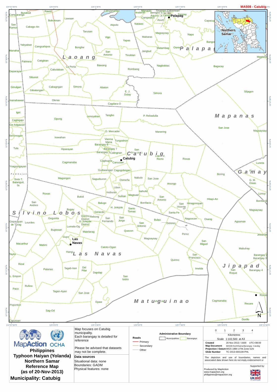
Map focuses on Palapagmunicipality.Each barangay is detailed forreferencePlease be advised that datasetsmay not be complete.
!
!
!
BoringClaro
M. Recto
D.Mercader
Manering
P. Rebadulla
RoxasSan
Francisco
Tangbo
TungodnonViennaMaria Henogawe
Abaton
Atipolo
Atipolo
Bawang
Cagdara-O
Calomotan
Candawid
Canyomanao
Canyomanao
E. J.Dulay
Napotiocan
Pangdan
Rombang
SanAntonio
Tan-Awan
Tan-Awan
Tinoblan
Vigo
Yapas
DelNorte
E.Laodenio
Jubasan
Magsaysay
Magtaon
Manaybanay
Naparasan
Quezon
San Jose
SantaPotenciana
Siljagon
Asum
Bagacay
Bangon
Benigno S.Aquino, Jr.
Binay
Cabariwan
Cabatuan
CampedicoCapacujan
Jangtud
Laniwan
MabarasMagsaysay
Manajao
Mapno
Mapno
Maragano
Matambag
Monbon
Nagbobtac
Napo
Natawo
Nipa
Osmeña
Pangpang
Paysud
Sangay
Simora
Sinalaran
Sumoroy
Talolora
TambanganTinampo
Palapag
C a t u b i g
G a m a y
L a o a n g
M a p a n a s
P a l a p a g
125°12'30"E
125°12'30"E
125°10'0"E
125°10'0"E
125°7'30"E
125°7'30"E
125°5'0"E
125°5'0"E12
°37'3
0"N
12°3
7'30"N
12°3
5'0"N
12°3
5'0"N
12°3
2'30"N
12°3
2'30"N
12°3
0'0"N
12°3
0'0"N
12°2
7'30"N
12°2
7'30"N
12°2
5'0"N
12°2
5'0"N´
0 1 2 3Kilometres
Created 20 Nov 2013 / 1600Map Document MA508-NorthSamarBarangayProjection / Datum WGS 1984 UTM Zone 51NGlide Number TC-2013-000139-PHL
UTC+08:00
PhilippinesTyphoon Haiyan (Yolanda)
Northern SamarReference Map
(as of 20-Nov-2013) Produced by [email protected]
Supported by:Situational data: noneBoundaries: GADMPhysical features: none
Data sources
RoadsPrimaryOther
Palapag
Municipality: Palapag
Administrative BoundaryMunicipalities Barangays 1:75,000Scale at A3
MA508 - Palapag
NorthernSamar

The depiction and use of boundaries, names andassociated data shown here do not imply endorsement or
Map focuses on Pambujanmunicipality.Each barangay is detailed forreferencePlease be advised that datasetsmay not be complete.
!
!
!
!
!
Cagmanaba
Hiparayan
Irawahan
Magongon
Opong
Aroganga
Bawang
Baybay
Bobolosan
Bongliw
Burabud
Cabagngan
Cabago-An
Cabulaloan
Cagaasan
CalintaanPoblacion
Cangcahipos
Catigbian
Gibatangan
Guilaoangi
Inamlan
La Perla
La Perla
Langob
Lawaan
LittleVenice
Mualbual
Oleras
Onay
Onay
Palmera
Rawis
Sangcol
Sibunot
Simora
Talisay
Talisay
Tarusan
Tumaguingting
Yabyaban
Bugay
Bugay
Bugtosan
Bukid
Geguinta
GuyoHangi
Lourdes Lumala-Og
MabiniMacarthur
Roxas
SanAndres
BagasbasBugko
Cablangan
Cahicsan
Chitongco
De Maria
Flormina
Hinabangan
Mirador
Nenita
Roxas
SanAntonio
SanIsidro
San Jose
San Juan
SantaCatalina
Talolora
Cababto-An
Cabari-An
Cagbigajo
Camparanga
Camparanga
Canjumadal
DoñaAnecita
DoñaAnecita
Ge-Adgawan
Geparayan
Ginulgan
Igot
Inanahawan
Manahao
Paninirongan
Paninirongan
PoblacionDistrict 1
PoblacionDistrict 3
PoblacionDistrict 4
PoblacionDistrict 5
PoblacionDistrict 6
PoblacionDistrict 7
PoblacionDistrict 8
SanRamon
Senonogan
Sixto T.Balanguit,
Sr.
Tula
Ynaguingayan
Balnasan
Balud
Bantayan
Coroconog
Dale
Ginagdanan
Lao-Angan
Lawaan
Malobago
Pagsang-An
Zone 1
Zone 2
Zone 3Zone 4
Zone 5Zone 6
Cababayogan
Cagda-ODeit deSuba Deit de
TuragGeparayande Turag
Gusaran
Poblacion IPoblacion II
San Roque
Pambujan
C a t u b i g
L a o a n g
L a s N a v a s
M o n d r a g o n
P a m b u j a n
S a n R o q u e
S i l v i n o L o b o s
125°0'0"E
125°0'0"E
124°57'30"E
124°57'30"E
124°55'0"E
124°55'0"E
124°52'30"E
124°52'30"E
124°50'0"E
124°50'0"E
124°47'30"E
124°47'30"E12
°37'3
0"N
12°3
7'30"N
12°3
5'0"N
12°3
5'0"N
12°3
2'30"N
12°3
2'30"N
12°3
0'0"N
12°3
0'0"N
12°2
7'30"N
12°2
7'30"N
12°2
5'0"N
12°2
5'0"N
12°2
2'30"N
12°2
2'30"N
12°2
0'0"N
12°2
0'0"N´
0 1 2 3 4Kilometres
Created 20 Nov 2013 / 1600Map Document MA508-NorthSamarBarangayProjection / Datum WGS 1984 UTM Zone 51NGlide Number TC-2013-000139-PHL
UTC+08:00
PhilippinesTyphoon Haiyan (Yolanda)
Northern SamarReference Map
(as of 20-Nov-2013) Produced by [email protected]
Supported by:Situational data: noneBoundaries: GADMPhysical features: none
Data sources
RoadsSecondaryTertiaryOther
Pambujan
Municipality: Pambujan
Administrative BoundaryMunicipalities Barangays 1:105,000Scale at A3
MA508 - Pambujan
NorthernSamar

The depiction and use of boundaries, names andassociated data shown here do not imply endorsement or
Map focuses on Rosariomunicipality.Each barangay is detailed forreferencePlease be advised that datasetsmay not be complete.
!
!
!
Frederic
Calantiao
E. Duran
JoseAbad
Santos
Santander
Barobaybay
Barobaybay
ChansvillaDatag
Enriqueta
Libertad
Macarthur
Magsaysay
Salvacion
SanAgustin
SanAgustin
SanIsidro
San Jose
San Juan
San Juan
SanMiguel
To-Og
Aguada
Bantolinao
BuenavistaBuenavista
Commonwealth
Guindaulan
Jamoog
Kailingan
Ligaya
Poblacion
PoblacionSalhag
SalhagSanLorenzo
Aguadahan
Aguadahan
BagongSabangBagong
Sabang
BagongSabang
Balite
BarangayEast
BarangayNorth
BarangayNorth
BarangaySouth
BarangayWest
BarangayWest
BarangayWest
BarangayWest
Bonglas
Da-O
Da-O
Gengarog
Geratag
Layuhan
Mandugang
P. Tingzon
P. Tingzon
SanLorenzo
Tubigdanao
Buenasuerte
Luisita
Pasabuena
Rosario
SanJose
A l l e n
B o b o n
L a v e z a r e s
R o s a r i o
S a n J o s e
V i c t o r i a
124°30'0"E
124°30'0"E
124°27'30"E
124°27'30"E
124°25'0"E
124°25'0"E12
°35'0
"N
12°3
5'0"N
12°3
2'30"N
12°3
2'30"N
12°3
0'0"N
12°3
0'0"N
12°2
7'30"N
12°2
7'30"N
´0 1 2
Kilometres
Created 20 Nov 2013 / 1600Map Document MA508-NorthSamarBarangayProjection / Datum WGS 1984 UTM Zone 51NGlide Number TC-2013-000139-PHL
UTC+08:00
PhilippinesTyphoon Haiyan (Yolanda)
Northern SamarReference Map
(as of 20-Nov-2013) Produced by [email protected]
Supported by:Situational data: noneBoundaries: GADMPhysical features: none
Data sources
RoadsTrunkTertiaryOther
Rosario
Municipality: Rosario
Administrative BoundaryMunicipalities Barangays 1:55,000Scale at A3
MA508 - Rosario
NorthernSamar

The depiction and use of boundaries, names andassociated data shown here do not imply endorsement or
Map focuses on San Antoniomunicipality.Each barangay is detailed forreferencePlease be advised that datasetsmay not be complete.
!
Burabod
Dalupirit
Manraya
Pilar
Rizal
SanNicolas
Vinisitahan
Ward I
Ward II
Ward III
BuenosAires
Colab-Og
SanLazaro
ZoneI
Zone II
SanAntonio
S a n A n t o n i o
V i c t o r i a
124°17'30"E
124°17'30"E
124°15'0"E
124°15'0"E12
°27'3
0"N
12°2
7'30"N
12°2
5'0"N
12°2
5'0"N
12°2
2'30"N
12°2
2'30"N
´0 1
Kilometres
Created 20 Nov 2013 / 1600Map Document MA508-NorthSamarBarangayProjection / Datum WGS 1984 UTM Zone 51NGlide Number TC-2013-000139-PHL
UTC+08:00
PhilippinesTyphoon Haiyan (Yolanda)
Northern SamarReference Map
(as of 20-Nov-2013) Produced by [email protected]
Supported by:Situational data: noneBoundaries: GADMPhysical features: none
Data sources
RoadsTrunkOther
San Antonio
Municipality: San Antonio
Administrative BoundaryMunicipalities Barangays 1:37,500Scale at A3
MA508 - San Antonio
NorthernSamar

The depiction and use of boundaries, names andassociated data shown here do not imply endorsement or
Map focuses on San Isidromunicipality.Each barangay is detailed forreferencePlease be advised that datasetsmay not be complete.
!
!
Santander
Guindaulan
Kailingan
Alegria
Balite
BaliteBuenavista
Caglanipao
HappyValley
Mabuhay
Palanit
PoblacionNorte
PoblacionSur
Salvacion Salvacion
San Juan
SanRoque
SevenHills
Veriato
Balite
Mandugang
Acedillo
Buenasuerte
Colab-Og
Erenas
LibertadLibertad
LuisitaLungib
Maxvilla
Pasabuena
SanLazaro
SanMiguel
SanRoman
Zone IZone IIZone III
BayoBugtong
Cag-Anibong
CaglanipaoSur
CagmanipesNorte
CangomaodDanao II
Dawo
Macatingog
Malaga
Pilar
Roxas I
Tinaplacan
SanIsidro
Victoria
B o b o n
R o s a r i o
S a n I s i d r o
S a n J o s e
V i c t o r i a
C a l b a y o g C i t y
124°27'30"E
124°27'30"E
124°25'0"E
124°25'0"E
124°22'30"E
124°22'30"E
124°20'0"E
124°20'0"E12
°27'3
0"N
12°2
7'30"N
12°2
5'0"N
12°2
5'0"N
12°2
2'30"N
12°2
2'30"N
12°2
0'0"N
12°2
0'0"N
12°1
7'30"N
12°1
7'30"N
12°1
5'0"N
12°1
5'0"N
´0 1 2 3
Kilometres
Created 20 Nov 2013 / 1600Map Document MA508-NorthSamarBarangayProjection / Datum WGS 1984 UTM Zone 51NGlide Number TC-2013-000139-PHL
UTC+08:00
PhilippinesTyphoon Haiyan (Yolanda)
Northern SamarReference Map
(as of 20-Nov-2013) Produced by [email protected]
Supported by:Situational data: noneBoundaries: GADMPhysical features: none
Data sources
RoadsTrunkSecondaryTertiaryOther
San Isidro
Municipality: San Isidro
Administrative BoundaryMunicipalities Barangays 1:75,000Scale at A3
MA508 - San Isidro
NorthernSamar
The depiction and use of boundaries, names andassociated data shown here do not imply endorsement or
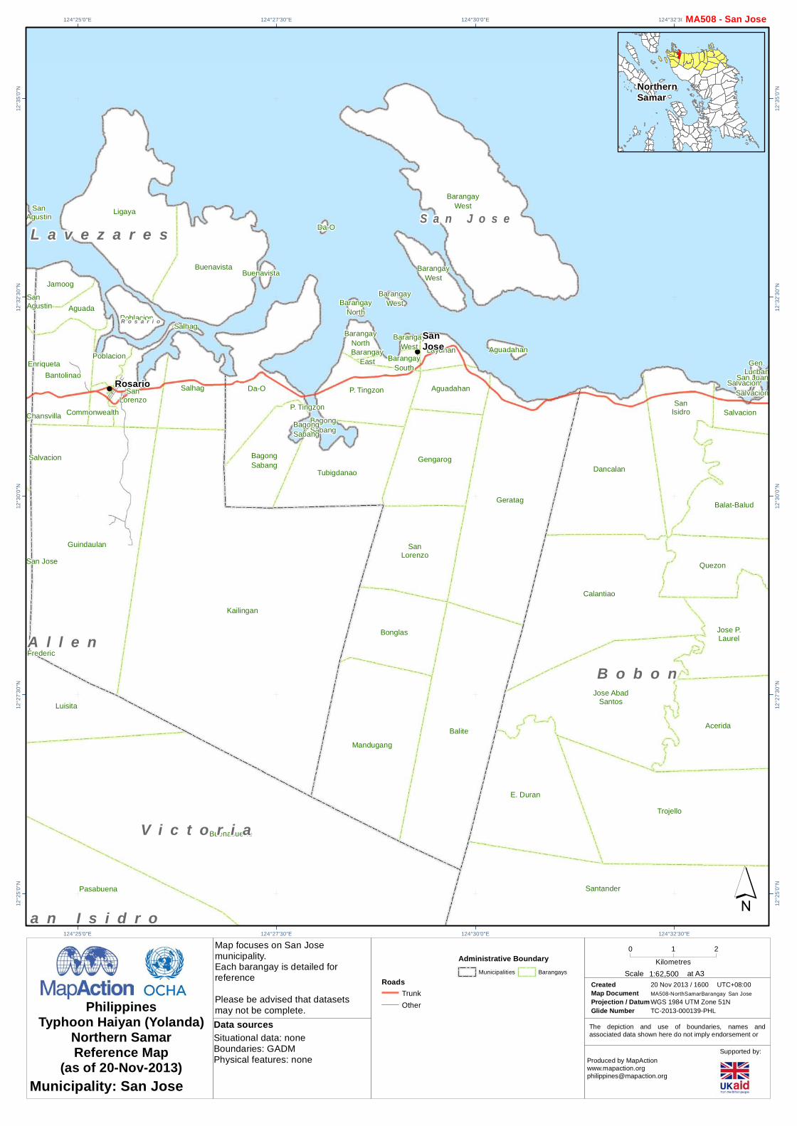
Map focuses on San Josemunicipality.Each barangay is detailed forreferencePlease be advised that datasetsmay not be complete.
!
!
!
Frederic
Acerida
Balat-Balud
Calantiao
Dancalan
E. Duran
Gen.Lucban
Jose AbadSantos
Jose P.Laurel
Quezon
SalvacionSalvacion
SalvacionSan
Isidro
San Juan
Santander
Trojello
Chansvilla
Enriqueta
Salvacion
SanAgustin
SanAgustin
San Jose
Aguada
Bantolinao
BuenavistaBuenavista
Commonwealth
Guindaulan
Jamoog
Kailingan
Ligaya
Poblacion
PoblacionSalhag
SalhagSanLorenzo
Aguadahan
Aguadahan
BagongSabangBagong
Sabang
BagongSabang
Balite
BarangayEast
BarangayNorth
BarangayNorth
BarangaySouth
BarangayWest
BarangayWest
BarangayWest
BarangayWest
Bonglas
Da-O
Da-O
Gengarog
Geratag
Layuhan
Mandugang
P. TingzonP. Tingzon
SanLorenzo
Tubigdanao
Buenasuerte
Luisita
Pasabuena
Rosario
SanJose
A l l e nB o b o n
L a v e z a r e s
R o s a r i o
S a n I s i d r o
S a n J o s e
V i c t o r i a
124°32'30"E
124°32'30"E
124°30'0"E
124°30'0"E
124°27'30"E
124°27'30"E
124°25'0"E
124°25'0"E12
°35'0
"N
12°3
5'0"N
12°3
2'30"N
12°3
2'30"N
12°3
0'0"N
12°3
0'0"N
12°2
7'30"N
12°2
7'30"N
12°2
5'0"N
12°2
5'0"N´
0 1 2Kilometres
Created 20 Nov 2013 / 1600Map Document MA508-NorthSamarBarangayProjection / Datum WGS 1984 UTM Zone 51NGlide Number TC-2013-000139-PHL
UTC+08:00
PhilippinesTyphoon Haiyan (Yolanda)
Northern SamarReference Map
(as of 20-Nov-2013) Produced by [email protected]
Supported by:Situational data: noneBoundaries: GADMPhysical features: none
Data sources
RoadsTrunkOther
San Jose
Municipality: San Jose
Administrative BoundaryMunicipalities Barangays 1:62,500Scale at A3
MA508 - San Jose
NorthernSamar

The depiction and use of boundaries, names andassociated data shown here do not imply endorsement or
Map focuses on San Roquemunicipality.Each barangay is detailed forreferencePlease be advised that datasetsmay not be complete.
!
!
Cagmanaba
Hiparayan
Irawahan
Magongon
Opong
Burabud
Cabago-An
GibatanganOleras
Palmera
Sibunot
Yabyaban
Lourdes
Roxas
SanAndres
Bagasbas
Bugko
Cablangan
De Maria
Hinabangan
Mirador
Nenita
Roxas
SanAntonio
San Jose
Talolora
Cababto-An
Cabari-An
Cagbigajo
Camparanga
Camparanga
Canjumadal
DoñaAnecita
DoñaAnecita
Ge-Adgawan
Geparayan
Ginulgan
Igot
Inanahawan
Manahao
Paninirongan
PoblacionDistrict 1
PoblacionDistrict 3PoblacionDistrict 4
PoblacionDistrict 5
PoblacionDistrict 6
PoblacionDistrict 7
SanRamon
Senonogan
Sixto T.Balanguit,
Sr.
Tula
Ynaguingayan
Balnasan
Balud
Bantayan
Coroconog
Dale
Ginagdanan
Lao-Angan
Lawaan
Malobago
Pagsang-An
Zone 1
Zone 2
Zone 3Zone 4
Zone5Zone 6
Cagda-ODeit deSuba
Deit deTurag
Geparayande Turag
Gusaran
SanRoque
Pambujan
C a t u b i g
L a o a n g
L a s N a v a s
M o n d r a g o n
P a m b u j a n
S a n R o q u e
S i l v i n o L o b o s
124°57'30"E
124°57'30"E
124°55'0"E
124°55'0"E
124°52'30"E
124°52'30"E
124°50'0"E
124°50'0"E
124°47'30"E
124°47'30"E12
°32'3
0"N
12°3
2'30"N
12°3
0'0"N
12°3
0'0"N
12°2
7'30"N
12°2
7'30"N
12°2
5'0"N
12°2
5'0"N
12°2
2'30"N
12°2
2'30"N
´0 1 2 3
Kilometres
Created 20 Nov 2013 / 1600Map Document MA508-NorthSamarBarangayProjection / Datum WGS 1984 UTM Zone 51NGlide Number TC-2013-000139-PHL
UTC+08:00
PhilippinesTyphoon Haiyan (Yolanda)
Northern SamarReference Map
(as of 20-Nov-2013) Produced by [email protected]
Supported by:Situational data: noneBoundaries: GADMPhysical features: none
Data sources
RoadsSecondaryTertiaryOther
San Roque
Municipality: San Roque
Administrative BoundaryMunicipalities Barangays 1:75,000Scale at A3
MA508 - San Roque
NorthernSamar

The depiction and use of boundaries, names andassociated data shown here do not imply endorsement or
Map focuses on San Vicentemunicipality.Each barangay is detailed forreferencePlease be advised that datasetsmay not be complete.
!
DestacadoPoblacion
Maragat
Maragat
MongolBongol
Poblacion
MongolBongol
Poblacion
PuntaPoblacion
Sangputan
Sangputan
Sila Tarnate
SanVicente
S a n V i c e n t e
124°7'30"E
124°7'30"E
124°5'0"E
124°5'0"E
124°2'30"E
124°2'30"E
124°0'0"E
124°0'0"E12
°25'0
"N
12°2
5'0"N
12°2
2'30"N
12°2
2'30"N
12°2
0'0"N
12°2
0'0"N
12°1
7'30"N
12°1
7'30"N
12°1
5'0"N
12°1
5'0"N´
0 1 2Kilometres
Created 20 Nov 2013 / 1600Map Document MA508-NorthSamarBarangayProjection / Datum WGS 1984 UTM Zone 51NGlide Number TC-2013-000139-PHL
UTC+08:00
PhilippinesTyphoon Haiyan (Yolanda)
Northern SamarReference Map
(as of 20-Nov-2013) Produced by [email protected]
Supported by:Situational data: noneBoundaries: GADMPhysical features: none
Data sources
San Vicente
Municipality: San Vicente
Administrative BoundaryMunicipalities Barangays 1:57,500Scale at A3
MA508 - San Vicente
NorthernSamar

The depiction and use of boundaries, names andassociated data shown here do not imply endorsement or
Map focuses on Silvino Lobosmunicipality.Each barangay is detailed forreferencePlease be advised that datasetsmay not be complete.
!
!
Cagmanaba
Hiparayan
Magongon
Caputoan
Cuenco
L. Empon
Lakandula
Lourdes
MabiniMacarthur
OsmeñaPaco
Palanas
Poponton
Rizal
Roxas
Rufino
Sag-Od
SanAndres
Tagan-Ayan
Taylor
Victory
Gebonawan
Cagmanaba
CahicsanCahicsan
De Maria
Hinabangan
SanAntonio
San Jose
Senonogan
Sixto T.Balanguit,
Sr.
Tula
YnaguingayanLawaan
Balud
Cababayogan
Cabunga-An
Cagda-O
Caghilot
Camanggaran
Camaya-An
Deitde Suba
Deit deTurag
Gebolwangan
Gebonawan
Gecbo-An
Genagasan
Geparayande Turag
Giguimitan
Gusaran
Imelda
Montalban
Poblacion IPoblacion II
SanAntonio
SanIsidro
Senonogande Tubang
Suba
Tobgon
Victory
Buenavista
Dinawacan
HelinoHigasaan
Himalandrog
Mabini I
Naguma
Olera
Pinamorotan
Salvacion
SanAntonio
BalocaweBeslig
Buao
Caranas
Carmona Caugbusan
ElcanoGiaboc
Hetebac
Hinayagan
Purog
SanAntonio
SanEnrique
SanIsidro San JoseSan Jose
TigbawonAngyap
Bag-Otan
Barruz
Camonoan
Camonoan
Carolina
Deit
DelRosario
Inubod
Libertad
Ligaya
MabuligonPoblacion
MadurotoPoblacion
Mahanud
Mahayag
Nagpapacao
Rizal
Salvacion
SanIsidro
SanRoque
SantaCruz
SanNicolas
Camperito Jolacao
Matayonas
SilvinoLobos
C a t u b i g
L a s N a v a s
L o p e d e V e g a
M o n d r a g o n
P a m b u j a nS a n R o q u e
S i l v i n o L o b o s
C a l b a y o g C i t y
G a n d a r a
M a t u g u i n a o
S a n J o s e d e B u a n
S a n t a M a r g a r i t a
124°57'30"E
124°57'30"E
124°55'0"E
124°55'0"E
124°52'30"E
124°52'30"E
124°50'0"E
124°50'0"E
124°47'30"E
124°47'30"E
124°45'0"E
124°45'0"E12
°22'3
0"N
12°2
2'30"N
12°2
0'0"N
12°2
0'0"N
12°1
7'30"N
12°1
7'30"N
12°1
5'0"N
12°1
5'0"N
12°1
2'30"N
12°1
2'30"N
12°1
0'0"N
12°1
0'0"N
12°7
'30"N
12°7
'30"N´
0 1 2 3 4Kilometres
Created 20 Nov 2013 / 1600Map Document MA508-NorthSamarBarangayProjection / Datum WGS 1984 UTM Zone 51NGlide Number TC-2013-000139-PHL
UTC+08:00
PhilippinesTyphoon Haiyan (Yolanda)
Northern SamarReference Map
(as of 20-Nov-2013) Produced by [email protected]
Supported by:Situational data: noneBoundaries: GADMPhysical features: none
Data sources
Silvino Lobos
Municipality: Silvino Lobos
Administrative BoundaryMunicipalities Barangays 1:97,500Scale at A3
MA508 - Silvino Lobos
NorthernSamar

The depiction and use of boundaries, names andassociated data shown here do not imply endorsement or
Map focuses on Victoriamunicipality.Each barangay is detailed forreferencePlease be advised that datasetsmay not be complete.
!
!
!
!
!
!
AlejandroVillage
Bonifacio
Calarayan
Frederic
Guin-Arawayan
ImeldaJubasan
KinabrananZone I
KinabrananZone II
Kinaguitman
Lagundi
Lipata
Lo-Oc
LondresSabangZone ISabang
Zone II
SantaRita
Tasvilla
Victoria
Calantiao
E. Duran
Jose AbadSantos
Santander
Barobaybay
CaburihanCaragas
Cataogan
Chansvilla
Datag
Enriqueta
LibasLibertad
MacarthurOcad
Sabong-Tabok
Salvacion
SanAgustin
SanAgustin
San Jose
SanMiguel
To-Og
Urdaneta
Villa Villahermosa
Aguada
Bantolinao
BuenavistaBuenavista
Commonwealth
Guindaulan
Jamoog
Kailingan
Ligaya
Poblacion
PoblacionSalhag
SalhagSanLorenzo
BurabodManraya
Pilar
Rizal
Ward I
Ward II
Ward III
Alegria
BaliteBaliteBuenavista
Caglanipao
HappyValley
Mabuhay
Palanit
PoblacionNorte
PoblacionSur
Salvacion Salvacion
San Juan
SanRoque
SevenHills
Veriato
Aguadahan
Aguadahan
BagongSabang
BagongSabang
Balite
BarangayEast
BarangayNorth
BarangayNorth
BarangaySouth
BarangayWest
BarangayWest
BarangayWest
Bonglas
Da-O
Da-O
Gengarog
Geratag
Layuhan
Mandugang
P. Tingzon P. Tingzon
SanLorenzo
Tubigdanao
Acedillo Buenasuerte
BuenosAires
Colab-Og
Erenas
LibertadLibertad
LuisitaLungib
Maxvilla
Pasabuena
SanLazaro
SanMiguel
SanRoman
Zone IZone II Zone III
BayoBugtong
CaglanipaoSur
Dawo
Macatingog
Pilar
Roxas I
Tinaplacan
Rosario
SanIsidro
Victoria
SanJose
Lavezares
AllenA l l e n
B o b o n
L a v e z a r e s
R o s a r i o
S a n A n t o n i o
S a n I s i d r o
S a n J o s e
V i c t o r i a
C a l b a y o g C i t y
124°30'0"E
124°30'0"E
124°27'30"E
124°27'30"E
124°25'0"E
124°25'0"E
124°22'30"E
124°22'30"E
124°20'0"E
124°20'0"E
124°17'30"E
124°17'30"E12
°32'3
0"N
12°3
2'30"N
12°3
0'0"N
12°3
0'0"N
12°2
7'30"N
12°2
7'30"N
12°2
5'0"N
12°2
5'0"N
12°2
2'30"N
12°2
2'30"N
12°2
0'0"N
12°2
0'0"N
12°1
7'30"N
12°1
7'30"N
´0 1 2 3 4
Kilometres
Created 20 Nov 2013 / 1600Map Document MA508-NorthSamarBarangayProjection / Datum WGS 1984 UTM Zone 51NGlide Number TC-2013-000139-PHL
UTC+08:00
PhilippinesTyphoon Haiyan (Yolanda)
Northern SamarReference Map
(as of 20-Nov-2013) Produced by [email protected]
Supported by:Situational data: noneBoundaries: GADMPhysical features: none
Data sources
RoadsTrunkPrimarySecondaryTertiaryOther
Victoria
Municipality: Victoria
Administrative BoundaryMunicipalities Barangays 1:97,500Scale at A3
MA508 - Victoria
NorthernSamar