A Combined IR and Lightning Rainfall Algorithm for Application to GOES-R Robert Adler, Weixin Xu and...
20
A Combined IR and Lightning Rainfall Algorithm for Application to GOES-R Robert Adler, Weixin Xu and Nai-Yu Wang University of Maryland Goal: Develop and test a combined geo-IR and lightning rain algorithm for use with GOES-R [and also applicable with other types of lightning information] Xu, Weixin, R. Adler, Nai-Yu Wang, 2014: Combining Satellite Infrared and Lightning Information to Estimate Warm‐Season Convective and Stratiform Rainfall. J. Appl. Meteor. Climato l., 53, 180–199. Xu, Weixin, R. Adler, Nai-Yu Wang, 2013: Improving Geostationary Satellite Rainfall Estimates Using Lightning Observations: Underlying Lightning–Rainfall–Cloud Relationships. J. Appl. Meteor. Climatol ., 52, 213–229.
-
Upload
lauren-white -
Category
Documents
-
view
213 -
download
0
Transcript of A Combined IR and Lightning Rainfall Algorithm for Application to GOES-R Robert Adler, Weixin Xu and...
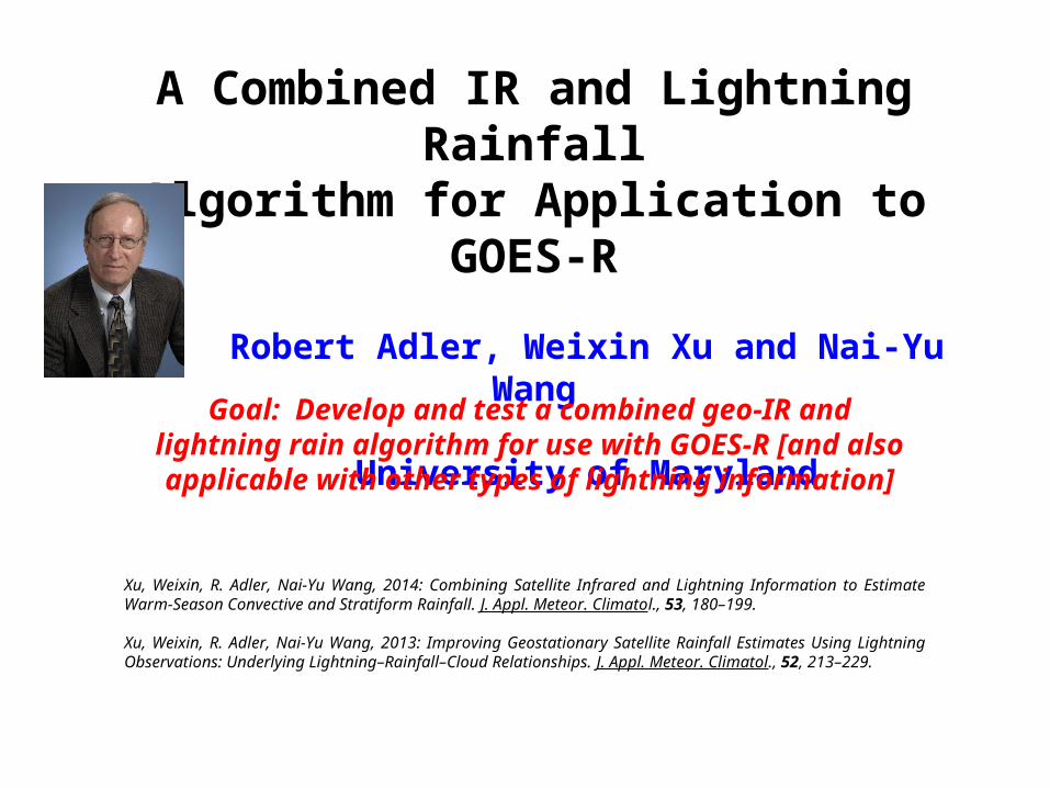
A Combined IR and Lightning RainfallAlgorithm for Application to GOES-R
Robert Adler, Weixin Xu and Nai-Yu Wang
University of Maryland
Goal: Develop and test a combined geo-IR and lightning rain algorithm for use with GOES-R [and also
applicable with other types of lightning information]
Xu, Weixin, R. Adler, Nai-Yu Wang, 2014: Combining Satellite Infrared and Lightning Information to Estimate Warm‐Season Convective and Stratiform Rainfall. J. Appl. Meteor. Climatol., 53, 180–199.
Xu, Weixin, R. Adler, Nai-Yu Wang, 2013: Improving Geostationary Satellite Rainfall Estimates Using Lightning Observations: Underlying Lightning–Rainfall–Cloud Relationships. J. Appl. Meteor. Climatol., 52, 213–229.

Approach1. Utilize Tropical Rainfall Measuring Mission (TRMM) data
(IR, Lightning, Passive Microwave and Radar) to develop and test an instantaneous rain estimation technique for use in deep convective situations.
1. Apply IR-based Convective-Stratiform Technique (CST; Adler and Negri, 1988). CST defines convective cores by Tb minima and adds stratiform rain through Tb threshold.
2. Use Lightning flash rate as additional information to CST to detect new convective cores, eliminate incorrect IR-defined cores, and estimate convective core rainfall rates.
2. Compare CST and CSTL against TRMM PMW and Radar rainrates to understand impact of Lightning information.

How Is Lightning Observed by TRMM LIS?
Lightning events are in color
While GOES-R GLM continuously monitors lightning, TRMM LIS monitors a region (600 km) every 80-90s.

IR-lightning Combined Algorithm
IR-based Conv./ Strat. Technique (CST)
Convective Area Stratiform Area
Convective Rain Rates
Stratiform Rain Rates
BaseAlgorithm
(Adler and Negri, 1988)
Lightning Information

Development and Evaluation Datasets (TRMM)
Dependent set: 2002-2004 (1427 cases); Independent set: 2005-2008 (2009 cases);Warm season (May-Aug), Southern CONUS;
Case criteria: > 5 flashes, every 800 by 800 km2.
Lightning events are in color

Convective/Stratiform Technique (CST)
IR Tb & local Minima
(+)
CST: 1. Find local Tb minima;
Do slope (gradient) test;
2. Assign conv. area as a
function of min Tb;
3. Assign rain rates for C/S.Rain Rate
1. 2.
3.
Convective AreaStratiform Area
black outlines = convective areas from TRMM radar

Slope test for Tb minima Convective cores or not?
Conv. Area as a function of Tmin
Functions for Convective Core and Area
Red: Conv.Blue: Non-Conv.
Conv. cores and area defined by TRMM radar observations
Slo
pe
Tb
Tb
Are
a

1. Remove convective cores not associated with lightning. 2. Define additional convective areas by lightning area.
Use of Lightning (CST+Lightning)
IR Tb
CST + Lightning
(Conv/Strat)
CST(Conv/Strat)
PMW(Passive MicroWave)
(Conv/Strat 10 mm/hr)Convective AreaStratiform Area
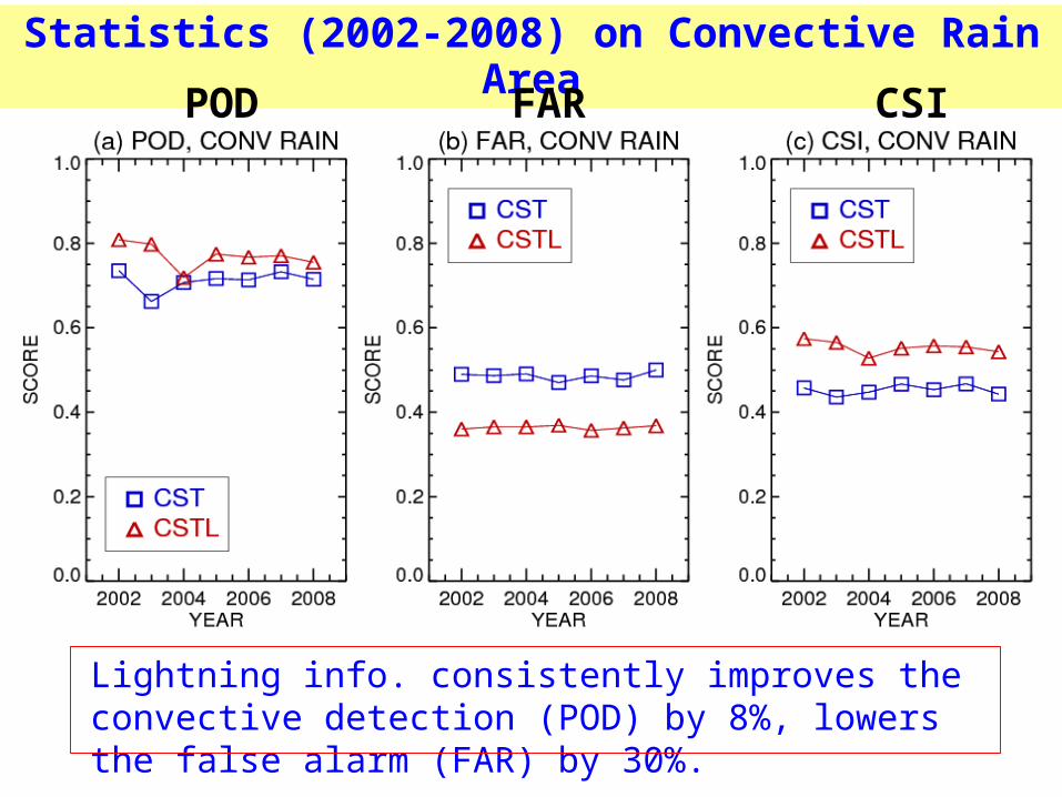
Lightning info. consistently improves the convective detection (POD) by 8%, lowers the false alarm (FAR) by 30%.
Statistics (2002-2008) on Convective Rain Area
POD FAR CSI

Functions for Rainrate Assignment
Convective RR Stratiform RR
RR = 2.5 mm hr-1
RR as a function ofLightning Density
Based on: Xu, Adler, and Wang, JAMC(2013)

Instantaneous Rain Estimates (10 km res.)
PMW RR PR RR
CST RR CST+L RR

Instantaneous Rain Estimates
PMW RRIR
CST RR CST+L RR

PMW RRIR
CST RR CST+L RR
Instantaneous Rain Estimates

PMW RRIR
CST RR CST+L RR
NOAA Operational
GOES IR Product
Instantaneous Rain Estimates

Instantaneous Rainrate (20km res.)
CST vs. PMW CSTL vs. PMW
May 2007—Similar in other months

Rainfall Statistics (20km res.)
BIAS and RMSE vs. PMWCorr. Coeff. vs. PMW
2002-2008 May-August
Lightning information clearly improves rainfall statistics
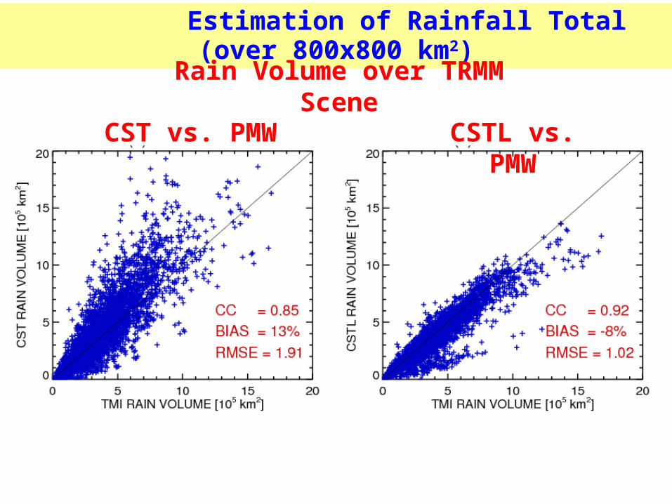
Estimation of Rainfall Total (over 800x800 km2)
CST vs. PMW CSTL vs. PMW
Rain Volume over TRMM Scene

Summary and Suggested Next StepsResults indicate that satellite lightning information from GLM will be very valuable in improving GOES-based rain estimation. This comes from the use of lightning information to establish location of convective cores “unseen” by IR and eliminate incorrect cores defined by IR, and by flash rate-rain rate relations.
A GOES-R IR/Lightning algorithm should be fully developed and tested, building on the convective-stratiform separation concept, which takes advantage of strength of the GLM lightning data.
Geostationary-based rain estimates should be a part of an overall integrated precipitation analysis system using ground-based (radar, raingauge) and low-orbit merged microwave estimates to provide users with an integrated space-time best estimate.
Xu, W., R. F. Adler, and N.-Y. Wang, 2014: Combining Satellite Infrared and Lightning Information to Estimate Warm Season Convective and Stratiform Rainfall. J. Appl. Meteor. Climatol.

Example 1: Early Stage of Convective Systems
PMW RRIR
CST RR CST+L RR

Estimates of Convective Precipitation
PR C/SIR Tb
CST C/S CST+L C/S
Convective-Stratiform Separation
Convective-Stratiform Separation Convective-Stratiform
Separation