A combined design approach for integrating habitats in ...
60
A combined design approach for integrating habitats in mixed- use development by Zhifang Wang A thesis submitted in partial fulfillment of the requirements for the degree of Master of Landscape Architecture (Natural Resources and Environment) the University of Michigan 2008 Advisors: Professor Joan I. Nassauer (Advisor) Adjunct Professor Chester B. Hill (Co-advisor)
Transcript of A combined design approach for integrating habitats in ...

0
A combined design approach for integrating habitats in mixed-use development
by
Zhifang Wang
A thesis submitted in partial fulfillment of the requirements
for the degree of Master of Landscape Architecture
(Natural Resources and Environment) the University of Michigan
2008 Advisors:
Professor Joan I. Nassauer (Advisor) Adjunct Professor Chester B. Hill (Co-advisor)
0
Table of Contents
Abstract .................................................................................................................................. 1
Chapter I
Introduction ........................................................................................................................... 2
Chapter II
Literature review .................................................................................................................... 5
2.1 Habitat definition .......................................................................................................... 5
2.2 Different approaches for integrating habitats by design .............................................. 8
2.2.1 Landscape-specific design approaches ................................................................... 8
2.2.2 Organism-specific design approaches .................................................................. 12
2.3 Summary comments about different methods for defining habitat ............................ 16
Chapter III
Study site conditions and project requirements ................................................................... 19
3.1 Site context .................................................................................................................. 19
3.2 Site description ............................................................................................................ 20
3.3 Project description ...................................................................................................... 22
Chapter IV
A combined approach for integrating habitats by design .................................................... 25
4.1 The riparian forest ecosystem in Oregon and restoration .......................................... 26
4.2 Habitat requirements for the Pacific tree frog (Pseudacrus regilla) ........................... 29
4.3 Cultural concerns for the combined approach ........................................................... 29
Chapter V
Site design using the combined approach to integrate habitats ........................................... 32
5.1 Human habitat and cluster development .................................................................... 32
5.2 Succession of the riparian forest habitat ..................................................................... 40
5.3 Habitats for Pacific tree frogs ..................................................................................... 41
5.4 Interaction of human and biotic habitats .................................................................... 44
Chapter VI
Conclusion ............................................................................................................................ 49
References ............................................................................................................................ 51

1
Abstract
This study contemplates the role of landscape architects in integrating habitats and
advocates a new framework to integrate habitats in urban environment. The literature
shows two types of design approaches that have been explored for protecting or restoring
habitats: landscape-specific approach and organism-specific approach. As each approach
has its own strength and weakness, this study suggests a combined design approach using
both landscape and organism concerns. The combined design approach is applied in one
hypothetical site in the Portland metropolitan area to demonstrate how habitats can be
integrated into mixed-use development by innovative design. Accounting for site factors,
the site design creates and integrates three habitat types: riparian forest habitats, human
habitats, and habitats for Pacific tree frogs. Landscape and organism concerns
complement each other in the design solution.

2
Chapter I
Introduction
The concept of “habitat” appears
frequently in landscape design practices
and management documents. Many
landscape architects and design firms
justify their design philosophy or project
goals, comprehensively or at least partially,
as ecological/sustainable design to create or
conserve habitats. Designing for habitats is
a fairly general topic and has been used
broadly and differently.
Integrating habitats in urban
environments is more challenging since
urban ecosystems are very unique in
several ways (Alberti, 2005; Niemela,
1999; Trepl, 1995). Urban ecosystems lack
habitat patches, instead they have abundant
invasive/nonnative species as well as strong
external control of natural succession
(Trepl, 1995). And in most cases, there are
many ecological, financial, and social
constraints on what it is possible to achieve
by landscape designs aiming to integrate
habitats (Hough, 2004).
The goal of this study is to
contemplate a design solution for
“The best way to know the lay of the land is to start by respecting it. --- Our planners and designers begin by seeing what is natural and sustainable. Our mission? It’s to orchestrate land uses that reduce transportation costs; make high-density projects livable; integrate architecture with the landscape in ways that optimize natural heating and cooling; save on the use and costs of water, energy, and other resources; create green environments that provide social amenities; and conserve natural open space and habitat for future generations. Nature is the ultimate example of great design. ----.”
----------SWA, http://www.swagroup.com/
“Natural Resources Design Inc. designs with native plants, implements appropriate stormwater management, and creates wildlife habitats in its designs. We integrate natural processes and aesthetics into our designed landscapes and work with communities to restore indigenous ecosystems and a ‘sense of place’.”
----------Natural Resources Design Inc., http://www.naturalresourcesdesign.com/

3
integrating habitats by design in mixed-use development, a place with diverse human
activities and intricate human-nature interactions.
The idea of integrating habitats in mixed-use development is inspired by the
design competition “integrating habitats”1, which invites innovative design solutions to
balance between development and conservation. In Fall semester 2007, I participated in
the design competition. This thesis used the same project from the competition, but it is a
new design, which includes much more to integrate habitats than what I achieved in my
design competition entry. After the competition, I searched the literature further to
understand the meaning of integrating habitats in urban environment.
My new design is also inspired by other competition entries, particularly those
winning entries. Nature in Neighborhoods (McDowell et al., 2008) employs a pre-
fabricated modular construction method to reduce the impact on site and its compact
arrangement of buildings protects all the habitat conservation areas. However, nature in
neighborhoods is not the same as habitats in neighborhoods because it is a mystery that
which species and how many species will exist in the “nature” designed by them. Daily
Migrations (Kennedy et al., 2008) addresses the on-site cyclical journeys of human and
wildlife during a day in terms of their flow, destination, stopover and home. Daily
migration diagrams are interesting ideas to demonstrate habitat requirements of both
wildlife and human. However, it is a mystery why the designers think that their design
would accommodate the species listed in their entries. In addition, the large area of
building footprint and surface transportation in their design makes me suspect whether
migration is possible or safe for the wildlife in their diagrams. Terra+Scapes (Zambelli,
2008) is a nice architecture work with almost entirely green footprint. By advocating the
development of a modular living unit, Living Craft (Page and Kley, 2008) raises up the
critical question of how to infuse human and natural orders. Both Terra+Scapes and
Living Craft do not address noticeably the habitat functions of their design.
This study starts with a literature review in Chapter II to understand the meaning
of “habitat” and to summarize different theories and practices in integrating habitats by
design. Following the literature review, study site conditions and project requirements are
1 http://www.oregonmetro.gov/index.cfm/go/by.web/id=21627

4
introduced in Chapter III. Based on the analysis of the site factors in Chapter III, a
combined approach to integrate habitats by design is proposed in Chapter IV. And
Chapter V summarizes the application of the combined design approach to integrate
habitats according to the site conditions. It demonstrates a design integrating three
different habitat types. The conclusion in Chapter VI reiterates the call to a combined
design approach to integrate habitats in urban environment.
5
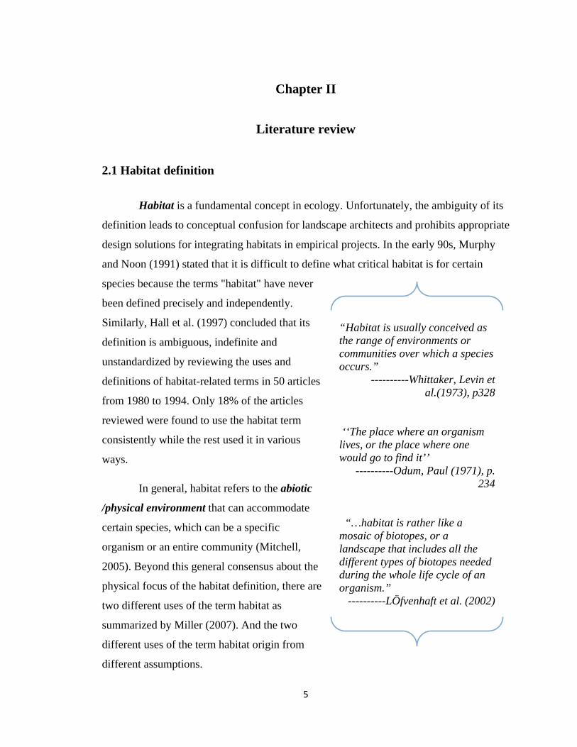
Chapter II
Literature review
2.1 Habitat definition
Habitat is a fundamental concept in ecology. Unfortunately, the ambiguity of its
definition leads to conceptual confusion for landscape architects and prohibits appropriate
design solutions for integrating habitats in empirical projects. In the early 90s, Murphy
and Noon (1991) stated that it is difficult to define what critical habitat is for certain
species because the terms "habitat" have never
been defined precisely and independently.
Similarly, Hall et al. (1997) concluded that its
definition is ambiguous, indefinite and
unstandardized by reviewing the uses and
definitions of habitat-related terms in 50 articles
from 1980 to 1994. Only 18% of the articles
reviewed were found to use the habitat term
consistently while the rest used it in various
ways.
In general, habitat refers to the abiotic
/physical environment that can accommodate
certain species, which can be a specific
organism or an entire community (Mitchell,
2005). Beyond this general consensus about the
physical focus of the habitat definition, there are
two different uses of the term habitat as
summarized by Miller (2007). And the two
different uses of the term habitat origin from
different assumptions.
“Habitat is usually conceived as the range of environments or communities over which a species occurs.”
----------Whittaker, Levin et al.(1973), p328
‘‘The place where an organism lives, or the place where one would go to find it’’
----------Odum, Paul (1971), p. 234
“…habitat is rather like a mosaic of biotopes, or a landscape that includes all the different types of biotopes needed during the whole life cycle of an organism.”
----------LÖfvenhaft et al. (2002)

6
One use of the term habitat is organism-specific (Miller, 2000; Morrison, 2001;
Odum, 1971; Whittaker et al., 1973). It starts with the concern of a given species or a
group of species, and assumes that those given species have specific requirements to
natural resources and environments for their life cycles. Thus, habitat is defined as a
place containing a combination of resources and environmental conditions that are
required by a given species or species group to carry out life processes. In this definition,
the behavior of a given species in terms of foraging, roosting and nesting as well as their
competitors and predators all play important roles in determining suitable conditions for a
given species or species group.
The other use of the term habitat is landscape-specific (Löfvenhaft et al., 2002).
In this instance, the term habitat refers to areas of similar vegetation or landcover. This
definition starts with landscape classification and assumes that different landscape types
can characterize areas with distinctive environmental conditions and natural resources
required by different species or species group. Consequently, each landscape type would
be a place in which certain species or species group can live. In this definition,
landscapes can easily be classified as different “habitat types” (Daubenmire, 1968).
According to the organism-specific definition, habitat is an area that contains the
necessary environmental conditions for certain species. The challenge of the organism-
specific definition is how to identify the suitable environment for a given species or
species group. First, the behavior of an organism is complicated in terms of its needs for
foraging, roosting and nesting, which may require totally different environment. Second,
it may be easier to identify a required environmental condition for ‘habitat specialists’
(e.g. coho salmon(Oncorhynchus kisutch), spotted owl (Strix occidentalis)), but it would
be very difficult for species ranging over wide geographic areas of greatly varying
conditions (e.g. ‘habitat generalists’ such as whitetail deer (Odocoileus virginianus),
coyote(Canis latrans), crow(Corvus spp.)) (Mitchell, 2005). Third, an unnatural
environment and atypical habitat components, like bird houses and bird feeders in urban
environment, can turn out to be important parts of the living environment for certain
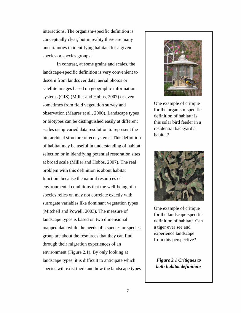
species (Figure 2.1). Last but not the least, the required living environment by a species
involves evolution or adjustment to environment. And there are complicated inter-species
7
interactions. The organism-specific definition is
conceptually clear, but in reality there are many
uncertainties in identifying habitats for a given
species or species groups.
In contrast, at some grains and scales, the
landscape-specific definition is very convenient to
discern from landcover data, aerial photos or
satellite images based on geographic information
systems (GIS) (Miller and Hobbs, 2007) or even
sometimes from field vegetation survey and
observation (Maurer et al., 2000). Landscape types
or biotypes can be distinguished easily at different
scales using varied data resolution to represent the
hierarchical structure of ecosystems. This definition
of habitat may be useful in understanding of habitat
selection or in identifying potential restoration sites
at broad scale (Miller and Hobbs, 2007). The real
problem with this definition is about habitat
function because the natural resources or
environmental conditions that the well-being of a
species relies on may not correlate exactly with
surrogate variables like dominant vegetation types
(Mitchell and Powell, 2003). The measure of
landscape types is based on two dimensional
mapped data while the needs of a species or species
group are about the resources that they can find
through their migration experiences of an
environment (Figure 2.1). By only looking at
landscape types, it is difficult to anticipate which
species will exist there and how the landscape types
One example of critique for the organism-specific definition of habitat: Is this solar bird feeder in a residential backyard a habitat?
One example of critique for the landscape-specific definition of habitat: Can a tiger ever see and experience landscape from this perspective?
Figure 2.1 Critiques to both habitat definitions

8
may interact with or affect species abundance or species diversity.
2.2 Different approaches for integrating habitats by design
Similar to the two distinctive habitat definitions, design approaches for integrating
habitats fall in two categories: landscape-specific design approaches and organism-
specific design approaches. Both approaches rely on making inferences from physical
landscape but they have distinctive foundations and assumptions. Landscape-specific
design approaches start with landscapes and assume that landscapes will eventually
provide habitats. Organism-specific design approaches start with species and aim to
create required living conditions for given species.
The landscape-specific design approaches prevail since they only require design
of physical environment, and the landscape-specific definition of habitat is easy to
operationalize. In discussing ecological restoration, Morrison (2001) made a similar
argument that the application of principles of wildlife ecology (organism-specific) to
restoration has lagged behind advances related to vegetation ecology (landscape-
specific).
2.2.1 Landscape-specific design approaches
2.2.1.1 Native ecosystems Like the definition of habitat as biotypes under the landscape-specific perspective,
there is a long history of advocates for protecting/restoring native ecosystems, or
biotypes, in different regions. A “native ecosystem” is considered to be an environment
that would accommodate native habitats since native ecosystems might harmoniously
integrate organism and environmental conditions through natural selection and the long-
history evolution.

9
A native ecosystem is a complicated, hierarchical and dynamic system, which
includes both biotic and abiotic components. A typical definition of an ecosystem is a
"[c]ommunity of organisms interacting with one another and with the chemical and
physical factors making up their environment. (Miller, 1991, pA7)" A native ecosystem
can be considered as the environment that contains the necessary chemical and physical
factors for life cycles of native plants, animals and microbes. Consequently, the objective
of designing for a native ecosystem is to restore and maintain the physical, chemical, and
biological conditions necessary to allow a native ecosystem to function and evolve over
time.
Two challenges to integrate native ecoystems by design in urban environment are:
geographical challenges and temporal challenges.
The geographical concern is about the question of “native to where?” Site analysis
and observation can provide some clues for a native ecosystem. However, it can be
challenging to determine what a native ecosystem is to be restored in an urban site with
totally invasive plants or a destroyed site without any vegetation. It should be a regional
prevailing ecosystem? a prevailing ecosystem in a city? an ecosystem within certain
distance to the site? or the ecosystem on the site at some point in history? For instance,
one primary goal of the Neal Smith National Wildlife Refuge and Prairie Learning
Center, located in Jasper County Iowa, is set to restore the refuge landscape as nearly as
possible to the natural condition, the tall grass prairie and oak savanna that existed before
Euro-American settlement in the 1840’s (Witte, 1999).
"In any area there is always a type of vegetation that would exist without being planted or protected. This native vegetation consists of specific groups of plants that adapted to specific environmental conditions.""
-------- Smyser (1982), p70
“There are trees that belong to low grounds and those that have adapted themselves to highlands. They always thrive best amid the conditions they have chosen for themselves through many years of selection and elimmation. They tell us that they love to grow here, and only here will they speak in their fullest measure."
------- Jensen (1956), p8

10
The ecosystem in history
speaks to the temporal concern in
designing for native ecosystems. A
common argument is that it takes years
to establish native ecosystems in an
area because the species of an area
need years to co-evolve, to adapt to
each other and to the peculiarities of
their physical environment (Gould,
1998). However, we also know that an
ecosystem is in dynamic changes all
the time. It is not always realistic to
expect the current ecosystem on a site
to be the same as the one thousands of
years ago.
Landscape architects have
attempted to understand and design with the “anatomy” of a native ecosystem as each
component is essential in
facilitating the ecological
function of the ecosystem
and the life cycle of native
species. There have been a
lot of advocates for native
plants in design (Figure
2.2). Native plants are not to
the same as native
ecosystems, which comprise
more systematic landscape
structure and landscape
functions. Native plants are
only the vegetation component of a native ecosystem. Another example is the flourishing
Fearful critics deplore new development: they wish that the land might be as it was. But how was it? Certainly never long the same. Environment changes steadily, even without our interference: new species crowd out the old, climates shift, geological processes continue. Decay, waste, entropy, and change are all part of the natural order. The past cannot be regained or the present fixed.
----------Lynch (1981), p123
Figure 2.2 Native plants in Lurie Garden, Chicago

11
design focus in stormwater management to better manage the hydrologic component of
an ecosystem (Campbell and Ogden, 1999; Davis and McCuen, 2005; Ferguson, 1998).
Single process of an ecosystem is easier to design and manipulate in real projects.
However, single process cannot guarantee habitat functions.
2.2.1.2 Landscape ecology and landscape pattern Landscape ecology, the study of the
effect of landscape pattern on landscape process
(Turner, 1989), provides another approach to
design spatial pattern or spatial arrangement of
landscape elements. The concepts of “corridor”,
“connectivity”, appear frequently in different
projects. For instance, the massive design
efforts about “greenways” / “greenbelts” and
ecological corridors use some landscape
ecological principles (Arendt, 2004; Coutts, 2006; Erickson, 2004). The ecological
corridor protected by the Otanerua Eco-Viaduct under the motorway provides some
connectivity for wildlife migration through the forests. The ecological corridor protects
“The full definition of landscape ecology is, then, the study of how landscape structure affects (the processes that determine) the abundance and distribution of organisms.”
----------Fahrig (2005), p3
Figure 2.4 The view of the eco-viaduct protecting the ecological corridor
http://www.transit.govt.nz/planning/urban/alpurtb2.jsp

12
native vegetation and ensures the sustainability of local fauna (Figure 2.4).
Landscape ecology can be used in many projects because it implies criteria for
designing landscape pattern. For instance, systems with lower diversity tend to be more
easily invaded by exotic species and more fragile to pollution regarding their nutrient
cycles and ecosystem functioning (Schindler, 1990). The amount of edge for a habitat
patch relates to potential predation in avian species and plants species richness (Moser et
al., 2002). Connected patches can smooth the migration of species so that those plants
and animals are more likely to survive (Forman and Godron, 1986). In Landscape
Ecology Principles in Landscape Architecture and Land-use Planning, Dramstad et
al.(1996) summarized and visualized a series of criteria that suggest implications for
different planning/design circumstances. One caution against using criteria from
landscape ecology in design is that the relationship between landscape function and
landscape pattern has not been fully supported by empirical research. For instance,
connectivity may facilitate species migrations between patches (Parker et al., 2008).
However, connectivity can also facilitate the spread of diseases, pollution, predators and
other disturbances to destroy habitats for certain species (Bennett, 2003; Linehan et al.,
1995). It is far from easy to integrate concepts and measurements from the theory of
landscape ecology into empirical landscape management (Gustafson, 1998). Landscape
management requires much more information about the relationship between patterns and
processes (Opdam et al., 2001). As argued by Turner et al. (2001), “there is a need to
build a collective library of empirical studies in which ecological responses are related to
particular landscape configurations. Unfortunately, we have the power to measure and
report more about landscape pattern that we can interpret in terms of effects on ecological
processes. (p108)”
2.2.2 Organism-specific design approaches
Organism-specific design approaches are more reliable for conservation efforts.
The essential issue in organism-specific design is to identify the given species or species
group. According to Wilcove (1994), one must first consider the specific habitat
requirements of individual species to determine the appropriate size, shape and
distribution of reserves designed to protect them. However, it may not be very easy for

13
designers to identify the right species quickly due to uncertainties in species behavior
within an environment, incomplete information about species behaviors and limited time
for a project.
Conservation biologists have developed shortcuts to identify key species to be
focused on for planning/design efforts based on incomplete information. The idea is that
by protecting habitat for the “right” subset of species, one will protect habitat for many
other species with similar requirements. The right subset of species can be a single
species or multiple species. Some studies have compared different methods to identify
key species(Conway, 1989; Power et al., 1996; Simberloff, 1998; Terborgh, 1986). This
thesis combines information from the literature and summarizes different approaches.
Keystone species
A keystone species has a unique connection to the community because its “impact
on its community is disproportionately large relative to its abundance” (Power et al.,
1996). Studies show that changes in a keystone species may lead to changes in species
diversity (Miller et al., 1998), species abundance (Power et al., 1996) or overall
ecosystem function (Callicott et al., 1999). A keystone species can alter ecosystem
structure in many ways, including food webs, competition, mutualism, and dispersal; or
physically by modifying the landscape (e.g., beavers (Castor spp.) create wetlands)
(Block et al., 1987). For example, Terborgh (1986) found that one-half to three quarters
of the total bird and mammalian biomass were lost if palm nuts, figs and nectar were
removed from a tropical ecosystem. In areas where keystone species are present,
conservation biologists can use the keystone species approach to set aside critical areas
and manage them to maintain identified keystone species and the critical ecological
“A major challenge in conservation efforts worldwide is to strike a balance between rigorous science and the need for expediency. Ideally, conservation strategies would be based on detailed surveys and a thorough knowledge of each species’ life history- information that is often unavailable and difficult to obtain. “
---------- Hess and King (2002), p28

14
processes in which they participate (Power et al., 1996). Conversely, in areas where
habitat had been destroyed and restoration projects were in progress, keystone species
would be re-introduced to re-establish and sustain ecosystem structure and stability
(Conway, 1989).
The keystone species approach is far from optimal in conservation efforts. First, it
is not an easy task to identify keystone species due to the ambiguity of the concept of
keystone species, which has been criticized by many scholars (Millers et al., 1993;
Simberloff, 1998). Furthermore, the use of a single keystone species is likely to leave
conservation gaps, which could result in the loss or decline of species that do not utilize
the same habitat as the selected species.
Umbrella species
An umbrella species requires large area as its habitat (Wilcox, 1984). The idea
underlying this umbrella species approach is that planning for species with large area
requirements will provide a “protective umbrella” for other species with similar habitat
requirements and smaller home ranges (Wilcox, 1984). For example, Martikainen et al.
(1998) studied the endangered white-backed woodpecker in Finland and Russia. They
found that 80% of the threatened beetle populations that utilize the same forests would
also be protected by conservation strategies developed for this bird (Martikainen et al.,
1998). The umbrella species has been suggested to be used to define the size or type of
area needed for a reserve system (Ryti, 1992).
Unfortunately, umbrella species does not cover all species. Kerr (1997) and
Prendergast (1993) have shown that one or two umbrella species are unlikely to provide
protection for all other species due to species richness in an area. Similarly, studies have
shown that the umbrella can leave out species that require rare or specialized habitats
(Fleury and Mock, 1998; Millers et al., 1993).
Focal species
The focal species approach is proposed to overcome conservation gaps in the
keystone and umbrella approaches (Davis, 1996; Lambeck, 1997). Lambeck suggested
selecting the focal species based on the single-species keystone and umbrella approaches

15
by 1) identifying threatening processes responsible for species decline and 2) selecting a
suite of species, each of which is considered most sensitive to each of the threatening
process (Lambeck, 1997). In theory, the focal species approach is less likely to leave
conservation gaps because more than one species is selected to represent a variety of
landscape characteristics that will encompass the needs of many other species. Carroll et
al. (2001) utilized the focal species approach in their regional planning efforts to preserve
threatened carnivores by human development pressures in the Rocky Mountains of the
United States and Canada. Hess and King (2002) used a Delphi survey to obtain
information from a panel of knowledgeable people for conservation efforts. Six landscape
types and nine associated focal species were identified: extensive undisturbed habitat
(bobcat (Lynx rufus), eastern box turtle (Terrapene carolina)), riparian and bottomland
forest (barred owl (Strix varia), beaver (Castor canadensis)), upland forest (ovenbird
(Seiurus aurocapillus), broad-winged hawk (Buteo platypterus)), mature forest (pileated
woodpecker (Dryocopus pileatus)), pastures and grassy fields (loggerhead shrike (Lanius
ludovicianus)), and open and early successional forest (northern bobwhite (Colinus
virginianus)).
The problems of the focal species approach are that it has not been well tested,
and required data are often unavailable (Hess and King, 2002). Also, since more than one
species and relevant habitats will be selected and examined, the process can be quite
time-consuming. In places where the economic pressure to develop land needs quick
decisions, the implementation of a focal species approach will be difficult.
Species guilds
Guilds are species assemblages and classifications. Root (1967, p335) defined
guild as a "group of species that exploit the same class of resources in a similar way" in a
study of five species of birds that foraged in the same general fashion. The idea of using
species guilds in planning/design is that the species guilds approach can categorize
species accordingly to different habitat types, which can be incorporated into
planning/design processes. In addition, the fact that species guilds cover more than one
species can lead to less conservation gaps compared to single species method. Fleury and
Brown (1997) used the guild concept to develop wildlife conservation corridors. Based

16
on the use of corridors for different activities, six species guilds were used in that study:
insects, reptiles and amphibians, birds, small mammals, medium mammals and large
mammals. The requirements and planned corridors for each guild were explored
respectively.
Beyond the general categorization of species guilds, Severinghaus (1981)
suggested that one species from a guild could be chosen as a "guild-indicator species,"
and its population and habitat monitored in lieu of monitoring those for every species
from the guild. The guild-indicator approach seems to be able to simplify the
implementation of species guilds. However, Block (1987) suggested that indicator
species should be used with caution. They investigated the ability of mountain quail to
indicate the presence of other species from the guild and to index the quality of the
habitat for other species. Mountain quail habitat was significantly different from the
habitats of sympatric species from the guild. Consequently, they suggest that, if
indicators are used, they should be applied to guilds composed of species that closely
share ecological affinities.
The appropriate application of guilds is challenging because there are many
different ways to categorize guilds and define guilds composition (Jaksic', 1981; Mannan
et al., 1984). The degree to which species in a guild are similar in resource use is critical
in the use of species guilds. Too general a guild definition creates too much uncertainty
within that guild, while too detailed a guild definition can be too time-consuming for
conservation efforts.
2.3 Summary comments about different methods for defining habitat
Defining habitats for design is complicated. Many methods are available as
reviewed but none of them provides optimal solutions (Table 2.1). The choice of either a
landscape-specific method or organism-specific method is more by operational necessity
or ethical concerns rather than by concrete theoretical proof. Some people think that the
focus on individuals and populations is simplistic and it is thought to be relevant only for
sensitive species requiring special attention (Knight, 1990). In contrast, others consider
that the positioning of a site in relation to extant populations of species of interest is an

17
essential component of successful design. Estimating the likelihood of site colonization
by target species is a means of evaluating site quality (Scott et al., 2001).
As a summary, landscape-specific methods may POTENTIALLY provide
habitats for many species, however it is a mystery that which species will exist there and
how many species will exist there. The habitat value of the landscape designed by the
landscape-specific method is difficult to be anticipated and evaluated. In contrast,
organism-specific methods are straightforward about habitat values if we can identify the
RIGHT species and its associated habitat. However, regardless of selecting single species
or multiple species, there are always potentials for conservation gaps. It seems that a
design method combining both landscape-specific method and organism-specific method
would help to overcome the constraints of each method because the organism-specific
method can at least ensure a site to be a suitable living environment for one or a group of
species as well as species with similar habitat requirements while landscape-specific
method has the potential to provide habitats for many other species.

18
Table 2.1: Strength and weakness of different design approaches to integrate habitats by design
Design approaches Strength Weakness
Landscape-specific The potential to provide habitats for many species. Uncertain which species will exist there and how many species
will exist there.
Native ecosystems The potential to support native habitats. -It is a complicated system.
-Difficult questions in need of answers before design, like
“native to where” and “native to when”.
Landscape ecology
and pattern
Available design criteria of landscape pattern
that are easily manipulated in real projects.
The relationships between landscape pattern and landscape
functions have not been fully examined and supported.
Organism-specific Clear habitat values. Difficult to identify the right species and potentials for
conservation gaps.
Keystone species Simple, single species that has large impact on a
community.
Difficult to identify keystone species due to the ambiguity of
the concept of keystone species.
Umbrella species A “protective umbrella” for other species with
similar habitat and smaller home ranges.
Potentials to leave out species that require rare or
specialized habitats.
Focal species A variety of landscape characteristics that will
encompass the needs of many other species.
Time-consuming, not been well tested and required data are
often unavailable.
Species guilds Potential to provide habitats for different species
accordingly to different habitat types.
Many different ways to categorize guilds and define guilds
composition.
19
Chapter III
Study site conditions and project requirements
The site used for this study is drawn from the “Integrating habitats” competition2.
It is not real, but prototypically represents common habitat and development types found
in the Portland Metropolitan area of Oregon, USA. All site descriptions in this chapter
are summarized from the competition brief (2007).
3.1 Site context
Figure 3.1: site context (modified from competition brief, 2007, p 16-18)
Landuse
2 http://www.oregonmetro.gov/index.cfm/go/by.web/id=21627

20
This 6.8-acre site is zoned for commercial/residential mixed-use development
(Figure 3.1). It is bordered to the south by industrial uses. The northern edge of the site is
of high commercial value because it is bordered to the north by mixed-use / residential
projects, and to the northwest by multi-family residential development. Existing retail
and entertainment provide amenities for the district’s residents (Competition brief, 2007).
Transportation
The site is located near the southwest corner of the intersection of two streets, a
parkway to the south and an arterial street to the north. The north-south running parkway
is a four-lane road with a center boulevard and speed limit of 45-mile per hour. A transit
stop is located to the east of the site across the river. The site can be accessed by car from
the north by the arterial and from the southwest by a north-south running street. “At
present the site can be accessed by car from the north by the arterial and from the
southwest by a north-south running street”. Besides, the site can be accessed by “a multi-
use recreational trail system running alongside the parkway across the stream from the
site, and farther to the south of the site” (Competition brief, 2007, p 11).
3.2 Site description
The site is ecologically important considering its riparian location and excellent
connectivity opportunities with a perennial urban creek to the east and a municipal
natural park to the west (Figure 3.2).
A perennial urban creek borders the east side of the site and can be a valuable urban
riparian corridor that extends through the site, the city and beyond. To protect this river
corridor, the site is designated into three areas: High level Habitat Conservation Areas
(HCAs), Low level HCAs, and the rest. High level HCAs is an area of land adjacent to
the stream’s ordinary high water line. “ Plants communities in HCAs are the same as
those along riparian slope with the addition of Douglas fir (Pseudotsuga menziesii) and a
shrub understory composed of snowberry (Symphoricarpos albus), Oregon grape
(Mahonia aquifolium), and other species tolerant of drier conditions in the upslope areas”
( Competition brief, 2007, p12). Low level HCA is an area adjacent to the high level
HCA due to its proximity to the stream corridor. Plant communities are primarily

21
invasive, non-native shrubs such as Armenian blackberry (Rubus armenicus). The rest of
the site is vacant and mainly consists of non-native grasses (Competition brief, 2007).
The municipal nature park that borders the west side of the site has received a
moderate HCA designation due to its intact native plant communities. This park is a
dense mixture of native deciduous hardwood and conifer over-story tree species with
species composition similar to those found along the upslope areas of the urban creek.
The difference is that this park has greater proportions of Douglas fir and other species
that tolerate drier conditions than the upslope area of the urban creek. Further west, the
park is linked to a significant upland forest wildlife corridor (Competition brief, 2007).
Figure 3.2: site description of the connectivity opportunities (modified from competition brief, p 16-18)
The entire site has soil suitable for built-up and/or stormwater infiltration. No
wetlands are on site and the floodplain of the urban creek is outside of the site. Prevailing

22
winter and summer winds are from the north and from the west respectively. The slope
within the high HCA areas is generally towards the urban creek to the east (<5% grade).
The rest of the area has a gentle slope towards the arterial to the north (<5%).
(Competition brief, 2007). According to the rough slope information, the stormwater on
site will be running from the southwest to the northeast toward the creek, as shown in
figure 3.3.
Figure 3.3: Stormwater flow direction according to site slope
3.3 Project description
This site calls for a “nature-friendly” development of a mixed-use area to protect
the urban creek and associate riparian habitat. Primary goals for this design are to:
“• Enhance interior forest and riparian habitat quality • Improve habitat connectivity through the restoration of existing habitat and
introduction of new habitat corridors • Apply resourceful, creative stormwater management practices (minimizing the
amount of stormwater generated on site and retaining the stormwater on site to the greatest practical extent)
• Provide for the housing, commercial and recreational needs of a diverse community
• Utilize materials and energy efficient design strategies that enhance livability

23
• Develop clear linkages to a light rail transit stop and a major recreational corridor/bike trail, both within walking and biking distance of the site.” (Competition brief, 2007, p11)
The required programmatic elements are summarized in table 2.1 (Competition
brief, 2007, p14-15).
Table 3.1: development program suggested for the competition
Building Program Floor Area Square feet (SF)
Residential (36) ‘family’ residential units @ 1200 SF/unit 43,200 (48) 2 bedroom residential units @ 800 SF/unit 38,400 (60) studio residential units @ 600 SF/unit 36,000 Community Day Care Center* * 2,400 Community Center 6,000 Enclosed bike storage 1,000 Commercial Small grocery 3,600 (8) Retail spaces @ 2,000 SF/space 16,000 Café** 2,000
Net Total Building Program (plus circulation, typically +/–10 to 15% of total building area)
148,600 SF
Parking, circulation and path system program Residential
(one space per unit x 144 units
@ 350 SF/space, typical***) 50,400
Community
(8400 SF x 1.5/1000 SF ratio = 13 spaces
@ 350 SF/space, typical***) 4,550
Commercial (21600 SF x 1.5/1000 SF ratio = 32 spaces
@ 350 SF/space, typical***) 11,200
Net Total Parking Program 66,150 SF
** the day care facility requires connected outdoor play space (this space may double with the shared open space below, as appropriate) ** the cafe requires connected outdoor space **** includes parking spaces, aisles and access roads Note: in addition to parking, site path systems should be incorporated into a strategy that links them up with nearby regional multi-use trail systems; the strategy may locate proposed trails within HCAs
The competition also requires at least 15% of the total site area to be devoted to
shared outdoor use. The design should avoid the development disturbance of HCAs. For

24
the high level HCAs, no more than 10% of its area may be disturbed. Low level HCAs
may be disturbed if necessary and facilities that infiltrate stormwater on site is
appropriate to be placed in low level HCAs. “For every acre of any HCA disturbed (high,
moderate, or low), 1.5 acres of native plant restoration must be completed elsewhere on
site, either within or contiguous to existing HCAs (Competition brief, 2007, p14).” If
more than 50% of all designated HCAs is protected by design, the maximum building
height can be increased to 65 feet.

25
Chapter IV
A combined approach for integrating habitats by design
As discussed in Chapter I, both landscape-specific and organism-specific methods
have some disadvantages in designing for habitat. The habitat values of the environment
designed by landscape-specific methods are difficult to be anticipated, while environment
designed by an organism-specific method potentially has conservation gaps.
Considering the constraints of each method, I intend to use a combined approach
to integrate habitats, which will combine both the landscape-specific method and the
organism-specific method.
One key component of the landscape-specific concern in my design is to
accommodate the native ecosystem on site, which is obviously a riparian forest
ecosystem as shown in Chapter II site analysis. Riparian forests can provide significant
ecosystem functions, which:
“…protect and improve water quality by cooling the water, slowing and storing water to replenish groundwater, reducing urban runoff, and filtering out toxics and excess sediments. Riparian areas are biologically diverse, complex ecosystems that contain more plant, mammal, bird, and amphibian species than the surrounding upland areas. In the Portland metropolitan region at least 45% of all wildlife species depend on riparian habitat and 93% use riparian habitat at some point during their life cycle. In naturally forested areas near water and in site designs and new development, every tree matters.” Competition Brief (2008, p6)
The organism-specific component is to design
suitable habitat for the Pacific tree frog (Pseudacrus
regilla), which is a common amphibian species in the
Figure 4.1 Pacific tree frog (Pseudacrus regilla)
http://www.lmconsult.com/pvaudubon/hummin-v27_6-pacific-tree-frog.jpg

26
West Coast of the United States (Figure 4.1). I chose an amphibian species because
amphibian species need both aquatic and terrestrial habitats, and the site has high
potential to serve as a corridor linking the creek to the east and the forest park to the west.
In addition, amphibians play an important role in stream-riparian dynamics (Bury, 1988)
and “reciprocal subsidies (the dynamic interdependence between terrestrial and aquatic
food webs)” of stream-riparian zones (Baxter et al., 2005). I did not select any
endangered or rare species in Oregon because I do not know whether the environmental
or climate conditions of the site are suitable for those endangered species..The Pacific
tree frog is common, but is also a keystone species because many other species, like
garter snakes, depend on its abundance as a prey item for survival. It was named as the
state frog of the State of Washington in 2007.
In summary, my combined design approach for integrating habitats is to design
for a riparian forest ecosystem to provide habitats for many species while specifying
habitats for one common amphibian species, Pacific tree frog.
4.1 The riparian forest ecosystem in Oregon and restoration
Design strategies for the riparian forest ecosystem rely on ecological information
about the structure and function of riparian forests. Furthermore, since the majority of the
site is vacant with nonnative grasses, the design needs to address the restoration of
riparian forests.
The Oregon Coast Range ecoregion includes two major vegetation types, the
western hemlock (Tsuga heterophylla) and the Sitka spruce (Picea sitchensis)
associations (Franklin and Dyrness, 1988). Shade intolerant conifers such as Douglas fir
(Pseudotsuga menziesii) tends to appear upslope, over distances up to approximately 30
m from streams (Nierenberg and Hibbs, 2000). They are the primary climax species.
Hardwood species, particularly red alder (Alnus rubra), is the pioneer species, which can
initially occupy a place after disturbance in that region (Nierenberg and Hibbs, 2000).
Big leaf maple (Acer macrophyllum), willow species (Salix, spp.) and black cottonwood
(Populus trichocarpa) are other pioneer species in that region. salmonberry (Rubus

27
spectabilis), a rhizomatous shrub and vigorous competitor, can dominate a site as the
hardwood stands degenerated after 9—150 years (Nierenberg and Hibbs, 2000).
Riparian forests can be restored by natural regeneration or managed succession.
Nierenberg and Hibbs pictured the natural regeneration process of pre-settlement
riparian vegetation in Oregon coastal bioregions. Following fire disturbance, any existing
underground salmonberry rhizomes sprouted rapidly (Tappeiner et al., 1991). The other
rapid grower, red alder, also quickly occupied open spaces. Douglas fir, the most fire-
resistant tree species, could have had limited regeneration due to competition in
salmonberry-or red alder-dominated areas. Other conifer species could also colonize both
partial and complete burns. The initial recolonization period could last up to 40 years.
There may be other post-fire disturbances such as animal activity, floods, debris flows,
and landslides that might cause a shift in dominance or permitted regeneration of a new
cohort of trees. Colonization of riparian environments by hemlock, red cedar, and spruce
might also have occurred without disturbance, but the extent to which this is possible is
not clear. Between stand age of 100 and 150, the original alder population senesced.
Existing conifers would continue to grow. Some shade-tolerant conifers may also
regenerate. Small-scale infrequent disturbances will regenerate new patches of alder. The
long-term dynamics of salmonberry patches is unknown. They appear immortal but
disease or animal factors may interfere to create tree regeneration opportunities.
Alternatively, hemlock, red cedar, and spruce may slowly colonize them.(Nierenberg and
Hibbs, 2000)
Natural regeneration takes a long time, i.e., the two hundred years suggested by
Nierenberg and Hibbs (2000). Hough (2004) proposed managed woodland succession
according to the principles of natural succession, which can speed up forest regeneration
by assisted management. It follows three general phases:
“-an initial planting of fast-growing, light-demanding pioneer species that quickly
provide vegetative cover, ameliorate soil drainage, fix nitrogen and stimulate soil micro-
organism, and create favorable micro-climatic conditions for more long-lived species;
- an intermediate phase of plants that ultimately replace the pioneers;
- a climax phase of slow-growing, shade-tolerant species that are the long-lived
plants. (p96)”

28
Hough (2004) suggested that the different planting phases to be introduced at
intervals because this has proven to be more successful than getting all planting phases
done all at one time. This can be explained by the fact that successful regeneration of
trees requires an adequate seed bed, and sufficient light and water.
Figure 4.2: Comparisons of natural regeneration with managed succession for
reforestation in Portland area (modified from Hough 2004, p98)
My design will use the managed succession method to restore the riparian forest
on site while considering the natural regeneration processes. The differences between my
managed succession and the natural regeneration are shown in Figure 4.2. The natural
regeneration starts with the establishment of pioneer species and invasive berries (berry
species different in different places) in Stage 1. In Stage 2, climax species takes the place
after some of the pioneer species die. Invasive berries are still the dominating under-story
species. Managed succession establishes mixed pioneer and climax species in the initial
stage with the control of invasive berries to encourage the growth of native shrub. When
canopy reaches certain closure, managed thinning can facilitate the establishment of

29
climax species in Stage 2. In general, managed succession takes a much shorter time to
achieve mature climax woodland development than natural regeneration.
4.2 Habitat requirements for the Pacific tree frog (Pseudacrus regilla)
Pacific tree frog has been described as the most common frog in the Pacific
Northwest (Leonard et al., 1993). They are found anywhere from Baja California all the
way up to British Columbia. They are also found eastward to Montana and Nevada.
Pacific tree frogs need both aquatic and terrestrial habitats.
For most of their life cycles, Pacific tree frogs live in low shrubbery (Leonard et
al., 1993), or cool, moist retreats used for overwintering or aestivation (Weitzel and
Panik, 1993). The breeding habitat of Pacific tree frog is aquatic, in both temporary and
permanent waters. In western Oregon and Washington, breeding of Pacific tree frogs can
happen anytime from November-July (Weitzel and Panik, 1993). Breeding habitat
includes most aquatic sites, including lakes, ponds, slow-moving streams, backwaters of
large rivers, wet meadows, emergent marshes, forested swamps, reservoirs, muskegs,
pools, golf course ponds, and irrigation ditches (Gardner, 1995; Leonard et al., 1993;
Rorabaugh et al., 2004; Stebbins, 1985; Waters, 1992) In the Pacific Northwest, they are
often found breeding in fishless, ephemeral wetlands that dry up before mid-summer
(Leonard et al., 1993). They are most likely to use shallow, quiet waters for breeding,
especially waters with submerged and/or emergent vegetation (Nussbaum et al., 1983).
There is no known difference between male and female habitat characteristics.
4.3 Cultural concerns for the combined approach
Integrating habitats into human-dominated areas is complicated due to potential
incompatibility of human uses and wildlife habitats. It is important to consider how
individual species respond to the habitat alteration and human activity in developing
overall conservation strategies (Miller and Hobbs, 2000).

30
In my study site, the chemical contaminants produced from human settlement
may impact the survival of Pacific tree frogs (Blaustein et al., 2003; Kiesecker et al.,
2001). It is better to treat all stormwater on site before it reaches aquatic habitats for
Pacific tree frogs. In addition, the migration of Pacific tree frogs in a human-dominated
environment needs special attention, particularly in areas with road crossings.
Probability of amphibians being killed by traffic is reported as 34% to 61% on a road
with 3200 veh/d (Forman, 2003). Tunnels, wing walls and vertical retaining walls have
been suggested as useful to facilitate the migration of amphibian and reptiles (Jackson,
2003).
“Integrating nature into settlement increases contact and friction between people and ecologically rich landscapes. People threaten streams, lakes, wetlands, woodlands, and prairies by changing the flow of energy or material into these habitats and by actually encroaching on them with development. These flows may be as apparently innocuous as a pet cat prowling an early meadow, as invisible as the flow of herbicides carried in rainwater from lawns to lakes, or as dramatic as a massive fish kill in a poisoned stream. ”
----------Nassauer (1997), p7

31
Figure 5.1 Site plan

32
Chapter V
Site design using the combined approach to integrate habitats
The application of the combined design approach to my study site aims to create
and integrate three habitat types: riparian forest habitats, human habitats, and habitats for
Pacific tree frogs (Figure 5.1).
The integration of different habitat types is achieved by a minimized human
development to save spaces for natural habitats; a managed succession of riparian forests
at the south edge of the site; and a careful allocation of suitable habitats for Pacific tree
frogs to minimize human disturbance and avoid human habitat as an ecological trap for
frogs. Human development is centralized at the northern edge of the site along the arterial
street according to site context that it is bordered to the north by mixed-use / residential
projects and to the northwest by multi-family residential development. In understanding
that wider ecological corridor can provide better connectivity and ecological functions,
my design does not provide several finger-shaped small corridors, but preserves the south
edge of the site as the main corridor connecting the western park and the eastern creek.
5.1 Human habitat and cluster development
The site design and allocation of human habitat is based on “cluster development”
because the site has an extensive development program, which leaves limited space for
biotic habitats. The idea of cluster development origins from Arendt’s advocates of better
subdivision and landuse development patterns, which was called “conservation
subdivisions” (Arendt, 1996, 1999, 2004). Cluster development is used in this design to
minimize development for human uses by grouping of development on a portion of the
available land while reserving a significant amount of the site as biotic habitats. In
addition, research has shown that cluster development is better to provide biotic habitat
(bird habitat) than conventional development (Odell et al., 2003).

33
Roads are strategically located to
minimize fragmentation and disturbance.
According to the site context of adjacent
transportation, there are three options for
the design of the main road on site (Figure
5.2). Option 1 is the most common way to
arrange a road by connecting existing
entrances to the site. It provides direct and
clear connection of the south industrial
area with the north mixed uses through the
site. However, the road along west side of
the site would have placed a physical
barrier between the residential units and
the natural areas, for both human and animals. Option 2 places the road in the middle of
the site, which allows for partial integration of the western park into the neighborhood
but still serves as a barrier. Meanwhile, through traffic runs across the neighborhood may
weaken the sense of community. Option3 only connects the site with the northern arterial
but has no connection to the southern industrial area. It sacrifices the convenience of
human activities to move through the site. Instead, Option 3 provides the opportunity to
protect the southern area of the site from transportation disturbance. This design utilizes
Option 3 to arrange the roads.
In my design, commercial uses are arranged in a row facing the northern arterial
street (Figure 5.4). The grocery store and café have two entrances to serve for people
from both the northern street (Figure 5.3) and from the neighborhood. Retail spaces are
only accessible from the street side to minimize their disturbance to the inside
neighborhood.
Figure 5.2: Options for main through traffic on site

34
Figure 5.3 Entrance to Grocery and Café from the arterial street on the north
Residential development is placed above commercial uses and in another separate
building (Figure 5.5). The perpendicular building arrangement embraces a center
“courtyard-like” community space, which is composed of a roof-top plaza and a ground-
level plaza. All floors in the development have residential units with views either to the
western forest or to the center plaza. Buildings overlook and interact with natural areas
and community activity spaces.
Figure 5.4 Commercial uses on the first floor at the northern edge

35
The community center
and daycare center are placed
in the transition of the roof-top
plaza and the ground-level
plaza (Figure 5.6). They both
have easy access from all
buildings and community
public spaces. In addition, they
locate in a place adjacent to
natural forests, which provide
tranquility and nice views to
both kids and adults using the
daycare and the community
center.
Figure 5.6 View from apartments on top of the commercial to the daycare and
community center
Figure 5.5 View orientation of residential development

36
Figure 5.7 Parking sections and entrance view from the roof-top plaza
An underground parking garage is used rather than surface parking lots. The two
floor parking garage is arranged underneath proposed buildings with entrances from the
northern arterial street (Figure 5.7, 5.8). The parking lot has a centralized entrance to the
upper level plaza and buildings (Figure 5.7, 5.8).

37
Figure 5.8 Parking layout
The two-level plaza provides diverse places for community activities and events
(Figure 5.9, 5.10, 5.11), which include both passive and active activities, like walking,
seating, dining, enjoying music or play from the stage, talking with neighbors etc.
Figure 5.9 View to the ground-level plaza from the roof-top plaza

38
Figure 5.10 View of the southeast corner of the ground-level plaza: a passive place and
a transition to riparian forests
Figure 5.11 View of the roof-top plaza
Walking and bike paths are designed as the primary on-site transportation (Figure
5.12). Bikeways and foot paths weave throughout the site, linking the neighborhood with
adjacent mass-transit, surrounding neighborhoods, and parks. Bikeways and foot paths
direct people’s movement and lead them to different experiences.

39
Figure 5.12 Walk paths directing human experiences
In general, the human habitat design aims to blend work, play, home and
education into a small environmental footprint that respects the natural systems of the
site.

40
5.2 Succession of the riparian forest habitat
The development is a catalyst for restoration of the surrounding riparian forest
habitats (Figure 5.13). The site provides a key corridor connecting the riparian habitat
across the site with the western natural park and eastern perennial creek. In addition, the
riparian forests buffer the neighborhood from the industrial zones at the south.
This development disturbs less than 50% of the low HCA areas and restores
undeveloped portion of the site. It does not encroach upon the high HCA zone. The
disturbed low HCA area is primarily used for stormwater treatment. By restoring the
riparian forests and adding in new areas to increase interior forest conditions, animal
habitats will thrive and become healthier. The connectivity of the site with adjacent park
and creek will facilitate species migration from/to surrounding areas, thus promote a
matrix of ecological communities.
Figure 5.13 View of forests along the trail
The restoration process of the riparian forest habitat is based on managed
succession as describe in Hough (2004). According to the characteristics of natural
regeneration of riparian forests in Oregon (Chapter IV), the site design starts with
alternative planting of both climax and pioneer species. In human dominated areas, the
plants with mixed climax and pioneer species will grow naturally for natural succession.
41
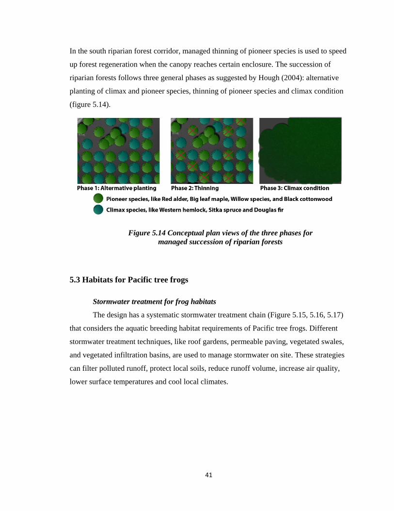
In the south riparian forest corridor, managed thinning of pioneer species is used to speed
up forest regeneration when the canopy reaches certain enclosure. The succession of
riparian forests follows three general phases as suggested by Hough (2004): alternative
planting of climax and pioneer species, thinning of pioneer species and climax condition
(figure 5.14).
Figure 5.14 Conceptual plan views of the three phases for
managed succession of riparian forests
5.3 Habitats for Pacific tree frogs
Stormwater treatment for frog habitats
The design has a systematic stormwater treatment chain (Figure 5.15, 5.16, 5.17)
that considers the aquatic breeding habitat requirements of Pacific tree frogs. Different
stormwater treatment techniques, like roof gardens, permeable paving, vegetated swales,
and vegetated infiltration basins, are used to manage stormwater on site. These strategies
can filter polluted runoff, protect local soils, reduce runoff volume, increase air quality,
lower surface temperatures and cool local climates.

42
Figure 5.15 View of the stormwater treatment from the community center
Figure 5.16 Elevation of the stormwater treatment
Buildings and stormwater treatment chain celebrate rain water (Figure 5.17). The
rain drains off the roof, feeding a series of wetland plants, and gets captured in an
invisible cistern which in turn meets the daily needs of the buildings’ residents. Excess
rainwater can be further treated in the surrounding wetlands near the cistern. The filtered
water is directed to another wetland pond to the east, from there, the cleared rainwater
will be released gradually through the forests into the creek.

43
Figure 5.17 Stormwater treatment chain on site
Frog habitats
Pacific tree frogs are common species and can use many landscapes as their
habitats (Chapter IV). However, not the entire site is suitable as habitat for Pacific tree
frogs. For instance, urban stormwater run-off can contain pollution, which is harmful to
the life cycles of Pacific tree frogs. According to the landscape quality on site and habitat
requirements of Pacific tree frogs, the site is designated into three habitat zones (Figure
5.18). Zone 1 is the encouraged habitat area for Pacific tree frogs with cleaner water for

44
breeding, cool/moist forests for nesting, and free connections to the western forest and
the eastern creek. Zone 2 and 3 are not suitable as frog habitats. Zone 2 can be polluted
by the arterial street and untreated stormwater from buildings on site. Zone 3 centralizes
human activities and polluted stormwater treatment on site. The migration of frogs into
these areas is discouraged using buildings, stairs and retaining walls to prevent the area to
be a sink for Pacific tree frogs. Zone 2 and 3 is not habitats for tree frogs but is also
critical for the health of frog habitats due to its ability to treat polluted stormwater and
release relatively clear water into Zone 1.
Figure 5.18 Habitat zones for Pacific tree frogs
5.4 Interaction of human and biotic habitats
This design addresses not only how to reconstruct boundaries for the coexistence
of the natural and human habitats, but also explores how each habitat can mutually
strengthen the other. The mutual interaction of human and biotic habitats is achieved in

45
this design by increased human appreciation of the biotic habitat and public participation
in management and monitoring of biotic habitats. By providing “sensorial” and
“explorative” landscape and encouraging public participation, the neighborhood residents
would play the role as both of the actor and of the audience towards landscape (Turri
1998, Cited from Castiglioni, 2007).
The development meets the needs of the community while enhancing each
person’s day-to-day experience by immersing them in an environment rich in natural
processes. Many components of biotic habitats
are designed to be enjoyable by humans. As the
rainwater flows through wetland plants on the
roof top plaza, a unique educational opportunity
is created (Figure 5.15 and 5.16). Residents can
see this vibrant stormwater clearing chain when
using this plaza as a pathway, a resting area or a
social place. Stormwater running through the
roof-top plaza to the ground-level plaza forms an ephemeral water fall, which serves as a
nice background for the stage and a visual focal point for the ground-level plaza (Figure
5.19). The wetland at the east with relatively clear water is another place with education
and exploration opportunities. It is a place that residents can look over for nice views,
enjoying the chorus of frogs, exploring wetland species using the stepping stones through
the wetland, and peaking into the riparian forests adjacent (Figure 5.20).
“Ecologically-grounded design that reveals natural processes engages site users in a dialogue by communicating to them what is at work in the natural world.”
---------- Howett (1987)

46
Figure 5.19 Stage using the stormwater as background
Figure 5.20 Wetland experiences

47
Landscapes in areas heavily manipulated by human activity are intentionally
designed to serve as a barrier for migration of certain species while a matrix for migration
of other species. As discussion in Figure 5.18, the developed area for human uses is
intentionally separated from the frog habitats due to the effect of pollution to the life
cycles of frogs. However, the developed area is still critical to the frog habitats
considering its function of treating pollutions and releasing relatively clear water to the
frog habitats near the creek. On the other hand, the purpose of landscape-specific
component of my design is to accommodate habitats for other species except Pacific tree
frogs and species having similar habitat requirements as tree frogs. If the developed area
is not an ecological trap for certain species, the developed area can be designed to serve
as a matrix to the adjacent forest habitat or at least a penetrable space for species using
the space (Franklin, 1993). In my design, native trees and shrub used in the developed
area are the same as those in the adjacent riparian forests. In such a case, some species
(like birds or insects) from the adjacent forests can use the human habitats as temporary
stepping stones or as resting places in their migration (Figure 5.21). In addition, native
species can discourage the spread of exotic species and further help the regeneration of
the eastern and southern riparian forests by pollination.
Figure 5.21 Potential wildlife migrations other than tree frogs

48
Interaction of human and biotic habitats can be further strengthened by public
participation in management and monitoring of biotic habitats. Involvement in the
management process reinforces the doctrine that humans are a part of nature and that they
have both the responsibility and the skills to steward the land on which they live. The
design suggests that there is a good opportunity for public participation in the process of
forest succession. Residents can help to plant alternative pioneer and climax species, and
later on to thin pioneer species when the forest canopy reaches certain closure. As the
blackberry is a barrier for the establishment of riparian forests on site, the community can
ask residents help in destroying blackberry to help the regeneration of native species.
Residents can also involve in monitoring. The site is changing and the changes are not all
predicable. The managed succession is conceptually feasible, but there are many factors
that will intervene with the growth of riparian forests. Monitoring is a process to assess
the site thus to modify our actions or our nonactions. Monitoring can help us to work
with the natural regenerative processes inherent in the patterns of each landscape.
49
Chapter VI
Conclusion
This study contemplates the role of landscape architects in integrating habitats and
advocates a new framework to integrate habitats in urban environment. The literature
shows two types of design approaches that have been explored for protecting or restoring
habitats: landscape-specific approach and organism-specific approach. As each approach
has its own strength and weakness, this study suggests a combined design approach using
both landscape and organism concerns. The combined design approach is applied in one
hypothetical site in the Portland metropolitan area to demonstrate how habitats can be
integrated into mixed-use development by innovative design. Accounting for site factors,
the site design creates and integrates three habitat types: riparian forest habitats, human
habitats, and habitats for Pacific tree frogs. Landscape and organism concerns
complement each other, which makes this design solution embody principles of
individuality, harmony and beauty in both biotic and human habitats.
As a summary, design principles to integrate habitats in my project are listed with
the purposes of advocating them to other projects elsewhere.
• Development for human uses is clustered to save spaces for biotic habitats.
• Vehicle transportation and surface parking are minimized to reduce
fragmentation and disturbance caused by vehicle circulations.
• Site design encourages pedestrian experiences to enhance site users’
interaction with surrounding natural landscapes.
• Stormwater is collected, treated and reused in developed areas so that the
pollution effect of development can be released.
• Managed succession is used to facilitate and speed up the natural
regeneration process of the native ecosystem on site.
• Site design provides suitable habitats for the “right” subset of species, which
is carefully selected to protect habitat for many other species with similar
requirements.

50
• If the developed area has the potential to be an ecological trap for selected
species, site design needs to intentionally discourage the migration of
selected species into the developed area using appropriate landscape
elements.
• If the developed area is not an ecological trap for certain species, site design
can accommodate the developed area as a matrix to the adjacent biotic
habitat or at least a penetrable space for species using the space.
• Components of biotic habitats are designed to reveal natural processes while
being enjoyable by humans so that site users can learn what is at work in the
natural world.
• Public participation in management and monitoring of biotic habitats is
encouraged to enhance site users’ understanding and appreciation of biotic
habitats through stewardship. In conclusion, I want to reiterate the call to a combined design approach for
integrating habitats into urban environment: landscape + species. For the purpose of
integrating habitats, landscape architects must work collaboratively with ecologists and
conservation biologists to understand the habitat requirements of species, about which we
may always have limited knowledge. Interdisciplinary work is a challenge but also an
opportunity for us to infuse many theories and knowledge into more sustainable design
solutions for the over populated and fast-paced world.

51
References
Alberti, M. (2005). The effect of urban patterns on ecosystem function. International
Regional Science Review 28, 168-192.
Arendt, R. (1996). "Conservation Design for Subdivision: A Practical Guide to Creating
Open Space Networks," Island Press, Washington, D.C.
Arendt, R. (1999). "Growing Greener: Putting Conservation into Local Plans and
Ordinances," Island Press, Washington, D.C.
Arendt, R. (2004). Linked landscapes: Creating greenway corridors through conservation
subdivision design strategies in the northeastern and central United States.
Landscape and Urban Planning 68, 241-269.
Baxter, C. V., Fausch, K. D., and Saunders, C. (2005). Tangled webs: Reciprocal flows
of invertebrate prey link streams and riparian zones. Freshwater Biology 50,
2001-2220.
Bennett, A. F. (2003). "Linkages in the Landscape: The Role of Corridors and
Connectivity in Wildlife Conservation." International Union for Conservation of
Nature and Natural Resources, Gland, Switzerland, Cambridge.
Blaustein, A. R., Romansic, J. M., Kiesecker, J. M., and Hatch, A. C. (2003). Ultraviolet
radiation, toxic chemicals and amphibian population declines. Diversity and
Distributions 9, 123-140.
Block, W. M., Brennan, L. A., and Gutiérrez, R. J. (1987). Evaluation of guild-indicator
species for use in resource management. Environmental Management 11, 265-
269.
Bury, R. B. (1988). Habitat relationships and ecological importance of amphibians and
reptiles. In "Streamside Management: Riparian Wildlife and Forestry
Interactions." (K. J. Raedeke, ed.), pp. 61-76. Institute of Forest Resources,
University of Washington, Seattle, WA.
Callicott, J. B., Crowder, L. B., and Mumford, K. (1999). Current normative concepts in
conservation. Conservation Biology 13, 22-35.

52
Campbell, C. S., and Ogden, M. H. (1999). "Constructed Wetlands in the Sustainable
Landscape," John Wiley and Sons, Inc., New York.
Carroll, C., Noss, R. F., and Paquet, P. C. (2001). Carnivores as focal species for
conservation planning in the Rocky Mountain region. Ecological Application 11,
961-980.
Castiglioni, B. (2007). Education on landscape: Theoretical and practical approaches in
the frame of the European Landscape Convention. Last Retrieve on June 2nd, 2008
from
http://www.aiig.it/Testi%20.pdf/Portale_Didattica/Castiglioni_paper%20Lucerna.
pdf.
Conway, W. G. (1989). The prospects for sustaining species and their evolution. In
"Conservation for the 21st Century" (D. Western and M. C. Pearl, eds.), pp. 199-
209. Oxford University Press, New York.
Coutts, C. J. (2006). Greenway accessibility and physical activity behavior in two
Michigan cities. Dissertation, University of Michigan, Ann Arbor, MI.
Daubenmire, R. (1968). "Plant Communities," Harper & Row, New York.
Davis, A. P., and McCuen, R. H. (2005). "Stormwater Management for Smart Growth,"
Springer Science, New York.
Davis, J. D. (1996). Focal species offer management tool Science 271, 1362-1363.
Dramstad, W., Olson, J. D., and Forman, R. T. T. (1996). "Landscape Ecology Principles
in Landscape Architecture and Land-Use Planning," Harvard University Graduate
School of Design, Cambridge, MA.
Erickson, D. L. (2004). The relationship of historic city form and contemporary greenway
implementation: A comparison of Milwaukee, Wisconsin (USA) and Ottawa,
Ontario (Canada). Landscape and Urban Planning 68, 199-221.
Fahrig, L. (2005). When is a landscape perspective important? In "Issues and
Perspectives in Landscape Ecology" (J. Wiens and M. Moss, eds.), pp. 3-10.
Cambridge University Press, Cambridge.
Ferguson, B. K. (1998). "Introduction to Stormwater: Concept, Purpose, Design " Wiley,
New York.

53
Fleury, A. M., and Brown, R. D. (1997). A framework for the design of wildlife
conservation corridors with specific application to southwestern Ontario.
Landscape and Urban Planning 37, 163-186.
Fleury, S. A., and Mock, P. J. (1998). Is the California Gnatcatcher a good umbrella
species? Ecological Application 10, 569-579.
Forman, e. a. (2003). "Road Ecology: Science and Solutions," Island Press, Washington,
D.C.
Forman, R. T. T., and Godron, M. (1986). "Landscape Ecology," John Wiley & Sons,
New York.
Franklin, J. F. (1993). Preserving biodiversity: Species, ecosystems or landscapes?
Ecological Application 3, 202-205
Franklin, J. F., and Dyrness, C. T. (1988). "Natural Vegetation of Oregon and
Washington" Oregon State University Press, Corvallis, OR.
G. Tyler Miller, J. (1991). "Environmental Science: Sustaining the Earth," Wadsworth
Publishing Co, Belmont, CA.
Gardner, J. D. (1995). Natural history notes: Pseudacris regilla (Pacific chorus frog)
Reproduction. Herpetological Review 26, 32.
Gould, S. J. (1998). An evolutionary perspective on strengths, fallacies, and confusions in
the concept of native plants. Arnoldia 58, 11-19.
Gustafson, E. J. (1998). Quantifying landscape spatial pattern: What is the state of the
art? Ecosystems 1, 143-156.
Hall, L. S., Krausman, P. R., and Morrison, M. L. (1997). The habitat concept and a plea
for standard terminology. Wildlife Society Bullet 25, 173-182.
Hess, G. R., and King, T. J. (2002). Planning open spaces for wildlife: Selecting focal
species using a Delphi survey approach. Landscape and Urban Planning 58, 25-
40.
Hough, M. (2004). "Cities and Natural Process: A basis for Sustainability," Routledge,
New York.
Howett, C. (1987). Systems, signs, sensibilities: Sources for a new landscape aesthetic.
Landscape Journal 6, 1-12.

54
Jackson, S. (2003). Proposed design and considerations for use of amphibian and reptile
tunnels in New England, Amherst. Last retrieved on Feb 3rd, 2008 from
http://www.umass.edu/nrec/pdf_files/herp_tunnels.pdf
Jaksic', F. M. (1981). Abuse and misuse of the term "guild" in ecological studies. Oikos
37, 397-400.
Jensen, J. (1956). "Siftings. The Major Portion of "The Clearing," and Collected
Writings," Chicago.
Kennedy, M., Jacobsen, B., Kosir, S., Dinsmore, K., and Babcock, R. (2008). Daily
Migrations. Integrating Habitat Competition.
Kerr, J. T. (1997). Species richness, endemism, and the choice of areas for conservation.
Conservation Biology 11, 1094-1100.
Kiesecker, J. M., Blaustein, A. R., and Belden, L. K. (2001). Complex causes of
amphibian population declines. Nature 410, 681-684.
Knight, R. L. (1990). Ecological principles applicable to the management of urban
ecosystems. In "Perspectives in Urban Ecology" (E. A. Webb and S. Q. Foster,
eds.), pp. 24-34. Denver Museum of Natural History and Thorne Ecological
Institute, Denver, Colorado.
Lambeck, R. J. (1997). Focal species: A multi-species umbrella for nature conservation.
Conservation Biology 11, 849-856.
Leonard, W. P., Brown, H. A., Jones, L. L. C., McAllister, K. R., and Storm, R. M.
(1993). "Amphibians of Washington and Oregon." Seattle Audubon Society,
Seattle, Washington.
Linehan, J., Gross, M., and Finn, J. (1995). Greenway planning: Developing a landscape
ecological network approach. Landscape and Urban Planning 33, 179-193.
Löfvenhaft, K., Björn, C., and Ihse, M. (2002). Biotope patterns in urban areas: A
conceptual model integrating biodiversity issues in spatial planning. Landscape
and Urban Planning 58, 223-240.
Lynch, K. (1981). "A Theory of Good City Form," MIT Press, Cambridge, MA.
Mannan, R. W., Morrison, M. L., and Meslow, E. C. (1984). Comment: The use of guilds
in forest bird management. Wildlife Society Bulletin 12, 426-430.

55
Martikainen, P., Kaila, L., and Haila, Y. (1998). Threatened beetles in white-backed
woodpecker habitats. Conservation Biology 12, 293-301.
Maurer, U., Peschel, T., and Schmitz, S. (2000). The flora of selected urban land-use
types in Berlin and Potsdam with regard to nature conservation in cities.
Landscape and Urban Planning 46, 209-215.
McDowell, B., Stradling, T., Nicoli, M., and Severson, T. (2008). Nature in
Neighborhoods. Integrating Habitat Competition.
Miller, B., Reading, R., Strittholt, J., Carroll, C., Noss, R., Soule, M., Sanchez, O.,
Terborgh, J., Brightsmith, D., Cheeseman, T., and Foremane, D. (1998). Using
focal species in the design of nature reserve networks. Wild Earth (1998/99) 81-
92.
Miller, C. J. (2000). Vegetation and habitat are not synonyms. Ecological Management
and Restoration 1, 102-104.
Miller, J. R., and Hobbs, N. T. (2000). Recreational trails, human activity, and nest
predation in lowland riparian areas. Landscape and Urban Planning 50, 227-236.
Miller, J. R., and Hobbs, R. J. (2007). Habitat restoration: Do we know what we’re
doing? Restoration Ecology 15, 382-390.
Millers, S. L., Soule, M. E., and Doak, D. F. (1993). The keystone-species concept in
ecology and conservation. BioScience 43, 219-224.
Mitchell, M. S., and Powell, R. A. (2003). Linking fitness landscapes with the behavior
and distribution of animals. In "Landscape Ecology and Resource Management:
Linking Theory with Practice" (J. A. Bissonette and I. Storch, eds.), pp. 93-124.
Island Press, Washington, D.C.
Mitchell, S. C. (2005). How useful is the concept of habitat? A critique. Oikos 110, 634-
638.
Morrison, M. L. (2001). Introduction: Concepts of wildlife and wildlife habitat for
ecological restoration. Ecology 9, 251-252.
Moser, D., Zechmeister, H. G., Plutzar, C., Sauberer, N., Wrbka, T., and Grabherr, G.
(2002). Landscape patch shape complexity as an effective measure for plant
species richness in rural landscapes. Landscape Ecology 17, 657-669.

56
Murphyd, D., and Noon, B. D. (1991). Coping with uncertainty in wildlife biology.
Journal of Wildlife Management 55, 773-782.
Nassauer, J. I. (1997). Cultural and landscape ecology: Insight for action. In "Placing
Nature: Culture in Landscape Ecology" (J. I. Nassauer, ed.). Island Press,
Washington, D.C.
Niemela, J. (1999). Ecology and urban planning. Biodiversity and Conservation 8, 119-
131.
Nierenberg, T. R., and Hibbs, D. E. (2000). A characterization of unmanaged riparian
areas in the central Coast Range of western Oregon. Forest Ecology and
Management 129, 195-206.
Nussbaum, R. A., Jr., E. D. B., and Storm., R. M. (1983). "Amphibians and Reptiles of
the Pacific Northwest," University Press of Idaho, Moscow, Idaho.
Odell, E. A., Theobald, D. M., and Knight, R. L. (2003). Incorporating ecology into land
use planning: The songbirds' case for clustered development. Journal of the
American Planning Association 69, 72 - 82.
Odum, E. P. (1971). "Fundamentals of Ecology, 3rd ed. ," W.B. Saunders Company.
Opdam, P., Foppen, R., and Vos, C. (2001). Bridging the gap between ecology and
spatial planning in landscape ecology. Landscape Ecology 16, 767-779.
Page, J., and Kley, C. V. (2008). Living Graft. Integrating Habitat Competition.
Parker, K., Head, L., Chisholm, L. A., and Feneley, N. (2008). A conceptual model of
ecological connectivity in the Shellharbour Local Government Area, New South
Wales, Australia. Landscape and Urban Planning 86, 47-59.
Power, M. E., Tilman, D., Estes, J. A., Menges, B. A., Bond, W. J., Mills, L. S., Daily,
G., Castilla, J. C., Lubchenco, J., and Paine, R. T. (1996). Challenges in the quest
for keystones. BioScience 46, 609-620.
Prendergast, J. R., Quinn, R. M., Lawton, J. H., Eversham, B. C., and Gibbons, D. W.
(1993). Rare species, the coincidence of diversity hotspots and conservation
strategies. Nature 365, 335-337.
Root, R. B. (1967). The niche exploitation pattern of the bluegray gnatcatcher. Ecological
Monographs 37, 317-350.

57
Rorabaugh, J. C., Howland, J. M., and Babb., R. D. (2004). Distribution and habitat use
of the Pacific treefrog (Pseudacris regilla) on the lower Colorado River and in
Arizona. Southwestern Naturalist 49, 94-99.
Ryti, R. T. (1992). Effect of the focal taxon on the selection of nature reserves.
Ecological Application 2, 404-410.
Schindler, D. W. (1990). Natural and anthropogenically imposed limitations to biotic
richness in fresh waters. In "The Earth in Transition: Patterns and Processes of
Biotic Improvement" (G. M. Woodwell, ed.), pp. 425-462. Cambridge University
Press, Cambridge.
Scott, T. A., Wehtje, W., and Wehtje, M. (2001). The need for strategic planning in
passive restoration of wildlife populations. Ecology 9, 262-271.
Severinghaus, W. D. (1981). Guild theory development as a mechanism for assessing
environmental impact. Environmental Management 5, 187-190.
Simberloff, D. (1998). Flagships, umbrellas, and keystones: Is single-species
management passé in the landscape era? Biological Conservation 83, 247-257.
Smyser, C. A. (1982). " Nature’s Design. A Practical Guide to Natural Landscaping,"
Rodale Press, Emmaus, PA.
Stebbins, R. C. (1985). "A Field Guide to Western Reptiles and Amphibians. Second
edition," Houghton Mifflin Company, Boston, Massachusetts.
Tappeiner, J., Zasada, J., Ryan, P., and Newton, M. (1991). Salmonberry clonal and
population structure: the basis for a persistent cover. Biology 72, 609-618.
Terborgh, J. (1986). Keystone plant resources in the tropical forest. In "Conservation
Biology: The Science of Scarcity and Diversity" (M. E. Soulé, ed.), pp. 330-344.
Sinauer, Sunderland, MA.
Trepl, L. (1995). Towards a theory of urban biocoenoses. In "Urban Ecology as the Basis
for Urban Planning" (M. N. H. Sukopp, and A. Huber, ed.), pp. 3-21.
SPBAcademic, The Hague, the Netherlands.
Turner, M. G. (1989). Landscape ecology: The effect of pattern on process. Annual
Review of Ecology and Systematics 20, 171-197.
Turner, M. G., Gardner, R. H., and R.V.O'Neill (2001). "Landscape Ecology in Theory
and Practice: Pattern and Process," Springer Verlag, New York, NY.

58
Waters, D. L. (1992). Geographic distribution: Pseudacris regilla (Pacific treefrog).
Herpetological Review 23, 24-25.
Weitzel, N. H., and Panik, H. R. (1993). Long-term fluctuations of an isolated population
of the Pacific chorus frog (Pseudacris regilla) in Northwestern Nevada. Great
Basin Naturalist 53, 379-384.
Whittaker, R. H., Levin, S. A., and Root, R. B. (1973). Niche, habitat and ecotope.
American Naturalist 107, 321-338.
Wilcove, D. (1994). Response (to Tracy and Brusssard’s preserving biodiversity: species
in landscapes). Ecological Application 4, 205-207.
Wilcox, B. A. (1984). In situ conservation of genetic resources: Determinants of
minimum area requirements. In "National Parks: Conservation and
Development." (J. A. McNeely and K. R. Miller, eds.), pp. 639-647. Smithsonian
Institution Press, Washington, DC.
Zambelli, M. (2008). Terra+Scapes. Integrating Habitat Competition.