99W Improvement Plan Final Report - Scholars' Bank Home
64
Conceptual Planning and Technical Information for Tigard 99W Improvement and Management Plan Final Report Prepared for: City of Tigard 13125 SW Hall Boulevard Tigard, OR 97223 Oregon Transportation and Growth Management Program 555 13th Street, NE Salem, OR 97301 Prepared by: DKS Associates 1400 SW Fifth Avenue Suite 500 Portland, OR 97201 Otak, Inc. 17355 SW Boones Ferry Road Lake Oswego, OR 97035 July 2007
Transcript of 99W Improvement Plan Final Report - Scholars' Bank Home

Conceptual Planning and Technical Information for
Tigard 99W Improvement and Management PlanFinal Report
Prepared for:City of Tigard
13125 SW Hall Boulevard
Tigard, OR 97223
Oregon Transportation and
Growth Management Program
555 13th Street, NE
Salem, OR 97301
Prepared by:DKS Associates
1400 SW Fifth Avenue
Suite 500
Portland, OR 97201
Otak, Inc.
17355 SW Boones Ferry Road
Lake Oswego, OR 97035
July 2007

i Oregon Transportation and Growth Management Program
Project Management TeamGus Duenas, City Engineer, City of TigardRoss Kevlin, Transportation Growth Management Program, Grant Manager
Technical Advisory CommitteeRoss Kevlin, Oregon Dept. of TransportationGus Duenas, City Engineer, City of TigardGreg Berry, City of TigardRon Bunch, City of TigardKim McMillian, City of TigardSgt. Karl Kaufmann, Tigard Police Dept.Jane Turner/David Wells, King CityClark Berry, Washington CountyMark Turpel, MetroHeather Boll, TriMetJerry Renfro, Tualatin Valley Fire & Rescue
Consultant Team DKS Associates Randy McCourt, Principal Alan Snook, Transportation Planner
Otak Tom Litster, Urban Planner Crista Gardner, Land Use Planner James Todd, Civil Engineering
Leslie McClain, Project Assistant
ECONorthwestTerry Moore, PrincipalRadcliffe Dacanay, Real Estate Mrkt. AnalysisRob Wyman, Real Estate Mrkt. Analysis
Citizen Advisory CommitteeRex Caffall, Tigard Planning CommissionPaul OwenTom FergussonDaniel BarnesJesse BlackRoger PotthoffCherree WeeksTim McGilvreySteve BoughtonSue CarverWilliam Moss
The Tigard 99W Improvements Plan is funded by a grant from the Transportation and Growth Management Program (TGM), a joint program of the Oregon Department of Transportation and the Oregon Department of Land Conservation and Development. This TGM grant is fi nanced, in part, by the federal Transportation Equity Act for the 21st Century (TEA-21), local government and the State of Oregon funds. The contents of this document do not necessarily refl ect views or policies of the State of Oregon.
Acknowledgements

iiTIGARD 99W IMPROVEMENT & MANAGEMENT PLAN
FINAL REPORT
Section 1—Introduction 1
Section 2—Public and Agency Involvement 3
Section 3—Developing a Recommended Plan 4
Section 4—The Recommended Plan 10
Section 5—Implementation Projects 36
Appendices Appendix A—Concept Alternatives and Evaluation 38
Appendix B—Response to ODOT Technical Review Comments 71
Appendix C—Tigard Transportation System Plan Updates 75
Figures Figure 1—Typical Cross Sections 12
Figure 2—Access Management 13
Figure 3—Access Management 14
Figure 4—Access Management 15
Figure 5—Access Management 16
Figure 6—Access Management 17
Figure 7—Intersections & Pedestrian Crossings 20
Figure 8—SW Durham Rd. 21
Figure 9—SW Beef Bend Rd. 22
Figure 10—SW Canturbury Ln. 23
Figure 11—SW Gaarde St. / SW McDonald St. 24
Figure 12—SW Walnut St. / SW Walnut Pl. 25
Figure 13—SW Greenburg Rd. / SW Main St. 26
Figure 14—SW Hall Blvd. 27
Figure 15—SW Dartmouth St. / SW 78th Ave. 28
Figure 16—SW 72nd Ave. 29
Figure 17—SW 68th Ave / SW 69th Ave. 30
Figure 18—Relocated Bus Stops 31
Figure 19—Pedestrian Improvements 34
Figure 20—Bike Lane Improvements 35
Tables Table 1—Categories of Enhancement Concepts 6
Table 2—Criteria for Evaluating and Comparing Alternatives 9
Table 3—Comparison of Evaluation Criteria by Alternative 9
Table 4—PM Peak Hour Travel Time Comparison 11
Table 5— Potential Project Ranking 37
Table of Contents

1 Oregon Transportation and Growth Management Program
The Tigard 99W Improvements and Management Plan area includes approximately four miles of the State Highway 99W corridor between the I-5 interchange at the north end and the Durham Road/99W intersection at the south end. The highway carries between 45,000 to 50,000 vehicles per day. Of those vehicle trips, 53% are regional trips not originating or ending within the study corridor. The corridor has a variety of land uses with the majority focused on retail/commercial services. Locally serving retail likely draws most customers from within a ¼ mile radius, while big-box retail or large scale commercial uses likely draw customer traffi c from fi ve or more miles away. Within a ¼ to ½ mile corridor on either side of the highway there are signifi cant residential uses.
Future forecasts indicate highway performance will continue to deteriorate as trip demand in the corridor grows. The Regional Transportation Plan (RTP) calls for a mix of interventions to address rising trip demand rather than just provide new transportation capacity. These interventions may vary from plans for mixed-use development to land use and transportation strategies aimed at mitigating growth and rising trip demand. The primary focus of the Tigard 99W Improvements and Management Plan is transportation strategies.
Through a planning and public involvement process the project developed a concept-level recommended plan for transportation improvements and recommended additional interventions to meet future needs in the corridor. Development of the recommended plan included detailed analysis of needs, opportunities, market analysis of redevelopment potential in the corridor, and comparative evaluation of concept plan alternatives.
The recommended plan was developed through a planning process of four key steps supported by a public and agency involvement effort. The planning steps were:
Establish inventory of existing conditions
Analyze needs, opportunities and constraints
Develop alternative improvement concepts
Compare and evaluate alternative concepts
•
•
•
•
This report provides a summary of those steps and descriptions and illustrations of the recommended transportation solutions. The intent of the plan is to improve safety for all modes of travel and mitigate the negative effects of rising trip demand in order to meet future needs of the corridor. Negative effects of trip demand can affect both transportation and land use.
The plan can be implemented through a series of specifi c projects or new transportation planning strategies. A prioritized list of potential improvement projects has been provided along with planning level costs. This is a conceptual plan; implementation projects and related transportation strategies will require further discussion and/or approvals not yet obtained and will require additional engineering studies. Additional community outreach to potentially affected property owners and to the public at large will also be required. The plan has not been reviewed nor approved by the City Traffi c Engineer or the State Traffi c Engineer. Changes to Highway 99W must meet the standards of the ODOT Highway Design Manual or received a Design Exception from the State Traffi c Engineer. Additional survey, engineering design, and analysis will be required to determine the feasibility and approval of the proposed improvements.
Introduction

2TIGARD 99W IMPROVEMENT & MANAGEMENT PLAN
FINAL REPORT
Project Area Map
IntroductionContinued

3 Oregon Transportation and Growth Management Program
To ensure support for the recommended plan from community and agency stakeholders, the project included public involvement and interagency coordination. The City of Tigard identifi ed and appointed members for both a Technical Advisory Committee (TAC) and a Citizens Advisory Committee (CAC). Members of the TAC represent ODOT, Metro, TriMet, Washington County, Tualatin Valley Fire and Rescue, and the City of Tigard. Their project role was to meet with the consultant team during each of the four key steps to provide technical review and identify additional analysis or refi nement of improvement concepts that might be needed.
The CAC comprises a spectrum of citizens including business owners, neighborhood representatives, representatives from the Chamber of Commerce, and other citizen groups with an interest in the Tigard 99W Improvements Plan project. The Highway 99W Improvements and Management Plan was not intended to be a visioning process. However, the CAC provided valuable review and input for draft memoranda at the conclusion of each step in the planning process. They also provided community perspectives regarding the needs, opportunities, and constraints for improving Highway 99W as a part of the City of Tigard.
In addition to the fi ve TAC and CAC meetings, three Public Open Houses were held to engage public input at three milestones in the project:
During the needs, opportunities, and constraints step;
the alternative development step; and
the alternatives evaluation step.
Stakeholder interviews were conducted to offer members from the business community an opportunity to express concerns or possible solutions to the transportation problems in the corridor. Out of twenty stakeholders invited, fourteen participated. The vast majority of participants interviewed believed that congestion and safety was a problem that could ultimately affect their businesses. However, most of the interviewees
•
•
•
objected to the idea of widening the corridor to seven lanes as called for in Metro’s 2004 Regional Transportation Plan (RTP). Over half were open to the idea of some kind of access management strategy.
Intersection at SW Gaarde/SW McDonald
Public and Agency Involvement

4TIGARD 99W IMPROVEMENT & MANAGEMENT PLAN
FINAL REPORT
The recommended Tigard 99W Improvement and Management Plan was completed through the four integrated and successive steps previously noted. Each step involved thorough analysis that resulted in key fi ndings that set the stage for the next step. Feedback from advisory committees and the public was used to refi ne fi ndings of each step before proceeding.
Step 1: Identify Existing ConditionsA thorough inventory of existing transportation conditions for the Highway 99W corridor was conducted. In addition, a review of prior studies was performed to help broaden the knowledge of the study area and roadway network and intersections. Inventory included existing traffi c operations (including lane geometry, historic and existing traffi c volumes, and traffi c travel times) as well as an evaluation of bicycle and pedestrian facilities, transit service, and intersection operations. This inventory included intersecting local streets and the on/off ramps for I-5 and OR 217. The fi ndings from the inventory suggested the need for multimodal transportation improvements along the Corridor.
The analysis of the existing conditions indicates a number of intersections along the corridor that fail to meet existing performance standards or are near capacity for motor vehicle operations. Six of the twenty study area intersections have this characteristic. These intersections act as bottlenecks (congestion points) along the corridor that can degrade travel times and produce signifi cant delays. Peak travel times along the corridor were also collected and the results indicated that on average, it takes motor vehicles 11 to 12 minutes to traverse the corridor study area in comparison to off-peak free fl ow travel times that are approximately 6 to 7 minutes.
In addition to the motor vehicle conditions, inventories for alternative modes of travel were conducted. The results revealed a number of gaps in the existing sidewalk system as well as substandard sidewalk widths. This creates a discontinuous pedestrian network along the corridor. The bicycle network is mostly complete; however, there are
some gaps located in the north portion of the corridor near Interstate 5.
The transit system serves approximately 6,000 daily riders that board and depart buses within the study area. Transit stops are on average 980 feet apart and are typically located at or near signalized crossings. However, there are some stop locations at unsignalized intersections requiring pedestrians to cross Hwy 99W to access the stops.
An inventory of driveways along Hwy 99W was also conducted. The corridor has approximately 100 existing driveways (most with full turn access) within the study area. Many of these driveways occur in the middle and northern portions of the corridor in close proximity to existing signalized intersections and existing interchanges with Hwy 217 and Interstate 5.
Step 2: Identify Needs, Opportunities and Constraints This step was important in the development and eventual evaluation of alternative concepts. Corridor defi ciencies were analyzed for all modes of travel in order to identify specifi c future transportation needs for the corridor. Future needs analysis considered the likelihood of a future I-5 to Highway 99W connection. The I-5/99W Connector Study is a parallel project currently underway that is detailing out the recommended roadway alignment to connect Interstate 5 to Hwy 99W south of the study area. As part of the future forecasting for this study, a generalized alignment for this project was in place in the Metro Regional Travel Demand Model.
A “toolkit” of potential improvements was developed, listing the pros, cons, and applicability of various enhancements. Opportunities and constraints for implementing enhancements were also identifi ed. This information was used to guide development of improvement alternatives in the next step of the plan process. Preliminary criteria for evaluating and comparing conceptual alternatives were also developed in Step 2.
Key needs identifi ed included:
Bicycle facilities ─ fi lling in gaps in the bicycle •
Developing a Recommended Plan

5 Oregon Transportation and Growth Management Program
network, local/regional connectivity and reducing bike/vehicle confl icts.
Pedestrian facilities ─ fi lling in gaps in the sidewalk network, upgrading existing sidewalks to a consistent design standard, and improved pedestrian crossing of Highway 99W.
Transit service and facilities ─ improving transit travel times, access to transit, driveway and transit stop confl icts and identifying poorly served transit areas.
Motor vehicles ─ inadequate capacity at intersections, congestion delays for through travel, access locations and growing traffi c volumes on side streets.
Step 2 also included a Real Estate Market Overview. Objectives of the overview were to evaluate potential for redevelopment in the corridor and identify opportunities for land use and site design regulations that may contribute to achieving project objectives.
Highway and auto-oriented commercial development is the dominant fronting land use. This automobile centered development pattern contributes to traffi c congestion along this segment of the Highway 99W corridor. From an economic perspective, extensive redevelopment along the corridor is not probable in the short-run. In the long-run, there are opportunities for redevelopment but they will be capitalized on more extensively and more quickly if supported by targeted public investments.
Following are key fi ndings about real estate market conditions and trends:
Expected growth in Washington County and the City of Tigard suggests the possibility and need for intensifying land use in the Corridor.
Increased densities in the Corridor support regional public policy.
Improvement-to-land value ratios suggest the possibility for long-run redevelopment.
Modest local retail strength and strong competition from nearby regional centers
•
•
•
•
•
•
•
suggest that Corridor redevelopment should be structured and concentrated to create a commercial identity for the Corridor and should be supported by a focused public policy.
The current zoning and comprehensive plan designations within the study corridor do not encourage or require mixed use (residential and commercial) developments, although mixed use developments are allowed in several of the zones within the corridor. Instead, the current zoning and site development standards facilitate the continued development of relatively low density residential and strip commercial.
As initially conceived, the Tigard 99W Improvement and Management Plan could have continued to examine potential land use changes. That examination may have resulted in recommendations for new zoning and/or site design guidelines, along with evaluation of the transportation impacts. However, given the City of Tigard’s on-going examination of current zoning as part of their Comprehensive Plan update, with expectation of staff to recommend changes, it was decided not to pursue a parallel study as part of this project.
99W looking Northeast from Hwy 217 Interchange
Developing a Recommended PlanContinued

6TIGARD 99W IMPROVEMENT & MANAGEMENT PLAN
FINAL REPORT
Step 2 also identifi ed a general strategy to help prioritize implementation of potential enhancements. The strategies were metaphorically characterized as “fruits hanging from a tree.” Descriptions of the three types of enhancements follow:
“Low Hanging Fruit”— enhancements and strategies that are relatively easy to implement considering factors such as low cost, minimal impact to right-of-way, minimal impact to modes of travel or land uses, and maximum perceived benefi t to alternatives modes of travel (non-single occupancy vehicle).
“Medium Hanging Fruit”— enhancements and strategies requiring additional effort to implement considering factors such as a right-of-way needs, project cost and funding, and time frame to implement.
“High Hanging Fruit”— enhancements and strategies that take a signifi cant effort to implement due to funding requirements, signifi cant impacts to adjacent properties/right-of-way, and/or the potential for multi-jurisdictional coordination that would require a long period of time. Additionally, these projects typically require signifi cant public involvement, as well as an often complex environmental review process to comply with the National Environmental Policy Act (NEPA).
•
•
•
Step 3: Alternatives DevelopmentThis step developed concepts that support the purpose and goals of the project and address transportation defi ciencies identifi ed in the corridor. One goal of this project is to identify improvements to the corridor that enhance and encourage alternative modes of travel; therefore, each alternative concept provides multimodal enhancements that include continuous sidewalks and bike lanes.
As part of the sensitivity analysis for future conditions, various locations along Hwy 99W were looked at to see if some parallel roadway connections could be made to help provide alternative travel paths to Hwy 99W for motor vehicles. Due to the diagonal orientation of Hwy 99W within a grid system of roadways, the potential to provide or connect a parallel roadway is diffi cult.
Some locations had a defi nite potential benefi t for shifting traffi c volumes from Hwy 99W, such as the SW Walnut Street extension to the east connecting to SW Hunziker Road. Other locations would be more diffi cult to implement due to the residential land uses adjacent to the commercial land uses that front Hwy 99W. A parallel roadway would need to align through residential neighborhoods for a signifi cant distance in order to provide enough of a connection to attract vehicles away from Hwy 99W. Due to its infeasibility, the creation of frontage/backage roads was not included in the alternatives.
Table 1: Categories of Enhancement ConceptsLow Hanging Fruit Medium Hanging Fruit High Hanging Fruit
Access Management through driveway closure.
Minor intersection capacity improvements.
Redesigned curb radii at intersections.
Location specifi c transit improvements.
Site design review to provide better direction for pedestrian access, bicycle amenities and transit access.
•
•
•
•
•
Filling in gaps of sidewalks and bicycle network.
Implementation of Intelligent Transportation Solutions along Hwy 99W
Small scale land use redevelopment.
•
•
•
Widen Hwy 99W to a seven lane facility from Interstate 5 to Greenburg Road.
Implement high capacity transit system that services Hwy 99W.
Local connecting (or backage) roadways.
Large scale redevelopment
•
•
•
•
Developing a Recommended PlanContinued

7 Oregon Transportation and Growth Management Program
Variations between concepts included retaining the current fi ve-lane cross section for the highway versus a seven-lane cross section (highway widening), the locations of additional travel lanes from widening, the type and location of transit improvements, and the extent of potential access management strategies in the corridor. The basic tools of access management were the same in each concept—raised medians and driveway closure/consolidation. Variations between concepts are summarized below.
Alternative A: Partial Widening
Consistent with 99W corridor improvements described in the Metro 2004 Regional Transportation Plan (RTP), this alternative would widen Highway 99W to seven lanes from Interstate 5 to SW Greenburg Road. Because this was the recommended solution for 99W in the adopted RTP, it was necessary to include it as an alternative in this project in order to verify at the corridor-plan level whether it should still be the recommended solution or if another alternative would better meet the project objectives. This alternative includes limited access management strategies focused within the interchange access spacing area in the vicinity of Highway 217 and Interstate 5. Localized intersection capacity improvements are also included in this plan to allow for adequate intersection operations.
An enhanced transit environment is achieved by relocating up to ten existing bus stops and adding transit queue bypass lanes at two intersections (SW Walnut Street and SW Gaarde/McDonald Street). South of Greenburg Road, local capacity improvements are included where intersections will have future defi ciencies.
Alternative B: Access Management Strategy
This alternative explored the effects of reducing the excessive number of driveways identifi ed in Step 2. It proposes corridor-wide strategies to reduce turn confl icts and congestion resulting from turn movements and egress and ingress associated with those driveways. Strategies include raised medians along 40% of the corridor’s length to preclude left turns (drivers would instead make U-turns at intersections to access destinations
across the street). Driveways were also identifi ed for further examination for closure, consolidation, or relocation where feasible along the corridor to reduce turn confl icts and congestion. This would apply particularly for properties with multiple driveways, access to side streets, or within 200 feet of intersections. In this concept, the transit environment is enhanced by both relocating bus stops and by the addition of transit queue bypasses at fi ve intersections:
68th Avenue
Dartmouth Avenue
Hall Boulevard
Walnut Street
Gaarde/McDonald Street
This alternative was evaluated as a “no-widening” option with the goal of minimizing right-of-way impacts. However, it does include some intersection widening to provide either new turn lanes and/or transit queue bypass lanes (Figure 2-6). Intersections that would be widened are:
99W and 68th Avenue ─ Transit queue bypass.
99W and Dartmouth ─ Transit queue bypass, southbound through lane.
99W and Hall Boulevard ─ Transit queue bypass, westbound turn lane.
•
•
•
•
•
•
•
•
Bicyclists at bus stop along 99W
Developing a Recommended PlanContinued
8TIGARD 99W IMPROVEMENT & MANAGEMENT PLAN
FINAL REPORT
99W and Greenburg Road ─ Eastbound/westbound left turn lanes.
99W and Walnut Street ─ Transit queue bypass, westbound left turn lane.
99W and Gaarde/McDonald ─ Transit queue bypass, northbound/southbound left turn lanes, eastbound/westbound through lanes and eastbound/westbound left turn lanes
99W and Canterbury ─ Westbound left turn lane.
99W and Beef Bend Road ─ Southbound right turn.
99W and Durham Road ─ Northbound left turn.
Alternative C: Full Widening
This alternative would widen Highway 99W to seven lanes for the entire length of the study corridor. This alternative allowed a comparison of the costs and benefi ts of widening only a portion of the corridor (Alternative A per the RTP) versus widening the entire corridor (Alternative C). No transit queue bypass lanes or turn lanes were included as these would create excessively wide pedestrian crossings that would be problematic both for pedestrians and for signal timing.
This concept also includes limited access management strategies that will reduce the potential for collisions as well as enhance the through capacity for vehicles. As with Concept A, access management would be limited to a ¼ mile distance from the I-5 and OR 217 interchanges. Access management is not as aggressive as in Concept B, which proposes raised medians and potential driveway closures/consolidations throughout the corridor.
Step 3 also completed two other signifi cant tasks. First, it fi nalized evaluation criteria to guide development of alternatives and to comparatively evaluate alternatives. Second, the impact of each alternative on adjacent properties and buildings was mapped and compared. Some widening of the highway footprint is needed in each alternative since each alternative features a wider sidewalk
•
•
•
•
•
•
design (including a landscaped buffer) than what currently exists along the highway. More signifi cant impacts to adjacent properties would result from areas of the highway widened to seven lanes or from additional lanes added to specifi c intersections to improve the performance of vehicles and/or transit.
The fi nal technical memorandum documenting the development of alternative concepts has been included in Appendix A.
Step 4: Alternatives EvaluationIn Step 4 each of the three concepts was evaluated and compared by applying criteria developed in Steps 2 and 3. The evaluation criteria were both qualitative (non-numerical) and quantitative (calculated). The criteria used to develop alternative concepts are summarized in Table 2 (page 9) and the comparative evaluation of concepts is summarized in Table 3 (page 9). As a part of this evaluation, building impact and right-of-way costs were assigned to each concept. If the proposed improvements extended beyond the existing right-of-way, additional costs were assigned for the purchasing of additional right-of-way and in some instances the taking of affected buildings.
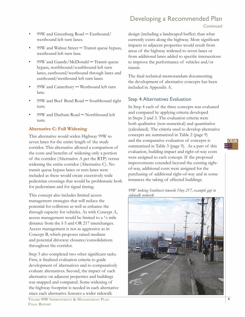
99W looking Southwest towards Hwy 217, example gap in sidewalk network
Developing a Recommended PlanContinued

9 Oregon Transportation and Growth Management Program
Table 3: Comparison of Evaluation Criteria by Alternative
Table 2: Criteria for Evaluating and Comparing Alternatives Category Criteria Measure(s)
Pedestrian Connectivity
Crossing distance
•
•
Adequate connections
Distance in feet
•
•
Bicycle Connectivity• Adequate connections•
Transit Facilities
Bypassing queues
•
•
Enhanced Pedestrian Crossings for Stops
Enhanced Pedestrian Environment at Stops
Intersection queue lengths
•
•
•
Motor Vehicle Intersection operations
Queuing/storage for vehicles
•
•
Level-of-service
Volume-to-capacity
Queuing in feet
•
•
•
Safety Driveways and confl ict points
• Frequency and number of occurrences•
Property Impacts Right-of-way impacted
Building impacted
•
•
Square feet•
Costs Dollars• Construction and Right-of-Way Acquisition
•
When evaluation criteria were applied, Alternative B: Access Management was determined to best meet the criteria and project objectives while carrying the fewest negative impacts.
Developing a Recommended PlanContinued
The summary of evaluations is indicated below. Detailed evaluations and summary fi ndings have been included in Appendix A as Alternatives Evaluation and Comparison.

10TIGARD 99W IMPROVEMENT & MANAGEMENT PLAN
FINAL REPORT
This is a conceptual plan that requires more detailed analysis and refi nement, which usually happens in the process of preliminary engineering prior to a construction project. Elements proposed that affect ODOT facilities will require review and approval by the State Traffi c/Roadway Engineer. This conceptual plan appears feasible to construct. However, issues that become apparent in a more detailed refi nement process may lead to plan modifi cations, which may include changing or eliminating some design elements.
Specifi c design issues regarding the recommended plan were raised by an ODOT reviewer during this planning process. The project consultant’s responses are included in Appendix B.
The recommended plan retains primary features of Alternative B, the “no widening” alternative. The plan maintains a fi ve-lane cross section with enhanced continuous sidewalks, planter strips, and bike lanes (Figure 1). There are exceptions to the fi ve-lane cross section at two locations. One exception is the intersections where additional turn lanes or transit bypass lanes are proposed, in which case the cross section is wider than fi ve lanes. The other exception is the overpass of the existing railroad lines near downtown Tigard. There is no center turn lane on the overpass and the cross section is limited to four travel lanes. Key improvement features are:
Access management strategy to improve safety and reduce travel delay.
Intersection improvements to reduce congestion delay.
Transit enhancements for travel time and pedestrian access.
Pedestrian and bike enhancements.
An Access Management ConceptIn comparison to other concepts, greater emphasis is placed on an access management concept. Access management would be applied throughout the corridor rather than limited to interchange areas for I-5 and OR 217. The primary implementation tools
•
•
•
•
for this concept would be:
Raised medians
Driveway closures, consolidation or relocation.
Raised medians are recommended along most of the corridor north of SW Gaarde/SW McDonald Street, placing medians along approximately 40% of the corridor’s length. Drivers would be allowed to make U-turns at intersections to access destinations across the street. Medians already in place and functioning to limit turning movements would not be replaced as part of the is concept. However, they are assumed to remain in place and be functional part of the access management concept. For cars to be allowed to make a U-turn at a signalized intersection, ODOT requires a minimum distance of 52 feet between the outside edge of the left turn lane and the curb edge of the opposing lane. At some intersections where improvements are proposed on 99W, attaining this minimum distance may require additional width in a raised median. This issue should be addressed during preliminary engineering for intersection improvements.
Raised medians can be a concern for emergency vehicle turning movements in response to an incident. Final design and implementation should be coordinated with Tualatin Valley Fire and Rescue regarding acceptable U-Turn or travel times to mid-intersection properties fronting the highway. It is possible the median design could allow for rolled curbs and designated turning areas across medians for emergency vehicle use. However, emergency vehicle access needs should not be construed to eliminate raised medians as an effective tool in reducing travel delays and increasing safety for typical vehicle traffi c in the corridor.
Potential closure/consolidation of access driveways throughout the corridor is preliminary and only at the planning level (Figures 3 through 6). These are candidate properties, used only to model potential changes in traffi c congestion. They do not represent an access management plan. For planning purposes, determination of candidate properties for driveway closure/consolidation was based on one or more of the following criteria:
•
•
Developing a Recommended PlanContinued

11 Oregon Transportation and Growth Management Program
Properties with multiple access points;
properties abutting side streets that can provide alternative access; and
driveways within two-hundred (200) feet of congested intersections or intersections that have higher collision rates.
Implementing access management will have positive effects on both corridor safety and congestion. As a safety improvement, it reduces vehicle collisions and reduces vehicle/bike and vehicle/pedestrian confl icts. As a congestion improvement, it can reduce delays in the corridor while retaining a fi ve-lane cross section (the “no widening” alternative). When combined with proposed intersection improvements, congestion delays can be even further reduced. Applying the Metro Regional Travel Demand Model to specifi c corridor intersections’ traffi c analyses indicated an increase in travel speeds along the corridor due to reduced confl ict points resulting from access management. This increase in speeds corresponds to a potential decrease in PM peak hour travel time of approximately 8% in the northbound direction and 10% in the southbound direction. The travel time in the southbound direction is longer due to heavier volume fl ow during the PM peak period. Access management can be expected to have similar benefi ts to travel times in the northbound direction during the AM peak period when vehicle volumes are heavier in that direction.
Before access management can be implemented, an access management plan for the corridor must be developed. An access management plan, as defi ned by ODOT, lists specifi c locations for driveways and driveway closures, consolidations and relocations.
•
•
•
The preparation of an access management plan includes extensive outreach and coordination with affected property owners. Access management plans are often done as part of preliminary engineering prior to construction projects so that driveway closures and relocations can be built as part of the construction project. This process could be applied along the 99W corridor in Tigard or the city could pursue development of an access management plan separate from any construction project. However, no construction project on 99W should proceed without an access management plan prepared in conformance with these guidelines to maximize benefi ts to safety and mobility:
Multiple driveways on 99W serving a single property should be reduced to no more than one driveway on 99W.
Properties that abut side streets should have access by way of side streets and not 99W, and their driveway connections to 99W should be closed.
To the greatest extent possible, adjoining properties should share a single, consolidated driveway. In these cases, internal crossover easements can be used to provide access to individual properties that now rely on direct access to 99W.
Determination of driveway closures and relocations should consider operational needs of affected businesses. Operational needs may include, for example, the need for tanker truck access and circulation at a gas station, but does not include the perceived need for direct vehicle access to and from 99W.
•
•
•
•
Table 4: PM Peak Hour Travel Time Comparison With and Without Access ManagementDirection Existing PM Peak Alternative B: Without Access
ManagementAlternative B: With Access Management
Northbound 11 min 0 sec 12 min 50 sec 11 min 50 sec
Southbound 12 min 30 sec 15 min 30 sec 14 min 0 sec
SOURCE: DKS Associates
Developing a Recommended PlanContinued

18TIGARD 99W IMPROVEMENT & MANAGEMENT PLAN
FINAL REPORT
Intersection Improvements
Intersection improvements are focused on changes to the design of the intersection confi guration (primarily adding turn lanes to ensure the intersection meets 20-year performance standards) and transit bypass queue lanes. Nine intersections have been identifi ed for improvements. Figures 7 through 17 are conceptual illustrations of recommended changes to these intersections:
99W and 68th Avenue — Transit queue bypass.
99W and Dartmouth — Transit queue bypass, southbound through lane.
99W and Hall Boulevard — Transit queue bypass, westbound turn lane.
99W and Greenburg Road — Eastbound/westbound left turn lanes.
99W and Walnut Street — Transit queue bypass, westbound left turn lane.
99W and Gaarde/McDonald — Transit queue bypass, northbound/southbound left turn lanes, eastbound/westbound through lanes and eastbound/westbound left turn lanes
99W and Canterbury — Westbound left turn lane.
99W and Beef Bend Road — Southbound right turn.
99W and Durham Road — Northbound left turn.
Bus Transit ImprovementsThe recommended plan improvements include bus transit queue bypass lanes at fi ve intersections (Figure 18):
SW 68th Avenue
SW Dartmouth Street
SW Hall Boulevard
SW Walnut Street
SW Gaarde/McDonald Street(s).
•
•
•
•
•
•
•
•
•
•
•
•
•
•
Bypass lanes will signifi cantly improve bus travel time along the corridor, as well as reducing vehicle delays behind loading/unloading buses. Queue bypass lanes must be designed with adequate length for buses to bypass the 95th percentile vehicle queues at the intersection.
Transit stop relocations along the corridor are also recommended (Figure 18). Relocation to a “far side” stop placement at signalized intersections allows transit vehicles to clear an intersection and stop on the opposing side to load/unload. Passengers crossing intersections after disembarking from a bus are more visible to motorists. Queue bypass lanes with far-side stops also provide improved right turn opportunities for vehicles. Detailed design and amenity upgrades for stops were not included in the recommended plan. However, a high level of amenities and design should be maintained throughout the corridor.
Developing a Recommended PlanContinued

19 Oregon Transportation and Growth Management Program
(This page left intentionally blank)

32TIGARD 99W IMPROVEMENT & MANAGEMENT PLAN
FINAL REPORT
The Future of High Capacity Transit in the 99W CorridorThe issue of High Capacity Transit (HCT) in the 99W Corridor was raised by the TAC and CAC as well as the general public. Metro’s Regional Transportation Plan (RTP) identifi es 99W as a high capacity transit corridor. However, the RTP does not indicate the specifi c mode of high-capacity transit, and it indicates such transit improvements on 99W as lower-priority, to be achieved in the longer term, rather than being a higher-priority, short-term project. Because there is no specifi city or certainty with regard to HCT, it was not refl ected in the evaluation criteria or listed as a transportation improvement as part of this project.
Three types of transit modes or facilities are generally considered to provide high-capacity transit, or HCT. They are Bus Rapid Transit (BRT), Dedicated Busway, or Light Rail Transit (LRT). Each mode usually requires a dedicated lane, free of any other through vehicle traffi c, to function effectively. Different design standards apply to each mode; which in turn can affect lane and overall right-of-way widths. Widening the highway to seven lanes does not guarantee that an HCT facility could fi t in the right-of-way.
Retaining a fi ve-lane cross section with an access management focus does not preclude future HCT. When plans for HCT become more specifi c with a selected mode and vehicle type, assessments of right-of-way needs and other impacts can be made at that time along with preliminary alignments and proposed station locations. Until that occurs, the City of Tigard might consider strategies such as building setbacks for new development to preserve physical space for right-of-way expansion to include HCT in the future. If anything, access management strategies may become even more aggressive if HCT is implemented.
Pedestrian ImprovementsEnhancing the pedestrian environment involves three key improvements (Figure 19):
Fill in the gaps in the existing sidewalk system. •
Gaps in the existing networks were identifi ed in Step 2: Existing Conditions Analysis.
Upgrading current sidewalks as necessary to meet the proposed design standard of eight-foot walkway and four-foot landscape strip.
Pedestrian crossing improvements.
Filling in the gaps in the existing sidewalks system will provide pedestrian connectivity along the corridor. The recommended sidewalk design (for fi lling in the gaps and for upgrading existing sidewalks) is an eight-foot walkway and four-foot landscape strip. Sidewalks segments that meet or exceed these standards would not be reconstructed.
The recommended plan also provides pedestrian advantages by avoiding seven lane highway widening. Widening intersections increases the time required for pedestrians to cross, which in turn requires longer red lights at traffi c signals. Longer red times can affect the roadway’s effi ciency for through travel. The plan also provides raised medians along a signifi cant portion of the corridor. This allows for potential pedestrian refuges for crossing at unsignalized intersections.
Two specifi c locations are recommended for new pedestrian activated signalized crossings. These two locations are at SW 71st Avenue and SW Watkins Avenue intersection. The 71st Avenue location improves pedestrian access to an existing transit stop. SW Watkins Avenue improves pedestrian access where current intersection spacing signifi cantly exceeds accepted standards for convenient pedestrian crossing. Implementation of these (as well as design components) would need to be determined at a later time when an engineering study is completed to determine if the locations meet warrants for pedestrian crossings as well as what type of crossing treatment is most appropriate for the safest design possible. Final design of the new pedestrian crossings will be subject to ODOT approval. Meeting signal warrants and spacing requirements may limit or preclude where additional signalized intersections could be implemented.
Access management strategies for closing or consolidating driveways will also reduce potential
•
•
Developing a Recommended PlanContinued
33 Oregon Transportation and Growth Management Program
bike/vehicle confl icts thereby improving safety for both users. Pedestrians accessing transit stops will also benefi t from reduced confl icts between stop locations and driveways located near those stops. This will be a signifi cant improvement in the pedestrian environment for transit.
The continuous landscape planter strip as part of the sidewalk enhancements provides an opportunity to add tree canopy or understory planting to the edges of the corridor. This enhancement has visual appeal and would add walking comfort for pedestrians. Any landscaping to be planted in the right-of-way is subject to ODOT approval to ensure that plantings do not obscure sight distance and pose a safety hazard. Also, landscaping is subject to a maintenance agreement to ensure that ODOT is not responsible for maintenance.
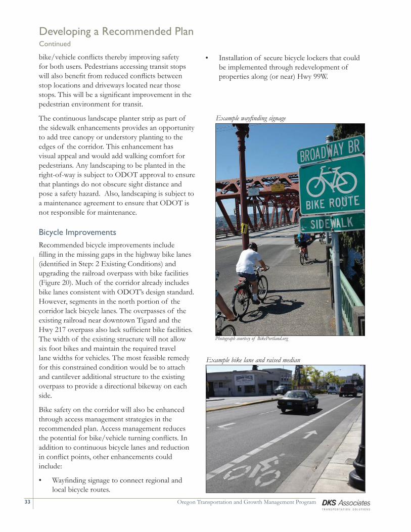
Bicycle ImprovementsRecommended bicycle improvements include fi lling in the missing gaps in the highway bike lanes (identifi ed in Step: 2 Existing Conditions) and upgrading the railroad overpass with bike facilities (Figure 20). Much of the corridor already includes bike lanes consistent with ODOT’s design standard. However, segments in the north portion of the corridor lack bicycle lanes. The overpasses of the existing railroad near downtown Tigard and the Hwy 217 overpass also lack suffi cient bike facilities. The width of the existing structure will not allow six foot bikes and maintain the required travel lane widths for vehicles. The most feasible remedy for this constrained condition would be to attach and cantilever additional structure to the existing overpass to provide a directional bikeway on each side.
Bike safety on the corridor will also be enhanced through access management strategies in the recommended plan. Access management reduces the potential for bike/vehicle turning confl icts. In addition to continuous bicycle lanes and reduction in confl ict points, other enhancements could include:
Wayfi nding signage to connect regional and local bicycle routes.
•
Developing a Recommended PlanContinued
Example bike lane and raised median
Example wayfi nding signage
Photograph courtesy of BikePortland.org
Installation of secure bicycle lockers that could be implemented through redevelopment of properties along (or near) Hwy 99W.
•

36TIGARD 99W IMPROVEMENT & MANAGEMENT PLAN
FINAL REPORT
Rebuilding the entire 99W Corridor in a single project would be extremely expensive and disruptive. Therefore, it is preferable that improvements be built as smaller projects phased over time. Smaller, phased projects can compete better for scarce transportation funding because they are less expensive; however, they still provide noticeable benefi ts to all highway users because they can be targeted to address the most crucial problems sooner, and less crucial problems later.
Table 5 (page 37) summarizes the individual improvements along the corridor. Project ranking refl ects potential benefi ts to various modes of travel. A specifi c improvement may benefi t one or more travel modes. In addition, the ranking of the intersection improvement projects takes into account the overall intersection performance in the future. The worse the performance the higher priority for improvement. All intersections on this list fail to meet the operational standard at the end of the 20-year planning horizon and should be monitored based on their performance. If a particular intersection’s operational performance degrades faster than predicted in this project’s traffi c analysis, it could be reprioritized to refl ect the greater urgency for a solution to be built sooner.
It should be noted that the City of Tigard may have additional priorities, such as improvements to cross-town connectivity involving side streets. These considerations may infl uence the timing of implementation independent of the ranking in Table 5.
As can be seen in Table 5, some projects occur generally along the corridor rather than in specifi c locations such as intersection improvements. Examples include access management, transit stop relocation, and construction of bicycle lanes and sidewalks. These types of projects can be implemented along the corridor in phases or as an integrated element in a larger improvement project.
Access management is a signifi cant element of the recommended alternative. To fully implement access management along the corridor a complete access management plan would need to be completed. The Oregon Department of Transportation follows
a specifi c process when implementing Access Management Plans (OAR 734, Division 51). The process involves an inventory of existing facilities, development of access control measures, and public involvement at both the individual property owner level as well as the general public. The entire process is aimed at providing a plan that is benefi cial for the corridor as well as the property owners along the corridor.
Implementation Projects

37 Oregon Transportation and Growth Management Program
Table 5: Potential Project Ranking Based on Individual Location Needs and Benefi tRank Location Description/Improvement Potential Benefi ts Approximate
Cost Estimate
Aut
o on
99W
Aut
o on
Sid
e St
reet
Tran
sit
Bik
e
Pede
stria
n
1 99W/Gaarde/McDonald
Transit queue bypass, northbound and southbound left turns, eastbound and westbound through lanes, eastbound and westbound left turns
$1.5 Million
7 99W/Dartmouth Transit queue bypass, southbound through lane for 500 feet
$600,000
8 99W/Walnut Street Transit queue bypass, westbound left turn $600,000
2 99W/I-5 southbound
Add northbound through lane for capacity/access to I-5
$300,000
5 99W/Durham Rd Northbound left turn $250,000
6 99W/Beef Bend Rd Southbound right turn $300,000
10 99W/72nd Avenue Southbound right turn pocket $300,000
4 99W/Hall Blvd Transit queue bypass, westbound left turn $750,000
3 99W/Greenburg Eastbound/westbound left turns $500,000
9 99W/Canterbury Westbound left turn $250,000
11 99W/68th Ave Transit queue bypass $400,000
12 99W/Watkins Avenue
Install signalized pedestrian activated crossing
$400,000
13 99W Corridor Access Management
Perform an access management study that specifi cally plans out the medians and driveway improvements for the corridor
$200,000
14 99W Center Median Install raised center median with low level low maintenance landscaping for access management
$180 per linear foot
15 Transit stop relocation/improvement
Upgrade and relocate existing transit stop to be consistent with transit queue bypass implementation. Install shelters and other appropriate transit amenities at transit stops.
$10,000 per site
16 99W Corridor Infi ll sidewalks
Install sidewalks where they currently do not exist. Upgrade sidewalks to include 4 foot landscape strip and 8 foot pedestrian zone.
$65 per linear foot
17 99W Corridor Infi ll bike lanes
Install 6 foot bike lanes where they currently do not exist.
$50 per linear foot
SOURCE: DKS Associates
Implementation ProjectsContinued

38TIGARD 99W IMPROVEMENT & MANAGEMENT PLAN
FINAL REPORT
Appendix A—Conceptual Alternatives and Evaluation
Appendix A

39 Oregon Transportation and Growth Management Program
((This page left intentionally blank))

Tigard 99W Improvement Plan Page 1 Task 4.1: Concepts Development April 30, 2007
INTRODUCTION The purpose of this memorandum is to outline the process for the development of concepts for the Tigard 99W Improvement Plan, as well as describe the concepts developed that will be evaluated and compared in a later task. Previous efforts for the Tigard 99W Improvement Plan project have documented existing data related to pedestrian, bicycle, transit and roadway operations and conditions. This inventory of data was utilized to help document a set of needs/opportunities/constraints that were then used to help develop concepts that address the deficiencies in the corridor. The next phase of this project focuses on developing concepts that support the purpose and goals of the project. A primary goal of this project is to develop concepts that enhance and encourage alternative modes of travel, while reducing the reliance of auto travel. For the purpose of the development of concepts, “themes” have been developed that focus treatments on a primary component to implement along the entire corridor. The corridor has four focus areas that allow for a more refined and detailed evaluation. EXECUTIVE SUMMARY Three different concepts have been developed for this phase of the project and have individual themes focused on enhancing the connectivity and operations of the corridor in different ways. Inherent to all concepts is providing a balanced multimodal environment especially related to pedestrian, bicycle and transit improvements. Therefore each concept will contain bicycle lanes, as well as sidewalks with landscape buffers all built to the ODOT standard. The following matrix summarizes these concepts.
4.1 TASK
CONCEPTS DEVELOPMENT
Appendix A
40

Tigard 99W Improvement Plan Page 2 Task 4.1: Concepts Development April 30, 2007
Table 1: Concepts Descriptions Concept General Description Concept A This concept focuses on widening Hwy 99W to seven (7)
cross-section from Interstate 5 to SW Greenburg Road. Access management is also a part of this concept, and is focused within the interchange access spacing area (1,320 feet) from Hwy 217 and Interstate 5. South of SW Greenburg Road local capacity improvements area implemented where intersections have future deficiencies.
Concept B This concept focuses on implementing aggressive access management, not only within the access spacing areas of Hwy 217 and Interstate 5, but also targeting properties along Hwy 99W that have multiple access points, and those properties in close proximity (200 feet) of intersections with high collision rates and/or congested conditions. Another integral part to this concept is the potential implementation of local parallel connecting roadways to help reduce the reliance on Hwy 99W for travel within the study area.
Concept C This concept is primarily focused on widening Hwy 99W the full length of the study corridor (from Interstate 5 to SW Durham Road). Access management would also be implemented along the corridor to help reduce the potential conflicts between motor vehicles and all modes of travel, as well as enhance the through capacity of the corridor. This concept is not as aggressive on access management as Concept B.
SOURCE: DKS Associates It is not expected that any one concept is going to be the single solution for Hwy 99W, but by representing the concepts that have multiple elements (across multiple focus areas) it allows for a “mix and match” of elements that are the most appropriate to each specific area as well as the entire corridor. EVALUATION CRITERIA As part of this task, evaluation criteria were used to help develop the concepts. These evaluation criteria were developed to help balance enhancements to all modes of travel along the corridor. The following table summarizes criteria themes for used to help develop the concepts.
Appendix A
41
Tigard 99W Improvement Plan Page 3 Task 4.1: Concepts Development April 30, 2007
Table 2: Evaluation Criteria for Developing Concepts Theme Criteria used for Concept Development General mobility Provide for adequate traffic operations.
Provide for adequate storage of vehicles (queuing). Alternative modes Provide for safe and convenient connections for pedestrian,
bicycle and transit modes. Freight movement Provide for connections and design considerations for freight
to/from the corridor as well as along the corridor. Safety Reduce or minimize the number of conflict points between
modes of travel. Design standards Meet access spacing standards at interchanges.
Meet access spacing standards between signals. Meet roadway design standards for all modes of travel.
Property impacts Minimize impacts to properties and buildings. Cost Minimize cost to implement project while providing a balanced
multimodal corridor treatment. SOURCE: DKS Associates These criteria were used to help develop concepts for the corridor, and will be used again in later task(s) of this project for the evaluation of the concepts. ALTERNATIVE MODES As part of the development of concepts, alternative modes such as bicycles, pedestrians and transit all will be addressed equally for addressing deficiencies. That is to say that no matter what concept, the improvements to the bicycle, pedestrian and transit environments would be the same. The following summarizes the potential improvements being considered as part of the concepts development for the alternative modes. Bicycle Enhancements Each concept includes the enhancement of the bicycle environment by providing for a six (6) foot bike lane along the entire corridor. Much of the corridor includes bike lanes today that meet this criterion. There are however some areas in the north portion of the corridor that would require the addition of bicycle lanes, and overpasses of the existing railroad near downtown Tigard and the Hwy 217 overpass where the existing bicycle facilities do not meet this criteria. In addition to these bicycle lanes, other amenities such as signage and additional secure bicycle lockers could be implemented. Signage would allow for wayfinding for bicycle users to connect to other regional (and local) bicycle routes to/from Hwy 99W. Bicycle lockers could be implemented through redevelopment of properties along (or near) Hwy 99W and are only considered as part of concepts in that capacity.
Appendix A
42

Tigard 99W Improvement Plan Page 4 Task 4.1: Concepts Development April 30, 2007
Pedestrian Enhancements Each concept includes the enhancement of the pedestrian environment by providing for a four (4) foot landscape buffer and an eight (8) foot sidewalk along the entire corridor. This assumes that even locations that have existing sidewalks would be upgraded to provide for this twelve (12) foot section. There are some areas that would only contain the eight (8) foot sidewalk. These areas are where the provision of a landscape buffer would be a cost burden to provide with little enhancement. The two areas where these occur are on the existing rail overpass, and the existing overpass of Hwy 217. Additional Pedestrian Crossings In addition to the provision of continuous sidewalks with a landscape buffer along the corridor, the provision of additional pedestrian crossings across Hwy 99W were also considered to allow for better connectivity. The Metro Regional Transportation Plan indicates that full street connections should be implemented no more than 530 feet apart. This is to help provide connectivity and accessibility within urban areas for all modes of travel. All signals along Hwy 99W (with the exception of one) are spaced further apart than 530 feet. Figure 1 summarizes the existing pedestrian crossing locations on Hwy 99W. Figure 1: Existing Crossings of Hwy 99W and Potential New Crossing Locations
Based on the existing access spacing for crossings there are five locations that may be areas to potentially implement new pedestrian crossings. The speeds vary along Hwy 99W between 35 to 45 miles per hour, and the average daily traffic ranges from approximately 40,000 to 50,000 vehicles. Given that Hwy 99W is at a minimum 4 lanes wide, sometimes with a median, the most appropriate crossing treatment for pedestrians would be a marked signalized crossing for safety reasons. However, meeting signal warrants and spacing requirements limit (or preclude) where additional signalized intersections could be implemented. There are other means to get pedestrians across Hwy 99W beyond signalized crossings. These include such measures as marked unsignalized crossings, pedestrian
Appendix A
43

Tigard 99W Improvement Plan Page 5 Task 4.1: Concepts Development April 30, 2007
median refuges, or a combination of the two. However, as previously mentioned, due to the speed, volume and nature of Hwy 99W any unsignalized crossing of Hwy 99W would need to have an engineering study and be well justified. The engineering study addresses multiple factors including safety, public involvement, pedestrian volumes/demand, collision history (3-5 most recent years), pedestrian desire lines for walking, sight distance, lighting and spacing to name a few. Other Pedestrian Enhancements In addition to upgraded sidewalks with landscape strips and the potential for new crossings, additional enhancements to the existing crossings could be implemented as well. These could consist of pedestrian countdown timers, pedestrian wayfinding signage, and enhanced striping for crossings (to name a few). Examples of these treatments are shown below.
Pedestrian countdown timer
Pedestrian wayfinding signage
Enhanced crossing markings
Transit Enhancements Each concept will also contain enhancements to the transit system that can be implemented as part of the existing transit network and does not related to implementing a new high capacity transit (HCT) system. The location of these types of treatments could vary between concepts, but are focused on providing a better transit environment and interaction with other modes of travel along the corridor. In addition, these enhancements should provide more reliable transit travel times and help to reduce delay to transit travel. The following summarizes the transit enhancements being considered for each concept. Stop Relocation All transit stops will be evaluated as to the potential to relocate to a “far side” stop placement at signalized intersections. A “far side” transit stop refers to a transit stop that is on the far side of the travel path through the intersection. The purpose of this is to allow transit vehicles to get through an intersection and stop on the opposing side to reduce potential delay at a signal for buses, as well as potential delay for motor vehicles that may be traveling behind a bus.
Appendix A
44
Tigard 99W Improvement Plan Page 6 Task 4.1: Concepts Development April 30, 2007
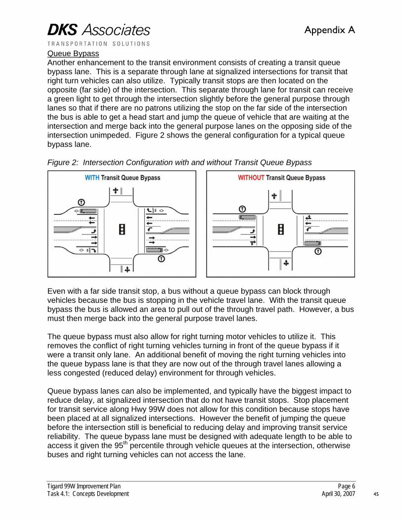
Queue Bypass Another enhancement to the transit environment consists of creating a transit queue bypass lane. This is a separate through lane at signalized intersections for transit that right turn vehicles can also utilize. Typically transit stops are then located on the opposite (far side) of the intersection. This separate through lane for transit can receive a green light to get through the intersection slightly before the general purpose through lanes so that if there are no patrons utilizing the stop on the far side of the intersection the bus is able to get a head start and jump the queue of vehicle that are waiting at the intersection and merge back into the general purpose lanes on the opposing side of the intersection unimpeded. Figure 2 shows the general configuration for a typical queue bypass lane. Figure 2: Intersection Configuration with and without Transit Queue Bypass
Even with a far side transit stop, a bus without a queue bypass can block through vehicles because the bus is stopping in the vehicle travel lane. With the transit queue bypass the bus is allowed an area to pull out of the through travel path. However, a bus must then merge back into the general purpose travel lanes. The queue bypass must also allow for right turning motor vehicles to utilize it. This removes the conflict of right turning vehicles turning in front of the queue bypass if it were a transit only lane. An additional benefit of moving the right turning vehicles into the queue bypass lane is that they are now out of the through travel lanes allowing a less congested (reduced delay) environment for through vehicles. Queue bypass lanes can also be implemented, and typically have the biggest impact to reduce delay, at signalized intersection that do not have transit stops. Stop placement for transit service along Hwy 99W does not allow for this condition because stops have been placed at all signalized intersections. However the benefit of jumping the queue before the intersection still is beneficial to reducing delay and improving transit service reliability. The queue bypass lane must be designed with adequate length to be able to access it given the 95th percentile through vehicle queues at the intersection, otherwise buses and right turning vehicles can not access the lane.
Appendix A
45

Tigard 99W Improvement Plan Page 7 Task 4.1: Concepts Development April 30, 2007
Transit Amenities Improving access to transit service and the reliability of that service is not the only enhancement to the transit environment. In addition to the previously listed enhancements, transit amenities can also be implemented. Typically these focus on improving the actual transit stops themselves, or the access to information related to transit. Criteria for installation of a shelter is determined by TriMet to be approximate 30 daily on/off patrons per stop. All concepts include enhancing the transit environment by providing shelters (where applicable) and adequate waiting space for patrons of transit. Connectivity Enhancements Each concept could also contain enhancements to roadway connectivity that could be implemented as part of any concept. “Roadway connectivity” means filling in gaps in the street system to give drivers alternative routes to 99W. Topography and man-made barriers (such as railroads and freeways) limit the potential for additional connectivity. The purpose of these types of connections is to alleviate congestion on Hwy 99W. One example of this is the identified project in the Tigard Transportation System Plan of connecting SW Walnut Street to SW Hunziker Street. CONCEPTS DESCRIPTION During the Needs, Opportunities and Constraints analysis, focus areas along the corridor were identified based on similar characteristics. These focus areas help to break up the corridor and focus treatments along the corridor in specific areas. The four (4) focus areas identified were:
• I-5 to Hwy 217 • Hwy 217 to Walnut Street • Walnut Street to Gaarde/McDonald Streets • Gaarde/McDonald Streets to Durham Road
As previously identified, treatments are not specific or confined to one particular focus area, and may span between focus areas or along the entire corridor. The treatments are aimed at providing enhancements to all modes of travel and provide a balanced transportation system. The following describes the concepts developed for this task with supporting graphics that give a general overview of treatments/elements for each concept by the individual focus areas. Concept A: Partial Widening/Local Capacity Improvements The primary focus of this concept is to create a seven (7) lane cross-section of Hwy 99W (three through travel lanes in each direction with a center turn lane) from Interstate 5 to SW Greenburg Road. This is consistent with the improvement on Hwy 99W outlined in the Metro Regional Transportation Plan (RTP). In addition to the widening in the north portion of the corridor, localized intersection capacity improvements were implemented to allow for adequate intersection operations.
Appendix A
46

Tigard 99W Improvement Plan Page 8 Task 4.1: Concepts Development April 30, 2007
Access management was also considered as part of this concept, but it was focused within the interchange access spacing area defined by the Oregon Department of Transportation which prohibits full intersection access (private or public street) within 1,320 feet from a signalized intersection of an on/off ramp. The access management technique employed in this area was to install a median in this area, which would modify all existing driveways (or public roadways) from full access to right-in/right-out access. Pedestrian and bicycle enhancements were implemented along the corridor by providing bicycle lanes at a minimum of five (5) feet on both sides of the corridor, and a four (4) foot landscape buffer that is curb tight to the roadway with an eight (8) foot sidewalk adjacent to the landscape buffer. Transit enhancements focused on relocating existing transit stops to minimize conflict for the pedestrian/bicycle environment as well as enhance connectivity to the transit network. In addition to these transit enhancements, queue bypass lanes were implemented at the more congested intersections to allow buses to travel in a dedicated lane (for transit) and bypass existing queues on Hwy 99W. Figure 3 summarizes the elements of Concept A and breaks the corridor into the four focus areas. Concept B: Access Management The primary focus of this concept is to maximize access management along the corridor. This was developed by using the similar access management found in Concept A (a median within 1,320 feet of the highway interchanges with Hwy 217 and I-5). Additionally, the access driveways along the corridor were evaluated to determine which properties had multiple access points and where multiple access points to one property existed the driveways were highlighted for potential consolidation and/or closure to allow only one access point. Another access management technique employed was to identify driveways within two-hundred (200) feet of intersections that had been shown to have higher collision rates than other intersections on the corridor and/or near congested intersections. Driveways that met these criteria were then evaluated to determine if consolidation or closure could be accomplished to help minimize potential conflicts near congested intersections. If closure (or consolidation) was considered for a driveway in these areas, particular concern was taken to make sure that concept safe access was still available. This concept represents a highly aggressive access management option along the corridor. A full access management plan would need to be conducted to determine the full impacts of implementing a median, closing a driveway, and/or consolidating driveways to allow for shared access for properties. That type of exercise requires a much more in-depth analysis than is allowed for in this project, and would require a detailed public involvement plan to coordinate with all affected property owners. Those elements would be necessary if this type of an concept was pursued. Local capacity improvements at intersections would be implemented to allow for acceptable traffic operations at study area intersections. In addition to that, local
Appendix A
47

Appendix A
48

Tigard 99W Improvement Plan Page 10 Task 4.1: Concepts Development April 30, 2007
connectivity that would parallel Hwy 99W would be implemented (where feasible) to help lessen the reliance of Hwy 99W for local trips using the corridor. Similar to Concept A, pedestrian and bicycle enhancements would be implemented along the entire corridor, while transit enhancements would focus on stop relocation and queue bypass lanes. Figure 4 summarizes the elements of Concept A and breaks the corridor into the four focus areas. Concept C: Full Widening This concept is a uses elements from Concept A and B, and also continues the widening of Hwy 99W south of SW Greenburg Road the remainder of the study corridor to SW Durham Road. In addition to this widening, access management would be implemented consisting of medians and driveway closures and/or consolidations, but would not be as aggressive as found in Concept B. Similar to the prior concepts, pedestrian and bicycle enhancements would be implemented along the entire corridor, while transit enhancements would focus on stop relocation and queue bypass lanes. Figure 5 summarizes the elements of Concept A and breaks the corridor into the four focus areas. SUMMARY Three concepts have been developed to apply throughout the four focus areas. The three concepts all include enhancements to the pedestrian, bicycle and transit environments by providing:
• Bicycle lanes along the entire corridor; • Landscape buffer and sidewalks along the entire corridor; • Transit enhancements either via stop relocation and/or queue bypasses; • Additional pedestrian crossings across Hwy 99W; and • Transit stop relocations.
One concept focuses on partial widening to seven (7) lanes from Interstate 5 to Greenburg Road, with localized capacity improvements at intersections forecasted to be deficient. Another concept focuses on aggressive access management and localized intersection capacity improvements. The last concept focuses on widening to seven (7) lanes for the whole corridor. While there is no one “magic bullet” to address all deficiencies along the corridor, the diversity of the concepts developed help to explore many of the potential mix of options to better the transportation environment along the corridor. A selection of various techniques from all concepts may be the recommended treatment for the corridor.
Appendix A
49

Appendix A
50

Appendix A
51
Tigard 99W Improvement Plan Page 1 Task 5.1: Alternatives Evaluation May 24, 2007
INTRODUCTION The purpose of this memorandum is to evaluate and compare the previously outlined set of alternatives. This evaluation and comparison helps to determine an appropriate preferred alternative to take forward for final recommendation. Previous efforts for the Tigard 99W Improvement Plan project have documented existing conditions, needs/opportunities/constraints of the corridor, and developed alternatives to address deficiencies of the corridor. These alternatives were then evaluated using a set of criteria that contain both qualitative (non-numerical) and quantitative (calculated) measures of effectiveness. The recommended alternative will be the option that best supports the purpose and goals of the project which has a primary goal of enhancing and encouraging alternative modes of travel, while reducing the reliance of auto travel. EXECUTIVE SUMMARY Three different alternatives were evaluated and compared for this phase of the project. Each was evaluated and compared by applying criteria developed previously to help develop the alternatives. While it is not expected that any one alternative will solve all the deficiencies in the future along Hwy 99W, the goal is to identify a solution that, on balance, best supports project objectives, including multi-modal travel needs, while minimizing negative impacts. The following is a brief summary of the findings within this memorandum for each of the criteria evaluated:
• Pedestrian – All alternatives contain the same pedestrian improvement -- widened sidewalks, separated from the roadway with a landscape strip. Widening of Hwy 99W creates longer pedestrian crossings, requiring longer red lights at traffic signals to accommodate walkers, which can reduce the operational efficiency of signals for vehicle traffic, especially through traffic on 99W. Alternative B has a slight advantage over other alternatives by providing raised medians along a significant portion of the corridor, which allows for
5.1 TASK
ALTERNATIVES EVALUATION & COMPARISON
52
Appendix A

Tigard 99W Improvement Plan Page 2 Task 5.1: Alternatives Evaluation & Comparison May 24, 2007
potential pedestrian refuges for crossing at unsignalized intersections. This could make 99W less of a barrier for pedestrians.
• Bicycle – All alternatives contain the same bicycle improvement of bike lanes
along the entire corridor. But alternatives that add travel lanes to 99W could negatively impact the bicycling environment by making the highway more intimidating to cyclists crossing the road or making left turns. Similar to the pedestrian environment, a wider cross-section of Hwy 99W could be detrimental to bicycle travel along Hwy 99W for bicyclists that need to traverse from the bike lane across the corridor to make a left turn at intersections.
• Transit – All alternatives include relocating transit stops to help minimize impacts
with existing driveways for pedestrians and bicycles. Areas where the corridor are widened to a 7 lane cross-section do not allow for transit queue bypasses due to the additional width (right-of-way) necessary to implement them. Therefore areas where queue bypass lanes are not implemented would require transit to operate in the general purpose traffic lanes. This could create delay for transit service. Alternatives A and B both contain transit queue bypasses, however Alternative B has the opportunity to implement more than Alternative A. Alternative C has no transit queue bypass lanes. Alternative A would save approximately 1 ½ minutes of delay to bus travel times, while Alternative B would save approximately 2 ½ - 3 minutes of delay to bus travel times. In terms of right-of-way impact, Alternative C would have the equivalent right-of-way impact of adding a dedicated transit lane along the entire Hwy 99W corridor.
• Motor Vehicle – Alternatives that add travel lanes provide additional vehicle
capacity, which can improve intersection operations and reduce congestion. However, the additional capacity is almost fully consumed by traffic demand between Interstate 5 and Hwy 217, and then pumps additional vehicles south of Hwy 217. The widening for Alternative A, as recommended in the Regional Transportation Plan, stops at SW Greenburg Road, so additional vehicles added to the corridor south of that degrade intersection operations even further because the additional capacity is not available, and more localized improvements are necessary that include additional travel lanes in each direction in the SW Gaarde/McDonald area. Alternative C widens the corridor the entire length, but past the downtown area volumes taper off to a level where the additional capacity is more than what is typically needed for the 20 year planning horizon. The addition of the SW Walnut Street extension is beneficial under any alternative because it helps to decrease the volumes on Hwy 99W between SW Walnut Street and the Hwy 217 northbound ramp by providing an alternative access to the south for the Tigard Triangle area and downtown Tigard.
• Safety – Additional access management through the use of medians and/or
driveway closure/consolidation is beneficial to safety because conflict points are eliminated, reducing the potential for vehicle crashes. Alternative B has the highest reduction in potential conflict points by 70% along the entire corridor.
53
Appendix A

Tigard 99W Improvement Plan Page 3 Task 5.1: Alternatives Evaluation & Comparison May 24, 2007
Alternatives A and C focus access management within the interchange areas (1,320 feet) and have the potential to reduce collision points by up to 75% in the interchange areas. The raised medians used extensively in Alternative B reduce opportunities for left turns directly into driveways, but this alternative allows for U-turns at intersections, so that destinations across the road are still accessible.
• Property Impacts and Costs – Based on the right-of-way necessary to
implement each alternative there is a different level of impacts to properties associated with property only and widening that impacts buildings as well. Alternative B has the least amount of property and buildings impacts at approximately 953,000 square feet. Alternative A has the next highest impact to property and buildings at approximately 1.16 million, while Alternative C has the highest impact at approximately 1.58 million square feet. Consequently, Alternative C has the highest cost associated with implementation due to that larger right-of-way from widening, and the cost associated with the physical infrastructure of widening itself, while Alternative A has the second least cost and Alternative B has the least cost for implementation. Table 1 summarizes the right-of-way and costs associated with each alternative.
Table 1: Comparison of Alternatives Right-of-way (ROW)/Building Impacts and Costs ROW Impact
(sq. ft.) Building Impact
(sq. ft.) Construction Cost
(millions) Total Cost (millions)
Alternative A 921,000 241,500 $27.27M $91.13M Alternative B 742,000 211,300 $23.18M $77.13M Alternative C 1,269,700 315,300 $32.14M $117.53M
SOURCE: DKS Associates & Otak, Inc. EVALUATION CRITERIA As part of this task, evaluation criteria were used to help compare and evaluate the alternatives. These evaluation criteria were developed for all modes of travel in the 99W corridor. Some of these evaluation criteria are qualitative in nature, meaning there is no clear numerical way to measure their effectiveness, but they can be assessed based on their expected or perceived effect. Other criteria were quantitative in nature, meaning they could be measured using a numeric value to gauge the effectiveness of an alternative for comparison. The following table summarizes the criteria used, whether the criteria were qualitative or quantitative, and the typical measure of effectiveness for comparison.
54
Appendix A

Tigard 99W Improvement Plan Page 4 Task 5.1: Alternatives Evaluation & Comparison May 24, 2007
Table 1: Criteria for Evaluating and Comparing Alternatives Category Criteria Measure(s) Qualitative Quantitative Pedestrian Connectivity
Crossing distance Adequate connections Distance in feet
X X
Bicycle Connectivity Adequate connections X Transit Facilities
Bypassing queues Enhanced environment Queue lengths
X X
Motor Vehicle Intersection operations
Queuing/storage for vehicles
Level-of-service Volume-to-capacity Queuing in feet
X X X
Safety Driveways and conflict points
Frequency and number of occurrences
X
Property impacts Land impacted Building impacted
Square feet X
Cost Dollars Estimated construction cost
Average square-foot cost of impacted land and buildings
X
SOURCE: DKS Associates While the quantitative measures of effectiveness will have a calculated (numeric) value, the qualitative measures will be assessed on a scale of 1 to 5 where a lower score represents less of an opportunity to meet the goal of the project and a higher number represents a high likelihood to meet the goal of the project. The following sections of this memorandum summarize the evaluation and comparison of each alternative using the previous identified categories and measures of effectiveness. Each alternative is evaluated individually within each category, and then a comparison of all alternatives is made at the end of each category. PEDESTRIAN ENVIRONMENT The following summarizes the evaluation by alternative, and comparison of alternatives for the pedestrian environment. Alternative A: Partial Widening This alternative includes the enhancement of the pedestrian environment by providing for a 4 foot landscape strip, and an 8 foot sidewalk along the entire corridor. This fills in the gaps along the corridor where sidewalks do not exist today, as well as enhancing the existing locations along the corridor where many of the sidewalks that exist today are sub-standard. The landscape strip buffers pedestrians from traffic, creating a safer, more inviting environment for walking. The widening from a 5 lane cross-section to a 7 lane cross section from Interstate 5 to Greenburg Road (approximately one-third of the study corridor) creates a wider cross-section for pedestrians to cross Hwy 99W. Under this alternative the new cross-section
55
Appendix A

Tigard 99W Improvement Plan Page 5 Task 5.1: Alternatives Evaluation & Comparison May 24, 2007
is approximately 24 feet wider than currently exists. This additional width requires additional time for pedestrians to cross the roadway, which can affect signal timing by keeping vehicles stopped longer on 99W. This reduces the road’s vehicle capacity. One additional signalized pedestrian activated crossing has been added in this alternative at approximately SW Watkins Avenue. This location was selected due to a long segment of roadway with no existing opportunities for safe pedestrian crossings. This crossing has been added to help improve the spacing of potential pedestrian crossings of Hwy 99W to better enhance connectivity within the study area. In addition, there are currently bus stops at this intersection that are served by an unsignalized pedestrian crossing. The new signalized pedestrian crossing will allow for a safer opportunity to cross Hwy 99W to access transit. Alternative B: Access Management This alternative is similar to Alternative A in that it contains a four (4) foot landscape strip and an eight foot sidewalk along the corridor, however the corridor is not widening at all and retains a five lane cross-section. This allows for shorter side street crossing times, which in turn has less impact to motor vehicle and transit traveling along the main corridor (Hwy 99W). The alternative also contains raised medians along most of the corridor north of SW Gaarde/SW McDonald Street. The raised medians allow for a pedestrian refuge at unsignalized locations to aid in additional crossings of Hwy 99W. Similar to Alternative A, an additional signalized/marked pedestrian crossing is located at the SW Watkins Street intersection. In addition to that crossing, one more signalized/marked crossing is proposed at SW 71st Avenue. The new signalized pedestrian crossing is located at an existing unsignalized transit intersection, so the new crossing will aid in safe crossing of Hwy 99W for transit access. Alternative C: Full Widening Similar to the previous alternatives, this alternative includes the enhancement of the pedestrian environment by providing for a four (4) foot landscape strip, and an eight (8) foot sidewalk along the entire corridor. The entire study corridor is proposed to be widened from a five lane cross-section to a seven lane cross-section. This creates longer crossing distances for pedestrians as well as requires longer crossing times for pedestrians. This additional crossing time can affect the main throughput for motor vehicle capacity and operations by taking time away from the main corridor. Similar to Alternative A, one additional signalized pedestrian activated crossing has been added in this alternative at approximately SW Watkins Avenue to aid with crossing Hwy 99W and service an unsignalized crossing with existing transit stops.
56
Appendix A

Tigard 99W Improvement Plan Page 6 Task 5.1: Alternatives Evaluation & Comparison May 24, 2007
Evaluation There is no quantitative (numeric) way to evaluate the pedestrian environment, however a qualitative (value based) assessment can be made. Each alternative has been evaluated for the pedestrian environment using various criteria. Table 2: Comparison of Alternatives for Pedestrian Environment Criteria Alternative A Alternative B Alternative C
Connectivity/Facilities Additional Crossings
Crossing Distance Overall Rating
Evaluation Scale
Poor Medium Good Based on the qualitative assessment in Table 2, both Alternatives A and C have approximately the same affect on the corridor for the pedestrian environment. However, Alternative B has a slight advantage over the other two alternatives due to the fact that the crossing distances are less which can affect operations on the main corridor for motor vehicle and transit services. BICYCLE ENVIRONMENT There is not differentiation for the bicycle environment between alternatives. All alternatives include bicycle lanes (designed to standard) along the entire study corridor length. If anything, alternatives that provide for widening Hwy 99W may make crossings of Hwy 99W more intimidating to bicyclists, and add an additional lane to traverse when traveling along Hwy 99W if a cyclist wants to take a left turn. Evaluation Similar to the pedestrian environment, evaluation for the bicycle environment is based on a qualitiative (non-numeric value based) assessment. Each alternative has been evaluated qualitatively and is summarized in Table 3. Table 3: Comparison of Alternatives for Bicycle Environment Criteria Alternative A Alternative B Alternative C
Connectivity/Facilities Left Turn Traversing
Crossing Distance Overall Rating
Evaluation Scale
Poor Medium Good
57
Appendix A

Tigard 99W Improvement Plan Page 7 Task 5.1: Alternatives Evaluation & Comparison May 24, 2007
Based on the qualitative assessment in Table 3, the bicycle environment in Alternative A has both positive and negative attributes that end up balancing out from a qualitative assessment. Alternative B shows a slight improvement due to filling in any gaps in the existing network. Alternative C shows a lower than average environment due to the wider distance to cross Hwy 99W and traverse if left turns are to be made by bicyclists. TRANSIT ENVIRONMENT The following summarizes the evaluation by alternative, and comparison of alternatives for the transit environment. Alternative A: Partial Widening This alternative includes the enhancement of the transit environment by providing transit queue bypass lanes at two intersections (SW Gaarde/McDonald Street and SW Walnut Street), as well as relocating up to ten existing bus stops that currently are located where they require pedestrians and bicyclists to cross over existing driveways. The transit queue bypasses could save up to 1 ½ minutes of delay to bus travel times. Including transit queue bypasses within the section of the corridor to be widened would not be advisable because it would create a nine lane cross-section at intersections. Alternative B: Access Management Similar to Alternative A, this alternative includes transit queue bypass lanes and transit stop relocations along the corridor. However, due to the fact that this alternative does not include widening to seven lanes, additional transit queue bypass locations were considered. The alternative includes transit queue bypasses at five locations; SW 68th Avenue, SW Dartmouth Street, SW Hall Boulevard, SW Walnut Street and SW Gaarde/McDonald Street(s). Implementing these queue bypasses could save approximately 2 ½ to 3 minutes of travel time delay for buses. The provision of a median in this alternative allows for a pedestrian refuge that can be used for crossing Hwy 99W for access to transit stops at unsignlized intersections. The same transit stops were considered for relocation as in Alternative A. Alternative C: Full Widening Due to the full widening of the corridor to seven lanes, no transit queue bypass lanes were considered. However, the same transit stops were considered for relocation as in previous alternatives. It should be noted that the wider roadway also makes a longer crossing distance at unsignalized pedestrian crossings. Evaluation The transit environment is based on a qualitiative (non-numeric value based) assessment. Each alternative has been evaluated qualitatively and is summarized in Table 4.
58
Appendix A
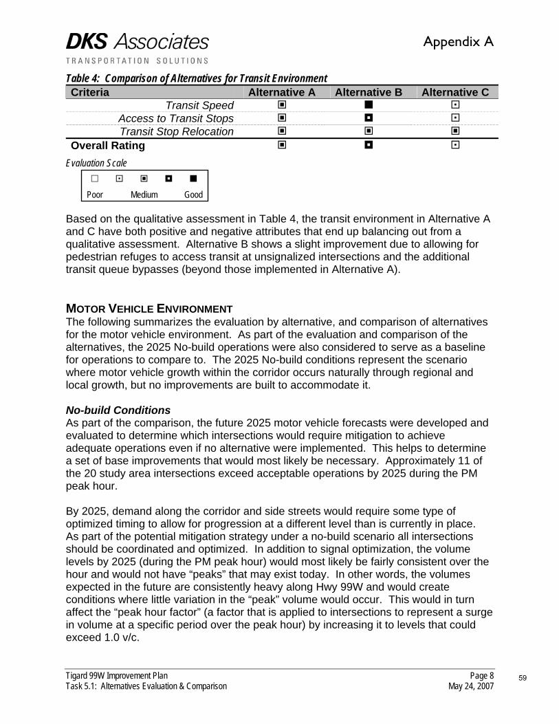
Tigard 99W Improvement Plan Page 8 Task 5.1: Alternatives Evaluation & Comparison May 24, 2007
Table 4: Comparison of Alternatives for Transit Environment Criteria Alternative A Alternative B Alternative C
Transit Speed Access to Transit Stops Transit Stop Relocation
Overall Rating Evaluation Scale
Poor Medium Good Based on the qualitative assessment in Table 4, the transit environment in Alternative A and C have both positive and negative attributes that end up balancing out from a qualitative assessment. Alternative B shows a slight improvement due to allowing for pedestrian refuges to access transit at unsignalized intersections and the additional transit queue bypasses (beyond those implemented in Alternative A). MOTOR VEHICLE ENVIRONMENT The following summarizes the evaluation by alternative, and comparison of alternatives for the motor vehicle environment. As part of the evaluation and comparison of the alternatives, the 2025 No-build operations were also considered to serve as a baseline for operations to compare to. The 2025 No-build conditions represent the scenario where motor vehicle growth within the corridor occurs naturally through regional and local growth, but no improvements are built to accommodate it. No-build Conditions As part of the comparison, the future 2025 motor vehicle forecasts were developed and evaluated to determine which intersections would require mitigation to achieve adequate operations even if no alternative were implemented. This helps to determine a set of base improvements that would most likely be necessary. Approximately 11 of the 20 study area intersections exceed acceptable operations by 2025 during the PM peak hour. By 2025, demand along the corridor and side streets would require some type of optimized timing to allow for progression at a different level than is currently in place. As part of the potential mitigation strategy under a no-build scenario all intersections should be coordinated and optimized. In addition to signal optimization, the volume levels by 2025 (during the PM peak hour) would most likely be fairly consistent over the hour and would not have “peaks” that may exist today. In other words, the volumes expected in the future are consistently heavy along Hwy 99W and would create conditions where little variation in the “peak” volume would occur. This would in turn affect the “peak hour factor” (a factor that is applied to intersections to represent a surge in volume at a specific period over the peak hour) by increasing it to levels that could exceed 1.0 v/c.
59
Appendix A

Tigard 99W Improvement Plan Page 9 Task 5.1: Alternatives Evaluation & Comparison May 24, 2007
Even with the previously identified conditions, some intersections still do not achieve adequate intersection operations and would require additional mitigation to operate at acceptable jurisdictional levels. Mitigation was pursued where feasible to achieve a level-of-service of D or better, and a volume-to-capacity ratio of 0.95 or better. This mitigation was considered “right-sizing” the intersections to allow for proper operations. This was done for all alternatives where intersection operations did not meet jurisdictional standards. However, even “right-sizing” the intersections there were two intersections (Interstate 5 off-ramp and SW Gaarde/SW McDonald Street) that would require significant mitigation to achieve these standards. Therefore If mitigation could be identified to achieve LOS E and V/C ratio of 1.0 or less additional mitigation beyond those levels were not pursued. While this does not meet the ODOT standard of V/C ratio of 0.95, a design exception could be pursued to allow this level of operation. Figure 1 summarizes the 2025 PM peak hour intersection operations as well as potential mitigation. Alternative A: Partial Widening As previously mentioned, this alternative widens Hwy 99W from a five lane facility to a seven lane facility from Interstate 5 to SW Greenburg Road. The remaining portion of the study corridor remains at five lanes. The widening attracts additional volumes to the corridor within the widened area and further to the south. Generally speaking the additional lane of capacity attracts between 800 to 1,000 vehicles in each direction between Interstate 5 to Hwy 217, then the volumes taper off in each direction further to the south achieving approximately 400 to 500 vehicles in each direction near SW Gaarde/McDonald Street(s), and approximately 100 to 200 in each direction down near SW Durham Road. There is still some additional mitigation south of SW Greenburg Road that is necessary to achieve acceptable operations in the SW Gaarde/McDonald and SW Walnut Street areas by adding an additional through lane in each direction. This “right-sizing” to achieve acceptable operations creates a “mini-widening” south of the partial widening. Based on these inputs, Figure 2 shows the 2025 PM peak hour intersection operations and potential mitigation to achieve adequate intersection operations. Alternative B: Access Management There is no additional capacity via widening in this alternative so the same base geometry applies. The access management creates restricted access by limiting left turning opportunities at many unsignalized intersections and driveways. To better accommodate circulation along Hwy 99W in this alternative u-turns were allowed at signalized intersections where medians were placed on the approach to a signalized intersection. Volumes were then adjusted from the future forecast to take into account these additional turning movements.
60
Appendix A

61
Appendix A

62
Appendix A
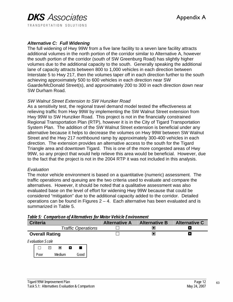
Tigard 99W Improvement Plan Page 12 Task 5.1: Alternatives Evaluation & Comparison May 24, 2007
Alternative C: Full Widening The full widening of Hwy 99W from a five lane facility to a seven lane facility attracts additional volumes in the north portion of the corridor similar to Alternative A, however the south portion of the corridor (south of SW Greenburg Road) has slightly higher volumes due to the additional capacity to the south. Generally speaking the additional lane of capacity attracts between 800 to 1,000 vehicles in each direction between Interstate 5 to Hwy 217, then the volumes taper off in each direction further to the south achieving approximately 500 to 600 vehicles in each direction near SW Gaarde/McDonald Street(s), and approximately 200 to 300 in each direction down near SW Durham Road. SW Walnut Street Extension to SW Hunziker Road As a sensitivity test, the regional travel demand model tested the effectiveness at relieving traffic from Hwy 99W by implementing the SW Walnut Street extension from Hwy 99W to SW Hunziker Road. This project is not in the financially constrained Regional Transportation Plan (RTP), however it is in the City of Tigard Transportation System Plan. The addition of the SW Walnut Street extension is beneficial under any alternative because it helps to decrease the volumes on Hwy 99W between SW Walnut Street and the Hwy 217 northbound ramp by approximately 300-400 vehicles in each direction. The extension provides an alternative access to the south for the Tigard Triangle area and downtown Tigard. This is one of the more congested areas of Hwy 99W, so any project that would help relieve this area would be beneficial. However, due to the fact that the project is not in the 2004 RTP it was not included in this analysis. Evaluation The motor vehicle environment is based on a quantitative (numeric) assessment. The traffic operations and queuing are the two criteria used to evaluate and compare the alternatives. However, it should be noted that a qualitative assessment was also evaluated base on the level of effort for widening Hwy 99W because that could be considered “mitigation” due to the additional capacity added to the corridor. Detailed operations can be found in Figures 2 – 4. Each alternative has been evaluated and is summarized in Table 5. Table 5: Comparison of Alternatives for Motor Vehicle Environment Criteria Alternative A Alternative B Alternative C
Traffic Operations Overall Rating
Evaluation Scale
Poor Medium Good
63
Appendix A

64
Appendix A

65
Appendix A

Tigard 99W Improvement Plan Page 15 Task 5.1: Alternatives Evaluation & Comparison May 24, 2007
Based on the assessment in Table 5, the motor vehicle environment has similar operations on an aggregate level due to the fact that the alternatives that widen Hwy 99W allow for additional capacity to help mitigate intersections, while the alternative that does not widen the roadway mitigates the problem areas. SAFETY Safety is an important component to evaluate because it encompasses all modes of travel. Two elements area specifically quantified through the evaluation and comparison of alternatives: number of conflict points at driveways, and number of driveways. Currently within the study area Hwy 99W has approximately ninety-eight driveways which the majority have full access (right and left turn access). A two-way driveway intersecting with a two-way roadway has approximately nine “conflict points” – locations where the travel paths of vehicles intersect, which therefore are potential locations for crashes. Closing the driveway would eliminate all motor vehicle conflict points as well as pedestrian and bicycle conflicts. Modifying the driveway to a right-in/right-out access reduces the potential conflict points from nine to two. Figure 5 illustrates these conflict points and the potential for their reduction. Figure 5: Conflict Points for Full Driveway Access vs. Right-in/right-out Access
The potential reduction of conflict points helps to evaluate the safety of a corridor at a qualitative level to compare alternatives via access management. The following summarizes the evaluation by alternative, and comparison of alternatives with respect to these two elements.
Right-in/Right-out Access Full Access Driveway
CONFLICT DIAGRAM Three leg intersection of a two-way street and an unrestricted side street or driveway
CONFLICT DIAGRAMThree leg intersection of a two-way street and a right-in/right-out side street or driveway
66
Appendix A

Tigard 99W Improvement Plan Page 16 Task 5.1: Alternatives Evaluation & Comparison May 24, 2007
Alternative A: Partial Widening As a means to address safety within this alternative, access management has been considered within the interchange access management area for Interstate 5 and Hwy 217 (1,320 feet within the interchange area) and to close any driveways on parcels that front Hwy 99W that more than one access point. This is being done to help reduce conflict points for motor vehicles with other motor vehicles as well as pedestrians and bicycles. The closure of some driveways also helps to improve through capacity on the corridor by only allowing access at specific locations rather than at multiple locations that are too closely spaced (e.g. parcels with multiple access points). Currently the study corridor has approximately 98 existing driveways. Using closures as a criterion, approximately 20 driveways could be closed. This would result in a decrease of approximately 20% in the total number of driveways in the corridor. This would reduce potential motor vehicle-to-motor vehicle conflicts by approximately 180. Approximately seven of these driveway closures would occur within the interchange access spacing areas. This correlates to 63 conflict points eliminated in the access spacing areas. In addition to driveway closure, raised medians are proposed within the access spacing areas (for Interstate 5 and Hwy 217). This would change full access driveways to right-in/right-out driveways reducing the number of potential collision points from 72 to 16 in the Interstate 5 area, and from 81 to 18 in the Hwy 217 area. In total that is approximately a 75% decrease in potential collision points within the interchange areas. Alternative B: Access Management This alternative has the most aggressive access management in place by using all of the same techniques implored in Alternative A, but also implementing additional raised medians along other areas of the corridor, as well as closing some additional driveways to create a shared access between adjacent properties where feasible. Areas targeted areas for this treatment were those within 200 feet of signalized intersections, in an effort to optimize safety and efficiency at intersections. Alternatively, a driveway could be closed on Hwy 99W wherever a property has feasible alternative access via a side street, as long as the side street driveway was in a safe location and would not create another safety problem. It should be noted that any strategy that would involve closing driveways and/or relocating driveways would require a detailed access management plan that species the locations, impacts and actions for providing property access. That detailed access management plan was not part of this scope of work and would need to be taken on as a separate project beyond the work conducted in this effort. Using the additional aggressive access management could add up to fifty-one (51) additional driveways to the list of potential driveways converted from full access to right-in/right-out. This would reduce potential conflict points from approximately 459 to 102. This represents a 75% decrease in potential collision points between vehicles, and a 70% decrease in potential collision points at driveways along the entire study corridor.
67
Appendix A

Tigard 99W Improvement Plan Page 17 Task 5.1: Alternatives Evaluation & Comparison May 24, 2007
Alternative C: Full Widening This alternative is less aggressive than Alternative B, but includes some additional access management beyond Alternative A through targeting intersections within the 200 foot influence area of signalized intersections. Driveways in this area were closed and/or consolidated where feasible to remove potential collision points near signalized intersections. Using these criteria Alternative C would close and/or relocate up to 29 driveways resulting in the removal of up to 261potential collision locations. In addition to that, implementing medians in the interchange access management areas could result in converting up to 17 driveways from full access with 153 collision points to right-in/right-out with 34 collision points. This alternative would have an overall reduction of collision points along the corridor of approximately 57%. Evaluation Safety is based on a quantitative (numeric) assessment. Each alternative has been evaluated and compared and is summarized in Table 6. Table 6: Comparison of Alternatives for Safety Criteria Alternative A Alternative B Alternative C
Reduction of motor vehicle collision points
Reduction of pedestrian/bicycle collision points
Overall Rating Evaluation Scale
Poor Medium Good Clearly Alternative B has the highest level of potential to affect the reduction of collision points along the study corridor. However, Alternatives A and C also help reduce the potential for collision points within the interchange areas which area highly congested areas on the corridor today. PROPERTY IMPACTS AND COST An extensive evaluation of impact to property and buildings associated with each alternative was conducted. The purpose of this assessment was to determine if the widening associated with either a roadway widening, or pedestrian improvement extended beyond the available right-of-way, and it would be necessary to purchase right-of-way to implement the alternative. In addition to assessing the property impacted, the potential impact to existing buildings was also evaluated. The widening of a project may not only impact right-of-way, but it may also affect a building and require that the building be taken as well.
68
Appendix A

Tigard 99W Improvement Plan Page 18 Task 5.1: Alternatives Evaluation & Comparison May 24, 2007
Using this criteria, analysis indicates that Alternative B has the least amount of property and buildings impacts at approximately 953,000 square feet. Alternative A has the next highest impact to property and buildings at approximately 1.16 million, while Alternative C has the highest impact at approximately 1.58 million square feet. Consequently, Alternative C has the highest cost associated with implementation due to that larger right-of-way from widening, and the cost associated with the physical infrastructure of widening itself, while Alternative A has the second least cost and Alternative B has the least cost for implementation. In addition, costs associated with construction only were developed for each alternative to help determine a total cost associated with each alternative. Table 7 summarizes the right-of-way and costs associated with each alternative. Table 7: Comparison of Alternatives Right-of-way/Property Impacts and Costs ROW Impact
(sq. ft.) Building Impact
(sq. ft.) Construction Cost
(millions) Total Cost (millions)
Alternative A 921,000 241,500 $27.27M $91.13M Alternative B 742,000 211,300 $23.18M $77.13M Alternative C 1,269,700 315,300 $32.14M $117.53M
SOURCE: DKS Associates & Otak, Inc. Evaluation Using the values calculated and the potential impact to properties and/or buildings, Table 8 summarizes the evaluation and comparison of each alternative. Table 6: Comparison of Alternatives for Safety Criteria Alternative A Alternative B Alternative C
Impact to properties Impact to buildings
Cost (not including ROW) Overall Rating
Evaluation Scale
Poor Medium Good SUMMARY Using the prior criteria the overall ratings have been summarizes and compiled to be able to compare all aspects of each alternative against the other alternatives in an aggregated level. The following table summarizes all criteria elements used for evaluation and the ranking for each alternative.
69
Appendix A

Tigard 99W Improvement Plan Page 19 Task 5.1: Alternatives Evaluation & Comparison May 24, 2007
Table 7: Comparison of Evaluation Criteria by Alternative Evaluation Criteria Alternative A Alternative B Alternative C Pedestrian Bicycle Transit Motor Vehicle Safety Property impacts and Cost
Overall Rating
Evaluation Scale
Poor Medium Good Based on the comparison in Table 7, it would appear that Alternative B would has the better overall affect on balancing modes of travel and allowing for connectivity. In fact in almost all criteria evaluation Alternative B scored the best. While Alternatives A and C do have improvements associated with all modes of travel to help enhance the operations of the corridor, the widening inherent in both of the alternatives creates adverse affects to the pedestrian environment, as well as difficulty to implement significant transit enhancements. In addition, the widening of Hwy 99W seems to favor the motor vehicle environment by adding through capacity along the corridor rather than more localized improvements at intersections. Under Alternative A, the additional lane of capacity in each direction is fully utilized in the future operations, and adds additional volumes in the southern portion of the corridor that is not widened and has some operational difficulties even today (specifically at the P&W railroad overpass and at SW Gaarde/McDonald Street). The widening for Alternative C adds a significant amount of capacity to the corridor, however the addition of volumes in the southern portion of the corridor does not need an additional through lane in each direction. The addition of the SW Walnut Street extension to SW Hunziker Road decreases the volume on Hwy 99W between SW Walnut Street and the Hwy 217 northbound ramp. The extension provides an alternative path to allow additional access to the Tigard Triangle area. This improves the operations of intersections within that area on Hwy 99W without having to add additional capacity in a constrained environment. While there is no one single measure to address all of the problems along Hwy 99W, this evaluation and comparison is aimed at providing both a qualitative and quantitative analysis for separate criteria components to determine how the individual components that make up the alternatives operate so that a preferred alternative could be constructed based on how the smaller pieces of the puzzle fit together. It may be determined that a mixture of different elements from each alternative may be the preferred alternative to take forward for recommendation.
70
Appendix A

71TIGARD 99W IMPROVEMENT & MANAGEMENT PLAN
FINAL REPORT
Appendix B—Response to ODOT Technical Review Comments
Appendix B

72 Oregon Transportation and Growth Management Program
Conceptual Design Comments from ODOT Technical ReviewAn ODOT reviewer provided comments and questions regarding elements of the recommended plan for Highway 99W improvements. Comments and the responses from the consultant team are summarized below.
It is important to remember that this is a conceptual plan. Implementation through specifi c projects will require more detailed analysis and refi nement, which usually happens in the process of preliminary engineering prior to a construction project. Elements proposed that affect ODOT facilities will require review and approval by the State Traffi c/Roadway Engineer.
Intersection Improvements
Recommended intersection improvements included changes to the design of the intersection confi guration and transit bypass queue lanes
99W/I-5/64th Intersection
Comment: Currently the NB right lane is a trap lane to I-5 ramps. Can we create a 2-2-1 split from this existing 2 and eliminate the trap lane?
Response: A 2-2-1 split can be created, and was done in Alternative 1 and 2. This concept could be incorporated into Alternative B and is not fatally fl awed. This detail could be designed in further preliminary engineering efforts.
99W/69th Intersection
Comment: WB 69th to NB 99W right turn radius can be tightened up so it won’t appear a free right. The current layout may cause some confusion because of the NB thru/right lane from the southerly approach and the appearance of a free right turn from the easterly approach. Tightening up the radius may also help the pedestrian crossing distance.
Response: This design level detail can be incorporated when the project is forwarded on to the preliminary engineering level of detail for design.
99W/71st
Comment: Can 71st be as a RIRO? Does the NB left turn lane (median) need to be there? Potentially, the SB traffi c could get into this turn lane and try to get to businesses on the east side of the highway, unless the proposed continuous sidewalk will take care of that.
Response: It does not appear that making SW 71st a right-in/right-out (RIRO) would have adverse affects with the proposed mitigation in Alternative B. However, details like this should be fi nalized during the Access Management Plan that should be part of implementing access management on the corridor.
Greenburg Road
Comment: Is there currently a trap lane, SB 99W to WB Greenburg?
Response: Yes, current conceptual plans show a trap lane in the southbound direction on 99W at SW Greenburg Road. Additional southbound capacity (through lane) is needed at SW Hall Boulevard upstream, which leads to a southbound trap lane. If this is undesirable it would be recommended in further design efforts to modify the southbound (trap) right turn pocket at SW Greenburg to a through lane that merges south of Hwy 99W.
Johnson Street
Comment: The right turn taper rate seems short? Is it because of the bridge end?
Response: Currently SW Johnson Street has a southbound right turn pocket for approximately 100 feet. The current conceptual proposed alternative retains this turn pocket.
Johnson Street - Park Street
Comment: Can un-signalized intersections be RIRO? What happens it a raised median proposed in this section?
Response: It seems that unsignalized intersections could be converted to right-in/right-out (RIRO). However, details like this should be fi nalized during the Access
Appendix B

73TIGARD 99W IMPROVEMENT & MANAGEMENT PLAN
FINAL REPORT
Walnut Street
Comment: SB 99W to WB Walnut taper does not appear to be very clear. Where’s the bike lane at this intersection?
Response: To help accommodate queuing as well as the transit queue bypass lane at SW Walnut Street, the right turn pocket/transit queue bypass lane was extended all the way back to SW Mackenzie Street. The transition occurs at the intersection of SW Mackenzie Street. This layout could change to accommodate the transition after the SW Mackenzie Street intersection in further preliminary design efforts.
Queuing Bypass Lanes
Comment: Generally, between the thru movement, left turn movement and right turn movement, whichever one longer in the queue will dictate where the turn taper begins. Unless it becomes excessive or impractical in length for these turn lanes. (Please call Canh for clarifi cation).
Response: Queuing was taking into account for this preliminary conceptual layout. Similar to the comment, the longest queue was accommodated where it was practical.
Medians and Access Management
Comment: An access management concept applied throughout the corridor is part of the recommended plan. The primary implementation tools for this concept would be:
Raised medians
Driveway closures, consolidation or relocation.
Raised medians are recommended along most of the corridor north of SW Gaarde/SW McDonald Street, placing medians along approximately 40% of the corridor’s length.
Comment: Some median deceleration distance/curb reversing curves appear to be short. Please check the decel distance).
Response: Every effort was made at the conceptual planning stage to incorporate ODOT standards for acceleration, deceleration, turn pockets and reverse
•
•
curves. This is a detail that should be fi nalized in preliminary engineering.
Comment: Was a shy distance next to raised medians included in these conceptual plan illustrations?
Response: Every effort was made to incorporate standard design details at this conceptual planning stage. A two foot shy distance was incorporated into this conceptual phase.
Comment: Is access management part of this effort? If not, is there a proposed access to the funeral home near the Hwy 217/Hwy 99W interchange ramp terminal? The current access location should be addressed in some way.
Response: Access management is part of the proposed alternative, and full details of all access points that would be affected would be fi nalized during the Access Management Plan that should be part of implementing access management on the corridor.
Comment: Is there an Access Management Plan as separate part of this project?
Response: This project did not develop an access management plan. Each alternative that was evaluated had an access management concept. The recommended plan describes an access management concept. Implementation of the access management would require an access management plan pursuant with OAR 734, Division 5.
Appendix B
74 Oregon Transportation and Growth Management Program
((This page left intentionally blank))

75TIGARD 99W IMPROVEMENT & MANAGEMENT PLAN
FINAL REPORT
Appendix C—Tigard Transportation System Plan Updates
Appendix C

76 Oregon Transportation and Growth Management Program
Tigard Transportation System Plan UpdatesTo implement the recommended plan for Highway 99W and the surrounding area, amendments should be made to the City of Tigard Transportation System Plan (TSP) to include modal improvements.
Many of the amendments/updates are related to the general fi nding that Hwy 99W would remain as a fi ve lane cross-section within the study area and would not be widened to a seven-lane cross-section (as per the current TSP and Regional Transportation Plan). The City of Tigard should update their TSP to refl ect the recommended Hwy 99W plan. The Regional Transportation Plan (RTP) is also being updated, therefore there is a potential to coordinate the City’s TSP updates with the RTP updates..
A key element to the Tigard 99W Improvement and Management Plan is the implementation of access management along Hwy 99W. While the current TSP does reference access management on Hwy 99W, the TSP does not call out access management in the area between Interstate 5 and SW Greenburg Road due to the potential to widen to seven lanes in each direction. The update to the TSP should take into account providing for access management along Hwy 99W from Interstate 5 to SW Durham Road through an access management plan. Local intersection improvements along Hwy 99W should implement access management by utilizing the guiding access management principles outlined previously.
The following text includes each potential modifi cation/amendment to the current City of Tigard TSP for each chapter. Many of the recommended modifi cations consist of specifi c text changes noted in underline/overstrike; other recommendations provide general guidance so the City can make the necessary changes to text and illustrations in the TSP. All of these suggested modifi cations support the fi ndings in the Tigard 99W Implementation and Management Plan.
Chapter 1: Summary
Page 1-15: Pedestrian Action Plan List – Update ORE 99W sidewalk project from “McDonald to South City Limits” to “Interstate 5 to South City
Limits”. Update cost from $500,000 to $800,000.
Page 1-17: Bicycle Master Plan
Update the description of bicycle lanes south of Gaarde/McDonald to Durham Road to note that these facilities are existing, not planned.
Page 1-18: Bicycle Action Plan Improvement List and Cost
Update ORE 99W bike lane improvement cost from $1,300,000 to $275,000
Page 1-25: Future Streets Where ROW is Planned for More Than Two Lanes
Update fi gure to change Hwy 99W from 7 lane (red line) between Interstate 5 to Greenburg Road to 4/5 lane (dark blue).
Page 1-30: Street Improvement Plan (Figure)
Update fi gure to remove 7 lane improvement along Hwy 99W from Interstate 5 to SW Greenburg Road.
Page 1-31: Intersection Improvement Locations
Update Figure 8-20 to include intersection improvements at:
ORE 99W/SW Durham Road
ORE 99W/SW Canterbury Lane
Chapter 2: Goals and Policy
No updates necessary. The Refi nement Plan is focused on future conditions. Any changes to existing conditions should be done via a full update to the TSP.
Chapter 3: Existing Conditions
No updates necessary. The Refi nement Plan is focused on future conditions. Any changes to existing conditions should be done via a full update to the TSP.
Chapter 4: Future Demand and Land Use
No updates necessary.
Chapter 5: Pedestrians
Page 5-9: Table 5-2 Potential Pedestrian Projects
Update ORE 99W project from “McDonald Street to South City Limits” to “Interstate 5 to South City Limits”.
•
•
Appendix C
77TIGARD 99W IMPROVEMENT & MANAGEMENT PLAN
FINAL REPORT
Page 5-11: Table 5-2 Potential Pedestrian Projects
Add pedestrian activated signalized crossing at SW 71st Avenue to project list with “Medium” ranking.
Page 5-11: Table 5-2 Potential Pedestrian Projects
Add pedestrian activated signalized crossing at SW Watkins Avenue to project list with “Medium” ranking.
Chapter 6: Bicycles
Page 6-8: Figure 6-1 Bicycle Plan Alternative
Update fi gure to include existing bike lanes just north of SW Greenburg Road.
Page 6-9: Figure 6-2 Bicycle Master Plan (Framework Option)
Update planned bicycle lanes south of Gaarde/McDonald to Durham Road to note that they are existing.
Chapter 7: Transit
Page 7-1: Paragraph 4, Line 3
Update text to “… park and ride at ORE 99W/72nd Avenue 74th Avenue).”
Page 7-9: Table 7-2 Potential Transit Projects
Update table with following potential transit project(s). (Updated Table Below)
Chapter 8: Motor Vehicles
Page 8-21: Figure 8-11 Future Streets Where ROW is Planned for More Than Two Lanes
Updated fi gure to change Hwy 99W from 7 lane (red line) between Interstate 5 to Greenburg Road to 5 lane (yellow line).
Page 8-34 and 8-35: Last Paragraph
Update text to “…The TSP recommends: 1) widening ORE 99W to seven lanes between I-5 and Greenburg Road; 2) retaining the fi ve lane cross section on roadway southwest of Greenburg Road; 3) extensive intersection improvements – turning lanes; 42) aggressive access management, including the development of an access management plan for the corridor; 53) improvements to ORE 217 and I-5 noted above; 64) off-system improvements such as freeway improvements and arterials such as Walnut extension; and 75) consideration of a western/Yamhill County commuter rail corridor.”
Page 8-37: Last Paragraph, fi rst bullet
Update text to “ORE 99W seven lanes access management”
Page 8-38: Table, third item
Update text to “Level of service F conditions result in Tigard Triangle without 7 lanes. This option would limit the potential of the Tigard Triangle to serve the projected land use in the future without localized intersection improvements. These improvements could include additional approach lanes northbound and southbound on ORE 99W for short periods. There were no subarea alternatives that precluded the need for
Rank Project Description
7 Enhance transit reliability along regional facilities
Implement transit queue bypass lanes along ORE 99W at the following locations:
SW Gaarde/SW McDonald Street
SW Walnut Street
SW Hall Boulevard (northbound)
SW Dartmouth Avenue (northbound)
SW 68th Avenue
Work with TriMet to relocate transit stops along ORE 99W (where appropriate) to allow for far side stop operations at signalized intersections to reduce potential delay to transit operations.
•
•
•
•
•
Table 7-2: Potential Transit Projects
Appendix C

78 Oregon Transportation and Growth Management Program
7 lanes between I-5 and 217.”
Page 8-42: Table 8-6 Project Number 21
Add asterisk to project description that identifi es that based on the recommendations of the Tigard 99W Improvements Plan, both the TSP and RTP should be amended to retain four/fi ve-lanes rather than the current designation to widen ORE 99W to 7 lanes.
Page 8-45: Table 8-7 Third Project Listed
Add asterisk to project description that identifi es that based on the recommendations of the Tigard 99W Improvements Plan, both the TSP and RTP should be amended to retain four/fi ve-lanes rather than the current designation to widen ORE 99W to 7 lanes.
Page 8-47: Figure 8-19 20 Year Street Improvement Plan
Update fi gure to remove seven lane widening project from Hwy 99W.
Page 8-48: Figure 8-20 Intersection Improvement Locations
Update fi gure to include projects at the following intersections:
#37 – ORE 99W/SW Durham Road
#38 – ORE 99W/SW Canterbury Lane
Page 8-49 through 8-51: Table 8-8 City of Tigard Future Intersection Improvements
Update table to include specifi c projects and add projects at the following intersections:
•
•
Appendix C

79TIGARD 99W IMPROVEMENT & MANAGEMENT PLAN
FINAL REPORT
No. Intersection Description8 Main/Greenburg/ORE 99W Southbound left turn lane
Retain westbound right turn lane when ORE 99W widened to 7 lanesAdd eastbound left turn pocketAdd westbound left turn pocket
••••
11 Hall/ORE 99W Southbound right turn laneNorthbound left turn laneWestbound right turn overlapRetain westbound right turn lane when ORE 99W widened to 7 lanesWestbound left turn laneAdd transit queue bypass lanes in northbound direction
••••••
12 ORE 217 NB Ramps/ORE 99W
Retain eastbound right turn lane when ORE 99W widened to 7 lanesRetain westbound right turn lane when ORE 99W widened to 7 lanes2nd northbound left turn lane
•••
13 ORE 217 SB Ramps/ORE 99W
2nd southbound right turn laneRetain eastbound right turn lane when ORE 99W widened to 7 lanes
••
14 Dartmouth/ORE 99W Retain eastbound right turn lane when ORE 99W widened to 7 lanesAdd southbound through laneAdd transit queue bypass lanes in northbound direction
•••
15 72nd/ORE 99W Southbound right turn laneNorthbound right turn overlapChange to protected left turn phasing north/southRetain eastbound right turn lane when ORE 99W widened to 7 lanes
••••
16 68th/ORE 99W 2nd westbound left turn laneNorthbound left turn laneSouthbound left turn laneChange to protected left turn phasing north/southAdd transit queue bypass lanes in northbound and southbound directions
•••••
25 ORE 99W/McDonald/Gaarde
Westbound right turn laneRetain eastbound right turn lane2nd Northbound left turn lane2nd Southbound left turn laneEastbound through laneWestbound through laneAdd transit queue bypass lanes in northbound and southbound directions
•••••••
30 Walnut/ORE 99W Retain westbound right turn lane when ORE 99W is widened to 7 lanesChange to protected left turn phasing on WalnutAdd westbound left turn laneAdd transit queue bypass lanes in northbound and southbound directions
••••
37 ORE 99W/Canterbury Lane Add westbound left turn lane•38 ORE 99W/Durham Road Add northbound left turn lane•
Table 8-8 City of Tigard Future Intersection Improvements
Appendix C

80 Oregon Transportation and Growth Management Program
(Updated Table on page 28)
Chapter 9: Other Modes
No updates necessary.
Chapter 10: Transportation Demand Management
No updates necessary.
Chapter 11: Funding/Implementation
Page 11-7: Table 11-4 Pedestrian Action Plan Project List
Update ORE 99W project from “McDonald Street to South City Limits” to “Interstate 5 to South City Limits”. Update cost from $500,000 to $800,000.
Page 11-7: Table 11-4 Pedestrian Action Plan Project List
Add pedestrian activated signalized crossing at SW 71st Avenue to project list with “Medium” ranking and cost of $200,000.
Page 11-7: Table 11-4 Pedestrian Action Plan Project List
Add pedestrian activated signalized crossing at SW Watkins Avenue to project list with “Medium” ranking and cost of $200,000.
Page 11-8: Table 11-5 Bicycle Action Plan Improvement List and Cost
Update ORE 99W bike lane improvement cost from $1,300,000 to $275,000.
Page 11-9: Table 11-6 Future Street Improvements
Add asterisk to project description that identifi es that based on the recommendations of the Tigard 99W Improvements Plan, both the TSP and RTP should be amended to retain four/fi ve-lanes rather than the current designation to widen ORE 99W to 7 lanes.
Page 11-11: Table 11-7 City of Tigard Future Intersection Improvements
Update table to include specifi c projects and add projects at the following intersections:
(Table on page 30)
Appendix C

81TIGARD 99W IMPROVEMENT & MANAGEMENT PLAN
FINAL REPORT
No. Intersection Description Cost
8 Main/Greenburg/ORE 99W
Southbound left turn laneRetain westbound right turn lane when ORE 99W widened to 7 lanesAdd eastbound left turn pocketAdd westbound left turn pocket
••••
$700,000$500,000
11 Hall/ORE 99W Southbound right turn laneNorthbound left turn laneWestbound right turn overlapRetain westbound right turn lane when ORE 99W widened to 7 lanesWestbound left turn laneAdd transit queue bypass lanes in northbound direction
••••••
$3,700,000$750,000
12 ORE 217 NB Ramps/ORE 99W
Retain eastbound right turn lane when ORE 99W widened to 7 lanesRetain westbound right turn lane when ORE 99W widened to 7 lanes2nd northbound left turn lane
•••
$900,000
13 ORE 217 SB Ramps/ORE 99W
2nd southbound right turn laneRetain eastbound right turn lane when ORE 99W widened to 7 lanes
••
$400,000
14 Dartmouth/ORE 99W
Retain eastbound right turn lane when ORE 99W widened to 7 lanesAdd southbound through laneAdd transit queue bypass lanes in northbound direction
•••
$200,000$600,000
15 72nd/ORE 99W Southbound right turn laneNorthbound right turn overlapChange to protected left turn phasing north/southRetain eastbound right turn lane when ORE 99W widened to 7 lanes
••••
$500,000$300,000
16 68th/ORE 99W 2nd westbound left turn laneNorthbound left turn laneSouthbound left turn laneChange to protected left turn phasing north/southAdd transit queue bypass lanes in northbound and southbound directions
•••••
$1,550,000$400,000
25 ORE 99W/McDonald/Gaarde
Westbound right turn laneRetain eastbound right turn lane2nd Northbound left turn lane2nd Southbound left turn laneEastbound through laneWestbound through laneAdd transit queue bypass lanes in northbound and southbound directions
•••••••
$700,000$1,500,000
30 Walnut/ORE 99W
Retain westbound right turn lane when ORE 99W is widened to 7 lanesChange to protected left turn phasing on WalnutAdd westbound left turn laneAdd transit queue bypass lanes in northbound and southbound directions
••••
$250,000$600,000
37 ORE 99W/Canterbury Lane
Add westbound left turn lane• $250,000
38 ORE 99W/Durham Road
Add northbound left turn lane• $250,000
Table 11-7 City of Tigard Future Intersection Improvements
Appendix C