9.4.1. Direct impacts - EPA WA
116
Greater Paraburdoo Iron Ore Hub Proposal Assessment No: 2189 EPBC 2018/8341 Environmental Review Document 259 9.4.1. Direct impacts Disturbance of sites of cultural heritage significance Clearing for the Proposal of up to 4,300 ha of native vegetation may impact a number of heritage sites. Based on current mine pit and infrastructure designs, the conceptual footprint will impact up to 13 rock shelter sites and in the order of 30 other sites, including artefact scatters, quarries and scarred trees. The sites to be affected include the following four registered heritage sites: • Site ID: 17006; PARA-A-02 (artefact/midden scatters); • Site ID: 30489; PB10-05 (artefact/midden scatters and quarry); • Site ID: 30490; PB10-06 (artefact/midden scatters); and • Site ID: 30491; PB10-07 (artefact/midden scatters). Consent under s.18 of the Aboriginal Heritage Act (WA) 1972 (AH Act) will be required for disturbance of the registered sites and potentially other sites that are yet to be assessed by DPLH. The Proposal will not result in disturbance of Gardagarli (ID: 7287; Johnny’s Gorge and Ratty Springs) or Garrabagarrangu (ID: 19444; Red Ochre Quarry) located in at Western Range. Changes to local landforms which may result in altered visual landscape within the region. The Proposal will result in changes to landforms from the development of mine pits and associated waste rock landforms which may alter the visual landscape within the Development Envelope. Mining activities will be most visible from the pastoral station lands to the south. The visual landscape will be predominantly unaltered when viewed from Paraburdoo town and other sites of local significance. 9.4.2. Indirect impacts Changes to the physical and biological attributes of the environment which may impact the values associated with significant heritage sites Water features within the Development Envelope are of high cultural significance to the Yinhawangka People. Impacts from groundwater drawdown due to pit dewatering and alterations to surface water hydrology including surplus water discharge from the Proposal have the potential to impact the cultural values associated with natural drainage lines (Section 8). All the pools in the Development Envelope other than the groundwater fed semi-permanent Ratty Springs (Gardagarli) pools are ephemeral. Wanu Wanu (Seven Mile Creek), sits within a landscape modified by historical mining. Riparian vegetation in the creek has also been modified by historical mine activities. There is expected to be an impact from the Proposal on a section of GDEs in Seven Mile Creek from groundwater drawdown associated with mine dewatering. Discharge of surplus dewatering water further downstream in Seven Mile Creek may also lead to vegetation downstream of the discharge point responding with increased vigour and recruitment (Sections 5 and 8). Significant heritage and environmental features within the Eastern Range include the 42E Pools, which occur in the vicinity of the 42EE and 47E deposits. These features do not interact with groundwater and are sustained by incident rainfall and surface water flows from the upper catchment. As discussed in Section 8, the development of the 42EE and 47E deposits involves the construction of two land bridges that will see the catchment of ephemeral pools in the vicinity of 42EE reduced. Additionally, mining activities including blasting will result in the deposition of further material in the gullies adjacent to these deposits. However, as modelling predicts these pools will still receive high velocity flows following significant rainfall events, it is expected that the condition of these pools will be similar to other pools adjacent to
Transcript of 9.4.1. Direct impacts - EPA WA
Greater Paraburdoo Iron Ore Hub Proposal Assessment No: 2189 EPBC 2018/8341 Environmental Review Document 259
9.4.1. Direct impacts
Disturbance of sites of cultural heritage significance
Clearing for the Proposal of up to 4,300 ha of native vegetation may impact a number of heritage sites.
Based on current mine pit and infrastructure designs, the conceptual footprint will impact up to 13 rock
shelter sites and in the order of 30 other sites, including artefact scatters, quarries and scarred trees.
The sites to be affected include the following four registered heritage sites:
• Site ID: 17006; PARA-A-02 (artefact/midden scatters);
• Site ID: 30489; PB10-05 (artefact/midden scatters and quarry);
• Site ID: 30490; PB10-06 (artefact/midden scatters); and
• Site ID: 30491; PB10-07 (artefact/midden scatters).
Consent under s.18 of the Aboriginal Heritage Act (WA) 1972 (AH Act) will be required for disturbance
of the registered sites and potentially other sites that are yet to be assessed by DPLH.
The Proposal will not result in disturbance of Gardagarli (ID: 7287; Johnny’s Gorge and Ratty Springs)
or Garrabagarrangu (ID: 19444; Red Ochre Quarry) located in at Western Range.
Changes to local landforms which may result in altered visual landscape within the region.
The Proposal will result in changes to landforms from the development of mine pits and associated
waste rock landforms which may alter the visual landscape within the Development Envelope. Mining
activities will be most visible from the pastoral station lands to the south. The visual landscape will be
predominantly unaltered when viewed from Paraburdoo town and other sites of local significance.
9.4.2. Indirect impacts
Changes to the physical and biological attributes of the environment which may impact the
values associated with significant heritage sites
Water features within the Development Envelope are of high cultural significance to the Yinhawangka
People. Impacts from groundwater drawdown due to pit dewatering and alterations to surface water
hydrology including surplus water discharge from the Proposal have the potential to impact the cultural
values associated with natural drainage lines (Section 8).
All the pools in the Development Envelope other than the groundwater fed semi-permanent Ratty
Springs (Gardagarli) pools are ephemeral.
Wanu Wanu (Seven Mile Creek), sits within a landscape modified by historical mining. Riparian
vegetation in the creek has also been modified by historical mine activities. There is expected to be an
impact from the Proposal on a section of GDEs in Seven Mile Creek from groundwater drawdown
associated with mine dewatering. Discharge of surplus dewatering water further downstream in Seven
Mile Creek may also lead to vegetation downstream of the discharge point responding with increased
vigour and recruitment (Sections 5 and 8).
Significant heritage and environmental features within the Eastern Range include the 42E Pools, which
occur in the vicinity of the 42EE and 47E deposits. These features do not interact with groundwater and
are sustained by incident rainfall and surface water flows from the upper catchment. As discussed in
Section 8, the development of the 42EE and 47E deposits involves the construction of two land bridges
that will see the catchment of ephemeral pools in the vicinity of 42EE reduced. Additionally, mining
activities including blasting will result in the deposition of further material in the gullies adjacent to these
deposits.
However, as modelling predicts these pools will still receive high velocity flows following significant
rainfall events, it is expected that the condition of these pools will be similar to other pools adjacent to

Greater Paraburdoo Iron Ore Hub Proposal Assessment No: 2189 EPBC 2018/8341 Environmental Review Document 260
the existing operations at Eastern Range (i.e. 23E and 32E), whereby they have been affected to varying
degrees by sedimentation and catchment reduction but continue to receive surface water flows.
Additionally, the planned removal of land bridges at closure will result in the reinstatement of some flows.
Most of other water sources scattered through Eastern and Western Range areas will experience
varying degrees of reduction in contributing catchment size; however, modelling indicates surface flow
regimes will be maintained at a level which should not significantly affect seasonal pooling (Section 8).
The creek feeding the Gurungu (Afghan Springs, Doggers Gorge) site approximately 4 km east of the
42E orebody, will not be impacted by the Proposal.
Numerous archaeological sites have also been recorded in the Development Envelope including artefact
scatters, quarries, reduction areas, rock shelters and scarred trees. Of these sites, rock shelters have
the highest potential to be indirectly disturbed by mining, due to possible vibrations from blasting, which
may affect the structural integrity of rock shelters. A Blast Management Plan for rock shelters will be
developed. Where impacts from vibration are unavoidable, the Proponent will apply to assess the
significance of rock shelters under s. 16 of the AH Act. The Proponent will consult with Yinhawangka
people about management of rock shelter sites that could be impacted by vibration.
9.5. Assessment of impacts
9.5.1. Direct impacts
Disturbance of sites of cultural heritage significance
As discussed in Section 9.4.1, clearing for the Proposal will directly impact up to 13 rock shelter sites
and approximately 30 other sites, including artefact scatters, quarries and scarred trees, including the
following registered heritage sites:
• Site ID: 17006; PARA-A-02 (artefact/midden scatters);
• Site ID: 30489; PB10-05 (artefact/midden scatters and quarry);
• Site ID: 30490; PB10-06 (artefact/midden scatters); and
• Site ID: 30491; PB10-07 (artefact/midden scatters).
The known sites within the Development Envelope with the most significant heritage values are:
• two SoSS’s (Gardagarli [Johnny’s Gorge and Ratty Springs] and Garrabagarrangu
[Red Ochre Quarry])
• Local creeks and water sources within the Development Envelope including Wanu Wanu (Seven
Mile Creek), Gurungu – Afghan Springs, Dadjeree (also known as Walirangu - Leech Pool
Complex), and other known water sources (e.g. ephemeral pools) at Eastern Range and Western
Range.
Gardagarli (Johnny’s Gorge, Ratty Springs) is located in Pirraburdu Creek to the north of the proposed
14-16W and 20W deposits and will not be directly impacted by the Proposal (Section 8).
Garrabagarrangu (Red Ochre Quarry) is located to the south of the proposed 36W deposit. An exclusion
zone will be established around Garrabagarrangu in consultation and agreement with the Yinhawangka
People and will be maintained in order to preserve the cultural value of the site and will be documented
in the CHMP. During mining, a 200 m wide corridor will be maintained between the adjacent waste
dumps to allow for continued access by the Yinhawangka People to Garrabagarrangu. Access rights
to this location will be incorporated into the Yinhawangka and Rio Tinto Paraburdoo Land Access
Protocol currently held and utilised by Greater Paraburdoo Operations and YAC.

Greater Paraburdoo Iron Ore Hub Proposal Assessment No: 2189 EPBC 2018/8341 Environmental Review Document 261
The Proponent (in consultation with the Yinhawangka People) will also ensure the CHMP:
• manages potential impacts to Garrabagarrangu; and
• includes a requirement for site inductions for all site employees and contractors to outline the
locations of heritage sites in the Development Envelope, s.18 requirements, and the consequences
if sites are knowingly disturbed.
Where it is deemed that impacts to heritage sites cannot be avoided, the Proponent will implement steps
to minimise or mitigate impacts and ensure required statutory approvals are obtained. The Proponent
will request approvals under s.16 and/or s.18 of the AH Act where applicable. This process will be
undertaken in consultation with the Yinhawangka People (Rio Tinto 2019e).
Changes to local landforms which may result in altered visual landscape within the region
The iron ore mineralisation lies on the southern side of the east-west striking Paraburdoo Range.
Therefore, similar to the existing operations, mining activities will be visible from the pastoral station
lands to the south; however, the visual landscape will be predominantly natural when viewed from
Paraburdoo town and other sites of local significance.
The Proponent, in designing the waste dumps, has considered the height and shape of the dumps to
ensure that they blend in with the surrounding natural topography as far as practicable. Additionally,
opportunities for progressive backfilling will be investigated throughout the life of the Proposal, further
reducing impact to visual amenity. Progressive rehabilitation with local native vegetation has been, and
will continue to be, undertaken where practicable.
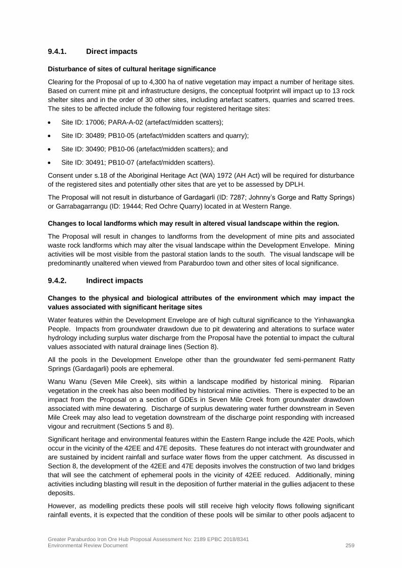
A Visual Impact Assessment (VIA) undertaken by Rio Tinto (2019i); (provided in Appendix 9) evaluated
the predicted visual impact of the Proposal for sites with the greatest potential for visual impact as well
as sites of cultural significance (e.g. Pirraburdu Creek). The VIA was conducted in three phases:
• desktop assessment (analysis);
• field assessment (photo locations); and
• visual impact assessment (photo montage).
The report focussed on visual amenity and associated impacts from the Proposal at specific locations
of particular interest being:
• Paraburdoo Airport;
• Paraburdoo town;
• Pirraburdu Creek;
• Paraburdoo Road; and
• Red Ochre Quarry.
Whilst the Proposal will be visible from the pastoral station lands to the south, the VIA demonstrates that
the Proposal will not be highly visible from Paraburdoo town or other sites of local significance.
Therefore, implementation of the Proposal is unlikely to significantly impact visual amenity values
associated with the local landforms.
Views of the Proposal from potentially sensitive viewpoints as identified in the VIA are presented below.
Photo locations and viewshed analysis is shown in Figure 9-2.
!
!
!
!(
!(
!(
!(!(!(!(!(
!(
!(
!(
!(
!(
Six Mile Cree
k
PRD01
PBO01
PBO02
PBO03ROQ01ROQ02ROQ03ROQ04 PCK01
PCK02PCK03
PRD02
PCK04Paraburdoo
Bellary Creek
Turee Creek
Tableland Creek
Pirraburdu Creek
Seven Mile Creek
Paraburdoo
Channar
Eastern Range
530,000
530,000
540,000
540,000
550,000
550,000
560,000
560,000
570,000
570,000
580,000
580,000
7,420,000
7,420,000
7,430,000
7,430,000
7,440,000
7,440,000
7,450,000
7,450,000
Figure 9-2: Viewshed analysis and photo locations
Disclaimer: This do cum ent ha s been prepa red to the highest level o f a ccura cy po ssible, fo r thepurpo ses o f Rio Tinto ’s iro n o re business. Repro ductio n o f this do cum ent in who le o r in pa rt bya ny m ea ns is strictly pro hibited witho ut the express a ppro va l o f Rio Tinto . Further, this do cum entm a y no t be referred to , quo ted o r relied upo n fo r a ny purpo se wha tso ever witho ut the writtena ppro va l o f Rio Tinto . Rio Tinto will no t be lia ble to a third pa rty fo r a ny lo ss, da m a ge, lia bility o rcla im a rising o ut o f o r incidenta l to a third pa rty using o r relying o n the co ntent co nta ined in thisdo cum ent. Rio Tinto discla im s a ll risk a nd the third pa rty a ssum es a ll risk a nd relea ses a ndindem nifies a nd a grees to keep indem nified Rio Tinto fro m a ny lo ss, da m a ge, cla im o r lia bilitya rising directly o r indirectly fro m the use o r relia nce o n this do cum ent.
Drawn: A.DPlan: PDE0169953v1Date: Februa ry 2020
Proj: GDA 1994 MGA Zo ne 50Scale: 1:200,000 @ [email protected]
0 10Kilo m etres
Ma p units in m etres
¯
Legend
! Rio Tinto MineTo wnDevelo pm ent Envelo peExisting o pera tio nsMa jo r Ro a dMino r Ro a dMa jo r Creek
!( Actua l Pho to Lo ca tio nViewshed Ana lysis
Proposed Conceptual FootprintPitWa ste Dum pSto ckpile

Greater Paraburdoo Iron Ore Hub Proposal Assessment No: 2189 EPBC 2018/8341 Environmental Review Document 263
Paraburdoo Airport
The Paraburdoo Airport is located approximately 15 km northeast of the Paraburdoo operations. Views
of the current Paraburdoo mining operations from the Paraburdoo Airport are limited, due to distance
and the obstruction of view by existing vegetation. The VIA shows no change to visual amenity as a
result of Proposal implementation when looking south-west from the Paraburdoo Airport. A photo
montage of the VIA for Paraburdoo Airport is shown in the Rio Tinto (2019i) report in Appendix 9..
Paraburdoo town
Paraburdoo town is located approximately 6 km north-east of the existing Paraburdoo mining
operations. From Paraburdoo town the existing Paraburdoo operations are obscured by local
topography and existing vegetation. The VIA shows no change to visual amenity as a result of Proposal
implementation as viewed from Paraburdoo town . A photo montage of the VIA for Paraburdoo Town
is shown in the Rio Tinto (2019i) report in Appendix 9.
Pirraburdu Creek
Pirraburdu Creek dissects the Development Envelope and runs adjacent to the existing operations and
the proposed 14-16W and 20W deposits and is of high local significance due to its cultural value to the
Yinhawangka People (the Gardagarli SoSS overlaps this area). The 14-16W pit design has been
modified to maintain the breakaway façade so as to minimise visual impacts and potential spillage of
material into Pirraburdu Creek. This is demonstrated by the VIA photo montages which confirm the
Proposal will be only partially visible when viewed from photo locations PCK01 PCK02 and PCK03. A
photo montage of the VIA for Pirraburdu Creek is shown in the Rio Tinto (2019i) report in Appendix 9.
Paraburdoo Road
Photo location PRD01 is on Paraburdoo Road, a public road approximately 18 km north of the
Development Envelope. A south and southwest perspective towards the Development Envelope does
not provide views of the current operations, due to distance, local topography and existing vegetation.
Therefore, it can also be expected that the Proposal will not be visible from Paraburdoo Road. A photo
montage of the VIA for Paraburdoo Road is shown in the Rio Tinto (2019i) report in Appendix 9.
Red Ochre Quarry
The Red Ochre Quarry (Garrabagarrangu) is a site of special significance to the Yinhawangka People
and is located south of the proposed 36W deposit at Western Range (further discussed in Section 9.3.3).
A photo montage of the VIA of the Red Ochre Quarry is shown in the Rio Tinto (2019i) report in
Appendix 9.
The VIA demonstrates that due to topography and existing native vegetation, the Proposal will not be
visible from this location. However, it should be noted the Proposal will be highly visible when
approaching the site from the south as access will be via a 200 m wide corridor between two waste
dumps. Additionally, the development of pits along the ridgeline to the north may be visible from the
general vicinity of the Garrabagarrangu.
9.5.2. Indirect impacts
Changes to the physical and biological attributes of the environment which may impact the
values associated with significant heritage sites
No indirect impacts to the SoSS’s, Gardagarli (Johnny’s Gorge/Ratty Springs) and Garrabagarrangu
(Red Ochre Quarry), are expected as a result of the Proposal. The Gardagarli area is located upstream
of the tributary that will carry surplus water from the dewatering of 36W at Western Range, and therefore
this discharge is not expected to affect Gardagarli. Discharge will be of short duration and low volume
so any effects on the creek environment including riparian vegetation and the water quality and extent

Greater Paraburdoo Iron Ore Hub Proposal Assessment No: 2189 EPBC 2018/8341 Environmental Review Document 264
of pools will be temporary and is expected to be negligible. This site is also hydraulically disconnected
from dewatering activities so will not be impacted by groundwater drawdown (Section 8).
Garrabagarrangu is near a small drainage line in Western Range. The catchment upstream of the
Garrabagarrangu will be impacted by the development of the 36W pits and some sedimentation may
occur in the upper catchment, however there are not expected to be any impacts to the
Garrabagarrangu. An exclusion zone will be established around Garrabagarrangu in consultation and
agreement with the Yinhawangka People and will be maintained in order to preserve the cultural value
of the site and will be documented in the CHMP.
Seven Mile Creek will be subject to drawdown from the dewatering of 4EE at Paraburdoo which is
predicted to impact up to approximately 27 ha of riparian vegetation (including GDE’s) north of the Mt
McRae Shale band (Section 5). Riparian vegetation condition in this section of Seven Mile Creek was
mapped by Astron (2018b) as Completely Degraded to Poor due to direct disturbance from existing
mining operations, presence of weeds and vegetation augmentation as a result of surplus water
discharge from the Paraburdoo Processing Plant. Therefore, there is not expected to be any significant
new effect on cultural values. Discharge of surplus dewatering water to Seven Mile Creek will also occur
via the existing licensed discharge point at Joe’s Crossing (excluded from this Proposal). However,
discharge (if required) will be intermittent and volumes will be small (up to 0.8 GL/a). As riparian
vegetation is adapted to intermittent inundation, impacts are expected to be temporary and not
significant. As such, significant adverse effects on cultural values are not anticipated with respect to
this watercourse as a result of the Proposal.
The Proposal will result in impacts to surface water catchments, particularly at Western Range and
Eastern Range. As a result, many ephemeral pools will receive reduced flows and increased sediment
loadings to varying degrees. However, surface water modelling indicates surface flow regimes will be
maintained at a level which should not significantly affect seasonal pooling (Section 8).
No significant indirect impacts to archaeological sites outside direct disturbance areas are expected to
occur. Dust management will minimise impacts on all sites and the implementation of a Blast
Management Plan will minimise any effects of blasting and vibration on potentially vulnerable rock
shelters. Where impacts from vibration are unavoidable, the Proponent will apply to assess the
significance of rock shelters under s. 16 of the AH Act. The Proponent will consult with Yinhawangka
people about management of rock shelter sites that could be impacted by vibration. The CHMP will also
address heritage sites outside the areas of direct disturbance (refer to Section 9.5.1).
Further consultations with the Yinhawangka People will continue to be undertaken to improve
sustainable water management outcomes through inclusive and ongoing engagement with
Yinhawangka aligned to Rio Tinto Iron Ore’s Water Strategy. The Proponent will also continue to review
and update the CHMP in consultation with the Yinhawangka People and in accordance with the
Agreement to manage potential direct and indirect impacts, as well as to ensure on-going access to the
site during operations and closure (Section 9.5.3).
9.5.3. Closure
The Closure Plans cover proposed mining area at Western Range, Paraburdoo and Eastern Range
(Appendix 5). A summary of the approach to closure of the Proposal and how it relates to the Social
Surroundings environmental factor is provided below.
The proposed post-mining land use assumes that the site will be rehabilitated to create a safe, stable
and non-polluting landscape revegetated with native species to the extent practicable, to be consistent
with the identified environmental and cultural heritage outcomes and ensure the site is compatible with
the current surrounding land use.
The main closure objective for heritage values of the Development Envelope is to preserve, protect and
manage the cultural heritage values of the area in cooperation with the Traditional Owners and other
stakeholders where possible.

Greater Paraburdoo Iron Ore Hub Proposal Assessment No: 2189 EPBC 2018/8341 Environmental Review Document 265
The maintenance of aesthetic values for cultural and amenity purposes are an important consideration
during mine closure. The following closure objectives will ensure that impacts to visual amenity are
minimised at closure:
• minimise the long-term visual impact by reshaping the land so it is compatible with the adjacent
landscapes; and
• re‐establish self‐sustaining ecosystems.
During the rehabilitation and closure of the Proposal, all reasonable and practicable measures will be
undertaken to prevent harm to cultural heritage sites. Where this is not practicable, minimisation and
mitigation steps will be implemented and required statutory approvals will be obtained. Closure is to
consider issues such as access requirements to culturally significant sites and the appropriate return of
any salvaged material from artefacts collected during mining operations.
Designs regarding waste landforms and restriction of public access are to consider the location of
heritage sites (e.g. sites may require access post closure).
To ensure ongoing limited access to pit voids; abandonment bunds will be established. Abandonment
bunds will only be placed in areas with potential access exposure and in conjunction with several
alternative methods for limiting access to pits (as outlined in detail in the Closure Plans). Methods to
enable safe access to specific areas where required (e.g. sites of cultural heritage significance) will be
discussed as the sites approach closure.
Consultation specifically regarding closure will be more thoroughly undertaken with the Yinhawangka
People closer to time of closure. Consultation will focus on ongoing access to heritage sites post-
closure, landform rehabilitation methodology, the selection and distribution of native plants during
rehabilitation, management of hydrological processes and the ultimate resting place, or repatriation, of
any salvaged artefacts.
At Eastern Range, post closure access requirements to culturally significant water sources will be
considered during closure planning. The Agreement and strategies in the CHMP will aid in the
appropriate management of cultural heritage values. Management of access will be finalised once
production at Eastern Range is nearing closure and consultation with relevant stakeholders will be
undertaken and documented in the Eastern Range Closure Plan.
At Western Range, ongoing access to the Garrabagarrangu SoSS (Red Ochre Quarry) will be
maintained post closure (as discussed in Table 9-2). Access to the Garrabagarrangu has also been
considered in the development of locations for the conceptual abandonment bunds at Western Range.
Heritage assessments will also be undertaken prior to closure to determine potential impacts to cultural
heritage sites as a result of closure implementation. The results of the assessments will inform the
development of alternative strategies, should they be required. Heritage assessments will also be
conducted post-closure to ensure implementation has been undertaken in an appropriate manner in
accordance with the Agreement.
9.6. Mitigation
Mitigation actions to address the potential impacts and the predicted outcomes for Social
Surroundings are presented in Table 9-2.

Greater Paraburdoo Iron Ore Hub Proposal Assessment No: 2189 EPBC 2018/8341 Environmental Review Document 266
Table 9-2: Application of mitigation hierarchy for social surroundings
Potential Impact Avoidance Minimisation Rehabilitation Predicted outcome
Disturbance of sites of cultural heritage significance
Impacts to SoSS; Gardagarli (Johnny’s Gorge and Ratty Springs) and Garrabagarrangu (Red Ochre Quarry) will be avoided.
Waste dump design at Western Range has been modified to allow for the provision of an exclusion zone around Garrabagarrangu and a 200 m wide corridor to ensure the site can continue to be accessed both during and on cessation of operations.
The Proponent is committed to avoiding heritage sites, wherever practicable.
Mitigation strategies such as salvaging of heritage sites that are subject to ss. 16 and 18 of the AH Act will be undertaken in consultation with the Yinhawangka People, and if appropriate, stored in the Keeping Place currently housed at Paraburdoo Operations.
An inventory of salvaged material is maintained and managed by Rio Tinto’s Heritage Team (Rio Tinto 2018f). Consultation is ongoing with the Yinhawangka to discuss the timings and procedures of repatriating of cultural materials currently held by Rio Tinto and will be formalised over the coming years once Yinhawangka have established their own Keeping Place facility.
A Blast Management Plan for rock shelters will be developed. Where impacts from vibration are unavoidable, Rio Tinto will apply to assess the significance of rock shelters under s16 of the AH Act. Rio Tinto will consult with Yinhawangka people about management of rock shelter sites that could be impacted by vibration. The Proposal has been designed to minimise impacts to pools and catchments where practicable.
The Proposal has been designed to minimise impacts to pools and catchments where practicable.
The pit design of the 14-16W deposit has been modified to minimise physical and visual impacts to Pirraburdu Creek as per consultation with the Yinhawangka People.
Not applicable. There will be no direct impacts to SoSS; Gardagarli (Johnny’s Gorge and Ratty Springs) and Garrabagarrangu (Red Ochre Quarry)
The Proposal is expected to result in disturbance to some sites of ethnographic and / or archaeological significance to the Yinhawangka People. (up to approximately 45 heritage sites).
However, potential for impacts to heritage values will be appropriately managed via existing legislation. Any disturbance will be in accordance with approval under s 16 and/or s 18 of the AH Act and will have the support of the Yinhawangka Traditional Owners.
Ongoing engagement with the Yinhawangka Traditional Owners is managed through engagement frameworks established through existing agreements.
The Proponent considers that the Proposal meets the EPA’s objective for this factor.

Greater Paraburdoo Iron Ore Hub Proposal Assessment No: 2189 EPBC 2018/8341 Environmental Review Document 267
Potential Impact Avoidance Minimisation Rehabilitation Predicted outcome
Changes to local landforms which may result in altered visual landscape within the region
Not applicable. The pit design of the 14-16W deposit has been modified to minimise the visual and physical impacts to Pirraburdu Creek as per consultation with the Yinhawangka People.
Mineral waste dumps will be designed to consider:
• minimisation of dump height;
• shaping of dumps to blend in with the surrounding natural topography;
• construction to meet the requirements of the final rehabilitation design; and
• drainage and erosion management features.
During closure the land will be reshaped to be compatible with the adjacent landscape to minimise long term visual impacts.
Progressive backfilling will be implemented as far as practicable.
Progressive rehabilitation with local native vegetation has been, and will continue to be, undertaken where practicable.
Self-sustaining ecosystems are intended to be re-established.
The development of the Proposal will result in permanent changes to the landforms and general landscape.
As disturbance associated with the Proposal will occur predominantly on the south side of Paraburdoo Range, the impact to visual amenity when viewed from Paraburdoo town and other sites of local significance will be similar to the existing operations. Additionally, the Proponent has modified the pit design at 14-16W to minimise the visual and physical impacts to Pirraburdu Creek as per consultation with the Yinhawangka People.
Therefore, the Proponent considers that the Proposal meets the EPA’s objective for this factor.
Changes to the physical and biological attributes of the environment which may impact the values associated with significant heritage sites
The Proponent will avoid, as far as practicable, any sites of archaeological significance. Given historical landscape and riparian vegetation modification in Seven Mile Creek, proposed dewatering and discharge activities are unlikely to have any impact on cultural heritage associated with this watercourse.
The Proposal has been designed to minimise impacts to pools and catchments where practicable. This is addressed further in Section 8.
Surface water management will be implemented to minimise disruption to natural flows, minimise erosion and prevent contamination of surface and groundwater where practicable
Dust management and implementation of a Blast Management Plan will minimise indirect impacts on sites of archaeological significance.
The Closure Plans regarding operations within the Development Envelope consider the long-term access to heritage sites which will be further refined during life of mine, as well as how salvaged artefact material (as a result of direct impacts) will be managed.
The Proponent will ensure that the Proposal:
• minimises impacts on sites of archaeological and cultural significance
• does not affect safe site access for the Yinhawangka Traditional Owners
• the ability of the Traditional Owners to use the area for cultural purposes.
The Proponent considers that the Proposal meets the EPA’s objective for this factor.

Greater Paraburdoo Iron Ore Hub Proposal Assessment No: 2189 EPBC 2018/8341 Environmental Review Document 268
9.7. Predicted Outcomes
The key Social Surroundings values identified in the Development Envelope that are considered relevant
to the Proposal include:
• Two SoSS’s (Gardagarli and Garrabagarrangu (Red ochre quarry) located within the Development
Envelope.
• Water sources identified as being highly significant to the Yinhawangka People.
• Various locations within the vicinity of the Proposal that are publicly accessible and potentially have
views of the Paraburdoo mine site (e.g. Paraburdoo town).
There will be no direct impact to Gardagarli or Garrabagarrangu. Waste dump designs at Western
Range have been modified to allow for the establishment of an exclusion zone around Garrabagarrangu
in consultation and agreement with the Yinhawangka People and will be maintained in order to preserve
the cultural value of the site. Additionally, the Proponent has modified the pit design at 14-16W to
minimise the visual and physical impacts to Pirraburdu Creek as per consultation with the Yinhawangka
People.
Implementation of the Proposal will result in impacts to some heritage sites including a limited section
of Wanu Wanu (Seven Mile Creek) and surface water pools at Eastern Range and Western Range
(Section 8). The Proponent acknowledges the high cultural significance of water systems to the
Yinhawangka People and further consultations will continue to be undertaken to improve sustainable
water management outcomes through inclusive and ongoing engagement with Yinhawangka aligned to
Rio Tinto Iron Ore’s Water Strategy. The issue of water management will remain an ongoing dialogue
between Rio Tinto and the Yinhawangka People that will adapt to requirements as the mine life
progresses.
After the application of the mitigation hierarchy (Table 9-2) and with ongoing consultation with the
Yinhawangka People regarding the Proposal through both formal and informal forums, and obligations
under the AH Act, the Proponent considers that the Proposal can be managed to meet the EPA’s
objective for Social Surroundings.

Greater Paraburdoo Iron Ore Hub Proposal Assessment No: 2189 EPBC 2018/8341 Environmental Review Document 269
10. MATTERS OF NATIONAL ENVIRONMENTAL SIGNIFICANCE
To be consistent with the EPBC Act, the Proposal is referred to as the Proposed Action in this chapter.
Further information regarding the Proposed Action is presented in Section 2.
10.1. Matters of National Environmental Significance
The Commonwealth EPBC Act provides a legal framework for the protection of Matters of National
Environmental Significance (MNES). The EPBC Act requires that all actions that will or may have a
significant impact on a MNES must be referred to the Minister for the Environment via the DAWE.
Protected matters under the EPBC Act include listed threatened species and ecological communities;
and migratory species protected under international agreements that occur within the Development
Envelope.
10.2. Proposed action and assessment process
The Proposed Action involves the extension of existing operations at the Paraburdoo and Eastern
Range mines and development of a new mine at Western Range. The Proposed Action will sustain the
current iron ore production from the Greater Paraburdoo Hub (currently around 25 Mt/a) for
approximately 20 years and is critical to sustain the town of Paraburdoo and more broadly the
Proponent’s business activities in the Pilbara region.
Key elements of the Proposed Action include the additional clearing of up to 4,300 ha of vegetation
within a 17,422 ha Development Envelope, groundwater abstraction at a rate of up to 14 GL/a, and
surplus water discharge of up to 1.7 GL/a.
The Proposed Action was referred to DAWE (then DotEE) on 6 December 2018 (EPBC 2018/8341).
On 24 January 2019, the Minister for the Environment and Energy determined that the Proposed Action
constitutes a Controlled Action under s. 75 of the EPBC Act and; therefore, requires assessment and a
decision about whether approval should be granted under the EPBC Act.
The assessment process was determined to be an accredited assessment under the EP Act.
10.3. Controlled action provisions
A comprehensive assessment of potential impacts on MNES has been undertaken in this chapter,
including potential impacts on threatened species recorded in, likely to, or with potential to occur in the
Development Envelope. The controlling provision of the EPBC Act is ‘Listed threatened species and
communities’ (ss. 18 and 18A of the EPBC Act), with potential for significant impacts on the following
matters:
• Northern Quoll (Dasyurus hallucatus) – Endangered;
• Pilbara Olive Python (Liasis olivaceus barroni) – Vulnerable;
• Ghost Bat (Macroderma gigas) – Vulnerable; and
• Pilbara Leaf-nosed Bat (Rhinonicteris aurantia) – Vulnerable.
The potential impacts to these MNES from the Proposed Action as it relates to the EPBC Act have been
determined through:
• a review of previous terrestrial fauna surveys and investigations within the Development Envelope,
including desktop findings and field-based identification and mapping of fauna habitat types; and
• spatial analysis of fauna habitats and species records to determine potential impacts on species
recorded or likely to occur in the Development Envelope.

Greater Paraburdoo Iron Ore Hub Proposal Assessment No: 2189 EPBC 2018/8341 Environmental Review Document 270
The significance and management of potential impacts on MNES have been assessed in the context of:
• Matters of National Environmental Significance Significant Impact Guidelines 1.1 (DoE 2013);
• the application of the mitigation hierarchy including avoidance, minimisation, rehabilitation and
offset measures to the design and implementation of the Proposed Action;
• a review of approved conservation advice and/or Recovery Plans, where available, for each
relevant MNES, specifically, whether a population is an important population, whether available
habitat in the Development Envelope is critical habitat for the local population or species; and
• ensuring the outcomes align with Recovery Plan or conservation advice actions for matters
identified to have a potential impact from the Proposed Action.
10.4. Policy and guidance
10.4.1. Significant Impact Guidelines
The Significant Impact Guidelines inform the impact assessment required under the EPBC Act on
matters and assesses the significance of potential impacts at a local and regional scale. In accordance
with these guidelines, the assessment of ‘Listed threatened species and communities’ is presented
within the context of the following key concepts:
• habitat critical to the survival of a species; and
• an important population (for species listed as Vulnerable under the EPBC Act - impacts to species
listed as Endangered or Critically Endangered are considered in relation to any population).
‘Habitat critical to the survival of a species,’ refers to areas that are necessary:
• for activities such as foraging, breeding, roosting, or dispersal;
• for the long-term maintenance of the species or ecological community (including the maintenance
of species essential to the survival of the species or ecological community, such as pollinators);
• to maintain genetic diversity and long-term evolutionary development; and
• for the reintroduction of populations or recovery of the species or ecological community.
Such habitat may include, but is not limited to, habitat identified in a recovery plan for the species or
ecological community as habitat critical for that species or ecological community, and/or habitat listed
on the Register of Critical Habitat maintained by the Minister under the EPBC Act (DoE 2013).
An ‘important population’ is a population that is necessary for a species’ long-term survival and recovery.
This may include populations identified as such in recovery plans, and/or that are:
• key source populations either for breeding or dispersal;
• populations that are necessary for maintaining genetic diversity; and
• populations that are near the limit of the species range (DoE 2013).
An assessment of significance for each MNES species is presented in this chapter and reflects
additional information provided by survey information presented after the submission of the EPBC
referral.

Greater Paraburdoo Iron Ore Hub Proposal Assessment No: 2189 EPBC 2018/8341 Environmental Review Document 271
10.4.2. Approved conservation advice and recovery plans
Approved conservation advice and recovery plans are in place for MNES known or likely to occur in the
Development Envelope. These guidance documents identify overall conservation objectives, critical
habitat, important populations, key threats and priority management actions. They are also relevant to
the assessment process as the Minister must consider the content of approved conservation advice to
ensure the Proposed Action aligns with objectives of the conservation advice and/or recovery plan.
Guidance and policy documents relevant to the Proposed Action are identified in Table 10-1 below.
Table 10-1: Relevant guidance on MNES
Guidance Objective/Priorities
Conservation Advice Macroderma gigas Ghost bat (TSSC 2016a)
Identifies primary conservation actions as:
1. Protect roosts from mining, human disturbance and collapse.
2. Replace the top strands of barbed wire in fences near roost sites with single-strand wire.
Also identifies key conservation and management actions, survey and research priorities.
Conservation Advice Rhinonicteris aurantia (Pilbara form) Pilbara Leaf-nosed Bat (TSSC 2016b)
Identifies national conservation objectives, which are summarised below:
1. Ensure that activities don’t have a significant impact.
2. Eliminate key threats and halt the predicted decline.
3. Protect and manage known roosts.
4. Identify and protect high value foraging habitat around roost sites.
5. Support research on occurrence, population size and ecological requirements.
The Conservation Advice also provides specific guidance about what does and does not comprise habitat critical to the survival of this species, and outlines guidance as to what impacts may be considered significant to Pilbara Leaf-nosed Bat.
National Recovery Plan for the Northern Quoll Dasyurus hallucatus (Hill and Ward 2010)
Identifies the national recovery objective as:
‘To minimise the rate of decline of Northern Quoll in Australia, and ensure that viable populations remain in each of the major regions of distribution into the future.’
A number of recovery objectives are identified, including the following as relevant to the Proposed Action:
1. Identify potential refuge habitats in Western Australia where quolls might be most likely to persist in the long-term alongside cane toads.
2. Halt Northern Quoll decline in areas not yet colonised by cane toads.
3. Investigate factors causing declines in Northern Quoll populations not yet affected by cane toads.
4. Manage key Northern Quoll populations in areas not currently affected by cane toads to halt population declines.
5. Reduce the impact of feral predators on Northern Quolls.
EPBC Act referral guideline for the endangered northern quoll Dasyurus hallucatus (DoE 2016)
Identifies critical habitat and important populations, recommended survey methods, actions likely to result in significant impacts and management/mitigation measures that are effective and appropriate for this species.

Greater Paraburdoo Iron Ore Hub Proposal Assessment No: 2189 EPBC 2018/8341 Environmental Review Document 272
Guidance Objective/Priorities
Approved Conservation Advice for Liasis olivaceus barroni (Olive Python – Pilbara subspecies) (DEWHA 2008a)
Identifies research priorities, regional and local priority actions, which includes (but is not limited to) the following that are relevant to this Proposed Action:
1. Identify populations of high conservation priority.
2. Ensure development does not adversely impact known populations.
3. Manage changes to hydrology.
4. Raise awareness of the species.
10.4.3. Threat abatement plans
Threat abatement plans (TAPs) establish national frameworks to guide and coordinate Australia’s
response to threats to biodiversity. These documents identify research, management and other priority
actions required to ensure the protection of threatened species. The Australian Government develops
and facilitates the implementation of the TAPs by establishing partnerships and cooperative programs.
When considering the approval of a project, the Minister must not act inconsistently with a TAP.
The TAPs relevant to the Proposed Action and the associated objectives for each plan are outlined in
Table 10-2
Table 10-2: Relevant threat abatement plans for the Proposed Action
Threat Abatement Plan Objectives
Threat abatement plan for predation by feral cats (DoE 2015a)
The goal of this TAP is to minimise the impact of feral cats on biodiversity by:
• protecting affected threatened species;
• preventing further species and ecological communities from becoming threatened.
The TAP has four objectives:
1. Effectively control feral cats in different landscapes.
2. Improve effectiveness of existing control options for feral cats.
3. Develop or maintain alternative strategies for threatened species recovery.
4. Increase public support for feral cat management and promote responsible cat ownership.
Threat abatement plan for predation by the European red fox (DEWHA 2008b)
This TAP identifies localised fox control measures applicable in specific areas of high conservation value and where:
• chances of reinvasion must be nil or very close to it
• all foxes must be accessible and at risk during the control operation
• foxes must be killed at a higher rate than their ability to replace losses through breeding
• where local eradication is not practicable, two strategies for localised management can be used, as follows:
• sustained management, where control is implemented on a continuing, regular basis; or
• intermittent management, where control is implemented at critical periods of the year when damage is greatest and short-term control will reduce impacts to acceptable levels.
Greater Paraburdoo Iron Ore Hub Proposal Assessment No: 2189 EPBC 2018/8341 Environmental Review Document 273
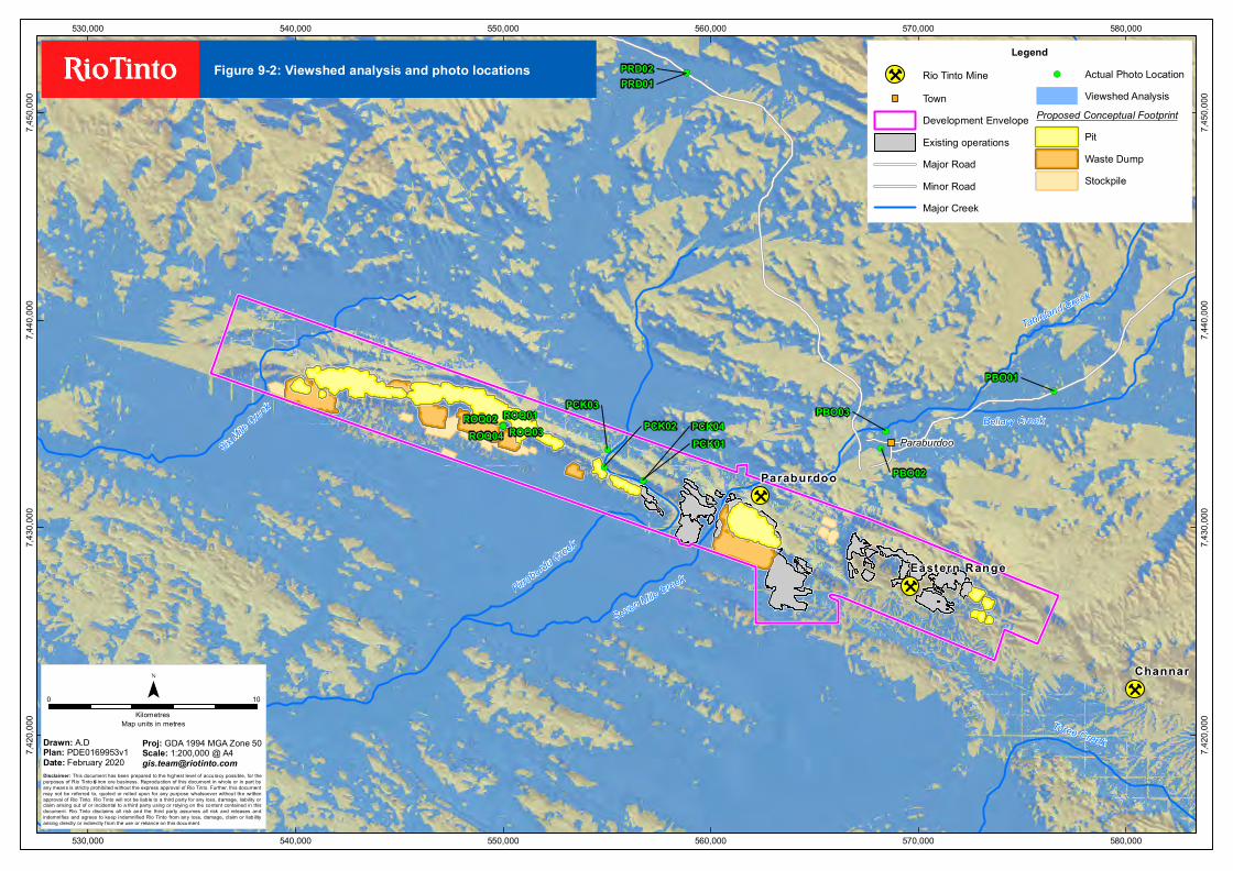
Threat Abatement Plan Objectives
Threat abatement plan for the biological effects, including lethal toxic ingestion, caused by cane toads (DSEWPaC 2011c)
The focus of this TAP is how native animals and natural environments can be protected from cane toads.
This plan aims to:
• identify native species and ecosystems at risk due to cane toads
• reduce the impact of cane toads on native species and ecosystems
• communicate information about cane toads and their impacts.
The TAP has three objectives as follows:
1. To identify priority native species and ecological communities (including those that are protected matters under the EPBC Act) at risk from the impact of cane toads.
2. To reduce the impact of cane toads on populations of priority native species and ecological communities.
3. To communicate information about cane toads, their impacts and this TAP.
Threat abatement plan to reduce the impacts on northern Australia’s biodiversity by the five listed grasses (DSEWPaC 2012a)
The goal of this TAP is to minimise the adverse impacts of the five listed grasses on affected native species and ecological communities. To achieve this goal, the TAP has six main objectives, as follows:
1. Develop an understanding of the extent and spread pathways of infestation by the five listed grasses.
2. Support and facilitate coordinated management strategies through the design of tools, systems and guidelines.
3. Identify and prioritise key assets and areas for strategic management.
4. Build capacity and raise awareness among stakeholders.
5. Implement coordinated, cost-effective on ground management strategies in high-priority areas.
6. Monitor, evaluate and report on the effectiveness of management programs.
10.5. Listed threatened species and ecological communities
The following sections provide an overview of the findings for MNES ‘Listed under threatened species
and communities’ under ss. 18 and 18A of the EPBC Act within 20 km of the Proposed Action.
10.5.1. Flora
No flora listed under the EPBC Act were recorded within the Development Envelope (Astron 2018a, b).
No flora species protected under the EPBC Act were identified in a Protected Matters Search Tool
(PMST) database search as having the potential to be present within 20 km of the Development
Envelope (DotEE 2018).
10.5.2. Ecological communities
No ecological communities listed under the EPBC Act were recorded within the Development Envelope
(Astron 2018a, b). No ecological communities protected under the EPBC Act were identified in a PMST
database search as having the potential to be present within 20 km of the Development Envelope
(DotEE 2018).

Greater Paraburdoo Iron Ore Hub Proposal Assessment No: 2189 EPBC 2018/8341 Environmental Review Document 274
10.5.3. Fauna
Eight listed threatened fauna species, and nine migratory species protected under the EPBC Act were
identified using the PMST (DotEE 2018) as likely to occur within 20 km of the Development Envelope.
Several fauna investigations, including a targeted survey to assess the presence of MNES have been
undertaken within the Development Envelope. A summary of existing environmental values relating to
MNES identified within the Development Envelope is provided in Section 10.6.
A summary of key MNES investigations are outlined below and provided in Appendix 6. These
documents also consolidate historical fauna investigations (including Astron [2014]; Biota [2010, 2011];
and Ecologia [2012]) conducted within the Development Envelope:
• Greater Paraburdoo Level 2 Fauna Survey (Astron 2018c).
• Western Range EPA Level 1 and Targeted Conservation Significant Fauna Assessment (Astron
2018d).
• Greater Paraburdoo Ghost Bat, Macroderma gigas - Contextual Study (Astron 2019).
• Rio Tinto, Ratty Spring and Paraburdoo Pools Pilbara leaf-nosed Bat monitoring program, 2015 to
January 2020 (Bat Call 2020a).
• Greater Paraburdoo Acoustic Survey of Ghost Bat Activity, July 2018 to February 2020 (Bat Call
2020b).
• Western Range: Pilbara Leaf-nosed Bat VHF Pilot Study (Biologic 2019a).
• Western Range: Pilbara Leaf-nosed Bat VHF Study (Biologic 2020a).
• Memo: Western Range Ghost Bat VHF Study (Biologic 2020b).
• Western Range 2019 Ghost Bat Scat Analysis Report (Biologic 2020c).
• Eastern Range EPA Level 1 Targeted Fauna Survey (Astron 2018e).
The following sections provide an overview of fauna listed under the EPBC Act that may be affected by
the Proposed Action.
Table 10-3 lists fauna species and likelihood of occurrence in the Development Envelope. Five EPBC
listed species have been recorded within the Development Envelope:
• Northern Quoll (Dasyurus hallucatus);
• Ghost Bat (Macroderma gigas);
• Olive Python (Pilbara subspecies) (Liasis olivaceus barroni);
• Pilbara Leaf-nosed Bat (Rhinonicteris aurantia); and
Species considered unlikely to occur in the Development Envelope are not discussed further.

Greater Paraburdoo Iron Ore Hub Proposal Assessment No: 2189 EPBC 2018/8341 Environmental Review Document 275
Table 10-3: EPBC Act fauna species and likelihood of occurrence in the Development Envelope
Species Conservation status (EPBC
Act) Broad habitat type
Likelihood of occurrence in the Development Envelope
Listed threatened species
Northern Quoll (Dasyurus hallucatus)
Endangered Rocky hills, gorges, mesas, high and low plateaus, low slopes and stony plains with spinifex.
Present.
Recorded at eight locations in the Development Envelope; six locations at Western Range (four scats and two motion sensitive camera records) and two scats at Paraburdoo (Astron 2018c, d). All eight records were in the Breakaway and Gorge/Gully habitats within the Development Envelope.
A Northern Quoll footprint was previously recorded at Eastern Range in 2010, with a track identified in a cave within Gorge habitat close to the Eastern Range mining operations (Astron 2018c).
Olive Python (Pilbara subspecies) (Liasis olivaceus barroni)
Vulnerable Escarpments, deep gorges, water holes and rock piles associated with permanent pools in rocky areas.
Present.
Previously recorded in 2011 at Seven Mile Creek within the Development Envelope and at other locations within the vicinity of the Development Envelope. A sighting of the species was identified by the Proponent at Channar (outside of the Development Envelope) in 2018. Suitable habitat is present in the Development Envelope comprising Gorge/Gully, Breakaway and Riverine habitats within the Development Envelope.
Ghost Bat (Macroderma gigas)
Vulnerable Rocky gorges and breakaways with caves and crevices.
Present.
Recorded in the Development Envelope through echolocation recordings, secondary evidence such as scats and midden piles within caves, and observations of individual bats. The Development Envelope contains nine significant caves for Ghost Bats that have the attributes that provide roost sites for Ghost Bat.
Pilbara Leaf-nosed Bat
(Rhinonicteris aurantia)
Vulnerable. Deep caves with high humidity and stable temperatures, water courses, riparian vegetation, hummock grassland and sparse tree and shrub savannah.
Present.
One permanent colony has been identified in the vicinity of Ratty Springs (Ratty Springs roost) within Breakaway habitat in the Development Envelope and has been confirmed as a permanent diurnal/maternal roost. VHF studies indicate that the Riverine habitat adjacent to the Ratty Springs roost is significant foraging habitat for this population (Biologic 2020a).
Suitable habitat occurs in Gorge/Gully and Breakaway habitats in the Development Envelope, including the presence of a number of deep/humid caves that potentially support roost sites. Acoustic records, observations and secondary evidence confirm the presence of the Pilbara Leaf-nosed Bat within the Development Envelope
Greater Paraburdoo Iron Ore Hub Proposal Assessment No: 2189 EPBC 2018/8341 Environmental Review Document 276
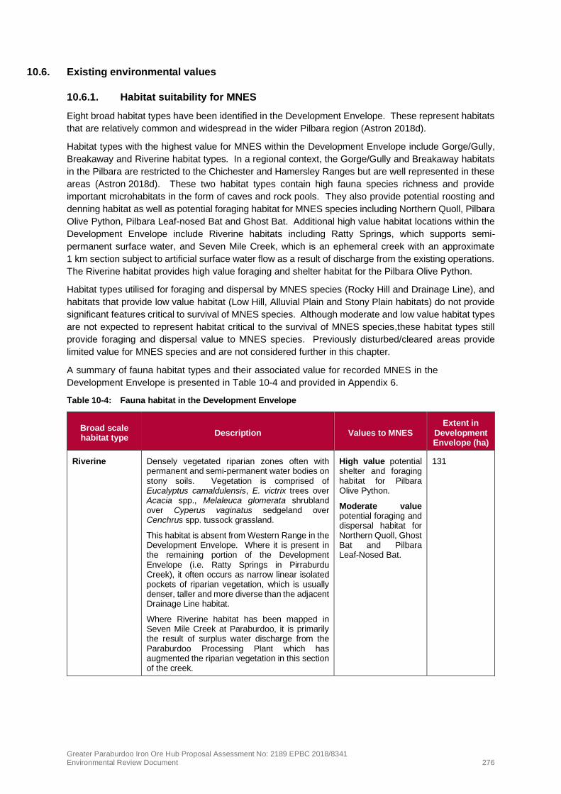
10.6. Existing environmental values
10.6.1. Habitat suitability for MNES
Eight broad habitat types have been identified in the Development Envelope. These represent habitats
that are relatively common and widespread in the wider Pilbara region (Astron 2018d).
Habitat types with the highest value for MNES within the Development Envelope include Gorge/Gully,
Breakaway and Riverine habitat types. In a regional context, the Gorge/Gully and Breakaway habitats
in the Pilbara are restricted to the Chichester and Hamersley Ranges but are well represented in these
areas (Astron 2018d). These two habitat types contain high fauna species richness and provide
important microhabitats in the form of caves and rock pools. They also provide potential roosting and
denning habitat as well as potential foraging habitat for MNES species including Northern Quoll, Pilbara
Olive Python, Pilbara Leaf-nosed Bat and Ghost Bat. Additional high value habitat locations within the
Development Envelope include Riverine habitats including Ratty Springs, which supports semi-
permanent surface water, and Seven Mile Creek, which is an ephemeral creek with an approximate
1 km section subject to artificial surface water flow as a result of discharge from the existing operations.
The Riverine habitat provides high value foraging and shelter habitat for the Pilbara Olive Python.
Habitat types utilised for foraging and dispersal by MNES species (Rocky Hill and Drainage Line), and
habitats that provide low value habitat (Low Hill, Alluvial Plain and Stony Plain habitats) do not provide
significant features critical to survival of MNES species. Although moderate and low value habitat types
are not expected to represent habitat critical to the survival of MNES species,these habitat types still
provide foraging and dispersal value to MNES species. Previously disturbed/cleared areas provide
limited value for MNES species and are not considered further in this chapter.
A summary of fauna habitat types and their associated value for recorded MNES in the
Development Envelope is presented in Table 10-4 and provided in Appendix 6.
Table 10-4: Fauna habitat in the Development Envelope
Broad scale habitat type
Description Values to MNES Extent in
Development Envelope (ha)
Riverine Densely vegetated riparian zones often with permanent and semi-permanent water bodies on stony soils. Vegetation is comprised of Eucalyptus camaldulensis, E. victrix trees over Acacia spp., Melaleuca glomerata shrubland over Cyperus vaginatus sedgeland over Cenchrus spp. tussock grassland.
This habitat is absent from Western Range in the Development Envelope. Where it is present in the remaining portion of the Development Envelope (i.e. Ratty Springs in Pirraburdu Creek), it often occurs as narrow linear isolated pockets of riparian vegetation, which is usually denser, taller and more diverse than the adjacent Drainage Line habitat.
Where Riverine habitat has been mapped in Seven Mile Creek at Paraburdoo, it is primarily the result of surplus water discharge from the Paraburdoo Processing Plant which has augmented the riparian vegetation in this section of the creek.
High value potential shelter and foraging habitat for Pilbara Olive Python.
Moderate value potential foraging and dispersal habitat for Northern Quoll, Ghost Bat and Pilbara Leaf-Nosed Bat.
131

Greater Paraburdoo Iron Ore Hub Proposal Assessment No: 2189 EPBC 2018/8341 Environmental Review Document 277
Broad scale habitat type
Description Values to MNES Extent in
Development Envelope (ha)
Gorge/Gully At Western Range and Eastern Range in the Development Envelope, this habitat included shallow gullies and deep open gorges, sometimes with rainfall fed ephemeral pools. Vegetation is comprised of Dodonaea pachyneura, Eremophila cryptothrix tall shrubland over Triodia epactia hummock grassland.
Shallow gullies are absent from the remainder of the Development Envelope, with the habitat consisting of deep, often rocky gorges, with rainfall fed ephemeral or semi-permanent pools. Vegetation in these areas is comprised of Corymbia ferriticola trees over Acacia citrinoviridis, A. aneura sens. lat. shrubland over Triodia epactia hummock grassland.
High value potential shelter, denning and/or roosting habitat for Northern Quoll, Pilbara Olive Python, Pilbara Leaf-nosed Bat and Ghost Bat.
630
Breakaway Breakaway or ridge line, falling away to steep scree slope or drainage line. Vegetation is comprised of Acacia pruinocarpa, Grevillea berryana tall open shrubland over Eremophila spp., Eucalyptus spp. shrubs over Triodia epactia hummock grassland.
High value potential shelter, denning and/or roosting habitat for Northern Quoll, Pilbara Olive Python, Ghost Bat and Pilbara Leaf-nosed Bat.
291
Drainage Line Open drainage areas on stony soils, where water bodies are only present during times of heavy inundation. Vegetation is comprised of Eucalyptus victrix woodland over Acacia spp., Melaleuca glomerata shrubs over Cenchrus spp. tussock grassland.
Within the Development Envelope, this habitat generally has a lower vegetative cover when compared to Riverine habitat, with less dense and less complex vegetation.
Moderate value potential foraging and dispersal habitat for Northern Quoll, Pilbara Olive Python, Ghost Bat and Pilbara Leaf-nosed Bat.
740
Rocky Hill Stony hills on high ranges with dissected valleys and gorges. At Western Range in the Development Envelope, the vegetation is comprised of Acacia aneura, A. pruinocarpa, Grevillea berryana tall open shrubland over A. tetragonophylla and Eremophila spp. scattered shrubs over Triodia epactia hummock. In the remainder of the Development Envelope, the vegetation includes Eucalyptus leucophloia subsp. leucophloia trees over Acacia spp., G. berryana, Eremophila spp. shrubs overTriodia. epactia, T. wiseana hummock grassland.
Moderate value potential foraging and dispersal habitat for Northern Quoll, Pilbara Olive Python, Ghost Bat and Pilbara Leaf-nosed Bat.
4,516
Low Hill Low stony hills and slopes with dissected valley and drainage on stony soils. Vegetation is comprised of Acacia spp. shrubland over Eremophila spp. Shrubs over Triodia epactia, Aristida contorta, Eriachne pulchella grassland.
Low value habitat for Northern Quoll, Pilbara Olive Python, Ghost Bat and Pilbara Leaf-nosed Bat.
3,947
Stony Plain Broad flat low-lying plains to undulating plains on soft loamy soils. Vegetation is comprised of Acacia aneura sens. lat., A. xiphophylla shrubland over A. tetragonophylla, Eremophila cuneifolia, Senna spp. and scattered low shrubs.
Low value habitat for Northern Quoll, Pilbara Olive Python, Ghost Bat and Pilbara Leaf-nosed Bat.
3,516

Greater Paraburdoo Iron Ore Hub Proposal Assessment No: 2189 EPBC 2018/8341 Environmental Review Document 278
Broad scale habitat type
Description Values to MNES Extent in
Development Envelope (ha)
Alluvial Plain This habitat type has been mapped only in the Western Range portion of the Development Envelope. It consists of flood plain surrounding drainage areas with Acacia aneura sens. lat., A. tetragonophylla tall shrubland over Triodia epactia open hummock grassland. Where similar habitat exists in the remainder of the Development Envelope it has been mapped as Drainage Line.
Moderate value potential foraging habitat for Pilbara Leaf-nosed Bat but rated as low value for Northern Quoll, Pilbara Olive Python and Ghost Bat as this habitat type offers minimal ecological value to these species.
104
10.6.2. Northern Quoll (Dasyurus hallucatus)
The Northern Quoll (Dasyurus hallucatus) is listed as Endangered under Schedule 2 of the BC Act and
Endangered under the EPBC Act.
The species was originally found across northern Australia from the North-West Cape of WA to south-
east Queensland; however, its abundance has significantly declined in recent years. The Northern Quoll
is now restricted to five regional populations across Queensland, the Northern Territory and Western
Australia on both the mainland and offshore islands (Rio Tinto 2018a). This species occurs in a variety
of habitats but is commonly found in open lowland savannah forest and rocky escarpments. Rocky
areas are particularly important for Northern Quolls in the Pilbara as these areas retain water and
provide a diversity of microhabitats (Astron 2018c). These areas also tend to have greater floristic
diversity and productivity resulting in greater prey density compared to non-rocky areas. These rocky
areas also provide refuge from feral cats, fire and livestock and provide breeding potential
(Astron 2018c).
A total of 8,172 records are located in the Pilbara and Kimberley regions of Western Australia
(DBCA 2019b), of which approximately 4,153 historical records are from the Pilbara (Dunlop et al. 2018).
The majority of these are recent records with 315 records, or less than 8%, dating prior to 2009. Records
from the Pilbara bioregion are scattered across the four subregions; the Hamersley, Fortescue Plains,
Chichester and Roebourne Plains subregions with records extending as far west as the Little Sandy
Desert and as far south as Karijini National Park (DotEE 2019). The majority of recent records however
have come from the Rocklea, Macroy and Robe land systems (DotEE 2019). The species distribution
is now considered to be fragmented and mostly confined to the larger conservation reserves such as
Millstream Chichester National Park (Henandez Santin et al. 2018) as well as to the Burrup Peninsula
(DotEE 2019).
The Pilbara Northern Quoll Monitoring Project has been conducted by DBCA since 2012 to improve the
understanding of distribution, ecology, abundance and demographics of Northern Quoll in the region
(Rangelands 2018). Northern Quoll records from this project are uploaded to the DBCA online
government database NatureMap. Extensive evidence of this species in the form of scats and motion
camera captures have been identified in Karlamilyi National Park (approximately 403 km northeast from
the Development Envelope) and in Karijini National Park (approximately 26 km northeast from the
Development Envelope) (Dunlop 2017). The project’s efforts have led to the confirmation of an eastern
range extension of over 200 km into Karlamilyi National Park.
Populations that constitute an important population for Northern Quoll include (DoE 2016):
• high density quoll populations that occur in refuge-rich habitat that is critical to the survival of the
species – this includes habitat where cane toads are present

Greater Paraburdoo Iron Ore Hub Proposal Assessment No: 2189 EPBC 2018/8341 Environmental Review Document 279
• populations that are free of cane toads and are unlikely to sustain cane toad populations upon their
arrival; for example, populations within a desert context and without permanent water; and
• populations subject to conservation or research programs – that is, populations that are monitored
by government agencies or universities.
The National Recovery Plan for the Northern Quoll (Hill and Ward 2010) also identifies four categories
of important populations, including populations in the Pilbara region as these are outside of the predicted
range of cane toads. Cane toads have not yet reached the Pilbara, but are projected to naturally
colonise the Pilbara mainland (and potentially its offshore islands) between 2026–2064 (Kearney et al.
2008 and Tingley et al. 2013 cited in DBCA 2018).
The referral guidelines (DoE 2016) for the species indicate that a high density population may be
characterised by numerous camera triggers of multiple individuals across multiple cameras or trap sites.
A low density population may be characterised by infrequent captures of one or two individuals confined
to one or two traps or where trapping has captured no individuals, but there is latrine evidence.
Key threats to the Northern Quoll population are habitat clearing, modification and land use change, the
cane toad, inappropriate fire regimes, weeds and feral predators (Hill and Ward 2010).
Survey effort within the Development Envelope
A targeted survey has been undertaken by Astron (2018e) for species at Eastern Range using motion
sensing cameras in suitable microhabitats in Gorge habitats within the Development Envelope.
Subsequent investigations for potential suitable habitat for Northern Quoll have been undertaken by
Astron (2018c, d) to ascertain its presence in the remaining areas of the Development Envelope. The
survey at Eastern Range was undertaken during the time of year that Northern Quolls in the Pilbara are
most active (Astron 2018e). The survey effort for Northern Quoll covers the entire Development
Envelope and results from baseline investigations are accurate in terms of the size and temporal
presence and abundance of the local Northern Quoll population.
Local population
The Development Envelope is at the southern extent of the known distribution of the species
(Astron 2018c, d).
Surveys within the Development Envelope have informed whether a ‘low’ or ‘high’ density of Northern
Quoll occurs in the Development Envelope (Astron (2018c, d). This species has been recorded at eight
locations in the Development Envelope including; six locations in Western Range (four scats and two
motion sensitive camera records) and two scats in the Paraburdoo portion of the Development Envelope
(Astron 2018c, d) (Figure 10-1). All eight records were within Breakaway and Gorge/Gully habitats.
One Northern Quoll had been recorded prior to the 2018 survey (in 2010) in the Development Envelope,
with a track being identified in a cave within Gorge habitat close to the Eastern Range mining operations
(Astron 2018c) (Figure 10-1). No Northern Quolls were recorded as part of the targeted fauna survey
at Eastern Range. A number of Northern Quoll records exist in the general vicinity of the Development
Envelope with scats found at two locations at Turee Syncline (Astron 2018c).
Despite the use of both traps and motion sensitive cameras, no captures of Northern Quoll individuals
have been recorded outside of the two camera records in the Western Ranges portion of the
Development Envelope. The low number of records, despite extensive survey effort and the availability
of suitable, good quality habitat, indicates that a low-density population exists within the Development
Envelope. No known dens are present in the Development Envelope.
Whilst the overall Northern Quoll population in the Pilbara is considered important, the population in the
Development Envelope would be expected to be classified as a ‘low-density’ population as defined by
the Northern Quoll Referral Guideline (DoE 2016). The Northern Quoll population in the Paraburdoo
Range is low density and the Pilbara is now viewed as within the future range of cane toads; therefore,
this population does not meet the definition of an important population in DoE (2016) guidance.

Greater Paraburdoo Iron Ore Hub Proposal Assessment No: 2189 EPBC 2018/8341 Environmental Review Document 280
Suitable/critical habitat
The EPBC Act Referral Guideline for the Endangered Northern Quoll (DoE 2016) (Northern Quoll
Referral Guideline) defines critical habitat for Northern Quoll as habitat within the modelled distribution
for the species which provides shelter for breeding, refuge from fire and/or predation by cane toad. This
includes:
• offshore islands where Northern Quoll is known to exist;
• rocky habitats such as ranges, escarpments, mesas, gorges, breakaways, boulder fields and major
drainage lines or treed creeks; and
• structurally diverse woodland or forest areas containing large diameter trees, termite mounds or
hollow logs.
Habitat that is critical to the survival of this species also includes dispersal and foraging habitat
associated with or connecting populations that are important to the long-term survival of the species
(DoE 2016). As the population of Northern Quoll in the Development Envelope is low density and does
not meet the definition of an important population, the foraging habitat in the Development Envelope is
not defined as critical habitat. Critical habitat in the Development Envelope for Northern Quoll is limited
to rocky habitats which include Breakaways and Gorge/Gully habitat where records and potential
denning habitat for Northern Quoll exist. The Northern Quoll Rocky habitats adjoining drainage lines
have a heightened level of importance given the proximity of denning habitat to foraging areas (Rio
Tinto 2018a).
A large area of habitat for this species is protected within Karijini National Park, approximately 32 km
east northeast of the Development Envelope.
Up to 921 ha of the Development Envelope provides high value (critical) denning and foraging habitat
for the Northern Quoll (Astron (2018c, d), including:
• Gorge/Gully – 629 ha of shelter (denning) and foraging habitat (critical habitat); and
• Breakaway – 291 ha of shelter (denning) and foraging habitat (critical habitat)
A further 131 ha of Riverine, 4,516 ha of Rocky Hill and 740 ha of Drainage Line moderate value
foraging and dispersal habitats are present within the Development Envelope. This does not represent
critical habitat for the species.

!(
!(
!(
!(
!(
!(!(!( !(!(
!
!
Six Mile
Creek
Turee Creek
Bellary Creek
Tablela
nd Cree
k
Pirraburdu Creek
Seven Mile CreekEastern Range
Paraburdoo
540,000
540,000
545,000
545,000
550,000
550,000
555,000
555,000
560,000
560,000
565,000
565,000
570,000
570,000
575,000
575,000
7,420,000
7,420,000
7,425,000
7,425,000
7,430,000
7,430,000
7,435,000
7,435,000
7,440,000
7,440,000
7,445,000
7,445,000Figure 10-1: Northern Quoll records and suitable habitat
within the Development Envelope
Disclaimer: T his document has been prepared to the hig hest level of accuracy possible, for thepurposes of Rio T into’s iron ore business. Reproduction of this document in whole or in part byany means is strictly prohibited without the ex press approval of Rio T into. Further, this documentmay not be referred to, quoted or relied upon for any purpose whatsoever without the writtenapproval of Rio T into. Rio T into will not be liable to a third party for any loss, damage, liability orclaim arising out of or incidental to a third party using or relying on the content contained in thisdocument. Rio T into disclaims all risk and the third party assumes all risk and releases andindemnifies and ag rees to keep indemnified Rio T into from any loss, damage, claim or liabilityarising directly or indirectly from the use or reliance on this document.
Drawn: A.D.Plan: PDE0169221v2Date: October 2019
Proj: GDA 1994 MGA Zone 50Scale: 1:150,000 @ [email protected]
0 5Kilometres
Map units in metres
¯
Legend
! Rio T into MineDevelopment EnvelopeMajor CreekExisting operations
Proposed Conceptual FootprintPitWaste DumpStockpile
!( Northern Quoll (recorded location)Habitat Suitability (Northern Quoll)
Potential shelter and foraging habitat
Suitable forag ing and dispersal habitat
Limited foraging and dispersal habitat

Greater Paraburdoo Iron Ore Hub Proposal Assessment No: 2189 EPBC 2018/8341 Environmental Review Document 282
10.6.3. Pilbara Olive Python (Liasis olivaceus barroni)
The Pilbara Olive Python (Liasis olivaceus barroni) is listed as Vulnerable under the EPBC Act and
Vulnerable under Schedule 3 of the BC Act.
The Pilbara Olive Python is restricted to ranges within the Pilbara region, is widespread in the region
and occurs as scattered populations. This species prefers escarpments, deep gorges, water holes and
rock piles associated with permanent pools in rocky areas in the ranges of the Pilbara region
(Astron 2018c) and occurs in scattered populations. Microhabitat preferences of the Pilbara Olive
Python are under rock piles, on top of rocks or under spinifex (Astron 2018c). Individuals spend the
cooler winter months within caves and rock crevices away from water sources. In the warmer summer
months, the pythons are found to move around widely, usually in proximity to water and rock outcrops.
The species uses waterholes to hunt and ambushes prey on animal trails or by striking from a
submerged position in water holes (DEWHA 2008a; DotEE 2019). Individuals occupy distinct home
ranges (87–449 ha) and males can travel distances of up to 4 km during the breeding season (June to
August) to locate females (DotEE 2019).
There are currently 190 records of this species across the Pilbara region (DBCA 2019b) including
populations at Pannawonica, Millstream, Tom Price and the Burrup Peninsula. It also occurs within the
Rangelands (Western Australia) Natural Resource Management Region and part of the species’ habitat
is conserved in Karijini National Park, approximately 26 km northeast of the Development Envelope.
At present, there is no species-specific policy guidelines on defining habitat critical to the survival of this
python or what an important population is. This is likely due to the species’ cryptic nature which makes
conducting reliable surveys difficult (DEWHA 2008a).
Key threats to the Pilbara Olive Python population include predation by feral cats and foxes, competition
for food sources with feral predators and loss of habitat (DEWHA 2008a).
Survey effort within the Development Envelope
Surveys to locate Pilbara Olive Python in the Development Envelope involved searches of suitable
habitat. Targeted survey effort for the species involved active searches in microhabitats such as rocky
habitats, waterbodies (including inside bore hole caps) suitable for Pilbara Olive Python and searching
for secondary signs including tracks.
Local population
The Development Envelope is located within the modelled distribution of Pilbara Olive Python. The
Pilbara Olive Python was recorded in 2011 in the Development Envelope at Seven Mile Creek, and in
the vicinity of the Development Envelope within the Gorge/Gully, Breakaway and Riverine habitats,
particularly at sites that contain semi-permanent water (Astron 2018c) (Figure 10-2). The species has
also been sighted by a Rio Tinto ecologist at Channar in 2018.
An assessment of ‘population’ was made based on guidance within the Significant Impact Guidelines
(DoE 2013). Although the species was not recorded during the most recent surveys and only one record
from 2011 exists in the Development Envelope; lack of records is not indicative of the species’ absence
from an area or absence of an important population, given its cryptic nature. Consequently, the
precautionary principle has been applied and it has been assumed that an important population of the
species may be present within the Development Envelope.
Suitable/critical habitat
An assessment of ‘critical habitat’ has been made based on guidance within the Significant Impact
Guidelines (DoE 2013). The Development Envelope contains high-quality habitat for the species in
terms of potential denning, foraging and dispersal areas. The high value habitat present within the
Development Envelope is expected to be important for long-term maintenance of the species or
maintaining genetic diversity of the species and; therefore, may meet the definition of critical habitat.
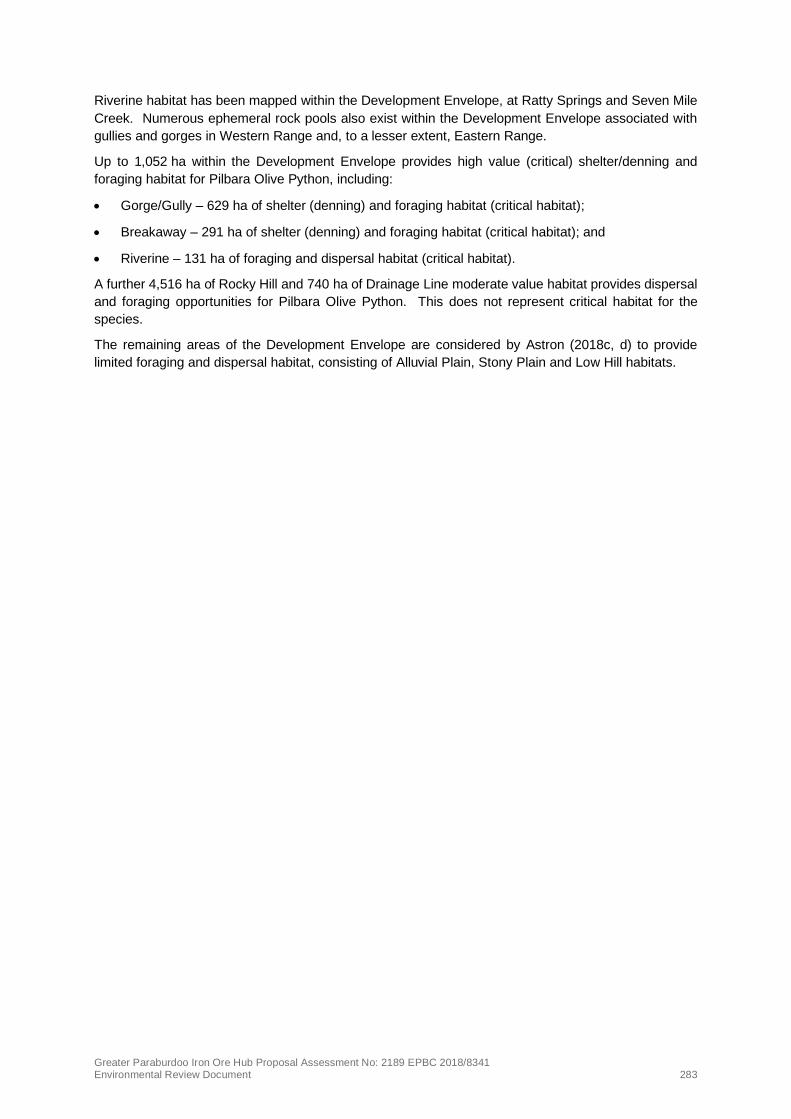
Greater Paraburdoo Iron Ore Hub Proposal Assessment No: 2189 EPBC 2018/8341 Environmental Review Document 283
Riverine habitat has been mapped within the Development Envelope, at Ratty Springs and Seven Mile
Creek. Numerous ephemeral rock pools also exist within the Development Envelope associated with
gullies and gorges in Western Range and, to a lesser extent, Eastern Range.
Up to 1,052 ha within the Development Envelope provides high value (critical) shelter/denning and
foraging habitat for Pilbara Olive Python, including:
• Gorge/Gully – 629 ha of shelter (denning) and foraging habitat (critical habitat);
• Breakaway – 291 ha of shelter (denning) and foraging habitat (critical habitat); and
• Riverine – 131 ha of foraging and dispersal habitat (critical habitat).
A further 4,516 ha of Rocky Hill and 740 ha of Drainage Line moderate value habitat provides dispersal
and foraging opportunities for Pilbara Olive Python. This does not represent critical habitat for the
species.
The remaining areas of the Development Envelope are considered by Astron (2018c, d) to provide
limited foraging and dispersal habitat, consisting of Alluvial Plain, Stony Plain and Low Hill habitats.

!(
!(
!(
!
!
Six Mile C
reek
Turee Creek
Bellary Creek
Tablela
nd Cree
k
Pirraburdu Creek
Seven Mile CreekEastern Range
Paraburdoo
540,000
540,000
545,000
545,000
550,000
550,000
555,000
555,000
560,000
560,000
565,000
565,000
570,000
570,000
575,000
575,000
7,420,000
7,420,000
7,425,000
7,425,000
7,430,000
7,430,000
7,435,000
7,435,000
7,440,000
7,440,000
7,445,000
7,445,000Figure 10-2: Pilbara Olive Python records and suitable
habitat within the Development Envelope
Disclaimer: Th is docum ent has been prepared to th e hig h est level of accuracy possible, for th epurposes of Rio Tinto’s iron ore business. Reproduction of th is docum ent in wh ole or in part byany m eans is strictly proh ibited with out th e express approval of Rio Tinto. Furth er, th is docum entm ay not be referred to, quoted or relied upon for any purpose wh atsoever with out th e writtenapproval of Rio Tinto. Rio Tinto will not be liable to a th ird party for any loss, dam ag e, liability orclaim arising out of or incidental to a th ird party using or relying on th e content contained in th isdocum ent. Rio Tinto disclaim s all risk and th e th ird party assum es all risk and releases andindem nifies and ag rees to keep indem nified Rio Tinto from any loss, dam ag e, claim or liabilityarising directly or indirectly from th e use or reliance on th is docum ent.
Drawn: A.D.Plan: PDE0169222v2Date: October 2019
Proj: GDA 1994 MGA Zone 50Scale: 1:150,000 @ [email protected]
0 5Kilom etres
Map units in m etres
¯
Legend
! Rio Tinto MineDevelopm ent EnvelopeMajor CreekExisting operations
Proposed Conceptual FootprintPitW aste Dum pStock pile
!( Pilbara Olive Py th on (Recorded Location)Habitat Suitability (Olive Python)
Potential Shelter and Foraging Habitat
Suitable Foraging and Dispersal Habitat
Lim ited Foraging and Dispersal Habitat

Greater Paraburdoo Iron Ore Hub Proposal Assessment No: 2189 EPBC 2018/8341 Environmental Review Document 285
10.6.4. Ghost Bat (Macroderma gigas)
The Ghost Bat (Macroderma gigas) is listed as Vulnerable under the EPBC Act and Vulnerable under
Schedule 3 of the BC Act. The Ghost Bat occupies rocky gorges and breakaways that contain caves
and crevices, which are used as nocturnal, diurnal (day) roosts, and maternity roosts. Ghost Bats are
known to require a number of suitable caves, of varying shapes and sizes, throughout their home ranges
to fulfil various ecological requirements. Individuals also move between roosts seasonally or according
to weather conditions, and populations tend to be widely dispersed when not breeding and concentrate
in relatively few roost sites when breeding (TSSC 2016a). Mating generally occurs in July and August,
with gestation extending from August to October and birth occurring between September and November
(Rio Tinto 2019j).
In the Hamersley Range in the Pilbara, preferred roosting habitat appears to be caves beneath bluffs of
low rounded hills composed of Marra Mamba geology, and larger hills of Brockman Iron Formation. In
the eastern Pilbara, caves beneath bluffs composed of Gorge Creek Group geology and granite
rockpiles are preferred (TSSC 2016a). The presence of active roosts in an area is considered by DAWE
to be the most important indicator of habitat for Ghost Bats, and these caves are generally the primary
focus of conservation and/or monitoring (DoE 2015b).
The species’ current range is discontinuous, with geographically disjunct colonies occurring in the
Pilbara, Kimberley, Northern Territory, Gulf of Carpentaria, coastal and near coastal eastern
Queensland from Cape York to near Rockhampton and western Queensland (TSSC 2016a). The Ghost
Bat has a patchy distribution in the Pilbara with a total of 903 records existing in Western Australia
(DBCA 2019b). The regional Pilbara Ghost Bat population is estimated at 1,300 to 2,000 individuals,
and in the Hamersley subregion a population of approximately 350 individuals (TSSC 2016a). The
Pilbara population of Ghost Bat is genetically distinct and divergent and has been assumed to be an
important population based on the definition in the Significant Impact Guidelines.
There are no species-specific policy guidelines on what constitutes habitat critical to the survival of the
Ghost Bat, or what is defined as an important population; persistence of this species in the Pilbara is
recognised as being dependent upon the presence of day roosts which comprise humid, temperature-
stable caves (TSSC 2016a). It is generally accepted that Ghost Bat utilise and require three types of
roost regularly, including maternity, diurnal and nocturnal roosts. The three types of roosts used
regularly by Ghost Bats are outlined below (TSSC 2016a):
• Nocturnal roosts (or feed caves) are used only at night, either habitually or for transitory visits.
They are often high in the strata and are typically shallow, poorly insulated caves and shelters that
are well lit during the day. The Ghost Bat hunts at night and uses nocturnal caves to consume prey
it has captured in the surrounding area. Feed caves often contain Ghost Bat scats and/or feeding
remnants (typically feathers and small animal bones).
• Diurnal roosts (or day roosts) are caves and disused mines that contain domed ceilings and are
deeper and more complex than nocturnal roosts. They typically have one or more large chambers
at or beyond the twilight area with additional fissures or chambers at the rear in the fully dark
regions. They have a minimum roof height in the chambers of 2–3 m providing protection from
attack by terrestrial predators. They are often at mid-levels or lower in the strata making them well
insulated. The stable temperature and elevated humidity of these caves relative to the ambient
conditions create physiologically benign conditions. Diurnal roosts can vary in importance from
almost continued use to occasional use by small numbers of Ghost Bats.
• Maternal roosts are diurnal roosts that usually include an interior chamber that rises toward the
rear trapping warmer, more humid air at the top. Maternal roosts have a stable temperature of 23°C
to 28°C and moderate to high relative humidity of 50% to 100%.
Bat Call (2020b) also provides a classification of caves within the Development Envelope based on the
categories above but also taking into account their level of use.

Greater Paraburdoo Iron Ore Hub Proposal Assessment No: 2189 EPBC 2018/8341 Environmental Review Document 286
To persist in an area, the Ghost Bat requires a group of caves/shelters that provide diurnal and nocturnal
sites and a gully or gorge system that opens onto a plain or riparian line that provides good foraging
opportunities. The persistence of the species in the Pilbara is believed to depend on the availability of
diurnal roosts that have stable temperature and humidity (TSSC 2016a).
The EPBC Act conservation advice identifies a number of known threats to Ghost Bats (TSSC 2016a).
Loss of roost sites, in particular maternity roosts containing breeding females, and nearby areas is rated
as having potentially severe consequences. Disturbance to roosts from human visitation is rated as
having moderate to severe consequences on the bat, and both the modification to foraging habitat and
collision with barbed wire fences have been given moderate consequence ratings (TSSC 2016a).
Potential population decline associated with competition for prey with foxes and feral cats has been
rated of ‘unknown’ consequence. Other threats identified in the conservation advice are not relevant to
the Proposed Action.
Survey effort in Development Envelope
Historical surveys at Western Range recorded limited Ghost Bat activity. They included a Level 2 Fauna
Survey (Biota 2011) which recorded Ghost Bats via acoustic calls at two locations at the 66W end of
Western Range, and a Level 1 Vegetation, Flora and Fauna Survey (Astron 2013) which recorded a
single Ghost Bat scat.
A Level 1 Targeted Fauna survey of the Western Range area of the Development Envelope was
commissioned to support the Proposed Action (Astron 2018d). This survey recorded Ghost Bats at four
different locations, with two records from sightings in diurnal roosts and two from ultrasonic recordings,
all within Gorge/Gully and Breakaway habitats in the 36W area.
Historical surveys at Eastern Range identified three records for Ghost Bat (Biota 2010; Astron 2014; Bat
Call 2014), two of which were acoustic records and one from feeding debris. The Greater Paraburdoo
Level 2 Fauna Survey (Astron 2018c) undertaken to support the Proposed Action covered the
Paraburdoo and Eastern Range portion of the Development Envelope and recorded Ghost Bat at one
location (from two possible acoustic calls) in Breakaway habitat north of the Eastern Range operations
near the Development Envelope boundary.
The Proponent subsequently commissioned the Greater Paraburdoo Ghost Bat Contextual Study
(Astron 2019), which included a desktop survey over a 30 km radius of Greater Paraburdoo and a
targeted field search across Western Range, Paraburdoo, Eastern Range and Channar, to identify
significant habitats for Ghost Bat within and surrounding the Development Envelope. The field survey
effort was concentrated around Western Range, eastern Paraburdoo and Eastern Range, specifically
in deeply incised, generally south facing gorges and gullies where typical roost caves are known to
occur. In total 18 caves were identified at Western Range as being utilised by Ghost Bats. A number
of these caves were targeted for further acoustic monitoring to measure levels of Ghost Bat activity and
to assess the relative importance of identified caves (Bat Call 2020b). These targeted echolocation
surveys undertaken by Astron (2018a) and more recently by Biologic and Rio Tinto Ecologists (Bat Call
2020b), and analysis of the recordings, combined with the physical properties of the caves and the
physical presence of Ghost Bats, has led to five caves being selected for longer term monitoring. These
are Caves 6, 11, 14, 15 and 18 (Figure 10-3). Fifteen cave assessments were undertaken at Eastern
Range in 2014, with seven of these caves revisited during the 2018 field survey as part of the Ghost Bat
Contextual Study (Astron 2019). Further to the visited seven caves, four more Eastern Range caves
were seen from afar and observed as being north facing and high in the landscape; as such they were
not considered by Astron as conducive to diurnal and maternal roosting for conservation significant bats
due to their orientation and position. No Ghost Bat roosts have been identified at Eastern Range;
however, evidence of Ghost Bat presence was recorded in the form of scats at three locations in
Gorge/Gully habitat in the vicinity of the proposed 42EE and 47E pits (Figure 10-3).
To provide a better understanding of the habits and movements of the Ghost Bats in Western Range
the Proponent commissioned a Very High Frequency (VHF) tracking survey and a faecal scat analysis

Greater Paraburdoo Iron Ore Hub Proposal Assessment No: 2189 EPBC 2018/8341 Environmental Review Document 287
study to be undertaken (Biologic 2020b, c). The VHF study involved the capture and tagging of eight
Ghost Bats and tracking them via 35 towers installed across the development envelope and its wider
surrounds (Turee and Mount Truchanas). The VHF study was designed to record the movement
patterns of the Ghost Bats in Western Range, particularly identifying roosting habitat and their favoured
foraging grounds.
Supporting this study was faecal scat analysis that was completed in seven caves within Western Range
and a further five caves from Mount Trucanas (approximately 35 km north of the Development
Envelope), all of which have previously shown evidence of use by Ghost Bats. Genetic analysis of the
scats collected provides a snapshot of the number of individual Ghost Bats using the caves during the
survey period and an indication of cave usage. The survey effort within the Development Envelope,
combined with publicly available data is expected to be an accurate representation of the presence of
this species in the Development Envelope and surrounding areas.
Local population
Ghost Bats have been recorded in the Development Envelope through echolocation recordings,
secondary evidence such as scats and midden piles within caves, and observations of individual bats.
Ghost Bats are present at Western Range and this area is likely to support a small population. Fourteen
of the eighteen caves at Western Range have had nineteen months of acoustic monitoring with
echolocation recordings of Ghost Bats being confirmed at 13 of the 14 caves (Bat Call 2020b).
Echolocation recordings and scats indicated regular, long term use of four caves (Cave 6, 11, 15 and
18) with Cave 6 having the most consistent use (Figure 10-3).
Eighteen sightings of individuals were recorded by Astron (2019) roosting within caves at Western
Range. Astron (2019) inferred the population of Ghost Bats within the Development Envelope to range
between five and 11 individuals using results from acoustic records. Further work by Bat Call (2020b)
based on additional acoustic surveys conducted from late 2018 to February 2020 also concluded that
up to 10 individuals are likely to be using the ridge lines within the Western Range area, probably on a
seasonal basis with low numbers present year-round (Bat Call 2020b). These results are consistent
with other Hamersley Range ridge lines where Ghost Bats occur in small numbers and utilise a number
of caves for varying times throughout the year and occasionally come together in larger groups for short
periods (Bat Call 2020b).
A total of 43 unique individuals were identified as using the monitored caves during the survey period
(September 2018 to September 2019). Of these, nine individuals appear to use the caves on a regular
basis. Caves 6 and 14 supported the highest number of different individuals (16 and 10 respectively)
(Biologic 2020c).
In the Eastern Range portion of the Development Envelope, given that there are limited records and no
maternal or diurnal roost sites have been recorded despite significant survey effort, it is likely that a
small number of individuals are utilising the gorge habitats within the Eastern Range area for foraging
and/or drinking purposes. However, the Gorge/Gully and Breakaway habitats were characterised as
providing suitable foraging and shelter habitat due to the potential presence of diurnal roost caves and
nocturnal feed caves (Astron 2018c).
Individuals of the species recorded within the Development Envelope likely meet the definition of an
important population outlined in the Significant Impact Guidelines (DoE 2013).
Suitable/critical habitat
Foraging habitat
The VHF study was designed to provide information regarding the foraging habits of the Western Range
population of Ghost Bats (Biologic 2020b). Of the eight tagged Ghost Bats only one individual spent
any time foraging within the Development Envelope. This individual appeared to forage around the
Rocky Hill and Gorge/Gully habitats of central Western Range and across the plains to the north of the

Greater Paraburdoo Iron Ore Hub Proposal Assessment No: 2189 EPBC 2018/8341 Environmental Review Document 288
Development Envelope. The remaining individuals spent most of the night outside of the detection
range of all towers suggesting they were foraging on the plains north and south of Western Range. The
data from this study suggests that the Riverine, Drainage Line, Low Hill and Stony Plain habitats of the
Development Envelope are not frequently used for foraging by Ghost Bats.
Roosting habitat
The persistence of genetically disjunct populations in key areas including the Pilbara is dependent on
the presence of day roosts in humid, temperature stable caves (TSSC 2016a). Day roosts are important
for long-term maintenance of the species or maintaining genetic diversity of the species and are
expected to meet the definition of critical habitat.
The Development Envelope contains 18 caves that have the attributes to provide roost sites for Ghost
Bats. The multiple bat surveys conducted for the Western Range area has provided a consistent picture
of cave usage (Astron 2019, Bat Call 2020b, Biologic 2019d, Biologic 2020b, c). Suitability of the caves
within the Development Envelope are presented below and in Figure 10-3:
• One cave (Cave 6) is a confirmed maternal roost, with hormone analysis recording high levels of
progesterone indicating the occurrence of pregnant females;
• Three caves (Cave 11, 15 and 18) classified as potential maternal roosts;
• Four caves (Caves 1, 4, 14 and 16) classified as confirmed diurnal roosts;
• Nine caves classified as potential diurnal roosts; and
• One cave as a nocturnal feed cave.
The 18 caves identified are all at the Western Range end of the Development Envelope and stretch from
Cave 14 located approximately 1 km east of the 27W pit to Cave 7 located approximately 2.7 km west
of the 66W pit (Figure 10-3).
This assessment was further refined by the extensive echolocation survey and consideration of previous
records by Bat Call (2020b). This work concluded that Cave 6, 11, 15 and 18 were all used regularly by
small numbers of bats. Cave 6 had the largest number of records. Monitoring indicated that Caves 1–
4, 12–14, 16 and 17 were used occasionally for diurnal roosting. No roosting was identified at the
remaining cave locations (Bat Call 2020b). No echolocation recordings were detected at Cave 5.
Three important groupings of caves were identified for the species based on detected usage and activity
(Bat Call 2020b):
• Caves 6 and 18 with 1 km separation and has Caves 16 and 17 between them;
• Cave 11 has Cave 2 approximately 250 m west of its location; and
• Cave 15 has Cave 12 approximately 500 m east of its location.
These cave systems have demonstrated regular and consistent usage by the Ghost Bat (Bat
Call 2020b).
There was limited usage of Caves 1, 3, 4 and 5 despite its proximity to Cave 6, therefore these are not
considered part of the important groupings. These caves had inconsistent ultrasonic call recordings and
had no large middens present (Bat Call 2020b). Cave 13 and 14 are isolated from other caves, however
both had regular usage by Ghost Bats (Bat Call 2020b).

Greater Paraburdoo Iron Ore Hub Proposal Assessment No: 2189 EPBC 2018/8341 Environmental Review Document 289
The VHF and scat analysis studies confirmed earlier assessments of cave usage, with Cave 6, 11 and
14 being used as diurnal roost sites (Biologic 2020b, c).
Ghost Bat roosting in the significant caves (outlined in Table 10-5) in the Development Envelope is
expected to be more frequent than documented due to the infrequent and intermittent nature of this
species’ calling when entering and exiting roost caves (Astron 2019).
Based on the presence of one confirmed maternity roost, confirmed diurnal roosts and potential
maternity roosts; critical habitat is present within the Development Envelope for the Ghost Bat.

Greater Paraburdoo Iron Ore Hub Proposal Assessment No: 2189 EPBC 2018/8341 Environmental Review Document 290
Table 10-5: Summary of roost/feed caves for Ghost Bat recorded in the Development Envelope
Site ID Category Location Entrance description/
orientation Internal description Details
Cave 1 Confirmed diurnal roost with low usage.
Western Range
36W deposit
Entrance: narrow and pinched (1 m wide x 0.6 m high).
Orientation: southwest.
Internal: 1 dome with 2 side pockets (12 m deep x 4 m wide x 3 m high).
Conditions: Raised humidity and elevated temperature.
Ghost Bat (x1) observed by Astron (2018c), Ghost Bat calls recorded.
Scats present.
No roosting detected; limited usage/activity by the species between 16–26 July and 4–9 December 2018 (Bat Call 2020b).
Cave 2 (significant as is within the Cave 11 group)
Potential diurnal roost
Western Range Entrance: narrow (2 m wide x 1 m high)
Orientation: south
Internal: forked cave, corkscrew to the right (25 m deep) and straight to the left (10 m deep), 2 domes (2 m high x 3 m wide), lots of crevices and solution pipes.
Conditions: microbats present, scats, raised humidity, elevated temperature, rear passages.
Cave properties conducive to diurnal roosting.
Ghost Bat scats present (Astron 2018c).
Ghost Bat calls recorded in July 2018, February 2019 and March 2019 (Bat Call 2020b)
Roosting detected by one suggested individual in February 2019 (Bat Call 2020b).
Activity and usage of this cave is regular and relatively consistent (Bat Call 2020b).
Cave 3 Potential diurnal roost
Western Range
36W deposit
Entrance: narrow (5 m wide x 1 m high)
Orientation: west
Internal: narrow with two side caverns (30 m deep x 1 m to 15 m wide x 1 m high).
Conditions: raised humidity and elevated temperature.
Cave properties conducive to diurnal roosting.
Ghost Bat calls recorded in December 2019 (Bat Call 2020b).
Cave 4 Confirmed diurnal roost.
Western Range
36W deposit
Entrance: overhang that is open/wide (5 m wide x 2 m high).
Orientation: west.
Internal: large cavernous dome with solution pipes (10 m deep x 4 m wide x 5 m high).
Conditions: Raised humidity and elevated temperature.
Ghost Bat present (x3), scats present (Astron 2018c).
Ghost Bat calls recorded inn July 2018 (Bat Call 2020b).
No roosting has been detected. Limited usage/activity recorded in the cave by the species (Bat Call 2020b).

Greater Paraburdoo Iron Ore Hub Proposal Assessment No: 2189 EPBC 2018/8341 Environmental Review Document 291
Site ID Category Location Entrance description/
orientation Internal description Details
Cave 5 Feed cave Western Range
36W deposit
Entrance: overhang that is open/wide (5 m wide x 1.5 m high)
Orientation: west
Internal: single dome (5 m deep x 5 m wide x 1.5 m high)
Ghost Bat scats present (Astron 2018c).
No echolocation recordings have been detected in this cave (Bat Call 2020b).
No roosting has been detected. Limited usage/activity recorded in the cave by the species (Bat Call 2020b).
Cave 6
(Significant)
Confirmed maternal roost. Highest significance
Western Range Entrance: open/wide (6 m wide x 1 m high).
Orientation: southwest.
Internal: two domed caverns, left dome has solution pipes 5 m to 7 m in height, right dome is large cavern (15 m deep x 10 m wide x 15 m high).
Conditions: High humidity and high elevated temperatures.
Ghost Bats detected roosting:
• on two occasions (four individuals and one individual from separate recording events) (Astron 2018c);
• between July–September 2018; and December 2018–February 2020 by Bat Call (2020a) between 32–100% of overnight recordings at the cave; and
• a single Ghost Bat was captured and tagged at this cave (Biologic 2020b).
Scat analysis indicates that 10 different individuals were recorded using this cave over the survey period but was only used regularly by one or two resident individuals (biologic 2020c). Two large midden piles present (Astron 2018c)
Ghost Bat calls recorded across 2018–2020 (Bat Call 2020b).
Activity and usage of this cave is regular and consistent.
Hormone analysis of scats indicating presence of pregnant females.
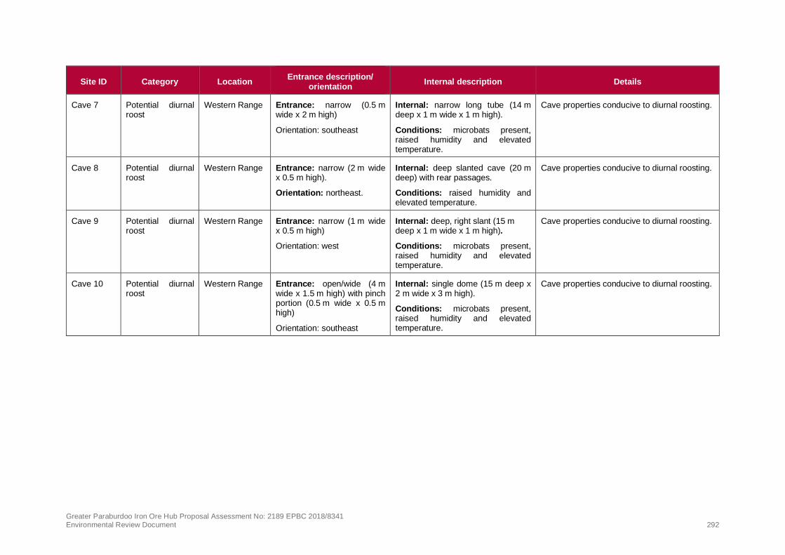
Greater Paraburdoo Iron Ore Hub Proposal Assessment No: 2189 EPBC 2018/8341 Environmental Review Document 292
Site ID Category Location Entrance description/
orientation Internal description Details
Cave 7 Potential diurnal roost
Western Range Entrance: narrow (0.5 m wide x 2 m high)
Orientation: southeast
Internal: narrow long tube (14 m deep x 1 m wide x 1 m high).
Conditions: microbats present, raised humidity and elevated temperature.
Cave properties conducive to diurnal roosting.
Cave 8 Potential diurnal roost
Western Range Entrance: narrow (2 m wide x 0.5 m high).
Orientation: northeast.
Internal: deep slanted cave (20 m deep) with rear passages.
Conditions: raised humidity and elevated temperature.
Cave properties conducive to diurnal roosting.
Cave 9 Potential diurnal roost
Western Range Entrance: narrow (1 m wide x 0.5 m high)
Orientation: west
Internal: deep, right slant (15 m deep x 1 m wide x 1 m high).
Conditions: microbats present, raised humidity and elevated temperature.
Cave properties conducive to diurnal roosting.
Cave 10 Potential diurnal roost
Western Range Entrance: open/wide (4 m wide x 1.5 m high) with pinch portion (0.5 m wide x 0.5 m high)
Orientation: southeast
Internal: single dome (15 m deep x 2 m wide x 3 m high).
Conditions: microbats present, raised humidity and elevated temperature.
Cave properties conducive to diurnal roosting.

Greater Paraburdoo Iron Ore Hub Proposal Assessment No: 2189 EPBC 2018/8341 Environmental Review Document 293
Site ID Category Location Entrance description/
orientation Internal description Details
Cave 11
(Significant)
Potential maternal roost/ Confirmed diurnal roost
Western Range Entrance: narrow (4 m wide x 0.5 m high).
Orientation: south.
Internal: pinched section that opens into a higher dome on a side chamber (20 m deep x 8 m wide x 4 m high).
Ghost Bat present (x5) and Ghost Bat calls recorded (which indicate roosting) during Astron (2018c) investigation.
Five Ghost Bats were captured and tagged at this cave (Biologic 2020b).
Scat analysis indicates that 16 different individuals were recorded using this cave over the survey period but was only used regularly by one or two resident individuals (Biologic 2020c).
Between one and seven Ghost Bats suggested to be roosting in the cave. Cave usage from February 2019 to March 2019 and July 2019 to February 2020 (Bat Call 2020b)
One large midden pile present.
Cave 12 (Significant as is within the Cave 15 group)
Potential diurnal roost
Western Range Entrance: narrow (1 m wide x 1 m high).
Orientation: west.
Internal: long tunnel shaped cave (18 m deep x 1 m wide x 1 m high) with a large, narrow top chamber (>15 m deep x 1 m wide x 3 m high)
Conditions: raised humidity and elevated temperature
Ghost Bat scats present.
Cave properties conducive to diurnal roosting, located near pools.
Ghost Bat call recordings were detected in February and March 2019 and had recorded regular usage and activity of the species in this cave during this time. No roosting was identified (Bat Call 2020b).

Greater Paraburdoo Iron Ore Hub Proposal Assessment No: 2189 EPBC 2018/8341 Environmental Review Document 294
Site ID Category Location Entrance description/
orientation Internal description Details
Cave 13 Potential diurnal roost
Western Range
36W deposit
Entrance: narrow (10 m wide x 2 m high).
Orientation: south.
Internal: two chambers, one left (10 m deep x 5 m wide x 2 m high) and one right (10 m deep x 3 m wide x 3 m high).
Conditions: Raised humidity and elevated temperature
Ghost Bat scats present (Astron 2018c).
Cave properties conducive to diurnal roosting.
Ghost Bat calls recorded in February and March 2019, and roosting indicated by Bat Call (2020). Cave 13 demonstrated regular usage by Ghost Bats in February and March 2019 (Bat Call 2020b).
Cave 14
(Significant)
Confirmed diurnal roost.
Paraburdoo Entrance: open/wide, large cathedral (12 m wide x 6 m high).
Orientation: south.
Internal: one large rear domed cavern, left dome with multiple cracks and crevices and mini roosting spots, main dome is 5 m to 8 m in height, 25 m deep x 12 m wide.
Ghost Bat present (two individuals and one individual observed roosting on separate occasions, and Ghost Bat calls recorded (indicate roosting) by Astron [2018c]).
A single Ghost Bat was captured and tagged at this cave (Biologic 2020b). Scat analysis indicates that the caves is used regularly by one or two resident individuals (Biologic 2020c).
A single Ghost Bat regularly using this cave to roost. Cave usage from October 2018 to October 2019 (Bat Call 2020b).
Cave 15
(Significant)
Potential maternal/ Confirmed diurnal roost
Western Range Entrance: narrow (0.5 m wide x 0.4 m high).
Orientation: east.
Internal: three domed caverns (potential), front dome 1.5 m high x 2 m wide x 2 m high, rear caverns dome dimensions unknown
Conditions: Multiple Ghost Bats present, midden piles, high humidity and high elevated temperatures
Ghost Bat present (x3) and observed roosting on one occasion by Astron (2018c).
Large midden pile present.
Ghost Bat calls recorded (indicate roosting).
Regular and consistent usage by the Ghost Bat with 2–3 suggested individuals roosting between October 2018 and February 2020 (Bat Call 2020b).
Cave 16
(Significant as is within the Cave 6/18 group)
Confirmed diurnal roost
Western Range Entrance: wide (3.0 m wide x 2.5 m high).
Orientation: east/southeast.
Internal: one long tunnel (~15 m to 20 m) leading to one high rear domed cavern.
Ghost Bat (x1) observed roosting on one occasion by Astron (2018c).
Large midden piles present.
No roosting detected (Bat Call 2020b).
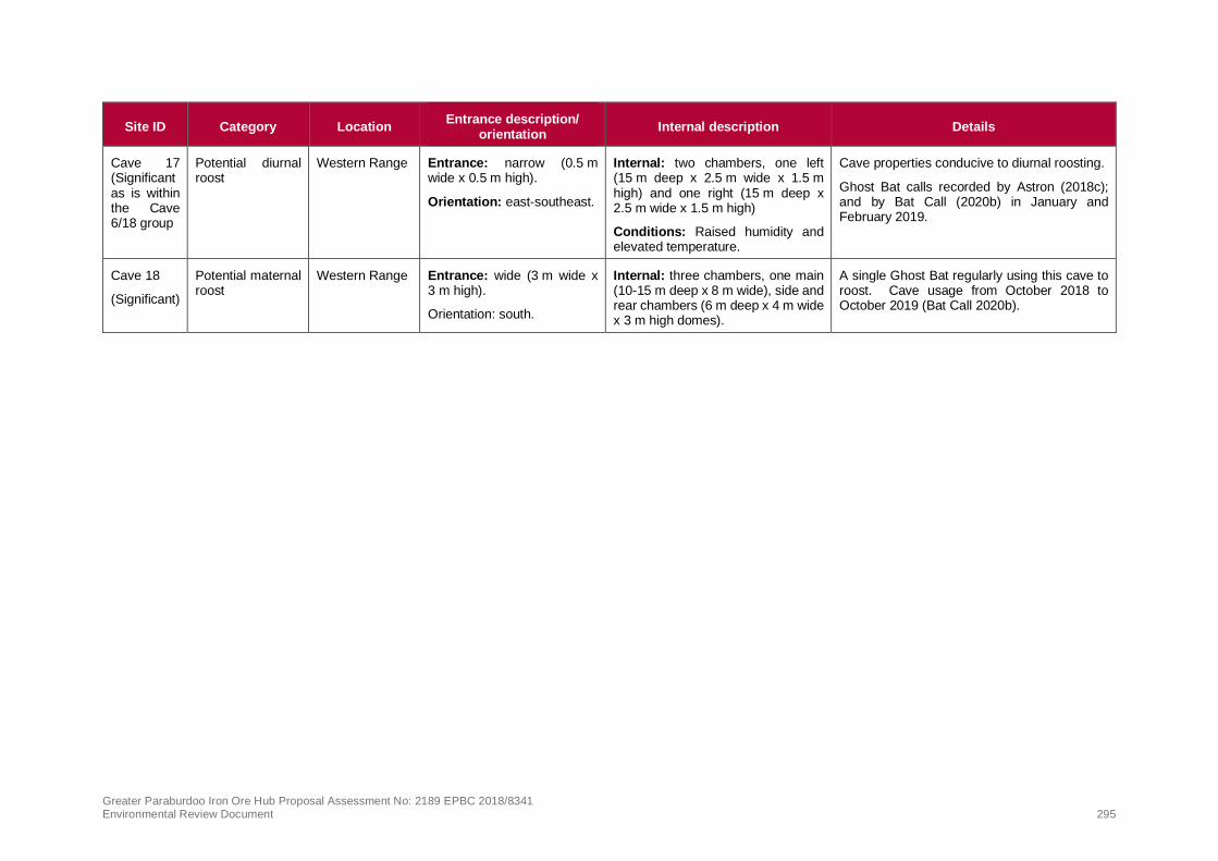
Greater Paraburdoo Iron Ore Hub Proposal Assessment No: 2189 EPBC 2018/8341 Environmental Review Document 295
Site ID Category Location Entrance description/
orientation Internal description Details
Cave 17 (Significant as is within the Cave 6/18 group
Potential diurnal roost
Western Range Entrance: narrow (0.5 m wide x 0.5 m high).
Orientation: east-southeast.
Internal: two chambers, one left (15 m deep x 2.5 m wide x 1.5 m high) and one right (15 m deep x 2.5 m wide x 1.5 m high)
Conditions: Raised humidity and elevated temperature.
Cave properties conducive to diurnal roosting.
Ghost Bat calls recorded by Astron (2018c); and by Bat Call (2020b) in January and February 2019.
Cave 18
(Significant)
Potential maternal roost
Western Range Entrance: wide (3 m wide x 3 m high).
Orientation: south.
Internal: three chambers, one main (10-15 m deep x 8 m wide), side and rear chambers (6 m deep x 4 m wide x 3 m high domes).
A single Ghost Bat regularly using this cave to roost. Cave usage from October 2018 to October 2019 (Bat Call 2020b).

Greater Paraburdoo Iron Ore Hub Proposal Assessment No: 2189 EPBC 2018/8341 Environmental Review Document 296
Critical habitat
An assessment of ‘critical habitat’ has been made based on guidance within the Significant Impact
Guidelines (DoE 2013). To persist in an area, the Ghost Bat requires a group of caves/shelters that
provide diurnal and nocturnal sites and a gully or gorge system that opens onto a plain or riparian line
that provides good foraging opportunities. The persistence of the species in the Pilbara is believed to
depend on the availability of diurnal roosts that have stable temperature and humidity (TSSC 2016a).
Ghost Bats do not require free surface water for drinking and forage after sunset and again before
sunrise, and utilise habitats including gullies and gorges with vertical vegetation complexity, that open
on to riparian drainage lines and plains that are typically within 5 km of roosts (TSSC 2016a). On this
basis, suitable foraging habitats that are located within approximately 5 km of recorded roosts are
expected to be utilised.
High value Ghost Bat habitats correspond to the locations where diurnal or potential maternal roosts
were identified or areas where aerial photography shows topography corresponding with significant
gorges or landforms likely to contain suitable caves for roost sites (Astron 2019). Moderate value
habitats correspond to rocky breakaways and cliffs where feeding sites were recorded or considered by
Astron likely to occur and sites where semi -permanent water sources occur (Astron 2019). Semi-
permanent pools exist in the Development Envelope at Ratty Springs and numerous ephemeral rock
pools associated with gullies and gorges occur throughout Western Range and, to a lesser extent,
Eastern Range. Semi-permanent water also exists to the east of Eastern Range at Doggers Gorge.
Rocky Hill habitat contains microhabitats such as boulder piles, cracks and crevices that support a wide
range of prey species for the Ghost Bat (Astron 2018c).
Based on suitable cave locations and likely locations of higher quality foraging areas containing pools,
the Development Envelope contains up to 921 ha high value (critical) shelter/denning and foraging
habitat for Ghost Bat, including:
• Gorge/Gully – 629 ha of potential roosting and foraging habitat (critical habitat); and
• Breakaway – 291 ha potential roosting and foraging habitat (critical habitat).
A further 4,516 ha of Rocky Hill, 131 ha of Riverine and 740 ha of Drainage Line habitat provide
dispersal and foraging opportunities for Ghost Bat. This does not represent critical habitat for the
species.
The remaining habitats present in the Development Envelope are considered by Astron (2018c, d) of
low value to Ghost Bat.

!(
!(!(
!(!(!(!(
!(!(
!( !(
!(
!(
!(
!(
!(
!(!(
#
#
#
#
#
#
#
#
#
#
#
#
# ##
##
##
# #
#
#
#### #
#
*
*
*
*
*
*
*
*
*
*
*
*
* **
**
**
* *
*
*
**** *
*#*
#*#*
#*
#*
!
!
!
Six Mile C
reek
Tablela
nd Cree
k
Turee Creek
Bellary Creek
Pirraburdu Creek
Seven Mile Creek
Eastern Range
Paraburdoo
535,000
535,000
540,000
540,000
545,000
545,000
550,000
550,000
555,000
555,000
560,000
560,000
565,000
565,000
570,000
570,000
575,000
575,000
580,000
580,000
7,420,000
7,420,000
7,425,000
7,425,000
7,430,000
7,430,000
7,435,000
7,435,000
7,440,000
7,440,000
7,445,000
7,445,000
Figure 10-3: Ghost Bat significant caves, records and suitablehabitat within the Development Envelope - Overview
Disclaimer: This docum ent has been prepared to the highest level of accuracy possible, for thepurposes of Rio Tinto’s iron ore business. Reproduction of this docum ent in whole or in part byany m eans is strictly prohibited without the express approval of Rio Tinto. Further, this docum entm ay not be referred to, quoted or relied upon for any purpose whatsoever without the writtenapproval of Rio Tinto. Rio Tinto will not be liable to a third party for any loss, dam age, liability orclaim arising out of or incidental to a third party using or rely ing on the content contained in thisdocum ent. Rio Tinto disclaim s all risk and the third party assum es all risk and releases andindem nifies and agrees to keep indem nified Rio Tinto from any loss, dam age, claim or liabilityarising directly or indirectly from the use or reliance on this docum ent.
Drawn: A.D.Plan: PDE0169223v3Date: January 2020
Proj: GDA 1994 MGA Zone 50Scale: 1:170,000 @ [email protected]
0 5Kilom etres
Map units in m etres
¯
Legend
! Rio Tinto MineDevelopm ent EnvelopeMajor CreekExisting operations
Proposed Conceptual FootprintPitW aste Dum pStock pile
#* Macroderm a gigas - Ghost Bat!( Confirm ed Diurnal Cave
!( Confirm ed Maternal Cave
!( Potential Maternal Cave!( Potential diurnal and nocturnal feed caves
Habitat Suitability (Ghost Bat)Potential shelter and foraging habitat
Suitable foraging and dispersal habitat
Lim ited foraging and dispersal habitat
Map 1
Map 2
Map 3

!(
!(
!(
!(!(!(!(
!(
!(
!(!(
!(
!(
!(
!(
!(
!(
#
#
#
#
#
#
#
#
##
# #
# #
#
#
##
##
#
*
*
*
*
*
*
*
*
**
* *
* *
*
*
**
**
*
#*
#*
#*
#*
#*
Six Mile Cree
k
Cave 4
Cave 5
Cave 6
Cave 16Cave 17
Cave 1
Cave 2
Cave 3
Cave 7Cave 8
Cave 9Cave 10
Cave 11
Cave 12
Cave 13
Cave 15Cave 18
535,000
535,000
540,000
540,000
545,000
545,000
550,000
550,000
7,435,000
7,435,000
7,440,000
7,440,000
Figure 10-3: Ghost Bat significant caves, records and suitablehabitat within the Development Envelope - Map 1
Disclaimer: This docum en t has been prepared to the highest level of accuracy possible, for thepurposes of Rio Tin to’s iron ore busin ess. Reproduction of this docum en t in whole or in part byan y m ean s is strictly prohibited without the express approval of Rio Tin to. Further, this docum en tm ay n ot be referred to, quoted or relied upon for an y purpose whatsoever without the writtenapproval of Rio Tin to. Rio Tin to will n ot be liable to a third party for an y loss, dam age, liability orclaim arisin g out of or in ciden tal to a third party usin g or relyin g on the con ten t con tain ed in thisdocum en t. Rio Tin to disclaim s all risk an d the third party assum es all risk and releases andin dem n ifies an d agrees to keep in dem n ified Rio Tin to from an y loss, dam age, claim or liabilityarisin g directly or in directly from the use or relian ce on this docum en t.
Drawn: A.D.Plan: PDE0169223v3Date: Jan uary 2020
Proj: GDA 1994 MGA Z on e 50Scale: 1:60,000 @ [email protected]
0 2Kilom etres
Map un its in m etres
¯
LegendDevelopm en t En velopeMajor Creek
Proposed Conceptual FootprintPitWaste Dum pStockpile
#* Macroderm a gigas - Ghost Bat!( Con firm ed Diurn al Cave
!( Con firm ed Matern al Cave
!( Poten tial Matern al Cave!( Poten tial diurn al an d n octurn al feed caves
Habitat Suitability (Ghost Bat)Poten tial shelter an d foragin g habitat
Suitable foragin g an d dispersal habitat
Lim ited foragin g an d dispersal habitat

!(
!(
!(
!(!(
!(
!(
!(
!(
!(#
#
#
#
### #
#
#
##
##
#
*
*
*
*
*** *
*
*
**
**
*
#*
#*
#*
!
Cave 14
Cave 4
Cave 5
Cave 6
Cave 16Cave 17
Cave 1
Cave 3
Cave 13
Cave 18
Seven Mile Creek
Seven Mile Creek
Pirrabu
rdu Cree
k
Paraburdoo
550,000
550,000
555,000
555,000
560,000
560,000
7,430,000
7,430,000
7,435,000
7,435,000
Figure 10-3: Ghost Bat significant caves, records and suitablehabitat within the Development Envelope - Map 2
Disclaimer: This docum en t has been prepared to the highest level of accuracy possible, for thepurposes of Rio Tin to’s iron ore busin ess. Reproduction of this docum en t in whole or in part byan y m ean s is strictly prohibited without the express approval of Rio Tin to. Further, this docum en tm ay n ot be referred to, quoted or relied upon for an y purpose whatsoever without the writtenapproval of Rio Tin to. Rio Tin to will n ot be liable to a third party for an y loss, dam age, liability orclaim arisin g out of or in ciden tal to a third party usin g or relyin g on the con ten t con tain ed in thisdocum en t. Rio Tin to disclaim s all risk an d the third party assum es all risk and releases andin dem n ifies an d agrees to keep in dem n ified Rio Tin to from an y loss, dam age, claim or liabilityarisin g directly or in directly from the use or relian ce on this docum en t.
Drawn: A.D.Plan: PDE0169223v3Date: Jan uary 2020
Proj: GDA 1994 MGA Z on e 50Scale: 1:60,000 @ [email protected]
0 2Kilom etres
Map un its in m etres
¯
Legend
! Rio Tin to Min eDevelopm en t En velopeMajor CreekExistin g operation s
Proposed Conceptual FootprintPitWaste Dum pStockpile
#* Macroderm a gigas - Ghost Bat!( Con firm ed Diurn al Cave
!( Con firm ed Matern al Cave
!( Poten tial Matern al Cave!( Poten tial diurn al an d n octurn al feed caves
Habitat Suitability (Ghost Bat)Poten tial shelter an d foragin g habitat
Suitable foragin g an d dispersal habitat
Lim ited foragin g an d dispersal habitat

#
#
#
#
##
#
*
*
*
*
**
*
!
!
Seven Mile Creek
Eastern Range
Paraburdoo
565,000
565,000
570,000
570,000
575,000
575,000
7,425,000
7,425,000
7,430,000
7,430,000
Figure 10-3: Ghost Bat significant caves, records and suitablehabitat within the Development Envelope - Map 3
Disclaimer: This do cum en t ha s been prepa red to the highest level o f a ccura cy po ssible, fo r thepurpo ses o f Rio Tin to ’s iro n o re busin ess. Repro ductio n o f this do cum en t in who le o r in pa rt bya n y m ea n s is strictly pro hibited witho ut the express a ppro va l o f Rio Tin to . Further, this do cum en tm a y n o t be referred to , quo ted o r relied upo n fo r a n y purpo se wha tso ever witho ut the writtena ppro va l o f Rio Tin to . Rio Tin to will n o t be lia ble to a third pa rty fo r a n y lo ss, da m a ge, lia bility o rcla im a risin g o ut o f o r inciden ta l to a third pa rty usin g o r relying o n the co n ten t co n ta in ed in thisdo cum en t. Rio Tin to discla im s a ll risk a n d the third pa rty a ssum es a ll risk a n d relea ses a n dindem n ifies a n d a grees to keep indem n ified Rio Tin to fro m a n y lo ss, da m a ge, cla im o r lia bilitya risin g directly o r indirectly fro m the use o r relia n ce o n this do cum en t.
Drawn: A.D.Plan: PDE0169223v3Date: Ma rch 2020
Proj: GDA 1994 MGA Zo n e 50Scale: 1:60,000 @ [email protected]
0 2Kilo m etres
Ma p un its in m etres
¯
Legend
! Rio Tin to MineDevelo pm en t En velo peMa jo r CreekExistin g o pera tio n s
Proposed Conceptual FootprintPitWa ste Dum pSto ckpile
#* Ma cro derm a giga s - Gho st Ba tHabitat Suitability (Ghost Bat)
Po ten tia l shelter a n d fo ra ging ha bita t
Suita ble fo ra ging a nd dispersa l ha bita t
Lim ited fo ra ging a nd dispersa l ha bita t

Greater Paraburdoo Iron Ore Hub Proposal Assessment No: 2189 EPBC 2018/8341 Environmental Review Document 301
10.6.5. Pilbara Leaf-nosed Bat (Rhinonicteris aurantia)
Pilbara Leaf-nosed Bat (Rhinonicteris aurantia) is listed as Vulnerable under the EPBC Act and
Vulnerable under the BC Act. In the Pilbara, roosts are thought to be restricted to caves formed in
gorges where at least semi-permanent water is nearby (TSSC 2016b). The distribution of this species
includes the Pilbara and Kimberley regions of Western Australia, the Top End of the Northern Territory,
and parts of several bioregions across the Gulf of Carpentaria in the Northern Territory and western
Queensland (DotEE 2019).
This species is known to require deep caves characterised by high levels of humidity and stable
temperatures (Astron 2018c). Caves deep enough to create this environment are relatively uncommon
in the Pilbara, with only 20 to 25 roost sites being known (Astron 2018c). The species is generally
encountered in rocky areas that provide opportunity for roosting in caves or disused underground
mines—particularly the ironstone hills of the Hamersley Range, the granite boulder piles and disused
mines in greenstone ranges of the eastern Pilbara, and the massive metamorphosed folded silcretes at
the southern margins of the region (DotEE 2019). Foraging habitat for the species is diverse and
includes riparian vegetation, hummock grassland, and sparse tree and shrub savannah (Astron 2018c).
In the Pilbara, the species has been observed in Triodia hummock grasslands covering low rolling hills
and shallow gullies, with scattered Eucalyptus camaldulensis along the creeks.
The population of Pilbara Leaf-nosed Bat in the Pilbara and upper Gascoyne is identified as an important
population and is comprised of one isolated interbreeding population of national significance, which
shows evidence of genetic divergence (TSSC 2016b). A total of 526 records of occurrence of the Pilbara
Leaf-nosed Bat are currently spread throughout the region (DBCA 2019b).
Habitat critical to the survival of the Pilbara Leaf-nosed Bat includes three Priority levels of diurnal roosts
as follows (TSSC 2016b):
• Permanent diurnal roosts (Priority 1) – occupied year round and likely the focus for some parts of
the breeding cycle.
• Non-permanent breeding roosts (Priority 2) – evidence of some usage during some part of the
breeding cycle but not occupied year-round.
• Transitory diurnal roosts (Priority 3) – occupied for part of the year, outside of breeding season and
which could facilitate dispersal in the region.
In addition to the above critical habitat, nocturnal refuges (Priority 4) are caves occupied at night for
resting or feeding and are not considered critical habitat.
The type and quality of foraging habitat can also be critical to the survival of the species. Foraging
habitats utilised by Pilbara Leaf-nosed Bat can be categorised as follows:
• Gorges with pools (Priority 1);
• Gullies (Priority 2);
• Rocky outcrop (Priority 3);
• Major watercourses (Priority 4); and
• Open grassland and woodland (Priority 5)
Known threats to the species include the loss of roosts, vegetation clearing, excavation, blasting and
vehicle activity in the species’ habitat, interruption of breeding activity, mine collapse and flooding,
human entry of roosts, fencing and predation.
Survey effort in Development Envelope
The presence of the Pilbara Leaf-nosed Bat population and their movements is well documented across
the Development Envelope (Astron 2018c) with targeted surveys for the species being conducted within

Greater Paraburdoo Iron Ore Hub Proposal Assessment No: 2189 EPBC 2018/8341 Environmental Review Document 302
the Development Envelope since 1998, including Armstrong (1998; 2001-2003); Specialised Zoological
(2008a, b; 2009); Biota (2010); Bat Call WA (2014); and Rio Tinto (2016). In addition, periodic
monitoring with an omni directional microphone began at the Ratty Springs roost following its discovery
in November 2015 and continuous monitoring has been undertaken since November 2017. This also
includes collections of ultrasonic call data at nearby permanent pools to characterise variations of
Pilbara Leaf-nosed Bat roosting activity (Bat Call 2020a). Most recently, a VHF Pilot Study (Biologic,
2019a) tagged and tracked the movements of 14 Pilbara Leaf-nosed Bats via 15 towers within and
around the Development Envelope. The pilot study was followed by the second phase of the study
(Biologic 2020a) where 20 Pilbara Leaf-nosed Bats were tagged and tracked via 35 towers over a wider
area encompassing the Development Envelope and its surrounds (Turee and Mount Truchanas,
approximately 30 km northeast and 40 km north of the Ratty Springs Roost, respectively).
This survey effort, combined with publicly available data is considered to provide an accurate
representation of the presence of this species in the Development Envelope and surrounding areas.
Local population
The Pilbara Leaf-nosed Bat has been recorded in the vicinity of the existing operations at Paraburdoo
since 1998 (Armstrong 1998).
Multiple surveys have confirmed the continual presence of the species at the Priority 1 Ratty Springs
roost, which is located within Breakaway habitat with nearby pools. According to Bat Call (2020a;
Appendix 6), the Ratty Springs roost holds a permanent colony of at least 400 to 600 individuals of the
species. This permanent colony is comparable to the average size of a Pilbara Leaf-nosed Bat
population (based on census counts) for the species in the Pilbara (Bat Call 2014; 2015; 2020a).
Monitoring results confirm that the colony continues to persist alongside Rio Tinto’s current operations
at Paraburdoo.
Individuals recorded within the Development Envelope are considered a part of the important Pilbara
population.
Suitable habitat
Roosting habitat
In 2015, a confirmed diurnal / maternity roost (Priority 1) was identified in Breakaway habitat in the
Development Envelope in the vicinity of Ratty Springs vicinity (Ratty Springs roost) (Plate 4). As
described above, this roost supports the continual presence of a Pilbara Leaf-nosed Bat colony and is
considered a high value roost.
Echolocation and tracking data indicate an additional diurnal roost site for the species (the Paraburdoo
East roost) occurs to the south-east of Paraburdoo town. Despite ongoing and comprehensive
searches, especially within the Development Envelope (mining lease ML4SA), the exact location of the
Paraburdoo East roost is yet to be determined. However, survey and monitoring data, including VHF
tracking of tagged bats, indicate the roost is located outside the Development Envelope. The data
suggest the roost is located north of the current Eastern Range mining operations outside the
Development Envelope, approximately 15–18 km east of the Ratty Springs roost and approximately 4–
6.5 km southeast of Paraburdoo town (Astron 2018c; Biologic 2019b). Although its particular
characteristics remain unknown, as a suspected diurnal roost the Paraburdoo East roost is expected to
be classed as of significant value for the regional Pilbara Leaf-nosed Bat population.
One individual has been previously recorded travelling approximately 170 km from the Ratty Spring
roost west of Paraburdoo, to the Koodaideri roost east of Karijini (Rio Tinto 2019j). This is the first time
an individual has been recorded travelling such a large distance, which may be due to previous lack of
adequate tracking, or this movement may be an exception. The VHF study also indicated that a tagged
individual roosted at an unknown site in Mount Truchanas for one night, approximately 40 km north of

Greater Paraburdoo Iron Ore Hub Proposal Assessment No: 2189 EPBC 2018/8341 Environmental Review Document 303
the Ratty Springs roost (Biologic 2020a). These results indicate that individuals of this species can
undertake regional movements.
Source: Bat Call (2015); Note: The entrance is approximately 1.0 m wide and 1.5 m high and goes back an indeterminate distance.
Plate 4: Ratty Springs roost for Pilbara Leaf-nosed Bat
Foraging habitat
A number of surface water features are present in the Development Envelope, in the vicinity of the Ratty
Springs roost. These include semi-permanent pools: Ratty Spring Pool East, Ratty Spring Pool West,
Seven Mile Creek (created by surplus water discharge from Paraburdoo Processing Plant approximately
5 km to the east of the Ratty Springs roost), Kelly’s Pool (approximately 11 km to the east) and Western
Range Pool 5 (approximately 11 km to the west in central Western Range) (Bat Call 2020a). The ridge
containing the Ratty Springs roost is drained by the ephemeral Pirraburdu Creek which includes Ratty
Springs approximately 800 m northwest of the roost (Bat Call 2020a). These surface water features
and the associated riparian vegetation are known to support foraging of the species.
Targeted survey effort has reported that besides the Ratty Springs roost, the location with the greatest
number of Pilbara Leaf-nosed Bat calls in any one night is within Ratty Springs (Bat Call 2020a), which
indicates the importance of the semi-permanent springs as a foraging and/or water source for the colony.
On comparison with other acoustic records in the surrounding drainage lines of Ratty Springs, nearby
riparian vegetation was identified to also be significant to the ongoing survival of Ratty Springs roost
population. Fewer numbers of foraging individuals were recorded in Breakaway, Drainage Line and
Riverine habitats within the Development Envelope (Astron 2018c).
Typically, Pilbara Leaf-nosed Bats emerge at dusk from their roosting sites to forage up to 10 km from
their roost. The tracking study (Biologic 2019a, 2020a) which monitored Pilbara Leaf-nosed Bats tagged
at the Ratty Springs roost was undertaken in 2018 and 2019 to determine:
• habitat use and broad flight paths utilised in the Development Envelope and beyond; and
• preferred foraging areas used by the local Ratty Springs colony.

Greater Paraburdoo Iron Ore Hub Proposal Assessment No: 2189 EPBC 2018/8341 Environmental Review Document 304
A total of 14 Pilbara Leaf-nosed Bats (nine males and five females) were captured and tagged under
the VHF pilot tracking study (Biologic 2019a) and 20 Pilbara Leaf-nosed Bats (nine males and 11
females) were captured and tagged under the second phase of the VHF tracking study (Biologic 2020a).
The VHF studies re-affirmed that Ratty Springs and associated riparian vegetation is the most significant
Pilbara Leaf-nosed Bat feature within the Development Envelope as recordings indicate that the roost
not only provides a diurnal roosting site for this species but is also used throughout the night for night
resting, feeding and/or social interactions (Biologic 2019a, 2020a). In addition, the VHF studies also
suggested the species are not limited to roosting at the Ratty Springs roost as six individuals appeared
to roost at a location northeast of Seven-Mile Creek, adding further evidence that a second diurnal
roosting site (Paraburdoo East Roost) is located nearby (Biologic 2019a, 2020a).
Results from both phases of the VHF studies indicate that the Pilbara Leaf-nosed Bats resident at the
Ratty Springs roost rarely forage within the Western Ranges. Only 11 of the 34 tagged Pilbara Leaf-
nosed Bats flew into Western Range. Of these, only one individual visited the area on a regular basis.
The majority of detection events represent fly bys where the individuals did not spend much time in the
area (Biologic 2020a).
The VHF studies indicate that the Pilbara Leaf-nosed Bats spend most of their time foraging within the
small section of Pirraburdu Creek near the Ratty Springs Roost (2018 survey period) and on the plains
to the north, north-east and south of the Paraburdoo Ranges (both 2018 and 2019 survey periods). This
is supported by other studies that found that the high number of acoustic records combined with the late
dry season timing of the detections indicates that Ratty Spring is a primary location for the bats from the
Ratty Springs roost to drink and forage immediately after leaving the roost (Astron 2018c). During the
second phase of the VHF study, Pilbara Leaf-nosed Bats spent most of their time outside the detection
range of the towers, suggesting that their preferred foraging areas at the time of the survey were located
outside of the Development Envelope. The plains surrounding the Paraburdoo Ranges contain several
drainage lines and ephemeral watercourses that provide suitable foraging habitat (Biologic 2019a).
Overall, areas to the east of the Ratty Springs Roost, north of the Paraburdoo Range and outside the
Development Envelope, may represent significant foraging area or fly ways for the Pilbara Leaf-nosed
Bats (Biologic 2019a, 2020a). The species is expected to forage across all habitat in the Development
Envelope, with Gorge/Gully, Breakaway, Alluvial, Drainage Line and Riverine habitat types expected to
provide better foraging opportunities than other habitat types in the area.
Up to 921 ha of habitat within the Development Envelope is considered high value roosting and foraging
habitat including:
• Gorge/Gully – 629 ha of shelter (roosting) and foraging habitat (critical habitat); and
• Breakaway – 291 ha of shelter (roosting) and foraging habitat (critical habitat).
Up to 131 ha of Riverine, 4,516 ha of Rocky Hill and 740 ha of Drainage Line comprising moderate value
foraging and dispersal habitat is also present in the Development Envelope. Generally, this does not
represent critical habitat for the species; although based on the findings from the VHF studies (Biologic
2019a, 2020a) the Riverine habitat and Drainage Line habitats found at Ratty Springs and in Pirraburdu
Creek (immediately adjacent to the Ratty Springs roost) are recognised as high value foraging habitat.
Alluvial Plain, Low Hill and Stony Plain is considered by Astron (2018c, d) as low value habitat for the
species, and is widespread outside of the Development Envelope and in the Pilbara bioregion. None of
these habitat types represent critical habitat to the species.
The balance of the Development Envelope comprises disturbed areas that have low value as foraging
and dispersal habitat for the species.

!(
!(
!(
!(!(!(
!(
!(
!( !(
!(!(!(!(!(!(!(
!(!( !(
!(!(!(!(
!(!(
!(!(!(
!(
!(!(
!(
!(
!(!(
!(
!(!(
!(
!(!(
!(
!(
!(
!(
!(!(!(!(!(
!(!(
!(!(!(!(!(!(
!(
!(!(
!(
!(
!(
!( !(!(
!(!(
!( !( !(
!(
!(!(
!(!(
!( !(
!(
!(
!(
!(
!(!(
!(
!
!
Six Mile C
reek
Turee Creek
Bellary Creek
Pirraburdu Creek
Seven Mile Creek Eastern Range
Paraburdoo
540,000
540,000
545,000
545,000
550,000
550,000
555,000
555,000
560,000
560,000
565,000
565,000
570,000
570,000
575,000
575,000
7,420,000
7,420,000
7,425,000
7,425,000
7,430,000
7,430,000
7,435,000
7,435,000
7,440,000
7,440,000
7,445,000
7,445,000Figure 10-4: Pilbara Leaf-nose Bat records and suitable
habitat within the Development Envelope
Disclaimer: T his document has been prepared to the hig hest level of accuracy possible, for thepurposes of Rio T into’s iron ore business. Reproduction of this document in whole or in part byany means is strictly prohibited without the ex press approval of Rio T into. Further, this documentmay not be referred to, quoted or relied upon for any purpose whatsoever without the writtenapproval of Rio T into. Rio T into will not be liable to a third party for any loss, damage, liability orclaim arising out of or incidental to a third party using or relying on the content contained in thisdocument. Rio T into disclaims all risk and the third party assumes all risk and releases andindemnifies and ag rees to keep indemnified Rio T into from any loss, damage, claim or liabilityarising directly or indirectly from the use or reliance on this document.
Drawn: A.D.Plan: PDE0169224v2Date: October 2019
Proj: GDA 1994 MGA Zone 50Scale: 1:150,000 @ [email protected]
0 5Kilometres
Map units in metres
¯
Legend
! Rio T into MineDevelopment EnvelopeMajor CreekEx isting operations
Proposed Conceptual FootprintPitWaste DumpStock pile
!(Pilbara Leaf-nosed Bat(Ratty Spring s Confirmed Roost)
!(Pilbara Leaf-nosed Bat(Recorded Location)
Habitat Suitability (Pilbara Leaf-nosed Bat)Potential shelter and foraginghabitatSuitable forag ing and dispersalhabitatLimited foraging and dispersalhabitat

Greater Paraburdoo Iron Ore Hub Proposal Assessment No: 2189 EPBC 2018/8341 Environmental Review Document 306
10.7. Potential impacts
The following provides a summary of aspects of the Proposal that may result in direct and indirect
impacts on MNES. Key impact pathways include:
• potential loss of fauna habitat as a result of clearing;
• loss of fauna individuals as a result of clearing (or other interactions);
• degradation/alteration of habitat as a result of altered hydrological regimes;
• habitat fragmentation and barriers to movement;
• habitat degradation associated with construction activity and/or increased human activity, including
transmission of weeds, dust and increased abundance of introduced fauna species; and
• disturbance from light, noise and/or vibration, and possible displacement of fauna associated with
construction activity and mining operations.
10.7.1. Direct impacts
Loss of fauna habitat
The Proposal will result in the clearing of up to 342 ha of high value habitat for MNES comprising:
• 335 ha of high value shelter/denning and foraging habitat for Northern Quoll, Ghost Bat and Pilbara
Leaf-nosed Bat, representing 36.4% of high value habitat in the Development Envelope; and
• 342 ha is high value denning/shelter and foraging habitat for Pilbara Olive Python, representing
32.5% of the high value habitat for the species in the Development Envelope.
The remaining habitat to be cleared is of low to moderate value for MNES.
The high value habitat to be removed provides shelter/denning and foraging habitat for all MNES
species.
Most clearing will occur in Rocky Hill habitat, with up to 1,000 ha to be affected. This habitat provides
moderate value foraging and dispersal opportunities for Northern Quoll, Pilbara Olive Python, Ghost Bat
and Pilbara Leaf-nosed Bat.
Of the 18 Ghost Bat caves identified within the Development Envelope, five will be removed, including
two confirmed diurnal roosts for Ghost Bats (Caves 1 and 4, both classified as having low usage), two
potential diurnal roosts (Caves 3 and 13) and one feed cave (Cave 5) (Figure 10-3). There will be no
impact to the Pilbara Leaf-nosed Bat roost or semi-permanent pools at Ratty Springs.
The indicative clearing for each habitat type and for habitat types grouped into potential high and
moderate value habitat for MNES recorded in the Development Envelope is outlined Table 10-6 and
and Table 10-7.

Greater Paraburdoo Iron Ore Hub Proposal Assessment No: 2189 EPBC 2018/8341 Environmental Review Document 307
Table 10-6: Proposed clearing of MNES fauna habitat in the Development Envelope
Broad scale habitat type
Extent in Development Envelope (ha)
Proposed to be cleared ha)
% habitat to be cleared
Value to MNES
Riverine 131 7 5.3 High value potential shelter and foraging habitat for Pilbara Olive Python.
Moderate value potential foraging and dispersal habitat for Northern Quoll, Ghost Bat and Pilbara Leaf-Nosed Ba
Gorge/Gully 630 290 46.1 High value potential shelter, denning and/or roosting habitat for Northern Quoll, Pilbara Olive Python, Pilbara Leaf-nosed Bat and Ghost Bat
Breakaway 291 45 15.4 High value potential shelter, denning and/or roosting habitat for Northern Quoll, Pilbara Olive Python, Ghost Bat and Pilbara Leaf-nosed Bat
Drainage Line 740 70 9.5 Moderate value potential foraging and dispersal habitat for Northern Quoll, Pilbara Olive Python, Ghost Bat and Pilbara Leaf-nosed Bat.
Rocky Hill 4,516 1000 9.5 Moderate value potential foraging and dispersal habitat for Northern Quoll, Pilbara Olive Python, Ghost Bat and Pilbara Leaf-nosed Bat
Low Hill 3,947 No value specified* Not specified Low value habitat for Northern Quoll, Pilbara Olive Python, Ghost Bat and Pilbara Leaf-nosed Bat.
Stony Plain 3,516 No value specified* Not specified Low value habitat for Northern Quoll, Pilbara Olive Python, Ghost Bat and Pilbara Leaf-nosed Bat.
Alluvial Plain 104 0 0 Moderate value potential foraging habitat for Pilbara Leaf-nosed Bat.
Low value for Northern Quoll, Pilbara Olive Python and Ghost Bat.
*The balance of clearing outside of high and moderate value MNES habitat will mostly occur in low value Stony Plain and Low Hill
habitat type (up to approximately 2,888 ha combined total).

Greater Paraburdoo Iron Ore Hub Proposal Assessment No: 2189 EPBC 2018/8341 Environmental Review Document 308
Table 10-7: Extent of high to moderate value MNES habitat estimated to be cleared for the Proposed
Action within the Development Envelope
MNES / habitat type Extent in
Development Envelope (ha)*
Proposed to be cleared (ha)*
% habitat to be cleared
Northern Quoll
High value potential shelter and foraging habitat (Gorge/Gully, Breakaway)
921 335 37
Moderate value foraging and dispersal habitat (Riverine, Drainage Line, Rocky Hill)
5,387 1,077 20
Total high and moderate value habitat 6,308 1,412 22
Pilbara Olive Python
High value potential shelter and foraging habitat (Gorge/Gully, Breakaway, Riverine)
1,052 342 33
Moderate value suitable foraging and dispersal habitat (Drainage Line, Rocky Hill)
5,256 1,070 33
Total high and moderate value habitat 6,308 1,412 33
Ghost Bat
High value potential shelter and foraging habitat (Gorge/Gully, Breakaway)
921 335 37
Moderate value foraging and dispersal habitat (Riverine, Drainage Line, Rocky Hill)
5,387 1,077 20
Total high and moderate value habitat 6,308 1,412 23
Pilbara Leaf-nosed Bat
High value potential shelter and foraging habitat (Gorge/gully, Breakaway)**
921 335 37
Moderate value foraging and dispersal habitat (Riverine, Alluvial Plain, Drainage Line, Rocky Hill)**
5,492 1,077 20
Total area (ha) high and moderate value habitat 6,413 1,412 22
*Note: Total numbers are subject to rounding; **No high value Riverine or Drainage Line habitat for Pilbara Leaf-nosed Bats at
Ratty Springs or in Pirraburdu Creek will be cleared.
Loss of fauna individuals
Injury and mortality of MNES may result from both direct and indirect impacts from the Proposed Action.
Fauna may be directly impacted from construction, operation and closure activities which have the
potential to decrease local fauna abundance, particularly species which are attracted to roads for
basking or foraging activities. This includes:
• fauna being injured/killed by collisions with earthmoving equipment and/or vehicles during
construction works or operation; and
• injury or mortality as a result of entanglement in fencing, especially to Ghost Bat and Pilbara Leaf-
nosed Bat.
Interaction with vehicles and fencing has the potential to reduce the local abundance of fauna,
particularly if habitats are in proximity to activity or infrastructure.

Greater Paraburdoo Iron Ore Hub Proposal Assessment No: 2189 EPBC 2018/8341 Environmental Review Document 309
10.7.2. Indirect impacts
Degradation/alteration of habitat as a result of altered hydrological regimes
Groundwater drawdown resulting from increased dewatering in the 4EE pit at Paraburdoo has the
potential to impact riparian vegetation within Riverine habitat areas of Seven Mile Creek; specifically,
the area to the north of the low permeability Mount McRae Shale/Mount Sylvia Formation, where the
creek intersects the Paraburdoo Range. This stretch of riparian vegetation is degraded but provides
high value habitat for Pilbara Olive Python and may be used by a number of species for both foraging
and dispersal. Groundwater abstraction has the potential to affect GDE’s over an area of up to
approximately 27 ha area and reduce canopy cover of phreatophytic species and potentially reduce the
abundance of understorey vegetation along Seven Mile Creek. This may in turn impact foraging and
dispersal habitat for MNES in the Development Envelope.
There will be minor dewatering required at Western Range, however there are no shallow watertables
that support GDE's in this area. Mining at Eastern Range is AWT. Therefore, there is no potential
change to habitat values associated with groundwater abstraction outside of the Paraburdoo mining
area.
Surplus water discharge to Riverine and Drainage Line fauna habitat may be required at Six Mile Creek,
Pirraburdu Creek and the existing Joe’s Crossing discharge location at Seven Mile Creek (refer to
Section 8). Surface water discharge may result in increased vegetative cover within the creekline that
may experience flow during natural no flow conditions. The area of flow will be managed to be limited
to the extent of the Development Envelope. Increased vegetation cover may provide increased shelter
and foraging habitat for fauna.
Habitat fragmentation and barriers to fauna movement
Fragmentation, the process by which contiguous areas of habitat are interrupted and/or separated into
two or more smaller areas, can result in the following impacts to MNES:
• altered movement patterns and/or reduced ability to disperse;
• genetic isolation; and
• increased competition for resources.
The Proposed Action extends along the east-west Paraburdoo Range, with the greatest potential for
habitat fragmentation occurring in the Western Range area where disturbance of the range will result in
fragmentation of habitat in a north-south direction. Habitat connectivity will be largely maintained in an
east-west direction to the north of Western Range. Additionally, north-south habitat connectivity will be
maintained along the major creeklines in the Development Envelope which will not be directly impacted
beyond the construction of essential infrastructure and crossings at Seven Mile Creek and Pirraburdu
Creek connecting Paraburdoo and Western Range. These linkages facilitate the connection of foraging
habitats for MNES and enable dispersal and connection between individuals and populations of MNES.
Habitat degradation associated with construction activity and/or increased human activity,
including transmission of weeds, dust and increased abundance of introduced fauna species
Construction activity and vehicle movements have the potential to increase dust and spread weeds.
However, these risks will be effectively managed by the Proponent and are not expected to affect habitat
values.
Vegetation clearing can increase access of feral predators to fauna habitats, resulting in increased
predation causing injury or mortality, impacting local populations of fauna. Feral cat control is not
currently undertaken within the Development Envelope. However, the Proponent will undertake feral
animal control within the Development Envelope.

Greater Paraburdoo Iron Ore Hub Proposal Assessment No: 2189 EPBC 2018/8341 Environmental Review Document 310
Disturbance from light, noise and/or vibration, and possible displacement of fauna associated
with construction activity and mining operations.
Light, noise and vibration emissions during mine construction and operations have the potential to
impact MNES in proximity to these activities.
The Northern Quoll, Pilbara Olive Python, Pilbara Leaf-nosed Bat and Ghost Bat utilise caves and
shelters in Breakaways and Gully/Gorge habitats for denning and shelter or roosting. The Proposal will
involve open cut mining by conventional drill and blast techniques. This has the potential to result in
vibration disturbance to major Gorge/Gully habitat adjacent to mining operations which provides
potential denning and roosting habitat for MNES recorded in the Development Envelope. Blast
vibrations may also result in damage to the structural integrity of bat roosts.
Noise and vibration from clearing, construction and blasting may disturb MNES and cause individuals
to temporarily or permanently vacate shelters and diurnal/maternal roosts. If these disturbances occur
during the breeding season or while pups remain in the roost, the breeding cycle of the local bat
population may be impacted.
Research and anecdotal evidence indicate the potential for artificial lighting to influence the behaviour
of both nocturnal and diurnal species (Gaston & Bennie 2014). Increased night time light emissions
within the Development Envelope may attract invertebrate species and in turn, alter nocturnal foraging
behaviour of MNES.
10.8. Assessment of impacts
The following provides a summary of aspects of the Proposed Action which may result in direct and
indirect impacts to MNES. Further description of potential impacts is provided in Section 10.7.
10.8.1. Northern Quoll
Direct impacts
Loss of fauna habitat
The Development Envelope includes denning habitats which satisfy the definition of critical habitat in
accordance with the Northern Quoll Referral Guideline (DoE 2016), including rocky habitats such as
Breakaways and Gorges/Gullies. This habitat within the Development Envelope does not support a
high-density important population of the species, as demonstrated by limited recorded captures; despite
appropriate survey effort in areas of suitable, good quality habitat within the Development Envelope. As
evidenced by the location of records, the local Northern Quoll population appears to have a strong
association with the Breakaway and Gorge/Gully habitat. This is consistent with records across the
Pilbara.
The Northern Quoll has been recorded at eight locations in the Development Envelope, six records from
the Western Range and two in the balance of the Development Envelope (Astron 2018c, d). No Northern
Quoll dens were recorded in the Development Envelope (Astron 2018c, d). Northern Quoll are common
in the Robe Valley, approximately 192 km northwest from the Development Envelope, with 906 records
in that location. Northern Quoll have also been recorded in historical mining areas in this region,
particularly where mesa escarpments are largely intact (Rio Tinto 2018a). In contrast to the Robe
Valley, the population of Northern Quoll in the Development Envelope is expected to be relatively small
and be classified as a ‘low density’ population in accordance with Northern Quoll Referral Guideline
(DoE 2016), based on the low number of observations and historical records in the Development
Envelope.
Breakaway and Gorge/Gully habitats are rated as being of high importance, or critical habitat, for
Northern Quoll locally and the Proposed Action has been designed to largely avoid these habitats.
Vegetation clearing in the Development Envelope will result in the direct loss of up to 335 ha of
Breakaway and Gorge/Gully habitat, which represents 36.4% of the available critical habitat for Northern

Greater Paraburdoo Iron Ore Hub Proposal Assessment No: 2189 EPBC 2018/8341 Environmental Review Document 311
Quoll within the Development Envelope. A further 1,077 ha of moderate value foraging and dispersal
habitat will be removed; however, these habitats are common and widespread in the Pilbara region and
do not represent critical habitat for the species and their removal is not expected to be characterised as
a significant residual impact. The balance of clearing will occur in Stony Plain and Low Hill habitats,
widespread and of low value to Northern Quoll, as such there will be no significant residual impact on
this species in these areas.
The direct loss of up to 335 ha of Breakaway and Gorge/Gully critical habitat for Northern Quoll within
the Development Envelope represents a locally significant impact and is proposed to be offset (refer to
Section 12).
Loss of fauna individuals
Northern Quoll may be vulnerable to injury or mortality from vehicle and machinery movements,
particularly when foraging nocturnally. Given the local population is expected to be low, the potential
for injury or mortality is also expected to be very low. To avoid and minimise the potential for interaction
with vehicle and machinery movements, most construction activities for the Proposed Action will occur
during daylight hours, reducing the risk of encounters with Northern Quoll during the construction phase.
While vehicle movements will increase temporarily during the construction period and roads will expand
into the proposed new mining areas, overall vehicle movements during the operational phase will not
increase from the existing number and/or frequency of vehicle movements associated with the existing
operation.
The Proponent will implement the following measures to mitigate potential indirect impacts to Northern
Quoll:
• progressive clearing to allow fauna to migrate away from clearing activities or machinery
movements;
• all relevant personnel to undergo training to identify Northern Quolls and their habitat, relevant
management measures, personnel/contractor responsibilities, and incident reporting requirements
(i.e. reporting of fauna observations and/or incidents); and
• progressive rehabilitation of cleared areas no longer required for operational purposes.
On this basis, vehicle and machinery movements for the Proposed Action are not expected to result in
significant impacts to Northern Quoll and will not result in a change to the conservation status of this
species.
Indirect impacts
Degradation/alteration of habitat as a result of altered hydrological regimes
Groundwater drawdown and surface water discharge have the potential to affect Riverine and Drainage
Line habitat. As Riverine and Drainage Line habitat is not considered high value for the Northern Quoll,
any change in habitat value as a result of altered hydrological regimes is not expected to have a
significant impact on the species. In addition, there is no potential for impacts to riparian/GDE vegetation
at Western Range where the majority of the Northern Quolls have been recorded.
Habitat fragmentation and barriers to fauna movement
Extensive tracts of intact Northern Quoll habitat will remain around the Proposed Action in the
Development Envelope. A total of approximately 4,896 ha (77.6%) of high and moderate value habitat
for shelter/denning, foraging and dispersal will remain available in the Development Envelope.
Significant corridors in different landforms such as ridges, hillsides and drainage lines will remain in
place to allow movement around the mining area and through the landscape. Northern Quolls have also
been recorded within operational areas at Pilbara mine sites and so can disperse through these areas.
Habitat fragmentation will also be mitigated through the staging of the Proposed Action to ensure areas
proposed to be cleared will not all be disturbed at once. Progressive rehabilitation of areas no longer

Greater Paraburdoo Iron Ore Hub Proposal Assessment No: 2189 EPBC 2018/8341 Environmental Review Document 312
required for mine operation will also occur to minimise the presence of disturbed areas. As such, habitat
fragmentation caused by the Proposed Action is not expected to result in significant overall effects on
Northern Quoll habitat or movement.
Habitat degradation associated with construction activity and/or increased human activity, including
transmission of weeds, dust, and increased abundance of introduced fauna species
The invasion of introduced grasses such as Gamba Grass (Andropogon gayanus) and other weeds are
recognised threats to Northern Quoll as they out-compete native grasses. Gamba Grass has not been
recorded in the Development Envelope. The Proponent will undertake weed control in areas of retained
native vegetation close to disturbance such as roads, tracks and infrastructure. In addition, vehicle and
machinery movements will be restricted to roads and access pathways within the conceptual footprint
to avoid spread or introduction of weeds. Weed management is outlined in Section 5.5.2.
The Pilbara region is naturally dusty, and the Proposed Action is located in and near an existing
operational mine. A study examining the impacts of dust on plant health in semi-arid environments
found no evidence dust deposition up to 77 g/m2/month results in detrimental effects (Matsuki et
al. 2016). Any decline in vegetation health, and hence Northern Quoll foraging habitat, due to dust
deposition is expected to be limited to areas immediately adjacent to the active mining operations.
Potential impacts to vegetation from dust emissions may occur in only a small proportion of the available
Northern Quoll foraging habitat adjacent to mine operations, and naturally occurring high dust events
are possible at exposed locations at dry and windy times of the year. Continued implementation of
existing dust suppression strategies to avoid prolonged dust emissions and dust cover on adjacent
vegetation is expected to result in a low likelihood of Northern Quoll being adversely affected by dust.
The cane toad is the invasive species which poses the greatest threat to Northern Quoll but is not
currently established in the Pilbara. The Proposed Action will not increase the potential for cane toads
to become established in the Development Envelope and the Proponent will undertake feral animal
control within the Development Envelope.
After the application of mitigation measures, no significant impacts on Northern Quolls are expected
from the habitat degradation from dust emissions and/or the introduction or spread of weeds into fauna
habitat.
Disturbance from light, noise and/or vibration, and possible displacement of fauna associated with
construction activity and mining operations.
The indirect impacts of noise and vibration emissions are not expected to impact Northern Quoll. A low-
density population of Northern Quoll exists in the Development Envelope despite noise and vibration
from current mining operations within Paraburdoo. No dens have been identified in the Development
Envelope and therefore, vibrations from mining operations will not significantly alter the number or
quality of available shelters. The sporadic and brief nature of blasting also means that blasting related
vibrations are not expected to interfere with the Northern Quoll’s foraging or breeding behaviour. As
such, it is not expected that noise and vibrations from the Proposed Action will result in a significant
impact to the species.
Light emissions from the Proposed Action are not expected to significantly alter nocturnal foraging
activities as light emissions are already present in the current operational mining area at Paraburdoo.
Additional light emissions from the Proposed Action is not expected to significantly impact Northern
Quoll denning or foraging behaviour as:
• lighting in the mining area will be directed into the pit, away from Northern Quoll potential denning
formations in Breakaway and Gorge/Gully habitat; and
• lighting will be installed only where required, that is, mainly in-pit and operational areas.
No significant impacts on Northern Quolls are expected from light, noise and/or vibration.

Greater Paraburdoo Iron Ore Hub Proposal Assessment No: 2189 EPBC 2018/8341 Environmental Review Document 313
Significance of direct and indirect impacts to Northern Quoll
An assessment of the Proposed Action on Northern Quoll is detailed in Table 10-8, with reference to the
Significant Impact Guidelines (DoE 2013).
Table 10-8: Assessment of the significance of impacts to Northern Quoll
Significant impact criteria Assessment of impacts to Northern Quoll
Potential to cause a long-term decrease in the size of a population
The local population of Northern Quoll that may be present in the Development Envelope is not expected to be characterised as ‘important’ due to its low density. This local, low density, population is expected to have a strong association with Gorges/Gully and Breakaway habitat, based on the location of records.
Given approximately 78% of high and moderate value habitat will remain in the Development Envelope, and the widespread availability of foraging and dispersal habitat beyond, the removal of 335 ha of high value Northern Quoll habitat is not expected to cause a long-term decrease to the low density population that may occur within the Development Envelope.
Potential to reduce the area of occupancy of the species
The species is expected to continue to exist within the Development Envelope and therefore the Proposed Action is not expected to reduce the area of occupancy of the species.
Potential for fragmentation of an existing population into two or more populations
The Proposed Action is not expected to fragment an existing population into two or more populations given the limited numbers within the Development Envelope and the mobile nature of the species. Significant corridors in different landforms such as ridges, hillsides and drainage lines will remain in place to allow movement around the mining area and through the landscape. Available habitat will also still occur within the Development Envelope and the areas surrounding the Development Envelope (including within mining leases such as Turee Syncline as well protected areas such as Karijini National Park), which will continue to support the overall Pilbara population of Northern Quoll.
Potential to adversely affect habitat critical to the survival of a species
The Development Envelope supports habitats which satisfy the definitions of critical habitat, including rocky habitats such as gorges, gullies and breakaways, which are all potential shelter/denning and foraging habitats. However, these habitats do not support an important population of Northern Quoll.
The listing advice and Northern Quoll Referral Guidelines indicate that the removal, degradation and fragmentation of habitat as a consequence of mining activities, transport infrastructure or agricultural activities has the potential to adversely affect the survival of the species (TSSC 2005; DoE 2016). Consequently, the Proposed Action has the potential to adversely affect habitat defined as critical to the survival of the species locally due to the clearing of 335 ha of high value shelter/denning and foraging habitat. Therefore, this potential impact is proposed to be offset.
Potential to disrupt the breeding cycle of a population
No evidence of Northern Quoll dens has been identified in suitable denning habitat within the Proposed Action or Development Envelope.
It is not expected that the removal of habitat from the Proposed Action will disrupt the breeding cycle of the population based on the lack of evidence of active dens, and the proportion and extent of habitat remaining in the Development Envelope.
Potential to modify, destroy, remove isolate or decrease the availability or quality of habitat to the extent that the species is likely to decline
The Proposed Action will result in the loss of up to 335 ha of potential and suitable high value habitat associated with Breakaway and Gorge/Gully areas. A further 1,077 ha of moderate value foraging and dispersal habitat from Riverine, Drainage and Rocky Hill areas will also be disturbed, however, these areas provide moderate value foraging and dispersal opportunities. The balance of clearing will occur in widespread Low Hill and Stony Plain habitats of low value to Northern Quoll.
The Proposed Action has the potential modify, destroy, remove or isolate or decrease the availability or quality of Northern Quoll habitat due to the clearing of high value potential shelter/denning and foraging habitat. However, this will not be at an extent at which the species is likely to decline.

Greater Paraburdoo Iron Ore Hub Proposal Assessment No: 2189 EPBC 2018/8341 Environmental Review Document 314
Significant impact criteria Assessment of impacts to Northern Quoll
Potential for the establishment of invasive species in the endangered species’ habitat that are harmful to the endangered species
The cane toad is the invasive species which poses the greatest threat to Northern Quoll but is not currently established in the Pilbara.
The Proposed Action will not increase the potential for cane toads to become established in the Development Envelope and the Proponent will undertake feral animal control within the Development Envelope.
Potential for the introduction of disease that may cause the species to decline
Currently there are no known diseases harmful to Northern Quoll. There is no evidence to suggest that the Proposed Action would introduce disease that may cause the species to decline.
Potential interference with the recovery of the species
The Proposed Action will impact a portion (approximately (335 ha; 36.4%) of the available Northern Quoll high value habitat within the Development Envelope. The Proposed Action has been designed to limit disturbance within highest value denning and foraging habitat (Gorge/Gully habitat) where practicable. The Proposed Action is not expected to interfere with the recovery of the Northern Quoll or affect its conservation status based on the available habitat remaining locally and regionally in the Pilbara.
10.8.2. Pilbara Olive Python
Direct impacts
Loss of potential habitat
The Pilbara Olive Python has previously been recorded in the Development Envelope at Seven Mile
Creek in Gorge/Gully habitat (Astron 2018c) and there are further records in the vicinity of the
Development Envelope. The Development Envelope contains suitable high-quality habitat including
Breakaway, Gorge/Gully and Riverine habitats which likely support denning, foraging and dispersal.
These habitats are likely to meet the definition of critical habitat.
The species could potentially be found throughout the Development Envelope at sites that contain semi-
permanent water.
The Proposed Action has been designed to limit disturbance to Breakaway, Gorge/Gully and Riverine
habitats as far as practicable. Vegetation clearing for the Proposed Action will result in the direct loss
of up to 342 ha of high value habitat, which represents 32.5% of potential denning, foraging and
dispersal habitat available for Pilbara Olive Python within the Development Envelope. No semi-
permanent pools will be removed as part of the Proposed Action and no permanent pools are known to
exist within the Development Envelope.
A further 1,070 ha of moderate value foraging and dispersal habitat will be removed as part of the
Proposed Action; however, this is not considered high value habitat and its removal is not expected to
be characterised as a significant residual impact. The balance of clearing will occur in Stony Plain and
Low Hill habitats, widespread and of low value to Pilbara Olive Python, as such there will be no
significant residual impact on this species in these areas.
The direct loss of up 342 ha of Breakaway, Gorge/Gully and Riverine habitat for Pilbara Olive Python
within the Development Envelope represents a locally significant impact and is proposed to be offset
(refer to Section 12).
Loss of fauna individuals
The Pilbara Olive Python is slow moving and nocturnal and is vulnerable to injury or mortality from
vehicle and machinery movements; particularly when foraging at night, when basking or during mating
season when movements are more frequent. Construction of the Proposed Action will occur
predominantly during daylight hours and will therefore minimise potential for interaction with this species.
Vehicle movements during the operational phase will not increase from the existing number and/or
Greater Paraburdoo Iron Ore Hub Proposal Assessment No: 2189 EPBC 2018/8341 Environmental Review Document 315
frequency of vehicle movements associated with the current mining activity at the existing operational
site. The Proponent will implement range of management measures to mitigate loss of fauna individuals,
such as:
• progressive clearing to allow fauna to migrate away from clearing activities or machinery
movements;
• awareness training to identify conservation significant fauna and habitat, relevant management
measures, personnel/contractor responsibilities, and incident reporting requirements (i.e. reporting
of fauna observations and/or incidents); and
• vehicle speed limits.
Indirect impacts
Degradation/alteration of habitat as a result of altered hydrological regimes
Groundwater drawdown in the alluvial aquifer in Seven Mile Creek as a result of dewatering activities at
Paraburdoo 4EE pit has the potential to impact approximately 27 ha of GDE vegetation including
mapped Riverine habitat areas, which provides high value habitat for Pilbara Olive Python. As
discussed in Section 5.3.2, vegetation in this section of Seven Mile Creek has been augmented by
historical surplus water discharge from Paraburdoo Plant, resulting in the occurrence of persistent
surface water and denser and more extensive vegetation than would otherwise exist naturally, thus
creating an artificially enhanced habitat for the Pilbara Olive Python. The Proposal will alter the
hydrological regime in this section of Seven Mile Creek, likely reducing the availability of surface water
and density of understory vegetation. Whilst this may reduce the area of suitable habitat available to
the Pilbara Olive Python; it is expected that suitable habitat will remain in this section of Seven Mile
Creek and; therefore, the Proposal is not expected to have a significant adverse effect on the Pilbara
Olive Python locally or regionally.
Discharge of dewatering water into Pirraburdu Creek and/or Seven Mile Creek has been proposed and
dewatering of 36W and 66W pits in the Western Range section of the Proposal is also proposed to be
discharged into Six Mile Creek and Pirraburdu Creek or tributaries. However, no adverse impacts to
Pilbara Olive Python are expected.
Habitat fragmentation and barriers to fauna movement
Extensive tracts of intact Pilbara Olive Python habitat will remain around and within the Development
Envelope. Significant corridors in Gorge/Gully, Breakaways and Riverine habitats will remain in place
to allow movement around the mining area and through the landscape. As such, habitat fragmentation
caused by the Proposed Action is not expected to result significant detrimental overall effects on Pilbara
Olive Python habitat or movement.
Habitat degradation associated with construction activity and/or increased human activity, including
transmission of weeds, dust, and increased abundance of introduced fauna species
Potential impacts to vegetation from dust emissions will occur in only a small proportion of the available
Pilbara Olive Python habitat. Consequently, dust emissions are not expected to have a significant
impact on the species. Dust will be managed by the Proponent and is expected to be of a short-duration.
As such, dust will not result in permanent impacts to Pilbara Olive Python.
Key threats to the Pilbara Olive Python include predation by feral cats and foxes, however the Proposed
Action is not expected to cause an increase in feral cat or fox populations; however, feral animal control
will be undertaken as needed by the Proponent in the Development Envelope. While the Pilbara Olive
Python is susceptible to cane toad poison, they are not known to eat cane toads but can be poisoned
from secondary consumption (Rio Tinto 2018a). The cane toad is not currently established in the
Pilbara; the Proposed Action is not expected to increase the opportunity for the cane toad to become
established in the area.

Greater Paraburdoo Iron Ore Hub Proposal Assessment No: 2189 EPBC 2018/8341 Environmental Review Document 316
No significant impacts on Pilbara Olive Python are expected from the risk of habitat degradation from
increased weeds, dust emissions, or introduced fauna.
Disturbance from light, noise and/or vibration and displacement of fauna
Snakes use the inner ear to identify prey and avoid predators by detecting ground vibrations (Rio
Tinto 2019b). Noise and vibration from blasting associated with the Proposed Action will be intermittent,
lasting for approximately two to ten seconds at a time. The sporadic and brief nature of blasting
associated with the Proposed Action means that blasting related vibrations are not expected to interfere
with the Pilbara Olive Python’s ability to detect prey and avoid predators and is not expected to result in
a significant impact to the species.
Lighting in the mining area will be directed into the pit, away from Pilbara Olive Python habitat in the
Breakaway, Gorge/Gully and Riverine habitats present in the Development Envelope. Light emissions
from the Proposed Action are not expected to significantly alter nocturnal hunting activities as light
emissions are already present in the operational mining area. Lighting will only be installed where
required, that is, mainly in-pit and operational areas. Additional light emissions from the Proposed Action
are not expected to significantly impact Pilbara Olive Python sheltering or hunting behaviour.
No significant impacts on Pilbara Olive Python are expected from the risk of disturbance from light, noise
and/or vibration.
Significance of direct and indirect impacts to the Pilbara Olive Python
An assessment of the Proposed Action on Pilbara Olive Python is detailed in Table 10-9, with reference
to the Significant Impact Guidelines (DoE 2013).
Table 10-9: Assessment of the significance of impacts to Pilbara Olive Python
Significant impact criteria Assessment of impacts to Pilbara Olive Python
Potential to cause a long-term decrease in the size of a population
As there are no permanent or semi-permanent pools being removed as part of the Proposed Action, and 68.2% of high and moderate value habitat will remain in the Development Envelope, the loss of 342 ha of high value habitat for the species is not expected to result in a long-term decrease in the size of an important population within the Development Envelope.
Potential to reduce the area of occupancy of the species
The species is expected to continue to exist within the Development Envelope. Approximately 75% of suitable mapped habitat will remain in the Development Envelope and surrounding areas. The Proposed Action is therefore, not expected to reduce the area of occupancy of the species.
Potential for fragmentation of an existing population into two or more populations
The Pilbara Olive Python is a mobile species and is likely to move through the retained major creeklines within the Development Envelope. Consequently, the Proposed Action is not expected to impede the movement of individuals within the Proposed Action area and is not expected to fragment an existing important population into two or more populations.
Potential to adversely affect habitat critical to the survival of a species
The Pilbara Olive Python is known only from the Pilbara region of Western Australia and suitable habitat within its modelled distribution is likely to be critical habitat for the species.
The Proposed Action has the potential to adversely affect habitat critical to the survival of the species due to the clearing of 342 ha of high value potential denning and foraging habitat. The loss of this high value habitat is considered a potentially significant impact and is proposed to be offset. A total of 70.6% of high value potential shelter and foraging habitat (comprising 743.0 ha) will remain in the Development Envelope and support the individuals that may be present.

Greater Paraburdoo Iron Ore Hub Proposal Assessment No: 2189 EPBC 2018/8341 Environmental Review Document 317
Significant impact criteria Assessment of impacts to Pilbara Olive Python
Potential to disrupt the breeding cycle of a population
A total of 710 ha (67.5%) of potential shelter and hunting habitat will remain in the Development Envelope. Given the small numbers of records of this species in the Development Envelope, and that approximately 67.5% of potential breeding habitat will remain in the Development Envelope, the Proposed Action is not expected to disrupt the breeding cycle of an important population
Potential to modify, destroy, remove isolate or decrease the availability or quality of habitat to the extent that the species is likely to decline
The Proposed Action will result in the loss of up to 342 ha of potential shelter and denning habitat associated with Breakaway, Gorge/Gully and Riverine areas.
However, this habitat clearing will not be at an extent at which the species is likely to decline.
The balance of clearing will occur in moderate value Drainage Line and Rocky Hill habitat, and Low Hill and Stony Plain habitats of low value to Pilbara Olive Python. Removal of areas of these habitats are not expected to be at an extent at which the species is likely to decline.
Potential for the establishment of invasive species in the endangered species’ habitat that are harmful to the endangered species
Predation by feral cats and foxes is an identified key threat to Pilbara Olive Python. The Proposed Action is unlikely to increase the numbers of feral predators in the Development Envelope. The Proponent will undertake feral fauna control within the Development Envelope. The Proposed Action is not expected to increase the risk of impacts of these invasive species.
Potential for the introduction of disease that may cause the species to decline
There is no evidence to suggest that the Proposed Action would introduce disease that may cause the species to decline.
Potential interference with the recovery of the species
Regional and local priority actions identified for Pilbara Olive Python including ensuring that development in areas where the species occurs does not impact known populations; managing changes to hydrology, and implementing Threat Abatement Plans for the control and eradication of foxes and cats.
The Proposed Action will result in the clearing of up to 342 ha of high value potential shelter and foraging habitat; and 1,070 ha of moderate foraging and dispersal habitat . The removal of high value habitat is considered to be a significant residual impact and proposed to be offset. Approximately 67.4% of total potential and suitable habitat will remain locally within the Development Envelope. In addition, the Proponent will undertake feral fauna control within the Development Envelope.
On this basis, the Proposed Action is not expected to interfere with the recovery of the species.
10.8.3. Ghost Bat
Direct impacts
Loss of potential habitat
The most important habitat types for Ghost Bats in the Development Envelope are Gorge/Gully and
Breakaway habitats, which provide suitable roost habitat. In addition, Riverine, Drainage Line and
Breakaway habitats provide foraging and dispersal habitat.
The Development Envelope supports 18 known Ghost Bat roosts, all within the Western Range area.
This area includes habitat which can be characterised as critical habitat, including one confirmed
maternity roost (Cave 6), three potential maternity roosts (Cave 11, 15 and 18) and four confirmed
diurnal roosts, all located in Gorge/Gully habitat areas.

Greater Paraburdoo Iron Ore Hub Proposal Assessment No: 2189 EPBC 2018/8341 Environmental Review Document 318
Although the VHF study (Biologic 2020b) provided evidence that the resident Ghost Bats do not regularly
forage within the Development Envelope, the precautionary principle has been applied and all fauna
habitats within 5 km of known roosts are assessed as foraging habitat.
A total of 3,921 ha of high and moderate value foraging habitat occurs within 5 km of Ghost Bat roosts.
Of this, 870 ha moderate value foraging habitat (within 5 km of Ghost Bat roosts) and 335 ha of high
value habitat occurs within the current conceptual footprint, the latter locally important habitat for the
species with its removal representing a significant residual impact requiring offsetting. Therefore,
approximately 30.7% of the foraging habitats within the Development Envelope will be removed as part
of the Proposed Action. The balance of clearing will occur in moderate value foraging habitat more than
5 km from of Ghost Bat roosts and low value common and widespread Low Hill and Stony Plain habitat
areas. This clearing of low or moderate value habitat will be subject to State EP Act offsets (refer to
Section 12).
In the context of land systems, the Newman land system is considered by Astron (2019) to be of the
highest value to Ghost Bat as this land system coincided with the majority of the high quality habitat
(97%), and the location of all roost caves for, including the significant diurnal roosts and potential
maternal roosts. Only 0.6% of the total extent of the Newman land system mapped in the Pilbara
bioregion is present within the conceptual footprint.
The direct loss of up 335 ha of high value, or critical, Gorge/Gully and Breakaway potential roosting
and/or foraging habitat located within the conceptual footprint and the removal of two confirmed diurnal,
two potential diurnal and one feed cave represents a significant impact and will be required to be offset
(refer to Section 12).
Of the 18 caves identified, a total of five caves will be removed for the Proposed Action. Bat Call (2020b)
identified the four potential maternity roosts (Caves 6, 11, 15 and 18) and a further four caves that are
significant as they support the use of these important caves which occur in three groups. None of the
eight caves considered significant by Bat Call (2020b) will be removed.
In early surveys with limited survey effort, any diurnal record was considered as an indication that the
cave could be significant. However, the detailed work over nineteen months of echolocation monitoring
by Bat Call (2020b) supersedes some of the early conclusions about potential significance.
The caves that will be removed for the Proposed Action are as follows:
• two confirmed diurnal caves with low levels of use (Cave 1 and 4);
• two potential diurnal caves (Cave 3 and 13) with occasional diurnal use; and
• one nocturnal foraging cave (Cave 5) with no evidence of diurnal use.
Any removal of roost caves is considered significant under the Conservation Advice, however these
caves were identified of lesser importance by Bat Call (2020b) as each is judged to be either nearby a
primary grouping or midway between two primary cave groupings that are separated by less than 5 km
and are judged to be of more importance for the local population. The cave groupings each include a
combination of at least one confirmed (Cave 6) or potential maternity cave (Caves 11, 15 and 18) and
at least one confirmed (Cave 16) or potential diurnal roost (Caves 2, 12 and 17). With the existence of
these cave groups providing a range of roosting habitats the removal of the relatively separate caves of
lower importance, Caves 1, 4, 3, 13 and 5, is not expected to result in a decline in the local population.
Targeted echolocation investigations by Bat Call (2020b) demonstrate that Cave 1 and 4 presented
limited usage and activity by the Ghost Bat despite their location close to Cave 6. These caves had
inconsistent ultrasonic call recordings and had no large middens present (Bat Call 2020b). As such, the
removal of these two confirmed diurnal caves are not expected to significantly impact the Ghost Bat at
a local or regional scale. The patterns, types and frequency of usage suggests the caves in the
important groupings as combined systems represent better habitat and suitable alternatives to the only
occasionally used individual caves of lower importance.

Greater Paraburdoo Iron Ore Hub Proposal Assessment No: 2189 EPBC 2018/8341 Environmental Review Document 319
The Proposed Action will avoid direct impacts to the remaining 13 Ghost Bat caves/roosts in the
Development Envelope comprising:
• one confirmed maternal roost (Cave 6), which is considered significant;
• three potential maternity roosts with regular use (Caves 11, 15 and 18), which are considered
significant;
• two confirmed diurnal roosts with regular use (Caves 14 and 16), which are considered significant;
and
• seven potential diurnal roosts with appropriate cave properties or signs of occasional use (Caves
2, 7, 8, 9, 10, 12 and 17).
Mining restriction zones with a 100 m radius will be established around Caves 6, 16, 17 & 18, as these
caves occur in proximity to the conceptual footprint (Figure 10-5). The remaining caves are located
greater than 300 m from the conceptual footprint, which is beyond the distance for which blast
management is proposed, therefore mining restriction zones are not proposed for the remaining caves.
The mining restriction zones will ensure direct impacts to these roosts are avoided and will minimise the
potential for indirect impacts on bats and caves from vibration, noise and light. Some limited ground
disturbance may occur within the mining restriction zones from the development of adjacent pits (i.e.
unavoidable spillage and rilling from drill and blast activities occurring upslope from protected roosts).
Ghost Bat monitoring at West Angelas (approximately 213 km northwest of the Development Envelope)
has demonstrated evidence of Ghost Bat activity in a cave located 70 m from an active mine pit every
year between 2012–2014. Sporadic use of another cave located 90 m from the mine pit has also been
recorded. The data suggest there has been no impact on the use of caves adjacent to mining activities
from the species (Rio Tinto 2018a), and that mining restriction zones are expected to effectively avoid
physical impacts to roosts.
Furthermore, no semi-permanent rock pools will be significantly impacted as part of the Proposed Action
and; therefore, these features will continue to support the habitat value surrounding retained roosts.
Loss of fauna individuals
Ghost Bats are known to be able to fly low and the use of vehicles and machinery for construction has
the potential to result in collision with bats that may be present in the Development Envelope. This may
result in injury or mortality to individuals, particularly at night when active foraging occurs. Construction
activities will occur predominantly during daylight hours, and will therefore minimise the potential for
interaction with bats. Vehicle movements at night (when Ghost Bats are foraging) are much less than
during the day and are generally limited to in-pit operations. Vehicle movements within the disturbance
footprint of the Proposed Action are not expected to result in a long-term decrease in the Ghost Bat
population.
Ghost Bats are known to become entangled in barbed wire fencing due to their low elevation flying
pattern. The use of barbed wire fencing within the Development Envelope will be avoided as far as
practicable, noting the requirements of pastoralists, whose leases intersect the Development Envelope,
to use barbed wire in their stock fences for the effective containment of cattle. Where the use of barbed
wire fencing is legislated, the top strand will be replaced with single strand wire and reflectors will be
installed to deter bay interaction. The potential impacts from infrastructure are expected to be low.

Greater Paraburdoo Iron Ore Hub Proposal Assessment No: 2189 EPBC 2018/8341 Environmental Review Document 320
In addition to the avoidance measures, the Proponent will implement measures to be undertaken during
clearing activities to ensure that impacts to Ghost Bats are not greater than predicted. The following
measures to address impacts from clearing of habitat include:
• progressive clearing and progressive rehabilitation of disturbed areas to allow fauna to migrate
away from clearing activities or machinery movements; and
• awareness training to identify conservation significant fauna and habitat, relevant management
measures, personnel/contractor responsibilities, and incident reporting requirements (i.e. reporting
of fauna observations and/or incidents).

!(
!(!(!(!(!(
!(
!(!(!(!(
!(!(!(!(!(!(
!(
!(
#
##
#
#
##*
**
*
*
**
#
#
#*
*
*
#*
!(
Pirraburdu Creek
Cave 4
Cave 1
Cave 3
Cave 5
Cave 6
Cave 13
Cave 14
Cave 16Cave 17
Cave 18
PLNBRoost
RattySprings
548,000
548,000
550,000
550,000
552,000
552,000
554,000
554,000
556,000
556,000
7,432,000
7,432,000
7,434,000
7,434,000
7,436,000
7,436,000
7,438,000
7,438,000
Figure 10-5: Ghost Bat Mining Restriction Zones and PilbaraLeaf-nosed Bat Mine Exclusion Zone within theDevelopment Envelope
Disclaimer: This docum en t has been prepared to the highest level of accuracy possible, for thepurposes of Rio Tin to’s iron ore busin ess. Reproduction of this docum en t in whole or in part byan y m ean s is strictly prohibited without the express approval of Rio Tin to. Further, this docum en tm ay n ot be referred to, quoted or relied upon for an y purpose whatsoever without the w rittenapproval of Rio Tin to. Rio Tin to will n ot be liable to a third party for an y loss, dam age, liability orclaim arisin g out of or in ciden tal to a third party usin g or relyin g on the con ten t con tain ed in thisdocum en t. Rio Tin to disclaim s all risk an d the third party assum es all risk an d releases an din dem n ifies an d agrees to keep in dem n ified Rio Tin to from an y loss, dam age, claim or liabilityarisin g directly or in directly from the use or relian ce on this docum en t.
Drawn: A.D.Plan: PDE0169878v4Date: April 2020
Proj: GDA 1994 MGA Zon e 50Scale: 1:40,000 @ [email protected]
0 1.5Kilom etres
Map un its in m etres
¯
LegendDevelopm en t En velopeExistin g operation s
Proposed Conceptual FootprintPitW aste Dum pStockpile
Pilbara Leaf-n osed Bat Min e Exclusion Zon eGhost Bat Min in g Restriction Zon e
#* Pilbara Leaf-n osed Bat Roost
#* Ghost Bat Cave - Higher Sign ifican ce
#* Ghost Bat Cave - Lower Sign ifican ce!( Ratty Sprin gs!( Ephem eral Pools

Greater Paraburdoo Iron Ore Hub Proposal Assessment No: 2189 EPBC 2018/8341 Environmental Review Document 322
Indirect impacts
Degradation/alteration of habitat as a result of altered hydrological regimes
Groundwater drawdown in the alluvial aquifer in Seven Mile Creek as a result of dewatering activities at
Paraburdoo 4EE pit has the potential to impact approximately 27 ha of riparian vegetation within
Riverine habitat areas. However, none of the known Ghost Bat roost caves are located within 5 km of
this potential adverse impact to riparian vegetation.
Discharge of surplus water to surface water systems may temporarily increase vegetative cover and
insect activity within the discharge zone. However, as surplus water discharge volumes will be relatively
small (up to 1.7 GL/a) and intermittent, these changes are not expected to have a significant impact on
foraging patterns in the Development Envelope.
Ghost Bat caves are elevated in the landscape and humidity levels in the caves are not related to
groundwater.
There are numerous small ephemeral rock pools that occur within the highly dissected landscapes of
the Development Envelope, particularly Western Range and Eastern Range. These pools occur
following rainfall in deeply incised rocky areas and would be expected to overflow in high rainfall events.
The Proposed Action will result in the removal of some pools and a reduction in the catchment of many
remaining pools. Sediment loadings to remaining pools will also increase to varying degrees due to
mining activities in the upper catchments. However, surface water modelling predicts pools will continue
to receive run-off following significant rainfall events. Therefore, a significant impact to the ephemeral
nature of the pools or their hydroperiod is not expected. The Proposed Action is therefore not expected
to have a significant impact on the availability of these pools for Ghost Bat.
Habitat fragmentation and barriers to fauna movement
The Proponent has modified the conceptual footprint of the Proposed Action to ensure a suitable
separation distance from recorded roosts. Mining restriction zones with a 100 m radius will be
established around Caves 6, 16, 17 and 18 as these roosts are in close proximity to the conceptual
footprint. All other roosts that are proposed to be retained are located greater than 300 m from the
conceptual footprint and therefore mining restriction zones for these roosts is not considered necessary.
Three important groupings of caves with recorded Ghost Bat activity have been identified at Western
Range (Bat Call 2020b). These include Caves 6, 16, 17 and 18 which are located within 1 km of each
other. Cave 12 and Cave 15 are located approximately 550 m apart in unfragmented habitat. Caves 2,
7, 8, 9, 10 and 11 are located within 1.5 km of each other, also in unfragmented habitat (Figure 10-5)
These important cave complexes will continue to provide roosting habitat for Ghost Bats and will provide
the species with opportunities to move to other caves within the species’ range in the event that
disturbance from the Proposed Action causes individuals to vacate a cave.
No significant impacts are expected from the Proposed Action from habitat fragmentation or barriers to
Ghost Bat movement from the Proposed Action based on:
• the application of the mining restriction zones providing unimpeded pathways to and from cave
sites;
• intact high value habitat within 100 m of cave roosts;
• availability of 13 known cave roosts within the Western Range area of the Development Envelope;
• high mobility and natural movement of Ghost Bats between cave roosts; and
• the known use of caves in historical mine areas.

Greater Paraburdoo Iron Ore Hub Proposal Assessment No: 2189 EPBC 2018/8341 Environmental Review Document 323
Habitat degradation associated with construction activity and/or increased human activity, including
transmission of weeds, dust, and increased abundance of introduced fauna species
Dust emissions from mining activities have the potential to impact the quality of foraging habitat but are
not expected to significantly impact roosts as they are located on the south side of the range and are
generally orientated towards the south, away from mine pits. Cave 18 is at increased risk of impacts
from dust emission as it is close to Waste dump 1b, which was modified to allow for Cave 18 to be
retained. However, the designated mining restriction zone will ensure the toe of the waste dump does
not encroach within 100 m of Cave 18.
Based on dust monitoring to date and a study by Matsuki et al. (2016), any decline in the quality of Ghost
Bat foraging habitat is likely to be limited to the area immediately adjacent to the Proposed Action.
The following measures to ensure habitat degradation associated with construction activity and/or
increased human activity is managed for Ghost Bat include:
• dust emissions to be controlled using conventional dust suppression techniques;
• implementation of approved fauna control methods in consultation with the DBCA and pastoralists,
where required; and
• education and awareness training will inform employees of their requirement to report sightings of
feral animals, that no domestic pets are allowed onsite and that no feeding of native and or feral
animals is permitted.
Cane toads are a recognised threat to Ghost Bat; however, the cane toad is not currently present in the
Pilbara and the Proposed Action will not increase the potential for cane toad to become established in
the Paraburdoo area. The Proponent will undertake feral animal control within the Development
Envelope.
The Proponent considers that this impact can be appropriately managed and; therefore, no significant
impacts to Ghost Bat is expected in relation to habitat degradation associated with construction
activities.
Disturbance from light, noise and/or vibration and displacement of fauna
The Proponent will implement a Blast Management Plan for all roosts within 300 m of the conceptual
footprint (being Caves 6, 16, 17 & 18) and mining restriction zones around the same caves which is
expected to be effective in minimising impacts from vibration and noise on Ghost Bat roosts. Fauna
monitoring at Process Minerals’ Poondano project near Port Hedland, and at the West Angelas mine
reported the continued presence of a colony of Ghost Bats despite mining. Studies on sound and
vibration transmissivity through Robe Pisolite as a result of blasting have also been undertaken at
Mesa A Operations and focussed on vibration propagation through the pit walls. Although the Mesa A
operations have different geology compared to that present in the Development Envelope, the studies
indicate that blast vibrations were attenuated over a distance of less than 50 m from the blast site,
without any specific blast management or trim shots being employed to reduce vibration (Rio
Tinto 2019b).
A geotechnical assessment has been completed at Cave 6 and determined that the geotechnical
sensitivity of this roost to structural instability is low. Geotechnical assessments will be completed for
Caves 16, 17 & 18 and results used to determine an appropriate vibration thresholds and stand-offs
from mining activities to ensure the structural integrity of caves is maintained throughout the life of mining
operations. The implementation of 100 m mining restriction zones represents a minimum stand-off
between caves and direct impacts from mining operations to be applied by the Proponent.
Impacts to roosting Ghost Bats from noise from mining activities is not expected to be significant as
caves are located on the south side of the range and generally face southwards, away from in-pit mining
activities to the north.

Greater Paraburdoo Iron Ore Hub Proposal Assessment No: 2189 EPBC 2018/8341 Environmental Review Document 324
Temporary night time construction lighting and increased night time light emissions around the active
mining areas may alter nocturnal foraging behaviour. The Proponent will implement the following
actions to address impacts from light, noise and/or vibration and displacement of fauna:
• lighting in the mining area will be directed into the pit, away from roosts in Breakaway and
Gorge/Gully; and
• lighting to be installed only where required, that is, mainly in-pit and operational areas.
The Blast Management Plan will be implemented to minimise vibration from blasting. The Blast
Management Plan takes a risk-based approach in relation to diurnal/potential maternal roost sites. This
approach assumes all diurnal / potential maternal roost sites are sensitive receptors requiring a high
level of protection. As such, a conservative blast threshold (peak particle velocity (PPV)) trigger criterion
will be set to ensure no structural damage to the caves occurs. Based on the Proponent’s experience
and monitoring from mining operations at mesa formations throughout the Robe Valley, and successfully
applied vibration control to blasting near sensitive sites such as culturally sensitive sites, sensitive
infrastructure (e.g. high pressure gas pipeline, communications tower) and environmentally sensitive
sites (e.g. troglofauna habitat and Ghost Bat roosts), the Proponent can demonstrate the effectiveness
of current blast management techniques and the Blast Management Plan is expected to also be effective
in its application to the Greater Paraburdoo Hub.
Calculation of the likelihood that the blast will reach or exceed the set trigger PPV is based on a
conservative generic set of ground condition parameters.
If the trigger is likely to be reached:
• conducting site specific tests to establish site specific ground condition parameters and re-
calculation of the vibration levels; and
• revision of the blast design.
The design of the blast can be altered in a number of ways to reduce the PPV. For example, distance
from the blast to the sensitive site may be increased, drill hole sizes and charge weights may be reduced,
blast timing (the layout and delays between firing successive holes) may be modified or high frequency
blasting techniques may be used.
The Proponent considers the proposed mining restriction zones of 100 m from Caves 6, 16, 17 and 18
are appropriate to ensure disturbance to the caves is avoided and the integrity of the caves is not
compromised by the Proposed Action. Together with implementation of the proposed blast
management techniques, the application of mining restriction zones around caves and vibration
thresholds, the Blast Management Plan is expected to provide protection to Caves 6,16, 17 and 18 and
will be effective in preventing damage these caves. All other retained caves are greater than 300 m
from the conceptual footprint and as such are not expected to be impacted by blasting activities.
No significant impacts on Ghost Bat are expected from the disturbance from light, noise and/or vibration.
Significance of direct and indirect impacts to Ghost Bat
An assessment of the Proposed Action on Ghost Bat is detailed in Table 10-14, with reference to the
Significant Impact Guidelines (DoE 2013).

Greater Paraburdoo Iron Ore Hub Proposal Assessment No: 2189 EPBC 2018/8341 Environmental Review Document 325
Table 10-10: Assessment of the significance of impacts to Ghost Bat
Significant impact criteria
Assessment of impacts to Ghost Bat
Potential to cause a long-term decrease in the size of a population
The Proposed Action will result in the loss of 1,412 ha of high and moderate value Ghost Bat habitat, of which 335 ha comprises high value habitat (Gorge/Gully and Breakaway habitat), which provides potential roosting habitat and foraging opportunities. This high value habitat aligns with the definition for critical habitat for the species. A total of 18 roost caves was identified within the Development Envelope for Ghost Bat of which the following five caves will be removed as part of the Proposed Action:
• two confirmed diurnal caves with low levels of use (Cave 1 and 4)
• two potential diurnal caves (Cave 3 and 13) with occasional diurnal use; and
• one nocturnal foraging cave (Cave 5) with no evidence of diurnal use.
The remaining 13 caves will be retained within the Development Envelope.
There is evidence of persistence of Ghost Bat population in the Pilbara region alongside existing mining operations so caves and habitat that are retained in the Development Envelope are expected to continue to be utilised.
Given approximately 63.6% of high value habitat will remain in the Development Envelope, the widespread availability of foraging and dispersal habitat beyond, and the retention of all confirmed (Cave 6) and potential (Cave 11, 15 & 18) maternity roosts within the Development Envelope and the additional four caves that were identified by Bat Call (2020b) as likely to support the use of these roosts; the removal of 335 ha of high value habitat is not expected to cause a long-term decrease in the size of a population that may occur within the Development Envelope.
Potential to reduce the area of occupancy of the species
The Proposed Action and Development Envelope are located toward the southern extent of the modelled distribution of the Pilbara population of the species extent of occupancy.
The species would continue to occupy the Development Envelope and wider Pilbara region. The Proposed Action may reduce the area of occupancy of an important population.
Potential for fragmentation of an existing population into two or more populations
The Proposed Action will result in the clearing of 335 ha of potential roosting and foraging habitat.
The species is highly mobile, and 63.6% of high value, and 80% of moderate value intact habitat for the species will remain in the Development Envelope post-disturbance, as well as habitat in the wider Pilbara region. The species is known to disperse up to 10 km from known roosts during nocturnal foraging activities. A total of 3,921 ha of foraging habitat occurs within 5 km of identified caves with the Development Envelope. Of this, 1,205 ha (30.7%) occurs within the conceptual footprint.
The Proposed Action is not expected to fragment the existing Ghost Bat population given extensive foraging habitat will remain within the species’ predicted nocturnal foraging range; the retention of 13 caves including one confirmed maternity cave (Cave 6), three potential maternity (Caves 11, 15 and 18), two confirmed diurnal roosts (Caves 14 and 16) and seven potential diurnal roosts (Caves 2, 7, 8, 9, 10, 12 and 17); the high mobility of the species; and the persistence of the population outside of the Development Envelope.
Greater Paraburdoo Iron Ore Hub Proposal Assessment No: 2189 EPBC 2018/8341 Environmental Review Document 326
Significant impact criteria
Assessment of impacts to Ghost Bat
Potential to adversely affect habitat critical to the survival of the species
The Development Envelope supports habitat that satisfies the definition of critical habitat for Ghost Bat including the known occurrences of roosts, in particular, maternity roosts in the Development Envelopment. The focus on retention of these roosts is required for the persistence of the species in the Pilbara and active roosts are the most important indicator of habitat suitability. The local population in the Development Envelope is an important population and the removal of two confirmed diurnal roosts (Caves 1 and 4); therefore, represents disturbance of critical habitat.
Ghost Bats have been recorded within the Development Envelope and the Proposed Action will result in the clearing of 335 ha of potential roosting and foraging (i.e. critical) habitat. Consequently, the Proposed Action has the potential to adversely affect habitat critical to the survival of the species.
Potential to disrupt the breeding cycle of a population
There is one confirmed maternity roost (Cave 6) and two potential maternity roosts (Cave 15 and 18) within the Development Envelope; however, these locations will not be directly impacted by the Proposed Action. Mining restriction zones will be implemented around Cave 6 and 18, and the design of Waste Dump 1b was modified so that Cave 18 could be retained. Cave 15 is located over 500 m from the conceptual footprint. As such, it is not expected that there will be a potential disruption to the breeding cycle of the local population.
Potential to modify, destroy, remove isolate or decrease the availability or quality of habitat to the extent that the species is likely to decline
The Proposed Action will result in the loss of up to 335 ha of potential high value habitat associated with Breakaway and Gorge/Gully areas.
The Proposed Action has the potential to modify, destroy, remove or isolate or decrease the availability or quality of Ghost Bat habitat due to the clearing of shelter, foraging and dispersal habitat. However, for the Proposed Action this will not be at an extent at which the species is likely to decline.
A further 870 ha of moderate value foraging habitat from Riverine, Drainage and Rocky Hill areas within 5 km of Ghost Bat roosts will also be disturbed. The balance of clearing will occur in moderate value Riverine, Drainage and Rocky Hill habitat more than 5 km from roosts, and Low Hill and Stony Plain habitats of low value to Ghost Bats. Removal of these areas of habitat, all of which are common and widespread in the Pilbara region, are not expected to be at an extent at which the species is likely to decline.
Potential for the establishment of invasive species in the endangered species’ habitat that are harmful to the endangered species
The Proponent will undertake feral animal control within the Development Envelope. Cane toads are a recognised threat to Ghost Bat; however, the cane toad is not currently present in the Pilbara and the Proposed Action will not increase the potential for cane toad to become established in the Paraburdoo area.
Potential for the introduction of disease that may cause the species to decline
A possible herpes-type virus is reported to be affecting a population at Mt Etna in Queensland; however, this has not been identified in the Paraburdoo region of Western Australia and the Proposed Action will not increase the potential for this disease to be introduced to the local population.
Greater Paraburdoo Iron Ore Hub Proposal Assessment No: 2189 EPBC 2018/8341 Environmental Review Document 327
Significant impact criteria
Assessment of impacts to Ghost Bat
Potential interference with the recovery of the species
The conservation advice for the species identifies active mitigation of threats as a key management action, including protection of land with significant colonies, replacing and avoiding the use of barbed wire fencing, protecting roost sites and surrounding foraging areas and preventing collapse of roost sites.
The Proponent commits to avoid the use of barbed wire fencing as far as practicable, noting the requirement for pastoralists, whose leases intersect the Development Envelope, to use barbed wire in stock fences for the effective containment of cattle. Where barbed wire is required by legislation, reflectors will be installed to prevent Ghost Bat interaction.
The Proposed Action has also been modified to limit disturbance within highest value denning and foraging habitat. Key mitigation measures include:
• modification of the 36W pit crest to provide an adequate stand-off for the protection of Cave 6 (potential Ghost Bat maternity roost); and
• modification of Waste Dump 1B to allow for the retention of Cave 18 (potential Ghost Bat maternity roost).
On this basis, the Proposed Action is not expected to interfere with the recovery of the species.
10.8.4. Pilbara Leaf-nosed Bat
Direct impacts
Removal of habitat
Critical habitat for the Pilbara Leaf-nosed Bat is present within the Development Envelope as a
confirmed permanent diurnal/maternal roost was identified at Ratty Springs which is classified as
Priority 1 habitat (TSSC 2016b). The Proposed Action will not impact the known Ratty Springs roost in
the Development Envelope. The conceptual footprint (14-16W pit) is approximately 440 m from the
Ratty Springs roost on the opposite side of Pirraburdu Creek.
Additional threats to the Pilbara Leaf-nosed Bat habitat includes disturbance to foraging habitat and
water sources within 10 km of the known roosts (TSSC 2016b).
The total extent of potential foraging habitat within the 10 km foraging range of the roost is approximately
2,605 ha. Of this, approximately 511 ha moderate value foraging habitat (occurring within 10 km of
Ratty Springs roost; excluding low value habitat) and 335 ha of high value habitat (Gorge/Gully and
Breakaway) occurs within the Proposed Action based on the current conceptual footprint.
The direct loss of up to 335 ha of high value foraging habitat located within the conceptual footprint,
represents a significant local impact to critical habitat and will be required to be offset (refer to
Section 12). The loss of this foraging habitat is not expected to significantly affect the viability of the
Ratty Springs roost as approximately 67% of the foraging habitat within 10 km of the roost will remain.
The balance of clearing will occur in moderate value Riverine, Drainage Line and Rocky Hill foraging
habitat and low value and widespread Low Hill and Stony Plain habitat areas. None of the high value
Riverine or Drainage Line foraging habitat at Ratty Springs and in Pirraburdu Creek will be impacted by
the Proposal. Alluvial Plain habitat, of moderate value for Pilbara Leaf-nosed Bat, is not located within
the conceptual footprint.
Semi-permanent pools exist at Ratty Springs in Pirraburdu Creek in proximity to the Ratty Springs roost.
These pools will not be impacted by the Proposed Action. Additionally, there are several ephemeral
pools that exist within a 10 km radius of the Ratty Springs roost and extensive riparian habitat north and
south in Pirraburdu Creek that will not be impacted by the Proposed Action.

Greater Paraburdoo Iron Ore Hub Proposal Assessment No: 2189 EPBC 2018/8341 Environmental Review Document 328
Loss of fauna individuals
The use of vehicles and machinery for construction has the potential to result in collision with bats that
may be present in the Development Envelope. This may result in injury or mortality to individuals,
particularly at night when active foraging occurs. Pilbara Leaf-nosed Bats are known to be attracted to
light and fly low, resulting in the potential for collisions with vehicles. However, vehicle movements at
night (when Pilbara Leaf-nosed Bats are foraging) are much less than during the day and are generally
limited to in-pit operations.
The species may also collide with fences, resulting in injury or death of individuals. The use of barbed
wire will be avoided as far as practicable, noting the requirement for pastoralists, whose leases intersect
the Development Envelope, to use barbed wire in stock fences. Where there is a statutory requirement
for barbed wire, reflectors will be installed to minimise bat entanglement. In addition to the avoidance
measures, the Proponent will implement measures to be undertaken during clearing activities to ensure
there are no adverse impacts outside of predictions to Pilbara Leaf-nosed Bats. The following measures
to address impacts from clearing of habitat include:
• progressive clearing and progressive rehabilitation of disturbed areas to allow fauna to migrate
away from clearing activities or machinery movements; and
• awareness training to identify conservation significant fauna and habitat, relevant management
measures, personnel/contractor responsibilities, and incident reporting requirements (i.e. reporting
of fauna observations and/or incidents).
Indirect impacts
Degradation/alteration of habitat as a result of altered hydrological regimes
The semi-permanent pools near Ratty Springs that support the Ratty Springs roost are not within the
area of groundwater drawdown for the Proposed Action. Therefore, the water levels in these pools will
not be affected as a result of the Proposed Action.
Habitat fragmentation and barriers to fauna movement
The one known confirmed maternity roost at Ratty Springs for Pilbara Leaf-nosed Bat within the
Development Envelope will be avoided by the Proposed Action. Habitat connectivity between roost and
foraging areas such as Ratty Springs east and west pools (which have demonstrated high usage from
the species) will also remain within the Development Envelope.
Given the high mobility of the species and retention of the majority of roost habitat within 10 km of the
known roost location at Ratty Springs, the removal of 335 ha of high value foraging habitat ha of Pilbara
Leaf-nosed Bat foraging habitat is not expected to fragment the local population or habitat.
Habitat degradation associated with construction activity and/or increased human activity, including
transmission of weeds, dust, and increased abundance of introduced fauna species
Any decline in the quality of Pilbara Leaf-nosed Bat foraging habitat is likely to be limited to the area
immediately adjacent to the conceptual footprint. In addition, the known roost location for the species
is located 440 m north of the Proposed Action. Dust will be managed in by the Proponent; any potential
dust generation is expected to be of a short-duration and will not result in permanent impacts to Pilbara
Leaf-nose Bat.
The following measures to ensure habitat degradation associated with construction activity and/or
increased human activity is managed for Pilbara Leaf-nosed Bat include:
• dust emissions to be controlled using conventional dust suppression techniques
• implementation of approved feral predator control methods in consultation with the DBCA and
pastoralists, where required.

Greater Paraburdoo Iron Ore Hub Proposal Assessment No: 2189 EPBC 2018/8341 Environmental Review Document 329
The approved conservation advice for the species suggests that invasive species are not expected to
have a significant impact overall on the Pilbara Leaf-nosed Bat (TSSC 2016b). The Proponent will
undertake feral animal control within the Development Envelope. Cane toads are identified as a threat
to the species; however, the cane toad is not currently present in the Pilbara and the Proposed Action
will not increase the potential for cane toad to become established in the Paraburdoo area or
Development Envelope.
No significant impacts on Pilbara Leaf-nosed Bat are expected from the risk of habitat degradation from
introduction or spread of introduced fauna.
Disturbance from light, noise and/or vibration and displacement of fauna
This species is known to display a curiosity for light sources (DotEE 2019). Light emissions may alter
nocturnal foraging activities, particularly if light enters potential night roosts or attracts invertebrates,
which are a food source for the species. Temporary mobile lighting in areas of active excavation may
result in temporal and localised areas of light spill on to habitat within the Development Envelope, and
attraction to light sources may also give rise to collisions with vehicles. However, as light will be directed
away from retained habitat and light emissions will affect only a small proportion of Pilbara Leaf-nosed
Bat foraging habitat, light emissions are not expected to significantly impact this species.
Noise and vibration impact from mining operations are not expected to significantly impact the Pilbara
Leaf-nosed Bat as the Ratty Springs roost is located approximately 440 m north from the proposed 14-
16W pit.
Significance of direct and indirect impacts to Pilbara Leaf-nosed Bat
An assessment of the Proposed Action on Pilbara Leaf-nosed Bat is detailed in Table 10-11, with
reference to the Significant Impact Guidelines (DoE 2013).
Table 10-11: Assessment of the significance of impacts to Pilbara Leaf-nosed Bat
Significant impact criteria
Assessment of impacts to Pilbara Leaf-nosed Bat
Potential to cause a long-term decrease in the size of a population
The confirmed diurnal/maternity roost at Ratty Springs will be avoided by the Proposed Action.
The Proposed Action will result in clearing of 335 ha of high value habitat (Gorge/Gully and Breakaway habitat), which provides potential roosting and foraging habitat. An additional 1,077 ha will be removed as part of the Proposed Action and represents moderate value habitat (Riverine, Drainage Line and Rocky Hill habitat) that provides foraging and dispersal opportunities. Moderate value Alluvial Plain habitat is not located within the conceptual footprint. Changes to the footprint may result in small amounts of clearing to this habitat type but this is not expected to result in clearing more than 5% of this habitat type and is unlikely to be significant. This moderate value habitat is not classified as critical habitat for the species. All habitats within the Proposed Action are common and widespread throughout the Pilbara region, with approximately 63.6% of high value habitat remaining undisturbed within the Development Envelope. The Proposed Action is not expected to result in the loss of, or unmitigated disturbance to, roosts constituting habitat critical to the survival of the Pilbara Leaf-nosed Bat (Priority 1 and 2 refuges, especially those with a known or suspected large colony size) and; therefore, will not lead to a long-term decrease in the size of the Pilbara Leaf-nosed Bat population.
Potential to reduce the area of occupancy of the species
The species will continue to exist within and surrounding the Development Envelope. Therefore, the Proposed Action is not expected to reduce the area of occupancy of an important population.
Potential for fragmentation of an existing population into two or more populations
The Proposed Action is not expected to fragment the existing Pilbara Leaf-nosed Bat population given extensive foraging habitat will remain within the species’ predicted nocturnal foraging range; the proposed retention of the known roost site at Ratty Springs; the high mobility of the species; and the persistence of the population outside of the Development Envelope.
Greater Paraburdoo Iron Ore Hub Proposal Assessment No: 2189 EPBC 2018/8341 Environmental Review Document 330
Significant impact criteria
Assessment of impacts to Pilbara Leaf-nosed Bat
Potential to adversely affect habitat critical to the survival of the species
The Development Envelope supports habitats that satisfy the definition of critical habitat for the Pilbara Leaf-nosed Bat including in particular, the only confirmed diurnal/ maternity roost in the Development Envelope. The local population in the Development Envelope is an important population and the known roost is therefore critical habitat.
Critical habitat for the Pilbara Leaf-nosed Bat is also classified as habitats identified as critical foraging habitat comprising Gorges with pools. Semi-permanent pools at Ratty Springs is located in the immediate proximity to the permanent diurnal/maternal roost in the Development Envelope. The Ratty Springs pools will not be directly or indirectly impacted by the Proposed Action.
Pilbara Leaf-nosed Bat have been recorded within the Development Envelope and the Proposed Action will result in the clearing of 335 ha of high value potential roosting and foraging habitat. Consequently, the Proposed Action has the potential to adversely affect habitat critical to the survival of the species.
Potential to disrupt the breeding cycle of a population
Development-related activities in proximity to diurnal roosts have the potential to disrupt the breeding cycle of the Pilbara Leaf-nosed Bat if they occur within any part of the breeding period (when aggregations may form to support mating, pregnancy, parturition and the raising of young), if they cause individuals to relocate elsewhere (TSSC 2016b).
A confirmed diurnal/maternity roost occurs within the Development Envelope but will not be impacted by the Proposed Action. As the conceptual footprint is approximately 440 m south from the Ratty Springs roost, there is not expected to be any impact on the breeding cycle of the local population.
Potential to modify, destroy, remove isolate or decrease the availability or quality of habitat to the extent that the species is likely to decline
The Proposed Action will retain the only known roost within the Development Envelope but will result in the clearing of 335 ha of potential roosting and foraging habitat. The approved conservation advice indicates that a reduction in habitat availability could result in a decline of the species in a region (TSSC 2016b). A total of 78.3% of intact high and moderate value habitat will remain within 10 km of the known roost site post-disturbance. As such, the Proposed Action is not expected to modify, destroy, remove or isolate or decrease the availability of habitat to the extent that Pilbara Leaf-nosed Bat population will decline.
Potential for the establishment of invasive species in the endangered species’ habitat that are harmful to the endangered species
The approved conservation advice for the species suggests that invasive species are not expected to have a significant impact overall on the Pilbara Leaf-nosed Bat (TSSC 2016b).
Cane toads are identified as a threat to the species; however, the cane toad is not currently present in the Pilbara and the Proposed Action will not increase the potential for cane toad to become established in the Paraburdoo area or Development Envelope.
Potential for the introduction of disease that may cause the species to decline
Currently there are no known diseases harmful to Pilbara Leaf-nosed Bat. There is no evidence to suggest that the Proposed Action would introduce disease that may cause the species to decline.
Potential interference with the recovery of the species
Key management actions for the recovery of the species include protection of land with significant colonies, replacement of barbed wire fencing, protection of roosts and protection of the structural integrity of roosts (TSSC 2016b).
There will be no direct disturbance to the confirmed permanent diurnal/maternity roost at Ratty Springs and mitigation measures will be implemented to minimise and manage any potential indirect impacts.
The Proponent will avoid the use of barbed wire fencing, as far as practicable, noting the requirement for pastoralists, whose leases intersect the Development Envelope, to use barbed wire in stock fences. Where barbed wire fencing is required, reflectors will be installed to deter interaction.
On this basis, the Proposed Action will not interfere with the recovery of Pilbara Leaf-nosed Bat.

Greater Paraburdoo Iron Ore Hub Proposal Assessment No: 2189 EPBC 2018/8341 Environmental Review Document 331
10.9. Proposed management
A summary of the Proposed management of MNES is provided in Table 10-12.
Table 10-12: Summary of residual impacts to MNES following implementation of management and mitigation measures
Potential impact Avoidance Minimisation Rehabilitation Residual impact
Removal of habitat. The conceptual footprint has been modified where practicable to avoid impacts to high value fauna habitat and cave systems. Including:
• Modification of the 36W pit crest to provide an adequate stand-off for the protection of Cave 6 (potential Ghost Bat maternity roost); and
• Modification of Waste Dump 1B to allow for the retention of Cave 18 (potential Ghost Bat maternity roost).
The Proposal avoids direct and indirect impacts to Ratty Springs as well as high value Riverine and Drainage Line Pilbara Leaf-nosed Bat foraging habitat at Ratty Springs and in Pirraburdu Creek.
The Proposed Action has avoided direct impacts to 13 recorded confirmed and potential diurnal/maternity roosts for the Ghost Bat and avoided the only known Pilbara Leaf-nosed Bat roost at Ratty Springs.
The mine design incorporates 100 m mining restriction zones from Ghost Bat caves 6, 16, 17 and 18 to avoid direct disturbance, minimise the impact of blasting and associated vibration on the structure and quality of roosts and protect the integrity of the habitat values of these caves.
Clearing of high value habitat will be restricted to the areas identified in the residual impact column.
Mining restriction zones retain high and moderate value habitat within the Development Envelope.
Mining restriction zones have been delineated to minimise indirect disturbance (dust and noise) to significant caves for Ghost Bat and Pilbara Leaf-nosed Bat.
A Blast Management Plan will be implemented to manage vibration from blasting to ensure the structural integrity of significant caves is maintained throughout the life of the mining operation.
The Proponent proposes that the Proposed Action approval Decision Notice will include the requirement to prepare and implement an EMP (in accordance with the State approval) to mitigate impacts to listed threatened species.
The Closure Plans includes, amongst others, objectives to ensure that vegetation on rehabilitated land is self-sustaining and compatible with the post-closure land use, and final landforms are stable and consider ecological and hydrological factors.
Habitat elements considered part of the rehabilitation design include, amongst others:
• vegetation known to provide food or shelter;
• retaining and replacing woody debris;
• retention of leaf litter using small-scale topography; and
• introducing in-situ rock features.
Rehabilitation will be conducted in accordance with the Rio Tinto Iron Ore Rehabilitation Handbook and will include fauna and habitat monitoring.
Residual impacts from the Proposed Action include:
• clearing up to 342 ha of high value and 1,070 ha of moderate value MNES habitat;
• clearing of low value MNES Stony Plain and Low Hill habitats comprising 2,895 ha.
Significant impacts that require offsets comprise of the following:
• removal of up to 342 ha of high value Pilbara Olive Python habitat;
• removal of up to 335 ha of high value habitat for Northern Quoll, Ghost Bat and Pilbara Leaf-nose Bat;
• removal of two confirmed diurnal roosts (Caves 1 and 4), two potential diurnal caves (Caves 3 and 13) and one nocturnal cave (Cave 5).
Low and moderate value habitat types in the Development Envelope are common and widespread; the local loss of these habitats is considered of low importance with regard to MNES ongoing viability in the Pilbara region.
The proposed offset for the significant residual impact is discussed in Section 12.
Loss of, or injury to, individuals as a result of vehicle and machinery movement or interactions with infrastructure.
Mining restriction zones with a 100 m radius will be established around Ghost Bat caves in proximity to the conceptual footprint (being Caves 6, 16, 17 and 18) to avoid direct impacts to the species.
The Proponent will avoid the use of barbed wire fencing, as far as practicable, noting the requirement for pastoralists, whose leases intersect the Development Envelope, to use barbed wire in stock fences. Where barbed wire fencing is required for legislative compliance, reflectors will be attached to make fencing more visible and to reduce the risk of fauna injury or mortality due to entanglement with fencing.
The Proponent will implement the following management measures:
• progressive clearing and progressive rehabilitation of disturbed areas to allow fauna to migrate away from clearing activities or machinery movements;
• implement vehicle speed limits on all access roads;
• roadkill will be removed from trafficable areas; and
• awareness training to identify conservation significant fauna and habitat, relevant management measures, personnel/contractor responsibilities, and incident reporting requirements (i.e. reporting of fauna observations and/or incidents).
The Proponent proposes that the Proposed Action approval Decision Notice will include the requirement to prepare and implement an EMP (in accordance with the State approval) to mitigate impacts to listed threatened species.
The Proponent will implement Closure Plans which include a closure objective to ensure that the final landform is stable and considers ecological and hydrological factors.
Given high value habitat has been avoided as much as is practicable (most impact is in low or moderate value habitat), the potential for loss of individuals has been minimised and; therefore, the Proponent expects no significant residual impact.

Greater Paraburdoo Iron Ore Hub Proposal Assessment No: 2189 EPBC 2018/8341 Environmental Review Document 332
Potential impact Avoidance Minimisation Rehabilitation Residual impact
Alteration of habitat as a result of groundwater drawdown and/or surplus water discharge.
Avoidance of dewatering and surplus water disposal is not possible for this Proposed Action.
Discharge of surplus dewatering water to surface water systems will be minimised as discharge to dis-used pits will be utilised where practicable.
No specific closure actions are proposed as altered hydrological regimes are expected to recover naturally.
Lowering of groundwater levels from groundwater abstraction, may impact the quality of up to 27 ha of GDEs that comprise a variety of habitats including Riverine foraging habitat for Ghost Bat, Pilbara Leaf-nosed Bat, Pilbara Olive Python and Northern Quoll in Seven Mile Creek. However, this is not considered a significant impact as the vegetation is located within a heavily modified landscape and is in Degraded condition.
The Proponent considers the Proposal can be appropriately managed to address this impact and; therefore, no offsets are proposed.
Disturbance to, or degradation of, potential habitat as a result of noise and vibration.
No blasting will occur within the 100 m mining restriction zones around Caves 6, 16, 17 and 18.
Proponent will implement a Blast Management Plan for Ghost Bat Caves 6, 16, 17 and 18 to ensure blast vibration levels roosts remain below an agreed trigger level.
Not applicable. The Proponent considers noise and vibration emissions which have the potential to disturb Ghost Bat individuals and roosts and may cause Pilbara Leaf-nosed Bat individuals to avoid foraging habitat can be managed to avoid any significant adverse effect on these species.
The Proponent anticipates no significant residual impact on terrestrial fauna with respect to this potential impact.
Disturbance to, or degradation of, potential habitat as a result of dust and light emissions.
Lighting will be directed into the active pits to avoid light spill to adjacent areas of habitat.
The Proponent will undertake the following:
• application of dust suppression methods including water sprays to minimise dust emissions; and
• lighting will be installed only where required, mainly in-pit and operational areas.
Not applicable. The Proponent considers the Proposal can be managed to address any potential disruption from light and dust on nocturnal foraging behaviour of the Northern Quoll, Ghost Bat and Pilbara Leaf-nosed Bat.
The Proponent anticipates no significant residual impact on terrestrial fauna with respect to this potential impact.
Indirect impact: Habitat degradation associated with construction activity and/or increased human activity, including transmission of weeds, dust, and increased abundance of introduced fauna species
No avoidance measures. The Proponent will implement hygiene procedures to prevent introduction of new or additional populations of weed species into the Development Envelope.
The Proponent will undertake annual weed control to minimise infestation in the Development Envelope
The Proponent will undertake feral animal control within the Development Envelope.
Not applicable. The Proponent considers the Proposal can be managed to address any potential degradation of habitat from introduction or spread of weeds, dust and feral animals. No residual impacts are expected from the Proposal.

Greater Paraburdoo Iron Ore Hub Proposal Assessment No: 2189 EPBC 2018/8341 Environmental Review Document 333
10.10. Consistency with relevant recovery plans and other guidance
A range of guidance exists to guide the protection and conservation of the MNES identified in
Section 10.4. The available guidance varies but generally includes recovery plans, conservation advice
and threat abatement plans. Guidance documents include measures for minimising further impacts as
well as broader conservation initiatives.
To the extent the guidance is relevant to this impact assessment, this section describes how the
Proposed Action has had regard to, and is not inconsistent with, relevant recovery plans, conservation
advices and threat abatement plans. Broader conservation initiatives are typically the focus of
organisations with those responsibilities and capabilities and are therefore not considered further in this
section.
10.10.1. Northern Quoll
The relevant plans and guidance documents for Northern Quoll are:
• EPBC Act Referral Guideline for the Endangered Northern Quoll Dasyurus hallucatus (DoE 2016);
• Commonwealth Listing Advice on Northern Quoll (Dasyurus hallucatus) (TSSC 2005);
• National Recovery Plan for the Northern Quoll Dasyurus hallucatus (Hill & Ward 2010);
• Threat abatement plan for the biological effects, including lethal toxic ingestion, caused by cane
toads (DSEWPaC 2011c);
• Threat abatement plan to reduce the impacts on northern Australia's biodiversity by the five listed
grasses (DSEWPaC 2012a); and
• Threat abatement plan for predation by feral cats (DoE 2015a).
There is no approved Conservation Advice for Northern Quoll. However, the Listed Advice
Commonwealth Listing Advice on Northern Quoll (Dasyurus hallucatus) (TSSC 2005) lists priority
recovery and threat abatement actions required for the Northern Quoll:
• minimise the impact of colonising cane toads on the species by:
• investigating the use of physical barriers or other means, where feasible, to prevent the
colonisation of key habitat areas;
• undertaking translocation and management of Northern Quoll populations in safe havens
where necessary;
• identify areas of critical habitat (e.g. island populations);
• investigate the need to establish a captive breeding program for the species; and
• investigate the status of the species in Queensland, including the reasons for its survival
following cane toad invasion.
The EPBC Act Referral Guideline for the Endangered Northern Quoll (DoE 2016) provides an outline of
the requirements for Proponents on habitat quality, habitats critical to the survival of the species,
populations important for the species long-term survival, survey expectations, standards for mitigating
impacts and significant impacts. These referral guidelines were used to guide the assessment of the
potential impacts from the Proposed Action to the Northern Quoll and development of appropriate
mitigations. Consistent with the EPBC Act Referral Guideline for the Endangered Northern Quoll
(DoE 2016), the Proponent has:
• assessed the Northern Quoll habitat values and potential for populations within the Development
Envelope using survey’s consistent with the use of the recommended detection technique (remote
activated cameras and scat searches) in this guideline;

Greater Paraburdoo Iron Ore Hub Proposal Assessment No: 2189 EPBC 2018/8341 Environmental Review Document 334
• used the information provided in the baseline and targeted investigations to identify and avoid
clearing habitat critical to the Northern Quoll within the Development Envelope;
• maintained dispersal opportunities within the Development Envelope for populations important for
the long-term survival of the Northern Quoll;
• developed measures to avoid and or minimise both direct and indirect mortality to the Northern
Quoll population; and
• developed adaptive management measures to control impacts from fire, pastoralism, and invasive
species, particularly feral cats and weeds.
The National Recovery Plan for the Northern Quoll (Dasyurus hallucatus) (Hill & Ward 2010). This
recovery plan aims to minimise the rate of decline of the Northern Quoll in Australia and ensure that
viable populations remain in each of the major regions of distribution into the future. The Proposed
Action aligns with the objective of this Recovery Plan (refer to Table 10-13).
Table 10-13: National Recovery Plan actions for the Northern Quoll
Objective Actions Proposed Action
assessment
Protect Northern Quoll populations on offshore islands from invasion and establishment of cane toads, cats and other potential invasive species
1.1 Maintain biosecurity of important offshore islands through quarantine measures on the mainland.
The Proposed Action does not involve transfers to offshore islands. As such, these actions do not apply to the Greater Paraburdoo Hub.
1.2 Monitor offshore islands supporting quoll populations to detect the presence of cane toads, cats and any other potential invasive predator.
1.3 Develop and where required implement a strategy for rapid-response control of cane toad or cat outbreaks on offshore islands occupied by Northern Quolls.
Foster the recovery of Northern Quoll subpopulations in areas where the species has survived alongside cane toads
2.1 Determine which factors affect survival and recovery of Northern Quolls in areas with cane toad.
The Proponent has completed baseline investigations, including a targeted survey for the Northern Quoll to identify potential refuge habitats within the Development Envelope.
2.2 Use information from Action 2.1 to assist surviving populations to recover in sympatry with cane toads.
2.3 Identify potential refuge habitats in WA and NT where quolls might be most likely to persist in the long-term alongside cane toads.
Halt Northern Quoll declines in areas not yet colonised by cane toads
3.1 Collect baseline data on population densities and monitor trends of quolls at a series of key sites not currently occupied by cane toads
The Proponent has completed baseline investigations, including a targeted survey for the Northern Quoll to identify possible resident populations of the Northern Quoll within the Development Envelope (an area not currently occupied by cane toads).
The Proponent will also implement an EMP to minimise fauna mortalities, manage fire regimes within the Development Envelope to avoid declines of populations.
3.2 Investigate factors causing declines in Northern Quoll populations not yet affected by cane toads
3.3 Manage key quoll populations in areas not currently affected by cane toads to halt population declines
3.4 Identify the effect of pastoral land management practices on Northern Quoll persistence
3.5 Interim fire management at potential key quoll populations in areas not currently affected by cane toads
3.6 Refine models of the current and expected distribution of cane toads and Northern Quolls, incorporating predictions of climate change

Greater Paraburdoo Iron Ore Hub Proposal Assessment No: 2189 EPBC 2018/8341 Environmental Review Document 335
Objective Actions Proposed Action
assessment
Halt Northern Quoll declines in areas recently colonised by cane toads
4.1 Continue research into the susceptibility of quolls to cane toad poisoning
The Proponent will monitor the presence of invasive species during construction and operation of the Greater Paraburdoo Hub. The cane toad is not currently present in the Development Envelope.
4.2 Test the efficacy of control measures for cane toads and whether they allow local persistence of quoll populations
Maintain secure populations and source animals for future reintroductions/ introductions, if they become appropriate
5.1 Manage translocated populations of Northern Quolls on Astell and Pobassoo Islands
The Proposed Action will not be impacting areas of suitable Northern Quoll habitat protected in National Parks and Conservation Agreements.
5.2 NT and WA to maintain captive breeding populations of Northern Quolls
5.3 Protection of key secure populations through protection of habitat in National Parks and Conservation Agreements
5.4 NT and WA to determine the status of Northern Quolls on islands with suitable habitat and assess the potential for future translocations to these islands
Reduce the risk of Northern Quoll populations being decimated by disease
6.1 Increase knowledge and vigilance of disease in Northern Quoll populations
The Proponent has completed baseline studies and a targeted survey to understand the population within the Development Envelope. The Proponent will also implement hygiene measures during construction and operation of the Greater Paraburdoo Hub to ensure introduction of disease is minimised.
Reduce the impact of feral predators on Northern Quolls
7.1 Assess the impacts of feral predators on populations of Northern Quolls
The Proponent will document invasive species within the Development Envelope.
7.2 Implement efforts to protect key Northern Quoll populations from the impacts of feral predators
Raise public awareness of the plight of Northern Quolls and the need for biosecurity of islands and WA
8.1 Develop new and promote existing materials for educating the public on the need for quarantine measures at important island habitat for quolls and along major routes westward into Western Australia
The Proponent will implement measures that include site inductions for all onsite personnel to ensure environmental awareness is raised and to also identify onsite threats to Northern Quoll populations.
8.2 Provide materials and support to Indigenous rangers and other groups responsible for habitat critical to survival for Northern Quolls to educate their communities on the importance of cane toad and cat control and quarantine measures
8.3 Implement a broader public education and awareness campaign on quolls and feral species (particularly cane toads and cats)
8.4 Develop and implement public education and awareness campaign on land management threats to quolls

Greater Paraburdoo Iron Ore Hub Proposal Assessment No: 2189 EPBC 2018/8341 Environmental Review Document 336
A number of factors are considered to be threatening the survival of the species:
• inappropriate fire regimes;
• predation following fire; and
• lethal toxic ingestion of cane toad toxin.
The Cane toad (Bufo marinus) is yet to establish in the Pilbara and is not expected to be introduced by
the Proposed Action; as such the actions documented in the Threat abatement plan for the biological
effects, including lethal toxic ingestion, caused by cane toads (DSEWPaC 2011c) are not relevant to the
Proposed Action as they relate to research and identification of cane toad impacts.
The five listed grasses in the Threat abatement plan to reduce the impacts on northern Australia's
biodiversity by the five listed grasses (DSEWPaC 2012a) are:
• gamba grass (Andropogon gayanus);
• para grass (Urochloa mutica);
• olive hymenachne (Hymenachne amplexicaulis);
• mission grass (Pennisetum polystachion); and
• annual mission grass (Pennisetum pedicellatum).
None of these introduced taxa were identified to occur within or in the vicinity of the Development
Envelope during database searches or recorded during the flora and vegetation assessments
(Astron 2018a, b). As such the actions documented within this threat abatement plan are not relevant
to the Proposed Action, with the exception that the Proponent is committed to minimising/preventing the
spread/introduction of weed species to the Development Envelope. The Proponent will implement
ground disturbance, flora management, and weed hygiene procedures as part of the EMP during
construction and operation of the Greater Paraburdoo Hub to ensure weeds are controlled as far as
practicable. The flora management procedure will also include regular and targeted weed control (e.g.
by spraying, physical removal) as appropriate.
Cats have been recorded within the Development Envelope. Mine sites have the potential to
attract/increase the abundance of introduced fauna due to the provision of additional resources (food
scraps, water, shelter), and as such, the Proponent will record all introduced fauna sightings and will
undertake feral animal control within the Development Envelope. As such, the Proposed Action will
align with the Threat abatement plan for predation by feral cats (DoE 2015a).
The proposed action is not expected to interfere with the recovery of the Northern Quoll given:
• the on-ground management within the Development Envelope; and
• the extensive areas of potential foraging and breeding habitat close to the Proposed Action area as
illustrated in Figure 10-1.
The Proposed Action is expected to be consistent with the recovery plan, in particular the protection and
management of suitable habitat within the Development Envelope.
10.10.2. Pilbara Olive Python (Liasis olivaceus barroni)
The relevant plans and guidance documents for Olive Python are:
• Approved Conservation Advice for Liasis olivaceus barroni (Olive Python - Pilbara subspecies)
(DEWHA 2008a)
• Threat abatement plan for predation by feral cats (DoE 2015a).
There are no adopted or made recovery plans for this species.

Greater Paraburdoo Iron Ore Hub Proposal Assessment No: 2189 EPBC 2018/8341 Environmental Review Document 337
The Approved Conservation Advice for Liasis olivaceus barroni (Olive Python - Pilbara subspecies)
(Conservation Advice) (DEWHA 2008a) was used to guide the assessment of the Proposed Action’s
potential impacts to this species and assist in the development of appropriate mitigations. The
conservation objective is to minimise the risk of extinction of this species and support the recovery of
the Olive Python through the implementation of priority recovery actions. The Proposed Action aligns
with the Conservation Advice (DEWHA 2008a) as outlined in Table 10-14.
Table 10-14: Regional and local priority actions in the Conservation Advice for the Olive Python
Aspect Actions Proposed Action
assessment
Habitat loss, disturbance and modification
Identify populations of high conservation priority. The Proponent will implement management measures to ensure changes in hydrology are managed.
Ensure road widening, maintenance activities, and gas infrastructure development (or development activities) in areas where the Olive Python (Pilbara subspecies) occurs do not adversely impact on known populations.
Manage any changes to hydrology which may result in changes to the water table levels, increased run-off, sedimentation or pollution.
Investigate further formal conservation arrangements such as the use of covenants, conservation agreements or inclusion in reserve tenure.
Animal predation or competition
Implement Threat Abatement Plan for the control and eradication of foxes and cats in the local region
The Proponent will undertake feral animal Within the Development Envelope.
Conservation information
Raise awareness of the Olive Python (Pilbara subspecies) within the local community.
A site induction will be implemented for all onsite personnel to ensure environmental awareness for the species is raised.
Use road signage to raise awareness of the Olive Python (Pilbara subspecies) with road users on or near roads.
Enable recovery of additional sites and/or populations
Investigate options for linking, enhancing or establishing additional populations.
Not applicable to the Proposed Action.
Proposed Action will align with the Threat abatement plan for predation by feral cats (DoE 2015a) by
managing the provision of additional resources (food scraps, water, shelter), recording all introduced
fauna sightings and implement a control program if required, as documented in the EMP, to ensure
invasive species are managed as far as practicable.
10.10.3. Ghost Bat
The relevant plans and guidance documents for Ghost Bat are:
• Approved Conservation Advice Macroderma gigas Ghost bat (TSSC 2016a).
• Threat abatement plan for predation by the European red fox (DEWHA 2008b).
There is no Recovery Plan for this species. However, the Threatened Species Scientific Committee
(TSSC) have recommended a Recovery Plan be developed.
The Approved Conservation Advice Macroderma gigas Ghost bat (TSSC 2016a) was used to guide
the assessment of the Proposed Action’s potential impacts to this species and assist in the
development of appropriate mitigations. The Proposed Action aligns with the Conservation Advice as
outlined in Table 10-15.

Greater Paraburdoo Iron Ore Hub Proposal Assessment No: 2189 EPBC 2018/8341 Environmental Review Document 338
Table 10-15: Regional and local priority actions in the Conservation Advice for the Ghost Bat
Aspect Actions Proposed Action
assessment
Protect roost sites from mining, human disturbance and collapse
Where there are known roosts in proximity to mining or other activities, ensure disturbance is minimised by undertaking environmental assessment, considering alternative locations for works and impact mitigation measures
Targeted Ghost Bat surveys have been undertaken and 100 m mining restriction zones will be established around Cave 6, 16, 17 & 18.
Assess impacts of disturbance of breeding sites and identify appropriate buffer zones for specific activities around roost sites so mining and other activities do not lead to abandonment.
Modification to foraging habitat
Protect areas from disturbance, including the loss of habitat quality due to changes to fire and grazing regimes.
The Proposal has been designed to minimise loss of high value habitat.
Collision with fences, especially those with barbed wire
Avoid the use of barbed wire fencing as far as practicable No barbed wire fences will be installed near roost sites in the Development Envelope.
Survey to better define distribution
Collate and review all information on Pilbara roost sites and identify banded-ironstone areas in all parts of the region that are planned for future mining or may be quarantined from mining.
Targeted Ghost Bat surveys have been undertaken in the Development Envelope.
Establish or enhance monitoring program
Monitor populations at key sites and where impacts from mining are occurring or likely.
The Proponent will continue to undertake population monitoring at significant Ghost Bat roosts.
Loss of roost sites, in particular maternity roosts containing breeding females, and nearby areas is
identified as having potentially severe consequences. No loss of maternity roosts is proposed and the
three important cave groupings likely to support breeding in Western Range will all be retained.
Five caves with occasional use will be removed and any removal of roost caves is considered significant
under the Conservation Advice; however these caves were not identified as priorities for protection by
Bat Call (2020b) and therefore, their removal is not expected to result in a decline in the local population.
Human disturbance to roosts is considered to have moderate to severe consequences, and both
modifications to foraging habitat and collision with barbed wire fences are considered to have moderate
consequences (TSSC 2016a). The Proponent will avoid the use of barbed wire fencing within the
Development Envelope as far as practicable, noting the requirement for pastoralists, whose leases
intersect the Development Envelope, to use barbed wire in stock fences. Where the use of barbed wire
fencing is legislated, the top strand will be replaced with single strand wire and reflectors will be installed
to deter bat interaction. Disturbance to the remaining 13 Ghost Bat roost caves will also be avoided.
Other threats are identified but are not considered relevant to the Proposal.
The Threat abatement plan for predation by the European red fox is outlined in Section 10.4.3, Ghost
Bat are a species that could be adversely affected. Some population declines could be attributable to
competition for prey with foxes and feral cats (TSSC 2016a). Red fox (Vulpes vulpes) have not been
recorded in the Development Envelope, therefore are not relevant to the Proposed Action.

Greater Paraburdoo Iron Ore Hub Proposal Assessment No: 2189 EPBC 2018/8341 Environmental Review Document 339
10.10.4. Pilbara Leaf-nosed Bat
The relevant plans and guidance documents for Pilbara Leaf-nosed Bat are:
• Approved Conservation Advice Rhinonicteris aurantia (Pilbara form) (Pilbara Leaf-nosed Bat)
(TSSC 2016b).
There is no Recovery Plan and no Threat Abatement Plan has been identified as being relevant for this
species.
The Approved Conservation Advice Rhinonicteris aurantia (Pilbara form) (Pilbara Leaf-nosed Bat)
(TSSC 2016b) was used to guide the assessment of the Proposed Action’s potential impacts to this
species and assist in the development of appropriate mitigations. The Proposed Action aligns with the
Conservation Advice as outlined in Table 10-16.
Table 10-16: Regional and local priority actions in the Conservation Advice for the Pilbara Leaf-nosed Bat
Aspect Actions Proposed Action
assessment
Discover new occurrences
During the planning and design stages of a new mine or expansion, ensure that placement of mine infrastructure on or near critical habitat of the Pilbara Leaf-nosed Bat discovered during pre-construction surveys is avoided
Targeted Pilbara Leaf-nosed Bat surveys have been undertaken in the Development Envelope
Discover new roosts
Confirm diurnal occupancy of suspected roost sites with an appropriate method, and estimate the actual or relative size of colonies in such roost sites using a robust non-invasive method with a demonstrable error rate
Targeted Pilbara Leaf-nosed Bat surveys have been undertaken in the Development Envelope
Confirm diurnal roosts
Establish permanent buffers around suspected or confirmed diurnal roosts to exclude all anthropogenic activities with the potential to negatively affect the colony, with buffer width dependent on local context, colony size estimates and information on alternative sites nearby
100 m mining restriction zone placed around the known roost site in the Development Envelope.
Monitor the population
Implement a standardised monitoring programme to confirm continued presence and levels of activity at diurnal roosts, night refuges or in open habitats such as over pools. Baseline information should be collected as early as possible before works commence, methods should be non-invasive such as making acoustic or video recordings, the design should be standardised to allow long term comparisons and the programme should include triggers and contingencies in the event that a negative influence of nearby development-related activity is detected
The Proponent will continue to monitor the population of Pilbara Leaf-nosed Bats at Ratty Springs
Assess and protect foraging habitat
Minimise the loss of high value foraging habitat by considering it in the design of development projects
The Proposed Action has been designed to minimise loss to high value foraging habitat (including avoiding Riverine and Drainage Line habitat at Ratty Springs and in Pirraburdu Creek).
Protect roosts Consider the location of diurnal roosts when designing and constructing roads, tracks and light sources to avoid mortality and localised decline of the Pilbara Leaf-nosed Bat through roadkill
The Proponent will implement management measures to minimise impact of light.

Greater Paraburdoo Iron Ore Hub Proposal Assessment No: 2189 EPBC 2018/8341 Environmental Review Document 340
Aspect Actions Proposed Action
assessment
Maintain water pools
Maintain existing natural water pools to encourage long term persistence in a project area
No impacts to the semi-permanent water features around Ratty Springs are predicted.
General public access
Restrict general access and entry to known or suspected roost sites
Public access restricted to the Development Envelope.
Artificial roosts Consider the replacement of existing natural roost sites with artificially created habitat as a solution of last resort only
Not applicable. No artificial roosts in the Development Envelope.
As per the approved conservation advice (TSSC 2016b) the population of Pilbara Leaf-nosed Bat in the
Pilbara is identified as an important population. Consequently, individuals within the Development
Envelope would be considered to be part of an important population.

Greater Paraburdoo Iron Ore Hub Proposal Assessment No: 2189 EPBC 2018/8341 Environmental Review Document 341
11. OTHER ENVIRONMENTAL FACTORS
11.1. Air Quality - Greenhouse gas emissions
Under its Environmental Factor Guidance for Air Quality EPA (2016m), the EPA encourages proposal
design, technology and operation that ensure emissions are minimised and may decide to assess
greenhouse gas (GHG) emissions within the environmental impact process if a proposal’s expected
total GHG emissions are deemed to be significant. The EPA defines this as proposals that have the
potential to significantly increase the State’s GHG emissions. The Proposal has the potential to be a
significant source of GHG emissions.
In 2019 the EPA released draft guidance for the related factor GHG emissions for public comment, with
the guidance expected to be finalised and published in March 2020. The draft EPA objective for the
environmental factor GHG emissions is to minimise the risk of environmental harm associated with
climate change (EPA 2019d).
National and international greenhouse gas reporting standards define a set of distinct classes (scopes)
of GHG emissions that delineate sources and associated responsibilities. Scope 1 GHG emissions are
the emissions released to the atmosphere as a direct result of an activity, or a series of activities at a
facility level. Scope 2 GHG emissions are the emissions from the consumption of an energy product.
Scope 3 emissions are indirect GHG emissions other than scope 2 emissions that are generated in the
wider community. Scope 3 emissions occur as a consequence of the activities of a facility, but from
sources not owned or controlled by that facility’s business.
This section describes and assess the potential impacts of the Proposal on GHG emissions, mitigation
and predicted outcome for this other environmental factor, based on the draft EPA guidance for GHGs.
The assessment is provided in Table 11-1.

Greater Paraburdoo Iron Ore Hub Proposal Assessment No: 2189 EPBC 2018/8341 Environmental Review Document 342
Table 11-1: Assessment of potential impacts of Greenhouse Gas Emissions
Policy and guidance Existing emissions Assessment of potential impacts Mitigation and predicted outcomes
EPA Objective: The EPA objective for the environmental factor Greenhouse Gas Emissions is to minimise the risk of environmental harm associated with climate change
The relevant policy and guidance for GHG emissions is:
• Environmental Factor Guideline: Greenhouse Gas Emissions (Draft);
• National Greenhouse and Energy Reporting Act 2007 (NGER Act).
The approved activities contribute the following emissions (on average, based on data from 2014–2019) annually:
• 107,433 tonnes of CO2 equivalent (CO2-e) Scope 1 emissions.
• 43,936 tonnes CO2-e Scope 2 emissions.
These emissions include the existing Greater Paraburdoo operations, including the Paraburdoo, Eastern Range and Channar operations.
The following aspects of the Proposal may result in the production of GHG emissions:
• Diesel combustion by haul trucks;
• Clearing of native vegetation;
• Use of explosives during blasting; and
• Power consumption for ore processing (e.g. conveyor and plant).
Based on an average of predicted emissions from 2025 to 2036 (when production at Greater Paraburdoo is being sustained by Western Range and 4EE at a rate of 25 Mtpa), the Proposal will bring the total Scope 1 emissions for the Greater Paraburdoo Hub to approximately 115,217 tonnes CO2-e per year. This equates to a 7% increase from the existing approved activities. The small increase is due to the fact that production from Western Range and 4EE will replace existing mining operations (particularly Channar and Eastern Range) as those mines reach the end of their life.
The Proposal will bring the total Scope 2 emissions for the Greater Paraburdoo Hub to approximately 48,230 tonnes CO2-e per year, which is comparable with Scope 2 emissions from the existing approved activities. This is due to the ongoing utilisation of processing plant infrastructure at Paraburdoo. Additionally, processing infrastructure at Western Range and the new overland conveyor will replace similar infrastructure at Channar and Eastern Range as those facilities reach the end of their life.
For the 2017-2018 year, corporations required to report under the NGER Act, reported a national total of 337 million tonnes CO2-e (Scope 1) and 83 million tonnes CO2-e (Scope 2) emissions (NGER 2019). The 2018-2019 data has not yet been published.
On this basis, Scope 1 emissions from the Proposal would represent approximately 0.03% of the national Scope 1 emissions. The Scope 2 emissions for the Proposal would represent approximately 0.06% of the national Scope 2 emissions.
Rio Tinto manages GHG emissions from its operations, consistent with all relevant legislation and national and state strategies. Rio Tinto also has well established procedures for reporting GHG emissions from its Pilbara operations.
Implementation of the Proposal will not result in a significant increase in GHG emissions, above those from the existing Greater Paraburdoo operations.
The Proponent considers that the Proposal can be managed to meet the EPA’s objective for this factor.

Greater Paraburdoo Iron Ore Hub Proposal Assessment No: 2189 EPBC 2018/8341 Environmental Review Document 343
12. OFFSETS
This section summarises the predicted significant residual environmental impacts associated with the
Proposal and the offsets proposed.
The process of identifying significant residual impacts and determining appropriate offsets follows the
framework provided by the WA Environmental Offsets Policy (GoWA 2011) and the WA Environmental
Offsets Guidelines (GoWA 2014) while ensuring that the type and scale of the offsets proposed for
MNES are appropriate and consistent with the EPBC Act Environmental Offsets Policy (Australian
Government 2012) in addition to the State’s requirements.
12.1. Offset policy and guidance
12.1.1. EP Act
The rate, scale and nature of current and future development, combined with the impacts of other land
uses and threatening processes, have raised the EPA’s concerns about cumulative environmental
impacts in the Pilbara region (EPA 2018e). In particular, the EPA is concerned about:
• informing regulation and management of cumulative impacts on native vegetation due to impacts
from clearing, pastoralism, feral animals, weeds and climate change in the Pilbara, and the lack of
reliable information on the extent and condition of native vegetation at a regional scale;
• addressing knowledge gaps in mine-site rehabilitation to understand practicable measures to
protect the environment; and
• subterranean fauna focussing on species identification, improved sampling and survey protocols,
understanding of habitat requirements, resilience to disturbance and access to data to inform advice
on development proposals, reduce uncertainty for decision-makers and improve conservation
outcomes.
The EPA has determined that a proactive approach to compensating for the clearing of native vegetation
in the Pilbara is required and have established a strategic regional conservation initiative for the
consolidation and management of offset funds for the Pilbara; the Pilbara Environmental Offsets Fund
(the Pilbara Fund). The Pilbara Fund has been established by the WA Government in response to
recommendations from the EPA for a strategic, coordinated approach to the application of environmental
offsets to achieve broad-scale biodiversity conservation outcomes.
The Pilbara Fund pools financial contributions for environmental offsets for Pilbara resource and
infrastructure projects approved under the EP Act which are conditioned in accordance with the WA
Environmental Offsets Policy (GoWA 2011) and associated WA Environmental Offsets Guidelines
(GoWA 2014). Financial contributions to the Pilbara Fund will be used to implement conservation
projects that counterbalance any significant residual impacts of those developments at a landscape level
in the Pilbara.
The EPA notes that in establishing and implementing the Pilbara Fund, the WA Government has
committed to ensuring that the offsets implemented via the Pilbara Fund will:
• be relevant and proportionate to the values being impacted (Principle 3);
• use sound knowledge and ensure the offset counterbalances the significant residual impact and
delivers long term environmental benefits (Principle 4);
• be adaptive and be evaluated to ensure that it achieves the outcomes required (Principle 5); and
• be focused on longer-term strategic outcomes (Principle 6).
Strategic approaches, such as the use of a fund, can provide a coordinating mechanism to implement
offsets across a range of land tenure (GoWA 2014). Funds should be used for landscape scale on-

Greater Paraburdoo Iron Ore Hub Proposal Assessment No: 2189 EPBC 2018/8341 Environmental Review Document 344
ground actions in the Pilbara IBRA region and indirect actions (such as research) that will directly
counterbalance the significant residual impacts and contribute to biodiversity conservation outcomes in
the region (EPA 2019b, c).
Contributions to the Pilbara Fund to offset the significant residual impact from the clearing of native
vegetation considered in Good to Excellent condition has been used as the standard offset approach by
the EPA and proponents in the Pilbara since 2012. Where there are other environmental values with
elevated significance, a higher offset rate (i.e. dollars per hectare cleared) is applied to account for this
greater value.
12.1.2. EPBC Act
The EPBC Act Environmental Offsets Policy (Australian Government 2012) outlines the Australian
Government’s approach to the use of environmental offsets under the EPBC Act.
From 2012 to 2018, the approach to MNES offsets in the Pilbara has been the application of conditions
to EPBC Act decision notices that require either a contribution to the Pilbara Fund for suitable habitat
cleared; or an alternative but equivalent resourcing of an offset project that will provide direct benefits
to the MNES in the Pilbara.
In 2019, the DAWE (then DotEE) commenced a review of the suitability of the Pilbara Fund in delivering
offset outcomes for MNES under the EPBC Act Environmental Offset Policy. The review is expected to
be completed in 2020 and a decision will be made as to whether the Pilbara Fund will be endorsed by
the Commonwealth Minister for Environment as an acceptable mechanism for delivering MNES offset
outcomes.
Consistent with recent decisions regarding mining in the Pilbara, the Proponent anticipates that if the
Proposed Action is approved, then it is likely that a condition would be applied that requires the
preparation of an Offset Strategy within six months of approval. If this occurs, the Offset Strategy would
be prepared in consultation with, and subject to approval of, the DAWE and EPA and detail projects that
will be implemented to achieve a positive conservation outcome for the relevant MNES.
If the Pilbara Fund receives Commonwealth endorsement before the Offset Strategy is due to be
submitted, then the Fund would be proposed as the appropriate mechanism for the delivery of MNES
offsets, subject to approval in line with any conditions.
12.2. Assessment of significant residual impact – EP Act
Environmental offsets will only be applied where the residual impacts of the Proposal are determined to
be significant after avoidance, minimisation and rehabilitation have been pursued (GoWA 2014). These
measures have been detailed in the relevant impact assessment chapters (Sections 5 to 10) are
summarised in Table 12-1.
The accreditation of the State assessment process for the Proposal presents an opportunity to avoid
duplication of offsets where there is an overlap between State and Commonwealth environmental
interests.
Significant residual impacts to environmental values recognised under WA policy are summarised in
Table 12-1 and were determined in accordance with the Residual Impact Significance Model (RISM)
provided in the WA Environmental Offsets Guidelines (GoWA 2014).

Greater Paraburdoo Iron Ore Hub Proposal Assessment No: 2189 EPBC 2018/8341 Environmental Review Document 345
The Proposal will result in the clearing of up to 4,300 ha of native vegetation. Following application of
the mitigation hierarchy, the following residual environmental impacts are considered significant impacts
and therefore may require an offset:
• clearing of up to 4,300 ha of native vegetation in Good to Excellent condition;
• clearing of up to 2 ha of Good condition riparian vegetation; and
• direct impacts to 5,179 individuals of Aluta quadrata within an area of 14.6 ha.
The above values co-occur so the areas affected are not additive. The clearing of up to 4,300 ha of
native vegetation will also impact terrestrial fauna habitats. The assessment of residual impacts to
MNES habitats are discussed in Section 10.

Greater Paraburdoo Iron Ore Hub Proposal Assessment No: 2189 EPBC 2018/8341 Environmental Review Document 346
Table 12-1: Residual Impact Significance Model (RISM)
Existing environment/ impact Environmental aspect Mitigation
Significant residual impact Avoid and minimise Rehabilitation type Likely Rehabilitation Success
Environmental factor: Flora and Vegetation
Context/key survey findings:
The Development Envelope comprises the following flora and vegetation values:
• 28 local vegetation units, nine of which are locally conservation significant;
• No TEC’s or PEC’s;
• Seven recorded conservation significant flora species (one Threatened and six Priority flora);
• Four taxa recorded as range extensions;
• Presence of up to 28 introduced flora species with first recorded occurrence of the weed *Ruellia simplex (Mexican petunia) in Western Australia;
• Presence of 642 ha of riparian vegetation in Poor to Degraded condition;
Impacts without mitigation
• Clearing of native vegetation
• Loss of conservation significant flora species
• Introduction/spread of weeds
• Altered hydrological regimes, groundwater drawdown and surplus water discharge to surface water systems
Clearing of 4,300 ha of native vegetation of which 156 ha comprise of moderate conservation value vegetation types.
Removal of 2 ha of riparian vegetation in Good condition.
Clearing of conservation significant flora species including:
• direct clearing of 5,179 individuals, and 467 individuals potentially impacted by indirect impacts of Aluta quadrata (T);
• direct clearing of 203 individuals, and 100 individuals potentially impacted by indirect impacts of Hibiscus campanulatus (P1);
• direct clearing of six individuals, and five individuals potentially impacted, of Sida sp. Barlee Range (S. van Leeuwen 1642) (P3);
• direct clearing of 107 individuals of Goodenia sp. East Pilbara (A.A. Mitchell PRP 727) (P3)
• direct clearing of five individuals of Grevillea saxicola (P3)
• direct clearing of 983 individuals of Ptilotus trichocephalus (P4)
Avoidance
The conceptual footprint of the Proposal avoids, as far as practical, impacts to A. quadrata. Avoidance measures include:
• Changing the location of four ramps required for pit access from locations that directly impacted A. quadrata to locations that do not directly impact any recorded individuals (see Figure 5-11 ; Figure 5-12).
• Sterilising two pods of ore to reduce direct and indirect impacts to A. quadrata and fragmentation of habitat.
• Ensuring no A. quadrata individuals will be directly impacted by the placement of waste dumps, landbridges, stockpiles or other infrastructure.
Minimisation
The Proponent proposes to minimise impacts to A. quadrata through the establishment of mining exclusion zones that will capture 79% of the A. quadrata population at Western Range.
The conceptual footprint of the Proposal minimises (where practicable) impacts to locally significant vegetation units and Aluta quadrata.
The Proponent will take measures to minimise the threat of new weeds entering the development envelope and the abundance and distribution of existing weed species through continued implementation of the Iron Ore (WA) Pilbara Weed Management Strategy and includes key actions such as periodic spraying and equipment hygiene. This program will include surveying and spraying for *Ruellia simplex (Mexican petunia).
Discharge to surface water systems will be minimised as discharge to dis-used pits will be utilised where practicable.
Abstracted groundwater will be used on site for processing and dust suppression to minimise discharge as far as practicable.
Discharge into Seven Mile Creek, Pirraburdu Creek and Six Mile Creek will be managed such that the discharge does not extend beyond the boundary of the Development Envelope.
Proposed regulatory mechanisms for ensuring mitigation.
The Proponent proposes that clearing be subject to a Ministerial Statement (MS). Schedule 1 of the MS shall authorise clearing of no more than 4,300 ha within the Development Envelope of 17,422 ha.
Disturbed areas will be rehabilitated progressively as mining activities are completed.
The conditions of the new Ministerial Statement shall require the Proponent to implement a Closure Plan in accordance with the DMP / EPA Guidelines for Preparing Mine Closure Plans. The Closure Plan (Appendix 5) includes the following Closure Objectives:
1. Rehabilitated vegetation will be self-sustaining and compatible with the post closure land use.
2. Closure activities will not result in direct impacts to mining exclusion zones at Western Range.
3. Maintenance of a self-sustaining Aluta quadrata population post closure
4. Weed species recorded within rehabilitation areas are present within the local uncleared area.
Can the environmental values be rehabilitated? Evidence?
To date, rehabilitation success across Paraburdoo has been variable, with poor rehabilitation outcomes observed in some historical mining areas. However, significant improvements have been made by the Proponent in waste characterisation and landform design to reduce erosion rates and improve waste dump stability. These refinements will result in improved rehabilitation outcomes for the Proposal.
Operator experience in undertaking rehabilitation?
Rio Tinto conducts rehabilitation activities progressively at all its operations in the Pilbara. All rehabilitation is undertaken in accordance with the Rio Tinto Iron Ore Rehabilitation Handbook, which is reviewed and updated periodically to reflect changes in industry standards, reflect new knowledge obtained through research and development, and to adopt learnings from ongoing rehabilitation projects. The Handbook addresses:
• soil resource management
• rehabilitation techniques
• local provenance species seeding practices
• records and data management
• ongoing monitoring.
What us the type of vegetation being rehabilitated?
A total of 28 vegetation units have been mapped in the Development Envelope. These are described in Section 5.3.2.
Time lag
Progressive rehabilitation will continue to be undertaken throughout the life of the Proposal where practicable, however the majority of the rehabilitation will be undertaken at closure.
Credibility of the rehabilitation proposed (evidence of demonstrated success)
Refer to Appendix 5 for Eastern Range, Paraburdoo and Western Range Closure Plans.
A significant residual impact following the consideration of the Residual Impacts Significance Model (RISM) has been identified for the following environmental aspects:
• clearing of native vegetation
• potential impacts to riparian vegetation
• direct and indirect impacts to threatened flora species Aluta quadrata.
Extent
• clearing up to 4,300 ha native vegetation;
• clearing of 5,179 Aluta quadrata (T) individuals within 14.6 ha; and
• clearing of up to 2 ha of riparian vegetation in Good condition.
Quality
Native vegetation is in Good to Excellent condition
Riparian vegetation has conservation significance in the Pilbara region
Aluta quadrata is a threatened flora species listed under the BC Act.
Land tenure
Not applicable.
Time scale
No temporary clearing.

Greater Paraburdoo Iron Ore Hub Proposal Assessment No: 2189 EPBC 2018/8341 Environmental Review Document 347
Existing environment/ impact Environmental aspect Mitigation
Significant residual impact Avoid and minimise Rehabilitation type Likely Rehabilitation Success
Environmental factor: Terrestrial Fauna
Context/key survey findings:
The Development Envelope comprises of the following terrestrial fauna values:
• Eight habitat types
• Presence of significant cave features including cave systems, surface water refuges and gorges
• 212 vertebrate species have been recorded; 68 reptile species, 110 bird species and 31 mammal species
• Five introduced fauna species: House mouse, cat, dog/dingo, cattle and horse
• Seven species of conservation significance has been recorded Northern Quoll, Pilbara Leaf-nosed Bat, Ghost Bat, Pilbara Olive Python, Grey Falcon, Common Sandpiper, Western Pebble-mound Mouse.
• 227 invertebrates from 36 taxa, of which, a total of 194 individuals represented 20 potential SRE taxa present within Eastern Range/Paraburdoo.
• Four potential SRE species, comprising 28 individuals were recorded at Western Range.
Impacts without mitigation
• Clearing of fauna habitat
• Injury/mortality of fauna
• Degradation/alteration of foraging and dispersal habitat as a result of altered hydrological regimes
• Habitat fragmentation and barriers to fauna movement.
• Habitat degradation associated with construction activity and/or increased human activity, including transmission of weeds, dust and increased abundance of introduced fauna species.
• Disturbance from light, noise and/or vibration, and possible displacement of fauna associated with construction activity and mining operations.
Loss of MNES habitat is outlined in Section 10.
Permanent loss of up to 342 ha of high value fauna habitat comprising:
• Up to 335 ha Breakaway and Gorges/Gully habitat;
• Up to 7 ha Riverine habitat.
Permanent loss of approximately 1,070 ha of moderate value fauna habitat comprising:
• 70 ha of Drainage Line habitat; and
• 1,000 ha of Rocky hill habitat.
Injury and/or mortality if fauna during clearing activities, construction and operation of the proposed mine activities.
Indirect impacts relating to the risk of degradation/alteration of foraging and dispersal habitat from altered hydrological regimes, habitat fragmentation, habitat degradation associated with construction activity and/or increased human activity, including transmission of weeds, dust and increased abundance of introduced fauna species and disturbance from light, noise and/or vibration, and possible displacement of fauna associated with construction activity and mining operations.
Avoidance
Conceptual footprint within the Development Envelope was modified during the design phase to avoid direct impacts to high value fauna habitat and cave systems where practicable.
The conceptual footprint has been modified where practicable to avoid impacts to high value fauna habitat. Including:
• Modification of the 36W pit crest to provide an adequate stand-off for the protection of Cave 6 (potential Ghost Bat maternity roost)
• Modification of Waste Dump 1B to allow for the retention of Cave 18 (potential Ghost Bat maternity roost)
Minimisation
Mining restriction zones retain high and moderate value habitat within the Development Envelope.
Mining restriction zones have been delineated to minimise indirect disturbance (dust and noise) to significant caves for Ghost Bat and Pilbara Leaf-nosed Bat (refer to Section 10).
A Blast Management Plan will be implemented to manage vibration from blasting to ensure the structural integrity of significant caves is maintained throughout the life of the mining operation (refer to Section 10 more detail).
Surplus groundwater will be utilised on-site for mine operations and processing, where practicable. Use of dewatering for operational water supply will minimise the need for additional groundwater abstraction from water supply borefields.
Discharge of surplus dewatering water to surface water systems will be minimised as discharge to dis-used pits will be utilised where practicable.
The Proponent will undertake feral animal control within the Development envelope.
The use of barbed wire fencing within the Development Envelope will be avoided as far as practicable. Where barbed wire fencing is required for legislative compliance, reflectors will be attached to make fencing more visible and to reduce the risk of fauna injury or mortality due to entanglement with fencing.
The Proponent will implement the following management measures:
• dust suppression to minimise disturbance to fauna habitats;
• locate and construct water sources, domestic waste facilities, administration
Disturbed areas will be rehabilitated progressively as mining activities are completed.
The conditions of the new Ministerial Statement shall require the Proponent to implement a Closure Plan in accordance with the DMP / EPA Guidelines for Preparing Mine Closure Plans. The Closure Plan (Appendix 5) includes a Closure Objective to ensure that vegetation on rehabilitated land is self-sustaining and compatible with the post closure land use.
Habitat elements considered part of the final landform design include:
• vegetation known to provide food or shelter
• retaining and replacing woody debris
• retention of leaf litter using small-scale topography
• introducing in-situ rock features.
See response as outlined for flora and vegetation. A significant residual impact following the consideration of the RISM has been identified for the clearing of high value fauna habitat
Extent
Clearing of up to 342 ha of high value fauna habitat.
Quality
Fauna habitat of high value to fauna species
Land tenure
Not applicable.
Time scale
No temporary clearing.

Greater Paraburdoo Iron Ore Hub Proposal Assessment No: 2189 EPBC 2018/8341 Environmental Review Document 348
Existing environment/ impact Environmental aspect Mitigation
Significant residual impact Avoid and minimise Rehabilitation type Likely Rehabilitation Success
facilities and camps to minimise fauna (and feral animal) access,
• installation of speed limits, to reduce risk to fauna;
• roadkill will be removed from trafficable areas; and
• lights will be directed inwards towards mine activities to minimise lighting effects on fauna in adjacent area.
Proposed regulatory mechanisms for ensuring mitigation.
The Proponent proposes that clearing be subject to a Ministerial Statement (MS). Schedule 1 of the MS shall authorise clearing of no more than 4,300 ha within the Development Envelope of 17,422 ha.

Greater Paraburdoo Iron Ore Hub Proposal Assessment No: 2189 EPBC 2018/8341 Environmental Review Document 349
12.3. Assessment of significant residual impact - EPBC Act
Significant residual impacts for environmental values recognised under Commonwealth policy have
been determined in accordance with the Commonwealth Offsets Assessment Guide (DSEWPaC 2012b)
and the Significant Impact Guidelines 1.1 (DoE 2013).
Five MNES have been recorded, or are considered likely to occur, in the Development Envelope, based
on survey findings and assessments of known distributions and habitats available; Northern Quoll, Ghost
Bat, Pilbara Leaf-nosed Bat and Pilbara Olive Python. The Proposed Action has been designed to avoid
and minimise potential impacts to the highest value habitats for these species, including Gorge/Gully,
Breakaway and Riverine habitats, as far as practicable. Mining restriction zones will be established
around recorded Ghost Bat roost within 300 m of proposed pits. A mining exclusion zone will also be
established around the known Pilbara Leaf-nosed Bat maternity roost at Ratty Springs. The Proponent
also commits to vibration monitoring and bat monitoring to detect, assess and mitigate any potential
indirect impacts to recorded bat roosts.
It is noted that the EPBC Act referral guidelines provide broad definitions of critical habitat at the national
level, however this should not preclude the use of extensive Pilbara datasets for MNES species to inform
a more detailed understanding and assessment of the significance of habitats and impacts at a local
and regional level. Where sufficient scientific information exists, the detailed understanding of local
species occurrence and habitat use in the Development Envelope has been used to support a local
definition of core habitat that is critical to the survival of local populations. A summary of the assessment
of significance is provided for each MNES in Section 10.
Following the application of avoidance and mitigation measures, the Proposed Action is predicted to
result in significant residual impacts to the four MNES species as a result of the direct loss of potential
denning, roosting, foraging and dispersal habitats.
The predicted significant residual impacts include:
• direct loss of up to 335 ha of high value Gorge/Gully and Breakaway habitat that provides:
• potential roosting/denning and foraging habitat for Northern Quoll, Pilbara Olive Python,
Ghost Bat and Pilbara Leaf-nosed Bat.
• removal of five caves that have recorded occasional use by Ghost Bats (noting that all significant
caves are being retained); and
• direct loss of up to 7 ha of high value potential shelter and foraging habitat for Pilbara Olive Python
comprising Riverine habitat.
Indirect impacts on terrestrial fauna habitats including those associated with groundwater drawdown
may alter fauna habitats but are still expected to retain habitat values. Therefore, indirect impacts on
MNES are not considered significant and are not proposed to be offset.
The Proposal is not expected to result in significant residual impacts to other MNES. The predicted
significant residual impacts to Northern Quoll, Ghost Bat, Pilbara Leaf-nosed Bat and Pilbara Olive
Python as a result of the Proposal are discussed further in Sections 12.3.1 to 12.3.4.
12.3.1. Northern Quoll
The regional records of Northern Quoll show that the species is strongly associated with rocky habitats.
This is supported by the local records in and around the Development Envelope which indicate that the
Northern Quoll is strongly associated with the Breakaways and Gullies habitat, Riverine habitat and the
directly adjacent habitat (likely for foraging and dispersal).
Within the Development Envelope, the Northern Quoll has been recorded at eight locations in the
Development Envelope (scats and footprint), six identifications in the Western Ranges portion and two

Greater Paraburdoo Iron Ore Hub Proposal Assessment No: 2189 EPBC 2018/8341 Environmental Review Document 350
in the balance of the Development Envelope (Astron 2018c, d). The Development Envelope does not
contain any known Northern Quoll dens (Astron 2018c, d).
Breakaway and Gorge/Gully habitats are rated as of high importance to Northern Quoll and the Proposal
largely avoids these habitats. Vegetation clearing in the Development Envelope will result in the direct
loss of up to 335 ha of high value habitat, that provides potential shelter (denning) opportunities,
available in the Development Envelope. The removal of habitat will result in a total loss of 36.4% loss
of available potential (denning and foraging) high value habitat for Northern Quoll within the
Development Envelope.
The Proposal avoids the highest value Northern Quoll habitat. The disturbance will impact only a small
proportion of the available potential denning habitat (Breakaways and Gorge habitat). Indirect impacts
on terrestrial fauna habitats including those associated with groundwater drawdown may alter fauna
habitats but are still expected to retain habitat values. Therefore, indirect impacts on terrestrial MNES
habitats are not considered significant and are not proposed to be offset.
After the application of mitigation measures, the Proposal is expected to result in the following outcomes
for Northern Quoll:
• removal of up to 335 ha of potential shelter and foraging habitat;
• retention of 63.6% of potential denning habitat within the Development Envelope;
• no significant disturbance to foraging or dispersal habitat given the extensive availability of foraging
habitat both within and outside the Development Envelope; and
• potential impacts to Northern Quoll denning, foraging and dispersal habitats from clearing are not
expected to lead to a long-term decrease in the size of the Northern Quoll population.
The direct impact to up to 335 ha of Breakaways and Gullies habitat is considered to be a significant
residual impact and requires offsetting. State EP Act offsets will also apply to disturbance of Northern
Quoll low or moderate value habitat which is rated as Good to Excellent condition native vegetation
(Table 12-2) providing additional benefits to MNES.
12.3.2. Pilbara Olive Python
The Pilbara Olive Python is cryptic and difficult to detect even during targeted surveys; however, it has
previously been recorded in the Gorge/Gully habitat in the Development Envelope (Astron 2018c). The
species is likely to be found throughout the Development Envelope at sites that contain semi-permanent
water.
Breakaway, Gully/Gorge and Riverine habitats are characterised as of high importance to the Pilbara
Olive Python and the Proposal has limited disturbance to these habitats. Vegetation clearing for the
Proposed Action will result in the direct loss of up to 342 ha of high value habitat, that provides potential
shelter and foraging opportunities, available in the Development Envelope. The removal of habitat will
result in a total loss of 32.5% of available potential (shelter and foraging) habitat for Pilbara Olive Python
within the Development Envelope.
The Proposal avoids the highest value Pilbara Olive Python habitat; the disturbance will impact only a
small proportion of the available potential denning habitat (Breakaways, Gorge and Riverine habitat)
and foraging and dispersal habitat. Indirect impacts on terrestrial fauna habitats including those
associated with groundwater drawdown may alter fauna habitats but are still expected to retain habitat
values. Therefore, indirect impacts on terrestrial MNES habitats are not considered significant and are
not proposed to be offset.
Given the availability of intact suitable and potential habitat within the Development Envelope, the
Proposed Action may significantly impact the availability of habitat for the species at a regional scale.
The removal of up to 342 ha of high value potential shelter habitat will not reduce the area of occupancy
of this species, or significantly impact the availability of suitable habitat, survival of a population of the

Greater Paraburdoo Iron Ore Hub Proposal Assessment No: 2189 EPBC 2018/8341 Environmental Review Document 351
species, nor will it fragment the Pilbara Olive Python population. Overall, significant residual impacts to
Pilbara Olive Python are not expected from the Proposal and the conservation status of this species will
remain unchanged.
After the application of mitigation measures, the Proposal is expected to result in the following outcomes
for Pilbara Olive Python:
• removal of up to 342 ha of potential shelter and foraging habitat (Breakaway, Gully/Gorge and
Riverine habitats;
• retention of 67.5% of potential shelter and foraging habitat within the Development Envelope; and
• potential impacts to Pilbara Olive Python foraging and dispersal habitats from clearing are not
expected to lead to a long-term decrease in the size of the Pilbara Olive Python population.
The direct impact to up to 335 ha of Breakaways and Gorge/Gully habitat and up to 7 ha of Riverine
habitat is considered to be a significant residual impact and requires offsetting. State EP Act offsets will
also apply to disturbance of Pilbara Olive Python low or moderate value habitat which is rated as Good
to Excellent condition native vegetation (Table 12-2) providing additional benefits to MNES.
12.3.3. Ghost Bat
The most important habitat types for Ghost Bats in the Development Envelope are Gorge/Gully and
Breakaway habitats, which provide suitable roost habitat. In addition, Riverine, Drainage Line and
Breakaway habitats also provide foraging and dispersal habitat.
The Development Envelope supports features which can be characterised as critical habitat, including
18 recorded caves including, four confirmed or potential maternity roosts, four confirmed diurnal roosts,
nine potential diurnal roosts and one nocturnal feed cave, all located in Rocky Hill and Gorge/Gully
habitat areas. Additional threats to Ghost Bat habitat includes disturbance to foraging habitat and water
sources within 5 km of the known roosts. Individuals of the species recorded within the Development
Envelope are considered to be part of an important population. Up to 335 ha of potential roost habitat,
comprising Gorge/Gully and Breakaway habitats, will be disturbed by vegetation clearing activities as
part of the Proposal, which represents approximately 36.4% of the available roost habitat in the
Development Envelope.
Of the 18 caves identified within the Development Envelope, Bat Call (2020a) identified eight as being
significant for Ghost Bats (Caves 2, 6, 11, 14, 15, 16, 17 and 18). None of these caves will be removed
by the Proposed Action. The Proposed Action will remove five caves with occasional use by Ghost
Bats:
• two confirmed diurnal caves with low levels of use (Cave 1 and 4);
• two potential diurnal caves (Cave 3 and 13) with occasional diurnal use; and
• one nocturnal foraging cave (Cave 5) with no evidence of diurnal use.
Any removal of roost caves is considered significant under the Conservation Advice; however, these
caves were not identified as priorities for protection by Bat Call (2020a) and; therefore, their removal is
not expected to result in a decline in the local population.
Mining restriction zones with a 100 m radius will be established around Caves 6, 16, 17 & 18, as these
caves occur in proximity to the conceptual footprint (Figure 10-5). The remaining caves are located
greater than 300 m from the conceptual footprint, which is beyond the distance for which blast
management is proposed, therefore mining restriction zones are not proposed for the remaining caves.
The mining restriction zones will ensure direct impacts to these roosts are avoided and will minimise the
potential for indirect impacts on bats and caves from vibration, noise and light.
After the application of mitigation measures, the Proposal is expected to result in the following outcomes
for Ghost Bat:

Greater Paraburdoo Iron Ore Hub Proposal Assessment No: 2189 EPBC 2018/8341 Environmental Review Document 352
• removal of up to 335 ha of potential shelter and foraging habitat (Breakaways, Gorge/Gully habitat);
• retention of 63.6% of potential shelter habitat within the Development Envelope;
• removal of five caves that have recorded occasional use by Ghost Bats (noting that all significant
caves are being retained); and
• no significant disturbance to foraging habitat given the extensive availability of foraging habitat both
within and outside the Development Envelope.
The direct impact to 335 ha of high value habitat, including loss of two confirmed diurnal roosts, two
potential diurnal roosts and one nocturnal feed cave is considered to be a significant residual impact
and requires offsetting. State EP Act offsets will also apply to disturbance of Ghost Bat low or moderate
value habitat which is rated as Good to Excellent condition native vegetation (Table 12-2) providing
additional benefits to MNES.
12.3.4. Pilbara Leaf-nose Bat
Critical habitat for the Pilbara Leaf-nose Bat within the Development Envelope is the confirmed
permanent diurnal/maternal roost at Ratty Springs.
Additional threats to the Pilbara Leaf-nose Bat habitat includes disturbance to foraging habitat and water
sources within 10 km of the known roosts. Individuals of the species recorded within the Development
Envelope would be part of an important population. Up to 335 ha of potential roost habitat, comprising
Gorge/Gully and Breakaway habitats, will be removed within the conceptual footprint by as part of the
Proposal, which represents approximately 36.4% of the available roost habitat in the Development
Envelope. Up to 511 ha of moderate value foraging and dispersal habitat (comprising Rocky Hill and
Drainage Line habitats) occur within 10 km of the Ratty Springs roost and is proposed to be cleared
within the conceptual footprint.
The Proposal will avoid direct impacts to the known Pilbara Leaf-nosed Bat roost at Ratty Spring in the
Development Envelope.
After the application of mitigation measures, the Proposal is expected to result in the following outcomes
for Pilbara Leaf-nosed Bat:
• removal of 335 ha of potential shelter and foraging habitat (Breakaways, Gorge/Gully habitat);
• retention of 63.6% of potential shelter habitat within the Development Envelope; and
• no significant disturbance to foraging habitat given the extensive availability of foraging habitat both
within and outside the Development Envelope.
The direct impact to 335 ha of high value habitat is considered to be a significant residual impact and
requires offsetting. State EP Act offsets will also apply to disturbance of Pilbara Leaf-nosed Bat low or
moderate value habitat which is rated as Good to Excellent condition native vegetation (Table 12-2)
providing additional benefits to MNES.
12.4. Proposed offsets
The Proponent proposes environmental offsets in the form of financial contributions to be defined under
an approved Offset Strategy at the specified rates outlined below for each significant residual impact.
The Proponent acknowledges the Commonwealth may use a different approach to the State
Government for offsetting the significant residual impacts of the Proposal, with the details of any
difference to be defined under the Offset Strategy anticipated to be a condition of any approval decision.
Areas requiring offsets outlined below and throughout this ERD are conservative estimates based upon
the most current mine planning information at the time of writing this ERD. The actual quantum of impact
and offsets required will be determined through an Impact Reconciliation Procedure. The proposed
offset rates for contributions under an approved Offsets Strategy, and the estimated areas are:
Greater Paraburdoo Iron Ore Hub Proposal Assessment No: 2189 EPBC 2018/8341 Environmental Review Document 353
• $3,000 per hectare of critical habitat (342 ha) for Northern Quoll, Ghost Bat, Pilbara Olive Python
and Pilbara Leaf-nosed Bat.
• $1,642 per hectare of direct area of impact for Aluta quadrata (3 ha) for funding further research
into the occurrence and range of Aluta quadrata. This area excludes high value fauna habitat
already proposed to be offset for MNES (12 ha).
• $1,642 per hectare for riparian vegetation (that is not MNES habitat but may also be native
vegetation in Good to Excellent condition) (approximately 2 ha). This offset contribution will address
significant residual impacts to riparian vegetation values and to native vegetation of Good to
Excellent condition.
• $821 per hectare for native vegetation that is in Good to Excellent condition; up to 3,953 ha
(4,300 ha less 342 ha of MNES habitat, 3 ha of Aluta quadrata population area and 2 ha of riparian
vegetation which will be offset at the higher rates listed above).
The total offset value is estimated to be $4,279,623 (of which $1,026,000 is directly related to MNES
impacts) (Table 12-2). The contributions to be determined under an approved Offset Strategy are
inclusive and offsets at the higher rates for MNES also include benefits to the other listed environmental
values. It is expected that a condition of approval under the EP Act will be the requirement for the
Proponent to apply to the CEO seeking a reduction in the funding required for State offsets where MNES
offsets also apply. Table 12-2 below summarises the proposed environmental offsets for the Proposal
under the EP Act based on the information provided in Sections 5 to 10. The actual offset amounts will
be based on clearing which will be reported biennially.

Greater Paraburdoo Iron Ore Hub Proposal Assessment No: 2189 EPBC 2018/8341 Environmental Review Document 354
Table 12-2: Environmental Offsets Summary
Environmental factor
Environmental aspect Status
(State/Commonwealth)
Indicative Area to be
offset Calculation notes
Proposed offset rate
Indicative offset contribution under an approved Offset
Strategy*
Flora and vegetation
Clearing of Good – Excellent condition vegetation
Not applicable 3,953 ha Total clearing area (4,300 ha less MNES, riparian and Aluta quadrata offset areas)
$821 $3,245,413
Clearing of riparian vegetation (that is not MNES habitat but may also be native vegetation in Good to Excellent condition)
Not applicable 2 ha Monetary offset contribution to under an approved Offset Strategy *
$1,642 $3,284
Clearing of 5,179 individuals of threatened flora species, Aluta quadrata within 14.6 ha area (12 ha of which co-occurs with MNES habitat so is already included in the offset numbers below).
Threatened under BC Act 3 ha* 12 ha of the Aluta area co-occurs with MNES habitat so only 3 ha of additional area included as an offset
$1,642 $4,926
Terrestrial fauna Clearing critical habitat in the form of Breakaways and Gullies habitat for Northern Quoll, Ghost Bat, Pilbara Leaf-nosed Bat and Pilbara Olive Python
Endangered under the EPBC Act Endangered under Schedule 2 of the WA BC Act
335 ha - $3,000 $1,005,000
Clearing Pilbara Olive Python critical habitat
Vulnerable under the EPBC Act and Vulnerable under Schedule 3 of the BC Act
7 ha Area of River habitat that may be directly affected.
$3,000 $21,000
Total indicative financial contribution under an approved Offset Strategy $4,279,623
*The Aluta quadrata population co-occurs with MNES for 12 ha, therefore, only 3 ha of additional offsets for Aluta quadrata are proposed

Greater Paraburdoo Iron Ore Hub Proposal Assessment No: 2189 EPBC 2018/8341 Environmental Review Document 355
The approach to offsetting the significant residual impacts associated with the Proposal is considered
to be consistent with the six principles outlined in the WA Environmental Offset Policy (GoWA 2011) and
with the eight offset principles outlined in the EPBC Act Environmental Offsets Policy (Australian
Government 2012). Table 12-3 and Table 12-4 summarise how these principles have been considered
during the development of the offsets approach.
Table 12-3: Considerations of principles of WA offset policy
Principle Response
Environmental offsets will only be considered after avoidance and mitigation options have been pursued.
Avoidance and minimisation of impact has been included as part of the planning and design process. The Proponent considered various options to avoid environmental impacts to areas of highest value where practicable. In particular, the mine pit, waste dump and land bridge configurations were designed to avoid direct disturbance to the following:
• important high value habitat for significant terrestrial fauna;
• threatened flora species Aluta quadrata;
• ephemeral creeklines and associated riparian vegetation including at Seven Mile Creek and Pirraburdu Creek;
• significant ephemeral surface water pools; and
• significant ethnographic and/or archaeological sites.
In addition to the physical design, the operational elements of the Proposal are planned to minimise impacts to receiving sensitive values by:
• minimising impacts to riparian vegetation and changes in hydrological regime in Seven Mile Creek, Pirraburdu Creek and Six Mile Creek as a result of surplus water discharge as discharge to dis-used pits will be utilised where practicable;
• surplus water discharge will be managed such that discharge does not extend beyond the Development Envelope boundary; and
• the Proponent is also investigating the viability of reinjecting surplus water into a neighbouring local aquifer.
The application of the mitigation hierarchy for the Proposal has ensured that all practical avoidance and minimisation measures have been considered and pursued where appropriate. Offsets have only been considered for those significant impacts that are not able to be avoided or minimised.
Environmental offsets are not appropriate for all projects.
The identified significant residual impacts are considered appropriate to be offset as they are not considered to be either minor (too minor to require an offset) or likely to be considered environmentally unacceptable regardless of offsets.
Environmental offsets will be cost-effective, as well as relevant and proportionate to the significance of the environmental value being impacted.
The Proponent considers the proposed offsets are cost-effective, relevant and proportionate to counterbalance the significant residual impacts to the identified environmental values.
The offsets for vegetation clearing are considered appropriate in that the significant residual impacts identified are not related to one specific Threatened species or community. Rather, they relate to the cumulative loss of vegetation due to clearing in the Pilbara and; therefore, the contribution to the Fund will allow implementation of offset projects that will benefit Pilbara vegetation and flora values more broadly, and in turn, fauna habitat values.
Environmental offsets will be based on sound environmental information and knowledge.
The Pilbara is predominantly Crown land so traditional land acquisition offsets are not possible and on-ground conservation actions are difficult for a single proponent to implement due to tenure constraints including pastoral leases and mineral tenements. Contribution to the Pilbara Fund, if utilised, is not a traditional offset where, for example a single conservation project would need to consider sound environmental information and knowledge about a particular species or community. However, the conservation and research projects to be implemented at a broad-scale through the Pilbara Fund are intended to address the cumulative impacts of mining in the Pilbara as identified by the EPA and provide a more detailed understanding of conservation values in the Pilbara region to improve decision making regarding conservation and management. The Proponent expects the outcomes to be based on the same principles if an alternative offsets approach is used as defined through an approved Offsets Strategy.

Greater Paraburdoo Iron Ore Hub Proposal Assessment No: 2189 EPBC 2018/8341 Environmental Review Document 356
Principle Response
Environmental offsets will be applied within a framework of adaptive management.
The Proponent understands an adaptive management framework should be applied in relation to environmental offsets to take account of the potential risks. One of the key risks associated with the Pilbara Fund as an environmental offset being applied for the majority of projects in the Pilbara is managing the time lag between establishing offsets and generating the anticipated benefits. This challenge and the adaptive management framework around conservation outcomes are being addressed in the development of the Pilbara Fund mechanisms including partnerships, scheduling, procurement, funding arrangements, performance measures and reporting requirements in consultation with stakeholders. The Proponent has experience in on-ground implementation and adaptive management of offsets and, therefore, is able to contribute knowledge to this process, which will apply whether that is through an approved Offsets Strategy or if the Pilbara Fund is deemed suitable by the Commonwealth on conclusion of its review.
Environmental offsets will be focussed on longer term strategic outcomes.
The EPA recognises that the establishment of the Pilbara Fund is consistent with this principle in that strategic approaches, such as the use of the Pilbara Fund (or alternative as defined through an approved Offsets Strategy), will provide a mechanism to coordinate implementation of offsets across a range of land tenures (Government of Western Australia 2014). The Pilbara Fund provides a strategic, coordinated approach to the application of environmental offsets to achieve broad-scale biodiversity conservation outcomes for the Pilbara region. The Proponent recognises the commitment of the EPA to this strategic approach and is contributing via being a participant in the working group for establishment of the Pilbara Fund. If an alternative approach is used for this Proposal the Proponent expects to achieve similar longer terms strategic outcomes through the alternative as it will be worked through with the EPA and DAWE and defined under an approved Offsets Strategy.
Table 12-4: Consideration of Commonwealth offset principles
Principle Response
Suitable offsets must deliver an overall conservation outcome that improves or maintains the viability of the protected matter
The offset contribution to be defined under an Offset Strategy is expected to contribute to large environmental offset projects which deliver wider ranging benefits to landscape scale values and threatened species.
Suitable offsets must be built around direct offsets but may include other compensatory measures
The proposed offset is a financial contribution to be defined under an Offsets Strategy, which will be used for on-ground improvement, rehabilitation and conservation and therefore, represents a 100% direct offset.
Suitable offsets must be in proportion to the level of statutory protection that applies to the protected matter
The proposed offset rate reflects the conservation status of the species impacted and significance of the habitat impacted. Where a species or significant population is known to occur, a higher offset rate applies.
Suitable offsets must be of a size and scale proportionate to the residual impacts on the protected matter
The proposed offset applies an offset contribution for each hectare of significant residual impact and is therefore proportionate in size. Differing offset rates apply, with higher rates applicable to the most significant values impacted.
Suitable offsets must effectively account for and manage the risks of the offset not succeeding
The predicted significant residual impacts have been determined based on ecological surveys and impact assessment, with consideration of both state and federal guidance. The determination of offsets is inherently based on predictions of success with a measure of uncertainty. Uncertainty is addressed by applying the highest applicable rate to each offset component, to increase the size of the offset.
Suitable offsets must be additional to what is already required, determined by law or planning regulations, or agreed to under other schemes or programs
The proposed offsets address both the EP Act and EPBC Act requirements, in accordance with recent, similar offset determinations.

Greater Paraburdoo Iron Ore Hub Proposal Assessment No: 2189 EPBC 2018/8341 Environmental Review Document 357
Principle Response
Suitable offsets must be efficient, effective, timely, transparent, scientifically robust and reasonable
The proposed offset contribution to be defined under an approved Offset Strategy is expected to be managed by the State, to ensure efficient and transparent use of funds which will contribute to larger conservation projects with greater environmental benefits than smaller, multiple projects.
Suitable offsets must have transparent governance arrangements including being able to be readily measured, monitored, audited and enforced.
Any condition regarding an Offsets Strategy is expected to include governance arrangements requirements, involving consultation with and endorsement by DAWE and the EPA.
Offsets are also documented in the publicly available Environmental Offsets Register
12.5. Stakeholder consultation
Discussion with DAWE and EPA regarding the development of the offset approach in this ERD are
ongoing.
Greater Paraburdoo Iron Ore Hub Proposal Assessment No: 2189 EPBC 2018/8341 Environmental Review Document 358
13. HOLISTIC IMPACT ASSESSMENT
This ERD provides a detailed assessment of the potential environmental impacts associated with the
Proposal and the management strategies for each environmental factor. This section provides
information regarding the key themes Land, Water and People and how these connect and interact
between the environmental factors identified for the Development Envelope (Table 13-1).
The key environmental factors relevant to the Proposal are:
• Flora and vegetation;
• Terrestrial fauna;
• Subterranean fauna;
• Inland waters; and
• Social surroundings.
These factors are addressed separately in Sections 5 to 9 and Table 13-1 provides a summary of the
predicted outcomes in relation to the EPA's environmental objectives, after the application of the EPA’s
mitigation hierarchy (avoid, minimise, rehabilitate). A review of how the Proposal addresses the
principles outlined in the EP Act is provided in Table 4-1. Matters of National Environmental Significance
are addressed in Section 10.
The Proponent acknowledges the relationships between environmental factors and that those
interrelationships may require consideration and management to achieve good environmental
outcomes.
Table 13-1 provides a summary of the key connections and interactions between the preliminary key
environmental factors (grouped by the relevant EPA theme) and proposed mitigation that reflect the
connections and interactions (shared with mitigation proposed for individual environmental factors).
The connections and interactions between environmental factors have been identified and the mitigation
proposed in this ERD is considered sufficient to meet the principles contained in the EP Act and the
EPA's objectives for individual factors, as set out in Section 4 and Sections 5 to 10 respectively. Where
a significant residual impact has been identified in the assessment, offsets are proposed. These impacts
and proposed offsets are summarised in Table 13-1.
Where practicable, management and mitigation measures have been considered from a holistic
perspective. The Proponent notes that offsets are yet to be finalised (see Section 12).

Greater Paraburdoo Iron Ore Hub Proposal Assessment No: 2189 EPBC 2018/8341 Environmental Review Document 359
Table 13-1: Connections and interactions between key environmental factors and predicted outcomes
Theme Environmental
factor Connection and
interaction pathway Key mitigation and management measures Predicted outcome
Land Flora and vegetation
Provides habitat to terrestrial fauna
Contribution to maintenance of subterranean fauna habitat
Contribution to maintenance of inland water quality, terrestrial environmental quality and landforms (e.g. through erosion, sediment release)
Contribution to social wellbeing in mining environments (e.g. maintenance of air quality or heritage sites)
Avoidance
The conceptual footprint avoids as far as practicable impacts to A. quadrata. Measures include:
• Changing the location of four ramps required for pit access from locations that directly impacted A. quadrata to locations that do not directly impact any recorded individuals (see Figure 5-11; Figure 5-12).
• Sterilising two pods of ore to reduce direct and indirect impacts to A. quadrata and fragmentation of habitat.
• Ensuring no A. quadrata individuals will be directly impacted by the placement of waste dumps, landbridges, stockpiles or other infrastructure.
Minimisation
The conceptual footprint of the Proposal minimises (where practicable) impacts to locally significant vegetation units and Aluta quadrata.
The Proponent proposes to minimise impacts to A. quadrata through the establishment of mining exclusion zones that will capture 79% of the A. quadrata population at Western Range.
The Proponent will take measures to minimise the threat of new weeds entering the development envelope and the abundance and distribution of existing weed species through continued implementation of the Iron Ore (WA) Pilbara Weed Management Strategy and includes key actions such as periodic spraying and equipment hygiene. This program will include surveying and spraying for *Ruellia simplex (Mexican petunia).
The Proponent will monitor vegetation to ensure impacts from surface water discharge are not greater than predicted.
Abstracted groundwater will be used on site for processing and dust suppression to minimise discharge as far as practicable.
Discharge to surface water systems will be minimised as discharge to dis-used pits will be utilised where practicable.
Discharge into Seven Mile Creek, Pirraburdu Creek and Six Mile Creek will be managed such that the discharge does not extend beyond the boundary of the Development Envelope.
Groundwater abstraction and dewatering will be minimised to that required for operational purposes and to safely access ore.
Proposed regulatory mechanisms for ensuring mitigation.
The Proponent proposes that clearing be subject to a Ministerial Statement (MS), which will include the requirement to prepare and implement an EMP to mitigate impacts to listed threatened species. Schedule 1 of the MS shall authorise clearing of no more than 4,300 ha within the Development Envelope of 17,422 ha.
Rehabilitation
Implementation of Closure Plans (Appendix 5).
Following the application of the proposed mitigation measures, the Proposal is expected to result in the following significant residual impact that require offsets:
• Clearing of 4,300 ha of native vegetation in Good to Excellent condition;
• Clearing of up to 2 ha of riparian vegetation in Good condition;
• Direct clearing of 5,179 individuals of Aluta quadrata within a 14.6 ha in the conceptual footprint.
These significant residual impacts are proposed to be offset via monetary contribution to be defined under an approved Offset Strategy at the following rates:
• $821 per hectare of vegetation in Good to Excellent condition
• $1,642 per hectare of riparian vegetation (that is not MNES habitat but may also be native vegetation in Good to Excellent condition)
• $4,926 contribution for the clearing of individuals of Aluta quadrat within 14.6 ha of the conceptual footprint (12 ha of which co-occurs with MNES habitat so is included in MNES offsets).
The Proposal can be managed to meet the EPA objective for flora and vegetation through the implementation of key mitigation, management and offset strategies.
Terrestrial fauna Disperse and pollinate flora and vegetation
Contribute to social wellbeing in highly disturbed environments
Scientifically and culturally important
Avoidance
The Proposal avoids direct and indirect impacts to Ratty Spring.
The conceptual footprint has been modified where practicable to avoid impacts to high value fauna habitat. Including:
• Modification of the 36W pit crest to provide an adequate stand-off for the protection of Cave 6 (potential Ghost Bat maternity roost)
• Modification of Waste Dump 1B to allow for the retention of Cave 18 (potential Ghost Bat maternity roost).
The conceptual footprint has avoided direct impacts to 13 recorded confirmed and potential diurnal/maternity roosts for the Ghost Bat and avoided the only known Pilbara Leaf-nosed Bat roost at Ratty Springs.
The mine design incorporates 100 m mining restriction zones from Ghost Bat caves 6, 16, 17 and 18 to avoid direct disturbance, minimise the impact of blasting and associated vibration on the structure and quality of roosts and protect the integrity of the habitat values of these caves.
Lighting will be directed into the active pits to avoid light spill to adjacent areas of habitat.
Minimisation
The Proposal has been designed to reduce where practicable disturbance of high and moderate value Breakaway, Gorge/Gully and Riverine habitat within the conceptual footprint.
Clearing of high value vertebrate fauna habitat will be restricted to these areas:
• up to 290 ha Gorge/Gully;
• up to 45 ha Breakaway; and
• up to 7 ha Riverine.
Following the application of the proposed mitigation measures, the Proposal is expected to result in the following significant residual impacts requiring offsets:
• Clearing of up to 335 ha of critical habitat in the form of Breakaways and Gullies habitat for Northern Quoll, Ghost Bat, Pilbara Leaf-nosed Bat and Pilbara Olive Python
• Clearing of up to 7 ha of critical habitat for the Pilbara Olive Python in the form of Riverine habitat.
These significant residual impacts are proposed to be offset via monetary contribution to be defined under an approved Offset Strategy at the following rates:
• $3,000 per hectare of Breakaways and Gorge/Gullies critical habitat for Ghost Bat, Pilbara Leaf-nose Bat, Northern Quoll and Pilbara Olive Python
• $3,000 per hectare of Riverine critical habitat for Pilbara Olive Python.
The Proposal can be managed to meet the EPA objective for terrestrial fauna through the

Greater Paraburdoo Iron Ore Hub Proposal Assessment No: 2189 EPBC 2018/8341 Environmental Review Document 360
Theme Environmental
factor Connection and
interaction pathway Key mitigation and management measures Predicted outcome
Mining restriction zones have been delineated to minimise indirect disturbance (dust and noise) to significant caves for Ghost Bat and Pilbara Leaf-nosed Bat (refer to Section 10).
A Blast Management Plan will be implemented to manage vibration from blasting to ensure the structural integrity of significant caves is maintained throughout the life of the mining operation (refer to Section 10 more detail).
Discharge of surplus dewatering water to surface water systems will be minimised as discharge to dis-used pits will be utilised where practicable.
The Proponent will undertake feral animal control within the Development Envelope.
Surplus groundwater will be utilised on-site for mine operations and processing, where practicable. Use of dewatering for operational water supply will minimise the need for additional groundwater abstraction from water supply borefields.
The Proponent will avoid the use of barbed wire fencing within the Development Envelope as far as practicable, noting the requirement for pastoralists, whose leases intersect the Development Envelope, to use barbed wire in stock fences. Where the use of barbed wire fencing is legislated, the top strand will be replaced with single strand wire and reflectors will be installed to deter bat interaction
The Proponent will implement the following management measures:
• dust suppression to minimise disturbance to fauna habitats;
• locate and construct water sources, domestic waste facilities, administration facilities and camps to minimise fauna (and feral animal) access;
• implementation of speed limits to reduce risk to fauna;
• roadkill will be removed from trafficable areas; and
• lights will be directed inwards towards mine activities to minimise lighting effects on fauna in adjacent areas
Proposed regulatory mechanisms for ensuring mitigation.
The Proponent proposes that clearing be subject to a Ministerial Statement (MS), which will include the requirement to prepare and implement an EMP to mitigate impacts to listed threatened species. Schedule 1 of the MS shall authorise clearing of no more than 4,300 ha within the Development Envelope of 17,422 ha.
Rehabilitation
Disturbed areas will be rehabilitated progressively as mining activities are completed.
Implementation of Closure Plans (Appendix 5)
implementation of key mitigation, management and offset strategies.
Subterranean fauna
Contribute to maintenance of water quality
Scientifically and culturally important
Avoidance
Avoidance measures are not practicable for the Proposal.
Minimisation
Impacts to subterranean taxa and assemblages will be minimised through retention of connected pre-mining habitat.
Dewatering will be minimised to that required to access the BWT resource.
Water from mine dewatering will be used on site in the first instance to minimise the requirement for additional groundwater abstraction for operational water supply.
Clearing will be minimised and limited to only that required for implementation of the Proposal.
Management controls will be implemented in respect of all ground disturbing activities to ensure the Proposal is developed in accordance with all regulatory approvals and that ground disturbance is minimised.
Rehabilitation
Cessation of groundwater abstraction at BWT pits will enable recovery of groundwater levels and re-saturation of stygofauna habitat.
Implementation of Closure Plans (Appendix 5).
After the mitigation hierarchy has been applied, the Proponent considers that Bathynellidae ‘sp. WAM-BATH001’ and Bathynellidae ‘sp. GP2’ are likely to persist in habitats outside the predicted impact area and; therefore, impacts are not likely to be significant.
Water Inland waters Hydrological regimes:
• support terrestrial and subterranean fauna, flora and vegetation
• contribute to inland water quality and consequent provision of safe water for people
Avoidance
Diversion of surface water flows in major creeks including Seven Mile Creek and Pirraburdu Creek will be avoided.
Landforms will be constructed to ensure separation between pit lakes and natural flows in Seven Mile Creek and Pirraburdu Creek
Minimisation
Cumulative water balance modelling and hydrogeological modelling has been, and will continue to be, undertaken to facilitate understanding and effective management of current and future operational water demands and dewatering requirements, with a view to minimising groundwater abstraction for water supply.
After the mitigation hierarchy has been applied, no significant residual impact to environmental values supported by hydrological processes or water quality are expected and the Proponent considers that the Proposal can be managed to meet the EPA’s objectives for Inland Waters.

Greater Paraburdoo Iron Ore Hub Proposal Assessment No: 2189 EPBC 2018/8341 Environmental Review Document 361
Theme Environmental
factor Connection and
interaction pathway Key mitigation and management measures Predicted outcome
• are significant culturally and scientifically significant.
Abstraction from the 4EE dewatering borefield is expected to reduce demand from the Turee Creek and Channar borefields.
Only water that is surplus to operational requirements will be discharged.
Discharge to surface water systems will be minimised where practicable via alternative discharge methods including in-pit disposal and aquifer recharge.
Surface water discharge will occur intermittently during the life of mine
Surface water discharge will be managed such that the wetting front does not extend beyond the Development Envelope
Surface water management during mining and closure will be designed to prevent adverse impacts on the natural function and environmental value of watercourses, water quality and sheet flow downstream for the mine area.
Water management structures will be constructed where practicable in key risk areas to minimise discharge of sediment laden runoff from the site (e.g. banks, sediment traps, catch bunds).
A Mineral Waste Management Plan, and the Spontaneous Combustion and ARD (SCARD) Management Plan (Appendix 5) will be implemented to ensure waste material is adequately geochemically characterised and PAF material that poses an AMD risk is appropriately managed.
Groundwater monitoring across the Development Envelope will continue in accordance with the Greater Paraburdoo Groundwater Operating Strategy. Data will be reported annually within the Annual Aquifer Review.
Additional pit lake modelling will be undertaken to confirm the predicted pit lake water quality closer to closure.
Hydrocarbon storage facilities and all associated connections will be constructed within appropriately bunded areas.
Rehabilitation
Waste landforms at closure will be rehabilitated to ensure they are stable and revegetated as part of requirements in Closure Plans (Appendix 5).
People Social Surroundings
Aboriginal Heritage
Visual amenity
Avoidance
Impacts to SoSS; Gardagarli (Johnny's Gorge and Ratty Springs) and Garrabagarrangu (Red Ochre Quarry) will be avoided.
Waste dump design at Western Range has been modified to allow for the provision of an exclusion zone around Garrabagarrangu and a 200 m wide corridor to ensure the site can continue to be accessed both during and on cessation of operations.
The Proponent will avoid, as far as practical, any sites of archaeological significance.
Minimisation
Mitigation strategies such as salvaging of heritage sites that are subject to ss. 16 and 18 of the AH Act will be undertaken in consultation with the Yinhawangka People, and if appropriate, stored in the Keeping Place currently housed at Paraburdoo Operations.
An inventory of salvaged material is maintained and managed by Rio Tinto's Heritage Team (Rio Tinto 2018f). Consultation is ongoing with the Yinhawangka to discuss the timings and procedures of repatriating of cultural materials currently held by Rio Tinto and will be formalised over the coming years once Yinhawangka have established their own Keeping Place facility.
A Blast Management Plan for rock shelters will be developed. Where impacts from vibration are unavoidable, Rio Tinto will apply to assess the significance of rock shelters under s16 of the AH Act. Rio Tinto will consult with Yinhawangka people about management of rock shelter sites that could be impacted by vibration. The Proposal has been designed to minimise impacts to pools and catchments where practicable.
The pit design of the 14-16W deposit has been modified to minimise physical and visual impacts to Pirraburdu Creek as per consultation with the Yinhawangka People.
Mineral waste dumps will be designed to consider:
• minimisation of dump height;
• shaping of dumps to blend in with the surrounding natural topography;
• construction to meet the requirements of the final rehabilitation design; and
• drainage and erosion management features.
Rehabilitation
During closure the land will be reshaped to be compatible with the adjacent landscape to minimise long term visual impacts.
Implementation of Closure Plans (Appendix 5).
The Proponent considers that the potential for impacts to heritage values can be managed via existing legislation, and approval under s.16 and s.18 of the Aboriginal Heritage Act 1972. Ongoing engagement with the Yinhawangka Traditional Owners will continue through engagement frameworks. As such, there are no significant residual impacts expected from the Proposal to heritage sites in Social Surroundings.
Given that new disturbances (such as new mine pits) as a result of the Proposal will occur on the southern side of the Paraburdoo Range and visual amenity when viewed from the town of Paraburdoo and other sites of local significance will be similar to the existing operations. The Proponent considers that these impacts to visual amenity can be appropriately addressed via existing management strategies.

Greater Paraburdoo Iron Ore Hub Proposal Assessment No: 2189 EPBC 2018/8341 Environmental Review Document 362
13.1. Conclusion
The river systems, gorges and rocky hills/breakaways are key environmental values in the Pilbara.
These landscape features provide significant shelter and foraging opportunities for fauna (in particular
MNES fauna), include cave habitats and have high heritage and amenity values.
The iron ore resource is associated with the Breakaways and Gorges/Gullies and these habitats are the
most significant features both environmentally and socially. Therefore, the protection of Breakaways
and Gorges/Gullies (through limiting clearing in this area and the implementation of mining exclusion
zones around caves), and locations of threatened flora species Aluta quadrata (through creation of
mining exclusion zones for remaining Western Range population), while allowing mining in the
Development Envelope, has been the overarching approach to mine planning for the Proposal. This
approach is expected to protect environmental values associated with these areas.
The Proposal will have the following predicted significant impacts:
• removal of 4,300 ha of native vegetation in Good to Excellent condition;
• removal of up to 2 ha of riparian vegetation in Good condition;
• removal of up to 335 ha of high value potential shelter, denning/roosting and foraging habitat will
be removed in the Development Envelope including five caves with occasional use by Ghost Bats;
and
• direct clearing of 5,179 individuals of Aluta quadrata within a 14.6 ha in the conceptual footprint.
Where key MNES habitat values cannot be protected, an offset has been proposed specifically for
critical habitat for Northern Quoll, Ghost Bat, Pilbara Leaf-nosed Bat and Pilbara Olive Python.
The Proponent has further considered these significant impacts through the implementation of mitigation
measures to avoid impacts greater than the predicted outcome. These mitigation measures include
some of the following:
• mining exclusion zones for remaining Western Range Aluta quadrata population, and 100 m wide
mining restriction zones for remaining Ghost Bat roosts in close proximity to proposed pits;
• avoidance of direct impacts to semi-permanent pools including the culturally and ecologically
important Ratty Springs;
• the Proposal has been designed to reduce where practicable disturbance of high and moderate
value Breakaway, Gorge/Gully and Riverine habitat within the conceptual footprint;
• abstracted groundwater will be used on site for processing and dust suppression to avoid discharge
as far as practicable;
• disposal of surplus water will be managed within the development envelope via a combination of
limited surface water discharge, and in-pit disposal, limiting the area of potential impact on riparian
vegetation;
• implementation of management measures to manage potential vibration, noise, dust,
contamination, erosion and sedimentation impacts;
• abstraction of groundwater to occur within the licence limits and monitor groundwater levels to
ensure impact remains within the predicted range of drawdown;
• implementation of Closure Plans for Eastern Range, Western Range and Paraburdoo which also
outlines rehabilitation requirements;
• implementation of a future Ministerial Statement under the EP Act; and
• ongoing engagement with the Yinhawangka Traditional Owners will continue through engagement
frameworks.

Greater Paraburdoo Iron Ore Hub Proposal Assessment No: 2189 EPBC 2018/8341 Environmental Review Document 363
The Proponent considers that the Proposal is in accordance with the EP Act Environmental Principles
(Section 4.2). The proposed rehabilitation is designed to ensure that the Proposal will not compromise
land use options in the area and therefore is consistent with the environmental principle of
intergenerational equity. The Proposal can be managed effectively through avoidance, management
and mitigation measures to ensure that the health, diversity and productivity of the environment is
maintained or enhanced for the benefit of future generations.
Offsets have also been proposed for significant residual impacts. The Proponent proposes the provision
of an environmental offset ($821 per hectare) for the unavoidable clearing of native vegetation in Good
to Excellent condition, and an environmental offset at the higher offset rate ($1,642 per hectare) for the
unavoidable clearing of Aluta quadrata and riparian vegetation, and $3,000/ha for clearing of high value
MNES habitat including Breakaways, Gorges/Gullies and Riverine habitat.
After the mitigation hierarchy has been applied, including avoidance and minimisation of direct impacts
to key environmental values and the proposed offsets, the Proponent considers that the Proposal can
be managed to meet the EPA’s objective for all environmental factors. The proposed loss of vegetation
and fauna habitat is not expected to cause a loss of biological diversity at the local or regional scale and
the ecological integrity of the area surrounding the proposed disturbance footprint is expected to be
maintained. Overall, the Proponent considers that the EPA objectives can be met for all environmental
factors; that the Proposal is environmentally acceptable; and can be adequately managed through MS
conditions (Appendix 10).

Greater Paraburdoo Iron Ore Hub Proposal Assessment No: 2189 EPBC 2018/8341 Environmental Review Document 364
14. REFERENCES
Australian and New Zealand Environment and Conservation Council (ANZECC) and Agriculture and
Resource Management Council of Australia and New Zealand (ARMCANZ) 2000. Australian and
New Zealand Guidelines for Fresh and Marine Water Quality. National Water Quality Management
Strategy Paper No. 4. Australian Government.
API Management Pty Ltd (API) 2013. West Pilbara Iron Ore Project Stage 2 Hardey Proposal
Assessment of Proponent Information. Version 0. May 2013.
Armstrong 1998. Roost investigation of the Orange Leaf-nosed bat, Rhinonycteris aurantius, in the
Eastern Ranges (Para 24-42 lease), near Paraburdoo. Unpublished report prepared for Hamersley
Iron.
Armstrong, K.N. 2001 – 2003. Multiple unpublished reports to Hamersley Iron.
Astron Environmental Services (Astron) 2013, Western Ranges Level 1 Vegetation, Flora and Fauna
Survey, report prepared for Rio Tinto Iron Ore.
Astron Environmental Services 2014, Eastern Range Level 1 and Targeted Fauna Survey, unpublished
report to Rio Tinto Iron Ore.
Astron Environmental Services (Astron) 2015a. Joe's Crossing Minor Tributary Biological Assessment,
report to Rio Tinto Iron Ore.
Astron Environmental Services (Astron) 2015b, Paraburdoo Haul Road Biological Assessment, Revision
1, report to Rio Tinto Iron Ore.
Astron Environmental Services Pty Ltd (Astron) 2018a. Western Range Desktop Flora and Vegetation
Study. Report prepared for Rio Tinto Iron Ore, August 2018. Report reference: 14298-18-BISR-
Rev0_181018.
Astron Environmental Services Pty Ltd (Astron) 2018b. Greater Paraburdoo Detailed Flora and
Vegetation Survey. Report prepared for Rio Tinto, April 2018. Report reference: 14284-18-BISR-
1Rev0_190123.
Astron Environmental Services Pty Ltd (Astron) 2018c. Greater Paraburdoo Level 2 Fauna Survey.
Report prepared for Rio Tinto Iron Ore, April 2018. Report reference: 14283-18-BISR-
1Rev0_181127.
Astron Environmental Services Pty Ltd (Astron) 2018d. Western Range EPA Level 1 and Targeted
Conservation Significant Fauna Assessment, June-July 2018, Report prepared for Rio Tinto Iron
Ore. Report reference: 14299-18-BISR-1Rev0_181220.
Astron Environmental Services Pty Ltd (Astron) 2018e. Eastern Range EPA Level 1 Targeted Fauna
Survey, June/July 2018. Letter report prepared for Rio Tinto, December 2018. Report reference
14300-18-BILR-1Rev0_18120.
Astron Environmental Services Pty Ltd (Astron) 2019. Greater Paraburdoo Ghost Bat, Macroderma
gigas - Contextual Study. Report prepared for Rio Tinto Iron Ore. June 2019. Report reference:
14303-18-BISR-1Rev3_190722.
Australian Government 2012. Environment Protection and Biodiversity Conservation Act 1999
Environmental Offsets Policy. October. Department of Sustainability, Environment, Water,
Population and Communities, Canberra, ACT.
Bat Call WA 2014. Paraburdoo – Eastern Ranges PLN Bat Roost Search 2014, unpublished report
prepared for Rio Tinto.
Bat Call WA 2015. Rio Tinto, Ratty Spring Pilbara leaf-nosed bat Roost Census, December 2015,
unpublished report prepared for Rio Tinto.

Greater Paraburdoo Iron Ore Hub Proposal Assessment No: 2189 EPBC 2018/8341 Environmental Review Document 365
Bat Call WA 2020a. Rio Tinto, Ratty Spring and Paraburdoo Pools Pilbara leaf-nosed Bat monitoring
program, 2015 to Janaury 2020, report prepared for Rio Tinto, March 2020.
Bat Call 2020b. Rio Tinto, Paraburdoo Western Range, Pilbara WA, Acoustic Survey of Ghost Bat
Activity, July 2018 to February 2020, report prepared for Rio Tinto, February 2020.
Beard, J.S. 1979. Vegetation Survey of WA: The Vegetation of the Perth Area WA, map and explanatory
memoir 1:250,000 series. Applecross, Vegmap Publications.
Biologic Environmental Survey Pty Ltd (Biologic) 2019a. Western Range: Pilbara Leaf-nosed Bat VHF
Study. Report prepared for Rio Tinto Iron Ore, May 2019.
Biologic Environmental Survey Pty Ltd (Biologic) 2019b. Greater Paraburdoo Subterranean Fauna
Survey. Prepared for Rio Tinto, May 2019.
Biologic Environmental Survey Pty Ltd (Biologic) 2019c. Greater Paraburdoo Targeted Stygofauna
Survey Memo. Prepared for Rio Tinto, September 2019.
Biologic Environmental Survey Pty Ltd (Biologic) 2019d. Ghost Bat Faecal Hormone Analysis. Letter
prepared for Rio Tinto, 23 April 2019.
Biologic Environmental Survey Pty Ltd (Biologic) 2020a. Western Range: Pilbara Leaf-nosed Bat VHF
Study. Report prepared for Rio Tinto Iron Ore, February 2020.
Biologic Environmental Survey Pty Ltd (Biologic) 2020b. Memo: Western Range Ghost Bat VHF Study.
Memo prepared for Rio Tinto Iron Ore, February 2020.
Biologic Environmental Survey Pty Ltd (Biologic) 2020c. Western Range 2019 Ghost Bat Scat Analysis
Report. Report prepared for Rio Tinto Iron Ore, February 2020.
Biologic Environmental Survey Pty Ltd (Biologic) (2020d), Greater Paraburdoo Iron Hub: Aquatic Fauna
Survey, Interim Report: Dry Season 2019, Report in preparation, for Rio Tinto, March 2020.
Biota Environmental Sciences 2003a. 66 West (Western Ranges) Rare Flora Survey, report to
Hamersley Iron Pty Ltd.
Biota Environmental Science (Biota) 2003b. Hamersley Iron Stygofauna Sampling 1998 - 2002. July
2003.
Biota Environmental Sciences (Biota) 2007. Regional Survey for Ptilotus sp. Brockman, Aluta quadrata
and Geijera aff. salicifolia, report to Pilbara Iron Pty Ltd.
Biota Environmental Sciences (Biota) 2009a. Western Range Phase 1 Vegetation and Flora Summary
Report. Report prepared for Rio Tinto Iron Ore Pty Ltd, December 2009.
Biota Environmental Science (Biota) 2009b. Western Range Troglofauna Survey. December 2009.
Biota Environmental Sciences (Biota) 2010. Eastern Ranges Targeted Fauna Survey. Report prepared
for Rio Tinto Iron Ore Pty Ltd, December 2010.
Biota Environmental Sciences (Biota) 2011. Western Range Two-Phase Fauna Survey. Report
prepared for Rio Tinto Iron Ore Pty Ltd, March 2011.
Biota Environmental Sciences (Biota) 2012a. Western Range Additional Area: Vegetation and Flora
Report. Draft report prepared for Rio Tinto Iron Ore Pty Ltd, March 2012.
Biota Environmental Sciences (Biota) 2012b. Western Range Phase 2 Vegetation and Flora Report.
Report prepared for Rio Tinto Iron Ore Pty Ltd, February 2012.
Bureau of Meteorology (BoM) 2019. Climate Data Online: Monthly climatic statistics for Paraburdoo
Aero (Station #007185). Available from:
http://www.bom.gov.au/climate/averages/tables/cw_007185.shtml [8 February 2019].

Greater Paraburdoo Iron Ore Hub Proposal Assessment No: 2189 EPBC 2018/8341 Environmental Review Document 366
Coineau, N. and A. I. Camacho 2013. Superorder Syncarida Packard, 1885. Pages 357–449 in J. C.
Von Vaupel Klein, M. Charmantier-Daures, and F. R. Schram, eds. The Crustacea - Treatise on
Zoology - Anatomy, Taxonomy, Biology (Vol. 4.). Leiden - Boston: Brill.
Commonwealth of Australia. 2001. National Objectives and Targets for Biodiversity Conservation 2001–
2005, Commonwealth of Australia 2001. Department of the Environment and Heritage,
Commonwealth of Australia, Canberra.
Copp, I.A. 2005. Geology and Landforms of the Pilbara. Department of Environment and Conservation,
Kensington, Western Australia.
Department of Aboriginal Affairs (DAA) and Department of the Premier and Cabinet (DPC) 2013.
Aboriginal Heritage Due Diligence Guidelines, Version 3.0. Department of Aboriginal Affairs and
Department of the Premier and Cabinet, Perth, Western Australia.
Department of Biodiversity Conservation and Attractions (DBCA) 2018. Pilbara Northern Quoll research
program, Annual report 2017. Department of Biodiversity, Conservation and Attractions, Perth.
Department of Biodiversity, Conservation and Attractions (DBCA) 2019a. Genetic assessment of Aluta
quadrata across the Western Range. April 2019.
Department of Biodiversity, Conservation and Attractions (DBCA) 2019b. NatureMap. Available from:
https://naturemap.dpaw.wa.gov.au/Login.aspx?ReturnUrl=%2f. [21 June 2019].
Department of Conservation and Land Management (DCLM) 2002. Biodiversity Audit of Western
Australia. Government of Western Australia, Perth, Western Australia.
Department of the Environment, Water, Heritage and the Arts (DEWHA) 2008a. Approved Conservation
Advice for Liasis olivaceus barroni (Olive Python – Pilbara subspecies). Department of
Environment, Water, Heritage and the Arts, Commonwealth of Australia, Canberra.
Department of the Environment, Water, Heritage and the Arts (DEWHA) 2008b. Threat abatement plan
for predation by the European red fox. Department of the Environment, Water, Heritage and the
Arts, Commonwealth of Australia, Canberra. Available from:
http://www.environment.gov.au/biodiversity/threatened/publications/tap/predation-european-red-
fox.
Department of Mines and Petroleum (DMP) and Environmental Protection Authority (EPA) 2015.
Guidelines for Preparing Mine Closure Plans. Department of Mines and Petroleum and
Environmental Protection Authority, Perth, Western Australia.
Department of the Environment (DoE) 2013. Matters of National Environmental Significance. Significant
impact guidelines 1.1. Environment Protection and Biodiversity Conservation Act 1999.
Department of the Environment, Australian Government, Canberra. Available from:
http://www.environment.gov.au/epbc/publications/significant-impact-guidelines-11-matters-
national-environmental-significance. [5 February 2019].
Department of the Environment (DoE) 2015a. Threat abatement plan for predation by feral cats,
Commonwealth of Australia 2015. Department of the Environment, Australian Government,
Canberra. Available from:
http://www.environment.gov.au/biodiversity/threatened/publications/tap/threat-abatement-plan-
feral-cats. [23 April 2019].
Department of the Environment (DoE) 2015b. Consultation Document on Listing Eligibility and
Conservation Actions: Macroderma gigas (Ghost Bat), Commonwealth of Australia 2015.
Department of the Environment, Australian Government, Canberra.
Department of the Environment (DoE) 2015c. Wildlife Conservation Plan for Migratory Shorebirds,
Commonwealth of Australia 2015. Department of the Environment, Australian Government,
Canberra.

Greater Paraburdoo Iron Ore Hub Proposal Assessment No: 2189 EPBC 2018/8341 Environmental Review Document 367
Department of the Environment (DoE) 2016. Environment Protection and Biodiversity Conservation Act
1999 referral guidelines for the endangered northern quoll, Dasyurus hallucatus, EPBC Act Policy
Statement, Commonwealth of Australia 2016. Department of the Environment, Australian
Government, Canberra.
Department of Environment and Energy (DotEE) 2017. National Reserve System IBRA region protection
level, Commonwealth of Australia 2017. Department of Environment and Energy, Australian
Government, Canberra. Available from: http://environment.gov.au/system/files/pages/3a086119-
5ec2-4bf1-9889-136376c5bd25/files/ibra-regions-protection-2016.pdf. [6 February 2019].
Department of Energy and Environment (DotEE) 2018. EPBC Act Protected Matters Search Tool,
Commonwealth of Australia. Department of Environment and Energy, Australian Government,
Canberra. Available from: http://www.environment.gov.au/epbc/pmst/index.html. [10 October
2018].
Department of Environment and Energy (DotEE) 2019. Species Profile and Threats Database,
Commonwealth of Australia. Department of Environment and Energy, Australian Government,
Canberra. Available from: http://www.environment.gov.au/cgi-bin/sprat/public/sprat.pl. [3 April
2019].
Department of the Environment, Water, Heritage and the Arts (DEWHA) 2010a. Survey guidelines for
Australia’s threatened birds: Guidelines for detecting birds listed as threatened under the
Environment Protection and Biodiversity Conservation Act 1999, Commonwealth of Australia.
Department of the Environment, Water, Heritage and the Arts, Australian Government, Canberra.
Department of the Environment, Water, Heritage and the Arts (DEWHA) 2010b. Survey guidelines for
Australia’s threatened bats: Guidelines for detecting bats listed as threatened under the
Environment Protection and Biodiversity Conservation Act 1999, Commonwealth of Australia.
Department of the Environment, Water, Heritage and the Arts, Australian Government, Canberra.
Department of Water (DoW) 2009. Pilbara water in mining guideline. Department of Water, Water
resource allocation planning series Report No. 34. Perth, Western Australia.
Department of Water (DoW) 2013a. Western Australian water in mining guideline. Water licensing
delivery series Report no. 12, May 2013. Perth, Western Australia.
Department of Water (DoW) 2013b. Strategic policy 2.09: Use of mine dewatering surplus. Department
of Water, Perth, Western Australia.
Department of Water (DoW) 2013c. Pilbara groundwater allocation plan. Water resource allocation and
planning report series Report No. 55. Perth. Western Australia.
Department of Parks and Wildlife (DPaW) 2017. Interim Guideline for Preliminary Surveys of Night
Parrot (Pezoporus occidentalis) in Western Australia. Department of Parks and Wildlife, Perth,
Western Australia.
Department of Sustainability, Environment, Water, Population and Communities (DSEWPC) 2011a.
Survey guidelines for Australia’s threatened reptiles, Commonwealth of Australia 2011.
Department of Sustainability, Environment, Water, Population and Communities, Australian
Government, Canberra.
Department of Sustainability, Environment, Water, Population and Communities (DSEWPaC) 2011b.
Survey guidelines for Australia’s threatened mammals: Guidelines for detecting mammals listed as
threatened under the Environment Protection and Biodiversity Conservation Act 1999,
Commonwealth of Australia 2011. Department of Sustainability, Environment, Water, Populations
and Communities, Australian Government, Canberra.
Department of Sustainability, Environment, Water, Population and Communities (DSEWPaC) 2011c.
Threat abatement plan for the biological effects, including lethal toxic ingestion, caused by cane
toads, Commonwealth of Australia 2011. Department of Sustainability, Environment, Water,

Greater Paraburdoo Iron Ore Hub Proposal Assessment No: 2189 EPBC 2018/8341 Environmental Review Document 368
Population and Communities, Australian Government, Canberra. Available from:
http://www.environment.gov.au/resource/threat-abatement-plan-biological-effects-including-
lethal-toxic-ingestion-caused-cane-toads. [23 April 2019].
Department of Sustainability, Environment, Water, Population and Communities (DSEWPaC) 2012a.
Threat abatement plan to reduce the impacts on northern Australia's biodiversity by the five listed
grasses. Department of Sustainability, Environment, Water, Population and Communities,
Australian Government, Canberra. Available from:
http://www.environment.gov.au/resource/threat-abatement-plan-reduce-impacts-northern-
australias-biodiversity-five-listed-grasses. [23 April 2019].
Department of Sustainability, Environment, Water, Population and Communities (DSEWPaC) 2012b.
Offsets assessment guide, Commonwealth of Australia 2012. Department of the Environment and
Energy, Australian Government, Canberra. Available from:
http://www.environment.gov.au/epbc/publications/epbc-act-environmental-offsets-policy. [9
January 2019].
Dunlop, J. 2017. Pilbara Northern Quoll Research Program, Annual Report 2016. Department of Parks
and Wildlife, Perth, Western Australia. April 2017.
Dunlop, J., Birch, N., and Moore, H. 2018. Pilbara Northern Quoll research program, Annual report 2017.
Department of Biodiversity, Conservation and Attractions, Perth, Western Australia.
Eberhard, S.M., Halse, S.A. and Humphreys, W.F. 2005. Stygofauna in the Pilbara region, north-west
Western Australia: a review. Journal of the Royal Society of Western Australia, 88: 167-176.
Eberhard, S.M., Halse, S.A., Williams, M.R., Scanlon, M.D., Cocking, J. and Barron, H.J. 2009.
Exploring the relationship between sampling efficiency and short-range endemism for groundwater
fauna in the Pilbara region, Western Australia. Freshwater Biology, 54: 885-901.
Ecologia Environment (Ecologia) 2012. Rio Tinto Paraburdoo Mine Area Botanical and Vertebrate
Fauna Survey. Report prepared for Rio Tinto Pty Ltd. 22 May 2012.
Eco Logical Australia (Ecological) 2016. Doggers Gorge Flora, Vegetation and Fauna Habitat
Assessment, report to Rio Tinto Iron Ore.
Environmental Protection Agency (EPA) 1988. Inland Waters of the Pilbara Western Australia (Part 1).
Technical Series. No. 10. EPA, Western Australia.
Environmental Protection Agency (EPA) 1989. Inland Waters of the Pilbara Western Australia (Part 2).
Technical Series. No. 24. EPA, Western Australia.
Environmental Protection Authority (EPA) 2002. Terrestrial Biological Surveys as an Element of
Biodiversity Protection, Position Statement 3. EPA, Western Australia. March 2002.
Environmental Protection Authority (EPA) 2004. Guidance Statement No. 51: Terrestrial Flora and
Vegetation Surveys for Environmental Impact Assessment in Western Australia. EPA, Western
Australia.
Environmental Protection Authority (EPA) 2014a. Cumulative environmental impacts of development in
the Pilbara Region. EPA, Western Australia. August 2014.
Environmental Protection Authority (EPA) 2014b. Cumulative environmental impacts of development in
the Pilbara region. Advice of the Environmental Protection Authority to the Minister for environment
under Section 16e of the Environmental Protection Act 1986. EPA, Western Australia.
Environmental Protection Authority (EPA) 2016a. Instructions on how to define the key characteristics
of a Proposal. EPA, Western Australia.
Environmental Protection Authority (EPA) 2016b. Environmental Factor Guideline: Flora and
Vegetation. EPA, Western Australia. December 2016.

Greater Paraburdoo Iron Ore Hub Proposal Assessment No: 2189 EPBC 2018/8341 Environmental Review Document 369
Environmental Protection Authority (EPA) 2016c. Technical Guidance: Flora and Vegetation Surveys
for Environmental Impact Assessment. EPA, Western Australia. December 2016.
Environmental Protection Authority (EPA) 2016d. Environmental Factor Guideline: Terrestrial Fauna.
EPA, Western Australia. December 2016.
Environmental Protection Authority (EPA) 2016e. Technical Guidance: Terrestrial Fauna Surveys. EPA,
Western Australia. December 2016.
Environmental Protection Authority (EPA) 2016f. Technical Guidance: Sampling Methods for Terrestrial
Vertebrate Fauna. EPA, Western Australia. December 2016.
Environmental Protection Authority (EPA) 2016g. Technical Guidance: Sampling of Short Range
Endemic Invertebrate Fauna. EPA, Western Australia. December 2016.
Environmental Protection Authority (EPA) 2016h. Environmental Factor Guideline: Subterranean Fauna.
EPA, Western Australia. December 2016.
Environmental Protection Authority (EPA) 2016i. Technical Guidance: Subterranean Fauna Survey.
EPA, Western Australia. December 2016.
Environmental Protection Authority (EPA) 2016j. Technical Guidance: Sampling Methods for
Subterranean Fauna. EPA, Western Australia. December 2016.
Environmental Protection Authority (EPA) 2016k. Environmental Factor Guideline: Social Surroundings.
EPA, Western Australia. December 2016.
Environmental Protection Authority (EPA) 2016l. Environmental Impact Assessment (Part IV Divisions
1 and 2) Administrative Procedures 2016. EPA, Western Australia. December 2016.
Environmental Protection Authority (EPA) 2016m. Environmental Factor Guideline: Social
Surroundings. EPA, Western Australia. December 2016.
Environmental Protection Authority (EPA) 2018a. Instructions on how to prepare an Environmental
Review Document. EPA, Western Australia. April 2018.
Environmental Protection Authority (EPA) 2018b. Statement of Environmental Principles, Factors and
Objectives. EPA, Western Australia. March 2019.
Environmental Protection Authority (EPA) 2018c. Instructions on how to prepare Environmental
Protection Act 1986 Part IV Environmental Management Plans. EPA, Western Australia.
Environmental Protection Authority (EPA) 2018d. Environmental Factor Guideline: Inland Waters. EPA,
Western Australia. June 2018.
Environmental Protection Authority (EPA) 2019a. Environmental Scoping Document - Greater
Paraburdoo Iron Ore Hub - Assessment No. 2189, EPA, Western Australia. Draft Report - not
finalised.
Environmental Protection Authority (EPA) 2019b. Report and recommendations of the Environmental
Protection Authority Eliwana Iron Ore Mine Project. Report prepared for Fortescue Metals Group
Limited. Government of Western Australia. Report 1641. June 2019.
Environmental Protection Authority (EPA) 2019c. Report and recommendations of the Environmental
Protection Authority Mesa A Hub Revised Proposal. Report prepared for Robe River Mining Co.
Pty Ltd. Government of Western Australia. Report 1640. June 2019.
Environmental Protection Authority (EPA) 2019d. Environmental Factor Guideline : Greenhouse Gas
Emissions (DRAFT). EPA, Western Australia. December 2019.
Environmental Resources Management Australia (ERM) 2019. Assessment of Potential Water Quality
Impacts Associated with In-Pit Tailings Storage. Report prepared for Rio Tinto Pty Ltd.

Greater Paraburdoo Iron Ore Hub Proposal Assessment No: 2189 EPBC 2018/8341 Environmental Review Document 370
Fortescue Metals Group Limited (Fortescue) 2018. Eliwana Railway Project Environmental Review
Document. Report number EW-RP-EN-0004_0. August 2018.
Gaston, KJ & Bennie J 2014. Demographic effects of artificial night time lighting on animal populations,
Environmental Reviews. Volume 22, pp. 323-330.
Gibson, L., William, F. Humphreys, M. H., Hyder, B., and Winzer, A. 2019. Shedding light on the hidden
world of subterranean fauna: A transdisciplinary research approach. Science of the Total
Environment, 648: 381-389.
Government of Western Australia (GoWA) 2001. State Water Quality Management Strategy No. 6.
Implementation Framework for Western Australia for the Australian and New Zealand Guidelines
for Fresh and Marine Water Quality and Water Quality Monitoring and Reporting (Guidelines Nos.
4 & 7): National Water Quality Management Strategy. Government of Western Australia, Perth.
Government of Western Australia (GoWA) 2011. WA Environmental Offsets Policy. Environmental
Protection Authority, Western Australia. September 2011.
Government of Western Australia (GoWA) 2014. WA Environmental Offsets Guidelines. Environmental
Protection Authority, Western Australia. August 2014.
Government of Western Australia (GoWA) 2019. 2018 State-wide Vegetation Statistics incorporating
the CAR Reserve Analysis (Full Report). Department of Biodiversity, Conservation and Attractions,
Western Australia. Current as of March 2019. Accessed from:
https://catalogue.data.wa.gov.au/dataset/dbca-statewide-vegetation-statistics. [6 July 2019].
Halse, S.A., Scanlon, M.D., Cocking, J.S., Barron, H.J., Richardson, J.B. and Eberhard, S.M. 2014.
Pilbara stygofauna: deep groundwater of an arid landscape contains globally significant radiation
of biodiversity. Records of the Western Australian Museum, 78: 443-483.
Harvey, M. S. 2002. Short-range endemism among the Australian fauna: some examples from non-
marine environments. Invertebrate Systematics 16:555–570.
Henandez Santin, L., Fisher, D., and Goldizen, A. 2018. Ecology and predator associations of the
northern quoll in the Pilbara. Report of the National Environmental Science Program Threatened
Species Recovery Hub. April 2018.
Hill B. M. and Ward, S.J. 2010. National Recovery Plan for the Northern Quoll Dasyurus hallucatus.
Department of Natural Resources, Environment, the Arts and Sport, Darwin, Northern Territory.
LandLoch 2020. Characterisation of erosion potential of mineral wastes for use in developing
rehabilitated landform designs, Western Range, Paraburdoo and Eastern Range. Memorandum
prepared for Rio Tinto. February 2020.
Matsuki, M., Gardener, M.R., Smith, A. Howard, R.K. and Gove, A. 2016. Impacts of dust on plant health,
survivorship and plant communities in semi‐arid environments. Austral Ecology.
Mattiske Consulting 1998. Flora, Vegetation and Vertebrate Fauna on 23E/42E Paraburdoo, report for
Hamersley Iron.
Mattiske Consulting 2011. Flora and Vegetation Survey of the Turee Syncline Area, prepared for Rio
Tinto Iron Ore.
National Greenhouse and Energy Reporting (NGER) 2019. 2017-2018 published data highlights
[Online]. Available at:
http://www.cleanenergyregulator.gov.au/NGER/Pages/Published%20information/Data%20highlig
hts/2017%E2%80%9318-published-data-highlights.aspx. Accessed 12 February 2020.
Office of the EPA 2012. A review of subterranean fauna assessment in Western Australia. Discussion
Paper. EPA, Western Australia. February 2012.

Greater Paraburdoo Iron Ore Hub Proposal Assessment No: 2189 EPBC 2018/8341 Environmental Review Document 371
Pilbara Flora 2011. Flora and Vegetation Surveys for the Paraburdoo Magazine and the Tom Price
Powerline Infrastructure Areas, prepared for Rio Tinto Iron Ore.
Rangelands NRM Western Australia (Rangelands) 2018. Five years of quoll monitoring in the Pilbara.
Available from: https://rangelandswa.com.au/five-years-of-quoll-monitoring-in-the-pilbara/. [26
June 2019].
Rio Tinto 2010. Eastern Ranges Life of Mine Flora and Vegetation Report, Rio Tinto Iron Ore,
Perth.
Rio Tinto 2012. Flora and Vegetation Assessment of the Turee Creek Water Pipeline Upgrade and
Paraburdoo Town Feeder One Line Replacement, Rio Tinto, Perth.
Rio Tinto 2014. Flora and Vegetation Assessment of the Eastern Ranges Study Area, Rio Tinto Iron
Ore, Perth.
Rio Tinto 2016. Regional Pilbara Leaf-nosed Bats data collected in 2016, unpublished report prepared
for Rio Tinto.
Rio Tinto 2018a. Environmental Review Document Mesa A Hub Revised Proposal, Assessment
Number: 2107. Prepared for Rio Tinto by Eco Logical Australia. 23 November 2018.
Rio Tinto 2018b. Water Resource Evaluation Part 1: H3 Detailed Hydrogeological Assessment,
Paraburdoo 4-East Extension 2018. Report reference: RTIO-PDE-0163098.
Rio Tinto 2018c. Water Resource Evaluation Part 2: Basic Hydrogeological Assessment: Western
Range. DRAFT.
Rio Tinto 2018d. 4EE Surplus Water Management Options. Rio Tinto Internal Memorandum: 30
November 2018.
Rio Tinto 2018e. Paraburdoo TSF solute migration assessment. Rio Tinto Internal Memorandum: 5
October 2018.
Rio Tinto 2018f. Greater Paraburdoo Cultural Heritage Management Plan. February 2018.
Rio Tinto 2019a. Western Range & 4 East Extension PFS Surface Water Management Report. Report
reference: RTIO-PDE-0166793, May 2019.
Rio Tinto 2019b. Environmental Review Document Mesa H Hub Revised Proposal, Assessment
Number: 2107. prepared for Rio Tinto by Eco Logical Australia. 8 April 2019.
Rio Tinto. 2019c. Eastern Range Closure Plan. September 2019.
Rio Tinto. 2019d. Paraburdoo Closure Plan. September 2019.
Rio Tinto. 2019e. Western Range Closure Plan. September 2019.
Rio Tinto 2019f. Surface Water Assessment Western Range. Report reference: RTIO-PDE-0166792.
March 2019.
Rio Tinto 2019g. Surface Water Assessment Eastern Range. Report reference: RTIO-PDE-0167963.
May 2019.
Rio Tinto 2019h. Greater Paraburdoo Surface Water Quality - Paraburdoo, Eastern Range and Western
Range. June 2019.
Rio Tinto 2019i. Greater Paraburdoo Iron Ore Hub Visual Impact Assessment. March 2019.
Rio Tinto 2019j. EPBC Act Preliminary Documentation West Angelas Iron Ore Project – Deposits C, D
and G, EPBC Act Ref 2018/8299. Prepared for Rio Tinto by Eco Logical Australia. 20 February
2019.
Rio Tinto 2019k. Greater Paraburdoo Progressing Rehabilitation. September 2019.

Greater Paraburdoo Iron Ore Hub Proposal Assessment No: 2189 EPBC 2018/8341 Environmental Review Document 372
Rio Tinto 2020a. Riparian Vegetation and Associated Groundwater Dependent Ecosystems Targeted
Survey. February 2020.
Rio Tinto 2020b. Greater Paraburdoo AMD and geochemical risk assessment summary to support the
2020 Greater Paraburdoo Iron Ore Hub Proposal Environmental Review Document. Prepared for
Rio Tinto.
Rio Tinto 2020c. Summary Report of Heritage Works Supporting the Greater Paraburdoo Iron Hub
Proposal. Prepared for Rio Tinto Iron Ore.
Specialised Zoological 2008a. Bat call identification from Turee Syncline, WA, unpublished report
prepared for Rio Tinto.
Specialised Zoological 2008b. Survey for conservation significant bat at Turee Syncline, unpublished
report prepared for Rio Tinto.
Specialised Zoological 2009. Turee Syncline bat monitoring, April 2009. Acoustic and video analysis.
Unpublished report prepared for Rio Tinto.
SRK Consulting (SRK) 2018a. Paraburdoo Water Storage/Infiltration Assessment. Memorandum
prepared for Rio Tinto Pty Ltd.
SRK Consulting (SRK) 2018b. Paraburdoo 4EE Pit Water Quality Modelling. Memorandum prepared for
Rio Tinto Pty Ltd. Thackway, R. and Cresswell, I. D. 1995. An interim biogeographic regionalisation
for Australia: framework for establishing the national system of reserves. Reserve System Unit,
Australian Nature Conservation Agency, Canberra.
Threatened Species Scientific Committee (TSSC) 2005. Commonwealth Listing Advice for Northern
Quoll (Dasyurus hallucatus). Department of the Environment and Energy, Australian Government,
Canberra. Available from: http://www.environment.gov.au/node/16356.
Threatened Species Scientific Committee (TSSC) 2016a. Conservation Advice Macroderma gigas
Ghost Bat, Department of the Environment and Energy, Australian Government, Canberra.
Available from: http://www.environment.gov.au/biodiversity/threatened/species/pubs/174-
conservation-advice-05052016.pdf.
Threatened Species Scientific Committee (TSSC) 2016b. Conservation Advice Rhinonicteris aurantia
Pilbara Leaf-nosed Bat. Department of the Environment and Energy, Australian Government,
Canberra. Available from:
http://www.environment.gov.au/biodiversity/threatened/species/pubs/82790-conservation-advice-
10032016.pdf.
van Vreeswyk, A.M., Leighton, K.A., Payne, A.L., and Hennig, P. 2004. An inventory and condition
survey of the Pilbara region, Western Australia. Department of Agriculture and Food, Western
Australia, Perth. Technical Bulletin 92.
Water and Rivers Commission 1999. Water Quality Protection Guidelines (Nos. 1-11), Mining and
Mineral Processing. Water and Rivers Commission, Western Australia.
Water and Rivers Commission 2000. Environmental Water Provisions Policy for Western Australia.
State-wide Policy No. 5. Waters and Rivers Commission, Western Australia.

Greater Paraburdoo Iron Ore Hub Proposal Assessment No: 2189 EPBC 2018/8341 Environmental Review Document 373
15. APPENDICES
The following supporting documents are contained on a CD_ROM inside the back cover of this ERD.
Appendix 1: Schedule 4 EPBC Regulations Checklist
Appendix 2: Environmental Scoping Document
Appendix 3: Environmental Management Plan
Appendix 4: Key Flora and Vegetation Studies
• Western Range Desktop Flora and Vegetation Study (Astron 2018a)
• Greater Paraburdoo Detailed Flora and Vegetation Survey (Astron 2018b)
• Riparian Vegetation and Associated Groundwater Dependent Ecosystems – Targeted Survey of
the Greater Paraburdoo Operations (Rio Tinto 2020a)
Appendix 5: Mine Closure and Rehabilitation Documents
• Eastern Range Closure Plan (Rio Tinto 2019c)
• Paraburdoo Closure Plan (Rio Tinto 2019d)
• Western Range Closure Plan (Rio Tinto 2019e)
• Greater Paraburdoo Progressive Rehabilitation (Rio Tinto 2019k)
• Paraburdoo 4EE Pit Water Quality Modelling (SRK 2018b)
• Rio Tinto Iron Ore (WA) Spontaneous Combustion and ARD (SCARD) Management Plan (2019)
• Characterisation of erosion potential of mineral wastes for use in developing rehabilitated landform
designs, Western Range, Paraburdoo and Eastern Range (LandLoch 2020)
• Greater Paraburdoo AMD and geochemical risk assessment summary (Rio Tinto 2020b)
Appendix 6: Key Terrestrial Fauna Studies
• Greater Paraburdoo Level 2 Fauna Survey (Astron 2018c)
• Western Range EPA Level 1 and Targeted Conservation Significant Fauna Assessment
(Astron 2018d)
• Eastern Range EPA Level 1 Targeted Fauna Survey (Astron 2018e)
• Greater Paraburdoo Ghost Bat, Macroderma gigas - Contextual Study (Astron 2019)
• Rio Tinto, Ratty Spring and Paraburdoo Pools Pilbara leaf-nosed Bat monitoring program 2015 to
January 2020 (Bat Call 2020a)
• Rio Tinto, Paraburdoo Western Range, Pilbara WA, Acoustic Survey of Ghost Bat Activity, July
2018 to February 2020 (Bat Call 2020b)
• Western Range: Pilbara Leaf-nosed Bat VHF Pilot Study (Biologic 2019a)
• Western Range: Pilbara Leaf-nosed Bat VHF Study (Biologic 2020a)
• Memo: Western Range Ghost Bat VHF Study (Biologic 2020b)
• Western Range 2019 Ghost Bat Scat Analysis Report (Biologic 2020c)

Greater Paraburdoo Iron Ore Hub Proposal Assessment No: 2189 EPBC 2018/8341 Environmental Review Document 374
• Western Range Two-Phase Fauna Survey (Biota 2011)
Appendix 7: Key Subterranean Fauna Studies
• Greater Paraburdoo Subterranean Fauna Survey (Biologic 2019b)
• Greater Paraburdoo Targeted Stygofauna Survey (Biologic 2019c)
Appendix 8: Key Inland Waters Studies
• Part 1: H3 Detailed Hydrogeological Assessment, Paraburdoo 4-East Extension (Rio Tinto 2018b)
• Part 2: Basic Hydrogeological Assessment: Western Range (Rio Tinto 2018c)
• Western Range & 4 East Extension PFS Surface Water Management Report (Rio Tinto 2019a)
• Surface Water Assessment Western Range (Rio Tinto 2019f)
• Surface Water Assessment Eastern Range (Rio Tinto 2019g)
• Greater Paraburdoo Surface Water Quality – Paraburdoo, Eastern Range and Western Range
(Rio Tinto 2019h)
• Greater Paraburdoo Iron Ore Hub: Aquatic Fauna Survey, Interim Report: Dry Season 2019
(Biologic 2020d)
• Paraburdoo Water Storage /Infiltration Assessment (SRK 2018a)
Appendix 9: Key Social Surroundings Studies
• Greater Paraburdoo Iron Ore Hub Visual Impact Assessment (Rio Tinto 2019i)
• Summary Report of Heritage Works Supporting the Greater Paraburdoo Iron Ore Hub Proposal
(Rio Tinto 2020c)
Appendix 10: Draft ministerial statement conditionsa