85th Percentile 24-hr Rainfall Analysis
16
County of Los Angeles Department of Public Works Analysis of 85 th Percentile 24-hour Rainfall Depth Analysis Within the County of Los Angeles Water Resources Division Hydrology Section February 2004
Transcript of 85th Percentile 24-hr Rainfall Analysis

County of Los Angeles Department of Public Works
Analysis of 85th Percentile 24-hour Rainfall Depth Analysis
Within the County of Los Angeles
Water Resources Division Hydrology Section
February 2004

Analysis of 85th Percentile 24-hour Rainfall Depths Within the
County of Los Angeles
County of Los Angeles Department of Public Works Water Resources Division / Hydrology Section
Prepared by
Ben Willardson, P.E.
Adam Walden, P.E.
Reviewed by
Iraj Nasseri, P.E.
Thuong Do, P.E.
Martin Araiza, P.E.
Peter Imaa, P.E.
Hartun Khachikian, P.E.
Mark Lombos, P.E.

INTRODUCTION .............................................................................................................1
ANALYSIS ......................................................................................................................1
Percentile Analysis.....................................................................................................1 Statistical Analysis .....................................................................................................1
MAPPING 85TH PERCENTILE 24-HOUR ISOHYETS...................................................2
APPENDICES .................................................................................................................3
Appendix A - Summary of 24-hour Rain Gage Data Appendix B - Probability Analysis Appendix C - 85th Percentile 24-hour Isohyetal Map and Rain Gage Locations

1
Introduction
Rainfall within the County of Los Angeles varies spatially. The Los Angeles Regional Water Quality Control Board (RWQCB) agreed to use a spatially distributed statistical rainfall distribution for water quality studies. The RWQCB allows the use of 85th percentile 24-hour rainfall event or the 0.75-inch event for Standard Urban Storm Water Mitigation Plan (SUSMP) and Best Management Practices (BMP) design hydrologic studies. The 85th percentile 24-hour rainfall depths vary from 0.30 to 1.50 inches within the County of Los Angeles. This report provides the analysis used to determine the spatial distribution of the 85th percentile 24-hour rainfall within the County of Los Angeles. Analysis The County of Los Angeles Department of Public Works maintains an extensive network of rain gages throughout the county. The 85th percentile 24-hour rainfall spatial distribution analysis required selection of gages to represent rainfall throughout the county. The analysis began with the selection of ninety-nine rain gages. Rain gage selection was based on spatial distribution and rainfall record length. Historic precipitation data includes 40 to 80 years of rainfall at most of the selected gages. Most rain gages in the Antelope Valley had approximately 15 years of historic record available for analysis. Percentile Analysis Percentile analysis determines a data value for a specified percentage. For example, if the 85th percentile rainfall depth is analyzed and a value of 1.00 inches is determined, 85 percent of all rainfall events produce 1.00 inch or less of precipitation. The analysis includes 24-hour periods with measurable rainfall and excludes all other 24-hour periods. The analysis provided the average 24-hour rainfall, the 50th, 75th, 85th, 90th, 95th, and 99th percentile 24-hour rainfall depth at each rain gage. The average rainfall represents the sum of all 24-hour rainfall depths divided by the number of records. Appendix A provides the percentile analysis for each rain gage. Statistical Analysis A statistical analysis of the data sample confirmed the validity of the percentile analysis. Each data sample was broken into groups of 0.50-inch depths and plotted as a histogram. The probability of occurrence for each 0.50-inch group was determined. Plotting the cumulative probability for the groups resulted in values very similar to the percentile analysis values. The 85th percentile 24-hour rainfall depths ranged from 0.50 to 1.5 inches for the various gages distributed throughout the County. Appendix B shows the histogram, the probability distribution tables, and cumulative distribution chart for the ninety-nine gages analyzed.

2
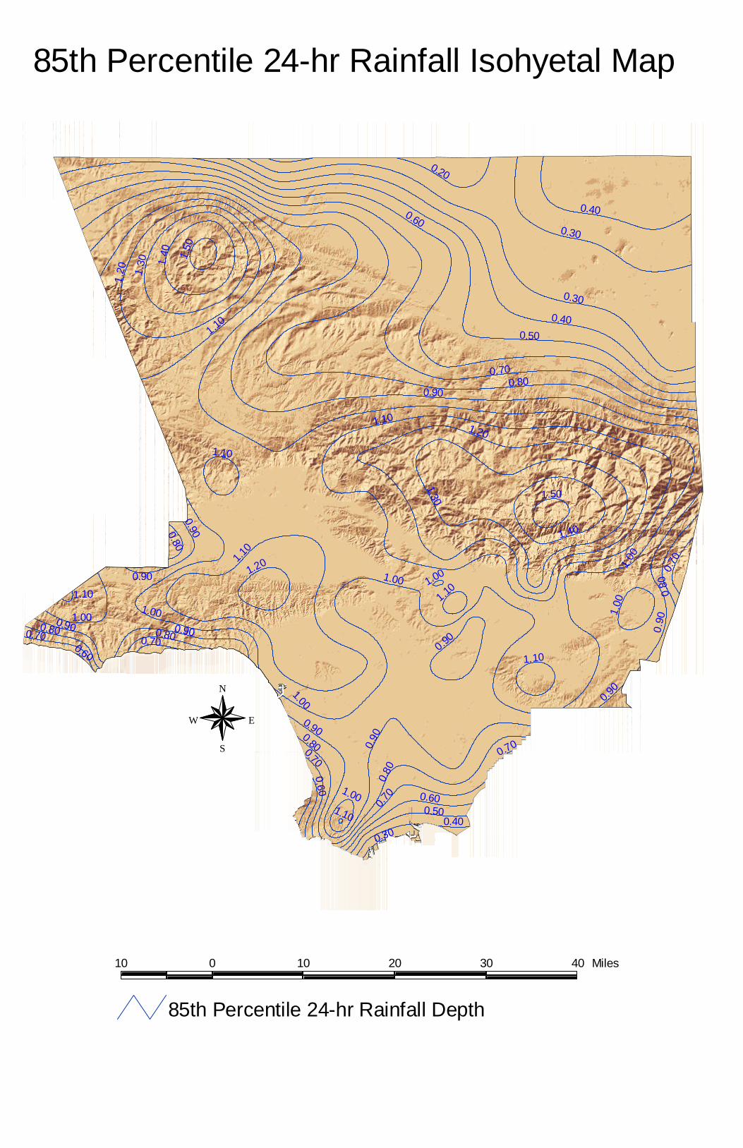
Mapping 85th Percentile 24-hour Isohyets A Geographic Information System (GIS) shape file was created using latitude and longitude coordinates for each rain gage. The GIS shape file also contained the data associated with the 24-hour rainfall analysis. The Spatial Analyst program extension was used with ArcView to create a rainfall grid based on the 85th percentile data for each gage. Contours were created from the grid file to represent the 85th percentile rainfall depth throughout the County of Los Angeles. These isohyets were compared to the NOAA 2-year 24-hour isohyets. The NOAA 2-year 24-hour isohyets reflect topographic influences on spatial rainfall patterns within the County of Los Angeles. The isohyets were also compared to county topography. Rain gages that caused anomalies in the isohyets were discarded. The final isohyetal map used ninety rain gages. The nine discarded gages had small data sets. A new grid and isohyetal contours were produced after discarding the nine gages. The contours were again compared to the NOAA contours and topographic features in the county. In the County of Los Angeles, areas of higher elevation generally receive more rainfall due to changes in pressure and temperature. The isohyetal map of the 85th percentile 24-hour storm shows this orographic affect. Higher rainfall occurs over the mountains and hills. Two dummy rain gages added near the county border keep the isohyetal distribution consistent with topography. Accurate portrayal of the isohyets along the Malibu Coast and in the Antelope Valley requires the dummy gages. Appendix C contains the 85th percentile 24-hour isohyetal map, a map of the rain gage locations, and a description of the settings and process used to create the rainfall grid and contour lines in ArcView. This report also contains an electronic copy of all the data used for the 85th percentile 24-hour rainfall depth analysis.

Appendices

Appendix A
Summary of 24-hour Rain Gage Data

Gage No. Gage Name Mean 50th Percentile 75th Percentile 85th Percentile 90th Percentile 95th Percentile 99th Percentile5 Calabasas 0.57 0.24 0.74 1.10 1.41 2.07 4.236 Topanga Canyon Patrol Station 0.54 0.20 0.69 1.11 1.44 2.10 4.0513 North Hollywood - Lakeside 0.53 0.23 0.66 1.06 1.40 2.02 3.6917 Sepulveda Canyon at Mulholland Hwy. 0.44 0.24 0.77 1.26 1.64 2.31 4.3123 Chatsworth Reservoir 0.47 0.20 0.60 0.94 1.23 1.82 3.3443 Palos Verdes Estates 0.26 0.13 0.34 0.52 0.67 0.94 1.6744 Point Vicente Lighthouse 0.28 0.10 0.34 0.55 0.75 1.07 2.0053 Colby's Sleepy Hollow Ranch 0.70 0.26 0.80 1.36 1.85 2.74 5.6363 Santa Anita Dam 0.55 0.20 0.69 1.12 1.53 2.20 4.1682 Table Mountain 0.51 0.23 0.57 0.96 1.26 1.91 4.11107 Downey Fire Station 0.50 0.28 0.66 0.97 1.25 1.77 3.00120 Vincent Patrol Station 0.30 0.16 0.39 0.60 0.79 1.13 1.67125 San Francisquito Canyon Power House #1 0.44 0.20 0.59 0.91 1.20 1.69 3.02128 Elizabeth Lake - Warm Springs Camp 0.66 0.34 0.90 1.35 1.63 2.32 4.16156 La Mirada - Standard Oil Company 0.43 0.17 0.45 0.72 0.95 1.43 2.84172 Duarte 0.66 0.35 0.88 1.32 1.67 2.34 3.77176 Altadena - Rubio Canyon 0.60 0.25 0.76 1.20 1.61 2.28 3.95201 Puente Hills - Alta Mira Ranch 0.58 0.30 0.78 1.12 1.40 2.03 3.38223 Big Dalton 0.50 0.14 0.59 1.00 1.38 2.11 3.82225 Montana Ranch - Lakewood 0.44 0.24 0.60 0.88 1.10 1.57 2.69227 San Gabriel - Bruington - Orton 0.56 0.27 0.75 1.15 1.45 2.03 3.58237 Stone Canyon Reservoir 0.58 0.22 0.77 1.20 1.66 2.35 3.95238 Hollywood Dam 0.48 0.21 0.63 0.96 1.27 1.92 2.93277 Sawmill Mountain 0.65 0.27 0.89 1.38 1.77 2.32 4.39283 Crystal Lake East Pine Flat 0.70 0.24 0.77 1.32 1.90 2.89 5.89291 Los Angeles 96th and Central 0.49 0.30 0.65 0.92 1.18 1.60 2.96293 Lake Los Angeles 0.49 0.23 0.69 1.01 1.31 1.87 3.10298 Gorman Sherriff Station 0.39 0.12 0.37 0.60 0.82 1.25 2.29299 Little Rock - Schwab 0.29 0.09 0.29 0.48 0.65 0.95 1.65304 Sawpit Canyon - Deer Park 0.60 0.19 0.73 1.20 1.76 2.45 4.88306 Zuma Beach 0.31 0.16 0.40 0.60 0.78 1.10 2.07322 Munz Valley Ranch 0.47 0.26 0.60 0.90 1.15 1.67 2.99334 Cogswell Dam 0.77 0.22 0.86 1.52 2.23 3.41 6.27356 Spadra Pacific Colony 0.49 0.25 0.62 0.98 1.27 1.78 3.01372 San Francisquito Canyon Power House #2 0.45 0.21 0.60 0.90 1.15 1.68 3.00373 Brigg's Terrace - Pickens Canyon 0.65 0.16 0.63 1.13 1.56 2.33 4.20379 San Gabriel Canyon East Fork 0.65 0.23 0.76 1.30 1.70 2.60 5.18390 Morris Dam 0.55 0.19 0.67 1.12 1.52 2.26 4.31391 Montebello Fire Department 0.51 0.17 0.54 0.87 1.13 1.56 3.05405 Soledad Canyon 0.48 0.20 0.56 0.90 1.18 1.73 3.20406 West Azusa 0.51 0.26 0.68 1.03 1.36 1.85 2.93409 Pyramid Reservoir 0.54 0.17 0.63 1.07 1.50 2.29 4.41425 San Gabriel Dam 0.63 0.20 0.75 1.28 1.79 2.61 4.83434 Agoura 0.41 0.13 0.44 0.75 1.03 1.58 3.46435 Monte Nido 0.47 0.20 0.60 0.96 1.28 1.79 3.46438 Los Angeles-University of Southern Cal 0.60 0.32 0.75 1.10 1.43 2.05 4.22443 Latigo Canyon - Beach Ranch 0.47 0.16 0.57 0.95 1.33 1.96 3.66446 Aliso Canyon - Oat Mountain 0.57 0.27 0.74 1.13 1.45 2.10 3.57447 Carbon Canyon 0.35 0.17 0.46 0.70 0.89 1.26 2.19455 Lancaster State Highway Maintenance De 0.32 0.16 0.38 0.59 0.79 1.18 2.08458 Zuma Canyon Patrol Station 0.48 0.22 0.60 0.90 1.20 1.80 3.17491 Pacific Palisades 0.40 0.27 0.60 0.85 1.05 1.41 2.24492 Chilao - State Highway Maintenance Sta 0.66 0.28 0.76 1.30 1.73 2.54 4.94497 Claremont - Slaughter 0.47 0.21 0.61 0.96 1.27 1.85 3.07517 Anderson Ranch 0.50 0.18 0.56 0.98 1.35 2.08 3.84564 Llano 0.31 0.18 0.40 0.61 0.78 1.01 1.75598 Neenach 0.36 0.14 0.45 0.69 0.93 1.35 2.75610 Pasadena City Hall 0.48 0.18 0.60 1.00 1.35 2.00 3.54619 San Antonio Canyon - Sierra Power Hous 0.44 0.11 0.40 0.70 1.00 1.71 4.29627 San Gabriel Canyon Power House 0.48 0.17 0.59 1.00 1.37 2.04 3.56634 Santa Monica 0.50 0.25 0.67 1.02 1.32 1.78 3.08694 Big Tujunga Camp 15 0.58 0.29 0.71 1.10 1.50 2.05 4.29716 Ducommons Street 0.47 0.24 0.62 0.94 1.24 1.74 3.33735 Bell Canyon - Platt Ranch 0.37 0.13 0.43 0.74 0.98 1.55 2.99750 Palmdale F.A.A. Airport 0.24 0.12 0.30 0.48 0.61 0.90 1.54795 Pasadena - Jourdan 0.49 0.19 0.63 1.02 1.41 2.00 3.44807 Ascot Reservoir 0.48 0.23 0.63 0.98 1.30 1.80 3.101006 San Pedro City Reservoir 0.27 0.14 0.36 0.53 0.69 1.02 1.601025 Malibu Beach - Dunne 0.33 0.16 0.43 0.64 0.84 1.17 2.201041 Santa Fe 0.53 0.27 0.71 1.09 1.40 1.93 3.181050 Old Topanga Canyon 0.50 0.18 0.60 1.01 1.38 2.04 3.671051 Canoga Park - Pierce College 0.50 0.20 0.65 1.00 1.33 1.95 3.561070 Manhattan Beach 0.41 0.22 0.54 0.82 1.05 1.39 2.391072 Little Tujunga Ranger Station 0.57 0.31 0.77 1.10 1.39 1.95 3.561074 Little Gleason 0.69 0.31 0.79 1.28 1.71 2.59 5.911081 Glendale - Gregg 0.55 0.24 0.71 1.11 1.45 2.09 3.791088 La Habra Heights - Mutual Water Co. 0.52 0.28 0.68 1.05 1.32 1.94 3.121107 La Tuna Debris Basin 0.55 0.30 0.70 1.07 1.40 1.89 3.491113 Dominguez Water Company 0.35 0.15 0.42 0.73 0.95 1.42 2.631242 Rocky Buttes Indian Museum 0.14 0.05 0.16 0.24 0.32 0.50 0.971243 Redman 0.26 0.10 0.29 0.44 0.60 0.88 2.651244 Lancaster - Roper 0.15 0.04 0.16 0.27 0.41 0.55 1.471246 Scott Ranch 0.14 0.08 0.20 0.40 0.60 0.96 1.511247 North Lancaster 0.13 0.04 0.12 0.24 0.32 0.50 0.801248 Mescal - Smith 0.22 0.08 0.20 0.36 0.60 1.20 2.321252 Palos Verdes Landfill 0.55 0.31 0.73 1.09 1.49 2.01 3.201253 Carson - County Sanitation 0.44 0.20 0.55 0.89 1.22 1.65 2.471259 Whittier Narrows Reclamation Plant 0.49 0.26 0.60 0.90 1.25 1.80 3.011262 Saugus Reclamation Plant 0.51 0.28 0.62 0.94 1.29 1.81 3.491263 Valencia Reclamation Plant 0.49 0.28 0.62 1.01 1.31 1.80 2.78
Discarded Gages1248 Mescal - Smith 0.22 0.08 0.20 0.36 0.60 1.20 2.321249 Relay 0.32 0.08 0.20 0.30 0.46 0.60 1.151252 Palos Verdes Landfill 0.55 0.31 0.73 1.09 1.49 2.01 3.201253 Carson - County Sanitation 0.44 0.20 0.55 0.89 1.22 1.65 2.471259 Whittier Narrows Reclamation Plant 0.49 0.26 0.60 0.90 1.25 1.80 3.011262 Saugus Reclamation Plant 0.51 0.28 0.62 0.94 1.29 1.81 3.491263 Valencia Reclamation Plant 0.49 0.28 0.62 1.01 1.31 1.80 2.78
Summary of Rain Gage Data
24-hour Rainfall Total
File: Final Gages Used for Rainfall Isohyet Analysis-85th Percentile-24hr Depth.xlsWorksheet: Gage SummaryDate: 03/16/2004

Appendix B
Statistical Analysis

File: Probability Analysis of 85th Percentile 24-hr Rainfall.xls Worksheet: HistogramDate: 03/16/2004
24-hr Rainfall Depth Histogram
0
500
1000
1500
2000
2500
3000
0.01-0
.50.5
-1.0
1.0-1.
5
1.5-2.
0
2.0-2.
5
2.5-3.
0
3.0-3.
5
3.5-4.
0
4.0-4.
5
4.5-5.
0
5.0-5.
5
5.5-6.
0
6.0-6.
5
6.5-7.
0
7.0-7.
5
7.5-8.
0
8.0-8.
5
8.5-9.
0
9.0-9.
5
9.5-10
.0
10.0-
10.5
10.5-
11.0
11.5-
12.0
12.0-
12.5
12.5-
13.0
13.0-
13.5
13.5-
14.0
14.0-
14.5
14.5-
15.0
15.0-
15.5
15.5-
16.0
16.0-
16.5
Rainfall Depth (Inches)
Nu
mb
er o
f E
ven
ts W
ith
in
Giv
en R
ang
e

Rainfall Depth
Inches / Gage # 5 6 10 13 17 23 25 43 44 53 57 63 82 107 120 125 128 156 172 176 201 223 225 227 237 238 277 283 291 293 298 299 304 306 322 334 352 356 372 373 379 390 391 405 406 409 425 434 435 438 443 4460 0.000 0.000 0.000 0.000 0.000 0.000 0.000 0.000 0.000 0.000 0.000 0.000 0.000 0.000 0.000 0.000 0.000 0.000 0.000 0.000 0.000 0.000 0.000 0.000 0.000 0.000 0.000 0.000 0.000 0.000 0.000 0.000 0.000 0.000 0.000 0.000 0.000 0.000 0.000 0.000 0.000 0.000 0.000 0.000 0.000 0.000 0.000 0.000 0.000 0.000 0.000 0.000
0.01-0.5 0.660 0.666 0.674 0.670 0.652 0.710 0.722 0.831 0.816 0.643 0.586 0.685 0.715 0.659 0.806 0.708 0.577 0.767 0.581 0.632 0.611 0.715 0.698 0.649 0.647 0.688 0.631 0.651 0.660 0.675 0.760 0.818 0.669 0.796 0.689 0.655 0.717 0.689 0.702 0.638 0.660 0.685 0.659 0.705 0.665 0.692 0.658 0.761 0.693 0.618 0.697 0.6370.5-1.0 0.168 0.151 0.162 0.166 0.148 0.151 0.151 0.120 0.120 0.146 0.146 0.142 0.141 0.195 0.127 0.159 0.194 0.137 0.197 0.179 0.199 0.133 0.178 0.168 0.163 0.169 0.147 0.148 0.206 0.170 0.137 0.130 0.130 0.137 0.178 0.121 0.164 0.165 0.165 0.157 0.145 0.141 0.185 0.161 0.176 0.139 0.147 0.127 0.157 0.211 0.145 0.1761.0-1.5 0.081 0.082 0.069 0.076 0.081 0.065 0.067 0.032 0.038 0.076 0.075 0.070 0.068 0.079 0.051 0.069 0.100 0.048 0.098 0.073 0.097 0.060 0.069 0.088 0.074 0.071 0.091 0.066 0.075 0.071 0.058 0.035 0.074 0.045 0.068 0.072 0.066 0.073 0.066 0.079 0.073 0.071 0.085 0.061 0.076 0.068 0.070 0.057 0.072 0.077 0.066 0.0901.5-2.0 0.037 0.038 0.034 0.035 0.050 0.032 0.028 0.011 0.014 0.046 0.051 0.040 0.030 0.029 0.007 0.029 0.061 0.022 0.056 0.047 0.041 0.034 0.027 0.043 0.047 0.024 0.053 0.042 0.026 0.041 0.023 0.010 0.040 0.010 0.031 0.036 0.024 0.035 0.033 0.043 0.044 0.039 0.032 0.035 0.040 0.032 0.042 0.023 0.033 0.040 0.038 0.0412.0-2.5 0.019 0.027 0.024 0.021 0.023 0.017 0.013 0.003 0.006 0.029 0.035 0.025 0.016 0.020 0.005 0.018 0.029 0.011 0.026 0.024 0.022 0.022 0.015 0.022 0.023 0.023 0.036 0.028 0.013 0.020 0.014 0.004 0.037 0.006 0.016 0.030 0.014 0.015 0.017 0.031 0.023 0.024 0.016 0.016 0.023 0.026 0.028 0.013 0.019 0.018 0.021 0.0222.5-3.0 0.010 0.011 0.017 0.012 0.014 0.011 0.010 0.001 0.002 0.017 0.026 0.014 0.010 0.007 0.001 0.007 0.016 0.008 0.013 0.017 0.012 0.011 0.006 0.015 0.019 0.015 0.013 0.018 0.009 0.011 0.002 0.001 0.014 0.004 0.008 0.021 0.006 0.012 0.007 0.020 0.020 0.012 0.009 0.007 0.010 0.012 0.017 0.005 0.010 0.009 0.014 0.0143.0-3.5 0.010 0.007 0.004 0.009 0.010 0.006 0.003 0.001 0.001 0.011 0.019 0.007 0.007 0.005 0.002 0.004 0.008 0.002 0.011 0.012 0.008 0.009 0.004 0.003 0.012 0.004 0.011 0.012 0.008 0.007 0.003 0.001 0.011 0.001 0.005 0.017 0.003 0.005 0.005 0.008 0.010 0.006 0.007 0.006 0.004 0.010 0.013 0.006 0.007 0.012 0.006 0.0103.5-4.0 0.004 0.006 0.006 0.003 0.007 0.003 0.002 0.000 0.001 0.010 0.010 0.005 0.003 0.003 0.000 0.002 0.004 0.002 0.008 0.006 0.006 0.008 0.001 0.006 0.006 0.002 0.006 0.006 0.001 0.002 0.001 0.001 0.006 0.000 0.004 0.014 0.002 0.001 0.005 0.009 0.008 0.010 0.004 0.002 0.003 0.007 0.009 0.001 0.003 0.004 0.004 0.0034.0-4.5 0.003 0.004 0.002 0.003 0.005 0.002 0.002 0.000 0.000 0.003 0.015 0.003 0.001 0.001 0.000 0.002 0.004 0.001 0.004 0.003 0.001 0.003 0.001 0.003 0.004 0.003 0.004 0.011 0.000 0.001 0.001 0.000 0.005 0.000 0.001 0.009 0.001 0.003 0.002 0.003 0.004 0.005 0.001 0.003 0.001 0.004 0.004 0.001 0.003 0.004 0.002 0.0034.5-5.0 0.002 0.004 0.002 0.002 0.002 0.001 0.001 0.000 0.000 0.004 0.009 0.002 0.003 0.000 0.000 0.001 0.001 0.002 0.002 0.003 0.001 0.000 0.001 0.001 0.002 0.001 0.003 0.003 0.001 0.000 0.001 0.001 0.004 0.000 0.001 0.006 0.000 0.001 0.001 0.003 0.004 0.002 0.001 0.001 0.001 0.003 0.003 0.002 0.001 0.002 0.001 0.0025.0-5.5 0.002 0.001 0.002 0.001 0.002 0.000 0.001 0.000 0.000 0.002 0.006 0.002 0.002 0.001 0.000 0.000 0.002 0.000 0.001 0.001 0.001 0.001 0.000 0.001 0.002 0.000 0.002 0.004 0.001 0.001 0.001 0.000 0.002 0.000 0.000 0.005 0.001 0.000 0.000 0.001 0.002 0.001 0.000 0.001 0.000 0.004 0.001 0.002 0.000 0.002 0.001 0.0025.5-6.0 0.002 0.001 0.001 0.001 0.001 0.000 0.000 0.000 0.000 0.003 0.004 0.001 0.000 0.000 0.000 0.000 0.003 0.000 0.001 0.001 0.000 0.000 0.000 0.001 0.002 0.000 0.002 0.002 0.000 0.000 0.000 0.000 0.002 0.000 0.000 0.002 0.000 0.000 0.000 0.002 0.002 0.002 0.000 0.001 0.000 0.001 0.001 0.000 0.001 0.001 0.003 0.0016.0-6.5 0.000 0.001 0.000 0.001 0.002 0.000 0.000 0.000 0.000 0.002 0.003 0.001 0.000 0.000 0.000 0.000 0.002 0.000 0.001 0.001 0.000 0.001 0.000 0.000 0.001 0.000 0.000 0.001 0.000 0.000 0.001 0.000 0.002 0.000 0.000 0.003 0.000 0.000 0.000 0.002 0.002 0.000 0.001 0.002 0.000 0.001 0.002 0.001 0.000 0.000 0.000 0.0006.5-7.0 0.000 0.000 0.001 0.000 0.000 0.000 0.000 0.000 0.000 0.000 0.004 0.001 0.001 0.000 0.000 0.000 0.000 0.000 0.000 0.001 0.000 0.000 0.000 0.000 0.000 0.000 0.000 0.002 0.000 0.000 0.000 0.000 0.001 0.000 0.000 0.002 0.000 0.000 0.000 0.000 0.000 0.000 0.000 0.000 0.000 0.001 0.001 0.000 0.000 0.001 0.000 0.0017.0-7.5 0.000 0.000 0.000 0.001 0.001 0.000 0.000 0.000 0.000 0.002 0.002 0.000 0.001 0.000 0.000 0.000 0.000 0.000 0.001 0.000 0.001 0.001 0.000 0.001 0.000 0.000 0.000 0.002 0.000 0.000 0.000 0.000 0.001 0.000 0.000 0.001 0.000 0.000 0.000 0.001 0.001 0.000 0.000 0.000 0.000 0.000 0.001 0.000 0.000 0.000 0.000 0.0017.5-8.0 0.001 0.000 0.000 0.000 0.001 0.000 0.000 0.000 0.000 0.000 0.001 0.000 0.000 0.000 0.000 0.000 0.001 0.000 0.000 0.001 0.000 0.001 0.000 0.000 0.000 0.000 0.000 0.001 0.000 0.000 0.000 0.000 0.002 0.000 0.000 0.000 0.000 0.000 0.000 0.000 0.001 0.000 0.000 0.000 0.000 0.001 0.001 0.000 0.000 0.001 0.000 0.0008.0-8.5 0.001 0.000 0.000 0.000 0.000 0.000 0.000 0.000 0.000 0.000 0.001 0.000 0.000 0.000 0.000 0.000 0.000 0.000 0.000 0.000 0.000 0.000 0.000 0.000 0.000 0.000 0.000 0.002 0.000 0.000 0.000 0.000 0.000 0.000 0.000 0.001 0.000 0.000 0.000 0.000 0.000 0.001 0.000 0.000 0.000 0.000 0.001 0.000 0.000 0.000 0.000 0.0008.5-9.0 0.000 0.000 0.000 0.000 0.001 0.000 0.000 0.000 0.000 0.000 0.000 0.000 0.001 0.000 0.000 0.000 0.000 0.000 0.000 0.000 0.000 0.000 0.000 0.001 0.000 0.000 0.000 0.000 0.000 0.000 0.000 0.000 0.000 0.000 0.000 0.000 0.000 0.000 0.000 0.000 0.000 0.000 0.000 0.000 0.000 0.000 0.000 0.000 0.000 0.000 0.000 0.0019.0-9.5 0.000 0.000 0.000 0.000 0.000 0.000 0.000 0.000 0.000 0.001 0.001 0.000 0.000 0.000 0.000 0.000 0.000 0.000 0.000 0.000 0.000 0.000 0.000 0.000 0.000 0.000 0.000 0.000 0.000 0.000 0.000 0.000 0.000 0.000 0.000 0.001 0.000 0.000 0.000 0.000 0.000 0.000 0.000 0.000 0.000 0.000 0.000 0.000 0.000 0.001 0.000 0.0009.5-10.0 0.000 0.000 0.000 0.000 0.000 0.000 0.000 0.000 0.000 0.000 0.001 0.000 0.000 0.000 0.000 0.000 0.000 0.000 0.000 0.000 0.000 0.001 0.000 0.000 0.000 0.000 0.000 0.000 0.000 0.000 0.000 0.000 0.000 0.000 0.000 0.000 0.000 0.000 0.000 0.000 0.000 0.000 0.000 0.000 0.000 0.001 0.000 0.000 0.000 0.000 0.000 0.000
10.0-10.5 0.000 0.000 0.000 0.000 0.000 0.000 0.000 0.000 0.000 0.000 0.000 0.000 0.000 0.000 0.000 0.000 0.000 0.000 0.000 0.000 0.000 0.000 0.000 0.000 0.000 0.000 0.000 0.000 0.000 0.000 0.000 0.000 0.000 0.000 0.000 0.000 0.000 0.000 0.000 0.000 0.000 0.000 0.000 0.000 0.000 0.000 0.000 0.000 0.000 0.000 0.000 0.00010.5-11.0 0.000 0.000 0.000 0.000 0.000 0.000 0.000 0.000 0.000 0.000 0.001 0.000 0.000 0.000 0.000 0.000 0.000 0.000 0.000 0.000 0.000 0.000 0.000 0.000 0.000 0.000 0.000 0.000 0.000 0.000 0.000 0.000 0.001 0.000 0.000 0.000 0.000 0.000 0.000 0.000 0.000 0.000 0.000 0.000 0.000 0.000 0.000 0.000 0.000 0.000 0.000 0.00011.5-12.0 0.000 0.000 0.000 0.000 0.000 0.000 0.000 0.000 0.000 0.000 0.000 0.000 0.000 0.000 0.000 0.000 0.000 0.000 0.000 0.000 0.000 0.000 0.000 0.000 0.000 0.000 0.000 0.001 0.000 0.000 0.000 0.000 0.000 0.000 0.000 0.000 0.000 0.000 0.000 0.000 0.000 0.000 0.000 0.000 0.000 0.000 0.000 0.000 0.000 0.000 0.000 0.00012.0-12.5 0.000 0.000 0.000 0.000 0.000 0.000 0.000 0.000 0.000 0.000 0.000 0.000 0.000 0.000 0.000 0.000 0.000 0.000 0.000 0.000 0.000 0.000 0.000 0.000 0.000 0.000 0.000 0.000 0.000 0.000 0.000 0.000 0.000 0.000 0.000 0.001 0.000 0.000 0.000 0.000 0.001 0.000 0.000 0.000 0.000 0.000 0.000 0.000 0.000 0.000 0.000 0.00012.5-13.0 0.000 0.000 0.000 0.000 0.000 0.000 0.000 0.000 0.000 0.000 0.001 0.000 0.000 0.000 0.000 0.000 0.000 0.000 0.000 0.000 0.000 0.000 0.000 0.000 0.000 0.000 0.000 0.000 0.000 0.000 0.000 0.000 0.000 0.000 0.000 0.000 0.000 0.000 0.000 0.000 0.000 0.000 0.000 0.000 0.000 0.000 0.000 0.000 0.000 0.000 0.000 0.00013.0-13.5 0.000 0.000 0.000 0.000 0.000 0.000 0.000 0.000 0.000 0.000 0.000 0.000 0.000 0.000 0.000 0.000 0.000 0.000 0.000 0.000 0.000 0.000 0.000 0.000 0.000 0.000 0.000 0.000 0.000 0.000 0.000 0.000 0.000 0.000 0.000 0.000 0.000 0.000 0.000 0.000 0.000 0.000 0.000 0.000 0.000 0.000 0.000 0.000 0.000 0.000 0.000 0.00013.5-14.0 0.000 0.000 0.000 0.000 0.000 0.000 0.000 0.000 0.000 0.000 0.000 0.000 0.000 0.000 0.000 0.000 0.000 0.000 0.000 0.000 0.000 0.000 0.000 0.000 0.000 0.000 0.000 0.000 0.000 0.000 0.000 0.000 0.000 0.000 0.000 0.000 0.000 0.000 0.000 0.000 0.000 0.000 0.000 0.000 0.000 0.000 0.000 0.000 0.000 0.000 0.000 0.00014.0-14.5 0.000 0.000 0.000 0.000 0.000 0.000 0.000 0.000 0.000 0.000 0.000 0.000 0.000 0.000 0.000 0.000 0.000 0.001 0.000 0.000 0.000 0.000 0.000 0.000 0.000 0.000 0.000 0.000 0.000 0.000 0.000 0.000 0.000 0.000 0.000 0.000 0.000 0.000 0.000 0.000 0.000 0.000 0.000 0.000 0.000 0.000 0.000 0.000 0.000 0.000 0.000 0.00014.5-15.0 0.000 0.000 0.000 0.000 0.000 0.000 0.000 0.000 0.000 0.000 0.000 0.000 0.000 0.000 0.000 0.000 0.000 0.000 0.000 0.000 0.000 0.000 0.000 0.000 0.000 0.000 0.000 0.000 0.000 0.000 0.000 0.000 0.000 0.000 0.000 0.000 0.000 0.000 0.000 0.000 0.000 0.000 0.000 0.000 0.000 0.000 0.000 0.000 0.000 0.000 0.000 0.00015.0-15.5 0.000 0.000 0.000 0.000 0.000 0.000 0.000 0.000 0.000 0.000 0.000 0.000 0.000 0.000 0.000 0.000 0.000 0.000 0.000 0.000 0.000 0.000 0.000 0.000 0.000 0.000 0.000 0.000 0.000 0.000 0.000 0.000 0.000 0.000 0.000 0.000 0.000 0.000 0.000 0.000 0.000 0.000 0.000 0.000 0.000 0.000 0.000 0.000 0.000 0.000 0.000 0.00015.5-16.0 0.000 0.000 0.000 0.000 0.000 0.000 0.000 0.000 0.000 0.000 0.001 0.000 0.000 0.000 0.000 0.000 0.000 0.000 0.000 0.000 0.000 0.000 0.000 0.000 0.000 0.000 0.000 0.000 0.000 0.000 0.000 0.000 0.000 0.000 0.000 0.000 0.000 0.000 0.000 0.000 0.000 0.000 0.000 0.000 0.000 0.000 0.000 0.000 0.000 0.000 0.000 0.000
Rainfall Depth
Inches / Gage # 447 455 491 492 497 517 564 598 610 619 627 634 694 695 716 735 750 795 807 1005 1006 1025 1041 1050 1051 1070 1072 1074 1076 1081 1088 1107 1113 1217 1242 1243 1244 1246 1247 1248 1249 1252 1253 1259 1262 12630 0.000 0.000 0.000 0.000 0.000 0.000 0.000 0.000 0.000 0.000 0.000 0.000 0.000 0.000 0.000 0.000 0.000 0.000 0.000 0.000 0.000 0.000 0.000 0.000 0.000 0.000 0.000 0.000 0.000 0.000 0.000 0.000 0.000 0.000 0.000 0.000 0.000 0.000 0.000 0.000 0.000 0.000 0.000 0.000 0.000 0.000
0.5-1.0 0.759 0.809 0.782 0.644 0.708 0.697 0.794 0.776 0.708 0.797 0.715 0.671 0.648 0.566 0.699 0.762 0.860 0.692 0.683 0.673 0.826 0.785 0.661 0.700 0.693 0.721 0.604 0.624 0.644 0.656 0.661 0.642 0.783 0.595 0.947 0.877 0.935 0.893 0.950 0.896 0.921 0.641 0.720 0.677 0.695 0.6961.0-1.5 0.153 0.123 0.151 0.166 0.148 0.144 0.146 0.140 0.140 0.104 0.134 0.169 0.170 0.196 0.161 0.133 0.100 0.154 0.168 0.200 0.118 0.137 0.165 0.141 0.155 0.165 0.207 0.181 0.165 0.167 0.174 0.187 0.122 0.199 0.043 0.084 0.043 0.059 0.040 0.044 0.066 0.184 0.144 0.187 0.167 0.1491.5-2.0 0.051 0.042 0.038 0.066 0.067 0.066 0.046 0.042 0.068 0.036 0.062 0.085 0.080 0.053 0.072 0.049 0.027 0.064 0.070 0.072 0.040 0.048 0.087 0.068 0.070 0.074 0.101 0.075 0.080 0.080 0.090 0.081 0.053 0.100 0.005 0.026 0.011 0.041 0.000 0.037 0.008 0.076 0.068 0.063 0.069 0.0782.0-2.5 0.022 0.012 0.012 0.044 0.034 0.037 0.007 0.012 0.034 0.020 0.035 0.035 0.046 0.063 0.032 0.022 0.010 0.039 0.037 0.028 0.011 0.014 0.039 0.037 0.033 0.022 0.039 0.036 0.032 0.040 0.030 0.046 0.024 0.037 0.005 0.000 0.011 0.004 0.005 0.007 0.004 0.045 0.046 0.032 0.028 0.0382.5-3.0 0.007 0.006 0.011 0.029 0.020 0.020 0.001 0.014 0.020 0.008 0.023 0.022 0.026 0.037 0.015 0.014 0.002 0.023 0.023 0.015 0.002 0.008 0.021 0.022 0.019 0.009 0.021 0.031 0.029 0.025 0.018 0.017 0.007 0.030 0.000 0.000 0.000 0.004 0.000 0.004 0.000 0.024 0.011 0.022 0.018 0.0223.0-3.5 0.004 0.003 0.005 0.016 0.011 0.015 0.003 0.007 0.013 0.009 0.015 0.007 0.008 0.032 0.011 0.008 0.002 0.011 0.007 0.008 0.001 0.002 0.012 0.010 0.009 0.005 0.011 0.021 0.021 0.012 0.016 0.012 0.004 0.018 0.000 0.000 0.000 0.000 0.005 0.011 0.000 0.018 0.007 0.007 0.006 0.0103.5-4.0 0.003 0.003 0.000 0.011 0.007 0.006 0.000 0.005 0.006 0.009 0.005 0.004 0.003 0.016 0.004 0.004 0.000 0.007 0.005 0.001 0.000 0.002 0.006 0.009 0.009 0.002 0.005 0.010 0.011 0.008 0.005 0.004 0.003 0.005 0.000 0.009 0.000 0.000 0.000 0.000 0.000 0.006 0.000 0.009 0.006 0.0044.0-4.5 0.001 0.000 0.000 0.008 0.002 0.006 0.001 0.002 0.004 0.004 0.006 0.002 0.004 0.005 0.006 0.005 0.000 0.004 0.005 0.003 0.000 0.001 0.003 0.004 0.004 0.001 0.006 0.004 0.004 0.004 0.005 0.002 0.002 0.004 0.000 0.000 0.000 0.000 0.000 0.000 0.000 0.002 0.002 0.002 0.006 0.0004.5-5.0 0.000 0.001 0.000 0.005 0.001 0.001 0.001 0.001 0.002 0.004 0.003 0.002 0.005 0.011 0.003 0.001 0.000 0.002 0.002 0.000 0.000 0.000 0.004 0.002 0.002 0.000 0.001 0.003 0.004 0.002 0.002 0.005 0.001 0.002 0.000 0.004 0.000 0.000 0.000 0.000 0.000 0.004 0.000 0.002 0.002 0.0005.0-5.5 0.000 0.000 0.001 0.002 0.000 0.002 0.000 0.000 0.002 0.001 0.002 0.002 0.002 0.000 0.001 0.000 0.000 0.002 0.001 0.000 0.000 0.000 0.001 0.003 0.002 0.001 0.001 0.001 0.002 0.003 0.000 0.002 0.001 0.004 0.000 0.000 0.000 0.000 0.000 0.000 0.000 0.000 0.000 0.000 0.000 0.0025.5-6.0 0.000 0.000 0.000 0.003 0.001 0.001 0.000 0.001 0.000 0.002 0.000 0.001 0.000 0.005 0.000 0.000 0.000 0.001 0.000 0.000 0.000 0.000 0.000 0.002 0.001 0.000 0.002 0.002 0.002 0.001 0.000 0.000 0.001 0.002 0.000 0.000 0.000 0.000 0.000 0.000 0.000 0.000 0.000 0.000 0.002 0.0006.0-6.5 0.000 0.000 0.000 0.002 0.000 0.001 0.000 0.000 0.001 0.000 0.000 0.000 0.002 0.000 0.000 0.000 0.000 0.000 0.000 0.000 0.000 0.000 0.000 0.000 0.001 0.000 0.000 0.001 0.001 0.000 0.000 0.001 0.000 0.000 0.000 0.000 0.000 0.000 0.000 0.000 0.000 0.000 0.002 0.000 0.002 0.0006.5-7.0 0.000 0.001 0.000 0.001 0.000 0.002 0.000 0.000 0.001 0.003 0.000 0.000 0.002 0.000 0.000 0.001 0.000 0.000 0.000 0.000 0.000 0.000 0.000 0.001 0.001 0.000 0.001 0.003 0.002 0.001 0.000 0.000 0.000 0.000 0.000 0.000 0.000 0.000 0.000 0.000 0.000 0.000 0.000 0.000 0.000 0.0007.0-7.5 0.000 0.000 0.000 0.002 0.000 0.001 0.000 0.000 0.000 0.001 0.000 0.000 0.001 0.000 0.000 0.000 0.000 0.000 0.000 0.000 0.000 0.000 0.001 0.000 0.001 0.000 0.000 0.001 0.001 0.001 0.000 0.000 0.000 0.000 0.000 0.000 0.000 0.000 0.000 0.000 0.000 0.000 0.000 0.000 0.000 0.0007.5-8.0 0.000 0.000 0.000 0.002 0.000 0.000 0.000 0.000 0.000 0.000 0.000 0.000 0.001 0.005 0.000 0.001 0.000 0.000 0.000 0.000 0.000 0.000 0.000 0.000 0.000 0.000 0.000 0.000 0.000 0.001 0.000 0.000 0.000 0.000 0.000 0.000 0.000 0.000 0.000 0.000 0.000 0.000 0.000 0.000 0.000 0.0008.0-8.5 0.000 0.000 0.000 0.000 0.000 0.001 0.000 0.000 0.000 0.001 0.000 0.000 0.000 0.000 0.000 0.000 0.000 0.000 0.000 0.000 0.000 0.000 0.000 0.000 0.000 0.000 0.000 0.002 0.001 0.000 0.000 0.000 0.000 0.000 0.000 0.000 0.000 0.000 0.000 0.000 0.000 0.000 0.000 0.000 0.000 0.0008.5-9.0 0.000 0.000 0.000 0.000 0.000 0.001 0.000 0.000 0.000 0.000 0.000 0.000 0.000 0.000 0.000 0.000 0.000 0.000 0.000 0.000 0.000 0.000 0.000 0.000 0.000 0.000 0.000 0.001 0.001 0.000 0.000 0.000 0.000 0.000 0.000 0.000 0.000 0.000 0.000 0.000 0.000 0.000 0.000 0.000 0.000 0.0009.0-9.5 0.000 0.000 0.000 0.000 0.000 0.000 0.000 0.000 0.000 0.000 0.000 0.000 0.000 0.005 0.000 0.000 0.000 0.000 0.000 0.000 0.000 0.000 0.000 0.000 0.000 0.000 0.000 0.001 0.001 0.000 0.000 0.000 0.000 0.000 0.000 0.000 0.000 0.000 0.000 0.000 0.000 0.000 0.000 0.000 0.000 0.0009.5-10.0 0.000 0.000 0.000 0.002 0.000 0.000 0.000 0.000 0.000 0.000 0.000 0.000 0.000 0.000 0.000 0.000 0.000 0.000 0.000 0.000 0.000 0.000 0.000 0.000 0.000 0.000 0.000 0.000 0.000 0.000 0.000 0.000 0.000 0.000 0.000 0.000 0.000 0.000 0.000 0.000 0.000 0.000 0.000 0.000 0.000 0.000
10.0-10.5 0.000 0.000 0.000 0.000 0.000 0.000 0.000 0.000 0.000 0.000 0.000 0.000 0.000 0.000 0.000 0.000 0.000 0.000 0.000 0.000 0.000 0.000 0.000 0.000 0.000 0.000 0.000 0.000 0.000 0.000 0.000 0.000 0.000 0.000 0.000 0.000 0.000 0.000 0.000 0.000 0.000 0.000 0.000 0.000 0.000 0.00010.5-11.0 0.000 0.000 0.000 0.000 0.000 0.000 0.000 0.000 0.000 0.001 0.000 0.000 0.000 0.000 0.000 0.000 0.000 0.000 0.000 0.000 0.000 0.000 0.000 0.000 0.000 0.000 0.000 0.000 0.000 0.000 0.000 0.000 0.000 0.000 0.000 0.000 0.000 0.000 0.000 0.000 0.000 0.000 0.000 0.000 0.000 0.00011.5-12.0 0.000 0.000 0.000 0.000 0.000 0.000 0.000 0.000 0.000 0.000 0.000 0.000 0.000 0.000 0.000 0.000 0.000 0.000 0.000 0.000 0.000 0.000 0.000 0.000 0.000 0.000 0.000 0.001 0.000 0.000 0.000 0.000 0.000 0.000 0.000 0.000 0.000 0.000 0.000 0.000 0.000 0.000 0.000 0.000 0.000 0.00012.0-12.5 0.000 0.000 0.000 0.000 0.000 0.000 0.000 0.000 0.000 0.000 0.000 0.000 0.000 0.000 0.000 0.000 0.000 0.000 0.000 0.000 0.000 0.000 0.000 0.000 0.000 0.000 0.000 0.000 0.000 0.000 0.000 0.000 0.000 0.000 0.000 0.000 0.000 0.000 0.000 0.000 0.000 0.000 0.000 0.000 0.000 0.00012.5-13.0 0.000 0.000 0.000 0.001 0.000 0.000 0.000 0.000 0.000 0.000 0.000 0.000 0.000 0.000 0.000 0.000 0.000 0.000 0.000 0.000 0.000 0.000 0.000 0.000 0.000 0.000 0.000 0.000 0.000 0.000 0.000 0.000 0.000 0.000 0.000 0.000 0.000 0.000 0.000 0.000 0.000 0.000 0.000 0.000 0.000 0.00013.0-13.5 0.000 0.000 0.000 0.000 0.000 0.000 0.000 0.000 0.000 0.000 0.000 0.000 0.000 0.000 0.000 0.000 0.000 0.000 0.000 0.000 0.000 0.000 0.000 0.000 0.000 0.000 0.000 0.000 0.000 0.000 0.000 0.000 0.000 0.000 0.000 0.000 0.000 0.000 0.000 0.000 0.000 0.000 0.000 0.000 0.000 0.00013.5-14.0 0.000 0.000 0.000 0.000 0.000 0.000 0.000 0.000 0.000 0.000 0.000 0.000 0.000 0.000 0.000 0.000 0.000 0.000 0.000 0.000 0.000 0.000 0.000 0.000 0.000 0.000 0.000 0.001 0.000 0.000 0.000 0.000 0.000 0.000 0.000 0.000 0.000 0.000 0.000 0.000 0.000 0.000 0.000 0.000 0.000 0.00014.0-14.5 0.000 0.000 0.000 0.000 0.000 0.000 0.000 0.000 0.000 0.000 0.000 0.000 0.000 0.005 0.000 0.000 0.000 0.000 0.000 0.000 0.000 0.000 0.000 0.000 0.000 0.000 0.000 0.000 0.000 0.000 0.000 0.000 0.000 0.000 0.000 0.000 0.000 0.000 0.000 0.000 0.000 0.000 0.000 0.000 0.000 0.00014.5-15.0 0.000 0.000 0.000 0.000 0.000 0.000 0.000 0.000 0.000 0.000 0.000 0.000 0.000 0.000 0.000 0.000 0.000 0.000 0.000 0.000 0.000 0.000 0.000 0.000 0.000 0.000 0.000 0.000 0.000 0.000 0.000 0.000 0.000 0.000 0.000 0.000 0.000 0.000 0.000 0.000 0.000 0.000 0.000 0.000 0.000 0.00015.0-15.5 0.000 0.000 0.000 0.000 0.000 0.001 0.000 0.000 0.000 0.000 0.000 0.000 0.000 0.000 0.000 0.000 0.000 0.000 0.000 0.000 0.000 0.000 0.000 0.000 0.000 0.000 0.000 0.000 0.000 0.000 0.000 0.000 0.000 0.000 0.000 0.000 0.000 0.000 0.000 0.000 0.000 0.000 0.000 0.000 0.000 0.00015.5-16.0 0.000 0.000 0.000 0.000 0.000 0.000 0.000 0.000 0.000 0.000 0.000 0.000 0.000 0.000 0.000 0.000 0.000 0.000 0.000 0.000 0.000 0.000 0.000 0.000 0.000 0.000 0.000 0.000 0.000 0.000 0.000 0.000 0.000 0.000 0.000 0.000 0.000 0.000 0.000 0.000 0.000 0.000 0.000 0.000 0.000 0.000
Probability that Rainfall Depth will Occur in a Given Range
Probability that Rainfall Depth will Occur in a Given Range
File: Probability Analysis of 85th Percentile 24-hr Rainfall.xlsWorksheet: Probability AnalysisDate: 03/16/2004

File: Probability Analysis of 85th Percentile 24-hr Rainfall.xlsWorksheet: CDF GraphDate: 03/16/2004
24-hour Rainfall Depth - Cumulative Distribution
0.00.10.20.30.40.50.60.70.80.91.0
0.0 1.0 2.0 3.0 4.0 5.0 6.0 7.0 8.0 9.0 10.0 11.0 12.0 13.0 14.0 15.0 16.0
Rainfall Depth (inches)
Cu
mm
ula
tive
D
istr
ibu
tio
n

Appendix C
85th Percentile 24-hour Isohyetal Map and Rain Gage Locations
0.60
0.700.80
1.00
0.90
0.50
0.40
0.30
1.101.20
1.30
0.201.
40 1.50
1.00
1.40
0.80
0.30
0.90
0.90
0.800.80
0.700.70
1.00
0.50
0.70
1.10
1.00
1.10
0.70
1.50
1.10
1.201.10
1.10
0.80
1.30
0.60
0.90
0.90
1.20
0.90
0.70
0.60
0.90
1.00
0.60
0.40
1.10
0.80
0.700.90
1.00 1.00
0.40
1.000.90
0.80
0.30
1.10
0.90
85th Percentile 24-hr Rainfall Isohyetal Map
10 0 10 20 30 40 Miles
N
EW
S
85th Percentile 24-hr Rainfall Depth

#
#
#
#
#
#
#
#
#
#
#
#
#
#
#
#
#
#
#
#
##
#
#
#
#
#
#
#
#
#
#
#
#
#
# #
#
#
#
#
#
#
#
#
#
#
#
#
#
#
#
#
#
#
#
#
#
#
#
#
#
#
#
#
#
#
#
#
#
#
#
#
#
#
#
#
#
#
#
#
#
#
#
#
#
#
#
#
#
#
#
Llano
Duarte Agoura
Redman
Neenach
Santa Fe
CalabasasBig Dalton
Zuma Beach
Morris Dam
West Azusa
Monte Nido
Scott Ranch
Cogswell Dam
Santa Monica
dummy-malibu
Hollywood Dam
Carbon Canyon
Table Mountain
Soledad Canyon
Anderson Ranch
Little Gleason
Mescal - Smith
Santa Anita Dam
San Gabriel Dam
Ascot Reservoir
Manhattan Beach
North Lancaster
Sawmill Mountain
Lake Los Angeles
Ducommons Street
Glendale - Gregg
Munz Valley Ranch
Pyramid Reservoir
Pacific Palisades
Lancaster - Roper dummy-ant. Valley
Pasadena City HallPasadena - Jourdan
Old Topanga Canyon
Downey Fire Station
Big Tujunga Camp 15
Chatsworth Reservoir
Palos Verdes Estates
Little Rock - Schwab
Malibu Beach - Dunne
La Tuna Debris Basin
Spadra Pacific Colony
Claremont - Slaughter
Palos Verdes Landfill
Vincent Patrol Station
Stone Canyon Reservoir
Altadena - Rubio Canyon
Gorman Sherriff Station
Palmdale F.A.A. Airport
Dominguez Water Company
Point Vicente Lighthouse
Montana Ranch - Lakewood
San Pedro City Reservoir
Saugus Reclamation Plant
Sawpit Canyon - Deer Park
Bell Canyon - Platt Ranch
North Hollywood - Lakeside
Montebello Fire DepartmentZuma Canyon Patrol Station
Rocky Buttes Indian Museum
Carson - County Sanitation
Valencia Reclamation Plant
Colby's Sleepy Hollow Ranch
Crystal Lake East Pine Flat
Latigo Canyon - Beach Ranch
Aliso Canyon - Oat Mountain
Los Angeles 96th and Central
San Gabriel Canyon East Fork
Canoga Park - Pierce College
Topanga Canyon Patrol Station
Little Tujunga Ranger Station
Puente Hills - Alta Mira Ranch
San Gabriel Canyon Power House
San Gabriel - Bruington - Orton
La Mirada - Standard Oil Company
Brigg's Terrace - Pickens Canyon
Elizabeth Lake - Warm Springs Camp
Whittier Narrows Reclamation Plant
Sepulveda Canyon at Mulholland Hwy.
La Habra Heights - Mutual Water Co.
San Francisquito Canyon Power House #1
San Francisquito Canyon Power House #2
Los Angeles-University of Southern Cal
Lancaster State Highway Maintenance De
Chilao - State Highway Maintenance Sta
85th Percentile 24-hr Isohyetal Map Gages
10 0 10 20 30 40 50 60 70 80 90 Miles
N
EW
S
# Rain Gage Name
File: final_85th-no_analyst-raingages.aprDate: 02/10/2004

File: Procedure for Creating an Isohyetal Map.doc Date: 03/16/2004
Procedure for Creating an Isohyetal Map
1. Create a shape file with rainfall depth data at given points throughout the county (rain gages).
2. Import shape file into ArcView and activate the Spatial Analyst extension.
3. Select the shape file with the rainfall data and then zoom to the extents of the
shape file.
4. Choose the Interpolate Grid option from the Surface pull down menu.
5. Set the following levels for the input parameters:
a. Output Extent – select the Same as Display option. b. Set the grid size at 1000. c. Leave the other settings alone and select the OK button.
6. Choose the spline method from the next pop-up menu. 7. Choose the data values corresponding to the contours desired (i.e., 85th
percentile values).
8. Leave the weight value at 0.1.
9. Set the number of points to 50.
10. Select Tension as the type for the interpolation surface and select the OK button.
11. ArcView will create a grid file. If the grid file appears to be what was expected, select the grid file.
12. Select Create Contours from the Surface pull down menu.
13. Set the contour interval and the base (beginning) contour and select the OK
button.
14. ArcView will create contours. Select Convert to Shape file from the Theme pull down menu.
15. Auto-label the contours and create a layout for the map.