
83230352-DOC-TAS-EN-001 EXOMARS 2018 RSM Optimisation A.Merlo C. Legnani.
51
83230352-DOC-TAS-EN-001 EXOMARS 2018 RSM Optimisatio n A. Merlo C. Legnani
-
Upload
hester-warren -
Category
Documents
-
view
215 -
download
0
Transcript of 83230352-DOC-TAS-EN-001 EXOMARS 2018 RSM Optimisation A.Merlo C. Legnani.

832
3035
2-D
OC
-TA
S-E
N-0
01
EXOMARS 2018
RSM Optimisation
A. MerloC. Legnani

This document is not to be reproduced, modified, adapted, published, translated in any material form in whole or in part nor disclosed to any third party without the prior written permission of Thales Alenia Space - 2012, Thales Alenia Space
Environment and RM Power Generation
ENVIRONMENTAL CONSTRAINTS AND RM POWER
GENERATION
ENVIRONMENTAL CONSTRAINTS AND RM POWER
GENERATION
2
This document is not to be reproduced, modified, adapted, published, translated in any material form in whole or in part nor disclosed to any third party without the prior written permission of Thales Alenia Space - 2012, Thales Alenia Space
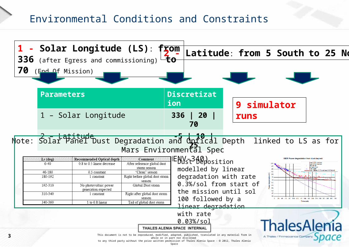
Environmental Conditions and Constraints
1 - Solar Longitude (LS): from 336 (after
Egress and commissioning) to 70 (End Of Mission)2 - Latitude: from 5 South to 25 North
Parameters Discretization
1 – Solar Longitude 336 | 20 | 70
2 – Latitude -5 | 10 | 25
9 simulator runs
Note: Solar Panel Dust Degradation and Optical Depth linked to LS as for Mars Environmental Spec (2018 MENV-340)
Dust Deposition modelled by linear degradation with rate0.3%/sol from start of the mission until sol 100 followed by a linear degradation with rate0.03%/sol
3

This document is not to be reproduced, modified, adapted, published, translated in any material form in whole or in part nor disclosed to any third party without the prior written permission of Thales Alenia Space - 2012, Thales Alenia Space
Favored Landing Sites
LS NameEllipse pattern's centre
coordinatesMOLA altitude:
max (avg) km
Mawrth Vallis 1&2 22.20° N, 342.00° E –1.8 (–2.2)
Oxia Planum 1 18.20° N, 335.45° E –2.8 (–3.1)
Hypanis Vallis 11.80° N, 314.96° E –2.3 (–2.7)
Oxia Palus 07.87° N, 348.80° E –1.9 (–2.1)
4

This document is not to be reproduced, modified, adapted, published, translated in any material form in whole or in part nor disclosed to any third party without the prior written permission of Thales Alenia Space - 2012, Thales Alenia Space
Solar Fluxes – Direct / Reflected
Solar Longitude (LS)
Lat
itud
e-5
1025
336 20 70
Mars Climate Database v.4.1
05:48 a.m. 05:59 p.m.
06:01 a.m. 05:50 p.m.
06:16 a.m. 05:36 p.m.
06:01 a.m. 05:50 p.m.
05:48 a.m. 06:03 p.m.
05:43 a.m. 06:08 p.m.
06:06 a.m. 05:49 p.m.
05:44 a.m. 06:16 p.m.
05:15 a.m. 06:41 p.m.
5
- Day / Night duration: The analysis leads to define the daylight duration as 12hours (6 a.m. to 6 p.m.). It is to be noted that the Rover activities can be effectively executed only when the energy generation is above a certain threshold: as a consequence the daily Rover activity duration is assumed to be 10 hours.
- Solar Fluxes: Based on the analyzed data it was agreed that the typical case is represented by the 10deg North Latitude, 20deg Solar Longitude.

This document is not to be reproduced, modified, adapted, published, translated in any material form in whole or in part nor disclosed to any third party without the prior written permission of Thales Alenia Space - 2012, Thales Alenia Space
Temperatures – Ground / Air / Sky
336 20 70Solar Longitude (LS)
Lat
itud
e-5
1025
Max Ground Temp 266 Min Ground Temp 173
Max Air Temp 246 Min Air Temp 175
Max sky Temp 169 Min sky Temp 145
Max Ground Temp 282 Min Ground Temp 180
Max Air Temp 261 Min Air Temp 181
Max sky Temp 179 Min sky Temp 151
Max Ground Temp 289 Min Ground Temp 183
Max Air Temp 268 Min Air Temp 184
Max sky Temp 185 Min sky Temp 154
Max Ground Temp 278 Min Ground Temp 175
Max Air Temp 256 Min Air Temp 177
Max sky Temp 165 Min sky Temp 141
Max Ground Temp 281 Min Ground Temp 176
Max Air Temp 259 Min Air Temp 177
Max sky Temp 167 Min sky Temp 141
Max Ground Temp 278 Min Ground Temp 174
Max Air Temp 255 Min Air Temp 175
Max sky Temp 164 Min sky Temp 139
Max Ground Temp 279 Min Ground Temp 176
Max Air Temp 257 Min Air Temp 178
Max sky Temp 162 Min sky Temp 139
Max Ground Temp 275 Min Ground Temp 172
Max Air Temp 252 Min Air Temp 174
Max sky Temp 157 Min sky Temp 135
Max Ground Temp 264 Min Ground Temp 167
Max Air Temp 241 Min Air Temp 168
Max sky Temp 149 Min sky Temp 129
Mars Climate Database v.4.1
6
- Temperature (Ground, Air, Sky): Based on the analyzed data it was agreed that the typical case is represented by the 10deg North Latitude, 20deg Solar Longitude.

This document is not to be reproduced, modified, adapted, published, translated in any material form in whole or in part nor disclosed to any third party without the prior written permission of Thales Alenia Space - 2012, Thales Alenia Space
Winds – NS / EW (1m height)
336 20 70Solar Longitude (LS)
Lat
itud
e-5
1025
Mars Climate Database v.4.1
7
- Winds: Based on the analyzed data it was agreed that the typical case is represented by the 10deg North Latitude, 20deg Solar Longitude. The winds are affecting the warm-up time, hence the biggest impact on the power budget and preparation of operations has been identified in the morning timeframe. It is to be noted that the magnitude of the winds is always less than 6m/s for the Typical Sol.

This document is not to be reproduced, modified, adapted, published, translated in any material form in whole or in part nor disclosed to any third party without the prior written permission of Thales Alenia Space - 2012, Thales Alenia Space
RM Generation – Parameters & Assumptions
Simulation parameters/assumptions:
40 strings (assuming 1 failed) of 18 cells 3G30, for a total of 2.2m2
5000 : Number of photons launched per spectral band
324 to EoM : Ls Solar longitude (deg)
-5 to 25 : Latitude (deg)
0 to 24 : Local True Solar Time
0.2 : Surface ground albedo (Spectrally integrated)
0 : Surface spectral type
X : Optical depth of dust at reference wavelength (0.67 micron)
0.0 : Optical depth of cloud layer at reference wavelength (0.67 micron)
0.4 : Height of cloud (given by dust optical thickness below cloud)
1 : Number of solar panel direction
0.0 : Zenith angle of normal vector to solar panel (deg)
0.0 : Azimuth angle
0 : RM on flat surface (deg)
Y : dust deposition on SA (%)
27.1 : Solar Cells conversion efficiency in percentage (%)
10 : Shadowing (%)
8

This document is not to be reproduced, modified, adapted, published, translated in any material form in whole or in part nor disclosed to any third party without the prior written permission of Thales Alenia Space - 2012, Thales Alenia Space
Power - Energy Generation Curves NOMINAL LANDING 2018
Rover Module Energy effective generation capability of the current RM design (full environment and RM generation chain implemented, including cell type, number of cells, efficiencies, dust deposition, shadowing, OD profile, battery model, etc...).
GENERATION - ROSEX
ENERGY: RM designed to support Ops at this Landing date. Advise to select a Landing Site in the North hemisphere. NO IMPACT
COMMS: Superior Solar conjunction happens just after the end of Reference surface Mission. NO IMPACT (or impact on the extended mission, if any)
From ToEarth Date Sol LS Julian Date -5 10 25 Solar Conjunction 2458720,5 2458736,514/01/2019 0 324 2458498,47000 1759 1529 1174 25/08/2019 10/09/201905/02/2019 21 336 2458520,04000 1605 1450 117613/03/2019 57 355 2458555,99430 1421 1370 120623/04/2019 96 15 2458597,09000 1179 1222 116303/05/2019 107 20 2458607,36000 1150 1209 118027/06/2019 160 45 2458661,80000 1055 1197 124519/07/2019 182 55 2458684,40000 1010 1173 125523/08/2019 215 70 2458719,33000 952 1133 1242
Latitude
NO
CO
MM
S
NO
CO
MM
S
NO
CO
MM
S
9
- Power Generation capability (depending on Latitude, Solar Longitude, Optical Depth, dust deposition on solar arrays): Based on the analyzed data it was agreed that the typical case is represented by the 10deg North Latitude, 20deg Solar Longitude, corresponding 1200Wh x Sol. In the identified Typical Sol case the Optical Depth to be considered is 0.75. The dust deposition on the Rover external surfaces to be considered are the typical values applicable after 109 Sols on the Mars surface.

This document is not to be reproduced, modified, adapted, published, translated in any material form in whole or in part nor disclosed to any third party without the prior written permission of Thales Alenia Space - 2012, Thales Alenia Space
Summary of Environmental Constraints affecting Ops
- Day / Night duration: The analysis leads to define the daylight duration as 12hours (6 a.m. to 6 p.m.). It is to be noted that the Rover activities can be effectively executed only when the energy generation is above a certain threshold: as a consequence the daily Rover activity duration is assumed to be 10 hours.
- Power Generation capability (depending on Latitude, Solar Longitude, Optical Depth, dust deposition on solar arrays): Based on the analyzed data it was agreed that the typical case is represented by the 10deg North Latitude, 20deg Solar Longitude, corresponding 1200Wh x Sol.
Currently RSM daily Operations cannot be completed within the (assumed 10hour) operational window. Problem to be discussed at ESWT with the aim of reducing/moving science ops to fit the 10hours daily operational time.
Depending on what has been done on the previous day, sometimes the battery state of charge is not enough for completing the planned RSM operations in sequence. Dozing sols are needed. Problem to be discussed at ESWT with the aim of reducing/moving science ops to fit the daily max pwr consumption of 1200Wh.
- Communication/TGO passes: the daily essential data is sometime not fully upload-able because of TGO communications variability. The induced inefficiency on RSM execution is included in P.Franceschetti presentation
10

This document is not to be reproduced, modified, adapted, published, translated in any material form in whole or in part nor disclosed to any third party without the prior written permission of Thales Alenia Space - 2012, Thales Alenia Space
What to do on Mars
REFERENCE SURFACE MISSION & FEASIBILITY
REFERENCE SURFACE MISSION & FEASIBILITY
11

This document is not to be reproduced, modified, adapted, published, translated in any material form in whole or in part nor disclosed to any third party without the prior written permission of Thales Alenia Space - 2012, Thales Alenia Space
Definitions – ESA RSM
12Extract from EXM-PL-RS-ESA-00002 Is.5 Rev.1
Nominal Landing Ls = 324 degBackup Landing Ls =34 deg
5 South < Latitude < 25 North
12

This document is not to be reproduced, modified, adapted, published, translated in any material form in whole or in part nor disclosed to any third party without the prior written permission of Thales Alenia Space - 2012, Thales Alenia Space
Definitions – RSM Operational Macro-Bricks
Extract from MOCD EXM-RM-DRP-AI-0014 issue 6
EC
VS
LT
MC
13
This document is not to be reproduced, modified, adapted, published, translated in any material form in whole or in part nor disclosed to any third party without the prior written permission of Thales Alenia Space - 2012, Thales Alenia Space
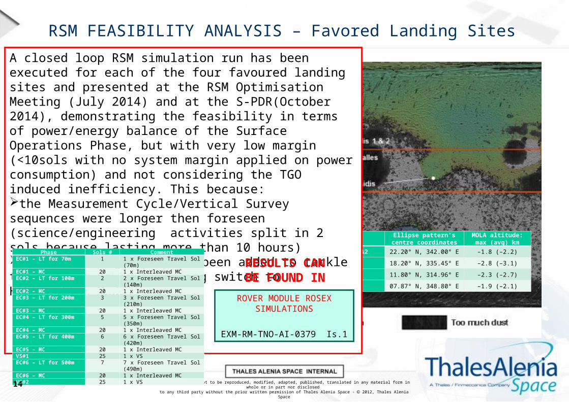
RSM FEASIBILITY ANALYSIS – Favored Landing Sites
LS NameEllipse pattern's centre
coordinatesMOLA altitude:
max (avg) km
Mawrth Vallis 1&2 22.20° N, 342.00° E –1.8 (–2.2)
Oxia Planum 1 18.20° N, 335.45° E –2.8 (–3.1)
Hypanis Vallis 11.80° N, 314.96° E –2.3 (–2.7)
Oxia Palus 07.87° N, 348.80° E –1.9 (–2.1)
A closed loop RSM simulation run has been executed for each of the four favoured landing sites and presented at the RSM Optimisation Meeting (July 2014) and at the S-PDR(October 2014), demonstrating the feasibility in terms of power/energy balance of the Surface Operations Phase, but with very low margin (<10sols with no system margin applied on power consumption) and not considering the TGO induced inefficiency. This because:the Measurement Cycle/Vertical Survey sequences were longer then foreseen (science/engineering activities split in 2 sols because lasting more than 10 hours)several Dozing sols have been added to tackle the lack of power (avoiding switch to Hibernation Mode)
Phase Sols # CommentEC#1 – LT for 70m 1 1 x Foreseen Travel Sol (70m)EC#1 – MC 20 1 x Interleaved MCEC#2 – LT for 100m 2 2 x Foreseen Travel Sol (140m)EC#2 – MC 20 1 x Interleaved MCEC#3 – LT for 200m 3 3 x Foreseen Travel Sol (210m)EC#3 – MC 20 1 x Interleaved MCEC#4 – LT for 300m 5 5 x Foreseen Travel Sol (350m)EC#4 – MC 20 1 x Interleaved MCEC#5 – LT for 400m 6 6 x Foreseen Travel Sol (420m)EC#5 – MC 20 1 x Interleaved MCVS#1 25 1 x VSEC#6 – LT for 500m 7 7 x Foreseen Travel Sol (490m)EC#6 – MC 20 1 x Interleaved MCVS#2 25 1 x VS
ROVER MODULE ROSEX SIMULATIONS
EXM-RM-TNO-AI-0379 Is.1
RESULTS CAN BE FOUND IN
14
This document is not to be reproduced, modified, adapted, published, translated in any material form in whole or in part nor disclosed to any third party without the prior written permission of Thales Alenia Space - 2012, Thales Alenia Space
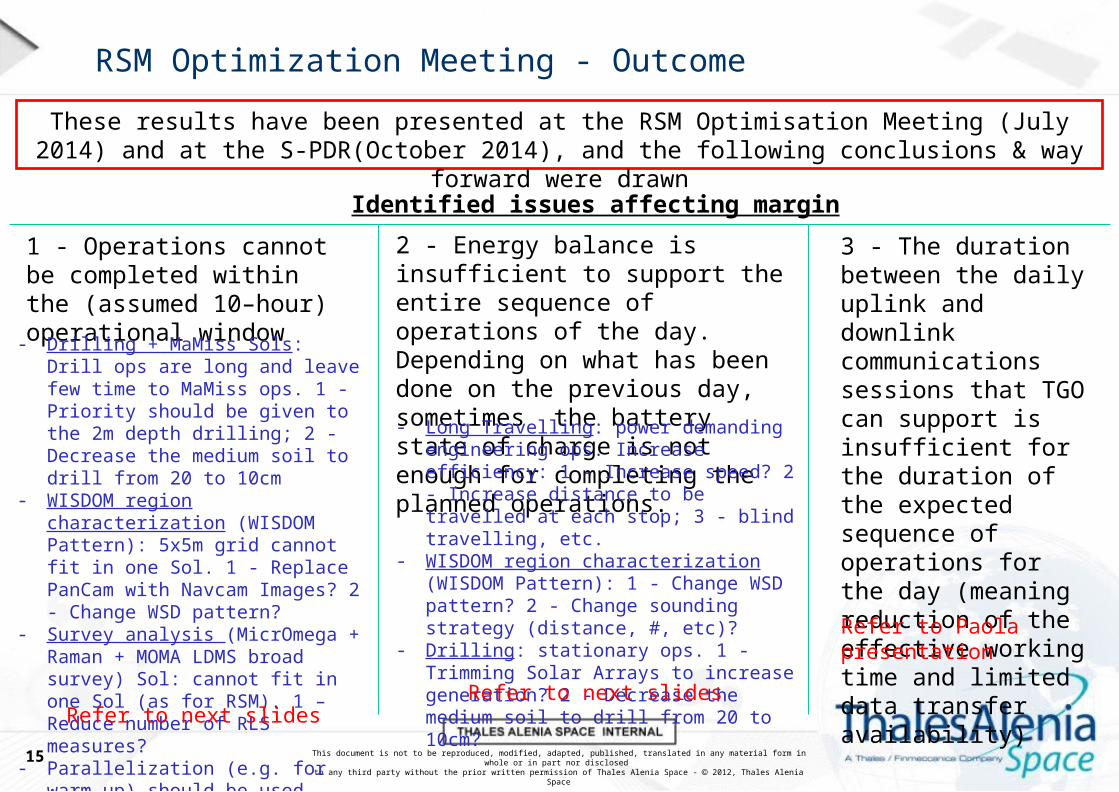
RSM Optimization Meeting - Outcome
These results have been presented at the RSM Optimisation Meeting (July 2014) and at the S-PDR(October 2014), and the following conclusions & way forward were drawn
15
Identified issues affecting margin
1 - Operations cannot be completed within the (assumed 10–hour) operational window
3 - The duration between the daily uplink and downlink communications sessions that TGO can support is insufficient for the duration of the expected sequence of operations for the day (meaning reduction of the effective working time and limited data transfer availability)
2 - Energy balance is insufficient to support the entire sequence of operations of the day. Depending on what has been done on the previous day, sometimes the battery state of charge is not enough for completing the planned operations.
Refer to Paola presentation
- Drilling + MaMiss Sols: Drill ops are long and leave few time to MaMiss ops. 1 - Priority should be given to the 2m depth drilling; 2 - Decrease the medium soil to drill from 20 to 10cm
- WISDOM region characterization (WISDOM Pattern): 5x5m grid cannot fit in one Sol. 1 - Replace PanCam with Navcam Images? 2 - Change WSD pattern?
- Survey analysis (MicrOmega + Raman + MOMA LDMS broad survey) Sol: cannot fit in one Sol (as for RSM). 1 – Reduce number of RLS measures?
- Parallelization (e.g. for warm-up) should be used whenever possible
Refer to next slides
- Long Travelling: power demanding engineering ops. Increase efficiency: 1 - Increase speed? 2 - Increase distance to be travelled at each stop; 3 - blind travelling, etc.
- WISDOM region characterization (WISDOM Pattern): 1 - Change WSD pattern? 2 - Change sounding strategy (distance, #, etc)?
- Drilling: stationary ops. 1 - Trimming Solar Arrays to increase generation? 2 - Decrease the medium soil to drill from 20 to 10cm?
Refer to next slides

This document is not to be reproduced, modified, adapted, published, translated in any material form in whole or in part nor disclosed to any third party without the prior written permission of Thales Alenia Space - 2012, Thales Alenia Space
RSM Optimisation: Drilling + MaMiss
RSM OPTIMISATION- Drilling + MaMiss -
RSM OPTIMISATION- Drilling + MaMiss -
16

This document is not to be reproduced, modified, adapted, published, translated in any material form in whole or in part nor disclosed to any third party without the prior written permission of Thales Alenia Space - 2012, Thales Alenia Space
RSM Measurement Cycle Sol #8: Requirement
17

This document is not to be reproduced, modified, adapted, published, translated in any material form in whole or in part nor disclosed to any third party without the prior written permission of Thales Alenia Space - 2012, Thales Alenia Space
RSM Measurement Cycle Sol #8: Clean run without MaMiss
18
Activity / State
Duration
Start Time
End Time
RAPDL Input FileOps Duration excluding Comms [hh:mm:ss] 03:10:27
Global Energy w/o 20% System Margin [Wh] 799.7
Nominal Night 00:00:00
8 hours 0 minutes 08:00:00
RV_WakeUp + Comms 08:00:00
0 hours 30 minutes 08:30:00
Warm-Up Mobility SS 08:30:00
0 hours 30 minutes 09:00:00
AbsLoc + Move 5m for Drill Placement
09:00:00
1 hours 22 minutes 10:21:37
Warmup, Deploy and Move Drill to Drilling Position
10:21:37
0 hours 23 minutes 10:44:21
Drill in Loose Soil for 500mm (30mm/min)
10:44:21
0 hours 16 minutes 11:00:40
Retract of 500mm (50mm/ min) and retract rod
11:00:40
0 hours 17 minutes 11:17:05
CLUPI Colour Image of the Drill Fines
11:17:05
0 hours 07 minutes 11:23:48
10 x WAC RRGB 11:23:48
0 hours 17 minutes 11:40:27
Dozing 11:40:27
6 hours 20 minutes 18:00:00
Comms + Prepare4Night 18:00:00
0 hours 30 minutes 18:30:00
Nominal Night 18:30:00
5 hours 30 minutes 24:00:00

This document is not to be reproduced, modified, adapted, published, translated in any material form in whole or in part nor disclosed to any third party without the prior written permission of Thales Alenia Space - 2012, Thales Alenia Space
RSM Measurement Cycle Sol #8: Considerations & Science
19
Time currently left to MaMiss science [hh:mm:ss] 06:19:33
Executable MaMiss Tasks (Operational Procedures)(from EXM-MA-PLN-SES-0011 Is.2d 26/11/2014)
MaMiss_Calibration 00:13:30
MaMiss_Ring_Max_Resolution(631points) 00:43:59MaMiss_Ring_High_Resolution(315points) 00:27:36MaMiss_Ring_Low_Resolution(63points) 00:14:32
MaMiss_Column_High_Resolution(2mm step) 03:45:56MaMiss_Column_Low_Resolution(10mm step) 01:45:37
Ops Duration
RSM Request
2 x MaMiss_Calibration5 x MaMiss_Ring_High_Resolution(315points)1 x MaMiss_Column_Low_Resolution(10mm step)
Total MaMiss Ops Time: 04:30:37
OK

This document is not to be reproduced, modified, adapted, published, translated in any material form in whole or in part nor disclosed to any third party without the prior written permission of Thales Alenia Space - 2012, Thales Alenia Space
RSM Measurement Cycle Sol #9: Requirement
20
This document is not to be reproduced, modified, adapted, published, translated in any material form in whole or in part nor disclosed to any third party without the prior written permission of Thales Alenia Space - 2012, Thales Alenia Space
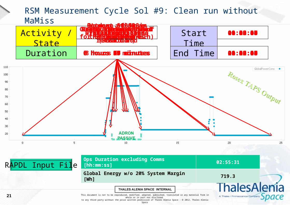
RSM Measurement Cycle Sol #9: Clean run without MaMiss
21
Activity / State
Duration
Start Time
End Time
RAPDL Input FileOps Duration excluding Comms [hh:mm:ss] 02:55:31
Global Energy w/o 20% System Margin [Wh] 719.3
Nominal Night 00:00:00
8 hours 0 minutes 08:00:00
RV_WakeUp + Comms 08:00:00
0 hours 30 minutes 08:30:00
Warmup and Move Drill to Drilling Position
08:30:00
0 hours 17 minutes 08:46:34
Go down 500mm in existing hole (50mm/min)
08:46:34
0 hours 10 minutes 08:56:34
Mount Extension Rod #1 08:56:34
0 hours 50 minutes 09:46:14
Drill in Loose Soil for 500mm (30mm/min)
09:46:14
0 hours 17 minutes 10:02:33
Retract of 500mm (50mm/min)
0 hours 10 minutes
10:02:33
10:12:33
Unmount Extension Rod #1 10:12:33
0 hours 50 minutes 11:02:18
Retract of 500mm (50mm/ min) and retract rod
11:02:18
0 hours 17 minutes 11:18:47
CLUPI Color Image of the Drill Fines
11:18:47
0 hours 07 minutes 11:25:31
Dozing 11:25:31
6 hours 34 minutes 18:00:00
Comms + Prepare4Night 18:00:00
0 hours 30 minutes 18:30:00
Nominal Night 18:30:00
5 hours 30 minutes 24:00:00

This document is not to be reproduced, modified, adapted, published, translated in any material form in whole or in part nor disclosed to any third party without the prior written permission of Thales Alenia Space - 2012, Thales Alenia Space
RSM Measurement Cycle Sol #9: Considerations & Science
22
Time currently left to MaMiss science [hh:mm:ss] 06:34:29
Executable MaMiss Tasks (Operational Procedures)(from EXM-MA-PLN-SES-0011 Is.2d 26/11/2014)
MaMiss_Calibration 00:13:30
MaMiss_Ring_Max_Resolution(631points) 00:43:59MaMiss_Ring_High_Resolution(315points) 00:27:36MaMiss_Ring_Low_Resolution(63points) 00:14:32
MaMiss_Column_High_Resolution(2mm step) 03:45:56MaMiss_Column_Low_Resolution(10mm step) 01:45:37
Ops Duration
RSM Request
2 x MaMiss_Calibration5 x MaMiss_Ring_High_Resolution(315points)1 x MaMiss_Column_Low_Resolution(10mm step)
Total MaMiss Ops Time: 04:30:37
OK

This document is not to be reproduced, modified, adapted, published, translated in any material form in whole or in part nor disclosed to any third party without the prior written permission of Thales Alenia Space - 2012, Thales Alenia Space
RSM Measurement Cycle Sol #10: Requirement
23

This document is not to be reproduced, modified, adapted, published, translated in any material form in whole or in part nor disclosed to any third party without the prior written permission of Thales Alenia Space - 2012, Thales Alenia Space
RSM Measurement Cycle Sol #10: Clean run without MaMiss
24
Activity / State
Duration
Start Time
End Time
RAPDL Input FileOps Duration excluding Comms [hh:mm:ss] 08:16:14
Global Energy w/o 20% System Margin [Wh] 1103.1
Nominal Night 00:00:00
8 hours 0 minutes 08:00:00
RV_WakeUp + Comms 08:00:00
0 hours 30 minutes 08:30:00
Warmup and Move Drill to Drilling Position
08:30:00
0 hours 17 minutes 08:46:34
Go down 500mm in existing hole (50mm/min)
08:46:34
0 hours 10 minutes 08:56:34
Mount Extension Rod #1 08:56:34
0 hours 50 minutes 09:46:14
Go down 500mm in existing hole (50mm/min)
09:46:14
0 hours 10 minutes 09:56:14
Mount Extension Rod #2 09:56:14
0 hours 50 minutes 10:46:07
Drill in Loose Soil for 400mm (30mm/min)
10:46:07
0 hours 13 minutes 10:59:08
Drill in Medium Soil for 100mm (1mm/min)
10:59:08
1 hours 37 minutes 12:36:10
Collect Sample in Medium Soil (coring)
12:36:10
0 hours 38 minutes 13:14:15
Retract of 500mm (50mm/min)
13:14:15
0 hours 10 minutes 13:24:15
Unmount Extension Rod #2 13:24:15
0 hours 50 minutes 14:14:14
Retract of 500mm (50mm/min)
14:14:14
0 hours 10 minutes 14:24:14
Unmount Extension Rod #1 14:24:14
0 hours 50 minutes 15:14:03
Retract of 500mm (50mm/ min) and retract rod
15:14:03
0 hours 17 minutes 15:30:36
CLUPI Color Image of the Drill Fines
15:30:36
0 hours 07 minutes 15:37:11
Move to Sample deliv. pos., open CSTM, warmup PTU
15:37:11
0 hours 39 minutes 16:16:54
CSTM Image with HRC and Sample Release
16:16:54
0 hours 12 minutes 16:28:49
Image with HRC/CLUPI and CSTM closure
16:28:49
0 hours 12 minutes 16:40:15
Park Drill and move RM to dozing configuration
16:40:15
0 hours 06 minutes 16:46:14
Dozing 16:46:14
1 hours 14 minutes 18:00:00
Comms + Prepare4Night 18:00:00
0 hours 30 minutes 18:30:00
Nominal Night 18:30:00
5 hours 30 minutes 24:00:00

This document is not to be reproduced, modified, adapted, published, translated in any material form in whole or in part nor disclosed to any third party without the prior written permission of Thales Alenia Space - 2012, Thales Alenia Space
RSM Measurement Cycle Sol #10: Considerations & Science
25
Time currently left to MaMiss science [hh:mm:ss] 01:13:46
Executable MaMiss Tasks (Operational Procedures)(from EXM-MA-PLN-SES-0011 Is.2d 26/11/2014)
MaMiss_Calibration 00:13:30
MaMiss_Ring_Max_Resolution(631points) 00:43:59MaMiss_Ring_High_Resolution(315points) 00:27:36MaMiss_Ring_Low_Resolution(63points) 00:14:32
MaMiss_Column_High_Resolution(2mm step) 03:45:56MaMiss_Column_Low_Resolution(10mm step) 01:45:37
Ops Duration
RSM Request
2 x MaMiss_Calibration5 x MaMiss_Ring_High_Resolution(315points)1 x MaMiss_Column_Low_Resolution(10mm step)
Total MaMiss Ops Time: 04:30:37
KO

This document is not to be reproduced, modified, adapted, published, translated in any material form in whole or in part nor disclosed to any third party without the prior written permission of Thales Alenia Space - 2012, Thales Alenia Space
Vertical Survey: Considerations & Science
26
Take sample at 0.5m depth and deliver to CSTM (assuming 400mm loose soil and 100mm in medium soil, coring in medium soil)
Take sample at 1.0m depth and deliver to CSTM (assuming 500mm insertion in previous hole, 400mm loose soil and 100mm in medium soil, coring in medium soil)
Take sample at 2.0m depth and deliver to CSTM (assuming 1500mm insertion in previous hole, 400mm loose soil and 100mm in medium soil, coring in medium soil)
Take sample at 1.5m depth and deliver to CSTM (assuming 1000mm insertion in previous hole, 400mm loose soil and 100mm in medium soil, coring in medium soil)
VS: Drilling Sol #1 VS: Drilling Sol #3
VS: Drilling Sol #2 VS: Drilling Sol #4
Ops Duration (no MaMiss): 04:10:00
Time left to MaMiss science: 05:20:00OK
Ops Duration (no MaMiss): 08:10:00
Time left to MaMiss science: 01:20:00KO
Ops Duration (no MaMiss): 06:10:00
Time left to MaMiss science: 03:20:00Reduced
Ops Duration (no MaMiss): 10:10:00
Time left to MaMiss science: 00:00:00KO

This document is not to be reproduced, modified, adapted, published, translated in any material form in whole or in part nor disclosed to any third party without the prior written permission of Thales Alenia Space - 2012, Thales Alenia Space
RSM Optimisation: Drilling + MaMiss
Discussion & Way Forward
-MaMiss can sometimes be unusable due to the type of terrain and/or drilling depth. This will be decided onboard thanks to the MMS validation + replanning strategy. Priority will be given to
the Drilling Operation.
- In case of shortage of time/energy, which are the most important MaMiss Tasks to keep in the sequence? Is it better to
compromise resolution or reduce the number of measures? Which is the minimum set of representative measures?
27
This document is not to be reproduced, modified, adapted, published, translated in any material form in whole or in part nor disclosed to any third party without the prior written permission of Thales Alenia Space - 2012, Thales Alenia Space
RSM Optimisation: WISDOM region characterization
RSM OPTIMISATION- WISDOM region characterization -
RSM OPTIMISATION- WISDOM region characterization -
28

This document is not to be reproduced, modified, adapted, published, translated in any material form in whole or in part nor disclosed to any third party without the prior written permission of Thales Alenia Space - 2012, Thales Alenia Space
RSM Measurement Cycle Sol #7: Requirement
29

This document is not to be reproduced, modified, adapted, published, translated in any material form in whole or in part nor disclosed to any third party without the prior written permission of Thales Alenia Space - 2012, Thales Alenia Space
RSM Measurement Cycle Sol #7: Current Implem. 5mx5m 2 Sols
30
5m
5m
1m2 POINT TURNSNumber of 90deg Point Turns: 10Time to perform 90deg Point Turn: 180sTime to perform all Point Turns: 1800s
WAC RR ImagesNumber of WAC RR Images: 7Time to perform a WAC RR Image: 315sTime to perform all WAC RR Images: 2205s
WISDOM Full Soundings (EXM-WI-BDG-LAT-0140 1.4)
Number of WAC RR Images: 306Stop for a Full Sounding duration: 47sTime to perform all Point Turns: 14382s
30m “WISDOM Active” Path + 5m “WISDOM Passive” Path to cover the 5mx5m Region, performing Path Checking stop every 2.3m and WISDOM Full soundings every 10cm.
Active & Passive WISDOM lines strategyNumber of 2.3m Navigation Cycles: 14Perception and Path checking @each stop: 279sTravelling for 2.3m Active at 9.6m/h: 862sTravelling for 5m Passive at 32m/h: 562sTime to perform all Point Turns: 16536s
Start Sol_2
TOTAL OPS DURATION
(assuming all equipment ready and
warmed up):
9 hour 45min
TOTAL AVAILABLE TIME
(excluding comms & preparatory
activities):
8 hour 15min
XX
This document is not to be reproduced, modified, adapted, published, translated in any material form in whole or in part nor disclosed to any third party without the prior written permission of Thales Alenia Space - 2012, Thales Alenia Space
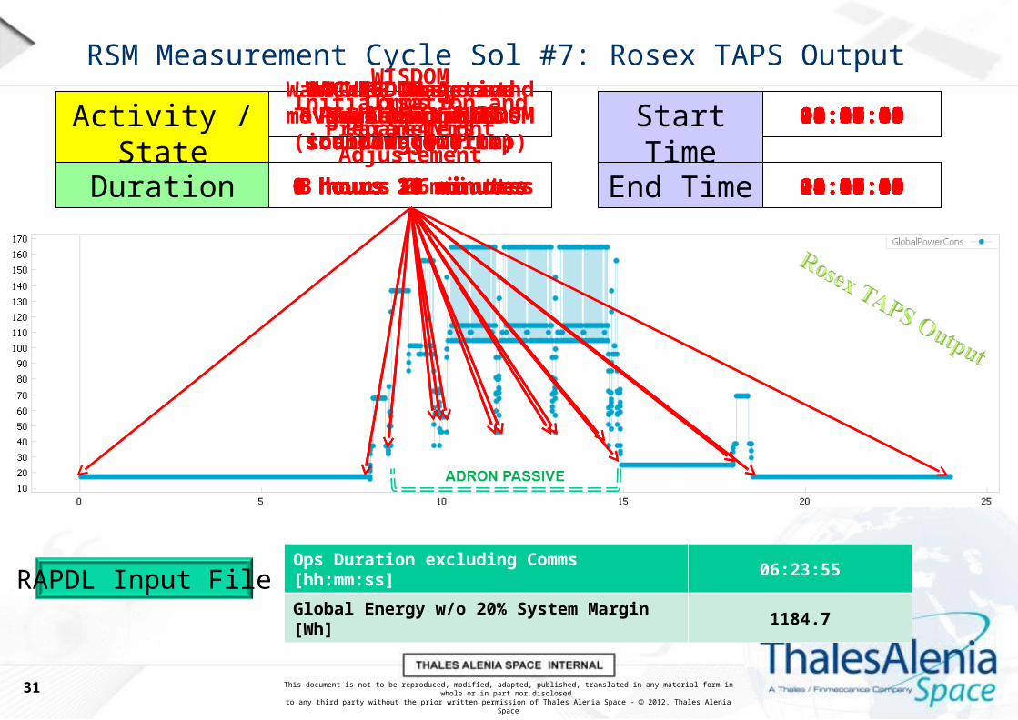
RSM Measurement Cycle Sol #7: Rosex TAPS Output
31
Activity / State
Duration
Start Time
End Time
RAPDL Input FileOps Duration excluding Comms [hh:mm:ss] 06:23:55
Global Energy w/o 20% System Margin [Wh] 1184.7
Nominal Night 00:00:00
8 hours 0 minutes 08:00:00
RV_WakeUp + Comms 08:00:00
0 hours 30 minutes 08:30:00
Warm-up, AbsLoc and 5m Autonav to candidate site
08:30:00
1 hours 16 minutes 09:45:33
WAC RR Image at begin of path (including warmup)
09:45:33
0 hours 10 minutes 09:55:00
WISDOM Initialisation and Parameters Adjustement
09:55:00
0 hours 12 minutes 10:06:44
1# WISDOM Active Path (5m, full sounding @ 0.1m)
10:06:44
1 hours 20 minutes 11:27:09
WAC RR Image and move to next WISDOM row (1m)
11:27:09
0 hours 14 minutes 11:41:53
2# WISDOM Active Path (5m, full sounding @ 0.1m)
11:41:53
1 hours 19 minutes 13:00:19
WAC RR Image and move to next WISDOM row (1m)
13:00:19
0 hours 14 minutes 13:14:40
3# WISDOM Active Path (5m, full sounding @ 0.1m)
13:14:40
1 hours 19 minutes 14:33:05
WAC RR Image and move to next WISDOM row (1m)
14:33:05
0 hours 20 minutes 14:53:55
Dozing 14:53:55
3 hours 06 minutes 18:00:00
Comms + Prepare4Night 18:00:00
0 hours 30 minutes 18:30:00
Nominal Night 18:30:00
5 hours 30 minutes 24:00:00

This document is not to be reproduced, modified, adapted, published, translated in any material form in whole or in part nor disclosed to any third party without the prior written permission of Thales Alenia Space - 2012, Thales Alenia Space
RSM Measurement Cycle Sol #7: Proposal “square spiral”
32
4m
5m
1m2 POINT TURNSNumber of 90deg Point Turns: 9Time to perform 90deg Point Turn: 180sTime to perform all Point Turns: 1620s
WAC RR ImagesNumber of WAC RR Images: 6Time to perform a WAC RR Image: 315sTime to perform all WAC RR Images: 1890s
WISDOM Full Soundings (EXM-WI-BDG-LAT-0140 1.4)
Number of WAC RR Images: 291Stop for a Full Sounding duration: 47sTime to perform all Point Turns: 13677s
29m “WISDOM Active” Path length to cover the 4mx5m Region, performing Path Checking stop every 2.3m and WISDOM Full soundings every 10cm.
“Active WISDOM” lines strategyNumber of 2.3m Navigation Cycles: 13Perception and Path checking @each stop: 279sTravelling for 2.3m at 9.6m/h: 862sTime to perform all Point Turns: 14833s
TOTAL OPS DURATION
(assuming all equipment ready and
warmed up):
8 hour 55min
TOTAL AVAILABLE TIME
(excluding comms & preparatory
activities):
8 hour 15min
XX

This document is not to be reproduced, modified, adapted, published, translated in any material form in whole or in part nor disclosed to any third party without the prior written permission of Thales Alenia Space - 2012, Thales Alenia Space
RSM Measurement Cycle Sol #7: Proposal “Archimedean Spiral”
33
5m
5m
1m2
WAC RR ImagesNumber of WAC RR Images: 4Time to perform a WAC RR Image: 315sTime to perform all WAC RR Images: 1260s
WISDOM Full Soundings (EXM-WI-BDG-LAT-0140 1.4)
Number of WAC RR Images: 287Stop for a Full Sounding duration: 47sTime to perform all Point Turns: 13489s
28.6m “WISDOM Active” Path length to cover the Region, performing Path Checking stop every 2.3m and WISDOM Full soundings every 10cm.
“Active WISDOM” lines strategyNumber of 2.3m Navigation Cycles: 13Perception and Path checking @each stop: 279sTravelling for 2.3m at 9.6m/h: 862sTime to perform all Point Turns: 14833s
1m
1m
1m 1m
1m
TOTAL OPS DURATION
(assuming all equipment ready and
warmed up):
8 hour 15min
TOTAL AVAILABLE TIME
(excluding comms & preparatory
activities):
8 hour 15min
√√

This document is not to be reproduced, modified, adapted, published, translated in any material form in whole or in part nor disclosed to any third party without the prior written permission of Thales Alenia Space - 2012, Thales Alenia Space
RSM Optimisation: WISDOM region characterization
Discussion & Way Forward-WISDOM region characterization as foreseen by the RSM is not possible in one
Sol.
-An alternative Solution is provided to keep the Sounding Type (Full Polarimetric) and distance (10cm). This solution is “incremental”, meaning that if time/energy will
be available the RM will keep mapping until possible, increasing the spiral length and area coverage. This will be decided onboard thanks to the MMS validation +
replanning strategy.
-Other solutions may be discussed but lead to compromise the type of measure or path safety: Less soundings per spot? More distance between spots? Decrease
control accuracy (-> increase RV speed)? Remove path checking?
34

This document is not to be reproduced, modified, adapted, published, translated in any material form in whole or in part nor disclosed to any third party without the prior written permission of Thales Alenia Space - 2012, Thales Alenia Space
RSM Optimisation: Long Travelling
RSM OPTIMISATION- Long Travelling-
RSM OPTIMISATION- Long Travelling-
35

This document is not to be reproduced, modified, adapted, published, translated in any material form in whole or in part nor disclosed to any third party without the prior written permission of Thales Alenia Space - 2012, Thales Alenia Space
RSM Optimisation: Long Travelling Definition
Extract from MOCD EXM-RM-DRP-AI-0014 issue 6
TBC
TBC
In the RSM Long Travelling sequences are expected as follows:About 60m from landing siteAbout 50m to MC#1About 100m to MC#2About 200m to MC#3About 300m to MC#4About 400m to MC#5 & VS#1About 500m to MC#6 & VS#2
Expected travel per day is a requirement (debated between 70 and 100 meters) as it depends on several parameters: Ls, Latitude, Elapsed time, …
This document is not to be reproduced, modified, adapted, published, translated in any material form in whole or in part nor disclosed to any third party without the prior written permission of Thales Alenia Space - 2012, Thales Alenia Space
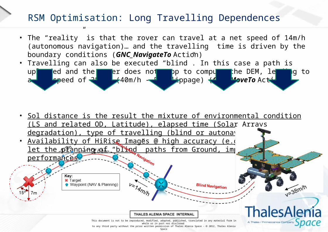
RSM Optimisation: Long Travelling Dependences
• The “reality” is that the rover can travel at a net speed of 14m/h (autonomous navigation)… and the travelling time is driven by the boundary conditions (GNC_NavigateTo Action)
• Travelling can also be executed “blind”. In this case a path is uploaded and the rover does not stop to compute the DEM, leading to a net speed of 38m/h (40m/h - 5% slippage) (GNC_MoveTo Action)
• Sol distance is the result the mixture of environmental condition (LS and related OD, Latitude), elapsed time (Solar Arrays degradation), type of travelling (blind or autonav).
• Availability of HiRise Images @ high accuracy (e.g. 25cm pixel) will let the planning of “blind” paths from Ground, improving the LT performances

This document is not to be reproduced, modified, adapted, published, translated in any material form in whole or in part nor disclosed to any third party without the prior written permission of Thales Alenia Space - 2012, Thales Alenia Space
RSM Measurement Cycle Sol #14-17: Requirement
38
This document is not to be reproduced, modified, adapted, published, translated in any material form in whole or in part nor disclosed to any third party without the prior written permission of Thales Alenia Space - 2012, Thales Alenia Space
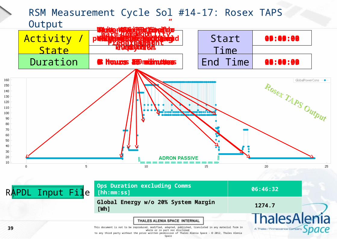
RSM Measurement Cycle Sol #14-17: Rosex TAPS Output
39
Activity / State
Duration
Start Time
End Time
RAPDL Input FileOps Duration excluding Comms [hh:mm:ss] 06:46:32
Global Energy w/o 20% System Margin [Wh] 1274.7
Nominal Night 00:00:00
8 hours 0 minutes 08:00:00
RV_WakeUp + Comms 08:00:00
0 hours 30 minutes 08:30:00
Wait 45minutes for power generation and Thrm. Env.
08:30:00
0 hours 45 minutes 09:15:00
Warm-up Mobility equipment
09:15:00
0 hours 30 minutes 09:45:00
Move 40m “blind”, with WSD sounding every 10m
09:45:00
1 hours 15 minutes 11:00:35
Autonav 60m, with WSD sounding every 10m
11:00:35
4 hours 46 minutes 15:46:39
11 x WAC RR Stereo to select next sol path
15:46:39
0 hours 15 minutes 16:01:32
Dozing 16:01:32
1 hours 59 minutes 18:00:00
Comms + Prepare4Night 18:00:00
0 hours 30 minutes 18:30:00
Nominal Night 18:30:00
5 hours 30 minutes 24:00:00

This document is not to be reproduced, modified, adapted, published, translated in any material form in whole or in part nor disclosed to any third party without the prior written permission of Thales Alenia Space - 2012, Thales Alenia Space
RSM Optimisation: Long Travelling
Discussion & Way Forward-Availability of HiRise Images @ high accuracy (e.g. 25cm pixel) + PanCam Images at the end of the path will let the planning of “blind” paths from Ground, improving
the LT performances
-Other engineering solutions are currently not supported by the RV design: - Increase the speed when extra power is available; - Increase the distance executed
between each autonomous navigation path planning (depending on the nature of the terrain to be traversed)
-Solar Array trimming functionality is currently under discussion. However the expected gain is very low (<7% per Sol)
40

This document is not to be reproduced, modified, adapted, published, translated in any material form in whole or in part nor disclosed to any third party without the prior written permission of Thales Alenia Space - 2012, Thales Alenia Space
RSM Optimisation: Survey Analysis
RSM OPTIMISATION- Survey Analysis-
RSM OPTIMISATION- Survey Analysis-
41

This document is not to be reproduced, modified, adapted, published, translated in any material form in whole or in part nor disclosed to any third party without the prior written permission of Thales Alenia Space - 2012, Thales Alenia Space
RSM Measurement Cycle Sol #4: Requirement
42

This document is not to be reproduced, modified, adapted, published, translated in any material form in whole or in part nor disclosed to any third party without the prior written permission of Thales Alenia Space - 2012, Thales Alenia Space
RSM Measurement Cycle Sol #4: Rosex TAPS Output
43
Activity / State
Duration
Start Time
End Time
RAPDL Input FileOps Duration excluding Comms [hh:mm:ss] 03:31:00
Global Energy w/o 20% System Margin [Wh] 820.1
Nominal Night 00:00:00
8 hours 0 minutes 08:00:00
RV_WakeUp + Comms 08:00:00
0 hours 30 minutes 08:30:00
Warm-up Mobility SS and Move over the outcrop
08:30:00
1 hours 28 minutes 09:58:11
Warm-up & deploy Drill. Image with CLUPI.
09:58:11
0 hours 24 minutes 10:21:51
Collect Sample in Medium Soil (coring)
10:21:51
0 hours 53 minutes 11:14:20
CLUPI Color Image of the Drill Fines
11:14:20
0 hours 07 minutes 11:21:03
Move to Sample deliv. pos., open CSTM
11:21:03
0 hours 19 minutes 11:39:23
Sample Release & Image with HRC and CLUPI
11:39:23
0 hours 13 minutes 11:51:53
CSTM closure & Park Drill 11:51:53
0 hours 10 minutes 12:01:00
Dozing 12:01:00
5 hours 59 minutes 18:00:00
Comms + Prepare4Night 18:00:00
0 hours 30 minutes 18:30:00
Nominal Night 18:30:00
5 hours 30 minutes 24:00:00

This document is not to be reproduced, modified, adapted, published, translated in any material form in whole or in part nor disclosed to any third party without the prior written permission of Thales Alenia Space - 2012, Thales Alenia Space
RSM Measurement Cycle Sol #4: Considerations & Science
44
Time currently left to RLS Calibration [hh:mm:ss] 05:59:00Executable RAMAN Operational Procedures
(from RLS-INT-RP-050 Is.1.1 16/07/2014)
OK

This document is not to be reproduced, modified, adapted, published, translated in any material form in whole or in part nor disclosed to any third party without the prior written permission of Thales Alenia Space - 2012, Thales Alenia Space
RSM Measurement Cycle Sol #5: Requirement
45

This document is not to be reproduced, modified, adapted, published, translated in any material form in whole or in part nor disclosed to any third party without the prior written permission of Thales Alenia Space - 2012, Thales Alenia Space
RSM Measurement Cycle Sol #5: Rosex TAPS Output 1st
46
Activity / State
Duration
Start Time
End Time
RAPDL Input FileOps Duration excluding Comms [hh:mm:ss] 08:21:48
Global Energy w/o 20% System Margin [Wh] 959.4
Nominal Night 00:00:00
8 hours 0 minutes 08:00:00
RV_WakeUp + Comms 08:00:00
0 hours 30 minutes 08:30:00
Crush, Dose, Flatten and bring Sample to MMega
08:30:00
2 hours 02 minutes 10:31:43
2 x MicrOmega Spectral Cubes + PSHS movement
10:31:43
0 hours 30 minutes 11:01:04
20 x RAMAN spectra + PSHS movements
11:01:04
5 hours 50 minutes 16:51:39
Dozing 16:51:39
1 hours 09 minutes 18:00:00
Comms + Prepare4Night 18:00:00
0 hours 30 minutes 18:30:00
Nominal Night 18:30:00
5 hours 30 minutes 24:00:00
This document is not to be reproduced, modified, adapted, published, translated in any material form in whole or in part nor disclosed to any third party without the prior written permission of Thales Alenia Space - 2012, Thales Alenia Space
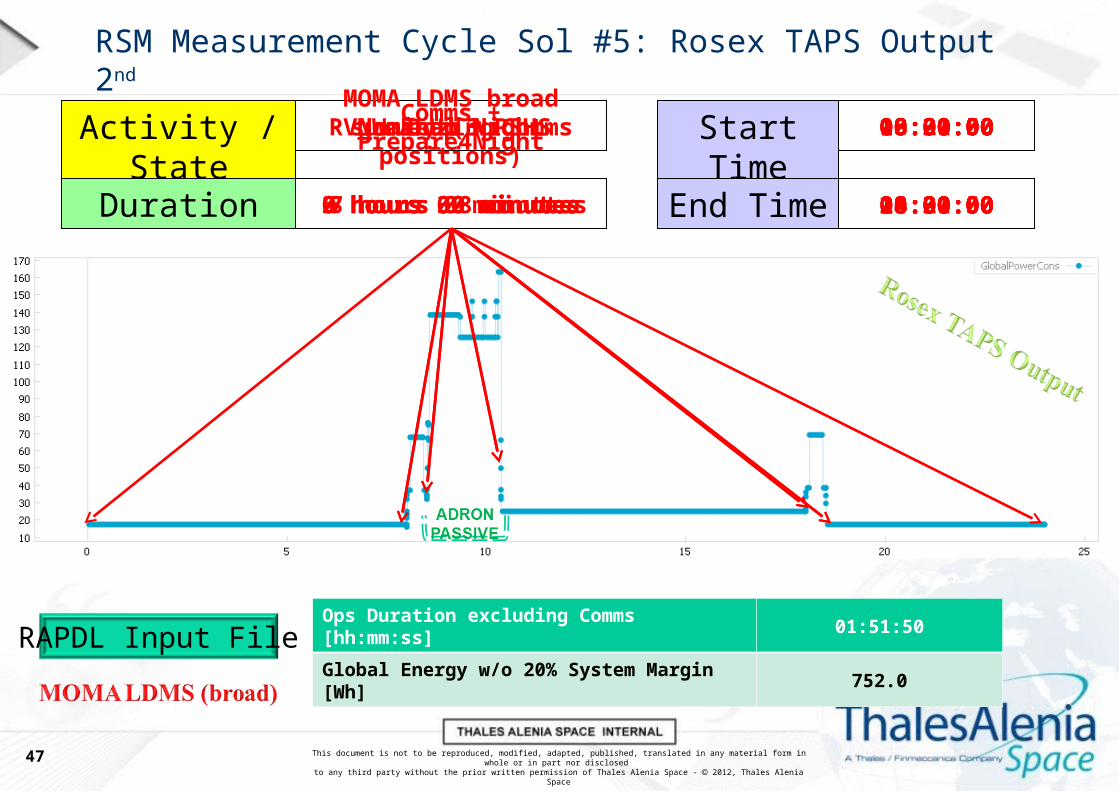
RSM Measurement Cycle Sol #5: Rosex TAPS Output 2nd
47
Activity / State
Duration
Start Time
End Time
RAPDL Input FileOps Duration excluding Comms [hh:mm:ss] 01:51:50
Global Energy w/o 20% System Margin [Wh] 752.0
Nominal Night 00:00:00
8 hours 0 minutes 08:00:00
RV_WakeUp + Comms 08:00:00
0 hours 30 minutes 08:30:00
MOMA LDMS broad survey (3 PSHS positions)
08:30:00
2 hours 02 minutes 10:21:50
Dozing 10:21:50
7 hours 38 minutes 18:00:00
Comms + Prepare4Night 18:00:00
0 hours 30 minutes 18:30:00
Nominal Night 18:30:00
5 hours 30 minutes 24:00:00

This document is not to be reproduced, modified, adapted, published, translated in any material form in whole or in part nor disclosed to any third party without the prior written permission of Thales Alenia Space - 2012, Thales Alenia Space
RSM Measurement Cycle Sol #5: Considerations & Science
48
2h 00min
0h 30min
5h 50min
2h 00min
TOTAL OPS DURATION
(without communication):
10 hour 20 min XX
This document is not to be reproduced, modified, adapted, published, translated in any material form in whole or in part nor disclosed to any third party without the prior written permission of Thales Alenia Space - 2012, Thales Alenia Space
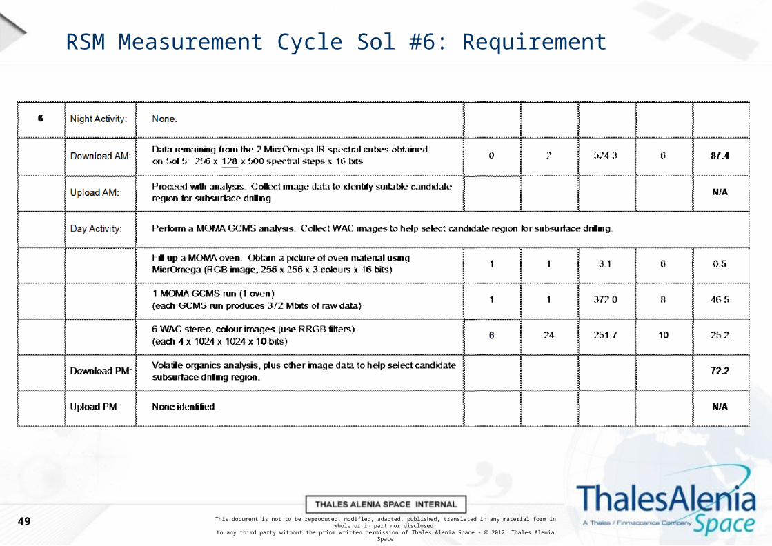
RSM Measurement Cycle Sol #6: Requirement
49

This document is not to be reproduced, modified, adapted, published, translated in any material form in whole or in part nor disclosed to any third party without the prior written permission of Thales Alenia Space - 2012, Thales Alenia Space
RSM Measurement Cycle Sol #6: Rosex TAPS Output
50
Activity / State
Duration
Start Time
End Time
RAPDL Input FileOps Duration excluding Comms [hh:mm:ss] 04:35:26
Global Energy w/o 20% System Margin [Wh] 1005.3
Nominal Night 00:00:00
8 hours 0 minutes 08:00:00
RV_WakeUp + Comms 08:00:00
0 hours 30 minutes 08:30:00
Fill MOMA oven and analyze with MMega
08:30:00
0 hours 26 minutes 08:55:24
Tap MOMA Oven and present to MOMA GCMS
08:55:24
0 hours 17 minutes 09:12:05
MOMA GCMS run 09:12:05
3 hours 16 minutes 12:27:24
6xWAC RRGB to select region to map with WSD
12:27:24
0 hours 38 minutes 13:05:26
Dozing 13:05:26
4 hours 54 minutes 18:00:00
Comms + Prepare4Night 18:00:00
0 hours 30 minutes 18:30:00
Nominal Night 18:30:00
5 hours 30 minutes 24:00:00

This document is not to be reproduced, modified, adapted, published, translated in any material form in whole or in part nor disclosed to any third party without the prior written permission of Thales Alenia Space - 2012, Thales Alenia Space
RSM Optimisation: Survey Analysis
Discussion & Way Forward-RSM Measurement Cycle Sol #4: RAMAN Calibration (currently < 2h) can be performed before the surface sample acquisition, depending on the duration of Mobility & Drill warm-ups and drilling/coring ops. It can be hard to fit the RAMAN calibration for the subsurface
sample (refer to RSM Measurement Cycle Sol #10, slide 23-24-25).
-RSM Measurement Cycle Sol #5: cannot be performed in one sol. At least one hour shall be recovered to fit in one sol (RAMAN reduction from 20 to 15 spots? MOMA LDMS broad
script reduction to 1 hour?).
-RSM Measurement Cycle Sol #6: Ok as is.
-No info found related to the MMS processing needed to extract from MicrOmega the interesting spots for RAMAN and MOMA. Currently Open Loop
51