700 FIRE PREVENTION MANUAL - Montana...
131
Appendix A NORTHERN ROCKIES COORDINATING GROUP (NRCG) RESTRICTION & CLOSURE PROCEDURES
-
Upload
vuongthuan -
Category
Documents
-
view
213 -
download
0
Transcript of 700 FIRE PREVENTION MANUAL - Montana...

Appendix A
NORTHERN ROCKIES COORDINATING GROUP (NRCG)
RESTRICTION & CLOSURE PROCEDURES

NORTHERN ROCKIES COORDINATING GROUP (NRCG) RESTRICTION & CLOSURE PROCEDURES
JUNE 1, 2001 UPDATED JULY 2004 PURPOSE 1 AUTHORITY 1 AREAS 1 PROCESS FOR FIRE RESTRICTIONS 1
INITIATION 1
IMPLEMENTATION 2 RESCISSION 2 PROCESS FOR CLOSURES 2 APPENDIX 1: AUTHORITIES 3 APPENDIX 2: ROLES AND RESPONSIBILITIES 5 APPENDIX 3: AREA BOUNDARIES 6 IDAHO 6 MONTANA 7 NORTH DAKOTA 8 SOUTH DAKOTA 9 APPENDIX 4: GUIDELINES FOR IMPLEMENTING RESTRICTIONS 10 APPENDIX 5: STAGE I AND STAGE II RESTRICTIONS 11 APPENDIX 6: CLOSURE GUIDELINES 13 APPENDIX 7: DEFINITIONS 14 APPENDIX 8: STAGE II AUTHORIZED EXEMPTIONS 16 PUBLIC UTILITIES – EMERGENCY WORK ONLY 16 RAILROAD COMPANIES – EMERGENCY WORK ONLY 19
R:3/05 Appendix A -1 700 Manual

NORTHERN ROCKIES COORDINATING GROUP (NRCG) RESTRICTION & CLOSURE PROCEDURES
JUNE 1, 2001 UPDATED JULY 2004
PURPOSE The purpose of fire restrictions is to reduce the risk of human-caused fires during unusually high fire danger and/or burning conditions. Fire restrictions impose many limitations on the public, and therefore should be implemented only after all other prevention measures have been taken. These measures include, but are not limited to: increasing the number of prevention signs, public contacts, media campaigns, etc. Fire restrictions should be considered when high to extreme fire danger is predicted to persist. Other considerations are the level of human-caused fire occurrences being experienced, firefighting resources available, potential high-risk occasions (4th of July, etc.), and large fire activity occurring on a unit. Fire restrictions should be considered one of the last prevention tools to be used. Restrictions should not be considered the prevention program. Emergency closures have an extreme impact on the public and fire agencies, and are discouraged except under the most severe conditions. Closures should be implemented only in situations where the public’s safety cannot be guaranteed. Closures are not justified by fire danger alone, but should be driven by the potential for risk to life safety due to extreme fire behavior, high potential for human-caused fires, severe shortages of resources, and numerous large fires. AUTHORITY Fire restrictions and closures are invoked on state, federal, tribal trust, and private lands under federal and state laws (Appendix 1). Agency Administrators/Tribal Chairpersons are responsible for coordinating with other agencies/tribes, issuing appropriate documents, and the enforcement of restrictions and closures for those lands on which they have authority (Appendix 2). Agencies/tribes are responsible for incorporating the geographic guidelines into their appropriate policy and procedures manuals. Restrictions and closure procedures shall be uniform across individual areas and the geographic area. AREAS For the ease of implementation and coordination, the geographic area will be divided into fire restriction and closure areas (Appendix 3). Managers and Agency Administrators/Tribal Chairpersons within the area will have the flexibility to decide how much of the area needs to be placed in or out of a specific restriction stage or closure. If conditions do not warrant restrictions or closures throughout the whole area, then only that portion of the area meeting critical levels should be placed under restrictions or closures. Areas of restriction or closure must be easily recognizable by the public. PROCESS FOR FIRE RESTRICTIONS Every spring, Area Agency Administrators/Tribal Chairpersons, law enforcement personnel, fire managers, and public information personnel, will review and validate the restriction and closure plan and applicable agency/tribal documents. All press releases, description of stages, and other necessary agency/tribal documents should be available in template format before the start of the fire season. Initiation When the conditions within an area approach threshold levels, areas should begin planning the initiation of fire restrictions. These threshold levels should be determined by all wildland agencies/tribes in the area before the onset of fire season. These guidelines will become part of the Area’s Restriction and R:2/05 Appendix A - 2 700 Manual

Closure Plan (Appendix 4). The planning process for restrictions should include a public awareness campaign, keeping the media and public informed of the possibility of restrictions. The Area Restriction Coordinator, who is chosen by the Agency Administrators/Tribal Chairpersons within the area, should coordinate all restriction actions (Appendix 2). The Area Restriction Coordinator will initiate discussion with the area fire managers, and coordinate the process with the adjacent area restriction coordinators. This decision process should be started early enough so all agencies/tribes in the area have time to plan, properly distribute the restriction documents, and notify the public. When fire managers in the area reach consensus that restrictions are needed, they will inform their respective Area Agency Administrator/Tribal Chairpersons that the thresholds for implementing fire restrictions have been reached. All agencies and tribes will coordinate the restriction stages, implementation and rescissions, and timing of media releases. Implementation The Area Restriction Coordinator will coordinate approval of all agency/tribal documents. Each Agency Administrator/Tribal Chairperson will be responsible for assuring that documents are completed and signed. The documents will be based on the elements listed in Appendix 5. The Area Restriction Coordinator will coordinate public notification. Each Area’s Restriction and Closure Plan will include a media communications process. When implemented, the restriction media release must be clear, concise, and understandable to the public. Each agency/tribe will post signs and notifications, according to their procedures and regulations, to inform the public of the restrictions. Once a restriction is in effect, participating agencies/tribes will not issue exemptions, exceptions, or waivers to the agreed-upon restrictions except through written individual permits. If permits are issued, affected agencies/tribes within the fire restriction area will be notified to avoid confusion among law enforcement and fire personnel. Each agency/tribe will be responsible for informing their employees of the restrictions being enacted. Those responsible for public contact (receptionists, etc.) will be provided with a copy of the restrictions and appropriate map. Rescissions Areas should plan restrictions for the long-term danger and not jump at short fluctuations in risk, weather, and fire danger/behavior. When Area Agency Administrators/Tribal Chairpersons agree that the restriction should be removed, the Area Restriction Coordinator will coordinate public information as conditions warrant. PROCESS FOR CLOSURES When fire danger/behavior threatens firefighter and public safety, the Geographic Agency Administrators can implement large-scale closures. These large-scale closures may involve multiple areas and/or multiple jurisdictions. Implementation, rescission, and public notification of these closures will occur at the geographic level. Standard exemptions for closures have been agreed upon by the Geographic Agency Administrators and are found in Appendix 6. Area closures covering a small area will be used when safety of the public and/or firefighters is a concern. These closures are typically warranted when there is an on-going incident and/or extreme fire conditions. The closures should be coordinated and all agencies/tribes within the Area and with adjacent Areas should be informed. Exemptions to incident related closures will be authorized by the Agency Administrator/Tribal Chairperson and/or the Incident Commander.
R:3/05 Appendix A - 3 700 Manual
APPENDIX 1
AUTHORITIES Fire restrictions and closures can be invoked on state, federal, and private lands under federal and state laws. The following are a reference of those authorities: Forest Service For Closures 36 CFR 261.52(e) – Going into or being upon an area For Restrictions 36, CFR 261.50 – Fire General that applies to both restrictions and closures 16 USC 551 and 18 USC 3559 and 3571 – Violation/Penalties 36 CFR 261.51 – Posting Requirements BLM Federal Land Policy and Management Act of 1976 (43 U.S.C. 1701, et seq.), Sections 302(b) and 301(a) 43, CFR, Part 9210 (Fire Management) 43, CFR, Part 9212 (Wildfire Prevention) Confederated Salish & Kootenai Tribes and Flathead Agency Forest restrictions and closures are issued by the Tribal Chairperson and Agency Superintendent under authority established in 25 CFR 163.3, 25 CFR163.28, the Hell Gate Treaty, the Tribal Constitution, and the Tribal Forest Products Harvesting Ordinance 61C. Forest restrictions and closures may be applied on all tribal trust and tribal fee lands within the exterior boundaries of the Flathead Indian Reservation. State of Idaho Using ICA 38-115 as the authority, the State Board of Land Commissioners developed supplemental rules and regulations that the Director of the Department of Lands is responsible to apply. Rule IDAPA 20.04.01.060 covers campfire and other burning permits; IDAPA 20.04.01.070 provides for area closures; IDA.PA 20.04.01.090 allows for invoking smoking limitations; and IDAPA 20.04.01.120 permits limiting activities to the least dangerous portion of the day. In dealing with Idaho on joint restrictions, consider that rules 20.04.01.070 and 20.04.01.120 require newspaper publication, and the State may need more lead time than a Federal agency. Any restriction implemented by the Director of the Department of Lands will apply to forest and rangelands as defined in ICA 38-101. State of Montana The parent law for the regulations is Montana Code Annotated (MCA) 76-13-109. Under these regulations, the Administrator of the Division of Forestry may invoke fire restrictions by issuing a proclamation. The Governor must do closure under these regulations, not the Administrator, and the regulations provide for the issuance of entry permits. The Montana Governor may also use part of the Military Affairs and Disaster and Emergency Services laws to close an area. MCA 10-3-103 defines an emergency or disaster as a fire or condition that could be considered a disaster or emergency. Montana Counties The Montana constitution, as well as Montana Code Annotated, provides counties in Montana the authority to impose restrictions and closures. R:3/05 Appendix A - 4 700 Manual

7-1-101. Self-government powers. As provided by Article XI, section 6, of the Montana constitution, a local government unit with self-government powers may exercise any power not prohibited by the constitution, law, or charter. These powers include but are not limited to the powers granted to general power governments. 7-33-2205. Establishment of fire season -- permit requirements. The county governing body may in its discretion establish fire seasons annually, during which no person may ignite or set any forest fire, slash-burning fire, land-clearing fire, debris-burning fire, or open fire within the county protection area on any forest, range, or croplands subject to the provisions of this part without having obtained an official written permit to ignite or set such fire from the recognized protection agency for that protection area.
R:3/05 Appendix A - 5 700 Manual
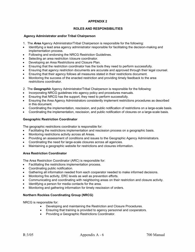
APPENDIX 2
ROLES AND RESPONSIBILITIES Agency Administrator and/or Tribal Chairperson 1. The Area Agency Administrator/Tribal Chairperson is responsible for the following: •
• • •
Identifying a lead area agency administrator responsible for facilitating the decision-making and implementation process.
• Following and endorsing the NRCG Restriction Guidelines. • Selecting an area restriction /closure coordinator. • Developing an Area Restrictions and Closure Plan. • Ensuring that the restriction coordinator has the tools they need to perform successfully. • Ensuring that agency restriction documents are accurate and approved through their legal counsel. • Ensuring that their agency follows all measures stated in their restrictions document. • Monitoring the success of the enacted restriction and providing timely feedback to the area
restrictions coordinator. 2. The Geographic Agency Administrator/Tribal Chairperson is responsible for the following: • Incorporating NRCG guidelines into agency policy and procedures manuals. • Ensuring that NRCG has the support, they need to perform successfully. • Ensuring the Area Agency Administrators consistently implement restrictions procedures as described
in this document. • Coordinating the implementation, rescission, and public notification of restrictions on a large-scale basis. • Coordinating the implementation, rescission, and public notification of closures on a large-scale basis. Geographic Restriction Coordinator The geographic restrictions coordinator is responsible for: • Facilitating the restrictions implementation and rescission process on a geographic basis. • Monitoring restrictions activity across all Areas. • Providing an assessment of conditions and issues to the Geographic Agency Administrators. • Coordinating the need for large-scale closures across all agencies. • Maintaining a geographic website for restrictions and closures information. Area Restriction Coordinator The Area Restriction Coordinator (ARC) is responsible for: • Facilitating the restrictions implementation process. • Coordinating public notification. • Gathering all information needed from each cooperator needed to make informed decisions. • Monitoring fire activity, ERC levels as well as prevention efforts. • Communicating and coordinating with neighboring areas on their restriction and closure activity. • Identifying a person for media contacts for the area. • Monitoring and gathering information for timely rescission of orders. Northern Rockies Coordinating Group (NRCG) NRCG is responsible for:
Developing and maintaining the Restriction and Closure Procedures. Ensuring that training is provided to agency personnel and cooperators. Providing a Geographic Restrictions Coordinator.
R:3/05 Appendix A - 6 700 Manual

APPENDIX 3
AREA BOUNDARIES IDAHO
~ MAP WOULD GO HERE ~ Specific detailed information and any updates can be found at: www.fs.fed.us/r1/fire/nrcg and by clicking on the restrictions and closures button.
Northern Idaho Area Includes: All lands within Boundary, Bonner, Kootenai, Benewah, Shoshone, Latah, Nez Perce, and Lewis counties. All lands outside of the Frank Church River of No Return, Gospel Hump, and Selway-Bitterroot Wilderness Areas in Clearwater, Idaho, and Lemhi counties.
Area 10 Includes: All public lands within the Frank Church River of No Return, Gospel Hump, and Selway-Bitterroot Wilderness areas located in: Idaho: Idaho, Lemhi, Valley, Custer, and Clearwater counties. Montana: Ravalli and Missoula counties.
R:3/05 Appendix A - 7 700 Manual
APPENDIX 3
AREA BOUNDARIES MONTANA
~ MAP WOULD GO HERE ~
Specific detailed information and any updates can be found at: www.fs.fed.us/r1/fire/nrcg and by clicking on the restrictions and closures button.
Northwest Montana Area Includes: All lands within Flathead and Lincoln Counties, and the portion of Lake County outside of the Flathead Reservation, and all lands administered by the Kootenai and Flathead National Forests, and all of Glacier National Park.
Southwest Montana Area Includes: Mineral, Missoula, Powell, Ravalli, Granite, Deer Lodge, and Silver Bow Counties, the Flathead Indian Reservation, and the portion of Sanders county outside the Kootenai National Forest.
Central Montana Area Includes: Beaverhead, Broadwater, Cascade, Jefferson, Lewis and Clark, Madison, Meagher, Pondera, Teton, Toole Counties, and Glacier County outside of Glacier National Park.
South Central Montana Area Includes: Park and Gallatin Counties, and the Gallatin National Forest.
Eastern Montana - Billings Area Includes: Big Horn, Carbon, Musselshell, Sweet Grass, Stillwater, Treasure, and Yellowstone Counties. Eastern Montana - Lewistown Area Includes: Blaine, Chouteau, Daniels, Fergus, Golden Valley, Hill, Judith Basin, Liberty, Petroleum, Phillips, Roosevelt, Sheridan, Valley, and Wheatland Counties. Eastern Montana - Miles City Area Includes: Carter, Custer, Dawson, Fallon, Garfield, McCone, Powder River, Prairie, Richland, Rosebud, and Wibaux Counties.
R:3/05 Appendix A - 8 700 Manual

APPENDIX 3
AREA BOUNDARIES NORTH DAKOTA
~ MAP WOULD GO HERE ~
Specific detailed information and any updates can be found at: www.fs.fed.us/r1/fire/nrcg and by clicking on the restrictions and closures button.
North Dakota Area Includes: All Dakota Prairie National Grasslands located within Adams, Billings, Bowman, Burleigh, Dunn, Emmons, Grant, Golden Valley, Hettinger. Mercer, McKenzie, Morton, Oliver, Sioux, Slope, Stark, and Williams Counties. All Bureau of Land Management lands within the North Dakota Field Office.
R:3/05 Appendix A - 9 700 Manual

APPENDIX 3
AREA BOUNDARIES SOUTH DAKOTA
~ MAP WOULD GO HERE ~ Specific detailed information and any updates can be found at: www.fs.fed.us/r1/fire/nrcg and by clicking on the restrictions and closures button.
South Dakota Includes: All National Forests and Grasslands within the Sioux Ranger District of the Custer National Forest and the Grand River District of the Dakota Prairie Grasslands. All Bureau of Land Management lands within the South Dakota Field Office.
R:3/05 Appendix A - 10 700 Manual

APPENDIX 4
GUIDELINES FOR IMPLEMENTING RESTRICTIONS When weather factors or fire suppression impacts become a concern, the following criteria can be used to help determine if a restriction is justified. Before the fire season, each area should review these evaluation guidelines to help determine threshold levels that substantiate the need for each restriction. These thresholds for restrictions should well exceed the normal fire season conditions. Examples include:
• 1,000-Hour fuel moisture content. • 3-day mean energy release component. • Live fuel moisture content. • Fire danger rating adjective class is at very high or extreme. • Fires are impacting available suppression resources making adequate initial attack difficult. • Area is receiving a high occurrence of human-caused fires. • Adverse fire weather conditions and risks are predicted to continue. • Life safety is jeopardized.
R:3/05 Appendix A - 11 700 Manual

APPENDIX 5
STAGE I AND STAGE II RESTRICTIONS There will be two fire restriction stages: Stage I and Stage II. Each agency/tribe within a fire restriction area must write its own agency/tribal document that authorizes the restrictions within its jurisdiction. Each agency/tribe is responsible for using its own format and having their legal counsel review the document to assure it is correct and enforceable. Appendix 8 contains the Stage II Fire Restriction Authorized Exemptions for Public Utilities and Railroad Companies. These terms and conditions tie back to exemption number four. To reduce confusion and standardize the restrictions, the following criteria will be used in all restriction documents:
STAGE I
The following acts are prohibited until further notice: 1. Building, maintaining, attending, or using a fire or campfire except within a developed recreation
site, or improved site. 2. Smoking, except within an enclosed vehicle or building, a developed recreation site or while
stopped in an area at least three feet in diameter that is barren or cleared of all flammable materials.
Exemptions:
1. Persons with a written permit that specifically authorizes the otherwise prohibited act. 2. Persons using a device solely fueled by liquid petroleum or LPG fuels that can be turned on and
off. 3. Persons conducting activities in those designated areas where the activity is specifically
authorized by written posted notice. 4. Any Federal, State, or local officer or member of an organized rescue or firefighting force in the
performance of an official duty. 5. All land within a city boundary is exempted. 6. Other exemptions unique to each agency/tribe.
An exemption does not absolve an individual or organization from liability or responsibility for any fire started by the exempted activity.
STAGE II
The following acts are prohibited until further notice:
1. Building maintaining, attending, or using a fire or campfire. 2. Smoking, except within an enclosed vehicle or building, a developed recreation site or while
stopped in an area at least three feet in diameter that is barren or cleared of all flammable materials.
3. The following acts are prohibited from 1:00 p.m. to 1:00 a.m.: a. Operating any internal combustion engine. b. Welding, or operating acetylene or other torch with open flame. c. Using an explosive.
A patrol is required for two hours following cessation of all work as described above.
1. Operating motorized vehicles off designated roads and trails. Exemptions:
1. Persons with a written permit that specifically authorizes the otherwise prohibited act.
R:3/05 Appendix A - 12 700 Manual
2. Persons using a device fueled solely by liquid petroleum or LPG fuels that can be turned on and off.

3. Operating motorized vehicles on designated roads and trails. 4. Emergency repair of public utilities and railroads as per attached conditions. 5. Persons conducting activities in those designated areas where the activity is specifically
authorized by written posted notice. 6. Any Federal, State, or local officer, or member of an organized rescue or firefighting force in the
performance of an official duty. 7. All land within a city boundary is exempted. 8. Other exemptions unique to each agency/tribe.
An exemption does not absolve an individual or organization from liability or responsibility for any fire started by the exempted activity.
R:3/05 Appendix A - 13 700 Manual

APPENDIX 6
CLOSURE GUIDELINES The Geographic Agency Administrators within the Northern Rockies Geographic Area should review these evaluation guidelines and determine threshold levels that substantiate the need for closures. Examples include:
• Potential loss of life due to explosive fire conditions. • Potential for extreme or blowup fire behavior. • Stage II restrictions are not effective in reducing the number of human-caused fires. • Resources across the geographic area are at a critical shortage level.
The following standard exemptions will be allowed during closure and will be noted on all closure documents. Exemptions: 1. Persons with a written permit that specifically authorizes the otherwise prohibited act. 2. Emergency repair of public utilities and railroads as per attached conditions. 3. Persons conducting activities in those designated areas where the activity is specifically authorized
by written posted notice. 4. Any Federal, State, or local officer, or member of an organized rescue or firefighting force in the
performance of an official duty. 5. All land within a city boundary is exempted. 6. Other exemptions unique to each agency/tribe.
R:3/05 Appendix A - 14 700 Manual

APPENDIX 7 DEFINITIONS
The following definitions should be used as part of, or referenced to, in the restrictions/closure documents that initiate and authorize a Stage I or Stage II Restriction: Area Agency Administrator/Tribal Chairperson: Field unit agency officials who have jurisdictional responsibilities for Agency lands. Agency officials within a designated restrictions and closure area such as, but not limited to: Montana Department of Natural Resources and Conservation, Area Manager; Bureau of Land Management, Field Manager; USDA Forest Service, Forest Supervisor; National Park Service, Park Superintendent; US Fish and Wildlife Service, Refuge Manager. Campfire: A fire, not within any building, mobile home, or living accommodation mounted on a vehicle, which is used for cooking, branding, personal warmth, lighting, ceremonial, or aesthetic purposes. Campfires are open fires, usually built on the ground, from native fuels or charcoal, including charcoal grills. Closure: The closing of an area to entry or use. Designated Roads and Trails: Those roads and trails that are identified to the public by land management agencies. Developed Recreation Site: An area that has been improved or developed for recreation. A developed recreation site is signed as a privately owned commercial campground, tribal or agency-owned campground or picnic area. Exemption: Authorization allowing an otherwise prohibited act or omission. Emergency Repair: Those actions taken outside the routine to prevent the start of a fire or restore critical resources. Explosive: Any substance or article, including a device, which is designed to function by explosion (i.e., an extremely rapid release of gas and heat) or which, by chemical reaction within itself, is able to function in a similar manner even if not designed to function by explosion. For the purposes of these restrictions, firearms are not considered an explosive. Geographic Agency Administrator/Tribal Chairperson: Agency officials at the statewide or regional level who have jurisdictional responsibilities for agency lands, such as: Montana Department of Natural Resources and Conservation, State Forester; Bureau of Land Management, State Director; USDA Forest Service, Regional Forester; Bureau of Indian Affairs, Regional Director; National Park Service, Regional Director; US Fish & Wildlife Service, Regional Director. Internal Combustion Engine: An engine in which combustion of the fuel takes place in a confined space, producing expanding gases that are used directly to provide mechanical power. Improved Site: An area that has been cleared and has an established fire barrier that restricts fire spread. These areas also include improvements such as picnic tables and/or toilets. Patrol: One or more people who will travel through a work site checking for and reporting fires discovered adjacent to and within the work site. Permit: A written document issued by an authorized agency representative to specifically authorize an otherwise prohibited act. Public Utilities: A government-regulated company that provides an essential public service such as water, gas, electricity, or telecommunications.
R:3/05 Appendix A - 15 700 Manual
Restriction: A limitation on an activity or use.
APPENDIX 8
STAGE II FIRE RESTRICTION AUTHORIZED EXEMPTION
PUBLIC UTILITIES FOR EMERGENCY WORK ONLY
Development and Objective The Stage II Fire Restriction Authorized Exemption was developed two-fold (1) based on the 2003 permit that was developed by the USFS, BLM and the MT-DNRC in consultation with NorthWestern Energy, and (2) the lessons learned in 2000 with an industrial specialist working one on one with public utility companies. The objective for allowing activities to occur from 1300 (1:00 p.m.) to 0100 (1:00 a.m.) is emergency in nature only. If mitigation of emergencies is not dealt with in a timely fashion, there is a good probability that the lack of mitigation could lead to a fire start or result in an immediate threat to life and property, or the disruption of a service.
Intent and Administration The intent of the exemption is to identify emergency conditions and on-site measures required to mitigate those conditions that would otherwise be prohibited under Stage II restrictions. As written, the authorized exemption would allow emergency repairs and be noted on each agency’s restrictions document. The exemption would remain in effect until the Stage II restriction was rescinded. The terms and conditions would become part of the agency restriction document and would not require the issuance of permits. Process The terms and conditions should not have to be modified. The intent is to ensure that there is consistency across the geographic area and that all operators are treated equally. The Area Restriction Coordinator will facilitate the distribution of the terms and conditions and work with the Area Lead Agency Administrator to ensure agencies throughout the restriction area are consistent in their implementation of the exemptions. The highlighted areas in the document are those that will be specific to each agency. The information in blue italics is an example of the type of information that the agency would fill in. The agency issuing the restriction document will establish a protocol for communications and coordination. It is highly encouraged that agencies throughout the restriction area work towards establishing a centralized protocol to lessen the impact on the public utility companies. The example for vehicles in this exemption was developed according to the forest fire rules and regulations for Montana. When used in other states you must utilize the proper requirements for that state and make sure you reference the proper state law or rule.
R:3/05 Appendix A - 16 700 Manual
Exercise of the priof all terms and coresponsibility for a AREA COVERED B This exemption only National Forest. ThiS-03 signed on [date SCOPE OF EXEMP For the purpose of thprovides an essentiaexemption covers emrepairs are defined auncontrolled releaseintegrity of the system With the exception oincluding any associtorches, or the remoestablished in the St CONDITIONS AND Public utilities are hefollowing conditions A. Emergency Con An emergency is a service. The followin
Emergency hazard to ca
Emergency a broken wir
Emergency system such
Emergency Emergency Associated w
required due B. On-site Measure
Any work req
flame, or powunder pressutank, and wi
R:3/05
STAGE II FIRE RESTRICTION AUTHORIZED EXEMPTION PUBLIC UTILITIES
FOR EMERGENCY WORK ONLY TERMS AND CONDITIONS
vileges granted by this exemption constitutes agreement with and acceptance nditions herein. This exemption does not absolve a company of any liability or ny fires ignited by the company’s operations.
Y EXEMPTION
applies to [type of lands] national forest system lands on the [unit] Kootenai s exemption is only valid under [agency document] Kootenai Forest Order F14-067-] July 6, 2004 and will remain in effect until rescinded.
TED ACTIVITIES
is exemption, public utilities are defined as a government-regulated company that l public service such as water, gas, electricity, or telecommunications. This ergency repairs between 1300 (1:00 p.m.) and before 0100 (1:00 a.m.). Emergency
s an unplanned outage, an unplanned break in operations of a system, an of natural gas, fire, explosion, or other situations that endangers life, property, or the
and associated components.
f emergency situations, all construction, maintenance and repair of public utilities, ated welding/grinding, the use of power tools, the use of acetylene or open flame val of “burners” (tree or limbs in or near the power lines), will follow the timelines age II restrictions as per [agency document] Kootenai Forest Order F14-067-S-03.
MEASURES
reby authorized the otherwise prohibited activities within their right-of-way per the and measures.
ditions
condition that poses an immediate threat to life and property, or the disruption of a g are typical emergencies associated with public utilities:
removal of trees or limbs in or near electric power lines that create an immediate use a direct impingement on the line or has the potential to start a fire. repair of electric transmission or distribution systems due to a power outage such as e, blown fuse, etcetera. repair of natural gas transmission or distribution system due to an outage on the as an uncontrolled release of natural gas, fire, explosion, etcetera. repair of an unplanned break in operations of a system. repair of telecommunications sites. elding/grinding, use of power tools, use of acetylene or other torch with open flame to the emergency.
s Required
uiring the emergency use of welding/grinding, acetylene or other torch with open er tools off a designated road, would require a pumper capable of spraying water re with a minimum of 40 psi at the first outlet, with at least a 200 gallon capacity
th a minimum of 200 feet of hose. All reasonable care should be taken to stay on
Appendix A - 17 700 Manual
designated roads. Pumper equipment must be within 100 feet of any operations using welding/grinding, acetylene or other torch with open flame, or power tools.
The use of a spark shield to surround the entire area is required when welding or grinding. One person with communications will be dedicated as a “fire watch” during the above operations,
and for two hours after all activity has ceased for the day. When power outages occur, the affected line segment will be inspected before being re-
energized. Motorized travel off established roads and trails is allowed during the inspection (to detect potential problems that could lead to a fire) of an electric or natural gas segment.
C. Vehicle Requirements In addition to the above, all vehicles will meet the [State and appropriate reference] Montana Forest Fire Rules & Regulations, Rule IV and VIII during the declared forest fire season. This includes [state requirements, below is MT’s]:
One 5-gallon backpack pump. (See note below) One serviceable fire fighting tool, #0 or equivalent shovel or a pulaski. One fire extinguisher with a minimum 2 ½ pounds capacity and 4 BC or higher rating. All internal combustion engines must be equipped with an approved spark arresting system
and/or with an approved muffler and exhaust system. Note: Two-2 gallon containers capable of being pressurized or with a hand pump capable of spraying water for a distance of 10 feet, or one-10 gallon container with an electric pump and 100 feet of ½ inch hose or enough hose to reach 50 feet beyond an activity may be substituted for the 5 gallon backpack pump. In addition to the above requirement, each vehicle will:
Have one firefighting tool per occupant with a least one tool a # 0 or equivalent shovel or a
pulaski. Not be parked or driving over flammable vegetation.
NOTIFICATION AND COMMUNICATIONS [Unit protocols for notification and communication when public utilities are conducting emergency work] Contact Flathead Interagency Dispatch Center (FIDC) (406-758-5260) by 0900 (9:00 a.m.) to provide daily locations of all activities associated with repair of transmission or distribution system or any associated welding/grinding, or the elimination of “burners”. Notifications of emergency response activities will take place no later than the next normal business day. ENTRY INTO A FIRE AREA Entry into an active fire area will require the approval of the Incident Commander or the responsible agency administrator. Conditions imposed at that time will require a minimum clothing requirement consisting of 8-inch leather boots, gloves, hardhat, and approved fire retardant (i.e. Nomex) clothing, unless exempted by the Incident Commander. [Agency Administrator Name and Title, If Signature Block is Needed] Date
R:3/05 Appendix A - 18 700 Manual

APPENDIX 8
STAGE II FIRE RESTRICTION AUTHORIZED EXEMPTION RAILROAD COMPANIES
FOR EMERGENCY WORK ONLY
Development and Objective The Stage II Fire Restriction Authorized Exemption was developed two-fold (1) based on the 2003 permit that was developed by the USFS, BLM and the MT-DNRC in consultation with Montana Rail Link and Burlington Northern Santa Fe, and (2) the lessons learned in 2000 with an industrial specialist working one on one with the railroad companies. The objective for allowing activities to occur from 1300 (1:00 p.m.) to 0100 (1:00 a.m.) is emergency in nature only. If mitigation of emergencies is not dealt with in a timely fashion, there is a good probability that the lack of mitigation could lead to a fire start or result in an immediate threat to life and property, or the disruption of a service.
Intent and Administration The intent of the exemption is to identify emergency conditions and on-site measures required to mitigate those conditions that would otherwise be prohibited under Stage II restrictions. As written, the authorized exemption would allow emergency repairs and be noted on each agency’s restrictions document. The exemption would remain in effect until the Stage II restriction was rescinded. The terms and conditions would become part of the agency restriction document and would not require the issuance of permits. Process The terms and conditions should not have to be modified. The intent is to ensure that there is consistency across the geographic area and that all operators are treated equally. The Area Restriction Coordinator will facilitate the distribution of the terms and conditions and work with the Area Lead Agency Administrator to ensure agencies throughout the restriction area are consistent in their implementation of the exemptions. The highlighted areas in the document are those that will be specific to each agency. The information in blue italics is an example of the type of information that the agency would fill in. The agency issuing the restriction document will establish a protocol for communications and coordination. It is highly encouraged that agencies throughout the restriction area work towards establishing a centralized protocol to lessen the impact on the railroad companies. The example for vehicles in this exemption was developed according to the forest fire rules and regulations for Montana. When used in other states you must utilize the proper requirements for that state and make sure you reference the proper state law or rule.
R:3/05 Appendix A - 19 700 Manual
Exercise of the priof all terms and coliability or respons AREA COVERED B This exemption only National Forest. ThiS-03 signed on [date SCOPE OF EXEMP This exemption coveEmergency repairs mtelecommunications system and associat With the exception oincluding any associacetylene or open fla[agency document] CONDITIONS AND Railroad companies the following conditio A. Emergency Con An emergency is a service. The followin
Emergency Emergency Emergency Emergency Rail relay wh Emergency Associated w
the emergen
B. On-site Measure
Any work reqflame, or powunder pressutank, and widesignated rwelding/grin
The use of a
R:3/05
STAGE II FIRE RESTRICTION AUTHORIZED EXEMPTION RAILROAD COMPANIES
FOR EMERGENCY WORK ONLY TERMS AND CONDITIONS
vileges granted by this exemption constitutes agreement with and acceptance nditions herein. This exemption does not absolve a railroad company of any
ibility for any fires ignited by the company’s operations.
Y EXEMPTION
applies to [type of lands] national forest system lands on the [unit] Kootenai s exemption is only valid under [agency document] Kootenai Forest Order F14-067-] July 6, 2004 and will remain in effect until rescinded.
TED ACTIVITIES
rs emergency repairs between 1300 (1:00 p.m.) and before 0100 (1:00 a.m.). ay need to be conducted due to a derailment, damaged line, signal remediation,
problem, or other situations that endangers life, property, or the integrity of the ed components.
f emergency situations, all construction, maintenance, and repair of rail lines ated welding/grinding (including thermite), the use of power tools, the use of me torches will follow the timelines established in the Stage II restrictions as per Kootenai Forest Order F14-067-S-03.
MEASURES
are hereby authorized the otherwise prohibited activities within their right-of-way per ns and measures.
ditions
condition that poses an immediate threat to life and property, or the disruption of a g are typical emergencies associated with railroads:
repair of a rail that has broken or been damaged. remediation of a track buckle caused by extreme heat. cleanup of a derailment. remediation of a railroad signal. en larger sections of a rail becomes worn or needs to be replaced.
repair of telecommunications sites. elding/grinding, use of power tools, acetylene, or other torch with open flame due to cy situation.
s Required
uiring the emergency use of welding/grinding, acetylene or other torch with open er tools off a designated road, would require a pumper capable of spraying water re with a minimum of 40 psi at the first outlet, with at least an 80-gallon capacity
th a minimum of 200 feet of hose. All reasonable care should be taken to stay on oads. Pumper equipment must be within 100 feet of any operations using ding, acetylene or other torch with open flame, or power tools. spark shield to surround the entire area is required when welding or grinding.
Appendix A - 20 700 Manual

Any work relating to rail relay activity off a designated road, would require a pumper capable of spraying water under pressure with a minimum of 50 psi at the first outlet, with at a least a 600-gallon on site capacity, and with a minimum of 400 feet of hose on site.
One person with communications will be dedicated as a “fire watch” during the above operations, and for two hours after all activity has ceased for the day.
Motorized travel off established roads and trails is allowed during the inspection (to detect potential problems that could lead to a fire) of a rail line segment or repair of a telecommunications site.
C. Vehicle Requirements
In addition to the above, all vehicles will meet the [State and appropriate reference] Montana Forest Fire Rules & Regulations, Rule IV and VIII during the declared forest fire season. This includes [state requirements, below is MT’s]:
One 5-gallon backpack pump. (See note below) One serviceable fire fighting tool, #0 or equivalent shovel or a pulaski. One fire extinguisher with a minimum 2 ½ pounds capacity and 4 BC or higher rating. All internal combustion engines must be equipped with an approved spark arresting system
and/or with an approved muffler and exhaust system. Note: Two-2 gallon containers capable of being pressurized or with a hand pump capable of spraying water for a distance of 10 feet, or one-10 gallon container with an electric pump and 100 feet of ½ inch hose or enough hose to reach 50 feet beyond an activity may be substituted for the 5 gallon backpack pump. In addition to the above requirement, each vehicle will:
Have one firefighting tool per occupant with a least one tool a # 0 or equivalent shovel or a
pulaski. Not be parked or driving over flammable vegetation.
NOTIFICATION AND COMMUNICATIONS [Unit protocols for notification and communication when public utilities are conducting emergency work] Contact Flathead Interagency Dispatch Center (FIDC) (406-758-5260) by 0900 (9:00 a.m.) to provide daily locations of all activities associated with emergency repair as a result of a derailment, damaged line, signal remediation or telecommunications problem. Notifications of emergency response activities will take place no later than the next normal business day. ENTRY INTO A FIRE AREA Entry into an active fire area will require the approval of the Incident Commander or the responsible agency administrator. Conditions imposed at that time will require a minimum clothing requirement consisting of 8-inch leather boots, gloves, hardhat, and approved fire retardant (i.e. Nomex) clothing, unless exempted by the Incident Commander. [Agency Administrator Name and Title, If Signature Block is Needed] Date
R:3/05 Appendix A - 21 700 Manual
Appendix B
Prevention Mobilization Guide

Prevention Actions by Preparedness Level for Montana DNRC. STAFFING LEVELS 1-P Pre and Post Legal Fire Season – Prior to May 1 and after September 30 or legal extension of fire season (normally fall, winter and spring months). Management Recommendations Responsibility Complete Preparedness Review including prevention program.
Interagency Review Teams/Unit Fire Supervisors
Review and update Unit Prevention Plans and Area Restriction Plans.
Unit Fire Supervisors/Prevention Specialist/Area Restriction Coordinators
Develop Community Awareness Programs; School Programs; County Fairs etc.
Prevention Specialist/Unit Fire Supervisors
Implement prevention sign program Prevention Technicians/Engine Crews Participate in interagency groups (fire protection associations) to plan and accomplish prevention activities
Prevention Specialist/Unit Fire Supervisors
Work with local planning boards to adopt fire protection guidelines in their subdivision regulations and to provide review of any planned developments.
Prevention Specialist/Unit Fire Supervisors
R:3/05 Appendix B - 1 700 Manual

STAFFING LEVEL 1 No Large fires in progress – Most Units with NFDRS Staffing Class 3 or lower. Potential for escape of initial attack fires is low. Evaluate National Preparedness Levels. Management Recommendations Responsibility Establish Media Contacts and inform public about prescribed fire activity.
Unit Fire Supervisor/ Information Officer/Prevention Specialist/Land Office Fire Management Specialist
Information requests and needs can still be handled at local level with out extra assistance
Information requests/phone calls increasing in volume
Consider starting daily press releases to local/regional media outlets.
Make sure frontline personnel are briefed daily, and updated as needed, so they can answer questions from public
Be Prepared to arrange media tours of incidents.
Consider establishing an information phone number for public and Media inquiries as well as extending hours of coverage beyond normal work hours.
Be prepared to make maps and other information packets available to media and residents.
Consider an information bulletin board, update daily with local and regional fire information and other related information
.
Conduct Community awareness programs, school programs, county fairs etc.
Unit Fire Supervisor, Prevention Tech, Engine Crews
Conduct prevention patrols, home evaluations, industrial inspections, and railroad inspections.
Unit Fire Supervisor, Prevention Tech, Engine Crews
Coordinate activities to accomplish fuels reduction projects
Unit Fire Supervisor, Prevention Tech, Engine Crews
Administer local burn permit program Unit Fire Supervisor, Prevention Tech, Engine Crews
R:3/05 Appendix B - 2 700 Manual

STAFFING LEVEL 2 No Large fires in progress – Three or more Units with NFDRS Staffing Class 3+. Initial attack suppression successful with only a few fires escaping to Class B or C. Potential for escape fires moderate. Evaluate National Preparedness Levels. Large fires in progress – One Unit requiring NRCC assistance, including overhead, crews, and equipment. Previous Preparedness level actions remain in effect. Management Recommendations Responsibility Prevention media release about the fire danger and fire weather conditions
Unit Fire Supervisor/ Information Officer/Prevention Specialist/Land Office Fire Management Specialist
Target specific prevention problem areas, ignition causes or activities (July 4th, campgrounds and campfires, hunting season, etc.)
Unit Fire Supervisor Information Officer/Prevention Specialist/Land Office Fire Management Specialist/Engine Crews
Information requests from public and media beyond capabilities of Unit or Land Office.
Order information officer from other DNRC source, local cooperator, or through dispatch system.
Consider establishing joint information outlet with local cooperators
Prepare and disseminate daily press releases, maintain contact with print and electronic media covering your area.
Look for alternate outlets for information: Internet, additional bulletin boards, press releases in local stores/meeting places, talk radio etc.
Rumors becoming rampant, public concern growing.
Consider holding public meetings to give local residents honest, up to date information on events, strategies, and to request help in prevention/defensible space effort. Include representatives of local cooperators.
R:3/05 Appendix B - 3 700 Manual

STAFFING LEVEL 3 No Large fires in progress – Two Units with NFDRS Staffing Class 4. Actionable fire not responding to initial attack as evidenced by the high number of class C and D fires each day. Multiple ignitions cause a large number of fires to escape initial attack. Evaluate National Preparedness Levels. Large fires in progress – At least three Units requiring NRCC assistance. More than three class D or two class E or larger fires requiring NRCC assistance. More than two Incident Teams committed in the Geographic Area. Previous Preparedness level actions remain in effect. Management Recommendations Responsibility Include needs of fire prevention into requested severity funding.
Unit Fire Supervisor/ Information Officer/Prevention Specialist/Land Office Fire Management Specialist/Fire Program Manager/Bureau
Establish communication of fire conditions, activity, and restriction needs with Fire cooperators.
Unit Fire Supervisor/ Information Officer/Prevention Specialist/Land Office Fire Management Specialist/ Restriction Coordinator
Increase prevention actions: signing and patrols to provide public awareness of fire danger. Media briefings on fire suppression activity and potential needs for fire restrictions.
Unit Fire Supervisor/ Information Officer/Prevention Specialist/Land Office Fire Management Specialist
Evaluate and coordinate needed Restriction stages and media releases.
Area Managers/Area Restriction Coordinators
Enforce Restrictions Unit Fire Supervisors, Preventions Techs, Engine Crews
Type II or Type I incident in progress Team has been ordered but not on site Continue all previous activities as needed. Determine level for oversight of
information process: (possible examples) Press releases ok’d by line officer or agency representative prior to dissemination to media. Press releases reviewed after dissemination by line officer or agency representative.
Determine immediate need, if any, for community meeting,
Determine need for special talking points outlining department and local issues. Possible examples: Prevention issues Political or other sensitive issues Community concerns
R:3/05 Appendix B - 4 700 Manual

STAFFING LEVEL 4 No Large fires in progress – Three or more Units are indicating a NFDRS Staffing Class 4 or higher. Actionable fire not responding to initial attack as evidenced by the high number of class C and D fires each day. Multiple ignitions cause a large number of fires to escape initial attack. Evaluate National Preparedness Levels. Large fires in progress – At least three Units requiring NRCC assistance. More than three class D or two class E or larger fires requiring NRCC assistance. More than two Incident Teams committed in the Geographic Area. Previous Preparedness level actions remain in effect. Management Recommendations Responsibility Evaluate need for Local or National Prevention Team to assist with large or complex wildland urban-interface incidents or prevention media efforts.
MAC/ Unit Administrators/ Unit Fire Supervisor/ Information Officer/ Prevention Specialist/Land Office Fire Management Specialist/ Fire Program Manager/Bureau
Increase Media effort- Consider paid advertisements to target specific cause categories. Increased patrols, news releases etc.
Unit Fire Supervisor/ Information Officer/Prevention Specialist/Engine Crews.
Type II or Type I incident in progress Team or Teams are on site (In-briefing and beyond) Outline previous information efforts, and
effectiveness Outline agency needs and expectations,
include talking points, press release clearance process, areas that need critical attention etc.
Monitor effectiveness of the team’s information effort; pay close attention to community attitude and rumors.
Determine need for/level of continued information effort following team’s departure/transition to type III organization.
R:3/05 Appendix B - 5 700 Manual

STAFFING LEVEL 5 Large fires in progress – Multiple fires are requiring Type 1 Incident Management Teams. Significant competition for resources occurring. Evaluate National Preparedness Levels. Previous Preparedness level actions remain in effect. Management Recommendations Responsibility If all other prevention measures have been exhausted, consider closures when needed for public or firefighter safety.
Agency Administrators/Area Restriction Coordinators
Increase Media Effort – consider an Information Center to coordinate multiple fires or complex urban-interface situations.
Agency Administrators/MAC
R:3/05 Appendix B - 6 700 Manual
Appendix C
Investigation Matrix
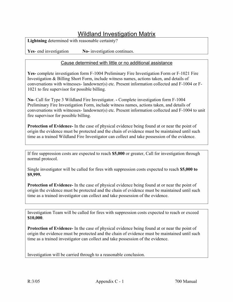
Wildland Investigation Matrix
Lightning determined with reasonable certainty? Yes- end investigation No- investigation continues.
Cause determined with little or no additional assistance Yes- complete investigation form F-1004 Preliminary Fire Investigation Form or F-1021 Fire Investigation & Billing Short Form, include witness names, actions taken, and details of conversations with witnesses- landowner(s) etc. Present information collected and F-1004 or F-1021 to fire supervisor for possible billing. No- Call for Type 3 Wildland Fire Investigator. - Complete investigation form F-1004 Preliminary Fire Investigation Form, include witness names, actions taken, and details of conversations with witnesses- landowner(s) etc. Present information collected and F-1004 to unit fire supervisor for possible billing. Protection of Evidence- In the case of physical evidence being found at or near the point of origin the evidence must be protected and the chain of evidence must be maintained until such time as a trained Wildland Fire Investigator can collect and take possession of the evidence. If fire suppression costs are expected to reach $5,000 or greater, Call for investigation through normal protocol. Single investigator will be called for fires with suppression costs expected to reach $5,000 to $9,999. Protection of Evidence- In the case of physical evidence being found at or near the point of origin the evidence must be protected and the chain of evidence must be maintained until such time as a trained investigator can collect and take possession of the evidence. Investigation Team will be called for fires with suppression costs expected to reach or exceed $10,000. Protection of Evidence- In the case of physical evidence being found at or near the point of origin the evidence must be protected and the chain of evidence must be maintained until such time as a trained investigator can collect and take possession of the evidence.
Investigation will be carried through to a reasonable conclusion.
R:3/05 Appendix C - 1 700 Manual

Appendix D
Railroad
Agreements

FS-01-91-03
MEMORANDUM OF AGREEMENT BETWEEN THE REGIONAL FORESTER, REGION 1; THE STATE FORESTER, STATE OF MONTANA, AND BURLINGTON NORTHERN RAILROAD, RELATIVE TO THE PREVENTION AND EXTINGUISHMENT OF FIRE ON OR NEAR BURLINGTON NORTHERN RAILROAD’S RIGHT-OF-WAY IN AND ADJACENT TO LANDS PROTECTED BY THE USDA FOREST SERVICE OR THE MONTANA DEPARTMENT OF STATE LANDS. PURSUANT TO: {ACT OF APRIL 24, 1950, SECTION 5; 16 U.S.C. 572 (GRANGER THYE ACT)} (ACT OF DECEMBER 12, 1975; P.L. 94-148; 16 U.S.C. 565A, 1-3) (69-14-721 MONTANA CODE ANNOTATED) (69-14-722 MONTANA CODE ANNOTATED) This MEMORANDUM OF AGREEMENT is made and entered into by and between BURLINGTON NORTHERN RAILROAD, hereinafter referred to as “BN”; the UNITED STATES DEPARTMENT OF AGRICULTURE, FOREST SERVICE, NORTHERN REGION, hereinafter referred to as the “FOREST SERVICE”; and the MONTANA DEPARTMENT OF STATE LANDS, Forestry Division, hereinafter referred to as ‘MDSL”.
I The above parties agree to cooperate to the fullest extent reasonably and legally possible relative to the prevention and suppression of fires on and adjacent to BN’s right-of-way wherever it operates on lands protected by either of the other two parties. BN promises and agrees to: 1. Prevent fires through treatment of its right-of-way in areas protected by the Forest Service or MDSL in accordance with detailed plans to be prepared jointly by the Chief Engineer or his appointed representative and the appropriate Forest Supervisor or MDSL Area Manager or their appointed representatives. Such a plan may require clearing and burning of flammable material, construction of fire breaks, other fire prevention measures and plans for fire suppression action. 2. Operate and maintain its locomotives and rolling stock in such a manner as to prevent the escape of sparks and fire as far as practicable, and to install a system of inspection for enforcing these instructions. 3. Continue an effective system for reporting fire upon or near its right-of-way discovered by train crews and other employees of BN to the appropriate officer of the Forest Service or MDSL.
R:3/05 Appendix D - 1 700 Manual
4. Instruct its employees in their responsibility and authority to initiate immediate action to bring under control and extinguish every fire on or near its right-of-way as quickly as possible.
5. Provide and keep with each section crew suitable firefighting equipment maintained in good condition and in sufficient quantity to equip the crew for the fuel type in each locality as agreed to between BN and the local official of the agency with fire protection responsibility.
6. Reimburse the Forest Service and/or MDSL for actual expenses incurred by them in the extinguishment of any fires started by operations of BN or its employees on or adjacent to its right-of-way.
7. Reimburse the Forest Service and/or MDSL for the cost of assistance they provide at the request of BN for the suppression of fires started by BN.
8. Patrol the track for railroad fires as a responsibility of BN in a manner to be agreed upon between the appropriate Forest Supervisor or MDSL Area Manager (depending which has fire protection responsibility) and BN’s Chief Engineer.
II
The FOREST SERVICE and MDSL promise and agree that wherever BN’s railroad runs through or is contiguous to National Forest lands and other lands protected by the FOREST SERVICE, Region 1, or through lands protected by MDSL to: 1. Assist BN in planning fire control activities by preparing jointly with them a detailed written fire plan to serve as a guide for the prevention and suppression of fires on and adjacent to the railroad right-of-way, no matter how or by whom caused. Such plans may be updated annually. 2. Furnish, without charge to BN, the services of the employees of the FOREST SERVICE and MDSL for planning, training and inspecting fire prevention work. 3. Have the appropriate Forest Supervisor or MDSL Area Manager or their representative make annual fire prevention inspections jointly with the Chief Engineer, or his representative, of BN’s right-of-way located within the fire protection boundaries of each National Forest protected by the FOREST SERVICE, Region 1 or areas protected by MDSL. Copies of all annual inspections made by the FOREST SERVICE or MDSL will be furnished the Chief Engineer with appropriate recommendations for actions needed to prevent fires. 4. Pay, upon proper certification by a Forest supervisor or MDSL Area Manager expenses for labor hired by BN and such other expenses as may be directly incurred by it in initially attacking any fires which started on lands protected by the FOREST SERVICE or MDSL beyond the rights-of-way of BN when such fires were not started by the operations of BN or its employees. The FOREST SERVICE or MDSL will assume supervision and responsibility
R:3/05 Appendix D - 2 700 Manual

at the earliest practical time. This obligation does not require the FOREST SERVICE or MDSL to indemnify or reimburse BN for any damages suffered by a third party. 5. Require employees of the FOREST SERVICE and MDSL to report immediately to the nearest roadmaster, dispatcher or section foreman of the BN any defect discovered in the track or roadbed of BN constituting a menace to the safe operation of the railroad. 6. Assist in suppressing fires on BN’s right-of-way, upon request of BN, when and if, in the judgment of the Forest Supervisor or MDSL Land Office Manager personnel, equipment and facilities can be made available. In such cases, a FOREST SERVICE or MDSL officer will be placed in charge; and shall have authority over the fire as long as any of his or her crews remain on the fire. Should a combination of crews from the FOREST SERVICE or MDSL be on the same fire, management of the fire will be the responsibility of the agency with the fire protection responsibility for the area on which the fire is burning. 7. Report to BN’s nearest local roadmaster, dispatcher or section foreman any fires on or immediately adjacent to BN’s rights-of-way that are discovered by or reported to the FOREST SERVICE or MDSL. Location of such fires will be given by milepost or other identifiable feature when known rather than by legal description.
III
IT IS MUTUALLY AGREED and understood by and between the parties to this Agreement: 1. The Forest Service and MDSL may initiate attack, without BN’s request, upon fires originating in BN’s right-of-way. Such action may continue until the fire is suppressed or until BN has manned the fire to a level deemed adequate by the FOREST SERVICE or MDSL. Costs of such action are to be reimbursed by BN. 2. Neither the United States of America nor the State of Montana shall be liable for any damage incident to the performance of work under this agreement to any depositors or landowners who are parties to the agreement and all such depositors or landowners hereby expressly waive any and all claims against the United States of America and the State of Montana for compensation for any loss, damage, personal injury or death occurring in consequence of the performance of this agreement. 3. The United States and the State of Montana shall be liable for injury or loss of property, personal injury or death caused by the negligent or wrongful action or omission of any employee of the United States or State of Montana, while acting within the scope of his or her office employment, under those circumstances where the United States or State of Montana would be liable to any claimant in accordance with the laws of the United States or the State of Montana. 4. That nothing in this Agreement shall be construed as relieving BN of liability for any fire damages for which BN would otherwise be held liable in the absence of this agreement.
R:3/05 Appendix D - 3 700 Manual
5. That nothing in this Agreement shall be construed to relieve BN from any requirements of the stipulations contained in any railroad right-of-way easement that shall have been granted to BN or any one of its predecessor companies across National Forest System lands or any requirements of Montana State laws. 6. Nothing herein contained shall be construed as binding the FOREST SERVICE or MDSL to expend in any one fiscal year any sum in excess of appropriations made by Congress or the Legislature for that fiscal year or to involve the Federal Government or the Government of Montana in any contract or other obligation for the future payment of money in excess of such appropriations. 7. That no member of or delegate to Congress, or resident commissioner shall be admitted to any share or part of this Agreement or to any benefit that may arise therefrom; but, this provision shall not be construed to extend to this Agreement if made with a corporation for its general benefit. 8. BN will comply with Title VI of the Civil Rights Act of 1964 (P.L. 88-352) and in accordance with Title VI of that Act, no person in the United States shall on the grounds of race, color, handicap or national origin, be excluded from participating in, be denied the benefits of, or be otherwise subjected to discrimination under any program or activity for which the cooperators receive Federal financial assistance and will immediately take any measures necessary to effectuate this agreement. 9. This Agreement shall continue in force unless canceled by one of the parties at any time upon not less than thirty (30) days written notice given to the other party to that effect, to be supplemented or amended at any time upon the written mutual consent of all the parties hereto.
10. Cooperative agreement between Burlington Northern Railroad and Regional Forester, Regional Forest Service, United States Department of Agriculture dated March 11, 1974, pertaining to extinguishment and suppression of fires on or near the right-of-way of Burlington Northern in and adjacent to lands protected by Region 1 of the Forest Service, is hereby terminated (BN Docket 4177).
IN WITNESS WHEREOF, the parties hereto have caused this Agreement to be executed
on the day and year last signed below.
USDA – FOREST SERVICE ______________________________________ _________________ Regional Forester Date BURLINGTON NORTHERN RAILROAD COMPANY ______________________________________ _________________
R:3/05 Appendix D - 4 700 Manual

Supt. Maintenance & Engineering Date STATE OF MONTANA _______________________________________ __________________ Commissioner, Dept. of State Lands Date ATTEST: ______________________________________ __________________ Administrator, Division of Forestry Date
R:3/05 Appendix D - 5 700 Manual

FS-01-88-16
MEMORANDUM OF AGREEMENT BETWEEN THE REGIONAL FORESTER, REGION 1; THE STATE FORESTER, STATE OF MONTANA; AND MONTANA RAIL LINK, RELATIVE TO THE PREVENTION AND EXTINGUISHMENT OF FIRE ON OR NEAR MONTANA RAIL LINK’S RIGHT-OF-WAY IN AND ADJACENT TO LANDS PROTECTED BY THE USDA FOREST SERVICE OR THE MONTANA DEPARTMENT OF STATE LANDS. PURSUANT TO: {ACT OF APRIL 24, 1950, SECTION 5; 16 U.S.C. 572 (GRANGER THYE ACT)} (ACT OF DECEMBER 12, 1975; P.L. 94-148; 16 U.S.C. 565A, 1-3) (69-14-721 MONTANA CODE ANNOTATED) (69-14-722 MONTANA CODE ANNOTATED) This MEMORANDUM OF AGREEMENT, is made and entered into by and between MONTANA RAIL LINK, hereinafter referred to as “MRL”; the UNITED STATES DEPARTMENT OF AGRICULTURE, FOREST SERVICE, NORTHERN REGION, hereinafter referred to as the “FOREST SEFVICE”; and the MONTANA DEPARTMENT OF STATE LANDS, Forestry Division, hereinafter referred to as “MDSL”.
I
The above parties agree to cooperate to the fullest extent reasonably and legally possible relative to the prevention and suppression of fires on and adjacent to MRL’s right-of-way wherever its railroad runs on lands protected by either of the other two parties. MRL promises and agrees to: 1. Prevent fires through treatment of its right-of-way in areas protected by the Forest Service or MDSL in accordance with detailed plans to be prepared jointly by the Chief Engineer or his appointed representative and the appropriate Forest Supervisor or MDSL Area Manager or their appointed representatives. Such a plan may require clearing and burning of flammable material, construction of fire breaks, other fire prevention measures and plans for fire suppression action. 2. Operate and maintain all locomotives and rolling stock in such a manner as to prevent the escape of sparks and fire as far as practicable, and to install a system of inspection for enforcing these instructions. 3. Establish an effective system for reporting fires upon or near its right-of-way discovered by train crews and other employees of MRL to the appropriate officer of the Forest Service or MDSL.
R:3/05 Appendix D - 6 700 Manual

4. Instruct its employees in their responsibility and authority to initiate immediate action to bring under control and extinguish every fire on or near its right-of-way as quickly as possible. 5. Provide and keep with each section crew suitable firefighting equipment maintained in good condition and in sufficient quantity to equip the crew for the fuel type in each locality as agreed to between MRL and the local official of the agency with fire protection responsibility. 6. Reimburse the FOREST SERVICE and/or MDSL for actual expenses incurred by them in the extinguishment of any fires started by operations of MRL or its employees on or adjacent to its right-of-way. 7. Reimburse the Forest Service and/or MDSL for the cost of assistance they provide at the request of MRL for the suppression of fires started by MRL. 8. Patrol the track for railroad fires as a responsibility of MRL in a manner to be agreed upon between the appropriate Forest Supervisor or MDSL Area Manager (depending which has fire protection responsibility) and MRL’s Chief Engineer.
II
The FOREST SERVICE and MDSL promise and agree that wherever MRL’s Railroad runs through or is contiguous to National Forest lands and other lands protected by the FOREST SERVICE, Region 1, or through lands protected by MDSL to: 1. Assist MRL in planning fire control activities by preparing jointly with them a detailed written fire plan to serve as a guide for the prevention and suppression of fires on and adjacent to the railroad right-of-way, no matter how or by whom caused. Such plans may be updated annually. 2. Furnish, without charge to MRL, the services of the employees of the FOREST SERVICE and MDSL for planning, training and inspecting fire prevention work. 3. Have the appropriate Forest Supervisor or MDSL Area Manager or their representative make annual fire prevention inspections jointly with the Chief Engineer, or his representative, of MRL’s right-of-way located within the fire protection boundaries of each National Forest protected by the FOREST SERVICE, Region 1 or areas protected by MDSL. Copies of all annual inspections made by the FOREST SERVICE or MDSL will be furnished the Chief Engineer with appropriate recommendations for actions needed to prevent fires. 4. Pay, upon proper certification by a Forest Supervisor or MDSL Area Manager expenses for labor hired by MRL and such other expenses as may be directly incurred by it in initial attacking any fires which started on lands protected by the FOREST SERVICE or MDSL beyond the rights-of-way of MRL when such fires were not started by the operations of MRL or its employees. The FOREST SERVICE or MDSL will assume supervision and responsibility at the earliest practical time. This obligation does not require the FOREST SERVICE or MDSL to indemnify or reimburse MRL for any damages suffered by a third party.
R:3/05 Appendix D - 7 700 Manual
5. Require employees of the FOREST SERVICE and MDSL to report immediately to the nearest Road Master, Dispatcher or Section Foreman of the MRL any defect discovered in the track or roadbed of MRL constituting a menace to the safe operation of the railroad. 6. Assist in suppression fires on MRL’s rights-of-way, upon request of MRL, when and if in the judgment of the Forest Supervisor or MDSL Land Office Manager personnel, equipment and facilities can be made available. In such cases, a FOREST SERVICE or MDSL officer will be placed in charge; and shall have authority over the fire as long as any of his or her crews remain on the fire. Should a combination of crews from the FOREST SERVICE or MDSL be on the same fire, management of the fire will be the responsibility of the agency with the fire protection responsibility for the area on which the fire is burning. 7. Report to MRL’s nearest local Road Master, Dispatcher or Section Foreman any fires on or immediately adjacent to MRL’s rights-of-way that are discovered by or reported to the FOREST SERVICE or MDSL. Location of such fires will be given by mile post or other identifiable feature when known rather than by legal description.
III
IT IS MUTUALLY AGREED and understood by and between the parties to this Agreement: 1. The Forest Service and MDSL may initial attack, without MRL’s request, fires originating in MRL’s right-of-way. Such action may continue until the fire is suppressed or until MRL has manned the fire to a level deemed adequate by the Forest Service or MDSL. Costs of such action are to be reimbursed by MRL. 2. Neither the United States of America nor the State of Montana shall be liable for any damage incident to the performance of work under this agreement to any depositors or landowners who are parties to the agreement, and all such depositors or landowners hereby expressly waive any and all claims against the United States of America and the State of Montana for compensation for any loss, damage, personal injury or death occurring in consequence of the performance of this agreement. 3. The United States and the State of Montana shall be liable for injury or loss of property, personal injury, or death caused by the negligent or wrongful action or omission of any employee of the United States or State of Montana, while acting within the scope of his office or employment under certain circumstances where the United States or State of Montana, if a private person, would be liable to the claimant in accordance with the law of the State of Montana. 4, That nothing in this Agreement shall be construed as relieving MRL of liability for any fire damages for which MRL would otherwise be held liable in the absence of this agreement. 5. That nothing in this Agreement shall be construed to relieve MRL from any requirements of the stipulations contained in any railroad right-of-way easement that shall have
R:3/05 Appendix D - 8 700 Manual
been granted to MRL or any one of its predecessor companies across National Forest System lands or any requirements of Montana State laws. 6. Nothing herein contained shall be construed as binding the FOREST SERVICE or MDSL to expend in any one fiscal year any sum in excess of appropriations made by Congress or the Legislature for that fiscal year or to involve the Federal Government or the Government of Montana in any contract or other obligation for the future payment of money in excess of such appropriations. 7. That no member of or delegate to Congress, or resident commissioner, shall be admitted to any share or part of this Agreement or to any benefit that may arise therefrom; but, this provision shall not be construed to extend to this Agreement if made with a corporation for its general benefit. 8. MRL will comply with Title VI of the Civil Rights Act of 1964 (P.L. 88-352) and in accordance with Title VI of that Act, no person in the United States shall on the ground of race, color, handicap, or national original, be excluded from participating in, be denied the benefits of, or be otherwise subjected to discrimination under any program or activity for which the cooperators receive Federal financial assistance and will immediately take any measures necessary to effectuate this agreement. 9. This Agreement shall continue in force unless cancelled by one of the parties at any time upon not less than thirty (30) days written notice given to the other parties to that effect, to be delivered after November 1 and before April 1 of any year. This Agreement may be supplemented or amended at any time upon the written mutual consent of all the parties hereto.
R:3/05 Appendix D - 9 700 Manual
IN WITNESS WHEREOF, the parties hereto have caused this Agreement to be executed on the day and year last signed below. USDA – FOREST SERVICE MONTANA RAIL LINK ____________________________ ________ __________________________ ________ Regional Forester Date Chief Engineer Date STATE OF MONTANA ____________________________ ________ Commissioner, Department Date of State Lands ATTEST: ____________________________ ________ Administrator, Division Date of Forestry
R:3/05 Appendix D - 10 700 Manual

FS-01-93-21
MEMORANDUM OF AGREEMENT
BETWEEN THE REGIONAL FORESTER, REGION 1; THE DEPARTMENT OF STATE LANDS, STATE OF MONTANA; AND UNION PACIFIC RAILROAD COMPANY, RELATIVE TO THE PREVENTION AND EXTINGUISHMENT OF FIRE ON OR NEAR UNION PACIFIC RAILROAD COMPANY’S RIGHT-OF-WAY IN AND ADJACENT TO LANDS PROTECTED BY THE USDA, FOREST SERVICE OR THE MONTANA DEPARTMENT OF STATE LANDS. PURSUANT TO: {ACT OF APRIL 24, 1950, SECTION 5; 16 U.S.C. 572 (GRANGER THYE ACT)} (ACT OF DECEMBER 12, 1975; P.L. 94-148; 16 U.S.C. 565A, 1-3) (69-14-721 MONTANA CODE ANNOTATED) (69-14-722 MONTANA CODE ANNOTATED) This MEMORANDUM OF AGREEMENT is made and entered into by and between UNION PACIFIC RAILROAD COMPANY, hereinafter referred to as “UPRR”; the UNITED STATES DEPARTMENT OF AGRICULTURE, FOREST SERVICE, NORTHERN REGION, hereinafter referred to as the “FOREST SERVICE”; and the MONTANA DEPARTMENT OF STATE LANDS, Forestry Division, hereinafter referred to as ‘MDSL.”
I
The above parties agree to cooperate to the fullest extent reasonably and legally possible relative to the prevention and suppression of fires on and adjacent to “UPRR” right-of-way wherever its railroad runs on lands protected by either of the other two parties. UPRR promises and agrees to: 1. Minimize the chance of fires through the treatment of its right-of-way in areas protected
by the Forest Service or MDSL in accordance with detailed plans to be prepared jointly by the UPRR Superintendent or his appointed representative and the appropriate Forest Supervisor or MDSL Area Manager or their appointed representatives. Such plans may require some clearing and burning of flammable material, construction of fire break, or other fire prevention measures, and may require plans for fire suppression action.
2. Operate and maintain all locomotives and rolling stock in such a manner as to prevent the
escape of sparks and fire as far as practicable, and to implement a system of inspection for enforcing these instructions.
3. Establish an effective system for reporting fires upon or near its right-of-way discovered
by train crews and other employees of UPRR to the appropriate officer of the Forest Service or MDSL.
R:3/05 Appendix D - 11 700 Manual

4. Instruct its employees in their responsibility and authority to initiate immediate action to
bring under control and extinguish fires on or near its right-of-way as quickly as possible. 5. Provide and keep with each section crew suitable firefighting equipment maintained in
good condition and in sufficient quantity to equip the crew for the fuel type in each locality as agreed to between UPRR and the local official of the agency with fire protection responsibility.
6. Reimburse the Forest Service or MDSL for actual expenses incurred by them in the
extinguishment of any fires started by operations of UPRR or its employees on or adjacent to its right-of-way.
7. Reimburse the Forest Service and/or MDSL for the cost of assistance they provide at the
request of UPRR for the suppression of fires started by UPRR. 8. Patrol the track for railroad fires as a responsibility of UPRR in a manner to be agreed
upon between the appropriate Forest Supervisor or MDSL Area Manager (depending which has fire protection responsibility) and UPRR’s Superintendent.
II
The Forest Service and MDSL promise and agree that wherever UPRR’s railroad runs through or is contiguous to National Forest lands and other lands protected by the Forest Service, Region 1, or through lands protected by MDSL to: 1. Assist UPRR in planning fire control activities by preparing jointly with them a detailed
written fire plan to serve as a guide for the prevention and suppression of fires on and adjacent to the railroad right-of-way, no matter how or by whom caused. Such plans may be updated annually.
2. Furnish, without charge to UPRR, the services of the employees of the Forest Service and
MDSL for planning, training and inspecting fire prevention work. 3. Have the appropriate Forest Supervisor or MDSL Area Manager or their representative
make annual fire prevention inspections jointly with the UPRR Superintendent or his representative of UPRR’s right-of-way located within the fire protection boundaries of each National Forest protected by the Forest Service, Region 1, or areas protected by MDSL. Copies of all annual inspections made by the Forest Service or MDSL will be furnished to the Superintendent with appropriate recommendations for actions needed to prevent fires.
4. Pay, upon proper certification by a Forest Supervisor or MDSL Area Manager, expenses
for labor hired by UPRR and such other expenses as may be directly incurred by it in initial attacking any fires which started on lands protected by the Forest Service or MDSL beyond the rights-of-way of UPRR when such fires were not started by the operations of UPRR or its employees. The Forest Service or MDSL will assume supervision and responsibility at the earliest practical time. This obligation does not require the Forest
R:3/05 Appendix D - 12 700 Manual

Service or MDSL to indemnify or reimburse UPRR for any damages suffered by a third party.
5. Require employees of the Forest Service and MDSL to report immediately to the UPRR
Dispatcher and nearest Manager of Track Maintenance or Section Foreman of the UPRR any defect discovered in the track or roadbed of UPRR constituting a menace to the safe operation of the railroad.
6. Assist in suppressing fires on UPRR’s rights-of-way, upon request of UPRR, when and if
in the judgment of the Forest Supervisor or MDSL Land Office Manager personnel, equipment and facilities can be made available. In such cases, a Forest Service or MDSL officer will be placed in charge and shall have authority over the fire as long as any of his or her crews remain on the fire. Should a combination of crews form the Forest Service or MDSL be on the same fire, management of the fire will be the responsibility of the agency with the fire protection responsibility for the area on which the fire is burning.
7. Report to UPRR’s Dispatcher and nearest Manager of Track Maintenance or Section
Foreman any fires on or immediately adjacent to UPRR’s rights-of-way that are discovered by or reported to the Forest Service or MDSL. Location of such fires will be given by mile post or other identifiable feature when known, rather than by legal description.
III
IT IS MUTUALLY AGREED and understood by and between the parties to this Agreement: 1. The Forest Service and MDSL may initiate suppression of, without UPRR’s request, fires
originating in UPRR’s right-of-way. Such action may continue until the fire is suppressed or until UPRR has manned the fire to a level deemed adequate by the Forest Service or MDSL. Costs of such action are to be reimbursed by UPRR.
2. Neither the United States of America nor the State of Montana nor UPRR shall be liable
for any damage incident to the performance of work under this Agreement to any depositors or landowners who are parties to the agreement, and all such depositors or landowners hereby expressly waive any and all claims against the United States of America and the State of Montana for compensation for any loss, damage, personal injury, or death occurring in consequence of the performance of this Agreement.
3. The United States and the State of Montana shall be liable for injury or loss of property,
personal injury, or death caused by the negligent or wrongful action or omission of any employee of the State of Montana, while acting within the scope of his office or employment under certain circumstances where the United States or the State of Montana, if a private person, would be liable to the claimant in accordance with the law of the State of Montana.
4. That nothing in this Agreement shall be construed as relieving UPRR of liability for any
fire damages for which UPRR would otherwise be held liable in the absence of this
R:3/05 Appendix D - 13 700 Manual
Agreement, nor shall it be construed to increase UPRR’s liability over that provided by law in the absence of this Agreement.
5. That nothing in this Agreement shall be construed to relieve UPRR from any
requirements of the stipulations contained in any railroad right-of-way easement that shall have been granted to UPRR or any one of its predecessor companies across National Forest System lands or any requirements of Montana State laws.
6. Nothing herein contained shall be construed as binding the Forest Service or MDSL to
expend in any one fiscal year any sum in excess of appropriations made by Congress or the Legislature for that fiscal year or to involve the federal government or the Government of Montana in any contract or other obligation for the future payment of money in excess of such appropriations.
7. That no member of or delegate to Congress, or resident commissioner, shall be admitted
to any share or part of this Agreement or to any benefit that may arise therefrom; but, this provision shall not be construed to extend to this Agreement if made with a corporation for its general benefit.
8. UPRR will comply with Title VI of the Civil Rights Act of 1964 (P.L. 88-352) and in
accordance with Title VI of that Act, no person in the United States shall on the ground of race, color, handicap, or national origin be excluded from participating in, be denied the benefits of, or be otherwise subjected to discrimination under any program or activity for which the cooperators receive federal financial assistance and will immediately take any measure necessary to effectuate this Agreement.
9. This Agreement shall continue in force unless canceled by one of the parties at any time
upon not less than thirty (30) days written notice given to the other parties to that effect, to be delivered after November 1 and before April 1 of any year. This Agreement may be supplemented or amended at any time upon the written mutual consent of all the parties hereto.
R:3/05 Appendix D - 14 700 Manual
IN WITNESS WHEREOF, the parties hereto have caused this Agreement to be executed on the day and year last signed below. USDA, FOREST SERVICE UNION PACIFIC RAILROAD COMPANY _____________________________________ ____________________________________ Dave Jolly, Regional Forester USDA, Forest Jerry Heavin, Superintendent Service R-1 Idaho Service Unit ______________________________________ ____________________________________ Date Date STATE OF MONTANA ______________________________________ Arthur R. Clinch, Commissioner Department of State Lands _______________________________________ Date Approved for Legal Content by: ______________________________________________________ Approved Fiscal Content Central Management Division ____________________________________ Approved by Forestry Division ______________________________________________________
R:3/05 Appendix D - 15 700 Manual

Appendix E
Fire Protection Guidelines For Wildland Residential Interface
Development
PART I INTRODUCTION 101 WILDFIRE PROTECTION
In Montana, summer typically brings the fire season--the result of low rainfall, high temperatures, low humidities, and summer thunderstorms. Nevertheless, major wildfires can occur at any time of the year. Varied topography, semi-arid climate, and numerous human- related sources of ignition make this possible. But Montanans can readily protect lives, property, natural resources, and scenic beauty and greatly facilitate the work of fire suppression organizations by following the guidelines offered in this publication.
Both the Montana Department of State Lands and State Fire Marshal recommend that these guidelines be adopted by local government, fire protection agencies, planners, developers, and homeowners. But because Montana is so large and diverse in terrain, vegetation and weather, it is important that the guidelines be applied with flexibility and in consultation with local fire experts. In some cases, certain trade-offs may be possible. For example, residential sprinklers may be used to compensate for a reduction in driveway width; a wide road with numerous turnouts may suffice, rather than a separate road for access and egress which may not be possible or very expensive to construct. Although our goal must be the protection of life, property, and resources, there may be several alternatives to achieving that end.
102 WILDLAND RESIDENTIAL INTERFACE
Since the mid-1960's, and particularly in the last 10 to 15 years, people have subdivided and developed wildlands for residential, recreational and commercial uses. This development has created many communities mixed with wildland vegetation. Fire Protection Specialists call these areas the Wildland Residential Interface (WRI).
A WRI fire situation exists anywhere that structures are located close to natural vegetation. A fire can spread from the vegetation to structures or vice-versa. A WRI can vary from a large housing development adjacent to natural vegetation to a structure(s) surrounded by natural vegetation. There are two general categories of WRI:
1. Boundary WRI - An area where a clearly defined, linear boundary of homes meets
wildland vegetation. Typically, we find this sort of interface on the fringe of large towns.
2. Intermix WRI - An area where structures are scattered among or mixed with
wildland vegetation, without a clearly defined boundary. Typically, we find the intermix WRI in rural areas where people have subdivided wildlands into small parcels of 1 to 40 acres.
R:3/05 Appendix E - 1 700 Manual
103 COMMON PROBLEMS
Fire protection agencies, local governments, developers, planners, and landowners must work together to improve fire protection in the WRI. Some common problems are:
1. Responsibilities and jurisdictions of different fire protection agencies are
sometimes unclear.
2. The responsibilities of the developer, planner, and landowner are not well defined. Few people who live, plan, and develop in the interface recognize the wildfire hazards. Consequently, they seldom invest in appropriate fire prevention measures.
3. Frequently no agency takes the responsibility for adopting or enforcing local and State
fire regulations.
4. Firefighters often find inadequate roads, insufficient water, and a build-up of natural fuels.
5. Some WRI areas have no organized fire protection agency.
Wildfire disasters in WRI areas are common in many parts of the nation, and the problem is increasing. This can be corrected only through comprehensive planning that includes housing development design, fuels management, and public education. A fire suppression organization by itself will not suffice.
The following guidelines describe how to reduce risk by reducing and managing the buildup of fuels, building and maintaining adequate road systems, providing adequate water to firefighters, and using fire-resistant materials and designs for homes and outbuildings.
R:3/05 Appendix E - 2 700 Manual

PART II GUIDELINES 200 APPLICATION
The following guidelines apply to all developments in the WRI, including residential, commercial, and recreational developments on private, State, and Federal lands. The guidelines should be used in conjunction with local fire authorities to safeguard homes and developments in a specific locale.
201 VEGETATION REDUCTIONS AND CLEARANCE
Trees, brush and dense undergrowth are the primary fire hazards. This vegetation can ignite readily, burn with intense heat, and promote rapid spread of fire. Vegetation must be managed so as to reduce exposure of structures to flames and radiant heat during a wildfire. The reduction of flammable vegetation and other hazards around buildings provides a "defensible space" for firefighters and residents. As a minimum, developers and landowners should:
1. Create a defensible space by:
a. Determining the slope of the building site.
. b. Use the vegetation-slope charts (Appendices A-D) as a guide. Reduce and
remove vegetation around each building according to the slope. Single ornamental trees or shrubs need not be removed as long as all vegetation near them is reduced according to the guideline. Ornamental trees and shrubs should not touch any buildings.
c. When planting select trees, shrubs, and vegetation that limit or retard fire
spread as suggested below:
i. Perennial: Choose hardy perennial flowers that are adapted to our climate. These green, leafy, succulent plants are difficult to burn. Watering and regular weeding improves fire resistance.
ii. Shrubs: Evergreen shrubs such as dwarf conifers or junipers tend to ignite
easily; avoid them unless well spaced. iii. Trees: Deciduous trees can be clumped, scattered, or planted in greenbelts
or windbreak patterns. Evergreen trees tend to ignite easily and should be spaced in accordance with the landscaping guidelines (Appendices A-D).
d. Montana Fire Hazard Reduction Law requires that any person who creates a
slash fire hazard as a result of logging or thinning must reduce or manage the hazard. Contact the Montana Department of State Lands for legal requirements and assistance in reducing any identified hazards.
R:3/05 Appendix E - 3 700 Manual
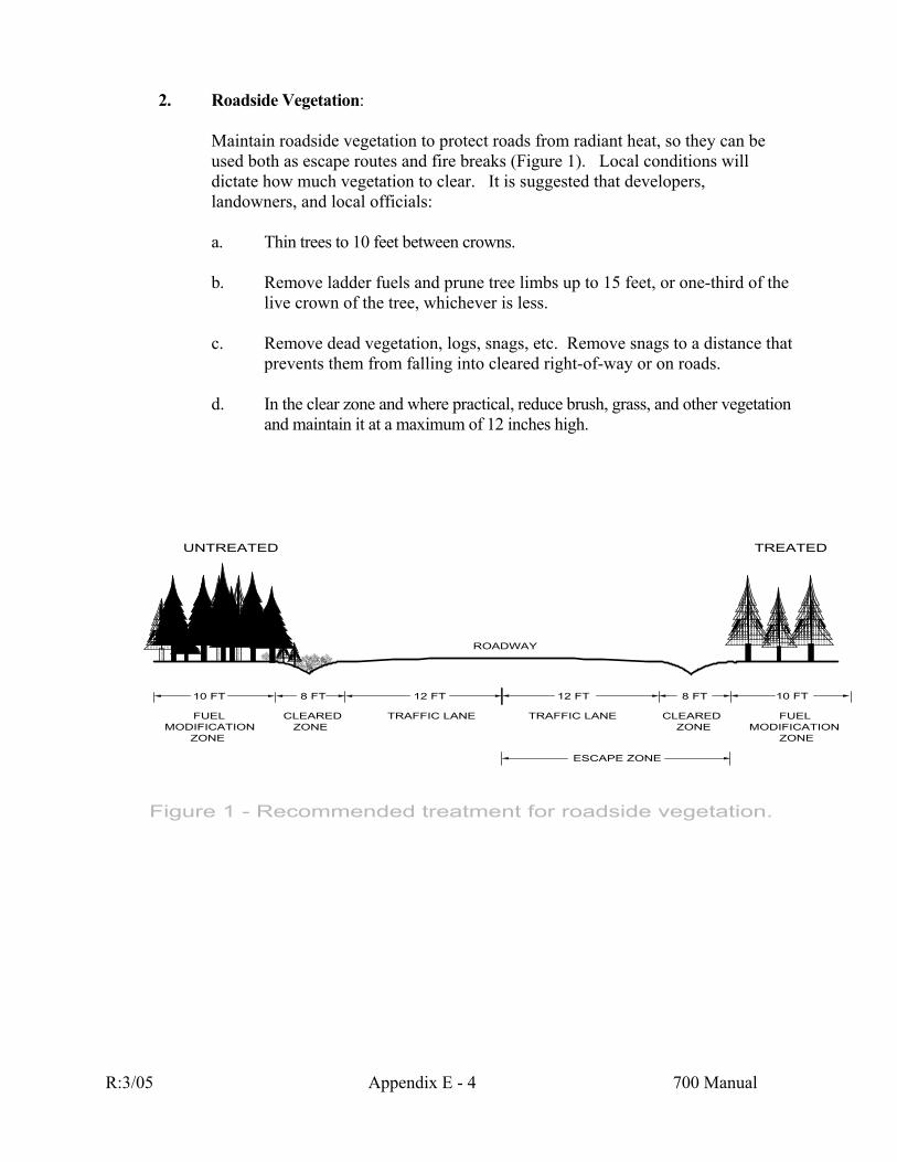
2. Roadside Vegetation:
Maintain roadside vegetation to protect roads from radiant heat, so they can be used both as escape routes and fire breaks (Figure 1). Local conditions will dictate how much vegetation to clear. It is suggested that developers, landowners, and local officials:
a. Thin trees to 10 feet between crowns. b. Remove ladder fuels and prune tree limbs up to 15 feet, or one-third of the
live crown of the tree, whichever is less. c. Remove dead vegetation, logs, snags, etc. Remove snags to a distance that
prevents them from falling into cleared right-of-way or on roads. d. In the clear zone and where practical, reduce brush, grass, and other vegetation
and maintain it at a maximum of 12 inches high.
10 FT 8 FT 12 FT 10 FT8 FT12 FT
ROADWAY
FUELMODIFICATION
ZONE
CLEAREDZONE
TRAFFIC LANE FUELMODIFICATION
ZONE
CLEAREDZONE
TRAFFIC LANE
UNTREATED TREATED
ESCAPE ZONE
Figure 1 - Recommended treatment for roadside vegetation.
R:3/05 Appendix E - 4 700 Manual

202 ROADS
In an emergency, all road systems shall provide for unobstructed traffic circulation for residents, firefighters, and fire equipment. This requires wide, well-constructed roads with sufficient turnarounds to prevent getting stuck off the road, and to allow simultaneous access by emergency vehicles and escape by local residents. Turns must be designed and hill grades established with truck traffic in mind. Fire departments must be able to drive close to residences. Narrow, private roads, while picturesque and inexpensive to build, reduce access and limit the ability of emergency vehicles to respond quickly.
1. Access Routes
All developments should have more than one access route. Access routes should allow two-way traffic so fire equipment can move in and people move out of an area in an emergency. Access route design should consider escape routes and safety zones. Roads should be designed to meet county standards, if the standards allow for adequate two-way traffic.
2. Primary Roads
Primary roads should be designed and built as follows (Figure 2):
a. An adequate right-of-way, consisting of:
i. Two 12-foot wide driving lanes.
ii. Two 8-foot wide zones clear of vegetation. [see Section 201(2).] iii. Two 10-foot wide zones of reduced vegetation. [see Section 201(2).]
DRIVING LANESCLEAR OF
VEGETATIONREDUCED
VEGETATIONCLEAR OF
VEGETATIONREDUCED
VEGETATION
60 FT. RIGHT-OF-WAY
10 FT 8 FT 12 FT 10 FT8 FT12 FT
Figure 2 - Primary road right-of-way.
R:3/05 Appendix E - 5 700 Manual
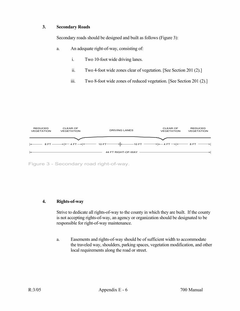
3. Secondary Roads
Secondary roads should be designed and built as follows (Figure 3):
a. An adequate right-of-way, consisting of:
i. Two 10-foot wide driving lanes.
ii. Two 4-foot wide zones clear of vegetation. [See Section 201 (2).]
iii. Two 8-foot wide zones of reduced vegetation. [See Section 201 (2).]
DRIVING LANESCLEAR OF
VEGETATIONREDUCED
VEGETATIONCLEAR OF
VEGETATIONREDUCED
VEGETATION
44 FT RIGHT-OF-WAY
8 FT 4 FT 10 FT 8 FT4 FT10 FT
Figure 3 - Secondary road right-of-way.
4. Rights-of-way
Strive to dedicate all rights-of-way to the county in which they are built. If the county is not accepting rights-of-way, an agency or organization should be designated to be responsible for right-of-way maintenance.
a. Easements and rights-of-way should be of sufficient width to accommodate the traveled way, shoulders, parking spaces, vegetation modification, and other local requirements along the road or street.
R:3/05 Appendix E - 6 700 Manual

5. Emergency Service Access to Individual Lots and Driveways
Driveways should be constructed as follows (Figure 4):
a. A minimum unobstructed driving surface of 12 feet and a vertical clearance of 15 feet for driveways less than 300 feet and a 16 foot driving surface for any driveway over 300 feet..
b. A 4-foot wide zone of reduced vegetation on each side of the driving surface is
desirable. c. Turnaround space should be provided at all building or structure sites on
driveways over 300 feet in length.
i. A turnaround should be within 50 feet of the building or structure when there is no community water supply with fire hydrants.
ii. A turnaround should be within 150 feet of the building or structure
when there is a community water supply with fire hydrants.
d. If the driveway is less than 16 feet wide turnouts, should be designed and constructed every 300 feet along the driveway's length.
e. The opening through a gate should be two feet wider than the road.
DRIVING SURFACE REDUCEDVEGETATION
REDUCEDVEGETATION
24 FT RIGHT-OF-WAY
Figure 4 - Individual lots and driveway access.
4 FT. 16 FT. 4 FT.
R:3/05 Appendix E - 7 700 Manual

6. Cul-de-sacs
a. In areas of extreme fire hazard classification, as determined by the local fire authority, the length of a road ending in a cul-de-sac T shall not exceed 600 feet (Figure 5). In all other areas the maximum length will be 1,000 feet.
b. End all cul-de-sacs with a clearance of at least 90 feet in diameter (45' radius).
600 - 1000 FT
CUL-DE-SAC
45 FT
90 FTDIAMETER
Figure 5 - Cul-de-sac specifications.
R:3/05 Appendix E - 8 700 Manual

7. Hammerhead T Turnarounds
a. Hammerhead-T designed turnarounds must provide emergency vehicles with a 3-point turnaround capability. In areas of extreme fire hazard classification, as determined by the local fire authority, the length of a road ending in a Hammerhead T shall not exceed 600 feet (Figure 6). In all other areas the maximum length will be 1,000 feet.
b. Maintain a minimum of 45 feet in length and 20 feet in width of turnaround
area.
8. Road Grades
Road grades often will determine what type of emergency fire equipment (if any) can access an area. The desirable road grades should be no greater than 8 percent. However, many factors influence the building of roads, and an 8 percent grade is not always possible or practical. Roads greater than 10 percent may be allowed upon approval by the local fire authority and should consider the following:
a. Roads with grades steeper than 10 percent should only be allowed when there
is no alternative and upon approval of the local fire authority. b. In steep areas where roads cannot be built on grades of 10 percent or less, keep
the steeper roads as short as possible. c. All roads with a grade steeper than 10 percent should be graded and surfaced
and of sufficient design to support the weight of 20-ton vehicles.
9. Road and Driveway Intersections
a. Build road intersections as close to 90 degrees as possible (Figure 7). b. Build all roads straight for a distance of 80 feet from any intersection.
R:3/05 Appendix E - 9 700 Manual

c. Avoid building an intersection at an angle less than 45 degrees.
10. Road Curve Radius
Fire equipment is as varied as road conditions. Consult the local fire authority and design the road to accommodate present and planned developments in terms of getting fire equipment in and people out in the case of an emergency. In general, build road curves in a radius of 100 feet or more (Figure 7).
24 FT MIN. WIDTH
80 FT. MIN.
90
100 FT MIN. RADIUS
90'
Figure 7 - Road curve specifications.
R:3/05 Appendix E - 10 700 Manual

11. Bridges
a. Build bridges as wide as the roads or driveways they connect (Figure 7). b. At primary entrances and exits of developed areas, build or reinforce all
bridges to a design load of 40 tons (80,000 pounds) minimum. c. Build or reinforce all other bridges within developments to a design load of 20
tons (40,000 pounds). d. Build all bridges using non-flammable materials.
24 FT MIN. WIDTH
BRIDGE40 TON MIN.
Figure 8 - Primary road bridge specifications.
R:3/05 Appendix E - 11 700 Manual
203 WATER STORAGE AND SUPPLY
Water is the single most important factor in suppressing structure fires. Water also plays an important role in suppressing wildland fires. Every community should store and supply water in a broadly-based system.
1. Fire Hydrants
If hydrants are planned, install hydrants of the size and type and in locations determined by the local fire authority or jurisdiction, or use the following general guidelines:
a. In interface areas of 0 to 2 homes per acre, install fire hydrants no more than
660 feet apart. The hydrant system must maintain a minimum flow of 500 gallons per minute.
b. In interface areas of more than 2 homes per acre, install fire hydrants no more
than 330 feet apart. The hydrant system must maintain a minimum flow of 750 gallons per minute.
c. In areas where the fire authority having jurisdiction has declared a high, very
high, or an extreme fire hazard, provide fire hydrants with 30 psi of residual water pressure.
d. In areas where the fire authority having jurisdiction has declared a low or
moderate fire hazard, provide fire hydrants with 20 psi of residual water pressure.
e. Store and supply enough water to flow through hydrants at the required rate
for at least 2 hours. This is in addition to the maximum daily flow that the area needs for domestic water.
2. Water Mains
a. When hydrants are required, use only waterways at least 6 inches in diameter. b. Install gate valves to connect the water mains and fire hydrants. c. Replace smaller water mains with ones that meet this standard. d. Install water mains that permit circulating water flow.
3. Individual Water Storage and Supply
It is recommended that in WRI areas where homes have an independent water supply, such as an individual well and pump, developers and owners should provide for adequate storage and supply of water for firefighting purposes.
R:3/05 Appendix E - 12 700 Manual
a. Developers and owners can use cisterns, swimming pools, tanks, lakes, ponds, streams, etc. to store water.
b. Store at least 2,500 gallons of water per residence in addition to the domestic
water source. c. Attach a dry hydrant or provide a draft opening to the 2,500-gallon water
source. For lakes, ponds, and streams, provide fire engine access as below and install dry hydrants where possible.
d. Locate the water source where fire engines can easily reach it. On level
ground, fire engines must be able to get within 10 feet of the water source to be able to use it effectively.
e. Install at least two 3/4-inch hose outlets for each building. f. Landowners must consult with the local fire authorities to see if they need to
operate a water shuttle. If so, develop the shuttle areas as specified. g. Equip any electrical pump with a reliable backup electrical generator or an
alternative gasoline-powered pump. h. Firefighters must be able to find the water source. Document each source of
water on the plans of the development, home, or other structure(s), and give this documentation to the local fire authority.
i. Protect the structures that house water storage or water supply, per Sections
201, 205, and 206.
4. Residential Sprinklers
Residential sprinkler systems provide excellent fire protection. These systems should be considered when evaluating the fire safety of homes. Fire authorities could consider installation of residential sprinkler systems as a trade-off for other fire protection measures.
Contact your local fire authorities to discuss residential sprinkler systems for the protection of your home. Be sure a licensed contractor designs and installs the sprinkler system.
Fire authorities having jurisdiction may require developers or landowners to store or supply water beyond the guidelines detailed above. These address only the minimum water storage and supply guidelines.
R:3/05 Appendix E - 13 700 Manual
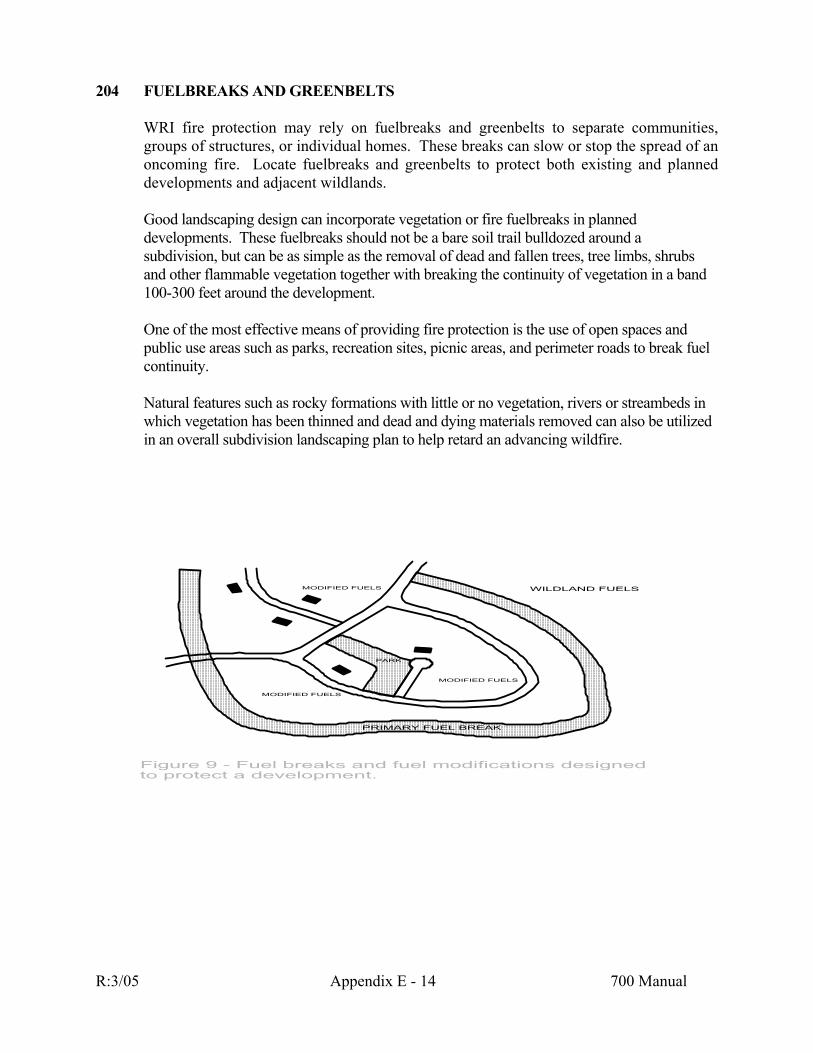
204 FUELBREAKS AND GREENBELTS
WRI fire protection may rely on fuelbreaks and greenbelts to separate communities, groups of structures, or individual homes. These breaks can slow or stop the spread of an oncoming fire. Locate fuelbreaks and greenbelts to protect both existing and planned developments and adjacent wildlands.
Good landscaping design can incorporate vegetation or fire fuelbreaks in planned developments. These fuelbreaks should not be a bare soil trail bulldozed around a subdivision, but can be as simple as the removal of dead and fallen trees, tree limbs, shrubs and other flammable vegetation together with breaking the continuity of vegetation in a band 100-300 feet around the development.
One of the most effective means of providing fire protection is the use of open spaces and public use areas such as parks, recreation sites, picnic areas, and perimeter roads to break fuel continuity.
Natural features such as rocky formations with little or no vegetation, rivers or streambeds in which vegetation has been thinned and dead and dying materials removed can also be utilized in an overall subdivision landscaping plan to help retard an advancing wildfire.
PARK
WILDLAND FUELS
PRIMARY FUEL BREAK
MODIFIED FUELS
MODIFIED FUELS
MODIFIED FUELS
Figure 9 - Fuel breaks and fuel modifications designed to protect a development.
R:3/05 Appendix E - 14 700 Manual

205 ROOF CONSTRUCTION
Wildfire can produce exceptionally strong winds that can carry particles up to a mile from the fire front. These airborne fire brands landing on a roof can ignite the building and threaten other structures. Roof material is more critical than roof construction. Consider the following elements:
1. *Use only Class A or B fire-rated roofing materials. 2. Never use untreated wood shakes or shingles. 3. Where practical, build all roofs with the minimum of a 4 in 12 pitch. 4. If possible, avoid horizontal roofs.
*Wood shakes or shingles can achieve a Class B rating by using a foil-faced or equivalent substrate or underlayment of non-combustible material and when the shakes are periodically treated with fire retardant. Follow manufacturer's treatment guidelines and re-treat as specified.
R:3/05 Appendix E - 15 700 Manual

206 BUILDING CONSTRUCTION
All buildings in the WRI shall be designed and constructed to comply with the Uniform Building Codes (UBC) and the Uniform Fire Codes (UFC).
enclosed Ro
nderside of all eavand floors with one hour fire-resistant materi
one hour fire-resistant materials.
a open
b. ofs w ch non-combustible, corrosion-resistant metal me
FIRE RATING OF ROOFING MATERIALS Fire Rating Type of Material Spread Index *** Class A Slate 0-25
Rock shingle Concrete tile Fiberglass based:
- asphalt shingle - rolled roofing Class B Aluminum shingle 26-75
Aluminum or steel panels Periodically treated - wood shingle or shake
plus heat barrier Class C Felt-tar based 76-200 - asphalt shingle - rolled roofing
Asphalt tar gravel Periodically Treated - wood shake - wood shingle Not Rated Untreated wood shingle or 200++ shake
The Spread Index is determined by the UL Tunnel Test that uses samples of 20 inches by 25 feet of building materials and compares the Flame Spread to Asbestos Cement Board (rated as 0) and uncoated red oak (rated as 100). The National Fire Protection Association (NFPA) has adopted these classifications based on the American Society for Testing and Materials ASTM-E-84 (UL Tunnel) test results. Federal, State, and local authorities accept these classifications.
1. Eaves, Balconies, Decks, Un ofs, and Floors
a. Protect the exposed u es, balconies, and unenclosed roofs, decks, als.
b. Protect all supporting beams and posts, in stilt or cantilevered construction, with
2. Vents
. Attic ings, soffit vents, foundation louvers, or other direct openings in outside walls, overhangs, or roofs should be no larger than 144 square inches.
Cover all openings in outside walls, overhangs, or ro ith a 1/4-in
sh.
R:3/05 Appendix E - 16 700 Manual

3. Chimneys
a. Install only an approved spark arrester around the mouth of the chimney,
stovepipe, or vent of any heater, stove, or fireplace. b. Clean spark arrester regularly to remove deposits.
4. Exterior Walls
Build outside walls out of one hour fire-resistant materials. Do not use shingles, shakes, or rough-cut wood siding to sheathe outside walls.
5. Exterior Rafters
Close off the spaces between outside rafters, wall plates, and the underside of the roof sheathing with wood at least two inches thick or equivalent solid blocking.
6. Windows
Wildfire can radiate through windows, heating the interior of houses to combustion temperature. It can heat, crack, and break the windows, letting in burning particles.
a. Keep window surface area to a minimum. In particular, since fire usually
travels uphill, minimize window surface area on downhill-facing walls. b. Build several small windows instead of one large window, as large windows
are more vulnerable to fire damage. c. Screen all windows.
R:3/05 Appendix E - 17 700 Manual

207 BUILDING SPACING AND DENSITIES
The distance between structures directly affects how fast a wildfire can spread. Local governments, developers, owners, and responsible fire authorities should consider base spacing and density dependent on slope and fuels in the area of the structures.
1. Building Spacing
a. Residential structure spacing must meet county requirements. Attempt to space buildings, including mobile homes, at least 60 feet apart and at least 30 feet from the property line.
2. Building Densities
a. Locate buildings on each piece of property so that developers and
homeowners can reduce vegetation in accordance with Section 201. General guidelines to meet the defensible space are:
i. Slope 0% - 20% - A minimum 1 acre for a structure to be placed on
lands in forest fuels.
ii. Slope 21% - 30% - A minimum 1.5 acre for a structure to be placed on lands in forest fuels.
b. Never build structures in forest fuels where the slope is greater than 30%, at a
canyon mouth, in a ridge saddle, or in other areas of extreme fire hazard.
R:3/05 Appendix E - 18 700 Manual
208 BUILDING ADDRESSES AND ROAD SIGNS - NAMES AND NUMBERS
Clearly designate roads by names and buildings by numbers so emergency personnel can find the fire site quickly. All road signs and address numbers must be visible from the road.
1. Buildings
a. A building should clearly display the address number between 4 and 8 feet
above the ground. b. The use of only non-combustible material for address markers is
recommended. c. Personnel in emergency vehicles must be able to read the address from at least
100 feet. Number all buildings with script at least 4 inches high and at least 1/2-inch wide. The signs should be reflectorized and should contrast with the background color of the sign.
d. A cluster of buildings owned by the same person may share a single address.
2. Road and Street Signs
a. The State or county must install and maintain State and county road signs. b. The owners of private roads must install and maintain approved private road
signs. c. The responsible party should place the approved road name on a sign between
4 and 8 feet off the ground, where it can easily be seen. d. The use of only non-combustible material for road signs is recommended.
Personnel in emergency vehicles must be able to read the road name from at least 100 feet. Print all road signs with script at least 4 inches high and at least 1/2-inch wide. The signs should be reflectorized, and numbers should contrast with the background color of the sign.
R:3/05 Appendix E - 19 700 Manual
209 UTILITIES Most fires resulting from electrical lines seem to be caused by distribution lines, not
transmission lines. In eastern Montana, however, transmission lines do cause some fires. On classified forest land, utility companies and individuals responsible for utilities, must maintain all rights-of-way in accordance with Rule VIII of the Montana Department of State Lands Forest Fire Regulations, which states:
All persons, firms or corporations who own, control, operate, or maintain electrical transmission or distribution lines shall, prior to the beginning of fire season each year, inspect said powerlines for hazards and risks, correct the fire hazards and risks found, and inform the recognized agency that necessary remedial actions have been accomplished.
In addition and on all lands:
1. Distribution Circuit (Line)
a. Build, modify, or extend all distribution lines underground wherever practical. b. For above-ground lines, vegetation in rights-of-way must be managed.
2. Transmission Circuit (Line)
a. Transmission lines of 34.5 kilovolts and greater cannot be placed underground. Rights-of-way should be free of fire hazards
R:3/05 Appendix E - 20 700 Manual
Glossary
Accessory Building or Structure- any building or structure used incidentally to another building or structure. Cantilevered Construction- a method of constructing structures on a slope, where part of the structure rests on foundation set in the ground and part of the structure rests on posts rising from further down the slope.
Cistern - an underground water storage tank, usually buried below frost level. Tree Crown - the primary and secondary branches growing out from the main stem, together with twigs and foliage. Defensible Space - a designated area around a home or other structure the size of which is dependent on the vegetation, proximity of tree crowns, slope and distance to adjacent buildings. Within this area all weeds, dry grass, slash, flammable debris and flammable fuel is removed. This managed buffer surrounding buildings and structures is designed to reduce the chances of a fire spreading to or from the buildings or structures. Draft Opening - an opening where firefighters can insert a standard size hose to pump water out. Development - human-made improvement of property. Distribution Circuit (Line) - high-voltage circuit between a main switchyard and the point of use. Driveway - vehicular ingress and egress routes that serve no more than two buildings or structures, not including accessory structures, on one parcel containing no more than three dwelling units.
Dry Hydrant - a pipe that leads to a water source, but has no pressure of its own. Firefighters use dry hydrants to draft water from the water source to supply water to apparatus and pumps. Easement - a legal right to use or enjoy, in a specific manner, land owned by someone else. Fuel - a material that will readily support combustion. In the case of the Wildland Residential Interface, fuels are primarily wildland fuels - i.e., the natural vegetation that grows, dies, and accumulates, but may also include structures, wood piles, yard accumulations, etc. Fuelbreak - a strip of land where the natural fuels have been greatly reduced or thinned. Gate Valve - a device that can be moved to open or shut off the flow of water. Greenbelt - a strip of land with lawn or other small quantities of non-native vegetation. Examples: golf courses, mowed parks, riverbank paths, etc. Hazard - the combination of accumulated fuels, weather, and topography patterns which contribute to the potential fire intensity, should an ignition occur.
R:3/05 Appendix E - 21 700 Manual

Interface - see Section 102. Intermix - see Section 102. Landowner - anyone who owns land, whether they have built on it or not. This includes corporations, private individuals, public agencies, real estate agencies, etc. Local (Government) Officials - city councils, county commissioners, county surveyors, mayors, planning departments, sheriffs, zoning departments, etc. Primary Access Road - a main entry and exit road. Usually the road(s) that leads into the development from a highway, county road, or major arterial. Must provide for unobstructed traffic circulation during an emergency. Rights-of-way - a strip of land on which a public road is built, or which a railroad or public utility has the legal right to use. Risk - the chance of a fire starting because there is a causative agent; the causative agent itself. Secondary Road - a road that leaves a primary access road to reach homes, buildings, recreational sites, etc. that lie away from the primary road. Driveways longer than 600 feet are considered as secondary roads. Sheathing - materials that cover the exterior walls and roof of a structure - i.e., wood, metal. Soffit - the under surface of a horizontal part of a structure, such as the bottom of an overhang or the bottom of a staircase.
Spark Arrester - a welded or woven wire mesh screen with openings no larger than 1/2-square inch, used to filter burning particles from smoke. Stilt Construction - a method of construction where the structure rests on posts rising up from the ground. Structure - any building - home, business, storage building, barn, shed, etc. Transmission Circuit (Line) - a very high voltage circuit between the generating source and the switchyard (substation). Vegetation - any plant, native or planted, living or dead; tree, shrub, bush, grass, flower, etc. Water Tank - a container to hold water, above or below ground. Water Main - a large pipe that carries water from its original source. Waterway - a channel or course for water within a valve or hydrant.
R:3/05 Appendix E - 22 700 Manual

Wildfire - an unplanned and uncontrolled fire spreading through vegetation, but often consuming structures or other improvements as well.
Wildlands - uncultivated land covered by forest, brush, or grass. Development is essentially nonexistent except for roads, railroads, power lines and similar facilities, or remote structures used for recreation or timber production. Not fallow lands. WRI - Wildland Residential Interface. See Section 102.
R:3/05 Appendix E - 23 700 Manual
REFERENCES
California Department of Forestry and Fire Protection, 1980. Fire Safety Guides for Residential Development in California Sacramento, CA. Clayton, B., Day, D. and McFadden, J., 1966. Wildland Firefighting State of California, Documents Section, North Highlands, CA. Colorado State Forest Service, 1974. Guidelines and Criteria for Wildfire Hazard Areas Fort Collins, CO. Colorado State Forest Service, 1980. Wildfire Hazards: Guideline for Their Prevention in Subdivisions and Developments Fort Collins, CO. Coulter, J.B., 1980. Wildfire Safety Guidelines for Rural Homeowners Colorado State Forest Service, Fort Collins, CO. Dennis, F.C., 1983. Fuelbreak Guidelines for Forested Subdivisions Colorado State Forest Service, Fort Collins, CO. Fischer, W.C. and Arno, S.F., compilers, 1983. Protecting People and Homes from Wildfire in the Interior West USDA Forest Service, Intermountain Research Station, Ogden, UT, General Technical Report INT-251. Proceedings of the symposium and workshop, October 6-8, 1987, Missoula, MT.
Gale, R.D. and Cortner, H.J., eds. 1987. People and Fire at the Wildland/Urban Interface - A Sourcebook USDA Forest Service, From the Wildland/Urban Fire Interface Workshop for Social Scientists, Asheville, NC.
International Conference of Building Officials, 1991. Uniform Building Code Whittier, CA. International Conference of Building Officials, 1991. Uniform Fire Code Whittier, CA. Kendall, D., 1974. Forest Fires and Land Use Planning Flathead County, MT. Kermer, R., 1986. Cabin Owner's Guide to Fire Prevention Office of the Minister of Indian Affairs and Northern Development, Ottawa, Ont., Canada. Laughlin, J. and Page, C., eds., 1987. Wildfire Strikes Home! NFPA No. SPP-86, ISBN No. 0-87765-337-2 Montana Department of State Lands, 1993. Fire Risk Rating for Existing and Planned Developments Missoula, MT. National Fire Academy, 1989. Wildland/Urban Interface Fire Protection Emmitsburg, MD. National Fire Protection Association, 1991. NFPA 299, Protection of Life and Property from Wildfire Boston, MA. R:3/05 Appendix E - 24 700 Manual

Oregon State Forestry Department, 1978. Fire Safety Considerations for Developments in Forested Areas Salem, OR. Pyne, S.J., 1984. Introduction to Wildland Fire Management in the United States John Wiley & Sons, New York, NY. Schmidt, Wyman C. and Wakimoto, Ronald H., 1988. Cultural Practices that Can Reduce Fire Hazards to Homes in the Interior West from the Protecting Your Home From Wildfire in the Interior West Proceedings of the Symposium and Workshop, Missoula, MT. Sierra Front Wildfire Cooperators, 1992. Wildfire Protection for Homeowners and Developers, California/Nevada. Steele, R.W., 1957. Man-Caused Forest Fires in Montana, 1946-1956 Bulletin No. 6, University of Montana, Missoula, MT. Western Fire Chiefs Association, 1991. Development Strategies in the Wildland/Urban Interface WFCA Press, Ontario, CA.
R:3/05 Appendix E - 25 700 Manual
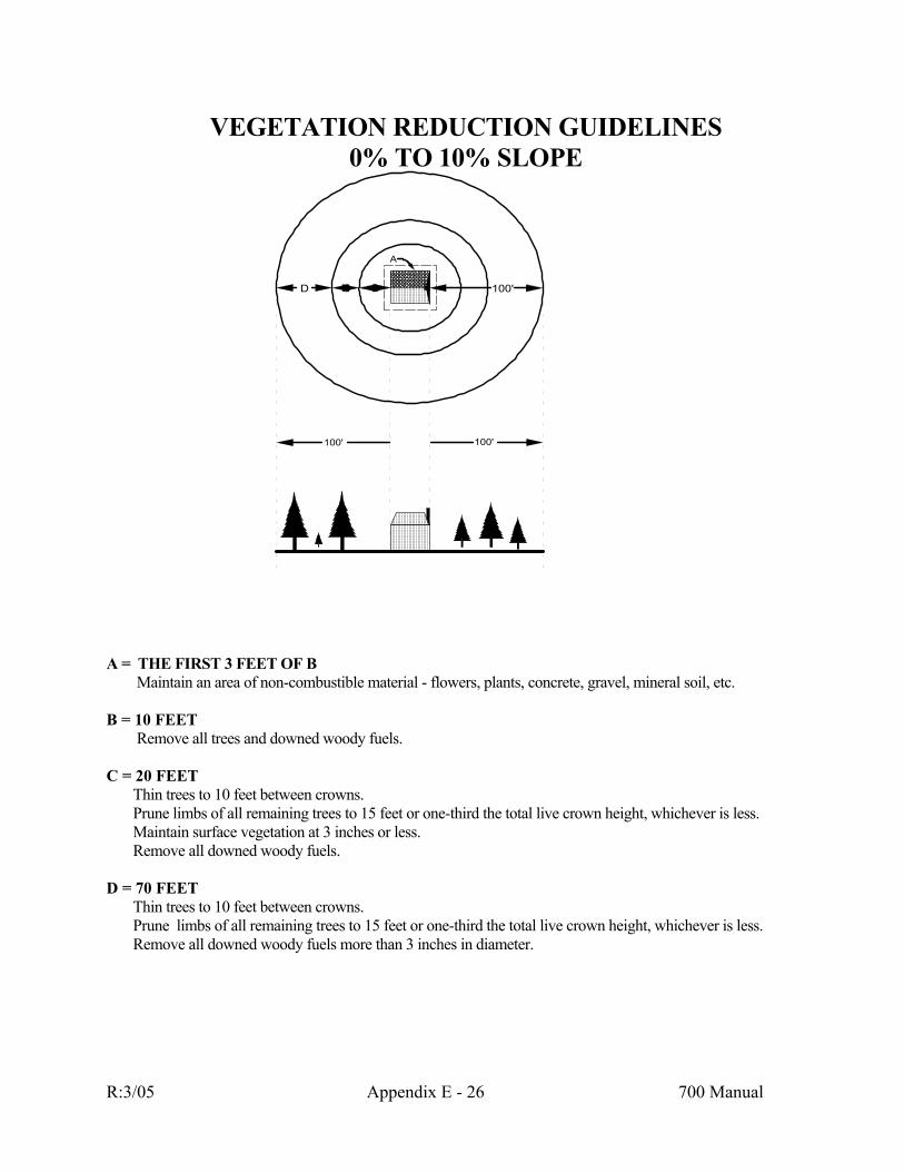
VEGETATION REDUCTION GUIDELINES
0% TO 10% SLOPE
100'
A
D C B 100'
100'
A = THE FIRST 3 FEET OF B
Maintain an area of non-combustible material - flowers, plants, concrete, gravel, mineral soil, etc.
B = 10 FEET Remove all trees and downed woody fuels.
C = 20 FEET Thin trees to 10 feet between crowns. Prune limbs of all remaining trees to 15 feet or one-third the total live crown height, whichever is less. Maintain surface vegetation at 3 inches or less. Remove all downed woody fuels.
D = 70 FEET Thin trees to 10 feet between crowns. Prune limbs of all remaining trees to 15 feet or one-third the total live crown height, whichever is less. Remove all downed woody fuels more than 3 inches in diameter.
R:3/05 Appendix E - 26 700 Manual
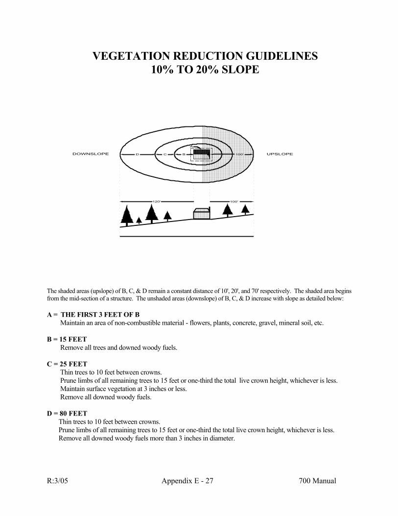
VEGETATION REDUCTION GUIDELINES
10% TO 20% SLOPE
100'
DOWNSLOPE UPSLOPE100'D C B
120'
A
The shaded areas (upslope) of B, C, & D remain a constant distance of 10', 20', and 70' respectively. The shaded area begins from the mid-section of a structure. The unshaded areas (downslope) of B, C, & D increase with slope as detailed below: A = THE FIRST 3 FEET OF B
Maintain an area of non-combustible material - flowers, plants, concrete, gravel, mineral soil, etc.
B = 15 FEET Remove all trees and downed woody fuels.
C = 25 FEET Thin trees to 10 feet between crowns. Prune limbs of all remaining trees to 15 feet or one-third the total live crown height, whichever is less. Maintain surface vegetation at 3 inches or less. Remove all downed woody fuels.
D = 80 FEET Thin trees to 10 feet between crowns. Prune limbs of all remaining trees to 15 feet or one-third the total live crown height, whichever is less. Remove all downed woody fuels more than 3 inches in diameter.
R:3/05 Appendix E - 27 700 Manual
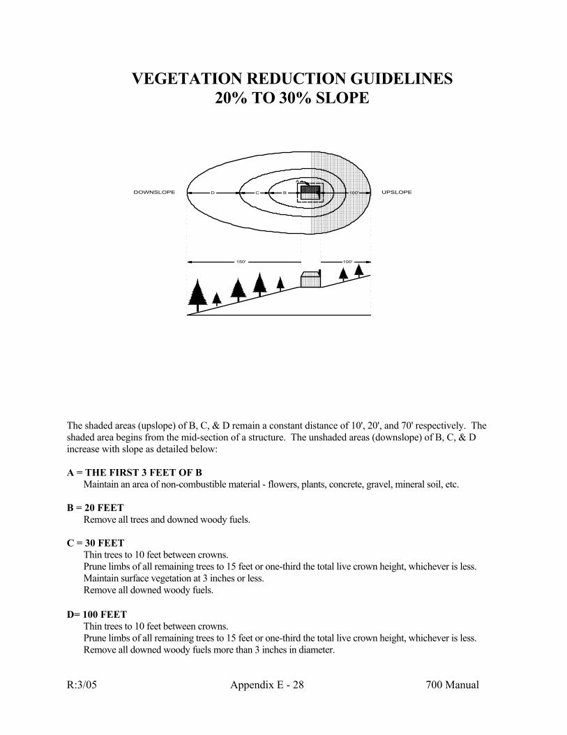
VEGETATION REDUCTION GUIDELINES 20% TO 30% SLOPE
100'
DOWNSLOPE UPSLOPE100'D C B
A
150'
The shaded areas (upslope) of B, C, & D remain a constant distance of 10', 20', and 70' respectively. The shaded area begins from the mid-section of a structure. The unshaded areas (downslope) of B, C, & D increase with slope as detailed below:
A = THE FIRST 3 FEET OF B
Maintain an area of non-combustible material - flowers, plants, concrete, gravel, mineral soil, etc.
B = 20 FEET Remove all trees and downed woody fuels.
C = 30 FEET Thin trees to 10 feet between crowns. Prune limbs of all remaining trees to 15 feet or one-third the total live crown height, whichever is less. Maintain surface vegetation at 3 inches or less. Remove all downed woody fuels.
D= 100 FEET Thin trees to 10 feet between crowns. Prune limbs of all remaining trees to 15 feet or one-third the total live crown height, whichever is less. Remove all downed woody fuels more than 3 inches in diameter.
R:3/05 Appendix E - 28 700 Manual

VEGETATION REDUCTION GUIDELINES THINNING AND PRUNING
10 FT
SURFACE FUEL3-12 IN.
THINNING
PRUNING
15 FEET OR1/3 LIVE CROWN
WHICHEVER IS LESS
In areas where vegetation modification is prescribed, use the following guidelines:
A THINNING
Thin trees to 10 feet between crowns. B. PRUNING
Prune the limbs of all remaining trees to 15 feet or one-third the total live crown height, whichever is less.
C. SURFACE VEGETATION
Maintain surface vegetation at 3" to 12" as detailed.
R:3/05 Appendix E - 29 700 Manual

Appendix F
FIRE RISK RATING For Existing and Planned Wildland Residential Interface Developments
in Montana

TABLE OF CONTENTS CHAPTER I - FIRE RISK RATING FOR EXISTING DEVELOPMENTS
Introduction....................................................................................................................... 1 How to use the Risk Rating System for Existing Developments......................................... 2 Part I - Instructions for Collecting Area Information ...................................................... 3 Part II - Instructions for Rating Existing Developments ............................................. 7 CHAPTER II - FIRE RISK RATING FOR PLANNED DEVELOPMENTS Introduction.................................................................................................................. 8 How to use the Risk Rating System for Planned Developments ................................. 9 Part I - Instructions for Collecting Area Information ................................................ 10 Part II - Instructions for Rating Planned Developments............................................ 14 DEFINITION OF TERMS.................................................................................................. 15 SOURCE LIST..................................................................................................................... 18
APPENDICES APPENDIX A - FORM A - EXISTING DEVELOPMENT DATA COLLECTION FORM APPENDIX B - FORM B - RESIDENTIAL TALLY SHEET APPENDIX C - FORM C - EXISTING DEVELOPMENT RATING FORM APPENDIX D - FORM A - PLANNED DEVELOPMENT DATA COLLECTION FORM APPENDIX E - FORM B - PLANNED DEVELOPMENT RATING FORM APPENDIX F - LANDSCAPING GUIDELINES
R:3/05 Appendix F - 1 700 Manual

INTRODUCTION The risk rating system for existing developments is a planning tool for fire prevention. It assesses the potential wildfire hazards faced by wildland residential developments. The system allows prevention planners to assess areas for risk, rank them according to their risk score, and then set priorities for prevention resources and actions. It organizes physical site information such as road access, topography, fuels, construction and water sources so that the planner can easily review all the information at once. The Montana Department of State Lands (DSL) developed this rating system for its staff and cooperators to use. The risk rating system can help anyone conducting or planning fire prevention activities in existing wildland/residential interface areas. Using the risk rating system also logically benefits all prevention planners by increasing their familiarity with hazardous locations and the values at risk within their fire protection areas. DSL continues to develop ways to minimize destruction from wildfire while using public funds most efficiently. The risk rating system adapts existing knowledge, from agencies well experienced with the interface fire problem, to this end.
R:2/05 Appendix F - 2 700 Manual

HOW TO USE THE RISK RATING SYSTEM FOR EXISTING DEVELOPMENTS Prevention planners can evaluate wildland and rural areas that have enough permanent, seasonal, recreational or commercial habitation to pose a fire hazard or risk. Logical applications might include rural subdivisions, scattered residential developments, camps, lodges and resorts. The rating area can be as large or small as deemed necessary. However, a rating area should meet two criteria: - It should be one relatively homogenous development that has distinct site factors. For
example, the Many Lakes subdivision may make a logical rating area, but the entire Flathead Valley would not. Part of a subdivision may constitute a logical rating area if it is somehow different from the rest of the subdivision.
- It should be large enough to take into account the surrounding fuels, topography, nearby
risks, etc., that will affect fire occurrence. Always access separate subdivisions individually. If you have any doubts about what to make a rating area, err on the small side. In the risk rating system, if you assess smaller areas, you will still have useful information; if you rate larger areas, your rating may be inaccurate, meaningless or, worse, misleading.
R:2/05 Appendix F - 3 700 Manual

PART I INSTRUCTIONS FOR COLLECTING AREA INFORMATION To collect the necessary information, you will need Form A - Data Collection Form for Existing Developments, (Appendix A), Form B - Residential Tally Sheet, (Appendix B), a 100-foot tape measure, a clinometer or Abney level, a compass, area maps, a vehicle and these instructions. The item numbers in these instructions correspond with the items on Form A - Data Collection Form.
1. Enter the number of primary access roads in the rating area. These must: - lead into or out of the rating area; - have two, twelve-foot traffic lanes, paved or gravel; - be able to be negotiated by structural fire equipment; - be maintained; and - be open year-round, not controlled access. If there are no roads that meet all of these conditions, enter zero.
2. Enter the number of alternative access roads in the rating area. These are roads which enter or leave the rating area, but do not meet the conditions for primary access roads.
They must:
- lead into or out of the rating area; - be able to be used by two-wheel drive vehicles as a substitute entry or exit road
for the rating area.
3. Enter the width of the road surface, including any serviceable shoulders, on the primary access roads. Do not include turn-outs.
4. Enter the grade (%) of the steepest part of road within the rating area. Include
secondary roads as well as primary and alternative access roads. Secondary roads are roads which leave a primary access road to reach homes, buildings, recreational sites, etc. that lie away from the primary road. Driveways over 600 feet are also considered secondary roads.
R:2/05 Appendix F - 4 700 Manual

5. Check the blank that matches the narrowest secondary road endings in the area. Include driveways longer than 600 feet as secondary roads. If the rating area has only one road, check the blank that describes how that road ends. Loop roads are those which return to a primary access road.
6. Check the blank which applies to the lightest capacity bridge on a primary access
road within the rating area. Thirty-eight ton (statutory limit) bridges should be considered 40 ton bridges.
7. Check the blank which applies to the lightest capacity bridge on a secondary road in
the rating area. Thirty-eight ton (statutory limit) bridges should be considered 40 ton bridges.
8. Check the blank which indicates the predominant slope (%) within and directly
adjacent to the part of the rating area where the homes are. 9. Check the blank which indicates the predominant aspect of the rating area. This can
be determined from a topographical map and/or site visit. To facilitate accurate aspect representation, the form asks for ranges by compass azimuth.
10. Check one or more blanks to indicate topographic features in and around the area
that would contribute to erratic or extreme fire behavior. The features are listed from least dangerous to most dangerous. If you check more than one, circle the one that is most dangerous/farthest down the list.
11. Check the blank which most closely indicates the predominant fuels conditions in the
rating area. 12. Check the blanks which indicate sources of risk in or immediately adjacent to the
rating area. Check all present. 13. Check the blank which indicates the worst maintained electrical utilities R.O.W. in
the rating area. 14. After actually counting, enter the number of homes in the rating area. An efficient
method would be to conduct this count and the spacing and landscaping information (items 14-17) at the same time. Use Form B - Residential Tally Sheet (Appendix B) for tallying this information, then transfer the total to item 14, Form A.
15. Enter the number of homes that have composition, metal, or tile roofs or other fire
resistant roofing (as defined on page 17). Do not include homes with wood shake or shingle roofs. Tally on Form B, then transfer the total to item 15, Form A.
16. Enter the number of homes which have one or more of: unenclosed balconies,
decks, eaves, stilts or cantilevered construction. Do not count any of these that have been thoroughly enclosed. Tally on Form B, then transfer the total to item 16, Form A.
R:2/05 Appendix F - 5 700 Manual

17. Visually estimate how far apart the homes are spaced. Check the blank which most nearly describes the distance between the majority of homes in the rating area. Tally on Form B, then transfer the total to item 17, Form A.
18. Tally the number of homes which meet or exceed the fire resistant landscaping
guidelines in Appendix F. Tally on Form B, then transfer the total to item 18, Form A.
19. If there are hydrants in the rating area, check "yes." 20. If there are hydrants in the rating area, measure the distance between them. Enter
that spacing. If no standard spacing exists, enter an average spacing. 21. If there are hydrants in the rating area, indicate whether they are of 500 gallon per
minute or greater capacity by checking either the "yes" or "no." To get this informa-tion, you can test the flow or check with the rural fire district, the water company or the county.
22. Check the blank which most closely indicates what draft sources exist and are
accessible in the rating area. 23. Check the blank which most closely indicates how close a reliable helicopter dip spot
is to the rating area. 24. Indicate whether the rating area is covered by a Rural Fire District (RFD), Fire
Service Area (FSA), or municipal fire department by checking either "yes" or "no." Do not include a Volunteer Fire Company unless it has been formed as part of one of the groups above, or by a county governing body or an incorporated town.
25. Check the blank which indicates the response time from the nearest fire organization
to the rating area. Get the response time from the chief officer. If that fire organi-zation is a Volunteer Fire Company, that is not part of a Rural Fire District, Fee Service Area or municipality, write "VFC" in the blank.
26. Indicate whether the rating area has a way to contact homeowners, such as a
homeowners association, civic club, development office, etc., by checking either "yes" or "no."
27. If you checked "yes" for item 26, check the blank which most closely describes the
group.
R:2/05 Appendix F - 6 700 Manual

28. Using statistics for the most recent 10-year period, indicate the average number of fires per thousand acres in and around the rating area. Follow either method of calculation below.
Example: Size of ABC Gulch Rating Area = 1280 acres Number of fires, 1977-1987 = 2 2 Fires 2 Fires x Fires ________ = .00156 _________ = _____ 1280 Acres 1280 Acres 1000 Acres x 1000 Conversion Factor 2000 = 1280x 200 = 128x 1.56 = x =1.56 Fires/1000 Ac./10 Yrs. = 1.56 fires/1000 Ac./10 Yrs.
R:2/05 Appendix F - 7 700 Manual
PART II INSTRUCTIONS FOR RATING To actually rate the area, you will need the filled-in Form A - Data Collection Form (Appendix A), Form C - Rating Form (Appendix C), and these instructions. Using the information on Form A, score each item on Form C by circling the number on Form C that corresponds to the answer you gave on Form A. For Item 10, circle the number for the most dangerous feature in the area. For Item 12, count the number of risks in the area and circle that number. For Item 15, divide the number of homes with fire resistant roofing by the total number of
homes in the area. For Item 16, divide the number of homes with unenclosed balconies, decks, eaves, stilts, etc.
by the total number of homes in the area. For Item 18, divide the number of homes that have fire resistant landscaping by the total
number of homes in the area. Total the numbers circled on Form C - Rating Form and enter that total in the "total score" space. Apply the following classifications to the totaled score. Fire Risk Ratings Score Classification <= 110 low risk - low priority 111-135 moderate risk - moderate priority 136-150 high risk - high priority 151-170 very high risk - very high priority >= 171 extreme risk - extreme priority Rating areas should also be ranked within these classifications. For example, two separate rating areas with scores of 136 and 150 would both be classified as "high" risk and priority. However, the area with the 150 score would logically pose the higher risk and the higher priority. The system provides a basic ranking system, which may be expanded using locally significant criteria, such as relative fire costs or cost per acre protected. We encourage all users to consider local factors which will help them clarify priorities.
R:2/05 Appendix F - 8 700 Manual
INTRODUCTION As with the risk rating system for existing developments, the risk rating system for planned developments is a planning tool for fire prevention. It assesses the potential wildfire hazards faced by developments planned in the Wildland Residential Interface. The risk rating for planned developments allows prevention planners to assess areas for risk, so that they may communicate the potential hazards to community planners, local government officials and developers prior to final platting or construction. Like the risk rating system for existing developments; it organizes physical site information such as planned road access, topography, fuels, planned construction, and water sources so that the planner can easily review all the information at once. Both risk rating systems logically benefits the prevention planner by increasing their familiarity with hazardous locations and the values at risk within their fire protection areas.
R:2/05 Appendix F - 9 700 Manual

HOW TO USE THE RISK RATING SYSTEM FOR PLANNED DEVELOPMENTS Prevention planners can assess proposed developments in wildland and rural areas which may pose a fire hazard or risk. Logical applications might include planned rural subdivisions, camps, lodges and resorts. The rating area can be as large or small as deemed necessary. However, a rating area should meet these criteria: 1. It should be one development represented by a single plat, that has distinct site factors. For
example: separate subdivisions, phases or plats covered under one Planned Unit Development, Neighborhood Plan, Overall Development Plan or similar document should be evaluated individually. A single development may be rated in separate parts if those portions are somehow unique.
2. It should be large enough to take into account the surrounding fuels, topography, nearby
risks, etc., that will affect fire occurrence or impact. Always rate separate projects individually. If you have doubts about what to make a separate rating area, err on the small side. In the risk rating system, if you choose to break a single development into smaller areas, you will still have useful information. However, excessively large areas may produce inaccurate, meaningless or misleading information.
R:2/05 Appendix F - 10 700 Manual

PART I INSTRUCTIONS FOR COLLECTING AREA INFORMATION To collect the necessary information you will need a copy of the project's preliminary plat, Form A - Data Collection Form for Planned Developments, (Appendix D), a topographic map of the project area and these instructions. Though some projects can be evaluated from the office, your evaluation will likely include a site visit. During that site visit you will need a 100-foot tape measure, a Clinometer or Abney level, and a compass. The items in these instructions correspond with the items on Form A - Data Collection Form. All required information can be obtained by examining the preliminary plat, discussing the project with a community planner or the developer and by visiting the site. 1. Enter the number of primary access roads which will serve the proposed development.
Primary access roads usually lead into the development from a highway, county road or arterial. These must:
- lead into or out of the proposed development (see plat); - have two, twelve-foot traffic lanes, paved or gravel (see plat); - be able to be negotiated by structural fire equipment (consider maximum grade and
curve radius); - be maintained; and - be open year-round, not controlled access. If there are no roads that meet all of these conditions, enter zero. 2. Enter the number of alternative access roads which will serve the development. These
are roads which enter or leave the rating area, but do not meet the conditions for primary access roads (may be platted or existing). They must:
- lead into or out of the proposed development (see plat); - be able to be used by two-wheel drive vehicles as a substitute entry or exit road for
the rating area. 3. Enter the width of the planned road surface, including any serviceable shoulders on the
primary access roads. Do not include turn-outs. 4. Enter the grade (%) of the steepest part of any road planned within the rating area.
Include secondary roads as well as primary and alternative access roads. Secondary roads are those which leave an access road to reach homes, buildings, recreational sites, etc. that lie away from the access road. Driveways over 600 feet are also considered secondary roads.
5. Check the blank that matches the most limiting secondary road endings planned for the
area. Include driveways longer than 600 feet as secondary roads. If the project planned only has one road, check the blank that describes how that road ends. Loop roads are those which return to a primary access road.
R:2/05 Appendix F - 11 700 Manual
6. Check the blank which applies to the lightest capacity bridge on a primary access road serving the planned development. Thirty-eight ton (statutory limit) bridges should be considered 40-ton bridges.
7. Check the blank which applies to the lightest capacity bridge on a secondary road within
the planned development. Thirty-eight ton (statutory limit) bridges should be considered 40-ton bridges.
8. Check the blank which indicates the predominant slope (%) within and directly adjacent
to the part of the rating area where dwellings will be constructed. This can be determined from a topographical map and/or site visit.
9. Check the blank which indicates the predominant aspect of the rating area. This can be
determined from a topographical map and/or site visit. To facilitate accurate aspect representation, the form asks for ranges by compass azimuth.
10. Check one or more blanks to indicate topographic features in and around the area that
would contribute to fire behavior which would threaten the proposed development or contribute to erratic or extreme fire behavior.
11. Check the blank which most closely indicates the predominant fuels conditions in and
around the rating area. 12. Check the blanks which indicate sources of risk which exist or are likely to exist in or
immediately adjacent to the rating area. Check all present. 13. Check the blank which indicates how electrical utilities will be installed and maintained
in the rating area. For small developments, you may want to consider the utility installations offsite instead.
14. Enter the number of homes planned for the development at full build-out. If the number
of homes are not indicated on the plat, use the number of lots platted. 15. Enter the number of homes that will have composition, metal, tile roofs or other fire
resistant roofing. Do not include homes with wood shake or shingle roofs. This infor-mation may require consultation with the developer or planner. If this information can not be obtained, make an assumption or enter multiple options.
16. Measure or estimate how far apart the homes will be spaced. Check the blank which
most nearly describes the distance between the homes in the rating area. If the prelimi-nary plat does not include proposed building sites, place the building site near the center of the lot.
17. Indicate whether the dwellings will meet or exceed the fire resistant landscaping guide-
lines in Appendix F. This information will likely require consultation with the de-veloper or planner. The fire prevention planner should not assume adequate defensible space unless it is clearly addressed in developer's covenants or attached as a condition of
R:2/05 Appendix F - 12 700 Manual
approval to the preliminary plat. The rating can be completed assuming adequate defensible space if the prevention planner feels confident that the developer has taken measures, or will be required, to take measures to incorporate adequate defensible space.
18. Indicate whether the project design has incorporated greenbelts and/or fuelbreaks to
protect the planned development, existing neighboring developments and/or the adjacent wildlands.
19. If fire hydrants are planned for the project, check "yes". 20. If hydrants are planned for the rating area, measure or otherwise ascertain the spacing
between them. Enter that spacing. If no standard spacing exists, enter an average spacing. You may have to consult the planner, developer or local fire department to collect this information.
21. If hydrants are planned for the rating area, determine whether their placement meets with
the approval or desire of the local fire department. You will have to consult with the local fire department to collect this information.
22. If hydrants are planned for the project, indicate whether they are of 500 gallon-per-
minute or greater capacity by checking either "yes" or "no". To get this information, check with the project engineer or the water company.
23. Check the blank which most closely indicates what draft sources exist and are accessible
in the rating area or are planned for the development. 24. Check the blank which most closely indicates how close a reliable helicopter dip spot will
be to the planned development. 25. Indicate whether the planned development is or will be protected by a Rural Fire District
(RFD), Fire Service Area (FSA), or municipal fire department by checking "yes" or "no". Do not include a volunteer fire company unless it has been formed as part of the groups above, or by a county governing body or an incorporated town. Obtain this information from the county or city governing body and fire district officers.
26. If the planned development is or will be protected by a fire department, check the blank
which indicates the response time from the nearest fire station. Get the response time from the chief officer. If that fire organization is a Volunteer Fire Company, that is not part of a Rural Fire District, Fire Service Area or municipality write "VFC" in the blank.
27. Indicate whether the planned development will have a way to contact homeowners, such
as a homeowner's association, civic club, developer's office, etc., by checking either "yes" or "no". This information can be obtained by examining the developer's covenants or consulting the developer.
28. If you checked yes" for item 25, check the blank which most closely describes the group.
R:2/05 Appendix F - 13 700 Manual
29. Using statistics for the most recent 10 year period, indicate the average number of fires per thousand acres in and around the rating area. Follow either method of calculation below.
Example: Size of Piney Woods Condos Rating area = 1280 acres Number of Fires, 1982-1992 = 2 2 Fires 2 Fires x Fires ________ = .00156 _________ = _______ 1280 Acres 1280 Acres 1000 Acres x 1000 Conversion Factor 2000 = 1280x 200 = 128x 1.56 = x =1.56 Fires/1000 Ac./10 Yrs. =1.56 fires/1000 Ac./10 Yrs.
R:2/05 Appendix F - 14 700 Manual

PART II INSTRUCTIONS FOR RATING To actually rate the area, you will need the filled-in Form A - Data Collection Form (Appendix D), Form B - Rating Form (Appendix E), and these instructions. Using the information on Form A, score each item on Form B by circling the number on Form B that corresponds to the answer you gave on Form A. For Item 10, circle the number for the most dangerous feature in the area. For Item 12, count the number of risk sources in the area and circle that number. For Item 15, divide the number of dwellings planned with fire resistant roofing by the total
number of dwellings planned. For Item 17, divide the number of dwellings planned to meet the fire resistant landscaping
guidelines by the total number of dwellings planned. Total the numbers circled on Form B - Rating form and enter that total in the "Total Score" space. Apply the following classifications to the totaled score. Fire Risk Ratings for Planned Developments Score Classification <= 101 Low Risk 102-124 Moderate Risk 125-139 High Risk 140-158 Very High Risk >= 159 Extreme Risk The system provides a basic ranking system, which may be expanded using locally significant criteria, such as relative fire costs or cost per acre protected. We encourage all users to consider local factors, which will help them, clarify their evaluation.
R:2/05 Appendix F - 15 700 Manual
DEFINITION OF TERMS Alternative Access Route: A road that two-wheel drive vehicles can use as a substitute exit or entry road for the rating area. Draft Source: A readily available source of water from which a person can draw water into a pump through a non-collapsible suction hose. Fire Hazard: A fuel complex defined by kind, arrangement, volume, condition and location that forms a special threat of ignition or presents a suppression difficulty. Fire Prevention: Activities to reduce the number of fires that start, including public education, law enforcement, and methods of engineering. Fire Resistant Landscaping: Reducing or replacing flammable vegetation from around a building, thereby reducing the building's possible exposure to radiant heat. Flammable vegetation may be replaced with: - ivy; - green lawn; - decorative stone; - gardens that are kept damp; - individually spaced green shrubs, of species that burn poorly; - individually spaced and pruned trees, of species that burn poorly; - other non-flammable or fire resistant materials. Fire Resistant Roofing: Composition, metal, tile, concrete, slate rock, asphalt or fiberglass roofing that is classed A, B or C in the Uniform Building Code (UBC) Standard 32.7. Fire Risk: The chance of a fire starting because there is a causative agent; the causative agent itself. Fire Service Area (FSA): An area with legally defined boundaries, in which money is raised for fire protection by fees levied annually on structures rather than by a tax on land. To create a fire service area: at least 30 homeowners (or 51% if there are less than 30) in the proposed area must sign a petition for it; the county commissioners must hold a public hearing; and the county commissioners must pass a resolution creating the fire service area unless 50% of the homeowners protest. Flow Testing: Using a gauge or visual inspection to measure a hydrant's capacity in gallons of water per minute. Fuel Type: An association of fuels that have common, similar or equivalent fire behavior or resistance to control. Helicopter Dip Spot: An accessible water source large enough for helicopters to be able to fill external water buckets.
R:2/05 Appendix F - 16 700 Manual
Hydrant: A discharge pipe with a valve and fittings at which water can be drawn for the purpose of fighting fires. Loop Road: A secondary road which leaves a primary access road, circumscribes a given area, and then returns to the primary access road. Pre-suppression: Activities that fire organizations conduct before a fire to make it easier to suppress the fire later on. Includes recruiting, training, planning, and getting and organizing equipment and supplies. Primary Access Road: A main entry and exit road serving a rating area. Usually the road(s) that leads into the rating area from a highway, county road or major arterial. Must have an all-weather road surface (paved or gravel), have two twelve-foot traffic lanes, be maintained, and open year-around. Rating Area: A rural or wildland area with enough permanent, seasonal, recreational or commercial development to pose a fire hazard or risk. Development should be relatively homogenous within the area and different enough from neighboring areas to be distinguished from them. The area should be large enough to take into account the surrounding fuels, topography, etc. that will affect fire occurrence. Road Surface: The part of the road designed to carry vehicles, including the driving lanes, parking lanes, and any shoulders that can safely support vehicles. The road surface does not include turnouts, turnarounds, cleared but unsurfaced right-of-way, etc. Rural Fire District (RFD): A district with legally defined boundaries, in which money is raised for fire protection by a tax on land and any improvements on it. To create a rural fire district: 50% or more of the landowners in the proposed district must sign a petition for it; the county commissioners must hold a public hearing; the county commissioners must approve the district. Once an RFD exists, the county commissioners appoint a board of trustees who either form a district fire company or contract with others to protect the RFD. Secondary Road: A road which leaves a primary access road to reach homes, buildings, recreational sites, etc. that lie away from the primary road. Treat driveways over 600 feet as secondary roads. Statutory Limit: Load limits on bridges, enacted and regulated by statute. Usually 38 tons. Volunteer Fire Company (VFC): A firefighting organization of up to 28 members that trains firefighters, acquires and houses firefighting apparatus, and fights fires. Usually, VFCs protect an area that is unincorporated and not legally defined, and are responsible for raising their own money. However, incorporated towns, rural fire districts, and county governing bodies can also form fire organizations which they call volunteer fire companies.
R:2/05 Appendix F - 17 700 Manual

Wildland/Residential Interface: The area where homes, other buildings, or other human development meet or are scattered among wildland vegetation. The concepts and criteria that the risk rating system uses were drawn from these sources, and from DSL Fire Bureau experience. The list also provides further reading about fire risks in the wildland/residential interface.
R:2/05 Appendix F - 18 700 Manual

SOURCE LIST California Department of Forestry, 1980. Fire Safe Guides for Residential Development in California. Sacramento, CA. Colorado State Forest Service, 1974. Model Wildfire Hazard Area Control Regulations. Ft. Collins, CO. Colorado State Forest Service. Wildfire Safety Guidelines for Subdivisions and Developments. Ft. Collins, CO. Fisher, William C. and Brooks, David J., Safeguarding Montana's Homes: Lessons from the Pattee Canyon Fire. Western Wildlands, Missoula, MT., Summer 1977. Montana Department of State Lands, 1992. Fire Protection Standards for Wildland Development in Montana. Missoula, MT. National Fire Protection Association, 1985. Homes and Camps in Forest Areas 1985. NFPA Publication 224. New Jersey Department of Environmental Protection, Division of Parks and Forestry, Bureau of Forest Fire Management. Miscellaneous correspondence during 1988. Trenton, NJ. USDA Forest Service, Fire Safety Considerations for Developments in Forested Areas.
R:2/05 Appendix F - 19 700 Manual
R:2/05 Appendix F - 20 700 Manual
APPENDIX A - FORM A RISK RATING OF EXISTING DEVELOPMENT
FIELD DATA COLLECTION FORM

R:2/05 Appendix F - 21 700 Manual
EXISTING DEVELOPMENT FORM A - FIELD DATA COLLECTION FORM (Rev. 3/93) RATING AREA: DATE: RATED BY: 1) NUMBER OF PRIMARY ACCESS ROADS ________ 2) NUMBER OF ALTERNATIVE ACCESS ROUTES ________ 3) WIDTH OF ROAD SURFACE + SHOULDER ON PRIMARY ________ ACCESS ROADS 4) MAXIMUM ROAD GRADE IN THE AREA ________ (PRIMARY, ALT., SECONDARY) 5) SECONDARY ROADS END AS:
Loops or > 90' Diameter Cul de Sacs ________ 70-90' Diameter Cul de Sacs ________ < 70' Diameter Cul de Sacs ________ Dead Ends - No Cul de Sac ________
6) BRIDGES ON PRIMARY ACCESS ROADS ARE:
> 40 Ton Capacity ________ 20-40 Ton Capacity ________ < 20 Ton Capacity ________ No Bridges ________
7) BRIDGES ON SECONDARY ROADS ARE:
20-40 Ton Capacity ________ < 20 Ton Capacity ________
No Bridges ________

R:2/05 Appendix F - 22 700 Manual
8) PREDOMINANT SLOPE IN AND AROUND THE INHABITED AREA IS:
0 - 10% ________
11 - 20% ________ 21 - 30% ________
> 30% ________
9) PREDOMINANT ASPECT IS:
North (316 degrees through 45 degrees) ________
East (46 degrees through 135 degrees) ________
Level ________
West (226 degrees through 315 degrees) ________
South (136 degrees through 225 degrees) ________ 10) DANGEROUS TOPOGRAPHIC FEATURES PRESENT ARE:
None ________
Adjacent Steep Slopes ________
Draws/Ravines ________
Chimneys, Canyons, Saddles ________ 11) PREDOMINANT FUEL TYPE IS:
Grass will be the main fuel type in the rating area around more than 90% of existing structures. ________
Low brush fields, or open timber stands will exist in the rating area around more than 10% of existing structures. ________
Dense timber stands or high brush fields will exist in the rating area around more than 10% of existing structures. ________
Slash and\or bugkilled timber stands will exist in rating area and won't be removed by development or dense stands of lodgepole pine trees will remain around more than 10% of existing structures. ________

R:2/05 Appendix F - 23 700 Manual
12) RISKS PRESENT ARE:
Campgrounds/Campsites/Picnic Grounds ________
Children (playgrounds, schools, etc.) ________
Commercial Businesses ________
Debris Burning ________
Domestic Wood Heat ________
Farming/Ranching ________
Mills ________
Mines ________
Powerlines ________
Railroads ________
Recreation Sites (gun clubs, 4x4/motorbike areas, kegger sites, etc.) ________
Travel Routes (highways, etc.) ________
Other(s) - Describe each ________
________ ________ 13) WORST-CASE ELECTRICAL SERVICE IS:
All utilities in the existing development rating area are underground. ________
Rating area utilities will include underground and/or well maintained above ground powerlines with cleared rights-of-way. Trees or improvements which could blow over into powerlines do not exist or are properly maintained. ________
Rating area utilities include above ground powerlines. Fuel build-up is present in existing rights-of-way, or improvements exist which could blow over onto powerlines. ________
14) HOW MANY HOMES ARE IN THE RATING AREA? ________

R:2/05 Appendix F - 24 700 Manual
15) HOW MANY HOMES HAVE FIRE RESISTANT ROOFING? ________ 16) HOW MANY HOMES HAVE UNENCLOSED BALCONIES, DECKS,
EAVES, STILTS, CANTILEVERED CONSTRUCTION, ETC.? ________ 17) HOMES ARE SPACED:
> 100' Apart ________
60-100' ________
< 60' Apart ________ 18) HOW MANY HOMES MEET THE FIRE-RESISTANT LANDSCAPING
GUIDELINES (See Appendix F) ________ 19) ARE HYDRANTS AVAILABLE? Yes ________ No ________ 20) IF YES, AT WHAT SPACING? ________ 21) IF YES, ARE THEY 500(+) GPM? Yes ________ No ________ 22) DRAFT SOURCES ARE:
Accessible By Hoselay ________
Within 5 Miles Via Primary Access Roads ________
Available, But Need To Be Developed ________
Distant or Unavailable ________ 23) HELICOPTER DIP SPOTS ARE:
Under 2 minute turnaround (< 1 mi.) ________
Within 2-5 minute turnaround (1-2 mi.) ________
Within 6 minute turnaround (3 mi.) ________
Distant or Unavailable ________
R:2/05 Appendix F - 25 700 Manual
24) IS RATING AREA IN A RURAL FIRE DISTRICT, FIRE SERVICE AREA OR MUNICIPAL FIRE DEPARTMENT? Yes ________
No ________ 25) FIRE DEPARTMENT RESPONSE:
Fire dept. can respond w/in 5 minutes - VFC? ________
Fire dept. can respond in 6-15 minutes - VFC? ________
Fire dept. can respond in 16-30 minutes - VFC? ________
26) IS THERE A WAY TO CONTACT HOMEOWNERS? Yes ________ No ________ 27) IF YES, WHAT TYPE OF GROUP(S)?
Formal, Well Organized Group ________
Informal, Loosely Organized Group ________
Multiple Groups ________ 28) AVERAGE NUMBER OF FIRES/1000 AC./10 YEARS ________
R:2/05 Appendix F - 26 700 Manual
APPENDIX B - FORM B RESIDENTIAL TALLY SHEET

FORM B – RESIDENTIAL TALLY SHEET RATING AREA
1. Total No.
Residences
2. No. with Fire
Resistant Roof
3. No. with
Unenclosed Features
4. 60’ to Next Residence
5. 60’- 100’ to next
Residence
6. 100’ to next Residence
7. Meets Landscaping Req. (appendix F)
DOT OR LINE TALLY EACH ITEM.
1) TALLY TOTAL NUMBER OF RESIDENCES IN RATING AREA 2) TALLY NUMBER OF RESIDENCES WITH FIRE RESISTANT ROOFING (COMPOSITE, METAL, TILE) NO WOOD SHAKES OR SHINGLES 3) TALLY NUMBER OF RESIDENCES WITH OVERHANGING FEATURES WHICH ARE NOT ENCLOSED UNDERNEATH DECK OR FLOOR LEVEL (BALCONIES, DECKS, STILTS ETC.) 4) TALLY NUMBER OF RESIDENCES WHICH HAVE LESS THAN 60 FEET BETWEEN THEM AND THE NEAREST ADJACNET RESIDENCE 5) TALLY NUMBER OF RESIDENCES WHICH HAVE 60’ – 100’ BETWEEN THEM AND THE NEAREST ADJACENT RESIDENCE 6) TALLY NUMBER OF RESIDENCES WITH 100’ BETWEEN THEM AND THE NEAREST ADJACENT RESIDENCE 7) TALLY NUMBER OF RESIDNECES THAT MEET THE FIRE RESISTANT LANDSCAPING STANDARDS FOR THEIR LOCATION
APPENDIX B

APPENDIX C - FORM C RISK RATING OF EXISTING DEVELOPMENT
RATINGS FORM
R:2/05 Appendix F - 28 700 Manual

EXISTING DEVELOPMENT FORM C - RATING FORM
(Rev. 3/93) RATING AREA: DATE: RATED BY: ROADS
ROAD ACCESS - Items 1 and 2 - Multiple primary access roads = 0 - Two primary access roads = 1 - One primary + one alternative access road = 2 - One-way in/out = 3 - No primary access roads = 4
ROAD SURFACE WIDTH, PRIMARY ACCESS ROUTES - Item 3
- > 28' Road Surface + Shoulder = 1 - 28' Road Surface + Shoulder = 2 - 16 - < 28' Road Surface + Shoulder = 3 - < 16' Road Surface + Shoulder = 4
MAXIMUM ROAD GRADE - Item 4
- 0-5% = 1 - 6-8% = 2 - > 8 - 10% = 3 - > 10% = 4
SECONDARY ROAD ENDINGS - Item 5
- Loops or > 90' Diameter Cul de Sacs = 1 - Cul de Sac Diameter 70-90' = 2 - Cul de Sac Diameter <70' = 3 - Dead Ends - No Cul de Sac = 4
BRIDGES - Items 6 and 7
- No Bridges = 1 - 40 Ton(+) limit on access bridges = 2 - 20-39 Ton limit on all access bridges = 3 - < 20 Ton limit any access bridge = 4
R:2/05 Appendix F - 29 700 Manual

TOPOGRAPHY
SLOPE - Item 8
- 0-10% = 2 - 11-20% = 4 - 21-30% = 6 - > 30% = 8
ASPECT - Item 9
- North (315 degrees through 45 degrees) = 0 - East (46 degrees through 135 degrees) = 1 - Level = 2 - West (226 degrees through 315 degrees) = 3 - South (136 degrees through 225 degrees) = 4
MOST DANGEROUS FEATURE - Item 10
- None = 2 - Adjacent Steep Slopes = 4 - Draws/Ravines = 6 - Chimneys, Canyons, Saddles = 8
FUELS
FUEL TYPE - Item 11 - - Grass around >90% of structures = 5
- Low brush field, or open timber around >10% of structures = 10 - Dense conifer or brush field exist around >10% of structures = 15 - Slash, bugkill, dense lodgepole pine exist around >10% of sructures = 20
RISK SOURCES - total from Item 12
- 0-4 Risk Sources Present = 5 - 5-8 Risk Sources Present = 10
- 9-12 Risk Sources Present = 15 - 13+ Risk Sources Present = 20
ELECTRICAL UTILITIES - Item 13
- All Underground = 0 - Above Ground/Underground Combination (Well Maintained) = 10 - Above Ground (Poorly Maintained) = 20
R:2/05 Appendix F - 30 700 Manual

HOMES
ROOF MATERIAL - Item 15
- 90-100% of homes have metal, composition, tile or other fire resistant roofing = 5
- 80-89% of homes have metal, composition, tile or other fire resistant roofing = 10
- 75-79% of homes have metal, composition, tile or other fire resistant roofing = 15
- < 75% of homes have metal, composition, tile or other fire resistant roofing = 20
UNENCLOSED BALCONIES, DECKS, EAVES, STILTS, ETC. - Item 16
- < 10% of homes have unenclosed balconies,
decks, eaves, stilts, etc. = 1 - 10-20% of homes have unenclosed balconies,
decks, eaves, stilts, etc. = 2 - 21-25% of homes have unenclosed balconies,
decks, eaves, stilts, etc. = 3 -> 25% of homes have unenclosed balconies,
decks, eaves, stilts, etc. = 5
DENSITY OF HOMES - Item 17
- (For 0-30% slope) - > 100' between homes = 1 - 0-100' between homes = 3 - < 60' between homes = 5
- (For 31-50% slope)
- > 100' between homes = 2 - 60'100' between homes = 4 - < 60' between homes = 6
LANDSCAPING - Item 18
- 76-100% homes meet the fire-resistant
landscaping guidelines in the Appendix F = 2 - 51-75% homes meet the fire-resistant
landscaping guidelines in the Appendix F = 4 - 26-50% homes meet the fire-resistant
landscaping guidelines in the Appendix F = 6 - 0-25% homes meet the fire-resistant
landscaping guidelines in the Appendix F = 9
R:2/05 Appendix F - 31 700 Manual
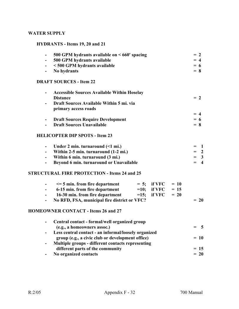
WATER SUPPLY
HYDRANTS - Items 19, 20 and 21
- 500 GPM hydrants available on < 660' spacing = 2 - 500 GPM hydrants available = 4 - < 500 GPM hydrants available = 6 - No hydrants = 8
DRAFT SOURCES - Item 22
- Accessible Sources Available Within Hoselay
Distance = 2 - Draft Sources Available Within 5 mi. via
primary access roads = 4
- Draft Sources Require Development = 6 - Draft Sources Unavailable = 8
HELICOPTER DIP SPOTS - Item 23
- Under 2 min. turnaround (<1 mi.) = 1 - Within 2-5 min. turnaround (1-2 mi.) = 2 - Within 6 min. turnaround (3 mi.) = 3 - Beyond 6 min. turnaround or Unavailable = 4
STRUCTURAL FIRE PROTECTION - Items 24 and 25
- <= 5 min. from fire department = 5; if VFC = 10 - 6-15 min. from fire department =10; if VFC = 15 - 16-30 min. from fire department =15; if VFC = 20 - No RFD, FSA, municipal fire district or VFC? = 20
HOMEOWNER CONTACT - Items 26 and 27
- Central contact - formal/well organized group (e.g., a homeowners assoc.) = 5
- Less central contact - an informal/loosely organized group (e.g., a civic club or development office) = 10
- Multiple groups - different contacts representing different parts of the community = 15
- No organized contacts = 20
R:2/05 Appendix F - 32 700 Manual

FIRE OCCURRENCE - Item 28
- .00-.10 Fires/1000 ac./10 yr. = 5 - .11-.20 Fires/1000 ac./10 yr. = 10 - .21-.40 Fires/1000 ac./10 yr. = 15 - .40+ Fires/1000 ac./10 yr. = 20
TOTAL SCORE <= 110 low risk - low priority 111-135 moderate risk - moderate priority 136-150 high risk - high priority 151-170 very high risk - very high priority >= 171 extreme risk - extreme priority
R:2/05 Appendix F - 33 700 Manual

APPENDIX D - FORM A RISK RATING OF PLANNED DEVELOPMENT
RATINGS FORM
R:2/05 Appendix F - 34 700 Manual

RISK RATING PLANNED DEVELOPMENT FORM A - FIELD DATA COLLECTION FORM (Rev. 3/93) RATING AREA: DATE: RATED BY: 1) NUMBER OF PRIMARY ACCESS ROADS ________ 2) NUMBER OF ALTERNATIVE ACCESS ROUTES ________ 3) WIDTH OF ROAD SURFACE + SHOULDER ON PRIMARY ACCESS ROADS
________ 4) MAXIMUM ROAD GRADE IN THE AREA (PRIMARY, ALT., SECONDARY)
________ 5) SECONDARY ROADS END AS:
Loops or > 90' Diameter Cul de Sacs ________ 70-90' Diameter Cul de Sacs ________ < 70' Diameter Cul de Sacs ________ Dead Ends - No Cul de Sac ________
6) BRIDGES ON PRIMARY ACCESS ROADS ARE:
> 40 Ton Capacity ________ 20-40 Ton Capacity ________ < 20 Ton Capacity ________ No Bridges ________
7) BRIDGES ON SECONDARY ROADS ARE:
20-40 Ton Capacity ________ < 20 Ton Capacity ________
No Bridges ________
R:2/05 Appendix F - 35 700 Manual

8) PREDOMINANT SLOPE IN AND AROUND THE INHABITED AREA IS:
0 - 10% ________
11 - 20% ________ 21 - 30% ________
> 30% ________
9) PREDOMINANT ASPECT IS:
North (316 degrees through 45 degrees) ________
East (46 degrees through 135 degrees) ________
Level ________
West (226 degrees through 315 degrees) ________
South (136 degrees through 225 degrees) ________ 10) DANGEROUS TOPOGRAPHIC FEATURES PRESENT ARE:
None ________
Adjacent Steep Slopes ________
Draws/Ravines ________
Chimneys, Canyons, Saddles ________ 11) PREDOMINANT FUEL TYPE IS:
Grass will be the main fuel type in the rating area around more than 90% of existing structures. ________
Low brush fields, or open timber stands will exist in the rating area around more than 10% of existing structures. ________
Dense timber stands or high brush fields will exist in the rating area around more than 10% of existing structures. ________
Slash and\or bugkilled timber stands will exist in rating area and won't be removed by development or dense stands of lodgepole pine trees will remain around more than 10% of existing structures. ________
R:2/05 Appendix F - 36 700 Manual

R:2/05 Appendix F - 37 700 Manual
12) RISKS PRESENT ARE:
Campgrounds/Campsites/Picnic Grounds ________
Children (playgrounds, schools, etc.) ________
Commercial Businesses ________
Debris Burning ________
Domestic Wood Heat ________
Farming/Ranching ________
Mills ________
Mines ________
Powerlines ________
Railroads ________
Recreation Sites (gun clubs, 4x4/motorbike areas, kegger sites, etc.) ________
Travel Routes (highways, etc.) ________
Other(s) - Describe each ________
________ ________ 13) WORST-CASE ELECTRICAL SERVICE IS:
All utilities in planned for development or existing in rating area are underground. ________
Rating area utilities will include underground and/or well maintained above ground powerlines with cleared rights-of-way. Trees or improvements which could blow over into powerlines do not exist or are properly maintained. ________
Rating area utilities include above ground powerlines. Fuel build-up is present in existing rights-of-way, or improvements exist which could blow over onto powerlines. ________

R:2/05 Appendix F - 38 700 Manual
14) HOW MANY HOMES ARE PLANNED FOR THE DEVELOPMENT? ________ 15) HOW MANY HOMES WILL HAVE FIRE RESISTANT ROOFING? ________ 16) HOMES ARE SPACED:
> 100' Apart ________
60-100' ________
< 60' Apart ________ 17) HOW MANY HOMES WILL MEET THE FIRE-RESISTANT
LANDSCAPING GUIDELINES (See Appendix F) ________
18) DOES THE PROJECT DESIGN INCORPORATE GREENBELTS Yes ________ OR FUEL BREAKS? No ________ 19) WILL HYDRANTS BE AVAILABLE? Yes ________ No ________ 20) IF YES, AT WHAT SPACING? ________ 21) IF YES, ARE THE HYDRANTS PLACED AS DESIRED BY Yes ________ THE FIRE DEPARTMENT? No ________ 22) IF HYDRANTS PLANNED, ARE THEY 500(+) GPM? Yes ________ DEPARTMENT? No ________ 23) DRAFT SOURCES ARE:
Accessible By Hoselay ________
Within 5 Miles Via Primary Access Roads ________
Available, But Need To Be Developed ________
Distant or Unavailable ________

R:2/05 Appendix F - 39 700 Manual
24) HELICOPTER DIP SPOTS ARE:
Under 2 minute turnaround (< 1 mi.) ________
Within 2-5 minute turnaround (1-2 mi.) ________
Within 6 minute turnaround (3 mi.) ________
Distant or Unavailable ________ 25) IS RATING AREA IN A RURAL FIRE DISTRICT, FIRE
SERVICE AREA OR MUNICIPAL FIRE DEPARTMENT? Yes ________ No ________ 26) FIRE DEPARTMENT RESPONSE:
Fire dept. can respond w/in 5 minutes - VFC? ________
Fire dept. can respond in 6-15 minutes - VFC? ________ Fire dept. can respond in 16-30 minutes - VFC? ________ 27) WILL THERE BE A WAY TO CONTACT HOMEOWNERS? Yes ________ No ________ 28) IF YES, WHAT TYPE OF GROUP(S)?
Formal, Well Organized Group ________
Informal, Loosely Organized Group ________ Multiple Groups ________ 29) AVERAGE NUMBER OF FIRES/100 AC./10 YEARS ________

APPENDIX E - FORM B
RISK RATING OF PLANNED DEVELOPMENT RATINGS FORM
R:2/05 Appendix F - 40 700 Manual

RISK RATING OF PLANNED DEVELOPMENT FORM B - RATING FORM
(Rev. 3/93) RATING AREA: DATE: RATED BY: ROADS
ROAD ACCESS - Items 1 and 2 - Multiple primary access roads = 0 - Two primary access roads = 1 - One primary + one alternative access road = 2 - One-way in/out = 3 - No primary access roads = 4
ROAD SURFACE WIDTH, PRIMARY ACCESS ROUTES - Item 3
- > 28' Road Surface + Shoulder = 1 - 28' Road Surface + Shoulder = 2 - 16 - < 28' Road Surface + Shoulder = 3 - < 16' Road Surface + Shoulder = 4
MAXIMUM ROAD GRADE - Item 4
- 0-5% = 1 - 6-8% = 2 - > 8 - 10% = 3 - > 10% = 4
SECONDARY ROAD ENDINGS - Item 5
- Loops or > 90' Diameter Cul de Sacs = 1 - Cul de Sac Diameter 70-90' = 2 - Cul de Sac Diameter <70' = 3 - Dead Ends - No Cul de Sac = 4
BRIDGES - Items 6 and 7
- No Bridges = 0 - 40 Ton(+) limit on access bridges = 1 - 20-39 Ton limit on all access bridges = 2 - < 20 Ton limit any access bridge = 4
R:2/05 Appendix F - 41 700 Manual
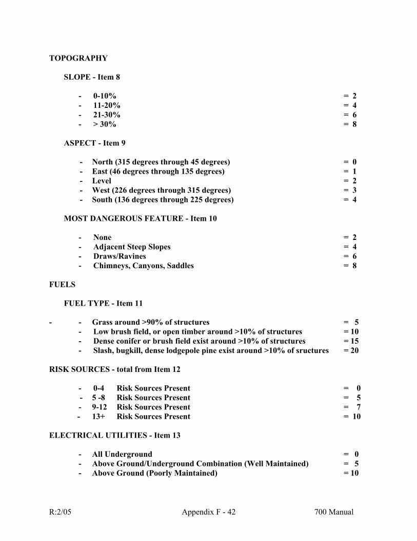
TOPOGRAPHY
SLOPE - Item 8
- 0-10% = 2 - 11-20% = 4 - 21-30% = 6 - > 30% = 8
ASPECT - Item 9
- North (315 degrees through 45 degrees) = 0 - East (46 degrees through 135 degrees) = 1
- Level = 2 - West (226 degrees through 315 degrees) = 3 - South (136 degrees through 225 degrees) = 4
MOST DANGEROUS FEATURE - Item 10
- None = 2 - Adjacent Steep Slopes = 4 - Draws/Ravines = 6 - Chimneys, Canyons, Saddles = 8
FUELS
FUEL TYPE - Item 11 - - Grass around >90% of structures = 5
- Low brush field, or open timber around >10% of structures = 10 - Dense conifer or brush field exist around >10% of structures = 15 - Slash, bugkill, dense lodgepole pine exist around >10% of sructures = 20
RISK SOURCES - total from Item 12
- 0-4 Risk Sources Present = 0 - 5 -8 Risk Sources Present = 5
- 9-12 Risk Sources Present = 7 - 13+ Risk Sources Present = 10
ELECTRICAL UTILITIES - Item 13
- All Underground = 0 - Above Ground/Underground Combination (Well Maintained) = 5 - Above Ground (Poorly Maintained) = 10
R:2/05 Appendix F - 42 700 Manual

HOMES
ROOF MATERIAL - Item 15
- 90-100% of homes have metal, composition, tile or other fire resistant roofing = 0
- 80-89% of homes have metal, composition, tile or other fire resistant roofing = 5
- 75-79% of homes have metal, composition, tile or other fire resistant roofing = 7
- < 75% of homes have metal, composition, tile or other fire resistant roofing = 10
DENSITY OF HOMES - Item 16
- (For 0-30% slope)
- > 100' between homes = 0 - 0-100' between homes = 4 - < 60' between homes = 8
- (For 31-50% slope)
- > 100' between homes = 2 - 60'100' between homes = 6 - < 60' between homes = 10
LANDSCAPING - Item 17
- 76-100% homes meet the fire-resistant landscaping guidelines in the Appendix F = 5 - 51-75% homes meet the fire-resistant landscaping guidelines in the Appendix F = 10 - 26-50% homes meet the fire-resistant landscaping guidelines in the Appendix F = 15 - 0-25% homes meet the fire-resistant landscaping guidelines in the Appendix F = 20
GREENBELTS AND FUEL BREAKS – Item 18 - Project design incorporates greenbelts and/or fuel breaks = 0 - Project design does not incorporate greenbelts and/or fuel breaks = 10
R:2/05 Appendix F - 43 700 Manual
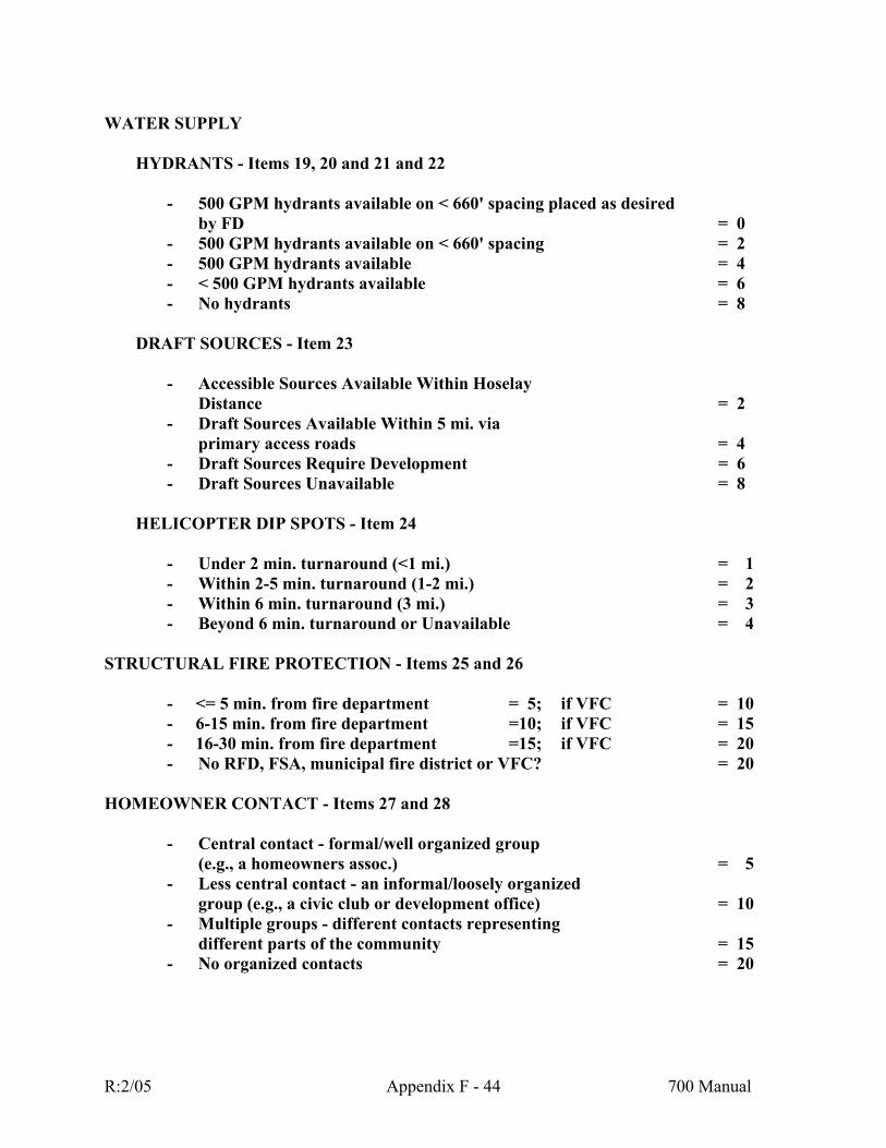
WATER SUPPLY
HYDRANTS - Items 19, 20 and 21 and 22
- 500 GPM hydrants available on < 660' spacing placed as desired by FD = 0 - 500 GPM hydrants available on < 660' spacing = 2 - 500 GPM hydrants available = 4 - < 500 GPM hydrants available = 6 - No hydrants = 8
DRAFT SOURCES - Item 23
- Accessible Sources Available Within Hoselay
Distance = 2 - Draft Sources Available Within 5 mi. via
primary access roads = 4 - Draft Sources Require Development = 6 - Draft Sources Unavailable = 8
HELICOPTER DIP SPOTS - Item 24
- Under 2 min. turnaround (<1 mi.) = 1 - Within 2-5 min. turnaround (1-2 mi.) = 2 - Within 6 min. turnaround (3 mi.) = 3 - Beyond 6 min. turnaround or Unavailable = 4
STRUCTURAL FIRE PROTECTION - Items 25 and 26
- <= 5 min. from fire department = 5; if VFC = 10 - 6-15 min. from fire department =10; if VFC = 15 - 16-30 min. from fire department =15; if VFC = 20 - No RFD, FSA, municipal fire district or VFC? = 20
HOMEOWNER CONTACT - Items 27 and 28
- Central contact - formal/well organized group (e.g., a homeowners assoc.) = 5
- Less central contact - an informal/loosely organized group (e.g., a civic club or development office) = 10
- Multiple groups - different contacts representing different parts of the community = 15
- No organized contacts = 20
R:2/05 Appendix F - 44 700 Manual
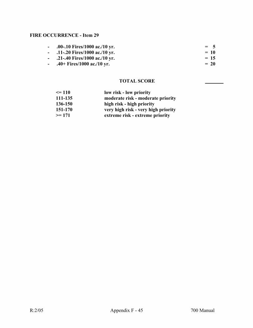
FIRE OCCURRENCE - Item 29
- .00-.10 Fires/1000 ac./10 yr. = 5 - .11-.20 Fires/1000 ac./10 yr. = 10 - .21-.40 Fires/1000 ac./10 yr. = 15 - .40+ Fires/1000 ac./10 yr. = 20
TOTAL SCORE <= 110 low risk - low priority 111-135 moderate risk - moderate priority
136-150 high risk - high priority 151-170 very high risk - very high priority >= 171 extreme risk - extreme priority
R:2/05 Appendix F - 45 700 Manual

APPENDIX F - LANDSCAPING GUIDELINES
R:2/05 Appendix F - 46 700 Manual

VEGETATION REDUCTION GUIDELINES 0% TO 10% SLOPE
100'
A
D C B 100'
100'
A = THE FIRST 3 FEET OF B
Maintain an area of non-combustible material - flowers, plants, concrete, gravel, mineral soil, etc. •
•
• •
• •
• •
•
B = 10 FEET
Remove all trees and downed woody fuels.
C = 20 FEET Thin trees to 10 feet between crowns. Prune limbs of all remaining trees to 15 feet or one-third the total live crown height, whichever is less. Maintain surface vegetation at 3 inches or less. Remove all downed woody fuels.
D = 70 FEET
Thin trees to 10 feet between crowns. Prune limbs of all remaining trees to 15 feet or one-third the total live crown height, whichever is less. Remove all downed woody fuels more than 3 inches in diameter.
R:2/05 Appendix F - 47 700 Manual
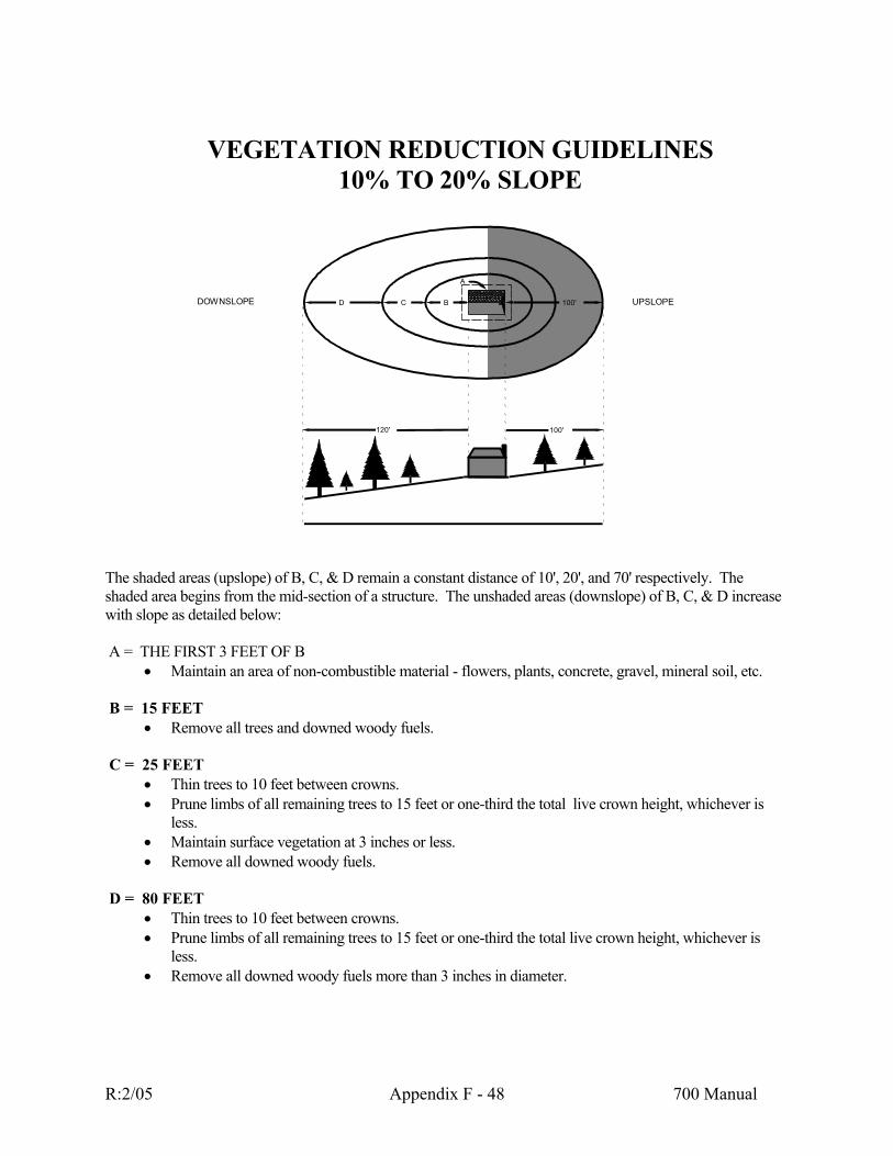
VEGETATION REDUCTION GUIDELINES
10% TO 20% SLOPE
DOWNSLOPE UPSLOPE 100'D C B
120'
A
100'
The shaded areas (upslope) of B, C, & D remain a constant distance of 10', 20', and 70' respectively. The shaded area begins from the mid-section of a structure. The unshaded areas (downslope) of B, C, & D increase with slope as detailed below: A = THE FIRST 3 FEET OF B
Maintain an area of non-combustible material - flowers, plants, concrete, gravel, mineral soil, etc. •
•
• •
• •
• •
•
B = 15 FEET
Remove all trees and downed woody fuels.
C = 25 FEET Thin trees to 10 feet between crowns. Prune limbs of all remaining trees to 15 feet or one-third the total live crown height, whichever is less. Maintain surface vegetation at 3 inches or less. Remove all downed woody fuels.
D = 80 FEET
Thin trees to 10 feet between crowns. Prune limbs of all remaining trees to 15 feet or one-third the total live crown height, whichever is less. Remove all downed woody fuels more than 3 inches in diameter.
R:2/05 Appendix F - 48 700 Manual

VEGETATION REDUCTION GUIDELINES
20% TO 30% SLOPE
he shaded areas (upslope) of B, C, & D remain a constant distance of 10', 20', and 70' respectively. The
A = THE FIRST 3 FEET OF B mbustible material - flowers, plants, concrete, gravel, mineral soil, etc.
B = 20 FEET
e all trees and downed woody fuels.
C = 30 FEET ees to 10 feet between crowns.
• feet or one-third the total live crown height, whichever is
• tain surface vegetation at 3 inches or less. •
D = 100 FEET
es to 10 feet between crowns. • feet or one-third the total live crown height, whichever is
• owned woody fuels more than 3 inches in diameter.
100'
DOWNSLOPE UPSLOPE100'D C B
A
150'
Tshaded area begins from the mid-section of a structure. The unshaded areas (downslope) of B, C, & D increase with slope as detailed below:
• Maintain an area of non-co
• Remov
• Thin trPrune limbs of all remaining trees to 15less. MainRemove all downed woody fuels.
• Thin trePrune limbs of all remaining trees to 15less. Remove all d
R:2/05 Appendix F - 49 700 Manual
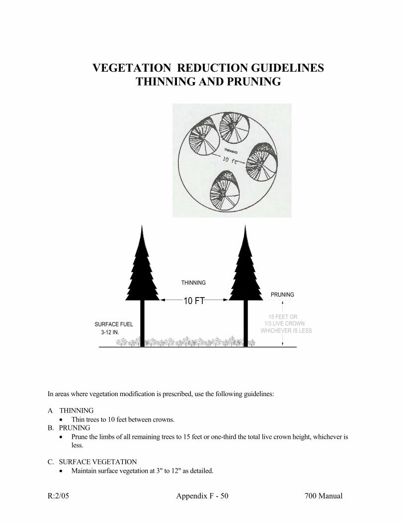
VEGETATION REDUCTION GUIDELINES
In areas where
Thin trees to 10 feet between crowns.
• o 15 feet or one-third the total live crown height, whichever is
C. SURFACE VEGETATION
Maintain surface vegetation at 3" to 12" as detailed.
THINNING AND PRUNING
vegetation modification is prescribed, use the following guidelines:
10 FT
SURFACE FUEL3-12 IN.
THINNING
PRUNING
15 FEET OR1/3 LIVE CROWN
WHICHEVER IS LESS
A THINNING •
B. PRUNING Prune the limbs of all remaining trees tless.
•
R:2/05 Appendix F - 50 700 Manual

Appendix G Home Evaluation Form
F-701
R:3/05 Appendix G - 1 700 Manual
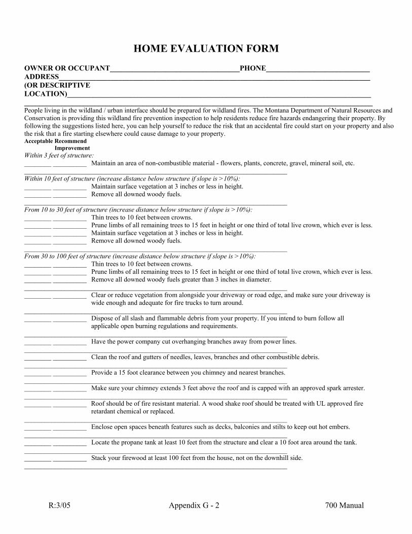
HOME EVALUATION FORM OWNER OR OCCUPANT___________________________________PHONE____________________________ ADDRESS____________________________________________________________________________________ (OR RIPTIVE LOCATION)__________________________________________________________________________________ ___ _______________________________________________________________________________________ Peop living in the wildland / urban interface should be prepared for wildland fires. The Montana Department of Natural Resources and
onservation is providing this wildland fire prevention inspection to help residents reduce fire hazards endangering their property. By llowing the suggestions listed her uld start on your property and also
the risk that a fire starting elsewhereAcceptable Recommend
Improvement Within 3 feet of structure: ________ __________ l soil, etc. ____________________Within 10 feet of structur________ __________ ________ __________ Remove all downed woody fue_____________________________________________ ___________ From 10 to 30 feet of structure (increase distance below %): ________ __________ Thin trees to 10 feet between cr________ __________ Prune limbs of all remaining trees to 15 feet in height or one third of total live crown, which ever is less. ________ __________ Maintain surface vegetation at 3 inches or less in height. ________ __________ Remove all downed woody fuels. ______________________________________________________________________________ From 30 to 100 feet of structure (increase distance below structure if slope is >10%): ________ __________ Thin trees to 10 feet between crowns. ________ __________ Prune limbs of all remaining trees to 15 feet in height or one third of total live crown, which ever is less. ________ __________ Remove all downed woody fuels greater than 3 inches in diameter. ______________________________________________________________________________ ________ __________ Clear or reduce vegetation from alongside your driveway or road edge, and make sure your driveway is wide enough and adequate for fire trucks to turn around. ______________________________________________________________________________ ________ __________ Dispose of all slash and flammable debris from your property. If you intend to burn follow all applicable open burning regulations and requirements. ______________________________________________________________________________ ________ __________ Have the power company cut overhanging branches away from power lines. ______________________________________________________________________________ ________ __________ Clean the roof and gutters of needles, leaves, branches and other combustible debris. ______________________________________________________________________________ ________ __________ Provide a 15 foot clearance between you chimney and nearest branches. ______________________________________________________________________________ ________ __________ Make sure your chimney extends 3 feet above the roof and is capped with an approved spark arrester. ______________________________________________________________________________ ________ __________ Roof should be of fire resistant material. A wood shake roof should be treated with UL approved fire retardant chemical or replaced. ______________________________________________________________________________ ________ __________ Enclose open spaces beneath features such as decks, balconies and stilts to keep out hot embers. ______________________________________________________________________________ ________ __________ Locate the propane tank at least 10 feet from the structure and clear a 10 foot area around the tank. ______________________________________________________________________________ ________ __________ Stack your firewood at least 100 feet from the house, not on the downhill side. ______________________________________________________________________________
DESC
____le
Cfo e, you can help yourself to reduce the risk that an accidental fire co
could cause damage to your property.
Maintain an area of non-combustible material - flowers, plants, concrete, gravel, minera__________________________________________________________ e (increase distance below structure if slope is >10%): Maintain surface vegetation at 3 inches or less in height.
ls. ______________________ structure if slope is >10owns.
R:3/05 Appendix G - 2 700 Manual

R:3/05 Appendix G - 3 700 Manual
________ __________ Ensure that you ep garden hoses readily available.
_____________________________________________________________________________
nsure that all motorized garden equipment, lawnmowers and chainsaws have approved spark arresters.
______________________________________________ _____________________________________________________________________DATE:_____________
FOR FU ATION CONTACT: NDERTAKEN AS A PUBLIC SERVICE AND IS ADVISORY ONLY
r water supply is usable during a fire emergency, and ke _________ __________ Keep storage areas clean. Do not allow oily rags, flammable chemicals or newspapers to accumulate. ______________________________________________________________________________ ________ __________ I______________________________________________________________________________ ________ __________ Display your name and house number in front of your property to assist firefighters in locating your home. ______________________________________________________________________________ Other Items:_________________________________________________________________________________________________ _____________________________________________________________INSPECTED BY:_____
RTHER INFORMTHIS INSPECTION IS UF-701 7/99 HOME EVALUATION FORM