7 v THE MAGAZINE FOR ARMY ENGINEERS FALL/WINTER 198t
48
-1 - 7 v THE MAGAZINE FOR ARMY ENGINEERS FALL/WINTER 198t COMBAT ENGINEER/TOPOGRAPtiIC ENGINEER TEAM ALSO: LIGHTENING THE LIGHT ENGINEER'S LOAD THE BLADE EFFORT TRIANGLE THE PROFESSIONAL ENGINEER EXAM -
Transcript of 7 v THE MAGAZINE FOR ARMY ENGINEERS FALL/WINTER 198t

-1 -7 v THE MAGAZINE FOR ARMY ENGINEERS FALL/WINTER 198t
COMBAT ENGINEER/TOPOGRAPtiIC ENGINEER TEAM ALSO: LIGHTENING THE LIGHT ENGINEER'S LOAD THE BLADE EFFORT TRIANGLE
THE PROFESSIONAL ENGINEER EXAM
-

Personal Viewpoint LKGMTENING THE LOAD O F TXE
by :LT Thomas P. Smith
f necess~tymost of the light0 . ' 2 .
engmeer sold~er'sload will be demolitions-cratering roads,knock-ing down walls and felling trees to create landing zones or to build expedient bridges.
But the Engineer School, the Waterways Experiment Station and the Army Materiel Command are realizing that the demolitions load is too heavy. Unless it's compact and versatile, it's incompatible with light engineers.
For example, a road crater cur-rently takes up to eight 40-pound cratering charges-charges that eat space and can only be used for one purpose-making craters.Similarly, Bangalores are bulky and tailored to a specific task.
Last July, the 65th Combat Engi-neer Battalion, 25th Infantry Divi-sion (Light),helped the Army experi-ment with several explosives sys-tems now under research and devel-opment for heavy forces, hoping they would hold promise for the light.
Under the-supervisionof WES, we tested-* Self-forging fragment weapons
system ballistic disks. XM-268 slurry. The rifleman's assault weapon.
We wanted to know not only whether ballistic disks will breach walls, but can they he hand-packed and fired from long distances? And can materials for the disks be found and fabricated on the battlefield?
We were interested not only in whether slurrycreates better craters, but will it also breach walls? And can it be repackaged into flexible, backpackable loads?
Theresultsraised someinteresting possibilities, and the Engineer School has asked WES to follow up with further research.
Self-Forging Fragment Weapons System
Ballistic disks-copper or alumi-num disks of varying shapes and
thicknesses-were tested. This type of system is already widely used in antiarmor munitions.
The disks weigh only four pounds and don't take much space. They offer light engineers apossibility for breaching walls and obstacles (or hitting targets such as fuel storage tanks) from extended standoff dis-tances.
The disks were placed inside short lengths of PVC pipe and packed on one side with C4-the engineer's most versatile explosive.
The disks worked well against concrete walls a t a standoff distance of 20 feet-blowing a 12-inchhole in reinforced concrete that was big enough for a soldier. It did not cut the rebar. however-a deficiency that must be overcome by research and development.
The 65th also experimented with the ballistic disks as a way to make one-man fightingpositions by firing the disks directly at the ground. The results were less than hoped, but research efforts could improve the explosive foxhole digger concept.
Overall, the tests demonstrated that the disks forge a slug that travels accurately over extended distances and offer a prospective low volume, lightweight breaching capability.
Slurry If XM-268 slurry-a liquid explo-
sive nearing the final stages of develo~ment-can be ~ackaeedfor-light soldiers, it offers an excellent alternative to standard military cratering charges.
The slurry consists of two non-detonatable chemical ingredients that become explosive when mixed.
It is under consideration as the liquid explosive for the Tactical Explosive Systems-to reduce em-bankments and create antitank ditches and road craters for the heavy force. Normally, it comes in 55-gallon drums to be mixed inlarge batches.
Possibly, smaller quantities could be packaged so soldiers could carry the ingredients in their rucksacks and mix them without special equip-ment.
During experiments, the 65th successfully devastated a triple-standard concertina obstacle by pouring the slurry, like paint, into &foot lengths of schedule 40 PVC pipe.
Arag was stuffedin oneend, then chemicals were poured in. The explosive was primed, and another rag was used to plug the pipe. Soldiers spent only five minutes preparing three pipes-demonstra-ting the slurry is easy to use if a suitable container can be improvised.
The slurry also created a road crater larger than the conventional 40-pound cratering charge.
In another experiment, the 65th poured the slurry into an MRE bag and taped the bag to a telephone pole. One pound of the explosive cut a twelve-inch-diameter pole.
Rifleman's Assault Weapon The RAW also offers interesting
possibilities as a relatively l ight weight, compact alternative to re-coilless weapons like the 90mm rifle and the LAW.
This rifle-launched munition, which is in the early design stages, weighs less than 7 pounds. It fires lines of sight with little backblast.
The RAW blew a hole 12inches in diameter in a 12-inch-thick, rein-forced concrete wall. In an 18-inch-thick wall, 3 rounds produced de-structive spalling; 5 breached it.
By comparison,it took 3 rounds to breach a 23-inch wall using the shoulder-launched multipurpose assault weapon-now used by the Marine Corps.
Potentially, the RAW offers light infantry soldiers high firepower without significantly increasing their load.
(continued on page 40)

1l VOLUME16 NUMBER 3
UNITED STATES ARMY ENGINEER CENTER A N D FORT BELVOIR, VA
C O M M A N D E R / C O M M A N D A N T M G Richard S. Kem
ASSISTANT C O M M A N D A N T COL James R. Whitley
CHIEF O F STAFF/DEPUTY INSTALLATION C O M M A N D E R
COL Robert R. Hardiman
C O M M A N D SERGEANT M A J O R CSM Matthew Lee Jr.
DIRECTOR O F TRAINING A N D DOCTRINE
LTC Robert L. Keenan
CHIEF O F PUBLICATIONS Patricia 5. Kitchell
M A N A G I N G EDITOR Marilyn Fleming Betty R. Graham
FEATURE EDITORS Victoria McAllister Penelope Schmitt
ASSOCIATE EDITOR PFC Eric Cramer
DESIGNER Jim Wilson
TYPOGRAPHER Linda Paradis Beverly Khosravi
On the Cover Topographic engineers are a force
multiplier for the combined arms team.
Art: Jeanne Elmore I
FALL-WINTER1986
FEATURES
10 The Combat Engineer/Topographic Engineer Team by COL David F. Maune
1 3 Comhat Engineer and Topographic Engineer Missions Intertwine by MAJ Thomas E. Mathews
17 Topographic Support Around the World by Penelope Schrnitt
19 The Key is Teamwork-Germany to Vietnam by COL David F. Maune
21 Topograhic Research and Development COL Alan L. Laubscher and Sandra J Cleua
24 Terrain Analysis Data Bases-What's in Them for You? by CW2 Kathleen Hawes
27 Terrain Analysis: Tailored to the Customer by CW2 Frederick N. Pessaro, Jr.
30 Hey Engineer, Make your BET! by MAJRalph R. D'Elosua
32 Gamelands Offer Realistic Training Sites for National Guard Engineers by LTC Charles M. Beehtel
34 Antique Shop Find ...Timeless Values by CPT Joseph J. Miano
36 Personal Computers a t Work in the Battalion by MAJRobert R. McLaughlin
37 Mobile Soils Labs: Immediate Quality Control by PFC Eric W. Cramer
38 Maintenance Certification by CPT Thomas P. Bostick
39 EOAC Making the Army's Best Better! by MAJ Randy R. Rapp
41 Earn Your Professional Engineer's License by CPT Calvin Evans
DEPARTMENTS Inside Front Cover: A P e r s o n a l Viewpoin t
2 Clea r t h e Way 3 Br idge t h e G a p 4 N e w s & Notes 5 S c h o o l N e w s
26 Eng inee r P rob l em
29 L e s s o n s L e a r n e d 40 Eng inee r Solut ion 42 Hot l ine Q & A 43 C a r e e r Notes 45 P a s t i n Rev i ew
ENGINEER (ISSN 0046-1989) is published quarterly by the US A m y PERSONAL SUBSCRIPTIONS are available through the Super- Engineer School, Fort Belvoir, VA 22060. Material does not necessarily intendent of Documents. US Government Printing Office. reflect official oolicv of the US Armv. Funds were aooroved bv HQDA Rates for domestic addresses includinr APO and FPO are $11.00 oer.. . . in accordance h t h AR 310-1. year, $3.00 singlecopies. Rates for foreign addresses are $13.50 per y&r. CONTENT is not copyrighted. Material may be reprinted if credit is $3.75 single copies. given to ENGINEER and to the author. To Subscribe or change your address, contact the Superintendent of MILITARY SUBSCRIPTIONS are available free to all engineer and Documents, ATTN: Chief, Mail List Branch, Stop SSOM, Washington, engineer related units by writing the magazine. DC 20402. CORRESPONDENCE, letters to the editor, manuscripts and phota- graphs should be sent to ENGINEER Magazine, ATTN: ATZA-TD-P, P0STMASTER:Second Class postageis paidat Fort Belvoir,VA, and Stop 291D. Fort Belvoir, VA 22060-5291. Telephone: (703) 664-3082, AV additional mailing offices. Send address change to ENGINEER 354. Magazine, ATZA-TD-P, Stop 291D, Fort Belvoir, VA 22060-5291.
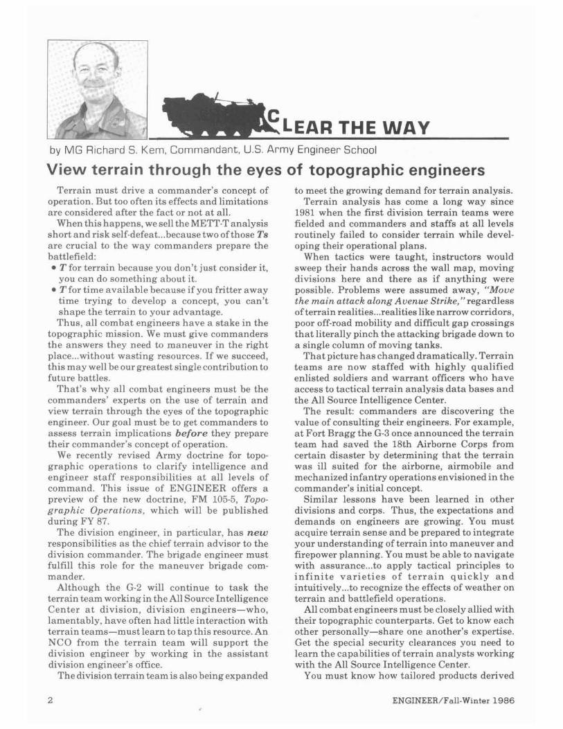
by M G Richard S. Kern, Commandant. U.S.A r m y Engineer School
View terrain through the eyes of topographic engineers Terrain must drive a commander's concept of to meet the growing demand for terrain analysis.
operation. But too often its effects and limitations Terrain analysis has come a long way since are considered after the fact or not a t all. 1981 when the first division terrain teams were
When this happens, we sell the METT-Tanalysis fielded and commanders and staffs a t all levels short and risk self-defeat...because two of those Ts routinely failed to consider terrain while devel-are crucial to the way commanders prepare the oping their operational plans. battlefield: When tactics were taught, instructors would
T for terrain because you don't just consider it, sweep their hands across the wall map, moving you can do something about it. divisions here and there as if anything were Tfor time available because if you fritter away possible. Problems were assumed away, "Moue time trying to develop a concept, you can't the main attack along Avenue Strike,"regardless shape the terrain to your advantage. of terrain realities ...realities like narrow corridors, Thus, all combat engineers have a stake in the poor off-roadmobility and difficult gap crossings
topographic mission. We must give commanders that literally pinch the attacking brigade down to the answers they need to maneuver in the right a single column of moving tanks. place...without wasting resources. If we succeed, That picture has changed dramatically. Terrain this may well be our greatest single contribution to teams are now staffed with highly qualified future battles. enlisted soldiers and warrant officers who have
That's why all combat engineers must be the access to tactical terrain analysis data bases and commanders' experts on the use of terrain and the All Source Intelligence Center. view terrain through the eyes of the topographic The result: commanders are discovering the engineer. Our goal must be to get commanders to value of consulting their engineers. For example, assess terrain implications before they prepare a t Fort Bragg the G-3 once announced the terrain their commander's concept of operation. team had saved the 18th Airborne Corps from
We recently revised Army doctrine for topo- certain disaster by determining that the terrain graphic operations to clarify intelligence and was ill suited for the airborne, airmobile and engineer staff responsibilities a t all levels of mechanized infantry operations envisioned in the command. This issue of ENGINEER offers a commander's initial concept. preview of the new doctrine, FM 105-5, Topo- Similar lessons have been learned in other graphic Operations, which will be published divisions and corps. Thus, the expectations and during FY 87. demands on engineers are growing. You must
The division engineer, in particular, has new acquire terrain sense and be prepared to integrate responsibilities a s the chief terrain advisor to the your understanding of terrain into maneuver and division commander. The brigade engineer must firepower planning. You must be able to navigate fulfill this role for the maneuver brigade com- with assurance...to apply tactical principles to mander. i n f in i t e var ie t ies of t e r r a i n quickly a n d
Although the G-2 will continue to task the intuitively...to recognize the effects of weather on terrain team working in the All SourceIntelligence terrain and battlefield operations. Center a t division, division engineers-who, All combat engineers must be closely allied with lamentably, have often had little interaction with their topographic counterparts. Get to know each terrain teams-must learn to tap this resource. An other personally-share one another's expertise. NCO from the terrain team will support the Get the special security clearances you need to division engineer by working in the assistant learn the capabilities of terrain analysts working division engineer's office. with the All Source Intelligence Center.
The division terrain teamis alsobeing expanded You must know how tailored products derived

- - -
by CSM Mat thew Lee Jr., U.S. Army Engineer Center and School
There is something unique about a map. It's worthless unless i t shows terrain of immediate interest. And then it's the most important piece of paper in the world.
Without a map to negotiate the terrain, you are quite simply and literally lost.
That was never clearer to me than while I was a t a Chinese rough terrain school in Taiwan-rough terrain meaning you must air drop into any terrain and do your job.
In the haste to deploy, the American members of the party jumped without a map. We landed in a rugged area-two men shattered their legs-and we hadn't a ghost of an idea where we were. We had radios, but without a map how could we tell the rescue party where to find us?
Some of us struggled our way to a road. But which road? Where did it go?
An operation that should have taken 4 hours took 15while the injured soldiers, one caught in a tree, waited-all for want of amap. A simple piece of paper was the vital missing link.
A mapis your eyes beyond your eyes-it lets you see miles in front of you, to your right, to your left, and behind.
Wrapped i n mylar, it's the record where you make notes on your surroundings. It's where you identify your route and the conditions you found. What's been built? What's been demolished? How has mother nature altered the terrain? Are the road, bridge and soil classifications accurate?
At theend of each mission, you must share your map notes. They hold invaluable information for the soldiers who come next. But only if topographic
from terrain data bases can be used to guide tactical decisions and learn how you can help fill voids in those data bases during reconnaissance missions.
Finally, give high priority to your responsi-bility to understand terrain ...to be the maneuver commander's expert on terrain, terrain effects on
engineers get the chance to incorporate your findings into their terraindata bases and pass the word.
If you think maps are worthless, you haven't learned their language. Maps are keepers of the faith for soldiers who know how to read them.
They tell you what's on the other side of the hill...where the enemy is likely to hide ...how steep the slope is ...whether there is a short cut ...where the next drop zone will be ...where to stash a food cache, look for water or plan a rest stop.
In Vietnam when my reconnaissance team went out, the first thing we asked for was a map. When I was chased, I'd throw everything away except my map, my compass and my weapons. If the pursuit continued, I'd shed the weapons; but I never gave up my map or the compass around my neck. They were the keys to coming out of the jungle.
It is imperative that every engineer soldier be able to use a map a s well as he uses a dozer. If you are set down by a river and told to build a bridge, you might a s well not start if you don't have a map. That map is a s essential a piece of your equipment a s the reinforcement bar that goes into the bridge.
After all, there is something that sets maps apart from the rest of a soldier's equipment. The infantryman can shoot his rifle, the aviatorfly his plane, the engineer operate his dozer anywhere in the world. But a pack full of the maps of Europe and Korea won't help you in Grenada.
A map is worthless unless the terrain is of immediate interest. And then it's the most impor- tant piece of paper in the world.
operations, movement through terrain, and terrain reinforcement through obstacle emplacement and construction of fighting positions.
Terrain analysis is thelinchpin of the mobility, countermobility, survivability and general engi- neering missions ...the heart of our contribution to AirLand Battle.

News & Notes-~ s s a u l tRiver Crossing Operation
unng a recent field exercise,D .Company A, 326th Engineer Battalion (Air Assault), built an expedient footbridge using aircraft cargo pallets. This bridge enabled infantry units to maintain contact with opposing mechanized forces without losing momentum.
The engineers used heavy drop pallets and 463L aircraft cargo pal-lets to build the bridge. Before the crossing started, engineers spanned the river with two steel cables. Anchored with deadmen, these cables provided extra stability for the bridge.
The rest of the construction was easy; they floated the pallets on the water and,using rings on thepallets, attached the pallets to each other with s n a p links. Final ly, they snapped the b'ridge to the cahles. The entire operation was performed quickly and quietly.
Lessons learned on the operation include-
The 463L pallets are easier to use than the heavy drop pallets. Con-struction with 463Lstook halfthe time a s with heavy drop pallets. Using the cable, 100 meters of bridge can he built in 1 hour. The cahles are not necessary, but add stabil i ty when crossing troops. Since each pallet can hold the weight of a man and his equip. ment, this bridge could span any gap.
Engineer Mechanization ngineers from the 54th Engi-E neer Battalion convov M577
armored personnel carriers from the railhead to the motor pool. The 54th and 82d Engineer Battalions re-ceived APCs as part of a plan to change V and VII Corps engineer units from wheeled to mechanized TOES. Three more corps combat engineer hattalions-the 317th, 9th, and 547th-were mechanized in FY 87. The 78th and 237th are to be
Kedge anchors or shore guys could beused on bridges spanning rivers with strong currents. Because all preparation is below ground (deadmen)or below water (cables),equipmentmaybe placed without detection by ae r i a l reconnaissance. An entire infantry battalion task force, including slice elements, can cross in under 3 hours.
mechanized by FY 88. Units stationed at Fort Ord, CA,
were the first to receive the M9 armored combat earthmover a s TOE equipment in May 1986.The fielding came after4 weeks of new equipment training, which included classes in operator/organizational mainte-nance and tactical employment. Many other units are scheduled to receive the ACE in the near future.
MINE WARFARE VIDEO AVAILABLE 17-minutevldeo tape, TVT 6- combat engineers with information Joint Visual Information ActivityA .135, entrtled "Employment of on the use and capabilities of these ATTN: ASNV-OJVT-ID(McIntire)
FASCAM" (family of scatterable rapidly deployable mines. If un- Tohyhanua Army Depot mines) was distributed to TASCs in available at your local TASC, the Tobyhanna, PA 18466-5102 mid-November 1986. The tape pro- tapes may be obtained from-vides the maneuvercommander and US Army Audio/Visual Center

School News
Department of ~ i l i t a r ~Engineering (DME)
BNCOC Changes: Bridge crewmen who graduated from the 12C primary technical course before 1June 1986 should attend 12B30 combat engineer BNCOC to receive credit for BNCOC attendance. This course provides BNCOC leadership training for skill level 2, but contains more advanced skill level 3 technical training.
Graduates of this course are proficient in skill level 3 tasks and have received the progressive and sequential training required for NCOs.
The 12C20 BNCOC combines the Sergeants Major Academy skill level 3 leadership training with skill level 2 technical training. Graduates of this course, which started a t Fort Belvoir in June, receive credit for attending BNCOC.
A 12C30 BNCOC for bridge crewmen will start a t Fort Leonard Wood, MO, in FY 89. At that time, 12C soldiers will no longer attend the 12B30 combat engineer BNCOC.
Directorate of Combat Developments (DCD)
Management DCD is now applying two new management tools, the TRADOC
Initiatives: Organization Management System (OMS) and the 1987 Engineer Functional Area Assessment (FAA).
The OMS will make i t easier to spot breakdowns between force structure and the personnel and equipment aspects of TOES.
The 1987 Engineer FAA, scheduled for presentation to the Vice Chief of Staff of the Army in January 1987, will analyze specific units to identify and correct problems with training, doctrine, force structure and personnel.
Using these techniques, DCD plans to survey selected engineer units to confirm what equipment field units have and correct the accuracy of TOE data. Engineers in the field can expect to hear from this property-book-level survey beginning in September 1987.
For more information, contact LTC Robert H. McDonald, ATZA- CDO-FI, Fort Belvoir, VA 22060-5281, telephone (703) 664-3826, AV 354.

School News
Hand-held The Directorate of Combat Developments has recommended that
Calculator: CTA 50-909, Field and Garrison Furnishings and ~ q u i ~ m e k t , be changed to allow engineers to requisition the TI-30 SLR solar calculator. Offering more than 50 functions, this calculator should help solve the many mathematical problems associated with typical field engineering tasks.
For more information contact James E. Mason, ATZA-CDO, Fort Belvoir, VA 22060-5281, telephone (703) 664-3502, AV 354.
Defense Mapping School (DMS)
DMA Reviews The Defense Mapping Agency is reviewing geodetic survey Survey Support support requirements. New, user-operated precise positioning de-
vices may eliminate the need for topographic surveyorsin the 1990s. Requirements: The basis for this review is The Army Position and Navigation Master Plan, April 1986, which is the Army plan for position and navigation systems.
If these systems meet all geodetic survey support requirements, they will eliminate the topographic surveyor (82D) MOS.
Address your comments to: Director, Defense Mapping School, ATTN: CW3 Besch, Fort Belvoir, VA 22060-5828.
MOS Revisions for Several changes are in store for the topographic engineer career
83E and 83F: management field. The Deputy Chief of Staff approved two revisions in June 1986.
Photo and layout specialist (83E)-Revisions to this MOS include skill level progression to staff sergeant. A secret security clearance will be required for all skill level 3 personnel.
Photolithographer (83F)-The title photolithographer will change to printingand bindery specialist. A secret security clearance will be required for all skill level 3 and 4 personnel.
Both MOSS will have revised duty position titles and standards of grade authorization. Mandatory training will be added.
CMF81 Streamlined: An electronicmaintenance study recommended the consolidation of MOSS for topographic instrument repair specialist (41B) and fire control i n s t rumen t repa i r special is t (41C) to s t reaml ine maintenance-specific occupations.
The Engineer School agrees with the concept and expects a final report with approval soon.

Engineer Personnel ~ r o ~ o n e n c ~Office (EPPO)
EPPO 24-hour Hotline:
Regimental System Update:
The Engineer Personnel Proponency Office now has a 24-hour hotline to answer questions-about structure, acquisition, deploy- ment, sustainment, professional development or separation-that cannot he handled a t the installation or MACOM level.
EPPO hotline numbers are: toll free 1-800-336-3095, extension 3646, (703) 664-3646, AV 354.
The goal of the Corps of Engineers in the new regimental system is to enhance combat effectiveness by forming all engineers into one unit characterized by strong bonds of loyalty and commitment. Army Reserve and National Guard engineers are now recognized as part of the Corps, emphasizing the strong kinship between Active and Reserve Components.
To further enhance the unity of the Corps, the Engineer School Brigade was redesignated the 4th Engineer Brigade, honoring the distinguished WWII unit of that name. In a November 7th ceremony, COL George T. LaBlonde turned over command of the brigade to COL Roger C. Strom, formerly Fort Belvoir's Director of Military Logistics.
At the same time, the 1st and 3d Battalions became the809th and 554th Engineer Battalions, respectively, both also units with historic combat records.
At a ceremony held a t Fort Leonard Wood on 28 September 1986, the following engineer units wereredesignated: 1st Training Support Brigade became 136th Engineer Brigade; 2d Training Brigade- 132d Engineer Brigade; 1st Battalion, 2d Brigade-35th Engineer Battalion; 2d Battalion, 2d Brigade-3lst Engineer Battalion; 4th Battalion, 2d Brigade-589th Engineer Battalion; 4th Training Brigade-1st Engineer Brigade; 2d Battalion, 4th Brigade-87th Engineer Battalion; 3d Battalion, 4th Brigade-169th Engineer Battalion; and 4th Battalion, 4th Brigade-577th Engineer Battalion.
Distribution ofthe new Corps of Engineers crest has been delayed until FY 87 for active and reserve units. AAFES clothing sales stores began stocking these items in November. Ultimately, the crest will be issued to enlisted personnel, but officers and warrant officers must purchase their own. Wearing of the crest is governed by AR 670-1 and is optional for all personnel.
School News
Directorate of Evaluation and Standardization (DOES)
Lessons Learned The USAES Quarterly Lessons Learned Message-containing
Message: information from NTC, Team Spirit , Blazing Trai ls and REFORGER-has replaced the Task Force Engineer/Combined Arms Package.
For more information, contact: Commandant, USAES, ATTN: ATZA-ES, Fort Belvoir, VA 22060-5271. POC is CPT Craig Tavani, (703)664-4172, AV 354.
DOES Staff LTC John Carey is the new director of the Directorate of Evalua- Changes: tion and Standardization at the US Army Engineer School.
LTC Otis Williams is the new chief of the Evaluation and Standardization Division. DOES.
Reserve Component Advisory Staff (RCS)
Advice for If you are an Army Reserve officer planning to take the Engineer EOAC Students: Officer Advanced Course a t Fort Belvoir, remember that most
Reservists are on TDY status (less than 140 days). Plan to live off-post. Bring enough money to pay initial expenses.
Fort Belvoir is a high-cost area and uses the "lodging plus" system. More details about this system are in the Advanced Course
Welcome Packet. Complete your plans a t least six weeks early so C Company, 3d Battalion, can send your packet on time.
If you have received your orders but not your packet, call C Company toll free 1-800-336-3095, extension 2184, commercial (703)664-2184, AV 354.
Directorate of Training and Doctrine (DOTD)
SQT Cancellations: Changes in doctrine, publications or proponency cause skill qualifications tests to be cancelled. TRADOC has approved the US Army Engineer School's request to cancel the following SQTs for 1987:
52C1-3 Utility equipment repairer 52D1-3 Power generation equipment repairer 52F1-3 Turbine engine driven generator repairer 52x4 Special purpose equipment repairer 62N3 Construction equipment repairer Soldiers holding these MOSS will take their next SQTs in 1988.
Scores from previous tests will be used for personnel management purposes a s appropriate.
Department of Military Logistics (DML)
Proponency Moves Proponency for M o s s utility equipment repairer (52C), turbine
for 52C, 52D engine driven generator repairer (52F) and power generation equipment repairer (52D) is being transferred from the Engineer and 52F: School to the Ordnance School. The commanding generals of both schools signed a memorandum of agreement in June 1986.
Proponency, training development, training and apprenticeship will transfer by October 1987. Command and control of troop units will move by October 1988.Training for MOSS 52C, 52D and 52F will continue a t the Engineer School until facilities are available a t the Ordnance School.
New DML Director: COL Gerald M. Tippins is the new director of the Department of Military Logistics.
COL Jack E. Weber is the new commander of 809th Engineer Battalion.

castle and topogrdljbik 'EH.gi'?feers, th enter theportalandgo their separate ways without
., communicating? Unfortuliately, too often the answer i- " '1 "... -
is, "Yes."
by COL David F. Maune
Combat engineers generally believe they alone are re- sponsible for the engineer
f'unr,tir,ns of mobility, countermobil- ity, survivability and general engi- neering (FMs 5-101 through 5-104). Topographic engineers tend to take sole responsibility for the topo- graphic function (FM 5-105).
In reality, the outcome of future battles depends upon our ability to work together a s a team. New doc- trine laid out in FM 5-105, Topo- graphic Operations, which will be published in FY 87, demands that all engineers become terrain experts. Every combat engineer must be a topographic engineer, just as every topographic engineer must be a combat engineer.
FM 5-105 places topographic en- gineers squarely at the portal-not only of the engineer castle but of the supported command post- gathering terrain information from and disseminating terrain informa- tion to all.
The Army's keystonemanual, FM 100-5, Operations, recognizes that "Weather and terrain have more impact on battle than any other physical factor, including weap- ons, equipment, or supplies .... Indeed, most battles have been
won by theside that usedterrain toprotect itself and to reinforce fires to destroy the enemy."
But terrain not only provides opportunities and imposes limita- tions; engineers can manipulateit- giving a decisive edge to the com- mander who uses it best.
FM 100-5 stresses that terrain analysis, engineer operations and intelligence preparation of the battlefield are all basic to the com- mander's operational use of terrain.
The command engineer, normally a combat engineer, is the terrain advisor a t each level of command. He helps the commander see the battlefield and use the terrain-two fundamentals of war.
The strength of his expertise de- pends on how well his combat and topographic engineers understand one another's business and ex-change terrain information.
For example, the combat engineer who understands topographic engi- neering can turn mobility and countermobility planning from art- ful guesswork into a science with the help of tailored products like the cross-country mobility analysis (story page 27).
At the same time, topographic engineers-who work primarily with
space-based sensors, aerial photo- graphy and terrain data base li- braries-need eyes and ears in the field. They depend upon combat engineers to establish the ground truth of their information so con- fident command decisions can be made.
They need reports on the latest s tatus of minefields, obstacles, rivers, bridges, roads, railroads, ports, harbors, airfields, facilities and utilities. They need assistance to verify and update data bases on surface drainage, soils, vegetation and lines of communication.
All engineer missions require a constant exchange of terrain infor- mation between topographic and combat engineers (story page 13).
No system currently exists to sup- port that exchange. But FM 5-105 opens the door for change.
New Doctrine Before 1981, the Army did not
routinely have terrain teams in direct support of maneuver divi-sions, and there were no terrain analysis technicians (warrant offi- cers) as we know them today.
Until now, Army doctrine (FM 5-146, Engineer Topographic Units, andFM 21-32, TopographicSupport)

placed the five-man division terrain team totally under the division G-2 with the "special staff cognizance" of the division engineer.
Most division terrain teams worked in the All SourceIntelligence Center of theTOC. While this worked for most of the Army, it had disad-vantages for engineers:
Division engineers and assistant division engineers had little, if anything, to do with division ter-rain teams. Combat and topo-g r a p h i c eng inee r s d id n o t routinely share terrain infor-mation because they did not con-sider themselves to be mutually supporting. Division engineers were not nec-essarily the terrain experts they were expected to be. They were, therefore, less effective in recom-mending optimum ways to rein-force the terrain. Division engineers had no direct terrain analysis support to handle topographic responsibilities. The organizational structure made it difficult for overworked division terrain teams to request backup supportfrom corpsterrain teams or reconnaissance support from divisional engineer bat-talions.
While supported commanders, G-2s, G-3s and G-4s were generally pleased with their topographic sup-port, the engineer house was not in order. To support AirLand Battle, we needed a more efficient, effective relationship between combat and topographic engineers.
FM 5-105makes significant de-partures from the past by clarifying intelligence and engineer staff topo-graphicresponsibilities a t all levels. The division engineer becomes the division commander's chief terrain advisor.
Intelligence Staff Responsibilities
"From the assistant chief of staff for intelligence a t HQDA down through the division G-2, the intel-ligence officer has general staff responsibility for topography," according to FM 5-105.
"This means the intelligence offi-cer is responsible for topographic policy, solicitation and validation of requirements, and establishment of priorities for topographic support within the command.
"This always includes high prior-ity, continuing terrain analysis support of the intelligence prepara-tion of the battlefield (IPB)process.
"The corps G-2 tasks the TOC support element of the corps terrain team and coordinates other topo-graphic support requirements and priorities with the corps engineer.
"Battalion and brigade S-2s com-pile and submit topographic re-quirements and priorities for their commands to their division G-2.
"The G-2 consolidates these requirements with division staff requirements, establishes priorities, coordinates topographic support with thedivision engineer, and tasks the division terrain team."
Engineer Staff Responsibilities FM 5-105gives the engineer offi-
cer, from the assistant chief of engineers a t HQDA, down through the division level, special staff responsibility for topography.
"This means the engineer officer is recognized as the terrain utiliza-tion expert responsible for topo-graphic program execution, train-ing, resourcing and coordinating technical topographic requirements with the staff and subordinate commands," FM 5-105says.
"Battalion task force and brigade engineers are also terrain experts a t their organizational levels.
"All engineers regularly assist in

terrain data collection(such asriver, soil, route and bridge classification) to fill data voids and verify data in terrain analysis data bases.
"All engineers also exploitterrain data and analysis in order to focus reconnaissance efforts and other-wise assist in site selection,planning and estimating for performance of mobility, countermohility, surviv-ability, and general engineering missions."
The Division Engineer Most significantly, the division
engineer has newresponsibilities to: Advise the division commander on effective terrain use. Coordinate division topographic support requirements and pri-orities with the G-2who tasks the division terrain team. Assist the G-2 in evaluating requirements, setting priorities and selecting alternatives. Coordinate terrain team deploy-ment in support of the G-2. Coordinatesupport from the corps topographic company through the corps engineer. Task engineer units organic to thedivision to collectterrain data in the field. Prepare the topographic opera-tions annex for division CON-PLANS/OPLANS/OPORDS in coordination with the G-2, G-3, G-4 and chief of the division ter-rain team.
FM 5-105 focuses responsibility for topographic engineering in the office of the assistant division engineer where one NCO from the division terrain team will be phys-ically located. The NCO will provide a liaison with the terrain team and assist the division engineer in carry-ing out his new responsibilities.
The remainder of the division terrain team is normally located with the G-2 staff.
This allows timely support to the division staff and gives the terrain team immediate access to the all source intelligence data that is criti-cal to prepare current products.
It also helps the G-2and engineer work closely together to satisfydivi-sion topographic responsibilities.
A new TOE, which will be imple-mented in October 1988, increases the staff of the division terrain team
from fivetoeight to meet the growing demand for terrain analysis.
For the new doctrine to succeed, division and assistant division en-gineers must:
Become familiar with the capa-bilities and limitations of topo-graphic units.
* G i v e h i g h p r i o r i t y t o t h e management of topographic en-gineer resources and execution of topographic responsibilities. Obtain the special security clear-ances necessary to operate in the all source intelligence arena.
Corps and Above The only doctrinal changes a t
corps and above involve the TOES, which will also be implemented in October 1988.
For unity of command, the new corps TOE merges the corps terrain team as two or more terrain squads wi th in the corps topographic company.
Modular TOES are being used to tailor engineer topographic organi-zations at all echelons to the unique requirements of the supported theater.
Reach Out Whencombat engineersjoin forces
with topographic engineers to ana-lyze and reinforce the terrain to maximum advantage, everybody wins.
The corps and division engineers are better advisors to their com-manders.
T h e G-2s-responsible f o r weather, enemy and terrain intel-ligence-are better able to carry out their intelligence preparation of the
Arm3 ent m
The c . . - A
.s.m he N ,n map 6
ering 40 z inNor!
battlefield mission. The G-3s can develop concepts of
operation and detailed plans of exe-cution based on accurate terrain information and realistic analyses.
TheG-4scanoperate with superior knowledge of the capabilities and limitations of transportation net-works.
The commander knows his entire staff is coordinating with the best possible terrain information.
Combat engineers, reach out and meet your teammates-the topo-graphic engineers. Together, we can meet the challenges of AirLand Battle. Divided, we repeat past mis-takes. Our choice is clear.
COL Dauid F. Maune is the Director of the Defense Mapping School.
His combat engineer assignments included company command a t Fort Leonard Wood, MO, and S-3 of a combat engineer group in Korea.
His topographic engineer assign-ments included company command and S-3of a topographic engineer battalion in Germany; map and weather officer for HQ, US Army Vietnam; topographicplans officer, OACSI, HQDA; command of a topo-graphic battalion in Hawaii; and inspector general of the Defense Mapping Agency.
COL Maune has a bachelor's degree in mechanical engineering from the Uniuersity of Missouri a t Rolla plus master's and doctorate degrees in geodetic science/photo-grammetry from the Ohio State Uniuersity. He is a graduate of the CGSC and the Naval War College.
lu know?
zg WWZZ,topographic support inEurope in-volved over 7,000 personnel who produced 30 tons or 600,000 maps per day-at a cost of Sf3 million per month.
? topograohic unitsproduced 40.000 difi laps cov, 10,000square mi ampaig~ thernAfrica reg -ent map zypes-over 10 million aczuus map
ormandy Znvasi - 70 ~heets.
on requi
,, lea. uired I , (. .

Combat Engineer and Topographic Engineer Missions Intertwine
- -
Mobility Combat engineers need to detect
enemy minefields and obstacles in order to p l an countermine or counterobstacle missions. Topo- graphic engineers can predict likely locations-saving time and focusing the engineer effort. As minefields and obstacles are reported, the topographic engineers can plot the locations and characteristics on map overlays for dissemination.
When a minefield or obstacle is neutralized, engineers must report through the assistant division or corps engineer so the terrain team can annotate the master map over-
lays for dissemination to others. To plan a gap or river crossing,
combat engineers need details about the river or gap not available on topographic maps. Reconnaissance is warranted if terrain and time permit. The findings should be fun- neled to the division or corps terrain team.
When reconnaissance isn't pos-sible, combat engineers should check with the terrain team to see whether information on the river or gap is available in the terrain data base (story page 27). Once the gap or river is crossed, combat engineers must
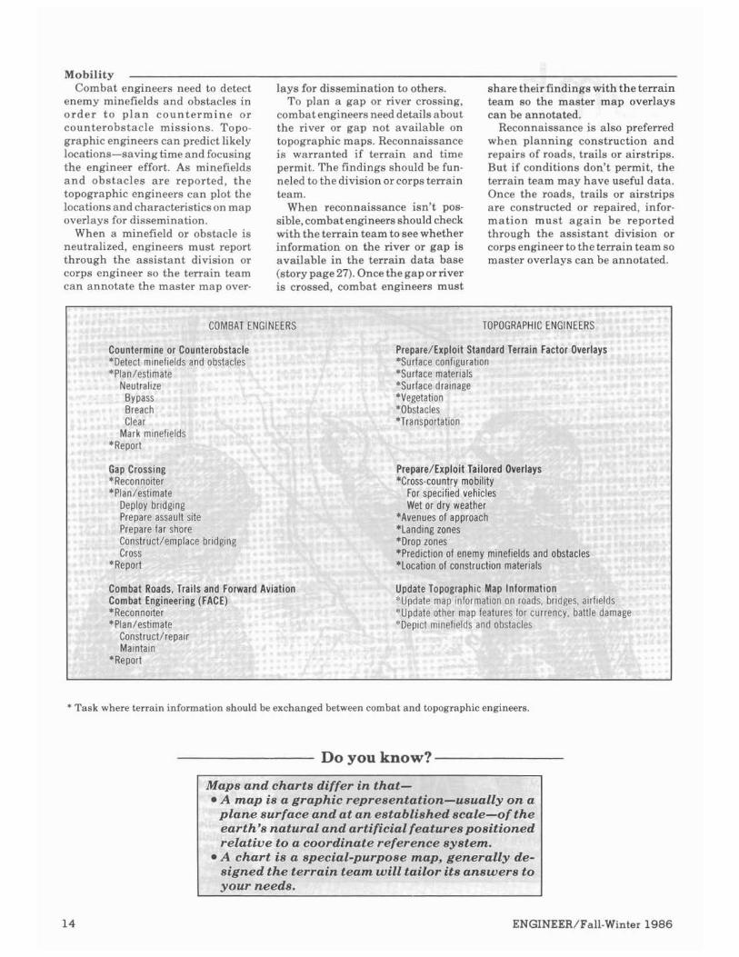
COMBAT ENGINEERS
share their findings with the terrain team so the master map overlays can be annotated.
Reconnaissance is also preferred when planning construction and repairs of roads, trails or airstrips. But if conditions don't permit, the terrain team may have useful data. Once the roads, trails or airstrips are constructed or repaired, infor- mation must aga in be reported through the assistant division or corps engineer to the terrain team so master overlavs can he annotated.
;RAPHIC ENGINEERS
Lounfermlne or ~ounrerobstacle r epa re~ t xp~o l rsranoaro Terrain Factor Overlays *Detect minefields a nd obstacles jurface confi guration *Plan/e stimate M a c e mate rials
Neutrallre jurface drain age ~~~
BYPass legetat~on BretICh Ibstacles Clear lransportatlo
Mark minelields *Report
Gap Cro ssing lit Tailored Overlays *Recon1loiter 1 moblltty
r+im.+n A*Plan/e,,,,,,.,, "1 >$,Cb"1C' " "c,#rb,c>
Deploy br~dglng Wet or dry Ineather Prepare assault SI *Avenues of a pproach Prepare far shore *Landing zone S
.,,,.., ,, r""~+ruct/emplac,"",,.., *Drop zones Cross *Prediction of enemy minefields and obstacles
*Report *Location of construction materials
--...- - .Roads. Trails and Forward Aviation l lpdate Topographic Map Information Engineering Jpdate map information on roads, b r~ r SCombat tges, airfield:
"Recon1loiter Jpdate other map feature s lor currenl ;y, battle dar nage stimate leptct m~nef~elds tacles*Plan/e and obs
Construct/reoair
* Task where terrain information should be exchanged between combat and topographic engineers.
Do you know? -
Maps and charts differ in that- *A map is a graphic representation- usually on a
plane surface and at an established t3cale-01 f the .____:a:_earth's natural and artificial feat~rea~uarrroned
relatine to a: coordinlate refe rence 83'stem. * A clzart is a special.-purpose? map, g enera113r de-
signred the t~ srrain tc !am will tailor it. s answeirs to vour neeas.

Countermobility Combat engineers normally per- and other tailored products tha t As countermobility missions are
form map, ground or aerial recon- identify sites with potentially high executed, engineers and maneuver naissance to estimate the best loca- payoffs (story page 27). They are units mustreport them through their tions for emplacing minefields, ideal for obstacle planning, followed division and corps engineers so ter- obstacles and demolitions to deny by ground reconnaissance to verify rain teams can annotate master map the enemy mobility. the merits of the site. Without them, overlays and disseminate the infor-
Topographic engineers can pro- combat engineers can waste valu- mation. vide cross-country mobility analyses able time and still end up guessing.
COMBAT E NGINEERS TOPOGR'APHIC ENGll UEERS
fare. Obstac l e Dernolitioins or ADMs Replroduce Map Overlays ., ...... -liter Sani e as all of the mob~l~ ty tanra exLepr IIIUU~II~~rnuuelr *Selects1 uJcd for cross-CI suntry mobili ty analyses f *Plan/es taskIS are based on character lstlcs of ener
Execut and wheeled vel iicles. *Report
* Task where terrain information should be exchanged between combat and topographic engineers.
Survivability Survivability involves camouflage Terrain teams can tailor products fighting, protective and decoy posi-
and concealment, as well a s con- that provide information on cover tions, warehouses, hospitals, tun- struction of fighting, protective and and concealment, observation and nels, utilities, food stocks, and POL. decoy positions. Each requires a fields of fire, and other information To improve the data base, all new reconnaissance, if possible, before to assist in survivability planning. information must be funneled to the planning and estimating. They should also depict locations of terrain team.
iT ENGINEER TOP!
- ...ng, rrotectlve ana uecov rosl t lons Prepareltxplolt btandara ierraln tactor Uvsrlays
*Rect mo l te r *Surface cor 'Plan /estimate "Surface ma
Dellloy assets *Vegetat~on Corbstruct
l r t
Camouflage and C loi it Tailorecl Overlays*,'.. '-....:.*Iden lily Y U I I I C I I "
/e Stlmate conceal me^i t potential fl rom horizont. al/vertical 110 y assets observat~on
Cor1struct *Observat~or)/fields of fir e maps, line of sight for *Rep[~ r t weapons ;~ n dradar
Enhance Tor lographic MI ~p lntorrnatlon........... UlUdfl dled maps
r.*n,,,ar * n tunnels)Fac~ l~ t~es(~a,,~,~~,,,. aqdsp~tals, Utilities Food stocks POL
. . . .Reproduce Map Overlays
* Task where terrain information should be exchanged between combat and topographic engineers.
ENGINEEWFall-Winter 1986
Summary I f you feel that combat and topo- MAJ Thomas E. Mathews is the and mobile assault bridge com-
graphic engineers have totally dif- Mapping, Charting and Geodesy panies, S-I of combat heauy and ferent functions, think again. Both Doctrine Deuelopment Coordinator assault bridge battalions, and have the mission to exploit or rein- at theDefense MappingSchool. His assistant S-3 of a combat heauy force the terrain. Both advise their topographic engineer assignments battalion. commanders on how to best use the include command of the Terrain MAJMathews has bachelor'sand battlefield terrain. Both require AnalysisDetachmentsupportingZZZ master's degrees in physical geog "terrain sense." Both need the best Corps, and Chief of the Terrain raphy f rom the Uniuersi ty o f possibleterraininformationandrely Evaluation Division, Defense Map- Michigan. He is a graduate of the on each other to get it. ping School. Command and General S t a f f
The better we understand this His combat engineer assignments College. concept,the better engineers we are, include command of panel bridge and the stronger the Army we support.
Do you know?
The Defense Mapping Agency (DMA) inventories over 21,000 different 1:50,000 scale topographic maps-a fraction of the line items in the total DMA inventory.
Even so, less than 50 percent of the world's land area has been mapped at a scale of 1:50,000 and only 80percent at a scale of1:250,000,according to a U.N. study.
Writer's Guidelines
Do you have any articles, photographs, or art- Letters to the Editor. work to submit to ENGINEER?Here are some tips. Lessons Learned.
TOPIC: We focus on combat engineering; however, any articles of interest to engineers are welcome. Write inactivevoice and beasconcise as possible. Please give your article a title, too.
LENGTH: Let your subject dictate length; generally, articles should be two to six pages, double spaced.
PHOTOGRAPHS A N D ARTWORK: Be-sides photographs and artwork which supplement articles, photographers and artists should submit any work that may be of interest to engineers. Your photos should be 5 x 7 black and white, glossy. Please include acaption and photocredit. Drawings should be legible, but do not have to be camera ready.
News and Notes. Personal Viewpoint.
ENGINEER PROBLEM: Please submit your challenging-but not too hard-Engineer Prob-lems. Problemsshould be referenced to a manual, but must be original. They should be checked for accuracy and should strengthen combat engineer skills as well.
COVER LETTER: When submitting materialto ENGINEER, enclose a cover letter with your name, address, and phone number. Also, please include biographical information such as military and civilian education and past and present assign-ments.
If you have any questions, please call us.
DEPARTMENTS: We are always looking for (703) 664-3082, AV 354. items for our departments:

Topographic Support Around the World
by Penelope Schmitt
Today's topographic mis-
a n d forward, moving to- w a r d flexibility a n d specialized services. Units provide field com-manders with tailored terrain in- f o rma t ion ; c a r t og raph i c effort emphasizes command-unique prod- ucts; decentralized product storage and distribution prevails; and sur-
The 30th Engineer Bat ta l ion, under t he command of t he 4th Engineer Brigade, receives peace- time missions from FORSCOM HQ and coordinates wartime planning with Third Army and CENTCOM. These linkages give the 30th a n open line of communication through- out the Army.
While its counterparts often oper- a te by deploying special teams to contingency areas, the 30th deploys much of i ts complement to the area of operations i n order to provide full topographic support. Strong i n arid area operations, the unit exercises throughout the western and south- western United States and has taken its specialized skills to Honduras, Egypt and Jordan.
The 29th Engineer Battalion, based i n Hawaii, provides topo- g raphic support to the Pacific Command. Operating over a vast area, the 2 9 t h ' ~ flexible force can sustain simultaneous operations in widely separated areas.
T h e Rapid Mapping Suppor t T e a m (RMST)
The 2 9 t h ' ~ rapid mapping support teams provide swift, deployable, topographic support to contingency and wartime operations. The spe- cialized teams field 16 to 20 members with up to four pieces of mission- essential equipment. When de-
veyors support positioning and vironment and the special needs of alignment missions. the commands it serves.
To meet these new challenges, the These four battalions can provide topographic battalions are devel- every US field commander in the oping programs unique to their world with flexible, deployable, missions. Each battalion-the 30th tailored topographic support on the at Fort Belvoir, VA, the 29th in AirLand battlefield. All you have to Hawaii, and the 649th i n West do is ask. Germany and the 1203d (NG) i n Alabama-reflects its theater en-
*'he 30th Engineer Battalion A Tes t Bed f o r N e w Systems- exercises followed, culminatingin a T h e Topographic Suppo r t battalion FTX to test the equipment Sys tem (TSS) i n the field.
The 30th, collocated with the US By January 1986, the 30th was Army Engineer School, is an ideal ready to deploy a fully trained rapid test bed for emerging doctrine and r e sponse e lement f o r exercise equipment. One of the battalion's Gallant Knight. On the way, the prime achievements this year is its battalion proved the TSS's excellent success in integrating, training and roadability and learned the limita- testing the TSS. tions of its air deployahility-only
In October 1985, the battalion re- two of the system's loaded semi- ceived the TSS, and i t s soldiers trailerrigs could beairliftedon each t ra ined on t he new equipment. C5A transport. During the post-training phase, the I n just four months, the 30th 30th conducted a n emergency de- successfully integrated a n d em-ployment readiness exercise, per- ployedtheTSS,deployingeffectively forming a full load out and a static and providing a major exercise with load onto C5A aircraft, checking car tographic a n d reproduct ion personnelforoverseasdeployability, support. and conducting a convoy. Other
'he 29th Engineer Battalion ployed, the RMST can support a uations, the RMST program gives limited operation or serve with other tactical commanders forward topo- units to support follow-on echelon graphic support and createsaunique forces. t ra ining environment for topo-
The29th trains two to four RMSTs graphic soldiers. each year. Selected soldiers are assigned to a n RMST for intensive Tailored Topographic technical and tactical training. All Products-The World You Need team members cross-train in each to See other's MOSS to ensure full coverage The special maps produced by the of topographic a n d equipment 29th exemplify the made-to-order maintenance skills. support commands can expect from
The RMSTs deployed in 1985 and all the topographic battalions. As 1986 to the Team Spirit and Ulchi always, DMA's standard products Focus Lens exercises i n Korea and are the maps of first resort. But the Balik-Samahan exercise in the standard maps can't always do the Philippines. I n these and other sit- job.Topographicsupportcanmodify
17

existingproductsor createnew ones. LOCD information in a highlighted They can- color.
Change scale. Team Spirit Black Map-Army Enhance or delete selected aviators needed to seemap features material. and flight hazards under blue-green Combinemap sheetstocenter the artificial light. The 29th developed area of interest. and tested four prototypes during Add information. Team Spirit 86.Thesemapsreversed Create or enhance a map with the normal use of colors. They were photography orintelligencedata. less reflective in the cockpit, more Create a photobased map. readable under all lighting, and
compatible with n ight vision The 29th has recently worked with goggles.
a variety of customersto design and DMZ Flight Map-The customer produce these tailored products: asked to see authorized flight cor-
Lines Of Communications Desig- ridors along the DMZ in Korea. na to r (L0CD)-The customer Accuratedepictionofthesecomdors needed a graphic index for existing is critical, because aircraft outside computerized highway and railway them are treated as likely hostiles. data. The resulting map showed all Flight information was overprinted base map features except water in in highlighted colors on standard subdued black and overprinted the base maps.
The 649th Engineer Battalio The expert in topography for climate conditions can shape mil-
USAREUR is the 649th Engineer itary operations. The 649th'~seven Ba t t a l ion . Headquar tered i n terrain detachments provide direct Schwetzingen, the 649th has sub- IPB support to USAREUR corps ordinate units stationed throughout and divisions. During the 1986 West Germany. The battalion is REFORGER Certain Sentinel exer-mobile throughout Europe, sending cise, the 526th Engineer Detachment elements to locations as diverse as proved the varied-and valuable-Spain, Italy, Turkey and Holland. potential of terrain analysis. Ma-Like its counterparts, the 649th pro- neuver restriction maps based on vides a wide variety of topographic their intensive soil and weather support services, including stan- condition analysis-dard , nonstandard and quick- *Prevented vehicles from miring response map products. in soft or wet terrain.
Protected valuable farmland and Intelligence Preparation of the populated areas. Battlefield (1PB)-REFORGER The analysis thus contributed 1986 immeasurably to a safe exercise. It
One of thefastest-growingaspects also reduced the fiscal and political of topographic support is terrain priceof Certain Sentinelby avoiding analysis. Knowledge of natural and damage to host nation lands and manmade features, weather, and cutting the cost of reparations.
Hokkaido Terrain Analysis Maps-The customer needed terrain analysis maps a t 1:250,000 scale. Since no DMA standard terrain factor overlays existed for this area, the customer obtained host nation support. A montage of several map sheets formed each base map. To date, twosheets have been produced with overprints showing LOCs, cross-countrymovement for wheeled vehicles, and concealment. The last two overprints show winter/dry season and summer/wet season conditions.
The ability to visualize the terrain the way you need to see it is vital to the success of your military opera-tion. This sampling of the support the 29th provides the Pacific Com-mand typifies the topographic re-sources that are yours to exploit.
.. Planning topographic support for
REFORGERstartsa year beforethe exercise. For Certain Sentinel, advance production and quick-response support resulted in a dis-t r ibu t ion of 1 .7 mill ion m a p produets-12 maps for every soldier participating in the exercise.
Nonstandard maps supplemented standard topographic, cross-country movement, and road and bridge maps. These were available for issue a t all times at corps map supply points.
The diversified 649th keeps pace with the demands of tactical com-manders, providing both standard and tailored support that mirrors changing developments on the modern battlefield.
The 1203d Engineer Battalion Based in Dothan, Alabama, the for all Reserve, ROTC and National analysis teams supply 8th Division
1203dEngineerBattalion,Alabama Guard units in the Southeastern (NG) commanders with special-National Guard, provides topo- United States. In overseas deploy- purpose map products, and team graphic support both in theU.S. and ment for NATO's topographic exer- elements have participated in FTXs overseas. Its HQ, cartographic, and cise, DOMINATE,the battalion has and CPXs in almost all 50 states. As survey companies, together with operated map depots under wartime a provider of timely, tailored map eight terrain analysis teams, offer conditions. products and terrain analysis, the high-quality topographic services. The 1203dcan also stand up to the 1203d exemplifies the high stand-
The 1203d. like its active Army active Army battalions in tailored ards of readiness and capability the counterparts, offers both standard support capability. It is now ac- National Guard maintains. and specializedtopographic support. quiring the new TSS, and will train For example, the battalion is the on the system in January and Penelope Schmitt is the Features primary source of maps and charts February of 1987. Its eight terrain Editor for ENGINEER magazine.
The key is teamwork-t o Vietnam
ALL topographic engineers are in the terrain information business. But terrain information is not generated in a vacuum. Data must come from those who know-combat engineers, infantrymen, aviators and others.
by COL David F. Maune
In the mid-l960s, I spent m- three years in key assign- -- ments with the engineer -
topographic battalion in Germany. We produced terrain studies speci- fied by FM 30-10, Military Geo- graphic Intelligence (Terrain).
These terrain studies included a series of 1:250,000 maps-each with separate map overprints depicting soils, rock types, drainage, vegeta- tion and landforms.
We compiled da ta from each country before publishing the final study-a 24- x 30-inch confidential book, 1inch thick. HQ USAREUR directed us to produce these terrain studies. But we never knew if they were needed or used.
Reassigned to Vietnam, I served as the map and weather officer in the G-2 office a t HQ, US Army Vietnam. I visited both corps (called field forces in Vietnam), every divi- sion and brigade, and several bat- talions. At each TOC, I asked the G-28, G-3s, S-2s and S-3s, "Are you satisfied or dissatisfied with your topographic support?"
The answers I received from the two corps were totally opposite.
In one corps, the consensus was
that topographic engineers were worthless. In the other corps, the unanimous response was that topo- graphic engineers were force multi- pliers essential to successful combat operations.
Each corps was supported by an identical organization-one topo-graphic company and one terrain team. I wanted to know what we were doing right in one half of Vietnam and wrong in the other.
In the corps that had taken a dim view of its topographic support, the units were applying FM 30-10 doc- trine...much a s we had done in Germany. For security reasons, the units burned the 1:250,000 scale ter- rain studies upon receipt.
Confidential analyses of soils, geology, drainage, vegetation and landforms a t any scale were of no use to the combined arms team. The topographic engineers had not talked with their customers to see what they really wanted or needed. The doctrine clearly didn't fit the war i n Vietnam ...and probably didn' t serve t h e customer i n Germany either.
In the corps that considered topo- graphic engineers indispensable,
terrain analysts regularly visited the combat units. They explained topographic unit capabilities and limitations and asked their custom- ers what they needed. A team spirit emerged.
The combat units wanted their obsolete 1:50,000 scale maps updated regularly and wanted map overlays or overprints of intelligence and operations information. The combat units provided most of the data based on their reconnaissance, and the topographic engineers tailored products to meet their combat needs.
Here's how the system worked: Whenever a reconnaissance pa-
trol, task force, aviator or driver found map information to be obso- lete, they reported the problem to the G-28, G-36, S-2s or 5-38 so the map could be updated. This data was funneled to the terrain team, which maintained mylar overlaysfor every 1:50,000 scale topographic map within the corps' area of respon- sibility.
I watched terrain analysts brief a reconnaissance team on expedient measurement techniques and spe- cificitems tocheck when on patrol. I saw mapoverlays with approximate

traces of jungle trails not found on standard topographic maps. Anno-tations showed where bridges had
VMA lhas Opened a new customer assistance ottlceto handle lnquirles trom all users of DMA products and services. Located in the DMA Office of Distribution Services in Washington. DC, the customer assistance office-- k l p s to obtain DMA products and s ~ ~ ~ ~ ; ~ o ~
Ine customer a!
le customer assistance' 26-0342,commercial 17-2495,AV 287.
te Mapping Agency Crisis Management Team.
!6-0342. secure ~ ~ 3 4 .commerctal (3u11L L I - ~ 4 ~ 3 .HV L
The crisis management team also handles requirementsfor nonstandard mapping, chartingand geodesy products beyond thecapability of supporting Army topographic units.
-During duty hours, call the crisis management team-commercial (202) 653-1401,secure 2305, AV 2! Outside normal duty hoc 653-1375,AV 294.
;e MappirDefens -....
~gAgencyI Customt!r Assista ~
[nee Offic been destroyed or added since the maps were last revised. Some of the annotations depicted enemy intelli-gence-locationsof suspededenemy organizations and road locations with frequent enemy ambushes.
A day or two before a combat operation, the TOC staff visited the terrain team to personally review the overlays and add intelligence and operations information-heli-copter landing zones, unit boundary symbols, artillery fire control plans.
The terrain analysts compiled this information so it could be over-printedon 1:50,000scaletopographic maps of the combat area. Then, cartographers drafted the informa-tion to make it suitable for repro-duction. The map distribution pla-toon provided several hundred copies of the standard, bcolor topo-graphic maps. Themap reproduction platoon used a 6th color to overprint this new intelligence and operations information on the maps.
Just hours before a combat opera-tion began, hundreds of unclassified, overprinted maps were furnished at the tactical scale. The information was so "hot off the press" there was no time for it to fall into enemy hands.
On 24-hournotice,theterrainteam and corps topographic company furnished the combat units with in-dispensable topographic products. These topographic units effectively communicated with their customers and worked with them as a team.
Published doctrine didn't fit, so -DOYOU know? topographic engineers improvised with astounding results. Although the terrain team performed many tasks normally done by the carto-graphic platoon of a topographic company, they did what was neces-sary to contribute to the success of combat operations.
Thekey was teamwork. Thepayoff was a terrain data base that couldbe tapped a t a moment's notice. The lesson is clear. If we exchange information habitually in peacetime, we will do it instinctively in war.
COL Dauid F. Maune is Director, Defense Mapping School (DMS), Fort Beluoir, VA.
.., .,"-.,. !quisitions. of maps,
IS reports o availabilit)
f current re I and use charts and
indles emel ~ord~natesC irwards o t h ~
~estsfor sta ,port to exe ;and reque
ndard DMA !rcises. sts to apprc
products.
lpriate expc
gcIILy icqu
IMAODS sul ?r question!
y through In the next
jsistance o lurs, telephc
fftce is open 0630-1s me messages are recorc
100 Monda jed for actic
- - ~ . ~ -office-toll free (800)8Call t l
(301122
Defens
has a 24-h()ur crisis management ..A- '---*.
team equil . - > - - A --3ped with t
--:-- -,.-DMA ' ,.-"A,-I l d l l U I ~
geodesy Dl 8;
ours, call the customer free (800) '87
assistance I . .a,.., "a-
office-toll .,,*
nal duty t 301) 227-2
lours, call 196,AV 28;
center-le comn
34. guard desIrs, call the
ay was YgnIzeu un 40 u u ~ yA r r r wnen GEN Ge
washingtofi pher and su of the count
of accu ge to me ,edto mand hc shift
wztnsucn sketches as1 couca traceout or my own observations and that of gentlemen around me. Z think i f gentlemen of known character and probity could be employed in making maps (from actual surveys), it would be o f the greatest advantage."
ic suppc -- " F , brt for i
.--, first !orge
TOP rea..,
the Am 7 ...L --
L appoin .rveyor c bry.''
ted Rob, > f the ro
ert Ersk ads, to t
tine "gec ake skei
rate ma, .Zhave i rve been
7
ps has 1 n vain el obliged..
"Th disc pro..
be want zdvanta, cure the. .
jeen a g ndeavor to make . .

Tdpogrdphic Research arid De~blopmentI I
to know the layout before you can compete. Accurate, timely terrain information helps commanders make quick decisions-allowing them to fight outnumbered against superior firepower and win.
by COL Alan L. Laubscher and Sandra J. Cleva
Technology is about to numbers-already allows military map information that is stored, pro- revolutionize battlefield missiles to hit targets with extreme cessed and read by computers. mtopographic support. Dur- accuracy and lets fighter pilots fine- The Defense Mapping Agency be-
ing the next decade, commanders tune their skills on aircraft simu- gan producing digital topographic will be getting terrain information lators without leaving the runway. data in the 1970s. Although the a t unprecedented speeds in new, New weapons systems-the agency still produces millions of more useful forms. Pershing 11, cruise missile and paper maps a year, digital data now
Digital topographic data-trans- FIREFINDER counterartillery and accounts for more than half i ts la t ing the earth's surface into countermortar radars-depend on output.

Theagency currently produces two basic types of digital topographic data:
Digital terrain eleuation data uses a matrix of uniformlv soaced points to describe the shape bf the earth's surface-its mountains, hills and valleys in x, y, z coordinates.
Digital feature analysis data describes the characteristics and geographic locations of manmade structures and natural landscape features using a series of x,y coordi-nates. DFAD depicts point features (towers, single buildings, silos), linear features (roads, rivers, power lines, runways, bridges) and areal features (fields, built-up areas, woods, lakes).
Scientists a t the Engineer Topo-graphic Laboratories are now work-ing to bring the digital data revolu-tion to soldiers in the field.
DTSS The Digital Topographic Support
System-scheduled for fielding in 1991-will automate much of the work now involved in terrain acal-ysis. Instead of hardcopy overlays, slide rules and calculators, terrain analysts will use computerized dig-ital topographic data bases.
DTSS will replace the direct sup-port section of the topographic sup-port system and will be mounted on a 5-ton truck. Plans call for one system per division, two per corps a i d twdfor echelons above corps:
DTSS will give terrain teams access to more than 20 different terrain analysis programs which fall into two categories: interuisibility and mobility.
Intervisibility analyses use eleva-tion and vegetation data to define areas that can be seen electronically or optically.
Products include terrain profiles, masked area plots, perspective views, flight line masking graphics, minimum detection altitude compu-tations and oblique projections.
They help commandersdetermine the best locations for systems by showing the effects of terrain on-* Weapons performance.
Communications facilities. Short-rangeradar. Other battlefield sensors.
DIGITAL TOPOGRAPHIC SUPPORT SYSTEM (DTSS)
QUICK RESPONSE MULITCOLOR PRINTER (QRMP)

For example, intervisibility anal-ysis plots target acquisition-showing radar's range of coverage for targets approaching a t different altitudes.
Mobility products help com-manders in deciding where to ma-neuver men and equipment by-* Computing the probability of
aerial detection for troops and vehicles. Examining lines of communica-tion. Predicting possible river crossing sites. Identifying optimal helicopter landing and drop zones, infiltra-tion routes and air avenues of approach.
For example, the cross-country movement model shows a vehicle's off-road speed capabilities by com-paring performance characteristics like climb and override to the slope, soil and vegetation found in the proposed area of operation.
QRMP The Quick Response Multicolor
Printer will soon give the Army fast, combat-oriented reproduction capa-bility-making it easier to copy ter-rain graphics, maps and other pro-ducts in the field.
What takes 27 soldiers and ten 30-foot vans full of equipment today will take one soldier and a 20-foot container on a 5-ton truck.
Fielding will begin in 1992.Plans call for two systems at corps and one
Artificial Intelligence Scientists are experimenting with
artificial intelligence as a way to transfer some of the slow, laborious work involved in interpreting aerial photos from man to machine.
Artificial intelligence allows com-puters to manipulate symbolic data using informal decision-making rules. Like human specialists, the computers apply inferential rea-soning, logic,deduction and a stored knowledge base to interpret infor-mation and solve problems.
Two demonstration projects now focus on using artificial intelligence to determine drainage networks and identify urban features like roads and buildings.
Researchers are also evaluating potential uses for terrain data from NASA space platforms and satel-lite-basedsensors. Information from multispectral sensors from NASA's Landsat program is being merged with terrain elevation data from the DefenseMapping Agency to produce three-dimensional perspectives. Future studies will explore ways to generate tactical terrain graphics from multispectral imagery.
Computer Image Generation Computer image generation-
realistic pictures created by com-bining digital terrain data with information from maps, photo-graphs and satellite imagery-is also on the horizon.
Computer-generated images are already being used for flight simu-lators and other training devices. The Engineer Topographic Labora-tories are exploring possible appli-cations for mission planning and battlefield management.
These images may prove an ideal command and control tool by elimi-nating much of the interpretation involved in map reading.
Commanders could then see the hills, trees,roadsand waterways that make up the battlefield while plan-ning their operation.
COL Alan L. Laubscher com-mands the Engineer Topographic Laboratories. He served previously as district engineer for the Corps of Engineers Galveston District. He commanded a combat engineer company in Korea and a combat engineer battalion in Germany.
He has a bachelor's degree in industrial engineering from Stan-ford University and a master's de-gree in geodetic science from Ohio State. He is a graduate of the CGSC and the Army War College.
Sandra J. Cleva,formerly apublic affairs specialist a t the Engineer, Topographic Laboratories, now works for the Department of the Interior.
system per terrain team a t echelons nn.ma. bmn.~,? above corps, corps and division.
The QRMP uses a dry printing process with a laser scanner. It will cut printing time for field-generated g r a p h i c s f r o m 8 h o u r s to 5 minutes-turning out 75 multicolor or 225 monochromecopies per hour.
The first printers fielded will re-produce almost any type of hard-copy product-including standard maps, annotated maps, terrain analysis graphics, transparent overlays, photographs and captured enemy documents.
Later, a digital interface will let soldiers print hardcopy products directly from digital terrain data provided by the Defense Mapping Agency or DTSS.
DMA producespointpositioning data bases used by Army, Navy,Air Force andMarine Corpsunits equipped with the analytical photogrammetric positioning system to perform hasty point posi-tioning surveys in friendly or enemy territory. System operators for all services are trained at the DefenseMapping School (DMS),FortBelvoir, VA.
Although some courses are very modern-usi satellites to establish accurate positions on t ground-DMS also teaches technology that .I hundreds of years old-plane table surveying popular when George Washii as a topo-graphic surveyor.
agton w

Terrain Analysis Data Bases- by CW2 Kathleen Hawes
AflTopographic units, espe- cial ly engineer te r ra in teams. are in the terrain
information business. Every com-mander, staff officer, soldier and weapons system is a potential cus- tomer for our business.
Ask terrain analysts about the terrain or the impact of weather on the terrain, and we give you a pro- fessional answer-the best we can in the time available.
If we have a current terrain anal- ysis data base covering the area in question, we can give good answers in minutes or hours. If we don't have the data base, we're all in a heap of
The s u r f a c e c o n f i g u r a t i o n f a c t o r o v e r l a y por t rays the maximum slope of the surface at each point on the ground, expressed as percent of slope. Areas are ex- pressed a s maximum slope into categories: 0-3percent (A), 3-10 per- cent (B). 10-20 percent (C), 20-30 percent (D), 30-45 percent (E), over 45 percent (F)and open water (W).
Data from this overlay is normally used only by terrain analysts, but combat engineers could determine locations for roads or airfields with slope limitations-for example, air- fields with slopes under 3 percent.
The surface materials factor overlay portrays the soil on the surface using the categories of the unified soils classification system.
The CL in the example is an inor- ganic clay, and the ML is an in- organic silt. The third digit indicates surface roughness. Soil categories are further identified by moisture content. Dots underlining the cate- gory indicate a moist soil, and dashes indicate a wet soil.
This information is useful for combat engineers when planning construction or repairs of roads, trails and airstrips. This informa- tion is vital to terrain analysts performing cross-country traffic- ability analyses.
trouble; it might take days, weeks or months to collect the raw terrain data needed.
The terrain analysis data base is our library of information from which analyses are prepared to answer specific questions. The data base consists of a series of terrain factor overlays described below.
Terra in Factor Overlays Terrain factor overlays are nor-
maliy produced by the Defense Mapping Agency (DMA) for use by terrain analysts, but may be pro- duced by engineer terrain teams to DMA specifications.
DMA produces these overlays at two scales-the tactical terrain analysis data base a t 1:50,000 scale and the planning terrain analysis data base at 1:250,000 scale.
There are six standard tactical terrain analysis overlays for each 1:50,000 scale topographicmap. The data bases for overseas geography are usually classified confidential or higher because of their potential value to the enemy. Data bases of the United States are normally unclassified, but are available only for selected training areas.
burtace contlguratlon
A 0
A
aurtace materials
qy * M L l. . .

What's in them for YOU? The surface d r a i n a g e f ac to r
vurrace ara lnage
overlay portrays bodies of water on the earth's surface. Lakes, ponds and reservoirs are depicted as open bodies of water.
Rivers, s t reams, cana l s a n d ditches are defined using a nine-digit code to indicate the type of feature, gap width, bottom mate-rials, height of right and left banks looking downstream, slope of right and left banks, average water veloc- ity, and average water depth. The overlay's legend explains the sym- bols and nine-digit codes.
This information i s extremely valuable to combat engineers plan-
/ /
/ /'.
/' /
\ /'. /..\ :4-.
413233171 0 -. w'
' J
213111111 A
IQI
/ /
/
ning river-crossing operations. . I A
The vegetat ion fac tor overlay divides vegetation into categories of tactical significance. Coded letters and numbers indicate types, canopy closure and tree height.
A vegetation factor table provides detailed information on average tree diameter and tree spacing plus the vegetation roughness factor on the forest floor used in trafficability analyses.
The vegetation factor overlay is also used by terrain analysts to cal- culateline-of-sight and provide cover and concealment information for survivability missions.
The obstacles fac tor overlay portrays linear terrain features that form natural obstacles not normally identifiable on a toooeraohic mao. . - . All obstacles shown are over 1.5 meters high and longer than 250 meters. Obstacles include road and railroad cuts and fills, escarpments, embankments, depressions, fences and walls, and other microrelief features.
This information is a tremendous benefit to combat engineers making obstacle plans.

The t r a n s p o r t a t i o n f a c t o r over lay portrays selected roads, bridges, tunnels, ferries, railroads and airfields over which troops and supplies could be moved during military operations.
Information shown on theoverlay includes roadway widths; steep grades; length, width, and runway surfaces; and bridge information such as length, width, overhead clearance and bypass potential. A bridge identification number cross- references a bridgedata table which gives added information, including construction material, span length and underbridge clearance.
This is important information for combat engineers, G-3s, G-4s and others requiring lines of communi- cation data.
The planning terrain analysis data bases at the smaller scale are similar to the tactical terrain anal- ysis data bases but also include special terrain overlays on water resources for arid areas. These are specifically designed to assist engi- neers in locating water supplies.
Combat Engineer Input Combat engineers are uniquely
qualified to fill voids in these data bases or to verify the accuracy of the data bases often derived through analyses of aerial photography. With the establishment of ground t ru th , engineer advice to com-manders can be given with far greater confidence.
Combat engineers are well quali- fied to classify soils, roads, bridges or airfields and provide data for the nine-feature codes for rivers on the surface drainage factor overlays.
All engineers must recognize in peacetime the need for maintaining accurate and up-to-date terrain factor overlays. If and when the Airland Battle begins, we must be ready.
Having our terrain analysis data base complete and ready at all times is the only way engineers can be prepared for war. This is the key to the library which contains answers to theinfinite variations ofquestions that commanders mieht ask about the terrain on whichthe battle is planned and fought.
I Transportation
CW2 Kathleen Hawes is the the2d Infantry Division. (For three Course Manager for the Basic Ter- consecutive years, this terrain team rain Analysis Course a t the Defense was cited as the key to success in the Mappingschool. She haspreviously annual Team Spirit exercises in served as Chief of the 527th Engi- Korea.) neer Detachment (Terrain) serving
~ n ~ i n e e rProblem I- I
Before a field exercise, you carefully tape together two adjacent maps that cover yourareaof operation. Youobservethat thegridsofthetwomapsdonot line up.
You are planning a night move from point A to point 8. At point A, the measured grid azimuth is 6 Z 0 . At point B, the measured grid azimuth is 246'.
What is the magnetic azimuth from point A to point B?I II MAP A MAP B I
Engrneer Problem/Solur~on submitted by MAJ Edward Wright. Advanced Tech-nology Division, Defense Mapping School. I I

Terrain Analysis: Tailored to t h e Customer
Did you ever ask a terrain analyst to give you a terrain analvsis o f the area o f o~erations? . That's" like asking for an ice cream cone without knowing they come in many flavors.
by CW2 Frederick N. Pessaro, Jr.
mThere are hundreds of dif- Artillery unitsrequirechokepoint Intelligence personnel need a ferent k inds of te r ra in analyses to preplan artillery fires. variety of terrain analysis products
5-analyses, each designed to Engineers need analyses of rivers to support the intelligence prepara- answer specific questions from the to plan river crossing operations or tion of the battlefield. This includes supported commander or staff. Ter- forecast floods. They need to locate analyses of how the weather affects rain analyses are normally tailored water in arid regions. They need the terrain for both friendly and from information contained on analyses of soils, geology or timber enemy forces. appropriate terrain factor overlays for construction. They need analyses Signal units require analyses of (story page 24), augmented by the of roads, bridges, pipelines, airfields, intervisibility for site selection of latest information available in the ports, landing beaches and other communication facilities. All Source Intelligence Center with- features affecting movement of s u p Transportat ion units require in the TOC. plies. They need many terrain anal- analyses of all forms of lines of
The combined arms team as a ysis products to support mobility, communications for logistics plan- whole needs analyses of the military countermobility, survivability and ning. aspects of terrain known as the general engineering site selection, Marines may ask for assistancein OCOKA factors: observation and planning and estimating. analyzing the terrain for special fields of fire. cover and concealment. obstacles, key terrain, and avenues of approach.
Infantry units areinterestedin all of these, but airborne units need special drop zone analyses, and airmobile units need landing zone analyses.
Aviation units requireanalysesof hazards to navigation, especially when flying nap-of-the-earth. They also need information on airfields and support facilities.
Armor units require analyses of cross-country movement. This re-quires synthesis of several terrain factor overlays (surface configura- tion, materials and drainage, vege- tation, obstacles), mobility charac- teristics of specified tracked or wheeled vehicles, and current mois- ture conditions which affect soil trafficability. (Terrain teams in Europe have analyzed these same factors in peacetime to reduce SP4 Rogers, 410, 688th Engineer Detachment, updates a terrain maneuver damage during recent overlay for Golden Saber XIII. REFORGER exercises.)

M-60 tank Cross Country Mobility (CCM) analysis n e a r Quantico, VA. CCM overlays a r e used by terrain teams i n analyzing potential mobility corridors and avenues of approach for specified tactical formations. Best locations for demolitions, minefields o r o ther obstacles a r e quickly apparent even though such locations a r e no t obvious from topographic map analyses o r actual reconnaissance. Such products a r e frequently classified because of thei r potential value t o the enemy. Time constraints cause such overlays t o be normally produced in black and white ra the r than in color as shown here for demonstration purposes.
GO-AREA > 15 KPH
SLOW-GO A R E A / 1.5-15 KPH
NO-GO A R E A < 1.5 KPH
amphibious operations. rain; fire; and conventional, chemi- Air Force units may ask for help cal or nuclear weapons on the
in analyzing natural or man-made terrain. terrain features for selection of In high-intensity warfare, the ter-optimal ordnance todestroy targets. rain is altered drastically. The ter-
Terrain teams have been asked to rain analyst must continuously analyze the effects of smoke; fog; track those battlefield terrain
Do you know?
We did not have division terrain teams and terrain analysis warrant officers until 1981. The Defense Mappi ncy firr ved the missiolIto produc in anab c bases a few yt ears ago. n. mnce rnen, engcneer rerracn reams nave naa a dramatic influence in helping commanders see the battlefield and use the terrain to maximum ad- vantage. Finally, c o m ~ s are using various forms ofterrain analyses to analyze the battlefield terrain before preparing the concept of operations.
changes and analyze the effects on military operations.
So, the next time you need a terrain analysis, considertheabove. If these options don't suit your taste, step right up so we can measure your needs and tailor our products to fit.
CW2 Frederick N. Pessaro Jr. is Course Manager of the Aduanced Terrain Analysis Course a t the Defense Mapping School.
His previous assignments include: Chief, 524th Engineer Detachment (Terrain), 2d Armored Division, Fort Hood, TX; ISG, 526th Engineer Detachment (Terrain) (VIZ Corps); and NCOZC, Theater Terrain Team of the 649th Engineer Battalion (Topo) (TA), Schwctzingen, FRG.
28

Lessons Learned -621B Scraper Lessons Learned features thoughts on tactical issues worthy o f reflection
and professional debate. Many questions have arisen concerning the capabilities and limitations o f the 621B scraper, which is replacing the 290M tractor and 830MB scraper. The Engineer School is conducting a survey o f 225 units to gather more data. Here are excerpts o f comments from the 92d Engineer Battalion (CH), Fort Stewart, GA, based on 16 months o f experience with eight scrapers. The views expressed do not necessarily reflect doctrine or policy o f the Engineer School.
Issue. What is the 6218 supposed to do? O b ~ e ~ a t i o n S .Earthmoving contractors have used this Caterpillar scraper as their primary earthmover with great success. It is more maneuverable, faster and lighter than either the 830MB scraper or 290M tractor. Extra weightcauses both maneuverability problemsand soil bearing problemsin many typesof soil.The621Blacksthepowerto pull itself in some soils-but notall. Forexample, i t can often excavate the sandy soils of southern Georgia by the pan alone; however, this is notthe mosteconomical way tooperate. Whena scraper pullsitself.lhe heat exchanged through the tirecauses premature failure. Replacement tires cost $2.600 to $3,000. Some contractors have gone bankrupt by mismanaging this aspect of maintenance.
Issue. The 6218 gets stuck. and units spend exorbitant amounts of time recovering it. Observation. The only reason for this is possibly inexperienced operators. When used with a push cat, this piece of equipment should never get stuck. If stuck, the 6218 can be retrieved by any dozer organic to the unit. By comparison, we haveseen 290Mssostuck that. because of their weight, they had to be recovered by a tank retriever.
Issue. The 6218 has no bull blade-a loss which has tremendous impact on production. Observation. Effective use i n scraper/push cat operations will help alleviate the problem. A 1:l ratio of push cats to scrapers is wasteful and unnecessary.There arethree primary methodsof usinga push cat: back-track loading,chain loading and shuttleloading. I f these are used wisely. a 3: l or 4 : l scraper to push cat ratio can be achieved.
Issue. Are there special maintenance or parts problems? Obse~at iOn. In 16 months, the only problem not due to normal wear and tear wasin thetachometersendingunit,and it was rectified. Parts for Caterpillar equipment are available worldwide-a major advantage over the 830MB and 290M, which were used only by the Army. Since the 6218 was fielded at the users' request, some units received it before parts were stocked in the Army inventory. This is not a problem with the equipment-just an example of getting the cart before the horse.
Issue. What about stability or possible blind spots? Observation. Problems can only be attributed to inexperience. The Army should spend more time and effort training operators. The improved maneuverability of the 6218 definitely outweighs any possible blind spots.
Issue. Durability. Observations. The 6218 has proven its durability and reliability. making it popular with earthwork contractors today. The Army has finally broken away from the concept that one piece of equipment can do everything. It has bought a tried and tested piece of name-brand equipment that performs scraping-its primary mission-well.
The POC for Lessons Learned is DOES.The Engineer School wantsto hear your training experiences-good and bad-so the lessons learned can be shared with the rest of the force. Write: Commandant, USAES, ATTN: ATZA-ES, Stop 271, Fort Belvoir, VA 22060-5271, or call CPT Craig Tavani, (703) 664.4172, AV 354.

ake your BY MAJ Ralph R. D'Elosua
T he Blade Effort Triangle, or BET, offers maneuver com-
manders and supporting engineers a method of agreeing on the blade effort required to support the scheme of maneuver.
The Engineer School teaches the BET as a successful technique for integrating engineer plans with maneuver in combined arms opera- tions, and it has been proposed for the Armor and Infantry schools.
The BET Simply stated, the triangle(Figure
1)shows the extent to which engi- neers can support the blade effort priorities first established by the maneuver commander.
The Y-axis initially represents the amount of unconstrained counter- mobility effort (antitank ditch in meters) the commander wants.
The X-axis represents the uncon- strained level of survivability (de- scribed in FM 5-103, page 2-6) he desires.
Since the engineer has a limited number of blades to support the operation, there is a direct relation- ship between theeffort available for survivability and the blade effort allocated to countermobility. What's directed toward countermobility is not available for survivability.
Mutual Appreciation A quick look a t the BET while
planning his operation shows the maneuver commander the tradeoffs he must make in establishing prior- ities. Therearelimits on what can he accomplished given the time and assets available. Once he has a reasonable best guess estimate of the engineer effort required to achieve a goal, he quickly realizes the engineers cannot achieve the impossible.
The BET gives the commander and eneineer a framework for dis- cussing priorities, shortfall problems and options. I t also gives the engi- neer an appreciation for the difficult decisions facing the commander.
Simplicity The beauty of the BET i s i ts
simplicity. I t can he drawn quickly by virtually anyone. Itcan hevague (describing only concepts) or specific (showing exactnumbers)-whatever is appropriate to the situation.
The BET is of greatest benefit early in the planning process when it can be drawn up to support the unconstrained engineer estimate.
This gives the engineer and his maneuver commander their first glimpse of how extensive the re-quired engineer support will be.
Once the constraints on time and resources are known, the BET is redrawn to show the optimum mix of countermobility andsurvivability support to be accomplished by "defend time." This gives the engi- neer and maneuver commander a working agreement.
For example, a brigade with three battalion task forces (two mechan- ized infantry and one armored) is preparing to defend within 72hours.
The brigade commander has directed effort to preparation of a counterattack route; overall prior- ities are to countermobility, surviv- ability and other mobility tasks.
He wants Survivability Level VI with one initial and one subsequent battle position for each task force (see page 2-6 of FM 5-103).
The engineer has 20 blade equiv- alents within the brigade area for mobility, survivability and counter- mobility. The directed mobility effort requires 100 hours. (Note: a blade hour is a blade equivalent working for 1 hour.)
After accounting for the effects of travel, maintenance and refueling, he estimates he has 980 blade hours remaining. That's enough time to construct either 33 km of antitank ditch or 1,633 survivability positions

I \ P o ~ n twhere maneuver commander
" -z7
BET! or some combination thereof.
Based on the unconstrained engi-neer estimate, he determines he needs 10kilometers of antitank ditch to support the countermobility plan. Survivability Level VI for two battle positions per task force requires 1,110 blade hours-unattainable even if all blade assets weredirected to the mission.
Given these realities, the question becomes how should the 980 blade hours available be allocated to best support the commander's intent? The BET (Figure 2) helps the engi-neer show thecommander the trade-offs a t a glance.
The engineers can carry out the countermobility mission and provide Level IV or 1,133survivability posi-tions (Point A).
Orthe commander can direct Level Vfor 1,550battle positions and settle for less antitank ditch (Point B).
During the planning stages for defensive operations, the BET accomplishes several things:
The maneuver commander and engineer agree early on how to accomplish established priorities realistically. The triangle provides a simple picture of how the engineer sup-port is programmed.
I \ a n d engineer agree o n opt lmum mix of CM a n d S elfort. The hvootenuse denotes total
I a m o u n i of blade effort available- - - - -
SURVIVABILITY (S1 In levels a n d number of posltlons
Figure 2
*The graph becomes a point of reference for reallocating re. sources a s the situation dictates. Planners have a basis for con-sidering alternate countermobil-ity methods such as employing minefields, reinforcing targets or using manpower ins tead of blades. Used properly, the BET is a tool
for preparing engineer estimates in thedefense thatgreatly enhancethe integration of engineers into the maneuver plan.
Engineer, are your ready to make your BET?
MAJ Ralph R. D'Elosua is an infantry officer.He has commanded a BCT unit and an airborne rifle company and served as a battalion S-1 in the 82d Airborne Diuision. Recently, he was a tactics instructor in the Engineer School. He is a USMA graduate with a master's of sciencefrom Universityof Southern California. He is now attending the CGSC.
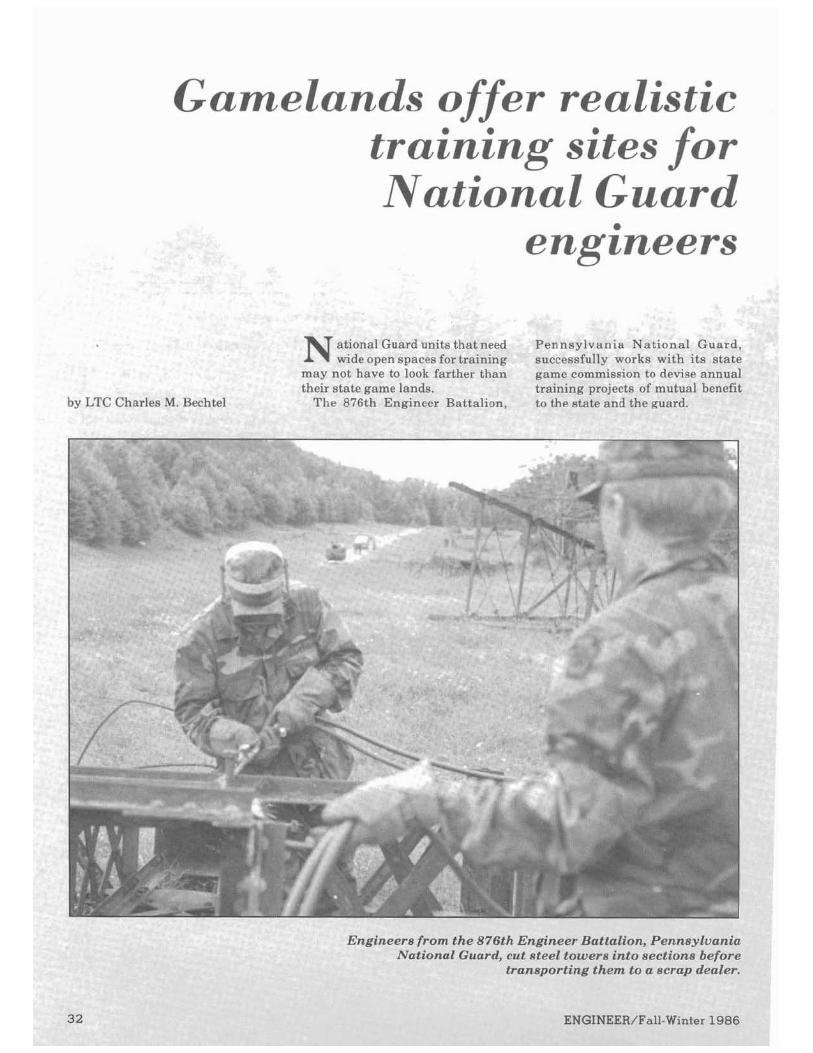
Gamelands offer realistic training sites .for ~ a t i o n a lGuard
engineers
Guard unii ts that nee d Pen nsylvania Nation~ a lGuurc sn spaces 1For trainin g SUCl:essfully . works wit.h its stal
not have t o look f;~r the r tha n g a r~e commis sion to d e vise annu; . . . ..A r scare game lands. rraining projecrs or mutual beneflr by LTC Charles M. Bechtel l e 876th Engineer ~ a r r a l l u n , to the state and the guard.
leers fror n the 876th Engin, eer Batta lion, Pen .nsylvani Nationa1 Guard. , cut steel !towers i nto sectit Yns befor
transpoirting the1 R to a ser,ap dealel
'inter 198'

W l t h
tha t OPF that
was land. win1- . bast
Site] in B, doub
'or the past two summers, th nbat engineers have combine blic service engineering project-
a realistic training scenario included air insel d
OR play. They d e ~ d soldiers can successkuuy =rain
state game lands without harm :the environment. rheir initial mission-to demolis.. mdoned steel electrical towers-
part of a project to create ing zones for rotary and fixed q aircraft. Pilots from the ern Army Aviation Training xacticeday andnight landings ear Valley. The landing zones #leasfeeding plots for white tail
deer. Bu
dirt l l n R B
acre; reali lengl late. post.
Al cludi
t the battalion also constructe, roads and culverts, replace fe bridges and performed othe
engineerine maintenance for th state
Th to operate in 121,50 - - - -s U L rugged terrain provideu
stic command and control chal-ss that are impossible to simu-when confined to a 10,000 acre
saua pend g ra t~ coml T L
mized intt r would i
T app stril solc
I levels of the command, in-hng platoons and line company ds, had room to overate inde-ently, but ?-
?d manne n >at.
..ree FM I ~ U , ~~~~.a~l.~~~~.a~wn itions on key terrain features rmitted the commander to com-lnicateover mountain ranges with
proj d cam d N lr mil,...-.
e mat tact
0 rect J ".
lpplied units located 115 mil, a &hour drive from the cor
~d post. CH 54 flying cran, delivered 400-gallon water trailers to c, tes.
Q parties w ?d by 2
H-1sand LOH-6shelped provide Innaissance, aerial survey, and
,-..imand and control during bat-talion moves. They served as both OPFOR aircraft and friendly aerial covering force during simulated NBC attacks.
he 28th In fan t ry Division lied constant OPFOR pressure-king by night and day, harrying liers working on construction ects and attempting to penetra ~pperimeters. ightly back briefs a t the cox ~d post helped company com-lders immediatelv analyze their
~dtake cor-
almost all of the suhordinatr units. Hplirootersfrom thePennsvlvania
National Guard were used exten-sively to give the 876th a chance to
lin with aviators. I '8
baLL8
peoi abo the -
Dmpany si uartering iir.
con v a l ~
W .am
~rlurougncuurulnarlun with sta officials is critical for units who a interestedin training on stateland
The state game commission pr,~ pared the environmental impact statements and supporting docu-mentation which set the parameters for the exercise. They provided fire fighting equipment an1 the guard units on its us
The state police playeu an lmpr '--:role-answeringquestionsfro~~~
ple living near the game lands ut aunfire and military trafficin
ther guard units should take k of their ability to assist states I projects that don't otherwisefit
the budget. The engineers' ability remove unwanted structures, co struct irrigation ditches and pond build and maintain access roads
duct a wildlife census is a
iable asset. hen working with state officials
.-...ember to-* Initiate planning and coordin
tion early so environmental co cerns are fully addressed. Inform the public and all poten-tially concerned parties on the purpose and extent of the opera-tion. Emphasize the community benefit.
1 Use the news media to explain the exercise and create a positive attitude before the exercisestarts. Request additional equipment like transmission sets well in advance and check everything thoroughly before you need it a t the site.
1 Plan alternative transportation anytime aviation is the primary means for delivering critical supplies such as Class I items. Recognize local officials in the media with letters and awards.
need the r t
-area.
'The876th proved that theNation-a1 Guard can work closelv with
-0
government agencies to developfield training exercises that benefit both the SC
-
community and the
'ou may gain.
!ir suppo
* L - ~~rcur lesM. BCL.,LLBLcum-mands the 876th Engineer BattaC ion. He is the state maintenance officer of the Pennsyluania Army National Guard a t Fort Indiantown Gap. He is a g radua te of the Command and General Staff College and holds an MBA from Penn State Uni

A ntigue shop find ...,- -
...Timeless Yalnes
by CPT Joseph J. Miano
I shop found a treasure in a n antique
m New Orleans last year. notes for a speech he apparently MAJ Brown's message rings 40 gave newly commissioned officers years la ter ...by how clearly the
For $3.00, I purchased Ralph E. during World War 11. attitudes and traditions hesought to Brown's copy of T h e Off icers ' T h e Officer's Guide that served foster are engrained in our heritage. Guide, printed in 1939. a s the foundation for MAJ Brown's I thought about trying to find out
Ralph Brown was a n officer in the talk is one of those small lessons in more about MAJ Brown ...who he Coastal Artillery Corps. He stamped history we so often forget-a re- was...what he did ...and I'm still his nameplate inside the cover as a minder that the roots of today's curious. But in the end, I wanted to first lieutenant in the 202d Coast policies and procedures are in our share his thoughts unencumbered Artillery and updated i t faithfully past. a s I found them. His words, stand a s he progressed to the rank of major Much h a s changed; yet much alone. They need no biographic in the 5th HQ, Special Troops, 4th remains the same. Values are a footnote to justify them. Army a t Camp Swift, TX. t i m e l e s s s t a n d a r d of s h a r e d Here are some excerpts of MAJ
Within the well-thumbed pages of beliefs-a cement tha t binds the Brown's lecture notes some 40 years MAJ Brown's book. I found nine aggregate members of the Army ago: yellowed, handwri t ten pages of together. I was struck by how true
S tand on your own feet. Your seniors are interested in your post only insofar a s it may indicate your fu ture worth. The fact that you a r e well educated, thot you spring from a fomous family, or that you beor a f ine reputation from prior work ore oll matters of small concern to your superiors. They are interested in how well you execute the tasks of today, so they can better estimate how well you may function tomorrow.
Most of us a r e men of ordinary capacity. Whenever on officer gets a secret suspicion that he i s something more than an ordinary mortal, he is likely, unintentionally. to disclose his belief to others. The big fal l is then not f a r dis tant . Ambition i s normal and healthy, if wisely controlled. Officers, like other men in this"Lond of the Free," a r e sometimes prone to take advantage of the freedom of speech. I refer to the habit of sneering, carping, grumbling and criticizing those who a r e above us.
The mon who i s anybody ond who does anything is surely going to be criticized, vilified and misunderstood. This is part of the penalty for greatness: and every man understonds it, and understonds, too, thot it is not proof of greatness. The f inal proof of greatness lies in being able to endure contumely without resentment.
Mind your own business. Do this, or i f for any reason you should prefer not to, then take your choice of these: get out or get in line.
Y o u must do one or the other-make your choice. I f you work for a man, in heaven's name, work for him! I f he pays the wages that supply your bread and butter, work for him ...speak well of hi m... stand b y him ...and stand b y the institution he represents.
I f put t o t h e pinch, an o u n ~ Ity is worth o potrnd o f cleverness. I f you must v i l i fy , conden sparage, resign your position: and when
you are outside, damn to your neart s content. But so long as you are part of an instittrtion, do not condemn i t . Not thot you
will injure the institution. But when you disparage it, you disparage yourself. Yotr cannot help the Old Man as long as you are explaining in undertone and
whisper, bygestureandsc~ggestions,by thought and mentalattitude, thot he i sa curmudgeon and his system dead wrong. You ore not menocing him by stirring up discontent and warming envy into strife, but you are doing this ...y ou ore getting yourself upon a well-greased chute thot will give you a quick ride down and out.
Avoid thoughtless remarks. Once, in a large building on the East Coast, on officer was standing at a window gazing o f f or /er the cii ! y . A n associote asked what interested him so profoundly.
" I was contemplating the damage w e do our "selves b! y idle conversation. A ..,year ago, I told o friend thot sometime I would like to oe stationed on the West Coost.
"Recently, m y friend has been on du ty where he has something to do wi th assignments. This morning I receivedo letter telling how happy he was toobtain m y orders for the far west. I am to leave at once because o f o cosuol remork made a year ago. lsholl have togo too distant station, far removedfrom the part of the country it is n o w in m y greot interest to remain."
All this is intended to emphasize the importanceof ovoiding those thoughtless remarks which may cause reaction counter to your intentions ond, in the extreme case, may even creote the impression of disloyalty.
You do mean t o be loyal. Let no person have any doubt about it whatever. Disloyalty is a garment difficult to shed.
CPTJoseph J. Mianois a trans- the S-3 for the 2d Mouements Officer Advanced Course. He has portation officer assigned to the Region, both in Germany. CPT a degree in English from the Department of Combined Arms, Miano is a graduate o f the University of Virginia. USAES. He served as the S-2 for Engineer Of f icer Advanced the 78th Engineer Battalion and Course and the Transportation
Subscribe to
IENGINEER: I Y o u can order a personal subscription t o ENGINEER t h a t will
follow you anywhere in t h e world. Jus t send a check or money order for $11.00 to:
Superintendent of Documents U.S. Government Printing Of f ice Washington , D.C. 20402

hy MAJ Robert R. Mc1,aughlin
T he 3d Battalion, Engineer School Brigadeat Fort Belvoir,
has successfully automated all aspects of its daily administration from training to duty rosters.
Thanks to a personal computer, the battalion commander and his first sergeant are no longer desk bound.
I t handles many of the mundane operational burdens, freeing the staff to manage troops rather than administer records.
The battalion is responsible for command and control of more than 1,000 permanent personnel and 2,000 student officers and NCOs annually. I t has two garrison companies of approximately 500personseach and four student companies or detach- ments.
Before automation, managing a 500-man company with an author- ized staff of two officers and two NCOs was a nightmare. The APRT ca rds alone required two fi le drawers.
The first step was to collect all the forms (from the suspense snowflake to the APRT card) andexamine how they were used. Each had been maintained as a separate data base in its own unique file. If someone wanted a composite picture, he had to hand sort through piles of cards to collate the data.
The logical question was, "Why can't we usedata basemanagement software to do this on a microcom- puter?"
Conceptually, a battalion system should encompass the functions of theS-1, S-2, S-3 and S-4. Thecompany should feed the battalion data base
and the battalion should feed hri- gade. Floppy discs can be used to transfer da ta from company to battalion.
Security is important. The auto- mated data processing security experts on post must accredit the system.
The 3d Battalion's system works on an IBM PC using dBase 111. The softwareincludes a tutorial package that helps managers set up data bases and develop their own pro- gram applications. The battalion created electronic versions of the standard forms and developed pro- grams so the computer will simul- taneously update all appropriate forms.
If, for example, a soldier fails the APRT, the computer calculates his score and annotates his APRTform. I t also compares his weight against the screening table weight (AR 600- 9). If the soldier is overweight, it annotates his reenlistmentcard. The computer also reminds managers to schedule a medical evaluation and enroll the soldier in remedial PTand an overweight program if doctors verify the problem.
If the company commander wants to counsel the soldier, the reenlist- ment card, personal data card and quality point average can be called up at the touch of a button.
For the firsttime, the3d Battalion commander has an instant handle on the status of all personnel in two large companies. He can get up-to- date reports on any functional area in minutes. The battalion uses the unit reports and has established a check and balance on the SIDPERS
da ta base. The staff generates SIDPERS reports, compares them to company reports and resolves differences.
One of the biggest benefits is the ability to link the computer to a video projector. Charts and graphs on the computer can be projected on the big screen and edited during briefingrehearsals. Changes can he made on the spot if the boss has a better idea, if data changes or if mistakes were made. I t now takes four hours to prepare the battalion's quarterly review and analysis in- stead of two weeks.
Automated duty ros ters a re another time saver. Each unit main- tains 10 to 15duty rosters. The clerk who used to spend two hours manu- ally producing a duty roster for 60 peoplenow spends fiveminutes. The computer completes the job in 45 minutes while the clerk performs other duties in the orderly room.
Computers are not a panacea for all that ails a battalion. Electronic forms aren't a complete substitute for the official hard copy forms and files. But they make it possible to keep accurate, up-todate records and analyze data.
MAJ Robert R. Mchughlin now serves with the DCSOPS/G-3, US Army, Japan. He was previously the executiveofficer of the 3d Battalion, Engineer School Brigade, Fort Beluoir. He is a graduate of the USMA and the CGSC. He has a master's degree in engineering management.

Mobile soil labs: Immediate quality control by PFC Eric W. Cramer
e t t~ngaccurate, timely soils.Gil~phillt' and con(:retrt~s t ingis a major problem engineers face when working on road or airfield construction. Poor or insufficient quality control results in construc-tion delays andlimits the engineer's ability to make sound decisions in the field.
P a r t of the problem is t h a t materials testing labs are usually located a t the command post miles from the construction site. Quality control testing takes only a short time. But transporting samples to the lab and results to the field takes much longer...whileexpensiveequip-ment and work crews a r e left waiting. This often encourages builders to cut corners by not taking the time to do proper testing.
The 802d Engineer Battalion solved this problem by building a mobile soils lab. The lab is equipped for everything from the simplest sieve analysis to asphalt Marshall testing and concrete strength tests. Working directly with the construc-tion crews, the specialists provide on-the-spot quality control without expensive lost time.
SSG Kevin McCarn and SP5 Robert Warner helped develop one of the first such labs while serving in Korea with the 802d.
The mobile soils lab received a thorough workout during its first five days. Operations performed in the field included-* Sieve analysis.
Hydrometer analysis. Specific gravity test. Compaction test (CE55). Moisture content test. Density determination. California Bearing Ratio test (CBR). Field identification.
Having thelab at theconstruction site saved four days for each test, according to SSG McCarn. Quality control specialists performed tests while surveyors compiled all the
A materials specialist with the 802d Engineer Battal ion in Korea weighs a soil sample f o r sieue analyeis. On t h e spot soils testing makes engineers faster a n d more efficient in t h e field.
survey information needed. No one this equipment is heavy, so distrib-had to leave the site until all impor- ute its weight carefully. tant data for both soils and survey The rest of the construction is had been obtained. straightforward carpentry. Plan
Easy access to samplesfortesting shelving and cabinets in the shop was another advantage. "If we van to best suit the needs of your needed another sample to get clear unit and still permit access to the results, all we had to do was step out power bands in the sides of the van. the back door," SSG McCarn said. The mobile soils lab decreases
A 2.5-ton shop van can easily be delays and increases the engineers' converted to a mobile soils lab with ability to make sound decisions in the following test kits: the field. Itis anidea whosetime has
Soils, NSN 6635-00-641-3643. come. Asphalt, NSN 6635-00-641-3462. For more information on construc-Concrete, NSN 6635-00-641-4361. ting a mobile soils lab for your unit,
Four pieces of testing equipment contactJeffery Vernon, DME, Roads must be bolted down-the concrete and Airfields Branch, US Army beam breaker, the concrete cylinder Engineer School, Fort Belvoir, VA breaker, the Rotorex for asphalt 22060-5335.Histelephonenumberis analysis and the sieve shaker. You (703)664-3075,AV 354. may have to attach angle irons to the sides of the concrete cylinder PFC Eric W. Cramer is the asso-breaker to bolt it down. Remember, ciate editor of ENGINEER.
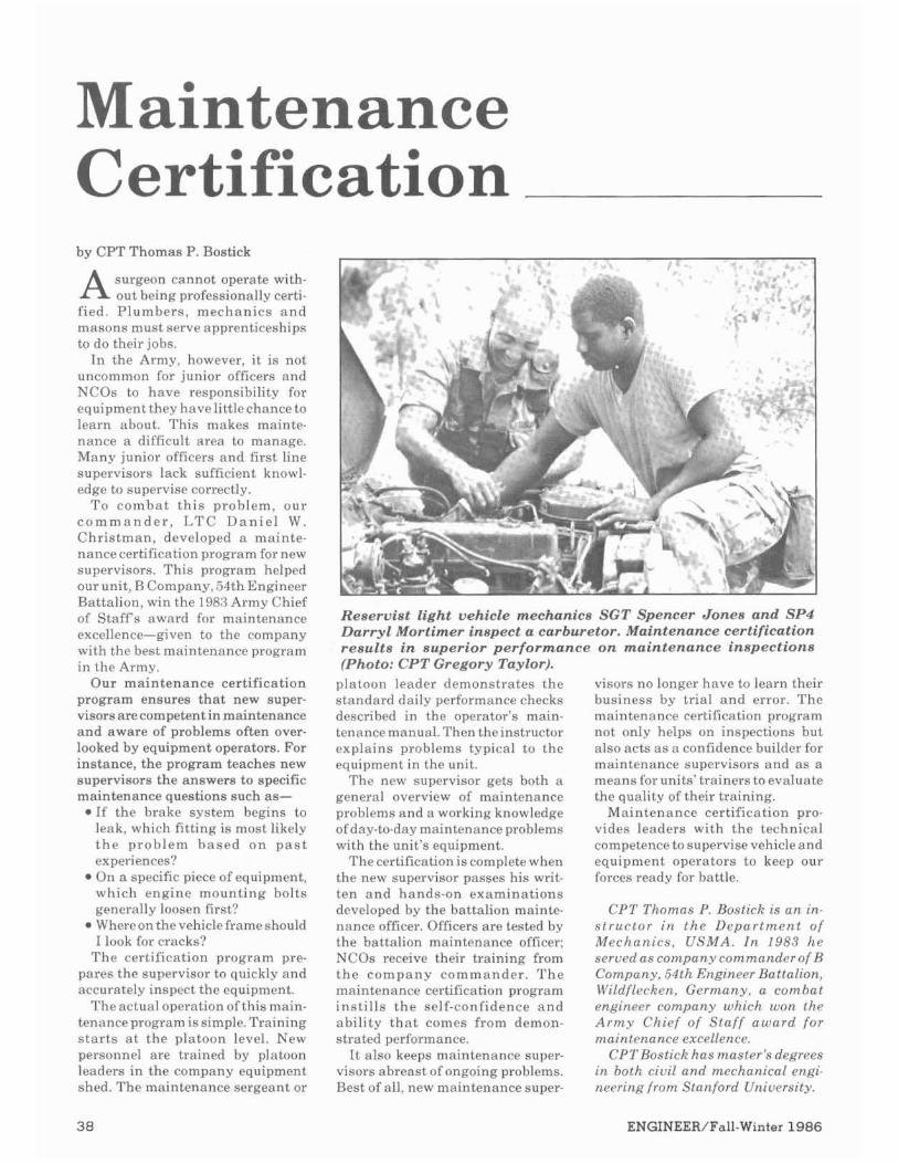
Maintenance Certification by CPT Thomas P. Bostick
surgeon cannot operate with-A out b e ~ n gprofessionally certi-fied. P lumbers , mechanics a n d masons must serve apprenticeships to do their jobs.
In the Army, however, i t i s not uncommon for junior officers and NCOs to have responsibility for equipment they have little chance to learn ahout. This makes mainte-nance a difficult area to manage. Many junior officers and first line supervisors lack sufficient knowl-edge to supervise correctly.
To c o m b a t t h i s problem, our c o m m a n d e r , 1,TC D a n i e l W . Chr i s tman , developed a mainte-nance certification program for new supervisors. This program helped our unit, R Company, 54th Engineer Battalion, win the 1983Army Chief of Staff's award for maintenance excellence-given to the company with the best maintenance program in the Army.
Our maintenance certification program ensures tha t new snper-visors arecompetent in maintenance a n d aware of problems often over-looked by equipment operators. For instance, the program teaches new supervisors the answers to specific maintenance questions such as-
Reservist light vehicle mechanics SGT Spencer Jones and SP4 Darryl Mortimer inspect a carburetor. Maintenance certification results in superior performance on maintenance inspections (Photo:CPT Gregory Taylor).
platoon leader demonstrates the visors no longer have to learn their standard daily performance checks business by trial a n d error. The described in the operator's main- maintenance certification program tenancemanual.Thentheinstructor not only helps on inspections but explains problems typical to the also acts a s a confidence builder for equipment in the unit. maintenance supervisors and a s a
The new supervisor gets both a means forunits'trainersto evaluate general overview of maintenance the quality of their training.
If the hrake system hegins to problems and a working knowledge Maintenance certification pro-leak, which fitting is most likely ofday-to-daymaintenance problems vides leaders with t h e technical t h e p rob lem b a s e d o n p a s t experiences? On a specific piece of equipment, which engine mount ing bolts generally loosen first? Whereon the vehicle frame should 1look for cracks?
T h e certification program pre-pares the supervisor to quickly and accurately inspect the equipment.
The actual operationofthis main-tenanceprogram is simple. Training s t a r t s a t t h e platoon level. New personnel are trained by platoon leaders in the company equipment shed. The maintenance sergeant or
with the unit's equipment. Thecertification is complete when
the new supervisor passes his writ-ten a n d hands-on examinat ions developed by the battalion mainte-nance officer. Officers are tested by the battalion maintenance officer: NCOs recelve their training from t h e c o m p a n y commander . T h e maintenance certification program ins t i l l s t h e self-confidence a n d abili ty t h a t comes from demon-strated performance.
I t also keeps maintenance super-visors abreast of ongoing problems. Best of all, new maintenance super-
competence to supervise vehicle and equipment operators to keep our forces ready for battle.
CPT Thomas P. Rostick is a n in-s t r u c t o r i n t h e D e p a r t m e n t of Mechanics , USMA. I n 1983 h e seruedascompany commander of B Company, 54th Engineer Battalion, Wildflecken. Germany, a combat engineer company which won the Army Chief of Staff a w a r d for nto~nrvnonc.~t .xcc/b,nc P.
C'I'TH<j,<lic/:hos moslcr'i d+.dr?,,.. rn both ciuil a n d mechanical engi-neering from Stanford Uniuerslty.
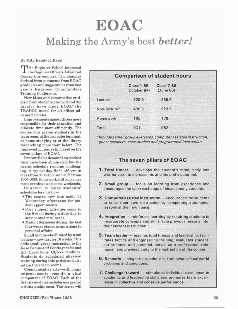
Making the Army's best better!
By MAJ Randy R. Rapp
he Enmneer School improvedTthe Engmeer.' OfficersAdvanced Course this summer. The changes derived from comments from EOAC graduates and suggestions fromlast year 's Engineer Commanders Training Conference.
New ideas and constructive criti-cismfromstudents, the field and the facul ty have made EOAC the TRADOC model for all officer ad-vanced courses.
Improvements make officersmore responsible for their education and allocate time more efficiently. The course now places students in the team room,atthecomputerterminal, a t home studying or a t the library researching more than before. The improved course is still based on the seven pillars of EOAC.
Irreconcilable demands on student time have been eliminated, but the course schedule remains challeng-ing. A typical day finds officers in class from 0700-1500and a t PTfrom 1500-1630.Homeworkstillconsumes most evenings and some weekends.
However, to make students ' schedules less hectic-*The course now sets aside 11
Wednesday afternoons for stu-dent appointments. Post support activities come to
-
Lecture
Non-lectu
I
IBU rrrslructrorr, guest speaners, case sruores ano programmeo instruction.
The seven pillars of EOA*
1.Total fitness - ps the student's mind, body and -,=r+r spirit to ...,,,,,, his and his unit's potential.
3.Coml loenrs to tail nated '
IS ar rnelr own pacc
reinforces learning by requiring students to orate concepts and skills from previous lessons into
urrent instruction.
,. .,,..i leader - teaches ,,.,mm,,m.,,, , , ~ dle,,,,,,rm,,
arlo- nlnges lnsrrucrron on arrameworKorrea1 worm ms and conditions.
/. Challenge/reward - stimulates individual excellel academic and leadership skills and promotes team c lence in collective and cohesive performance.
of stuc a. ~
lent hc
Class 1 - 8 0 w a s s I-ao (October 84) (June 86)
uter assis, - ~- ~~ ~~ - 2
I group ------ ..-- focus I ng from I :Ae--
sxperienc----...A-2. Small encou
e and nts.
3uter assi or their (
. .. .
sted instr ,wn instr
,uction-uction by
encourag 1 c o m ~ l e t
lesthe S ~ L
ing autor
the ~ c h o o lduring a duty day to service students' needs. Many afternoons during the last four weeks students can attend to personal affairs.
Small groups-facilitated by team leaders-now last for 16weeks.This itates
perfor model
tactics ar mance ar ,and pro\
id engine id potent rides unit!
~eringtrai ial, serve!
to the in
ning, eva ;as a prl struction
luates st1 ~fessiona of the cot
dent I role m e .
adds small group instruction to the Rase Carnos and Continnencies and-. ... -the Operations Officer modules. Students do scheduled physical training during this period and also retain their team rooms.
Communicative arts-with many improvements-remain a vital component of EOAC. Each of the first six modulesincludes one graded writing assignment. The course will
6. Seen< proble

soon use a new TRADOC writing program. Instruction in briefing techniques is more structured than before.
Other improvements include- Combined a r m s t a c t i c s /
combat engineering. Eliminating the One-Day War Gameallows time for new modulesin Engineersupport of Light Infantry and Special Op- erations and Heavy Battalion Task Force in the Attack plus expansion of older lessons. Engineers learn to "talk tactics" with the perspectives of maneuver officers.
Technical engineering. A re-vised scenario makes students thoroughly address tactical consid- erations in their construction plans. As a result of lessons learned in Germany and Central America, more time is devoted to drainage and concrete construction. Non- standard fixed bridging is com- pletely revised and consolidated into three days of instruction. Training in POL pipelines is reduced.
(continued from inside front cover)
Light engineers recognize better than anyone that highly specialized systems have no place in the light soldier's pack. We need versatile, light-weight, low-bulk explosives.
We may never be able to signi- ficantly reduce the weight light engineers carry. But we can cer-tainly increase the efficiency and utility of our load.
Our mission and lack of organic resupply mean use what we can carry or find. I hope that the new technology, likeslurry ortheballistic disks, will someday findits wayinto our rucksacks.
ILT Thomas P. Smith is currently the executive officer of C Company 65th Combat Engineer Battalion, 25th Infantry Division (Light). He served 18 months a s a platoon leader, first of a combat engineer platoon, then for a light engineer platoon. He is a graduate of USMA and has completed EOBC, Airborne School, Jungle Warfare School, and the Sapper Leader Course.
Senior team advisorprogram. A senior engineer officer stationed at or near Fort Belvoir voluntarily associates with a team, critiquing their solutions to tactical and engi- neering exercises. The mature officer's involvement is limited only by his schedule and his desire to help teach young engineers.
Optional military studiespro- gram. Especially dedicated students voluntarily study military history, advanced tactics or professional values during free afternoons, with the guidance of a senior faculty member. Six seminars in each of these topics lend structure to off- duty efforts many students make to improve their professional compe- tence.
Professional development day. Teams visit a military activity or battlefield of their choice. Con- ducted the last day the teams are together, this exercise gives theteam leader a final shot at reinforcing course objectives.
Research paper presentation program. Instead of oral book reviews, students deliver formal classes about the results of research for their papers. The program ex- poses the teams to less familiar military subjects.
Theseimprovementsin theEOAC stem from the Engineer School's strong desire to provide the best captains' training possible. The in- fusion of new ideas from students, the field, and faculty makes the course the best it can be.
The improved EOAC better accomplishes its mission-to train battle winners.
MAJ Randy R. Rapp was the Senior Team Leader forthe EOAC. He served in the 293d. 94th and 326th Engineer Battalions.
MAJRapp has a bachelor'sdegree from the USMA and a master's degree in ciuil engineering from the University of Missouri/Rolla. He is a licensed professional engineer in Virginia.
Engineer Solution
The magnetic azimuth from point A to point B is 64O. The fact that the grids do not line up is irrelevant. On either map sheet. the
magnetic azimuth is determined using the magnetic declination diagram for that map sheet.
Map A
To convert from grid azimuth to magnetic azimuth, add the GM angle: Magnetic azimuth = grid azimuth + GM angle Magnetic azimuth = 6Z0t Z05' = 64O5' Magnetic azimuth = 6Z0+ Z05' -64O
Map B
TO Convert from grid azimuth to magnetic azimuth, subtract the G M angle: Magnetic azimuth =grid azimuth - G M angle Magnetic azimuth = 246O - 1°40' = 244O20' Magnetic azimuth = 246O - 1°40' - 244O
Magnetic azimuth (A to 6)= 244O. 1 80° = 64O
The grids do not line up because the maps are compiled using different universal transverse mercator (UTM) gridrones. Thegrid in each zone isaligned with the central meridian (line of longitude) for each zone. As the meridians converge towards the pole, the two grids must also converge.
The direction of magnetic north is independent of grid zones and will be the same-or very nearly the same-for two adjacent map sheets.

Earn your professional engineer's license by CPT Calvin Evans
competency in engineering skills and enjoys greater credibility in dealing with civilian engineers. He can also be proud of a major accomplishment-doing all i t takes to acauire the license is an achieve- ment in itself, requiring a large investment of time to apply and study for the test.
I took the exam while I was at tending the Engineer Officer Advanced Course at Fort Belvoir. After finishing the test, I thought I had passed, but I wasn't sure. So I wrote myself a few notes on things to do in case I had to take the test again.
I based this article on my notes, hoping that lessons I learned in preparing for the exam will help other officers to succeed in getting their PE licenses.
General Advice: Don't attempt the exam unless
you can put the time into preparing for it.
Acquire and read "Professional Engineer-AGuideto Registration." This pamphlet, published by the Engineer School, is a good explana- tion of the registration process and the exam's organization. It includes a fine bibliography of commercially available guides that can help you study.
Applying to take the exam is extremely time consuming and ex- pensive. For example, it costs $245 to take the test and get a license in the state of New York. Most states require you to apply again and pay another fee if you fail the test the first time.
When to Take the Exam During or shortly after aduanced
civil schooling-If you plan toattend advanced civil schooling, this is the ideal time to take the PE exam. You
can usually arrange an academic program that satisfies degree re- quirements while preparing you for thePE exam by including classes in your weak areas. This will also accustom you to studying for tests and give you time to study specif- icallv for the PE exam.
During EOAC-This is a good time to take the PE exam for several reasons. First, some of the topics covered in EOAC are directly appli- cable to the PE exam (for example: concrete, drainage, horizontal and vertical curve calculations, soil phase relationships). Second, al- though homework has increased, study timeis available, and you will be accustomed to studying for tests. Third, many officers take the exam every year at Fort Belvoir, and your classmates can be valuable study aids. Any other point in your career whereregular study hours can beset aside for preparation is also a good time to take the test.
Applying to Take the Exam Shop around-Unless you want a
license from a particular state, it may be advantageous to request application materials from several different states. The requirements are similar for most, but the experi- ence requirements and fees vary enough to makeit worth your time to shop around. Some states may not accept your military experience as meeting the requirements. Virginia accepts most military experience.
Start early-Apply well in ad- vance of the exam to ensure that the registration board receives all your materials before the deadline. Starting application paperwork 6 months before the test is not too early. To allow for problems, 9 months to a year is not unreason- able. Each state requires that its own forms be used for references and verification. You have to allow enough time, for example, to send a
particular reference form to a regis- tered professional engineer now stationed in Europe, wait for him to fill it in and mail it back to you, and get it to the board.
Haue your endorsements sent to you rather than straight to the board-I recommend having sour - . references return their materials to you, then send the references to the board with your application. This way, you know your application is complete when youmailit. You won't need to call theregistration board to ask if your references have arrived.
Ask for more references than are required-For onereason or another, one of the people you ask to write a reference may not get it to you on time. It is extremely frustrating and embarrassing to have to ask this person (usually a senior officer)if he has completed your reference or to try to hurry him up to meet your suspense date. It is better to ask for four or fivereferences, then send the first three you receive with your application. This should enable you to avoid wasting time following up on references.
Ask for references before you leave your unit-If you plan ahead, you can get your references before you leave your unit and avoid mailing materials back and forth to Europe. This can save you a lot of time and expense.
Studying for the Exam Get a study guide-This will tell
you the areas covered and the kinds of problems you can expect. Profes- sional Publications, Inc. publishes excellent review manuals for thePE exam in the four major areas (chem- ical, civil, electrical and mechanical engineering).
Take a review course-Taking a course designed to prepare you for the PE exam can be very helpful, but is not necessary. The advantages are that this will force you to spend

time studying and may help to expose areas on which you need to concentrate. Do not expect the prep course to teach you everything you need to know. Thesecourses usually hit only major concepts and work a few sample problems in each area. Most of what you learn must come from self-study.
Start studying early-Don't wait for the day before the exam to try to learn a complete subject area.
Organize your study materials-While reviewing, i t will be very helpful to tab or index your notes or
credit on all the problems rather than a "perfect" solutionto only one or two.
Go for partial credit-If you are mnning out of time, write down the equations that show how you would solvethe problem. This will be worth more pointsthan numbercmnching. More weight is given to solution methods than to mathematical computations.
Conclusion This advice may seem obvious.
but i t works. I hope the lessons I
learned in obtaining my PE license can help those who are planning on taking the exam in the future. Good luck-and study hard!
CPT Calvin Evans is a registered professional engineer in Virginia. He served a s a platoon leader, company executiveofficer, battalion S-4 and company commander in the 4th Engineer Battalion. A graduate of USMA, CPTEvans is doingpost-graduate work in civil engineering a t Stanford University.
books for quick reference during the - - - -exam. Good sample problems are particularly useful. The less time you spend searching through your Hotline 0 & A references, the more time you will have to work the problems.
Get a good civil engineering handbook-A good handbook, such a s Memtt's S tanda rd Handbook for Civil Engineers,is a helpful guide to the areas you have never studied before or for which you don't have a good reference. These are expensive, so you may want to try to borrow rather than buy one.
Study the basics in every major subject-Even if you have never studied, say, sanitary engineering, the basic concepts are fairly easy to understand. Sometimes the proh-lems in less popular a reas are significantly easier than those in the more popular areas.
Tak ing t h e Exam Read all the problems before you
start to work-The problems that you feel you can solve easily should be highlighted. Then quickly rate the problems from easiest to most difficult. Thetime you take to dothis will be well spent.
Work the easiest problems first-You will feel more confident and relaxed after you have solved the first problem. All problems are equally weighted, so don't solve a large or difficult problem when an easier one is available.
Don't waste time copying the problem or redrawing figures-Only do this if a figure will help to show how you reached certain values.
Budget your time-If you are solving the easiest problems first, don't spend more than a n hour on each one. I t is better to get partial
Q. What new 5-100 series field manuals are currently available? A. New field manuals 5-104. General Engineering. and 5-105. Topo-graphic Operations, should be fielded by January 1987.
Field manuals currently available are-5-100, Engineer Combat Operations. 5-101, Mobility. 5-102. Countermobility. 5-103, Survivability. 5-106, Employment of Atomic Demolition Munitions. These manuals can be ordered from the US Army Adjutant General
Publications Center. 2800 Eastern Boulevard. Baltimore. M D 21 220-2896.
Q. Are there refresher courses for field grade officers in engineer doctrine and equipment? A. Refresher courses for fieldgrade officers include-
Mapping and Charting GeodesyforTopographicAssignments - 2 weeks. DEH Executive Management Course - 1 week. Combat Engineering Course. Phases I I and 111 - 3 weeks. A separate, l-week refresher course to update field grade engineers
being assigned as reserve component advisors or as engineer staff officers is scheduled for FY 88.
0.How close can an M-16 rifle be to a magnetically fused mine before detonating it? How close can soldiers carrying helmets and weapons be to a mine before detonating it? A. Magneticallyfused minesare intendedto respondtothe metallic mass of a tank. It is unlikelythat a soldier'ssteel pot or M-16woulddetonate one of these mines. However, a good rule of thumb is to keep weapons and other metal objects at least 12 inches away. Q. Cansand grids beused in place of sandbagsfor bunkerconstruction in humid climateswheresandbags deteriorate rapidly? How can I order sand grids? A. No. Sandbags are meant to stabilize loose material without adding hazardous material to the potential area cf explosion. They are easily replaced whendamagedandtheentiresystem cannot be destroyedbyone impact. Sand grids provide the stability required, but are not easily replaced. Lining sandbags with sealed plastic bags preventsdeterioration in humid climates.
Sand grids may be ordered through the standard AFCS channels under the NSN: 5680-01-198-7955.

- Career Notes
Commissioned Officers Branch
Captains Promotion If you are a Reserve commissioned officer-and wantto remain on Board: active duty after your obligation date-you must apply for condi-
tional voluntary indefinite status between the 24th and 27th month of active federal commissioned service (AFCS).
The captains promotion board and conditional voluntary indef- inite (CVI) board are held a t the same time.
This year, 25 engineer officers failed to file their applications until June. As a result, their applications did not arrive a t MILPERCEN i n time to be reviewed by the board.
To avoid delays in career decisions and uncertain career status, you should submit your application a t least 60 days before the board meets. The next CPT/CVI board is from 27 January 1987 to 10 February 1987.
Promotion Packet Officers must have official photographs in their promotion Photos: packets. Officers should have a photograph taken a s soon as
possible after they are promoted to 1LT. When the last board met, 30 percent of the officers did not have a
photograph in their promotion packet. Engineer Branch sent letters to all officers with no photograph in their packets, but 15 percent still did not provide a photograph.
The photograph is essential to the promotion file. (See AR 640-30, Photographs For Military Personnel Files).
Preference You must have a current preference statement in your file. This Statement: provides information on assignment preferences, duty and home
addresses, and telephone numbers needed to contact you. Use the comments portion of DA Form 483 to explain your choices.
Engineer Officer The Engineer Officer Bulletin gives up-to-date information on Bulletin: assignments and professional development issues. The bulletin is
published twice each year by MILPERCEN, Engineer Branch. The latest bulletin, Number 3, June 1986, was distributed to troop units, Engineer Districts, ROTC units and schools. The next issue will be published this winter.
Officer Selection Selection boardsfor FY 87 involving Engineer officers-are listed Board: below. Officers in the zone of consideration must submit current
photographs, medical examinations and corrected Officer Record Briefs through their servicing MILPO in time to reach MILPERCEN for these boards.
Board Dates
LTC Product Manager 20 Jan - 30 Jan CPT Army CVI 27 Jan - 10 Feb LTC Army 18 Feb - 27 Mar MAJ Army 3 Mar - 18Apr RA Army 27 Apr - 1May Brigadier General 9 Jun - 2 Jul Senior Services College 21 Jul - 21 Aug CPT Army CVI 9 Sep - 25 Sep
Engineer Branch The following Engineer Branch visits are scheduled for FY 87. Visits: Contact Engineer Branch if your unit wants to schedule a visit.
Engineer Branch visits are funded by the visiting unit.
BC, USAREUR Engineer Conference 1-5 Mar 87 BC, Engineer Proponent meeting, Fort Leonard Wood, MO 20-23 May 87
Statement of Ownership, Management, a n d Circulation (required by 39 U.S. Code 3685)
ENGINEER, an official periodical of the Department of the Army, is published quarterly by the US Army Engineer School, ATTN: ATZA-TD-P, Fort Belvoir, VA 22060-5291
Date of Filing: September 29,1986 Paid circulation: none Publisher and Editor: Marilyn Fleming Requested circulation: 9,900 Extent and Nature of Circulation: The following information Other free copies: 900 shows actual number of copies of the singleissue nearest the Copies not distributed: 200 filing date. Total number of copies: 11,000

Past in Review
Aviation Engineers in the Southwest Bacific, WWII
by Dr. James Dunn Office of History, OCE
T he Army recognized the im- portance of aviation engineers
shortly before the United States entered World War 11. The first unit - the 21st Engineer Regiment (Aviation) was activated June 1940 a t Fort Benning, GA.
Following the Japanese attack on Pearl Harbor, 7 December 1941, the engineer aviation battalionscontrib- uted greatly to America's success in the Pacific. Charged with the mis- sion of building air bases in remote, undeveloped islands and tropical jungles, these battalions played prominent roles in the Pacific the- ater of operations.
The 804th from Hawaii and the 805th from Panama participated in ADM Chester Nimitz's Central Pacific offensive and built air bases for the B-29 heavy bomber units.
The 803d was captured in the Philippines when Bataan fell-but not before the battalion built 12 air bases on Luzon, moved and em-placed heavy guns for thedefenseof Bataan, builtricemills, and repaired roads and bridges. In the final days, the battalion fought a s infantry in the front line.
The 802d remained in Alaska for the Aleutian campaign.
The 808th Engineer Aviation Battalion-activated in September 1941, March Field. CA-bad little time to prepare for war. The com- mander, MAJ Elvin R. Heiberg, held the first formation on Saturday morning, 6 December 1941. Not knowingthe Japanese would attack Pearl Harbor the next day, he told his men how fortunate they were to have such fine barracks and living conditions.
Alerted for tropical foreign service, the battal ion sailed from S a n Francisco and anivedin Melbourne, Australia on 2 February 1942.
The battalion moved to the North- ern Territory to build air bases around Darwin. Over 2.000 miles from the closest America1 1depot, t h ~ 808th with on11
I C , ,, ..'
. . .&,
Engineers construct an ail
three dump trucks and two tractors. The first mail was a month late, and February pay wasdelayed. However, local bread and beef were plentiful; and any spare time could be spent panning for gold.
From February to July, the bat- talion built seven air bases in the Darwin area and developed a unique method of clearing the sites by stretching a cable between two tractors and moving back and forth across the field uprooting trees.
In keeping with GEN Douglas MacArthur's strategy of confronting the Japanese in the forward area rather than waiting to be attacked, the 808th moved from Australia to Port Moresby, Papna, New Guinea, in July 1942.
For the first time, the battalion encountered the difficulties of op- erating in an unfriendly, jungle environment: hordes of malaria- carrying mosquitoes, jungle rot, leeches, flying foxes, heavy rain and Japanese air raids. Yet, the 808th built an air basein one month and- between August 1942 and March 1943-completed four sites in the vicinity of Port Moresby.
These and other bases provided air support to stop the Japanese attack along the Kokoda Trail, aided MacArthur's attack on Buna, and
royed an entire Japanese convoy te Battle of the Bismarck Sea.
" m : ., . .
rfield in the South Pacific.
The 808th continued to operate in the Southwest Pacific area. At Finschhafen, New Guinea-in what the battalion considered its greatest accomplishment-the 808th hacked an air base out of the middle of the jungle in six weeks.
On Leyte, in the Philippines, the 808th started construction of the Dulag air base one day after the area was cleared of Japanese. The field was ready two days later for emergency use by Navy planes during the Battle of Leyte Gulf.
Forty-four months after leaving San Francisco, the 808th sailed into Yokohama Harbor a s part of the American occupational forces in Japan.
The battalion-that had so little timetoDreDarefor war-contributed . A
greatly to America's success. Among the first US Army troops to reach Australia in early 1942, the 808th Aviation Engineer Battalion helped build the long Pacific trail that eventually led to victory.
Suggestions for further reading: George E . White, Jr., "From Pearl
Harbor to Tokyo," The Military Engineer 38 (January 1946): 1-8.
HQ Army Forces, Pacific, Office of the Chief Engineer,Engineers of the Southwest Pacific 1941-1945, Volume VI: Airfields and Base Deuelopment.

- -
The editor and staff of Engineer appreciate the concern of our dedicated readers about the article "Army Kills 41 Command, School Magazines" published November 17, 1986, in Army Times. Although the program under which Engineer was previously pub- lished has been discontinued, the function still exists. While there may be changes in funding and format, the function will not change, and we are assured that we will continue to publish. However, the publication may be called a professional bulletin instead of a magazine.
While some readers may have to purchase their copies in the future, be assured that all of our Engineer units and students will continue to receive free copies. We encourage vour articles for Engineer.and look forward to your continued interest in our publication.
Do not despair-Engineer IS NOT DEAD! I