7. Challenges for water planning, management and use – the ... · demand for this resource will...
32
7. Challenges for water planning, management and use – the risk assessment
Transcript of 7. Challenges for water planning, management and use – the ... · demand for this resource will...
7. Challenges for water planning, management and use – the risk assessment


Part 7. Challenges for water planning, management and use – the risk assessmentThe following Chapter outlines the current and future risks to the availability and condition of water resources in the Wimmera-Mallee water resource plan area identified through the risk assessment completed to meet the requirements of Part 9 of Chapter 10 of the Basin Plan.
7.1 Water availability
The Wimmera-Mallee water resource plan area has highly variable climatic conditions. This was exemplified by the extreme water shortages during the Millennium Drought when many waterways dried out and significant water quality issues arose in the few remaining waterbodies that held water.
The drought was followed by large floods in the summer of 2010–11. Low inflows returned after that year until 2016–17. Overall trends indicate decreasing water availability in the future.
Climate change and severe drought are expected to have the most significant effect on future water availability and condition. Climate change is projected to cause serious reductions in rainfall, groundwater recharge and runoff (see Figure 22).
Figure 22: Changes in runoff to 2065 under a medium climate change scenarioSource: Figure 2.4 of DELWP (2016d)
Department of Environment, Land, Water and Planning
102 | Part 7 Wimmera–Mallee Water Resource Plan

Surface water entitlements in the Wimmera-Avon and Avoca River systems are capped meaning that no additional surface water entitlements can be issued.
The volumes of groundwater SDLs in some areas permit increases in groundwater entitlements but because groundwater is brackish in most of the water resource plan area, it is expected that demand for this resource will remain within the SDL volume for the foreseeable future. Victoria’s comprehensive water framework manages annual extractions within the SDLs (see Part 8).
Victoria’s water sector is well placed to manage future water shortages because of the existing legislative framework, experience from the Millennium Drought and the actions and policies in Water for Victoria, which are documented throughout this report with reference to the Wimmera-Mallee water resource plan area.
7.2 Water resource condition
The third index of stream condition report (DEPI, 2013a) found that water quality in the waterways of the Wimmera basin ranged from good to very poor.
All river reaches with water quality results had elevated levels of turbidity and generally high levels of phosphorus. The lower reaches of the Wimmera River had very high levels of salinity. Water quality is largely attributable to water availability and historic land use practices that caused erosion and elevated nutrient and salinity levels.
The environmental condition of waterways includes hydrology, physical form, streamside zone and aquatic life in addition to water quality. Most of the stream length in the Wimmera basin was in moderate condition (63 per cent) and 21 per cent in poor or very poor condition. More than half (56 per cent) of the stream length in the Avon-Richardson River system was in poor condition.
DEPI (2013a) assessed four of 23 reaches in the Avoca River. All had poor to moderate water quality, which was attributed to elevated phosphorus and salinity levels. The majority of stream length in the Avoca Basin was in moderate condition.
There is a low risk of further deterioration in waterway condition due to the management activities (including fencing, revegetation, weed control and environmental watering undertaken by CMAs and landholders in the region).
As with water availability, Victoria is well placed to manage future challenges related to the condition of water resources with proposed reforms documented in Water for Victoria.
7.3 Water resources for Aboriginal values and uses
Water availability and condition pose risks to cultural values and uses of water by Traditional Owners.
Until recently, Victoria’s Traditional Owners and Aboriginal Victorians have had very limited involvement in decision making in Victoria’s water planning and management framework. Part 11 looks at how the Victorian Government will work with Traditional Owners on water-related matters.
7.4 Commonwealth Water Act
The Commonwealth Water Act requires the Basin Plan to identify the risks to the condition or continued availability of water resources (section 22(1), (item 3)).
Department of Environment, Land, Water and Planning
Part 7 | 103Wimmera–Mallee Water Resource Plan
The risks must deal with the availability of basin water resources which arise from the taking and use of water (including interception activities), the effects of climate change, land use changes and limitations on the state’s knowledge of water resources on which estimates about matters relating to basin water resources are made.
7.5 Basin Plan requirements
Consistent with the Commonwealth Water Act, section 4.02 of the Basin Plan identifies potential risks to Murray-Darling Basin water resources, particularly to the condition or continued availability of water, and strategies to manage or address these risks. Risks include:
• insufficient water being available for the environment
• water being of unsuitable quality for use
• poor health of water-dependent ecosystems.
The Basin Plan identifies that the consequences of these risks eventuating would be insufficient water of suitable quality being available:
• for consumptive and other economic uses
• to maintain social, cultural, Indigenous and other public benefit values.
Section 4.03 of the Basin Plan details a number of strategies to manage, or address, the risks identified in section 4.02. These strategies are:
• implementation of the Basin Plan, including its following key elements:
- environmental watering plan
- water quality and salinity management plan
- water trading rules
- water resource planning
• developing water resource plans and amendments to the Basin Plan based on the best available knowledge and in consultation with relevant stakeholders
• promoting a risk-based approach to water resource planning and management
• managing flows to optimise outcomes across the range of water uses in the Murray-Darling Basin
• ensuring effective monitoring and evaluation of the implementation of the Basin Plan
• promoting and enforcing compliance with the Basin Plan and water resource plans
• improving knowledge of water requirements within the Murray-Darling Basin including:
- environmental watering requirements
- requirements relating to the social, spiritual and cultural use of Basin resources by Indigenous peoples
- the impact of climate change on water requirements
- the water required to deliver social and economic benefits to Basin communities
• improving knowledge of the impact on Basin water resources of the following:
- interception activities and land use change
- floodplain harvesting and peri-urban and industrial take
- climate change
• improving knowledge of:
- groundwater and surface water resources, including through improved measurement
- the causes of water quality degradation and the effects of water quality on environmental assets and ecosystem function.
Department of Environment, Land, Water and Planning
104 | Part 7 Wimmera–Mallee Water Resource Plan
The risk assessment has been used as the basis for the preparation of the water resource plan. Identified risks are discussed throughout the water resource plan and the measures and strategies to address those risks presented in the relevant part of the water resource plan.
7.6 Water resource plan requirements
Section 10.41(1) of the Basin Plan requires Victoria to prepare its water resource plans having regard to the current and future risks to the condition (quality) and continued availability of water in the water resource plan area.
The methodology for conducting the risk assessment, described in the Basin Plan (section 10.41), covers a mix of primary causes, threatening processes and implications for beneficial uses of water resources. These requirements are set out in multiple cross-referenced provisions within the Basin Plan (see below).
The identification and interpretation of the detailed requirements of the risk assessment can be challenging. However, the key requirement is clear: that the risk assessment should consider “current and future risks to the condition and continued availability” of water resources (Basin Plan, section 10.41(1)).
A water resource plan must:
• identify, list, assess and define the level of risk (high, medium or low) in line with the AS/NZS 120 31000:2009 (10.40)
• describe the data and methods used to assess the risk (10.41(7))
• describe quantified uncertainties (10.41(8)).
• for risks assessed as medium or high risks, must describe the risks (10.42(a)) and the factors contributing to the risks (10.42(b)) as well as describing strategies to address them (10.43).
The Commonwealth Water Act, Basin Plan and MDBA provide interpretation of the terms that assist to set the context for the water resource plan’s risk assessments:
• water resource—includes “all aspects of the water resource, including water, organisms, other components and ecosystems”.
• condition—includes condition of all the above aspects of the water resource.
• current and future risks—includes risks that could occur during and beyond the life of the water resource plan, regardless of whether a management strategy is currently in place.
7.6.1 Availability and condition of water resources
The following risks relating to availability and condition of water resources are to be considered:
• risks relating to water condition and availability (10.41(1)) for economic (4.02(2) (a)), social, cultural, Indigenous/Aboriginal and other public benefit values (4.02(2) (b))
• risks that water will not be of a suitable quality for use (4.02 (1) (b)) including salinity (10.41(2)(d))
• poor health of water-dependent ecosystems (4.02(1) (c)) (10.41(2)(a))
• risks to meeting environmental watering requirements (identified in Victoria’s long-term watering plans) (10.41 (2) (a))
• risks to groundwater systems (including structural damage and groundwater/surface water connections) (10.20(1)(a) and (b)) (10.41(2)(b))
• risks arising from elevated salinity and other types of water quality degradation (10.31 and 10.41(2)(d)).
Department of Environment, Land, Water and Planning
Part 7 | 105Wimmera–Mallee Water Resource Plan

7.6.2 Interception
Risks from interception activities (10.41(c)) that may have a significant impact on water resources including those identified in section 10.23 of the Basin Plan include:
• runoff dams
• commercial plantations
• mining activities, including coal seam gas mining
• floodplain harvesting.
7.6.3 Extreme events
As required by the Basin Plan, a water resource plan must describe how the water resources of the water resource plan area will be managed during extreme events (10.51).
These events include extreme dry periods (drought), extreme water quality events and other events that compromise the ability to meet critical human needs.
These types of risks are ‘event based’ extreme drought, major asset failure, bushfire, point source discharge, flooding, and overbank inundation and were included in the risk assessment in terms of their impact on the ability to meet critical human water needs.
In Victoria, critical human needs are defined as: “The volume of water required to supply Stage 4 restricted demand in urban areas, supply domestic and stock needs and operate the distribution system to deliver that water”.
7.6.4 Aboriginal objectives
Under the Basin Plan, a water resource plan must identify the objectives and outcomes sought by Aboriginal people in relation to the management of water resources in the water resource plan area (10.52). Regard must be had to the social, spiritual and cultural values of Indigenous peoples and the uses of water resources for these purposes.
7.6.5 Environmental outcomes
The risk assessment has also considered risks related to matters within Chapter 10, Part 4 which sets out the requirements in relation to the sustainable use and management of water resources of the water resource plan area within the long-term annual diversion limit and SDL resource unit:
• surface water – environmental water requirements for priority environmental assets and ecosystem functions (10.17 and 10.22(b))
• groundwater – related risks including groundwater requirements for priority environmental assets and ecosystem functions (10.18)
- groundwater and surface water connections (10.19)
- productive base of groundwater and its management (10.20)
- environmental outcomes related to groundwater (10.21 and 10.22(b)).
7.6.6 Priority environmental assets and ecosystem functions
The risk assessment includes risks to:
• priority environmental assets and ecosystem functions relating to surface water (10.17)
• priority environmental assets and ecosystem functions relating to groundwater (10.18)
• meeting environmental watering requirements, identified in Victoria’s long-term watering plans.
Department of Environment, Land, Water and Planning
106 | Part 7 Wimmera–Mallee Water Resource Plan
Victoria has developed three long-term watering plans (LTWPs), for the three surface water water resource plan areas.
The priority environmental assets identified in Victoria’s LTWPs are the environmental watering assets assessed in this risk assessment.
7.7 Victoria’s approach to the risk assessment – data and methods used to identity and assess risks (10.41(7))
A single, common and consistent risk assessment framework has been adopted for Victoria’s five water resource plan areas. The framework adopted provides a transparent, comprehensive assessment of risk, allowing all risks to be documented and explicitly considered.
The framework allows for a detailed exploration and analysis of risk and allows any individual risk to be reviewed and updated if and as required. The structured nature of the framework also enabled risks to be combined and analysed in themes, enabling summaries of risks across the water resource plan areas to be generated and evaluated.
The assessment was undertaken over a 12-month period and overseen by the:
• DELWP Water Resource Plan Risk Assessment Working Group: comprising subject matter leads from within DELWP, with skills and responsibilities in fields of surface water policy, interception (farm dams and forestry), climate change, groundwater, environmental water, water quality and drought. This group provided preliminary review and input to data, methods and project outputs before a review by the Water Resource Plan Risk Assessment Advisory Panel.
• Water Resource Plan Risk Assessment Advisory Panel: this panel was established to provide milestone review of the risk assessment. It consisted of representatives from DELWP, rural water corporations, CMAs, VicWater, Murray Lower Darling Rivers Indigenous Nations and the Victorian Environmental Water Holder. A representative from the Victorian Farmers Federation was also invited to attend as an observer. The advisory panel members and their respective organisations provided critical review of the data used in the risk assessment, the identification of risks, the method adopted for the risk assessment, the scenarios to be assessed and the outcomes of the assessment.
The following core concepts framed the scope of the risk assessment and the assessment of risks.
7.7.1 Scope of the risk identification and assessment
The risk assessment must identify the current and future risks to the condition and availability of water resources in the water resource plan area (10.41(1)).
Basin Plan definitions have been adopted for this risk assessment and as a consequence the condition of the water resource includes not only water quality, but the health of the water-dependent ecosystems including priority environmental assets. The risk assessment identifies and assesses the risks to the condition of organisms, water-dependent ecosystems and other components of the water resource.
The identified risks need to include (but not be limited to) those specified in the Basin Plan. The risk assessment has included these risks and others identified through the risk identification process.
7.7.2 Temporal and spatial scale
The Basin Plan requires water resource plans to address risks to the availability and condition of water resources in Victoria’s water resource plan areas.
Department of Environment, Land, Water and Planning
Part 7 | 107Wimmera–Mallee Water Resource Plan

For the purpose of this assessment, risks were assessed in terms of their scale of impact on water resources and the uses of the water resource plan area.
This scale of impact included explicit assessment of the magnitude, spatial extent and duration of impact within the water resource plan area over the life of the water resource plan (2019 to 2029) and beyond. This approach has enabled site-specific and broad-scale risks to be assessed, reflecting the issues within each water resource plan area.
7.7.3 Residual risk
The risk assessment is based on the current level of risk assuming existing policy and practice are in place. In this respect the risk assessment identifies the level of residual risk under current arrangements in Victoria.
7.7.4 Data used to identify and assess risks
Data has formed the basis of the risk assessment.
The literature reviewed is listed in Schedule 1 of Appendix B, in line with its thematic category. The adequacy of the literature to describe its relevant relationship is rated High (H), Medium (M) or Low (L).
The Basin Plan requires that the data and methods used to identify and assess risk be described in the water resource plan. The descriptions provided in this report and the accompanying materials are considered to be adequate for MDBA to understand and to assess the water resource plan and the risk assessment against Basin Plan requirements. There is also a requirement for the water resource plan to describe any quantified uncertainties and sensitivity analysis. The data and methods adopted for the risk assessment and the level of uncertainty in the assessment have been explicitly included in the risk assessment and reporting including the risk register.
7.8 Risk identification and assessment methodology (10.41)
The Basin Plan requires water resource plans to describe the data and methods used to identify and assess risk. The descriptions provided in the water resource plan and Risk Assessment Report in Appendix B.
When preparing a water resource plan, Chapter 10 of the Basin Plan requires a water resource plan to have regard to the risks, strategies and guidelines from Chapter 4 – Identification and management of risks.
Victoria undertook a comprehensive risk assessment in accordance with the requirements of the Basin Plan as described above. The approach adopted for the risk assessment was based on the requirements of the Basin Plan for water resource plans (10.41).
For the purpose of this risk assessment, risks have been identified in terms of causes, threats and beneficial uses of the water resource, whereby a cause may result in a threat that impacts on a beneficial use of water.
The risk assessment required an approach that provides structure to the mix of causes, threats and beneficial uses, set out in the Basin Plan. Such structure enables a methodical, systematic, repeatable and transparent approach to the identification and evaluation of risks necessary for the development of the water resource plans.
Victoria undertook the risk assessment in accordance with the requirements of the Basin Plan. This approach is summarised below.
Department of Environment, Land, Water and Planning
108 | Part 7 Wimmera–Mallee Water Resource Plan

The approach adopted for the risk assessment aligns with international and national standards for risk assessment, with risk being assessed as the product of the likelihood and consequence of a threat impacting on an ‘asset’.
In accordance with the provisions of the Basin Plan, levels of risk assigned to events and their consequences have been defined in a manner consistent with AS/NZS ISO 31000:2009 Risk Management – Principles and guidelines. The approach adopted for risk identification and assessment has been undertaken in accordance with the risk management process set out in ISO 31000. As set out in ISO 31000:2009, the likelihood and consequence assessment must be appropriate to the context of the risk assessment, and customisation of likelihood and consequence categories is entirely appropriate.
The Basin Plan describes the requirements for determining risk. Under the provisions of the Basin Plan:
• the assessment examined risks in a consistent, structured and transparent way. Risks were assessed taking into account Victoria’s comprehensive water management arrangements and influencing factors such as environmental management, land use planning and emergency management to determine the residual risks on identified beneficial uses.
• risk levels, ranging from very low to very high, were determined as a product of likelihood and the consequence of a risk occurring. When assessing the consequence of the risk occurring, it was considered on a water resource plan scale rather than on a local scale.
• likelihood is assessed in terms of how each cause impacts on each threat.
Consequence is assessed in terms of how each threat impacts on each beneficial use.
The overall risk therefore represents how each cause will impact on each threat, and how that threat will in turn impact on each beneficial use.
For the purpose of this risk assessment likelihood has been defined as a function of susceptibility and probability, and consequence defined as a function of sensitivity. This framework developed and adopted for the preliminary risk assessment is shown in Figure 23.
LIKELIHOODof the threat being
realised
CONSEQUENCEof the threat on beneficial use
RISK LEVELof cause/threat to beneficial use
SC
EN
AR
IO
THREAT USECAUSE
PROBABILITYof the cause
occuring
SUSCEPTIBILITYof the threat to
that cause
SENSITIVITYof the beneficial use to the threat
Figure 23: Risk assessment matrix
Department of Environment, Land, Water and Planning
Part 7 | 109Wimmera–Mallee Water Resource Plan

Example: risk identification
A cause (e.g. extreme drought) may result in a threat (e.g. decline in water availability) that impacts on a use (e.g. consumptive use) of water.
As an example, there may be a risk associated with an increased number of farm dams (‘cause’), that leads to a reduction in volume of surface water available (‘threat’), adversely impacting on the environment (‘use’).
7.9 Identifying risks in the water resource plan area
A set of potential causes of risk were identified from the literature and through the engagement process. The causes identified (e.g. climate change) were assigned a specific scenario that would generate an adverse threat. These causes and accompanying scenarios included one-off natural events, gradual changes over time, and incremental changes to land and water use and management.
The risk assessment included:
• 16 causes and scenarios
• 13 threats
• 37 water use categories.
7.9.1 Causes and scenarios
CAUSE
A cause is defined as: an event and accompanying scenario that gives rise to or generates a threat. For this risk assessment, the causes are described as the events that led to the development of a threat. Causes can be changes in levels of development such as increased use of existing rights and entitlements, or events such as climate change or bushfires.
A set of potential causes of risk were identified from an extensive literature review and through the engagement process (see Appendix B). Based on a detailed literature review and consultation the causes identified (e.g. climate change) were then assigned a specific scenario that would generate an adverse threat.
These causes and accompanying scenarios included one-off natural events, gradual changes over time, and incremental changes to land and water use and management. Descriptions of these causes and the scenario adopted are provided in Table 7.
Department of Environment, Land, Water and Planning
110 | Part 7 Wimmera–Mallee Water Resource Plan

7.9.2 Scenarios
Specific scenarios for each cause are required to enable risks to be assessed. Each scenario adopted for the risk assessment comprises a detailed description of the specific cause to be assessed.
Many alternative scenarios could be envisaged for each cause. For example, many alternative climate change scenarios are possible. Analysis of each possible scenario for each potential cause would significantly expand the list of potential risks and render the analysis unworkable. For the purpose of this assessment, one scenario has been assessed for each identified cause. As an example, the International Panel on Climate Change median warming scenario has been adopted for the assessment of the cause ‘climate change’.
A full description of the scenario options and rationale for the scenario chosen is contained in the Preliminary Risk Assessment Report.
A brief description of each adopted scenario within each water resource plan area is set out in Table 7 with further detail provided in criteria adopted for the selection of scenarios included:
• the probable scenario that produces the highest risk (e.g. extreme drought) and
• an extrapolation of past trends (e.g. farm dams, land use) or
• that which is adopted in the literature (e.g. median climate change).
Importantly, the scenarios cover a range of possible future situations and are not ‘forecasts’ of a most likely future. The scenarios each represent a possible future. The risk assessment has not combined these scenarios to form one overall future scenario. Each scenario has been assessed independently to identify the risk associated with that cause and related scenario. Scenarios have also been identified at the water resource plan area scale to ensure their relevance to the causes and threats that will potentially drive risks in each area.
Department of Environment, Land, Water and Planning
Part 7 | 111Wimmera–Mallee Water Resource Plan

Table 7: Causes and adopted scenarios of risk considered in the risk assessment
Cause category
Cause ConsequenceSurface water area scenario
Groundwater area scenario
Climate change
Climate change
Likely to lead to reduced rainfall over south-eastern Australia, increased variability of rainfall and increased mean temperatures
Median (50th percentile) of global climate model projections based on Moran and Sharples (2011). The median is considered appropriate given much of the analysis available is based on the median rather than the high scenario, and scenario based on the Millennium Drought (see extreme drought scenario) is equivalent to the high scenario in mid to late this century.
This scenario and its analysis will be based on the outputs from Scenario B from the Western Region Sustainable Water Strategy (DSE, 2011) and Northern Region Sustainable Water Strategy (DSE, 2009b)
As for surface water
Extreme events
Bushfires Impacts on availability and condition of water resources arising from bushfires
Water quality: Major fire during water resource plan period followed by significant flow event (based on worst known examples, including post 2005–06 Grampians bushfire)
Water quantity: assessed but expected to be negligible based on lack of Ash species in these catchments
Water quality: Water quality impacts of bushfire on groundwater based on Wimmera-Mallee (surface water) water resource plan area
Water quantity: Assessed based on scenario for Wimmera-Mallee (surface water) water resource plan area
Extreme events
Extreme drought
An extended period of low rainfall resulting in severe, low-water availability
Repeat of the Millennium Drought 13-year climate pattern scaled to represent the rarity of a 1 in 100 year drought. Scenario includes low flow events (minor freshes) within the drought
As for surface water
Department of Environment, Land, Water and Planning
112 | Part 7 Wimmera–Mallee Water Resource Plan

Cause category
Cause ConsequenceSurface water area scenario
Groundwater area scenario
Extreme events
Extreme wet period
An extended period of above average rainfall, which may lead to rising groundwater levels and associated waterlogging and salinity threats
Wet period equivalent to late 1980s to early 1990s scaled to represent the rarity of a 1 in 100-year wet period. Scenario includes periods of low flow (events) within the wet period
As for surface water
Extreme events
Flooding and overbank inundation
Significant flooding can adversely impact on the condition of water resources
5% annual exceedance probability event (or appropriate historical example)
Not applicable
Extreme events
Major asset failure
A catastrophic failure of major water harvesting and storage infrastructure
50% reduction in the available storage volume in Lake Bellfield over the period of the water resource plan
Failure of bores / bore casings on up to 5% of bores based on review of state bore data
Extreme events
Point source discharges
Point source discharges are assumed to be a continuation of existing licensed discharges, urban stormwater runoff, and accidental spills
Note: Point source discharges associated with mining are described under the ‘earth resource development’ cause
Point source discharges associated with irrigation drainage are assessed as a component of ‘land use practice’
Agricultural chemical spill directly into the Wimmera River
Leaking landfill sites
Land use and interception
Earth resource development
The development, operation, closure and legacy of earth resource activities such as mining, quarrying, oil and gas (hydrocarbons), carbon capture and storage, geothermal and pipelines that intersect aquifers/aquitards and/or are near waterways pose hazards to surface and groundwater availability and condition (including structural damage to aquifers)
Coal seam gas: There is no coal seam gas development in Victoria’s water resource plan areas. Note that there may also be effects on Victoria’s groundwater resources due to gas development in NSW.
Mining: The cessation of mining (and aquifer dewatering) in the region, and legacy issues (such as mercury and arsenic contamination) in the historic mining areas. Ongoing gold mining with tailing storage facilitates.
Open pit: Quarrying – 20% expansion of existing floodplain-based sand and gravel extractions with onsite disposal dams. Mineral sands – development in the Wimmera and Mallee
As for surface water
continued
Department of Environment, Land, Water and Planning
Part 7 | 113Wimmera–Mallee Water Resource Plan
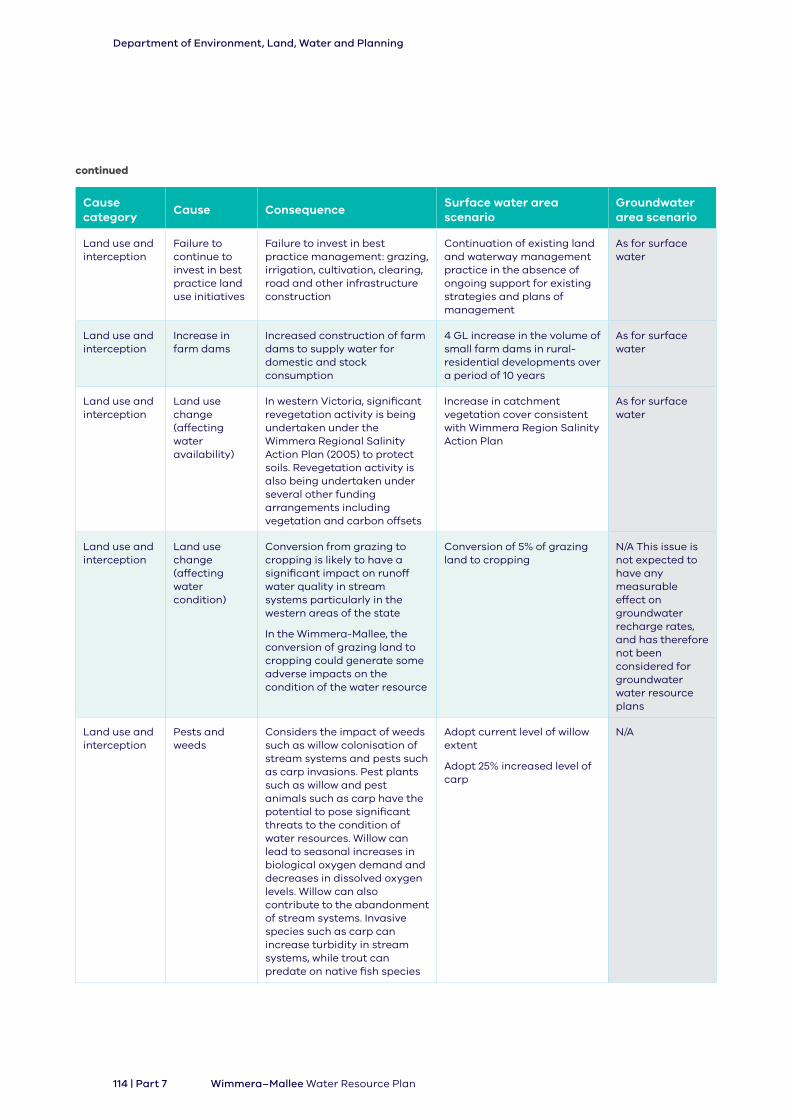
Cause category
Cause ConsequenceSurface water area scenario
Groundwater area scenario
Land use and interception
Failure to continue to invest in best practice land use initiatives
Failure to invest in best practice management: grazing, irrigation, cultivation, clearing, road and other infrastructure construction
Continuation of existing land and waterway management practice in the absence of ongoing support for existing strategies and plans of management
As for surface water
Land use and interception
Increase in farm dams
Increased construction of farm dams to supply water for domestic and stock consumption
4 GL increase in the volume of small farm dams in rural-residential developments over a period of 10 years
As for surface water
Land use and interception
Land use change (affecting water availability)
In western Victoria, significant revegetation activity is being undertaken under the Wimmera Regional Salinity Action Plan (2005) to protect soils. Revegetation activity is also being undertaken under several other funding arrangements including vegetation and carbon offsets
Increase in catchment vegetation cover consistent with Wimmera Region Salinity Action Plan
As for surface water
Land use and interception
Land use change (affecting water condition)
Conversion from grazing to cropping is likely to have a significant impact on runoff water quality in stream systems particularly in the western areas of the state
In the Wimmera-Mallee, the conversion of grazing land to cropping could generate some adverse impacts on the condition of the water resource
Conversion of 5% of grazing land to cropping
N/A This issue is not expected to have any measurable effect on groundwater recharge rates, and has therefore not been considered for groundwater water resource plans
Land use and interception
Pests and weeds
Considers the impact of weeds such as willow colonisation of stream systems and pests such as carp invasions. Pest plants such as willow and pest animals such as carp have the potential to pose significant threats to the condition of water resources. Willow can lead to seasonal increases in biological oxygen demand and decreases in dissolved oxygen levels. Willow can also contribute to the abandonment of stream systems. Invasive species such as carp can increase turbidity in stream systems, while trout can predate on native fish species
Adopt current level of willow extent
Adopt 25% increased level of carp
N/A
continued
Department of Environment, Land, Water and Planning
114 | Part 7 Wimmera–Mallee Water Resource Plan

Cause category
Cause ConsequenceSurface water area scenario
Groundwater area scenario
Non-compliance
Non-compliance with the Victorian Water Act
Includes the unauthorised take and/or use of water or the constructing or altering of works without consent
5% illegal take and continuation of current level of unauthorised works on waterways
5% above licensed bore take without authorisation and
10% of Domestic and Stock bore use being applied to (unlicensed) non ‘domestic and stock’ use
Water access, take, utilisation and location
Increase in the number of rights and volume of entitlements
Leads to increased take. The MDBA has capped surface water diversions and there are caps on groundwater entitlement volumes in major groundwater management areas. There are no limits on the number of domestic and stock users. Risk lies in the issue of new groundwater licences (for commercial or irrigation purposes) in unincorporated areas outside existing groundwater management areas (GMAs) or in GMAs where total entitlement volumes are lower than the permissible consumptive volume
For surface water resources, the only plausible increase in rights or entitlements could be through stock and domestic use, excluding farm dams. Even a generous estimate of increase in these small entitlements would represent a negligible proportion of the overall unregulated licence pool. On this basis, this scenario has not been applied to surface water
5% increase in unincorporated areas
Increased utilisation of water access rights
Some existing water entitlements are not fully utilised by their holders. Increased utilisation of these entitlements may impact on the availability/condition of water resources
5% increase in use of unregulated surface water entitlements
2006–07 levels of demand occurs on two or more occasions and a 2.5% increase in the domestic and stock bores
Timing and location of demand
Changes to the timing and location of demands for water within the river system may give rise to a range of threats to water availability and/or condition
Victoria does not envisage any significant change in the timing of delivery of water in the Wimmera region or a change that will impact on groundwater resources
As for surface water
continued
Department of Environment, Land, Water and Planning
Part 7 | 115Wimmera–Mallee Water Resource Plan

7.9.3 Threats
THREAT
A threat is a deviation from an agreed starting point that may affect the use of the water resource or this risk assessment. A deviation from an agreed starting point could include:
• adverse changes in the volume or pattern of water
• continuation or changes in water quality or ecosystems that renders them not fit-for- purpose.
Table 8: Threat categories assessed
Threats Category Sub category Definition
Continued availability of the water resource
Surface water Reduction in volume A change to the inflow of water to the water resource plan area
Changes to seasonal pattern of water
A change to the seasonal pattern of rainfall and runoff (e.g. a shift in weather patterns that results in an increase in summer rainfall within the water resource plan area)
Changes to the inter-annual pattern
A change to the annual pattern of water such as increased annual variability
Groundwater Decline or adverse rise in inflow to aquifer
A long-term decline or adverse rise in the inflow of water to the aquifers of the area. An adverse rise would include increases that result in waterlogging or rising salinity
Adverse change to the seasonal pattern of inflows to aquifer
A change to the seasonal pattern of inflow to the aquifers of the area that have an adverse impact on users and beneficial uses
Department of Environment, Land, Water and Planning
116 | Part 7 Wimmera–Mallee Water Resource Plan

Threats Category Sub category Definition
Condition of the water resource
Risks arising from elevated salinity and other types of water quality degradation (10.31 and 10.41(2)(d))
Water quality Levels of salinity Level of salinity in the water resource plan area
Levels of suspended sediment and/or nutrients
Level of suspended sediment and nutrients (phosphorus and nitrogen) in the water resource plan area
Levels of toxicants Level of toxicants (pesticides, herbicides, heavy metals, hydrocarbons) in the water resource plan area
Levels of pathogens Level of pathogens (such as Giardia and cyanobacteria) present in the water resources of the water resource plan area
Other water quality attributes
Level of other water quality attributes such as water temperature, pH and/or dissolved oxygen including temperature
Priority environmental assets and ecosystem functions – surface water (10.17)
Structural form (physical/non-water/non-biological) of priority rivers and wetlands
Loss or decline in longitudinal connectivity
Defined to comprise barriers to fish passage and other barriers such as vegetation connectivity
Loss or decline in lateral connectivity
Defined to comprise loss of floodplain connectivity such as levees
Loss or decline in physical habitat
Defined to comprise the loss or decline in condition of instream physical habitat such as sedimentation, erosion, loss of large wood
Priority environmental assets and ecosystem functions dependent on groundwater (10.18)
Environmental water
Environment: high-reliability bulk entitlement
Environment: low-reliability bulk entitlement
Controlled water (passing flows)
Uncontrolled water (above-cap water)
Availability of environmental water to meet watering needs
Groundwater surface water connections (10.19)
Risks to the productive base of ground water (10.20)
Risks to groundwater systems (including structural damage and groundwater/surface water connections) (10.19) (10.20 (1) (a) and (b))
Loss of structural form of aquifer as an impact affecting connection to surface water
Risk to the productive base of groundwater for consumptive uses
Loss of structural form of aquifer as an impact from the causes
Risk to availability consumptive uses of groundwater
Environmental outcomes related to groundwater (10.21)
Availability impacts on groundwater resources for environmental purposes
Basin Margin Deep
Basin Margin Shallow
Upland Layered Valley
Uplands
Considerations around environmental water needs captured in local and statutory management plans
continued
Department of Environment, Land, Water and Planning
Part 7 | 117Wimmera–Mallee Water Resource Plan

7.9.4 Use of water
USE
The use to which water resources are applied including, environmental, consumptive, recreational/social and Indigenous/Aboriginal.
For this risk assessment, the water resource plans have been developed to protect the “condition and continued availability” of Basin water resources for the identified beneficial uses.
For the purpose of this risk assessment the impact on the availability of water for the environment (surface or groundwater) considers all water used by the environment, not only water which has been specifically released from storage for environmental purposes, or water which is allocated as an environmental entitlement. In this respect environmental, recreational/social and Indigenous/Aboriginal values may be supported by the provision of water and may not ‘use’ water in the same manner as consumptive use.
Water resource plan area (surface water)
Beneficial uses have been assessed in terms of:
• consumptive uses
• environmental uses
• social/recreational uses
• Aboriginal/Indigenous uses.
These beneficial uses have been assessed based on risk to:
• surface water availability based on categories that define the legal entitlement or right to water
• groundwater availability based on categories that reflect the physical attributes of the aquifer from which water is derived
• water quality condition based on the State Environment Protection Policy (Waters) beneficial use categories
• structural form of surface water resources based on categories that reflect priority assets:
- wetlands and rivers
- structural form of aquifer.
Department of Environment, Land, Water and Planning
118 | Part 7 Wimmera–Mallee Water Resource Plan

Table 9: Beneficial use categories for assessment of surface water availability risk
Beneficial use Entitlement and right/form of access to water (temporal)
Environment High-reliability bulk entitlement and water shares
Low-reliability bulk entitlement and water shares
Controlled water (passing flows)
Uncontrolled water (above-cap water)
Consumptive Very high-reliability water (urban bulk entitlements)
High-reliability bulk entitlements and water shares
Low-reliability bulk entitlements and water shares
System operation water
Section 51 licences
Section 8 domestic and stock rights
Social/Recreational
Recreation bulk entitlement (Wimmera-Mallee (surface water) water resource plan area only)
Social and recreation values not provided by a recreation bulk entitlement
Indigenous/Aboriginal
Section 8A Traditional Owner Rights
Note: Other indigenous uses of surface water include consumptive, environmental and social uses. The current entitlement framework for these are set out under these headings above
Water resource plan area (groundwater)
The groundwater beneficial use sub-categories from the risk assessment divide the Basin into groundwater areas based on recharge rates, and the size of the aquifer. The rate of recharge is associated with the storage (S) of the aquifer relative to recharge (R) rate to the aquifer (S/R), such that an aquifer with a small S/R will be more sensitive to a change in recharge condition.
Conversely, an aquifer with a high S/R has a significantly large storage volume relative to annual recharge and hence is less sensitive to a change in recharge. This method was used in the development of the groundwater SDLs for the Basin Plan (CSIRO & SKM, 2010).
Department of Environment, Land, Water and Planning
Part 7 | 119Wimmera–Mallee Water Resource Plan

Table 10: Beneficial use categories for assessment of groundwater availability risk
Beneficial use Beneficial use sub-classStorage to recharge ratio
Form of access to water
Environment Basin GCS S/R >40 None (disconnected to surface systems)
Basin Margin GCS (deep) S/R 20–40
Basin Margin GCS (shallow) S/R 10–20 Considerations around environmental water needs captured in groundwater management plans
Upland Layered Valley S/R 10–20
Uplands GCS S/R <10
Consumptive Basin GCS S/R >40 Licence entitlements and D&S rights
Basin Margin GCS (deep) S/R 20–40
Basin Margin GCS (shallow) S/R 10–20
Upland Layered Valley GCS S/R 10–20
Uplands GCS S/R <10
Social/Recreational
Not assessed
Indigenous/Aboriginal
Aboriginal values provided by groundwater
7.9.5 Condition
The beneficial uses categories adopted for the assessment of water quality (condition) reflect those set out in the State Environment Protection Policy (Waters).
Table 11: Beneficial use categories for assessment of surface (water quality) condition risk
Beneficial uses Categories
Environment/aquatic ecosystems
Largely unmodified
Slightly to moderately modified
Highly modified
Consumptive Human consumption after appropriate treatment
Agriculture and irrigation
Aquaculture
Industrial and commercial use
Fish, crustaceans and molluscs for human consumption
Social/recreational
Primary contact recreation (e.g. swimming)
Secondary contact recreation (e.g. boating)
Aesthetic enjoyment
Indigenous/Aboriginal
Indigenous cultural and spiritual values
Department of Environment, Land, Water and Planning
120 | Part 7 Wimmera–Mallee Water Resource Plan
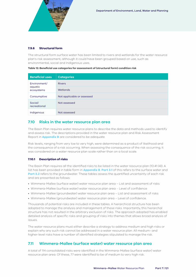
7.9.6 Structural form
The structural form surface water has been limited to rivers and wetlands for the water resource plan’s risk assessment, although it could have been grouped based on use, such as environmental, social and Indigenous uses.
Table 12: Beneficial use categories for assessment of (structural form) condition risk
Beneficial uses Categories
Environment/aquatic ecosystems
Rivers
Wetlands
Consumptive Not applicable or assessed
Social/recreational
Not assessed
Indigenous Not assessed
7.10 Risks in the water resource plan area
The Basin Plan requires water resource plans to describe the data and methods used to identify and assess risk. The descriptions provided in the water resource plan and Risk Assessment Report in Appendix B are considered to be adequate.
Risk levels, ranging from very low to very high, were determined as a product of likelihood and the consequence of a risk occurring. When assessing the consequence of the risk occurring, it was considered on a water resource plan scale rather than on a local scale.
7.10.1 Description of risks
The Basin Plan requires all the identified risks to be listed in the water resource plan (10.41 (4)). A list has been provided in table form in Appendix B. Part 3.1 of this refers to the surface water and Part 3.2 refers to the groundwater. These tables assess the quantified uncertainty of each risk and are presented as follows:
• Wimmera-Mallee (surface water) water resource plan area – List and assessment of risks
• Wimmera-Mallee (surface water) water resource plan area – Level of confidence
• Wimmera-Mallee (groundwater) water resource plan area – List and assessment of risks
• Wimmera-Mallee (groundwater) water resource plan area – Level of confidence.
Thousands of potential risks are included in these tables. A hierarchical structure has been adopted to manage the analysis and management of these risks. Importantly, this hierarchal structure has not resulted in the arbitrary exclusion of risks. The approach adopted has enabled detailed analysis of specific risks and grouping of risks into themes that allows broad analysis of issues.
The water resource plans must either describe a strategy to address medium and high risks or explain why any such risk cannot be addressed in a water resource plan. All medium- and higher-level risks have a number of identified strategies stipulated to manage the risk.
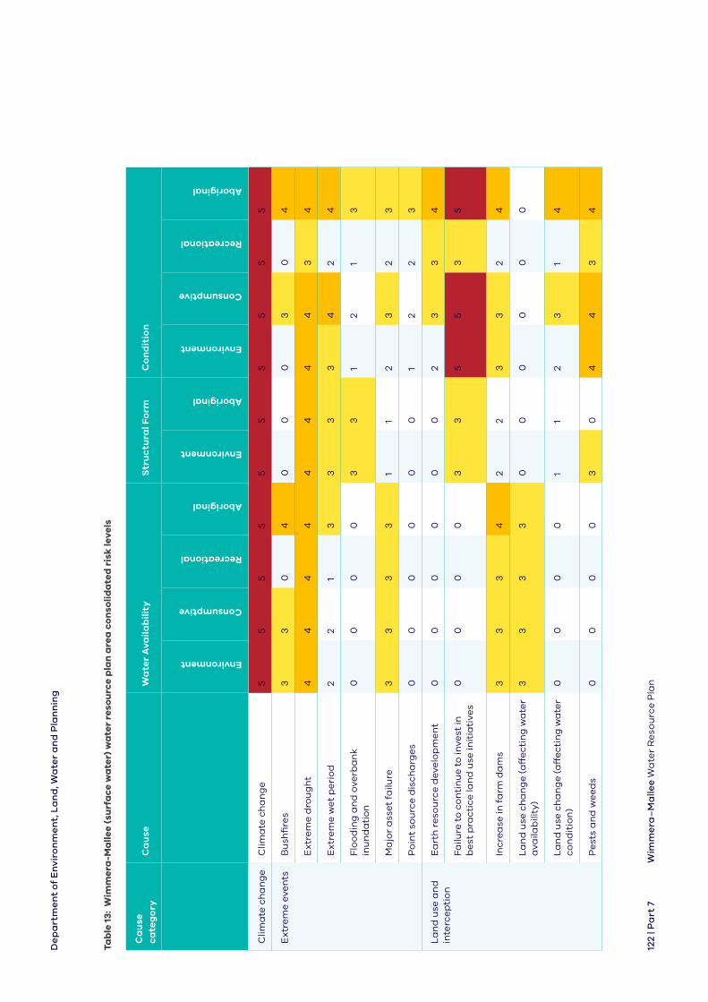
7.11 Wimmera-Mallee (surface water) water resource plan area
A total of 114 consolidated risks were identified in the Wimmera-Mallee (surface water) water resource plan area. Of these, 77 were identified to be of medium to very high risk.
Department of Environment, Land, Water and Planning
Part 7 | 121Wimmera–Mallee Water Resource Plan
Tab
le 1
3: W
imm
era
-Ma
llee
(su
rfa
ce w
ate
r) w
ate
r re
sou
rce
pla
n a
rea
co
nso
lida
ted
ris
k le
vels
Ca
use
ca
teg
ory
C
au
seW
ate
r A
vaila
bili
tyS
tru
ctu
ral F
orm
Co
nd
itio
n
Environment
Consumptive
Recreational
Aboriginal
Environment
Aboriginal
Environment
Consumptive
Recreational
Aboriginal
Clim
ate
ch
an
ge
Clim
ate
ch
an
ge
55
55
55
55
55
Ex
tre
me
eve
nts
Bu
shfi
res
33
04
00
03
04
Ex
tre
me
dro
ug
ht
44
44
44
44
34
Ex
tre
me
we
t p
eri
od
22
13
33
34
24
Flo
od
ing
an
d o
verb
an
k
inu
nd
ati
on
00
00
33
12
13
Ma
jor
ass
et
failu
re3
33
31
12
32
3
Po
int
sou
rce
dis
cha
rge
s0
00
00
01
22
3
La
nd
use
an
d
inte
rce
pti
on
Ea
rth
re
sou
rce
dev
elo
pm
en
t0
00
00
02
33
4
Fa
ilure
to
co
nti
nu
e t
o in
vest
in
be
st p
ract
ice
lan
d u
se in
itia
tive
s0
00
03
35
53
5
Incr
ea
se in
fa
rm d
am
s3
33
42
23
32
4
La
nd
use
ch
an
ge
(a
ffe
ctin
g w
ate
r a
vaila
bili
ty)
33
33
00
00
00
La
nd
use
ch
an
ge
(a
ffe
ctin
g w
ate
r co
nd
itio
n)
00
00
11
23
14
Pe
sts
an
d w
ee
ds
00
00
30
44
34
De
pa
rtm
en
t o
f E
nvi
ron
me
nt,
La
nd
, Wa
ter
an
d P
lan
nin
g
122
| Pa
rt 7
Wim
me
ra–
Ma
llee
Wa
ter
Re
sou
rce
Pla
n

Ca
use
ca
teg
ory
C
au
seW
ate
r A
vaila
bili
tyS
tru
ctu
ral F
orm
Co
nd
itio
n
Environment
Consumptive
Recreational
Aboriginal
Environment
Aboriginal
Environment
Consumptive
Recreational
Aboriginal
No
n-
com
plia
nce
No
n-c
om
plia
nce
wit
h t
he
V
icto
ria
n W
ate
r A
ct2
21
31
13
32
4
Wa
ter
acc
ess
, ta
ke, u
tilis
ati
on
a
nd
loca
tio
n
Incr
ea
se in
th
e n
um
be
r o
f ri
gh
ts
an
d v
olu
me
of
en
titl
em
en
ts0
00
00
00
00
0
Incr
ea
sed
uti
lisa
tio
n o
f w
ate
r a
cce
ss r
igh
ts2
21
30
03
31
3
Tim
ing
an
d lo
cati
on
of
de
ma
nd
00
00
00
00
00
Le
gen
d
54
32
10
Ve
ry h
igh
ris
kH
igh
ris
kM
ed
ium
ris
kL
ow
ris
kV
ery
low
ris
kN
ot
pla
usi
ble
– n
o r
isk
con
tin
ued
De
pa
rtm
en
t o
f E
nvi
ron
me
nt,
La
nd
, Wa
ter
an
d P
lan
nin
g
123
| P
art
7W
imm
era
–M
alle
e W
ate
r R
eso
urc
e P
lan

7.11.1 Risks to water availability
Surface water availability was assessed on the form of legal entitlement of beneficial users to the surface water. Due to this level of assessment a large number of risks were identified.
It was found that climate change could activate threats related to a reduction in volume and/or change to seasonal pattern across:
• low-reliability water and uncontrolled water for environmental purposes
• low-reliability and section 51 licences for consumptive purposes
• recreational bulk entitlements for social purposes.
Extreme drought leading to a reduction in volume, change to seasonal pattern and/or changes to inter-annual pattern also generated high risks across low-reliability, uncontrolled, section 51 and section 8 licences under the Act, and recreational bulk entitlements. Bushfires, land use change affecting availability, farm dams and major asset failure generate some medium-level risks across environmental, consumptive and social uses.
7.11.2 Risks to water condition
Surface water condition assessments were based on the beneficial uses and users of water (based on Victoria’s State Environment Protection Policy (Waters)).
The risk assessment found that climate change could activate threats related to salinity, suspended solids and nutrients, toxicants, pathogens and other water quality impacts which may pose a very high, high or medium risk to the consumptive use of water for human drinking, agricultural and irrigation, aquaculture, industry and commercial and fish/crustaceans consumption, and medium-level threats across the other beneficial consumptive uses. Release of toxicants also posed a very high risk to environmental use of water.
The risk assessment found that a failure to continue to invest in improving existing land and waterway management practice would trigger very high-level threats of salinity across environmental beneficial uses and several consumptive beneficial uses.
High risks were recorded across the causes of extreme drought, extreme wet and pests and weeds.
7.11.3 Risks to social/recreational and Aboriginal uses of water
Risks to recreational and amenity and Aboriginal cultural values were assessed in terms of the risks associated to the condition and quality of water available for these purposes, and the availability of water for these functions.
The social, environmental, and consumptive uses of water are relatively well understood as water resource planning concepts. However, Aboriginal uses of water are not as well understood which is why a large number of risks have been generated as high at this stage in the risk assessment.
Department of Environment, Land, Water and Planning
124 | Part 7 Wimmera–Mallee Water Resource Plan

Climate change generated very high risks associated with impacts on Aboriginal uses of water with regard to:
• reduction in volume
• change to seasonal pattern
• salinity
• suspended solids and nutrients
• toxicants
• other water quality impacts
• loss or decline in longitudinal connectivity
• loss or decline in lateral connectivity
• loss or decline in instream physical habitat.
Climate change and extreme drought also posed medium or high risks to recreational and amenity uses due to threats associated with declines in water availability. Changes to seasonal patterns of inflows were associated only with climate change.
7.11.4 Risks to rivers and wetlands (structural form/waterway biota)
Climate change generated high and very high risks with regard to waterway biota in rivers and wetlands including:
• loss or decline in longitudinal connectivity
• loss or decline in lateral connectivity
• loss or decline in instream physical habitat.
Extreme drought generated some high-level risks, while extreme wet, flooding and overbanking inundation, failure to continue to invest in best practice land use initiatives and pests and weeds were also assessed as having the potential to generate medium-level risks to waterway biota in rivers and wetlands.
7.12 Wimmera-Mallee (groundwater) water resource plan area
For the Wimmera-Mallee (groundwater) water resource plan area, 66 consolidated risks were identified. Of these, 29 were identified to be of medium to very high risk. Causes associated with the high occurrence of these moderate to very high risks were:
• climate change
• land use and interception.
Department of Environment, Land, Water and Planning
Part 7 | 125Wimmera–Mallee Water Resource Plan

Tab
le 1
4: W
imm
era
-Ma
llee
(gro
un
dw
ate
r) w
ate
r re
sou
rce
pla
n a
rea
co
nso
lida
ted
ris
k le
vels
Ca
use
ca
teg
ory
C
au
seW
ate
r A
vaila
bili
tyS
tru
ctu
ral F
orm
Co
nd
itio
n
Environment
Consumptive
Recreational
Aboriginal
Environment
Aboriginal
Consumptive
Aboriginal
Clim
ate
ch
an
ge
Clim
ate
ch
an
ge
55
35
00
55
Ex
tre
me
eve
nts
Bu
shfi
res
11
13
00
13
Ex
tre
me
dro
ug
ht
11
13
00
13
Ex
tre
me
we
t p
eri
od
00
00
00
13
Flo
od
ing
an
d o
verb
an
k
inu
nd
ati
on
00
00
00
13
Ma
jor
ass
et
failu
re0
00
00
00
0
Po
int-
sou
rce
dis
cha
rge
s0
00
00
02
3
La
nd
use
an
d
inte
rce
pti
on
Ea
rth
re
sou
rce
dev
elo
pm
en
t1
11
41
42
4
Fa
ilure
to
co
nti
nu
e t
o in
vest
in
be
st p
ract
ice
lan
d u
se in
itia
tive
s0
00
00
01
3
Incr
ea
se in
fa
rm d
am
s1
11
30
01
3
La
nd
use
ch
an
ge
(a
ffe
ctin
g
wa
ter
ava
ilab
ility
)1
11
30
01
3
La
nd
use
ch
an
ge
(a
ffe
ctin
g
wa
ter
con
dit
ion
)0
00
00
03
4
Pe
sts
an
d w
ee
ds
00
00
00
00
De
pa
rtm
en
t o
f E
nvi
ron
me
nt,
La
nd
, Wa
ter
an
d P
lan
nin
g
126
| P
art
7W
imm
era
–M
alle
e W
ate
r R
eso
urc
e P
lan

Ca
use
ca
teg
ory
C
au
seW
ate
r A
vaila
bili
tyS
tru
ctu
ral F
orm
Co
nd
itio
n
Environment
Consumptive
Recreational
Aboriginal
Environment
Aboriginal
Consumptive
Aboriginal
No
n-
com
plia
nce
No
n-c
om
plia
nce
wit
h t
he
V
icto
ria
n W
ate
r A
ct1
11
30
01
3
Wa
ter
acc
ess
, ta
ke, u
tilis
ati
on
a
nd
loca
tio
n
Incr
ea
se in
th
e n
um
be
r o
f ri
gh
ts
an
d v
olu
me
of
en
titl
em
en
ts1
11
30
01
3
Incr
ea
sed
uti
lisa
tio
n o
f w
ate
r a
cce
ss r
igh
ts1
11
30
01
3
Tim
ing
an
d lo
cati
on
of
de
ma
nd
00
00
00
00
Le
gen
d5
43
21
0
Ve
ry h
igh
ris
kH
igh
ris
kM
ed
ium
ris
kL
ow
ris
kV
ery
low
ris
kN
ot
pla
usi
ble
– n
o r
isk
con
tin
ued
De
pa
rtm
en
t o
f E
nvi
ron
me
nt,
La
nd
, Wa
ter
an
d P
lan
nin
g
127
| Pa
rt 7
Wim
me
ra–
Ma
llee
Wa
ter
Re
sou
rce
Pla
n

7.12.1 Risks to water availability
Groundwater availability was assessed on the physical attributes of the aquifer. The risk assessment found that climate change could cause medium to very high-level risks across the availability of water for environmental and consumptive uses, with the exposure to risk depending on individual aquifers.
It was found that climate change could activate threats related to:
• a decline in inflows to or increased extraction of water from the aquifer
• adverse changes to the seasonal pattern of inflow or extraction
• increased salinity affecting water availability for consumptive uses.
7.12.2 Risks to water condition
Groundwater condition assessments were based on the beneficial uses and users of water (based on Victoria’s State Environment Protection Policy (Waters)).
The risk assessment found that climate change could activate threats related to increased salinity which poses very high risk across a variety of consumptive uses.
The risk assessment also found that land use changes within the water resource plan area had the potential to impact on some consumptive uses generating medium-range threats related to increasing salinity and the potential release of toxicants into aquifers.
7.12.3 Risks to social/recreational and Aboriginal uses
Risks to Aboriginal cultural values were assessed in terms of the risks associated with the condition or quality of water available and the availability of water for these functions. The social, environmental and consumptive uses of water are relatively well understood as water resource planning concepts. However, Aboriginal use or value of water is not as well understood, contributing to the large number of risks generated at this stage in the risk assessment.
Climate change generated very high risks associated with impacts on Aboriginal cultural uses of water, followed by land use changes affecting water condition, and threats generated from earth resource development which were assessed as high risks.
Climate change also posed medium risks with regard to recreational and amenity uses due to threats associated with declines in water availability and changes to seasonal patterns of inflows to or extraction from aquifers.
Department of Environment, Land, Water and Planning
128 | Part 7 Wimmera–Mallee Water Resource Plan
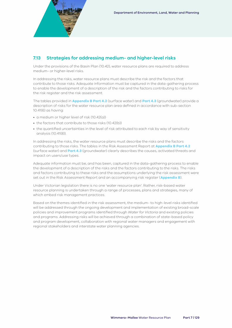
7.13 Strategies for addressing medium- and higher-level risks
Under the provisions of the Basin Plan (10.42), water resource plans are required to address medium- or higher-level risks.
In addressing the risks, water resource plans must describe the risk and the factors that contribute to those risks. Adequate information must be captured in the data-gathering process to enable the development of a description of the risk and the factors contributing to risks for the risk register and the risk assessment.
The tables provided in Appendix B Part 4.2 (surface water) and Part 4.3 (groundwater) provide a description of risks for the water resource plan area defined in accordance with sub-section 10.41(6) as having:
• a medium or higher level of risk (10.42(a))
• the factors that contribute to those risks (10.42(b))
• the quantified uncertainties in the level of risk attributed to each risk by way of sensitivity analysis (10.41(8)).
In addressing the risks, the water resource plans must describe the risks and the factors contributing to those risks. The tables in the Risk Assessment Report at Appendix B Part 4.2 (surface water) and Part 4.3 (groundwater) clearly describes the causes, activated threats and impact on users/use types.
Adequate information must be, and has been, captured in the data-gathering process to enable the development of a description of the risks and the factors contributing to the risks. The risks and factors contributing to these risks and the assumptions underlying the risk assessment were set out in the Risk Assessment Report and an accompanying risk register (Appendix B).
Under Victorian legislation there is no one ‘water resource plan’. Rather, risk-based water resource planning is undertaken through a range of processes, plans and strategies, many of which embed risk management practices.
Based on the themes identified in the risk assessment, the medium- to high-level risks identified will be addressed through the ongoing development and implementation of existing broad-scale policies and improvement programs identified through Water for Victoria and existing policies and programs. Addressing risks will be achieved through a combination of state-based policy and program development, collaboration with regional water managers and engagement with regional stakeholders and interstate water planning agencies.
Department of Environment, Land, Water and Planning
Part 7 | 129Wimmera–Mallee Water Resource Plan
Examples of such planning and policy development include:
• review and enhancement of climate change adaption policy and practice
• review and enhancement of drought management policy and practice
• review and enhancement of statewide water quality policy
• reaffirmation of continued commitment to support existing programs of best practice management including waterway management programs, soil conservation programs, forestry management, dairy management, grazing management and irrigation management.
The assessment of risks to the availability and condition of water resources together with a description of the risks, the estimated level of each risk and the level of confidence in the estimate and strategies to address medium- and high-level risks are contained in the following tables in Appendix B (Part 4.2 and Part 4.3 of the Risk Assessment).
Identified medium, high and very high risks are managed in Victoria through various mechanisms commensurate to their risk level. Risks are managed through a combination of long-term water resource planning, water allocation, land use/catchment management planning, environment protection policies and enforcement provisions.
Almost 40 strategies were identified as part of Victoria’s water and catchment management framework. Continued implementation of these strategies will address the risks identified to the availability and condition of water resources. These strategies are a combination of the policy directions contained and reinforced through Water for Victoria and existing regulations and guidelines. These strategies are identified in Table 78 of Appendix B. Each medium- or high-level risk has been linked to the strategies where they contribute to the management of that risk.
7.13.1 Surface water risks
Appendix B Part 4.2 identifies the medium- or higher-level risks, confidence level and identifies the strategies to address the risk for the Wimmera-Mallee (surface water) water resource plan area.
7.13.2 Groundwater risks
Appendix B, Part 4.3 identifies the medium- or higher-level risks, confidence level and strategies to address the risk for the Wimmera-Mallee (groundwater) water resource plan area.
Department of Environment, Land, Water and Planning
130 | Part 7 Wimmera–Mallee Water Resource Plan

This page left deliberately blank


![Introduction to SDL Bibliography: [Doldi2001] L. Doldi, (2001), SDL Illustrated. [Edwards2001] S. Edwards, (2001), SDL, sedwards/classes/2001/w4995-](https://static.fdocuments.us/doc/165x107/56649efe5503460f94c121a9/introduction-to-sdl-bibliography-doldi2001-l-doldi-2001-sdl-illustrated.jpg)