6.5 Road Safety Audit - · PDF fileTransport Engineering commissioned Point 8 to conduct ......
32
Wilston Grange Precinct Study Transport Engineering Studies 140040 Wilston Grange Technical Report 150428.docx Final Draft Page 60 6.5 Road Safety Audit As part of Council’s investigation of future needs for the study area, a Road Safety Audit (RSA) was undertaken to identify existing deficiencies within the road network which may potentially compromise user safety. Given the magnitude of the study area, the RSA was broken down into three sub areas, as illustrated in Figure 6.7. The audit scope was limited to the highlighted streets within each of the sub-area boundaries which were determined based on the streets role in the road network and historical crash data. Figure 6.7 : Road Safety Review Sub-Areas
Transcript of 6.5 Road Safety Audit - · PDF fileTransport Engineering commissioned Point 8 to conduct ......

Wilston Grange Precinct Study Transport Engineering Studies
140040 Wilston Grange Technical Report 150428.docx Final Draft Page 60
6.5 Road Safety Audit
As part of Council’s investigation of future needs for the study area, a Road Safety Audit (RSA) was
undertaken to identify existing deficiencies within the road network which may potentially
compromise user safety.
Given the magnitude of the study area, the RSA was broken down into three sub areas, as illustrated in
Figure 6.7. The audit scope was limited to the highlighted streets within each of the sub-area
boundaries which were determined based on the streets role in the road network and historical crash
data.
Figure 6.7 : Road Safety Review Sub-Areas
Wilston Grange Precinct Study Transport Engineering Studies
140040 Wilston Grange Technical Report 150428.docx Final Draft Page 61
Transport Engineering commissioned Point 8 to conduct the RSA for Sub-Area 1, Arup to conduct the
RSA for Sub-Area 2 and MWH to conduct the RSA for Sub-Area 3.
6.5.1 Road Safety Audit Methodology
The audits were completed in accordance with the requirements of Austroads, Guide to Road Safety :
Part 6 Road Safety Audit, 2009. The essential elements of a road safety audit are:
· A formal process and not an informal check;
· An independent process;
· Carried out by persons with appropriate experience and training; and
· Restricted to road safety issues.
The methodology adopted generally follows the format and topics outlined in Austroads Checklist 6.
Risk rating of safety issues is defined as per Austroads Part 6 : Table 4.4 as being Intolerable, High,
Medium and Low.In the Austroads Guide Intolerable implies that there should be some measure of
risk management considered to potentially reduce its likelihood. A number of mitigation solutions
made as a result of the RSAs could be relatively straightforward in an engineering sense but may
require alternative solutions that have community acceptance.
In this report the issues with the highest risk identified in the Road Safety Audit are referred to as a
Very High risk.
6.5.2 Limitations of Road Safety Audit
Whilst road safety audits are detailed in some respects, they represent a relatively brief assessment of a
road network or of an associated feature and are not intended to extend or investigate every aspect
which may potentially have some level of influence on road function and safety. It is not a check
against the design standards and does not imply compliance with the standards nor does it guarantee
safety.
There were a number of issues raised in the RSAs that will require further detailed assessment to
determine conformity with all relevant standards and what, if any, further action will be required going
forward. For instance, the audit identified that roadway lighting is insufficient however the actual
levels or quality was not verified in absolute terms. The aim of an audit is to highlight potential safety
issues and have them formally considered by the asset owner (Council), in conjunction with all other
asset considerations.
Each safety issue raised was assed qualitatively to determine appropriate risk ranking for each issue.
It should also be noted that the determination of risk ratings as per the categories listed in Austroads
Part 6 : Table 4.4 is not based on quantitative process and instead relies on professional judgement and
experience of the audit team. Given that there were three different auditors involved in the road safety
audit, the risk category associated with each identified issue for each sub-area is subjective and not
necessarily consistent across sub-areas.
The auditors have pointed out that no guarantee is made that every deficiency has been identified.
Further, if all recommendations in the report were to be followed, this would not guarantee that the
existing roads are safe, rather the adoption of the recommendations should improve the level of safety
of the roads.
Wilston Grange Precinct Study Transport Engineering Studies
140040 Wilston Grange Technical Report 150428.docx Final Draft Page 62
A database using Excel has been developed for the study area which can be filtered by categories.
These categories were developed as per Austroads guidelines and include:
- Road Alignment & Cross Section;
- Signs & Lighting;
- Markings & Delineation;
- Crash Barriers & Clear Zones;
- Traffic Signals;
- Pedestrians & Cyclists;
- Bridges & Culverts;
- Pavement/Parking and
- Miscellaneous.
This database will be provided separately in digital format.
Findings for each sub area have been discussed separately below.
6.5.3 Road Safety Audit : Sub – Area 1
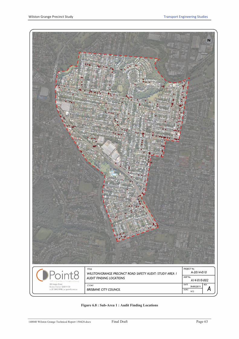
While audit findings were recorded for each street/intersection, there were a number of road safety
issues that were identified by the auditors as repeatedly occurring precinct wide. These are
summarised below:
· Vegetation overhanging or encroaching within the carriageway;
· Need for improved street lighting;
· Faded/worn pavement markings;
· Narrow footpaths or limited footpaths;
· Low hanging power lines which cross the carriageway;
· Missing Tactile Ground Surface Indicators on most kerb ramps;
· Inappropriate location of roadside furniture behind road kerb; and
· Need for improved signs.
Audit findings, illustrated in Figure 6.8 and in Table 6.12, indicated that the safety issues generally
occur along major carrying roads including Grange Road, Raymont Road, Days Road and Wilston
Road. In addition to road sections, the intersections of Grange Road/Raymont Road, Grange
Road/Days Road, Wilston Road/Daisy Street, Wilston Road Level Crossing and Wilston
Road/Newmarket Road were identified as areas of concern.
Wilston Grange Precinct Study Transport Engineering Studies
140040 Wilston Grange Technical Report 150428.docx Final Draft Page 63
Figure 6.8 : Sub-Area 1 : Audit Finding Locations

Wilston Grange Precinct Study Transport Engineering Studies
140040 Wilston Grange Technical Report 150428.docx Final Draft Page 64
Table 6.12 : Sub-Area 1 RSA Summary of All Issues
RSA Category Very High High Medium Low
Crash Barriers and Clear
Zones
Raymont Rd/Blandford St
Raymont Rd/Plymouth St
Waterford/Wakefield St
Wilston Rd
Beatson Terrace/Sidney St
Colston Rd/Daisy St
Days Rd / Grange Rd
Grange Rd
Wilston Rd/Murrell St
David St
Robe St/Days Rd
Cyclists Mina Pde
Newmarket Rd
Alderley Ave
Blandford St
Mina Pde
Wilston Rd/Daisy St
Alderley Ave
Huddart St
Mina Pde
Progress Pde
Waterford/Wakefield St
Drainage Railway Place
Raymont Rd
Chelford St
Longsight St
Royal Pde
Lighting Raymont Rd/Royal Pde Blandford St
Days Rd
Farrington St/Huddart St
Longsight St/Chelford St
Newmarket Rd
Raymont Rd
Farrington St
Grange Rd
Longsight St
Mina Pde
Markings and
Delineation
Days Rd / Grange Rd
Newmarket Rd
Raymont Rd/Royal Pde
Wilston Rd
Carberry St/Colston Rd
Grange Rd
Grange Rd/Raymont Rd Intersection
Raymont Rd
Raymont Rd/Royal Pde
Wilston Rd / Newmarket Rd
Wilston Rd
Alcester St
Chelford St
David St/Sidney St
Farm St/Enoggera Rd
Farrington St/Huddart St
Grange Rd
Grange Rd/Blandford St
Grange Rd/Evelyn St
Longsight St/Royal Pde
Newmarket Rd
Newmarket Rd/Baradine St
Raymont Rd/Chelford St
Raymont Rd/Chermside St
Raymont Rd/Plymouth St
Raymont Rd/Southerden Ave
Wilston Rd
Miscellaneous Chermside St
Days Rd / Grange Rd
Grange Rd
Wilston Rd/Mina Pde
Alderley Ave
Colston Rd
Days Rd / Grange Rd
Alcester St
Wilston Rd
Wilston Rd/Murrell St
Parking Chermside St
Wilston Rd
Abuklea St
Alcester St
Days Rd
Grange Rd
Mina Pde
Robe St
Wilston Rd / Newmarket Rd
Evelyn St
Gracemere St (North of Days Rd)
Longsight St
Newmarket Rd
Raymont Rd
South St
Wilston Rd
Pavement Mina Pde Blandford St
Grange Rd
Raymont Rd
Alderley Ave
Mina Pde
Pedestrians Days Rd
Wilston Rd
Mina Pde
Wilston Rd/Mina Pde
Alcester St
Beatson Terrace/Sidney St
Billington St
Chelford St
Chermside St
Daisy St
David St
Gracemere St (South of Days Rd)
Grange Rd
Grange Rd/Evelyn St
Longsight St
Newmarket Rd
Railway Place
Raymont Rd
Robe St
Royal Pde
South St
Southerden Ave
Wilston Rd/Daisy St
Public Transport Days Rd
Raymont Rd
Days Rd
Grange Rd
Progress Pde
Raymont Rd
Wilston Rd

Wilston Grange Precinct Study Transport Engineering Studies
140040 Wilston Grange Technical Report 150428.docx Final Draft Page 65
RSA Category Very High High Medium Low
Road Alignment and
Cross Section
Grange Rd/Dennis St
Grange Rd/Howard St
Grange Rd/Myrtle St
Wilston Rd/Days Rd
Wilston Rd/Murrell St
Alderley Ave
Alderley Ave/Park Ave
Campbell Terrace
Chelford St/Raymont Rd
Chermside St/Raymont Rd
Clowes Lane
Colston Rd/Days Rd
David St
Days Rd
Gracemere St (South of Days Rd)
Grange Rd/Blandford St
Grange Rd/Myrtle St
Grange Rd/Raymont Rd Intersection
Mina Pde
Montpelier St
Montpelier St/Wilston Rd
Moran St/South Pine Rd
Progress Pde
Progress Pde/Andrew St
Raymont Rd/Billington St
Raymont Rd/Royal Pde
Raymont Rd/Wellbeck St
Robe St/Days Rd
Southerden Ave/Days Rd
Wilston Rd/Daisy St
Wilston Rd/Mina Pde
Wilston Rd/Murrell St
Yarradale St
Alcester St/Blandford St
Alcester St/Leyton St
Alderley Ave
Alderley Ave/Hall St
Alderson/Murrell St
Blandford St
Carberry St/Wilston Rd
Clowes Lane
Colston Rd/Days Rd
Grange Rd/Evelyn St
Moran St/Ainslee St
Newmarket Rd
Raymont Rd
Raymont Rd/Birrimba St
Robe St
Stevenson St
Travill St
Ward St/Wickham St
Wilston Rd / Newmarket Rd
Wilston Rd
Wilston Rd/Daisy St
Wilston Rd/Raymont Rd
Yarradale St/Mina Pde
Colston Rd
David St
Denman St/Huddart St
Farm St/Green Terrace
Longsight St
Longsight St/Plymouth St
Waterford/Wakefield St
Wilston Rd
Signs Newmarket Rd
Raymont Rd/Wellbeck St
Ward St
Wickham St
Wilston Rd/Daisy St
Alderley Ave/Yarradale St
Alderson/Murrell St
Carberry St
Carberry St/Colston Rd
Chermside St
Colston Rd
Colston Rd/Days Rd
Daisy St
Days Rd
Erneton St
Longsight St/Royal Pde
Newmarket Rd/Baradine St
Progress Pde
Raymont Rd
Raymont Rd/Blandford St
Raymont Rd/Plymouth St
Robe St/Days Rd
Ward St/Wickham St
Waterford/Wakefield St
Wilston Rd / Newmarket Rd
Wilston Rd
Wilston Rd/Daisy St
Alderley Ave
Alderson/Murrell St
Chelford St
Chermside St
Clowes Lane
Colston Rd/Daisy St
Colston Rd/Days Rd
Days Rd / Grange Rd
Days Rd
Days Rd/Gracemere St
Farrington St
Gracemere St (North of Days Rd)
Grange Rd
Grange Rd/Howard St
Grange Rd/Raymont Rd Intersection
Mina Pde
Montpelier St
Newmarket Rd
Railway Place
Raymont Rd
Raymont Rd/Wellbeck St
Robe St/Days Rd
South St
Stevenson St
Ward St
Wickham St
Wilston Rd / Newmarket Rd
Traffic Signals Grange Rd/Raymont Rd Intersection
Wilston Rd / Newmarket Rd
Grange Rd/Raymont Rd Intersection
Raymont Rd
Newmarket Rd/Baradine St
Vertical Clearance Chelford St
Raymont Rd
Alcester St
Alderley Ave
Alderson/Murrell St
Blandford St
Chermside St
Colston Rd
Days Rd
Erneton St
Evelyn St
Gracemere St (South of Days Rd)
Grange Rd
Longsight St
Montpelier St
Robe St
Royal Pde
Southerden Ave
Stevenson St
Wickham St
Wilston Rd

Wilston Grange Precinct Study Transport Engineering Studies
140040 Wilston Grange Technical Report 150428.docxFinal Draft Page 66
The RSA identified a large number of issues, and for ease of reporting a detailed summary of issues
with a risk rating of “Very High” or “High” follow.
There were five specific issues with a risk rating Very High which are listed in Table 6.13. These
were identified at intersections with high volume roads with limited sight distance with right turns
currently permitted from the side road. Although execution of right turn bans is straightforward, this
treatment affects convenience of access and may not be supported some sections of the community.
Alternative solutions could be developed that retain access and improve safety, but would be more
costly to achieve and still may not be supported by the community directly affected.
Table 6.13 : Locations Identified with Very High Risk
Location Issue/Risk Description Recommendation
Murrell Street /
Wilston Road
Sight distance to the north from Murrell Street is
limited by the level crossing infrastructure.
Risk of conflict between turning and through traffic
at the intersection.
Consider banning the right turn into
Wilston Road from Murrell Street.
Consider signalisation of the two
intersections as a dual signalised
intersection.
Days
Road/Wilston
Road
Sight distance at Days Road/Wilston Road
(travelling northbound) is limited and presents a
difficult situation for the driver. It is difficult for
drivers to see oncoming traffic before entering Days
Road.
Visibility is restricted in both directions by adjacent
properties and on-street parking.
Risk of conflicts between turning and through traffic
at the intersection.
Consider banning right turn
movement at intersection.
Consider establishing parking
restrictions on Days Road west of the
intersection to maximise sight
distance.
Grange
Road/Howard
Street
Sight distance out of Howard Street is limited and
there is a risk of conflict between turning and
through traffic at the intersection.
Crash history includes incidents at the intersection
involving right turning vehicles.
Consider banning right turn
movements.
Grange
Road/Dennis
Street
Sight distance out of Dennis Street is limited and
there is a risk of conflict between turning and
through traffic at the intersection.
Crash history includes incidents at the intersection
involving right turning vehicles.
Consider banning right turn
movements.
Grange
Road/Myrtle
Street
Sight distance out of Myrtle Street is limited and
there is a risk of conflict between turning and
through traffic at the intersection.
Crash history includes past incidents at the
intersection involving right turning vehicles.
Consider banning right turn
movements.
Source : Wilston Grange Precinct Area 1 Road Safety Report - Point 8
Wilston Grange Precinct Study Transport Engineering Studies
140040 Wilston Grange Technical Report 150428.docx Final Draft Page 67
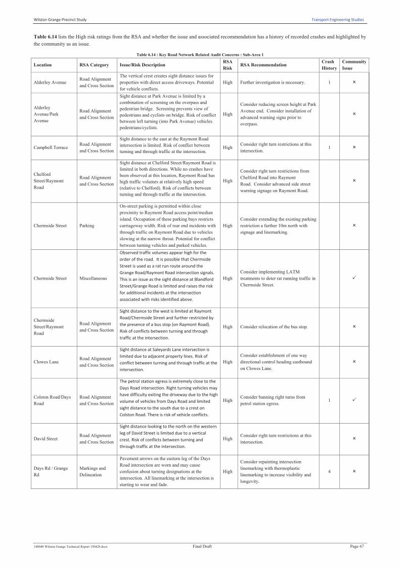
Table 6.14 lists the High risk ratings from the RSA and whether the issue and associated recommendation has a history of recorded crashes and highlighted by
the community as an issue.
Table 6.14 : Key Road Network Related Audit Concerns : Sub-Area 1
Location RSA Category Issue/Risk Description RSA
Risk RSA Recommendation
Crash
History
Community
Issue
Alderley Avenue Road Alignment
and Cross Section
The vertical crest creates sight distance issues for
properties with direct access driveways. Potential
for vehicle conflicts.
High Further investigation is necessary. 1 O
Alderley
Avenue/Park
Avenue
Road Alignment
and Cross Section
Sight distance at Park Avenue is limited by a
combination of screening on the overpass and
pedestrian bridge. Screening prevents view of
pedestrians and cyclists on bridge. Risk of conflict
between left turning (into Park Avenue) vehicles
pedestrians/cyclists.
High
Consider reducing screen height at Park
Avenue end. Consider installation of
advanced warning signs prior to
overpass.
O
Campbell Terrace Road Alignment
and Cross Section
Sight distance to the east at the Raymont Road
intersection is limited. Risk of conflict between
turning and through traffic at the intersection. High
Consider right turn restrictions at this
intersection. 1 O
Chelford
Street/Raymont
Road
Road Alignment
and Cross Section
Sight distance at Chelford Street/Raymont Road is
limited in both directions. While no crashes have
been observed at this location, Raymont Road has
high traffic volumes at relatively high speed
(relative to Chelford). Risk of conflicts between
turning and through traffic at the intersection.
High
Consider right turn restrictions from
Chelford Road into Raymont
Road. Consider advanced side street
warning signage on Raymont Road.
O
Chermside Street Parking
On-street parking is permitted within close
proximity to Raymont Road access point/median
island. Occupation of these parking bays restricts
carriageway width. Risk of rear end incidents with
through traffic on Raymont Road due to vehicles
slowing at the narrow throat. Potential for conflict
between turning vehicles and parked vehicles.
High
Consider extending the existing parking
restriction a further 10m north with
signage and linemarking.
O
Chermside Street Miscellaneous
Observed traffic volumes appear high for the
order of the road. It is possible that Chermside
Street is used as a rat run route around the
Grange Road/Raymont Road intersection signals.
This is an issue as the sight distance at Blandford
Street/Grange Road is limited and raises the risk
for additional incidents at the intersection
associated with risks identified above.
High
Consider implementing LATM
treatments to deter rat running traffic in
Chermside Street.
P
Chermside
Street/Raymont
Road
Road Alignment
and Cross Section
Sight distance to the west is limited at Raymont
Road/Chermside Street and further restricted by
the presence of a bus stop (on Raymont Road).
Risk of conflicts between turning and through
traffic at the intersection.
High Consider relocation of the bus stop.
O
Clowes Lane Road Alignment
and Cross Section
Sight distance at Saleyards Lane intersection is
limited due to adjacent property lines. Risk of
conflict between turning and through traffic at the
intersection.
High
Consider establishment of one way
directional control heading eastbound
on Clowes Lane.
O
Colston Road/Days
Road
Road Alignment
and Cross Section
The petrol station egress is extremely close to the
Days Road intersection. Right turning vehicles may
have difficulty exiting the driveway due to the high
volume of vehicles from Days Road and limited
sight distance to the south due to a crest on
Colston Road. There is risk of vehicle conflicts.
High Consider banning right turns from
petrol station egress. 1 P
David Street Road Alignment
and Cross Section
Sight distance looking to the north on the western
leg of David Street is limited due to a vertical
crest. Risk of conflicts between turning and
through traffic at the intersection.
High Consider right turn restrictions at this
intersection. O
Days Rd / Grange
Rd
Markings and
Delineation
Pavement arrows on the eastern leg of the Days
Road intersection are worn and may cause
confusion about turning designations at the
intersection. All linemarking at the intersection is
starting to wear and fade.
High
Consider repainting intersection
linemarking with thermoplastic
linemarking to increase visibility and
longevity.
4 O

Wilston Grange Precinct Study Transport Engineering Studies
140040 Wilston Grange Technical Report 150428.docx Final Draft Page 68
Location RSA Category Issue/Risk Description RSA
Risk RSA Recommendation
Crash
History
Community
Issue
Days Rd / Grange
Rd
Markings and
Delineation
Geometry for dual right turns northbound is narrow
for two vehicles simultaneously turning,
particularly large vehicles (there is a bus route that
uses this movement). Vehicles in the outside lane
were observed crossing guide lines and into
adjacent lane. There is a risk of side swipe
collisions for northbound vehicles turning right
from Days Road.
High
Investigate options for improvements
to intersection geometry or phasing
options to maintain existing capacity
with only single right turn lane.
4 O
Days Rd / Grange
Rd Miscellaneous
During peak periods, congestion of the northbound
left turn from Days Road into Grange Road may
result in through movements on Days Road
(eastbound) travelling in the westbound lane
opposing traffic (due to driver impatience). The
high volume of turning movements at service
station access which may not expect an eastbound
vehicle in the westbound lane.
High
Investigate improvements to increase
northbound capacity from Days Road
into Grange Road. Consider physical
restrictions on Days Road between
Colston and Grange.
4 O
Days Road Road Alignment
and Cross Section
Sight distance from all side streets is limited
throughout Days Road. Risk of conflicts between
turning and through traffic at the intersection.
High
Refer to detailed recommendations for
each side street. Consider signage
strategy between Colston Road and
Sidney Street to advise motorists to be
aware of turning traffic from side
streets with limited sight distance.
3 O
Days Road Road Alignment
and Cross Section
The horizontal curves and vertical crests have a
limited design speed. There is risk of vehicle
crashes, pedestrian crashes and vehicles leaving the
carriageway due to inappropriate speeds for the
road environment.
High
Consider LATM treatments, reduced
speed limits, upgrade of infrastructure
to allow for prevailing vehicle speeds.
3 O
Days Road Pedestrians
The footpaths on both sides of the road are very
narrow and are occasionally obstructed by
powerpoles. Wheelie bins were observed to impede
the path for pedestrians and force them to walk
within the road carriageway.
High
Consider alternative refuse collection
arrangements. Consider increasing
warning signs for
pedestrians. Consider reducing posted
speed of road due to high volume of
pedestrians during peak hour. Consider
options to increase footpath width in
isolated locations.
3 O
Days Road Pedestrians
A high number of pedestrians have been observed
crossing Days Road at varying points.
Limited pedestrian crossing facilities exist between
Southerden Avenue And Colston Road which
encourages crossing at random locations.
High
Consider implementing a pedestrian
crossing facility between Southerden
Avenue and Colston Road i.e. zebra
crossing.
3 O
Gracemere Street
(South of Days
Road)
Road Alignment
and Cross Section
Sight distance at Mina Parade is limited. Risk of
conflict between turning and through traffic at the
intersection. The road intersects with South Street
and Mina Parade with unconventional geometry
which creates confusion and priority needs to be
more clearly defined needs to be better defined.
Risk of conflict between vehicles at Gracemere
Street and South Street.
High
Consider implementing intersection
treatment which clearly defines
priorities. Consider implementing a
“half-roundabout) at the intersection of
South and Gracemere with Mina
Parade.
1 O
Grange Road Miscellaneous
The free flow speed of traffic was perceived to be
higher than appropriate for the road environment,
geometry and lane widths. High speeds increase
the likelihood of crashes due to larger stopping
distances and sight distances. The risk of injury
severity is increased due to the higher perceived
speed environment.
High Consider whether a speed limit review
is warranted. 9 O
Grange
Road/Blandford
Street
Road Alignment
and Cross Section
The sight distance at Grange Road intersection is
limited. Crashes have been observed at this
location. Risk of conflicts between turning and
through traffic at the intersection.
High
Consider further restrictions on turning
movements at this intersection, and
advanced warning on Grange Road to
advise the presence of Blandford Street
intersection and acute angle of
intersection geometry.
O
Grange
Road/Blandford
Street
Road Alignment
and Cross Section
Sight distance to Blandford Street (northbound
direction) is limited due to vertical crest. Risk of
conflict between turning and through traffic at the
intersection.
High Further investigation required.
O
Grange
Road/Blandford
Street
Road Alignment
and Cross Section
The left turn into Blandford Street is acute,
requiring northbound vehicles to slow down to
considerably low speed relative to through traffic.
Risk of rear end crashes.
High
Consider advance warning signage for
side street on Grange Road. Consider
intersection treatment at Blandford
Street.
O
Wilston Grange Precinct Study Transport Engineering Studies
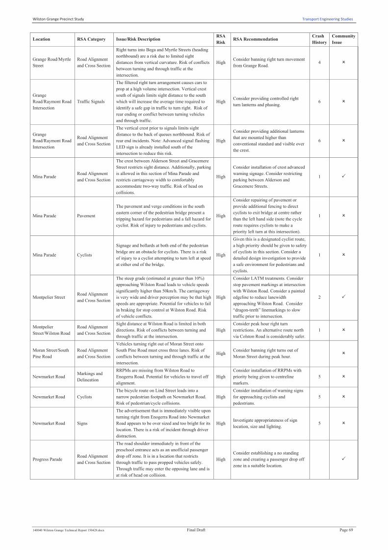
140040 Wilston Grange Technical Report 150428.docx Final Draft Page 69
Location RSA Category Issue/Risk Description RSA
Risk RSA Recommendation
Crash
History
Community
Issue
Grange Road/Myrtle
Street
Road Alignment
and Cross Section
Right turns into Bega and Myrtle Streets (heading
northbound) are a risk due to limited sight
distances from vertical curvature. Risk of conflicts
between turning and through traffic at the
intersection.
High Consider banning right turn movement
from Grange Road. 4 O
Grange
Road/Raymont Road
Intersection
Traffic Signals
The filtered right turn arrangement causes cars to
prop at a high volume intersection. Vertical crest
south of signals limits sight distance to the south
which will increase the average time required to
identify a safe gap in traffic to turn right. Risk of
rear ending or conflict between turning vehicles
and through traffic.
High Consider providing controlled right
turn lanterns and phasing. 6 O
Grange
Road/Raymont Road
Intersection
Road Alignment
and Cross Section
The vertical crest prior to signals limits sight
distance to the back of queues northbound. Risk of
rear end incidents. Note: Advanced signal flashing
LED sign is already installed south of the
intersection to reduce this risk.
High
Consider providing additional lanterns
that are mounted higher than
conventional standard and visible over
the crest.
6 O
Mina Parade Road Alignment
and Cross Section
The crest between Alderson Street and Gracemere
Street restricts sight distance. Additionally, parking
is allowed in this section of Mina Parade and
restricts carriageway width to comfortably
accommodate two-way traffic. Risk of head on
collisions.
High
Consider installation of crest advanced
warning signage. Consider restricting
parking between Alderson and
Gracemere Streets.
1 P
Mina Parade Pavement
The pavement and verge conditions in the south
eastern corner of the pedestrian bridge present a
tripping hazard for pedestrians and a fall hazard for
cyclist. Risk of injury to pedestrians and cyclists.
High
Consider repairing of pavement or
provide additional fencing to direct
cyclists to exit bridge at centre rather
than the left hand side (note the cycle
route requires cyclists to make a
priority left turn at this intersection).
1 O
Mina Parade Cyclists
Signage and bollards at both end of the pedestrian
bridge are an obstacle for cyclists. There is a risk
of injury to a cyclist attempting to turn left at speed
at either end of the bridge.
High
Given this is a designated cyclist route,
a high priority should be given to safety
of cyclists in this section. Consider a
detailed design investigation to provide
a safe environment for pedestrians and
cyclists.
1 O
Montpelier Street Road Alignment
and Cross Section
The steep grade (estimated at greater than 10%)
approaching Wilston Road leads to vehicle speeds
significantly higher than 50km/h. The carriageway
is very wide and driver perception may be that high
speeds are appropriate. Potential for vehicles to fail
in braking for stop control at Wilston Road. Risk
of vehicle conflicts.
High
Consider LATM treatments. Consider
stop pavement markings at intersection
with Wilston Road. Consider a painted
edgeline to reduce lanewidth
approaching Wilston Road. Consider
“dragon-teeth” linemarkings to slow
traffic prior to intersection.
2 P
Montpelier
Street/Wilston Road
Road Alignment
and Cross Section
Sight distance at Wilston Road is limited in both
directions. Risk of conflicts between turning and
through traffic at the intersection.
High
Consider peak hour right turn
restrictions. An alternative route north
via Colston Road is considerably safer.
1 O
Moran Street/South
Pine Road
Road Alignment
and Cross Section
Vehicles turning right out of Moran Street onto
South Pine Road must cross three lanes. Risk of
conflicts between turning and through traffic at the
intersection.
High Consider banning right turns out of
Moran Street during peak hour. O
Newmarket Road Markings and
Delineation
RRPMs are missing from Wilston Road to
Enogerra Road. Potential for vehicles to travel off
alignment.
High
Consider installation of RRPMs with
priority being given to centreline
markers.
5 O
Newmarket Road Cyclists
The bicycle route on Lind Street leads into a
narrow pedestrian footpath on Newmarket Road.
Risk of pedestrian/cycle collisions.
High
Consider installation of warning signs
for approaching cyclists and
pedestrians.
5 O
Newmarket Road Signs
The advertisement that is immediately visible upon
turning right from Enogerra Road into Newmarket
Road appears to be over sized and too bright for its
location. There is a risk of incident through driver
distraction.
High Investigate appropriateness of sign
location, size and lighting. 5 O
Progress Parade Road Alignment
and Cross Section
The road shoulder immediately in front of the
preschool entrance acts as an unofficial passenger
drop off zone. It is in a location that restricts
through traffic to pass propped vehicles safely.
Through traffic may enter the opposing lane and is
at risk of head on collision.
High
Consider establishing a no standing
zone and creating a passenger drop off
zone in a suitable location.
P

Wilston Grange Precinct Study Transport Engineering Studies
140040 Wilston Grange Technical Report 150428.docx Final Draft Page 70
Location RSA Category Issue/Risk Description RSA
Risk RSA Recommendation
Crash
History
Community
Issue
Progress
Parade/Andrew
Street
Road Alignment
and Cross Section
Access to Andrew Street is at an extremely high
angle that does limit sight distance to the west
when exiting. This high angle also makes it very
difficult for vehicles to turn left, or u-turn in this
case, without encroaching opposing lanes. Sight
distance to the east is limited due to the horizontal
curvature of Progress Parade. There is a high risk
for side swiping and head on incidents.
High
Consider banning left turns out of
Andrew Street. Consider providing a
convex driveway mirror to allow
exiting vehicles to identify approaching
traffic.
O
Raymont
Road/Billington
Street
Road Alignment
and Cross Section
Sight distance to the east at the Billington Street
intersection is limited. On-street parking
contributes to this limitation. Risk of conflict
between turning and through traffic at the
intersection.
High Consider restriction of right turn
movements from Billington Street. O
Raymont
Road/Blandford
Street
Crash Barriers
and Clear Zones
The steel ARMCO barrier at Blandford Street
needs a standard end treatment and does not appear
to serve any purpose. Increased risk of injury
severity due to spear hazard.
High Consider removing barrier.
O
Raymont
Road/Plymouth
Street
Crash Barriers
and Clear Zones
The steel ARMCO barrier at Plymouth Street
needs a standard end treatment and shows evidence
of striking. Increased risk of injury severity due to
spear hazard.
High
Consider replacing barrier with one of a
suitable standard or retrofitting of a
new end treatment.
O
Raymont
Road/Royal Parade
Road Alignment
and Cross Section
Sight distance at both legs of Royal Street is
limited due to vegetation within the verge. Risk of
conflicts between turning and through traffic at the
intersection.
High
Consider vegetation clearing to
improve sight distance at the
intersection.
2 O
Raymont
Road/Royal Parade
Markings and
Delineation
The westbound carriageway width at the
intersection of Raymont Road/Royal Parade is too
narrow for traffic to safely pass turning traffic at
speed (which are high due to the downgrade
section of road). There is risk of vehicle conflicts
between Raymont Road through traffic and
vehicles propped at Royal Parade. A near miss
incident was observed during the site inspection.
High
Consider reconfiguration of
linemarking at the intersection to
incorporate a wider linemarked median
to visually reduce the carriageway
width to deter drivers from attempting
to pass right turning vehicles at
speed. Alternatively, consider whether
a right turn lane can be provided in the
carriageway width available.
2 O
Raymont
Road/Royal Parade Lighting
Street lighting at the Royal Parade pedestrian
refuge limits visibility of crossing pedestrians at
night time. Increased risk of injury to pedestrians.
High Consider investigation of lighting
conditions and potential improvements. 2 O
Raymont
Road/Welbeck Street
Road Alignment
and Cross Section
Sight distance looking west from Welbeck Street
intersection is limited due to vertical crest. Risk of
conflicts between turning and through traffic at the
intersection.
High Consider an advanced side street
warning sign on Raymont Road. O
Raymont
Road/Welbeck Street
Road Alignment
and Cross Section
Sight distance westbound towards Welbeck Street
is limited due to vertical crest. The presence of on-
street parking and driveways on the descending
side of the crest is restricted. Risk of conflict
between through traffic and vehicles
entering/exiting the carriageway. Risk of
pedestrian collisions and cyclist "dooring"
incidents. Crashes have been recorded at this
location.
High
Consider implementing parking
restrictions and erecting "concealed
driveways" warning signage prior to the
crest.
P
Raymont
Road/Welbeck Street Signs
Westbound grade, after vertical crest at Welbeck
Street, encourages high speeds downgrade. Risk of
vehicles travelling at speeds inappropriate for the
road environment.
High
Consider repeating speed signs and
linemarking treatments or speed control
devices that reduce perceived
carriageway width.
P
Robe Street/Days
Road
Road Alignment
and Cross Section
Sight distance at the Days Road intersection is
limited in both directions. Risk of conflicts
between turning and through traffic at the
intersection.
High
Consider banning right turn from
southern leg of intersection and
trimming vegetation around
intersection.
1 O
Southerden
Avenue/Days Road
Road Alignment
and Cross Section
Sight distance at Days Road is limited. Risk of
conflict between turning and through traffic at the
intersection.
High Consider restriction of right turns at
this intersection. 1 O
Ward Street Signs
No advisory speed sign present before sharp right
turn into Erneton Street. Wheel scuff marks on the
median island suggest that vehicles travel through
the corner at speeds higher than appropriate for the
geometry.
High
Consider installation of curve advisory
signage prior to Erneton Street.
Consider parking restrictions on
Erneton Street near Ward Street.
O
Waterford/Wakefield
Street
Crash Barriers
and Clear Zones
The barrier end treatments used within the
Wakefield Street median are a potential spear
hazard and need to be upgraded. Risk of increased
injury severity due to spear hazard.
High Consider replacement of end
treatments. O

Wilston Grange Precinct Study Transport Engineering Studies
140040 Wilston Grange Technical Report 150428.docx Final Draft Page 71
Location RSA Category Issue/Risk Description RSA
Risk RSA Recommendation
Crash
History
Community
Issue
Wickham Street Signs
The T intersection advanced warning sign on
approach to Ward Street needs to be amended to
suit the existing road arrangements. The existing
arrangements prioritise a sharp turn into the
northern leg of Ward Street. The southern leg of
Ward Street gives way. There is a risk of rear end
incidents as drivers may be expecting to come to a
full stop after the vertical crest at North Street.
High
Consider replacement of T intersection
warning sign with curve advisory
warning sign.
O
Wilston Rd /
Newmarket Rd Traffic Signals
The right turn from Newmarket Road into Wilston
Road is a filtered right turn through tight geometry.
This is a high risk for rear end incidents as well as
a risk of through-right turn crashes due to the high
volume of traffic on Newmarket Road.
High
Consider changing phasing
arrangements to allow for a right turn
phase or reconfiguration of the
intersection for a protected right turn.
16 O
Wilston Road Markings and
Delineation
The old pedestrian crossing near Newmarket train
station is reappearing and is clearly visible at all
times. There is potential for pedestrians assuming
that the crossing is active and thus a risk of
pedestrian/vehicle collision.
High Consider removal of redundant
pedestrian crossing by water blasting. 2 P
Wilston Road Parking
No standing signs are designated for 7am to 6pm.
Cars parked on Wilston Road outside these hours
will restrict carriageway width and only allow one
direction of traffic through causing potential for
head on incidents.
High Consider establishing no standing
arrangements at all times of day. 2 O
Wilston Road Pedestrians
Wheelie bins were observed on the narrow
footpath (approximately 1m wide) and obstructing
pedestrian movements which are high due to the
road being a main thoroughfare for train station
passengers. Pedestrians at risk of vehicle collision
when forced to walk off the path onto the road.
High
Consider alternative refuse collection
arrangements. Consider increasing
warning signs for pedestrians. Consider
reducing posted speed of road due to
high volume of pedestrians during peak
hour.
2 P
Wilston Road Crash Barriers
and Clear Zones
The median barrier between Newmarket Road and
Erneton Street does appear to be at an appropriate
height to prevent vehicles from falling into the
opposing lane. Increased risk of injury severity.
High Investigate barrier height and
specifications. 2 O
Wilston Road/Daisy
Street
Road Alignment
and Cross Section
Left turn access to and from Wilston Road has
limited linemarking to indicate priorities and is
confusing. Presence of the median island seems to
suggest that access is not allowed. Potential for
rear end incidents for vehicles accessing Daisy
Street from Wilson Road.
High
Consider extending median prevent
vehicle movements to and from
Wilston Road. Consider upgrading the
intersection in the long term to either
eliminate west and north legs or
provide a signalised intersection.
P
Wilston Road/Daisy
Street Signs
Chevron alignment markers (CAMs) located on the
median strip are ambiguous and can be viewed as
directing vehicles in the incorrect direction
(eastbound direction). The bilateral marker used in
the median is incorrect for its intended purpose.
High
Consider redesign of geometric
arrangements and signage to improve
clarity of permitted movements for all
approaches.
O
Wilston Road/Mina
Parade
Road Alignment
and Cross Section
Limited sight distance looking to the north at
Mina/Wilston. There is an increased risk of angle
crashes associated with drivers being unable to see
southbound traffic on Wilston Road. This may be
improved by relocating the median island on Mina
Parade further south to increase sight distance for
drivers.
High
Consider relocating median
south. Consider recommendation
below regarding signals.
3 P
Wilston Road/Mina
Parade Miscellaneous
A high number of right turning vehicles were
observed during peak hours from Mina Parade to
Wilston Road. Due to the high volume of traffic on
Wilston Road and the limited sight distance
looking north and south, as well as the four leg
intersection, drivers on Mina Parade are likely to
attempt to turn with shorter gaps in traffic than
would be considered safe for an unsignalised
intersection. There is increased risk of angle
crashes due to the volume of traffic and restricted
sight distances at the intersection.
High
Consider a dual signalised intersection
which coordinates the Murrell/Wilston
Road and Mina Parade/Wilston Road/
Abuklea Road intersections.
3 P
Wilston
Road/Murrell Street
Road Alignment
and Cross Section
Sight distance to the north at the Murrell/Wilston
Road intersection is limited. Risk of conflict
between turning and through traffic at the
intersection.
High
Consider restriction of right turns from
Murrell Street (i.e. altogether or during
peak periods only).
3 P
Wilston Grange Precinct Study Transport Engineering Studies
140040 Wilston Grange Technical Report 150428.docx Final Draft Page 72
Location RSA Category Issue/Risk Description RSA
Risk RSA Recommendation
Crash
History
Community
Issue
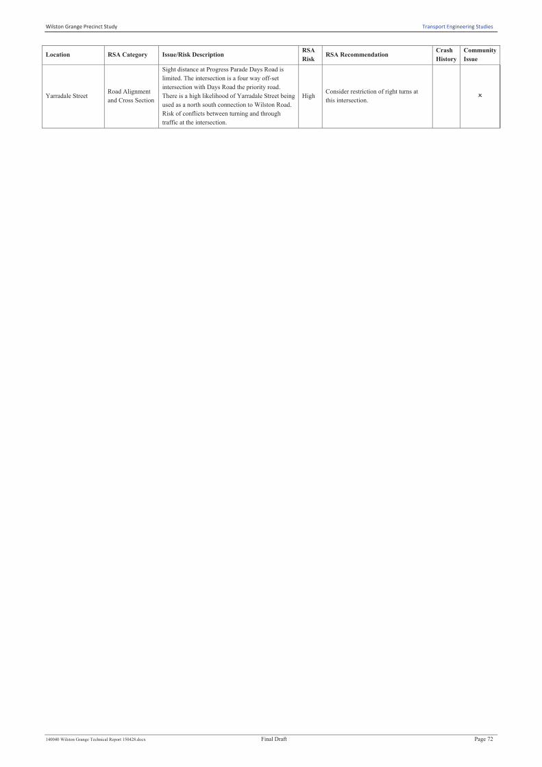
Yarradale Street Road Alignment
and Cross Section
Sight distance at Progress Parade Days Road is
limited. The intersection is a four way off-set
intersection with Days Road the priority road.
There is a high likelihood of Yarradale Street being
used as a north south connection to Wilston Road.
Risk of conflicts between turning and through
traffic at the intersection.
High Consider restriction of right turns at
this intersection. O

Wilston Grange Precinct Study Transport Engineering Studies
140040 Wilston Grange Technical Report 150428.docx Final Draft Page 73
6.5.4 Road Safety Audit : Sub – Area 2
While audit findings were recorded for each street/intersection, there were a number of road safety
issues that were identified by the auditors as repeatedly occurring precinct wide. These are
summarised below:
· Vegetation overhanging or encroaching within the carriageway;
· Faded/worn pavement markings;
· Narrow footpaths or limited of footpaths;
· Low hanging power lines which cross the carriageway;
· Inappropriate location of roadside furniture behind road kerb; and
Pedestrian network requires improvement. Audit findings, illustrated in Figure 6.9 and summarised in
Table 6.15 indicates that the safety issues generally occur along major carrying roads including Days
Road, Maygar Street, Thistle Street, Bradshaw Street, Fuller Road and Gilbert Road. In addition to
road sections, the intersections of Days Road/Kedron Brook Road, Maygar Street/Brook Street,
Archer Street/Montrose Street, Khartoum Street/Thistle Street and Stafford Road/Alva Terrace were
identified as areas of concern.
Figure 6.9 : Sub-Area 2 : Audit Finding Locations
Wilston Grange Precinct Study Transport Engineering Studies
140040 Wilston Grange Technical Report 150428.docx Final Draft Page 74
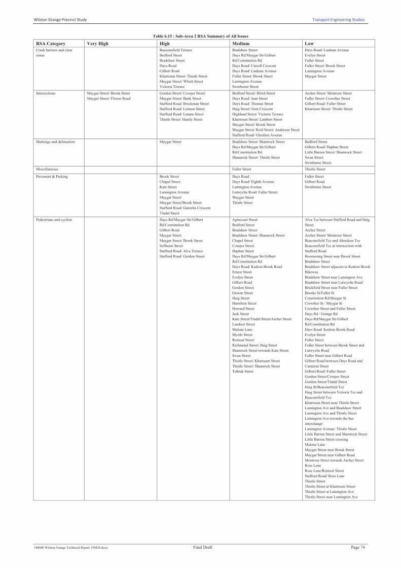
Table 6.15 : Sub-Area 2 RSA Summary of All Issues
RSA Category Very High High Medium Low
Crash barriers and clear
zones
Beaconsfield Terrace
Bedford Street
Bradshaw Street
Days Road
Gilbert Road
Khartoum Street/ Thistle Street
Maygar Street/ Whish Street
Victoria Terrace
Bradshaw Street
Days Rd/Maygar Str/Gilbert
Rd/Constitution Rd
Days Road/ Carroll Crescent
Days Road/ Lanham Avenue
Fuller Street/ Brook Street
Lamington Avenue
Swinburne Street
Days Road/ Lanham Avenue
Evelyn Street
Fuller Street
Fuller Street/ Brook Street
Lamington Avenue
Maygar Street
Intersections Maygar Street/ Brook Street
Maygar Street/ Flower Road
Gordon Street/ Cowper Street
Maygar Street/ Bank Street
Stafford Road/ Brockman Street
Stafford Road/ Lennon Street
Stafford Road/ Lutana Street
Thistle Street/ Huntly Street
Bedford Street/ Ilford Street
Days Road/ Jean Street
Days Road/ Thomas Street
Haig Street/ Gort Crescent
Highland Street/ Victoria Terrace
Khartoum Street/ Lambert Street
Maygar Street/ Brook Street
Maygar Street/ Reid Street/ Anderson Street
Stafford Road/ Glenfern Avenue
Archer Street/ Montrose Street
Fuller Street/ Crowther Street
Gilbert Road/ Fuller Street
Khartoum Street/ Thistle Street
Markings and delineation Maygar Street Bradshaw Street/ Shamrock Street
Days Rd/Maygar Str/Gilbert
Rd/Constitution Rd
Shamrock Street/ Thistle Street
Bedford Street
Gilbert Road/ Daphne Street
Little Barron Street/ Shamrock Street
Swan Street
Swinburne Street
Miscellaneous Fuller Street Thistle Street
Pavement & Parking Brook Street
Chapel Street
Kate Street
Lamington Avenue
Maygar Street
Maygar Street/Brook Street
Stafford Road/ Gamelin Crescent
Tindal Street
Days Road
Days Road/ Eighth Avenue
Lamington Avenue
Lutwyche Road/ Fuller Street
Maygar Street
Thistle Street
Fuller Street
Gilbert Road
Swinburne Street
Pedestrians and cyclists Days Rd/Maygar Str/Gilbert
Rd/Constitution Rd
Gilbert Road
Maygar Street
Maygar Street/ Brook Street
Sellheim Street
Stafford Road/ Alva Terrace
Stafford Road/ Gordon Street
Agincourt Street
Bedford Street
Bradshaw Street
Bradshaw Street/ Shamrock Street
Chapel Street
Cowper Street
Daphne Street
Days Rd/Maygar Str/Gilbert
Rd/Constitution Rd
Days Road/ Kedron Brook Road
Ernest Street
Evelyn Street
Gilbert Road
Gordon Street
Groom Street
Haig Street
Hamilton Street
Howard Street
Jack Street
Kate Street/Tindal Street/Archer Street
Lambert Street
Malone Lane
Myrtle Street
Rentoul Street
Richmond Street/ Haig Street
Shamrock Street towards Kate Street
Swan Street
Thistle Street/ Khartoum Street
Thistle Street/ Shamrock Street
Tobruk Street
Alva Tce between Stafford Road and Haig
Street
Archer Street
Archer Street/ Montrose Street
Beaconsfield Tce and Aberdeen Tce
Beaconsfield Tce at intersection with
Stafford Road
Boomerang Street near Brook Street
Bradshaw Street
Bradshaw Street adjacent to Kedron Brook
Bikeway
Bradshaw Street near Lamington Ave
Bradshaw Street near Lutwyche Road
Brickfield Street near Fuller Street
Brooks St/Fuller St
Constitution Rd/Maygar St
Crowther St / Maygar St
Crowther Street and Fuller Street
Days Rd / Grange Rd
Days Rd/Maygar Str/Gilbert
Rd/Constitution Rd
Days Road/ Kedron Brook Road
Evelyn Street
Fuller Street
Fuller Street between Brook Street and
Lutwyche Road
Fuller Street near Gilbert Road
Gilbert Road between Days Road and
Cameron Street
Gilbert Road/ Fuller Street
Gordon Street/Cowper Street
Gordon Street/Tindal Street
Haig St/Beaconsfield Tce
Haig Street between Victoria Tce and
Beaconsfield Tce
Khartoum Street near Thistle Street
Lamington Ave and Bradshaw Street
Lamington Ave and Thistle Street
Lamington Ave towards the bus
interchange
Lamington Avenue/ Thistle Street
Little Barron Street and Shamrock Street
Little Barron Street crossing
Malone Lane
Maygar Street near Brook Street
Maygar Street near Gilbert Road
Montrose Street towards Archer Street
Rose Lane
Rose Lane/Rentoul Street
Stafford Road/ Rose Lane
Thistle Street
Thistle Street at Khartoum Street
Thistle Street at Lamington Ave
Thistle Street near Lamington Ave

Wilston Grange Precinct Study Transport Engineering Studies
140040 Wilston Grange Technical Report 150428.docx Final Draft Page 75
RSA Category Very High High Medium Low
Road alignment and cross-
section
Brook Street
Fuller Road
Gilbert Road/ Maygar Street
Maygar Street
Maygar Street/Brook Street
Thistle Street
Bradshaw Street
Days Road
Khartoum Street/ Thistle Street
Lanham Avenue/ Howard Street
Maygar Street
Richmond Street/ Thistle Street
Stafford Road
Stafford Road/ Alva Terrace
Thistle Street
Archer Street
Archer Street/ Montrose Street
Bedford Street
Brook Street
Brook Street/Boomerang Street
Chapel Street
Daphne Street
Khartoum Street
Little Barron Street/ Shamrock Street
Maygar Street
Stafford Road/ Khartoum Street
Stafford Road/ Rose Lane
Thistle Street
Wesley Street
Signs and lighting Bradshaw Street
Lutwyche Road/ Fuller Street
Shamrock Street
Stafford Road/ Richmond Street
Thistle Street
Aberdeen Tce/Bedford Street
Aberdeen Tce/Huntly Street
Beaconsfield Street/Cowper Street
Beaconsfield Tce/Aberdeen Tce
Brook Street/Bess Street
Brook Street/Boomerang Street
Brook Street/Spear Street
Brook Street/Wesley Street
Burnaby Tce/Haig Street
Days Road/ Jean Street
Days Road/ Thomas Street
Days Road/Inglis Street
Days Road/Uxbridge Street
Fuller Street/Brickfield Street
Fuller Street/Damon Road
Fuller Street/Tobruk Street
Gilbert Road/Cameron Street
Gordon Street/Hamilton Street
Gordon Street/Lambert Street
Gordon Street/Malone Lane
Gordon Street/Tindal Street
Haig Street/Gort Crescent
Highland Street/Beaconsfield Street
Jean Street/Evelyn Street
Kate Street/Groom Street
Lamington Ave/McGregor Ave
Lamington Avenue/ Bradshaw Street
Maygar Street/ Bank Street
Maygar Street/Laneway to Crowther Street
Maygar Street/McKenzie Street
Rose Lane/Rentoul Street
Sellheim Street
Shamrock Street
Shamrock Street/Johnston Street
Shamrock Street/Piper Street
Swan Street/Goulburn Street
Swan Street/Rentoul Street
Swan Street/Tyson Treet
Swinbourne Street/Laneway to Reid Lane
Swinbourne Street/Sears Street
Thistle Street
Thistle Street/Huntly Street
Thistle Street/Lucas Street
Tindal Street/Montgomery Street
Victoria Tce/Haig Street
Victoria Tce/Highland Street
Wesley Street/Ernest Street
Wesley Street/Sears Street
Wesley Street/Tobruk Street
Days Road
Lanham Avenue/ Evelyn Street
Sellheim Street/ Jean Street
Thistle Street
Traffic signals Stafford Road/ Richmond Street Days Road/ Lanham Avenue
Wilston Grange Precinct Study Transport Engineering Studies
140040 Wilston Grange Technical Report 150428.docx Final Draft Page 76
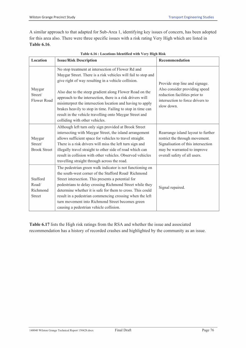
A similar approach to that adapted for Sub-Area 1, identifying key issues of concern, has been adopted
for this area also. There were three specific issues with a risk rating Very High which are listed in
Table 6.16.
Table 6.16 : Locations Identified with Very High Risk
Location Issue/Risk Description Recommendation
Maygar
Street/
Flower Road
No stop treatment at intersection of Flower Rd and
Maygar Street. There is a risk vehicles will fail to stop and
give right of way resulting in a vehicle collision.
Also due to the steep gradient along Flower Road on the
approach to the intersection, there is a risk drivers will
misinterpret the intersection location and having to apply
brakes heavily to stop in time. Failing to stop in time can
result in the vehicle travelling onto Maygar Street and
colliding with other vehicles.
Provide stop line and signage.
Also consider providing speed
reduction facilities prior to
intersection to force drivers to
slow down.
Maygar
Street/
Brook Street
Although left turn only sign provided at Brook Street
intersecting with Maygar Street, the island arrangement
allows sufficient space for vehicles to travel straight.
There is a risk drivers will miss the left turn sign and
illegally travel straight to other side of road which can
result in collision with other vehicles. Observed vehicles
travelling straight through across the road.
Rearrange island layout to further
restrict the through movement.
Signalisation of this intersection
may be warranted to improve
overall safety of all users.
Stafford
Road/
Richmond
Street
The pedestrian green walk indicator is not functioning on
the south-west corner of the Stafford Road/ Richmond
Street intersection. This presents a potential for
pedestrians to delay crossing Richmond Street while they
determine whether it is safe for them to cross. This could
result in a pedestrian commencing crossing when the left
turn movement into Richmond Street becomes green
causing a pedestrian vehicle collision.
Signal repaired.
Table 6.17 lists the High risk ratings from the RSA and whether the issue and associated
recommendation has a history of recorded crashes and highlighted by the community as an issue.

Wilston Grange Precinct Study Transport Engineering Studies
140040 Wilston Grange Technical Report 150428.docx Final Draft Page 77
Table 6.17 : Key Road Network Related Audit Concerns : Sub-Area 2
LOCATION RSA CATEGORY DESCRIPTION RSA
RISK RSA RECOMMENDATION
Crash
History
Community
Issue
Beaconsfield Terrace Crash barriers and
clear zones
Railing with a height of approximately 1m is
installed along the centre of Beaconsfield
Terrace. There is no crash barrier installed at
either end of the railings. This creates an
impaling risk if a vehicle were to collide with
the railing.
High Consider removing the fence railing or
installing a crash barrier treatment. 1 O
Bedford Street Crash barriers and
clear zones
A railing with a height of approximately 1m is
installed along the centre of Bedford Street.
There is no crash barrier installed at either end
of the railing. This creates an impaling risk if a
vehicle were to collide with the railing.
High Consider removing the fence railing or
installing a crash barrier treatment. O
Bradshaw Street Crash barriers and
clear zones
No barrier end treatment provided for approach
to bridge. There is a risk vehicles can have a
head on collision with the end of the railing and
travel over the abutment and bridge.
High Consider installation of barrier
treatment on bridge approach. 1 O
Bradshaw Street Signs and lighting
Sight to bike crossing refuge island advisory
sign on Bradshaw Street blocked by overgrown
trees. There is a risk drivers will not be aware
of the refuge island ahead which could result
with a collision with a cyclist and or pedestrian.
High
Consider tree maintenance to remove
overhanging tree branches to improve
sight to signage or alternatively relocate
signage to be located before the tree
1 O
Bradshaw Street Crash barriers and
clear zones
Bridge approach barrier treatment on Bradshaw
Street is only protecting the tree behind and not
protecting the bridge railing end. There is a risk
that the barrier will deflect the vehicle during a
collision into the end of the railing. Observed
barrier not bolted to vertical support and loose.
High Provide appropriate bridge approach
barrier treatment 1 O
Brook Street Road alignment and
cross-section
The very sharp crest on Brook Street has
limited warning with the road environment
conducive to reasonable high speeds over the
crest. There is a risk of crashes occurring due to
limited sight distance available to driveways or
on road obstacles beyond the crest.
High
Consider installing advisory speed
reduction signage. Consider installing
traffic calming measures to force
drivers to slow significantly through
this section.
O
Brook Street Pavement, Parking
Vehicles parked along Brook Street near the
intersection of Spear Street greatly reduce the
sight distance for vehicles travelling along
Brook Street to see vehicles travelling out from
Spear Street. There is an increased risk of
vehicle to vehicle collisions.
High
Consider providing yellow line marking
to provide no parking zone in vicinity of
intersection to provide clear sight
distance from Brook Street to Spear
Street.
O
Chapel Street Pavement, Parking
Vehicles parked along Chapel Street block the
sight distance available over the crest for
vehicles to safely pass the parked vehicle. There
is a risk of a head on collision with oncoming
vehicles.
High Provide yellow line to delineate no
parking zone to increase sight distance 1 O
Days Rd/Maygar
Str/Gilbert
Rd/Constitution Rd
Pedestrians and
cyclists
The zebra crossing at Days Rd / Maygar St
roundabout is close to the intersection which
caters for relatively high flow of traffic
movements. There is a risk of drivers failing to
see pedestrians on the crossing until late due to
being distracted by negotiating the busy
roundabout, resulting in a pedestrian being
struck at the crossing. There is a secondary risk
of rear end collisions on the roundabouts as
drivers brake suddenly to give way to
pedestrians on the crossing.
High
Consider relocating the crossing to be
further away from the roundabout and
increase visual awareness of the
crossing.
O
Days Road Crash barriers and
clear zones
There are numerous trees directly behind kerb
on Days Road on the westbound approach to
Grange Road intersection. There is a risk of the
trees being impacted by traffic on Days Road,
particularly by tall vehicles.
High
Consider tree maintenance to remove
overhanging trees/branches over the
road
3 O
Fuller Street Road alignment and
cross-section
Driveway access along Fuller Road located
10m from Lutwyche Road exiting the petrol
station allows vehicles to turn right to travel
onto Lutwyche Road. There is a risk vehicles
from Lutwyche Road turning into Fuller Street
will collide with those vehicles exiting the
petrol station. Observed vehicles exiting petrol
station and turning right.
High Consider closure of driveway from
petrol station. 1 O

Wilston Grange Precinct Study Transport Engineering Studies
140040 Wilston Grange Technical Report 150428.docx Final Draft Page 78
LOCATION RSA CATEGORY DESCRIPTION RSA
RISK RSA RECOMMENDATION
Crash
History
Community
Issue
Gilbert Road Pedestrians and
cyclists
Inconsistent use of barrier and fencing
treatment along Gilbert Road along bridge over
Kedron Brook Bikeway. There is a risk that
pedestrians can trip and fall over these barriers
which can result in serious injury.
High
Consider replacing barrier with full
height fence or barrier to reduce risk of
pedestrians falling over edge.
1 O
Gilbert Road Crash barriers and
clear zones
Bridge approach end treatment located on the
approach to the bridge over Kedron Brook
Bikeway along Gilbert Road is not flared at the
correct angle. There is a risk vehicles can
collide with the end and travel over the
abutment.
High
Consider providing a new alignment of
barrier to be compliant for bridge
approaches.
1 O
Gilbert Road/
Maygar Street
Road alignment and
cross-section
The shop on the corner of Gilbert Road and
Maygar Street has a driveway very close to the
roundabout departure leg, with limited
visibility. Traffic using the driveway is also
required to reverse out into the roundabout to
exit the driveway. There is a risk of crash
occurring as drivers exit the driveway.
High
Consider removing this driveway and
limit property access to the existing
Gilbert Road driveway.
P
Gordon Street/
Cowper Street Intersections
It is difficult at night to see the give way signs
and lines on the southbound approach to the
Gordon Street/Cowper Street intersection. The
pavement markings are hidden by a slight dip in
the road and the give way warning and give
way signs are obscured. Drivers may fail to
perceive the intersection and priority until it is
too late to effectively give way, leading to a
crash with an adjacent vehicle.
High
Trim vegetation that is obscuring the
give way sign. Consider installing
splitter islands at the intersection to
increase driver awareness of the
intersection.
O
Kate Street Pavement, Parking
Vehicles are allowed to park around tight curve
located along Kate Street travelling around to
Shamrock Street. A parked vehicle in this
location will reduce the lane width and there is
a risk that drivers will travel beyond their lane
around the tight curve with limited sight
distance and collide with oncoming traffic in
the opposite direction.
High
Consider adding yellow solid lane
marking to delineate no parking zone
around tight curve.
O
Khartoum Street/
Thistle Street
Crash barriers and
clear zones
The power pole located on the corner of
Khartoum Street and Thistle Street is very close
to the road edge. There is a risk for vehicles to
collide with the pole whilst travelling around
the tight curve.
High
Consider relocating the road furniture to
increase the setback distance from the
kerb; or shoulder lane lines/kerb
buildouts to create a separation between
the kerb & travel lane; or provide
reflective sheeting/markers on poles to
increase drivers awareness of pole
locations; or installing advisory signage
prior; or additional lighting.
O
Lamington Avenue Pavement, Parking
On Lamington Ave at the approach to
Bradshaw Street, parking is allowed near the
intersection. There is risk vehicles will collide
with pedestrians who divert around parked cars
to cross the road. Visibility to pedestrian is also
restricted by parked vehicles. Vehicles also
park across the access ramps.
High Consider adding yellow line marking to
delineate no parking zone. O
Lutwyche Road/
Fuller Street Signs and lighting
There is no signage in the centre median at the
intersection of Fuller Street and Lutwyche Road
to advise drives of left turn only onto Lutwyche
Road. There is a risk drivers are unaware that
right turn is banned and try to cross over the
road which can result in a head on collision
with the traffic on Lutwyche Road.
High
Consider installation of left turn only
sign in centre median to help highlight
turning restriction.
8 O
Maygar Street Pavement, Parking
Bus zone along Maygar Street is insufficient
length. There is a risk where vehicles are
parked just before the bus zone, the bus doesn’t
have sufficient space to turn into the bay
leaving the rear end of the bus projecting into
the through traffic lane. This can result in a
vehicle colliding with the bus due to the limited
space available.
Observed bus pull in and rear end of bus
extending into the traffic lane
High
Consider increasing the length of the
bus zone to enable buses to stop fully
within the bay
3 O

Wilston Grange Precinct Study Transport Engineering Studies
140040 Wilston Grange Technical Report 150428.docx Final Draft Page 79
LOCATION RSA CATEGORY DESCRIPTION RSA
RISK RSA RECOMMENDATION
Crash
History
Community
Issue
Maygar Street Pavement, Parking
Parked vehicles along Maygar Street near
Brook Street restrict sight distance available for
vehicles leaving driveways. There is a risk
vehicles will reverse into oncoming traffic
resulting in a collision.
High
Provide yellow line to delineate no
parking zone along Maygar Street to
improve sight distance
3 O
Maygar Street Pavement, Parking
Parking is currently allowed at the apex of tight
corners on Maygar Street. This limits the lane
width available at the tight horizontal curves
and appears to make the curves more severe.
There is an increased risk of crash due to the
presence of parked cars at the tight corners.
High
Consider restricting on street parking at
the inside of tight curves along Maygar
Street to increase visibility and overall
safety.
3 O
Maygar Street Pedestrians and
cyclists
There are limited pedestrian connections to
cross Maygar Street to access the bus stops and
shops from the opposite side of the road. The
road carries high traffic numbers and sight
distance for pedestrians is limited by the
geometry. There is a risk of a pedestrian being
struck while attempting to cross the road
(particularly difficult between Reid Street and
Brook street).
High
Consider solutions for improving the
safety of pedestrian access near bus
stops, particularly between Reid St and
Brook St.
3 O
Maygar Street Road alignment and
cross-section
The length of Maygar Street (from Constitution
Road to Lutwyche Road) comprises tight
horizontal and vertical geometry. This
significantly reduces sight distances available
for entering traffic from driveways and side
roads. The observed speeds through this section
were significantly higher than the posted
40km/hr advisory speed. There is an increased
risk of crashes occurring through this section
due to the geometry, combined with high traffic
numbers.
High
Consider reviewing speed and sight
distance and identify solutions to
improve safety with regard to the
function of Maygar St in the road
hierarchy.
3 O
Maygar Street Markings and
delineation
The centre line markings on Maygar Street,
particularly through the curves, are worn and
difficult to see at night. Drivers may stray onto
the wrong side of the road, causing the potential
for head-on collisions.
High
Re-new the centreline markings and
consider the installation of additional
RRPMs to increase delineation of the
road
3 O
Maygar Street/ Bank
Street Intersections
The sight distance to eastbound traffic on
Maygar Street from the Bank Street intersection
is very limited by the horizontal and vertical
geometry. There is an increased risk of crash
occurring as entering traffic fails to effectively
give way to through traffic.
High
Consider turning restrictions at the
Bank Street intersection to allow left in
– left out only.
O
Maygar Street/
Whish Street
Crash barriers and
clear zones
There is a power pole at the bend of Maygar
Street / Whish Street intersection which is
directly behind kerb on the inside of a tight
bend. There is an increased risk of impact to the
pole, which is located in a vulnerable position.
High
Consider treatments to slow drivers
through this section and highlight the
road geometry. Treatments could
consist of a combination of signage, line
marking and median build out
treatments.
O
Maygar Street/Brook
Street
Pedestrians and
cyclists
There are limited positions for pedestrians to
safely cross Maygar Street near Brook Street.
There is a risk pedestrians will cross at a
location with limited visibility and increase
their risk of being struck by a vehicle.
High
Consider installation of refuge island at
a suitable mid-block location.
Signalisation of this intersection may be
warranted to improve overall safety for
pedestrians.
1 P
Maygar Street/Brook
Street
Pedestrians and
cyclists
Very difficult to see oncoming vehicles for
pedestrians trying to cross the road to access the
bus stop on the other side at Maygar Street and
Brook Street intersection. There is a risk
pedestrians will not be able to see oncoming
vehicles while crossing and potentially be
struck by a vehicle.
High
Consider installation of refuge island at
a suitable mid-block location.
Signalisation of this intersection may be
warranted to improve overall safety for
pedestrians.
1 P
Maygar Street/Brook
Street
Road alignment and
cross-section
Due to the crest prior to Brook Street along
Maygar Street, there is a risk drivers will not be
able to sight a stopped vehicle wanting to turn
right into Brook Street resulting in a rear end
collision due to limited stopping time for the
speed environment.
High Consider providing a line marked right
turn pocket 1 P

Wilston Grange Precinct Study Transport Engineering Studies
140040 Wilston Grange Technical Report 150428.docx Final Draft Page 80
LOCATION RSA CATEGORY DESCRIPTION RSA
RISK RSA RECOMMENDATION
Crash
History
Community
Issue
Maygar Street/Brook
Street Pavement, Parking
Currently parking is not restricted in the marked
shoulder next to the embankment along Maygar
Street near Brook Street. There is a risk
vehicles will park in the location and cause
pedestrians to walk along the road creating a
potential conflict with passing vehicles.
High
Consider providing pathway next to
shoulder to allow access to parked
vehicles or alternatively provide no
parking zone along shoulder.
1 O
Sellheim Street Pedestrians and
cyclists
The crossing point of the shared user path
across Sellheim Street is often obscured by
parked vehicles. Pedestrians or cyclists may fail
to effectively give way to opposing vehicles.
High
Consider increasing the length of
restricted parking on each side of the
crossing point; consider installing kerb
build-outs.
1 O
Shamrock Street Signs and lighting
Overhanging tree branches blocking sight to
guide posts and directional signage around the
tight curve along Shamrock Street travelling
towards Kate Street. There is a risk that drivers
will not be aware of the tight curve until the last
minute and travel straight resulting in the
vehicle travelling into the park and then over
the embankment.
High
Consider undertaking tree maintenance
to remove overhanging branches and
installing of CAMs in lieu of directional
signage and guide posts to provide
increased awareness to drivers
O
Stafford Road/ Alva
Terrace
Pedestrians and
cyclists
Pedestrian sight distance at the intersection of
Stafford Road and Alva Street is limited by
roadside furniture and terrain. This increases
the risk of a vehicle-pedestrian collision hazard.
High
Consider providing a pedestrian
crossing on Alva Street, away from the
intersection to encourage pedestrians to
cross at a safer location.
O
Stafford Road/
Brockman Street Intersections
At the intersection of Stafford Road and
Brockman Street, there is no protected right
turn into Brockman Street. Stafford Road
carries a relatively high volume of traffic in an
urban speed environment There is an increased
risk of rear-end vehicle collisions with vehicles
stopped to turn tight from the through lane.
High
Consider prohibiting the right turn into
Brockman Street and separate via a
raised central median, alternatively
provide a protected turn pocket as part
of any upgrade works.
1 O
Stafford Road/
Gamelin Crescent Pavement, Parking
There is reverse parking along Stafford Road at
the corner of Stafford Road and Gamelin
Crescent. Stafford Road carries high traffic
flows in an urban speed environment. There is a
risk of rear-end collisions with vehicles
stopping and reversing into parking bays.
High
Consider revising the southern verge to
incorporate these bays into a combined
off-street parking arrangement to reduce
the risk to drivers accessing parking.
O
Stafford Road/
Gordon Street
Pedestrians and
cyclists
There is no easily accessible crossing point
within the immediate vicinity of the Stafford
Road/ Gordon Street intersection with
signalised crossings provided approximately
350m to the east and 250m to the west. A bus
stop is located on the north side of Stafford
Road and a local store is located on the south
side. It is likely pedestrians will attempt cross
Stafford Road at this location, which carries
relatively high traffic volumes and has a very
narrow median. There is an increased risk of
pedestrian/vehicle collision.
High
Consider installation of a pedestrian
fence along the median strip with
signage directing pedestrians to use
signalised intersections to the east/west;
or alternatively, install a pedestrian
crossing point to provide increased
protection and mid crossing storage for
pedestrians.
O
Stafford Road/
Lennon Street Intersections
At the intersection of Stafford Road and
Lennon Street, there is no protected right turn
into Lennon Street. Stafford Road carries a
relatively high volume of traffic in an urban
speed environment There is an increased risk of
rear-end vehicle collisions occurring with
vehicles stopped to turn right from the through
lane.
High
Consider adjusting the signal phasing to
protect the right turn into Lennon Street.
Alternatively provide a protected turn
pocket as part of any upgrade works.
3 O
Stafford Road/
Lutana Street Intersections
At the intersection of Stafford Road and Lutana
Street, there is no protected right turn into
Lutana Street. Stafford Road carries a relatively
high volume of traffic in an urban speed
environment. There is an increased risk of rear-
end vehicle collisions with vehicles stopped to
turn tight from the through lane.
High
Consider prohibiting the right turn into
Lutana Street and separate via a raised
central median, alternatively provide a
protected turn pocket as part of any
upgrade works.
O
Stafford Road/
Richmond Street Signs and lighting
At the Stafford Road/ Richmond Street
intersection a driveway is located on the north
side of the intersection. Traffic leaving this
driveway is not able to observe traffic phases
for movements along Stafford, causing a risk of
vehicles leaving the driveway at an unsafe time
resulting in potential collision.
High Consider installing additional signal
heads visible to the driveway. 4 O

Wilston Grange Precinct Study Transport Engineering Studies
140040 Wilston Grange Technical Report 150428.docx Final Draft Page 81
LOCATION RSA CATEGORY DESCRIPTION RSA
RISK RSA RECOMMENDATION
Crash
History
Community
Issue
Thistle Street Road alignment and
cross-section
There is limited sight distance from the
driveway along Thistle Street approx. 15m from
Gordon street due to the proximity of the crest.
There is a risk vehicles travelling along Thistle
Street will be unable to sight a vehicle reversing
out of the driveway which can result in a rear
end collision.
High
Consider provide an advisory sign
advising drivers of concealed driveways
ahead along Thistle Street.
1 O
Thistle Street Signs and lighting
There is limited sight distance to the refuge
island warning sign for vehicles travelling along
Thistle Street towards Gordon Street. There is a
risk drivers will miss the sign and having to
break heavily once over the crest and possibly
colliding with a pedestrian crossing the road.
High
Consider undertaking tree maintenance
to remove offending branches to
improve sight distance sign or relocate
sign to be located prior to trees.
1 O
Thistle Street Road alignment and
cross-section
No cul-de-sac treatment provided to help
vehicles negotiate a U-turn. There is a risk
vehicles will not be able to do a proper U-turn
and be forced to do a 3 point turn. There is also
a risk that while vehicles are doing the 3 point
turn, a vehicle from Lutwyche Road will turn
into Thistle Street resulting in a vehicle
collision.
High
Consider installation of guidance
islands for U-Turn to help vehicles
navigate around at a safe angle.
1 O
Thistle Street Road alignment and
cross-section
There is very limited sight distance available to
the driveway located at the end of Thistle Street
towards Lutwyche Road for vehicles turning
into Thistle Street from Lutwyche Road. There
is a risk of a vehicle collision with vehicles
pulling out of the driveway.
High
Consider providing an advisory sign
prior to the turn advising drivers of a
concealed driveway ahead and removal
of planting and shrubs to increase the
sight distance available.
1 O
Thistle Street/Huntly
Street Intersections
Limited sight distance to vehicles stopping to
turn right into Huntly Street from Thistle Street.
There is a risk drivers will not be able to see a
stopped vehicle whilst travelling over the crest
located at the intersection of Montrose Street
and Thistle Street. This can result in a rear end
collision between vehicles.
High Consider banning right turn into Huntly
Street and provide no right turn sign. O
Tindal Street Pavement, Parking
Vehicles are allowed to park around tight curve
located along Tindal Street travelling around to
Kate Street. A parked vehicle in this location
will reduce the lane width and there is a risk
that drivers will travel beyond their lane around
the tight curve with limited sight distance and
collide with oncoming traffic in the opposite
direction.
High
Consider adding yellow solid lane
marking to delineate no parking zone
around tight curve.
O
Victoria Terrace Crash barriers and
clear zones
A railing with a height of approximately 1m is
installed along the centre of Victoria Terrace.
There is no crash barrier installed at either end
of the railing. This creates an impaling risk if a
vehicle were to collide with the railing. The
keep left sign is also located behind the railing
and back from the nose of the median, creating
a risk of drivers not observing the sign.
High
Consider removing the fence railing or
installing a crash barrier treatment; and
move the keep left sign in front of
roadside furniture.
O
Wilston Grange Precinct Study Transport Engineering Studies
140040 Wilston Grange Technical Report 150428.docx Final Draft Page 82
6.5.5 Road Safety Audit : Sub – Area 3
While audit findings were recorded for each street/intersection, there were a number of road safety
issues that were identified by the auditors as repeatedly occurring precinct wide. These are
summarised below:
· Vegetation overhanging or encroaching within the carriageway;
· Faded/worn pavement markings;
· Inappropriate location of roadside furniture behind road kerb;
· Need to improve pedestrian network.
Audit findings, summarised in Table 6.18, indicate that the safety issues generally occur along major
carrying roads including Newmarket Road, Kedron Brook Road, Montpelier Street and Lamont Street.
In addition to road sections, the intersections of Newmarket Road/Swan Road, Newmarket
Road/Victoria Street/Rosemount Terrace, Montpelier Street/Lansdowne Street, Lamont Street/Ruth
Street were identified as areas of concern.

Wil
sto
n G
ran
ge
Pre
cin
ct S
tud
y
Tra
nsp
ort
En
gin
ee
rin
g S
tud
ies
1400
40
Wil
sto
n G
rang
e T
ech
nic
al R
eport
1504
28
.do
cx
Fin
al D
raft
P
age
83
Fig
ure
6.1
0 :
Su
b-A
rea
3 :
Au
dit
Fin
din
g L
oca
tio
ns

Wilston Grange Precinct Study Transport Engineering Studies
140040 Wilston Grange Technical Report 150428.docx Final Draft Page 84
Table 6.18 : Sub-Area 3 RSA Summary of All Issues
RSA Category Very High High Medium Low
Bridges & Culverts Railway overpass - Lamont
Railway underpass - Kedron Brook
Railway overpass - Cox
Swan / Newmarket
Crash Barriers and Clear Zones Lamont Rd / Newmarket Rd Crane / Watson
Oakwal / Newmarket
Ray / Montpelier
Silvester St / Noble St/ Newmarket Rd
Vardon / Newmarket
Victoria / Rosemount / Newmarket
Antill / Kedron Brook
Crane / Watson
Dalrymple / Eighth
Flower / Palmer
Gaunt / Montpelier
General - Eildon Rd
General - Newmarket Road
General - Ruby Street
Granville / Newmarket
Heather / Vale
Hooker / Eildon
Lansdowne / Abuklea
Lansdowne / Montpelier
Olney / Lamont
Ruth / Lamont
Vale / Montpelier / Olney
Victoria / Northey
Watson / Montpelier
Markings & Delineation General - Newmarket Road
Ray / Montpelier
Victoria / Rosemount / Newmarket
Antill / Paling
Carberry / Inglis
Dover / Montpelier
Flower / Palmer
General - Brook Street
General - Parker Street
Granville / Newmarket
Green / Cox / Newmarket
Harris / Mackay
Homezone / Newmarket
Lansdowne / Montpelier
Oakwal / Newmarket
Olney / Lamont
Ruth / Lamont
Silvester / Eildon / Kedron Brook
Silvester St / Noble St/ Newmarket Rd
Swan / Newmarket
Vale / Montpelier / Olney
Victoria / Northey
Victoria / Rosemount / Newmarket
Miscellaneous Silvester St / Noble St/ Newmarket Rd General - Lansdowne Street
Homezone / Newmarket
Melvin / Vale
Stain / Fifth / Macgregor / Kedron Brook
Swan / Newmarket
Pavement & Parking Finsbury / Newmarket Gaunt / Abuklea
General - Harris Street
General - Vivienne Street
Granville / Noble
Newbery / Finsbury
Prospect / Abuklea
Pedestrians & Cyclists General - Parker Street Baradine / Edmondstone
General - Inglis Street
General - Montpelier Street
General - Newmarket Road
General - Northey Street
Green / Swan / Allom / Northey
Inglis / Montpelier
Kedron Brook Rd / Hawdon St
Lansdowne / Montpelier
Lincoln / Ada / Kedron Brook
Primrose / Thomas
Stain / Fifth / Macgregor / Kedron Brook
Swan / Newmarket
Finsbury / Newmarket
Gaunt / Abuklea
General - Harris Street
General - Jessop Street
General - Lamont Road
General - Lansdowne Street
Homezone / Newmarket
Kedron Brook Rd / Main Ave
Mars / Lamont
Montpelier / Watson
Railway overpass - Cox
Railway overpass - Lamont

Wilston Grange Precinct Study Transport Engineering Studies
140040 Wilston Grange Technical Report 150428.docx Final Draft Page 85
RSA Category Very High High Medium Low
Road Alignment & Cross Section Lamont Rd / Newmarket Rd
Victoria / Rosemount / Newmarket
Allom / Northey
Antill / Paling
Baradine / Edmondstone
Colston / Montpelier
Finsbury / Newmarket
Foster / Edmondstone
Gaunt / Montpelier
General - Inglis Street
General - Newmarket Road
General - Parker Street
Hooker / Constitution
Inglis / Montpelier
Kedron Brook Rd / Angliss St
Lansdowne / Montpelier
Lincoln / Ada / Kedron Brook
Murray / Newmarket
Olney / Kedron Brook
Primrose / Thomas
Ray / Montpelier
Swan / Newmarket
Victoria / Rosemount / Newmarket
York / Jeffrey / Kedron Brook
Abuklea / Lamont
Antill / Constitution
Antill / Paling
Arwin / Palmer
Arwin / Thorne
Brook / Jessop / Mackay / Constitution
Daisy / Thomas
Dalrymple / Eighth
Days / Carroll
Dover / Montpelier
Edmondstone / Murray
Eildon Rd / Cox St
Fifth / Silvester
Finsbury / Edmondstone
Foster / Edmondstone
Foster / Parker
General - Brook Street
General - Hooker Street
General - Jessop Street
General - Lansdowne Street
General - Lincoln Street
General - Macgregor Street
General - Main Avenue
General - Ruby Street
General - Watson Street
Graham / Constitution
Green / Cox / Newmarket
Hawdon / Constitution
Heather / Lamont
Katherine / Macgregor
Kelvin / Parker
Lansdowne / Abuklea
Laurel / Newmarket
Lincoln / Ada / Kedron Brook
Lovedale / Inglis
Mars / Lamont
Oakwal / Newmarket
Primrose / Inglis
Ruth / Lamont
Silvester St / Noble St/ Newmarket Rd
Stafford / Silvester
Stain / Lamont
Swan / Newmarket
Tenth / Brown / Eildon
Vale / Montpelier / Olney
Victoria / Northey
Victoria / Rosemount / Newmarket
Signs & Lighting Baradine / Edmondstone
Brook / Jessop / Mackay / Constitution
Eildon Rd / Cox St
General - Kedron Brook Road
Graham / Constitution
Ray / Montpelier
Ruth / Lamont
Stain / Fifth / Macgregor / Kedron Brook
Vardon / Newmarket
Abuklea / Lamont
Antill / Kedron Brook
Antill / Paling
Dalrymple / Paling
Dover / Montpelier
Eildon Rd / Cox St
Foster / Parker
General - Brook Street
General - Edmondstone Street
General - Finsbury Street
General - Parker Street
Granville / Newmarket
Jessop / Fifth
Lansdowne / Montpelier
Lovedale / Inglis
Oakwal / Newmarket
Olney / Lamont
Silvester / Eildon / Kedron Brook
Stain / Lamont
Swan / Newmarket
Vale / Montpelier / Olney
Victoria / Rosemount / Newmarket
Traffic Signals Green / Cox / Newmarket Green / Cox / Newmarket
Silvester St / Noble St/ Newmarket Rd

Wilston Grange Precinct Study Transport Engineering Studies
140040 Wilston Grange Technical Report 150428.docx Final Draft Page 86
A similar approach to that adopted for Sub-Area 1, identifying key issues of concern, has been
adopted for this area also. Based on the audit results, there were no specific issues with a risk rating of
Very High.
Table 6.19 lists locations identified in the RSA where the identified as High.

Wilston Grange Precinct Study Transport Engineering Studies
140040 Wilston Grange Technical Report 150428.docx Final Draft Page 87
Table 6.19 : Key Road Network Related Audit Concerns : Sub-Area 3
Location RSA Category Description RSA
Risk RSA Recommendation
Crash
history
Community
Issue
General -
Parker Street
Pedestrians &
Cyclists
Kedron Brook cycleway joins Parker St at both ends of Parker
St. The transition between the narrow bike path and on-road
conditions for cyclists is not smooth with limited warning
generating potential conflicts between
cyclists/drivers/pedestrians.
High
Consider the widening of the
Kedron Brook cycleway path
from Enoggera Rd to Parker St.
Further consider the provision of
sufficient warning and visibility
space between motorists and
cyclists.
- û
Green / Cox /
Newmarket Traffic Signals
Strong right-turn demand from Newmarket Rd to Green Tce
has the potential (and have realised through crash records) for
rear-end accidents as there are no dedicated right turn bays
and current signal setup shows right-turn red arrow on
through green.
High
Consider the revision of the
existing signal phasing to allow
for strong right-turn movement
from Newmarket Rd to Green
Tce.
14 û
Lamont Rd /
Newmarket
Rd
Road Alignment &
Cross Section
Vehicles turning right into Lamont Rd from Newmarket Rd
must stop in the right hand lane. Drivers travelling on
Newmarket Rd stay in the right lane due to parked vehicles on
the kerbside lane. This has the potential for rear-end crashes,
as indicated in crash records
High
Consider a protected right turn
pocket as part of any upgrade
works.
10 û
Lamont Rd /
Newmarket
Rd
Crash Barriers and
Clear Zones
Sightline from Lamont Rd into Newmarket Rd disrupted by
railway overpass non-transparent anti-throw barrier for
approaching vehicles. At stop bar, visibility is favoured by
Lamont Rd's location on top of crest on Newmarket Rd.
High
Review and consider the
installation of sufficiently
intersection street lighting and
consider the installation of a 'T-
Intersection Ahead' sign on
Lamont Rd approach.
10 û
Lamont Rd /
Newmarket
Rd
Crash Barriers and
Clear Zones
Power poles close to kerb creating visibility and potential
serious crash issues. High
Consider relocating the road
furniture to increase the setback
distance from the kerb; or crash
barrier guard rail.
10 û
Victoria /
Rosemount /
Newmarket
Road Alignment &
Cross Section
Parked cars on kerbside lane of Newmarket Rd limits
sightlines and visibility for vehicles turning into Newmarket
Rd.
High
Consider left in/left out
arrangement or right turn pockets
on Newmarket Rd as part of any
future upgrade works and
parking evaluation.
4 û

Wilston Grange Precinct Study Transport Engineering Studies
140040 Wilston Grange Technical Report 150428.docx Final Draft Page 88
6.6 Road Network Summary
A summary of Section 6.0 has been provided below:
Road
Network
Component
Summary
Existing Volumes
The major traffic carrying roads within the study area include Stafford Road, Grange
Road, Newmarket Road, Days Road, Kedron Brook Road, Maygar Street, Wilston
Road and Raymont Road
Road Hierarchy This review has identified a number of streets that are functioning differently to their
current City Plan road hierarchy classification.
Speed Surveys Available speed surveys indicate that the 85th%ile speed on Montpelier St, Wilston
Rd, Progress Pde and Mina Pde is greater than the posted speed limit
Traffic Crash History The intersection of Newmarket Rd/Wilston Rd recorded the highest number of
crashes
Grange Rd between Myrtle St and Dennis St recorded the highest number of crashes
on any road section
Four crashes resulted in fatalities. These crashes occurred at Haig Rd/Richmond St
(has been upgraded since fatality), Newmarket Rd/Wilston Rd, Newmarket Rd
between Silvester Rd & Oakwal Ln and Swan St between Little Barron St & Rentoul
St
Crashes that resulted in hospitalisation predominantly occurred on Grange Road
Road Safety Audit Intersections where issues were identified in the RSA as very high included:
· Wilston Rd/Murrell St & Wilston Rd/Mina Pde – Issue No 1;
· Days Rd/Wilston Rd – Issue No 2;
· Grange Rd/Howard St – Issue No 3;
· Grange Rd/Dennis St – Issue No 4;
· Grange Rd/Myrtle St – Issue No 5.
· Maygar St/Brook St – Issue No 33; and
· Maygar St/Flower St – Issue No 34.
6.7 Global Issues Summary
A density plot was developed to visually illustrate the locations where issues were identified across the study
area, either by the Road Safety Audit, the community or by the recorded crashes. This is illustrated in Figure
6.11.
The intersections or road sections are coloured according to the number of issues or crashes that have been
recorded at that particular point. Locations that are coloured in red indicate more than 9 incidents, orange
indicates more than 6 incidents, yellow indicates more than three incidents and green indicates a single isolated
issue. For the purpose of this exercise, every incident whether it related to a crash, community issue or Road
Safety Audit issue was weighted the same
With the exception of incidents along Lutwyche Road and South Pine Rd/Enoggera Road, Table 6.20 lists
locations where more than 6 incidents (generally) occurred:

Wilston Grange Precinct Study Transport Engineering Studies
140040 Wilston Grange Technical Report 150428.docx Final Draft Page 89
Table 6.20 : Locations with High Incident Rates (not listed in any particular order)
Major Road Intersection
Newmarket Road Newmarket Rd/Baradine St
Newmarket Rd/Wilston Rd
Newmarket Rd/Finsbury St
Newmarket Rd/Lamont Rd
Newmarket Rd/Silvester St/Noble St
Newmarket Rd/Green Tce/Cox Rd
Newmarket Rd/Swan Tce
Newmarket Rd/Oakwal Tce
Newmarket Rd/Victoria St/Rosemount Tce
Grange Road Grange Rd/Raymont Rd
Grange Rd/Howard St
Grange Rd/Dennis St
Grange Rd/Myrtle St
Grange Rd/Days Rd
Wilston Road Wilston Rd/Mina Pde
Wilston Rd/Murrell St
Raymont Road Raymont Rd/Royal Pde
Kedron Brook Road Kedron Brook Rd/Eildon St/Silvester St
Days Road Days Rd/Robe St
Days Rd/Lanham Ave
Days Rd/Brook St
Thistle Street Thistle St/Richmond Rd
Bradshaw Street Bradshaw St/Lamington St
Richmond Road Richmond St/Haig St
Green Terrace Green Tce/Northey St
Green Tce/Rosemount Tce
Mina Parade Mina Pde/Frederick St
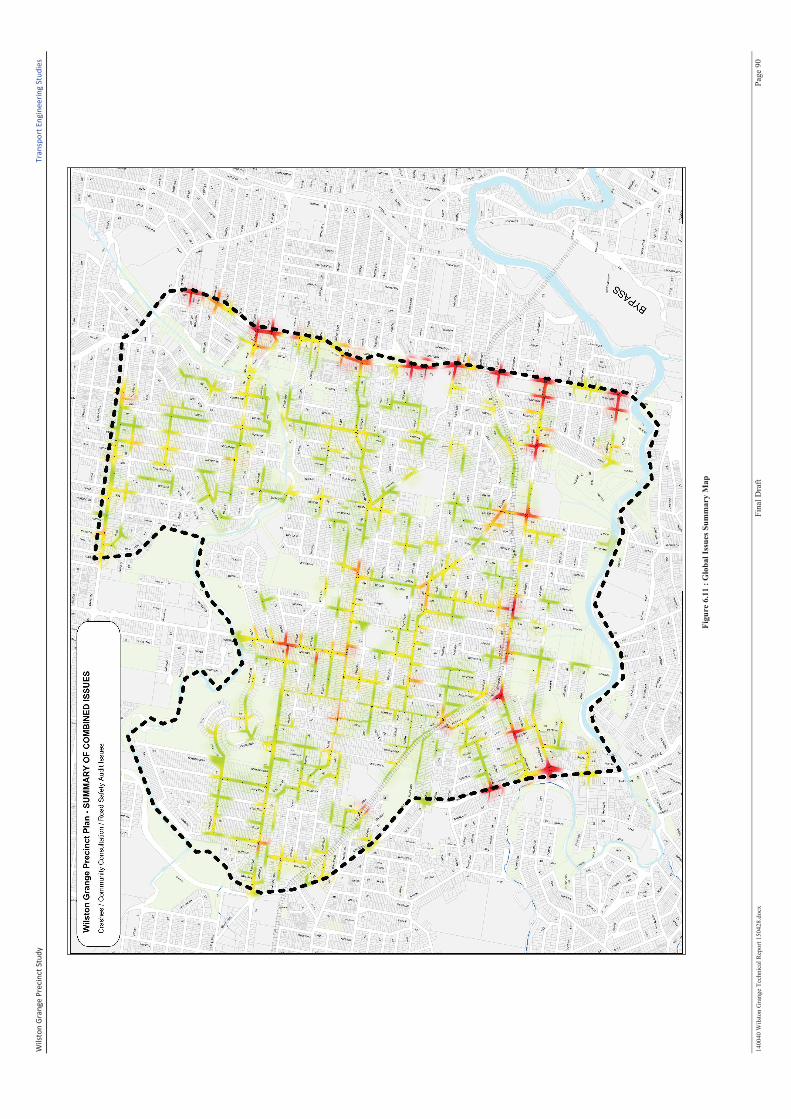
Wil
sto
n G
ran
ge
Pre
cin
ct S
tud
y
Tra
nsp
ort
En
gin
ee
rin
g S
tud
ies
1400
40
Wil
sto
n G
rang
e T
ech
nic
al R
eport
1504
28
.do
cx
Fin
al D
raft
P
age
90
Fig
ure
6.1
1 :
Glo
ba
l Is
sues
Su
mm
ary
Ma
p
Wilston Grange Precinct Study
G:\BI\TPS\Transport Engineering\Proj14\140040 Wilston Grange Precinct Plan\Reports\Draft\Issue #1- SEP 2014 - Draft Report\140040 Wilston Grange
Technical Report 150428.docx