6 WATER QUALITY IMPACT
42
Highways Department Agreement No. CE 43/2010 (HY) Central Kowloon Route - Design and Construction Final EIA Report 042-03 | 4 th Issue | January 2013 042-03_FINAL EIA (CH6 - WATER QUALITY).DOCX Page 6-1 6 WATER QUALITY IMPACT 6.1 Introduction This chapter presents the assessment of potential water quality impacts which may arise during the construction and operation of the Central Kowloon Route. Construction runoff, sediment dredging, sewage from site workforce, drainage diversion and temporary reclamation are potential water pollution sources during the construction phase. Operational water quality impact would mainly include road run-off and wastewater discharge from ventilation buildings. Mitigation measures have been proposed to alleviate the potential water quality impact. With the implementation of the recommended mitigation measures, adverse residual impacts during the construction and operational phases are not anticipated. 6.2 Legislation and Standards 6.2.1 Environmental Impact Assessment Ordinance (EIAO), Cap.499, S16 The “Technical Memorandum on Environmental Impact Assessment Process (TM-EIAO)” specifies the assessment methods and criteria for impact assessment. This Study follows the TM-EIAO to assess the potential water quality impact that may arise during the construction and operational phases of the Project. Sections in the TM-EIAO relevant to the water quality impact assessment are: Annex 6 - Criteria for Evaluating Water Pollution; and Annex 14 - Guidelines for Assessment of Water Pollution 6.2.2 Water Quality Objectives (WQOs) The Water Pollution Control Ordinance (WPCO) (Cap.358) provides the major statutory framework for the protection and control of water quality in Hong Kong. According to WPCO and its subsidiary legislation, the whole Hong Kong waters are divided into ten Water Control Zones (WCZs). Water Quality Objectives (WQOs) were established to protect the beneficial uses of water quality in each WCZ. The proposed CKR is located within the Victoria Harbour WCZ. The WQO in Victoria Harbour WCZ is summarized in the following table. Table 6.1: Summary of Water Quality Objectives for Victoria Harbour WCZ Parameters Objectives Sub-Zone Offensive Odour, Tints Not to be present Whole zone Visible foam, oil scum, litter Not to be present Whole zone Dissolved Oxygen (DO) within 2 m of the seabed Not less than 2.0 mg/L for 90% of samples Marine waters Depth-averaged DO Not less than 4.0 mg/L for 90% of samples Marine waters
Transcript of 6 WATER QUALITY IMPACT

Highways Department Agreement No. CE 43/2010 (HY) Central Kowloon Route - Design and Construction Final EIA Report
042-03 | 4th Issue | January 2013
042-03_FINAL EIA (CH6 - WATER QUALITY).DOCX Page 6-1
6 WATER QUALITY IMPACT
6.1 Introduction
This chapter presents the assessment of potential water quality impacts which may arise during the construction and operation of the Central Kowloon Route. Construction runoff, sediment dredging, sewage from site workforce, drainage diversion and temporary reclamation are potential water pollution sources during the construction phase. Operational water quality impact would mainly include road run-off and wastewater discharge from ventilation buildings.
Mitigation measures have been proposed to alleviate the potential water quality impact. With the implementation of the recommended mitigation measures, adverse residual impacts during the construction and operational phases are not anticipated.
6.2 Legislation and Standards
6.2.1 Environmental Impact Assessment Ordinance (EIAO),
Cap.499, S16
The “Technical Memorandum on Environmental Impact Assessment Process (TM-EIAO)” specifies the assessment methods and criteria for impact assessment. This Study follows the TM-EIAO to assess the potential water quality impact that may arise during the construction and operational phases of the Project. Sections in the TM-EIAO relevant to the water quality impact assessment are:
Annex 6 - Criteria for Evaluating Water Pollution; and
Annex 14 - Guidelines for Assessment of Water Pollution
6.2.2 Water Quality Objectives (WQOs)
The Water Pollution Control Ordinance (WPCO) (Cap.358) provides the major statutory framework for the protection and control of water quality in Hong Kong. According to WPCO and its subsidiary legislation, the whole Hong Kong waters are divided into ten Water Control Zones (WCZs). Water Quality Objectives (WQOs) were established to protect the beneficial uses of water quality in each WCZ.
The proposed CKR is located within the Victoria Harbour WCZ. The WQO in Victoria Harbour WCZ is summarized in the following table.
Table 6.1: Summary of Water Quality Objectives for Victoria Harbour WCZ
Parameters Objectives Sub-Zone
Offensive Odour, Tints Not to be present Whole zone
Visible foam, oil scum,
litter
Not to be present Whole zone
Dissolved Oxygen (DO)
within 2 m of the seabed
Not less than 2.0 mg/L for 90% of samples Marine waters
Depth-averaged DO Not less than 4.0 mg/L for 90% of samples Marine waters

Highways Department Agreement No. CE 43/2010 (HY) Central Kowloon Route - Design and Construction Final EIA Report
042-03 | 4th Issue | January 2013
042-03_FINAL EIA (CH6 - WATER QUALITY).DOCX Page 6-2
Parameters Objectives Sub-Zone
pH To be in the range of 6.5 - 8.5, change due to
human activity not to exceed 0.2
Marine waters
Salinity Change due to human activity not to exceed 10% of
ambient
Whole zone
Temperature Change due to human activity not to exceed 2 oC Whole zone
Suspended solids (SS) Not to raise the ambient level by 30% caused by
human activity
Marine waters
Unionised Ammonia
(UIA)
Annual mean not to exceed 0.021 mg/L as
unionised form
Whole zone
Nutrients Shall not cause excessive algal growth Marine waters
Total Inorganic Nitrogen
(TIN)
Annual mean depth-averaged inorganic nitrogen
not to exceed 0.4 mg/L
Marine waters
Toxic substances Should not attain such levels as to produce
significant toxic, carcinogenic, mutagenic or
teratogenic effects in humans, fish or any other
aquatic organisms.
Whole zone
Human activity should not cause a risk to any
beneficial use of the aquatic environment.
Whole zone
Notes:
[1] Statement of Water Quality Objectives (Victoria Harbour (Phases One, Two and Three) Water Control
Zone).
6.2.3 Technical Memorandum on Effluent Discharge
Standards
Discharges of effluents are subject to control under the WPCO. The Technical Memorandum on Standards for Effluents Discharged into Drainage and Sewerage Systems, Inland and Coastal Waters (TM-DSS) specifies limits for effluent discharges in different water control zones.
6.2.4 Practice Note for Professional Persons on Construction
Site Drainage
The Practice Note for Professional Persons (ProPECC Note PN1/94) on Construction Site Drainage provides guidelines for the handling and disposal of construction discharges. This note is applicable to this study in controlling the site runoff and wastewater generated during the construction phase. The types of discharges from construction sites outlined in the ProPECC Note PN1/94 include:
Surface run-off;
Groundwater;
Boring and drilling water;
Wastewater from concrete batching;
Wheel washing water;
Bentonite slurries;
Water for testing and sterilization of water retaining structures and water pipes;
Wastewater from building construction and site facilities; and

Highways Department Agreement No. CE 43/2010 (HY) Central Kowloon Route - Design and Construction Final EIA Report
042-03 | 4th Issue | January 2013
042-03_FINAL EIA (CH6 - WATER QUALITY).DOCX Page 6-3
Acid cleaning, etching and pickling wastewater.
6.2.5 WSD Water Quality Criteria for Salt Water Intakes
The criteria for assessing the water quality impact on the Water Supplies Department (WSD) seawater intakes are based on the Water Quality Criteria of Seawater for Flushing Supply (at intake point) issued by the Water Supplies Department (WSD) and are summarized in the following table.
Table 6.2: WSD Water Quality Criteria for Salt Water Intakes
Parameter Concentration
Colour < 20 H.U.
Turbidity < 10 N.T.U.
Threshold Odour No. < 100
Ammonia Nitrogen < 1 mg/l
Suspended Solids < 10 mg/l
Dissolved Oxygen > 2 mg/l
Biochemical Oxygen Demand < 10 mg/l
Synthetic Detergents < 5 mg/l
E. coli. < 20,000 cfu/100 ml
6.2.6 Assessment Criteria for Heavy Metals and Trace
Organics
There is no existing legislation or guideline for individual heavy metals and trace organics (PCBs, PAHs and TBT) in Hong Kong waters. According to the common practices in the past EIA studies, a conservative selection was made by comparing the standards of EU, Japan, USA, UK, Australia and Singapore. The lowest values from various international standards will be adopted as the assessment criteria. The adopted criteria for heavy metals and trace organics are presented in the following table.
Table 6.3: Proposed Assessment Criteria for Heavy Metal and Trace Organics
Heavy Metal/Trace Organics Proposed Criteria (g/l) Reference
Arsenic 10 1
Cadmium 2.5 2
Chromium 15 2
Copper 5 7
Lead 8.1 3
Mercury 0.16 4
Nickel 8.2 3
Silver 1.9 3
Zinc 40 2
Total PAHs 3.0 6
PCBs 0.03 3
TBT 0.1 3
References: [1] Environment Agency, Government of Japan [2] EC Dangerous Substances Directive (76/464/EEC), Environmental Quality Standards for List 1 and List
2 dangerous substances [3] USEPA National Recommended Water Quality Criteria, Criterion Continuous Concentration [4] United Nations Economic and Social Commission for Asia and the Pacific, ASEAN Marine Water
[5] Australian Water Quality Guidelines for Fresh and Marine Waters

Highways Department Agreement No. CE 43/2010 (HY) Central Kowloon Route - Design and Construction Final EIA Report
042-03 | 4th Issue | January 2013
042-03_FINAL EIA (CH6 - WATER QUALITY).DOCX Page 6-4
[6] Total PAH consist of the combination of individual components including acenaphthene, acenaphthylene, anthracene, fluorene, naphthalene, phenanthrene, benzo[a]anthracene, benzo[a]pyrene, chrysene, dibenzo]a,h]anthracene, fluoranthene, pyrene, benzo[b]fluoranthene, benzo[k] fluoranthen, indeno[1,2,3-c,d]pyrene and benzo[g,h,i]perylene. According to Australian Water Quality Guidelines for Fresh and Marine Waters, the criterion of naphthalene is 3.0 µg/L for fresh water aquatic ecosystem conservations.
Nevertheless, since all the WSRs are typhoon shelters and industrial use, the functions of these WSRs are neither ecological importance nor portable use. Hence, the tolerant levels should be much higher. Adoption of 3.0 µg/L as proposed criterion for total PAH is in much conservative side.
[7] According to Australian Water Quality Guidelines for Fresh and Marine Waters, the criterion of copper is 5.0 µg/L for irrigation and aquaculture purpose. Nevertheless, since all the WSRs are typhoon shelters and industrial use, the functions of these WSRs are neither for irrigation nor aquaculture purpose. Adoption of 5.0 µg/L as proposed criterion for copper is in much conservative side.
6.3 General Methodology and Principles
In accordance with Clause 3.4.8.3 of the EIA Study Brief, the area for water quality impact assessment included all areas within a distance of 300m from either side and along the full length of the project boundary.
The design of CKR has made due consideration to the Protection of Harbour Ordinance (PHO), which states that “(1) The harbour is to be protected an preserved as a special public asset and a natural heritage of Hong Kong people, and for that purpose there shall be a presumption against reclamation in the harbor. All public officers and public bodies shall have regard to the principle stated in subsection (1) for guidance in the exercise of a powers vested in them”.
While permanent reclamation requires careful consideration under the PHO, temporary reclamation is still required as the key marine works, and thus, it will be the major source of water quality impact nearby WSR such as To Kwan Wan Typhoon Shelter and the seawater intakes in Kowloon Bay. A 3 dimensional mathematical model is conducted to simulate the water quality impact due to marine works.
Apart from the marine works in To Kwa Wan, other sections of CKR will involve land-based work. In considering the anticipated small scale water quality impact, a qualitative assessment approach was adopted to all land-based works. The assessment approach is referred to Annex 6 – Criteria for Evaluating Water Pollution and Annex 14 – Guidelines for Assessment of Water Pollution under the TM-EIAO.
6.4 Baseline Conditions
To Kwa Wan is an elongated bay of Victoria Harbour between Kowloon Peninsula and Hong Kong Island. Current directions are in line with the coastline of Ma Tao Wai and the streamlines are generally parabolic.
In the Victoria Harbour WCZ, the 2010 compliance rate was 77% as compared with 80% in 2008 and 93% in 2009 which was the second highest recorded since the commissioning of HATS stage 1. It is noted that Harbour Area Treatment Scheme (HATs) stage 1 was fully commissioned at the end of 2001 and dredging works for Wan Chai Reclamation II started from 2009 while Cruise Terminal commenced in 2010. These major dredging works might affect the ambient water quality. Therefore, water quality monitoring data of 2002 to 2008 was adopted to determine the ambient water quality. The average water quality of closest monitoring stations VM2 and VT11 between 2002 and 2008 is presented in the

Highways Department Agreement No. CE 43/2010 (HY) Central Kowloon Route - Design and Construction Final EIA Report
042-03 | 4th Issue | January 2013
042-03_FINAL EIA (CH6 - WATER QUALITY).DOCX Page 6-5
Table 6.4. Details of the annual monitoring data at each station are given in Appendix 6.1.
Table 6.4: Average Water Quality of VM2 and VT11 from 2002 to 2008
Parameters VM2 VT11
Temperature (°C) 23.2 23.2
Salinity 32.1 31.5
Dissolved Oxygen (mg/L) Depth Average 5.6 5.5
Bottom 5.5 5.5
Dissolved Oxygen (%
Saturation)
Depth Average 79 76
Bottom 76 76
pH 8.0 8.0
Secchi Disc Depth (m) 2.3 1.9
Turbidity (NTU) 9.4 10.1
Suspended Solids (mg/L) 4.4 5.3
5-day Biochemical Oxygen Demand (mg/L) 0.9 1.0
Ammonia Nitrogen (mg/L) 0.124 0.157
Unionised Ammonia (mg/L) 0.005 0.007
Nitrite Nitrogen (mg/L) 0.023 0.027
Nitrate Nitrogen (mg/L) 0.099 0.130
Total Inorganic Nitrogen (mg/L) 0.25 0.31
Total Kjeldahl Nitrogen (mg/L) 0.29 0.34
Total Nitrogen (mg/L) 0.41 0.50
Orthophosphate Phosphorus (mg/L) 0.03 0.03
Total Phosphorus (mg/L) 0.04 0.05
Silica (as SiO2) (mg/L) 0.8 0.8
Chlorophyll-a (μg/L) 3.6 4.7
E.coli (count/100mL) 1077 777
Faecal Coliforms (count/100mL) 2357 1990
6.5 Water Sensitive Receivers
6.5.1 Selection of Indicator Points
Indicator points will be selected in the water quality model to provide hydrodynamic and water quality outputs to evaluate water quality impact. The selected indicator points include water quality sensitive receivers (WSR) and EPD marine water sampling stations.
The WSRs1 in the vicinity will include the followings:
WSR 1 – Tai Wan Salt Water Intake (~900m from works area)
WSR 2 – Planned Kai Tak Cooling Water Intake (~500m from works area)
1Other WSRs outside Kowloon Bay such as the seawater intakes at Yau Tong and Hong Kong Island are
considered far away from site and adverse water quality impact is not anticipated. Further justifications will
be confirmed in according to the modeling results. A water sports centre at Kai Tak Approach Channel and To Kwa Wan Typhoon Shelter has been proposed in the 10th meeting of Task Force on Kai Tak Harbourfront Development Harbourfront Commission (see http://www.hfc.org.hk/en/task_forces/kai_tak/meeting_20121127.html). However, it is still in investigation stage and no implementation programme. According to the meeting audio, it also requires significant improvement in water quality in the vicinity prior to operation and thus unlikely to be operated during construction phase of CKR. Thus, this WSR is not taken into account.

Highways Department Agreement No. CE 43/2010 (HY) Central Kowloon Route - Design and Construction Final EIA Report
042-03 | 4th Issue | January 2013
042-03_FINAL EIA (CH6 - WATER QUALITY).DOCX Page 6-6
WSR 3 – To Kwa Wan Typhoon Shelter (~200m from works area)
Figure 6.1 shows the locations of these water quality sensitive receivers. The location of EPD marine water and sediment sampling stations VM2, VM4, VT11 and VS3 in Victoria Harbour WCZ are also shown in the figure for reference.
6.5.2 Proposed SS Criteria for Indicator Points
According to WQO, SS is defined as “waste discharge not to raise the natural ambient level by 30% nor cause the accumulation of suspended solids which may adversely affect aquatic communities”. It is expected that the Victoria Harbour WCZ will be affected from the construction works. In order to determine the ambient SS concentrations in the waters likely to be affected by the construction works, water quality monitoring data from 2002 to 2008 EPD‟s routine monitoring station VM2 and VT11 in the WCZ have been selected for analysis due to other dredging works in WCZ as discussed in Section 6.4.
The WQO for SS specifies that human activity or waste discharges shall not raise the ambient SS level by 30% and shall not affect communities. In this study, rather than averaging the 90th percentile SS concentrations over the whole area which could be affected by the construction works, it is proposed to assign each sensitive receiver to nearest EPD water quality monitoring station and to set the WQO at each station as 30% of the 90th percentile at the stations as presented in the following table. Additionally, 10 percentile of dissolved oxygen (DO) from 2002 to 2008 at VM2 and VT11 monitoring stations are also given in the following table.
Table 6.5: 90 Percentile of Suspended Solids
Monitoring
Stations
Season Depth 90
Percentile of
SS (mg/L)
30% of 90
Percentile of
SS (mg/L)
10
percentile of
DO (mg/L)
VM2 Dry
Season [1]
Surface 5.4 1.6 4.3
Middle 6.8 2.0 4.3
Bottom 8.3 2.5 4.5
Depth Averaged 6.6 2.0 4.4
Wet
Season [2]
Surface 6.4 1.9 4.1
Middle 7.2 2.2 3.9
Bottom 9.0 2.7 3.0
Depth Averaged 7.7 2.3 4.0
VT11 Dry
Season
[1]
Surface 5.2 1.6 4.9
Middle 7.6 2.3 4.9
Bottom 7.7 2.3 5.2
Depth Averaged 6.5 2.0 5.0
Wet
Season [2]
Surface 7.8 2.3 4.0
Middle 11.0 3.3 4.0
Bottom 17.0 5.1 3.8
Depth Averaged 12.5 3.8 4.0 Notes: [1] Dry season starts from October to March. [2] Wet season lasts from April to September.
Taking the WSD Water Quality Objectives for salt water intake into account, the
proposed SS assessment criteria at WSRs are summarized in the following table.

Highways Department Agreement No. CE 43/2010 (HY) Central Kowloon Route - Design and Construction Final EIA Report
042-03 | 4th Issue | January 2013
042-03_FINAL EIA (CH6 - WATER QUALITY).DOCX Page 6-7
Table 6.6: Proposed Assessment Criteria for SS
WSR Season Depth SS Elevation
(mg/L)
SS Absolute[1]
(mg/L)
WSR 1 – Tai
Wan Salt Water
Intake (refer to
VM2)
Dry
Season
Surface 1.6 10
Middle 2.0 10
Bottom 2.5 10
Depth Averaged 2.0 10
Wet
Season
Surface 1.9 10
Middle 2.2 10
Bottom 2.7 10
Depth Averaged 2.3 10
WSR 2 –
Planned Kai
Tak Cooling
Water Intake
(refer toVM2)
Dry
Season
Surface 1.6 -
Middle 2.0 -
Bottom 2.5 -
Depth Averaged 2.0 -
Wet
Season
Surface 1.9 -
Middle 2.2 -
Bottom 2.7 -
Depth Averaged 2.3 -
WSR 3 – To
Kwa Wan
Typhoon Shelter
(refer to VT11)
Dry
Season
Surface 1.6 -
Middle 2.3 -
Bottom 2.3 -
Depth Averaged 2.0 -
Wet
Season
Surface 2.3 -
Middle 3.3 -
Bottom 5.1 -
Depth Averaged 3.8 - Notes: [1] Applicable to WSD Salt Water Intakes only
6.6 Potential Concurrent Projects
As discussed in Section 1.8, a number of concurrent projects have been identified. The major existing / planned marine works that might potentially affect the water quality during the construction phase of CKR are listed in the following table.
Table 6.6a: Potential Concurrent Projects Related to Water Quality
Project with Marine Works Programme Cumulative Impact
Kai Tak Runway Opening
(KTRO)
Land-based construction:
2015 to 2018
Opening and dredging: 2018
(to be reviewed by
Development Bureau in end
2013)
Construction Phase:
Hydrodynamic impact due
to Stage 2 Reclamation
Trunk Road T2 (T2) Construction: 2015 to 2019 Construction Phase: Water
quality
Kai Tak Approach Channel
(KTAC) and Kwan Tong
Typhoon Shelter (KTTS)
Improvement Works (Phase 1)
To be completed by Sept
2014
Not anticipated

Highways Department Agreement No. CE 43/2010 (HY) Central Kowloon Route - Design and Construction Final EIA Report
042-03 | 4th Issue | January 2013
042-03_FINAL EIA (CH6 - WATER QUALITY).DOCX Page 6-8
Project with Marine Works Programme Cumulative Impact
Cruise Terminal Berth No.1 to be completed
before 2013
Berth No.2 to be completed
before 2015
Not anticipated
Submarine Gas Pipeline To be completed before 2015 Not anticipated
Shatin to Central Link- Tai
Wai to Hung Hom Section
(SCL-Tai Wai To Hung Hom)
Dredging works required in
SCL-Tai Wai To Hung Hom
will start from mid 2012 to
end 2012
Not anticipated
Notes: [1] Projects of SCL IMT, Wan Chai Reclamation, Central-Wan Chai Bypass and other projects in Victoria
Harbour, Junk Bay or Eastern Buffer are considered far away from the site and are not taken into the cumulative impact assessment.
6.7 Construction Phase Water Quality Assessment
6.7.1 Land-based Works
6.7.1.1 Construction Runoff
Construction site runoff comprises:
Runoff and erosion from site surfaces, earth working areas and stockpiles;
Wash water from dust suppression sprays and wheel washing facilities; and
Fuel, oil, solvents and lubricants from maintenance of construction machinery and equipment.
Construction runoff may cause physical, biological and chemical effects. The physical effects include potential blockage of drainage channels and increase of Suspended Solid (SS) levels in Victoria Harbour WCZ.
Local flooding may also occur in heavy rainfall situations. The chemical and biological effects caused by the construction runoff are highly dependent upon its chemical and nutrient content.
Runoff containing significant amounts of concrete and cement-derived material may cause primary chemical effects such as increasing turbidity and discoloration, elevation in pH, and accretion of solids. A number of secondary effects may also result in toxic effects to water biota due to elevated pH values, and reduced decay rates of faecal micro-organisms and photosynthetic rate due to the decreased light penetration.
6.7.1.2 Runoff from Tunnelling Activities and Underground
Works
During tunnelling work, rainfall, surface runoff and groundwater seepage pumped out from the tunnel would have high SS content. The situation would be worse during wet seasons.
Surface runoff may also be contaminated by bentonite and grouting chemicals that would be required for the tunneling works and diaphragm walls for cut-and-cover

Highways Department Agreement No. CE 43/2010 (HY) Central Kowloon Route - Design and Construction Final EIA Report
042-03 | 4th Issue | January 2013
042-03_FINAL EIA (CH6 - WATER QUALITY).DOCX Page 6-9
tunnel sections. In addition, wastewater from tunnelling works will also contain a high concentration of SS.
6.7.1.3 Sewage from Workforce
Sewage effluents will arise from the amenity facilities used by the construction workforce and site office‟s sanitary facilities. The characteristics of sewage would include high levels of BOD5, Ammonia and E. coli counts.
Overnight sewage from chemical toilets will also be generated. The sludge needs to be properly managed to minimize odour and potential health risks to the workforce by attracting pests and other disease vectors.
As the workers will be scattered within the construction sites, the most effective solution will be to provide adequate number of portable toilets within the site to ensure that sewage from site staff is properly collected. Depending on site conditions, land availability and site activities, the locations and number of portable toilets will be determined in the Environmental Management Plan (EMP) to be submitted by the Contractor. No adverse waste impact is envisaged provided that maintenance by licensed contractors is conducted regularly.
6.7.1.4 Groundwater Seepage
Some of the tunnel sections will be constructed by cut-and-cover method. Construction methodology using diaphragm wall techniques can minimise the intrusion of groundwater during excavation. It involves excavation of a narrow trench that is kept full of slurry, which exerts hydraulic pressure against the trench walls and acts as a shoring to prevent collapse. Slurry trench excavations can be performed in all types of soil, even below the ground water table.
The construction usually begins with the excavation of discontinuous primary panels of typically up to 6m long and down to the rockhead. In order to provide an effective cut-off to ground water flow, the walls will need to be toe grouted. Once the excavation of a panel is completed, a steel reinforcement cage will be placed in the centre of the panel. Concrete is then poured in one continuous operation. Once the primary panels are set, secondary panels will be constructed between the primary panels and the process then repeats to create a continuous wall. It should be noted that this slurry trench method will reduce the gap between the panels to the practicable minimum. After this, soil excavation will be commenced. The intrusion of groundwater through D-wall panels during soil excavation is therefore considered insignificant.
For those sections that may require bored tunnelling and / or drill-and-blast, some ground treatment (e.g. grouting) will be carried out prior to bored tunnelling. The intrusion of groundwater during bored tunnelling would therefore be insignificant.
6.7.1.5 Discharge of Groundwater Pumped out from Potential
Contaminated Area
According to the 2008 survey results, there is no contaminated area identified within areas requesting excavation. Hence, adverse water quality impact due to discharge of groundwater is not anticipated.

Highways Department Agreement No. CE 43/2010 (HY) Central Kowloon Route - Design and Construction Final EIA Report
042-03 | 4th Issue | January 2013
042-03_FINAL EIA (CH6 - WATER QUALITY).DOCX Page 6-10
Nevertheless, due to constraints in site access, further site investigation (SI) works at Ma Tau Kok will be required to further investigate the potential of land contamination prior to construction which would need to be carried out after possession of site by the contractor (see Chapter 8). If contaminated site found, discharge/ recharge of groundwater generated from this area may affect the groundwater quality, if uncontrolled.
6.7.1.6 Accidental Spillage
The site coverage would be rather large during the construction phase. The soil of site area may be potentially contaminated by accidental spillage of grouting materials, surplus adhesives, lubrication oil, grease, acidic/alkaline solutions, petroleum products, chemical solvents, etc. Site runoff may wash the contaminated soil into stormwater drains or watercourses and cause water quality impact.
6.7.2 Marine-based Works
Temporary reclamation and re-location of navigation channels at To Kwa Wan will include dredging activities. As discussed in Section 3.5, a pipepile seawall method will be applied for the temporary reclamation. This will avoid the need for open dredging and subsequent filling. Compared with traditional fully dredged method, the total in-situ dredging volume for marine channel outside pipepile walls could be reduced from 357,500 m
3 to 19,700 m
3 (~95% reduction). With the
adoption of pipepile seawall method, excavation and filling activities will be carried out within pipepile walls. Thus no contact of marine water with the works is anticipated for temporary reclamation. However, dredging activities will still be occurred during the re-location of navigation channels, as shown in Appendix 3.3. The brief procedures of marine-based works are listed in follows:-
Stage 1 Reclamation: Jan 2015 to Dec 2016 (Tentative)
- Step 1: Installation of stone columns
- Step 2: Stage 1 Reclamation – Installation of pipepile seawall
- Step 3: Stage 1 Reclamation – Excavation, filling activities and all tunneling works within the pipepile seawall
- Step 4: Stage 1 Reclamation – Excavation of filled materials and sediment to the required depth for navigation within the pipepile seawall
- Step 5: Demolition of Stage 1 pipepile seawall (except the interfacing part) by trimming of sheet pipes at top of seabed.
Dredging of Navigation Channel: Jan 2017 to Feb 2017 (Tentative)
- Step 6: Dredging of navigation channel
Stage 2 Reclamation: Mar 2017 to Apr 2019 (Tentative)
- Step 7: Stage 2 Reclamation (repeat Step 2 to 5)
The following potential water quality impacts were identified:

Highways Department Agreement No. CE 43/2010 (HY) Central Kowloon Route - Design and Construction Final EIA Report
042-03 | 4th Issue | January 2013
042-03_FINAL EIA (CH6 - WATER QUALITY).DOCX Page 6-11
Change of hydrodynamic regime due to temporary reclamation
Sediments loss due to dredging
Contaminant release due to dredging
Stone Column Installation
Seawall Demolition
Apart from temporary reclamation and their associated works, there will be a proposed barging point at Kwai Chung (see Figure 3.2.1). Since, the existing land use of this barging point is already barging activities occupied by other projects. Thus, there will be basically no additional construction works on the proposed barging point, except minor facilities might be erected on land base.
6.7.2.1 Change of Hydrodynamic Regime due to Temporary
Reclamation
The 3-dimensional modeling tool, Delft3D, is adopted to simulate the hydrodynamic and water quality impact due to the construction and operation of CKR. The Delft3D-FLOW module was used for hydrodynamic simulations.
The approved SEK Model was nested from the Update Model, which is a regional model developed and calibrated under the Update on Cumulative Water Quality and Hydrological Effect of Coastal Developments and Upgrading of Assessment Tool (1998). The SEK Model was also validated for hydrodynamic and water quality modeling under EIA – Kai Tak Development (EIA-157/2008). The model was therefore be adopted for hydrodynamic and so as the water quality modeling (see Section 6.7.2 below) in the present study.
Despite that SEK Model has been calibrated in that EIA study, calibration or validation of the model was required in this Study as coarse grids used in SEK Model are not suitable for the Project. Therefore, the refinement of grids will be made by either domain-decomposition or nesting process. Moreover, the pollution load inventory inside the model will be updated according to the latest information. Details of modeling parameters and calibration are attached in Appendix 6.2.
The temporary reclamation will be divided into two phases. The construction of Stage 1 temporary reclamation platform will be erected at the eastern part of Kowloon Bay during January 2015 to December 2016 while Stage 2 temporary reclamation platform will be erected at western part of Kowloon Bay near Ma Tau Kok Public Pier and will stay from March 2017 to April 2019. The graphical presentation on reclamation sequence is presented in Appendix 3.3. The following modeling scenarios were therefore identified
2:
Scenario H0 – Base Scenario
Scenario H2a – Stage 1 Reclamation
Scenario H1a – Stage 2 Reclamation
Scenario H1b – Stage 2 Reclamation (with Kai Tak Runway Opening)
2 While the Kai Tak Runway Opening will be operated in 2018 (see Table 6.6a), it is unlikely to
have hydrodynamic cumulative impact during Stage 1 scenario but will be considered in Stage 2 scenario.

Highways Department Agreement No. CE 43/2010 (HY) Central Kowloon Route - Design and Construction Final EIA Report
042-03 | 4th Issue | January 2013
042-03_FINAL EIA (CH6 - WATER QUALITY).DOCX Page 6-12
The modeling results were presented in Appendix 6.3 and the results are summarized in the table below.
Table 6.7: Summary of Hydrodynamic Impact due to Temporary Reclamation
Indicators Season Base Case Stage 1
Reclamation
Stage 2
Reclamation
Stage 2
Reclamation
(with Kai Tak
Runway
Opening)
Accumulated Flow (×108m
3)
Victoria – TST to
WC
Dry 14.8 14.8 14.8 14.8
Wet 3.4 3.4 3.4 2.8
Lei Yue Mun Dry 14.7 14.7 14.7 14.8
Wet 3.3 3.3 3.3 2.7
Average Velocity (m/s)
WSR 1 Dry 0.076
(0.003-0.180)
0.076
(0.004-0.180)
0.076
(0.004-0.180)
0.084
(0.012-0.194)
Wet 0.127
(0.025-0.312)
0.126
(0.028-0.310)
0.126
(0.027-0.310)
0.138
(0.020-0.332)
WSR 2 Dry 0.046
(0.002-0.110)
0.046
(0.002-0.110)
0.046
(0.002-0.109)
0.037
(0.004-0.103)
Wet 0.141
(0.020-0.497)
0.138
(0.020-0.477)
0.138
(0.020-0.478)
0.154
(0.020-0.523)
WSR 3 Dry 0.034
(0.003-0.066)
0.034
(0.003-0.067)
0.034
(0.003-0.067)
0.041
(0.006-0.092)
Wet 0.059
(0.010-0.168)
0.059
(0.009-0.158)
0.059
(0.010-0.159)
0.068
(0.014-0.161)
Embayed Area Dry 0.008
(0.001-0.060)
0.006
(0.000-0.055)
0.007
(0.000-0.052)
0.012
(0.002-0.048)
Wet 0.030
(0.006-0.064)
0.023
(0.003-0.056)
0.031
(0.004-0.067)
0.028
(0.008-0.064)
According to the modeling results, it is observed that the change of average velocity due to the temporary reclamation is less than 0.007m/s (refer Base Case and Stage 1 Reclamation).
In the embayed area formed by the temporary reclamation, it is observed that the current directions will be changed due to the semi-enclosed opening. The velocity variations at the embayed area are less than 0.007m/s and 0.001 m/s due to the Stage 1 and 2 Reclamations (project only) respectively. Nevertheless, the water circulation at this embayed area is already in a low side (0.001 to 0.060 m/s and 0.006 to 0.064 m/s for dry and wet season respectively) compared to that typhoon shelter and outer Kowloon Bay (WSR 1 to WSR 3). The change of hydrodynamic regime due to temporary reclamation will only last for less than 5 years (around Jan 2015 to Apr 2019). Thus, hydrodynamic impact is insignificant and the associated water quality impact including dissolved oxygen profile (which the re-aeration rate is a function of velocity) would be negligible.
The Kai Tak runway opening will be operated in 2018, where will have about 16-month concurrent period. With the operation of Kai Tak runway opening during Stage 2 Reclamation, pollutant from Kai Tak Nullah and Approach Channel may be diluted and dispersed to Kowloon Bay and the embayed area
[6-8]. These
pollutants are dominated by the implementation of Tolo Harbour Effluent Export

Highways Department Agreement No. CE 43/2010 (HY) Central Kowloon Route - Design and Construction Final EIA Report
042-03 | 4th Issue | January 2013
042-03_FINAL EIA (CH6 - WATER QUALITY).DOCX Page 6-13
Scheme (THEES), which diverts the secondary treated effluent from the Tai Po and Sha Tin sewage treatment works, and also the existing pollutants from Kai Tak Nullah and Kai Tak Approach Channel. According to the modelling prediction under in the EIA Report of Kai Tak Development (EIA-157/2008), the annual mean ammonia nitrogen and unionised ammonia levels would exceed the existing WQO
[6-8] at the embayed area. This pollutant plume may further trapped
inside the embayed area if Stage 2 Reclamation occurred. This phenomenon is also shown in the salinity plot in Appendix 6.3 (H1b-D-SL-ET, H1b-D-SL-FT, H1b-W-SL-ET, H1b-W-SL-FT).
Additional scenario, Scenario H2b-DN, representing a do-nothing scenario with Kai Tak Runway Opening was modelled for comparison. The comparison of salinity levels with and without Stage 2 Reclamation was presented in Appendix 6.3A. Marginal change in salinity levels is observed with and without Stage 2 Reclamation. In general speaking salinity levels will be reduced at surface layer but increase in bottom layer with the presence of Stage 2 Reclamation. These changes are considered to be minor and will not further deteriorate the water quality and the impact were mainly due to the Kai Tak runway opening, which is a not related to CKR project.
According to the model result, the velocity variations at the embayed area is +0.004 m/s and -0.002 m/s in dry and wet season respectively during Stage 2 Reclamation with Kai Tak runway opening. Similar to the above, given the embayed area is already under a low flow condition, major change of water circulation due to the Project is not anticipated. There are also no WSR within the embayed area. Thus, the associated water quality impact is considered to be minor. In addition, according to the latest programme, Environmental Bureau will further review the tentative operation date of Kai Tak runway opening in end 2013 and the actual operation date is likely to be further delayed. Thus, cumulative impact from Stage 2 Reclamation and Kai Tak runway opening might not exist if programme changed. For conservative consideration, the maximum overlapping period of Stage 2 Reclamation and Kai Tak runway opening will only last for about 16 months. Thus, such minor impact is reversible after demolishment of Stage 2 Reclamation. Once the Stage 2 Reclamation is demolished, the water quality regime will remain as that predicted in the EIA for Kai Tak Development.
Given the insignificant hydrodynamic and water quality impact due to temporary reclamation, generic mitigation measure is recommended as follows:
Illegal discharges to the embayed marine water is strictly prohibited; and
Regular litter/rubbish clearance in the embayed marine water should be implemented.
6.7.2.2 Sediment Loss due to Dredging
With the adoption of pipepile seawall approach using double-layer seawall method, excavation and filling activities will be carried out within the temporary reclamation area enclosed by double-layer seawall. Thus no contact of marine water with the works is anticipated for temporary reclamation.
Demolition of temporary reclamation will involve excavation of bulk fill. The proposed construction method adopts an approach where the double-layer seawall not be removed until completion of all excavation works within the temporary

Highways Department Agreement No. CE 43/2010 (HY) Central Kowloon Route - Design and Construction Final EIA Report
042-03 | 4th Issue | January 2013
042-03_FINAL EIA (CH6 - WATER QUALITY).DOCX Page 6-14
reclamation area enclosed by the double-layer seawall. The double-layer seawall will then be demolished by first removing the soil infill within the double-layer steel pipepile/sheetpiles, followed by the removal of the steel pipepile/sheetpiles. Thus, excavation of bulk fill will be carried out within the area enclosed by the double-layer seawall and the sediment plume can be effectively contained within the works area. The last stage of demolition of double-layer seawall will involve trimming of pipe piles/sheet piles only, which would not create significant SS impact. No additional dredging will be required. Fines content in the filling materials in the seawall would be negligible and loss of fill material during temporary reclamation demolition is not expected.
In addition, as the project will not cause any additional marine traffic except the dredgers/barges operation. Good site practices are proposed and included in Section 6.9.
The main potential impact on water quality will be arisen from 2-month dredging activities (as shown in activities 14a and 14b in Appendix 6.10) for navigation channels immediately after demolition of Stage 1 Reclamation but prior to the construction of Stage 2 Reclamation starting from January 2017 to February 2017. The dredging location will be outside pipepile walls for Stage 1 temporary reclamation. Potential water quality impact will be related to disturbances to the water column and seabed, which will lead to the potential for physio-chemical changes in the water column. Grab dredgers will be utilized and it may release sediment into suspension by the following activities:
Impact of the grab on the seabed as it is lowered;
Washing of sediment off the outside of the grab as it is raised through the water column and when it is lowered again after being emptied;
Leakage of water from the grab as it is hauled above the water surface;
Spillage of sediment from over-full grabs;
Loss from grabs which cannot be fully closed due to the presence of debris; and
Disturbance of the seabed as the closed grab is removed.
The sediment loss rate for dredging activities will be calculated by the multiplication of volumetric dredging rate. The sediment loss per volumetric dredging rates closed grab dredgers will be 17 to 20 kg/m
3. As a conservative
approach, sediment loss of 25 kg/m3 was adopted.
Silt curtain will normally be adopted to mitigate the potential water quality impact during dredging. The effectiveness of mitigation measures is summarized in the following table.
Table 6.8: Summary Table of Loss Reductions from Silt Curtain Configurations
Silt Curtain Type Loss Reduction Factor Remark
Dredging Activities
Cage type for Grab Dredger (Figure 6.1a) 80% EIA – HZMB HKLR
Floating Single Silt Curtain 75% EIA – Cruise Terminal
Receiver Control
Silt Screen at Seawater Intakes 60% EIA – Cruise Terminal

Highways Department Agreement No. CE 43/2010 (HY) Central Kowloon Route - Design and Construction Final EIA Report
042-03 | 4th Issue | January 2013
042-03_FINAL EIA (CH6 - WATER QUALITY).DOCX Page 6-15
Water Quality Model
The hydrodynamic outputs from the model will provide inputs for water quality simulation. The hydrodynamic forcing including averaged fresh water flow, wind, initial conditions and boundary conditions for the dry season and wet seasons will be applied separately in the corresponding hydrodynamic simulation. Similarly, the dry and wet season pollution loads will be applied in the corresponding dry and wet season water quality simulations.
According to the construction programme, the construction period of CKR under water tunnel will be Year 2015 to 2019 tentatively and the dredging period will be tentatively about 2 months. While the Kai Tak Runway Opening will be operated in 2018, the hydrodynamic conditions were therefore based on Base Case (Scenario H0). In considering the cumulative impact with other nearby marine works, the following modeling scenarios are identified:
Scenario C3 – Dredging of marine channel for CKR
Scenario C4 – Dredging of marine channel for CKR + T2
The sediment loss rates during dredging/filling activities are presented in Appendix 6.4 and summarized in the table below and Figure 6.3.
Table 6.9: Sediment Loss Rate
Loading Point Production Rate Sediment Loss Rate
Scenario C3
CKR – Dredging 1500 m3/day[1] 0.87 kg/s for 2 dredgers[2] (Unmitigated)
Scenario C4
CKR – Dredging 1500 m3/day[1] 0.87 kg/s for 2 dredgers[2] (Unmitigated)
T2 – Dredging[3] 8000 m3/day 0.93 kg/s (Mitigated)
T2 – Filling[3] 2000 m3/day 0.19 kg/s (Mitigated) Notes: [1] Dredging rate of 1500 m3/day refers to unmitigated scenario. Silt curtain and 50% dredging rate reduction
in wet season will be adopted as a mitigation measure (see below sections)
[2] Assume 12 working hours per day. Calculations refer to Appendix 6.4. [3] According to the latest information, TBM method will be adopted for T2 project and thus no
dredging/filling work is required. However, the actual construction method for T2 project is still under investigation, traditional dredging/filling works were assumed as a conservative approach.
The degree of oxygen depletion exerted by a sediment plume is a function of the sediment oxygen demand of the sediment, its concentration in the water column and the rate of oxygen replenishment. For the purposes of this assessment, the impact of the sediment oxygen demand on dissolved oxygen concentrations has been calculated based on the following equation (ERM, 1997):
DODep = C * SOD * K * 0.001
where,
DODep = Dissolved Oxygen depletion (mg/l)
C = Suspended Solids concentration (kg/m3)
SOD = Sediment Oxygen Demand
K = Daily oxygen uptake factor (set at 1.0 for worse case estimate)
There is no monitoring data for SOD. As a conservative approach, the average Chemical Oxygen Demand (COD) of 22,000 mg/kg from 2002 to 2008 has been

Highways Department Agreement No. CE 43/2010 (HY) Central Kowloon Route - Design and Construction Final EIA Report
042-03 | 4th Issue | January 2013
042-03_FINAL EIA (CH6 - WATER QUALITY).DOCX Page 6-16
taken with reference to the closest EPD marine monitoring station – VS3 as a suitably representative value for sediments in the Victoria Harbour.
The analysis using the above equation does not allow for re-aeration which would tend to reduce any impact of the suspended sediment on the water column DO concentrations. The analysis, therefore, errs on the conservative side so as not to underestimate the extent of DO depletion. Further, it should be noted that, for sediment in suspension to exert any oxygen demand on the water column will take time and, in that time, the sediment will be transported and mixed/dispersed with oxygenated water. As a result, the oxygen demand and the impact on dissolved oxygen concentrations will diminish as the suspended sediment concentrations decrease.
Oxygen depletion is not instantaneous and thus previous workers have assumed that the impact of suspended sediment on dissolved oxygen will depend on tidally averaged suspended sediment concentrations (ERM, 1997). The previous studies (ERM, 1997) assumed that the oxygen demand would be satisfied at the same rate as the biological demand which equates to a K value of 0.23/day. However for the purposes of this demonstration the maximum increase in suspended sediment has been used as the basis for the calculation in order to identify the hypothetical worst case. As such, the daily uptake factor, K, in the equation above was set to be equal to 1.0 (Meinhart, 2007; Mouchel, 2002) which indicates instantaneous oxidation of the sediment oxygen demand and represents a worst case to ensure oxidation rates are not underestimated. The resulting calculated dissolved oxygen deficit, therefore, is expected to be much larger than would be experienced in reality.
The modeling results were presented in Appendix 6.5 and the results are summarized in the tables below. It is noted that the predicted SS elevations, SS and DO were well within the criteria during dry season.
Exceedances of SS elevations were anticipated in WSR 2 (Planned Kai Tak Cooling Water Intake) and WSR 3 (To Kwa Wan Typhoon Shelter) during CKR dredging works of temporary marine channel outside pipepile walls (Scenario C3) during wet season without any mitigation measure. The percentage of exceedance time is up to 12%, i.e. around 8 days for the 2-month dredging period.
When considering the cumulative impacts from the potential concurrent project such as T2, exceedances at WSR 2 and WSR 3 are still anticipated during wet season. The percentage of exceedance time is around 12%, around 8 days of the 2-month dredging period. The exceedance of total SS was also anticipated at WSR1 when taking T2 into account while the percentage of exceedance time is around 1%, i.e. around 1 day of the dredging period.

Highways Department Agreement No. CE 43/2010 (HY) Central Kowloon Route - Design and Construction Final EIA Report
042-03 | 4th Issue | January 2013
042-03_FINAL EIA (CH6 - WATER QUALITY).DOCX Page 6-17
Table 6.10a: Summary of Water Quality Impact due to Dredging/Filling Activities (Scenario C3) – Unmitigated
Indicators Season Modeling Result Criteria
WSR 1 WSR 2 WSR 3 WSR 1 WSR 2 WSR 3
Suspended Solid Elevation (mg/L)
Surface Dry 0.0 0.5 0.5 1.6 1.6 1.6
Wet 0.0 1.8 0.0 1.9 1.9 2.3
Middle Dry 0.0 0.5 0.0 2.0 2.0 2.3
Wet 0.2 15.3 (12%) 6.1(1%) 2.2 2.2 3.3
Bottom Dry 0.0 0.0 0.0 2.5 2.5 2.3
Wet 0.4 10.9 (8%) 19.6 (2%) 2.7 2.7 5.1
Depth Averaged Dry 0.0 0.2 0.2 2.0 2.0 2.0
Wet 0.1 7.4 (8%) 6.5 (1%) 2.3 2.3 3.8
Suspended Solid (mg/L)[3]
Surface Dry 5.4 5.9 5.9 ≤10 - -
Wet 6.4 8.2 6.4 ≤ 10 - -
Middle Dry 6.8 7.3 6.8 ≤ 10 - -
Wet 7.4 22.5 13.3 ≤ 10 - -
Bottom Dry 8.3 8.3 8.3 ≤ 10 - -
Wet 9.4 19.9 28.6 ≤ 10 - -
Depth Averaged Dry 6.6 6.8 6.8 ≤ 10 - -
Wet 7.8 15.1 14.2 ≤ 10 - -
Dissolved Oxygen Depletion (mg/L)
Bottom Dry 0.0 0.0 0.0 - - -
Wet 0.0 0.2 0.4 - - -
Depth Averaged Dry 0.0 0.0 0.0 - - -
Wet 0.0 0.2 0.1 - - -
Dissolved Oxygen (mg/L)
Bottom [4] Dry 4.5 4.5 5.2 2 2 2
Wet 3.0 2.8 3.4 2 2 2
Depth Averaged [4] Dry 4.4 4.4 5.0 4 4 4
Wet 4.0 3.8 3.9 4 4 4
Notes: [1] The dredging period will be 2 months, from January 2017 to February 2017. [2] Grey cell represents exceedance records and the bracket shows the percentage of exceedance period.
[3] Baseline SS levels of WSRs 1 and 2 refer to VM2 and WSR 3 refer to VT11 during dry and wet seasons, separately. (Refer to Table 6.5) [4] Baseline Bottom and depth-averaged DO levels of WSRs 1 and 2 refer to VM2 and WSR 3 refer to VT 11 during dry and wet seasons, separately. (Refer to Table 6.5)

Highways Department Agreement No. CE 43/2010 (HY) Central Kowloon Route - Design and Construction Final EIA Report
042-03 | 4th Issue | January 2013
042-03_FINAL EIA (CH6 - WATER QUALITY).DOCX Page 6-18
Table 6.10b: Summary of Water Quality Impact due to Dredging/Filling Activities (Scenario C4) – Unmitigated
Indicators Season Modeling Result Criteria
WSR 1 WSR 2 WSR 3 WSR 1 WSR 2 WSR 3
Suspended Solid Elevation (mg/L)
Surface Dry 0.0 0.5 0.5 1.6 1.6 1.6
Wet 0.5 1.8 0.0 1.9 1.9 2.3
Middle Dry 0.0 0.5 0.0 2.0 2.0 2.3
Wet 1.1 15.3 (12%) 6.1 (1%) 2.2 2.2 3.3
Bottom Dry 0.0 0.0 0.0 2.5 2.5 2.3
Wet 1.1 10.9 (8%) 19.6(2%) 2.7 2.7 5.1
Depth Averaged Dry 0.0 0.2 0.2 2.0 2.0 2.0
Wet 0.4 7.4 (8%) 6.5 (1%) 2.3 2.3 3.8
Suspended Solid (mg/L)[3]
Surface Dry 5.4 5.9 5.9 10 - -
Wet 6.9 8.2 6.4 10 - -
Middle Dry 6.8 7.3 6.8 10 - -
Wet 8.3 22.5 13.3 10 - -
Bottom Dry 8.3 8.3 8.3 10 - -
Wet 10.1(1%) 19.9 28.6 10 - -
Depth Averaged Dry 6.6 6.8 6.8 10 - -
Wet 8.1 15.1 14.2 10 - -
Dissolved Oxygen Depletion (mg/L)
Bottom Dry 0.0 0.0 0.0 - - -
Wet 0.0 0.2 0.4 - - -
Depth Averaged Dry 0.0 0.0 0.0 - - -
Wet 0.0 0.2 0.1 - - -
Dissolved Oxygen (mg/L)
Bottom [4] Dry 4.5 4.5 5.2 2 2 2
Wet 3.0 2.8 3.4 2 2 2
Depth Averaged [4] Dry 4.4 4.4 5.0 4 4 4
Wet 4.0 3.8 3.9 4 4 4
Notes: [1] The dredging period will be 2 months, from January 2017 to February 2017. [2] Grey cell represents exceedance records and the bracket shows the percentage of exceedance period.
[3] Baseline SS levels of WSRs 1 and 2 refer to VM2 and WSR 3 refer to VT11 during dry and wet seasons, separately. (Refer to Table 6.5) [4] Baseline Bottom and depth-averaged DO levels of WSRs 1 and 2 refer to VM2 and WSR 3 refer to VT 11 during dry and wet seasons, separately. (Refer to Table 6.5)

Highways Department Agreement No. CE 43/2010 (HY) Central Kowloon Route - Design and Construction Final EIA Report
042-03 | 4th Issue | January 2013
042-03_FINAL EIA (CH6 - WATER QUALITY).DOCX Page 6-19
6.7.2.3 Contaminant Release due to Dredging
Sediment samples have been collected at the proposed site of temporary reclamation. Elutriate tests and pore water test have been conducted for the following parameters:
Heavy metals and metalloid including cadmium, chromium, copper, mercury, nickel, lead, zinc, silver and arsenic;
Organic micro-pollutants including PCB, PAH, and TBT; and
TKN, NO3-N, NO2-N, NH4-N, PO4-P, total phosphorus, reactive phosphorus and chlorinated pesticides.
The laboratory results for the sediment samples collected within the dredging area were presented in Appendix 6.6. The sediment results for other concurrent projects are also included in Appendix 6.6 for easy referencing. It is observed that the elutriate and pore water test results of most contaminant parameters complied the proposed criteria. Thus, the release of other contaminants will be well mixed locally around the dredging point without causing enlargement of mixing zones with the exception of Cu, Ni, Total PAH, UIA, TIN, PO4 and TP. The extracted elutriate data with exceedance or higher than baseline level was incorporated in Table 6.11.
The elutriate and pore water test results provided the information on the initial concentrations of these parameters that would be released from the marine mud during the dredging operation. As a conservative approach, the contaminant loss rate (in mg/s or µg/s) for model input assumed that all of the heavy metals and nutrient concentrations in the sediment would be released to the water (i.e. sediment release rates (in kg/s) times the sediment quality (in mg/kg or µg/kg).
Similar to Section 6.7.2.2, two scenarios, Scenario C3 and C4, were identified and tracer substances is adopted in the model run.

Highways Department Agreement No. CE 43/2010 (HY) Central Kowloon Route - Design and Construction Final EIA Report
042-03 | 4th Issue | January 2013
042-03_FINAL EIA (CH6 - WATER QUALITY).DOCX Page 6-20
Table 6.11: Summary of Maximum Elutriate Test Results (for those sampling points with exceedance or higher than baseline levels)
Metal Trace Organics Nutrients
Cu Ni Total PAHs UIA[1]
TIN[2]
PO4 TP
Unit µg/L µg/L µg/L mg/L mg/L mg/L mg/L
Assessment Criteria[3] 5 8.2 3.0[7] 0.021 0.4 N/A N/A
Reference sample (Considered as
background level if above detection
limit) [4]
less than
detection limit
less than
detection limit
less than detection
limit[8]
0.008 0.3 less than
detection limit
less than
detection limit
Project
CKR[5] 22 93 549 4.996 89.2 0.1 0.2
T2[6] <2 7 <<32 1.017 18.1 - 4.0
Note: [1] [UIA] = 5.62 x 10⁻¹⁰ x [NH3-N] / 10-pH, taking pH of 8.0 according to the average pH value of EPD‟s monitoring stations VM2, VT11 [2] [TIN] = [NO3-N] + [NO2-N] + [NH3-N]
[3] Apart from parameters of UIA and TIN, the assessment criteria are set with reference to Table 6.3 while the assessment criteria of UIA and TIN are set based on the WQO for Victoria Harbour WCZ.
[4] Concentrations of reference sample of elutriate testing results. The detection limit for Cu, Ni, TPAH, PO4 and TP are one-third of the reporting limits, i.e. 0.33µg/L, 0.33µg/L, 1.07µg/L(see footnote [8]), 0.0033µg/L and 0.033µg/L respectively.
[5] According to dredging extent and dredging depth, elutriate data from VR2, VR3, VR4, VR5, GB6 and GB7 from 0 to 2.9m were adopted. [6] EIA Report of South East Kowloon Development, Table 4.29, 4.30 [7] According to Australian Water Quality Guidelines for Fresh and Marine Waters, the criterion of naphthalene is 3.0 µg/L for fresh water aquatic ecosystem conservations. Nevertheless,
since all the WSRs are typhoon shelters and industrial use, the functions of these WSRs are neither ecological importance nor portable use. Hence, tolerant levels should be much higher.
Adoption of 3.0 µg/L as proposed criterion for total PAH is in much conservative side. [8] The detection limit of individual PAH (e.g. naphthalene) is 0.067 µg/L. The concentration of total PAH is determined by adding the concentration of individual PAH. Thus, the
detection limit of total PAH is 1.07 µg/L.

Highways Department Agreement No. CE 43/2010 (HY) Central Kowloon Route - Design and Construction Final EIA Report
042-03 | 4th Issue | January 2013
042-03_FINAL EIA (CH6 - WATER QUALITY).DOCX Page 6-21
Appendix 6.7 presents the mixing zones and time series contaminant levels at individual WSRs. The summary of modeling results are presented in Tables 6.12a and 6.12b. According to the modeling results, no exceedance was predicted for any scenarios during wet season. The detail analysis are given below:-
Heavy Metals
The size of mixing zones of heavy metals will be highly localized during peak dredging periods as shown in Appendix 6.7. The maximum mixing zone of Cu during peak time is around 1.53 km
2, cumulating at the inner Kowloon Bay (see
Drawings D-CU and D-CCU of Appendix 6.7). The predicted Cu level at WSR 3 (To Kwa Wan Typhoon Shelter) exceeds the proposed criteria of 5 µg/L at bottom layer for Scenario C3 during dry season.
Nevertheless, since the proposed copper criterion (i.e. 5.0 µg/L) is for protection of irrigation and aquaculture purpose according to Australian Water Quality Guidelines for Fresh and Marine Waters, it is already in a conservative side. Since all the WSRs are typhoon shelters and industrial use, the functions of these WSRs are neither for irrigation nor aquaculture purpose. Thus, exceedance of heavy metals levels are not sensitive to these WSRs. In addition, the dredging period will occur within a short period (only 2 months). The residue impacts are likely to be temporary and will not deteriorate their existing functions.
In cumulative consideration with T2 dredging (Scenario C4), exceedance were predicted or both WSR 2 (Planned Kai Tak Cooling Water Intake) and WSR 3 (To Kwa Wan Typhoon Shelter) and the highest Cu level is 6.0 µg/L. In order to further protect the WSRs, mitigation measures are proposed as much as possible and details are presented in Section 6.9.2.2.
The mixing zones of other heavy metals are unnoticeable. The predicted peak levels of Ni at all three WSRs are lower than the respective proposed criteria of 8.2 µg/L.
Trace Organics
The initial concentration of PAH levels is rather high (549 µg/L) during dredging periods. Unlike the unnoticeable mixing zones from other trace organics, the maximum mixing zone of PAH due to the project during the peak time is around 0.78 km
2 at the inner Kowloon Bay as shown in Drawings D-PAH and D-CPAH
of Appendix 6.7. The predicted PAH levels at WSR 3 (To Kwa Wan Typhoon Shelter) has exceeded the proposed criteria of 3.0 µg/L at bottom layer for Scenario C3 during dry season.
Nevertheless, since the proposed total PAH criterion (i.e. 3.0 µg/L) is for protection of fresh water aquatic ecosystem according to Australian Water Quality Guidelines for Fresh and Marine Waters, the tolerant levels for marine aquatic ecosystem is much higher. Since all the WSRs are typhoon shelters and industrial use, the functions of these WSRs are neither ecological importance nor for portable use. Thus, exceedance of total PAH levels are not sensitive to these WSRs. In addition, the dredging period will occur within a short period (only 2 months). The residue impacts are likely to be temporary and will not deteriorate their existing functions.
In cumulative consideration with T2 dredging (Scenario C4), exceedance were predicted or both WSR 2 (Planned Kai Tak Cooling Water Intake) and WSR 3

Highways Department Agreement No. CE 43/2010 (HY) Central Kowloon Route - Design and Construction Final EIA Report
042-03 | 4th Issue | January 2013
042-03_FINAL EIA (CH6 - WATER QUALITY).DOCX Page 6-22
(To Kwa Wan Typhoon Shelter) and the highest PAH level is 12.0 µg/L. In order to further protect the WSRs, mitigation measures are proposed at much as possible and details are presented in Section 6.9.2.2.
Nutrients
The size of mixing zones of nutrient will be highly diluted during peak dredging periods. The levels of UIA and TIN at three WSRs are all far below the respective assessment criteria (0.021 and 0.4 mg/L respectively), only with marginal increase due to the dredging. And their maximum mixing zones are not noticeable during peak time. Very limited increase of PO4 and TP are also estimated at three WSRs, as shown in Table 6.12a. The maximum mixing zones of PO4 and TP during peak time are around 0.125 km
2 due to CKR while the cumulative maximum mixing
zone of TP would possibly be 1 km2 without reaching WSRs (see Drawings D-
RP, D-CRP, D-TP and D-CTP of Appendix 6.7). No exceedance to the proposed criteria is therefore anticipated.

Highways Department Agreement No. CE 43/2010 (HY) Central Kowloon Route - Design and Construction Final EIA Report
042-03 | 4th Issue | January 2013
042-03_FINAL EIA (CH6 - WATER QUALITY).DOCX Page 6-23
Table 6.12a: Model Results for Release of Contaminants (Dry Season dredging)
Metal Trace
Organics
Nutrients
Cu[1]
Ni[1]
Total PAHs[1]
UIA[2]
TIN[2]
PO4[1]
TP[1]
Unit µg/L µg/L µg/L mg/L mg/L mg/L mg/L
Assessment Criteria 5 8.2 3.0 0.021 0.4 N/A N/A
Reference sample (Considered as
background level if above detection
limit)
less than
detection limit
less than
detection limit
less than
detection limit
0.008 0.3 less than
detection limit
less than
detection limit
WSR 1 – Tai Wan Salt Water Intake
Scenario C3 – CKR
Only
Surface 1.5 0.1 0.8 0.008[3]
(Peak: 0.008)
0.3[3]
(Peak: 0.3)
0.001 0.001
Bottom 1.7 0.1 1.2 0.008[3]
(Peak: 0.008)
0.3[3]
(Peak: 0.3)
0.001 0.001
Scenario C4 –
Cumulative
Surface 2.7 0.1 2.9 0.008[3]
(Peak: 0.008)
0.3[3]
(Peak: 0.3)
N/A 0.001
Bottom 3.3 0.1 3.0 0.008[3]
(Peak: 0.008)
0.3[3]
(Peak: 0.3)
N/A 0.001
WSR 2 – Planned Kai Tak Cooling Water Intake
Scenario C3 – CKR
Only
Surface 5.0 0.3 3.0 0.008[3]
(Peak: 0.008)
0.3[3]
(Peak: 0.3)
0.003 0.001
Bottom 4.1 0.2 2.8 0.008[3]
(Peak: 0.008)
0.3[3]
(Peak: 0.3)
0.002 0.001
Scenario C4 –
Cumulative
Surface 5.1 0.3 5.1 0.008[3]
(Peak: 0.008)
0.3[3]
(Peak: 0.3)
N/A 0.003
Bottom 6.1 0.3 6.0 0.008[3]
(Peak: 0.008)
0.3[3]
(Peak: 0.3)
N/A 0.002
WSR 3 – To Kwa Wan Typhoon Shelter
Scenario C3 – CKR
Only
Surface 4.6 0.3 3.0 0.008[3]
(Peak: 0.008)
0.3[3]
(Peak: 0.3)
0.002 0.002
Bottom 10.0 0.6 6.0 0.008[3]
(Peak: 0.008)
0.3[3]
(Peak: 0.3)
0.005 0.006

Highways Department Agreement No. CE 43/2010 (HY) Central Kowloon Route - Design and Construction Final EIA Report
042-03 | 4th Issue | January 2013
042-03_FINAL EIA (CH6 - WATER QUALITY).DOCX Page 6-24
Metal Trace
Organics
Nutrients
Cu[1]
Ni[1]
Total PAHs[1]
UIA[2]
TIN[2]
PO4[1]
TP[1]
Scenario C4 –
Cumulative
Surface 6.3 0.4 5.0 0.008[3]
(Peak: 0.008)
0.3[3]
(Peak: 0.3)
N/A 0.003
Bottom 12.3 0.7 12.0 0.008[3]
(Peak: 0.008)
0.3[3]
(Peak: 0.3)
N/A 0.006
Note: [1] Refers to peak value. [2] Refers to annual mean according to WQO. For 2 months dredging, Annual mean = Peak elevation x 2/12 + background
[3] Included background

Highways Department Agreement No. CE 43/2010 (HY) Central Kowloon Route - Design and Construction Final EIA Report
042-03 | 4th Issue | January 2013
042-03_FINAL EIA (CH6 - WATER QUALITY).DOCX Page 6-25
Table 6.12b: Model Results for Release of Contaminants (Wet Season dredging)
Metal Trace
Organics
Nutrients
Cu[1]
Ni[1]
Total PAHs[1]
UIA[2]
TIN[2]
PO4[1]
TP[1]
Unit µg/L µg/L µg/L mg/L mg/L mg/L mg/L
Assessment Criteria 5 8.2 3.0 0.021 0.4 N/A N/A
Reference sample (Considered as
background level if above detection
limit)
less than
detection limit
less than
detection limit
less than
detection limit
0.008 0.3 less than
detection limit
less than
detection limit
WSR 1 – Tai Wan Salt Water Intake
Scenario C3 – CKR
Only
Surface 0.4 0.0 0.3 0.008[3]
(Peak: 0.008)
0.3[3]
(Peak: 0.3)
0.000 0.000
Bottom 0.3 0.0 0.2 0.008[3]
(Peak: 0.008)
0.3[3]
(Peak: 0.3)
0.000 0.000
Scenario C4 –
Cumulative
Surface 1.4 0.1 0.3 0.008[3]
(Peak: 0.008)
0.3[3]
(Peak: 0.3)
N/A 0.000
Bottom 1.7 0.1 0.2 0.008[3]
(Peak: 0.008)
0.3[3]
(Peak: 0.3)
N/A 0.000
WSR 2 – Planned Kai Tak Cooling Water Intake
Scenario C3 – CKR
Only
Surface 2.4 0.1 1.3 0.008[3]
(Peak: 0.008)
0.3[3]
(Peak: 0.3)
0.001 0.001
Bottom 0.6 0.0 0.3 0.008[3]
(Peak: 0.008)
0.3[3]
(Peak: 0.3)
0.000 0.000
Scenario C4 –
Cumulative
Surface 3.4 0.2 1.3 0.008[3]
(Peak: 0.008)
0.3[3]
(Peak: 0.3)
N/A 0.001
Bottom 2.2 0.1 0.3 0.008[3]
(Peak: 0.008)
0.3[3]
(Peak: 0.3)
N/A 0.001
WSR 3 – To Kwa Wan Typhoon Shelter
Scenario C3 – CKR
Only
Surface 2.6 0.1 1.3 0.008[3]
(Peak: 0.008)
0.3[3]
(Peak: 0.3)
0.001 0.001
Bottom 3.4 0.2 1.7 0.008[3]
(Peak: 0.008)
0.3[3]
(Peak: 0.3)
0.002 0.002

Highways Department Agreement No. CE 43/2010 (HY) Central Kowloon Route - Design and Construction Final EIA Report
042-03 | 4th Issue | January 2013
042-03_FINAL EIA (CH6 - WATER QUALITY).DOCX Page 6-26
Metal Trace
Organics
Nutrients
Cu[1]
Ni[1]
Total PAHs[1]
UIA[2]
TIN[2]
PO4[1]
TP[1]
Scenario C4 –
Cumulative
Surface 3.0 0.2 1.3 0.008[3]
(Peak: 0.008)
0.3[3]
(Peak: 0.3)
N/A 0.002
Bottom 3.9 0.2 1.7 0.008[3]
(Peak: 0.008)
0.3[3]
(Peak: 0.3)
N/A 0.002
Note: [1] Refers to peak value. [2] Refers to annual mean according to WQO. For 2 months dredging, Annual mean = Peak elevation x 2/12 + background
[3] Included background

Highways Department Agreement No. CE 43/2010 (HY) Central Kowloon Route - Design and Construction Final EIA Report
042-03 | 4th Issue | January 2013
042-03_FINAL EIA (CH6 - WATER QUALITY).DOCX Page 6-27
6.7.3 Stone Column Installation
Stone columns will be installed prior to pipepile seawall erection. Stone columns will be installed to accelerate the settlement and improve the strength of marine deposits and foundation of temporary reclamation, as shown in Figure 6.4. The stone columns will be installed under seabed levels both inside and outside pipepile walls and a geotextile layers will be installed to cover the seabed to prevent re-suspension and seabed disturbance. A silt curtain will be deployed to the stone column working vessels during penetrations. In addition to the perimeter silt curtain to the entire marine works area, minor disturbance to water column is anticipated during installation/removal of jet. In order to ensure the acceptance of water quality during stone column installation, performance review for stone column installation is proposed and the details are provided in the EM&A manual.
6.7.4 Installation/Demolition Temporary Reclamation
Temporary reclamation will be installed by pipepile wall method. A perimeter silt curtain will be deployed prior to pipepile wall installation and no dredging work is required (Figure 6.5). Minor seabed disturbance is anticipated and the water quality impact could be mitigated by good site practices such as perimeter silt curtain.
During demolition of temporary reclamation, the perimeter silt curtain will be deployed. Demolition of temporary reclamation will involve excavation of bulk fill. The proposed construction method adopts an approach where the double-layer seawall would not be removed until completion of all excavation works within the temporary reclamation area enclosed by the double-layer seawall. The double-layer seawall will then be demolished by first removing the soil infill within the double-layer steel pipepile/sheetpiles, followed by the removal of the steel pipepile/sheetpiles. Thus, excavation of bulk fill will be carried out within the area enclosed by the double-layer seawall and the sediment plume can be effectively contained within the works area. Hence, all these works will have no contact with water body and adverse water quality impact is not anticipated. The last stage of demolition of double-layer seawall will involve removal of pipe piles/sheet piles only, which will be trimmed on the seabed and involve minor seabed disturbance. No additional dredging is required during pile trimming. The water quality impact could be mitigated by good site practice such as the deployment of perimeter silt curtain and no significant SS impact would be anticipated. Fines content in the filling materials in the seawall would be negligible and loss of fill material during temporary reclamation demolition is not expected. No stone column will be demolished and the perimeter silt curtain will not be removed during the whole demolition process.
The construction details for installation/demolition of temporary reclamation are given in Section 3.5.1.
6.7.5 Dumping of Marine Sediment
The total quantity of marine sediment generated (including both from land-based excavations and marine dredging) is 218.894 m
3. 500m
3 of Category L land-based
sediment will be reused on site, 71,159m3 of which requires Type 1 – Open Sea Disposal, 4,070 m
3 requires Type 1 – Open Sea (Dedicated Sites) Disposal,
Highways Department Agreement No. CE 43/2010 (HY) Central Kowloon Route - Design and Construction Final EIA Report
042-03 | 4th Issue | January 2013
042-03_FINAL EIA (CH6 - WATER QUALITY).DOCX Page 6-28
84,272 m3 requires Type 2 – Confined Marine Disposal, and 58,893 m
3 requires
Type 3 – Special Treatment/Disposal.
Normally, the contaminated sediment will require to be disposed of at confined contaminated mud pits such as East Sha Chau, while the uncontaminated marine sediment will require open sea disposal, e.g. in South Cheung Chau, Nine Pin, etc. However, no dredging work is allowed to proceed until all issues on management of dredged sediments have been resolved and all relevant arrangements have been endorsed by the relevant authorities including MFC and EPD. The details sediment handlings are discussed in Section 7.5.
6.7.6 Operation of Proposed Kwai Chung Barging Point
Subject to further confirmation, marine access may be one of the route for material transportation and thus a barging point may be required at Kwai Chung during construction phase. The proposed site is located at Rambler Channel as shown in Appendix 6.1A. Surrounding the proposed site is major navigation channel and cargo terminals. The existing land use of the proposed location is already barging activities occupied by other projects and will be handed over to CKR use after completion. According to analysis from EPD‟s Marine Monitoring Report, the overall WQO compliance rate of Victoria Harbour WCZ in 2011 was only 50% compared with 76.7% in 2010, mainly due to the exceedances of DO and TIN objectives in the WCZ at some monitoring stations, including those stations at Rambler Channel (i.e. VM12, VM14). The baseline condition near the proposed Kwai Chung Barging Point is shown in Appendix 6.1A.
The water quality impact due to the operation of Proposed Kwai Chung Barging Point will only involve minor disturbance to marine water during transportation and loading/unloading operation. In addition, the proposed location will be within the Rambler Channel, which is mainly for navigation and cargo terminal use. The site is neither ecological importance nor potable use and the closest seawater intakes (Tsuen Wan) is about >1.2 km away. While barging operation will be commenced once the barging facilities is handed over by other projects after their completion, there will be no additional barging facilities construction activities in the sea compared to existing conditions. Therefore, additional deterioration of water quality due to operation of proposed Kwai Chung Barging Point and adverse water quality impact to the surrounding water body is not anticipated. Good site practices will be adequate to minimize and mitigate water quality impact.
6.8 Operational Phase Water Quality Assessment
Road runoff discharge for viaduct/at-grade sections may be arisen during operational phase. Substances such as dust and lubricant oil deposited and accumulated on the road surfaces will be washed into the drainage system or Kai Tak Nullah during rainfall. Measures to mitigate the water quality from road runoff will be required.
Wastewater discharge during ventilation maintenance may be generated. A pre-treatment using active carbon filters will be applied before discharging to foul sewerage systems. Thus, adverse water quality impact is not anticipated.

Highways Department Agreement No. CE 43/2010 (HY) Central Kowloon Route - Design and Construction Final EIA Report
042-03 | 4th Issue | January 2013
042-03_FINAL EIA (CH6 - WATER QUALITY).DOCX Page 6-29
As discussed in Section 3.9.2, both the ESP and the NO2 removal process of the APS would generate some wastewater. For the ESP, the wastewater mainly comes from the water employed to wash away the dust from the collecting plates of ESP to maintain a good capture efficiency. The wastewater would then be directly discharged to the public sewerage system, or collected by licensed contractor, or filtered to dried dust „cake‟ depending on the specific technology adopted.
For the NO2 removal system, depending on the proprietary design to be determined at a later stage, some aqueous chemicals may need to be disposed. Depending on the chemical content of these aqueous solutions to be ascertained at a later stage, these solutions may need to be either collected by licenced chemical waste collectors and sent to Chemical Waste Treatment Facilities at Tsing Yi as required under the Chemical Waste Ordinance, or discharged to public sewerage systems as appropriate.
6.9 Mitigation Measures
6.9.1 Construction Phase – Land-Based Works
In accordance with the Practice Note for Professional Persons on Construction Site Drainage, Environmental Protection Department, 1994 (ProPECC PN 1/94), construction phase mitigation measures shall include the following:
6.9.1.1 Construction Runoff
At the start of site establishment, perimeter cut-off drains to direct off-site water around the site should be constructed with internal drainage works and erosion and sedimentation control facilities implemented. Channels (both temporary and permanent drainage pipes and culverts), earth bunds or sand bag barriers should be provided on site to direct stormwater to silt removal facilities. The design of the temporary on-site drainage system will be undertaken by the contractor prior to the commencement of construction, during the application of discharge license under WPCO.
The dikes or embankments for flood protection should be implemented around the boundaries of earthwork areas. Temporary ditches should be provided to facilitate the runoff discharge into an appropriate watercourse, through a site/sediment trap. The sediment/silt traps should be incorporated in the permanent drainage channels to enhance deposition rates.
The design of efficient silt removal facilities should be based on the guidelines in Appendix A1 of ProPECC PN 1/94, which states that the retention time for silt/sand traps should be 5 minutes under maximum flow conditions. Sizes may vary depending upon the flow rate, but for a flow rate of 0.1 m
3/s a
sedimentation basin of 30 m3 would be required and for a flow rate of 0.5 m
3/s
the basin would be 150 m3. The detailed design of the sand/silt traps shall be
undertaken by the contractor prior to the commencement of construction during the application of discharge license under WPCO.
All exposed earth areas should be completed and vegetated as soon as possible after earthworks have been completed, or alternatively, within 14 days of the cessation of earthworks where practicable. Exposed slope surfaces should be covered by tarpaulin or other means.

Highways Department Agreement No. CE 43/2010 (HY) Central Kowloon Route - Design and Construction Final EIA Report
042-03 | 4th Issue | January 2013
042-03_FINAL EIA (CH6 - WATER QUALITY).DOCX Page 6-30
The overall slope of the site should be kept to a minimum to reduce the erosive potential of surface water flows, and all traffic areas and access roads protected by coarse stone ballast. An additional advantage accruing from the use of crushed stone is the positive traction gained during prolonged periods of inclement weather and the reduction of surface sheet flows.
All drainage facilities and erosion and sediment control structures should be regularly inspected and maintained to ensure proper and efficient operation at all times and particularly following rainstorms. Deposited silt and grit should be removed regularly and disposed of by spreading evenly over stable, vegetated areas.
Measures should be taken to minimise the ingress of site drainage into excavations. If the excavation of trenches in wet periods is necessary, they should be dug and backfilled in short sections wherever practicable. Water pumped out from trenches or foundation excavations should be discharged into storm drains via silt removal facilities.
Open stockpiles of construction materials (for example, aggregates, sand and fill material) of more than 50m
3 should be covered with tarpaulin or similar
fabric during rainstorms. Measures should be taken to prevent the washing away of construction materials, soil, silt or debris into any drainage system.
Manholes (including newly constructed ones) should always be adequately covered and temporarily sealed so as to prevent silt, construction materials or debris being washed into the drainage system and storm runoff being directed into foul sewers.
Precautions be taken at any time of year when rainstorms are likely, actions to be taken when a rainstorm is imminent or forecasted, and actions to be taken during or after rainstorms are summarised in Appendix A2 of ProPECC PN 1/94. Particular attention should be paid to the control of silty surface runoff during storm events, especially for areas located near steep slopes.
All vehicles and plant should be cleaned before leaving a construction site to ensure no earth, mud, debris and the like is deposited by them on roads. An adequately designed and sited wheel washing facilities should be provided at every construction site exit where practicable. Wash-water should have sand and silt settled out and removed at least on a weekly basis to ensure the continued efficiency of the process. The section of access road leading to, and exiting from, the wheel-wash bay to the public road should be paved with sufficient backfall toward the wheel-wash bay to prevent vehicle tracking of soil and silty water to public roads and drains.
Oil interceptors should be provided in the drainage system downstream of any oil/fuel pollution sources. The oil interceptors should be emptied and cleaned regularly to prevent the release of oil and grease into the storm water drainage system after accidental spillage. A bypass should be provided for the oil interceptors to prevent flushing during heavy rain.
Construction solid waste, debris and rubbish on site should be collected, handled and disposed of properly to avoid water quality impacts. Requirements for solid waste management are detailed in Section 7.
All fuel tanks and storage areas should be provided with locks and sited on sealed areas, within bunds of a capacity equal to 110% of the storage capacity

Highways Department Agreement No. CE 43/2010 (HY) Central Kowloon Route - Design and Construction Final EIA Report
042-03 | 4th Issue | January 2013
042-03_FINAL EIA (CH6 - WATER QUALITY).DOCX Page 6-31
of the largest tank to prevent spilled fuel oils from reaching water sensitive receivers nearby.
By adopting the above mitigation measures with Best Management Practices (BMPs) it is anticipated that the impacts of construction site runoff from the construction site will be reduced to an acceptable level before discharges.
All the earth works involving should be conducted sequentially to limit the amount of construction runoff generated from exposed areas during the wet season (April to September) as far as practicable.
Within the site of temporary reclamations, stand-by pumps and stormwater treatment facilities should be provided to avoid discharge of polluted surface runoff. Independent temporary storm drain should be provided. Regular site inspections should be conducted in order to ensure the effectiveness of temporary storm drain. The details will be designed during the application of discharge license under WPCO.
A perimeter silt curtain should be deployed surrounding all marine works including temporary reclamations installation/demolition and stone column installations. Figure 6.3 shows the indicative set-up of stone column installations and the mitigation measures.
6.9.1.2 Runoff from Tunnelling Activities and Underground
Works
Cut-and-cover tunnelling work should be conducted sequentially to limit the amount of construction runoff generated from exposed areas during the wet season (April to September) as far as practicable.
Uncontaminated discharge should pass through sedimentation tanks prior to off-site discharge
The wastewater with a high concentration of SS should be treated (e.g. by sedimentation tanks with sufficient retention time) before discharge. Oil interceptors would also be required to remove the oil, lubricants and grease from the wastewater.
Direct discharge of the bentonite slurry (as a result of D-wall and bored tunnelling construction) is not allowed. It should be reconditioned and reused wherever practicable. Temporary storage locations (typically a properly closed warehouse) should be provided on site for any unused bentonite that needs to be transported away after all the related construction activities are completed. The requirements in ProPECC PN 1/94 should be adhered to in the handling and disposal of bentonite slurries.
6.9.1.3 Sewage from Workforce
Adequate numbers of portable toilets should be provided for handling the construction sewage generated by the workforce. The portable toilets should be maintained in a reasonable state, which will not deter the workers from utilizing these portable toilets. Overnight sewerage should be collected by licensed collectors regularly.

Highways Department Agreement No. CE 43/2010 (HY) Central Kowloon Route - Design and Construction Final EIA Report
042-03 | 4th Issue | January 2013
042-03_FINAL EIA (CH6 - WATER QUALITY).DOCX Page 6-32
6.9.1.4 Groundwater Seepage
With the implementation of ground treatment (e.g. grouting), groundwater seepage is considered insignificant and mitigation measure is not required.
6.9.1.5 Discharge of Groundwater Pumped out from Potential
Contaminated Area
There is no potential contaminated area identified from the SI works conducted during the Investigation Stage and adverse water quality impact due to discharge of groundwater is not anticipated according to existing findings. SI works to further confirm any contaminated area have been substantially completed. Due to access problem, further SI will be required and groundwater from potential contaminated area will be further reviewed.
The Contractor should apply for a discharge licence under the WPCO through the Regional Office of EPD for groundwater discharge. Prior to the excavation works within these potentially contaminated areas, the groundwater quality should be reviewed during the process of discharge license application. The compliancy to the TM-DSS and the existence of prohibited substance should be confirmed after further SI. If the review results indicated that the groundwater to be generated from the excavation works would be contaminated, the contaminated groundwater should be either properly treated in compliance with TM-DSS or properly recharged into the ground.
If wastewater treatment is deployed, the wastewater treatment unit shall deploy suitable treatment process (e.g. oil interceptor / activated carbon) to reduce the pollution level to an acceptable standard and remove any prohibited substances (e.g. TPH) to undetectable range. All treated effluent from wastewater treatment plant shall meet the requirements as stated in TM-DSS and should be discharged into the foul sewers.
If groundwater recharging wells are deployed, recharging wells should be installed as appropriate for recharging the contaminated groundwater back into the ground. The recharging wells should be selected at places where the groundwater quality will not be affected by the recharge operation as indicated in the Section 2.3 of TM-DSS. The baseline groundwater quality shall be determined prior to the selection of the recharge wells, and submit a working plan (including the laboratory analytical results showing the quality of groundwater at the proposed recharge location(s) as well as the pollutant levels of groundwater to be recharged) to EPD for agreement. Pollution levels of groundwater to be recharged shall not be higher than pollutant levels of ambient groundwater at the recharge well. Prior to recharge, any prohibited substances such as TPH products should be removed as necessary by installing the petrol interceptor.
6.9.1.6 Accidental Spillage
In order to prevent accidental spillage of chemicals, proper storage and handling facilities should be provided. All the tanks, containers, storage area should be bunded and the locations should be locked as far as possible from the sensitive watercourse and stormwater drains. The Contractor should register as a chemical waste producer if chemical wastes would be generated. Storage of chemical waste arising from the construction activities should be stored with suitable labels and

Highways Department Agreement No. CE 43/2010 (HY) Central Kowloon Route - Design and Construction Final EIA Report
042-03 | 4th Issue | January 2013
042-03_FINAL EIA (CH6 - WATER QUALITY).DOCX Page 6-33
warnings. Disposal of chemical wastes should be conducted in compliance with the requirements as stated in the Waste disposal (Chemical Waste) (General) Regulation.
6.9.2 Construction Phase – Marine-Based Works
6.9.2.1 Change of Hydrodynamic Regime due to Temporary
Reclamation
The change of hydrodynamic regime due to temporary reclamation will only last for 5 years. In addition, all the impact are reversible after demolishing the reclamations and no permanent impact is anticipated. Generic mitigation measure is recommended as follows:
Illegal discharges to the embayed marine water is strictly prohibited; and
Regular litter/rubbish clearance in the embayed marine water should be implemented.
6.9.2.2 Sediment Loss due to Dredging
Tier 1 Mitigation Measures – Adoption of Cage-typed Silt Curtain
The cage-typed silt curtain is recommended and an 80% reduction of sediment release could be achieved with adoption of such silt curtain, as shown in Figure 6.2. The mitigated sediment loss rate is presented in Table 6.13. The sediment loss rates during dredging/filling activities with cage-typed silt curtain are presented in Appendix 6.4 and summarized in the table below and Figure 6.3.
Table 6.13: Sediment Loss Rate with Cage-typed Silt Curtain
Loading Point Production Rate Sediment Loss Rate
Scenario C3
CKR – Dredging 1500 m3/day[1] 0.17 kg/s for 2 dredgers (with cage-typed silt curtain)
[2] (Mitigated – Tier 1)
Scenario C4
CKR – Dredging 1500 m3/day[1] 0.17 kg/s for 2 dredgers (with cage-typed silt curtain)
[2] T2 – Dredging[3] 8000 m3/day 0.93 kg/s (Mitigated)
T2 – Filling[3] 2000 m3/day 0.19 kg/s (Mitigated) Notes: [1] Dredging rate of 1500 m3/day refers to unmitigated scenario without silt curtain. With the adoption of
cage-typed silt curtain, 80% of reduction of sediment release is anticipated. [2] Assume 12 working hours per day. Calculations refer to Appendix 6.4. [3] According to the latest information, TBM method will be adopted for T2 project and thus no
dredging/filling work is required. However, the actual construction method for T2 project is still under investigation, traditional dredging/filling works were assumed as a conservative approach.
The modeling results after implementation of cage-typed silt curtain is presented in Appendix 6.8 and summarized in below tables.

Highways Department Agreement No. CE 43/2010 (HY) Central Kowloon Route - Design and Construction Final EIA Report
042-03 | 4th Issue | January 2013
042-03_FINAL EIA (CH6 - WATER QUALITY).DOCX Page 6-34
Table 6.14a: Summary of Water Quality Impact due to Dredging/Filling Activities (Scenario C3) – Tier 1 Mitigation Measures (Adoption of Cage-typed Silt
Curtain)
Indicators Season Modeling Result Criteria
WSR 1 WSR 2 WSR 3 WSR 1 WSR 2 WSR 3
Suspended Solid Elevation (mg/L)
Surface Dry 0.0 0.1 0.1 1.6 1.6 1.6
Wet 0.0 0.3 0.0 1.9 1.9 2.3
Middle Dry 0.0 0.1 0.0 2.0 2.0 2.3
Wet 0.0 3.1 (1%) 1.3 2.2 2.2 3.3
Bottom Dry 0.0 0.0 0.0 2.5 2.5 2.3
Wet 0.0 3.1 (1%) 3.9 2.7 2.7 5.1
Depth Averaged Dry 0.2 0.0 0.0 2.0 2.0 2.0
Wet 0.0 1.3 1.3 2.3 2.3 3.8
Suspended Solid (mg/L)[3]
Surface Dry 5.4 5.5 5.5 10 - -
Wet 6.4 6.7 6.4 10 - -
Middle Dry 6.8 6.9 6.8 10 - -
Wet 7.2 10.3 8.5 10 - -
Bottom Dry 8.3 8.3 8.3 10 - -
Wet 9.0 12.1 12.9 10 - -
Depth Averaged Dry 6.8 6.6 6.6 10 - -
Wet 7.7 9.0 9.0 10 - -
Dissolved Oxygen Depletion (mg/L)
Bottom Dry 0.0 0.0 0.0 - - -
Wet 0.0 0.1 0.1 - - -
Depth Averaged Dry 0.0 0.0 0.0 - - -
Wet 0.0 0.0 0.0 - - -
Dissolved Oxygen (mg/L)
Bottom [4] Dry 4.5 4.5 5.2 2 2 2
Wet 3.0 2.9 3.7 2 2 2
Depth Averaged [4] Dry 4.4 4.4 5.0 4 4 4
Wet 4.0 4.0 4.0 4 4 4 Notes: [1] The dredging period will be 2 months, from January 2017 to February 2017. [2] Grey cell represents exceedance records and the bracket shows the percentage of exceedance period.
[3] Baseline SS levels of WSRs 1 and 2 refer to VM2 and WSR 3 refer to VT11 during dry and wet seasons, separately. (Refer to Table 6.5) [4] Baseline Bottom and depth-averaged DO levels of WSRs 1 and 2 refer to VM2 and WSR 3 refer to VT 11 during dry and wet seasons, separately. (Refer to Table 6.5)

Highways Department Agreement No. CE 43/2010 (HY) Central Kowloon Route - Design and Construction Final EIA Report
042-03 | 4th Issue | January 2013
042-03_FINAL EIA (CH6 - WATER QUALITY).DOCX Page 6-35
Table 6.14b: Summary of Water Quality Impact due to Dredging/Filling Activities (Scenario C4) – Tier 1 Mitigation Measures (Adoption of Cage-typed Silt
Curtain)
Indicators Season Modeling Result Criteria
WSR 1 WSR 2 WSR 3 WSR 1 WSR 2 WSR 3
Suspended Solid Elevation (mg/L)
Surface Dry 0.5 0.1 0.1 1.6 1.6 1.6
Wet 0.0 0.3 0.0 1.9 1.9 2.3
Middle Dry 0.0 0.1 0.0 2.0 2.0 2.3
Wet 1.1 3.1 (1%) 2.5 2.2 2.2 3.3
Bottom Dry 0.5 0.0 0.0 2.5 2.5 2.3
Wet 1.1 3.1 (1%) 3.9 2.7 2.7 5.1
Depth Averaged Dry 0.2 0.0 0.0 2.0 2.0 2.0
Wet 0.4 1.3 1.3 2.3 2.3 3.8
Suspended Solid (mg/L)[3]
Surface Dry 5.9 5.5 5.5 10 - -
Wet 6.4 6.7 6.4 10 - -
Middle Dry 6.8 6.9 6.8 10 - -
Wet 8.3 10.3 9.7 10 - -
Bottom Dry 8.8 8.3 8.3 10 - -
Wet 10.1(1%) 12.1 12.9 10 - -
Depth Averaged Dry 6.8 6.6 6.6 10 - -
Wet 7.9 9.2 9.1 10 - -
Dissolved Oxygen Depletion (mg/L)
Bottom Dry 0.0 0.0 0.0 - - -
Wet 0.0 0.1 0.1 - - -
Depth Averaged Dry 0.0 0.0 0.0 - - -
Wet 0.0 0.0 0.0 - - -
Dissolved Oxygen (mg/L)
Bottom [4] Dry 4.5 4.5 5.2 2 2 2
Wet 3.0 2.9 3.7 2 2 2
Depth Averaged [4] Dry 4.4 4.4 5.0 4 4 4
Wet 4.0 4.0 4.0 4 4 4 Notes: [1] The dredging period will be 2 months, from January 2017 to February 2017. [2] Grey cell represents exceedance records and the bracket shows the percentage of exceedance period.
[3] Baseline SS levels of WSRs 1 and 2 refer to VM2 and WSR 3 refer to VT11 during dry and wet seasons, separately. (Refer to Table 6.5) [4] Baseline Bottom and depth-averaged DO levels of WSRs 1 and 2 refer to VM2 and WSR 3 refer to VT 11 during dry and wet seasons, separately. (Refer to Table 6.5)
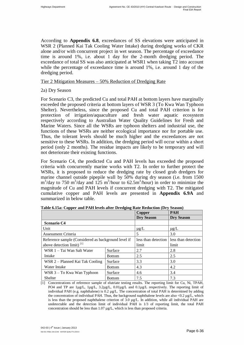
Highways Department Agreement No. CE 43/2010 (HY) Central Kowloon Route - Design and Construction Final EIA Report
042-03 | 4th Issue | January 2013
042-03_FINAL EIA (CH6 - WATER QUALITY).DOCX Page 6-36
According to Appendix 6.8, exceedances of SS elevations were anticipated in WSR 2 (Planned Kai Tak Cooling Water Intake) during dredging works of CKR alone and/or with concurrent project in wet season. The percentage of exceedance time is around 1%, i.e. about 1 day for the 2-month dredging period. The exceedance of total SS was also anticipated at WSR1 when taking T2 into account while the percentage of exceedance time is around 1%, i.e. around 1 day of the dredging period.
Tier 2 Mitigation Measures – 50% Reduction of Dredging Rate
2a) Dry Season
For Scenario C3, the predicted Cu and total PAH at bottom layers have marginally exceeded the proposed criteria at bottom layers of WSR 3 (To Kwa Wan Typhoon Shelter). Nevertheless, since the proposed Cu and total PAH criterion is for protection of irrigation/aquaculture and fresh water aquatic ecosystem respectively according to Australian Water Quality Guidelines for Fresh and Marine Waters. Since all the WSRs are typhoon shelters and industrial use, the functions of these WSRs are neither ecological importance nor for portable use. Thus, the tolerant levels should be much higher and the exceedances are not sensitive to these WSRs. In addition, the dredging period will occur within a short period (only 2 months). The residue impacts are likely to be temporary and will not deteriorate their existing functions.
For Scenario C4, the predicted Cu and PAH levels has exceeded the proposed criteria with concurrently marine works with T2. In order to further protect the WSRs, it is proposed to reduce the dredging rate by closed grab dredgers for marine channel outside pipepile wall by 50% during dry season (i.e. from 1500 m
3/day to 750 m
3/day and 125 m
3/hour to 62.5m
3/hour) in order to minimize the
magnitude of Cu and PAH levels if concurrent dredging with T2. The mitigated cumulative copper and PAH levels are presented in Appendix 6.9A and summarized in below table.
Table 6.15a: Copper and PAH levels after Dredging Rate Reduction (Dry Season)
Copper PAH
Dry Season Dry Season
Scenario C4
Unit µg/L µg/L
Assessment Criteria 5 3.0
Reference sample (Considered as background level if
above detection limit) [1]
less than detection
limit
less than detection
limit
WSR 1 – Tai Wan Salt Water
Intake
Surface 2.7 2.8
Bottom 2.5 2.5
WSR 2 – Planned Kai Tak Cooling
Water Intake
Surface 3.3 3.0
Bottom 4.3 4.2
WSR 3 – To Kwa Wan Typhoon
Shelter
Surface 4.6 3.4
Bottom 7.5 7.3 [1] Concentrations of reference sample of elutriate testing results. The reporting limit for Cu, Ni, TPAH,
PO4 and TP are 1µg/L, 1µg/L, 3.2µg/L, 0.01µg/L and 0.1µg/L respectively. The reporting limit of individual PAH (e.g. naphthalene) is 0.2 µg/L. The concentration of total PAH is determined by adding the concentration of individual PAH. Thus, the background naphthalene levels are also <0.2 µg/L, which is less than the proposed naphthalene criterion of 3.0 µg/L. In addition, while all individual PAH are undetectable and the detection limit of individual PAH is 1/3 of reporting limit, the total PAH concentration should be less than 1.07 µg/L, which is less than proposed criteria.

Highways Department Agreement No. CE 43/2010 (HY) Central Kowloon Route - Design and Construction Final EIA Report
042-03 | 4th Issue | January 2013
042-03_FINAL EIA (CH6 - WATER QUALITY).DOCX Page 6-37
With the implementation of mitigation measures, the Cu and PAH levels at WSRs could be reduced by around 40% to 50%. Same trends are also anticipated for other contaminants.
According to Appendix 6.9A (D-CCU-M), residue impact due to Cu and PAH levels are still anticipated at bottom layer of WSR 3 (To Kwa Wan Typhoon Shelter). However, due to programme constraint, there is no further room to reduce the dredging rate.
As discussed above, the proposed Cu and total PAH criterion are under a conservative side since it is for protection of irrigation/aquaculture and freshwater aquatic ecosystem respectively. While WSR 3 is a typhoon shelter without any potable use and the dredging period will only last for 2 months only, such exceedances will not deteriorate the existing functions of WSR 3. In addition, regular water quality monitoring in the Kowloon Bay and its vicinity are recommended during the construction phase and details are given in EM&A manual.
2b) Wet Season
Since exceedance of SS elevations were anticipated in wet season only (Scenario C3 and C4), it is recommended to avoid the exceedance by carrying dredging works in dry season if programme allowed to avoid concurrent dredging with T2. If this is unavoidable, additional mitigation measure is required.
It is proposed to reduce the dredging rate by closed grab dredgers for marine channel outside pipepile wall by 50% during wet season (i.e. from 1500 m
3/day to
750 m3/day and 125 m
3/hour to 62.5m
3/hour) in order to minimize the magnitude
of exceedance level. The mitigated sediment loss rate is presented in Table 6.15b. The sediment loss rates during wet season with 50% reduction of dredging rate and cage-typed silt curtain are presented in Appendix 6.9B and summarised in the Tables 6.15c and d.
Table 6.15b: Sediment Loss Rate with Cage-typed Silt Curtain (Wet Season)
Loading Point Production Rate Sediment Loss Rate (Mitigated – Tier 2)
Scenario C3
CKR – Dredging 750 m3/day 0.09 kg/s for 1 dredger (with cage-typed silt curtain) [2]
(Mitigated – Tier 2)
Scenario C4
CKR – Dredging 750 m3/day 0.09 kg/s for 1 dredger (with cage-typed silt curtain) [2]
(Mitigated – Tier 2) T2 – Dredging[3] 8000 m3/day 0.93 kg/s (Mitigated)
T2 – Filling[3] 2000 m3/day 0.19 kg/s (Mitigated) Notes: [1] Dredging rate of 700 m3/day refers to mitigated scenario. With the adoption of cage-typed silt curtain,
80% of reduction of sediment release is anticipated. [2] Assume 12 working hours per day. Calculations refer to Appendix 6.4. [3] According to the latest information, TBM method will be adopted for T2 project and thus no
dredging/filling work is required. However, the actual construction method for T2 project is still under investigation, traditional dredging/filling works were assumed as a conservative approach.

Highways Department Agreement No. CE 43/2010 (HY) Central Kowloon Route - Design and Construction Final EIA Report
042-03 | 4th Issue | January 2013
042-03_FINAL EIA (CH6 - WATER QUALITY).DOCX Page 6-38
Table 6.15c: Summary of Water Quality Impact due to Dredging/Filling Activities (Scenario C3) – Tier 2 Mitigation Measures (Adoption of Cage-typed Silt
Curtain and 50% reduction of dredging rate) (Wet Season)
Indicators Season Modeling Result Criteria
WSR 1 WSR 2 WSR 3 WSR 1 WSR 2 WSR 3
Suspended Solid Elevation (mg/L)
Surface Wet 0.0 0.4 0.0 1.9 1.9 2.3
Middle Wet 0.0 1.7 0.8 2.2 2.2 3.3
Bottom Wet 0.0 1.5 4.0 2.7 2.7 5.1
Depth Averaged Wet 0.0 0.8 1.3 2.3 2.3 3.8 Notes: [1] Grey cell represents exceedance records and the bracket shows the percentage of exceedance period.
Table 6.15d: Summary of Water Quality Impact due to Dredging/Filling Activities (Scenario C4) – Tier 2 Mitigation Measures (Adoption of Cage-typed Silt
Curtain and 50% reduction of dredging rate) (Wet Season)
Indicators Season Modeling Result Criteria
WSR 1 WSR 2 WSR 3 WSR 1 WSR 2 WSR 3
Suspended Solid Elevation (mg/L)
Surface Wet 1.1 0.4 0.0 1.9 1.9 2.3
Middle Wet 1.1 2.5 (<1%) 2.5 2.2 2.2 3.3
Bottom Wet 0.6 2.5 4.0 2.7 2.7 5.1
Depth Averaged Wet 0.7 0.9 1.3 2.3 2.3 3.8 Notes: [1] Grey cell represents exceedance records and the bracket shows the percentage of exceedance period.
Highways Department Agreement No. CE 43/2010 (HY) Central Kowloon Route - Design and Construction Final EIA Report
042-03 | 4th Issue | January 2013
042-03_FINAL EIA (CH6 - WATER QUALITY).DOCX Page 6-39
With the recommended mitigation measures, cumulative impacts are anticipated at WSR 2 (Planned Kai Tak Cooling Water Intake) and the exceedance period is <1%. The SS elevation at WSR 2 is up to 2.5 mg/L.
While WSR 2 is a planned receiver, the project proponent shall liaise with the project proponent of District Cooling System (DCS) for Kai Tak Development on the implementation programme prior to wet season dredging. In case the DCS would be operated during the dredging period of CKR, additional silt screen to the cooling water intake shall be provided to WSR 2. Refer to the Section 6.7.2, a 60% of SS reduction is anticipated with the implementation of silt screen. Thus, the SS elevations for WSR 2 will comply with the criterion. No residual impacts are anticipated. Nevertheless, regular water quality monitoring in the Kowloon Bay and its vicinity are recommended during the construction phase to monitoring the level of SS and details are given in EM&A manual.
Other Site Practice during Dredging Works
The following good practice shall apply for the dredging works:
Install efficient cage-typed silt curtains, i.e. at least 80% SS reduction, at the point of dredging/filling to control the dispersion of SS;
Water quality monitoring should be implemented to ensure effective control of water pollution and recommend additional mitigation measures required;
The decent speed of grabs should be controlled to minimize the seabed impact and to reduce the volume of over-dredging; and
All vessels should be sized so that adequate clearance is maintained between vessels and the seabed in all tide conditions, to ensure that undue turbidity is not generated by turbulence from vessel movement or propeller wash.
The dredging rates by closed grab dredgers for temporary marine channel outside pipepile wall shall be less than 1,500 m
3/day and 125 m
3/hour (without
concurrent dredging with T2 in dry season only) or 750 m3/day and 62.5
m3/hour for other conditions respectively.
Marine dredging works shall be only for the provision marine channel. Sediment removal for construction of underwater tunnel will be conducted within the pipepile wall area for temporary reclamation.
The workfront of temporary reclamation shall be surrounded by cofferdams and the associated excavation and backfilling works for temporary reclamation shall have no contact with seawater. The construction method of temporary reclamation is presented in Chapter 3.
6.9.2.3 Stone Column Installation and Temporary Reclamation
Installation/Demolition
The seabed disturbance of stone column installation and temporary reclamation installation/demolition has been minimized. Good site practices such as perimeter silt curtain and regular inspections is consider adequate to minimize the water quality impact.

Highways Department Agreement No. CE 43/2010 (HY) Central Kowloon Route - Design and Construction Final EIA Report
042-03 | 4th Issue | January 2013
042-03_FINAL EIA (CH6 - WATER QUALITY).DOCX Page 6-40
6.9.2.4 Dumping of Marine Sediment / Operation of Proposed
Kwai Chung Barging Point
The following good practice shall apply for the marine sediment handling and barging facilities operations:
All barges should be fitted with tight bottom seals to prevent leakage of materials during transport;
Barges or hoppers should not be filled to a level that will cause overflow of materials or polluted water during loading or transportation;
All vessels should be sized so that adequate clearance is maintained between vessels and the seabed in all tide conditions, to ensure that undue turbidity is not generated by turbulence from vessel movement or propeller wash; and
Loading of barges and hoppers should be controlled to prevent splashing of material into the surrounding water.
Mitigation measures for land-based activities as outlined in Section 6.7.1 should be applied to minimise water quality impacts from site runoff and open stockpile spoils at the proposed barging facilities where appropriate.
6.9.3 Operational Phase
No maintenance dredging required in the Project and thus mitigation measures for dredging are not required. However, in order to minimize road runoff and wastewater discharge from APS during the operational phase, the following mitigation measures during operational phase are recommended:
Drainage discharge should pass through oil/grit interceptors/chambers to remove oil, grease and sediment before discharging into public storm drainage/ foul sewerage system;
The silt traps and oil interceptors should be cleaned and maintained regularly;
Oily contents of the oil interceptors should be transferred to an appropriate disposal facility, or to be collected for reuse, if possible;
The wastewater from ESP should be properly treated prior to either discharge to public sewerage systems or collected by licenced contractor as appropriate; and
Depending on the proprietary design and the chemical content of the aqueous solutions discharge from the NO2 removal process, these solutions should either be collected by licenced chemical waste collectors and sent to Chemical Waste Treatment Facilities at Tsing Yi as required under the Chemical Waste Ordinance, or discharged to public sewerage systems.
6.10 Residue Impacts
Exceedance due to Cu and PAH levels were predicted in bottom layer of WSR 3 (To Kwa Wan Typhoon Shelter). In accordance with Section 4.4.3 of the TM-EIAO, the evaluations of residual impacts are assessed in below table.

Highways Department Agreement No. CE 43/2010 (HY) Central Kowloon Route - Design and Construction Final EIA Report
042-03 | 4th Issue | January 2013
042-03_FINAL EIA (CH6 - WATER QUALITY).DOCX Page 6-41
Table 6.16: Evaluation of Residue Impact
Section 4.4.3 of the TM-EIAO Evaluation
Effects on public health and health
of biota or risk to life
The proposed Cu and total PAH criteria are under a
conservative side since these criteria are for protection of
irrigation/aquaculture and fresh water aquatic ecosystem
respectively. While WSR 3 is a typhoon shelter only and
its function are neither ecological importance nor for
portable use, such exceedances will not deteriorate the
existing functions of WSR 3 and will not induce effects
on public health and health of biota or risk to life.
The magnitude of adverse
environmental impacts
The mixing zone of Cu and PAH is presented in
Appendices 6.7 and 6.9a. Exceedance were predicted in
bottom layer under dry season only.
The geographic extent on the
adverse environmental impacts
The duration and frequency of the
adverse environmental impacts
The mixing zone of Cu and PAH is presented in
Appendices 6.7 and 6.9a. Exceedance were predicted in
bottom layer under dry season only.
The entire dredging period is only last for 2 months.
The likely size of the community
or the environment that may be
affected by the adverse impacts
Exceedance were predicted in bottom layer at WSR 3 (To
Kwa Wan Typhoon Shelter) under dry season only. The
proposed Cu and total PAH criteria are under a
conservative side since these criteria are for protection of
irrigation/aquaculture and fresh water aquatic ecosystem
respectively. While WSR 3 is a typhoon shelter only and
its function are neither ecological importance nor for
portable use, such exceedances will not deteriorate the
existing functions of WSR 3 and will not affect the
community or the environment.
The degree to which adverse
environmental impacts are
reversible or irreversible
The entire dredging period is only last for 2 months and
conditions are reversible after completion of dredging
activities.
The ecological context
No ecological context will be affected since the affected
WSR is a typhoon shelter only and not an ecological
importance.
The degree of disruption to sites of
cultural heritage
No cultural heritage context will be affected since the
affected WSR is a typhoon shelter only and not a heritage
importance.
International and regional
importance
Residual impact are localised in Kowloon bay. Thus,
effect on regional and international context is
insignificant.
Both the likelihood and degree of
uncertainty of adverse
environmental impacts
The proposed Cu and total PAH criteria are under a
conservative side since these criteria are for protection of
irrigation/aquaculture and fresh water aquatic ecosystem
respectively. While WSR 3 is a typhoon shelter only and
its function are neither ecological importance nor for
portable use, such exceedances will not deteriorate the
existing functions of WSR 3.
While the above impact will occur in dry season only, it is considered advisable to conduct some of the dredging works in wet season, if programme allows.

Highways Department Agreement No. CE 43/2010 (HY) Central Kowloon Route - Design and Construction Final EIA Report
042-03 | 4th Issue | January 2013
042-03_FINAL EIA (CH6 - WATER QUALITY).DOCX Page 6-42
6.11 Conclusion
With full implementation of the mitigation measures, no adverse impact is anticipated. In addition, all the affected WSRs were either typhoon shelter or industrial use which has no ecological importance and not in portable use. Moreover, given the low phosphate contents, it is unlikely to have red tide algal bloom. In order to ensure the effectiveness of the implemented mitigation, regular water quality monitoring in the Kowloon Bay and its vicinity are recommended during the construction phase.
6.12 References
[6-1] EIA Report for Hong Kong Zhuhai Macao Bridge Hong Kong Link
Road (EIA-172/2009)
[6-2] EIA Report for Cruise Terminal (EIA-138/2007)
[6-3] EIA Report for Submarine Gas Pipeline (EIA-182/2010)
[6-4] EPD Marine Water Quality Monitoring Report
[6-5] ERM Hong Kong, Ltd (1997). Environmental Impact Assessment
Study for Disposal of Contaminated Mud In the East of Sha Chau
Marine Borrow Pit. Prepared for Civil Engineering Department,
HKSAR Government.
[6-6] Meinhardt Infrastructure and Environment (2007). Contract P325
Environmental Assessment Services for Permanent Aviation Fuel
Facility. Final Environmental Impact Assessment Report. Prepared for
Airport Authority Hong Kong.
[6-7] Mouchel Asia Limited (2002b). Contract M811 Environmental
Assessment Services for Permanent Aviation Fuel. Final
Environmental Impact Assessment Report. Prepared for Airport
Authority Hong Kong.
[6-8] EIA Report for Kai Tak Development (EIA-157/2008), Appendix 6.8