6;/?-$ )*+# - Planning Africa1).pdfPlanning Africa 2016 ... Approach to Transform the Future City...
162
4-6 JULY 2016 Sandton Convenction Centre Johannesburg, South Africa Making Sense of the Future Planning Africa 2016 Disruption and Reinvention ABSTRACT BOOK 1996-2016. 20 Years of Planning
Transcript of 6;/?-$ )*+# - Planning Africa1).pdfPlanning Africa 2016 ... Approach to Transform the Future City...

4-6 JULY 2016Sandton Convenction CentreJohannesburg, South Africa
Making Sense of the Future
PlanningAfrica 2016
Disruption and Reinvention
ABSTRACT BOOK
1996-2016. 20 Years of Planning

1996-201620 Years of Planning
Making Sense of the Future / Disruption and Reinvention 2
Planning Africa 2016Making Sense of the Future: Disruption and Reinvention
4 - 6 July 2016 Sandton Convention Centre, Johannesburg Gauteng, South Africa
ABSTRACT BOOK ISBN: 978-0-620-69628-9
Editors: Nthato Minyuku | Karuna Mohan | Itumeleng Nkoane | Aurobindo Ogra
Organised by: South African Planning Institute (SAPI) Post Box X15, Halfway House, 1685 | Tel: +27-11-655 7369 | Fax: +27-11-655 7011 Email: [email protected] | www.sapi.org.za | www.planningafrica.org.za
© South African Planning Institute (SAPI)
Disclaimer:
No part of this abstract book may be reproduced, republished and transmitted in any form without the written permission and consent of SAPI. Requests for reproduction of any content from the abstract book should be addressed to SAPI.
The abstracts published followed a rigorous peer review process set out and managed by the scientific committee and review panel in terms of: relevance, purpose and significance to the conference themes and objectives. Based on the rigorous peer review process the authors of the selected abstracts were invited to submit full papers. The accepted full papers followed a double blind peer review process by review panel comprising of national and international academia, research and industry experts in the planning and built environment field for inclusion in the conference proceeding.
The Editors and SAPI takes no responsibility for the abstract contents. The abstracts and the details published are purely based on the contents submitted by the author(s)/ registered lead author(s).

1996-2016. 20 Years of Planning
Making Sense of the Future / Disruption and Reinvention 3
Editorial Foreword The 7th Planning Africa Conference takes the continuity of previous conference themed ‘‘Making Great Places” to “Making Sense of the Future: Disruption and Reinvention”. The rapid changes arising from technology, innovation, social and economic exclusion has changed the way we understand the world.
In “Making Sense of the Future” the planning profession must keep up with changes and be willing to accept disruptions. This in itself brings about a discontinuity in thought, practice and process, and will shape the future. While technology and innovations are disruptive, improvements come about in the lives of people. In this book, there are some thought provoking ideas on technology and innovation within the field of planning and the impact this could have in reshaping services and delivery.
This conference provides an opportunity to seek views from various stakeholders on six sub-themes namely: Planning in the Age of Technology and Innovation; Disrupting and Reinventing Planning Thought; Spatial Governance -The Powers that Form Urban and Rural Spaces; Planning Responses to Demographic Challenges; Planning and the Optimal Utilization of Land; and Planning and Communities: How is Capital Contributing to the Spatial/Social Divide in Cities.
The call for conference paper submissions resulted in a wide array of inputs that will certainly assist in setting South Africa and Africa on a path of reinventing a viable future. The abstracts and papers range from policy discussions to case studies, new and alternative methodologies. Following a double blind peer review process, 126 abstracts were accepted for presentation and inclusion in the abstract book. Contributions were received from 20 academic and research institutions, 5 public sector (provincial and local government), 8 private sector organisations and a paper from the UN-Habitat.
The South African Planning Institute (SAPI) sincerely thanks the contributors for their time and efforts in putting together their abstracts, full papers and presentations for Planning Africa 2016. Special thanks goes to scientific committee and review panel comprising of local and international academic, researchers and industry domain experts for their rigorous comments and constructive criticism on abstracts and papers peer reviewed by them.
Editorial Team Planning Africa Conference 2016

Making Sense of the Future / Disruption and Reinvention 4
Index of Abstracts (by Authors First Name)
Authors TitlePage No.
A D (Tony) Williams, Prof Verna NelSpatial Governance Principles for Rural Areas Under Traditional Authority
56
Aadil Engar Planning Africa’s first Aerotropolis 157
Abraham Matamanda, Veronica Skiyi, Ruramai Kadebu
Climate Change in Southern Africa: Implications for Infrastructure Planning and Urban Management in Zimbabwe and Botswana
104
Adefemi Adegeye, Dr Johnny Coetzee
Exploring the Fragments of a Possible Theory and Policy on (Spatial) Justice in an Attempt to Build Justified and Just Cities and Communities in South Africa
58
Adetunji Adebayo, Jacques du Toit, Steve Koch, Willem Badenhorst
An Empirical Investigation of the Underlying Assumptions of Place-Based and Spatial Efficiency Views in Spatial Planning Practice: A focus on Gauteng’s Space Economy
130
Amanda Zungu, Rosemary Hayangah, George Onatu
A Critical Evaluation of the Challenges and Opportunities Inherent in the Evaluation of Spatial Development Framework: A Case of Outer West SDP, eThekwini Municipality
149
Amy Pieterse, Willemien van Niekerk, Elsona van Huyssteen, Gerbrand Mans, Johan Maritz, Alize Le Roux
Exploring Risks and Vulnerabilities in Gauteng’s Three Metropolitan Cities: Trends and Implications for City Governance and Forward Planning
71
Anri de Lange, Dr Johnny CoetzeeMaking Sense of Future Spatial Planning System in South Africa
60
Anthony Barnes Putting Spatial Resilience into Practice 57
AP Barnes, Dr E Barclay, JH Jacobs; C Hauptfleisch, S Orie, NS Jacobs, Prof Verna Nel
De-Complexifying the SPLUMA Principles 52
AP Hugo, Prof Das Steÿn The Graduate Identity of Professional Planning in South Africa 70
Ashley HayUnderstanding and Overcoming the Development Application Blockages in Gauteng Province 153
Azra RajabThe Adoption of Appropriate Technology in Service Delivery in South Africa 72
Belinda Verster Urban Planning Curriculum: Reviewing Assessment Strategies as a Learning (and not a Testing) Tool 98

1996-2016. 20 Years of Planning
Making Sense of the Future / Disruption and Reinvention 5
Bongumusa Ndwandwe, Dr Trynos Gumbo
Innovative Urban Public Transport Systems and Economic Transformation Nexus: Case of Gautrain and Are Yeng in the City of Tshwane
106
Bonolo Letlape, Dr Trynos GumboThe Role of Innovations in Municipal Solid Waste Management to Attaining Sustainable Cities: Case of City of Johannesburg 105
Carmen Paulsen
Guiding the Metropolitan Budgeting Process through the Capital Investment Framework: Taking a Data Driven Approach to Transform the Future City Scape of the Ekurhuleni Metropolitan Municipality
156
Celiwe KgowediGIS Data Availability for Spatial Planning: The practicality of Open Data in Addressing Data Accessibility for Spatial Planning in Government
154
Chéri Green, Gerbrand Mans, Johan Maritz, Mawande Ngidi, Zukisa Sogoni
Developing a Node Hierarchy as a Focus for Locating Middle to Higher Order Social Services in South Africa 84
Danie du PlessisAn Application of ISO 37120 Indicators to Compare Sustainable Development in South African and International Cities 64
Danie du PlessisAn Integrated Framework and Methodology for Spatial Planning Evaluation 65
Danisile SeecoInadequate Implementation of the Galeshewe Urban Renewal Programme, in Hindsight (2001-2010), Sol Plaatje Municipality, Northern Cape, South Africa
91
Desiree SehlapeloThe Spatial Dimension for Gauteng City Region ‘Green Infrastructure’ 136
Dr Dillip Kumar DasInfluence of Information Communication Technology to Create an Image of a Creative City in Developing Countries 31
Dr Dillip Kumar DasImages of Central Areas: A comparative Analyses Between South African and European Cities 32
Dr Eizabeth BarclayGamification, Gaming, Apps and Social Media in Development Planning: Needs Versus Limits of Technology 48
Dr Elizabeth Barclay, J Rumbelow, H Jacobs, K Munro
The Zoning Predicament of Airbnb 46
Dr Elizabeth Barclay, JH Jacobs, J Rumbelow
Conceptual Framework to Guide the Development Planning Research in the Western Cape 45
Dr Thulisile Mphambukeli, Patricia Luckan
If planning is Not Addressing the Imbalances of the Past, Maybe Planning is Being Undermined 103
Dr. Mutakela Kingsley Minyoi The Dilemma of Urban Planning Practice in Botswana 132

Making Sense of the Future / Disruption and Reinvention 6
Elijah Babasola Afolabi AGBAJEHyper-Regulation Within a Deregulated Economy: the Emergence of the Fifth Columnists and the Hampering of the National Growth and Development in Nigeria
99
Elvia Sofia BonillaProviding High Quality Infrastructure in a Bankrupted Environment: Comparison of Local Synergies in the Cities of Dar-es-Salaam (Tanzania) and Santa Tecla (El-Salvador)
127
Engela Petzer Is Planning Paying Attention to ‘The Future’? Experiences in Eight South African Municipalities 77
Engela Petzer, Tinus Kruger, Azra Rajab, Thuli Ndlovu
Revising the South African Guidelines for Human Settlement Planning and Design (The Red Book) 80
Eric Nyembezi MakoniIsisindo Soluntu: Decolonial Theory and Practices in the African City 140
Eric Nyembezi MakoniFrom Bantustans to Functional Regions? Planning for Rural Development in Post 1994 South Africa 141
Faith Dowelani, Emaculate IngwaniUrban Expansion and Spatial Distribution of Wetlands in Thohoyando Town, South Africa 150
Francois WüstUrban Social and Spatial Upgrading in the Western Cape through the RSEP/VPUU Programme 38
Frank CummingDevelopment Charges and Housing Affordability: A Policy Conundrum 49
Frank CummingEnabling Regeneration in an Age of Austerity: The Public Sectors Role in Facilitating Development 50
G P Kelly, Dr P J v V CoetzeeOver the Edge: The Impact of Urban Sprawl on the City of Ekurhuleni 94
G.S. Cornelius, Prof. C.B. SchoemanMosaic Project: A Case Study of the Spatial Impacts of HIV & AIDS on Informal Settlement Development 138
George Onatu, Eric MakoniUrban Governance and Social Housing in South Africa: the Case of Johannesburg Social Housing Company (JOSHCO) 142
George Onatu, Prof Didibhuku Thwala
The Prospects and Challenges of Mixed-Income Housing Development Strategies in Socio-Spatial Transformation of South African Human Settlements: Evidence from Two Case Studies
146
George Onatu, Prof Didibhuku Thwala
Public Private Partnership: Evidence from the Breaking New Ground (BNG) Human Settlements Programme at Cosmo City, Johannesburg
147
1996-2016. 20 Years of Planning
Making Sense of the Future / Disruption and Reinvention 7
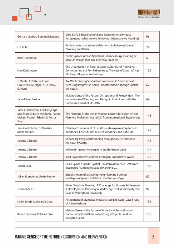
Gerhard Gerber, Bernard NiemandIDPs, SDFs & EIAs: Planning and Environmental Impact Assessment - What are we Achieving, Where are we Heading? 96
H.E RohrRe-Evaluating the Intimate Relationship Between Spatial Planning and Water 74
Ilaria BoniburiniPublic Spaces in Post-Apartheid Johannesburg: Clashing of Ideals in Imaginaries and Everyday Practices 63
Ivan KadungureThe Urbanisation of Rural Villages, Cultural and Traditional Communities and Peri-Urban Areas: The case of South Africa’s Phokeng Village in Rustenburg
126
J. Maritz, A. Pieterse, E. Van Huyssteen, M. Ngidi, A. Le Roux, G. Mans
Are We Achieving Spatial Transformation in South Africa? Accessing Progress in Spatial Transformation Though Spatial Indicators.
67
Jaco-Albert BakkerMaking Sense of the Future: Disruption and Reinvention - The Importance of Planning and Design in Rural Areas with the Commencement of SPLUMA
66
James Chakwizira, Cecilia Njenga, Mac Mashiri, Buyisiwe Zuma, Rajesh Makan, Maartin Friedrich, Petrus Steyn
The Planning Profession in Motion: Lessons for South Africa’s Planning Profession Act (2002) from International Experiences 143
Jennilee Kohima, Dr Thulisile Mphambukeli
Effective Enforcement of Land Use Management Systems in Windhoek: Case Studies of Klein Windhoek and Katutura 122
Jeremy GibberdEnhancing Integrated Planning through City Performance Indicator Systems 116
Jeremy Gibberd Informal Trading Typologies in South African Cities 117
Jeremy Gibberd Built Environments and the Ecological Footprint of Waste 117
Josiah LodiCall a Spade a Spade: Spatial Transformation Post 1994, from Integrated Planning to Spatial Planning ..… 155
Julien Rumbelow, Riette Fourie Establishment of a Development Planning Business Intelligence System (DP-BIS) in the Western Cape 82
Justman SUHWater Sensitive Planning: A Challenge for Human Settlements & Development Planning in Madibeng Local Municipality, the Case of Mothutlung Township
92
Kailin Singh, Aurobindo OgraAssessment of Municipal Infrastructure Life Cycle: Case Study of Johannesburg 133
Karien Erasmus, Robbie LouwMaking Sense of the Future of Mine Land Rehabilitation: Community Based Renewable Energy Projects on Mine Impacted Land
135

Making Sense of the Future / Disruption and Reinvention 8
Karien Louw, Louis Lategan, Prof Elizelle Cilliers
Reflecting on the Impacts of Chinese Migration in South Africa – A Local Perspective 75
Karien Louw, Prof Elizelle Cilliers, Dr Waldo Krugell
Building Cities from Scratch: A Case Study of Cidade de Kilamba 76
Keitumetse Phala, Dr Trynos Gumbo
An Assessment of Environmental Impacts of Urban Housing Informality on Residents: Experiences with Water, Sanitation and Waste Management in Alexandra Township
123
Kgaogelo Kgatjepe, Aurobindo Ogra
Sustainable Transport for Urban Poor: A Case of Johannesburg 119
Kgaugelo S. MametjaSpatial Governance – The Powers that Form Urban and Rural Spaces: SPLUMA and Its Implications 29
Kgosi Mocwagae, Dr Thulisile Mphambukeli
Traditional Leadership Creating Enabling Environments for Human Settlements: A Case Study of QwaQwa (a former Bantustan)
90
Khwathisi Ntsieni Colin, Marule Ditsepu Kholofhelo
Investigating Challenges Hindering the Implementation of Infrastructure Projects in the Rural Areas of Maruleng Municipality
124
Kutulo Mahlare, Aurobindo OgraComparative Analysis of Public Participation Strategies of Metropolitan Cities of Gauteng, South Africa 131
Laura Pinfold, Nicholas PinfoldAn Investigation into Land Tenure Opportunities for the Goedverwacht Moravian Mission Station in the Western Cape 88
Lebo Radebe-RadebeMeasuring and Monitoring Urban (And Rural) Development Performance Against an Appropriate Set of Sustainable Development Performance Indicators
24
Lodie Venter Questioning Business-as-Usual Spatial Planning 120
Lourens Booysen, Maléne Campbell
A Lack of Stakeholder Buy in Derails an Urban Development Zone Tax Incentive: The Case of Mangaung, South Africa 26
Louw van Biljon The Collateral Damage of Local Politics 112
Mac Mashiri, Dr James Chakwizira, Peter Njenga, Abena Kwayisi
Corridors as Place Making, Identity Creation and Space Branding Tools: Imagining the Possibilities of a Future South African Spatial System Anchored on Vibrant and Sustainable Corridors
144
Mac Mashiri, Peter Njenga, Maartin Friedrich, James Chakwizira
Employing a Functional Region Approach to Promoting Inclusive and Sustainable Rural Development: The Case for Xhariep District Municipality, Free State Province
145
Mahlatse Mankge, Zinzile Seepie The Journey from the City of “Survive” to Land of “Thrive”… 137

1996-2016. 20 Years of Planning
Making Sense of the Future / Disruption and Reinvention 9
Mantsha Tsheoga, Aurobindo OgraSustainable Urban Infrastructure & Service Delivery Assessment of City-Regions of South Africa: A Case Study of Gauteng City-Region & Cape Town City-Region
152
Marek Kedzieja Greater Cape Metropolitan Spatial Implementation Framework 37
Ma-Rene' Maree, Prof Elizelle CilliersA Policy and Legislation Investigation Supporting the Creation of Child-Friendly Spaces 109
Maryam Jafari Mehrabadi, Hamid Rokhsari
Informal Settlements Access to Public Transport Systems (A Comparative Study: Tehran and Johannesburg) 111
Maryam Jafari Mehrabadi, Hamid Rokhsari
Investigating the Experiences in Empowering the Informal Settlements in Iran 115
Moffat Frank, Prof Peter BikamExploring Revenue Enhancement Strategies in Rural Municipalities: A Case of Mutale Municipality 125
Monwabisi Mdleleni, Dr Thulisile Mphambukeli
Exploring the Underlying Factors Behind the Resurgence of New Informal Settlements Post in-Situ Upgrading in South Africa: A Case Study of Phelindaba Informal Settlement, Matjhabeng Local Municipality, Free State
83
Nicholas Pinfold, Laura Pinfold Using Cognitive, Participatory and Community Mapping Methods for Spatial Analysis 87
Nico VenterMaking Urban - “Making Sense of the Future - Disruption and Reinvention” 97
Nozipho Shabalala, Lodene Willemse
Consumption Expenditure Patterns of Unsustainable RDP Households in South Africa 30
Ojo-Fajuru Olufemi, Moolaji OlaseniEnvironmental Planning Theories and Best Practices: The Nexus Between Urban Re-Naturalization and Sustainable Cityscape in Nigeria
55
Olufemi Ojo-Fajuru, Ambrose Adebayo
Recovering Lost Socio-Cultural Spaces to Re-Establish Sustainable Green Places and Reinvent Ado-Ekiti, Nigeria as a Great City of Tomorrow
41
Olufemi Ojo-Fajuru, Ambrose Adebayo
Development Control Regulations Compliance: Paradigm Change to Reinvent Disrupted Public Spaces and Make Future Great Place in Ado-Ekiti, Nigeria
42
Petronella Tizora, Alize Le Roux, Gerbrand Mans, Antony Cooper
Understanding Past Drivers of Land Use Change to Model Potential Future Land Use in the Western Cape Province 54
Prof Das SteynHow Sound Planning Sense Should Disrupt the Different Powers in the Planning World 114
Prof Verna Nel, Darren Nel A Transect Approach to Land Use Management in South Africa 61

Making Sense of the Future / Disruption and Reinvention 10
Prof Vusi Mashinini Gated-Communities in Lesotho: Prospects and Constraints 101
Rapuleng Ramatsoele, Dr Maléne
Campbell
The Impact of the Southern African Development Community
Protocol on Market Access along the Maputo Development
Corridor
35
Rebecca Cameron and Tania
Katzschner
Every Last Drop - The Role of Spatial Planning in Enhancing
Urban Water Management in the City of Cape Town40
Retsebile Moswane,
Dr Trynos Gumbo
Movement Patterns of Commuters between Sandton and
Park Micro City Centers in the Johannesburg Metropolitan
City: Towards a Connectivity Model for Urban Public Transport
Systems
139
Rialivhuwa Tshivhase, Ikuko
OkamotoImpact of Rural-Urban Migration on Household Economy 113
Rob Dyer An ‘Uncompact City’ - The Spatial History of Durban 34
Rocio Armillas Tiseyra Making Great Places: Women's Access and Use of Public Space 89
RS Veiga, Prof Elizelle Juanee CilliersEvaluating South Africa's Green Planning Strategies: The
Fleurhof Case Study69
Sarah McCabe, Denise FerrisStudent Photovoice in Uganda: Education, Service, Leadership,
and the Future102
Shylet Nyamwanza, Prof Peter
Bikam
An Assessment of Trans-Border Spatial Development
Cooperation: Insights from Musina-Beitbridge Twinning
Agreement
121
Sinovuyo Babalwa Sitingal, Dr
Walter Musakwa
Pursuing Rural Development Whilst Maintaining Ruralism: A
Case Study of Qunu (Empa), Eastern Case, South Africa and
Tsholotsho (Hwange, National Park), Zimbabwe
100
Siyabonga NjekePublic Participation and Collaborative Planning: the Key to
Unlocking the 20 Basic Pillars of Planning108

1996-2016. 20 Years of Planning
Making Sense of the Future / Disruption and Reinvention 11
Siyabonga Njeke, Jivan Pardesi
Cross-Border Municipal Planning as a Process Towards
Integrated and Sustainable City Regions: A Case Study of
Ethekwini Metropolitan
107
Stehan Coetzee, K Puren
An Exploration of Student’s Experiences of Safety on Campus
Environments in Finland and South Africa: Towards an
Integrated Environmental Design Approach
148
Sthembiso Welcome Ngomane,
Emaculate Ingwani
Dynamics of Accessing Water in Rural Villages of Mbombela
Municipality in South Africa151
Taariq Ismail, Daniel Irurah Possible Futures: The Trajectory of Marlboro 134
Tania de WaalThe Ongoing Apartheid Spatial Planning Pattern: Is SPLUMA
the Light at the End of the Tunnel?53
Thandi Makale, Anele Horn Service Delivery in South African Rural Municipalities 36
Thando Gono, George Onatu
A Critical Evaluation of the Impact of National Informal
Settlement Upgrade Programme in Townships: A Case of Ivory
Park in the Northern of the City of Johannesburg
159
Thembani Moyo,
Dr Walter Musakwa
The Potential of Social Media to Demarcate the Catchment of
Commuters of the Gautrain Public Transit System110
Thembeka NxumaloThe Role of the Built Environment Performance Plan in Re-
Inventing our City44
Thomas Stellmach, Gianluca Crispi,
Benjamin Scheerbarth
UN-Habitat's Rapid Planning Studio: An Actionable Planning
Methodology for Periods of Rapid Urbanization93
Thomas Stewart, Simon ShingutoThe Irrelevance of Planning in a Dynamic Sub-Sahara Africa
and Back to Relevance?95
Tresor Mbayvahe,
Dr Innocent Musonda
The Use of ICT Tools to Improve the Slum Upgrading Process
in South Africa: A Case of Denver Slum Upgrading Project in
Johannesburg
78
Tresor Mbayahe, George OnatuProgramming Regional Development for the New Provincial
Structure in the Democratic Republic of Congo79

Making Sense of the Future / Disruption and Reinvention 12
Werner Fourie
Land Use Management in Traditional Authority Areas -
Disrupting Conventional Thought and Providing Innovative
Practices for a Workable Future
62
Werner Mostert Urban and Rural Growth Modelling – Predicting Urban and
Rural Growth Patterns: A South African Case Study28
Zaakirah Jeeva, Prof Elizelle Cilliers The Formation of Metropolitan Regions in South Africa? 68
Zenzile Mbinza
You Wore My Socks Again...The Case of Brand Encroachment
Between the Cities of Johannesburg and Ekurhuleni, Gauteng,
South Africa
128
Zenzile MbinzaWho Owns Joburg: Investigating Corporate and Survivalist
Branding Strategies in Johannesburg129
Zhan Goosen, Prof Elizelle Juanee Cilliers
Planning Child-friendly Green Spaces for the South African Context
27
Zukisa Sogoni, Mawande Ngidi, Cheri Green
The Morphological / Settlement Pattern Classification of South African Settlements Based on the CSIR Settlement Catchment Approach, to Inform Facility Allocation and Service Delivery
86

1996-2016. 20 Years of Planning
Making Sense of the Future / Disruption and Reinvention 13
Index of Abstracts (by Sub-Themes)
Planning in the Age of Technology and Innovation
Authors TitlePage No.
Azra RajabThe Adoption of Appropriate Technology in Service Delivery in South Africa
72
Bongumusa Ndwandwe, Dr Trynos Gumbo
Innovative Urban Public Transport Systems and Economic Transformation Nexus: Case of Gautrain and Are Yeng in the City of Tshwane
106
Bonolo Letlape, Dr Trynos GumboThe Role of Innovations in Municipal Solid Waste Management to Attaining Sustainable Cities: Case of City of Johannesburg
105
Celiwe KgowediGIS Data Availability for Spatial Planning: The practicality of Open Data in Addressing Data Accessibility for Spatial Planning in Government
154
Dr Dillip Kumar DasInfluence of Information Communication Technology to Create an Image of a Creative City in Developing Countries
31
Dr Eizabeth BarclayGamification, Gaming, Apps and Social Media in Development Planning: Needs Versus Limits of Technology
48
Julien Rumbelow, Riette Fourie Establishment of a Development Planning Business Intelligence System (DP-BIS) in the Western Cape
82
Kgaogelo Kgatjepe, Aurobindo Ogra
Sustainable Transport for Urban Poor: A Case of Johannesburg 119
Nicholas Pinfold, Laura Pinfold Using Cognitive, Participatory and Community Mapping Methods for Spatial Analysis 87
Retsebile Moswane, Dr Trynos Gumbo
Movement Patterns of Commuters between Sandton and Park Micro City Centers in the Johannesburg Metropolitan City: Towards a Connectivity Model for Urban Public Transport Systems
139
Thembani Moyo, Dr Walter Musakwa
The Potential of Social Media to Demarcate the Catchment of Commuters of the Gautrain Public Transit System 110
Tresor Mbayahe, Dr Innocent Musonda
The Use of ICT Tools to Improve the Slum Upgrading Process in South Africa: A Case of Denver Slum Upgrading Project in Johannesburg
78
Werner Mostert Urban and Rural Growth Modelling – Predicting Urban and Rural Growth Patterns: A South African Case Study 28

Making Sense of the Future / Disruption and Reinvention 14
Disrupting and Reinventing Planning Thought
Authors TitlePage No.
Anri de Lange, Dr Johnny Coetzee Making Sense of Future Spatial Planning System in South Africa 60
AP Hugo, Prof Das Steÿn The Graduate Identity of Professional Planning in South Africa 70
Belinda Verster Urban Planning Curriculum: Reviewing Assessment Strategies as a Learning (and not a Testing) Tool 98
Dr Dillip Kumar Das Images of Central Areas: A comparative Analyses Between South African and European Cities 32
Dr Thulisile Mphambukeli, Patricia Luckan
If planning is Not Addressing the Imbalances of the Past, Maybe Planning is Being Undermined 103
Dr. Mutakela Kingsley Minyoi The Dilemma of Urban Planning Practice in Botswana 132
Elijah Babasola Afolabi AGBAJEHyper-Regulation Within a Deregulated Economy: the Emergence of the Fifth Columnists and the Hampering of the National Growth and Development in Nigeria
99
Engela Petzer Is Planning Paying Attention to ‘The Future’? Experiences in Eight South African Municipalities 77
Engela Petzer, Tinus Kruger, Azra Rajab, Thuli Ndlovu
Revising the South African Guidelines for Human Settlement Planning and Design (The Red Book) 80
Eric Nyembezi Makoni Isisindo Soluntu: Decolonial Theory and Practices in the African City 140
Eric Nyembezi Makoni From Bantustans to Functional Regions? Planning for Rural Development in Post 1994 South Africa 141
Francois Wüst Urban Social and Spatial Upgrading in the Western Cape through the RSEP/VPUU Programme 38
Frank Cumming Development Charges and Housing Affordability: A Policy Conundrum 49
Frank Cumming Enabling Regeneration in an Age of Austerity: The Public Sectors Role in Facilitating Development 50
George Onatu, Eric Makoni Urban Governance and Social Housing in South Africa: the Case of Johannesburg Social Housing Company (JOSHCO) 142

George Onatu, Prof Didibhuku Thwala
The Prospects and Challenges of Mixed-Income Housing Development Strategies in Socio-Spatial Transformation of South African Human Settlements: Evidence from Two Case Studies
146
H.E Rohr Re-Evaluating the Intimate Relationship Between Spatial Planning and Water 74
Ilaria Boniburini Public Spaces in Post-Apartheid Johannesburg: Clashing of Ideals in Imaginaries and Everyday Practices 63
J. Maritz, A. Pieterse, E. Van Huyssteen, M. Ngidi, A. Le Roux, G. Mans
Are We Achieving Spatial Transformation in South Africa? Accessing Progress in Spatial Transformation Though Spatial Indicators.
67
James Chakwizira, Cecilia Njenga, Mac Mashiri, Buyisiwe Zuma, Rajesh Makan, Maartin Friedrich, Petrus Steyn
The Planning Profession in Motion: Lessons for South Africa’s Planning Profession Act (2002) from International Experiences 143
Jeremy Gibberd Enhancing Integrated Planning through City Performance Indicator Systems 116
Jeremy Gibberd Informal Trading Typologies in South African Cities 117
Jeremy Gibberd Built Environments and the Ecological Footprint of Waste 118
Josiah Lodi Call a Spade a Spade: Spatial Transformation Post 1994, from Integrated Planning to Spatial Planning ..… 155
Kailin Singh, Aurobindo Ogra Assessment of Municipal Infrastructure Life Cycle: Case Study of Johannesburg 133
Karien Louw, Prof Elizelle Cilliers, Dr Waldo Krugell
Building Cities from Scratch: A Case Study of Cidade de Kilamba 76
Keitumetse Phala, Dr Trynos Gumbo
An Assessment of Environmental Impacts of Urban Housing Informality on Residents: Experiences with Water, Sanitation and Waste Management in Alexandra Township
123
Louw van Biljon The Collateral Damage of Local Politics 112
Moffat Frank, Prof Peter Bikam Exploring Revenue Enhancement Strategies in Rural Municipalities: A Case of Mutale Municipality 125
Petronella Tizora, Alize Le Roux, Gerbrand Mans, Antony Cooper
Understanding Past Drivers of Land Use Change to Model Potential Future Land Use in the Western Cape Province 54
Prof Das Steyn How Sound Planning Sense Should Disrupt the Different Powers in the Planning World 114
Rob Dyer An ‘Uncompact City’ - The Spatial History of Durban 34
1996-2016. 20 Years of Planning
Making Sense of the Future / Disruption and Reinvention 15

Making Sense of the Future / Disruption and Reinvention 16
Taariq Ismail, Daniel Irurah Possible Futures: The Trajectory of Marlboro 134
Thomas Stellmach, Gianluca Crispi, Benjamin Scheerbarth
UN-Habitat's Rapid Planning Studio: An Actionable Planning Methodology for Periods of Rapid Urbanization 93
Thomas Stewart, Simon Shinguto The Irrelevance of Planning in a Dynamic Sub-Sahara Africa and Back to Relevance? 95
Zenzile MbinzaYou Wore My Socks Again...The Case of Brand Encroachment Between the Cities of Johannesburg and Ekurhuleni, Gauteng, South Africa
128
Disrupting and Reinventing Planning Thought
Authors TitlePage No.
A D (Tony) Williams, Prof Verna Nel Spatial Governance Principles for Rural Areas Under Traditional Authority 56
Adefemi Adegeye, Dr Johnny Coetzee
Exploring the Fragments of a Possible Theory and Policy on (Spatial) Justice in an Attempt to Build Justified and Just Cities and Communities in South Africa
58
Adetunji Adebayo, Jacques du Toit, Steve Koch, Willem Badenhorst
An Empirical Investigation of the Underlying Assumptions of Place-Based and Spatial Efficiency Views in Spatial Planning Practice: A focus on Gauteng’s Space Economy
130
Amanda Zungu, Rosemary Hayangah, George Onatu
A Critical Evaluation of the Challenges and Opportunities Inherent in the Evaluation of Spatial Development Framework: A Case of Outer West SDP, eThekwini Municipality
149
Amy Pieterse, Willemien van Niekerk, Elsona van Huyssteen, Gerbrand Mans, Johan Maritz, Alize Le Roux
Exploring Risks and Vulnerabilities in Gauteng’s Three Metropolitan Cities: Trends and Implications for City Governance and Forward Planning
71
Anthony Barnes Putting Spatial Resilience into Practice 57
AP Barnes, Dr E Barclay, JH Jacobs; C Hauptfleisch, S Orie, NS Jacobs, Prof Verna Nel
De-Complexifying the SPLUMA Principles 52
Danie du Plessis An Application of ISO 37120 Indicators to Compare Sustainable Development in South African and International Cities 64
Danie du Plessis An Integrated Framework and Methodology for Spatial Planning Evaluation 65

Desiree Sehlapelo The Spatial Dimension for Gauteng City Region ‘Green Infrastructure’ 136
Dr Elizabeth Barclay, J Rumbelow, H Jacobs, K Munro The Zoning Predicament of Airbnb 46
Dr Elizabeth Barclay, JH Jacobs, J Rumbelow
Conceptual Framework to Guide the Development Planning Research in the Western Cape 45
G P Kelly, Dr P J v V Coetzee Over the Edge: The Impact of Urban Sprawl on the City of Ekurhuleni 94
Gerhard Gerber, Bernard Niemand IDPs, SDFs & EIAs: Planning and Environmental Impact Assessment - What are we Achieving, Where are we Heading? 96
Jaco-Albert BakkerMaking Sense of the Future: Disruption and Reinvention - The Importance of Planning and Design in Rural Areas with the Commencement of SPLUMA
66
Kgaugelo S. Mametja Spatial Governance – The Powers that Form Urban and Rural Spaces: SPLUMA and Its Implications 29
Kutulo Mahlare, Aurobindo Ogra Comparative Analysis of Public Participation Strategies of Metropolitan Cities of Gauteng, South Africa 131
Lebo Radebe-RadebeMeasuring and Monitoring Urban (And Rural) Development Performance Against an Appropriate Set of Sustainable Development Performance Indicators
24
Lodie Venter Questioning Business-as-Usual Spatial Planning 120
Lourens Booysen, Maléne Campbell
A Lack of Stakeholder Buy in Derails an Urban Development Zone Tax Incentive: The Case of Mangaung, South Africa 26
Mac Mashiri, Dr James Chakwizira, Peter Njenga, Abena Kwayisi
Corridors as Place Making, Identity Creation and Space Branding Tools: Imagining the Possibilities of a Future South African Spatial System Anchored on Vibrant and Sustainable Corridors
144
Mac Mashiri, Peter Njenga, Maartin Friedrich, James Chakwizira
Employing a Functional Region Approach to Promoting Inclusive and Sustainable Rural Development: The Case for Xhariep District Municipality, Free State Province
145
Marek Kedzieja Greater Cape Metropolitan Spatial Implementation Framework 37
Nico Venter Making Urban - “Making Sense of the Future - Disruption and Reinvention” 97
Olufemi Ojo-Fajuru, Ambrose Adebayo
Recovering Lost Socio-Cultural Spaces to Re-Establish Sustainable Green Places and Reinvent Ado-Ekiti, Nigeria as a Great City of Tomorrow
41
1996-2016. 20 Years of Planning
Making Sense of the Future / Disruption and Reinvention 17

Making Sense of the Future / Disruption and Reinvention 18
Olufemi Ojo-Fajuru, Ambrose Adebayo
Development Control Regulations Compliance: Paradigm Change to Reinvent Disrupted Public Spaces and Make Future Great Place in Ado-Ekiti, Nigeria
42
Rapuleng Ramatsoele, Dr Maléne Campbell
The Impact of the Southern African Development Community Protocol on Market Access along the Maputo Development Corridor
35
RS Veiga, Prof Elizelle Juanee Cilliers Evaluating South Africa's Green Planning Strategies: The Fleurhof Case Study 69
Shylet Nyamwanza, Prof Peter Bikam
An Assessment of Trans-Border Spatial Development Cooperation: Insights from Musina-Beitbridge Twinning Agreement
121
Sinovuyo Babalwa Sitingal, Dr Walter Musakwa
Pursuing Rural Development Whilst Maintaining Ruralism: A Case Study of Qunu (Empa), Eastern Case, South Africa and Tsholotsho (Hwange, National Park), Zimbabwe
100
Siyabonga Njeke, Jivan PardesiCross-Border Municipal Planning as a Process Towards Integrated and Sustainable City Regions: A Case Study of Ethekwini Metropolitan
107
Sthembiso Welcome Ngomane, Emaculate Ingwani
Dynamics of Accessing Water in Rural Villages of Mbombela Municipality in South Africa 151
Tania de Waal The Ongoing Apartheid Spatial Planning Pattern: Is SPLUMA the Light at the End of the Tunnel? 53
Thembeka Nxumalo The Role of the Built Environment Performance Plan in Re-Inventing our City 44
Making Sense of the Future / Disruption and Reinvention 19
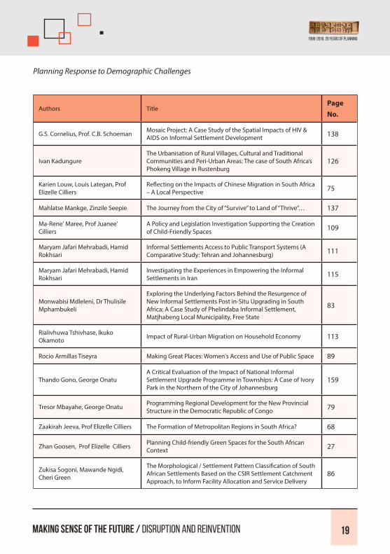
Planning Response to Demographic Challenges
Authors TitlePage No.
G.S. Cornelius, Prof. C.B. Schoeman Mosaic Project: A Case Study of the Spatial Impacts of HIV & AIDS on Informal Settlement Development 138
Ivan KadungureThe Urbanisation of Rural Villages, Cultural and Traditional Communities and Peri-Urban Areas: The case of South Africa’s Phokeng Village in Rustenburg
126
Karien Louw, Louis Lategan, Prof Elizelle Cilliers
Reflecting on the Impacts of Chinese Migration in South Africa – A Local Perspective 75
Mahlatse Mankge, Zinzile Seepie The Journey from the City of “Survive” to Land of “Thrive”… 137
Ma-Rene' Maree, Prof Juanee' Cilliers
A Policy and Legislation Investigation Supporting the Creation of Child-Friendly Spaces 109
Maryam Jafari Mehrabadi, Hamid Rokhsari
Informal Settlements Access to Public Transport Systems (A Comparative Study: Tehran and Johannesburg) 111
Maryam Jafari Mehrabadi, Hamid Rokhsari
Investigating the Experiences in Empowering the Informal Settlements in Iran 115
Monwabisi Mdleleni, Dr Thulisile Mphambukeli
Exploring the Underlying Factors Behind the Resurgence of New Informal Settlements Post in-Situ Upgrading in South Africa: A Case Study of Phelindaba Informal Settlement, Matjhabeng Local Municipality, Free State
83
Rialivhuwa Tshivhase, Ikuko Okamoto Impact of Rural-Urban Migration on Household Economy 113
Rocio Armillas Tiseyra Making Great Places: Women's Access and Use of Public Space 89
Thando Gono, George OnatuA Critical Evaluation of the Impact of National Informal Settlement Upgrade Programme in Townships: A Case of Ivory Park in the Northern of the City of Johannesburg
159
Tresor Mbayahe, George Onatu Programming Regional Development for the New Provincial Structure in the Democratic Republic of Congo 79
Zaakirah Jeeva, Prof Elizelle Cilliers The Formation of Metropolitan Regions in South Africa? 68
Zhan Goosen, Prof Elizelle Cilliers Planning Child-friendly Green Spaces for the South African Context 27
Zukisa Sogoni, Mawande Ngidi, Cheri Green
The Morphological / Settlement Pattern Classification of South African Settlements Based on the CSIR Settlement Catchment Approach, to Inform Facility Allocation and Service Delivery
86
1996-2016. 20 Years of Planning

Planning and the Optimal Utilization of Land
Authors Title Page No.
Aadil Engar Planning Africa’s first Aerotropolis 157
Abraham Matamanda, Veronica Skiyi, Ruramai Kadebu
Climate Change in Southern Africa: Implications for Infrastructure Planning and Urban Management in Zimbabwe and Botswana
104
Danisile SeecoInadequate Implementation of the Galeshewe Urban Renewal Programme, in Hindsight (2001-2010), Sol Plaatje Municipality, Northern Cape, South Africa
91
Faith Dowelani, Emaculate Ingwani Urban Expansion and Spatial Distribution of Wetlands in Thohoyando Town, South Africa 150
George Onatu, Prof Didibhuku Thwala
Public Private Partnership: Evidence from the Breaking New Ground (BNG) Human Settlements Programme at Cosmo City, Johannesburg
147
Jennilee Kohima, Dr Thulisile Mphambukeli
Effective Enforcement of Land Use Management Systems in Windhoek: Case Studies of Klein Windhoek and Katutura 122
Karien Erasmus, Robbie LouwMaking Sense of the Future of Mine Land Rehabilitation: Community Based Renewable Energy Projects on Mine Impacted Land
135
Laura Pinfold, Nicholas Pinfold An Investigation into Land Tenure Opportunities for the Goedverwacht Moravian Mission Station in the Western Cape 88
Mantsha Tsheoga, Aurobindo OgraSustainable Urban Infrastructure & Service Delivery Assessment of City-Regions of South Africa: A Case Study of Gauteng City-Region & Cape Town City-Region
152
Ojo-Fajuru Olufemi, Moolaji OlaseniEnvironmental Planning Theories and Best Practices: The Nexus Between Urban Re-Naturalization and Sustainable Cityscape in Nigeria
55
Prof Verna Nel, Darren Nel A Transect Approach to Land Use Management in South Africa 61
Stehan Coetzee, K PurenAn Exploration of Student’s Experiences of Safety on Campus Environments in Finland and South Africa: Towards an Integrated Environmental Design Approach
148
Werner FourieLand Use Management in Traditional Authority Areas - Disrupting Conventional Thought and Providing Innovative Practices for a Workable Future
62
Making Sense of the Future / Disruption and Reinvention 20

Making Sense of the Future / Disruption and Reinvention 21
Planning and Communities: How is Capital Contributing to the Spatial / Social Divide in Cities
Authors Title Page No.
Ashley Hay Understanding and Overcoming the Development Application Blockages in Gauteng Province 153
Carmen Paulsen
Guiding the Metropolitan Budgeting Process through the Capital Investment Framework: Taking a Data Driven Approach to Transform the Future City Scape of the Ekurhuleni Metropolitan Municipality
156
Chéri Green, Gerbrand Mans, Johan Maritz, Mawande Ngidi, Zukisa Sogoni
Developing a Node Hierarchy as a Focus for Locating Middle to Higher Order Social Services in South Africa 84
Elvia Sofia BonillaProviding High Quality Infrastructure in a Bankrupted Environment: Comparison of Local Synergies in the Cities of Dar-es-Salaam (Tanzania) and Santa Tecla (El-Salvador)
127
Justman SUHWater Sensitive Planning: A Challenge for Human Settlements & Development Planning in Madibeng Local Municipality, the Case of Mothutlung Township
192
Kgosi Mocwagae, Dr Thulisile Mphambukeli
Traditional Leadership Creating Enabling Environments for Human Settlements: A Case Study of QwaQwa (a former Bantustan)
90
Khwathisi Ntsieni Colin, Marule Ditsepu Kholofhelo
Investigating Challenges Hindering the Implementation of Infrastructure Projects in the Rural Areas of Maruleng Municipality
124
Nozipho Shabalala, Lodene Willemse
Consumption Expenditure Patterns of Unsustainable RDP Households in South Africa 30
Prof Vusi Mashinini Gated-Communities in Lesotho: Prospects and Constraints 101
Rebecca Cameron and Tania Katzschner
Every Last Drop - The Role of Spatial Planning in Enhancing Urban Water Management in the City of Cape Town 40
Sarah McCabe, Denise Ferris Student Photovoice in Uganda: Education, Service, Leadership, and the Future 102
Siyabonga Njeke Public Participation and Collaborative Planning: the Key to Unlocking the 20 Basic Pillars of Planning 108
Thandi Makale, Anele Horn Service Delivery in South African Rural Municipalities 36
Zenzile Mbinza Who Owns Joburg: Investigating Corporate and Survivalist Branding Strategies in Johannesburg 129
1996-2016. 20 Years of Planning

List of Contributors: By Organisations –Public, Private Sector, University and Research Institutions
University & Research Institutions
Ardhi University, Dar es Saalam
Cape Peninsula University of Technology
Central University of Technology, Free State
Council for Scientific and Industrial Research (CSIR)
National University of Lesotho
North West University
Osun State University, Nigeria
Stellenbosch University
Toyo University, Japan
University of Botswana
University of Guilan, Iran
University of Johannesburg
University of KwaZulu-Natal
University of Pretoria
University of South Africa
University of the Free State
University of Venda
University of Witwatersrand
University of Zimbabwe
Yaba College of Technology, Nigeria
Making Sense of the Future / Disruption and Reinvention 22

Making Sense of the Future / Disruption and Reinvention 23
Public Sector
City of Tshwane
Department of Cooperative Governance and Traditional Affairs, KwaZulu-Natal Government
Department of Environmental Affairs and Development Planning, Western Cape Government
Ekurhuleni Metropolitan Municipality
Gauteng Planning Division, Office of the Premier, Gauteng Government
Private Sector
Arup
BRAC Uganda
Gwarajena TRD
I@Consulting (Pty) Ltd
MCA Urban and Environmental Planners
Promethium Carbon
Spatium Environmental Planning & Design
Thomas Stellmach Planning and Architecture (TSPA)
Other
UN-Habitat
1996-2016. 20 Years of Planning

Measuring and Monitoring Urban (And Rural) Development Performance Against an Appropriate Set of Sustainable Development Performance Indicators
Lebo Radebe-RadebeEkurhuleni Metropolitan Municipality
Abstract
South Africa’s municipal efforts to promote rapid growth and development are being pursued within the context of
building a developmental state. However, mechanisms put in place to achieve this mandate are impeding the ability
in which these municipalities can effectively and efficiently deliver their mandate. In that, the Integrated Development
Plans (IDPs) and Spatial Development Frameworks (SDFs) often fall short of triumphing their intentions, mainly because
they present a number of projects, programmes and interventions that need to be implemented overtime. However, the
challenge that remains is that the implementation and monitoring framework meant to guide and facilitate the ongoing
execution of the projects including the impacts of these developments is largely neglected. The IDPs and SDFs are
apparatus meant to enable municipalities or local government to direct resources successfully and ensure viable growth
of both urban and rural areas through fighting service delivery backlogs and high levels of poverty.
The IDP’s and SDF’s are apparatus meant to enable municipalities to direct resource successfully and ensure, inclusive,
productive, and sustainable urban and rural areas. South African municipalities are legislatively required to integrate a wide
range of sectoral projects and programmes in their respective IDPs and SDFs. As a procedure to facilitate development
municipalities are required to develop appropriate sustainable development indicators for measuring and monitoring
development performance. Sustainable development performance indicators are considered to be good mechanisms in
helping to measure sustainable development progress; they can position municipality’s decision-makers take diagnostic
measures in time. The selection of sustainable development indicators requires transparency, accountability, stakeholder
consensus and most essential they have to be relevant to the community. The primary of objective of this study was to
investigate the use of sustainable development performance indicators in rural and urban municipalities. The second
objective of the study was to investigate the facilitation of the IDP and SDF identified projects and programmes in terms
of monitoring and measuring performance.
The study took into account the composition of South African municipalities as defined by the Constitution of the
Republic. In order to carry out the objective of the study appropriately ten South African municipalities were selected,
based on the Auditor General South Africa (AGSA) outcome in the 2012-2013 financial year. The study only focusses
on municipalities that obtained a clean audit outcome from the 2012-2013 financial year. The study investigated 10
Making Sense of the Future / Disruption and Reinvention 24

Making Sense of the Future / Disruption and Reinvention 25
municipal IDP’s and SDF of the following municipalities; Sedibeng District Municipality, Ehlanzeni District Municipality
and Steve Tshwete Local Municipality, ZF Mgcawu District Municipality, Msinga Local Municipality, Ntambanana Local
Municipality and Okhahlamba Local Municipality, City of Cape Town Metropolitan Municipality, West Coast District
Municipality and Langeberg Local Municipality. The study provided recommendations on the selection criteria for
sustainable development performance indicators and the implementation framework that can be tailor-made for
municipalities’ municipal specifications.
Keywords:
Sustainable Development Performance Indicators, Performance Management Systems, Local Government Performance
Systems, Spatial Development Framework, Integrated Development Framework, Spatial Transformation Analysis.
1996-2016. 20 Years of Planning

A Lack of Stakeholder Buy in Derails an Urban Development Zone Tax Incentive: The Case of Mangaung, South Africa
Lourens Booysen1, Maléne Campbell2University of the Free State
Abstract
The South African Revenue Services rolled out the Urban Development Zone (UDZ) tax incentive for property developers
in 2009. This incentive, applicable to, the erection or improvement of buildings in the inner city, among others, should
be instrumental in introducing low-income families to the inner city. Inner city residents have an advantageous access to
economic opportunities (Todes, 2011), their time spent travelling is short and therefore their daily commutes are more
affordable. The expectation was that this incentive would promote and stimulate urban renewal projects in the inner city
among private sector developers but this did not happen in the Mangaung Metropolitan Municipality. No developers
in Mangaung made use of this opportunity that could have resulted in the provision of housing for low-income families
within walking distance of urban opportunities (Mojaki, 2014; Olivier, 2014).
The aim of this article is to assess the lack of interest among developers in the UDZ incentive in Mangaung. ‘Simplified
planning zones’ (SPZs) was a drastic attempt to turn planning in the United Kingdom towards neo-liberalism. SPZs did
away with discretion by introducing a combination of plan and permission unlike other systems where decisions on
development control are based on merits and plans do not automatically grant consent (Allmendinger, 2009). Unlike
the SPZs, the UDZ is a tax incentive, and not a combination of plan and permission, where decisions on development
applications are based on merit. In regard to Mangaung, the questions may be asked why the developers did not buy in
and whether this one-size-fits-all national policy was the right one for this municipality (Speak 2014). It is argued in this
paper that the absence of collaborative relationships between governments and stakeholders will contribute towards
project failures, as stakeholder buy-in is imperative to such projects. Qualitative interviews were conducted with six local
government officials and eight of the leading private developers of low-income housing in Mangaung. These respondents
were selected purposively.
Keywords:
Policy Implementation, Institutional Capacity, Stakeholder Cooperation
Making Sense of the Future / Disruption and Reinvention 26

Making Sense of the Future / Disruption and Reinvention 27
Planning Child-friendly Green Spaces for the South African Context
Zhan Goosen 1, Prof Elizelle Juanee CilliersNorth West University
Abstract
The remarkable impact that green spaces have on urban and/or rural environments link with objectives of sustainability.
The need for green space planning within South Africa are often not prioritized due to the extensive growth in population,
increasing urbanisation, and exponential housing demands. This does not nullify the value and increasing need to plan
and provide green spaces for a variety of communities and users. Even more so when considering child-friendly spaces,
and creating environments in which people (children) feel intimately connected to, while developing physical, social, and
emotional skills.
This research investigated the concept of child-friendly spaces, along with the importance of planning such within local
context, referring to the different development stages of children, and appropriate facilities and activities that should
be included in the planning. Local realities, constrains and challenges were acknowledged in an attempt to create an
approach that will fit the local context, based on the findings of the local Ikageng case study, located in the North West
Province of South Africa.
Keywords: Integration, Child-Friendly Spaces, Green Spaces, Rural Areas
1996-2016. 20 Years of Planning

Urban and Rural Growth Modelling – Predicting Urban and Rural Growth Patterns: A South African Case Study
Werner MostertI@Consulting
Abstract
Cities are considered complex systems (Batty, 2008). A city consists of numerous interactive sub-systems and is affected
by diverse factors including governmental land policies, population growth, transportation infrastructure and market
behaviour (Rui, 2013). According to Rui (2013) land use and transportation systems are considered as the two most
important subsystems determining urban form and structure in the long term. The demarcation of 2000 created “wall-to-
wall” municipalities, including all land between the towns. This meant municipalities had to extend their planning well
beyond that of the former towns. Part of these new land uses and geographic areas needs to be accommodated. These
include land under traditional leadership, informal settlements, mining areas, conservation areas, and agricultural land.
As our cities and towns continue to grow, many issues are arising from urban sprawl to the expansion of suburban areas
away from the central city to the development of informal settlements (Vanowen, 2007). These changes cause various
important social and environmental impacts in our communities (Lambin & Geist, 2007). To understand the spatial and
temporal dynamics of these processes, the factors that drive urban and rural development must be identified, especially
those factors that can be used to predict future changes and their potential environmental effects. Predicting future
growth can ensure that the necessary planning is in place which includes infrastructure planning. We need to know how
many citizens must be served, where and what their needs, preferences and abilities are. This paper is based on an inter-
disciplinary platform of knowledge towards urban and rural growth; infrastructure planning; growth modelling initiatives
and environmental sustainability. Currently there is limited research done on growth modelling initiatives within rural
villages in South Africa. Therefore there is a need to plan and model growth patterns within these areas.
Keywords:
Growth, Land Use, Modelling, Infrastructure, Services
Making Sense of the Future / Disruption and Reinvention 28

Making Sense of the Future / Disruption and Reinvention 29
Spatial Governance – The Powers that Form Urban and Rural Spaces: SPLUMA and Its Implications
Kgaugelo S. MametjaI @ Consulting
Abstract
Apartheid spatial planning has influenced how South Africa has developed with dire consequences for the majority of
the citizens of the country. The democratically-elected government has since developed legislation and policies that
seek to redress past imbalances on land usage and the management thereof. Amongst the many legal frameworks that
has been introduced, the one that not only empowers local government but also seeks to strengthen the interrelations
between the three spheres of government is the Spatial Planning and Land Use Management Act, 2013, (Act 16 of 2013).
The enactment of SPLUMA brought about exciting changes in the way planning is being carried out within the municipal
space. It is a transformative law that is consistent and will radically change the way land is valued, information on land
is managed in order to integrate and support economic development and an inclusive society. SPLUMA seeks to correct
colonial and grand apartheid spatial defects.
This paper explores the role of SPLUMA in effecting change as espoused by the Constitution of South Africa and a number
of policies developed over a period of time. This paper further looks at the influence that past legislation and policies have
had on the land use management and development of South Africa and what the enactment of SPLUMA entails in the
bigger scheme of things. Through research on international trends on land use management, past legislative context that
informed the structure of land usage in South Africa and developed guidelines on land use management and the systems
related thereto, this paper seeks to set an irrefutable approach to South Africa’s land use management. The purpose of this
research, in terms of alignment with constitutional prerogatives, is to have an outcome based spatial planning.
Keywords:
Spatial Planning and Land Use Management Act, Authorisation of Authority, Land Use Management Systems, Spatial
Development Frameworks, Land Use Schemes and Municipal Planning Tribunals.
1996-2016. 20 Years of Planning

Consumption Expenditure Patterns of Unsustainable RDP Households in South Africa
Nozipho Shabalala; Lodene Willemse1Centre for Regional and Urban Innovation and Statistical Exploration (CRUISE), Department of Geography and
Environmental Studies, Stellenbosch University
Abstract
Sustainable human settlements should conserve a balance between the social, economic and environmental objects
in people’s lives. Achieving this balance in the implementation of Reconstruction and Development (RDP) households
in South Africa has been difficult considering the discriminative apartheid legacy that remains eminent. The location
of sustainable and unsustainable RDP households and the factors influencing the unsustainability of the RDP
households throughout South Africa are identified. Sustainable RDP households are mostly located in metropolitan
and more urbanised areas, while unsustainable RDP households are located in less urbanised and non-urban areas. The
consumption expenditure patterns differ for sustainable and unsustainable RDP households; with the unsustainable RDP
households only being able to fulfil their most basic needs. Unsustainability of RDP households is influenced by the
location and proximity to amenities, the physical characteristics of the RDP households and service availability, and the
socio-demographic characteristics of RDP households. Important policy implications are discussed.
Keywords:
Consumption Expenditure, RDP Households, Location, Sustainable Human Settlements, Unsustainable Human
Settlements
Making Sense of the Future / Disruption and Reinvention 30

Making Sense of the Future / Disruption and Reinvention 31
Influence of Information Communication Technology to Create an Image of a Creative City in Developing Countries
Dillip Kumar DasCentral University of Technology, Free State
Abstract
Creativity has been a major key word in the city planning and urban marketing policies all over the world. Creativity
ensue an image, which leads to marketable branding of a city. Thus a creative city has major socio-economic implications.
However, the question remains how a creative environment in a city can be engendered and an attractive image can be
built. Therefore, the objectives of the paper are (1) to map the theoretical insights on the concepts of creativity, city image
building and branding; and (2) to explore the influence of Information Communication Technology (ICT) on developing
image of a creative city. The investigation was conducted by using both qualitative and quantitative research methods.
A stimulating mix of literature review and case study analyses were done to develop the concept of a creative city and
image building.
A survey research method was used to collect data. For this purpose two cities: Bloemfontein in South Africa and
Bhubaneswar from India were taken as case studies and how ICT can engender a creative image of a city in developing
countries was examined. Findings suggest that although, urban creativity is not a revolutionary approach towards
urban policies, and there are criticisms against such a concept, economic variables, such as, business environment,
entrepreneurship and innovation; socio-cultural variables, such as, architecture, heritage, culture, receptive attitude,
safety and tolerance; and environmental variables, such as, cleanliness, greenery, spatial hotspots and tourism, and
technological variables such as availability of knowledge based activities, available of knowledge workers, and quality
of ICT facilities enforce distinct images of cities. It is also revealed that ICT can play a catalytic role in building an image
of a creative city as it contributes extensively in the form of prompting entrepreneurship and innovation; bring social
cohesion and multicultural tolerance, and consequent engendering of clean and green environment. However, the
image of every city could be unique depending on the attributes focused and reinforced in the development of a city
Keywords:
Creative Image, City Branding, Entrepreneurship, Environment, ICT, Socio-Cultural
1996-2016. 20 Years of Planning

Making Sense of the Future / Disruption and Reinvention 32
Images of Central Areas: A comparative Analyses Between South African and European Cities
Dr Dillip Kumar DasCentral University of Technology, Free State
Abstract
Central areas depict distinct images of cities. Increasingly, it is seen that the significance of the designated central areas
in many cities across the world has been relegated because of the up market developments in other areas of the cities,
particularly in developing countries like South Africa. However, central areas could still become the nerve centers of the
cities and contribute to their vitality and to the verve of residents. Thus, there is a need to explore to know what ails the
central areas, what attributes are necessary and how to revitalize central areas of cities. Using comparative analyses of
the images of central areas of different European and South African cities, and qualitative discussions with visitors, this
study explores how the central areas of South African cities can be revitalized as well as how to make them more vibrant
and attractive.
The study was conducted by using images of central areas of cities like Pretoria, Bloemfontein, and Port Elizabeth in South
Africa; and Vienna, Budapest and Cologne in Europe. It is revealed that despite the availability of similar features, the
central areas of the South African cities are less vibrant, active and attractive than the European cities. The major reasons
are lack of adequate accessibility, lack of safety and fear of crime, and lack of animated areas to enforce multicultural
activities. Besides, they do not portray distinct attractive images in the minds of the people. The experience from European
cities suggests that land marks, such as heritage and architecture have certain contribution, but accessibility to the central
areas by different public transportation modes, prevention of vehicular movement in core areas, full pedestrianization
and walkability, cleanliness, safety, sense of belongingness, and availability of animated areas for various activities, such
as shopping, dining, meeting, entertainment and relaxing are major contributors to the vitality of the central areas. Thus,
enhancement of accessibility by major modes of transportation, fully pedestrianization of the core areas, safety and
creation of vibrant areas of multicultural activities in addition to creation of unique images are the prime requirements to
make the central areas of the South African cities dynamic and livelier.
Keywords:
Accessibility, Belongingness, Central Areas, Images, Vibrant

Making Sense of the Future / Disruption and Reinvention 33
An Assessment of Trans-Border Spatial Development Cooperation: Insights from Musina-Beitbridge Twinning Agreement
Shylet Nyamwanza1, Prof Peter BikamUniversity of Venda
Abstract The study analyses the implementation of the twinning agreement between Musina local municipality and Beitbridge
Rural District Council in South Africa and Zimbabwe respectively.. The aim of the paper is to unpack to what extent the
agreement has been achieved by the two towns mentioned, in terms of spatial development cooperation. It is assumed
that the twinning agreement’s objectives have not been achieved since its inception in 2004. This is because certain
challenges of the agreement between Musina local municipality and Beitbridge Rural District Council have not been
addressed adequately. In the first place the issues of the agreement were to create employment, promote infrastructure
development, share information and expertise as well as promoting foreign direct investment through special economic
zones on both sides of the towns. In view of the importance of the two border towns in South Africa and Zimbabwe,
the importance of spatial development cannot be overemphasized, but preliminary investigation has shown that not
much has been achieved since 2004.The study therefore assesses the challenges faced by the two municipalities in terms
of sharing information, coordination of development projects and the strategies used to achieve such. The discussion
further focuses on suggesting spatial planning strategies including a twinning implementation model to address the
implementation of twinning agreements between two border towns in different countries.
Keywords: Assessment, Trans–Border, Spatial Development, Cooperation, Strategies.
1996-2016. 20 Years of Planning

Making Sense of the Future / Disruption and Reinvention 34
An ‘Uncompact City’ - The Spatial History of Durban
Abstract Although the concept of the compact city as a spatial form that promotes equity has been contested, it is evident that
the dispersed nature of South African cities imposes high transport costs on the urban poor, isolating them from jobs and
other amenities. Colonial Durban at the end of the 19th century consisted of a formally proclaimed town surrounded by
the shanties and small farms of Africans and Indians. The land beyond Durban’s boundaries had been racially segregated,
with Africans being confined to “Native Reserves”. The white residents of Durban had since the 1870s been campaigning
for racial segregation, which was formally promulgated after the passage of the Group Areas Act in 1950. This enabled
the construction of Durban’s well known racial townships of Umlazi, Kwa Mashu and Chatsworth, and provided a spatial
framework for the industrialisation of the south of the city and the creation of additional racially segregated townships.
After 1980, significant developments were: the state funded, market-driven housing programme, which created new
residential townships; on cheap land usually located far from the centre; the extension of the city’s boundaries to form
the current eThekwini, incorporating large; areas of traditional Ingonyama Trust land; the establishment of King Shaka
International Airport near to the northern boundary of the city.
However, the main force driving development in Durban since the 1980s has been the market-driven northwards
expansion into former sugar farming land, mainly to develop upmarket residential areas but also creating commercial
and industrial areas. The city’s statutory planning tools have had a limited effect on guiding this development to align
with the city’s strategic spatial objectives. National government is attempting to influence the spending of the metros
through its Integrated Cities funding criteria. But if the city fails to assert its primary role in shaping development by
intervening strongly in the market, the current trends will continue.
Keywords:
Durban, Spatial, History, Planning, Urban Sprawl, Compact

Making Sense of the Future / Disruption and Reinvention 35
1996-2016. 20 Years of Planning
The Impact of the Southern African Development Community Protocol on Market Access along the Maputo Development Corridor
Rapuleng Ramatsoele1, Dr Maléne Campbell2University of the Free State
Abstract
An objective of Regional Planning is to encourage economic dispersal and to counteract isolation of marginalised areas.
The premise of the study is that development corridors can unlock market access, particularly when strategies are
harmonised with neighbouring countries and development nodes. The main objective of this research was to determine
if the Southern African Development Community (SADC) Protocol Agreement is beneficial to market access along the
Maputo Development Corridor (MDC). This research compared market access scenarios of commercial businesses in
close proximity to the MDC along the N4 road between Middelburg and Witbank in relation to commercial businesses
that are out of the influence sphere of the MDC. The main finding of the empirical survey is that the MDC acted as
a catalyst in market access which is achieved when the exploration of natural resources, infrastructure- and industrial
development is supported by private-public-partnerships while disconnects in infrastructure development hamper
the economic growth potential of the SADC. Nine qualitative interviews were conducted with government- and SADC
officials as well as businessmen.
Keywords:
Southern African Development Community Protocol, Road Transport Corridor, Market Access, Regional Planning

Making Sense of the Future / Disruption and Reinvention 36
Service Delivery in South African Rural Municipalities
Thandi Makale, Anele Horn1Stellenbosch University
Abstract Despite successes of the democratic South Africa, the country still experiences challenges of poverty, unemployment
and inequalities. These challenges are more prevalent in rural communities even after government’s attempt to
address them through development programmes such as the RDP, GEAR, ASGISA and now the NDP. Many scholars
have examined the status of service delivery in the country, but not over the democratic years at a community level, to
understand community characteristics contributing to service delivery failures. This paper seeks to present the status
of service delivery at both municipal and ward level for rural communities under the administration of all category B4
municipalities in South Africa. This paper further reveals rural household characteristics contributing to service delivery
by using a basic service index. Therefore, findings present that male headed households in rural communities have better
access to basic services compared to female headed households.
Keywords:
Rural Service Delivery, South Africa, Governance, Basic Service Delivery, Household Characteristics

Making Sense of the Future / Disruption and Reinvention 37
1996-2016. 20 Years of Planning
Greater Cape Metropolitan Spatial Implementation Framework
Marek KedziejaDepartment of Environmental Affairs and Development Planning, Western Cape Government
Abstract Subsequent to the initial promulgation of SPLUMA, the Department of Environmental Affairs and Development Planning
was prompted to ensure that service delivery be maintained and enhanced during the period of legislative shift (and
beyond). This has necessitated wide-ranging changes predominantly at municipal level, where there has been a need
for capacitation and resource allocation. In support of the need for clarity with regard to municipal and regional spatial
plans, the Department has embarked on a roll-out of Provincial Regional Spatial Implementation Frameworks which are
to be drafted in terms of the aligned National (SPLUMA) and Provincial (LUPA) legislation. Within a context of greater
certainty regarding constitutional mandates of the respective spheres of governance, the WCG has deemed it essential
to embark on an early commencement of frameworks such as this in order to test the substance and texture of regional
plans. The Greater Cape Metropolitan Spatial Implementation Framework is the first of these initiatives to be drafted in
terms of the new planning regime and this paper should viewed as an opportunity to share experiences and discuss
process issues related to the drafting of regional plans generically as well as the content aspects of (provincial) regional
plans. In addition to the above, it is the intention of the paper to present the interlinkages between the provision of a
spatial vision that strives to balance economic, social and environmental considerations and the promotion of rational
and predictable land use planning. The stated objectives of the plan include facilitating the coordination, integration
and alignment of provincial and municipal land use planning policy while addressing specific economic, social, natural
or unique features.
Keywords:
Regional, Planning, Implementation, Framework, Metropolitan
Making Sense of the Future / Disruption and Reinvention 38
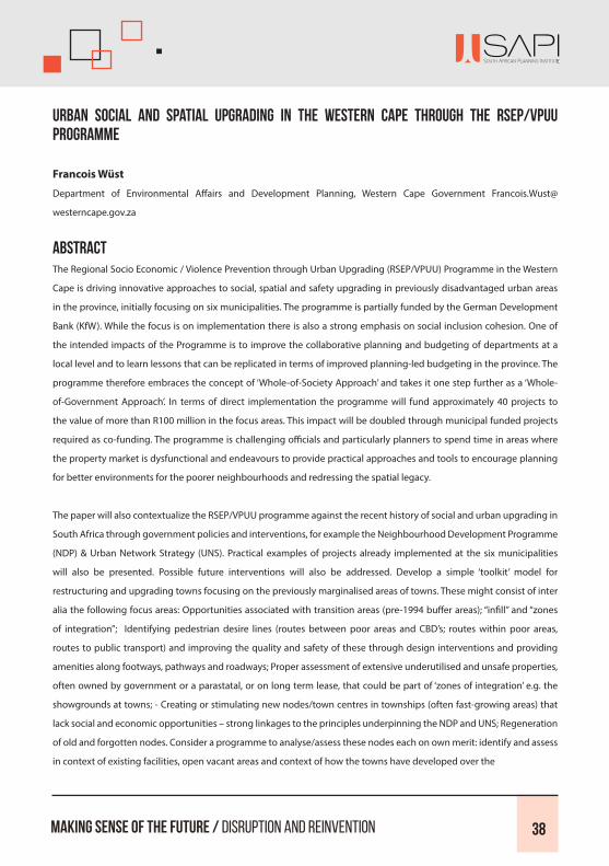
Urban Social and Spatial Upgrading in the Western Cape through the RSEP/VPUU Programme
Francois WüstDepartment of Environmental Affairs and Development Planning, Western Cape Government Francois.Wust@
westerncape.gov.za
Abstract The Regional Socio Economic / Violence Prevention through Urban Upgrading (RSEP/VPUU) Programme in the Western
Cape is driving innovative approaches to social, spatial and safety upgrading in previously disadvantaged urban areas
in the province, initially focusing on six municipalities. The programme is partially funded by the German Development
Bank (KfW). While the focus is on implementation there is also a strong emphasis on social inclusion cohesion. One of
the intended impacts of the Programme is to improve the collaborative planning and budgeting of departments at a
local level and to learn lessons that can be replicated in terms of improved planning-led budgeting in the province. The
programme therefore embraces the concept of ‘Whole-of-Society Approach’ and takes it one step further as a ‘Whole-
of-Government Approach’. In terms of direct implementation the programme will fund approximately 40 projects to
the value of more than R100 million in the focus areas. This impact will be doubled through municipal funded projects
required as co-funding. The programme is challenging officials and particularly planners to spend time in areas where
the property market is dysfunctional and endeavours to provide practical approaches and tools to encourage planning
for better environments for the poorer neighbourhoods and redressing the spatial legacy.
The paper will also contextualize the RSEP/VPUU programme against the recent history of social and urban upgrading in
South Africa through government policies and interventions, for example the Neighbourhood Development Programme
(NDP) & Urban Network Strategy (UNS). Practical examples of projects already implemented at the six municipalities
will also be presented. Possible future interventions will also be addressed. Develop a simple ‘toolkit’ model for
restructuring and upgrading towns focusing on the previously marginalised areas of towns. These might consist of inter
alia the following focus areas: Opportunities associated with transition areas (pre-1994 buffer areas); “infill” and “zones
of integration”; Identifying pedestrian desire lines (routes between poor areas and CBD’s; routes within poor areas,
routes to public transport) and improving the quality and safety of these through design interventions and providing
amenities along footways, pathways and roadways; Proper assessment of extensive underutilised and unsafe properties,
often owned by government or a parastatal, or on long term lease, that could be part of ‘zones of integration’ e.g. the
showgrounds at towns; - Creating or stimulating new nodes/town centres in townships (often fast-growing areas) that
lack social and economic opportunities – strong linkages to the principles underpinning the NDP and UNS; Regeneration
of old and forgotten nodes. Consider a programme to analyse/assess these nodes each on own merit: identify and assess
in context of existing facilities, open vacant areas and context of how the towns have developed over the

Making Sense of the Future / Disruption and Reinvention 39
1996-2016. 20 Years of Planning
last few decades; - Analysing whether the centre of gravity for small towns (each on own merit but consider trends and
importance of trends for planning in general) has shifted or is starting to shift with the expansion of new housing areas
(formal and informal); - Clustering of facilities in neighbourhoods to create a sense of place and safe defendable spaces.
Keywords:
Social Upgrading, Capital Contribution, Spatial Improvement, Cities / Towns Divide

Making Sense of the Future / Disruption and Reinvention 40
Every Last Drop - The Role of Spatial Planning in Enhancing Urban Water Management in the City of Cape Town
Rebecca Cameron1 and Tania KatzschnerMCA Urban and Environmental Planners
AbstractWater is essential to life. Current urban water systems often degrade freshwater ecosystems, nature’s ability to
replenish resources and the relationship between people and the environment. To address this, Integrated Urban Water
Management (IUWM) has been developed; yet, is too often undermined by institutional paralysis and a subsequent lack
of physical change in cities. This paper presents key learnings from research undertaken for a dissertation in the Maters
of City and Regional Planning programme to understand how spatial planning can be utilised as a tool to enhance
IUWM; where hydrological systems influence the form and structure of cities. The intention is to improve water literacy in
urban planning where complex conditions confront urban and natural systems. Urban Spatial Planning, unlike land use
management, is a process of long term future imagining that is well-positioned to address the conflicts and tensions that
arise through the implementation of a variety of sectoral policies with competing interests while including the voice of
multiple stakeholders.
This research culminates in a theoretically considered Spatial Water Framework (SWF) for the City of Cape Town to guide
appropriate and innovative intervention in the urban water system. This plan is governed by the principles of reverence,
restoration, restraint and responsibility. The SWF envisions Cape Town transitioning to an increasingly water-secure
future as facilitated through nurturing a reverence for water; enabling restoration of water systems through ecological
alignment; embracing restraint towards water use; and cultivating responsibility to develop good water stewards. Therein
lies the opportunity for a closer integration of planning for urban development and water systems while reconciling the
human-nature relationship.
Keywords:
City of Cape Town, Integrated Urban Water Management (LUWM), Spatial Planning, Water Literacy, Spatial Water
Framework

Making Sense of the Future / Disruption and Reinvention 41
1996-2016. 20 Years of Planning
Recovering Lost Socio-Cultural Spaces to Re-Establish Sustainable Green Places and Reinvent Ado-Ekiti, Nigeria as a Great City of Tomorrow
Olufemi Ojo-Fajuru1, Adebayo AmbroseUniversity of KwaZulu Natal
Abstract The importance of public spaces in human settlements cannot be over emphasized. Such open spaces include squares
at village, town or city levels. Others include private parks, public parks, plazas, green spaces, greenways, highways, right-
of-ways, private roads, incidental open spaces, setbacks and easements. These green infrastructures help define the
character of a place, promote sense of community belonging, enhance movement and circulation, and well guarantee
liveability and comfort in the urban setting. However, in developing countries, negative effects of rural-urban migration,
which triggered uncontrolled expansion, are manifested in form of encroachment on these breathing spaces as typified in
Nigerian cities. In Ado-Ekiti, the spate of unlawful spatial encroachment along major transportation corridors, incursions
into public and incidental open spaces, and amorphous expansion onto outlying regions have reached alarming levels.
In effect, the cityscape is devoid of adequate open spaces and greenery. This situation, coupled with excessive use of hard
landscaping materials that generate heat radiation, result into poor environmental quality and reduce urban comfort.
This paper investigates and establishes the illegality of fragrant public space encroachment in the city. It also advocates
the retrieval of lost open spaces from erring developers as leeway to reestablishing greenery in the city landscape.
Published and unpublished secondary literature sources were indispensable in reviewing relevant topical issues to
establish research gaps. Essentially, reliable empirical research in the case study area elicited information, facts and
figures from the delineated districts in the zoned city through the use of observation, focal discussions and questionnaire.
Findings establish high-level contravention of existing development regulation laws. This culminates to sheer impunity
in the building up of socio-culturally and environmentally significant spaces mostly for commercial use in the city. The
paper recommends that encroached urban spaces should be reclaimed and reestablished as lush green places. These
corrective and change-oriented measures are guaranteed to actualize the tenets of placemaking in transforming
existing and newly established public open spaces into interconnecting network of gardens, parks and greenways. The
emerging verdure will revive the city environment, protect the dwellers, reverse dwindling quality of living, and promote
inclusiveness. In so doing, Ado-Ekiti will be reinvented as a great city of the future.
Keywords:
Public Space, Reclamation, Greening, Placemaking, Inclusiveness

Making Sense of the Future / Disruption and Reinvention 42
Development Control Regulations Compliance: Paradigm Change to Reinvent Disrupted Public Spaces and Make Future Great Place in Ado-Ekiti, Nigeria
Olufemi Ojo-Fajuru1, Ambrose AdebayoUniversity of KwaZulu Natal
Abstract The existence of public spaces in the human society is not a chance occurrence but naturally endowed, predated the built
environment. The inevitability of settlement expansion unto vegetated land necessitated some measures of statutory
control to chart the course of development in orderly manner that ensures mutual existence of various land uses.
However in the face of rapid urbanisation instigated by population increase in urban centres, public spaces in developing
countries like Nigeria suffer high magnitude encroachment and depletion in response to steadily increasing space
demand for other human activities. It is disheartening to note that extant development control byelaws and regulations
seem to be non-existent and of no effect given the ubiquitous incidences of willful contraventions, weak implementation
or outright neglect, which portend debilitating effects that disrupt public spaces particularly and degrade the overall
urban environment. In Ado-Ekiti, the capital city of Ekiti State, the subjugation of squares, parks, open spaces, setbacks
and even roadways by illegal development and informal activities have reached alarming levels of disorderliness,
formlessness, unhealthiness and exclusion. It suffices to quip that these ugly situations have subtracted greenery- by
implication liveability and inclusiveness- which have eroded the quality of a great place befitting of a state capital.
This paper therefore delves into assessing the state of the environment to determine the extent of encroachment on
public spaces, factors responsible for the magnitude of encroachment, and make up leeway out of the dolorous city
environment. Research methods entail the review of existing national and state laws controlling development matters,
particularly the establishment and maintenance of setbacks, open spaces and parks, and other relevant information
on related issues from published and unpublished sources. The study largely depended on firsthand data collected
on field survey by means of questionnaire, interviews, focus group discussions and direct observation in the selected
districts in the case study. Findings reveal a deplorable state of the environment occasioned by highly rated audacious
encroachment on public spaces mainly by informal commercial activities. Ignorance and carefree attitude to good
quality environment, lack of governmental control, and desire for economic benefits are chief among factors responsible
for the disruption of public spaces in the city.
This situation have exerted adverse effects on aesthetics and environmental quality; circulation and movement; health
and wellbeing; liveability and inclusiveness, even as the city is starkly devoid of greenery. Already asunder are the
potentialities of placemaking in the city. The paper concludes that the bane of public space basterdisation and disruption

Making Sense of the Future / Disruption and Reinvention 43
1996-2016. 20 Years of Planning
is the ineffectiveness of development control regulations and the lukewarm attitude of the Planning Permit and Building
Control Agency to matters bordering on encroachment. It is therefore recommended the State Government should key
into the change mantra of the nascent Federal Government and strictly enforce extant statutory development control
enactments to the letter to revitalize lost socio-cultural spaces. This guarantees to return greens into the cityscape and
provides leeway to making future sense of great place in Ado-Ekiti, the fledging capital city of Ekiti State, Nigeria.
Keywords: Development Control, Planning Law, Compliance Level, Public Spaces, Change Mantra, Placemaking

Making Sense of the Future / Disruption and Reinvention 44
The Role of the Built Environment Performance Plan in Re-Inventing our City
Thembeka NxumaloEkurhuleni Metro Municipality
Abstract
The Built Environment Performance Plan (BEPP), is a plan required annually by National Treasury as a requirement to
the Division of Revenue Act. How we build our cities, is not making a huge meaningful impact on the ground, hence
the formulation of the BEPP to help in re-inventing our city. Cities must be designed and built so as to bring meaningful
spatial transformation. Currently, the way in which infrastructure is being planned and delivered is not necessarily making
a meaningful change in the lives of people on a daily basis. How then, do we re-invent our city with such a plan? In order
to spatially transform, there needs to be spatial areas of prioritization. In these priority areas all departments of the city
must follow the same vision and prioritize these areas in their planning and service delivery. In this regard, the Ekurhuleni
BEPP embraces the National Treasury proposed Urban Network Plan that comprises of elements that forms Integration
Zones. These Integration Zones are specific areas of prioritization that are in line with the spatial vision and long term
plans for the city following the spatial structuring elements of the Municipal Spatial Development Framework. The BEPPs
are circulated to all spheres of government and state owned companies. Intergovernmental Relations are entrenched
through the BEPP process, so that urban planning is now becoming more impactful across various sectors and spheres of
government. If the Metropolitan Municipalities are planning catalytic projects within the identified integration zones, the
responsible provincial and national departments and state owned companies are all planning in the same geographic
area in support of such catalytic project. Spatial transformation will only be seen and be impactful, when all levels of
government are planning for and implementing in the same geographic priority areas. The BEPP is a very useful tool for
spatial transformation and spatial targeting. If we all plan in the areas of prioritization identified, then cities will be re-
invented and bring change in the lives of people. In conclusion, for a person that lives far away from economic activity
and away from proper public transport, change will happen. If the BEPP is used in the way in which it is intended, the lives
of people will change for the better.
Keywords:
Spatially Targeting, Infrastructure, Planning, Development

Making Sense of the Future / Disruption and Reinvention 45
1996-2016. 20 Years of Planning
Conceptual Framework to Guide the Development Planning Research in the Western Cape
Dr Elizabeth Barclay1, Helena Jacobs2, Julien Rumbelow3Department of Environmental Affairs and Development Planning, Western Cape Government
Abstract
In 2015 the Directorate Development Planning Information Management & Research was established in the Western Cape
Department of Environmental Affairs & Development Planning. Important tasks was attached to the Directorate, such as
the drafting of the State of Development Planning Report, the review of the Growth Potential of Towns Study and the
review of the Intelligence Management Strategy that includes the draft of a Research Framework. This can however not be
done in a laissez faire method. It was important to create a strong epistemological foundation to build the various studies
and documents upon. For that purpose a Conceptual Framework was designed that links best practice Gold Standard to
topical themes receiving global focus and reflects the zeitgeist of Development Planning. This exercise was of particular
importance due to the objective of the Western Cape to be the best run regional government in the world. Pertinent
Realities such as Resilience, Place-making, Disaster Management, People-centred Design, Hybrid Insights, Innovation @
The Core, Sustainability, Micro-focus, Green Spaces, Just Spaces, Indigenous Knowledge Systems, Slow Movement, Small
is Beautiful and ‘Local is Lekker’ (linked to multiplier spread) was adopted as part of a bouquet of relevant issues that
should ground the research activities of the Directorate. The process of drafting, debating, deliberating and adoption of
the Conceptual Framework integrated the process of disruption through the inclusion of Design Thinking instruments
to guide the process and eventually led to the first step in reinventing planning though within the Western Cape
Government. The process is by no means concluded, nor will it ever be as complexities associated with diversification
of the population and economy, climate change and fast innovation processes will escalate at an increasing rate. This
paper aims to illuminate the various issues and how that informed the execution of the particular desired outcomes, i.e.
the State of Development Planning Report, review of the Growth Potential of Towns Study and the Research Framework.
Keywords:
Conceptual, Framework, Provincial, Policy, Realities

Making Sense of the Future / Disruption and Reinvention 46
The Zoning Predicament of Airbnb
Dr Elizabeth Barclay1, Julien Rumbelow, Helena Jacobs, K MunroDepartment of Environmental Affairs and Development Planning, Western Cape Government 1elizabeth.barclay@
westerncape.gov.za
Abstract
The adoption of the Spatial Planning and Land Use Management Act (SPLUMA, Act 16 of 2013) was inherently disruptive
on the National, Provincial, District and Municipal spheres of government. Many of the issues in regard to the conversion
in focus to the power of decision-making being placed in the hands of municipalities are still being resolved. The change
in interpretation and application from zoning and zoning schemes is also a resultant reality of SPLUMA, which town and
regional planning on especially municipal level are battling with. The variety and range of zoning classifications are still
seen as a valuable method of land use management.
From January to December 2013 about 2.7 million tourists visited South Africa from Overseas and in total, with the
inclusion of domestic and African tourists, a total of R9, 62 million tourists travelled in South Africa (SA Tourism). The
majority of tourists that travelled in South Africa in the past stayed with, mostly, formally zoned tourism establishments,
be that a bed-and-breakfast, guest house, backpackers, lodge, hotel, boutique hotel or resort. There is also no consensus
from one authority to the next of what each of the various tourist establishments are, or what they should be zoned
to or whether they should apply for consent use. Many of the descriptions in zoning schemes and bylaws for tourist
establishments, does also not correspond with the perceptions or descriptions in academia, policy formulation and the
industry.
While this debate is raging, especially in the light of the drafting of new town planning schemes, a disruptive technology
is revolutionising the tourist accommodation establishment industry, that being Airbnb. Airbnb is a website, with an
associated device App, which was established in San Francisco, United States of America in 2008. It is a site where people
can list, search for, and book accommodation lodging. The company want to satisfy the market between couchSurfing
and formal tourist accommodation.
By February 2011 more than 1 million people has booked with them. Airbnb are available in more than 190 countries with
millions of alternative choices to stay in from a spare room to a castle. By July 2015 they have had around 50 million users
and about 500000 people use Airbnb for accommodation every night. On the 12th of November 2015, Airbnb had more
than 300 places available that night around Cape Town in the Western Cape in South Africa and one could choose from
a shared room to a private room and entire house. People listing a spare room on Airbnb are on average much cheaper

Making Sense of the Future / Disruption and Reinvention 47
1996-2016. 20 Years of Planning
than suitably rezoned formal accommodation places, due to the cost linked to the formalisation process. The question
is thus: how does this disruptive technology influence the planning processes in South Africa and how should planning
react in turn and how will that influence the formal accommodation industry?
Keywords:
AirBnB, Disruption, Technology, Policy, Tourism, Accommodation
Making Sense of the Future / Disruption and Reinvention 48
Gamification, Gaming, Apps and Social Media in Development Planning: Needs Versus Limits of Technology
Dr E BarclayDepartment of Environmental Affairs and Development Planning, Western Cape Government elizabeth.barclay@
westerncape.gov.za
Abstract
In the age of technology, mass data, hashtags, selfies, Apps and games, town and regional planners range from those
that pretend it does not exist and those that has a gluttonous need for mass emersion. Words and terms are scattered
around, but do planners really understand technology’s inner workings and what and what cannot be done. Furthermore,
does strict ICT and property right legislation allow for the technological development and innovation we as planners
seek? Technology in development planning from a government perspective needs to adopt a cube continuum in its
provision to ensure that the complexity of society and technology be provided for. On the continuum relevant issues are
placed on the extremes, it being private versus public, formal versus informal, rich versus poor and early adopters versus
laggards. Each of these extremes suggests very decisive scopes of engagement, technological focus and constraints and
cost involved for government as well as the users.
When technology is engaged with and provided points within the cube must be identified that can be the most
appropriate for a variation of markets, needs, trends and technological abilities. There are limits to what an App can be
used for, especially in the pro-poor environment, as the data use and size of the App can be impractical for the older
generation phones used by the poor. Data use by especially social media and Apps might also be unaffordable by the
poor. Gaming, especially resources based, predictive games to determine how land might be used in future is a need that
has been expressed on several occasions by various levels of government. However, that requires an advanced Artificial
Intelligence core that will be extremely expensive to develop. In some cases it might also be better to put the technology
aside and focus on physical role-playing games as an alternative to computer games. It might be better to use crayons
and post-it notes in a user based design process and it might be better for a community to use mud in a community
mapping exercise.
This paper aims to elaborate the cube continuum of technology use in development planning, as well as an evaluation of
what is feasible, possible and probable in regard to the use and development of social media, Apps and especially gaming.
The Directorate Intelligence Management and Research, in the Department of Environmental Affairs and Development
Planning in the Western Cape Government has embarked on a journey of discovery and implementation of various levels
of technology within their functions and this journey will be mapped and shared within this paper.

Making Sense of the Future / Disruption and Reinvention 49
1996-2016. 20 Years of Planning
Keywords:
Gaming, App, Gamification, Social Media, Technology
Development Charges and Housing Affordability: A Policy Conundrum
Frank CummingDepartment of Environmental Affairs and Development Planning, Western Cape Government frank.cumming@
westerncape.gov.za
Abstract
Twenty one years into democratic rule, South African cities remain highly fragmented, imposing higher costs on households,
particularly the urban poor and the economy. Successive policy and investment frameworks post 1994 have not yielded
the desired spatial outcomes nor have they improved the efficiency of our urban environments. Although driven by a
well-intended focus on outputs to eliminate the housing backlog and improving living conditions of the poor, policies
have often perpetuated the legacy of apartheid-era spatial planning, as projects have often materialised in peripheral
locations on cheap land far removed from employment and amenity opportunities – compounding the challenges facing
communities. More recent policy initiatives have recognised the importance of adopting a spatial perspective in planning
and delivery. These have focussed on the creation of integrated and sustainable human settlements as a key objective
amongst policymakers targeting spatial transformation and thereby improving affordability to communities. Another
area attracting considerable attention amongst policymakers in recent years is the sustainability of municipal finances.
The capital and operating costs to municipalities associated with prevailing spatial growth patterns and the form and
density of new development are growing, whilst the ability of municipalities to raise revenues to cover these costs is
severely limited. Consequently, in our fast growing urban areas, municipalities are constrained in their ability to fund
infrastructure that supports new growth in housing development. The notion of raising municipal rates and taxes is also
politically unpopular. So a policy framework of municipal development charges was introduced by the National Treasury
as a method of funding new urban infrastructure. These infrastructure charges are levied on developers by municipalities
and imposed as a condition for the approval of that development application. Property developers, driven by speculative
returns, pass these costs onto prospective home purchasers, increasing costs and therefore contribute toward declining
housing affordability. Against the context of competing public policy objectives, firstly, related to housing affordability
and the spatial transformation agenda and second, the financial constraints affecting municipal finances; this paper will
review the international experience of development contributions on housing affordability. The paper will then consider

Making Sense of the Future / Disruption and Reinvention 50
the potential for more equitable alternative approaches to funding urban infrastructure based upon value capture
principles.
Keywords:
Development Charges, Municipal Financial Viability, Housing Affordability, Infrastructure; Equitable Practices
Enabling Regeneration in an Age of Austerity: The Public Sectors Role in Facilitating Development
Frank CummingDepartment of Environmental Affairs and Development Planning, Western Cape Government frank.cumming@
westerncape.gov.za
Abstract
After twenty one years of democratic rule, Cape Town remains a deeply divided city where the majority of middle-to-
lower income families live on the periphery, furthest from the metros major employment and amenity opportunities.
The city also suffers from an acute shortage of well-located, affordable housing. Rapid urbanisation, together with a
shortfall in service delivery - particularly for affordable housing, exacerbates the challenge, placing increasing strain on
limited public resources and capacity. Urbanisation however, can be harnessed as a positive force for socio-economic
transformation. Public policy objectives related to economic development, employment and poverty alleviation can
be achieved through greater private sector participation and investment in service delivery. In the spatial context,
restructuring the city with dense affordable development on well-located, surplus public land supports the realisation
of more inclusive and sustainable living environments capable of redressing the scourge of the apartheid city. Against
this backdrop, the economic debate in South Africa has also shifted toward a rebalancing of the economy and less public
borrowing. Prevailing economic and fiscal conditions require government to prioritise investment in delivering essential
infrastructure to create high quality business and community environments.
The WCG is responding to the downturn by scrutinising all services to ensure their optimal utilisation, committing to
greater efficiency in the public sector through more effective management and delivery of public services and the fuller
utilisation of public assets. This new policy focus will require innovative methods of resourcing priority programmes,
including partnerships to leverage the WCG’s under-utilised property portfolio to generate new revenue streams
in support of front-line service delivery, whilst stimulating economic development for inclusive growth and jobs. The

Making Sense of the Future / Disruption and Reinvention 51
1996-2016. 20 Years of Planning
accelerated release of well-located surplus public land for regeneration can catalyse development that meets the WCG’s
objectives for strong, sustainable and balanced economic growth; jobs; spatial transformation; whilst building resilient,
sustainable, quality and inclusive living environments. The high cost of well-located land however places a considerable
burden on the commercial viability of development - particularly for integrated human settlements. This paper will
explore the leveraging potential of the provincial government’s surplus land portfolio to catalyse mixed-use, inclusive
development. It will also consider a range of mechanisms and levers available to government to enable private sector
participation in urban development, particularly amongst institutional investors, citing international best practice (e.g.
innovative payment terms and contractual structures, and value capture mechanisms).
Keywords:
Regeneration, Affordable Housing, Innovation, Leverage, Partnership, Land Value Capture, Service Delivery

Making Sense of the Future / Disruption and Reinvention 52
De-Complexifying the SPLUMA Principles
AP Barnes, Dr Elizabeth Barclay1, Helena Jacobs, C Hauptfleisch, S Orie, NS Jacobs, Prof Verna Nel2Department of Environmental Affairs and Development Planning, Western Cape Government, University of the Free
State2
Abstract
The Spatial Planning and Land Use Management Act, 2013 (Act No. 16 of 2013)(SPLUMA) has been instituted to guide
land use and planning in South Africa. There are 5 Development principles, contained in Section 5 of the act, that have
been identified to guide and inform planning decisions. These are the principle of: • Spatial Justice • Spatial Sustainability
• Efficiency • Spatial Resilience • Good Administration The concepts of “spatial justice”, “spatial sustainability” and “spatial
resilience” are related to social justice, sustainability and resilience, but are deeply rooted within spatiality. The concepts
are not defined in-depth in the Act, and limited academic scrutiny has been given thus far. This leaves vast scope open
for interpretation of these principles on both conceptual and contextual levels. There are also questions about the
spatial applicability and measurability of the principles within the spatial and land use management mandate platform.
Furthermore, questions arise on how spatial sustainability and spatial resilience relate to each other, if in fact it might
be divergent points or do they actually complement each other. Within the complexities of the South African spatial
landscape, application of the principles will be a challenge and understanding thereof might entirely be in the eye of
the beholder. In order to understand and implement the principles, it is clearly necessary to interrogate and examine the
principles not only in the context of SPLUMA, but also in the context of South Africa’s history and current challenges. This
paper will elaborate on the process the Department of Environmental Affairs and Development Planning of the Western
Cape Government followed in firstly making sense on the SPLUMA principles and secondly how this process was used to
develop a benchmarking instrument to set up a diagnostic tool for tracking Development Planning.
Keywords:
SPLUMA, Spatial, Resilience, Sustainability, Equity

Making Sense of the Future / Disruption and Reinvention 53
1996-2016. 20 Years of Planning
The Ongoing Apartheid Spatial Planning Pattern: Is SPLUMA the Light at the End of the Tunnel?
Tania de WaalDepartment of Environmental Affairs and Development Planning, Western Cape Government tania.dewaal@westerncape.
gov.za
Abstract
The dawn of our democracy in 1994, brought with it the hope that the apartheid spatial planning patterns of South
African settlements, would come to an end. No longer would low income settlements be banished to the periphery of
our towns and cities, from where residents had to struggle to access urban opportunities. This hope that spatial change
was imminent was strengthened with the implementation of the Municipal Systems Act (MSA) (Act 3 of 2000). The MSA
required municipalities to draft Spatial Development Frameworks (SDF’s) as part of their Integrated Development Plans
(IDP’s). The SDF’s in turn spoke of the need to develop strategies and policies which addressed “the spatial reconstruction
of the municipality”. This was to result in greater integration between rich and poor. Sadly however, despite the existence
of legislation which requires spatial reconstruction, settlement development patterns remain largely unchanged. The
poor continue to be spatially marginalised and the wealthy, for the most part, continue to seek to develop in greenfields
areas on or beyond the urban edge. The reasons for this are numerous and include: nimbyism; cost of land; ease of
developing greenfields vs brownfields; land ownership; in the subsidised housing arena, focus on the number of units
delivered rather than quality of life provided; focus on short term interests vs long term needs; lack of understanding of
the long term impacts of a development etc. The question that now arises is will the implementation of SPLUMA change
anything, or will our settlements continue to be characterised by segregation, inefficiency and inequality? In this paper
it will be argued that SPLUMA, does provide some hope, as far as spatial reconstruction of our settlements is concerned.
However the effectiveness of SPLUMA to correct the current spatial patterns will to a large extent be dependent on how
well the requirements of SPLUMA are adhered to. In particular the principle of “spatial sustainability”, which requires that
the current and future costs to all parties for the provision of infrastructure and social services in land development, must
be considered and that viable communities should be created.
Keywords:
SPLUMA, Apartheid Spatial Planning, MSA, Spatial Reconstruction, Change, Costs, Viable Communities.
Making Sense of the Future / Disruption and Reinvention 54
Understanding Past Drivers of Land Use Change to Model Potential Future Land Use in the Western Cape Province
Petronella Tizora1, Alize Le Roux, Gerbrand Mans, Antony CooperUniversity of Pretoria, Department of Geography, Geoinformatics and Meteorology
Abstract
The Western Cape Province is currently faced with population growth, declining household sizes, increasing household
numbers, high levels of migration, urbanization and escalating development pressures. Consequently these factors have
triggered changes in land use and incited issues such as urban sprawl, marginalization of the poor, limited public access
to resources, land degradation and climate change in the Province. Furthermore, the issues surrounding land use in the
Province emanate from past inequities in access to land and unsustainable land use practices. This poses a challenge to
the government which strives for a sustainable nation that safeguards democracy by providing basic access to services,
managing limited resources and advancing effective and efficient integrated planning whilst maintaining ecosystem
functions. Understanding drivers of land use change and articulating how various factors influence land use is critical in
meeting this challenge.
This paper seeks to understand the most significant drivers of land use change in the Western Cape Province - which
consists of one metropolitan and five district municipalities. To achieve this, the paper focuses on the major land use
changes which have occurred in the Western Cape Province in past 20 years; factors which led to these changes; potential
economic, social and environmental impacts of land use changes; and measures being implemented by municipalities
to address these impacts. An analysis of historical land cover data using the 1990 and 2013-2014 South African National
Land-Cover Datasets, document analysis and expert opinion in the form of semi-structured interviews with municipal
officials are the methods used to study past changes in land use. The paper concludes with proposed priority driving
factors which influence land use change in the Western Cape Province. Driving factors of land use change provide critical
knowledge that can be used in the design of effective land use change models which have the ability to analyse future
scenarios and support planning.
Keywords:
Land-Use, Land-Cover, Land-Use Change, Driving Forces, Urbanization, Development

Making Sense of the Future / Disruption and Reinvention 55
1996-2016. 20 Years of Planning
Environmental Planning Theories and Best Practices: The Nexus Between Urban Re-Naturalization and Sustainable Cityscape in Nigeria
Olufemi Ojo-Fajuru1, Moolaji OlaseniUniversity of Kwazulu-Natal/Yaba College of Technology
Abstract
In virtually every country of the world, the ability of man to urbanize rural entities is ever- changing the earth’s cape. The
trend is similar in Nigeria where villages have metamorphosed into large urban centres and metropolitan areas such
as Lagos, Ado-Ekiti, Kaduna and Port Harcourt through the agglomeration of human activities. Indeed the challenge is
that, virgin lands are continuously ‘eaten up’ by unplanned urban sprawl, which inundates the suburbs and degrades the
environment. The problem is manifested in the form of indiscriminate removal of vegetative cover and the exposure of
the cityscape to direct tropical sunrays and glare with concomitant effects on urban comfort, health and liveability. The
need therefore arises to imbibe the tenets of productive landscape development initiatives to redress this ugly trend. The
methodology of study involved the use of quota sampling technique to obtain existing state of cities selected by quota
sampling system is established by survey of the attributes of the physical landscape and socio-economic characteristics of
residents. In this wise, published and unpublished data of world cities, as well as human activities, landscaping, liveability
and manageability in selected Nigerian cities are used to support observed primary data. Findings reveal high proportion
of uncoordinated development, extreme use of concrete paving, scanty or absolute lack of greenery and decreasing
thermal comfort in the cities.
This paper advocates environmental planning theories such as bimimicry, biomorphism, biophilia, and mimesis as
indispensable best practices for the bio-recuperation and re-naturalization of sprawling cities for the meaningful
reminiscence of Nigerian cityscapes. It concludes that the re-germination of greenery proves the efficacy of the
environmental planning theories and improves environmental quality, urban liveability and comfort towards attaining
sustainable cityscape in Nigerian urban centres. Recommendations are centred on implementing models in biomimicry,
biomorphism, biophilia and mimesis to pursue massive urban green landscape resuscitation and re- naturalization to
re-establish the primordial bond between man and nature in the cities. Through concerted efforts, Nigerian cities will be
reinvented as havens of greenery and liveable environment for living, working and relaxation while threading the path to
overall landscape sustainability as antidote to climate change.
Keywords:
Practices, Greenery, Hard Landscaping, Planning Theories, Urban Liveability, Urban Re-Naturalisation

Making Sense of the Future / Disruption and Reinvention 56
Spatial Governance Principles for Rural Areas Under Traditional Authority
A D (Tony) Williams, Prof Verna Nel1University of the Free State
Abstract
The former ‘homelands’ or Bantustans of South Africa are a legacy of colonial-apartheid regimes when most Black
people were confined to an area comprising some 13% of the land area of the country. Currently these areas are home
to between 20 to 30 percent of the national population, and include some of the poorest municipalities. Much of these
areas fall under the authority of traditional leaders, where customary law and practices are espoused. Land use largely
reflects traditional lifestyles where subsistence agriculture is one of the major economic activities. Concurrently with the
jurisdictions of tribal leaders and their traditional councils are local and district municipalities. The boundaries of the
latter do not necessarily align with the traditional council boundaries, nor is there alignment between municipal and
traditional council wards. Moreover, there are parallel land use and land allocation systems operating. The municipalities
use western-style land governance systems (generally based on land use zoning) while traditional leaders allocate land
based on customary law using indigenous knowledge. Case studies from KwaZulu Natal, Mpumalanga, the Eastern Cape
and Free State all demonstrate that there is little communication between these systems and their role players, which
creates conflict. This conflict is not limited to the municipal sphere. While the Constitution of South Africa recognises the
institution of traditional leadership, subsequent legislation appears to have limited its role to cultural leaders.
Furthermore, the Spatial Planning and Land Use Management Act (SPLUMA) mandates municipalities to take land use and
development decisions, pertinently excluding traditional leaders from decision-making and decision-making structures.
In addition this act obliges local municipalities to prepare land use schemes based on zoning for the entire municipal
area, including areas under traditional authority. The imposition of western planning approaches that view land as a
commodity, rather than a sacred social asset, is bound to exacerbate the existing conflict between the traditional and
modern systems and discontent among traditional communities. Thus there is a need for a land use management system
that is acceptable and can function effectively in traditional areas yet complies with SPLUMA. If is possible what are its key
elements? This paper will present a key principles and a broad framework that could form the basis for a functional spatial
governance and land use management system in traditional rural areas. These principles draw on concepts relating to
social justice, sustainable development, complexity, the rights of indigenous peoples, indigenous knowledge systems,
common pool resource management and alternative land use management systems.
Keywords: Land Use Management, Traditional Authority Areas, SPLUMA, Municipal Planning, Spatial Governance Principles

Making Sense of the Future / Disruption and Reinvention 57
1996-2016. 20 Years of Planning
Putting Spatial Resilience into Practice
Anthony Barnes, Prof Verna Nel1University of the Free State
Abstract
There is a growing awareness of disaster risk management and creating resilience to potential risks and hazards within
the planning fraternity. There is a considerable literature on the concept of resilience and the definitions thereof. These
include the ability to spring back after being stressed to a systems focused definition of the ability to maintain the
system’s functions by absorbing or adapting to change despite stresses and pressures placed on it. Within a systems’
conceptualisation of resilience are attributes such as diversity, redundancy, flexibility and adaptability, buffers, and in
human systems, foresight. Although initially research was focussed on ecosystems the resilience of socio-ecological
systems is now receiving attention. This is of critical importance in the South African context, where, according to the
Green Paper on Development and Planning, 1999, and the White Paper of Spatial Planning and Land Use Management,
2001, the first democratic government in South Africa in 1994 inherited a spatial planning and land use management
system that was being fragmented, unequal and incoherent, resulting in a dysfunctional South African space economy
that still prevails today. It is characterised by the coexistence of deep poverty, a formal and informal economy, poor
transportation systems and housing backlogs with sprawling informal settlements. There is a critical need to improve the
resilience of the economy to detrimental spatial, social and economic shocks.
The recently enacted South African Spatial Planning and Land Use Management Act (SPLUMA) includes ‘spatial resilience’
among the five principles intended to promote more just, sustainable and efficient settlements. According to SPLUMA,
the principle of spatial resilience refers to “flexibility in spatial plans, policies and land use management systems are
accommodated to ensure sustainable livelihoods in communities most likely to suffer the impacts of economic and
environmental shocks.” Neither the Green Paper on Development and Planning, 1999, nor the White Paper on Spatial
Planning and Land Use Management, 2001, which were the precursors to SPLUMA, made mention of the principle of
‘spatial resilience’. While the concept of resilience is widely understood, does the same apply to that of spatial resilience
as defined by SPLUMA? What does spatial resilience mean in practice in South Africa? How can it be implemented in
the spatial planning and land use management system? This paper will describe a study conducted to determine how
practicing planners interpret the concept of spatial resilience. A semi-structured questionnaire was sent to planners in
different fields in all three spheres of government, planners in the private sector and in academia. After an introduction
the paper will discuss theoretical concepts regarding resilience and ‘spatial resilience’, before describing the methodology
and findings. The responses received from planners indicate a wide range of perceptions. The conclusion will discuss the
implication of the confusion and diversity of opinions and the need for further dialogue around both the interpretation

Making Sense of the Future / Disruption and Reinvention 58
and implementation of the principle of ‘spatial resilience’.
Keywords: Resilience, Spatial Planning, SPLUMA, Social-Ecological Systems, Planners’ Perceptions, Planning Law
Exploring the Fragments of a Possible Theory and Policy on (Spatial) Justice in an Attempt to Build Justified and Just Cities and Communities in South Africa
Adefemi Adegeye1, Dr Johnny CoetzeeUniversity of Pretoria
Abstract
During the last two decades, various efforts were made in South Africa to restructure the distorted and fragmented spatial
form, to re-integrate the fragmented spaces and communities and to create sustainable development in general. These
smart goals, however did not realize as was expected, mainly due to an (un) just government and planning system. A
major milestone was however achieved in 2013, after more than a decade’s efforts and struggles to develop the first
real Planning Act for South Africa, namely the Spatial Planning and Land Use Management Act, 2013 (SPLUMA). It was
enlightening to note that one of the five main planning principles on which this act was built on emphasizes the aspect of
“Spatial Justice”. The term spatial justice had been missing from literature for more than 30 years only to resurface in 2010
as a concept which was under theorized. What is spatial justice and how can it change any landscape, most importantly
the South African apartheid landscape? The research investigates the concept of spatial justice by analysing theories
related to space, justice as well as the right to the city concept. In the end, it was discovered that there was a general
consensus that could be drawn from these theories to come up with a concept of what spatial justice should be.
Having discovered and come up with the concept of spatial justice, application of it is now tested on the City of Tshwane
by analysing the spatial structure, policies, legislations, planning and development as well as court decisions in other to
ascertain if spatial justice exists in the City. It was discovered that most of the policies, plans and legislation in the country
are built on a concept of spatial justice but the implementation of these plans as seen in the spatial structure of the City
of Tshwane as well as court decisions shows that spatial justice is being ignored and planners do not plan for the people
who need and rather plan for the people who have as can be seen in the City’s bus transport routes which covers middle
and high income suburbs and totally ignoring the low income areas. The research concludes that to make progress in
undoing the spatial injustice that exists in our geographies, the concept of spatial justice which I have come up with must

Making Sense of the Future / Disruption and Reinvention 59
1996-2016. 20 Years of Planning
be applied to every policy, plan, development and court decisions. That is no plan or policy should be approved until they
have passed the Spatial Justice Test. Amongst other recommendations are that Planning Schools in South Africa should
have a module on spatial justice which can further encourage students on the concept and ultimately help in moving
towards a theory of spatial justice.
Keywords:
Spatial Justice, Right to the City, Housing, Transportation, Tshwane

Making Sense of the Future / Disruption and Reinvention 60
Making Sense of Future Spatial Planning System in South Africa
Anri de Lange1, Dr Johnny CoetzeeUniversity of Pretoria
Abstract
Planning is for people. The value of spatial planning and the essential role it can play in creating favored future spatial
environments is a conventional concept. Many academics agree that spatial planning is now more than ever, an intriguing
and crucial part of modern day society. The primary goal of spatial planning is to enhance quality of life (Van de Valk
2002:201). Taking this into account, the need to make sense of future spatial environments of South Africa arises. This
paper aims to address this urge by exploring the possibility of a spatial planning system that ensures inclusive, equitable,
liveable and sustainable environments for all. Various spatial planning instruments and development policies have
darkened the door of South African planning in attempt to promote a desired future for all South Africans. This future
is not yet a reality. This paper further sheds light on a new innovative way to think about the future of spatial planning,
through the development of the Spatial Planning Evaluation Matrix. Research on the current spatial planning challenges
in South Africa indicate that very little has been done to successfully address the challenges facing the country’s spatial
environment. When weighing the challenges and outcomes of South Africa’s Spatial Planning System on one part of a
scale and placing the outcomes of international spatial planning systems on the other side, the imbalance is evident.
This investigation makes it possible to identify the required elements to develop a spatial planning system to ensure an
effective, inclusive and transparent spatial planning system in South Africa. These elements form the core of the Spatial
Planning Evaluation Matrix tool, which is developed to enhance spatial planning in South Africa. The Northern Cape
Province Spatial Planning System was used as a case study to assess to what extent it complies with this evaluation. The
tool will add value to planning, development and growth of South Africa.
Keywords:
Spatial Planning, Planning Instrument, Northern Cape

Making Sense of the Future / Disruption and Reinvention 61
1996-2016. 20 Years of Planning
A Transect Approach to Land Use Management in South Africa
Prof Verna Nel1, Darren NelUniversity of the Free State; University of Pretoria
Abstract
The recently enacted Spatial Planning and Land Use Management Act (SPLUMA) requires municipalities to adopt land
use zoning schemes that are applicable to all land within the municipality: urban areas, informal settlements, commercial
farming and traditional areas alike. Yet there is considerable criticism of zoning as applied in South Africa and elsewhere.
The use of land use zoning in South Africa, coupled with Apartheid planning policies, has been blamed for our fragmented,
mono-functional urban settlements. It is thus questioned if land use schemes are an apposite form of development
regulation within our diverse landscape. In reaction to the detrimental effects of zoning New Urbanist planners in the
USA have adopted form-based codes linked to a transect of low density or intensity natural spaces to high intensity urban
cores. The land use and development regulations are then tailored to the relevant part of the transect. Thus rural regions
are treated differently to central business districts. The transect approach allows differentiation between different density
and intensity areas, allowing appropriate land development regulation.
This paper will explore whether a transect approach can be adapted for South African circumstances as a basis for
planning and land use management. The first part of the paper will briefly set out the theoretical framework and rationale
for a transect approach while the second will investigate a possible South Africa transect from both a theoretical and
practical perspective using a provisional transect from Mangaung Metropolitan Municipality, Free State, to Lesotho
that encompasses most spatial typologies, such as an urban core, wealthy and poor peripheral suburbs, commercial
agriculture, small towns and areas under traditional authority, developed using GIS tools. The paper will conclude with
some thoughts on the applicability of the transect for spatial planning and land use management as well as areas for
further research.
Keywords:
Urban and Regional Planning, Transect, Land Use Management, Spatial Planning System, GIS

Making Sense of the Future / Disruption and Reinvention 62
Land Use Management in Traditional Authority Areas - Disrupting Conventional Thought and Providing Innovative Practices for a Workable Future
Werner Fouriei@Consulting (Pty) Ltd
Abstract
The recently implemented Spatial Planning and Land Use Management Act of 2013 requires (amongst others) that
each South African municipality formulate a single land use scheme covering its entire area of jurisdiction. 27% of all
households in South Africa reside in areas that have never been subject to land use management schemes (previously
called town planning schemes). In addition, 14 million hectares of land (on which this 27% of households stay) are not
surveyed. Traditional Authority areas affect 116 out of 234 local municipalities across South Africa. While SPLUMA provides
for the “incremental” introduction of land use management and regulation in these areas, many land use practitioners see
land use schemes in these areas as an extension of the typical Town Planning Schemes of the past. In return, Traditional
leaders view SPLUMA and Land Use Schemes as an infringement of their right to allocate and manage land within the
boundaries of traditional council areas.
This paper draws on case studies of recently completed land use schemes and interaction between planning practitioners
and Traditional Authorities in a number of local municipalities in Northwest Province. It explores existing land allocation
procedures within these areas and proposes an innovative framework that can be used for the compilation of land use
schemes within Traditional Council areas across South Africa. The proposed framework negates the current accepted
practice of linking a zoning to a surveyed land parcel and instead relies on technology to develop land use maps. Land
use rules are developed through community interaction, providing the basis for a new type of “zoning” map that assists
traditional leaders in deciding where to allocate land. Lastly the paper explores possible partnerships between the
Municipal Planning Tribunal (or land development officer), traditional leaders and community members to ensure the
sustainability of land use schemes in areas under traditional management.
Keywords:
Land Use Management, Spatial Planning, Traditional Authorities, Land Use Scheme

Making Sense of the Future / Disruption and Reinvention 63
1996-2016. 20 Years of Planning
Public Spaces in Post-Apartheid Johannesburg: Clashing of Ideals in Imaginaries and Everyday Practices
Ilaria BoniburiniUniversity of Witwatersrand
Abstract
This paper explores the state of Johannesburg’s public spaces, underpinning the ideas and ideologies embedded
in planning policies, spatial strategies and practices shaping the open public spaces. Public spaces are dynamic
representations of the cultural, social, economic and political changes and emblematic materializations of the way cities
negotiate among different identities, competing interests and meanings of public. Johannesburg is a point in case, where
the transition to a democratic system and a spatial planning apparatus supporting ideals of integration, accessibility
and spatial justice is forced to converse and clash with spatial segregation, social isolation, and limited opportunities for
propinquity among people of different classes and race. On the one hand, the objective is to explain the competing views
of public spaces in contemporary Johannesburg, through the concept of imaginary (Jessop and Oosterlynck 2008) – a
descriptive, regulatory and projecting narration reflecting a specific conception of space, governance, and citizenship.
The attention is on who is involved in the circulation, adoption, and adaptation of ideas, in orienting design and guiding
practices; and how specific ideas prevail and are legitimised.
On the other hand, the objective is linking the influence of ideas, relations of power, interests, and institutions on spatial
planning practices, revealing the reasons that foster or impede the adoption of innovative and progressive approaches
for the attainment of inclusion and spatial justice goals in planning and designing public spaces. Perspectives on the
production of space (Lefebvre 1991) and Gramscian-Foucaudian understandings of power and space are adopted for
analysing the selected public spaces. Firstly, these spaces are viewed as “representation of spaces”, highlighting the
semiotic order and its epistemic, rhetorical and regulative functions capturing the unavoidable cultural dimension
associated with the “production of space”. It is the space discursively constructed by regimes of knowledge, which
disseminate ideas, orient design, guide practices and give scientific coherence to the spontaneous ideologies of
appropriated lived space, ensuring the coherence of spatial practices (Schmid 2012). Secondly, public spaces are viewed
as the “spaces of representation”, which is the symbolic dimension, pointing out to the meanings and what they stand
for, thus to the ensemble of social norms, believes, and behaviours, as well as inspirations. Reading public spaces through
the symbolic lens allows deconstructing the genealogy of meanings given by the established order (but also the uprising
orders). Thirdly, public spaces are seen as spatial practices, thus revealing the perception dimension, the materiality of the
elements, activities and interactions taking place there.
Making Sense of the Future / Disruption and Reinvention 64
Keywords: Public Spaces, Knowledge, Hegemony, Inclusion, Spatial Justice
An Application of ISO 37120 Indicators to Compare Sustainable Development in South African and International Cities
Danie du PlessisStellenbosch University
Abstract
The use of sustainability indicators has become a widespread practice amongst regional and local authorities in their
pursuit of a more sustainable future. However, research suggests a lack of consistency in the application and interpretation
of these indicators resulting in limited impacts. This inconsistency also precludes reliable cross city comparisons and
time series analysis and resulted in a new series of international standards being developed for a holistic and integrated
approach to measure sustainable and resilient development. In 2014 the International Organization for Standardization
(ISO) published international standard ISO 37120 known as “Sustainable development of communities – Indicators for
city services and quality of life”. This set of standardized indicators provides a uniform approach to what is measured and
how that measurement is to be undertaken. It contains both core and supporting indicators and is classified into themes
according to different sectors and services provided by cities. This paper applies a range of these indicators to a cross
section of South African cities to compare their performance with a range of international cities from both the Global
North and South. The results provide a fascinating benchmarking of the performance of South African cities in the various
themes compared to their international counterparts.
Based on the sample of cities analysed and the indicators for which information could be sourced, South African cities
generally performed satisfactorily compared to their international counterparts in the environmental, financial, and
governance themes. However the South cities generally performed much poorer than the international examples in the
case of the economic, education, energy, emergency services, telecommunication and innovation, safety, and shelter
themes. The performance in the other themes was highly variable. The results of this paper make three contributions to
the debate on sustainable and resilient urban development in South Africa. Firstly it illustrates the potential application
and value of the ISO 37120 indicators in providing standardized, consistent, and comparable results over time and across
cities. Secondly, it provides an indication of particular areas of strengths and weaknesses of South African cities in their
pursuit of more sustainable development. Finally it outlines comparative trends of the South African cities over the last

Making Sense of the Future / Disruption and Reinvention 65
1996-2016. 20 Years of Planning
decade and highlights areas of specific improvement and concern. Although not laying claim to being definitive, the
study results contribute some thought provoking perspectives to the debate on urban sustainability and resilience in
South Africa.
Keywords: Sustainability Indicators, ISO 37120, Urban Sustainability, Urban Resilience, International Benchmarking
An Integrated Framework and Methodology for Spatial Planning Evaluation
Danie du PlessisStellenbosch University
Abstract
The principles of plan evaluation and monitoring have long been understood as an important element of urban planning practice. However, despite increasing research attention into policy and plan implementation in fields such as public administration and management sciences, little focus has been directed at the evaluation of outcomes in the field of urban planning. As a result planners generally have inadequate knowledge about the implementation of plans and their effects on spatial development. Empirical research on planning evaluation also generally tend to focus on the characteristics and quality of plans and planning processes, with little attention to the achievement of plan objectives and policies in practice. It is thus hardly surprising that monitoring and evaluation has been referred to as the “forgotten stage’’ in planning practice and research (Seasons, 2003). Although the official guidelines for the preparation of Spatial Development Frameworks in South Africa make specific provision for a monitoring and evaluation component, very little details are provided regarding the monitoring and evaluation procedures, techniques and indicators to be applied.
This paper provides a proposed framework and methodology for an integrated spatial plan/ning evaluation methodology. It starts by summarizing the challenges for measuring the impact of spatial planning and then proceeds to consider how plan quality and success could be determined. It provides a critique of the three main approaches to plan evaluation being conformance based evaluation, performance based evaluation and theory based plan evaluation. It then culminates in the description of a suggested integrated and robust framework for spatial plan/ning evaluation consisting of a number of key components: contextual and operational environment evaluation, plan quality evaluation, and plan success evaluation. It concludes by outlining the types of indicators that could be applied in each of these components
of the suggested methodology.
Keywords:
Spatial Planning, Plan Quality Evaluation, Plan Success Evaluation, Monitoring Indicators, Evaluation Methodology

Making Sense of the Future / Disruption and Reinvention 66
Making Sense of the Future: Disruption and Reinvention - The Importance of Planning and Design in Rural Areas with the Commencement of SPLUMA
Jaco-Albert BakkerI@Consulting
Abstract
Rural villages present a major development challenge spatially. This can be ascribed to the low level of economic
activity, major infrastructure backlogs and the difficult and costly procedure to provide such infrastructure because of
the sprawling or widespread nature of these villages (Maruleng LM, 2007). Often villages are located far from towns
and economic opportunities, therefore, most of the community are poor and depend on subsistence farming to survive.
Poor households in rural areas depend on a combination of subsistence agriculture, social grants and remittances from
family members working in the cities or mines. Assets in the likes of property are often tied to traditional forms of land
tenure, making it hard to leverage household assets to generate wealth (Treasury, 2011). Challenges of poverty and
unemployment are obstructed by limited access to basic municipal services as well as a lack of good quality social services
and a lack of adequate transport (National Treasury, 2011). The lack of design and land use management disciplines in
rural and traditional areas has related to poor quality of design of development in recent decades and has contributed to
the erosion of social and economic opportunity for rural communities, particularly those on low incomes (Owen, 2011).
Spatial issues in rural villages can be attributed to the fact that these areas did not have any spatial planning and land
use management legislation before the commencement of SPLUMA. The commencement of SPLUMA has enforced the
inclusion of rural and traditional villages in spatial documents such as Land Use Schemes (LUS) and Spatial Development
Frameworks (SDF). To help these poor communities economically, tourism and agriculture were initially identified as the
economic potential pillars for rural development in South Africa (Department of Tourism, 2012). This paper will focus on
the rural population located within traditional authorities, because they form the majority of rural South-Africa. Because
Traditional Authorities are so rich in culture and are located in natural areas, cultural and eco-tourism poses the greatest
economic opportunity. If more tourism can be developed in rural areas, particularly in ways that involve a high level of local
participation in decision making and enterprises, then poverty alleviation impacts are likely to be improved (Department
of Tourism, 2012). A common challenge for tourism development in a single rural community is its pulling power because
of the absence of a distinctive image (Gisolf, 2012). Cities and entire regions can gain a valuable ‘competitive edge’ by
virtue of their unique character (Ministry for the Environment, 2005). With the use of rural design elements villages can
inherit a unique character and simultaneously create spaces that will enrich the lives of the community.
Keywords:
Rural, Traditional, SPLUMA, Design, Land Use Management

Making Sense of the Future / Disruption and Reinvention 67
1996-2016. 20 Years of Planning
Are We Achieving Spatial Transformation in South Africa? Accessing Progress in Spatial Transformation Though Spatial Indicators.
Johan Maritz1, Amy Pieterse, E. Van Huyssteen, M. Ngidi, A. Le Roux, G. MansCouncil for Scientific and Industrial Research
Abstract
With the advent of a democratic order in South Africa in 1994 a number of policy frameworks have seen the light. All of
these have indicated the need to spatially transform cities and settlements – to break from the pre-1994 apartheid city.
With the progression of time these frameworks change, new ones are developed which often state the same objectives.
A major focus has also been placed on tracking this impact through spatial outcomes through SPLUMA, 2013 and also
internationally through the recently introduced SDGs. Are cities succeeding in reinventing and restructuring the past?
To explore these issues we need to investigate how the landscape has changed spatially. To assess the progress made
by South African cities in the last 20 years, a number of standardised repeatable sub-city level spatial indicators and
or indices are being compiled by CSIR, each illustrating a specific component of change or transformation. This paper
also reflects on spatial transformation for a number of cities using the indicators developed. These Indicators have been
developed partly in collaboration with SACN to support the 2016 State of Cities Report’s theme on spatial transformation.
Keywords:
Spatial Transformation, Indicators, SACN, Sub-City Level, South Africa

Making Sense of the Future / Disruption and Reinvention 68
The Formation of Metropolitan Regions in South Africa?
Zaakirah Jeeva1, Prof Elizelle Juanee CilliersNorth West University
Abstract
Over the last two decades there have been various attempts to categorise South African settlements by the CSIR,
National Treasury and the National Spatial Development Perspective without much success (SACN, 2014). Currently, the
formation and classification of South African settlements is driven by selective size indicators such a population size and
municipal gross value added (GVA). In 2011, Lindiwe Mahlangu the chairman of the South African Municipal Demarcation
Board announced the consideration of doing away with economically weak municipalities, by combining the weak
municipalities with stronger counterparts, to create stronger and more integrated metropolitan municipalities, with the
anticipation that this would of create a more balanced spatial economic landscape. Reasons and motivation to create
such metropolitan areas rarely include the location, economic function or financial performance and role played by these
settlements in the national development (SACN, 2014).
This paper will explore the possible implications of pre-mature categorisation of secondary cities to metropolitan cities
on the national spatial development by analysing two case studies (Buffalo city and Mangaung) in order to explore the
implications of clustering of weaker municipalities with stronger municipalities. The findings of this study would provide
a deeper understanding of the changing South African spatial economy, as well as provide an understanding of the cost
and benefits of balanced and unbalanced development on the spatial landscape.
Keywords:
Secondary Cities, Metropolitan, Cluster Development, Urban Classification, Spatial Economy

Making Sense of the Future / Disruption and Reinvention 69
1996-2016. 20 Years of Planning
Evaluating South Africa’s Green Planning Strategies: The Fleurhof Case Study
RS Veiga1, Prof Elizelle Juanee CilliersNorth-West University, Unit for Environmental Sciences and Management
Abstract
In Africa the green planning concept cannot be regarded as optional. South Africa’s population is continually becoming
more urbanised as people seek employment opportunities. Consequently cities have to expand in order to accommodate
the increasing population, producing more costly cities as well as negatively impacting the natural environment, which
is reaching a point where “vital-signs” are begin exhibited. As illustrated by Hammarby Sjöstad, a green planning
forerunner, green planning can improve urban functions and provide efficient and effective solutions that will ensure
responsible development. By examining local and international green planning strategies as well as benchmark tools
it was discovered that energy, transportation, land-use, structures, waste management, water and sanitation elements
are crucial in a successful green planed urban space. This study used the identified elements to create a local benchmark
tool, which was applied to Fleurhof (an integrated housing development in Gauteng, South Africa) to evaluate South
Africa’s green planning strategies. It was concluded that South Africa is far-off from being a pioneer in green planning,
however the country deserves to be commended for taking action through its policies, action plans and legislation which
promotes green planning as well as development approaches towards green planning as seen in Fleurhof.
Keywords:
Benchmark-Tool, Environment, Green Planning, Responsible Development, Sustainability

Making Sense of the Future / Disruption and Reinvention 70
The Graduate Identity of Professional Planning in South Africa
AP Hugo1,, Prof Das SteÿnUniversity of the Free State
Abstract
Following international debate on the validity of planning as a profession the draft SACPLAN competency guideline
(published in 2014) was investigated to determine whether the proposed competency themes describe the graduate
identity of a professional planner in South Africa. An online survey sampled three stakeholder groups in planning
education; SACPLAN Council, SAPI Council and Planning Academics to collect expert opinions on four main areas of
investigation. The first investigation was regarding the entrenchment of the 20 core and functional competency themes
in the three stakeholder groups. The second investigation determined the consensus between the three groups regarding
the competency profiles of different planning fields (Provincial Government Planner, Local Government Planner, Rural
Development Planner and Private Practice Planner) based on the 20 core and functional competency themes. The third
investigation determined the five most important competency themes in the draft regulations according to the expert
opinions of the stakeholder groups. Lastly the experts had to state if they believed the 20 core and functional competency
themes describe the graduate identity of the South African planner.
A low entrenchment of the core and functional competency themes in the three stakeholder groups were observed,
consensus among the stakeholder groups were only reached on 50% of the competency themes. The study uncovered
different expectations in competency profiles for the different planning fields but no consensus was reached among
the stakeholder groups in terms of definitive competency profiles for the different planning fields. Six themes emerged
as important to the different stakeholder groups but consensus among the stakeholder groups were very low at 5% or
less. Most respondents agreed that the core and functional competencies describe the graduate identity of the South
African planner. The low consensus among the stakeholder groups on nearly all the investigations in the study follows the
international trend of disagreement between planning academia and planning practice regarding the knowledge and
skills base for professional planners. The report provides recommendations towards defining a graduate identity for the
South African Planner to enhance the professional status of planning in South Africa.
Keywords:
Graduate Identity, Professionalism, Planning Education

Making Sense of the Future / Disruption and Reinvention 71
1996-2016. 20 Years of Planning
Exploring Risks and Vulnerabilities in Gauteng’s Three Metropolitan Cities: Trends and Implications for City Governance and Forward Planning
Amy Pieterse1, Willemien van Niekerk, Elsona van Huyssteen, Gerbrand Mans, Johan Maritz, Alize Le RouxCouncil for Scientific and Industrial Research (CSIR)
Abstract
Since 1994 the South African urban landscape has been changing as a result of fundamental social, economic and
political transformations. Metropolitan cities, especially, face unique challenges because of the dynamism of urban
populations. South African metros are characterised by significant inequalities across population groups and across
space and the spatial isolation of vulnerable groups have been continuing rather than easing. Making use of a set of
recently developed indicators for change, developed by the CSIR in collaboration with SACN, spatial change as drivers
of risk and vulnerabilities for three metropolitan cities are explored. These three cities are the City of Tshwane, the City of
Johannesburg and the Metropolitan Municipality of Ekurhuleni.
Evidence from the analysis has shown that whilst illustrating major strides in service delivery within former disadvantaged
townships, spatial patterns, as expected; confirm the embedded vulnerabilities associated with socio-economic
and institutional exclusion, high travel distances and limited access to urban opportunities in former so-called ‘black’
townships on the urban periphery. However, in addition to the spatial legacies associated with apartheid cities, the
analyses also points out new patterns of exclusion and spatial injustice, contributing to the already complex challenge of
addressing spatial specific inequalities and transformation.
Keywords:
Risk and Vulnerability, Population Change, Spatial Trends, Governance

Making Sense of the Future / Disruption and Reinvention 72
The Adoption of Appropriate Technology in Service Delivery in South Africa
Azra RajabCouncil for Scientific and Industrial Research (CSIR)
Abstract
There exist a large number of service delivery programmes being rolled out to impoverished communities across South
Africa. These national programmes provide free basic services with the aim of improving access for South Africans to
healthcare facilities, schools, water, sanitation, housing and electrification. However, poverty, poor living conditions and
environmental degradation persist and informal settlements remain home to one in seven South African households
despite efforts to decrease the backlog of inadequate services and housing. In response to many of these widespread
developmental challenges, emerging technologies and the social processes followed to implement them have made
possible affordable access to basic services in the areas of energy supply and waste management.
Dozens of companies, for instance, have developed high quality, solar-powered solutions specifically targeting the
needs of the energy poor. New distribution models developed by these companies are bringing these products to off-
grid areas around the world. The impact of these new technologies are apparent in examples found in Kenya and South
Africa, where innovative opportunities are being created for and co-produced with low income communities through
the deployment of Information and Communication Technology (ICT). The benefits of these technical systems go far
beyond simply lighting up a home; the aftereffects have led to low-income consumers investing in other technological
products, developing businesses, and accessing improved services and micro-finance. Remarkably, studies have shown
a substantial increase in household income and exam pass rates due to stable electricity generation and continuous
lighting. Such service delivery processes, often driven by the private sector, developmental researchers and/or the
affected communities, offer an approach to transform settlements redefining previous conceptions of planning and who
is responsible for initiating change.
The aim of this paper is to investigate the adoption of appropriate and innovative technologies into service delivery
processes for poverty-stricken South African human settlements. It will explore the current status of technology adoption
in the provision of housing and informal settlement upgrading, what roles can be played by various stakeholders in
enabling technology adoption, and what a collaborative approach to service delivery means both for the future of
South African informal settlements and for the planning profession. This is achieved through a literature review and
interviews with key state planning and implementing agents as well as practical examples, of which inform a set of
recommendations proposed towards a collaborative approach to settlement transformation through the delivery of

Making Sense of the Future / Disruption and Reinvention 73
1996-2016. 20 Years of Planning
more innovative basic services. By doing so it contributes to future planning approaches through the understanding of,
and barriers to, collaborative localisation through technological systems that improve settlement services, in processes
that would ordinarily be seen as the primary responsibility of the state. The paper illustrates that the transformation of
informal settlements can be realised through the collaborative intervention of government, businesses, civil society and
communities in the production, distribution and use of technologies that provide opportunities for user self-sustenance.
This opens up an alternate approach to traditional state service delivery and reinvents previous conceptions of urban
planning in informal settlements as a service to be provided for by state urban planners. By exploring the potential for
innovative technologies as a driver of change within state processes that offer the promise of transformation we can
conclude that the structure and practice of planning in South African informal settlements does not lie solely in the hands
of the state but can be redefined rather as most effective through the co-generation of knowledge and capabilities.
Keywords:
Service Delivery, Innovation, Technology, Informal Settlements, Co-Production, Collaborative, Localisation

Making Sense of the Future / Disruption and Reinvention 74
Re-Evaluating the Intimate Relationship Between Spatial Planning and Water
H.E Rohri@Consulting (Pty) Ltd
Abstract
When people were few and water was plentiful, the issue of water-intensive socio-economic development were generally
overlooked by decision makers (spatial planners). Today, South Africa faces a different situation where water demand
exceeds the current and future water availability. Every land-use decision and practice has a water resource footprint, a
change in land use has the ability to either decrease or increase quality and quantity of groundwater and surface water
resources. There is a general lack of understanding as to what negative and often disastrous effects spatial planning
decisions have on water resources within the planning profession. To date, spatial planning policies and practices lack
the ability to effectively manage, protect and enhance water resources. With five out of nine provinces being declared
as drought disaster areas, municipal decision makers must re-evaluate its relationship with water. The recently published
Water Sensitive Urban Design for South Africa: Framework and Guidelines provides strategic guidance to urban water
management decision-makers (primarily city managers and other local authority officials) on the use of Water Sensitive
Urban Design in a South African context.
The framework highlights the fact that Water Sensitive Urban Planning is considered to be one of the major components
within a Water Sensitive Settlement. Unfortunately, many good frameworks and guidelines achieve nothing due to a lack
of some driver ensuring that it gets used. There is a need for policy makers and/or individuals to leverage their positions
to ensure that the concept of water sensitivity is incorporated into relevant policy document. The Spatial Planning and
Land Use Management Act no. 16 of 2013 (SPLUMA) stipulates that municipalities must develop a wall-to-wall Land
Use Scheme which provides land use and development rights for the entire municipality. Keeping in mind the already
established inter-relationship between land and water, section 26(2)(a) of the Act states that land may only be used only
for the purpose permitted by the land use scheme. Evidently, the municipal land use scheme (within the context of
SPLUMA) will affect the management of water resources. The article will explore new technologies and information which
planners and relevant stakeholders can use to develop informed “fit-for-purpose” land use schemes which will result in
water-conscious land–use planning.
Keywords:
Water, Land Use Management, Policy, Sustainable Decision Making

Making Sense of the Future / Disruption and Reinvention 75
1996-2016. 20 Years of Planning
Reflecting on the Impacts of Chinese Migration in South Africa – A Local Perspective
Karien Louw1, Louis Lategan, Prof Elizelle Juanee CilliersNorth West University
Abstract
South Africa has experienced Chinese in-migration since the mid-17th century. In the past, these journeys were
undertaken by a relatively small number of migrants who stayed for short periods of time. Over the last decade, however,
South Africa has seen the arrival of thousands of Chinese migrants who have relocated on a more permanent basis.
Whilst the emphasis has been placed on large-scale investments and developments initiated by Chinese companies,
such as Modderfontein, many Chinese entrepreneurs have now also infiltrated cities and towns throughout South Africa.
The impact of these small businesses should not be underestimated. Today, most South African CBD’s accommodate
an escalating number of Chinese-owned businesses, whether legal or illegal. These enterprises commonly occupy
premises left vacant after South African businesses have closed down or have relocated. This research is not intended as
a complete account of the phenomenon of Chinese-South African migration or entrepreneurship, but aspires to provide
local viewpoints and inform existing and future research on the topic. As such, this paper makes use of two South African
case studies, as the towns of Oudtshoorn and Potchefstroom where large numbers of colloquially branded “china shops”
have been established in decaying CBD’s. Existing literature on Chinese migration, inner city revitalisation and mixed-use
development, surveys and interviews are used to inform research and facilitate comparative analysis.
This paper hopes to provide some perspective on the proliferation of Chinese owned businesses in the South African
urban landscape to answer key questions, including: What effects these retailers have on local economies – to what extent
do they contribute to the local economy, or do most proceeds leave the country to be spent in China?; The degree to
which migrants integrate into the South African society – do they adopt local customs and mix with the local population,
are they accepted, do they maintain their Chinese lifestyles and customs, or is a new Chinese- South African culture on
the rise?; What are the implications of these migrations for urban planning? With regards to the latter, the tendency for
migrants to work and live in their shops with their families, often in contravention of zoning restrictions; the potential
for CBD revitalisation in preventing urban decay and promoting mixed land use, are especially significant. It is expected
that Chinese-South African migration will increase in the future and that planners will therefore have to account for the
phenomenon and plan accordingly as part of the prerogative to make sense of the future.
Keywords:
Chinese Migration, South Africa, Mixed-Use Development, CBD Decay, CBD Revitalisation, Social Integration, Local
Economies

Making Sense of the Future / Disruption and Reinvention 76
Building Cities from Scratch: A Case Study of Cidade de Kilamba
Karien Louw1, Prof Elizelle Juanee Cilliers, Dr Waldo KrugellNorth West University
Abstract
With the ever increasing population of African countries, sustainable housing solutions are an incremental part of the
urban planning principles for the future. Sustainable development entails more than ensuring that there are enough
schools, hospitals, open spaces etc. for the number of houses planned. Sustainable development should firstly provide
solutions for the current housing backlog and high levels of poverty, i.e. many Angolans are making a living out of
approximately $2 a day; providing housing which cost $120 000 to $200 000 is not a sustainable solution to the housing
problem – which mainly affects the poor. This is, however, the average price for an apartment in the “social housing
development” of Cidade de Kilamba situated in Kilamba Kiaxi, Angola. The development, built by the Chinese company,
Citic Construction Co, is said to house approximately 500 000 households upon completion. It is now three years after
completion and indications are rife that the newly built city is following in the footsteps of the Ghost Cities of China. One
example of a Ghost City in China is Kangbashi. The city of Kangbashi, Ordos, built with the potential to house more than 1
million people, is now a ghost city with a population not exceeding 20 000 people. Office buildings and shopping centres
stand empty, while certain buildings were left mid-construction.
It is believed that the reason for building this city, and other similar cities in China, relates to the infrastructure investment
and ensuring high levels of economic growth. This property bubble is, however, beginning to burst. The similarities
between Cidade de Kilamba and Kangbashi, Ordos, are immense and the question should be asked whether China is now
building ghost cities in African countries to keep China’s economy from lagging and to extract valuable resources from
Africa. This article will seek to elaborate on the sustainability of allowing China to build cities and other infrastructure in
exchange for natural resources such as oil rather than money. The article will provide an analysis on the process followed
before building a city of this magnitude from scratch and whether this has the potential to eradicate the housing backlog
of African cities or is only proving to be an even bigger problem. The question should ultimately be asked whether it is
sustainable to invest vast amount of state funds to build large cities from scratch to ensure housing supply for the long
term future?
Keywords:
Sustainable, Housing, Social Housing, Ghost City, Cidade de Kilamba, China, Development Solutions

Making Sense of the Future / Disruption and Reinvention 77
1996-2016. 20 Years of Planning
Is Planning Paying Attention to ‘The Future’? Experiences in Eight South African Municipalities
Engela PetzerCouncil for Scientific Industrial and Research (CSIR)/ University of Pretoria
Abstract
Planning is inherently about looking ahead. Our profession holds the promise of bringing hope of a better future. Among
planners it is sometimes taken for granted that planning is concerned with the future and that planners will confront the
future and inevitably have an impact on tomorrow through desirable planning outcomes. However, a number of theorists
have claimed that planning is neglecting the future and that planning tends to be reactive. Mark Tewdwr-Jones (1999) says
that planning sometimes conjures up an image of a profession that is “abandoning the past” and not necessarily a future-
seeking and future-shaping profession. In the field of planning, ‘futures’ issues include uncertainty, change, strategic
choice, visioning, scenarios, forecasts and prediction. Do planners explicitly engage these issues, especially within the
context of the long term? South African legislation guiding planning at municipal level (the Municipal Systems Act, 2000
and the Spatial Planning and Land Use Management Act (SPLUMA), 2013) requires municipalities to make declarations
about the future, by making the formulation of vision statements a statutory requirement. But even this requirement
does not necessarily mean that planners actively engage with the future. There are many reasons why planning remains
preoccupied with administrative and managerial duties and stops well short of the strategic. It might be that planners
are consumed by meeting immediate needs or it might be that plans are linked to short-term electoral cycles, forcing
planners to focus on ‘quick wins’. It might also be that planners are faced with too much complexity and unpredictability
and do not have the appropriate tools to address these issues.
This paper asks whether municipal planning in South Africa has an active engagement with the future. It draws on
a literature review of mainstream planning literature in the English language. It further draws on the findings of and
specifically the interviews conducted by a group of students at the University of Pretoria during 2014 and 2015. The
interviews with key IDP role players in a number of municipalities addressed issues such as timeframes of plans, plans’
focus on the future and the tools/techniques used to engage with the future. It was found that planning’s engagement
with the future is in most cases merely a response to legislative requirements. The paper will highlight the reasons for
planning’s ‘neglect’ of the future and will conclude with a reflection on the implications for municipal planning in South
Africa.
Keywords:
Planning Theory, Futures Thinking, Municipal Planning, IDP, South Africa
Making Sense of the Future / Disruption and Reinvention 78
The Use of ICT Tools to Improve the Slum Upgrading Process in South Africa: A Case of Denver Slum Upgrading Project in Johannesburg
Tresor Mbayahe1, Dr Innocent MusondaUniversity of Johannesburg
Abstract
The proliferation of informal settlements in cities has become a critical concern across the world, particularly in
developing countries. Informal settlement upgrading projects aim to address this critical urban issue to ensure a quality
living conditions for citizens. However, these projects are perceived to be non-effective due to the lack of an appropriate
methodology. Hence the need to find suitable tools that could improve the process is pivotal. The purpose of this study
is to investigate the possibility of using ICT tools to make the slum upgrading process more efficient. The research report
will explore different literature and will use the case of Denver Informal Settlement in Johannesburg to demonstrate that
ICT technology can be beneficial in overcoming some obstacles in slum upgrading projects. The paper argues that the use
of smart tools can avoid duplication and delays in data capturing, and facilitate community participation in the project.
Keywords:
Slum Upgrading, ICT Tools, Informal Settlement, Data Capturing, Community Participation

Making Sense of the Future / Disruption and Reinvention 79
1996-2016. 20 Years of Planning
Programming Regional Development for the New Provincial Structure in the Democratic Republic of Congo
Tresor Mbayahe1, George Onatu2University of Johannesburg
Abstract
The Constitution of the 18 February 2006 in the Democratic Republic of Congo, under its Article 226, states that the
country provincial structure will have to change from 11 to 26 provinces. This decision was taken to accelerate the
decentralisation programme, which gives autonomy to each province, and to facilitate the administration of the immense
Congolese territory. Pursuant to this, the legislation suggests that some of the biggest provinces be divided into small
provinces, formed from the current district sub-division. Each new province would have a governor as well as local
government. Different regional economic theories and models were reviewed from journals, government reports and
books. The paper analyses the implications of creating new provinces in the Democratic Republic of Congo. In addition,
the paper investigates the applicability of the proposed provincial structure in the current economic state of the country
and would identify key challenges that the implementation of this new administrative organisation might face. Thus, the
article argues that a clear and detailed regional development strategy needs to be proposed to facilitate the economic
integration of the new regions. By using Growth Pole Model and Regional Economic Concepts, the research attempted to
design a regional economic plan that would assist in the economic development of the new provinces.
Keywords:
Regional Development, Regional Economy, Growth Pole, New Provincial Structure, Democratic Republic of Congo
Making Sense of the Future / Disruption and Reinvention 80
Revising the South African Guidelines for Human Settlement Planning and Design (The Red Book)
Engela Petzer1, Tinus Kruger, Azra Rajab, Thuli Ndlovu Council for Scientific Industrial and Research (CSIR)
Abstract
The Guidelines for Human Settlement Planning and Design, commonly known as the Red Book, is a publication that
outlines the qualities that should be sought in South African settlements and provide practical guidance on how these
qualities can be achieved. The current edition of the guidelines was published in 2000. A complete revision and update
of the guidelines is necessary to ensure their alignment with recent policies and strategies and with current thinking
regarding the planning and design of sustainable and resilient human settlements. Also, socio-political changes and
global challenges, especially climate change and its impact on the built environment, need to be acknowledged, while
new technological innovation in materials and processes should be incorporated.
The Department of Human Settlements has contracted the CSIR to assist with the revision and update of the Red Book.
This paper provides background to the existing Red Book to contextualise the initiative aimed at revising the document.
It relates the history of the current guidelines, the original intent and the existing structure and content. Substantial shifts
in priorities, values and the understanding of human settlements have occurred globally as well as in South Africa in the
15 years since publication of the current Red Book. The paper addresses the reasons why a revision is required. Amongst
others, there is a need to bring the theoretical approach to settlement-making in line with current thinking as reflected in
the latest research and in various policies and strategies developed by government since 2000.
The new Red Book would assist in transforming the South African human settlement landscape and to re-structure our
cities and towns over time to reflect the qualities and objectives outlined in, for instance, the National Development Plan,
the Integrated Urban Development Framework and the Comprehensive Plan for the Development of Sustainable Human
Settlements (Breaking New Ground).
The document would also play a role in supporting the global Sustainable Development Goals. The revised guidelines
would be influenced and directed to varying degrees by international factors such as climate change, resource scarcity
and globalisation as well as local realities including poverty, inequality, marginalisation, rapid urbanisation, informality,
population dynamics and migration. The revised guidelines should give guidance on local responses to these challenges
by not only incorporating established practices but also cutting edge ideas and innovative processes and technologies.
It is anticipated that it would focus in particular on aspects related to the mitigation of and adaptation to climate

Making Sense of the Future / Disruption and Reinvention 81
1996-2016. 20 Years of Planning
change, settlement resilience and resource efficiency. Specific topics that could be addressed include pedestrian
friendly neighbourhoods, water sensitive design, appropriate housing typologies, co-production of human settlements,
informal settlement upgrading and crime prevention through planning and design. The paper will describe the project
as commissioned by the Department of Human Settlements and implemented by the CSIR in terms of the process and
methodology. The paper will conclude with a summary of preliminary findings, including potential new themes to be
included in a revised Red Book, recommended refinement or expansion of existing information and proposals on the
packaging, structuring and presentation of the revised Red Book.
Keywords:
Planning and Design Guidelines, Human Settlements, Red Book

Making Sense of the Future / Disruption and Reinvention 82
Establishment of a Development Planning Business Intelligence System (DP-BIS) in the Western Cape
Mr Julien Rumbelow1, Ms Riette Fourie & Mrs Chantel Hauptfleisch.Department of Environmental Affairs and Development Planning, Western Cape Government
Abstract
Establishing enhanced Development Planning Intelligence capability is a stated strategic objective of the Western Cape
Government (WCG). This paper focuses on the initial conceptual and practical inputs and steps towards building this
desired capability though a smart flexible innovative Development Planning Business Intelligence System (DP-BIS).
The system aims to empower decision making in line with strategic and tactical objectives at municipal and provincial
level while also being regionally and globally relevant, and sensitive to real grassroots issues that may differ in type and
complexity based on context. The system design is rooted in the Western Cape Government’s inclusive vision and values
as encapsulated in the goal of ‘an Open-opportunity Society for All’ The intended flexible system (business model*) draws
on a mandate to enable scalable, inclusive and sustainable socio-economic value lift from within resilient environmental
ecosystems which support effective social activity and organising that leads to necessary socio-economic value
generation required for a better future for all.
The paper draws on an articulation information and consequent needs emerging from the strategic policy documents of
the Province as embedded in the South African Constitution and responsibly situated within the National Development
Plan (NDP) framework, the Municipal Systems Action (MSA) and Spatial Planning and Land Use Management Act
(SPLUMA), with particular emphasis on the information necessary for plans that mitigate known risk while boosting
long-term environmental, spatial, social and economic resilience, equity, sustainability and value through enabling
inclusive knowledge-driven pro-active decision making and implementation. Furthermore, the system seeks effective
relevance across various areas and disciplines. It draws on inter-disciplinary skills, knowledge and collaboration, both
practically and in theory. It recognises that both Human and Technological elements are necessary, both through existing
diverse distributed networks of data owner-generators and their information, knowledge and know-how, and through
cooperative and coordinated effort based on agreed data governance standards and participative research methods,
to ultimately enable and generate development planning intelligence that empowers long-term sustainability and
alignment through effective evidenced-based decision-making for inclusive development planning. Ultimately the WCG
DPIMS aims to be innovative, smart, pragmatic and implementation-oriented in terms of the intelligence generated for
planning decisions, monitoring, support and oversight at various levels (*a model that draws on and links to relevant
data, technologies, human and institution capability, including contracts and arrangements for data supply, as required).
Keywords:
Innovation, Development Planning, Intelligence Management

Making Sense of the Future / Disruption and Reinvention 83
1996-2016. 20 Years of Planning
Exploring the Underlying Factors Behind the Resurgence of New Informal Settlements Post in-Situ Upgrading in South Africa: A Case Study of Phelindaba Informal Settlement, Matjhabeng Local Municipality, Free State
Monwabisi Mdleleni1, Dr Thulisile Mphambukeli2Department of Urban and Regional Planning, University of the Free State
Abstract
Although the South African housing policy and legislation have undergone a number of transformations in order to
provide adequate housing, the number of informal settlements in South Africa has increased from just over 300 in 1994
to more than 2 600 by the end of 2012. This study explored the underlying factors that influenced the resurgence of new
informal settlements, particularly after an in-situ upgrading: a case of the Phelindaba informal settlement, in Virginia, Free
State. An exploratory qualitative case study research methodology was employed in this study. The study revealed that
mine downscaling played a significant role in the increase of informal settlements in the Goldfields in general. Specific
to Phelindaba informal settlement, it was found that poor land use management facilitated by the local authorities was
a major underlying factor, followed by the political nuances of Ward Councillors who instructed local people to invade
land. In addition, the expansion of the informal settlements attracted more dwellers which to the further growth of the
informal settlement. The study concluded that there is a sense of urgency with regards to understanding the factors that
lead to the proliferation of new informal settlements, as this will improve informal settlement upgrading process as well
as the related policies.
Keywords:
Informal Settlements, Land Use Management, Mine Downscaling, Poor Governance

Making Sense of the Future / Disruption and Reinvention 84
Developing a Node Hierarchy as a Focus for Locating Middle to Higher Order Social Services in South Africa
Chéri Green1; Gerbrand Mans; Johan Maritz; Mawande Ngidi; Zukisa SogoniCouncil for Scientific Industrial and Research (CSIR)
Abstract
Delivery of services in South Africa remains a major challenge twenty years after the demise of apartheid. Challenges
include poor planning and allocation of facilities, often as a result of politically based decision-making. To support a more
spatially structured and just allocation of resources, the CSIR has for over 20 years undertaken research with regards
to facility location planning in South Africa using the accessibility planning approach. This has been customised for
application at a range of levels ranging from cities, provinces and also at a national scale. A key finding of the research has
been that the cost of undertaking specific projects is high due to the poor availability of data and high interaction costs
and thus a process was started to consider alternative analysis approaches that are less data intensive. The application of
the concepts of accessibility and centrality, together with the use of a nodal approach to investment, has been explored as
a means to achieve a balanced, just and sustainable allocation of services which meets the needs of both users and service
providers and can contribute to better future sense of place. Such an approach can go a long way to achieving equity
in the distribution of services and more effectively serving the largest number of people. It is essential that this be done
within the principles of equity, government policy and fairness. A project undertaken between 2008 and 2011 for the
eThekwini Municipality led to the development of a hierarchy of social facility nodes for the city that were envisioned as
acting as focal points for new social investment. These nodes were the centroids of a series of nested service catchments,
the sizes of which were related to the access distances and facility thresholds of a range of social facilities from local to
suburban through to metropolitan level. Each node of a higher order had an increasing wider service area and larger
population.
Based on a growing conviction that a similar approach on a wider scale would prove useful, an internally funded project
was undertaken by the CSIR to test a similar approach using the central place concept and accessibility principles in the
development of a provincial, and later national, level service hierarchy. The intention of the spatial hierarchy is that it can
be used to focus investment relating to middle to higher order facilities without requiring significant data modelling.
Such a hierarchical service centre approach can assist with planning carried out by all spheres of government and other
investors on where the most accessible nodes are to locate different levels of facilities. During 2013/2014 the concept
was piloted in the North West Province and later the rest of South Africa and is currently being applied in a project for
national government which will be reported on at a later stage. A key component of the project was to use nodal points

Making Sense of the Future / Disruption and Reinvention 85
1996-2016. 20 Years of Planning
as the key mechanism to focus public good services in non-metro South Africa. The entire country was demarcated into
service catchment areas for the most basic service provision using the identified towns as service destinations. The service
catchment areas were demarcated, analysed and profiled. Using these profiles together with spatial optimisation routines
a preliminary service hierarchy of settlements has been developed. This paper outlines the development of the nodal
hierarchy and how this can be used to focus different levels of services in different nodal places to effectively serve as
many people as possible from the least number of service points. This paper briefly outlines the theoretical framework
for node based social services delivery to rural areas as well as the development of a spatially specific node hierarchy for
South Africa and how this is linked to facility location in support of SA spatial outcomes.
Keywords:
Facility, Location, Nodal Development, Hierarchy, Equity
Making Sense of the Future / Disruption and Reinvention 86
The Morphological / Settlement Pattern Classification of South African Settlements Based on the CSIR Settlement Catchment Approach, to Inform Facility Allocation and Service Delivery
Zukisa Sogoni1, Mawande Ngidi, Cheri GreenCouncil for Scientific and Industrial Research (CSIR)
Abstract
South Africa, as a developing country, is faced with many challenges, one of which is the provision of social facilities
in an equitable and sustainable manner. The problem is compounded by uneven and dualistic development arising
from the apartheid era as well as geographical variations in respect to resource availability and allocation and natural
resource advantage. This has resulted in a wide variety of development patterns and settlement types ranging from
well-developed neighbourhoods usually found within city limits and under-developed settlements in deep rural areas.
Development patterns impact on the provision of social services as geographical dispersion and low density sprawl are
major factors influencing the efficiency of service delivery. With the above in mind, it is of the utmost importance that
a critical evaluation of settlement structure and patterns is undertaken to directly inform the manner in which different
services are delivered in different settlement types. This will aid in making sense of how space influences the delivery of
services and how this critical information could be used in future for better decision making.
Using the CSIR catchment-based approach for demarcating potential service areas for towns, the whole country was
subdivided into service catchments around the towns / settlements or central places identified in terms of the CSIR/
SACN typology of settlements. Using other national datasets in the form of the STATS SA dwelling frame and ESKOM’s
SPOT building count, the CSIR undertook a process of analysing and classifying the internal structure of the building
point distribution in each of the catchments to develop a morphological classification of each catchment. Nine dominant
settlement types have been identified. This information is important in understanding the character of spaces and as such
is critical to the planning of facility location and distribution networks as it informs decision making with respect to the
best options available in the distribution of services in different types of areas. This paper briefly indicates the approach
used to allocate the dwelling frame and SPOT building count data to a national set of service catchments developed by
CSIR. Following this, it discusses the classification process of these catchments according to their morphology. It also
highlights the nine main types identified and then provides some detail on the most common environments where these
catchments occur. It also briefly addresses the implications for service delivery of each of the different settlement types.
Keywords: Settlement Patterns, Development, Access, Central Place, Morphology

Making Sense of the Future / Disruption and Reinvention 87
1996-2016. 20 Years of Planning
Using Cognitive, Participatory and Community Mapping Methods for Spatial Analysis
Nicholas Pinfold1, Laura PinfoldCape Peninsula University of Technology
Abstract
Indigenous knowledge and the understanding of individual’s connection with their physical environment can significantly
enhance the quality of urban planning, urban design, and the management of environments. A combination of both
quantitative and qualitative participation-based methods for collecting and recording spatial data is applied. Qualitative
data consists of cognitive mapping while quantitative data is the analyses of spatial data in a Geographic Information
System (GIS). The use of cognitive maps is an extremely useful way of gaining social spatial information that describes the
way people perceive their environment. In this case cognitive mapping is grounded in outdoor digital plans that allow
the information to be interrogated using GIS. The GIS output can then be communicated using computer-drawn maps.
Participatory GIS (PGIS) consists of accurate, detailed maps that display the spatial layout of the community as well as
various georeferenced features. These maps are presented to community members and stakeholders during participatory
planning meetings for discussion. Community mapping is usually carried out with groups of community stakeholders
together rather than with individuals. This form of participatory mapping helps communities understand their own
environment and leads not only to a physical map but also to dialogue and collaboration between community residents.
This collaboration creates social capital and social networks that promote trust and cooperation within the community.
Communities are able to quantify their assets and participate in developing their own solutions. This paper reflects on
two community engagement/service-learning projects piloted by the Department of Town and Regional Planning at
the Cape Peninsula University of Technology in the Western Cape. Cognitive, participatory and community mapping was
carried out during the Flamingo Heights informal settlement re-blocking project in Lansdowne as well as during the
spatial development plan compiled at the Goedverwacht Moravian Mission Station situated in the Bergriver Municipality
in the Western Cape.
Keywords:
Cognitive Mapping, Participatory GIS (PGIS), Community Mapping, Re-Blocking, Spatial Analysis

Making Sense of the Future / Disruption and Reinvention 88
An Investigation into Land Tenure Opportunities for the Goedverwacht Moravian Mission Station in the Western Cape
Laura Pinfold1, Nicholas PinfoldCape Peninsula University of Technology
Abstract
Since the 1980s the Moravian Church in the Western Cape has considered land tenure reform within their communities. In
1996 the Genadendal Accord was signed between the South African government and the Moravian Church committing
both state and Church to working towards land reform and development. Furthermore the Bergrivier municipality in the
Western Cape stated in its 2012-2017 spatial development framework report that it supports the provision of individual
ownership for residents of the Goedverwacht Moravian Mission station which is located in the Platkloof valley situated
in the Bergriver Municipality near Piketberg in the Western Cape. Moravian Mission stations are governed by the Rural
Areas Act, 1987 (Act No 9 of 1987) which means that the land is held in trust by the Minister of Land Affairs for the benefit
of the residents. The Goedverwacht Moravian Mission station community is responsible for their own development and
are not bound by any land use planning ordinances or building restrictions imposed by the Bergriver Municipality. These
circumstances have resulted in the informality of Goedverwachs layout.
This research investigates land tenure reform strategies for properties governed by The Rural Areas Act and the type of
land tenure that will best suit the Goedverwacht Moravian Mission station community in promoting development as
well as protecting its character. Ultimately the Church and community residents will decide what tenure and land use
will be best for them. In signing the Genadendal Accord parties agreed that tenure security is needed to create a basis for
development in these communities. Mission towns in South Africa have in the past provided a place for the marginalised
in society rather than to serve religious, administrative and commercial needs. Mission towns were places where people
could live simple but dignified lives under the guidance of the church. They provided a sheltered, community life for
people who otherwise would have been farm labourers or servants. In the Western Cape these people were specifically
former KhoiSan pastoralists deprived of their land, probably former slaves. One of the main economic benefits of land
tenure reform will be derived from improving delivery of housing and infrastructure in the community. A range of land
tenure systems are suggested to suit the circumstances of the respective community i.e. mixed tenure systems, private
ownership, or individual and communal ownership.
Keywords:
Land Tenure, Community Ownership, Land Reform, Rural Development, Mission Towns

Making Sense of the Future / Disruption and Reinvention 89
1996-2016. 20 Years of Planning
Making Great Places: Women’s Access and Use of Public Space
Rocio Armillas TiseyraUnited Nations Human Settlements Programme
Abstract
For the moral and political theorist, Mary Wollstonecraft, the condition of the female sex was the site whence to depart
in understanding human relations within societies. Like her contemporaries, Wollstonecraft recognized that power, be
it economic, political or social, was restricted to the public sphere; a sphere, she noted, exclusively reserved to men.
Ultimately, for Wollstonecraft, access to the public sphere was crucial to the empowerment of women and to, eventual,
gender equality in society (Wollstonecraft, (1792) 2004). Space is intimately related to the gender organisation of societies
and to power relations between the genders. In short, space is gendered. In all societies, but to varying degrees, the
private sphere is female and the public sphere is male (Wollstonecraft, (1792) 2004). It follows that gender and urban
development are intimately interrelated. The recognition that space and the built environment are constitutive of gender
has long been established in the feminist analyses of the city (Chant & McIlwaine, 2013).
Women’s access to different spaces in the city–especially public space–is more limited than that of men, not only
because of the resource constraints associated with reproductive labour, but also because of strong symbolic dimensions
surrounding gender constructions, which may require certain modes of dress and/or behaviour that render women
invisible in the public sphere (Jarvis, Cloke, & Kantor, 2009). When women access the city, they move with purpose: they
do not loiter. Yet it is loitering that defines the use and safety of spaces: streets, parks, and markets. There is a widespread
conception that women are in danger in public spaces, that these are not spaces for women; and they conceptions are
widespread across the media and cultural discourses. Yet, statistics suggest that women, and those who identify as such,
are in no more danger in public than in their homes (POV Team, 2015). How can women across Africa be encouraged to
access public spaces, to make great places? Consequently, designing gender-sensitive public spaces will be fundamental
to gender equality in cities in the region, because these spaces represent points of access to the public sphere. This paper
suggests that the implementation of the Safer Cities methodology can transform public spaces, by facilitating women’s
access to and participation in the public sphere.
Keywords:
Public Space, Access to the City, Women, Gender Equality

Making Sense of the Future / Disruption and Reinvention 90
Traditional Leadership Creating Enabling Environments for Human Settlements: A Case Study of QwaQwa (a former Bantustan)
Mocwagae, Kgosi1, Dr Thulisile MphambukeliUniversity of the Free State
Abstract
The study highlights the inconsistencies produced by a planning system of governance where on one hand the formal
municipal or local government is tasked with basic service delivery as well as the maintenance of infrastructure, whilst
on the other hand the traditional leadership are also expected to play a significant role in facilitating the delivery of basic
services in South Africa. The promulgation of Spatial Planning and Land Use Management Act (SPLUMA) in July 2015
presents a challenge for the community of QwaQwa, a former Bantustan, where an inconsistency in human settlement
development is visible and has perpetuated class segregation between ‘urban’ municipal areas and traditional areas.
The paper is at an exploratory phase as part of a PhD in Urban and Regional Planning proposal. Hence, it is hoped that
an exploratory ethnographic qualitative approach will be employed in seeking answers to these human settlement
inconsistencies. Unstructured interviews will be used as a primary data collection method, and literature review as a
secondary data collection method. The results of the study are consistent service implementation proposals that will
unite the landscape of ‘urban’ municipal area and traditional area. The implications hereof will thus be giving positive tools
to traditional leadership for sustainable human settlements.
Keywords:
Planning, Traditional Leadership, Land Use Management, Local Government, Traditional Area, Urban Municipal Area

Making Sense of the Future / Disruption and Reinvention 91
1996-2016. 20 Years of Planning
Inadequate Implementation of the Galeshewe Urban Renewal Programme, in Hindsight (2001-2010), Sol Plaatje Municipality, Northern Cape, South Africa
Danisile SeecoUniversity of the Free State
Abstract
The study explored the implementation process of the Galeshewe Urban Renewal Programme (GURP) in hindsight from
2001 – 2010. The aim was to gain insights to the key challenges experienced by the Sol Plaatje Municipality that might
have contributed to the inadequate implementation of GURP. An inductive content analysis strategy was employed.
Within the urban and regional planning context, qualitative inductive content analysis is less commonly used, and the
infrequency of this research method created an opportunity for the researchers to present a unique way of systematic
analysis of what might have gone wrong during the implementation process of the GURP. Hence, a chronological history
through a timeline of key events that took place during the implementation of GURP is presented. The study concluded
that the manner in which GURP was introduced in Galeshewe produced disintegration and a disconnect between the
people of Galeshewe and the infrastructure provided – resulting in dysfunctionality and a degeneration of GURP projects.
This conclusion nullifies the notion that the Urban Renewal Programme was introduced to redress the socio-economic
and spatial historical injustices of the colonial-segregation-planning development. Consequently, a lack of a well thought
legislative and policy framework that was to guide the conceptualization and implementation of GURP contributed to a
disconnect on a contextual, political and socio-economic level.
Keywords:
Urban Fragmentation, Urban Renewal Programme, Planning, Post-Apartheid Urban Re-Integrative Planning

Making Sense of the Future / Disruption and Reinvention 92
Water Sensitive Planning: A Challenge for Human Settlements & Development Planning in Madibeng Local Municipality, the Case of Mothutlung Township
Justman SUHUniversity of the Free State
Abstract
South Africa normally is a water scarce country. Thus, putting the national water crisis aside, poor infrastructure, lack
of capacity, maintenance, overall poor management and governance; are but a few of the contributing factors to the
challenges faces by South Africans towards the access to water in human settlements as a basic service. Although
the enactment of SPLUMA, supported by several pre-existing well scripted legislation around human settlement
development, conservation and sustainable development, water sensitive planning and related developments thereof
have in practice done so little in developing sustainable human settlements bearing the knowledge in mind that South
Africa is in effect a water scarce country.
This study explored the underlying role Town Planning could have played in pre-empting, preventing and dealing with
the water crisis that surfaced in human settlements in the Madibeng, North West Province: A case study of Mothutlung
Township. The study presents the underlying factors that led to the water crisis in Mothutlung. The study revealed that
among many other factors, infrastructural challenges, high water demand, poor management, population growth and
climate change were the major underlying factors that had bearings to the water crisis in Mothutlung. Significantly, the
study concluded that the aforementioned factors were indeed to be blamed for the water crisis. However, the study
findings also supported the fact that sustainable human settlement development planning, water sensitive planning and
water sensitive urban design and town planning in generally that were hardly appraised by the local tier of government
therein that could in effect play a role in averting and managing the water crisis.
Keywords:
Human Settlements, Infrastructure, Land Use Management, Madibeng, Mothutlung, Planning Control, Spatial Planning,
Sustainable Development, Water Demand, Water Harvesting, Water Sensitive Urban Design, Water Sensitive Planning,
Water Supply

Making Sense of the Future / Disruption and Reinvention 93
1996-2016. 20 Years of Planning
UN-Habitat’s Rapid Planning Studio: An Actionable Planning Methodology for Periods of Rapid Urbanization
Thomas Stellmach1, Gianluca Crispi2, Benjamin Scheerbarth31UN-Habitat, TSPA, 2UN-Habitat, 3TSPA
Abstract
Beneath the global trend toward 70% urbanization in 2050 lie geographically strongly differentiated urban growth
dynamics. Especially sub-Saharan African cities are set to undergo a period of dramatic urban growth. Due to both
increased birth rates and migration, many cities are growing exponentially. Municipalities often lack the capacities to
plan in advance and at scale for the expected population increase, failing to make sufficient and affordable serviced land
available. The result is urban growth in the form of informal settlements, which rarely provide adequate living conditions.
This paper considers UN-Habitat’s “Rapid Planning Studio” as a case study and example of an innovative approach
to assist municipalities in developing and improving urban planning methods and systems that address current
urbanization rates. The Rapid Planning Studio is a simulation of a full planning process in a rapid, three-day format
tailored to technical municipal staff. Based on UN-Habitat’s three-pronged approach to sustainable urban development,
the workshop discusses city-wide urban analysis and planning, providing an actionable methodology to supply serviced
land for planned city extensions that takes into consideration existing legal and institutional frameworks and current and
potential financial resources to support the implementation of the plans. This integrated format has been developed by
the Urban Planning and Design Branch in cooperation with Urban Legislation, Land & Governance Branch and the Urban
Economy Branch. The workshop differentiates itself from the mainstream in two ways. First, it integrates three disciplines
- urban legislation, urban finance and economy, and urban planning and design - into a set of coherent exercises. Every
planning phase is thus discussed from a legal, financial-economic and spatial planning vantage point. Second, general
principles and supporting case studies are not at the core of the workshop. Rather, they are contextualised and applied
to the participating municipalities themselves. Specifically, the paper aims to introduce and evaluate the workshop’s
underlying methodology. It then reports back from experiences collected during the last four years of testing this method
in Rwanda, Kenya, Nigeria and Ethiopia among others.
Keywords:
UN-Habitat, Capacity Building, City Extension, Rapid Urbanization, Planning Methodology

Making Sense of the Future / Disruption and Reinvention 94
Over the Edge: The Impact of Urban Sprawl on the City of Ekurhuleni
Glyn Kelly1, Dr P J v V CoetzeeUniversity of Pretoria
Abstract
Since the dawn of democracy in South Africa, spatial planning and its associated legislation have undergone a paradigm
shift from being apartheid-led and very prescriptive in nature to that of participatory and characteristically, more
developmentally orientated. Following both international and local trends, as well as best practice scenarios, South
Africa’s very own cities and towns need to find meaningful and long-lasting solutions, in order to attain and secure a
more sustainable urban form. Urbanisation, as well as globalisation have both become principal drivers in ensuring the
competitive nature of our cities. Currently, just under half of the world’s total population live and work in urban areas and
as such urban sprawl is a global phenomenon which undermines the very heart of sustainability. From a comparative
perspective, the paper also provides insight on the Gauteng metropolitan municipalities of Ekurhuleni, Johannesburg
and Tshwane, in order to formulate a greater understanding on the impact of urban sprawl in these cities and how this
could affect what is rapidly emerging as a Global City Region.
The literature review for this paper followed both a narrative and qualitative research approach, in an effort to shed light
on the various characteristics and distinguishing factors, such as policy; urban sprawl versus the compact city scenario;
international trends; edge cities; transport and mobility; environmental preservation; eco-tourism; as well as socio-
economic exclusion, which all play a significant role in determining the reasons behind the continuation of urban sprawl.
As a phenomenon which still haunts South Africa today and as a result thereof, plagues the settlement patterns of our
cities and towns, the paper examines the rationale behind sprawl and suggests various means to curtail an all too familiar
occurrence affecting this country’s urban landscape. In conclusion, the paper identifies a number of key strategies which
should be implemented throughout Ekurhuleni, in order to curtail urban sprawl thereby achieving a more compact and
efficient urban form.
Keywords:
Urban Sprawl, Urbanisation, Sustainability, Legislation, Municipalities
Making Sense of the Future / Disruption and Reinvention 95
1996-2016. 20 Years of Planning
The Irrelevance of Planning in a Dynamic Sub-Sahara Africa and Back to Relevance?
Thomas Stewart1, Simon ShingutoUniversity of the Free State
Abstract
Land invasions and occupation often precede land use planning and servicing, setting the norm and determining the
future of a particular area and by implication a town or city. Is planning “leading or lagging”; “setting the pace” or “running
to keep up “; “determining” land use or “regularising” it? Planning, by definition, concerns the future and is unsettled by
disruptions of former plans. In the context of Sub-Saharan Africa the ongoing reinvention of towns and cities amplify
the need for the planning profession and practice to reinvent its own relevance. Research conducted in the Oshitayi area
of the town of Ondangwa, in northern Namibia, provide results worthy of universal application, while assisting in the
understanding of a “unique” land invasion. The extent; nature; impact; motivations; and opportunities associated with the
particular land invasion is presented as background to the profiles of the land invaders; their land use activities; and the
general impact on sustainability. The above is contrasted to the notion of land invaders being poor; desolate; uneducated;
desperate; and ignorant. Thought provoking suggestions for pro-active planning, relevant to the realities, needs, and
opportunities are presented.
Keywords:
Land Invasions Dictate Planning, Sub-Sahara Africa, Irrelevance of Planning, Profiles and Motivation of Invaders, Impact of
Invasions, Suggestions for Pro-Active Planning
Making Sense of the Future / Disruption and Reinvention 96
IDPs, SDFs & EIAs: Planning and Environmental Impact Assessment - What are we Achieving, Where are we Heading?
Gerhard Gerber, Bernard Niemand1Department of Environmental Affairs and Development Planning, Western Cape Government 1bernard.niemand@
westerncape.gov.za
Abstract
With the coming into effect of the 2014 Environmental Impact Assessment (EIA) Regulations in terms of the National
Environmental Management Act, 1998 (Act No. 107 of 1998) (NEMA) in December 2014 and the Spatial Planning and Land
Use Management Act, 2013 (Act No. 16 of 2013) (SPLUMA) in July 2015, South Africa is entering a new era of planning and
environmental management. Planning and environmental management were always supposed to be complementary
processes and the legislation again calls for improved integration. Until recently the integration of planning and EIA in
practice has remained challenging. Through closer partnership between the Provincial Departments and Municipalities
in the Western Cape an improved process of integrated planning has been followed with further improvements being
worked on. The improved integrated planning is also paving the way for improved project-level EIA decision-making,
while the information generated at the EIA-level feeds into the planning cycle. The lessons learnt would be of value to
other Provinces which are confronted with the same challenges, as well as to planning and environmental practitioners.
Keywords:
Integrated Development Plan, Spatial Development Framework, Environmental Impact Assessment
Making Sense of the Future / Disruption and Reinvention 97
1996-2016. 20 Years of Planning
Making Urban - “Making Sense of the Future - Disruption and Reinvention”
Nico VenterArup
Abstract
In its aim to redress the inequalities of the past, the South African cities of today turned a blind eye to the urban, rural,
natural & social needs of citizens. Our cities, as they stand today, reflect an urban form that is neither sustainable nor
equitable. Our cities do not invest in social capital nor aim to react to the reality of diminishing recourses. They are not ‘civic
in nature, pedestrian friendly nor environmentally smart’. When did our cities become so unimportant and disconnected
from society? Through this Research & Design Report it is explored whether South African cities and City Regions can be
transformed through retrofitting cities, building cities, making cities, unmaking cities, redeveloping cities, restructuring
cities by placing the needs of citizens and nature first_ to inform urbanization, natural resources and the infrastructure that
feeds it. It is examined here whether the answer could lie with the application of measured urbanization and controlled
positive urban sprawl. It is within the measurement of these urban elements and thinking of alternative futures that the
future of South African cities can be imagined, it is through the smart application of these measured responses that broad
based realistic and true change will be brought about; that the urban barriers of segregation, isolation & exclusion will be
overcome. Adapted Abstract From: The Research Report: Making Urban, The City 7.0 - Rebuilding The South African City
By Applying Measured Urbanization
Keywords:
City Region, Urban Edge, Equity, Smart, Urbanization

Making Sense of the Future / Disruption and Reinvention 98
Urban Planning Curriculum: Reviewing Assessment Strategies as a Learning (and not a Testing) Tool
Belinda VersterCape Peninsula University of Technology
Abstract
The past few years saw a number of significant shifts in the Higher Education landscape such as the (1) Council for
Higher Education and Higher Education Qualifications Committee, amongst others, call for re-curriculation and a new
qualification mix at Universities of Technology; (2) SACPLAN’s revised competencies documents and (3) the nationwide
#feesmustfall campaign. The above shifts have created an opportunity to reflect and critique educational practice.
“Business as usually” is not an acceptable response anymore and a possibility to re-think, re-position and influence urban
planning education is on offer. This paper focus on one of the elements in any curriculum that if aligned clearly with
professional and academic objectives can yield maximum return. Reference is being made here of assessment strategies.
The currency in academia for a long time has been pass rates and marks to determine students’ progress. This then places
all the emphasis on assessment as a testing tool and not a learning tool. A case will be made for redefining “learning” or
rather placing emphasis on levels of learning as an indicator of student performance.
A number of questions will be discussed in this paper, namely: (1) How can assessment strategies contribute to a
responsive urban planning curriculum? (2) What is the relationship between the knowledge, skills, competencies and
values (as prescribed by Higher Education bodies, SACPLAN and the urban planning industry) and specific assessment
strategies? (3) What will be considered as evidence of learning with special reference to the hidden curriculum vs the
formal curriculum? (4) How do you implement the assessment loop and ensure the value of feedback and feedforward.
Boud and Molloy (2013:699) suggest that feedback should be “…re-positioned as a practice that has a sustained influence
on learning.” (5) How would students prefer to be assessed and why? How can their preference be accommodated in the
assessment strategy? In conclusion, the thoughts and arguments presented here are not to diminish the roll of assessing
students as the current practice in planning schools, but to determine to what extend assessment strategies can ensure a
knowledgeable, skillful and value-driven urban planning professional.
Keywords:
Curriculum, Responsive, Learning, Assessment Strategies, Knowledge, Skills, Values

Making Sense of the Future / Disruption and Reinvention 99
1996-2016. 20 Years of Planning
Hyper-Regulation Within a Deregulated Economy: the Emergence of the Fifth Columnists and the Hampering of the National Growth and Development in Nigeria
Elijah Babasola Afolabi AGBAJEOsun State University, Osogbo, Nigeria
Abstract
Deregulation, as a strategy to jump start the ailing economy of the less-developed countries, presupposes the un-fouled
atmosphere for the thriving of economic activities through unrestricted unleashing of private enterprise and movement
of persons, goods and services within a nation. This paper, adopting a survey method, probes into the plights of small
scale economic actors under the hampering influences of some fifth columnist within the Nigerian economy. Whereas,
it is the expectation that what makes a state is its ability to regulate social context through its laws serving as the grand
norm, the docility or corporatist handling of state affairs at all levels of government has created an atmosphere in which
primitive accumulation still thrives to the advantage of some private interest groups to curtail the entrepreneurial spirit
of the surviving poor in Nigeria. The paper concludes that the curtailment of the SME as bastion of national development
correlates the increase in social vices such as stealing, robbery, kidnapping, cattle-rustling, and other disguised vices as
cultism, prostitution, drug-abuse that currently poses avoidable complexity to national planning thereby constituting
major drags on national development.
Keywords:
Economy, Deregulation, SMEs, National Planning and Development

Making Sense of the Future / Disruption and Reinvention 100
Pursuing Rural Development Whilst Maintaining Ruralism: A Case Study of Qunu (Empa), Eastern Case, South Africa and Tsholotsho (Hwange, National Park), Zimbabwe
Sinovuyo Babalwa Sitinga1, Dr Walter MusakwaUniversity of Johannesburg
Abstract
Robert chambers pointed the world to the injustice of the urban bias. Investments, education, socio-economic prosperity,
are all associated with the city, thus leaving the rural as a passive participant or factor in the economies of nations.
Development theory has also neglected the question of rural development, with the assumption that for development
to be achieved within rural settlements, they must be modernised and urbanised. Overall, Third World Nations have
had to live up to the expectations of modernisation, with this being undertaken under pressure to catch up with the
“modernised” world. Countries such as South Africa and Zimbabwe have adopted development policies that promote
development in the sense of modernisation, as opposed to development in a holistic manner. Thus, for such countries
rural development has been limited to attempting to urbanise rural settlements. This paper looks at the association of
development with modernisation and urbanism, whilst alternatives rural development models remain insignificantly
explored. Ultimately, the paper aims to propose a harmonious rural development model that recognises the unique and
specific needs of rural populations and economies, without compromising the rurality of such settlements. .
Keywords:
Urban Bias, Development, Modernisation, Rural Development, Ruralism, Rural Development Models

Making Sense of the Future / Disruption and Reinvention 101
1996-2016. 20 Years of Planning
Gated-Communities in Lesotho: Prospects and Constraints
Professor Vusi Mashinini National University of Lesotho
Abstract
Over the past 10 years, Maseru- the capital city of Lesotho- has experimented with and witnessed a rise in the development
of gated communities as a new model for developing up market and upper class urban neighborhoods approved by the
Maseru City Council for the 21st century. While the rationalization behind the gated communities model is justified in
terms of efficient land use, design standards, rates collection, environment, safety/security and class pomp, interalia, it is
faced with challenges arising from promoting urban segregation and exclusion, scarcity of urban land within up market
areas in Maseru, lack of finance for both the property developers and property consumers alike, high property prices
likely to promote indebtedness, security of tenure and the targetedness of the communities themselves despite their
gated fortresses. The objective of this paper is to assess the prospects and challenges faced by gated communities model
in housing provision in Maseru. Secondary and primary data collection methods will be used to collect information for
this paper. Secondary data will come from literature review; while primary data will be collected using a questionnaire
administered to all households of a gated community called Mpilo Estates in Maseru as a case study. SPSS will be used
to process and analyze the data. The paper itself will be in five sections. Section one is the introduction. Section two is
literature review on gated communities and urban housing. Section three will be urban housing policy in Lesotho. Section
four presents field data on the Mpilo Estates case study and its prospects and challenges. Section five makes conclusions
and recommendations.
Keywords:
Gated Communities, Mpilo Estates, Maseru, Lesotho

Making Sense of the Future / Disruption and Reinvention 102
Student Photovoice in Uganda: Education, Service, Leadership, and the Future
Sarah McCabe1, Denise FerrisBRAC Uganda
Abstract
Photovoice pilot program was created by BRAC Uganda to use as an evaluation tool for students of the MasterCard
Foundation Scholarship program. 12 students were recruited to attend a 4-day workshop, in which they learned
photography, basic research skills, and participated in activities and discussions about creativity, critical thinking, and
photo analysis. As a methodology, photovoice is successfully used to empower the research participants towards
independence, marketable skill(s), and more. The students were sent home after the workshop with their digital cameras
to photograph their lives based on the research question we created in the workshop. At the follow-up, students set
their photos to a storyboard to form a photo essay. Focus groups were conducted to gauge the participants’ experiences
and perceptions of how their lives have been influenced since becoming scholars. The photovoice pilot has been
a success in enabling the students to voice their evaluation of the MCF scholarship program as told through their
photo stories. Important themes that rose from the photovoice include empowerment, increased independence, and
renewed conviction that young people can affect social change, and that their voices, united, can be heard by policy and
government leaders. This photovoice teaches us that we as development workers and NGO workers have a lot to learn
from the recipients or beneficiaries of our work. Due to the success of this pilot program, we anticipate more photovoice
programs for Scholars in the future, including longitudinal follow-up with Scholarship alumni.
Keywords:
Photovoice, Uganda, Development, Empowerment, Education

Making Sense of the Future / Disruption and Reinvention 103
1996-2016. 20 Years of Planning
If planning is Not Addressing the Imbalances of the Past, Maybe Planning is Being Undermined
Dr Thulisile Mphambukeli1, Patricia LuckanFaculty of Natural and Agricultural Sciences, University of Free State
Abstract
There is no doubt that in South Africa after many years of colonial-segregated-apartheid-planning, the ushering in of
democracy in 1994 presented many opportunities for a new way of planning practice and implementation. Hence, there
have been some improvements in the provision of planning frameworks and basic services for instance where planners
have played a significant role. However, South Africa is still characterised by spatial disparities such as disparate access
to infrastructure and the increase of informal settlements in urban and rural areas. Such spatial disparities are taking
place despite the presence of institutional and legal tools that can assist planners to realistically and practically exercise
their agency in incorporating social justice in planning practice. In an attempt to make planning more empirically valid
by establishing whether the intention of redressing the imbalances of the past have been fulfilled, the study adopted
a content analysis method with a focus on the institutional and legal tools at hand in the new era of constitutional
democracy in general and specifically on the Land Development Objectives (LDOs) Spatial Development Frameworks
(SDFs) which were supposed to facilitate ‘a new way of planning’. These legal tools were chosen because they are
meant to practically redress the spatial imbalances of the past through integrative planning practice, land usage and
administration. The sample size consisted of 2-3 District and local municipalities from KwaZulu-Natal and the Free State
as well as eThekwini and Mangaung Metropolitan Municipalities in both provinces. It was found that a lot of money has
been spent in developing the constitutional democracy informing the institutional, legal and planning tools such as the
LDOs and SDFs but despite this fact it is not clear as to who took responsibility for ensuring that agency is adequately
incorporated into socially just planning practice and implementation.
Keywords:
Land Development Objectives, Planning, Spatial Development Framework, Socially Just Planning Practice

Making Sense of the Future / Disruption and Reinvention 104
Climate Change in Southern Africa: Implications for Infrastructure Planning and Urban Management in Zimbabwe and Botswana
Abraham Matamanda1, Veronica Skiyi, Ruramai KadebuUniversity of Zimbabwe
Abstract
Southern African is indisputably one of the most vulnerable regions to the impacts of climate change. Supporting evidence
can be seen in the current climatic variabilities and extreme weather which often has implications on infrastructure.
This then calls for the rethinking of infrastructure development as climate change poses some opportunities and
constraints. Climate policies are a sure means through which the climate change challenges can be addressed, yet most
Africans countries lack such policies which are an effective tool in spearheading sustainable infrastructure development.
Considering the critical role of infrastructure development in a nation’s socio-economic development, it has been
imperative to undertake this study which seeks to examine the best approaches for framing climate change into the realm
of infrastructure development in Southern Africa. The paper focuses on the opportunities and challenges brought about
by climate change and how infrastructure development is constrained in one way or another, paying special attention to
road, housing and water infrastructure. The paper examines and analyses experiences from Zimbabwe and Botswana and
tries to understand how climate policies in the two countries address the issue of climate change within the context of
infrastructure development. The methods used to collect data for this study include secondary data analysis, interviews
with various stakeholders and field surveys. The results of the study indicate that there is need to adopt new approaches
for infrastructure development as climate change has rendered the current infrastructure developments unsustainable.
Keywords:
Climate Change, Policy, Infrastructure Development, Green Infrastructure, Sustainability, Urban Management
Making Sense of the Future / Disruption and Reinvention 105
1996-2016. 20 Years of Planning
The Role of Innovations in Municipal Solid Waste Management to Attaining Sustainable Cities: Case of City of Johannesburg
Bonolo Letlape1, Dr Trynos Gumbo2University of Johannesburg
Abstract
Globalisation, industrialisation and urbanisation processes have given rise to improved standards of living in most cities
of World. In turn, this has resulted in high volumes of municipal solid waste being generated in the ever-growing urban
centres, thus creating new pressures in the form of waste management. In response, municipalities have developed
innovative ways of managing municipal solid waste and among them is the capturing, flaring and conversion of landfill
gas to electricity. In order to further knowledge on the role of landfill gas capturing and flaring technologies in creating
cleaner urban environments , this paper investigated the operations within the Gauteng’s city region, focusing on Marie
Louis and Robinson Deep landfill sites. In particular, the paper aimed to highlight the impact of the innovations not only in
managing municipal solid waste in cities but also in achieving sustainable urban centres. A case study research design and
a qualitative research approach were adopted to gather data from key informants through the application of interviews
and observations and photographic surveys of landfill sites and solid waste management approaches within the City of
Johannesburg. The study revealed that there have been reasonable innovations in the collection, transportation, disposal
and treatment of municipal solid waste at the landfill sites, thus improving the sustainability status of the city. Although
the innovations still face some challenges, if concerted efforts are exerted in adopting and applying the novel ways of
managing municipal solid waste, cities will be safer and sustainable in the near future.
Keywords:
Municipal Solid Waste, Landfill Gas, Innovations

Making Sense of the Future / Disruption and Reinvention 106
Innovative Urban Public Transport Systems and Economic Transformation Nexus: Case of Gautrain and Are Yeng in the City of Tshwane
B Ndwandwe1, Dr Trynos Gumbo2University of Johannesburg
Abstract
There is general an interconnectedness among the complex urban challenges that are being experienced in most
developing countries. Of particular note are the spatial fragmentation and inefficient and ineffective transport systems
that characterise South African cities. In response, innovative urban public transport systems that seek to improve
mobility and encourage mixed land use development have emerged. The innovations also seek to resolve the three
apartheid vices that are unemployment, poverty and inequality thus enhancing economic growth and development
within South African cities. This paper therefore examined the role of innovations in urban public transport systems to
the creation and improvement of business operations and employment opportunities within the City of Tshwane. Both
qualitative and quantitative research approaches were adopted and applied to gather from key informants and users of
the transport services using interviews and questionnaires.
Study findings revealed that the innovations have resulted in some commendable developments within the city of
Tshwane however the really poor and previously disadvantaged citizens are yet to benefit meaningfully. The economic
transformation agenda still needs to deliberately facilitate the inclusion of the poor in line with the massive transport
infrastructure investments that have been made. The previously disadvantaged citizens need to be at the fore front in
order to access employment opportunities and get the necessary exposure for entrepreneurship and improved business
opportunities that come with innovative urban transport systems. Accordingly, the study recommends an integrated
approach to economic transformation and innovative urban transport system. Human capacity development anchored
through investment in education, skills development and human rehabilitation for self-help projects and Small, Medium
and Micro Enterprises (SMME’s) is highly recommended. Major investments opportunities should prioritise the urban
poor instead of mainly improving the lives of that are already part of the formal economy. As a result the study concludes
by developing a model on Integrated Approach to Innovative urban transport planning and economic transformation.
Keywords:
Public Transport, Innovations, Economic Transformation, Spatial Planning

Making Sense of the Future / Disruption and Reinvention 107
1996-2016. 20 Years of Planning
Cross-Border Municipal Planning as a Process Towards Integrated and Sustainable City Regions: A Case Study of Ethekwini Metropolitan
Siyabonga Njeke1, Jivan PardesiDepartment of Cooperative Governance and Traditional Affairs, KwaZulu-Natal
Abstract
This paper attempts to frame the relationship between “city regions” and cross-border municipal planning in and around these regions. Cross-border municipal planning as a method to approaching “city regions” has beneficial outcomes that facilitate efficient and sustainable development beyond cities and into the surrounding regions. With globalisation driving the development of most “city regions” in general, it is becoming more apparent that not enough attention is being paid to the rural component, which is more prevalent within “city regions” in the developing world. When cities change and develop, the peripheral areas are often neglected and are subject to underdevelopment. Consequently, cross-border municipal planning becomes perceived as a complex and time-consuming task that is often ignored. This occurs because the primary city planning approach is “city centric” and inward of focus. This paper argues that cross-border municipal planning is thus potentially a restructuring element of the city region innovation that is overlooked by planners. Therefore, the continued reach of cross-border municipal planning based on infrastructural advancements needs to be taken into account. Smart city initiatives in “city regions” must also be guided by clear cross-border municipal planning outcomes that serve to drive the region forward whilst prioritizing the upliftment of lives. It is important to understand the spatial characteristics of a place before we can plan. Understanding the South African past and present enables a planner to strategize delivery in an inclusive and sustainable manner. Given this approach, cross-border municipal planning and development should be a pre-planning priority. This would entail the positive characteristics of “city regions” being actively capitalised upon across jurisdictive boundaries as opposed to being restricted to the current city space.
To facilitate cross-border municipal development in a South African context, a distinction must be made between cross-border municipal alignment and cross-border municipal planning. Cross-border municipal alignment is when different jurisdictive territories have independent internal plans that need to be synchronised. On the other hand, cross-border municipal planning is when the interdependent nature of territories is acknowledged by planners and plans are developed that facilitate and harness the mutual territorial benefits of innovation and globalization. The impact of cross-border municipal planning is also dependent on whether the “city region” is developed or underdeveloped. Underdeveloped cities and their cross-border municipal planning approach cannot be expected to have the same level of impact that developed cities have, given the disparities that exist between their social and infrastructural circumstances. The application of cross-border municipal planning in the South African context can help to breach the aforementioned disparities between different spatial regions. The paper explores the application of the cross-border municipal planning concept in the eThekwini Metropolitan Municipality (Durban) given that there is a unique presence of both rural and
urban components.

Making Sense of the Future / Disruption and Reinvention 108
Keywords: Cross-Border Municipal Planning, City Regions, Smart Cities
Public Participation and Collaborative Planning: the Key to Unlocking the 20 Basic Pillars of Planning
Siyabonga NjekeDepartment of Cooperative Governance and Traditional Affairs, KwaZulu-Natal
Abstract
Communication is a fundamental instrument in the processes of planning as it plays a significant role in ensuring that
the beneficiaries contribute to the practical delivery of the intervention. This is achieved through engaging all relevant
stakeholders through workshops, providing information for understanding and engagement through various forms of
discourse. Planning should be brought in line with what is currently happening in society, since the communities we plan
with are continuously transformed based on what is happening around the country and the world. The challenges facing
the South African rural communities appear to be similar in some instances and unique in others. To effectively solve
these challenges requires diverse viewpoints but most importantly numerous levels of action that extend beyond the
scope of our work as planners. This has been one of the multiple lessons from my engagements in facilitating workshops
with traditional leaders of tribes (Amakhosi ezizwe).There are various institutions in kwaZulu- Natal that form a structure
for communication and technical support for engaging with collaborators. These are the Traditional Councils, Ingonyama
Trust Board, Municipality and the KwaZulu - Natal Department of Co- operative Governance and Traditional Affairs. Useful
planning approaches can be drawn from planning theory as it places great accent on public participation in order to
understand and meet public demands. Therefore distribution of goods and services to communities should be based
on everyone benefiting equitably. It is important to understand the dynamics of a place before initiating any spatial
interventions. Understanding the South African past and present enables a planner and planning collaborators to deliver
in a cohesive, inclusive and sustainable manner. The paper aims to be a contribution towards collaborative democratic
planning practice as the key to unlocking the 20 basic pillars of planning as derived from the Bill of Rights in the South
African constitution.
Keywords: Communication, Collaborative, Democratic, Collaborators, Governance

Making Sense of the Future / Disruption and Reinvention 109
1996-2016. 20 Years of Planning
A Policy and Legislation Investigation Supporting the Creation of Child-Friendly Spaces
Ma-Rene’ Maree1, Prof Elizelle Juanee CilliersNorth West University
Abstract
The phenomenon and planning of child-friendly spaces is well documented in literature, supported by the various
social and developmental benefits that such spaces can provide to children. Based on theoretical objectives, child-
friendly spaces are not successfully implemented in South Africa, due to various problems, including but not limited
to urbanization, development pressure, lack of qualitative open spaces and lack of policy and legislation guiding the
planning and protection of such spaces. This study will focus on the current legislation and policies, as one of the key
factors in planning, essential for creating frameworks and guidelines in which planners make development decisions.
This study will investigate international legislation and policies which supports and incorporates child-friendly spaces to
capture best-practice approaches, as well as South Africa’s legislation and policies, in an attempt to highlight areas that
can be improved and integrated to support the creation of child-friendly spaces locally. For the purposes of this study,
policies and legislation applicable to green space provision and planning for child friendly spaces was included amongst
others The Sustainable Cities Program, United Nations Convention of the Rights of the child, Local Agenda 21, UNICEF, The
South African Constitution, Bill of rights, National Spatial Development Perspective, White Paper on Sport and Recreation
etc. A policy and legislation matrix was created as final output to summarise the scope and effectiveness of legislation and
policies supporting child-friendly spaces internationally and locally.
Keywords:
Child-Friendly Spaces, Rural Planning, Green Space Provision, Legislation and Policies

Making Sense of the Future / Disruption and Reinvention 110
The Potential of Social Media to Demarcate the Catchment of Commuters of the Gautrain Public Transit System
Thembani Moyo1, Dr Walter Musakwa2University of Johannesburg
Abstract
The paper systematically analyses the phenomena of being smart in light of the growth of information and communications
technology being incorporation into urban development. In a setting where technological advancements are taking hold
of every aspect of peoples’ lives this paper explores the potential of geographical location data derived from social media
platforms can be used to demarcate the catchment area of the Gautrain. The study demonstrates how social media data
can be used to analyse the variations in the catchment area of the various nodes with the Gautrain system through the
use of a prediction model which utilises interpolation and fiscal statistics analytic techniques in Arc Gis. The results of the
study will assist in identifying areas of potential expansion and areas in need of intervention, hence highlighting points
of interest with Gauteng.
Keywords:
Information and Communications Technology, Geographical Location Data, Commuters, Interpolation, Catchment

Making Sense of the Future / Disruption and Reinvention 111
1996-2016. 20 Years of Planning
Informal Settlements Access to Public Transport Systems (A Comparative Study: Tehran and Johannesburg)
Prof Maryam Jafari Mehrabadi1, Hamid RokhsariGeography and Urban Planning, University of Guilan
Abstract
According to the international reports (2013) nearly 80 percent of the world population will be living in cities by 2030. It is
also estimated that 889 million people will live in slums by 2020. However, 6 out of every 10 people in Africa currently live
in slums. In Johannesburg, South Africa’s most populated metropolis, 180,000 households live in 180 informal settlements
which include more than 25% of the population. Considering Asia, in Tehran, the capital of Iran, 25% to 30% of population
resides in such settlement. These informal settlements are often characterized by low-income residents and lack of formal
planning at all levels, including environment and transportation, so that in metropolises, public transportation systems do
not possess the capacity to meet the transportation needs of millions of urban residents due to the increasing population
growth. Over the past few decades, public policies of cities towards this essential need have been ignored. Comparative
and qualitative study of planning policies in cities in developing countries in the areas of urban infrastructures can lead
to a comprehensive model of an efficient, humane, cost-effective and secure transport system in informal settlements of
these metropolises.
Access to public transport is a matter of social justice; i.e. public transport should be sustainable, accessible, and affordable,
and the needs of all segments in the society must be considered. Many residents of informal settlements are in dire need
for public transport; however, not all of these areas are subject to public transport service due to their uncontrolled
growth as a result of the increase in population. In this study, the status of transport systems of two metropolises in two
developing countries in relation to the informal settlements is examined using comparative method: Iran (Tehran) and
South Africa (Johannesburg). The purpose of this study is to investigate one of the components of the equitable planning
process in developing countries. Due to limited purchasing power, spatial density and income-earning opportunities
and other urban functions, access to urban transport network may be a determining factor to overcome the poverty of
informal urban residents. The methodology of this study is a process through which evidence from reports; statistics and
maps are collected and converted into findings using documental method.
Keywords:
Informal Settlements, Public Transport, International Comparison, Tehran, Johannesburg

Making Sense of the Future / Disruption and Reinvention 112
The Collateral Damage of Local Politics
Louw van BiljonSpatium Environmental Planning & Design
Abstract
Whenever a gathering of humans turns into a permanent settlement, egos start to vie for the power to control that
space. Settlement governance is essentially a political contest and planning is (in a perverse sense) an attempt to order
the outcome of the contest (and the market, to a lesser extent). It follows that planning must take cognisance of power
struggles and political trends. Human power struggles have always been more-or-less predictable outcomes. However,
prediction of the impact of these outcomes on the future has always been a hit and miss affair. So, given these constraints
within which planning has to function, how do we make sense of the future? Planners are not trained to manage political
power struggles, nor could we. In stead, we must learn from experience and historical precedent. For instance: • How did
the modern Paris come about? How was Baron Eugène Haussmann’s talents mustered for the urban ambitions of Emperor
Napoleon III? • How did Robert Moses manage to exert such an immense influence over the physical development of New
York, for so long? • How did the Cape Town Waterfront come to be? • How did Jaime Lerner manage to make Curitiba the
envy of the planning world? • What is hindering us now, in SA, to emulate these trail-blazers? Firstly, it is suggested that
a combination of faction-politics and lack of technical expertise at local municipal level is hindering development and
service delivery.
It is portended that, as long as continuity in municipal management is thwarted by faction politics and, as long as
unsuitable cadres are deployed in middle and top management, local government in SA will never be able to deliver.
Secondly, it is also suggested that local councillors do not understand their developmental roles. Good intentions are not
enough – councillors have to get out there and work; they have to focus the power vested in them in a specific sector or
project. Furthermore, their focus must be sustained over the whole span of their tenure for results to be effective. Thirdly,
the private sector’s potential role in local municipal development is ignored. Although private-public-partnerships are
touted as developmental vehicles, in practice the private sector is rather viewed as a cash-cow for funding purposes,
instead of the managing partner of projects.Lastly: The future is not what it used to be. The game has changed. Climate
change and resource depletion impel us to revert to different ways and means to deliver services. We have not yet
cottoned onto this game-changer. Subtheme 3. Spatial governance – The powers that form urban and rural spaces.
Keywords: Local Governance, Politics, Future, Public-Private-Partnerships, Service Delivery

Making Sense of the Future / Disruption and Reinvention 113
1996-2016. 20 Years of Planning
Impact of Rural-Urban Migration on Household Economy
Rialivhuwa Tshivhase1, Ikuko OkamotoToyo University
Abstract
Rural-Urban Migration is a well-researched area in South Africa, however most of the studies done focuses on the
migrants, the effects of urbanization and policy formulation. They are silent on issues affecting household economy of the
people left-behind. This study will inform policy gaps in order to address issues affecting household economy of people
left behind. The study will provide best practices in other counties to create sustainable villages. The main aim of the study
is to assess the impacts of rural-urban migration on poverty and income of rural households in Limpopo Province, South
Africa. In order to achieve the main aim of the study, the following objectives are applied. ¬ To assess the impact of rural
urban migration on the people left behind. ¬ To examine the major determinant factors of rural -urban migrants to leave
their place of origin. This study was operationalized in Dzimauli-Ha Rambuda village, Limpopo province, South Africa. The
questions have mainly been answered by using semi-structured interviews. They were made with 14 farmers in Village
and each interview took about one hour.
The interview guide that was used focused on the farmers’ thoughts about what kind of effects or challenges they
experienced on their livelihoods when younger household members (mainly the farmers’ children) migrated to urban
areas and the strategies used to maintain their livelihoods. Focus was also on general thoughts about rural-urban
migration and the future of farming and agricultural development both on a personal and a national level. The results of
this study show that rural-urban migration made an impact and affected the farmers’ livelihoods in terms of time spent on
the farm, depletion of the able-bodied in the rural areas and even economic effects were shown. The main strategies for
coping with these effects were for example to employ local workers or to spend more time on the farm. The results from
this study have been analyzed through the so called livelihood framework (LF) which is a framework used to understand
how underlying causes and factors directly or indirectly determine people’s access to resources or assets and thus their
livelihoods.
Keywords: Rural-Urban Migration, Development, Household

Making Sense of the Future / Disruption and Reinvention 114
How Sound Planning Sense Should Disrupt the Different Powers in the Planning World
Prof Das SteynUniversity of the Free State
Abstract
Through history planners is and was confronted by the different manifestations of power. Important power manifestations
that influence planning are political, financial, social, technological and informational forms of power. In totalitarian states,
monopolies and other types of “empires” where power are exclusive, universal planning goals based on sound planning
sense are difficult to achieve. This paper will use a Dutch academic, Prof. H.M. Goudappel’s Urbanistic Concept (1985) to
show how ideological, theoretical and practical issues concerning power could be dissected. The Urbanistic Concept
advocates sphere sovereignty as a structural principle in planning and society. Sphere sovereignty prevents conflicts
of interest in society that exists because of power forms. By identifying the force of power, whether it be the state, the
church, the business or any other organisation or person(s) the extent of the power’s authority can be managed by sound
senses. Without sphere sovereignty the power’s authority might be unrestricted over people, their lives, their rights,
their conscience, their religious believes and their planned environment. Sound senses are necessary to confront the
different forms in which power manifest in the South African planning environment. In example peoples power should be
managed by sound governance and not by buying votes. People think that through mass action in the streets or voting
in elections, they can demand more, even more rights, amongst other’s a right to housing. Thus hundreds of thousands
of houses are built in areas where there are no employment possibilities, a planning tragedy that cannot achieve the
social agenda. Hans Blumensfeld (1979), a self-confessed Marxist and former chief planner of Moscow, wrote that people
don’t need houses – they need employment. In the example of housing in South Africa a disruption of power is needed
to reinvent the social agenda, sound planning sense dictates housing should be near employment for a sensible social
agenda. By accepting that there are set norms for human society and laws for nature, a conscious choice can be made for
promoting the social process in a specific direction. Planners should understand the structural principles of different value
systems, like humanism, socialism and capitalism, then planning can create the conditions for man and society to be led
to • greater responsibility • greater freedom and • a richer variety of spatial uses that are in harmony.
Keywords:
Planning, Power, Sphere Sovereignty, Values, Society

Making Sense of the Future / Disruption and Reinvention 115
1996-2016. 20 Years of Planning
Investigating the Experiences in Empowering the Informal Settlements in Iran
Maryam Jafari Mehrabadi1, Hamid RokhsariGeography and Urban Planning, University of Guilan
Abstract
One of the effects and consequences of the disproportionate physical development of cities is marginal settlements
and informal settlements. Today, thousands of millions of people worldwide, especially in developing countries, live in
unauthorized settlements and dormitories under poor economic, social and environmental conditions. According to a
report published by the United Nations, informal settlements are known as the main challenge of the third millennium.
According to international estimates, of every six people in the world, one lives in informal settlements. In 2030, about
2 billion of the world’s urban population will live in these areas. In dealing with these challenges, there is a consensus
among international organizations on the use of comprehensive methods to improve living conditions and quality of
life in informal areas and deteriorated areas, to create conditions for long-term poverty reduction, and to ensure legal
and secure tenure. Commitment to the Millennium Development Goals by the UN member states leads to confidence in
having this strategy in the national agenda. Participating and applying the successful experiences of countries in solving
the problems of informal settlements is essential to promote the global development debate, to find the right strategy
to improve the livelihood of residents of informal settlements, to ensure the security of tenure, and also to improve the
urban environment.
The study begins by analyzing the concept of informal settlements, different experiences related to the empowerment
of informal housing environment, and intervention policies in Iran, while it is almost 60 years that the country is facing
the problem of informal settlements, and it is more than five decades that the experts and scholars have worked in
this area. Most of these experiences have participatory approach to attract private sector investment in the contexts
of informal settlements with the aim of their empowerment. Finally, the recommendations and conclusions from these
experiences are provided using the documentary method. The main objective of this research is participating and
using the experiences of developing countries in empowering and solving the problem of informal settlements at the
international level. Therefore, the study of global experiences must just be conducted to learn different ways of testing
and to prevent the errors resulted by how to deal in the considered context, since there are a lot of factors based on
regional and environmental differences.
Keywords:
Informal Settlement, Developing Countries, Empowerment, International Experiences, Iran

Making Sense of the Future / Disruption and Reinvention 116
Enhancing Integrated Planning through City Performance Indicator Systems
Dr Jeremy GibberdCouncil for Scientific and Industrial Research (CSIR)
Abstract
A wide range of city performance indicator systems and rating indices have been developed. These aim to measure
city performance in areas such as improved quality of life, reduced carbon emissions and efficient mobility. This paper
critically reviews a selection of these systems and indices in relation to cities, and in particular, the City of Johannesburg, in
South Africa. The relevance and applicability of the systems and indices are evaluated and the alignment of these systems
with existing strategies and city performance indicators is ascertained. Findings from the study are drawn on to show
how city performance indicators systems may be enhanced and tailored to local conditions and to support improved
integrated planning. The paper draws a number of conclusions from the study and makes recommendations for further
research and the development of policy and enabling instruments.
Keywords:
City Indicators, Sustainability, Integrated Planning

Making Sense of the Future / Disruption and Reinvention 117
1996-2016. 20 Years of Planning
Informal Trading Typologies in South African Cities
Dr Jeremy GibberdCouncil for Scientific and Industrial Research (CSIR)
Abstract
Informal trading in cities is often regarded as a nuisance, as it is associated with litter and congested pedestrian
routes. However informal trading provides many city inhabitants with valuable livelihoods. Informal markets may also
enhance the attractiveness of neighbourhoods and local availability of services and products from traders can improve
convenience and reduce transportation requirements and impacts. A study of informal trading in the Pretoria CBD is
presented and analysed to develop an outline classification of informal trading typologies. These typologies are reviewed
to ascertain how different types of informal trading may be integrated into existing urban fabric in a synergistic way. This
forms the basis to propose policy and enabling instruments that could be used to integrate informal trading in South
African cities in an effective manner.
Keywords:
Informal Trading, City Planning

Making Sense of the Future / Disruption and Reinvention 118
Built Environments and the Ecological Footprint of Waste
Dr Jeremy GibberdCouncil for Scientific and Industrial Research (CSIR)
Abstract
The Human Development Index and Ecological Footprint are used to measure the sustainability performance of human
populations. The type and amount of waste produced by populations is a significant contributor to ecological footprints
and it is therefore important to understand how this can be influenced in order to improve sustainability performance.
Built environments affect waste related ecological footprints of populations in a number of ways. For instance, providing
access to recycling facilities can be used reduce waste directed to land fill and increase the amount of waste that is reused
and recycled. This paper investigates the relationship between ecological footprints, waste and built environments. It
aims to identify, and quantify, key factors within a built environment that affect the ecological footprint of waste produced
by occupant populations. This is used to develop simple waste assessment criteria for buildings and neighbourhoods.
This is tested by applying it to a neighbourhood in Pretoria, South Africa. The results provide a useful insight into the
potential contribution built environments can make in reducing waste related ecological footprints. The paper discusses
the findings of the study in order to draw conclusions and make recommendations for further development of the
methodology.
Keywords:
Ecological Footprint, Waste, Recycling
Making Sense of the Future / Disruption and Reinvention 119
1996-2016. 20 Years of Planning
Sustainable Transport for Urban Poor: A Case of Johannesburg
Kgaogelo Kgatjepe1, Aurobindo Ogra2University of Johannesburg
Abstract
According to Gomide (2008) urban poverty manifest itself through spatial isolation of the poorest areas characterized by
lacking public services and inadequate infrastructures, where the procurement of mass transportation is inappropriate as
far as cost and also accessibility. These impediments restrict income and employment opportunities for the urban poor due
to lack of mobility. The urban poor are then compelled to restrict their travel to essential trips related to work, education
and shopping for important households needs. Access to affordable transport is crucial for the urban poor as it offers a
method for financial, social and physical disconnection. The unsustainable nature of the current transportation practices
is displayed in three key areas, namely: environmental degradation, global climate change and social deprivation. South
Africa is no exception to these impacts, but also suffers an extra disadvantage of demonstrating very little knowledge
of more sustainable transportation option in terms of its planning regime. Transportation systems are planned to move
individuals and merchandise to where they have to go securely, rapidly and affordably. Some of the land based public
transport modes in Johannesburg incorporate trains, busses, mini busses and taxis. The city of Johannesburg transport
services lacks smart or integrated transport systems, especially in the Central Business District (CBD) where poor people
have a higher rate of dependence on taxis compared with rich individuals.
Transportation can play an exceptionally crucial part in poverty reduction, because of its reciprocal relationship with the
urban economy, through economic development and its effect on the needs of poor people. The methodology used for
this research is a mixed method that covers both qualitative and quantitative data based on information obtained from
respondents through interviews, questionnaires and direct observation of various modes of transportation. Both primary
and secondary research methods were used to collect data. The paper outlines the role of sustainable transport in terms
of mobility, accessibility and affordability for the urban poor in Johannesburg and identifies the key issues/ challenges
in sustainable transport for urban poor. The study concluded that the poor commuters could benefit from the more
accessible transport systems as well as reduced travel times because these would be less expensive and mostly affordable.
Keywords:
Transportation, Accessibility, Urban Poor, Mobility, Sustainability
Making Sense of the Future / Disruption and Reinvention 120
Questioning Business-as-Usual Spatial Planning
Lodie VenterCity of Tshwane
Abstract
Cities, as the story goes, are both central to the problem of climate change - being the places where over two-thirds of carbon emissions are produced - and to its solution - offering the means and capacities through which to develop more resilient infrastructure, address vulnerability, and develop low carbon economies. To address climate change, we need to stop thinking about the problem only as a global one and think as well of climate change as a fundamentally urban issue. One of the defining challenges of our time is how to reconcile the need for rapid growth and poverty alleviation in many parts of the world with the need to avoid irreversible and costly environmental damage. This is a challenge that will be played out in the world’s cities within the present decade. The Tshwane 2055 Vision envisages that in 2055 the City of Tshwane will be a liveable, resilient and inclusive city whose citizens enjoy a high quality of life, have access to social, economic and enhanced political freedoms and where citizens are partners in the development of the African Capital City of excellence. Land use management in Tshwane is primarily governed by the Tshwane Town-Planning Scheme, 2008 as well as the new Spatial Planning and Land Use Management Act, 2013, (SPLUMA). Spatial planning is guided by Regional Spatial Development Frameworks. The City’s spatial planning focus primarily on densification of nodes along public transport corridors – the most prominent being the densification along the bus rapid transport (BRT) system. Despite Vision 2055, new spatial planning policies and legislation Tshwane has not eliminate the Apartheid spatial legacy. New residential townships are established on the periphery of the city, taxis remains the main transport mode for the majority of residents, who have to travel long distances between work and home. New high density residential developments along the BRT route persist to implement the segregated model.
This paper will analyse and evaluate Tshwane’s current land use planning policies against the following: i. Paris Agreement reached at COP21 during December 2015, ii. Sustainable Development Goals (SDG) and iii. World Economic Forum’s 2016 Risk report. The objective is: • To identify the implications of these global conventions on Tshwane’s development trajectory; • To emphasise the policy changes Tshwane will need to institute to implement the global conventions; • To propose drastic policy changes to integrate climate change adaptations and mitigations into Tshwane’s spatial planning policies in order to achieve global average temperatures well below 2.0° C above pre-industrial times. Contribution i. Practical application of the Paris Agreement, SDG’s and WEF Risks on urban planning level; ii. Disruptions of the current planning practices to implement these global protocols; iii. Reinventing the current planning thought to integrate climate change adaptation on urban planning level. iv. The paper will address the implications of current development trajectory on climate change, and v. Propose solutions towards a sustainable city. Planning Africa 2016: Making Sense of the Future
- Disruption and Reinvention Sub Theme: 2. Disrupting and Reinventing Planning Thought
Keywords: Urban Planning, COP21, SDG, Integrated Spatial Planning, Climate Change

Making Sense of the Future / Disruption and Reinvention 121
1996-2016. 20 Years of Planning
Assessing the Impact of Trans-Border Spatial Development Cooperation: Insights from Musina-Beitbridge Twinning Agreement
Shylet Nyamwanza1, Professor Peter BikamUniversity of Venda
Abstract
Current studies reveal that adjacent municipalities can achieve more if they plan and share resources collaboratively. This
paper assesses the impact of transborder spatial development cooperation with respect to a twinning agreement that
was signed between Musina local municipality, South Africa and Beitbridge Rural District Council, Zimbabwe in October
2004 and unpacks to what extent the twinning agreement objectives were achieved in terms of spatial development.
The implementation of the agreement showed:- inadequate initial planning, in terms of desirable outcomes, inputs
in terms of resources, the implementation process involved in terms of effectiveness and efficiency, outputs in terms
of targets achieved, impact with respect to where they are now, who needs to do what and when, was the planning
and implementation process effective? These and other questions were investigated via key informant interviews and
a goal achievement method. In addition to this an assessment of the outcomes of the agreement since 2004 shows
that out of eight development objectives only three were appropriately achieved between 2004 and 2016 by both
municipalities. The inputs in terms of funding the projects were inadequate because only twenty percent of the total
amount pledged was made available between 2004 and 2016. As a result of this the establishment of Special Economic
Zones, the implementation of the Regional Spatial Development Framework, the sharing of spatial planning information
by the experts, the rehabilitation and widening of the N1 between the two municipalities were only partially achieved.
Consequently, the residents from both towns have not benefited much from the implementation of the twinning
agreement. The study recommends a transborder implementation model which addresses the challenges of initial
planning provisions, inadequate inputs, inadequate stakeholder participation and ensuring that targets are achieved as
well as mitigation of risks.
Keywords:
Assessment, Trans–Border, Spatial Development Cooperation, Evaluation

Making Sense of the Future / Disruption and Reinvention 122
Effective Enforcement of Land Use Management Systems in Windhoek: Case Studies of Klein Windhoek and Katutura
Jennilee Kohima1, Dr Thulisile Mphambukeli2University of the Free State
Abstract
The City of Windhoek, as with all Third World cities, is experiencing a tremendous influx of people from rural areas, seeking
employment and the promise of a better life. This influx results in the need for resources in the city to be used in a
sustainable way. Considering the fact that Windhoek is experiencing rapid urbanization, which keeps increasing as the
year’s progress, the utilisation of land resources in relation to the number of people currently residing in the city and
the area of land available for human use is under pressure. The primary purpose of this study was to explore the barriers
experienced by the City of Windhoek in facilitating land development applications under the Windhoek Town Planning
Scheme of 1976. The study adopted a qualitative case study method, conducted in Klein Windhoek and Katutura suburbs
of the City of Windhoek. Consequently, semi-structured interviews with town and regional planners were conducted,
supported by direct observations and content analysis of official reports, policies and legislation of City of Windhoek. The
respondents were selected using the purposive sampling method, its usefulness enabled the researcher to identify key
respondents deliberately by virtue of their knowledge and experience.
The study revealed four major barriers experienced by the City of Windhoek in facilitating land development applications
under the Windhoek Town Planning Scheme in Klein Windhoek and Katutura respectively. These included the shortage of
staff members in land use management within the City of Windhoek. City of Windhoek is experiencing a shortage of staff
members in its strategic departments which results in poor enforcement of its policies and legislations; outdated Town
Planning Ordinance and Town Planning Scheme; inadequate awareness on land development applications particularly in
Katutura; and the rigid nature of the Windhoek Town Planning Scheme. The study further found that the enforcement of
the Town Planning Scheme is inconsistent in Klein Windhoek and Katutura. Hence, proactive implementation of the land
use management systems in Windhoek and the creation of public awareness on town planning procedures and processes
are crucial. Effective facilitation of land development applications and the consistent enforcement of the Windhoek Town
Planning Scheme is necessary in both Klein Windhoek and Katutura. Hence, the study concluded that there are major
inconsistencies in terms of the facilitation of land development applications in the two suburbs.
Keywords: Land Use, Land Use Management Systems, Enforcement, Windhoek, Town Planning Scheme, Katutura, Klein Windhoek

Making Sense of the Future / Disruption and Reinvention 123
1996-2016. 20 Years of Planning
An Assessment of Environmental Impacts of Urban Housing Informality on Residents: Experiences with Water, Sanitation and Waste Management in Alexandra Township
Ms Keitumetse Phala1, Dr Trynos Gumbo2University of Johannesburg
Abstract
The need to protect and preserve urban environments can never be emphasised enough given the essential role cities in
general and housing in particular play in the people’s lives be it physically, economically or socially. Although numerous
studies have been conducted on informal settlements, particularly their cause, prevalence and general conditions, very
little is understood about the impact of water, sanitation and solid waste conditions on residents. Interestingly, the
struggles people face on a daily basis as they make efforts to access water, sanitation and waste management services
are not well documented. This work therefore explored in detail the nature of relationships that are forged by service
providers, the level of service provision and daily experiences of the residents of Alexandra. A case study research design
and a qualitative research approach were adopted and applied to gather relevant and meaningful data using interviews
of key stakeholders and the residents. The work extended the frontiers of existing knowledge by bringing to the fore new
insights on the direct impact of poor state of water supply, deplorable sanitation and glaring inadequacies in municipal
solid waste management on residents.
First, temporary water storage facilities such as drums and buckets; a mechanism to respond to water supply challenges;
results in small particles being formed at the bottom of the facility and if consumed they result in water-borne diseases.
Second, the use of pit latrines and the bucket system as a response to poor sanitation in Alexandra has given rise to
outbreaks of diseases that are related and caused directly by lack of proper sanitation. Third, the absence of waste disposal
facilities and the erratic nature of waste collection services have forced residents to use open pits in their yards to dispose
waste or have resorted to open fire burning of waste thus exposing residents to risk of injury, poisoning and infection.
Furthermore, uncollected solid waste obstruct storm water drainages, leading to the formation of stagnant pools of water,
which in turn facilitate the breeding of mosquitoes and other insects in the Alexander informal settlement. This work
concludes by recommending relevant stakeholders to support efforts of residents to improve their living environments
and to adopt a collaborative approach to resolving the environmental challenges being faced in this informal settlement.
Such an approach will give rise to massive improvements as opposed to piecemeal and disjointed interventions by
different stakeholders.
Keywords:
Urban Housing Informality, Water, Sanitation, Waste Management, Alexandra

Making Sense of the Future / Disruption and Reinvention 124
Investigating Challenges Hindering the Implementation of Infrastructure Projects in the Rural Areas of Maruleng Municipality
Khwathisi Ntsieni Colin1, Marule Ditsepu KholofheloUniversity of Venda
Abstract
Infrastructure planning and implementation is instrumental in promoting economic growth and elevating poverty in
both urban and rural areas. Infrastructure builds the foundation for human and economic development. Infrastructure is
important for the services it provides rather than for its own sake. At its best, it attracts businesses, improves productivity
and makes our lives more pleasant. Well-chosen and operated infrastructure can bring benefits that extend for many
generations. But infrastructure is expensive to build and maintain, and can have significant environmental and social
impacts. If we don’t choose wisely, it may reduce our quality of life and add to the burdens faced by the society at large.
Therefore it is very crucial to ensure that infrastructure projects are implemented in order to enhance people’s quality of
life. The primary objective of the study is to investigate the challenges hindering the implementation of infrastructure
project in rural areas of Maruleng Municipality. Various methods of data collection were utilized such as interviews,
questionnaires and documentation to come to a conclusion. The spatial extent of the study area under investigation has
covered three villages (of Ga-Sekororo, Metz and Balloon).
The purpose of this study was to highlight challenges encountered in the Municipality and come out with solutions
to resolve them. The study also generated knowledge that will aid in improving and supporting the implementation
of infrastructure projects, because in South Africa the emphasis, both in research and in policy-making, seems to be
more in identifying backlogs of infrastructure than cultivating the grounds were this infrastructure projects will be
implemented. The study therefore came to a conclusion that rural areas of Maruleng Municipality encounter challenges
which hinder the effective implementation of infrastructure projects. This is evident through the understanding and
knowledge of community members and also municipal officials who were participants during the period of study. One of
the deductions made from the data analysis and interpretation was that the major challenges which hinder the effective
implementation of infrastructure projects were identified as disputes and conflicts on land related issues. The research
findings also pointed out other issues such as financial constraints and personnel problems as other challenges which
hinder the implementation of infrastructure projects.
Keywords: Infrastructure Project, Planning, Implementation, Municipality, Rural Areas
Making Sense of the Future / Disruption and Reinvention 125
1996-2016. 20 Years of Planning
Exploring Revenue Enhancement Strategies in Rural Municipalities: A Case of Mutale Municipality
Moffat Frank1, Prof Peter BikamUniversity of Venda
Abstract
This study explores revenue enhancement strategies in a rural municipality with specific reference to Mutale Local
Municipality to identify ways of increasing revenue and to determine if the municipality effectively implements its
revenue enhancement strategy, identify constraints and opportunities associated with revenue enhancement. The study
took the revenue enhancement survey approach adopting qualitative and qualitative research methods to unpack the
challenges faced by rural municipalities. The sample study was selected from semi-urban wards and rural tribal wards
using stratified random sampling method and key informants from the municipality to determine the situation on
the ground. A conceptual approach linked to the theory of fiscal stress was used to explain that the causes of revenue
collection problems in Mutale Local Municipality are due to cyclical (external) and structural (internal) factors.
The study shows that if Mutale Local Municipality does not implement its revenue enhancement strategy effectively it will
not be able to expand its revenue base. Generally the major constraints to revenue enhancement in rural municipalities
are attributed to ineffective municipal business model and structural constraints i.e. lack of awareness campaigns, poor
enforcement and implementation of revenue enhancement policies, poor service delivery and lack of exploration of
alternative revenue avenues. Thus to enhance municipal revenue generation there is need to review the key aspects the
municipal business model. It was recommended that the municipality should strive to reduce the revenue collection
constraints by implementing revenue efficiency measures and explore other revenue collection avenues like acquiring
the services of a consultant to undertake a feasibility study and strategize on the opportunities as way forward.
Keywords:
Revenue, Revenue Enhancement, Municipal Business Model, Revenue Collection, Effective Implementation

Making Sense of the Future / Disruption and Reinvention 126
The Urbanisation of Rural Villages, Cultural and Traditional Communities and Peri-Urban Areas: The case of South Africa’s Phokeng Village in Rustenburg
Ivan [email protected]
Abstract
Naturally, population growth results in changes in human settlements. There is a perceived or factual difference in degree
which depends on the nature and extend of the growth. In recent times these trends have been acute in urbanising
cities, towns and dense villages of the developing world. Consequently there are challenges of informal settlements,
poverty, unemployment, inequality and exclusion (and in the case of post-colonial nations is the case of land tenure
after dispossession and in particular, urban land tenure reform). Conventional planning criminalises informality of
human settlements and economic activity. Most of these are found in villages, cultural and traditional as well as peri-
urban settlements and related informal business and economic activities which are all not documented, recorded or
registered. All this has implications for planning practice and education, culture, gender and exclusion and access to land
and land reform. The paper focuses on the lived experiences of the indigenous and traditional community of Phokeng in
Rustenburg in the process of urbanising. It is a community affected by unclarified policies and documents to secure their
tenure. Phokeng community in Rustenburg is located approximately 200 km to the west of Johannesburg. This rural and
marginalised community is urbanising within a context of inadequacy of legislation or policy to guarantee security of
tenure in an area under traditional authority. The community has historically depended on oral tradition and storytelling
and oral recording of information. The outcome of a survey conducted to elicit information on thirty (30) informant’s
understanding of security of tenure, the role they played to secure tenure to their land was conducted and analysed. It
also probed, and significantly their awareness of developmental policies affecting their activities and expectations. The
study revealed that whilst people did not have title to the land they occupied, they were very content that they were
safe from eviction(s) because the traditional leader and his traditional authority provided this much desired guarantee.
Keywords:
Tenure, Traditional Authority, Urbanisation, Policy, Legislation

Making Sense of the Future / Disruption and Reinvention 127
1996-2016. 20 Years of Planning
Providing High Quality Infrastructure in a Bankrupted Environment: Comparison of Local Synergies in the Cities of Dar-es-Salaam (Tanzania) and Santa Tecla (El-Salvador)
Elvia Sofia BonillaArdhi University, Dar es Salaam
Abstract
Over the past decades, the global economy has grown without translating itself into stronger economies of many of the
partakers, especially in the global south. Sub-Saharan Africa, as a region with a profound colonial history and a rather
short experience of independent rule, has a strong dependency on international cooperation, donors and international
financial institutions to make the countries operate (Castells, 2010). Tanzania is not an exception. While the national
government lacks resources, it even provides 75% of each of its municipalities´ budget. Consequently, the main city of
Dar Es Salaam, for instance, performs very poorly regarding basic infrastructure and services. Approximately 70% of the
city´s territory consists of informal settlements, and its rapid population growth is likely to squeeze the resources of the
urban space even more. Due to Tanzania´s highly centralised political system and deep-rooted hierarchical culture, local
governments have very few possibilities to administrate their territories, which in turn leads to deficient infrastructure,
lack of resources for investment and a low degree of citizen participation.
Although, the central government´s institutional framework provides policies, laws and acts that, in theory, support land
management by local governments, in practice this does not occur. Making strategic use of the legal basis, however,
bears the potential of implementing innovative financing mechanisms, which through the capitalisation of revenues
could sustain the provision of high quality infrastructure, attract investment and improve the overall quality of life of
the citizens. This paper aims at presenting an ideal picture of how the Tanzanian local governments could provide high
quality infrastructure, based on the existing planning and land management system. It tries to visualise the potential local
authorities possess of generating their own financial resources for the benefit of their respective populations. The focus
will be on infrastructure as a fundamental physical intervention, although the spill over effects of this, i.e. job creation
and the upgrading of environments will also be taken into consideration. In order to identify feasible paths, the paper will
draw on a comparison of the case of Dar Es Salaam with the good practices of the Central American city of Santa Tecla
(El Salvador), which shares to a certain extent Tanzania´s experience of a colonial past and of a weak economic system.
Keywords: Local Financing, Financing Instruments, Land Management, Infrastructure, Decentralisation

Making Sense of the Future / Disruption and Reinvention 128
You Wore My Socks Again...The Case of Brand Encroachment Between the Cities of Johannesburg and Ekurhuleni, Gauteng, South Africa
Zenzile MbinzaUniversity of Johannesburg
Abstract
This paper analogises the relationship between the cities of Johannesburg and Ekurhuleni in Gauteng, South Africa to
that of sibling rivalry. Between these cities lies a ferocious conflict for the attraction of national and provincial government
transfers as well as foreign direct investment. Owing to its relative popularity, the city of Johannesburg is deemed as the
older brother. It is argued in this paper that the younger brother, Ekurhuleni, has until now not effectively and sufficiently
rebutted Johannesburg’s advancements on its territory to be globally competitive and recognisable. Using Carnival
City, a theme park and casino in the jurisdiction of Ekurhuleni, this paper highlights Ekurhuleni’s failure to showcase its
entertainment psyche. The paper first begins by arguing that Ekurhuleni does not have a coherent and transferable place
brand. By this argument, an explication is offered as to the relative “absence” of Ekurhuleni to steer the Gauteng City
Region development agenda. Then, the paper proceeds to offer suggestions on imagineering a brand for Ekurhuleni.
The paper concludes by giving counsel in as far as how Ekurhuleni can circumvent the “traditional” strangleholds of
place branding processes, particularly in a Global South context. The paper is submitted in line with Theme 3 (Spatial
Governance - The powers that form urban and rural spaces) of the conference.
Keywords:
Ekurhuleni, Johannesburg, Place Branding, Imagineering

Making Sense of the Future / Disruption and Reinvention 129
1996-2016. 20 Years of Planning
Who Owns Joburg: Investigating Corporate and Survivalist Branding Strategies in Johannesburg
Zenzile MbinzaUniversity of Johannesburg
Abstract
This paper has two aims. Firstly, it catalogues the capture of the city of Johannesburg through the numerous corporate
brands displayed on its buildings and billboards. Secondly, it illuminates the pervasive struggle to being of the city
through graffiti and survivalist branding strategies of the urban poor. Through these aims, a contemporary contestation
of Johannesburg’s urban space is catapulted to academic inquiry with the view of answering the question: “Who owns
Joburg?” The paper is centred on the corporatisation and commodification of urban space as well as the undercurrents of
the right to the city. The paper is submitted in line with Theme 6 (Planning and Communities : How is capital contributing
to the spatial/social divide in cities) of the conference.
Keywords:
Commodification, Corporatisation, Survivalist Branding, Urban Poor, Space Capture

Making Sense of the Future / Disruption and Reinvention 130
An Empirical Investigation of the Underlying Assumptions of Place-Based and Spatial Efficiency Views in Spatial Planning Practice: A focus on Gauteng’s Space Economy
Adetunji Adebayo1, Jacques du Toit, Steve Koch, Willem BadenhorstGauteng Planning Division, Office of the Premier, Gauteng Government
Abstract
In spatial planning practice, planners are often confronted with two problems, namely: (i) how should government,
guided by spatial planning, invest its limited resources in space; and (ii) what spatial arrangement may best enable
citizens across all social groupings to actively pursue their economic, social and cultural aspirations, without prejudice.
The answer to these questions has created two discernible camps in spatial planning practice; those who lend support to
“people-based” or “spatial efficiency” arguments on the one hand, and those who lend support to “place-based” or “spatial
justice” arguments on the other. In South Africa, the National Spatial Development Perspective (NSDP) 2006 was the first
policy framework which openly lended support to the former view; there have however been appearances of the latter
view in various planning policies and legislation since then. The lack of empirical work in this area is a critical challenge.
It has also been very difficult to learn from practice, as outcomes of spatial plans with any giving conceptual slant often
take decades to manifest, and are usually influenced by changing variables. This study therefore attempts to model the
assumptions underlying “people-based” or “spatial efficiency” arguments, and tests this against empirical data using
various econometrics and spatial econometrics techniques. The study finds these assumptions to be largely supported
by the empirical evidence; within bounds of caution. The results are then discussed within the wider spatial planning
dialogue, with a view to critically examining the usefulness of emerging views in in South Africa’s spatial planning practice.
Keywords:
Spatial Planning, Space-Economy, Informal Sector

Making Sense of the Future / Disruption and Reinvention 131
1996-2016. 20 Years of Planning
Comparative Analysis of Public Participation Strategies of Metropolitan Cities of Gauteng, South Africa
Kutulo Mahlare1, Aurobindo Ogra2University of Johannesburg
Abstract
Public participation as the term indicates could be looked upon as a process by which the inhabitants of a particular nationality are involved in or rather made part of the development processes that concerns them. However according to contrasting planning cultures of the countries throughout the world it is said to be understood or applied in a different manner. Although a number of theorists or scholars have attempted to debunk the definition of the concept in question, fewer consensuses have been reached concerning its exact meaning. It can be mentioned that, in nature public participation has been looked upon as a more radical process in relation to public engagement for as far as urban planning or rather policy making processes are concerned. Public participation continues to form the most integral part of urban planning and has been looked upon as one of the most integral driving forces behind comprehensive and thorough planning processes. However, controversies remain in relation to the manner in which its processes are carried out. Strategies and/or approaches adopted in most cases have been associated with a number of discrepancies.
The study aimed to: identify the public participation strategies; investigate and assess the extent of public participation strategies and approaches followed by metropolitan municipalities in Gauteng; identify key issues and challenges faced in implementation of public participation strategies in planning and development projects; and identify key determinants which favour successful involvement and implementation of public participation in planning and development projects. The study was conducted in Ormonde Suburb part of Johannesburg South, Kempton Park in City of Ekurhuleni and Mamelodi in City of Tshwane. Based on the qualitative research methodology, the study involved community survey’s and interviews of town planners from three metropolitan cities. The findings thereof revealed that, public participation reach to communities was minimal, as responded by the communities. The public participation is a legal requirement as it is informed by a number of planning instruments applied at municipal level. Although such instruments have been put in place to ensure comprehensive and constructive public participation processes, the findings have in contrast indicated their uncertainties. The study concludes that, it is conspicuous that the strategies used by these municipalities are ineffective. As a point of departure, it is recommended that new modes of consultations such as on line communication,
with factual feedback and more technological advances be implemented.
Keywords:
Public Participation, Strategies, Metropolitan Planning, Planning Instruments, Gauteng

Making Sense of the Future / Disruption and Reinvention 132
The Dilemma of Urban Planning Practice in Botswana
Dr Mutakela Kingsley MinyoiUniversity of Botswana
Abstract
The approach of urban planning typically incorporating the preparation of settlement development plans and regulatory
procedures for ‘controlling’ land use development in line with the plans have been in existence for many decades in most,
if not all countries. While the rationale for public sector intervention in urban development is still valid, however, this
approach of urban planning practice has been found to be wanting in many respects. It is in this light that the paper seeks
to analyse and highlight the dilemma of urban planning practice in Botswana. The paper is based on findings of a study
undertaken in Gaborone City. Using the Case Study Research Strategy data was collected from planning authorities and
actors engaged in the plan-making and implementation process, as well as other stakeholders. Gaborone City provided
the context of the study while the Gaborone City Development Plan was the unit of analysis.
The study employed documentary research method based on the recognition that land development intervention is
realized through the use of plans. Thus the Gaborone City Development Plan was explored to describe and interpret its
use as a framework for regulating decisions. Consequently the study identified and used three sub-cases to undertake the
task of ‘testing’ the effectiveness of plan-making and implementation. The paper reveals that there is consensus that the
approach of urban planning practice in Botswana is falling far short of meeting urban development objectives because
using only top-down legal instruments and set of standards is not entirely effective in guiding urban development, and
thus urban planning has become marginalized in action. Consequently, change is needed if urban planning is to make a
more positive contribution to society. Furthermore, proposals are put forward for reforming the way development plans
are produced, which has implications for how they are used in land development processes and decision making.
Keywords:
Planning System, Urban Planning Practice, Plan-Making and Implementation, Land Development Control, Participatory
Planning, Urban Development

Making Sense of the Future / Disruption and Reinvention 133
1996-2016. 20 Years of Planning
Assessment of Municipal Infrastructure Life Cycle: Case Study of Johannesburg
Kailin Singh1, Aurobindo Ogra2University of Johannesburg
Abstract
According to Wall (2006), many South African municipalities are not conforming to the requirements of the Municipal Systems Act of 2000 and other legislation that requires them to ensure that adequate life cycle assessments are undertaken. This is highly concerning, as when precise assessments and maintenance of infrastructure systems are not undertaken, adequate provision cannot be made for the long-term maintenance of infrastructure assets which eventually leads to a service delivery crisis and great fiscal challenges for the country. This calls for enhanced municipal infrastructure life cycle assessments to assist with accurately, efficiently and effectively assessing the amount of surplus bulk infrastructure capacity that is available, the age and condition of assets, the nature of projected service demand, and the resources available to finance investments. However to date, very little record could be found of any formal broad-based audits or life-cycle assessments regarding the state of infrastructure assets from a South African municipality perspective. The objective of this research study was to review the existing municipal infrastructure assessment frameworks; assess the infrastructure life cycle at municipal level, and development of a municipal infrastructure assessment report card. The research adopted mixed method approach based on breadth vs depth approach that used corresponding qualitative and quantitative approach to underpin the objectives of research. The developed infrastructure report card incorporated assessment practices of the American Society of Civil Engineers (ASCE) and the South African Institute of Civil Engineers (SAICE) for the evaluation of imperative categories of municipal infrastructure assets.
The City of Johannesburg Metropolitan Municipality was used for testing, application and validation, before the infrastructure report card was finalised. The research findings indicate, there is a need to develop a comprehensive municipal infrastructure report card in dealing with accurate assessments of the current state of municipal infrastructure. Data analysis reveal that majority of the imperative categories of municipal infrastructure in Johannesburg have exceeded their design life-cycle, leaving majority of these assets vulnerable to rapid deterioration which poses serious risks to public safety in general. This is worsened by the inability of the City of Johannesburg to effectively operate and maintain imperative infrastructure assets, an observation evidenced by extreme skills shortages and lack of capacity. Moreover, the City of Johannesburg was clearly not prepared for such rapid population, economic and overall capacity growth trajectories which has ultimately made operations, maintenance, rehabilitation and capital investment in infrastructure
assets more difficult and costly.
Keywords:
Municipal Infrastructure, Life Cycle, Infrastructure Report Card, Johannesburg, Metropolitan City

Making Sense of the Future / Disruption and Reinvention 134
Possible Futures: The Trajectory of Marlboro
Taariq Ismail 1, Daniel IrurahGauteng Planning Division, Office of the Premier, Gauteng Government
Abstract
The advancement of the Gautrain in recent years has led to rejuvenation and upliftment of many precincts surrounding
the various stations. This is evident specifically in Rosebank and Sandton where there is constant ongoing development,
increased investment in the precincts and the escalation of property prices. Yet, not all the Gautrain stations and the
surrounding precincts have received as much attention, and Marlboro is a clear example of this. The location of the
Gautrain station in Marlboro has not replicated the success of Rosebank and Sandton, with little added benefit as the
precinct and the greater surround areas are highly underwhelming and underdeveloped. The suburb of Marlboro
specifically the location of the Gautrain precinct is not utilised to its best potential. Even basic planning principles of inter
alia densification or mixed-land use championed by many local authorities are not employed nor does the area have an
effective public realm for socio-spatial enjoyment. In addition, infrastructure and service provision as well as housing are
in a worrisome state. The purpose of this paper was to analyse the Marlboro precinct. From this both a best and worst
case scenario of Marlboro and the greater surrounding area was presented. The worst case scenario looked at possible
outcomes for the precinct if it’s left to develop in the manner it has been developing in, as well as what could happen
given external influence from the major close proximity economic nodes such as Sandon City (developed), Waterfall
City (in construction phase) and Modderfontein City (to be developed). The best case scenario will, through the lens of
inclusive green urbanism, present a desired future trajectory for the Marlboro precinct and surrounding areas.
The research was conducted through the use of site inspections to gather information through observations and
experiences of the site. Coupled with this were six preliminary studies that were conducted by students registered for the
course ARPL 7054 Energy for Sustainable Cities. This contributed to the formation of the arguments to justify both the
best and worst case scenario. To further the arguments for each scenario, a literature review on inclusive green urbanism
was drafted that provided a lens for the analysis. Looking at the worst case scenario, either Marlboro will remain in its
current state with little intervention that benefits the current community, or market forces will drive out the current
residents that will further segregate and entrenching the socio-economic divide in Gauteng. If Marlboro and the residents
are allowed to develop within the approach of inclusive green urbanism in mind then projects and programmes can be
developed that target each pillar of inclusive green urbanism to make Marlboro a more desirable space to live in.
Keywords:
Spatial Planning, Green Urbanism, Inclusivity, Inclusive Green Urbanism, Mega-City Developments, Scenario Planning

Making Sense of the Future / Disruption and Reinvention 135
1996-2016. 20 Years of Planning
Making Sense of the Future of Mine Land Rehabilitation: Community Based Renewable Energy Projects on Mine Impacted Land
Karien Erasmus1, Robbie LouwPromethium Carbon
Abstract
Sustainable post mine-life is a significant issue within the context of spatial transformation and socio-economic resilience. In this regard the British High Commission has sponsored the Community Based Renewable Energy project under the Prosperity Fund in South Africa. This study found that there is a dynamic synergy between land restoration and transformation, renewable energy and community upliftment. South Africa’s mining sector plays a critical role in the national economy and has a major impact on the spatial economy. Energy security - and the ability to provide a continuous, capacitated energy service - is a major challenge that threatens the sustainability of the South African economy across all sectors. As a result, dependence on a resource intensive energy mix is unlocking opportunities for the use and integration of renewable energy alternatives. Mine land rehabilitation, through renewable energy technology alternatives that incorporate phytoremediation (such as solid biomass to energy) contributes to soil restoration. This is a strategic opportunity for achieving a sustainable spatial economy in areas where mine impacted land fragment spatial cohesiveness. From a local perspective, access to basic services especially energy and water within peripheral communities, is critical to ensuring a sustainable quality of life. In addition, unemployment and the need to reskill retired /retrenched mine employees are key developmental challenges which add to localised socio-economic pressures. Renewable energy provides significant opportunities for community involvement across a number of sectors and supports local economic development initiatives. This project focussed on addressing three long standing and interlinked challenges: • The economic viability of mining impacted land within the South African spatial economy; • Community resilience through job creation and post-mine local economic development; and • The contribution of localised renewable energy to the South African grid in light of the energy crisis.
A case study on developing mine land rehabilitation projects was conducted successfully, through investigating the possibility of restoring degraded land to the benefit of both the mining operations and local communities. In addition, the project outcome includes an online toolkit for potential project developers such as mining companies and government departments. This toolkit illustrates how to effectively utilise mine impacted land for renewable energy and simultaneous community upliftment. The long term objective is to facilitate the development of sustainable and bankable renewable energy projects, to integrate communities through building resilience and to reinstate degraded land parcels as financial assets. These objectives contribute effectively to a transformative spatial economy, “making sense of the future” by
reinventing our thinking around mine land rehabilitation and localised renewable energy.
Keywords:
Land Rehabilitation, Sustainability, Spatial Economy, Integration, Restoration, Renewable Energy, Community Upliftment

Making Sense of the Future / Disruption and Reinvention 136
The Spatial Dimension for Gauteng City Region ‘Green Infrastructure’
Desiree SehlapeloUNISA
Abstract
Problem: Striking a balance between social equity and environmental sustainability when planning for a city is a complex
process. More so when planning for a mega-cities like Gauteng city region which is a cluster of economic nodes made out
of towns, cities and metropolitan areas. Purpose: The paper focuses on the theoretical models and applications for spatial
configuration of the green infrastructure in support of the build environment of Gauteng city region. Green infrastructure
which is a strategically planned network of natural and semi-natural areas with environmental features is emerging as a
necessary link between the build environment and ecological functions. Methods: The conclusion is based on the review
of the literature and the case study of Gauteng City Region Results and conclusions: The paper will provide theoretical
models and guidelines for comparison as a way of understanding various approaches applied in the global south and
internationally as well as concepts and principles for green infrastructural development. Finally, the paper concludes by
proving a framework for green infrastructural considerations for city regions.
Keywords:
Green Infrastructure, City-Region, Gauteng, Spatial Planning, Sustainability

Making Sense of the Future / Disruption and Reinvention 137
1996-2016. 20 Years of Planning
The Journey from the City of “Survive” to Land of “Thrive”…
Mahlatse Mankge1, Zinzile SeepieGauteng Planning Division, Office of the Premier, Gauteng Government
Abstract
Over the past two decades of post-apartheid Town Planning in South Africa, spatial planning professionals have mastered the art of defining the problems faced by the peripheral “poor”. The development of a series of living standard tools and classifications, has precisely illustrated the urban reality and impact of the inherited apartheid spatial logic. However, large populations of unskilled and low-income people continue to live helplessly, barely surviving on the outskirts of our cities. The perpetuation of “Apartheid” town planning, post 1994 has resulted in the creation of unsustainable townships, some as far as over a 25 km radius away from the CBD. Poortjie is one such township. The City of Johannesburg’s Sustainable Human Settlements study revealed it was the least sustainable of all townships within the metro. Located almost 40km radius from the CBD, Poortjie is characterised as a small township surrounded by agricultural land and very little economic and transportation opportunity. Planners are forced to reckon, now more than ever with the “tough” questions. What must be done with the forgotten settlements located in the middle of nowhere without a hope for development? Planning doesn’t happen on a blank page so, given the ever increasing urbanisation and growing socio-economic divides, planners need to begin unpacking “How to create environments where communities thrive and not merely survive?” in spite of their inherited spatial location. The Planning fraternity is calling for revolutionary thinking, radical listening and unconventional planning techniques that move communities from “making-ends-meet”, “survivalists”, to those that “thrive” and which allow individuals to reach their highest potential.
This paper seeks to investigate the frameworks and environments which hamper the decisive planning required to actualise change in the lives of extremely isolated and specifically “peripheral” communities. To accomplish this, the paper identified a peripheral development namely, Poortjie, a small township in Johannesburg Metropolitan Municipality to illustrate the extent of challenges faced by similar communities. The paper then models two scenarios, namely: Scenario 1: Relocation out of Poortjie, and Scenario 2: Investment into Poortjie. These scenarios describe “possible” solutions for solving the issues faced by the peripheral townships. In Scenario 1 the paper explores the relocation of the entire settlement. In this scenario radical collaborative planning engages private sector, political will and economic mechanisms to house this community in a more sustainable manner throughout the Gauteng City Region (GCR). Scenario 2 explores what would need to happen in and around Poortjie to turn this settlement into a “Thriving” township at its current location. There is no denying that peripheral townships form part of the urban form and issues faced by these marginalised communities require a wide range of collaborative efforts to answer the hard hitting question about actualising change in the lives South Africa’s disenfranchised marginalised “peripheral” communities. The outcome of this research will contribute to the continuing efforts to understand how to deal with peripheral communities within the metropolitan and what it takes to move communities from survival mode to thriving.
Keywords: Survival, Thrive, Peripheral, Poor, Intervention

Making Sense of the Future / Disruption and Reinvention 138
Mosaic Project: A Case Study of the Spatial Impacts of HIV & AIDS on Informal Settlement Development
G.S. Cornelius1, Prof C.B. SchoemanNorth West University
Abstract
It is no secret that the prevalence of HIV & AIDS is a significant problem in South Africa. It has a vast impact on the country’s
demographic profile and this consequently leads to spatial as well as psycho-social impacts, especially with regards to the
communities living within South Africa’s Informal Settlements. The growing number of maternal orphans as well as the
high mortality rate amongst the adult (and economically active) population, raises cause for enormous concern regarding
the impacts of these demographic changes on the socio-economic environment as well as spatial development within
these areas. Central questions that arise include: • Does the HIV & AIDS pandemic impact (spatially as well as psycho-
socially) on the lives of the people living in the informal settlements? • Which of the current spatial structures functions
well within these communities? • How can these spatial structures be improved or changed in order to accommodate HIV
& AIDS affected households? • How can we change our current planning approach to settlement development in order to
accommodate the demographic changes caused by the HIV & AIDS pandemic? In order to achieve this, extensive research
is needed within the spatial and psycho-social environment within which these informal settlements function. Current
approaches to informal settlement development within South Africa do not specifically take the needs of HIV & AIDS
affected households into consideration. Housing and other forms of aid are provided on an ad hoc basis.
This study takes a closer look at the Mosaic project which is a rare example of a case study taking a comprehensive and
holistic approach to sustainable development. The main objective of this project is to improve the living circumstances of
AIDS-orphans. Mosaic does community development and upliftment work in Ikageng township, the informal settlement
of Potchefstroom. For Mosaic, this is attained by taking a holistic approach on sustainable development which includes
ventures like a foster home programme, social development and a number of business ventures. This study aims to
measure, evaluate and discuss the spatial, economic as well as psycho-social impacts of this project on the surrounding
community and informal settlement development in general, by making use of sustainable human settlement
development attributes, which was identified during an extensive literature research on this topic.
Keywords: Informal Settlement Development, HIV/AIDS, Spatial Planning, Sustainable Human Settlements, Socio-Economic Impacts,
Alternative Development Approach

Making Sense of the Future / Disruption and Reinvention 139
1996-2016. 20 Years of Planning
Movement Patterns of Commuters between Sandton and Park Micro City Centers in the Johannesburg Metropolitan City: Towards a Connectivity Model for Urban Public Transport Systems
Retsebile Moswane1, Dr Trynos Gumbo2University of Johannesburg
Abstract
The movement of people within cities follows patterns and changes in the development of transport systems as well as
innovations within the information and communication technologies (ICT) sector. The City of Johannesburg has been
witnessing massive transformations in urban public transport systems in the past decade and very little is currently
known about the movement patterns of commuters between major centers of the city. Investigating and illuminating
novel insights on the movement patterns of commuters is very imperative and essential given the multiplicity of modes,
centers in increasing decentralized cities such as the Johannesburg Metropolitan City. This work therefore investigated
movement patterns of commuters between Sandton and Park station centers, using a case study research design and
mixed methods approaches consisting of qualitative, quantitative and spatial data. Exploratory tools such as observations
were used to determine the patterns of movement, interviews with commuters and key informants were used to capture
perceptions of people, whilst geographical information systems and social media were used to determine movement
patterns of commuters. Findings revealed that various modes of urban public transport including very eccentric ones are
in use between these two city centers and that a variety of challenges are being experienced by commuters as they try to
connect between the two centres. A geo-visualised model that depicts the level and state of current spatial connectivity
and the movement networks of urban public transport was developed. The paper concludes by proposing strategic
approaches towards improving connectivity between Sandton and Park micro city centers.
Keywords:
Movement Patterns, Connectivity, Public Transport, Urban, Johannesburg

Making Sense of the Future / Disruption and Reinvention 140
Isisindo Soluntu: Decolonial Theory and Practices in the African City
Eric Nyembezi MakoniUniversity of Johannesburg
Abstract
In this paper I seek to highlight the salience of decolonial theory in reading cities in the African present i.e. - the now.
With the recent calls for decolonisation of cities, knowledge, universities and other important institutions in South
Africa, theories from the global South have never been so relevant. Decolonial theory exposes the coloniality of power,
knowledge, nature and being, with the intention of advancing a pluri-(multiple)-versal (and not a uni-(singular)-versal)
approach to the decolonisation project. Put differently, decolonial thought is a combative critical social theory aimed
at promoting ecologies of knowing, doing and being in- the-world. Apart from articulating the key tenets of decolonial
theory, I will focus on the recent #Rhodemustfall as well as the #feesmustfall movements, as depictions of decolonial
practices in South African cities. These unfolding movements and others decolonial currents similar to it, attest to the
Africans’ quest for isisindo soluntu, i.e. ontological density.
Keywords:
Decolonial Theory, African Cities

Making Sense of the Future / Disruption and Reinvention 141
1996-2016. 20 Years of Planning
From Bantustans to Functional Regions? Planning for Rural Development in Post 1994 South Africa
Eric Nyembezi MakoniUniversity of Johannesburg
Abstract
This paper seeks to trace the evolution of the rural development agenda in post 1994 South Africa. With the recent crafting
of the National Development Plan and the District Rural Development Plans, the rural development agenda has become
a priority. It is presented here that while these plans are well-intentioned, there exist a number of challenges in need of
immediate attention if meaningful rural development is to be achieved. These include skewed land ownership patterns,
depopulation in rural areas, and the overreliance on ‘sunset’ primary economic sectors such as agriculture and mining.
The paper proposed a functional regional approach to rural development planning, prioritising urban-rural linkages for
rural economic transformation.
Keywords:
Rural Development Planning, Functional Regions

Making Sense of the Future / Disruption and Reinvention 142
Urban Governance and Social Housing in South Africa: the Case of Johannesburg Social Housing Company (JOSHCO)
George Onatu1, Eric Makoni2University of Johannesburg
Abstract
Johannesburg Social Housing Company (JOSHCO) as will be seen in this research provides a unique model of a social
housing institution (SHI) that is partially funded by a local authority City of Johannesburg (CoJ). From an operational
point of view, this entity manages newly constructed and revamped rental housing stock. It also serves as a developer
through the appointment of contractors and professionals. Very few studies have been conducted to investigate the
unique governance structure that exists between these two aforementioned organisations. Of particular interest in this
discussion is the impact of affordable rental housing provision by JOSHCO through this co-operative arrangement in
addressing the socio-spatial injustices of the past with resultant fragmentation. In engaging with the role and activities of
JOSHCO within the housing delivery sector, the paper is anchored on a broader appreciation of the complexities related
to the delivery of low-cost housing in postapartheid Johannesburg. First, we provide existing body of literatures on Social
Housing in relation to urban governance. Then, we discuss the City of Johannesburg and the various social housing
projects JOSHCO manages. We then we consider the governance model guiding the provision of low-cost rental housing
in the city. Finally, we look at some of the challenges that exist in the provision of social housing and we suggest some
recommendations.
Keywords:
Social Housing, Co-Operative Governance, Urban Governance, JOSHCO

Making Sense of the Future / Disruption and Reinvention 143
1996-2016. 20 Years of Planning
The Planning Profession in Motion: Lessons for South Africa’s Planning Profession Act (2002) from International Experiences
James Chakwizira1, Cecilia Njenga, Mac Mashiri, Buyisiwe Zuma, Rajesh Makan, Maartin Friedrich, Petrus Steyn2University of Venda
2University of Johannesburg
Abstract
The profession of town and regional planners was often perceived as having been employed by successive pre-1994
governments as a tool to satisfy and entrench many land-based segregation measures. The enactment of the Planning
Profession Act (PPA), Act 36 of 2002 is thus considered a landmark as this piece of legislation was considered as one of
the most progressive post-1994 pieces of legislation enacted to deal with the perceived legitimacy crisis in the planning
profession in South Africa. However, since its enactment, there has been significant developments with far-reaching
impacts on the planning environment. Seminal work including the adoption of the National Development Plan (NDP)
in November 2011 and the enactment of the Spatial Planning and Land Use Management Act (SPLUMA), Act 16 of
2013 have necessitated the need to review the PPA and update it accordingly. The role of the planning profession and
professional planners in leading the realisation of the vision, mission and anticipated outcomes as espoused in the NDP
and in the implementation of SPLUMA is critical. Like the “birth of professions” the planning profession continues to adapt
to “new and changing roles” and this implies that the legislation governing the profession should support the continued
maintenance of high standards of professional conduct and integrity. In addition, the planning profession must support
the changes to the legislative environment that affects the profession at large. Further research and benchmarking
directions are required on how other countries legislate their planning profession. While it is acknowledged that relatively
sound research has been done in relation to other international planning institutions, however, more research is required
to ensure the South African Planning profession remains globally competitive, innovative and relevant. Making use
of extensive literature review and key informant interviews, this paper discusses major planning profession areas of
discourse and makes suggestions on how to address the planning profession “sticky” points in the context of South Africa.
Keywords:
Planning Profession, Legislation, Competitiveness, Innovation, Relevancy, Transformation, South Africa
Making Sense of the Future / Disruption and Reinvention 144
Corridors as Place Making, Identity Creation and Space Branding Tools: Imagining the Possibilities of a Future South African Spatial System Anchored on Vibrant and Sustainable Corridors
Mac Mashiri, James Chakwizira1, Peter Njenga, Abena KwayisiGwarajena TRD
1University of Venda
Abstract
The need to enhance South Africa’s economic vitality, the quality of life for its citizens and sustaining the environment,
is increasingly necessitating the generation of new development paradigms or revamping and strengthening existing
ones. In this regard, and with respect to the transportation sector, solutions that focus on human beings are being
preferred to those that largely emphasize the movement of motor vehicles – which have essentially been responsible,
for example, for the incessant increase in congestion (impacting negatively on productivity and the cost of goods and
services) despite significant investments in the construction of new roads and adding capacity to existing ones. In
addition, motor vehicle-oriented solutions have spawned sprawling patterns of land use that tend to undermine and
overtax the ability of Government to provide the infrastructure necessary to stimulate the country’s economic growth and
development. This has been associated with transportation planning that considers only the narrow context of projects,
rather than broader development ecosystems – the inevitable result of approaching transportation planning and land
use management as two separate processes. This is where the notion of corridor development becomes an attractive
practical solution integrating land use management and transportation along an entire length of linkages and nodes.
A corridor can spatially be defined as a broad linear geographic band characterised by logical, existing, and forecasted
travel patterns undergirded by a combination of discrete, adjacent surface transportation networks (e.g. highway, arterial,
rail) connecting major sources of trips (USDOT, 2009). A corridor is thus a multi-modal transportation network, knit
together around various transport facilities as it links together places and nodes. Drawing from the outcomes of a study
commissioned by the Department of Rural Development and Land Reform, this paper critically unpacks the rationale for
corridor development, enumerates the main corridor typologies that could be employed for spatial structuring in South
Africa and paraphrases the main strands of guidelines associated with each typology. These guidelines indicate practical
ways of giving effect to the development principles and applicable norms and standards established in Chapter 2 of the
Spatial Planning and Land Use Management Act (2013).
Keywords: Corridors, Land Use, Transportation, Spatial Planning, Place Making, Nodal and Linkage Development

Making Sense of the Future / Disruption and Reinvention 145
1996-2016. 20 Years of Planning
Employing a Functional Region Approach to Promoting Inclusive and Sustainable Rural Development: The Case for Xhariep District Municipality, Free State Province
Mac Mashiri, Peter Njenga, Maartin Friedrich, James Chakwizira1Gwarajena TRD
1University of Venda
Abstract
The Department of Rural Development and Land Reform (DRDLR) is mandated by the Government of the Republic of
South Africa to champion rural development programs in the country. To achieve this, the department is required to
develop plans that will address the needs of people who live in extreme poverty and underdevelopment in rural South
Africa. In September 2011, DRDLR initiated a program, which focuses mainly on the people living in 27 most impoverished
districts in the country. The development of Rural Development Plans (RDPs) to assist in identifying development
opportunities in these rural spaces to underpin their quest to achieve their full development potential was a core activity
in this initiative. Xhariep District is among the districts identified as needing special attention and therefore to benefit
from the development a RDP. Employing a case study methodology, this paper presents key tenets that informed the
generation of robust functional regions in Xhariep as a precursor to developing forward-looking and inclusive Xhariep
rural development interventions that undergird the plan. The paper is further intended to act as a departure point to
facilitate deeper dialogue regarding alternative rural development pathways in the context of promoting diverse
spatial planning identities and development dialects in South Africa. This is achieved through discussing firstly the
headline rural development issues and challenges, opportunities and constraints relating to Xhariep District. Secondly,
possible and alternative rural development strategies and actions for enhancing growth and development in Xhariep
its immediate environments are presented. Lastly, the need to expand platforms for extensive discussion and dialogue
around generating rural development paradigms and solutions dictated by contextual realities is considered paramount
to generate plans fit for purpose.
Keywords:
Inclusive Rural Development, Functional Regions, Poverty, Underdevelopment, Xhariep

Making Sense of the Future / Disruption and Reinvention 146
The Prospects and Challenges of Mixed-Income Housing Development Strategies in Socio-Spatial Transformation of South African Human Settlements: Evidence from Two Case Studies
George Onatu1, Prof Didibhuku ThwalaUniversity of Johannesburg
Abstract
Evidence suggests that the demand for affordable and better accommodation in key urban centres have continued to
skyrocket. The poor remain on the peripheries of the cities far from their places of work and have to travel for hours to
and from work daily, at great cost with meager wages. Attempt by the low-income families to reside close to centers of
economic opportunities has reinforced the proliferation of informal settlements that is established without legal right or
tenure. Informal settlements are not simply ‘dormitories for employed households (as are most formal neighborhood)
which need to be improved as mere shelter. Rather they are places of residence and socio-economic activities, in which
the inhabitants pursue a variety of livelihood strategies. This paper looks at an attempt by the City of Johannesburg and
eThekweni to formalize informal settlements into formal neighbourhood through mixed income residential development
strategy. Although the term ‘mixed-income housing development is becoming widely used and very contentious in the
planning literatures, there remains certain gaps and many open questions about how best to implement it, what are the
expected social integration outcomes and can it improve the socio-spatial and prospects of low-income families? Despite
the importance and popularity of the concept of mixed-income housing in national housing policy circles / agenda, it is
noted that very few studies have attempted to evaluate the conditions under which programs have succeeded or failed
and the implication for future programs. This calls for an investigation using a case study approach. The conclusion drawn
from this research will inform policy and guide decisions with respect to integrated human settlements and strategies in
South Africa.
Keywords:
Mixed-Income Housing, Low-Income, Private Public Partnership, Social Integration

Making Sense of the Future / Disruption and Reinvention 147
1996-2016. 20 Years of Planning
Public Private Partnership: Evidence from the Breaking New Ground (BNG) Human Settlements Programme at Cosmo City, Johannesburg
George Onatu1, Prof Didibhuku ThwalaUniversity of Johannesburg
Abstract
The rapid growth in housing demand since 1994 represents a mammoth task for both the present and future housing
policy in South Africa. The new Developmental Local Government in an effort to address this challenge has placed high
premium to informal settlement formalization and mixed income housing development. The rationale behind these two
approaches is to address urban poverty, segregation and redevelopment. The goal of this paper is to appraise mixed
income housing development as it relates to sustainable land use with the objective towards integration along racial and
social grounds. The problem associated with South African housing policy in creating separate residential development
based on income group has reached a crisis point in addressing housing challenge facing the country. The City of
Johannesburg is characterized by fragmented housing development that lack harmonious integration and this impact
on infrastructural provision and access to job opportunities. Hence, this investigation tends to appraise the development
of mixed income housing development in addressing these challenges based on Public Private Partnership.
Integration of the poor into the urban system is achievable with effective and efficient Public Private Partnership. This
investigation also finds out that the mixed income housing development can lead to inclusive and sustainable city with
varying housing typology as provided by the local authority that meets the needs of cross section of society. Poverty and
marginalization can be addressed through carefully planned housing typology. For mixed income housing development
to be successful and sustainable there is need for interactive participation of the end user or beneficiaries as well as
relevant stakeholders. Integration along social and racial line can be achieved through appropriate housing typology.
Keywords:
Sustainable Land Use, Mixed Income Housing Strategy, Public Private Partnership and Poverty Alleviation

Making Sense of the Future / Disruption and Reinvention 148
An Exploration of Student’s Experiences of Safety on Campus Environments in Finland and South Africa: Towards an Integrated Environmental Design Approach
Stehan Coetzee1, K PurenNorth West University
Abstract
Recently, many university campuses have been transformed from safe sanctuaries into places of crime and fear of crime.
Traditionally higher education institutions, especially university campuses, have always been regarded as safe sanctuaries
that apart from providing opportunities for learning and generating knowledge, also create enabling contexts in which
students can flourish, improve their quality of life and built interpersonal relationships. Unfortunately, incidents of
crime and violence on campuses such as protests, drugs, assault, vandalism and rape have become a growing concern
internationally and affect the way students perceive campus environments. This issue of safety has become even more
relevant on campuses in countries with a high crime index such as South Africa. In this study environmental design is used
as theoretical point of departure to explore the experiences and perceptions of students on two medium sized university
campuses namely Lahti University of Applied Sciences in Finland and the North-West University, Potchefstroom campus
in South Africa. A qualitative approach was used to generate data about the role of environmental design in terms of
feelings of safety among students. Data was generated by conducting semi-structured in-depth interviews with fifty
students (25 of each campus) supported by visual data (photographs and maps) of spatial environments and features/
aspects that relate to students’ experiences of safety. Textual data (transcribed interviews) and visual data (photographs
and maps) were analysed by using content analysis in order to generate rich and thick qualitative descriptions of how
spatial environments on campuses can support or hinder feelings of safety. While environmental design features seem to
play a prominent role in the perceptions of safety on these two campuses, other themes such as environmental use, social
behavior and the larger political context also contribute to student’s overall experience. The study suggests an integrated
and multi-dimensional approach to address safety on university campuses in which perceived safety (the perception or
experience of risk and safety or level of comfort experienced in an area) should be included in how campuses are planned
and designed.
Keywords: Environmental Design, Experience of Safety, University Campuses, Urban Planning, Qualitative Research

Making Sense of the Future / Disruption and Reinvention 149
1996-2016. 20 Years of Planning
A Critical Evaluation of the Challenges and Opportunities Inherent in the Evaluation of Spatial Development Framework: A Case of Outer West SDP, eThekwini Municipality
Amanda Zungu, Rosemary Hayangah, George Onatu1Department of Cooperative Governance and Traditional Affairs, KwaZulu-Natal Government, University of KwaZulu-Natal,
1University of Johannesburg
Abstract
The urban spatial policies and legislations developed in post-apartheid South Africa has been strongly focused mainly
on restructuring the apartheid city through the promotion and implementation of integrated development planning
policies and concepts. The continued fragmentation and spatial segregation that characterise South African cities has
featured extensively in the literature, but there still remain a lot of unanswered questions that confront planners on daily
basis. The eThekwini Municipality has produced and adopted a strategic approach by adopting a package of plans as part
of the spatial restructuring process and in accordance with Municipal Systems Act (MSA) 2000 that stipulates that every
municipality should adopt an Integrated Development Plan (IDP), Spatial Development Framework (SDF) and Scheme to
strategically guide spatial development and land use management within the respective municipality. The Municipality
is divided into four cohesive and functional areas (North, South, Central and Outer West), with each area developed with
a Spatial Development Plan providing a greater level of detail than the municipal SDF and guide the nature and intensity
of development that can potentially be sustained on the land.
The philosophy of the Outer West SDP, first adopted in 2005 and reviewed annually, is to ensure that the carrying capacity
of land and natural systems ought not to be exceeded as a result of development and together with the Consolidated
Outer West Town Planning Scheme (2000) that provide guidance and direct development. The municipal SDF delineated
the urban services edge that encourages urban development densification and infilling within designated areas. Despite
the existence of spatial development policy guidelines and land use management tools, the Outer West Region, especially
the Western Suburbs, have been subjected to unprecedented development pressures during the past ten years that has
resulted in ad-hoc development trends and limitation in service and infrastructure provision for the area. The research
raises the question what are the factors that led to the resultant uncoordinated development trend in the case of the
Western Suburbs? This is an exploratory research based on case study. The findings will provide guidance and policy
direction on the need for effective land use management/ proper coordination.
Keywords: IDP, Town Planning Schemes, Development Controls, Spatial Planning Legislation and Policy

Making Sense of the Future / Disruption and Reinvention 150
Urban Expansion and Spatial Distribution of Wetlands in Thohoyando Town, South Africa
Faith Dowelani, Emaculate Ingwani1University of Venda
Abstract
Urban expansion is on the increase in most Sub-Saharan cities. This has been a result of unprecedented levels of migration
and urbanization more generally. Consequently, this impacts on the sustainability of ecologically sensitive ecosystems
such as wetlands. Wetlands situated in the urban periphery of small rural towns such as Thohoyandou in South Africa
are impacted through urban expansion in many ways. This has increasingly become a cause of concern for urban and
regional planners. This paper seeks to interrogate the impact of urban expansion on the spatial distribution of wetlands
in Thohoyandou, and why this is happening. The paper reveals these changes over the 1994-2014 decade using an
extensive desktop review of literature, observation of wetlands in the precinct, and mapping using Arc GIS and Remote
Sensing. The Delphi technique was used to triangulate evidence through interacting with local government officials. The
disappearance of wetlands in Thohoyandou Town is a result of both anthropogenic as well as natural causes. Curbing
the unprecedented disappearance of wetlands situated in the urban periphery remains important. This can be achieved
through strict enforcement of environmental policy.
Keywords:
Urban Expansion, Urban Periphery, Wetlands

Making Sense of the Future / Disruption and Reinvention 151
1996-2016. 20 Years of Planning
Dynamics of Accessing Water in Rural Villages of Mbombela Municipality in South Africa
Sthembiso Welcome Ngomane, Emaculate Ingwani1University of Venda
Abstract
This paper is work in progress. The paper focuses on the dynamics of accessing water in a rural village under Mbombela
Municipality in Mpumalanga Province of South Africa. Accessing water for household use is a huge challenge in most
rural areas of South Africa, and in Sub-Saharan Africa more generally. Using a case study of Mpakeni Village, this research
unravels the challenges faced by households in accessing water for household use. The paper also highlights municipal
response to the situation in Mpakeni Village. Data was collected from sixty heads of households from Mpakeni Village,
seven Mbombela Municipal officials, three officials from a local water supplier called Sembcorp Silulumanzi (Pty) Ltd,
the Ward Councilor, and the Traditional Leader of the Mpakeni Village. A total of seventy-two respondents therefore
participated in this research. The Public Goods Theory was used to extract meaning from data collected through
questionnaires and interviews during fieldwork. Challenges to accessing water in Mpakeni Village are clearly apparent.
These are not only a result of the local changes in demographic patterns due to population increase in the village, but
also economics and other factors such as drought as well. Mbombela Local Municipality therefore needs to come up with
feasible policy strategies on water provision to ensure that households living in rural villages such as Mpakeni access
adequate water for household use without excluding vulnerable groups of residents such as the elderly and the rural
poor.
Keywords:
Rural, Village, Water, Municipality

Making Sense of the Future / Disruption and Reinvention 152
Sustainable Urban Infrastructure & Service Delivery Assessment of City-Regions of South Africa: A Case Study of Gauteng City-Region & Cape Town City-Region
Mantsha Tsheoga1, Aurobindo Ogra2University of Johannesburg
Abstract
South Africa inherits number of complex issues through apartheid legacy in areas of infrastructure, service delivery, governance and administration, racial segregation and disparities in areas of social, economic and financial realms of cities, towns and city-regions. South Africa’s rapid growth in urban areas has prompted challenges of innovative approaches to sustainable development; urbanization as a result of rapid growth is accompanied by challenges which include increasing poverty where millions of people currently live in slums without service delivery, access to basic services such as clean water, electricity, sanitation and health facilities. The city-regions are associated beyond the realms of mere economic, social, physical and political dynamic realities. Some of the key issues constituting city-regions are deeply associated with inadequate capital, labour, quality of living having relationship and impact on national to local contexts. The city-regions encompass scattered and sparsely populated urban settlements areas which is largely shaped by outgrowth of peripheral metropolitan areas. The literature points to varied views or understanding about city-region, according to Couch: 2009, the city-region is defined as “where the city’s economic, social and cultural footprint exceeds that of its administrative boundary”.
The paper deals with the performance of city-regions with regards to urban infrastructure and service delivery assessment with the objective to assess the performance of sustainable urban infrastructure and service delivery of city-regions of Cape Town and Gauteng city-region. The paper evaluates the significance of city-regions in the context of regional planning and development and assess sustainable urban infrastructure and service delivery in city regions of South Africa through developing a framework applicable at city-region. The assessment of urban infrastructure and service delivery is compared for water & sanitation, roads, storm water, solid waste and electricity. This research follows a qualitative approach based on descriptive and explorative approach to study city-regions identified in terms of their performances with regards to urban infrastructure and service delivery. The paper concludes that South African cities need to plan for the unprecedented growth which has negative impacts on city-regions to fall short of their full economic potential with regards to their performances. The city-regions are found to be complex urban systems that develop over time. The day to day activities of city-regions as a result move faster than government policies, as there are millions of daily human, social and economic transactions that take place in a city-region. Therefore the greatest challenges evolving within city regions of Gauteng and Cape Town inclusive of other South African city regions have been noted to being the severe inequality in access to basic services across different demographic segments of population. Much has improved over the years however, there is still a huge backlog that needs to be addressed, in terms of accessibility, affordability, efficiency, quality, transparency and good governance to urban infrastructure and service delivery.
Keywords: Sustainable Urban Infrastructure, Service Delivery Assessment, City-Region, Cape Town, Gauteng

Making Sense of the Future / Disruption and Reinvention 153
1996-2016. 20 Years of Planning
Understanding and Overcoming the Development Application Blockages in Gauteng Province
Ashley HayGauteng Planning Division, Office of the Premier, Gauteng Government
Abstract
Since 1994, the South African government introduced many systems to set a new development path that will build on, amongst others, principles of democracy, equity and justice. Key to this, is a system of land use management premised in the area of spatial development and transformation. Land, land use management and spatial planning are primary tenets necessary to realize equity, justice and democracy to the majority of South Africans. Lessons learnt from the previous regime demonstrate how spatial segregation was used as a powerful and effective tool to entrench segregation and disempower the black majority in South Africa. The National Development Plan (NDP) 2030 states clearly how critical it is for South Africa to invest energy, time and effort in unravelling the current land use management laws and practices that continue to disempower the majority of South Africans. One of the recent tools that starts to address the historically stubborn and unjust land use management regime in South Africa, is the Spatial Planning and Land Use Management Act No. 16 of 2013 (commonly known as SPLUMA). SPLUMA was implemented in South Africa on 1 July 2015 with a land mark feature of decentralizing land use management responsibilities traditionally administered jointly by provinces and municipalities through a number of planning legislations exclusively to the local sphere of government. One of the fundamental aims of SPLUMA is to address the decision-making challenges and conflicts between the Provincial and Local spheres of Government created through apartheid legacy planning and land use management practices. Hence, the Act proposes a new single piece of framework legislation for spatial planning and land use management with slight variations per province.
The fragmentation in development application procedures and the disjuncture in the length of time for processing of applications under the different pieces of legislation is a concern in the Gauteng City Region where it has been acknowledged that some of the “shortfalls of the public administration” were due to the long timeframes for developments to obtain decisions and approvals. In light of this, research was deemed necessary to provide solutions to the problem. The first objective of the research is to provide in-depth understanding of blockages that lead to delays in effective processing of land use applications. The second objective of the research is to conduct in-depth research on how to promote land use management practices that are sustainable and progressive towards development in the built environment of the Gauteng City Region. The third objective of the research study is to make recommendations on how to improve current land use practices in Gauteng based on national and international good practices that will inform the development of the provincial land use planning legislation and the manner that municipalities are implementing their land use management systems. The attainment of the objectives will assist to realize provincial outcomes, visions and aspirations of the current administration as it seeks to fast track the transformation of the current space economy of
Gauteng.
Keywords: Land Use Management, Spatial Planning, Development Application Processes, Gauteng City Region

Making Sense of the Future / Disruption and Reinvention 154
GIS Data Availability for Spatial Planning: The practicality of Open Data in Addressing Data Accessibility for Spatial Planning in Government
Celiwe KgowediGauteng Planning Division, Office of the Premier, Gauteng Government
Abstract
South Africa is a very dynamic country with each province with unique characteristics. South Africa has positioned itself as a developmental state, defined as a condition when the state possesses the vision, leadership and capacity to bring about a positive transformation of society. For the Vision of a developmental state to be realized, accurate planning of space and proper zoning of land according to sustainable land use is key. This requires efficient and effective integrated planning and coordinated effort from the different spheres of government. GIS plays an important role in the effective and sustainable planning of space towards Economic Development. Data is one of the fundamental components of GIS, specifically data availability and data accessibility. Availability of data for planning in South Africa is not necessarily an issue. The biggest problem is data accessibility. There are many private companies, Government agencies and government departments who generate vast volumes of spatial data on daily basis. Some of the data is available on real time, which makes it a powerful resource to make informed decisions based on accurate data. The biggest challenge facing Government with regard to planning data is accessibility. There are many obstacles that Government is faced with in order to get access to accurate and ideally real-time data. Some of the challenges are attributed to limited capacity to deal with data generation and update, and some are attributed to data acquisition.
One of the solutions that have now gained popularity is the Open Data Concept in GIS. Open Data can be defined according to the sub headings below: • Availability and Access: the data must be available as a whole as and at no more than a reasonable reproduction cost, preferably by downloading over the internet. The data must also be available in a convenient and modifiable form. • Re-use and Redistribution: the data must be provided under terms that permit re-use and redistribution including the intermixing with other datasets. • Universal Participation: everyone must be able to use, re-use and redistribute - there should be no discrimination against fields of endeavor or against persons or groups. For example, ‘non-commercial’ restrictions that would prevent ‘commercial’ use, or restrictions of use for certain purposes (e.g. only in education), are not allowed. The Open Data concept is now gaining popularity and is encouraged by the spatial data Infrastructure Act of South Africa. While some provinces like Western Cape and Limpopo have embraced the concept of open data, the practicality of availability of data for planning in Government is still a big question. This paper aims to investigate the concept of Open data in relation to data availability, data quality and access to relevant accurate data
required for use in planning and to encourage and implement integrated planning.
Keywords: Open Data, Availability, Planning, Government

Making Sense of the Future / Disruption and Reinvention 155
1996-2016. 20 Years of Planning
Call a Spade a Spade: Spatial Transformation Post 1994, from Integrated Planning to Spatial Planning..…
Josiah LodiGauteng Planning Division, Office of the Premier, Gauteng Government
Abstract
How is it that over 22 years since the democratic South Africa we still drive, work and live in spaces that are segregated, derelict and in some instances depressing? Very few of us can be truly proud of the character and form of our spaces in South Africa. If we are, then we need to rethink and ask ourselves what it is we are truly pleased with. There is no argument that the apartheid regime unapologetically/deliberatively implemented planning policies that promoted segregation and separation of people based on race and class. Something they achieved very well I must add, so much so that in planning, we talk about the apartheid city as a typical model of cities in South Africa. For many years we have been reciting stories of black mothers who have to spend most of their minuscule disposable income on transport with empathy and passion yet this is still the case today. Some of us have come to understand the depth of these long traveling distances on other facets of the social fabric such as families, productivity of people and the economy at large. When do we sincerely stop to realise that it all starts with what we as planners, politicians and governments do? It starts with what we call these plans and how that translates into the decisions that are taken, managed and enforced. It starts with the extent to which we are decisive and deliberate as spatial planners. A new planning regime was introduced post 1994 with the noble intention of inclusivity and participation on the one hand. It is until recently that increased frustration is creeping in with the stubbornness of our spatial pattern as quoted by the National Development Plan (NDP). There is even evidence that points to the fact that in some instances, our spatial planning practices have done all else but transform our places in the direction we desire. The battle for South Africa to put in place a spatial planning legislation for over 10 years is perhaps telling in this instance. While participatory planning through integrated development planning was and remains crucial in our planning processes, it is has not been sufficient to enable the transformation of our spaces to promote social cohesion, improve the quality of lives of many South Africans in a true sustainable manner and lead to integrated spaces multifunctional spaces.
This paper seeks to question our current planning instruments. It also calls for the development and implementation of deliberate and unapologetic planning instruments that will lead to real spatial transformation. The paper also questions the rituals that have creeped into the planning system that have become nothing other than just that, rituals that are undertaken for the sake of retaining the dominant practice, in this regard, integrated development planning practices will be used as an example. The paper also calls for a deliberate shift and a renaming of our planning instruments to reflect that which matters most in the South African space economy, with the idea that the name of a planning instrument – given the current challenges in South Africa – will lead to psychological shifts that are geared towards producing tangible results. Lastly, the paper will make an argument for South Africa to let spatial planning lead all the other plans and determine/
guide desired investment decisions from all sectors and spheres.
Keywords: Spatial Planning, Integrated Planning, Spatial Transformation, Planning Instruments, Space Economy

Making Sense of the Future / Disruption and Reinvention 156
Guiding the Metropolitan Budgeting Process through the Capital Investment Framework: Taking a Data Driven Approach to Transform the Future City Scape of the Ekurhuleni Metropolitan Municipality
Carmen PaulsenEkurhuleni Metropolitan Municipality
Abstract The capital investment framework must be understood as a key component of a Metropolitans Spatial Development Framework as required in terms of Section 21(n) of the Spatial Planning and Land Use Management Act, 2013, and Section 4(e) of the Municipal Planning and Performance Management Regulations, 2001 as promulgated in terms of the Municipal Systems Act. The CIF as a component of the MSDF is geared towards strategically and spatially guiding, aligning and co-ordinating municipal capital expenditure across all sectors to achieve targeted spatial transformation of the urban environment; and make allowance for balanced spending of the municipal budget so as to also promote economic growth and meet the infrastructure needs of the Ekurhuleni Metropolitan Municipality (EMM) residents. National Policies in the case of the National Development Plan, 2030 Vision and the National Spatial Development Perspective, 2006 have outlined the need for metros to start targeting investment into strategically identified spatial areas with the spin off effect of shifting past spatial, social and economic equalities. The following three principles as extracted from the National Spatial Planning Development Perspective starts to emphasis the importance of the Capital Investment Framework as an instrument in achieving: • “Rapid economic growth that is sustainable and inclusive”; • “basic services to all citizens (e.g. water, energy, health and educational facilities)”; • “government spending on fixed investment that is focused on specifically identified localities of economic growth and/or economic potential in order to gear up private-sector investment, to stimulate economic activities and to create long term employment opportunities”. • “Investment into infrastructure that should primarily support localities that will become major growth nodes in South Africa”. (National Spatial Planning Development Perspective, 2006)
The National Development Plan: 2030 Vision in addition to focusing investment into specific areas also outlines milestones pertaining to economic growth as demonstrated by the following key objectives: • Increase employment from 13 million in 2010 to 24 million in 2030. • Gross Domestic Product (GDP) should increase by 2.7 times in real terms, requiring average annual GDP growth of 5.4 percent over the period. • GDP per capita should increase from about from about R50 000 per person in 2010 to R110 000 per person in 2030 in constant prices. (National Development Plan, ) The aforementioned key objectives extracted from the National Development Plan further accentuates the importance of the CIF as a key instrument in not only achieving positive spatial transformation, but also catering for infrastructure investment, drawing investment potential and promoting economic growth. In the case study of the Ekurhuleni Metropolitan Municipality the approach taken in the future direction and implementation of the CIF is based around utilizing socio – economic and market demand related data outputs as an evidence led approach to informing the metros future expenditure requirements, investment opportunities, and future economic growth potential and restraints as boasting an impact on the Metros spatial strategy over the long term. The case study will outline the questions that the CIF seeks to answer through the data outputs and how the data starts to formulate a strategic and spatial directive for the EMM.
Keywords: Infrastructure Planning, Budgeting, Policy, Development

Making Sense of the Future / Disruption and Reinvention 157
1996-2016. 20 Years of Planning
Planning Africa’s first Aerotropolis
Aadil EngarEkurhuleni Metropolitan Municipality
Abstract
The abstract describes the planning rationale and history of spatial planning in the City of Ekurhuleni which guided the
current planning thinking towards the logistics and aviation based economy. Since the 17th Century, the development
of transportation infrastructure has shaped & informed business’ locational choice to pursue commercial developments.
In the 21st Century, airports have become centres of economic activity which are attributed to trade, investment and
tourism. Airports were seen as critical infrastructure for the development of this game changing mode of transport.
However due to noise and other constraints associated with airports and the aviation industry in general, these key
facilities were located as far away as possible from the cities they serve. This apparent line of thinking holds true for the
O.R.Tambo International Airport, which initially was constructed to serve the major cities of Johannesburg and Pretoria.
The unintended consequence of such thinking gave rise to the development of the industrial power house of Africa,
known as the City of Ekurhuleni.
Located in the City of Ekurhuleni, within the Gauteng Province, O.R. Tambo International Airport is Africa’s largest and
busiest airport handling approximately 18 million passengers per annum and 87% of all air cargo movements within
Africa’s most developed and industrialized economy. With a highly interconnected road network connecting the airport to
the adjacent metropolitan areas of Johannesburg and Tshwane, an extensive rail network in the form of freight (Transnet),
passenger (PRASA) and high speed rail (Gautrain) and most importantly a highly developed industrial and manufacturing
economy, the city is geared to become Africa’s first aviation and logistics based economy and a mega aviation hub in the
form of the Gauteng City Region Aerotropolis.
The City of Ekurhuleni has during the course of 2011, embarked on embedding the Aerotropolis concept through its
Metropolitan Spatial Development Framework (2011) and the subsequent adoption of the Aerotropolis Strategic
Roadmap as crafted by international experts in the field of aviation city building. This laid the groundwork to develop
and further integrate the concept into the sphere of municipal strategic planning. During 2013, the approval of the
city’s Growth and Development Strategy 2055 further embedded the Aerotropolis as a key economic lever to drive the
economic trajectory. At this point, the Aerotropolis was also incorporated as one of the key projects in the Presidential
Infrastructure Coordinating Commission’s SIP2 portfolio. This provided substantive importance and recognition of the
Aerotropolis at a national scale.
Making Sense of the Future / Disruption and Reinvention 158
With substantial support at a national level, 2013 saw the formal adoption of a working partnership between the Airports
Company of South Africa (ACSA), Gauteng Provincial Government and the City of Ekurhuleni. The year 2014 saw the
approval of the Regional Spatial Development Framework (RSDF) for Region A. With the O.R. Tambo International Airport
at the heart of Region A, the adoption of the RSDF firmly cemented the land-uses and development trajectory of an
integrated airport region. 2016 will see the focus on the implementation of the 30 years Aerotropolis Master Plan by
focusing on the initial 5 year implementation plan through a concerted programme that mobilizes strategic stakeholders
and partners across all levels of government and the private sector.
Keywords:
Aerotropolis, Policy, Development, Mega City

Making Sense of the Future / Disruption and Reinvention 159
1996-2016. 20 Years of Planning
A Critical Evaluation of the Impact of National Informal Settlement Upgrade Programme in Townships: A Case of Ivory Park in the Northern of the City of Johannesburg
Thando Gono1, George Onatu2University of Johannesburg
Abstract
There is evidence that the approaches to addressing the complex issues of informal settlements in South Africa has been
proven to be ineffective. There is also a mounting consciousness that promises to housing and other development is
made merely to garner political support ahead elections because there is limited delivery against these promises. In
the face of the increasing pressure and community dissatisfaction, it is critical that well informed decisions are made
in respect of addressing the issue of informal settlements. Hence, the shift away from predominance of policies have
been designed to eliminate informal settlement growth by influx control and forced removal, to the present widespread
acceptance of informal settlement upgrading as a component of housing policy in most developing countries. Despite the
increase in the number of housing delivery that the state has provided for South Africans in need of housing, there is still
a rapid demand for more houses. This demand has put a strain on the government in terms of keeping up with the rapid
growth. Hence, settlement upgrading is mostly appreciated as the necessary mechanism to integrate the fragmented
housing sector. However, a key shortcoming of settlement upgrading has been that most initiatives have been project-
based approaches that only benefit a few neighborhoods or a minority of city residents. To have an appreciable impact,
upgrading must go to scale. To assist in formulating upgrading approaches that can reach greater numbers of urban
dwellers, this research investigation distills what are considered the “best practices’ in upgrading that can lead to scale
impacts and improve housing products. This is a literature review and the conclusion points to the need for inter-sectoral
collaboration in the programme management of informal settlement upgrade.
Keywords:
Informal Settlements, Upgrading, Policy Shifts, Inter-Sectoral Collaboration and Scale Delivery

1996-201620 Years of Planning

Planning Africa 2016 Partners & endorsers