
5.7 Land Use 2009 Blythe Solar Power Project 5.7-1 5.7 Land Use This section addresses the land use...
24
5.7 Land Use August 2009 Blythe Solar Power Project 5.7-1 5.7 Land Use This section addresses the land use impacts of the Blythe Solar Power Project (BSPP or Project). It describes existing and planned land uses within a “Project Study Area” that encompasses lands within one mile of the Project site. The section addresses potentially applicable Federal, state and local land use laws, ordinances, regulations and standards (LORS), the Project’s compatibility with existing and planned land uses, other potential land use impacts and identifies measures to mitigate adverse impacts as needed. This land use evaluation is intended to support compliance both by the California Energy Commission (CEC) with the requirements of the California Environmental Quality Act (CEQA), and by the Bureau of Land Management (BLM) with the requirements of the National Environmental Policy Act (NEPA). The two agencies are conducting a joint review of the Project and a combined CEQA/NEPA document will be prepared. Summary Project land use impacts would be less than significant. The Project site is located almost entirely on BLM-managed public lands within the California Desert Conservation Area (CDCA), and is managed under the CDCA Plan (1980) as amended. The site is classified as Multiple Use Class Moderate by BLM, which allows energy and utility development, but a CDCA Plan Amendment will be required because the Project was not identified in the existing Plan. The Project is not within, and would not be expected to significantly affect, designated wilderness areas, National Parks, Desert Wildlife Management Areas (DWMAs), Areas of Critical Environmental Concern (ACEC), or recreational areas. There is one 160-acre private parcel inholding on the facility site, but no Project activity is currently planned on that parcel. There are two residences within one mile of the Project site. These nearby land uses may be inconvenienced temporarily by noise, dust, and traffic during Project construction. However, there would be minimal impacts on these residences during Project operation. The Project is located in close proximity to the Blythe Airport and within its Area of Influence and will require reviews by the FAA and the Riverside County Airport Land Use Commission. Project structures will stay below applicable FAA height limitations and the Project is expected to be considered a compatible use. Cumulatively, the Project and other renewable energy projects will unavoidably alter the land use patterns of portions of eastern Riverside County along the U.S. Interstate 10 (I-10) corridor. However, these changes are compatible with Federal legislation (e.g., Energy Policy Act of 2005), Department of Interior policy (orders issued by the last two Secretaries of the Interior), and State law and policy (e.g., Renewable Portfolio Standards) that recognize the need to utilize the solar energy resource of the California desert. 5.7.1 LORS Compliance The applicable Federal, state, and local LORS related to land use are summarized in Table 5.7-1 and additional discussion is provided following the table. The Project will comply with the applicable Federal, State, and local LORS.
Transcript of 5.7 Land Use 2009 Blythe Solar Power Project 5.7-1 5.7 Land Use This section addresses the land use...

5.7 Land Use
August 2009 Blythe Solar Power Project
5.7-1
5.7 Land Use
This section addresses the land use impacts of the Blythe Solar Power Project (BSPP or Project). It describes existing and planned land uses within a “Project Study Area” that encompasses lands within one mile of the Project site. The section addresses potentially applicable Federal, state and local land use laws, ordinances, regulations and standards (LORS), the Project’s compatibility with existing and planned land uses, other potential land use impacts and identifies measures to mitigate adverse impacts as needed.
This land use evaluation is intended to support compliance both by the California Energy Commission (CEC) with the requirements of the California Environmental Quality Act (CEQA), and by the Bureau of Land Management (BLM) with the requirements of the National Environmental Policy Act (NEPA). The two agencies are conducting a joint review of the Project and a combined CEQA/NEPA document will be prepared.
Summary
Project land use impacts would be less than significant. The Project site is located almost entirely on BLM-managed public lands within the California Desert Conservation Area (CDCA), and is managed under the CDCA Plan (1980) as amended. The site is classified as Multiple Use Class Moderate by BLM, which allows energy and utility development, but a CDCA Plan Amendment will be required because the Project was not identified in the existing Plan. The Project is not within, and would not be expected to significantly affect, designated wilderness areas, National Parks, Desert Wildlife Management Areas (DWMAs), Areas of Critical Environmental Concern (ACEC), or recreational areas.
There is one 160-acre private parcel inholding on the facility site, but no Project activity is currently planned on that parcel. There are two residences within one mile of the Project site. These nearby land uses may be inconvenienced temporarily by noise, dust, and traffic during Project construction. However, there would be minimal impacts on these residences during Project operation.
The Project is located in close proximity to the Blythe Airport and within its Area of Influence and will require reviews by the FAA and the Riverside County Airport Land Use Commission. Project structures will stay below applicable FAA height limitations and the Project is expected to be considered a compatible use.
Cumulatively, the Project and other renewable energy projects will unavoidably alter the land use patterns of portions of eastern Riverside County along the U.S. Interstate 10 (I-10) corridor. However, these changes are compatible with Federal legislation (e.g., Energy Policy Act of 2005), Department of Interior policy (orders issued by the last two Secretaries of the Interior), and State law and policy (e.g., Renewable Portfolio Standards) that recognize the need to utilize the solar energy resource of the California desert.
5.7.1 LORS Compliance The applicable Federal, state, and local LORS related to land use are summarized in Table 5.7-1 and additional discussion is provided following the table. The Project will comply with the applicable Federal, State, and local LORS.

5.7 Land Use
August 2009 Blythe Solar Power Plant
5.7-2
Table 5.7-1 Summary of Applicable Land Use LORS
LORS Applicability Where
Discussed in AFC
Federal:
Federal Land Policy and Management Act (FLPMA): 43 United States Code (USC) Sections 1761-1771 and Title 43 Code of Federal Regulations (CFR) Part 2800
Establishes the authority of BLM to manage land within its jurisdiction, and to provide management direction including planning, environmental, and right-of-way (ROW) grant requirements.
Section 5.7.1
California Desert Conservation Area (CDCA) Plan; Northern and Eastern Colorado Desert (NECO) Coordinated Management Plan
Under FLPMA, BLM is required to develop Resource Management Plans. All activities proposed for public land must be consistent with the approved Resource Management Plan(s). The relevant land use plan for this Project is the CDCA Plan, as amended by NECO.
Section 5.7.1
California Desert Protection Act (CDPA): Public Law 103-433 (1994)
Established Federal wilderness lands and National Parks in the region of the Project. Section 5.7.3
43 CFR Part 2920 Establishes procedures for the processing of lease proposals for non-Federal use of BLM lands.
Section 5.7.1
Federal Aviation Regulations, 14 CFR Part 77
The part of the Federal Aviation Regulations that deals with projects affecting navigable airspace.
Section 5.7.1
Energy Policy Act: Public Law 109-58 (2005)
Establishes a goal for the Department of Interior to approve 10,000 megawatts of renewable energy on public lands by 2015.
Section 5.7.1
National Environmental Policy Act (NEPA), 42 USC Sections 4321-4347 and 40 CFR Sections 1500-1508
Requires Federal agencies to review the environmental significance of proposed actions.
Section 5.7.1
State:
Executive Order S-14-08 Renewable Portfolio Standard (RPS)
Established a goal for the RPS to produce 33 percent of California’s electrical needs by 2020.
Section 5.7.1
Airport Land Use Law Created Airport Land Use Commissions to review land use planning applications for airport compatibility.
Section 5.7.1

5.7 Land Use
August 2009 Blythe Solar Power Project
5.7-3
Table 5.7-1 Summary of Applicable Land Use LORS
LORS Applicability Where
Discussed in AFC
Local:
Riverside County General Plan (2003 and 2008 update)
Provides land use designations, goals, and policies for the development and conservation of non-Federal land within the unincorporated areas of Riverside County.
Section 5.7.3
Riverside County Land Use Ordinance
Assigns zones to land within the unincorporated areas of Riverside County, describes land uses allowed within each zone, and generally includes direction for implementing the Riverside County General Plan.
Section 5.7.3
Riverside County ALUCP Contains land use compatibility guidelines for the Blythe Airport. Section 5.7.1
5.7.1.1 Federal LORS
FLPMA and Federal Regulations Pertaining to ROWs
Construction, operation, and maintenance of electric facilities within BLM jurisdiction require a BLM ROW grant. A ROW grant is an authorization to use a specific piece of public land for a specific project, such as roads, pipelines, transmission lines, power plants, and communication sites. A ROW grant authorizes rights and privileges for a specific use of the land for a certain period of time, with appropriate terms and conditions. Generally, a BLM ROW is granted for a term appropriate for the life of the project.
Applications for commercial solar energy facilities will be processed as ROW authorizations under FLPMA Subchapter V and CFR Title 43 Part 2800. Commercial concentrating solar power (CSP) or photovoltaic (PV) electric generating facilities must comply with the BLM’s planning, environmental and ROW application requirements. In reviewing a ROW application for the BSPP, BLM will consider all project information, existing land use information, and environmental impacts. BLM will hold a public hearing prior to deciding whether to issue a ROW grant.
Pursuant to CFR Title 43 Section 1610.5-3, any ROW granted by BLM must be consistent with the relevant Resource Management Plan(s). For the BSPP, the relevant plans are the CDCA Plan and the NECO-coordinated Management Plan, which are discussed below.
In processing an application for a ROW, BLM must comply with NEPA (42 U.S.C. Sections 4321-4347) and its implementing regulations (CFR Title 40 Sections 1500-1508). NEPA requires federal agencies to review the significance of actions, both short and long term, of the effects on a locale and its environment. NEPA compliance for the BSPP will be achieved by the preparation of a joint NEPA /CEQA document prepared by the BLM and the CEC. The Applicant will obtain the ROW grant before construction. The NEPA environmental review process also includes public hearings and other opportunities for public involvement.
Pursuant to FLPMA, Title 43 USC section 1761-1771 and its implementing regulations (CFR Title 43 Parts 2800 and 2920), the BLM is responsible for the orderly and timely processing of proposals for

5.7 Land Use
August 2009 Blythe Solar Power Plant
5.7-4
nonFederal use of public lands. The procedural and informational requirements of the regulations vary by the nature of the anticipated use. BLM ROW grants include six processing categories and fee levels that are generally based on the amount of federal work involved, starting at eight hours to more than 50 hours. BLM’s objective is to grant ROWs in a manner that protects the natural resources associated with public lands and adjacent lands, whether private or administered by a government entity. BLM endeavors to prevent unnecessary or undue degradation to public lands, and coordinates to the fullest extent possible with state and local governments, interested individuals, and appropriate quasi-public entities for its ROW grants.
CDCA Plan and the NECO Plan
Per Title 43 CFR Section 1610.5-3, BLM must manage the land within its jurisdiction in compliance with the applicable Resource Management Plan. The proposed plant site and Project linear facilities will be located on lands under BLM jurisdiction and managed pursuant to the CDCA Plan, as amended (BLM, 1980). The CDCA Plan serves as a guide for the management of all BLM-administered lands in three desert areas: the Mojave, the Sonoran, and a small portion of the Great Basin. The CDCA Plan covers approximately 25 million acres, of which 12 million are public lands. The primary goal of the CDCA Plan is to provide overall maintenance of the land while planning for multiple uses and balancing the needs of people with the protection of the natural environment.
The NECO Plan is a landscape-scale, multi-agency planning effort that protects and conserves natural resources while simultaneously balancing human uses of the California portion of the Sonoran Desert ecosystem. The NECO Plan amended the CDCA Plan. The CDCA Plan/NECO is the comprehensive federal land use and planning document for BLM and other public lands in the Project Area. The NECO Plan was approved in 2002, and is currently undergoing evaluation for further amendment. This review is related to the Solar Energy Programmatic Environmental Impact Statement (PEIS), a draft of which is scheduled to be released for public review in the fall of 2009, and discussed below.
The CDCA Plan/NECO organizes BLM-managed lands into one of four multiple-use classes: Controlled Use (C), Limited Use (L), Moderate Use (M), and Intensive Use (I) (see Figure 5.7-2, BLM Multiple Use Classes). The Project site (plant site and linear facilities, with the exception of privately owned parcels), is designated L-Limited Use (NECO Map 2-7, Multiple Use Classes). The Limited Use classification protects sensitive, natural, scenic, ecological, and cultural resource values. Public lands designated as Class L are managed to provide for relatively lower-intensity, carefully-controlled multiple use of resources, while ensuring that sensitive values are not significantly diminished. Sites associated with power generation or transmission not identified in the CDCA Plan must apply for a Plan Amendment in order for those uses to be allowed. The Project and its linear facilities are not identified in the existing CDCA Plan/NECO. A Plan Amendment will be required in accordance with Chapter 7 of the CDCA and with the planning regulations set forth at Title 43 CFR Section 1600 et seq. It is not yet clear how this Plan Amendment process will be handled, in part because it is unclear what the relationship will be of the Solar Energy PEIS to the Project-specific Plan Amendment process.
The Project site is within the large NECO Southern Recovery Unit for the Desert Tortoise. The BLM has identified two federally listed species affected by the CDCA Plan in the NECO Planning Area: the desert tortoise (Gopherus agassizii) and the Coachella milkvetch (Atragalus lentiginosus var.coachellae). Issues related to special-status wildlife and plant species are discussed in Section 5.3, Biological Resources. The Project site itself is not subject to any Habitat or Natural Community Conservation Plan or within the boundaries of any wildlife preserve or critical habitat areas. According to NECO maps, the nearest mineral areas are near the Big Maria Mountains north of the Project site, which is outside the Project land use study area. There are no areas identified by BLM for High Mineral Development Potential that would be affected by the Project. The proposed Project would not restrict the development of these resources.

5.7 Land Use
August 2009 Blythe Solar Power Project
5.7-5
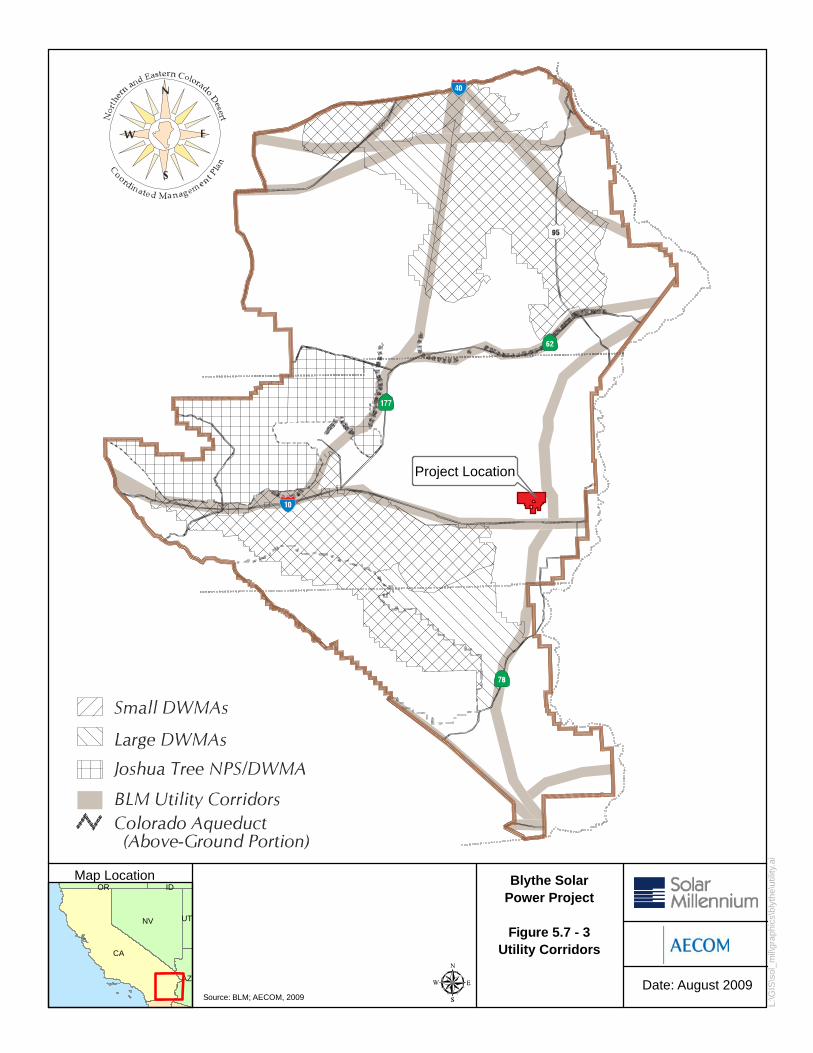
The CDCA Plan requires that new gas, electric, and water transmission facilities and cables for interstate communication may be allowed only within appropriately designated corridors. As shown in the CEC maps titled “Renewable Energy Transmission Initiative (RETI) Phase 2A Draft Maps,” the northeastern most portion of the Project is located within a designated BLM Energy Corridor and the proposed Section 368 transmission corridors, as described in Section 5.1 (Figure 5.7-3, BLM Utility Corridors).
CDPA
The U.S. Congress enacted the CDPA in 1994 (Public Law 103-433) to establish desert wilderness areas for protection including the Chuckwalla Mountains Wilderness, the Little Chuckwalla Mountains Wilderness, the Palen/McCoy Wilderness, the Palo Verde Mountains Wilderness, and many other wilderness areas on public land. In addition, the CDPA established Death Valley National Park, Joshua Tree National Park and the Mojave National Preserve. The CDPA established administration of wilderness lands and addresses land use compatibility issues such as buffers and utility ROWs.
Title VIII of the CDPA specifically permits military lands and overflights. The proposed Project is not within or contiguous to any CDPA wilderness area or National Park, nor does the proposed Project require or propose use or construction of right of way within a wilderness area or National Park, thus, the Project would be consistent with the CDPA plan.
Current Federal/State Interagency Cooperation for Renewable Energy Applications
California Executive Order S-14-08 established a goal for the RPS to produce 33 percent of California’s electrical needs by 2020. Two interagency memoranda of understanding (MOUs) have been executed to encourage the development of renewable energy sources that meet the RPS.
On August 8, 2007, the BLM California Desert Conservation District and the CEC executed a MOU to establish a policy for the joint environmental review of 49 solar thermal power plant projects. As indicated elsewhere in this Application for Certification (AFC), a key element of this joint review will be preparation of a joint NEPA/CEQA document by the two agencies. The Project addressed in this AFC will result in a joint NEPA/CEQA document. The intention of this joint CEC and BLM review is to expedite permitting of solar power plants that are needed to meet California’s RPS goals, and to satisfy the Project objectives (see Section 2.0, Project Description). This AFC is needed to address BLM needs as well as those of the CEC in order to support preparation of the joint NEPA/CEQA document.
In November 2008, the BLM, the California Department of Fish and Game (CDFG), the U.S. Fish and Wildlife Service (USFWS) and the CEC signed a MOU regarding the establishment of the California Renewable Energy Action Team. The goal of this MOU is to accelerate cooperation among federal and state agencies to facilitate the State of California’s renewable energy goals. The parties agreed to work cooperatively to develop a conservation strategy (referred to as the Desert Conservation Energy Plan) to provide for effective protection and conservation of the natural resources within the Mojave and Colorado Desert Regions while allowing solar and other qualified RPS energy project siting development in a manner that avoids or minimizes environmental impacts. The Applicants are working with these various agencies individually and collectively to support the acceleration of the Project permitting/licensing process.
Federal Aviation Regulations
Federal Aviation Administration (FAA) regulations, 14 CFR Part 77, establish standards and notification requirements for objects affecting navigable airspace. This notification serves as the basis for evaluating the effects of construction or alteration on operating procedures; determining the potential hazardous effect of the proposed construction on air navigation; identifying mitigating measures to enhance safe air navigation; and charting of new objects.

5.7 Land Use
August 2009 Blythe Solar Power Plant
5.7-6
These regulations apply to the following:
• Any construction or alteration exceeding 200 feet above ground level;
• Any construction or alteration;
o within 20,000 feet of a public use or military airport which exceeds a 100:1 surface from any point on the runway of each airport with at least one runway more than 3,200 feet
o within 10,000 feet of a public use or military airport which exceeds a 50:1 surface from any point on the runway of each airport with its longest runway no more than 3,200 feet
o within 5,000 feet of a public use heliport which exceeds a 25:1 surface;
• Any highway, railroad or other traverse way whose prescribed adjusted height would exceed that above noted standards;
o when requested by the FAA; and
o any construction or alteration located on a public use airport or heliport regardless of height or location.
Section 5.13, Traffic and Transportation provides a detailed analysis of the proposed Project with respect to potential airport hazards and regulations. Because of its proximity to the Blythe Airport, the Project operation could potentially cause concern with respect to aircraft flight operations. FAA would conduct a review of the Project known as a “7460 review”. The Applicant would need to submit a “Notice of Proposed Construction or Alteration” found on the FAA website at faa.gov/ats/atat/ata400/oeaaa.html.
Energy Policy Act of 2005
The Federal Energy Policy Act of 2005 directs Federal agencies to undertake efforts to ensure energy efficiency, and the production of secure, affordable, and reliable domestic energy. Section 211 sets a goal for the Department of Interior (of which the BLM is a part), to approve 10,000 megawatts of renewable energy on public lands by 2015.
NEPA
The Department of Energy’s Office of Energy Efficiency and Renewable Energy and BLM are currently preparing a Solar Energy Development PEIS to evaluate utility-scale solar energy development, to develop and implement agency-specific programs that would establish environmental policies and mitigation strategies for solar energy projects, and to amend relevant agency land use plans with the consideration of establishing a new BLM solar energy development program. As a practical matter, the PEIS will help BLM to more efficiently address the significant number of applications it has received that are seeking approval of utility-scale solar power plant projects on BLM lands. The Draft PEIS is currently in the scoping process and, according to the PEIS website, the document’s publication schedule will be determined after the scoping period closes in September and the comments received are evaluated (http://solareis.anl.gov/eis/index.cfm, accessed August 12, 2009).
As mentioned earlier, NEPA compliance for the Project will be achieved through a combined NEPA/CEQA document which will be prepared jointly by the BLM and CEC.
5.7.1.2 State LORS
Warren-Alquist State Energy Resources Conservation and Development Act
The California Public Resources Code (PRC) establishes the CEC, through the AFC process, as the decision-making authority over land use decisions and environmental determinations in accordance with the

5.7 Land Use
August 2009 Blythe Solar Power Project
5.7-7
Warren-Alquist State Energy Resources Conservation and Development Act (Warren-Alquist Act), codified in Section 25000 et seq. of the PRC. The CEC has exclusive jurisdiction over large (50 MW or greater) thermal power plant siting pursuant to section 25500 of the Warren-Alquist Act, including CEQA implementation, and in most aspects the Project will demonstrate conformity with state, regional, and local laws, including land use laws.
Title 20 California Code of Regulations, Section 1701 et seq. establishes CEC procedures, documentation, and required environmental and other findings for siting of electrical energy generating facilities. Included in these regulations are specific instructions for providing public notice, environmental and other information required to be submitted with all applications, and the required public safety, environmental and other findings to be made by the CEC in order to approve an application.
As discussed above, the CEC and BLM will prepare a joint NEPA/CEQA document to streamline the review process for the Project.
Farmland Mapping and Williamson Act
The California Department of Conservation’s Farmland Mapping and Monitoring Program (FMMP) produces maps and statistical data used for analyzing impacts on California’s agricultural resources. Agricultural land is rated according to soil quality and irrigation status. The Project site has no history of agricultural use. It has not been mapped for agricultural purposes, and no special agricultural land use designations have been assigned pursuant to the FMMP or the Williamson Act. Thus, the FMMP and Williamson Act do not apply to the Project.
The nearest Farmland of Statewide Importance was located approximately one mile east of the Project site on the Palo Verde Mesa. This 640 acre area of Farmland of Statewide Importance has recently been developed with a solar photovoltaic facility. The Palo Verde Valley has important farmland designations. In 2006, the Palo Verde Valley had 93,000 acres in production with an Agricultural District valuation of approximately 90 million dollars. The primary crops grown in the valley are citrus crops, tree and vine crops, vegetable, melon and miscellaneous crops, and field and seed crops. Some properties in the Palo Verde Valley are protected by Williamson Act contracts. Agricultural properties within the eastern portion of the study area are designated by Riverside County as agricultural. Because the proposed Project is not located on agricultural land and would not provide services requiring the development of additional land, there is no reason to expect that Project implementation would lead to additional development on protected agricultural land. However, at the same time, based on the conversion of the 640 acres of farm land east of the site to solar photovoltaic use, there is no guarantee that other solar project proposals would not occur in the Palo Verde Mesa and Valley.
Airport Land Use Law
The State of California has adopted the Airport Land Use Law, Public Utilities Code Sections 21670-21679.5, which created county Airport Land Use Commissions. The Riverside County General Plan is intended to implement and be consistent with the purposes of the Airport Land Use law. The Riverside County Airport Land Use Commission (ALUC) has adopted airport land use compatibility plans to assist the County and its affected cities in land use planning in the vicinity of public use airports located in the County.
The Blythe Airport is located immediately south of the Project site. It is owned by Riverside County and managed by the City of Blythe. The Project is within the Blythe Airport Influence Zone (AIA) and falls within airport safety zones D and E. The Project’s transmission line is expected to be routed south initially before turning west turning toward the proposed Colorado River substation where it will interconnect with the regional grid. The portion of the line heading south will be located within the airport influence zone and will cross through zones E, D, C and B1; this will require an airport land use consistency determination by the Riverside County ALUC under the Airport Land use law.

5.7 Land Use
August 2009 Blythe Solar Power Plant
5.7-8
5.7.1.3 Local LORS
Riverside County General Plan
The Riverside General Plan was originally adopted October 7, 2003. An update was prepared in 2008, and the General Plan five-year review and update is expected to be completed in June 2010. The General Plan consists of a vision statement and the following elements: Land Use, Circulation, Multi-purpose Open Space, Safety, Noise, Housing, Air Quality and Administration. It sets forth county land use policies and implementation measures. This section draws upon the 2008 General Plan update (GPA 960) information which included all amendments to date, and is the most current information for the General Plan. It is expected that the GPA 960 will be adopted in June 2010. The GPA 960 proposes a new element for Healthy Communities, proposes changes to various areas that are outside of the Project vicinity, and makes several corrections. No changes in land use designations were noted with regard to the Project land use study area.
The existing General Plan and County Land Use Ordinance do not specifically address the siting of utility-scale solar energy facilities and the County recognizes that policy conflicts may exist for proposed solar power plants. The Riverside County Land Use Ordinance describes all zoning and includes guidance for technical amendments, entitlements and policy amendments for foundation component amendments and General Plan amendments. County zoning is described in detail in Table 5.7-2. One private parcel inholding has a W-2-10 zoning designation and is not proposed for development. The W-2-10 zoning zoning refers to a public utility use, which is not clearly defined. However, recognizing the County’s considerable solar resource of Riverside County, the County is planning to address the siting of solar power plants and will clarify the definition of public utility uses in its General Plan update and in future revisions of the County Land Use Ordinance. Updates of the Energy, Cultural Resources, and Water Conservation policies and a review of Multi-species Habitat Conservation Plans are also expected.
Policies at the General Plan and Area Plan levels implement the Riverside County vision. The Project is located on the Palo Verde Mesa just west of the City of Blythe. As noted above, the proposed Project is located within unincorporated Riverside County on BLM land that is within the Palo Verde Area Plan. The Project study area is partially within the Eastern Riverside County Desert Area (a “non-area plan” defined as the area that is not part of any of the County of Riverside’s 19 Area Plans) and partly with the Palo Verde Area Plan. The unique features and landforms in the Palo Verde Area Plan include the Palo Verde Mesa and Valley, agricultural lands within the Palo Verde Valley, the Colorado River, the mountains and wilderness lands, the intaglio resources, and the Blythe Airport. The Project is not located on any private land under the jurisdiction of Riverside County.
Two private parcels are found within close proximity to the Project and are designated in the Riverside County General Plan as Open Space Rural and within the Palo Verde Area Plan. No private parcels will be developed by the Project and therefore the County of Riverside policies do not apply to this Project. Figure 5.2-4 Land Use Designations, is based on the latest available Riverside County General Plan maps and shows the land uses on the Project site and the land use study area. The eastern, western, and southern portions of the study Area are within the Palo Verde Area Plan boundary; the northern portion of the study area is within the Eastern Riverside County Desert Area.
Scenic Corridors
I-10 has been identified by the County of Riverside in its Circulation Element as eligible for designation as a scenic corridor. The County of Riverside has indicated in its General Plan Land Use Element that I-10 should be designated a scenic highway and has developed General Plan scenic corridor policies. Since private property under the jurisdiction of Riverside County will not be developed, County policies would not apply to the Project.

5.7 Land Use
August 2009 Blythe Solar Power Project
5.7-9
Land Use Element Airport Policies
The Riverside County General Plan Land Use Element has adopted the following policies related to airport land use compatibility.
• Allow airport facilities to continue operating in order to meet existing and future needs respecting potential noise and safety impacts.
• Review all proposed projects and require consistency with any applicable airport land use compatibility plan as set forth in Appendix L and as summarized in the Area Plan’s Airport Influence Area section for the airport in question.
• Review all subsequent amendments to any airport land use compatibility plan and either adopt the plan as amended or overrule the Airport Land Use Commission (ALUC) as provided by law (Government Code Section 65302.3).
• Prior to the adoption or amendment of this General Plan or any specific plan, or the adoption or amendment of a zoning ordinance or building regulation within the planning boundary of any airport land use compatibility plan, refer such proposed actions for determination and processing as provided by the Airport Land Use Law.
• Allow the use of development clustering and/or density transfers to meet airport compatibility requirements as set forth in the applicable airport land use compatibility plan.
• In accordance with FAA criteria, avoid locating sanitary landfills and other land uses that are artificial attractors of birds within 10,000 feet of any runway used by turbine powered aircraft and within 5,000 feet of other runways. Also avoid locating attractors of other wildlife that can be hazardous to aircraft operations in locations adjacent to airports.
• Ensure that no structures or activities encroach upon or adversely affect the use of navigable airspace.
• All development proposals within an Airport Influence Area will be submitted to the affected airport.
ADVISORY REVIEWS: The County may from time to time elect to voluntarily submit proposed actions or projects that are not otherwise required to be submitted to the ALUC under the Airport Land Use Law in the following circumstances:
a. Clarification: If there is a question as to the purpose, intent or interpretation of an airport land use compatibility plan (LUCP) or its provisions; or
b. Advisory: If assistance is needed concerning a proposed action or project relating to Airport Land Use matters.
Riverside County Airport Land Use Commission
Riverside County has adopted the Airport Land Use Compatibility Plan (RCALUCP) in compliance with State Law. Pursuant to the RCALUCP, certain types of actions in airport influence areas must be referred to the Riverside County ALUC in order to determine a proposed project’s consistency with its Compatibility Plan. In general, the following actions require an ALUC Review: General Plan Amendment, Specific Plan Amendment, Rezoning, and Heliports/Helistops. Although, this Project does not fit any of these categories, it falls within the Blythe Airport Area of Influence and requires an airport land use compatibility review by the ALUC.
One private parcel inholding in the Project area (for which there are no current plans to develop as part of the BSPP), in the southwest one-quarter of Section 14, and the southeast portion of the Project site are

5.7 Land Use
August 2009 Blythe Solar Power Plant
5.7-10
within safety zone E of the Blythe AIA; about 870 acres will be developed in this zone. Additionally, a small corner of the Project site is located in safety zone D, and as shown on Figure 5.7-5, about 34 acres would be developed in this zone. A transmission line from the Project site to the proposed Colorado River substation about five miles to the southwest would cross airport safety zones E, D, C and B1. Based on the RCALUCP Policy Document (Appendix D Compatibility Guidelines for Specific Land Uses), power plants and electrical substations will be located in zones that are designated generally compatible or potentially compatible with restrictions.
The ALUC will review the Project concerning navigation safety issues such as reflectivity, solar panel orientation, general airport safety issues, heights of Project components, airport or runway obstructions, and occupancy. The applicant will be required to obtain clearance of airport compatibility prior to approval of the Project. The RCALUCP specifically addresses residential uses and the number of people allowed on a site, and the parcel sizes allowed within the safety zones A through D. The RCALUCP policies also include a requirement for a percentage of open land within developments. The airport compatibility table includes prohibited uses and other development conditions within the airport safety zones.
In safety zone D, the RCALUCP allows up to 100 people per acre on a site except in rare circumstances. The RCALUCP specifically prohibits highly noise-sensitive outdoor non-residential land uses and hazards to flight in this zone. The RCALUCP requires airspace review for objects greater than 70 feet tall and a deed notice to disclose information about airport proximity to new property owners. In zone D, children’s schools, hospitals and nursing homes are discouraged. As noted above, the project will not develop in this zone.
Safety zone E requirements do not restrict residential parcel sizes or impose other requirements for open space. Hazards to flight are discouraged in this zone. For all structures over 100 feet tall, airspace review is required. Transmission structures near the airport will be no taller than 90 feet in order to meet FAA requirements concerning possible obstructions to aircraft operations. The Project’s cooling towers will be the tallest solar plant structure at 120 feet. The FAA Part 77 review is discussed in Section 5.13, Traffic and Transportation.
Riverside County Land Use Ordinance
The Riverside County Land Use Ordinance includes provisions for issuance of building and grading permits, grading plans, and zoning requirements, and standards and procedures for building review. The Riverside County Land Use Ordinance describes all zoning and includes guidance for technical amendments, entitlements and policy amendments for foundation component amendments and General Plan amendments.
The Project land use study area (including the Project site) is within the Chuckwalla Area zoning district and outside of any county service area. Two private parcels exist near or within the Project’s facility footprint, but will not be developed. These private parcels are within the jurisdiction of Riverside County, are located in the Palo Verde Area Plan of unincorporated Riverside County, and are zoned W-2-10, Controlled Development (with a 10-acre minimum parcel size per residence) (Table 5.7-2, Figure 5.7-6). The W-2 zone (County Code Section 15.1(e (2)) permits public utilities, structures, and appurtenant facilities for power generation and other such infrastructure. Based on conversations with the Riverside County Planning Director, if the Project were to develop on private parcels and is determined to fit the category of “public utility”, the County would provide input to the CEC during the AFC process regarding any applicable requirements. Currently, no private parcels within the jurisdiction of Riverside County would be developed as part of the project.
In the northern and western parts of the land use study area, two large privately owned parcels are intermingled with large blocks of BLM-managed public land. These two parcels are zoned W-2-10 (e.g.,

5.7 Land Use
August 2009 Blythe Solar Power Project
5.7-11
the W-2-10 zoning is within the W-2 zone which permits controlled development). In the eastern portions of the Study area, smaller private parcels are used for agricultural and other rural uses. These parcels are within the Palo Verde Area Plan of Riverside County and also designated W-2-10. The Project study area to the southeast includes the northwest section of Blythe Airport property, which is zoned Manufacturing-Heavy (MH). None of these private parcels would be developed or otherwise affected by the Project.
Based on discussions with Riverside County Planning Department and City of Blythe Planning Department staff, and reviews of the Riverside County land use database, there are no records of recent or proposed zoning changes, land use amendments, or other discretionary reviews in the general vicinity of the Project site within the last 18 months.
Table 5.7-2 County of Riverside Zoning
Zone District Description of Permitted Uses and Development Regulations
Controlled Development Areas (W-2)
W-2-10 zoning classification is within the W-2 zone and requires a minimum of 10-acres per dwelling. This zone permits, “public utility uses, such as 1) Structures and installations necessary to the conservation and development of water such as dams, pipelines, water conduits, tanks, reservoirs, wells and the necessary pumping and water production facilities; 2) Structures and the pertinent facilities necessary and incidental to the development and transmission of electrical power and gas such as hydroelectric power plants, booster or conversion plants, transmission lines, pipe lines and the like; and 3) Telephone transmission lines, telephone exchanges and offices.”
Natural Assets (N-A)
This zone permits, “One-family dwellings, field and tree crops, apiaries, limited grazing of cattle, horses, sheep or goats. With a Plot Plan and parcel of appropriate size: public utility substations, menageries, museums, agricultural mobile homes. Uses with a CUP: recreational vehicle parks, hotels, extraction and bottling of well water, riding academies, golf courses and appurtenant facilities, fishing lakes, camps, guest ranch.”
Manufacturing-Heavy M-H
Permits most light, medium, and heavy industrial and manufacturing uses with Plot Plan approval. Certain uses require Conditional Use Permit. Caretaker’s residence allowed with approved Plot Plan. Off-site advertizing at 500-feet intervals with Planning approval.
City of Blythe Airport
The Project itself is not within the boundaries of the City of Blythe or its Sphere of Influence; however, the land use study area encompasses Blythe Airport property, which is within the City of Blythe Sphere of Influence. As noted earlier, the Project falls within the Blythe Airport Influence Area (AIA). The Blythe Airport is owned by Riverside County and managed by the City of Blythe. The Blythe City Council adopted the Final Blythe Airport Master Plan in September, 2000. The Master Plan provides short-, mid- and long-range airport use and improvement polices for both aeronautical and non-aeronautical use of airport lands.
The City of Blythe component of the ALUCP was adopted by the Riverside County Airport Land Use Commission in October 2004. The ALUCP serves as a guide for future development within the airport environs and is intended to facilitate orderly development and avoid land use conflicts. The primary function of the ALUC is to “…protect the public health, safety and welfare by ensuring the orderly expansion of airports and the adoption of land use measures that minimize the public’s exposure to excessive noise and safety hazards within areas around public airports…” Similarly, it is the goal of the City of Blythe to promote development on and around the Blythe Municipal Airport while maintaining

5.7 Land Use
August 2009 Blythe Solar Power Plant
5.7-12
safety both on the ground and in the air. Since the proposed Project would not develop on airport property, the Riverside County ALUC would be responsible for the airport land use compatibility review.
The AIA as defined by the ALUCP is delineated on the Blythe General Plan Land Use Map, Figure 3-2-1 and shown in this report as Figure 5.7-5. Basic compatibility guidelines are found on Table 3.7-1 of the Blythe General Plan. The City of Blythe has also developed Guiding Policies for the Blythe Airport as follows:
• The City of Blythe hereby adopts by reference into General Plan 2025, the Blythe Airport Master Plan dated September 2000 as may be amended by the Blythe City Council from time to time. Further, all applicable goals, policies and development plans and standards contained in the Blythe Airport Master Plan are also City of Blythe policies.
• The City of Blythe hereby adopts by reference the Blythe Airport component of the 2004 Riverside County Airport Land Use Compatibility Plan as may be amended by the Airport Land Use Commission from time to time. Further, all applicable policies and criteria contained in the ALUCP are also City policy.
• Prior to City action pertaining to currently unincorporated lands within the AIA, such proposed actions will be submitted to the ALUC for consistency review until such time as a more detailed general plan and /or specific plan for the area has been found consistent by the ALUC.
• As required by Public Utilities Code Section 21676(b), prior to City approval, appropriate pre-zoning, specific plan, planned unit development, individual development projects, or other actions involving land within the City of Blythe Sphere of Influence and AIA designated “planned development” will be submitted to the ALUC for review.
5.7.1.4 Agency Contacts
The agencies with jurisdiction to process land use entitlements for the BSPP are listed in Table 5.7-3.
Table 5.7-3 Agency Contact List
Agency Contact Phone/E-mail Permit/issue
Ron Goldman Planning Director County of Riverside 4080 Lemon Street, 9th Floor P.O. Box 1409 Riverside, CA 92501
(951) 955-3265
Compatibility with county land use requirements (zoning, land use plans and policies)
Claude Kirby BLM Palm Springs 1201 Bird Center Drive Palm Springs, CA 92262
(760) 251-4850
[email protected] ROW Application
Sandra McGuiness/Erin Dreyfuss, BLM, Environmental Planning, Natural Resources, 2800 Cottage Way, W-1928, Sacramento, CA 95825-1886
(916) 978-4400
[email protected] Plan Amendment
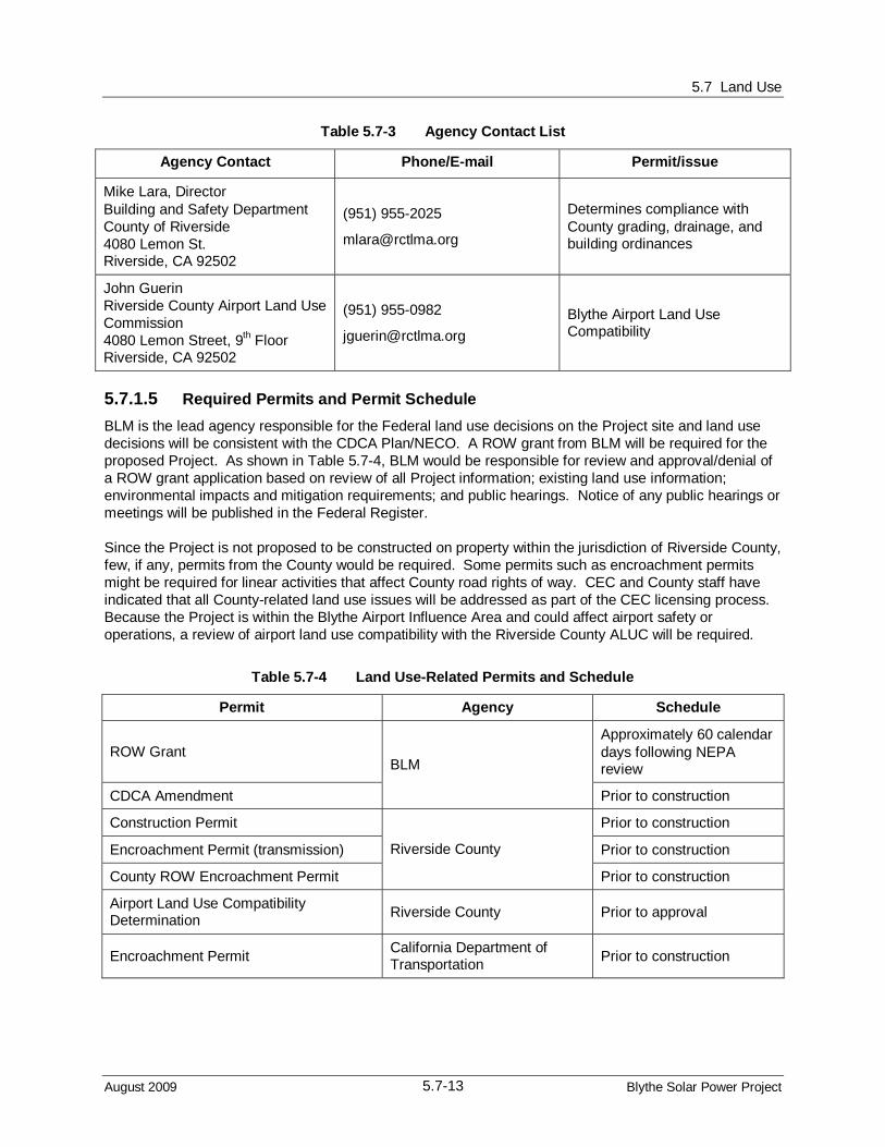
5.7 Land Use
August 2009 Blythe Solar Power Project
5.7-13
Table 5.7-3 Agency Contact List
Agency Contact Phone/E-mail Permit/issue
Mike Lara, Director Building and Safety Department County of Riverside 4080 Lemon St. Riverside, CA 92502
(951) 955-2025
Determines compliance with County grading, drainage, and building ordinances
John Guerin Riverside County Airport Land Use Commission 4080 Lemon Street, 9th Floor Riverside, CA 92502
(951) 955-0982
[email protected] Blythe Airport Land Use Compatibility
5.7.1.5 Required Permits and Permit Schedule BLM is the lead agency responsible for the Federal land use decisions on the Project site and land use decisions will be consistent with the CDCA Plan/NECO. A ROW grant from BLM will be required for the proposed Project. As shown in Table 5.7-4, BLM would be responsible for review and approval/denial of a ROW grant application based on review of all Project information; existing land use information; environmental impacts and mitigation requirements; and public hearings. Notice of any public hearings or meetings will be published in the Federal Register.
Since the Project is not proposed to be constructed on property within the jurisdiction of Riverside County, few, if any, permits from the County would be required. Some permits such as encroachment permits might be required for linear activities that affect County road rights of way. CEC and County staff have indicated that all County-related land use issues will be addressed as part of the CEC licensing process. Because the Project is within the Blythe Airport Influence Area and could affect airport safety or operations, a review of airport land use compatibility with the Riverside County ALUC will be required.
Table 5.7-4 Land Use-Related Permits and Schedule
Permit Agency Schedule
ROW Grant Approximately 60 calendar days following NEPA review
CDCA Amendment
BLM
Prior to construction
Construction Permit Prior to construction
Encroachment Permit (transmission) Prior to construction
County ROW Encroachment Permit
Riverside County
Prior to construction
Airport Land Use Compatibility Determination Riverside County Prior to approval
Encroachment Permit California Department of Transportation Prior to construction

5.7 Land Use
August 2009 Blythe Solar Power Plant
5.7-14
5.7.2 Affected Environment This subsection discusses existing land use conditions in the areas potentially affected by the Project. For the purposes of this evaluation, the land use study area or local affected environment is defined as a one-mile radius around the Project plant site and 0.25 miles on both sides of the Project’s offsite linear features. BLM, Riverside County, and the City of Blythe are the governmental entities with jurisdiction within the Project study area. There are two private parcels, one of which is adjacent to the ROW and another of which is an inholding within the ROW boundary. No facilities are proposed to be constructed on, or otherwise affect, these two private parcels.
5.7.2.1 Regional Setting The BSPP site is located in the Colorado Desert in eastern Riverside County, approximately eight miles west of the City of Blythe and contiguous to the City of Blythe Sphere of Influence (airport property). Riverside County is the fourth largest county in California, with a population of over two million people. Most of the population is found in the western portion of the County. The eastern area comprises nearly 40 percent of the County’s acreage but contains less than one percent of its population; it consists of most of the County’s desert regions which include a mixture of publicly and privately owned lands.
Most of the native desert is covered by desert scrub and with chaparral at the western edge and woodlands and forests at higher elevations in the San Jacinto Mountains and desert mountains. Elevations range from 230 feet below mean sea level at the Salton Sea to about 9,800 feet at Mount San Jacinto in the San Bernardino National Forest. As with western Riverside County, the region’s various environments accommodate a wide variety of plants and animals, including many rare or endemic to Southern California. At least five sensitive habitat communities and over 170 plant and animal species have been identified for Eastern Riverside County. As shown in the CEC map titled “RETI Phase 2A Draft Maps”, a small portion of the northeast section of the Project is within a designated BLM Energy Corridor and the proposed Section 368 transmission corridors (Figure 5.7-3, BLM Utility Corridors).
5.7.2.2 Project Site and Immediate Vicinity
Plant Site and Vicinity
The Applicants have applied for a ROW Grant for 9,400 acres of Federal land managed by BLM and the facility footprint (the area inside the ROW that is within the facility’s fenceline), would occupy approximately 5,950 acres. The Project site is vacant undeveloped desert located approximately one mile north of the Blythe Airport, two miles north of I-10, and eight miles west of the City of Blythe. The small rural community of Mesaville lies to the east of the Project site on the Palo Verde Mesa.
The Project site is not located in a designated wilderness area; however, it is located near lands that are designated as wilderness lands or ACEC (NECO Maps 2-38 and 2-4). The nearest Federal wilderness areas are located on mountainous land to the northwest and south of the Project site and are referred to as the Palen/McCoy Wilderness Area, and the Chuckwalla Mountains Wilderness Area, respectively (Figure 5.7-1). Riverside County land uses in the study area include Open Space-Rural, Agricultural and Public Facility.

5.7 Land Use
August 2009 Blythe Solar Power Project
5.7-15
As noted earlier, the Blythe Airport is located south of the Project site. North and west of the Project site are vacant desert lands. South of I-10 is undeveloped public and private desert land. Undeveloped and irrigated desert is located east of the site where several large and small parcels are actively farmed. The nearest residence is located in the southeast one-quarter of section 14, outside of the BLM- administered property and outside the 7,030-acre area within the overall ROW that will be disturbed by Project construction and operation. Another residential structure is located off-site between the southern boundary of the Project site and north of the Blythe Airport. No other residences are known to exist within the one-mile radius of the Project site.
The Project site is vegetated with desert scrub throughout. Based on information in the NECO Plan, the Project site has not been leased for grazing by BLM.
Recreation Land Use
The site is currently undeveloped and few OHV tracks were observed. No portion of the Project site or study area is known to be used for recreation.
Scenic Land Use
The NECO Plan does not identify any scenic resources in the Project study area. Riverside County has identified the I-10 corridor as eligible for county designation as a scenic corridor. I-10 corridor is not a State-designated scenic highway in the area between Palm Springs and Blythe.
Agricultural Land Use
According to the California Department of Conservation FMMP, most of the Project and a portion of the study area have not been mapped for agricultural purposes. In order to meet the definition of Prime Farmland, Farmland of Statewide Importance, or Unique Farmland, the land must have been used for irrigated agricultural production at some time during the four years prior to the mapping date (FMMP). The Project site has not been used for agricultural production at any time in the past, and thus does not fit the definition of Prime Farmland.
The FMMP indicates that agricultural land of approximately 640 acres exist approximately one mile east of the Project site on the Palo Verde Mesa. This mapped farmland includes every type of important farmland: including Prime Farmland, Farmland of Statewide Importance, Farmland of Local Importance, and Unique Farmland. However, based on aerial photographs and review of City and County data, this 640 acre area of agricultural land is no longer in production. Other small farms near Mesaville are scattered throughout the mesa east of the Project site and are designated mostly Prime Agricultural Land.
The Palo Verde Valley is well known for its rich agricultural land. The Palo Verde Valley surrounding the City of Blythe and Town of Ripley is heavily farmed and nearly the entire valley outside of these urban areas is designated as Prime Farmland and Farmland of Statewide Significance. Other significant agricultural land is found approximately 60 to 100 or more miles from the Project site, north and south of the Salton Sea in Riverside and Imperial Counties. The Project site does not contain any mapped agricultural lands, nor has the site any history of agricultural use. The Project would not directly or indirectly result in a conversion of agricultural land to non-agricultural use as a result of development. Further, development of the BSPP would not lead to additional development on protected agricultural land.
5.7.2.3 Linear Facilities The BSPP will have two offsite linear facilities: a 500 kilovolt (kV) gen-tie line to connect the Project with the regional grid and a natural gas line that will connect with an existing gas line just south of the I-10. The

5.7 Land Use
August 2009 Blythe Solar Power Plant
5.7-16
Project will use natural gas for quick startup and heat transfer fluid freeze protection. Although the transmission line route is not yet finalized the Project will connect to the proposed Colorado River substation to be located about five miles southwest of the Project site south of I-10. It is expected that the gas line and the transmission line will be routed in the same utility corridor leaving the Project site.
5.7.3 Environmental Impacts The land use impact evaluation focuses on the following issues: 1) the conformity of the Project with federal and local land use plans, ordinances and policies; and 2) the potential for the BSPP to have direct, indirect and/or cumulative land use conflicts with existing and planned uses.
5.7.3.1 Construction Phase Impacts The Project will require construction of a new transmission line to connect to the proposed Colorado River substation located south of I-10. The transmission line ROW is expected to be located at least partially on BLM land and BLM land occupied by the Project transmission line would be included with the ROW grant.
Project construction is not expected to affect airport operations. However, a land use compatibility review with the County of Riverside ALUC will be required in order to determine whether there are any compatibility issues with the Blythe Airport.
The residences in the Project study area in Sections 24 and 14 site may experience some temporary impacts from construction phase dust emissions, noise and construction traffic, as discussed in AFC Section 5.2, Air Quality, Section 5.8, Noise, and Section 5.13 Traffic. Construction activities will be designed to minimize interference with existing land uses in the vicinity of the Project site. Due to the temporary nature of construction (approximately 69 months) and with planned mitigation measures, these impacts would be less than significant.
5.7.3.2 Operations Phase Impacts The proposed Project site is classified as Multiple Use Class L by the BLM, which protects sensitive, natural scenic, ecological, and cultural resource values. The Project will not affect designated wilderness areas, DWMAs, recreational areas, important mineral resource areas, or other designated sensitive or scenic land uses. However, as stated earlier, the CDCA Plan states that sites associated with power generation or transmission not identified in the Plan must apply for a CDCA Plan Amendment. With a CDCA Amendment, the proposed Project would be in conformance with CDCA Plan/NECO.
Residences and some rural farms exist within the land use study area. Once the Project is operational, the Project would have only minor noise and traffic impacts. Project facilities would be visible from the nearby residences (see Section 5.15, Visual Resources).
5.7.3.3 Cumulative Impacts Current land uses along the I-10 corridor consist largely of undeveloped land or desert wilderness areas. No large scale energy facility (or other development) currently occurs in this area with the exception of transmission lines. Thus, cumulatively, the Project with the other projects identified in Section 5.1.2 will unavoidably alter the land use patterns of portions of eastern Riverside County along the I-10 corridor. The various projects, include potential projects with BLM ROW applications on approximately 100,000 acres of land, although the actual facility footprints of these projects will much less. Furthermore, there are several transmission system facilities (additional high-voltage transmission lines and utility substations), that are planned in the I-10 corridor to support energy facilities along the I-10 corridor.

5.7 Land Use
August 2009 Blythe Solar Power Project
5.7-17
The various proposed energy projects (almost all solar) are located in areas that various ongoing study/planning efforts (e.g., California’s RETI) recognize as generally suitable for solar energy. This suitability is based on factors such as the presence of the needed strong solar resource, topography, the presence/proximity of needed infrastructure (transmission lines and highways), and significantly, the avoidance of areas that would conflict with other sensitive uses (wilderness areas, National Parks and other recreational facilities, ACEC, etc.).
The need to utilize the desert for solar energy resources is recognized in applicable land use/resource management and planning documents (e.g., CDCA Plan/NECO), Federal legislation (Energy Policy Act of 2005), and an order issued by Secretary of Interior Salazar in June 2009 vowing to have 13 commercial-scale solar projects on public lands under construction by the end of 2010. Thus, while the cumulative effects of these projects will be to effect a substantial change in land uses in the vicinity of the I-10 corridor, these changes are and will be compatible with applicable plans and policies that encourage renewable energy development.
5.7.4 Mitigation Measures The following measures are proposed to mitigate the Project’s land use impacts:
LAND-1 Prior to construction, the Applicant will work with the Blythe Airport and the County of Riverside ALUC to assure conformity with the Blythe Airport Land Use Compatibility Plan.
LAND-2 Prior to construction, the Applicant will obtain and provide to the CEC’s Compliance Project Manager a copy of the BLM ROW Grant and an amendment to the CDCA to comply with BLM’s CDCA Plan/NECO and Title 43 CFR 2800 and 2880.
5.7.5 References BLM, 1980. CDCA Plan of 1980.
BLM, 2002. NECO Plan. Accessed online http://www.blm.gov/ca/news/pdfs/neco2002/
BLM and CEC, 2007. Memorandum of Understanding Between the U.S. Department of the Interior, Bureau of Land Management California Desert District and the California Energy Commission Staff Concerning Joint Environmental Review for Solar Thermal Power Plant Projects.
California Department of Conservation, 2004. Farmland Mapping and Monitoring Program. Accessed online at ftp://ftp.consrv.ca.gov/pub/dlrp/FMMP/2004
California Department of Transportation. 1997. Encroachment Permits: Manual for Encroachment Permits on California State Highways. Accessed online. http://www01.smgov.net/engineering/intranet/caltrans/Publications/encroach/Encroachment%20Permits%20Manual.pdf
California Department of Food and Agriculture. 2009. Fruit and Vegetable Quality Control-Standardization. Accessed on-line August 10, 2009 http://www.cdfa.ca.gov/is/docs/Commodity_list.pdf
CEC, 2009. Renewable Energy Transmission Initiative (RETI) Phase 2A Draft Maps, California, Draft Proposed Renewable Energy Zones, & Conceptual Transmission Segments- New and Existing Corridors. July 22.
Goldman, Ron, 2009. Riverside County Planning Director; Damian Meins, Assistant Planning Director,

5.7 Land Use
August 2009 Blythe Solar Power Plant
5.7-18
2009. Riverside County Planning Department. Personal Communication. June 17.
Olivas, Jay, 2009. Riverside County Planning Department Planner. Personal Communication. May 13.
Riverside County Airport Land Use Commission, 2008. Application ZAP1003BL08, First Solar Blythe Land Holdings, LLC. Accessed online August 5, 2009, http://www.rcaluc.org/filemanager/agenda/agendas/archive/2008/10_09_08_sr/sr_4.1.pdf
Riverside County Airport Land Use Commission. 2004. Background Data Volume 3 East County Airports, October.
Riverside County General Plan, 2003. Accessed online http://www.rctlma.org/genplan/default.aspx
Riverside County, Agricultural Commissioner. 2006. Palo Verde Valley Acreage and Agricultural Crop Report. Accessed on line August 10, 2009 http://www.rivcoag.org/sites/default/publications/cropreports/2006_Dist_PV.pdf
Riverside County General Plan Update, 2008. Accessed online http://www.rctlma.org/genplan/content/gp.aspx
Riverside County Land Information System, 2009. Accessed online http://www3.tlma.co.riverside.ca.us/pa/rclis/index.html
Riverside County Zoning Ordinance 348, 2009. Amended May 28. Accessed online http://www.rctlma.org/planning/content/zoning/ordnance/ord348_toc.html
Riverside County Code of Ordinances, 2008. Title 17 Zoning. Accessed online http://www.municode.com/Resources/gateway.asp?pid=16320&sid=5
Solar Millennium, 2008. Plan of Development.
Schwarzenegger, Arnold, 2008. California Office of the Governor, Executive Order S-14-08 amended March 1999.


Source: BLM; AECOM, 2009
Blythe SolarPower Project
Figure 5.7 - 2Current BLM
Multiple Use Classes
LEGEND
CA
NV
AZ
UT
OR IDMap Location
Date: August 2009
L:\G
IS\s
ol_m
il\gr
aphi
cs\b
lyth
e\m
ultip
le_u
se.a
i
Project Location
Source: BLM; AECOM, 2009
Blythe SolarPower Project
Figure 5.7 - 3Utility Corridors
LEGEND
CA
NV
AZ
UT
OR IDMap Location
Date: August 2009
L:\G
IS\s
ol_m
il\gr
aphi
cs\b
lyth
e\ut
ility
.ai
Project Location


![[Jim Blythe, Phil Megicks] Marketing Planning Str(BookFi.org)](https://static.fdocuments.us/doc/165x107/55cf9b9b550346d033a6b5fd/jim-blythe-phil-megicks-marketing-planning-strbookfiorg.jpg)


