
5.2.6 Ocean Remote Sensing (ORS) for Coastal Habitat Mappingiocwestpac.org › final ppt WESTPAC X...
29
5.2.6 Ocean Remote Sensing (ORS) for Coastal Habitat Mapping Teruhisa KOMATSU Atmosphere and Ocean Research Institute The University of Tokyo
Transcript of 5.2.6 Ocean Remote Sensing (ORS) for Coastal Habitat Mappingiocwestpac.org › final ppt WESTPAC X...

5.2.6 Ocean Remote Sensing (ORS) for Coastal Habitat Mapping
Teruhisa KOMATSU
Atmosphere and Ocean Research Institute
The University of Tokyo
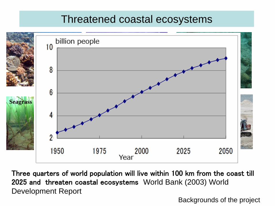
Threatened coastal ecosystems
Coral reef Blast coral fishing Devastated reef bottom
ReclamationIndustrial pollution
Backgrounds of the project
Seagrass bed
Three quarters of world population will live within 100 km from the coast till 2025 and threaten coastal ecosystems World Bank (2003) World Development Report

Realizing sustainable use of coastal habitats
• Monitoring, control and surveillance of coastal habitats are indispensable for sustainable development of fisheries and human society.
• In WESTAPAC region, monitoring and surveillance of coastal areas are a key issue due to broad unknown areas for policy makers.
• Strategic plan for 2011-2020 adopted by COP10 stated “By 2020, at least 10 percent of coastal and marine areas of particular importance for biodiversity and ecosystem services, are conserved”, namely, setting of marine protected areas.
Backgrounds of the project

WESTPAC VIII adopted reform of ORSP from NGSST and OC to Coastal Habitat Mapping for ICAM in Bali in May 2010
Remote sensing is an efficient tool to grasp status of coastal habitat
ORSP decided to focus on seagrass mapping at the first Workshop in Busan in 2011

Project Steering Group: Prof. Mazlan Hashim (Universiti Teknologi Malaysia, Malaysia) Dr. Aidy Muslim (Universiti Trengannu, Malaysia)Ms Thidarat Noiraksar (Brapha University, Thailand)Dr. Anchana Prathep (Prince Sonkla University, Thailand)Mr. Luong Cao Van (Institute of Marine Environment and Resources, Vietnam)Mr. Phan Minh Thu (Insitute of Oceanography, Vietnam)Dr. Hoang Son Tong Phuc (Insitute of Oceanography, Vietnam)Prof. Kenichi Hayashizaki (Kitasato University, Japan)Dr. Tatsuyuki Sagawa (Remote Sensing Technology Center, Japan), Prof. Sam Wouthyzen (LIPI, Indonesia)Dr. Nurjannah Nurdin (Hasanuddin University, Inodnesia) Mr. Sophany Phauk (Royal University of Phenom Phen, Cambodia)
Project leader: Dr. Teruhisa Komatsu (Atmosphere and Ocean Research Institute, The University of Tokyo)
Steering group from May 2012 to May 2015

The Terms of Reference of the project from May 2012 to May 2015 is as follows:
1) to establish a network of researchers working on remote sensing of seagrass mapping: all members2) to standardize satellite image analysis: Prof. Teruhisa Komatsu, Prof. Mazlan Hashim, Dr. Tatsuyuki Sagawa and Dr. Hoang Son Tong Phuc3) to standardize ground truthing methods: Prof. Kenichi Hayashizaki, Prof. Anchana Prathep, Ms. Thidarat Noiraksar and Prof. Teruhisa Komatsu4) to apply the standardized methods of seagrass mapping to target areas: all members5) to organize workshops to standardize remote sensing methods: Prof. Teruhisa Komatsu, Prof. Mazlan Hashim, Prof. Kenichi Hayashizaki, Dr. Tatusyuki Sagawa, Mr. Phan Minh Thu, Dr. Hoang Son Tong Phuc and Prof. Anchana Prathep

Participants of ORSP members to the 8th SPIE Asia-Pacific Remote Sensing 2012 held in Kyoto
1) Participation of ORSP members to the 8th SPIE Asia-Pacific Remote Sensing 2012 in KyotoEleven members participated in the 8th SPIE-Pacific Remote Sensing 2012 held in Kyoto from 29 October to 1 November 2012 to present results obtained by the project using ALOS AVNIR2 data provided by the project leader. Travels of foreign members were covered by the project leader’s own research fund. 12 papers were published in SPIE Proceedings after reviewing.
Activities from May 2012 to May 2015

2) Workshop on ORSP for ICAM during the 9th WESTPAC Scientific Symposium in Nha Trang on 24 April 2014
Agenda of the third workshop was1) present status of ORSP for ICAM (seagrass mapping) in members’ states, 2) discussion on future plan of ORSP for ICAM, 3) decision of next workshop of ORSP for ICAM and 4) selection of Steering Committee members.
Number of participants: 38 including young scientists . Reviewing seagrass beds mapping in each member country. Adoption of two standadized analyzing methods in WESTPAC:: Depth Invarian Index and Bottom Reflectance Index. Cooperative studies on temporal changes in seagrass habitats Next training workshop: sea truthing methods of seagrass habitats in Thailand in 2015 or later.

Workshop during the WESTPAC Scientific Symposium

3) The Fourth Training Workshop on ORSP for ICAM held at Institute of Oceanography in Nha Trang from 25
to 27 April 2014This workshop was partly supported with the network of the Asian CORE Program of the Japan Society for the promotion of Science, “Establishment of research and education network on coastal marine science in Southeast Asia”.
A total of 24 participants from 8 countries partly funded by JFIT attended the workshop. Those countries include Cambodia, Indonesia, Malaysia, the Philippines, Thailand, Vietnam, Yemen and Japan.
This workshop was designed to initiate beginners of coastal habitat mapping for ICAM who had longed for the training course and to share radiometric correction methods of the Depth Invariant Index and Bottom Reflectance Index among participants. Ground truthing methods were also lectured.

Training workshop at Institute of Oceanography on 24-27 April 2014

Training workshop at Institute of Oceanography on 24-27 April 2014

Example of ORSP activitiesMapping seagrass beds in Merambong shoal, Sg Pulai Estuary, Johor Baru, Malaysia under ORSP with cooperation of MoE-UPM-JSPS (ACORE-COMSEA) on Integrative Research on Seagrass Ecosystems (IER) in Southeast Asia

Sg Pulai Estuary, Johor
14

ORSP targeted on broad seagrass beds in Merambong facing Johor Straight in 2010

Ground truth data collection- Merambong
courtesy of Prof. Mazlan Hashim

Spatial Extent of Seagrass beds in Feb. 2009 by applying Bottom Reflectance Index
(Sagawa et al., 2010) to LANDSAT 5 TM
courtesy of Prof. Mazlan Hashim

Southern Johor reclamation projects to build artificial islands

Merambong viewed from Landsat 8 OLI (2013-2014)
courtesy of Prof. Mazlan Hashim

courtesy of Dr. Muta Harah and Prof. Japar Sidik

Spatial Extent of Seagrass in 2013 by applying Bottom Reflectance Index (Sagawa
et al., 2010) to LANDSAT 8 OLI
courtesy of Prof. Mazlan Hashim

2009 (km2) 2013 (km2) Changes
Status Percentage changes
Decline
-36.8% or
equal to 8604.3 km2
23,377.8 km2 14,773.5km2
Feb 2009 June 2013
23,378 km2 14,774 km2 Decrease by 37%courtesy of Prof. Mazlan Hashim

Reclamation was suspended in June 2014
on 21 September 2014
Local villagers affected by the Johor Forest City project shout out their concerns during the public hearing about the project in Tanjung Kupang, Johor today

On Wednesday, Country Garden Pacific View (CGPV), the master developer of the project, said reclamation works will continue, although the total size of the project was slightly reduced from 1,623 ha to 1,386 ha (3,425 acres).
“Our next step is to ensure that all compliance monitoring, in terms of air, noise, water quality and sediment, are robustly implemented and carried out,” said CGPV executive director Datuk Md. Othman.

courtesy of Dr. Muta Harah and Prof. Japar Sidik

Future plan of coastal habitat mapping
Activities Objectives Expected outputs/outcomes Date and place
1. Strategic meeting Discussion on future activities, especially on capacity and scientific developments
List of training coursesDrafts of outreach material
2015 - 2016
2. Establishment of regional network
Facilitation of information exchange and dissemination
Networking 2015-2017
3. Capacity development
Training workshops Trained scientists and students
2015-2017
4. Interaction with other costal habitat mapping projects
Information exchange and collaboration of activities
Enhance effectiveness of activities
2015-2017
5. Production of outreach material
Information dissemination
Better understanding on coastal habitats and necessity of mapping by remote sensing
2015-2017
6. Preparation of textbook
Increase effectiveness of training
Increase and standardization of coastal habitat mapping techniques with remote sensing and production of training material
2015-2017

The project will invite one new member from the Department of Marine and Coastal Resources of Thailand (DMCR) and other relevant scientists from Member States considering their expertise on seagrass monitoring and mapping to realize sustainable coastal areas and healthy ocean in WESTPAC region.

Thank you for your attention
Zostera caulescens Zostera marina
Posidonia oceanica

Ecological services of coastal biomes in the world
BiomeArea
(ha x 106)Total value per ha ($ha-1 yr-1)
Total global flow value($yr-1 x10⁹)
Estuaries 180 22,832 4,110
Seagrass/seaweed beds 200 19,004 3,801
Coral reefs 62 6,075 375
Shelf 2,660 1,610 4,283
Tidal marsh/mangroves 165 9,990 1,648
Total coastal biome 3,267 4,352 14,217
Tropical forest 1,900 2,007 3,813
Temperate/boreal forests 2,955 302 894
Total forest biome 4,855 970 4,707
Costanza et al. (1997)


