5.0 CEQA Mandated Analyses Jan 2013 · 5.0 CEQA Mandated Analyses ... Viewers traveling eastbound...
33
5-1 Eagle Mountain Pumped Storage Project Draft Final Environmental Impact Report January 2013 5.0 CEQA Mandated Analyses The California Environmental Quality Act (CEQA) requires consideration and discussion of a range of issues extending beyond analysis of project-specific impacts to individual resource areas. This section of the Eagle Mountain Pumped Storage Project (Project) Draft Final Environmental Impact Report (EIR) contains additional CEQA-mandated analyses listed below, as well the required analysis for Energy Conservation as stated within the CEQA Guidelines, Appendix F. The mandated analyses are as follows: Unavoidable Adverse Impacts – CEQA Guidelines §15126.2(b) Growth Inducing Effects – CEQA Guidelines §15126.2(d) Significant Irreversible Environmental Changes – CEQA Guidelines §15126.2(c) Cumulative Impacts – CEQA Guidelines §15130 5.1 Significant and Unavoidable Impacts Public Resources Code Section 21100(b)(2)(A) requires an EIR to include a detailed statement setting forth any significant effects on the environment that cannot be avoided if a project is implemented. CEQA Guidelines §15126.2(b) states that such impacts include those which can be mitigated but not reduced to a level of less than significance. Where there are impacts that cannot be alleviated without selecting an alternative design, the implications and the reasons why a project is being proposed, notwithstanding its effect, must be described in a statement of overriding considerations. Significant and unavoidable impacts identified for the proposed Project relate to aesthetics, air quality, and groundwater. 5.1.1 Aesthetics The transmission line segment from the Eagle Mountain Road turnoff to the interconnection substation (~2.5 miles) would introduce a new utility feature to the landscape, creating high visual contrast within foreground view zones. Of the 10 Key Observation Points established, two (Interstate 10 [I-10] and Desert Center) would be exposed to significant, visual changes that cannot be entirely mitigated to less than significant. Although the proposed Project’s transmission line would be similar in design and height to Southern California Edison’s (SCE’s) Devers-Palo Verde 2 (DPV2) Transmission line segment proposed to cross I-10 in the foreground (see various figures within this EIR for locations of existing and proposed transmission lines), the new structures would cause additional view blockage in the foreground of the panoramic views of the Chuckwalla Valley and surrounding mountains. The new transmission line and new right-of-way (ROW) would also increase the structural complexity and industrial character, which would be more pronounced as the viewer gets closer to the structures. Viewers traveling eastbound on I-10 would be most affected by the Project transmission line whereas unobstructed views of the line would be apparent in the
Transcript of 5.0 CEQA Mandated Analyses Jan 2013 · 5.0 CEQA Mandated Analyses ... Viewers traveling eastbound...

5-1
Eagle Mountain Pumped Storage Project Draft Final Environmental Impact Report January 2013
5.0 CEQA Mandated Analyses
The California Environmental Quality Act (CEQA) requires consideration and discussion of a range of issues extending beyond analysis of project-specific impacts to individual resource areas. This section of the Eagle Mountain Pumped Storage Project (Project) Draft Final Environmental Impact Report (EIR) contains additional CEQA-mandated analyses listed below, as well the required analysis for Energy Conservation as stated within the CEQA Guidelines, Appendix F. The mandated analyses are as follows:
Unavoidable Adverse Impacts – CEQA Guidelines §15126.2(b)
Growth Inducing Effects – CEQA Guidelines §15126.2(d)
Significant Irreversible Environmental Changes – CEQA Guidelines §15126.2(c)
Cumulative Impacts – CEQA Guidelines §15130
5.1 Significant and Unavoidable Impacts
Public Resources Code Section 21100(b)(2)(A) requires an EIR to include a detailed statement setting forth any significant effects on the environment that cannot be avoided if a project is implemented. CEQA Guidelines §15126.2(b) states that such impacts include those which can be mitigated but not reduced to a level of less than significance. Where there are impacts that cannot be alleviated without selecting an alternative design, the implications and the reasons why a project is being proposed, notwithstanding its effect, must be described in a statement of overriding considerations. Significant and unavoidable impacts identified for the proposed Project relate to aesthetics, air quality, and groundwater.
5.1.1 Aesthetics
The transmission line segment from the Eagle Mountain Road turnoff to the interconnection substation (~2.5 miles) would introduce a new utility feature to the landscape, creating high visual contrast within foreground view zones. Of the 10 Key Observation Points established, two (Interstate 10 [I-10] and Desert Center) would be exposed to significant, visual changes that cannot be entirely mitigated to less than significant. Although the proposed Project’s transmission line would be similar in design and height to Southern California Edison’s (SCE’s) Devers-Palo Verde 2 (DPV2) Transmission line segment proposed to cross I-10 in the foreground (see various figures within this EIR for locations of existing and proposed transmission lines), the new structures would cause additional view blockage in the foreground of the panoramic views of the Chuckwalla Valley and surrounding mountains. The new transmission line and new right-of-way (ROW) would also increase the structural complexity and industrial character, which would be more pronounced as the viewer gets closer to the structures. Viewers traveling eastbound on I-10 would be most affected by the Project transmission line whereas unobstructed views of the line would be apparent in the
5-2
Eagle Mountain Pumped Storage Project Draft Final Environmental Impact Report January 2013
foreground/middle-ground view zones. The new structures will be apparent to westbound travelers as well, but potentially “filtered” due to the proposed DPV2 line. The moderate-to-high level of visual change that would result from this component of the Project would be inconsistent with the applicable U.S. Bureau of Land Management’s (BLM) Visual Resource Management (VRM) Class III management objectives, resulting in a significant and unavoidable impact.
5.1.2 Air Quality
The proposed Project will result in a significant [short-term] construction-related impact from nitrogen oxide (NOx) in construction years 1 through 3, resulting in a significant and unavoidable impact. Other air quality parameters will not exceed the thresholds of significance. No significant operational air quality impacts were identified.
5.1.3 Groundwater
Pumping will exceed recharge for approximately four years of the 50-year Project life. During the remaining years, recharge will exceed Project pumping. At the end of the 50-year Federal Energy Regulatory Commission (FERC) Project license period, the aquifer storage (cumulative change) is projected to increase by about 74,000 acre-feet. This will not result in depletion of groundwater supplies, and this potential impact is less than significant.
However, in combination with pumping for all reasonably foreseeable projects, basin overdraft of about 9 feet is likely to occur over the life of the Project, in which case, this Project would contribute to a significant adverse cumulative effect. Information and calculations used to support conclusions regarding cumulative impacts are found in Section 12.4, pages 9 through 16
5.2 Growth-Inducing Impacts
Public Resources Code Section 21100(a)(5) requires that the growth-inducing impacts of a project be addressed in the EIR. A project may be growth-inducing if it directly or indirectly fosters economic or population growth or the construction of additional housing, removes obstacles to growth, taxes community service facilities, or encourages or facilitates other activities that cause significant environmental effects. It must not be assumed that growth in any area is necessarily beneficial, detrimental, or of little significance to the environment (CEQA Guidelines §15126.2[d]).
The Project proposes to establish industrial activities. Industrial activities are typically associated with economic growth and stimulated population growth. However, the Project’s operation does not require a large number of employees that would typically be required for other industrial operations, such as a landfill or mining pit. At Project build-out, the pumped storage facility would be expected to operate with a staff totaling 30 persons based on three work-shifts within a given 24-hour period.
5-3
Eagle Mountain Pumped Storage Project Draft Final Environmental Impact Report January 2013
The majority of required manpower is needed during construction, particularly in the time frame approximately two years into the construction period, with considerably less needed in the first and last years. Peak monthly employment would occur in Year 2 with a high of 209 employees.
It is expected that most of the general labor required during construction would be available from the labor pool within Riverside County and the Project region. As much as 50 percent of the skilled trades and management and support personnel could also be provided by regional labor. There would be some immigration of non-local workers to meet Project manpower requirements. It is expected that many of these employees will use local housing. Significant vacant housing and rental units are available within Riverside County as well as large numbers of hotel/motel rooms. Long-term employment during Project operation may generate additional demand for housing in the Desert Center area, but the number of employees will be small (approximately 30 employees) and the existing housing stock will likely accommodate these employees.
Estimates of peak construction work force and the expected percentage of non-local workers suggest that during the peak period, approximately 105 workers will require short-term (two years) housing accommodations. Therefore, the relatively small number of employees would likely be derived from the area’s resident population and significant numbers of employees from outside the area would not be needed long-term. The proposed Project would have no indirect growth-inducing impacts. The Project does not have the ability to remove a barrier to growth. Based on this analysis, the growth inducing impact based on implementation of the proposed Project would be considered less than significant.
5.3 Significant Irreversible Environmental Changes
Public Resources Code Section 21100(b)(2)(B) requires an EIR to include a detailed statement setting forth any significant effects on the environment that would be irreversible if a project were implemented. Pursuant to CEQA Guidelines §15126.2(c), the uses of nonrenewable resources during the initial and continued phases of the Project may be irreversible since a large commitment of such resources makes removal or nonuse thereafter unlikely; whereas irreversible damage and irretrievable commitments of resources may result in significant impacts.
The site’s use as a pumped storage facility may limit the capacity to recover further iron ore; however, as stated in Section 3.1 Geology and Soils, the property’s owner intends to convert the site to a landfill. The remaining deposits contain low average iron content, and no ore processing facilities remain on the site. Furthermore, using rail to transport material would require substantial reconstruction for reoperation. Therefore, future iron mining is not a probable future project within the proposed Project boundary.
The proposed Project would use part of the fine tailings stored on-site to create a reservoir liner or construction of a low-permeability central core in the embankments proposed for the Upper Reservoir site. Recycling of the large volumes of mine tailings around the site would be a

5-4
Eagle Mountain Pumped Storage Project Draft Final Environmental Impact Report January 2013
significant benefit over the long-term. None of these changes are irreversible, but resources will be committed for the life of the proposed Project.
The proposed Project will convert disturbed land to industrial use with reservoirs, transmission structures, and other related components; however, these changes would only occur over the life of the Project. This impact could be reversed if the reservoirs were reclaimed [drained] and transmission line is dismantled at the end of the Project. The Project duration is estimated at 30 to 50 years based in part on FERC licensing, California State Water Resources Control Board (State Water Board) permitting, market conditions, and various other components which are unknown at this time. In summary, the proposed Project would have no significant irreversible environmental changes.
5.4 Cumulative Projects
A cumulative project refers to land development projects that are in various phases of entitlement, planning and/or construction and that may affect the same resources and geographic area as the proposed Project. CEQA defines cumulative impacts as:
Two or more individual effects which, when considered together, are considerable or which compound or increase other environmental impacts. (a) The individual effects may be changes resulting from a single project or
a number of separate projects.
(b) The cumulative impact from several projects is the change in the environment which results from the incremental impact of the project when added to other closely related past, present, and reasonably foreseeable probable future projects. Cumulative impacts can result from individually minor but collectively significant projects taking place over a period of time. (CEQA Guidelines §15355).
Pursuant to CEQA Guidelines §15130, “An EIR shall discuss cumulative impacts of a project when the project’s incremental effect is cumulatively considerable, as defined in section 15065(a)(3)…” And further, “cumulatively considerable” means that the incremental effects of an individual project are significant when viewed in connection with the effects of past projects, the effects of other current projects, and the effects of probable future projects (CEQA Guidelines §15065 (a)(3)).
When an incremental effect is not “cumulatively considerable,” the Lead Agency (the State Water Board) need not consider that effect significant, but shall briefly describe its basis for concluding that the incremental effect is not cumulatively considerable (CEQA Guidelines §15130(a). CEQA also states that both the severity of impacts and the likelihood of their occurrence are to be reflected in the discussion,

5-5
Eagle Mountain Pumped Storage Project Draft Final Environmental Impact Report January 2013
…but the discussion need not provide as great detail as is provided for the effects attributable to the project alone. The discussion of cumulative impacts shall be guided by standards of practicality and reasonableness, and shall focus on the cumulative impact to which the identified other projects contribute rather than the attributes of other projects which do not contribute to the cumulative impact. (CEQA Guidelines §15130(b)).
As defined under CEQA Guideline §15130(b), the following elements are necessary to provide an adequate discussion of significant cumulative impacts.
1. Either:
(a) A list of past, present, and probable future projects producing related or cumulative impacts, including, if necessary, those projects outside the control of the agency, or
(b) A summary of projections contained in an adopted local, regional or statewide plan or related planning document, that describes or evaluates conditions contributing to the cumulative effect. Such plans may include: a general plan, regional transportation plan, or plans for the reduction of greenhouse gas emissions. A summary of projections may also be contained in an adopted or certified prior environmental document for such a plan. Such projections may be supplemented with additional information such as a regional modeling program. Any such planning document shall be referenced and made available to the public at a location specified by the lead agency.
2. When utilizing a list, factors to consider when determining whether to include a related project should include the nature of each environmental resource being examined, the location of the project and its type;
3. Lead agencies should define the geographic scope of the area affected by the cumulative effect and provide a reasonable explanation for the geographic limitation used;
4. A summary of the expected environmental effects to be produced by those projects with specific reference to additional information stating where that information is available; and
5. A reasonable analysis of the cumulative impacts of the relevant projects. An EIR shall examine reasonable, feasible options for mitigating or avoiding the project’s contribution to any significant cumulative effects.
This Draft Final EIR uses the list approach to define the past, present, and probable future projects (see below: Table 5-2 Existing Projects along the I-10 Corridor and Table 5-3 Future Foreseeable Projects along the I-10 Corridor).
The geographic area of cumulative effect varies by resource. For example, air quality impacts tend to disperse over a large area, while traffic impacts are typically more localized. For this reason, the geographic scope for the analysis of cumulative impacts must be identified for each

5-6
Eagle Mountain Pumped Storage Project Draft Final Environmental Impact Report January 2013
resource area (see Table 5-1 Geographic Scope of Cumulative Effects Analysis). The analysis of cumulative effects considers a number of variables including geographic (spatial) limits, time (temporal) limits, and the characteristics of the resource being evaluated. The geographic scope of each analysis is based on topography and the natural boundaries of the resource affected, rather than jurisdictional boundaries. The geographic scope of cumulative effects often extends beyond the scope of the direct effects, but not beyond the scope of the direct and indirect effects of the proposed action and alternatives. The geographic area encompassed by the listed projects covers an approximate 15 to 20 mile radius around the Project site.
Table 5-1. Geographic Scope of Cumulative Effects Analysis
Resource Area
Geographic Scope of Cumulative Effects Analysis
Geology & Soils Chuckwalla Valley Surface Water Chuckwalla Valley Groundwater Chuckwalla Aquifer and surrounding hydrologically
interconnected aquifers. Agricultural Resources Chuckwalla Valley Biological Resources Chuckwalla Valley and surrounding mountains (~ 10
mile radius from Project) with consideration for the range of individual species and populations.
Threatened & Endangered Species
Chuckwalla Valley and surrounding mountains with consideration for the range of individual species and populations.
Aesthetics Chuckwalla Valley, including I-10 corridor in the area of Desert Center, California
Cultural Resources Chuckwalla Valley Land Use / Public Services
Eastern Riverside County
Recreation Chuckwalla Valley Population/Housing Riverside County, with focus on eastern Riverside
County within commuting distance to the site. Transportation I-10 corridor in eastern Riverside County, and the
Chuckwalla Valley.
Air Quality South Coast Air Quality Management District Noise Chuckwalla Valley Greenhouse Gas Emissions
Global
Hazards and Hazardous Materials
Chuckwalla Valley
Environmental Justice Chuckwalla Valley, including Desert Center and Lake Tamarisk
The cumulative projects in the immediate Project vicinity include those along the I-10 corridor in eastern Riverside County (see Table 5.2 Existing Projects along the I-10 Corridor and Table 5.3 Future Foreseeable Projects along the I-10 Corridor). Both tables indicate project name, type, ownership, general location, acreage, and status. This information was compiled by the BLM for use in the cumulative environmental impact analysis for the proposed solar energy projects and
5-7
Eagle Mountain Pumped Storage Project Draft Final Environmental Impact Report January 2013
was provided to the State Water Board (Lead Agency) in March 2010 (Ysmael Wariner, BLM staff, personal communication, March 2010). Several projects in the Chuckwalla Valley are in the planning and permitting stage. They include various proposed solar energy projects, the proposed Eagle Mountain Landfill project, and other relevant probable future projects.
5.4.1 Past and Present Projects
Based on the data provided by the BLM, past and present projects within the Project vicinity include roadway projects, prison projects, transmission line and energy facilities, recreational activities and mining. See Table 5-2 Existing Projects along the I-10 Corridor (Eastern Riverside County) for a complete list.
5.4.2 Probable Future Projects
Based on the data provided by the BLM, probable foreseeable projects within the Project vicinity include several proposed transmission line and energy facilities, the proposed Eagle Mountain Landfill, and recreational activities. See Table 5-3 Future Foreseeable Projects along the I-10 Corridor (Eastern Riverside County) for a complete list.
5.4.2.1 Proposed Solar Energy Projects
Established in 2002 under Senate Bill (SB) 1078 (Statutes 2002, Chapter 516, Sher), accelerated in 2006 under SB 107 (Statutes 2006, Chapter 464, Simitian) and expanded in 2011 under SBx1 2 (Statutes 2011, Chapter 1, Simitian), California's Renewables Portfolio Standard (RPS) is one of the most ambitious renewable energy standards in the country. The RPS program requires investor-owned utilities, electric service providers, and community choice aggregators to increase procurement from eligible renewable energy resources to 33% of total procurement by 2020.
Solar power is one of the forms of eligible renewable energy that is being encouraged by the California RPS. According to the California Energy Commission (CEC), there is tremendous potential for utility-scale solar facilities in California. The CEC and the BLM have signed a Memorandum of Understanding to facilitate permitting of these facilities. As of January 2010, there were 244 renewable projects proposed in California in various stages of the environmental review process or under construction. Projects representing more than 30,000 megawatts (MW) of solar power have initiated discussion with the regulatory agencies.
In the Desert Center area, five large scale solar projects have been proposed. In the broader Palm Springs area there are at least 17 solar projects proposed. There is a limited amount of publically available information about these projects at this time. This Draft Final EIR addresses the cumulative impacts of the Project and the proposed solar projects to the extent possible, with the information available at this time. It is assumed that these projects will start construction at the end of 2010, in order to qualify for funding under American Recovery and Reinvestment Act of 2009 (ARRA).

5-8
Eagle Mountain Pumped Storage Project Draft Final Environmental Impact Report January 2013
The large renewable projects now described in applications to the BLM and on private land are competing for utility Power Purchase Agreements, which will allow utilities to meet the state-required RPS. However, it can be reasonably assumed that not all of the proposed solar projects will complete the environmental review, and not all projects will be funded and constructed. It is unlikely that all of these projects will be constructed for a number of reasons including the detailed federal and state licensing and permitting process, mitigation requirements, technological limitations, endangered species habitat issues, and/or financial constraints.
5.4.2.2 Section 368 Energy Corridor
Section 368 of the Energy Policy Act of 2005, Public Law 109-58 (H.R. 6), enacted August 8, 2005, directs the secretaries of Agriculture, Commerce, Defense, Energy, and the Interior (the Agencies) to designate under their respective authorities corridors on federal land in 11 western states (Arizona, California, Colorado, Idaho, Montana, Nevada, New Mexico, Oregon, Utah, Washington, and Wyoming) for oil, gas, and hydrogen pipelines, electricity transmission and distribution facilities (energy corridors).
The BLM and the U.S. Forest Service issued a Record of Decision in January 2009 designating more than 6,000 miles of Section 368 energy corridors. The evaluation of future project-related environmental impacts must await site-specific proposals and the required site-specific environmental review. A quantifiable and accurate evaluation of impacts at the local project level can be made only in response to an actual proposed energy project, when a proposal for an action with specific environmental consequences exists.
One of the corridors identified in the decision is a proposed Section 368 Energy Corridor which
parallels I-10 and includes the existing federal utility corridor designated in the California Desert Conservation Area Plan. The non-default corridor width shown for the Chuckwalla Valley segment of the Section 368 corridor is 10,560 feet (U.S. DOI, 2009).
5.4.2.3 United States Department of Energy and BLM Solar Energy Study Areas in California
The U.S. Department of Energy (DOE), Office of Energy Efficiency and Renewable Energy, and the BLM, in response to direction from Congress under Title II, Section 211 of the Energy Policy Act of 2005, as well as Executive Order 13212, Actions to Expedite Energy-Related Projects (May 18, 2001), are currently preparing a Programmatic Environmental Impact Statement to evaluate utility-scale solar energy development, to develop and implement Agency-specific programs that would establish environmental policies and mitigation strategies for solar energy projects, and to amend relevant BLM land use plans with the consideration of establishing a new BLM solar energy development program (SED PEIS IC, 2010).
On March 11, 2009, Secretary of Interior Salazar announced Secretarial Order No. 3285, a policy goal of identifying and prioritizing specific locations best suited for large-scale production of solar energy on tracts of BLM administered land. The BLM identified a 202,295 acre area in eastern Riverside County identified as “Riverside East.” Riverside East includes the Chuckwalla Valley, the north side of I-10, and west of the city of Blythe.

5-9
Eagle Mountain Pumped Storage Project Draft Final Environmental Impact Report January 2013
5.4.2.4 The Proposed Eagle Mountain Landfill
Plans for the proposed Eagle Mountain Landfill project have been developed by Mine Reclamation Corporation and others to use portions of the previous Eagle Mountain mine site for a regional landfill serving the Southern California urban areas. The EIR/EIS [Environmental Impact Statement] was approved in 1999; however, the project remains in litigation at the time of this writing (November 2012). Because of the ongoing litigation, and the current lack of demand for additional landfill capacity in southern California, it is assumed that construction of the landfill will not begin until after the proposed Project is completed. For a more thorough discussion of the timing of proposed landfill construction, see Section 3.9, Land Use.
The proposed Project has been formulated with the assumption that the proposed landfill will be constructed as currently proposed by the landfill developers. Details of an assessment of compatibility of the Project with the Eagle Mountain Landfill project are found in a technical memorandum in Section 12.5 Eagle Mountain Pumped Storage Project/Landfill Compatibility and in Section 3.9 Land Use.

5-10
Eagle Mountain Pumped Storage Project Draft Final Environmental Impact Report January 2013
Table 5-2. Existing Projects along the I-10 Corridor (Eastern Riverside County)
Project Name / Agency ID Location Ownership
Status as of June 2010 Acres Project Description
Interstate 10 Linear project extending from Santa Monica to Blythe, CA
California Department of Transportation
Existing. N/A Interstate 10 (I-10) is a major east-west route for trucks delivering goods to and from California. I-10 is a four lane divided highway in the Blythe region.
Chuckwalla Valley State Prison
19025 Wiley's Well Road Blythe, CA
California Department of Corrections & Rehabilitation
Existing. 1,080 State prison providing long-term housing and services for male felons classified as medium and low-medium custody inmates. The prison is jointly located on 1,720 acres of state-owned property APN 879040006,008, 012, 027, 028, 029, 030.
Ironwood State Prison
19005 Wiley's Well Road Blythe, CA
California Department of Corrections & Rehabilitation
Existing. 640 ISP jointly occupies (with Chuckwalla Valley State Prison) 1,720 acres of state-owned property, of which ISP encompasses 640 acres. The prison complex occupies approximately 350 acres with the remaining acreage used for erosion control, drainage ditches, and catch basins. (APN 879040001, 004, 009, 010, 011, 015, 016, 017, 018, 019, 020)
Devers-Palo Verde Transmission Line
From the Midpoint Substation to Devers Substation
Southern California Edison
Existing. N/A Existing 500 kilovolt (kV) transmission line parallel to I-10 from Midpoint Substation from approximately 10 miles southwest of Blytheto the SCE Devers Substation near Palm Springs.
Blythe Energy Project Transmission Line
From the Blythe Energy Project (Blythe, CA) to Devers Substation
Blythe Energy, LLC Under construction.
N/A Transmission Line Modifications including upgrades to Buck Substation, approximately 67.4 miles of new 230 kV transmission line between Buck Substation and Julian Hinds Substation, upgrades to the Julian Hinds Substation, installation of 6.7 miles of new 230 kV transmission line between Buck Substation and SCE’s DPV 500 kV transmission line.
5-11
Eagle Mountain Pumped Storage Project Draft Final Environmental Impact Report January 2013
Project Name / Agency ID Location Ownership
Status as of June 2010 Acres Project Description
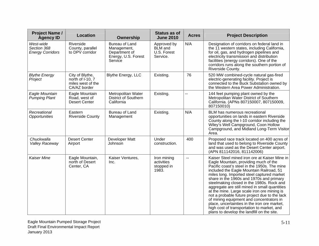
West-wide Section 368 Energy Corridors
Riverside County, parallel to DPV corridor
Bureau of Land Management, Department of Energy, U.S. Forest Service
Approved by BLM and U.S. Forest Service.
N/A Designation of corridors on federal land in the 11 western states, including California, for oil, gas, and hydrogen pipelines and electricity transmission and distribution facilities (energy corridors). One of the corridors runs along the southern portion of Riverside County.
Blythe Energy Project
City of Blythe, north of I-10, 7 miles west of the CA/AZ border
Blythe Energy, LLC Existing. 76 520 MW combined-cycle natural gas-fired electric-generating facility. Project is connected to the Buck Substation owned by the Western Area Power Administration.
Eagle Mountain Pumping Plant
Eagle Mountain Road, west of Desert Center
Metropolitan Water District of Southern California
Existing. -- 144 feet pumping plant owned by the Metropolitan Water District of Southern California. (APNs 807150007, 807150009, 807150010)
Recreational Opportunities
Eastern Riverside County
Bureau of Land Management
Existing. N/A BLM has numerous recreational opportunities on lands in eastern Riverside County along the I-10 corridor including the Wiley’s Well Campground, Coon Hollow Campground, and Midland Long-Term Visitor Area.
Chuckwalla Valley Raceway
Desert Center Airport
Developer Matt Johnson
Under construction.
400 Proposed race track located on 400 acres of land that used to belong to Riverside County and was used as the Desert Center airport. (APN 811142016, 811142006)
Kaiser Mine Eagle Mountain, north of Desert Center, CA
Kaiser Ventures, Inc.
Iron mining activities stopped in 1983.
-- Kaiser Steel mined iron ore at Kaiser Mine in Eagle Mountain, providing much of the Pacific coast’s steel in the 1950s. The mine included the Eagle Mountain Railroad, 51 miles long. Imported steel captured market share in the 1960s and 1970s and primary steelmaking closed in the 1980s. Rock and aggregate are still mined in small quantities at the mine. Large scale iron ore mining is not a probable future project due to the lack of mining equipment and concentrators in place, uncertainties in the iron ore market, high cost of transportation to market, and plans to develop the landfill on the site.

5-12
Eagle Mountain Pumped Storage Project Draft Final Environmental Impact Report January 2013
Table 5-3 Future Foreseeable Projects along the I-10 Corridor (Eastern Riverside County)
Project Name /
Agency ID
Location Ownership Status as of July
2010
Acres Proposed Project Description
Devers-Palo Verde 2 Transmission Line Project
From the Midpoint Substation to Devers Substation.
Southern California Edison
Project was approved by California Public Utilities Commission (CPUC) 11/2009.
N/A New 500 kV transmission line parallel to the existing Devers-Palo Verde Transmission Line from Midpoint Substation, approximately 10 miles southwest of Blythe, to the SCE Devers Substation near Palm Springs. The ROW for the 500 kV transmission line would be adjacent to the existing DPV ROW and would require an additional 130 feet of ROW on federal and state land and at least 130 feet of ROW on private land and Indian Reservation land.
Desert Southwest Transmission Line
118 miles primarily parallel to DPV.
Imperial Irrigation District
Final EIR prepared 2005. Approved by the BLM in 2006.
N/A New, approximately 118-mile 500 kV transmission line from a new substation/switching station near the Blythe Energy Project to the existing Devers Substation located approximately 10 miles north of Palm Springs, California.
Green Energy Express Transmission Line Project
70-mile transmission line from the Eagle Mountain Substation to southern CA.
Green Energy Express LLC
September 9, 2009, Green Energy Express LLC filed a Petition for Declaratory Order requesting that FERC approve certain rate incentives for the project.
N/A 70-mile double-circuit 500 kV transmission line and new 500/230 kV substation from near the Eagle Mountain Substation (eastern Riverside County) to Southern California
Blythe Energy Project II
Blythe, CA. Near the Blythe Airport and I-10.
Blythe Energy, LLC.
Approved December 2005.
30 520 MW combined-cycle power plant located entirely within the Blythe Energy Project site boundary. Blythe Energy Project II will interconnect with the Buck Substation constructed by Western Area Power Administration (WAPA) as part of the Blythe Energy Project. Project is designed on 30 acres of a 76-acre site.

5-13
Eagle Mountain Pumped Storage Project Draft Final Environmental Impact Report January 2013
Project Name /
Agency ID
Location Ownership Status as of July
2010
Acres Proposed Project Description
Palen Solar Power Project
North of I-10, 10 miles east of Desert Center
Solar Millennium, LLC and Chevron Energy
Undergoing environmental review. Construction expected to begin in late 2010 with one unit online in 2012 and one unit online in 2013.
5,200 500 MW solar trough project on 5,200 acres. Facility would consist of two 250 MW plants.
Blythe Solar Power Project
North of I-10, immediately north of the Blythe Airport
Solar Millennium, LLC and Chevron Energy
Undergoing environmental review.
9,400 1,000 MW solar trough facility on 9,400 acres.
NextEra (FPL) McCoy
Northwest of Blythe, CA, immediately north of Blythe Solar Power Project
NextEra (FPL)
Plan of Development submitted to the Palm Springs BLM.
20,608 250 MW solar trough project. ROW in process for monitoring water well drilling.
McCoy Soleil Project
10 miles northwest of Blythe
enXco Plan of Development submitted to the Palm Springs BLM.
1,959 300 MW solar power tower project located on 1,959 acres. Project would require a 14 mile transmission line to proposed SCE Colorado Substation south of I-10.
Genesis Solar Energy Project
North of I-10, 25 miles west of Blythe and 27 miles east of Desert Center
NextEra (FPL) Undergoing environmental review. Construction to begin late 2010.
4,640 250 MW solar trough project located on 4,640 acres north of the Ford Dry Lake. Project includes six mile natural gas pipeline and a 5.5 mile gen-tie line to the Blythe Energy Center to Julian Hinds Transmission Line, east on shared transmission poles to the Colorado River Substation.

5-14
Eagle Mountain Pumped Storage Project Draft Final Environmental Impact Report January 2013
Project Name /
Agency ID
Location Ownership Status as of July
2010
Acres Proposed Project Description
Big Maria Vista Solar Project
North of I-10,approx. 12 miles NW of Blythe
Bullfrog Green Energy
Plan of Development submitted to BLM.
2,684 500 MW solar photovoltaic project on 2,684 acres.Project would be built in three phases and would require 6,000 gallons of water monthly.
Chuckwalla Solar
1 mile north of Desert Center
Chuckwalla Solar I, LLC
Plan of Development submitted to BLM.
4,083 200 MW solar photovoltaic project on 4,083 acres. Project would be developed in several phases and would tap into an existing SCE 161-kV transmission line crossing the site.
Rice Solar Energy Project
Rice Valley, Eastern Riverside County
Rice Solar Energy, LLC (SolarReserve LLC)
Undergoing environmental review. Construction to begin in 2011.
1,410 150 MW solar power tower project with liquid salt storage. Project is located on approximately 1,410 acres and includes a power tower approximately 650 feet tall and a 10-mile long interconnection with the WAPA Parker-Blythe transmission line.
Blythe Airport Solar I Project
Blythe Airport U.S. Solar Application has been submitted to City of Blythe. Approved in November, 2009.
640 100 MW solar photovoltaic project located on 640 acres at the Blythe airport.
Blythe PV Project
Blythe First Solar CPUC approved power purchase agreement for 7.5 MW. Under construction in fourth quarter 2009.
200 7.5 MW solar photovoltaic project located on 200 acres. Project was constructed by First Solar and sold to NRG Energy.
Desert Quartzite
South of I-10, 8 miles southwest of Blythe
First Solar Plan of Development (POD) in to BLM.
7,724 600 MW solar photovoltaic project located on 7,724 acres. Adjacent to DPV transmission line and SCE Colorado Substation.
5-15
Eagle Mountain Pumped Storage Project Draft Final Environmental Impact Report January 2013
Project Name /
Agency ID
Location Ownership Status as of July
2010
Acres Proposed Project Description
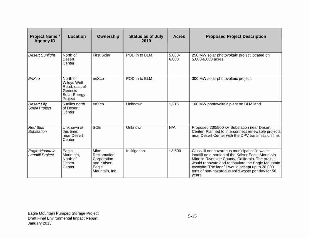
Desert Sunlight North of Desert Center
First Solar POD in to BLM. 5,000-6,000
250 MW solar photovoltaic project located on 5,000-6,000 acres.
EnXco North of Wileys Well Road, east of Genesis Solar Energy Project
enXco POD in to BLM. 300 MW solar photovoltaic project.
Desert Lily Soleil Project
6 miles north of Desert Center
enXco Unknown. 1,216 100 MW photovoltaic plant on BLM land.
Red Bluff Substation
Unknown at this time; near Desert Center
SCE Unknown. N/A Proposed 230/500 kV Substation near Desert Center. Planned to interconnect renewable projects near Desert Center with the DPV transmission line.
Eagle Mountain Landfill Project
Eagle Mountain, North of Desert Center
MineReclamation Corporation and Kaiser Eagle Mountain, Inc.
In litigation. ~3,500 Class III nonhazardous municipal solid waste landfill on a portion of the Kaiser Eagle Mountain Mine in Riverside County, California. The project would renovate and repopulate the Eagle Mountain townsite. The landfill would accept up to 20,000 tons of non-hazardous solid waste per day for 50 years.

5-16
Eagle Mountain Pumped Storage Project Draft Final Environmental Impact Report January 2013
Project Name /
Agency ID
Location Ownership Status as of July
2010
Acres Proposed Project Description
Wileys Well Communication Tower (part of the Public Safety Enterprise Communication System)
East of Wileys Well Road, just south of I-10
Riverside County
Final EIR for the Public Safety Enterprise Communication System published in August 2008.
N/A The Public Safety Enterprise Communication project is the expansion of the County of Riverside’s fire and law enforcement agencies approximately 20 communication sites to provide voice and data transmission capabilities to assigned personnel in the field.
Mule Mountain Solar Project
South of I-10, approx. 4 miles west of Blythe
Bullfrog Green Energy
Plan of Developmentin to Palm Springs BLM.
2,684 500 MW solar concentrating photovoltaic project located on 2,684 acres.
BLM Renewable Energy Study Areas
Along the I-10 corridor between Desert Center and Blythe
BLM Proposed. -- The DOE and BLM identified 24 tracts of land as Solar Energy Study Areas in the BLM and DOE Solar Programmatic EIS. These areas have been identified for in-depth evaluation for solar development and may be found appropriate for designation as solar energy zones in the future.
Proposed National Monument (former Catellus Lands)
Between Joshua Tree National Park and Mojave National Preserve
Federal In December 2009, Senator Feinstein introduced bill S.2921 that would designate two new national monuments including the Mojave Trails National Monument.
941,000 The proposed Mojave Trails National Monument would protect approximately 941,000 acres of federal land, including approximately 266,000 acres of the former railroad lands along historic Route 66. The BLM would be given the authority to conserve the monument lands and also to maintain existing recreational uses, including hunting, vehicular travel on open roads and trails, camping, horseback riding and rockhounding.

5-17
Eagle Mountain Pumped Storage Project Draft Final Environmental Impact Report January 2013
Project Name /
Agency ID
Location Ownership Status as of July
2010
Acres Proposed Project Description
Kaiser Mine Eagle Mountain, north of Desert Center, CA
Kaiser Ventures, Inc.
Iron mining activities stopped in 1983, but rock and aggregate mining is continuing.
-- Kaiser Steel mined iron ore at Kaiser Mine in Eagle Mountain until 1983. The mine included the Eagle Mountain Railroad, 51 miles long, now out of service. Rock and aggregate are still mined in small quantities at the mine. Large scale iron ore mining is not a probable future project due to the lack of mining equipment and concentrators in place, uncertainties in the iron ore market, high cost of transportation to market, and plans to develop the landfill on the site.
5-18
Eagle Mountain Pumped Storage Project Draft Final Environmental Impact Report January 2013
5.5 Cumulative Impacts
5.5.1 Geology and Soils
The proposed Project would expose people or structures to potential substantial adverse effects, including the risk of loss, injury, or death involving: rupture of an earthquake fault, strong seismic ground shaking, seismic-related ground failure, liquefaction or landslides. On-site faults have been evaluated and found to be inactive and the risk of surface rupture, liquefaction-induced settlement and other seismic effects at the site caused by faulting is very low (GeoSyntec, 1993, 1996) and less than significant. Other projects in the area would experience similar risk. No cumulative impacts associated with geological resources have been identified related to the solar projects proposed for development in the Chuckwalla Valley. Therefore, any cumulative impact would be less than significant and the proposed Project’s incremental contribution less than significant. Similarly, the proposed Project is not located on a geologic unit or soil that is unstable, or that would become unstable as a result of the Project and potentially result in on- or off-site landslide, lateral spreading, subsidence, liquefaction or collapse. The Project is not located on expansive soils. Because the risk of these effects is low in the region, any cumulative impact would be less than significant and the Project’s incremental contribution less than significant. The proposed Project would not affect soils incapable of adequately supporting the use of septic tanks or alternative wastewater disposal systems where sewers are unavailable for the disposal of wastewater. The waste disposal system will be permitted, engineered, and constructed and will not rely upon natural soils. Therefore, the proposed Project would have no impact and would not contribute to a cumulative impact. The proposed Project’s impact on soil erosion and loss of topsoil would be less than significant. Other cumulative projects in areas where soil is vulnerable to erosion could result in loss of topsoil and a potential cumulative impact. However, the impact of soil erosion is minimized by all projects to the extent possible by limiting surface disturbance to only those areas necessary for construction. Stormwater and dust control best management practices (BMPs) will be employed to minimize erosion, sedimentation and fugitive dust. Where natural topsoil occurs, it would be salvaged and stockpiled prior to construction, stabilized, and used during site restoration. State and federal laws require soil stabilization BMPs during construction as part of stormwater regulations, which require preparation and implementation of a Storm Water Pollution Prevention Plan. Erosion control measures are outlined in MM GEO-1, which will reduce the Project’s contribution to any cumulative soil erosion impacts to a less than cumulatively considerable. No cumulative impacts associated with the geological resource area have been identified.

5-19
Eagle Mountain Pumped Storage Project Draft Final Environmental Impact Report January 2013
5.5.2 Surface Water
This section evaluates potential cumulative impacts on surface water; whereas, it does not evaluate cumulative effects to which the Project would have no contribution including substantial alteration of drainage patterns of a stream or river resulting in erosion or flooding, runoff contributions that would exceed the capacity of a storm drain system, placement of housing or other structures in a flood zone, redirection of flood flows, or inundation by catastrophic events (seiche, tsunami, or mudflow). Eagle Crest Energy Company (ECE; Applicant; Owner; Licensee) and engineering team will collaborate with the Eagle Mountain Landfill project personnel on final design to ensure that there is no interference with the landfill’s water collection systems. The proposed Project may experience water quality issues within the reservoirs, such as elevated salt and metals. This issue would be addressed through water treatment processes. However, this is a Project-specific issue not incremental as part of a cumulative impact. None of the proposed solar projects in the vicinity of the proposed Project are anticipated to have an impact on surface water bodies. Therefore, there will be no significant cumulative impacts to surface waters. 5.5.3 Groundwater
The proposed Project would use groundwater to fill the Project reservoirs and for evaporation makeup water. As described in Section 3.3 Groundwater, this would have a less than significant impact on groundwater hydrology (drawdown elevation) after implementation of the mitigation program. Other cumulative projects in the planning and permitting stages are also within the Chuckwalla Groundwater Basin include the proposed Eagle Mountain Landfill (held in litigation), solar generating facilities, and the existing Metropolitan Water District of Southern California (MWD) groundwater banking program in the Orocopia Valley. The proposed landfill would be located at the mine site and would likely use water from wells in the Upper Chuckwalla Valley needing an average of 830 acre-feet per year (AFY). Solar generating facilities would have relatively low water demands for wash water, dust control, and (for thermal plants only) steam cycle make-up water. These projects are located at various locations in Upper Chuckwalla Valley, Desert Center, and east of Desert Center. Their combined water demand is estimated to average about 4,000 AFY and may range up to 6,000 AFY during construction. The solar facilities were assumed to begin operation between 2012 and 2019. Over 70 percent of the solar water use will be east of Desert Center, in the lower Chuckwalla Valley. MWD stores water in the Orocopia Valley Groundwater Basin and plans to extract the water in the near future. Because the net effect on the groundwater is zero this evaluation of cumulative impacts does not include potential effects of MWD’s conjunctive management.

5-20
Eagle Mountain Pumped Storage Project Draft Final Environmental Impact Report January 2013
Together, these and other projects could contribute to cumulative effects from the Project, agricultural users, the prisons, and local residences. Drawdown from existing projects, the proposed Project, and other sources of pumping was combined to assess the cumulative effects. As discussed above in Section 5.1 Unavoidable Adverse Impacts, Project pumping will exceed recharge for approximately four years of the 50-year Project life. During the remaining years, recharge will exceed pumping. By 2065, at the end of the 50-year FERC Project license period, the aquifer storage (cumulative change) is projected to increase by about 74,000 acre-feet. This will not result in depletion of groundwater supplies, and this potential impact is less than significant. Information and calculations used to support conclusions regarding cumulative impacts are found in Section 12.4. However, in combination with pumping for all reasonably foreseeable projects, basin overdraft of about 9 feet is likely to occur over the life of the Project, in which case, this Project would contribute to a significant adverse cumulative effect. Table 5-4 Chuckwalla Groundwater Basin Water Balance Cumulative Effects on Groundwater Years 2008 through 2100 demonstrates the results of the groundwater balance and potential effects of groundwater pumping on groundwater storage over the life of the Project with the landfill and solar projects. Using 2008 as the start of the budget, recharge will exceed pumping until the start of the Project in 2014 at which time pumping will exceed recharge by about 6,500 to 10,700 AFY for four years. Throughout much of Project life the combination of pumping, including the cumulative solar projects and the proposed landfill will exceed recharge by about 2,600 to 3,200 AFY. By 2046 the aquifer storage (cumulative change) will have been reduced by about 95,300 acre-feet, equal to one percent of the total groundwater in storage in the Chuckwalla Groundwater Basin for the conservative estimate of 9,100,000 acre-feet, and 0.6 percent for the more recent California Department of Water Resources (DWR) estimated volume of 15,000,000 acre-feet. As a comparison, the cumulative change in groundwater storage during agricultural pumping between 1981 and 1986 was over 36,000 acre-feet as shown in Table 3-11. Near the end of the Project life, in 2047, recharge is greater than the pumping. The basin will recover to pre-project levels by about 2094. The cumulative effect of local groundwater pumping in the Upper Chuckwalla Valley Groundwater Basin varies by location. Over the 50 year life of the Project, the resulting cumulative drawdown will exceed the maximum historic drawdown by 7 feet beneath the Colorado River Aqueduct (CRA) near the Project site, 6 feet in the Orocopia Valley Groundwater Basin, and 1 foot at the mouth of the Pinto Valley Groundwater Basin. The maximum historic drawdown would not be exceeded in the Desert Center area (Appendix C, Section 12.4, Figures 21 through 24, green line).

5-21
Eagle Mountain Pumped Storage Project Draft Final Environmental Impact Report January 2013
Although the combination of existing water use, the proposed Project, and other proposed pumping will result in temporary overdraft, groundwater levels for the most part will remain within the range of past drawdown that has occurred in the past when little to no change in water quality occurred. For that reason, projected cumulative pumping will not adversely affect the water quality in the groundwater basin.

Eagle MoDraft FinaJanuary 2
untain Pumpeal Environmen2013
T
ed Storage Prntal Impact Re
Table 5-4. ChCumulativ
roject eport
huckwalla Grve Effects on
roundwater BGroundwate
Basin Waterer Years 200
r Balance 8-2100
5-22

Eagle MoDraft FinaJanuary 2
untain Pumpeal Environmen2013
ed Storage Prntal Impact Re
roject eport 5-23
5-24
Eagle Mountain Pumped Storage Project Draft Final Environmental Impact Report January 2013
5.5.4 Agriculture
This section addresses potential cumulative impacts on agriculture. The proposed Project would have very short-term, temporary impacts on agricultural lands that would be less than significant. The proposed water pipeline will cross undeveloped desert and some previously farmed lands. Installation of the water pipeline would require excavation and side-casting of soil. However, surface soil conditions would be restored and farming could resume. Further, the construction contractor would use BMPs to conserve top soil and minimize erosion. Cumulative projects may have similar minor impacts from utility installation. Larger solar power projects may result in loss of farmland, resulting in a significant cumulative impact. However, the impact of the proposed Project would be short-term (only during construction) and the incremental addition of the proposed Project with the cumulative projects will not be cumulatively considerable. Therefore, the Project’s contribution to cumulative impacts on agricultural lands would be less than cumulatively considerable. 5.5.5 Biological Resources / Threatened & Endangered Species
This section addresses potential cumulative impacts on biological resources. It does not, however, analyze cumulative impacts on state or federal wetlands, including riparian habitat, because the proposed Project would have no impacts on these resources. Therefore, the proposed Project would not contribute to a cumulative impact.
Effects of the Project on common and special plants, habitats, and wildlife have been analyzed and considered to be less than significant with implementation the mitigation program. The mitigation program has been designed to reduce, avoid, and/or offset potential biological impacts, where feasible. Thus, the incremental effects of the Project to other cumulative actions will be negligible to minor and fully mitigated. No synergistic effects between the Project and other cumulative actions are foreseeable. There are no foreseeable long-term impacts of the Project’s mitigation program.
The proposed Project would have a direct effect on 83 acres of native desert tortoise habitat and could have a direct effect on desert tortoise individuals. The amount of desert tortoise habitat that will ultimately be affected by cumulative projects, including the proposed solar power developments is currently unknown, but much of the solar project acreage is desert tortoise habitat of variable quality. The acreage of native habitat affected by the proposed Project is less than 0.3 percent of the acreage of the solar projects. However, because the affected habitat supports desert tortoise and construction could have direct effects on this species, the Project’s contribution to this cumulative impact would be cumulatively considerable prior to implementation of the mitigation program. Specifically, the mitigation measures and project design features include implementation of pre-construction special species and habitat surveys, preconstruction surveys and clearance surveys, construction monitoring, biological reporting program and monthly reports during construction, annual comprehensive reports, and special-

5-25
Eagle Mountain Pumped Storage Project Draft Final Environmental Impact Report January 2013
incident reports, exclusion fencing, translocation or removal plans, hiring of an approved Project Biologist, worker environmental awareness program, and habitat compensation (MM TE-1 through MM TE-4, MM TE-6, MM BIO-1 through MM BIO-4, MM BIO 18, and MM BIO-22). Adherence to the mitigation program would result in a less than significant impact; and therefore is not cumulatively considerable.
The evaporation ponds could also attract ravens, which are a threat to desert tortoise as predators of juvenile tortoises. The Draft EIS/EIR for the proposed Eagle Mountain Landfill (County of Riverside and BLM, 1996) identified several common species that inhabit the disturbed Kaiser Eagle Mountain Mine and surrounding mine shafts as a result of that disturbance, including common raven. With regard to synergistic effects, landfills are well known to attract ravens and other birds. Human activities, including dumping of garbage, landfills, roads, increased nesting opportunities, irrigation, and increased vehicle use have led to increased numbers of common ravens in California deserts. The proposed Project, when considered together with the landfill, could result in a cumulative predation impact on desert tortoise. However, neither food nor water are limiting factors for raven populations in the area under existing conditions. Water sources present in the project area include a water treatment pond, the open water portions of the CRA, and Metropolitan Water District’s Eagle Mountain Pumping Plant (which is part of the CRA system). In addition, humans have occupied the Eagle Mountain townsite for many years. Perching, roosting and nesting sites for ravens are plentiful under the existing condition of the project area. Increased water alone would likely not increase predator populations. Nevertheless, both the proposed Project and the landfill will have mitigation and monitoring requirements for ravens, reducing this cumulative impact to less than significant.
The brine ponds could be an attractant for birds and possibly bats who would be exposed to evaporation pond water containing high concentrations of salt and metals. However, the brine pond will have netting to prevent birds from having access. The landfill will not have evaporation ponds. The three thermal solar facilities to the east in Chuckwalla Valley may have evaporation ponds if wet-cooling techniques are employed, but the CEC [the permitting agency for thermal solar power plants in California] and state law strongly discourages use of water for cooling, and it is highly likely that all thermal solar plants will be dry-cooled. Therefore the proposed Eagle Mountain Pumped Storage Project will have the only evaporation pond in this portion of the Eagle Mountains and would not contribute to a cumulative impact.
No cumulative impacts to biological resources are anticipated with Project implementation.
5.5.6 Aesthetics
The Project transmission line would have significant adverse effects on aesthetics and visual resources resulting from the portion of the transmission line from Eagle Mountain Road to the Interconnection Substation. This impact is significant and unavoidable with Project implementation. It is important to note that this significant adverse effect is not related to a cumulative impact on night lighting, but rather is a result of a visual change in the character of

5-26
Eagle Mountain Pumped Storage Project Draft Final Environmental Impact Report January 2013
the natural landscape based on the proposed/planned solar facilities. Proposed solar projects are intended to cover approximately 10,000 acres within the Chuckwalla Valley and have interconnection transmission lines along the I-10 corridor and interconnection at the Red Bluff substation. Cumulative projects include the proposed DPV2 Transmission Line Project, with two 500 kilovolt (kV) transmission lines parallel to the existing DPV1. These projects considered together would result in a significant cumulative impact. Because the proposed Project will add to the region’s increase in developed facilities and progressive change in visual character of the natural landscape, its contribution to this cumulative impact would be cumulatively considerable.
5.5.7 Cultural Resources
This section evaluates potential cumulative cultural resources impacts. It does not evaluate cumulative impacts on historical resources defined in CEQA Guideline §15064.5. The remains of Camp Desert Center and the evacuation hospital are located at the southern end of Eagle Mountain Road. The proposed transmission line route comes no closer than 0.25 miles north of the closest recorded World War II Desert Training Center/Arizona-California Maneuver Area (DTC/C-AMA) site and the Interconnection Collector Substation is located 2 miles to the north and east, respectively, of the known DTC/C-AMA features. Results of a Class III survey of the transmission line and water line indicate that no historic properties exist where these alignments diverge from existing access roads. The transmission and water pipelines cross over buried portions of the CRA, which is very likely eligible for the National Register of Historic Places (NRHP) based on its historical and engineering significance. Impacts to materials, feeling, setting, and association are therefore expected to be potentially significant. In addition, the transmission line crosses over the Eagle Mountain Industrial Railroad in two places. A formal significance determination of the rail line remains to be undertaken by the BLM but there have been substantial previous impacts to its integrity and it is unlikely to be found NRHP-eligible. The Eagle Mountain townsite and mine are now over 50 years old and will need to be evaluated as potential historic resources. Other cumulative projects may have similar impacts on historic resources, resulting in a cumulative impact. However, implementation of mitigation measures (MM CR-1, MM CR-3, MM CR-5, MM CR-6, and MM CR-11) would reduce the Project’s contribution to less than cumulatively considerable.
All cumulative projects would require mitigation measures to protect cultural and paleontological resources including monitoring, services of a qualified archaeologist and paleontologist, and procedures for addressing human remains. The proposed Project would implement mitigation measures (MM CR-3, MM CR-4, MM CR-5, MM CR-6, MM CR-7, MM CR-8, MM CR-9, MM CR-10, and MM CR-11), reducing the proposed Project’s contribution to this cumulative impact to less than cumulatively considerable.
5.5.8 Land Use / Public Services
The proposed Project is one of several projects planned for the Chuckwalla Basin, which cumulatively, will increase the conversion of rural, undeveloped and/or disturbed lands to a

5-27
Eagle Mountain Pumped Storage Project Draft Final Environmental Impact Report January 2013
developed land use character. The Project’s overall contribution to cumulative land use effects is incremental due to development within a previously developed and disturbed location, and the fact that only the transmission line will be visible once the Project is operational. The following assessment considers the proposed Eagle Mountain Landfill project, various proposed solar projects, and relevant probable future projects as determined by the BLM.
The proposed Project will be constructed on an existing mining site and would not divide an existing community; as such, the proposed reservoirs would not contribute to a cumulative impact. The proposed transmission line and substation would not divide a community as they would be constructed through unpopulated areas, and to the extent possible, to take advantage of existing corridors, whereby minimizing impacts on land use. Similarly, the proposed water pipeline will cross undeveloped desert and previously farmed lands. The pipeline will cross State Route 177; however, the pipelines will be tunneled underneath the road. Therefore, neither the transmission line nor the water pipeline would divide a community and would not contribute to a cumulative impact.
As discussed in Section 3.9 Land Use, the proposed Project would not conflict with any applicable land use plan, policy, or regulation of an agency with jurisdiction over the Project. The proposed transmission line route will not affect the Desert Center Airport Influence Area. It would also cross BLM lands managed for “Limited” and “Moderate” MUC designations as part of the Northern and Eastern Colorado Desert Coordinated Management (NECO) Plan, including crossing approximately 6 miles of NECO’s Desert Wildlife Management Area. Most of the transmission line is within two designated BLM utility corridors identified in the NECO plan.
BLM-administered lands surrounding the Upper Reservoir will largely be unaffected and serve as a buffer element. An access road to the Upper Reservoir that currently crosses public lands will be utilized by the proposed Project for construction and operation. Minor improvements to the access road will not conflict with BLM’s “Limited” MUC designation for the area.
The proposed Project would not conflict with any applicable habitat conservation plan or natural community conservation plan. No habitat conservation plan or natural community conservation plan has been developed for the Project area. The cumulative effects analysis is based on the conservative (and unlikely) assumption that all of the proposed renewable energy projects that are proposed will be constructed. The incremental effect of the proposed Project, combined with the effects of the other projects within the geographic scope of the cumulative analysis would not contribute to a cumulative land use impact.
The proposed Project would not result in substantial adverse physical impacts associated with the provision of new or physically altered governmental facilities, or need for new or physically altered governmental facilities, the construction of which could cause significant environmental impacts, in order to maintain acceptable service ratios, response times or other performance objectives for any of the following public services. The proposed Project would be served by

5-28
Eagle Mountain Pumped Storage Project Draft Final Environmental Impact Report January 2013
existing fire and police projection as well as existing schools, parks, and other public facilities. Therefore, the proposed Project would not contribute to a cumulative impact to public resources.
5.5.9 Recreation
The Project would not displace recreation such that increased use of existing recreational facilities would result in substantial or accelerated deterioration. No developed recreation sites occur within the Project boundary or in the immediate vicinity. The entire Kaiser Eagle Mountain Iron Mine site is currently (and will continue to be) fenced and inaccessible to the general public. The highly disturbed property is unsuitable for public recreation. The future condition of the site with highly variable water levels is not conducive for recreation. Furthermore, there are no facilities in the area that could be affected by displaced recreation. There are no regional parks or open spaces operated by the Riverside County Regional Park and Open Space District in the Chuckwalla Valley. There are no California State public parks within the Chuckwalla Valley. Therefore, the few recreational users of the Project area would be dispersed over a very large area. The Project’s proposed transmission line and to a lesser extent the buried water pipeline will add to the basin’s developed landscape, but will have no significant effects on available open space and dispersed recreational opportunities. Further, no recreational facilities are proposed. Therefore, the Project would not contribute to a cumulative impact from construction or expansion of recreational facilities in the region.
Development and operation of the proposed Project in addition to other potential projects, including the proposed landfill and cumulative solar projects, may have an effect on the wilderness experiences of visitors to the remote eastern margins of the Joshua Tree National Park (JTNP). This would be most noticeable as park visitors approach the Wilderness boundary. Similar activities have occurred in the past as the Kaiser Mine was in operation from the 1950s, before the designation of JTNP’s Wilderness Areas. Once operational, the only visible elements of the Project will be portions of the reservoirs (from a very remote and high elevation zone within the JTNP) and a portion of the transmission line that will be difficult to detect at a distance of several miles. Very few users reach these areas. In similar situations, Congress has indicated “the fact that non-wilderness activities or uses can be seen or heard from areas within a wilderness area shall not, of itself, preclude such activities or uses up to the boundary of the wilderness area” (CDPA, 1994). Therefore, this cumulative impact would be less than significant and the incremental impact of the proposed Project would be less than cumulatively considerable.
5.5.10 Population and Housing
The proposed Project would be expected to have a less than significant effect on population and housing. The Project would not induce substantial population growth nor contribution to any short-term cumulative impacts related to population and housing. Workers for construction and operation would come from Riverside County and the southern California region. The Project may import some non-local workers; however, these workers would be temporary and would not

5-29
Eagle Mountain Pumped Storage Project Draft Final Environmental Impact Report January 2013
add substantially to the population. Foreseeable development in the Project area includes primarily renewable energy electrical generation and transmission infrastructure projects.
In the event an influx of construction workers occurred within the area as a result of construction of large renewable energy projects, many of these workers would likely choose to stay at motels in Blythe or the nearby desert cities (Indio to Palm Springs) because of the temporary nature of Project construction activities. It is assumed these construction workers would not permanently relocate to the area. Due to the availability of temporary and permanent housing to both the regional and local labor force associated with both the proposed Project and the reasonably foreseeable projects, the proposed Project would not contribute to cumulative increases in demand for local housing.
The proposed Project would not displace any people or necessitate construction of replacement housing elsewhere. Therefore, there would be no impact from displacement and no contribution to a cumulative impact.
5.5.11 Transportation
Traffic generated by the Project’s construction and operation will add to that generated by the cumulative projects listed above. Traffic generated during construction will increase congestion on area roads. There are two proposed solar projects in the Chuckwalla Valley: (1) the First Solar “Desert Sunlight Solar Farm” project, and (2) the enXco “Eagle Mountain” project. Details regarding traffic generation from these projects were not available at the time of this writing; however, because both projects are adjacent to Kaiser Road, both will likely use Kaiser Road for access during construction and operation. The Desert Sunlight Solar Farm is proposed on BLM land 6 miles north of Desert Center. The enXco Eagle Mountain Project is proposed just south of the Desert Sunlight Solar Farm.
However, the proposed Project’s construction period is not expected to overlap with the construction period for the proposed landfill or the proposed solar energy projects thus eliminating cumulative effects of traffic during construction. Implementation of the Project will not cause area roads to exceed, either individually or cumulatively, a level of service standard established by the Riverside County Congestion Management Agency. Further, a Transportation Management Plan (MM AQ-6) will be implemented to control construction traffic onto the site and within the Project vicinity.
Operation of the pumped storage hydroelectric facility will require a labor force of about 30 employees. This translates to approximately 60 daily one-way trips. Operation of the facility would also generate minor truck traffic during activities such as delivery and off-site waste shipments. Project operation is anticipated to generate up to four truck trips per day, which would not affect the level of service on area roadways and intersections. The addition of operational traffic to the cumulative project would not be expected to significantly affect local roadways, and no cumulative effect would result.

5-30
Eagle Mountain Pumped Storage Project Draft Final Environmental Impact Report January 2013
5.5.12 Air Quality
The cumulative analysis considers whether the Project, in combination with other related and reasonably foreseeable local and regional developments, would create a significant cumulative effect. Other developments identified include several solar projects and the proposed Eagle Mountain Landfill. However, construction of these projects are removed in time (would not occur simultaneously) with the proposed Project.
CEQA guidance indicates that cumulative impacts are to be assessed in a two-step process: (1), to determine if a significant adverse overall or cumulative impact would occur, and (2), to determine if the Project’s contribution to that impact would be “cumulatively considerable.”
In general, the cumulative air quality analysis can consider applicable planning documents that guide development at, or in the vicinity of, the Project and within the region; under CEQA this is considered a plan-based approach. The cumulative contribution of the proposed Project to criteria pollutants is considered in the on-going planning by the South Coast Air Quality Management District to meet the state and federal regulatory ambient air quality standards into the future. This planning is based on inventories of emissions to be anticipated from development in accordance with each of the county general plans within the air basin.
As discussed previously, the proposed Project alone would result in a significant construction-related impact from NOx in construction years 1 through 3. If a project would individually have a significant air quality impact, the Project would also be considered to have a significant cumulative air quality impact. As such, the Project would also have a significant cumulative contribution to NOx impacts as a precursor to ozone formation in construction years 1 through 3.
Additionally, although daily carbon monoxide (CO), PM10 (particulate matter smaller than 10 micrometers in diameter), and PM2.5 (particulate matter smaller than 2.5 micrometers in diameter) construction emissions from the proposed Project are below the significance threshold, the CO, PM10, and PM2.5 emissions from the cumulative projects scenario have the potential to exceed the significance threshold. However, given the location and timing of the cumulative projects, the CO, PM10, and PM2.5 impacts are not likely to be cumulatively significant. Additionally, given the temporary nature of construction activities, and assuming implementation of the mitigation measures, the severity and frequency of these impacts would be limited. It is therefore concluded that the cumulative impact from construction would be less than significant for CO, PM10, and PM2.5.
5.5.13 Greenhouse Gas Emissions
The specific emissions from this proposed Project would not be expected to individually have an impact on global climate change, but they are also analyzed for the potential for a significant contribution to the cumulative impact of greenhouse gas (GHG) emissions.

5-31
Eagle Mountain Pumped Storage Project Draft Final Environmental Impact Report January 2013
As noted in Section 3.15 Greenhouse Gas Emissions, the proposed Project would displace energy production demand of peaker plants (fossil-fuel power plants), and would reduce existing GHG emissions and assist with meeting California’s future energy demands with a larger portfolio of renewable power generation sources. Because the proposed Project would not contribute to GHG emissions, its contribution to the cumulative impact of GHGs would be less than cumulatively considerable. Moreover, the proposed Project would have a beneficial effect on cumulative GHG emissions.
5.5.14 Noise
The cumulative analysis considers whether the Project, in combination with other cumulative development, would create a significant cumulative effect. The other cumulative developments include several solar projects and the proposed Eagle Mountain Landfill. However, the construction of the cumulative projects are removed in time (would not occur simultaneously) from the proposed Project.
CEQA guidance indicates that cumulative impacts are to be assessed in a two-step process: (1) determine if a significant adverse overall or cumulative impact would occur, and (2) determine if the Project’s contribution to that impact would be “cumulatively considerable.”
The following section evaluate cumulative effects from noise levels that may exceed noise standards, permanent increase in ambient noise levels, significant increases in noise at sensitive receptors, and temporary or periodic increases in ambient noise above baseline levels. It does not evaluate ground-borne vibrations or ground borne noise levels, however, because of the distances from construction activity to sensitive receptors (1.5 to 4 miles). It also does not address cumulative issues from airport noise issues because the Project site is not within an airport land use plan or 2 miles or a public or public use airport.
The proposed Project would generate noise impacts during construction. Although receptors are screened from the mine pits where much of the construction would take place, truck traffic would generate noise. Tunnel construction would occur beneath rock and 1.5 to 4 miles from any sensitive receptor, resulting in no contribution to cumulative impacts. The proposed powerhouse would be located underground and would not affect noise levels aboveground. During construction, truck traffic and transmission construction would create a temporary adverse increase in noise along Eagle Mountain and Kaiser roads. Construction would move continuously, reducing temporal aspect.
The potential noise impacts of the proposed Project are from the construction phase as the noise from project operations would be minimal. During construction there would be an adverse temporary increase in noise along Kaiser Road. The majority of the proposed solar projects in the area would not use Kaiser Road; and as such, would not add to this adverse temporary noise impact from traffic on Kaiser Road. One solar project that would add to the traffic on Kaiser Road would be the First Solar Inc. project; however project construction would not overlap in

5-32
Eagle Mountain Pumped Storage Project Draft Final Environmental Impact Report January 2013
timing (the solar project would be expected to break ground in 2010; whereas the proposed Project is expected is expected to commence within 2 years of licensing, anticipated to be in 2013). Noise from Project operations would be minimal and would not contribute to any cumulative noise impact.
5.5.15 Hazards and Hazardous Materials
This section evaluates potential cumulative impacts on hazards and hazardous materials. The Project would not emit hazardous emissions or handle hazardous or acutely hazardous materials within one-quarter mile of an existing or proposed school. No acutely toxic hazardous materials will be used on-site during construction. The closest school is located more than 1 mile away from the reservoirs and powerhouse. The site is not on a list of hazardous materials sites compiled pursuant to Government Code Section 65962.5. Further, the site has little to no risk of wildfire and no nearby urbanized areas. The Project would have no contribution to any cumulative impact in these areas.
The Project’s hazards from the routine transport, use or disposal of hazardous materials would be less than significant. The proposed Project and cumulative projects would use, store and transport hazardous materials (i.e., petroleum products, lubricants, solvents) subject to regulatory controls designed to minimize the potential for spills and other releases into the environment through improper storage and/or handling. Any impact of spills or other releases of these materials will be limited to the site because of the small quantities involved, infrequent use of those materials (and therefore reduced chances of release), and/or temporary containment berms. In addition, the construction contractor will implement mitigation measures MM HM-1. Therefore, any Project contribution to a cumulative impact would be less than cumulatively considerable.
5.5.16 Environmental Justice
The Project will not result in a disproportionate effect on minority populations, low income populations or Native Americans, and the Project does not pose any substantial effects relative to environmental justice.
5.6 Energy Conservation [CEQA Guidelines Appendix F]
CEQA Guidelines §15126.4(a)(1)(C) states: “Energy conservation measures, as well as other appropriate mitigation measures, shall be discussed when relevant.” The CEQA Guidelines Appendix F recognizes the goal of conserving energy and implies the wise and efficient use of energy. The means of achieving this goal include:
Decreasing overall per capita energy consumption
Decreasing reliance on natural gas and oil
Increasing reliance on renewable energy sources

5-33
Eagle Mountain Pumped Storage Project Draft Final Environmental Impact Report January 2013
As designed, the proposed Project will reliably integrate solar and wind generation and offset natural gas-fired power with the overall benefit of reduced GHG emissions and direct contribution to long-term climate change effects. The Project provides an economical supply of peaking capacity, as well as load following, electrical system regulation through spinning reserve, and immediately available standby generating capacity. These latter benefits, referred to as ancillary services, are considered essential for integration of renewable wind and solar power resources to meet state RPS of 33 percent by year 2020, and to offset fossil-fueled peak power generation to help meet state GHG emissions reduction goals.
The proposed Project has been designed to play a vital role in the integration of renewable energy resources already mandated to be developed by the state of California; as such, the Project is intended to meet existing and future energy demands.