4.4 HYDROLOGY AND WATER QUALITY 4.4.1 … Banning Ranc… · Draft Environmental Impact Report 4.4...
82
Section 4.4 Hydrology and Water Quality R:\Projects\Newport\J015\!Draft EIR\4.4 Hydro-090211.doc 4.4-1 Newport Banning Ranch Draft Environmental Impact Report 4.4 HYDROLOGY AND WATER QUALITY 4.4.1 INTRODUCTION This section identifies, discusses, and analyzes the effects of the proposed Project on local and regional hydrology, flooding, and water quality. The purpose of this section is to provide (1) a discussion of existing hydrology, flooding, and water quality conditions on the Project site and (2) an analysis of how the proposed Project would affect those existing conditions. This analysis considers the effects of the proposed Project on hydrology, water quality, storm water runoff, and potential on- and off-site erosion and sedimentation. Cumulative impacts are addressed in Section 5.0 of this EIR. This analysis was based on the proposed land use plan for the Project (FORMA 2010). Primary sources for this analysis are Fuscoe Engineering’s Watershed Assessment Report, Newport Banning Ranch (2010), the Santa Ana Regional Water Quality Control Board’s Basin Plan (Santa Ana RWQCB 1995), GMU’s Report of Geotechnical Studies, the City of Newport Beach’s General Plan and General Plan EIR (Newport Beach 2006a, 2006b) and the Newport Banning Ranch Green and Sustainable Program (Newport Banning Ranch LLC 2010). These reports were also the source documents for presenting site design concepts and for identifying and selecting Best Management Practices. The Watershed Assessment Report, Newport Banning Ranch (Fuscoe 2010b) is provided in Appendix C to this EIR. Groundwater quality impact assessments and characterization were derived from the Technical Memorandum from Geosyntec to the Applicant dated September 18, 2009, and the Memorandum to the City of Newport Beach from Fuscoe Engineering dated September 16, 2009, which are also included in Appendix C. 4.4.2 REGULATORY SETTING Federal Clean Water Act In 1972, the Federal Water Pollution Control Act (Clean Water Act) was amended to require National Pollutant Discharge Elimination System (NPDES) permits for the discharge of pollutants to “Waters of the U.S.” 1 from any point source. 2 In 1987, the Clean Water Act was further amended to require that the U.S. Environmental Protection Agency (USEPA) establish regulations for permitting municipal and industrial storm water discharges under the NPDES permit program. Final regulations regarding storm water discharges were issued on November 16, 1990, and require that municipal separate storm sewer system (MS4) discharges and industrial (including construction) storm water discharges to surface waters be regulated by an NPDES permit. NPDES permit requirements relevant to the proposed Project are discussed later in this section. The Clean Water Act also requires states to adopt water quality standards for receiving water bodies and to have those standards approved by the USEPA. Water quality standards consist of designated beneficial uses for a particular receiving water body (e.g., wildlife habitat, agricultural supply, fishing), along with the water quality criteria necessary to support those uses. Water quality criteria are prescribed concentrations or levels of constituents (such as lead, suspended 1 “Waters of the U.S.” include all waters that have, are, or may be used in interstate or foreign commerce (including sightseeing or hunting), including all waters subject to the ebb and flow of the tide and all interstate waters including interstate wetlands (33 CFR 328.3). 2 Point sources are discrete water conveyances such as pipes or man-made ditches.
Transcript of 4.4 HYDROLOGY AND WATER QUALITY 4.4.1 … Banning Ranc… · Draft Environmental Impact Report 4.4...
Section 4.4 Hydrology and Water Quality
R:\Projects\Newport\J015\!Draft EIR\4.4 Hydro-090211.doc 4.4-1 Newport Banning Ranch Draft Environmental Impact Report
4.4 HYDROLOGY AND WATER QUALITY
4.4.1 INTRODUCTION
This section identifies, discusses, and analyzes the effects of the proposed Project on local and regional hydrology, flooding, and water quality. The purpose of this section is to provide (1) a discussion of existing hydrology, flooding, and water quality conditions on the Project site and (2) an analysis of how the proposed Project would affect those existing conditions. This analysis considers the effects of the proposed Project on hydrology, water quality, storm water runoff, and potential on- and off-site erosion and sedimentation. Cumulative impacts are addressed in Section 5.0 of this EIR.
This analysis was based on the proposed land use plan for the Project (FORMA 2010). Primary sources for this analysis are Fuscoe Engineering’s Watershed Assessment Report, Newport Banning Ranch (2010), the Santa Ana Regional Water Quality Control Board’s Basin Plan (Santa Ana RWQCB 1995), GMU’s Report of Geotechnical Studies, the City of Newport Beach’s General Plan and General Plan EIR (Newport Beach 2006a, 2006b) and the Newport Banning Ranch Green and Sustainable Program (Newport Banning Ranch LLC 2010). These reports were also the source documents for presenting site design concepts and for identifying and selecting Best Management Practices. The Watershed Assessment Report, Newport Banning Ranch (Fuscoe 2010b) is provided in Appendix C to this EIR. Groundwater quality impact assessments and characterization were derived from the Technical Memorandum from Geosyntec to the Applicant dated September 18, 2009, and the Memorandum to the City of Newport Beach from Fuscoe Engineering dated September 16, 2009, which are also included in Appendix C.
4.4.2 REGULATORY SETTING
Federal
Clean Water Act
In 1972, the Federal Water Pollution Control Act (Clean Water Act) was amended to require National Pollutant Discharge Elimination System (NPDES) permits for the discharge of pollutants to “Waters of the U.S.”1 from any point source.2 In 1987, the Clean Water Act was further amended to require that the U.S. Environmental Protection Agency (USEPA) establish regulations for permitting municipal and industrial storm water discharges under the NPDES permit program. Final regulations regarding storm water discharges were issued on November 16, 1990, and require that municipal separate storm sewer system (MS4) discharges and industrial (including construction) storm water discharges to surface waters be regulated by an NPDES permit. NPDES permit requirements relevant to the proposed Project are discussed later in this section.
The Clean Water Act also requires states to adopt water quality standards for receiving water bodies and to have those standards approved by the USEPA. Water quality standards consist of designated beneficial uses for a particular receiving water body (e.g., wildlife habitat, agricultural supply, fishing), along with the water quality criteria necessary to support those uses. Water quality criteria are prescribed concentrations or levels of constituents (such as lead, suspended
1 “Waters of the U.S.” include all waters that have, are, or may be used in interstate or foreign commerce
(including sightseeing or hunting), including all waters subject to the ebb and flow of the tide and all interstate waters including interstate wetlands (33 CFR 328.3).
2 Point sources are discrete water conveyances such as pipes or man-made ditches.
Section 4.4 Hydrology and Water Quality
R:\Projects\Newport\J015\!Draft EIR\4.4 Hydro-090211.doc 4.4-2 Newport Banning Ranch Draft Environmental Impact Report
sediment, and fecal coliform bacteria) or narrative statements that represent the quality of water that support a particular use. Because the State of California was unable to develop these standards for priority toxic pollutants, the USEPA promulgated the California Toxics Rule in 1992 (40 Code of Federal Regulations [CFR] 131.38), which fills this gap. As a separate Rule, the California Toxics Rule is discussed further below under State regulations.
When water quality issues compromise the designated beneficial uses of a particular receiving water body, Section 303(d) of the Clean Water Act requires the identification and listing of that water body as “impaired”. Once a water body has been deemed impaired, a Total Maximum Daily Load (TMDL) must be developed for the impairing pollutant(s). A TMDL is an estimate of the total load of pollutants from point, non-point, and natural sources that a water body may receive without exceeding applicable water quality standards (plus a “margin of safety”). Once established, the TMDL allocates the loads among the water body’s current and future pollutant sources.
Section 404 of the Clean Water Act is a program administered by the U.S. Army Corps of Engineers (USACE) that regulates the discharge of dredged and fill material into “Waters of the U.S.”, including wetlands. Activities that affect “Waters of the U.S.” that are regulated under this program include fills for development (including physical alterations to drainages to accommodate storm drainage, stabilization, and flood-control improvements); water resource projects (such as dams and levees); infrastructure development (such as highways and airports); and conversion of wetlands to uplands for farming and forestry. The USEPA and the USACE have issued Section 404(b)(1) Guidelines (40 CFR 230) that regulate dredge and fill activities, including water quality aspects of such activities.
Section 401 of the Clean Water Act requires that any person applying for a federal permit or license that may result in a discharge of pollutants into “Waters of the U.S.” must obtain a State water quality certification ensuring that the activity complies with all applicable water quality standards, limitations, and restrictions. Section 404 permits and authorizations are subject to a Section 401 certification by the local Regional Water Quality Control Board (RWQCB).
Federal Antidegradation Policy
The federal Antidegradation Policy was released in 1968 and was included in the USEPA’s first Water Quality Standards Regulation. The Antidegradation Policy represents a three-tiered approach to maintaining and protecting water quality. First, all existing beneficial uses and levels of water quality necessary to protect those uses must be preserved and protected from degradation. Second, water quality must be protected in areas where the quality cannot support the propagation of fish, shellfish, and wildlife and recreation (“fishable/swimmable”). Third, the policy provides special protection of waters for which the ordinary water quality criteria are not sufficient. These waters are called “Outstanding National Resources Waters” and have been designated as unique or ecologically sensitive.
If an activity is going to be allowed to degrade or lower water quality (in situations where existing water quality is higher than that needed to maintain established beneficial uses), the Antidegradation Policy requires that proposed projects meet the criteria below:
• The activity is necessary to accommodate important economic or social development in the area.
• Water quality is adequate to protect and fully maintain existing beneficial uses.
Section 4.4 Hydrology and Water Quality
R:\Projects\Newport\J015\!Draft EIR\4.4 Hydro-090211.doc 4.4-3 Newport Banning Ranch Draft Environmental Impact Report
• The highest statutory and regulatory requirements and Best Management Practices (BMPs) for pollution control are achieved.
National Flood Insurance Act
The National Flood Insurance Act of 1968 established the National Flood Insurance Program, which is based on the minimal requirements for floodplain management and is designed to minimize flood damage within Special Flood Hazard Areas. The Federal Emergency Management Agency (FEMA) is the agency that administers the National Flood Insurance Program. Special Flood Hazard Areas (SFHA) are defined as areas that have a 1 percent chance of flooding within a given year, also referred to as the 100-year flood. Flood Insurance Rate Maps were developed to identify areas of flood hazards within a community.
State
California Porter-Cologne Act
California’s Porter-Cologne Water Quality Control Act of 1970 (Porter-Cologne Act) grants the State Water Resource Control Board (SWRCB) and the RWQCBs power to protect surface water and groundwater quality and is the primary vehicle for implementing California’s responsibilities under the federal Clean Water Act. The Porter-Cologne Act grants the SWRCB and the RWQCBs authority and responsibility to adopt plans and policies, to regulate discharges of waste to surface and groundwater, to regulate waste disposal sites, and to require cleanup of discharges of hazardous materials and other pollutants. The Porter-Cologne Act also establishes reporting requirements for unintended discharges of any hazardous substance, sewage, or oil or petroleum product.
Each RWQCB must formulate and adopt a Water Quality Control Plan (Basin Plan) for its region. The Basin Plan must conform to the policies set forth in the Porter-Cologne Act and established by the SWRCB in its State Water Policy. The Basin Plan establishes beneficial uses for surface and groundwater in the region, and sets forth narrative and numeric water quality standards to protect those beneficial uses. The Porter-Cologne Act also states that an RWQCB may include water discharge prohibitions applicable to particular conditions, areas, or types of waste within its regional plan.
California Toxics Rule
The California Toxics Rule (40 CFR 131.38) is a USEPA-issued federal regulation that provides water quality criteria for potentially toxic constituents in California surface waters with designated uses related to human health or aquatic life. The rule fills a gap in California water quality standards that was created in 1994 when a State court overturned the State’s water quality control plans containing water quality criteria for priority toxic pollutants. These federal criteria are legally applicable in the State of California for inland surface waters, enclosed bays, and estuaries for all purposes and programs under the Clean Water Act.
The California Toxics Rule establishes two types of aquatic life criteria: (1) acute criteria represent the highest concentration of a pollutant to which aquatic life can be exposed for a short period of time3 without harmful effects and (2) chronic criteria equal the highest concentration to which aquatic life can be exposed for an extended period of time (four days) without deleterious effects. Due to the intermittent nature of storm water runoff (especially in 3 The rule does not specify timeframe for “acute”. Standard practice would likely imply that any condition that is
permanent or semi-permanent is chronic—all else would be short-term.
Section 4.4 Hydrology and Water Quality
R:\Projects\Newport\J015\!Draft EIR\4.4 Hydro-090211.doc 4.4-4 Newport Banning Ranch Draft Environmental Impact Report
Southern California), the acute criteria are considered to be more applicable to storm water conditions than chronic criteria.
State Antidegradation Policy
Under the State’s Antidegradation Policy (as set forth in SWRCB Resolution No. 68-16), whenever the existing quality of waters is better than what is needed to protect present and future beneficial uses, such existing quality must be maintained. This State policy has been adopted as a water quality objective in all the State’s Basin Plans. The State policy establishes a two-step process to determine if discharges with the potential to degrade the water quality of surface or groundwater will be allowed.
The first step requires that, where a discharge would degrade high-quality water, the discharge may be allowed only if any change in water quality would:
• Be consistent with the maximum benefit to the people of the State;
• Not reasonably affect present and anticipated beneficial uses of such water;
• Result in water quality that is not less than that which is prescribed in State policies (i.e., Basin Plans).
The second step (as set forth in SWRCB Resolution No. 68-16) states that any activity resulting in discharge to high-quality waters is required to use the best practicable treatment or control of the discharge necessary in order to avoid the occurrence of pollution or nuisance and to maintain the “highest water quality consistent with the maximum benefit to the people of the state”. The State policy applies to both surface and groundwater, as well as to both existing and potential beneficial uses of the applicable waters.
Recycled Water Policy
On February 3, 2009, by Resolution No. 2009-0011, the SWRCB adopted a Recycled Water Policy. In this Recycled Water Policy, the SWRCB states “we declare our independence from relying on the vagaries of annual precipitation and move towards sustainable management of surface waters and groundwater, together with enhanced water conservation, water reuse and the use of storm water” (SWRCB 2009b). The following goals are included in the Policy:
• Increase use of recycled water over 2002 levels by at least one million acre-feet per year (afy) by 2020 and at least two million afy by 2030.
• Increase the use of storm water over use in 2007 by at least 500,000 afy by 2020 and at least one million afy by 2030.
• Increase the amount of water conserved in urban and industrial areas by comparison to 2007 by at least 20 percent by 2020.
• Substitute as much recycled water for potable water as possible by 2030.
The SWRCB also states in this Recycle Water Policy that they expect to develop additional policies to encourage the use of storm water, encourage water conservation, encourage the conjunctive use of surface and groundwater, and improve the use of local water supplies.
The Recycled Water Policy provides direction to the RWQCBs regarding appropriate criteria in issuing permits for recycled water projects that are intended to streamline permitting of the vast majority of recycled water projects, while also reserving sufficient authority and flexibility to
Section 4.4 Hydrology and Water Quality
R:\Projects\Newport\J015\!Draft EIR\4.4 Hydro-090211.doc 4.4-5 Newport Banning Ranch Draft Environmental Impact Report
address site-specific conditions. The Policy also addresses the benefits of recycled water and encourages other public agencies to presume there is a benefit from the use of recycled water in evaluating the impacts of recycled water projects on the environment as required by CEQA. The Policy addresses a mandate for use of recycled water and indicates that the SWRCB will exercise their authority to the fullest extent possible to encourage the use of recycled water, consistent with State and federal water quality laws.
The Recycled Water Policy indicates that some groundwater basins contain salts and nutrients that exceed or threaten to exceed water quality objectives established in Basin Plans and states that the Policy’s intent is to manage salts and nutrients on a basin-wide or watershed-wide basis through development of regional or sub-regional management plans. The Policy describes the components of these salt and nutrient management plans.
Finally, the Policy addresses the control of incidental runoff from landscape irrigation projects, recycled water groundwater recharge projects, antidegradation (i.e., not applying less restrictive standards to high quality water bodies such as Lake Tahoe), control of emerging constituents and chemicals of emerging concern, and incentives for use of recycled water.
National Pollutant Discharge Elimination Program (NPDES)
The NPDES permit program is administered in the State of California by the RWQCBs, and was first established under the authority of the Clean Water Act to control water pollution by regulating point sources that discharge pollutants into “Waters of the U.S.”. If discharges from industrial, municipal, and other facilities go directly to surface waters, those project applicants must obtain permits. An individual NPDES permit is specifically tailored to a facility. A general NPDES permit covers multiple facilities within a specific activity category such as construction activities. A general permit applies the same or similar conditions to all dischargers covered under the general permit.
There are nine RWQCBs in the State of California. These boards have the mandate to develop and enforce water quality objectives and implementation plans within their regions The Project site is located within the jurisdiction of the Santa Ana RWQCB.
General Construction Permit
The SWRCB has issued a statewide general NPDES Permit and Waste Discharge Requirements for storm water discharges from construction sites. Under this General Construction Permit, discharges of storm water from construction sites with a disturbed area of one or more acres are required to either obtain individual NPDES permits for storm water discharges or be covered by the General Construction Permit. Each applicant under the General Construction Permit must file a Notice of Intent (NOI) with the RWQCB and ensure that a Storm Water Pollution Prevention Plan (SWPPP) is prepared prior to grading. Terms of the SWPPP must be implemented during construction. The primary objective of the SWPPP is to identify BMPs to reduce or eliminate pollutants in storm water discharges and authorized non-storm water discharges from the site during construction.
In 1999, the SWRCB issued and subsequently amended the General Construction Storm Water Permit (Water Quality Order 99-08-DWQ), which governs discharges from construction sites that disturb one acre or more of surface area. Again, on September 2, 2009, the SWRCB adopted a new General Construction Permit that substantially alters the approach taken to regulate construction discharges through (1) requiring the determination of risk levels posed by a project’s construction discharges to water quality and (2) establishing numerical water quality
Section 4.4 Hydrology and Water Quality
R:\Projects\Newport\J015\!Draft EIR\4.4 Hydro-090211.doc 4.4-6 Newport Banning Ranch Draft Environmental Impact Report
thresholds that trigger permit violations. These new permit regulations took effect on July 1, 2010. Municipal Storm Water Permitting (MS4 Permit)
The State’s Municipal Storm Water Permitting Program regulates storm water discharges from MS4s. MS4 Permits were issued in two phases. Phase I was initiated in 1990, under which the RWQCBs adopted NPDES storm water permits for medium (serving between 100,000 and 250,000 people) and large (serving more than 250,000 people) municipalities. As part of Phase II, the SWRCB adopted a General Permit for small MS4s (serving less than 100,000 people) and non-traditional small MS4s including governmental facilities such as military bases, public campuses, and prison and hospital complexes (WQ Order No. 2003-0005-DWQ).
California Coastal Commission
The California Coastal Commission (Coastal Commission) is responsible for protecting water quality in coastal environments as defined under Sections 30230 and 30231 of the California Coastal Act. These water quality provisions provide a broad basis for protecting coastal waters, habitats and biodiversity associated with new development and redevelopment projects. To meet the objectives of Sections 30230 and 30231, the Coastal Commission supports a multi-pronged approach to water quality management, which includes implementing site-design, source-control, and treatment-control BMPs and low impact development (LID) features. New development and redevelopment projects that are within the Coastal Zone are required to apply for a Coastal Development Permit through the Coastal Commission prior to construction. As part of the Coastal Development Permit process, projects must demonstrate water quality protection with the implementation of site-design, source-control, and treatment-control BMPs. The Project’s consistency with applicable California Coastal Act policies is provided later in this section.
California Ocean Plan
The Water Quality Control Plan for Ocean Waters of California (Ocean Plan), amended through 2001, establishes beneficial uses and water quality objectives for waters of the Pacific Ocean along the California coast outside enclosed bays, estuaries, and coastal lagoons. The Ocean Plan establishes water quality objectives, discharge prohibitions, and management guidelines for safeguarding the Pacific Ocean’s water quality.
Regional
Basin Plan
As indicated above, the Project site is located within the Santa Ana RWQCB’s jurisdiction. The Water Quality Control Plan for the Santa Ana River Basin (Santa Ana River Basin Plan) designates beneficial uses and water quality objectives for water bodies in the region. Narrative water quality criteria contained in the Basin Plan cover a range of both organic and inorganic constituents for both surface and groundwater; the Santa Ana River Basin Plan prohibits the degradation of water quality in a manner that would adversely impact a water body’s designated beneficial uses. The Basin Plan incorporates applicable portions of a number of national and statewide water quality plans and policies, including the California Water Code and the Clean Water Act. For certain designated surface water bodies and groundwater management zones, specific numeric water quality objectives have been established for a range of constituents.
Section 4.4 Hydrology and Water Quality
R:\Projects\Newport\J015\!Draft EIR\4.4 Hydro-090211.doc 4.4-7 Newport Banning Ranch Draft Environmental Impact Report
These water quality criteria apply within receiving waters and do not apply directly to runoff. Within the Project area, there are no water bodies (or groundwater management zones) for which numeric objectives have been established.
General Waste Discharge Requirements for Discharges to Surface Waters Which Pose an Insignificant (de minimus) Threat to Water Quality (Dewatering Permit)
The Santa Ana RWQCB issued Order No. R8-2003-0061 and Amendments to NPDES Permit No. CAG998001 (Dewatering Permit) to regulate the discharge of dewatering wastes from construction, subterranean seepage, and other similar types of discharges considered to have “de minimus” impacts on water quality within the jurisdictions covered by the County permit. This permit was updated in March 2009 (by Order No. R8-2009-0003, NPDES NP. CAG998001) and applies to projects located within the City of Newport Beach (City). To obtain coverage under this permit, an applicant must submit an NOI and data establishing the chemical characteristics of the dewatering discharge. A standard monitoring and reporting program is included as part of the permit. For dewatering activities that are not covered by the General Permit, Waste Discharge Requirements, and an individual NPDES permit must be obtained from the applicable RWQCB.
Orange County Storm Water Program 2003 Drainage Area Management Plan (DAMP)
Section 402(p) of the Clean Water Act, as amended by the Water Quality Act of 1987, requires that municipal NPDES Permits include requirements (1) to essentially prohibit non-storm water discharges into municipal storm sewers and (2) to control the discharge of pollutants from municipal storm drains to the maximum extent practicable. In response to this requirement, the Orange County Drainage Area Management Plan (DAMP) was developed in 1993, which has been updated several times in response to requirements associated with NPDES permit renewals (County of Orange et al. 2003). The City is a permittee covered by the requirements of this permit.
The main objectives of the Orange County DAMP are to fulfill the Permittees’ commitment to present a plan that satisfies NPDES permit requirements and to evaluate the impacts of urban storm water discharges on receiving waters. Orange County DAMP elements include (1) the establishment of public outreach and educational programs, management strategies, and inter-agency coordination; (2) continuing participation in the Regional Research/Monitoring program that is being conducted with the neighboring counties, the Southern California Coastal Waters Research Project, and three Southern California Regional Boards; (3) the establishment of BMPs aimed at managing project-induced hydrologic effects; and (4) the improvement of water quality throughout the region (County of Orange et al. 2003).
Areas of Special Biological Significance
Areas of Special Biological Significance are areas designated by the SWRCB for the protection of sensitive marine species or biological communities from undesirable alterations in natural water quality. Pursuant to recent revisions to the California Public Resources Code (PRC), Areas of Special Biological Significance are now included within the areas classified as “State Water Quality Protection Areas” where marine species and biological communities are protected from “undesirable alteration[s] in natural water quality” (PRC §36700[f]). The two closest Areas of Special Biological Significance to the Project site include the Irvine Coast Marine Life Refuge Areas of Special Biological Significance, located offshore and about seven miles south, and the Newport Beach Marine Life Refuge, also offshore and about five miles to the south.

Section 4.4 Hydrology and Water Quality
R:\Projects\Newport\J015\!Draft EIR\4.4 Hydro-090211.doc 4.4-8 Newport Banning Ranch Draft Environmental Impact Report
City of Newport Beach
City of Newport Beach Council Policy Manual
The City of Newport Beach Council Policy Manual stipulates Policies L-18 and L-22 for the protection of water quality within the City, both of which are intended to minimize dry-weather runoff and runoff from small rain events to improve water quality-limited receiving waters, the near-shore ocean environment, and Newport Bay’s water quality (Newport Beach 2002). Policy L-18 is entitled “Protection of Water Quality: Drainage – Public Rights-of-Way”. Policy L-22 is entitled “Protection of Water Quality: Water Quality Management Plans for New Development and Redevelopment”.
Policy L-18 states that “Whenever possible, runoff should be retained on private property to prevent the transport of these pollutants… Reduction, detention or diversion of runoff can benefit property owners through water conservation and reuse of water that would otherwise drain to the City’s street drainage system and our harbors, bays, and ocean” (City of Newport Beach 2002a). Policy L-22 states:
New development or redevelopment presents the City and the public with the opportunity to reduce the impacts of runoff that would otherwise drain to the City’s street drainage system and our harbors, bays, and ocean. At the time of submittal of an application for a new development or redevelopment project, an applicant shall submit [a] Water Quality Management Plan (WQMP) to the City. The WQMP’s purpose is to minimize to the maximum extent practicable dry weather runoff and runoff from small storms (less than 3/4″ of rain falling over a 24-hour period) during construction and post-construction from the property” (Newport Beach 2002b).
City of Newport Beach Municipal Code
The City of Newport Beach Municipal Code contains policies relevant to water quality management, specifically to control storm water runoff from development sites. Section 14.36.040, Control of Urban Runoff, requires new development and redevelopment projects to comply with the DAMP as well as conditions and requirements established by the Community Development Department or Building Department to reduce or eliminate pollutants in storm water runoff from a project site.
Local Implementation Plan (LIP)
The City’s Local Implementation Plan (LIP) was prepared as part of a compliance program pursuant to the Third Term NPDES Permit. The LIP presents the actions, activities and programs undertaken by the City, as well as current activities and programs, to meet the requirements of the NPDES Permit and to improve urban water quality. Although the LIP is intended to serve as the basis for City compliance during the five-year period of the Third Term NPDES Permit, the LIP is subject to modifications and updates as the City determines necessary, or as directed by the Santa Ana RWQCB.
The LIP, in conjunction with the County DAMP, is the principal policy and guidance document for the City’s NPDES Storm Water Program. Sections A.7.0 and A.8.0 of the LIP address new development and significant redevelopment controls for incorporating BMPs into environmental compliance requirements. The LIP also addresses construction requirements for sedimentation and erosion control, as well as on-site hazardous materials and waste management.
Section 4.4 Hydrology and Water Quality
R:\Projects\Newport\J015\!Draft EIR\4.4 Hydro-090211.doc 4.4-9 Newport Banning Ranch Draft Environmental Impact Report
On May 22, 2009, the Santa Ana RWQCB re-issued the MS4 Permit for the Santa Ana Region of Orange County (Order R8-2009-0030). Re-issuance of the fourth term of this permit resulted in changes to the 2003 DAMP and City of Newport Beach LIP and storm water program. This updated Fourth Term permit includes new requirements pertaining to hydromodification4 and low impact development (LID) features associated with new developments and redevelopment projects. Within 12 months after the permit adoption, the County of Orange, as the Principal Permittee, must finalize a new Model WQMP that incorporates feasibility criteria for LID and hydromodification requirements. Following the Santa Ana RWQCB’s approval of the Model WQMP, the City will be required to update their LIP and storm water programs and incorporate the new Model WQMP into their discretionary approval processes for new development and redevelopment projects.
One component of the New Development/Significant Redevelopment Section of the City’s LIP is the provision to prepare a WQMP for specified categories of development aimed at reducing pollutants in post-development runoff. Specifically, a project-specific WQMP includes Santa Ana RWQCB-approved BMPs, where applicable, that address post-construction management of storm water runoff water quality. This includes operation and maintenance requirements for all structural or treatment-control BMPs required for specific categories of developments to reduce pollutants in post-development runoff to the Maximum Extent Practicable (MEP). The categories of development that require preparation of a project-specific WQMP include:
• All significant redevelopment projects, where redevelopment is defined as the addition of 5,000 square feet (sf) or more of impervious surface on an already developed site;
• New development projects that create 10,000 sf or more of impervious surface (collectively over the entire site) including commercial, industrial, residential housing subdivisions, mixed use, and public projects;
• Automotive repair shops;
• Restaurants where the land area of development (including parking areas) is 5,000 sf or more;
• Hillside developments on 5,000 sf or more, which are located on areas with known erosive soil conditions or where the natural slope is 25 percent or more;
• Developments of 2,500 sf or more located within, directly adjacent to (within 200 feet), or discharging directly into receiving waters within Environmentally Sensitive Areas such as areas designated in the Ocean Plan as Areas of Special Biological Significance or water bodies listed on the Clean Water Act Section 303(d) list of impaired water bodies;
• Parking lots with 5,000 sf or more of impervious surface, or with 15 parking spaces or more exposed to urban storm water runoff;
• Streets, roads, highways and freeways of 5,000 sf or more of paved surface, which shall also incorporate USEPA guidance contained within “Managing Wet Weather with Green Infrastructure: Green Streets” in a manner consistent with the MEP standard;
• Retail gasoline outlets of 5,000 sf or more with a projected average daily traffic of 100 vehicles or more per day.
As required by the City’s municipal ordinances on storm water quality management, a project’s WQMP must be submitted to the City for approval prior to the City issuing any building or grading permits. Since the proposed Project includes the development in multiple categories 4 Hydromodification is generally defined as the alteration of natural flow characteristics.
Section 4.4 Hydrology and Water Quality
R:\Projects\Newport\J015\!Draft EIR\4.4 Hydro-090211.doc 4.4-10 Newport Banning Ranch Draft Environmental Impact Report
listed above (e.g., residential and commercial uses, parking), the Project is subject to the requirements of the City’s WQMP. This includes meeting any new requirements of the updated MS4 Permit and associated revised LIP. These updated requirements may include LID features and erosion/sediment controls.
General Plan Natural Resources Element and Harbors and Bay Element
The Natural Resources Element and the Harbors and Bay Element of the City of Newport Beach General Plan includes goals and policies related to water quality and water resources that are applicable to the proposed Project. The Project’s consistency with applicable General Plan goals and policies is provided at the end of this EIR section.
4.4.3 METHODOLOGY
A hydrologic analysis was performed to assess the potential impacts on water and groundwater resources as a result of the proposed development. In general, the proposed change in land uses and flow patterns would increase impervious surfaces and runoff potential within the Project site which, in turn, affects the downstream hydrology in the watershed, which is described below in Existing Conditions.
Hydrologic modeling was performed by Fuscoe Engineering according to procedures specified in the Orange County Hydrology Manual (1986) and Addendum No. 1 of the Hydrology Manual (1996). Two types of design events (as defined by Orange County) were analyzed for the Project watershed: (1) high-confidence (HC) events and (2) expected-value (EV) events. As described in the Hydrology Manual, HC events are used for flood-control facility design and loading assessment, and EV events are used to mitigate for increased runoff due to development. The following hydrologic conditions with a range of storm return frequencies were analyzed for each of the subwatershed areas, discussed further below, within the Project watershed:
• Existing Condition: 10-year, 25-year, 100-year HC events;
• Existing Condition: 2-year and 100-year EV events;
• Proposed Condition: 10-year, 25-year, 100-year HC events; and
• Proposed Condition: 2-year and 100-year EV events.
These analyses were performed for all Project subwatershed drainage areas. Presentation and summarization of these results focuses on the changes in peak flow rate and runoff volume within the subwatersheds impacted by the proposed Project.
4.4.4 EXISTING CONDITIONS
Hydrologic Setting
Orange County encompasses an area of approximately 798 square miles, beginning on the coastal plain and rising to an elevation of over 5,000 feet above mean sea level (msl) in the Puente Hills and Santa Ana Mountains to the north and east (County of Orange et al. 2003). The climate of the Santa Ana Region is classified as Mediterranean, which is generally dry in the summer with mild, wet winters. The average annual rainfall in the region is about 15 inches and under 11 inches in Newport Beach; most of it occurring between November and March (Fuscoe 2010b).
Section 4.4 Hydrology and Water Quality
R:\Projects\Newport\J015\!Draft EIR\4.4 Hydro-090211.doc 4.4-11 Newport Banning Ranch Draft Environmental Impact Report
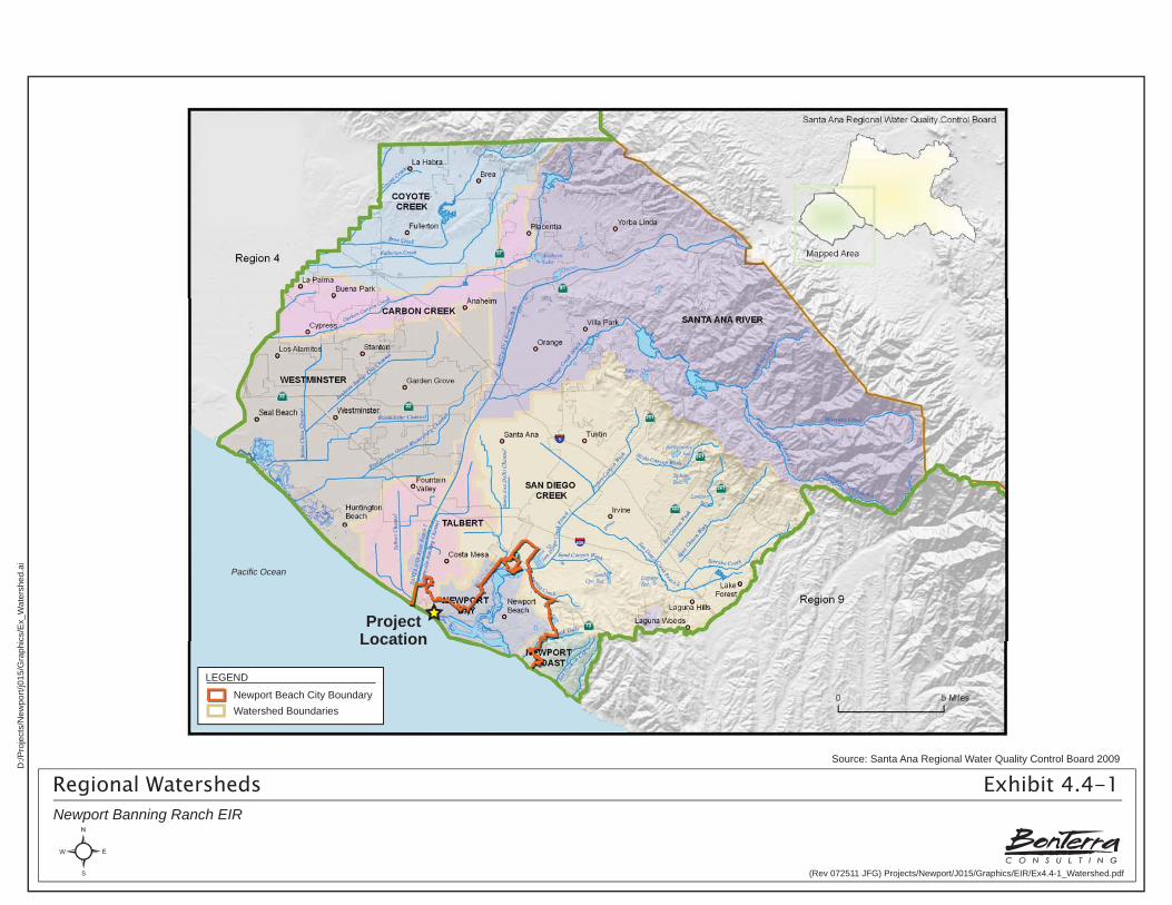
Newport Beach is located within four distinct watersheds, all of which are related to the hydrologic areas delineated by the Santa Ana RWQCB in the Basin Plan. As depicted on Exhibit 4.4-1, Regional Watersheds, the four regional watersheds are the Newport Bay, Newport Coast, Talbert, and San Diego Creek Watersheds. Although most of the City is located within the Newport Bay and Newport Coast Watersheds, the Project site is located within the Talbert Watershed, which covers approximately 21.4 square miles and drains into the Pacific Ocean on either side of the mouth of the Santa Ana River. Two main tributaries drain the Talbert Watershed: the Greenville–Banning Channel in the portion of the watershed to the east of the Santa Ana River mouth, and the Talbert and Huntington Beach Channels on the western side of the river mouth. As shown on the County of Orange’s Environmentally Sensitive Area Watershed Maps (County of Orange 2010, the Project site is located within Watershed D (Talbert-Greenville Banning Channel). The Project site is located within the Lower Santa Ana River Hydrologic Area and the East Coast Plain Hydrologic Sub-Area (HSA) 801.11 discharging to the Santa Ana River Tidal Prism and Newport Slough (Fuscoe 2010b).
Site Drainage Patterns and Characteristics
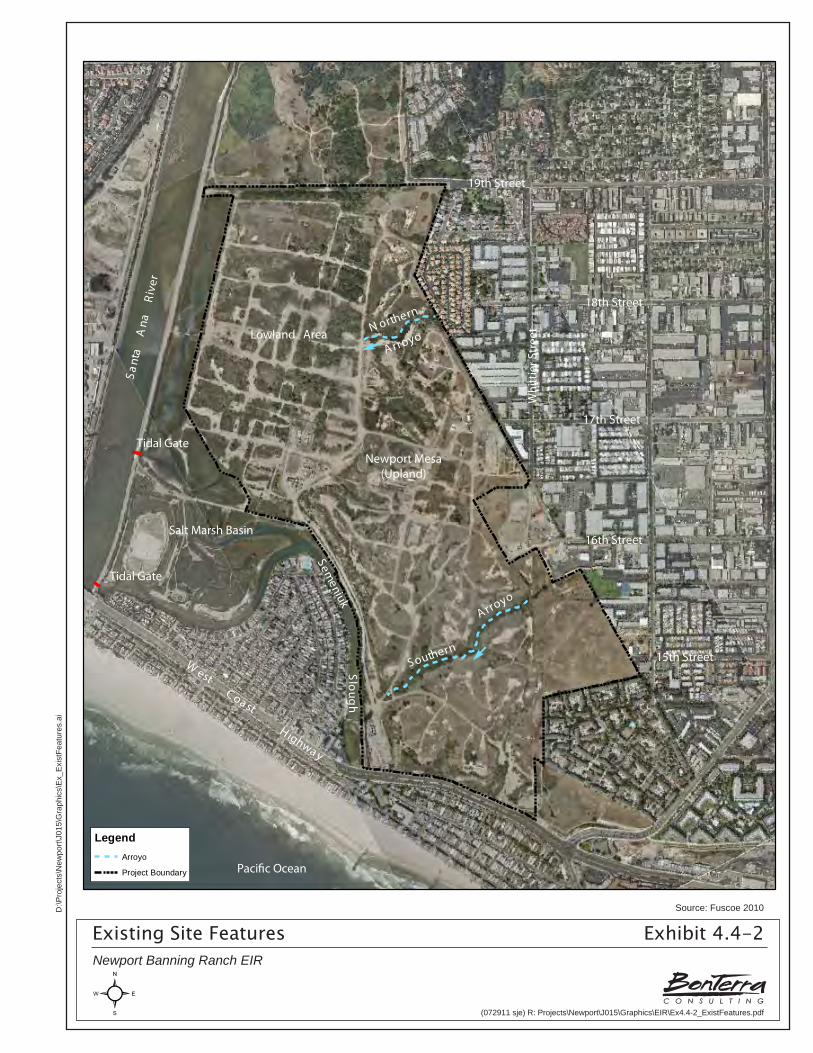
Drainage patterns on the Project site generally flow from the higher elevations in the east toward lower elevations to the west. Off-site drainage from the existing urban areas of the Cities of Costa Mesa and Newport Beach enter the Project site through storm drain culverts at the upstream ends of the larger Arroyos. As depicted on Exhibit 4.4-2, Existing Site Features, there are five geomorphic features on the Project site that apply to site hydrology, drainage patterns, and sediment transport (see Exhibit 3-4, Existing Topographic Site Conditions, Section 3.0, Project Description). These features are:
• Lowland: This area is located in the northern and northwestern portions of the Project site. The Lowland area contains several narrow channels and shallow depressions, and often ponds water under conditions where the Santa Ana River tidal gates are closed and/or during significant precipitation events. This area is fairly degraded and heavily impacted by infrastructure that supports oil operations. The USACE has restored salt marsh (USACE-restored salt marsh basin) habitat near the mouth of the Santa Ana River. This area is separated from the Lowland by a low berm; however, water exchange between the USACE-restored salt marsh basin and the Lowland does occur through two culverts.
• Newport Mesa (Upland): The Upland area is located in the eastern portion of the Project site. This area is actually a part of the larger (Upland) geological region that extends off the Project site. The portion of the Upland located on the Project site has also been heavily impacted by the construction and use of oil infrastructure including pipelines, roads, buildings, and other equipment.
• Bluffs: The bluffs are located adjacent to the Lowland area in the transition zone between the Lowland and the Upland. These bluffs form the western edge of the Upland and are characterized by west- and southwest-facing slopes of varying steepness. The bluffs have historically contributed sediment to the Semeniuk Slough through localized erosion of bluff faces and shallow slumping of colluvial material.
• Arroyos: There are three existing arroyos on the Project site that are formed by precipitation and local site runoff/drainage. One of these drainages, located at the Project site’s northeastern boundary, is fairly small and does not convey large quantities of flow. The two other arroyos, referred to as the “Northern Arroyo” located in the northern portion of the Project site and the “Southern Arroyo” the southernmost arroyo, both convey on- and off-site flows as well as significant volumes of sediment across the
Source: Santa Ana Regional Water Quality Control Board 2009
Regional Watersheds Exhibit 4.4-1Newport Banning Ranch EIR
(Rev 072511 JFG) Projects/Newport/J015/Graphics/EIR/Ex4.4-1_Watershed.pdf
D:/P
roje
cts/
New
port/
j015
/Gra
phic
s/E
x_W
ater
shed
.ai
ProjectLocation
Pacific Ocean
Watershed Boundaries
LEGEND
Newport Beach City Boundary
Sant
a A
naR
iver
Lowland Area
West
C oa st
H ighwa y
Paci�c Ocean
Semeniuk
Sloug
h
A rroyo
A rroyoN orthern
Southern
Salt Marsh Basin
15th Street
16th Street
17th Street
18th Street
19th Street
Whi
ttie
r Str
eet
Tidal Gate
Tidal Gate
Newport Mesa(Upland)
E
E
NEWPORT BANNING RANCHApril 9, 2010
NOT TO SCALE
P:\Project\821\01\Wat\GISWat\MXD\EIR Figures&Exhibits\pdf\82101gh-Fig2_SiteFeatures.pdf
LegendArroyo
Project Boundary
FIGURE 2: Existing Site Features
## ## ## ##!!UNITS!!
Existing Site Features Exhibit 4.4-2Newport Banning Ranch EIR
Source: Fuscoe 2010
(072911 sje) R: Projects\Newport\J015\Graphics\EIR\Ex4.4-2_ExistFeatures.pdf
D:\P
roje
cts\
New
port\
J015
\Gra
phic
s\E
x_E
xist
Feat
ures
.ai
Section 4.4 Hydrology and Water Quality
R:\Projects\Newport\J015\!Draft EIR\4.4 Hydro-090211.doc 4.4-12 Newport Banning Ranch Draft Environmental Impact Report
Project site from the eastern edge of the Project site to the Semeniuk Slough and Lowland in the west.
• Semeniuk Slough: also known as the Oxbow Loop Channel, the Semeniuk Slough consists of a meandering drainage course that flows along the southern and southwestern edge of the Project site. A reinforced concrete box (RCB) channel under West Coast Highway discharges off-site flows into Semeniuk Slough a short distance from the West Coast Highway roadway, and on-site flows enter the slough from the Southern Arroyo and bluff faces. The Semeniuk Slough drains to the west and north into the USACE-restored salt marsh basin.
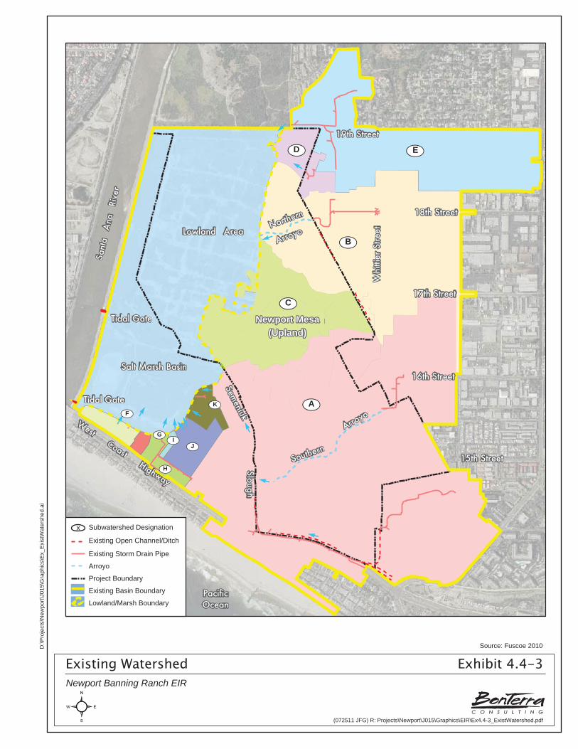
Existing Drainage Conditions and Infrastructure
Exhibit 4.4-3, Existing Watershed, depicts the Project site’s existing drainage patterns and associated infrastructure. There are no major storm drain facilities within the Project site boundary. A reinforced concrete box (RCB) storm drain under West Coast Highway discharges off-site runoff from hydrologically contiguous areas north and east of the Project site into the Semeniuk Slough located at the southern boundary of the Project site. This existing storm drain at West Coast Highway is owned and maintained by the California Department of Transportation (Caltrans). Flows within the Semeniuk Slough discharge into the USACE-restored salt marsh basin and are hydrologically connected to the Santa Ana River by means of a tidal gate in the Santa Ana River channel levees. Flows in the Lowland area ultimately drain into the Santa Ana River through a second tidal gate located in the river levee approximately a half-mile north of the first tidal gate. These tidal gates are designed to stay open to allow tidal flows to circulate through the Lowland; the Santa Ana River’s water surface elevation controls the gates and determines when these gates close. At times when the tidal gates are closed, flows within the Lowland area and the USACE-restored salt marsh basin cannot discharge and therefore, water ponds within both basins.
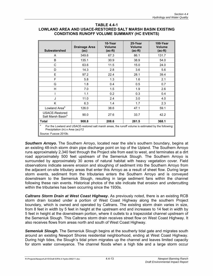
Lowland Area and USACE-restored Salt Marsh Basin. As noted on Table 4.4-1, the drainage area of the on-site Lowland area is composed primarily of Subwatersheds A through K (Exhibit 4.4-3), which encompass approximately 368 acres. The design elevations of the tidal gates in the Santa Ana River Levee indicate that they will begin to close when the water level inside the USACE-restored salt marsh basin reaches an elevation of 3.0 feet above msl, and will be completely closed when interior water elevations reach 3.5 feet above msl. As the maximum design water level elevation within the USACE-restored salt marsh basin is 6.0 feet above msl, the basin storage volume encompassed between elevations 3.5 and 6.0 feet above msl can be viewed as available storage capacity for local runoff once the tidal gates are closed. The USACE-restored salt marsh basin has a footprint of approximately 90 acres, and the adjacent Lowland area has a footprint of approximately 126 acres. The combined flood storage capacity of both basins is approximately 345 acre-feet.
Northern Arroyo. The Northern Arroyo is located near the northern portion of the Project site, receiving both on- and off-site runoff from a 42-inch storm drain pipe and a V-ditch along the Project site boundary. The Northern Arroyo starts at the discharge location of the 42-inch pipe, which is located within a retaining wall at the eastern Project site boundary, and runs approximately 930 feet to the east to its discharge point in the Lowland area. There are no existing engineering improvements to the Northern Arroyo. There is evidence of localized erosion associated with from site runoff and local culvert drainage.
Sant
a A
na
Rive
r
Lowland Area
West Coast Highway
PacificOcean
Semeniuk
Sloug hE
E
EEUpland Mesa
Arroyo
ArroyoNorthern
Southern
Salt Marsh Basin
EE
15th Street
16th Street
17th Street
18th Street
19th Street
Whi
ttier
Stre
etEE
Tidal Gate
Tidal Gate
¿ÀI¿ÀG
¿ÀF
¿ÀH
¿ÀK
¿ÀJ
EEEE
E
E
¿ÀD ¿ÀE
¿ÀB
¿ÀC
¿ÀA
Legend
Existing Open Channel/Ditch
Arroyo
Project Boundary
Lowland / Marsh Boundary
Existing Storm Drain Pipe
Existing Basin Boundary
Newport MesaNewport Mesa(Upland)(Upland)
Newport Mesa(Upland)
Existing Watershed Exhibit 4.4-3Newport Banning Ranch EIR
Source: Fuscoe 2010
(072511 JFG) R: Projects\Newport\J015\Graphics\EIR\Ex4.4-3_ExistWatershed.pdf
D:\P
roje
cts\
New
port\
J015
\Gra
phic
s\E
x_E
xist
Wat
ersh
ed.a
i
x Subwatershed Designation
Existing Open Channel/Ditch
Existing Storm Drain Pipe
Arroyo
Project Boundary
Existing Basin Boundary
Lowland/Marsh Boundary
Section 4.4 Hydrology and Water Quality
R:\Projects\Newport\J015\!Draft EIR\4.4 Hydro-090211.doc 4.4-13 Newport Banning Ranch Draft Environmental Impact Report
TABLE 4.4-1 LOWLAND AREA AND USACE-RESTORED SALT MARSH BASIN EXISTING
CONDITIONS RUNOFF VOLUME SUMMARY (HC EVENTS)
Subwatershed Drainage Area
(ac)
10-YearVolume (ac-ft)
25-YearVolume (ac-ft)
100-Year Volume (ac-ft)
A 349.6 67.3 86.1 131.7 B 135.1 30.9 38.9 54.0 C 63.6 11.5 15.0 24.0 D 14.3 2.8 3.6 5.6 E 97.2 22.4 28.1 39.4 F 5.8 1.3 1.6 2.1 G 1.8 0.4 0.5 0.7 H 7.0 1.5 1.9 2.6 I 1.1 0.2 0.3 0.4 J 11.0 2.4 3.0 4.0 K 6.3 1.4 1.7 2.3
Lowland Areaa 126.0 38.6 47.1 59.1 USACE-Restored Salt Marsh Basina 90.0 27.6 33.7 42.2
Total 908.8 208.6 261.5 368.1 a For the Lowland and USACE-restored salt marsh areas, the runoff volume is estimated by the following:
Precipitation (in) x Area (ac)/12 Source: Fuscoe 2010b.
Southern Arroyo. The Southern Arroyo, located near the site’s southern boundary, begins at an existing 48-inch storm drain pipe discharge point on top of the Upland. The Southern Arroyo runs approximately 2,340 feet through the Project site from east to west, and terminates at a dirt road approximately 500 feet upstream of the Semeniuk Slough. The Southern Arroyo is surrounded by approximately 30 acres of natural habitat with heavy vegetation cover. Field observations indicate severe erosion and sloughing of sediment into the Southern Arroyo from the adjacent on-site tributary areas that enter this Arroyo as a result of sheet flow. During large storm events, sediment from the tributaries enters the Southern Arroyo and is conveyed downstream to the Semeniuk Slough, resulting in large sediment fans within the channel following these rain events. Historical photos of the site indicate that erosion and undercutting within the tributaries has been occurring since the 1930s.
Caltrans Storm Drain at West Coast Highway. As previously noted, there is an existing RCB storm drain located under a portion of West Coast Highway along the southern Project boundary, which is owned and operated by Caltrans. The existing storm drain varies in size, from 8 feet in width by 5 feet in height at the upstream end and increases to 14 feet in width by 5 feet in height at the downstream portion, where it outlets to a trapezoidal channel upstream of the Semeniuk Slough. This Caltrans storm drain receives street flow on West Coast Highway. It also receives flows from areas north and south of West Coast Highway.
Semeniuk Slough. The Semeniuk Slough begins at the southerly tidal gate and migrates south around an existing Newport Shores residential neighborhood, ending at West Coast Highway. During high tides, the Slough’s tidal prism migrates up the channel and leaves limited capacity for storm water conveyance. The channel floods when a high tide and a large storm occur
Section 4.4 Hydrology and Water Quality
R:\Projects\Newport\J015\!Draft EIR\4.4 Hydro-090211.doc 4.4-14 Newport Banning Ranch Draft Environmental Impact Report
simultaneously. Storm flows passing through the Semeniuk Slough are primarily stored in the southerly portion of the USACE-restored salt marsh basin.
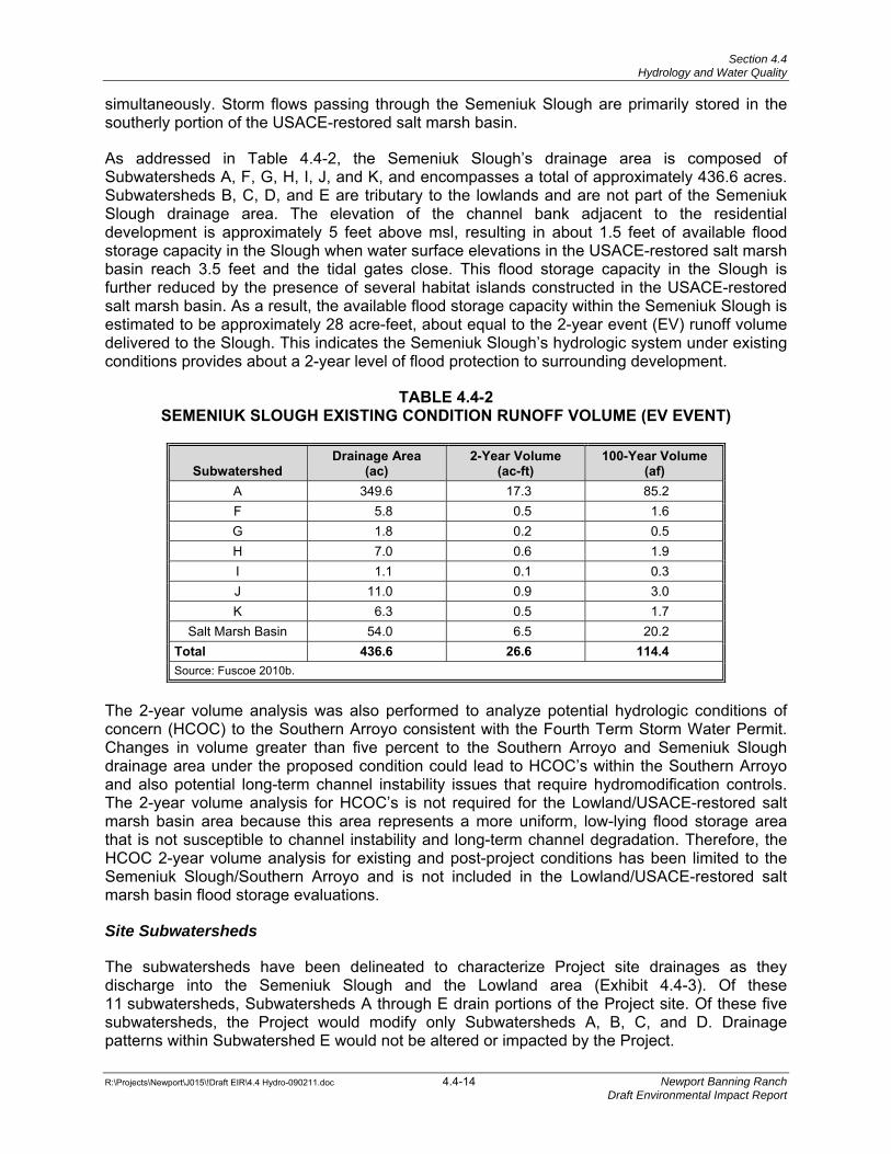
As addressed in Table 4.4-2, the Semeniuk Slough’s drainage area is composed of Subwatersheds A, F, G, H, I, J, and K, and encompasses a total of approximately 436.6 acres. Subwatersheds B, C, D, and E are tributary to the lowlands and are not part of the Semeniuk Slough drainage area. The elevation of the channel bank adjacent to the residential development is approximately 5 feet above msl, resulting in about 1.5 feet of available flood storage capacity in the Slough when water surface elevations in the USACE-restored salt marsh basin reach 3.5 feet and the tidal gates close. This flood storage capacity in the Slough is further reduced by the presence of several habitat islands constructed in the USACE-restored salt marsh basin. As a result, the available flood storage capacity within the Semeniuk Slough is estimated to be approximately 28 acre-feet, about equal to the 2-year event (EV) runoff volume delivered to the Slough. This indicates the Semeniuk Slough’s hydrologic system under existing conditions provides about a 2-year level of flood protection to surrounding development.
TABLE 4.4-2 SEMENIUK SLOUGH EXISTING CONDITION RUNOFF VOLUME (EV EVENT)
Subwatershed Drainage Area
(ac) 2-Year Volume
(ac-ft) 100-Year Volume
(af) A 349.6 17.3 85.2 F 5.8 0.5 1.6 G 1.8 0.2 0.5 H 7.0 0.6 1.9 I 1.1 0.1 0.3 J 11.0 0.9 3.0 K 6.3 0.5 1.7
Salt Marsh Basin 54.0 6.5 20.2 Total 436.6 26.6 114.4 Source: Fuscoe 2010b.
The 2-year volume analysis was also performed to analyze potential hydrologic conditions of concern (HCOC) to the Southern Arroyo consistent with the Fourth Term Storm Water Permit. Changes in volume greater than five percent to the Southern Arroyo and Semeniuk Slough drainage area under the proposed condition could lead to HCOC’s within the Southern Arroyo and also potential long-term channel instability issues that require hydromodification controls. The 2-year volume analysis for HCOC’s is not required for the Lowland/USACE-restored salt marsh basin area because this area represents a more uniform, low-lying flood storage area that is not susceptible to channel instability and long-term channel degradation. Therefore, the HCOC 2-year volume analysis for existing and post-project conditions has been limited to the Semeniuk Slough/Southern Arroyo and is not included in the Lowland/USACE-restored salt marsh basin flood storage evaluations.
Site Subwatersheds
The subwatersheds have been delineated to characterize Project site drainages as they discharge into the Semeniuk Slough and the Lowland area (Exhibit 4.4-3). Of these 11 subwatersheds, Subwatersheds A through E drain portions of the Project site. Of these five subwatersheds, the Project would modify only Subwatersheds A, B, C, and D. Drainage patterns within Subwatershed E would not be altered or impacted by the Project.
Section 4.4 Hydrology and Water Quality
R:\Projects\Newport\J015\!Draft EIR\4.4 Hydro-090211.doc 4.4-15 Newport Banning Ranch Draft Environmental Impact Report
These subwatershed designations confirm the Project site’s overall east-to-west drainage pattern and provide additional detail relative to topographic variation in flow. The Northern Arroyo, located within Subwatershed B, receives flows from surrounding neighborhoods to the east as well as localized site runoff, and discharges into the Lowland area. The Southern Arroyo, located within Subwatershed A, discharges into Semeniuk Slough and receives runoff from the Project site and off-site runoff from areas east of the Project site.
Soils
Three soil units are present on the Project site, interspersed with colluvial material in areas near the bluffs and arroyos. The site is underlain by the San Pedro Formation, which is the oldest geologic unit at the Project site and which constitutes a “bedrock” layer comprised of siltstone and clayey-siltstone mixed with lenses of fine-to-coarse sandstone. In the Upland area, San Pedro Formation materials are overlain by marine terrace deposits. Recent alluvial materials consisting of sediments deposited by earlier Santa Ana River flows and tributary drainages comprise the Lowland and USACE-restored salt marsh basin. Pockets of artificial fill are also found throughout the site and are generally associated with oil support facilities.
Flood Hazards
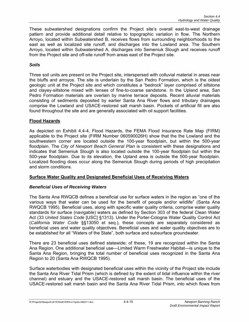
As depicted on Exhibit 4.4-4, Flood Hazards, the FEMA Flood Insurance Rate Map (FIRM) applicable to the Project site (FIRM Number 060590026H) show that the the Lowland and the southwestern corner are located outside the 100-year floodplain, but within the 500-year floodplain. The City of Newport Beach General Plan is consistent with these designations and indicates that Semeniuk Slough is also located outside the 100-year floodplain but within the 500-year floodplain. Due to its elevation, the Upland area is outside the 500-year floodplain. Localized flooding does occur along the Semeniuk Slough during periods of high precipitation and storm conditions.
Surface Water Quality and Designated Beneficial Uses of Receiving Waters
Beneficial Uses of Receiving Waters
The Santa Ana RWQCB defines a beneficial use for surface waters in the region as “one of the various ways that water can be used for the benefit of people and/or wildlife” (Santa Ana RWQCB 1995). Beneficial uses, along with specific water quality criteria, comprise water quality standards for surface (navigable) waters as defined by Section 303 of the federal Clean Water Act (33 United States Code [USC] §1313). Under the Porter-Cologne Water Quality Control Act (California Water Code §§13050 et seq.), these concepts are separately considered as beneficial uses and water quality objectives. Beneficial uses and water quality objectives are to be established for all “Waters of the State”, both surface and subsurface groundwater.
There are 23 beneficial uses defined statewide; of these, 19 are recognized within the Santa Ana Region. One additional beneficial use—Limited Warm Freshwater Habitat—is unique to the Santa Ana Region, bringing the total number of beneficial uses recognized in the Santa Ana Region to 20 (Santa Ana RWQCB 1995).
Surface waterbodies with designated beneficial uses within the vicinity of the Project site include the Santa Ana River Tidal Prism (which is defined by the extent of tidal influence within the river channel) and estuary and the USACE-restored salt marsh basin. The beneficial uses of the USACE-restored salt marsh basin and the Santa Ana River Tidal Prism, into which flows from
C RY STA L C OV E\STAT E P A R K
P A C I F I CO C E A N
U P P E RN EW P O RT
BAY
B A L B O A I S L A N DC
HANNEL
HARBOR
ENTRANCE
N EW P O RT
C HA N N E L
W E ST
NEWPORT
BLVD
S UP ERI OR
AVENUE
ANA
AVE NUE
I RVI NE
AVENUE
CAMPUS
DR IV E
COR ONADE L
MARF R E EW
AY
F O R D
R O A D
MACARTHUR
BL VD
S AN
J OAQUI N
R O A D
S AN
J OA QU I N
H I L L S
T R A N S P ORT
A
T I ON
CO
RRI DOR
N EW P O RT
COAST
DRIVE
C O A ST
HI GHWAY
J AMBORE E
ROAD
I RV I N E
C O STA M E S A
SANTA
H I L L S
?k
%&l(
N:/
GIS
Proj
ects
/New
port
Bea
ch_1
0579
/Flo
odH
azar
ds.m
xd
Figure S3FLOOD HAZARDS
CITY of NEWPORT BEACHGENERAL PLAN
PROJECT NUMBER: 10579-01Source: City of Newport Beach, 2006
7N
Date: 03/17/06
Legend
Special Flood Hazard AreasInundated by 100-year flood
Areas of 500-year flood; areas of100-year flood with averagedepths of less than 1 foot or withdrainage areas less than 1 squaremile; and areas protected bylevees from 100-year floodZone VE, Coastal flood zone withvelocity hazard (wave action);base flood elevations determined.
0 0.5 10.25Miles
ApproximateProject Location
Flood Hazards Exhibit 4.4-4Newport Banning Ranch EIR
(072511 JFG) R: Projects\Newport\J015\Graphics\EIR\Ex4.4-4_floodhaz.pdf
D:\P
roje
cts\
New
port/
J015
\Gra
phic
s/ex
_flo
odha
z.ai
Source: City of Newport Beach 2006
ApproximateProject Location
Section 4.4 Hydrology and Water Quality
R:\Projects\Newport\J015\!Draft EIR\4.4 Hydro-090211.doc 4.4-16 Newport Banning Ranch Draft Environmental Impact Report
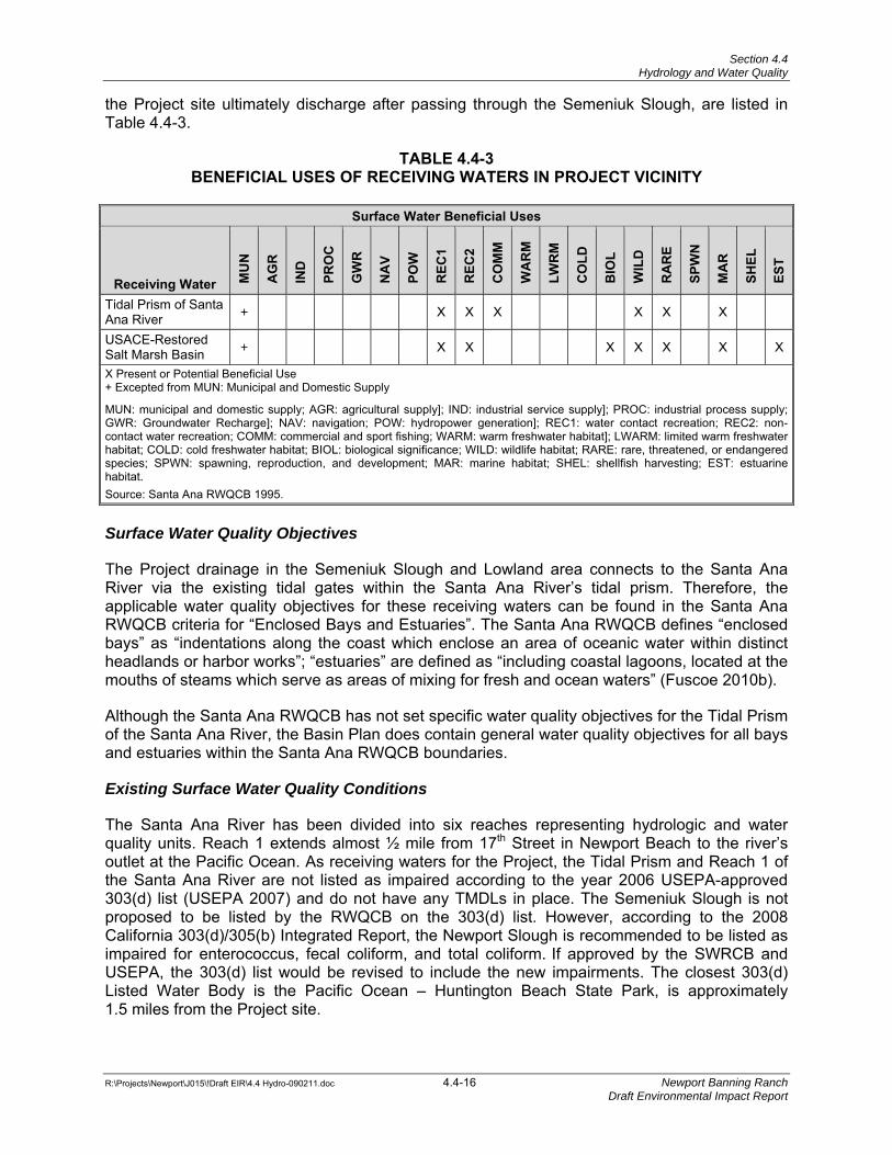
the Project site ultimately discharge after passing through the Semeniuk Slough, are listed in Table 4.4-3.
TABLE 4.4-3 BENEFICIAL USES OF RECEIVING WATERS IN PROJECT VICINITY
Surface Water Beneficial Uses
Receiving Water MU
N
AG
R
IND
PRO
C
GW
R
NA
V
POW
REC
1
REC
2
CO
MM
WA
RM
LWR
M
CO
LD
BIO
L
WIL
D
RA
RE
SPW
N
MA
R
SHEL
EST
Tidal Prism of Santa Ana River + X X X X X X
USACE-Restored Salt Marsh Basin + X X X X X X X
X Present or Potential Beneficial Use + Excepted from MUN: Municipal and Domestic Supply
MUN: municipal and domestic supply; AGR: agricultural supply]; IND: industrial service supply]; PROC: industrial process supply; GWR: Groundwater Recharge]; NAV: navigation; POW: hydropower generation]; REC1: water contact recreation; REC2: non-contact water recreation; COMM: commercial and sport fishing; WARM: warm freshwater habitat]; LWARM: limited warm freshwater habitat; COLD: cold freshwater habitat; BIOL: biological significance; WILD: wildlife habitat; RARE: rare, threatened, or endangered species; SPWN: spawning, reproduction, and development; MAR: marine habitat; SHEL: shellfish harvesting; EST: estuarine habitat. Source: Santa Ana RWQCB 1995.
Surface Water Quality Objectives
The Project drainage in the Semeniuk Slough and Lowland area connects to the Santa Ana River via the existing tidal gates within the Santa Ana River’s tidal prism. Therefore, the applicable water quality objectives for these receiving waters can be found in the Santa Ana RWQCB criteria for “Enclosed Bays and Estuaries”. The Santa Ana RWQCB defines “enclosed bays” as “indentations along the coast which enclose an area of oceanic water within distinct headlands or harbor works”; “estuaries” are defined as “including coastal lagoons, located at the mouths of steams which serve as areas of mixing for fresh and ocean waters” (Fuscoe 2010b).
Although the Santa Ana RWQCB has not set specific water quality objectives for the Tidal Prism of the Santa Ana River, the Basin Plan does contain general water quality objectives for all bays and estuaries within the Santa Ana RWQCB boundaries.
Existing Surface Water Quality Conditions
The Santa Ana River has been divided into six reaches representing hydrologic and water quality units. Reach 1 extends almost ½ mile from 17th Street in Newport Beach to the river’s outlet at the Pacific Ocean. As receiving waters for the Project, the Tidal Prism and Reach 1 of the Santa Ana River are not listed as impaired according to the year 2006 USEPA-approved 303(d) list (USEPA 2007) and do not have any TMDLs in place. The Semeniuk Slough is not proposed to be listed by the RWQCB on the 303(d) list. However, according to the 2008 California 303(d)/305(b) Integrated Report, the Newport Slough is recommended to be listed as impaired for enterococcus, fecal coliform, and total coliform.
If approved by the SWRCB and
USEPA, the 303(d) list would be revised to include the new impairments. The closest 303(d) Listed Water Body is the Pacific Ocean – Huntington Beach State Park, is approximately 1.5 miles from the Project site.
Section 4.4 Hydrology and Water Quality
R:\Projects\Newport\J015\!Draft EIR\4.4 Hydro-090211.doc 4.4-17 Newport Banning Ranch Draft Environmental Impact Report
Groundwater Resources
Groundwater Characterization and Elevations
Geographically, the Project site is located within the Orange County Groundwater Management Zone as defined in the Basin Plan. The Orange County Groundwater Management Zone consists primarily of three intra-connected confined aquifers: the Lower, Middle, and Upper Aquifers.
The Lower Aquifer system is a series of hydraulically interconnected aquifers overlying the non-water-bearing formations of consolidated sedimentary and basement rock. The Middle Aquifer system is composed of a series of aquifers predominantly of the water-bearing San Pedro Formation. The Main Aquifer, the predominant aquifer within the Middle Aquifer system, is comprised of coarse sand and gravel that contain layers of finer deposits and is Orange County’s primary source of groundwater (Fuscoe 2010b). The Upper Aquifer system is made up of discontinuous lenses of coarse sand and gravel confined by lenses of clay sediments. The Talbert Aquifer is the uppermost confined aquifer in the Upper Aquifer system. Local fine-grained sediments give rise to perched or quasi-perched water above the Talbert Aquifer.
Groundwater within the Orange County Groundwater Management Zone is affected by salt water intrusion near the coast and colored water from natural organic materials in the Lower Aquifer system. The most typical source of groundwater contamination in the area is the erosion of natural deposits, which could deliver chemicals such as arsenic, barium, fluoride, nickel, and selenium along with radiologicals such as radium and uranium in the groundwater (Newport Beach 2006b). Nitrates are also problematic owing to the extensive use of fertilizers within Orange County (Newport Beach 2006b). The Santa Ana RWQCB has identified water quality objectives for the Orange County Groundwater Management Zone for total dissolved solids (TDS) and nitrates.
Groundwater levels below the Lowland area of the Project site generally occur within a few feet of mean sea level (Geosyntec 2009). Groundwater elevations below the Upland have been identified at around sea level, although sampling data indicate that local variations in groundwater elevation in the area could occur in relation to a perched water condition (Fuscoe 2010b). Seepage in the existing on-site bluff faces has not been observed.
Beneath the Project site, the Upper Aquifer is subject to sea water intrusion, which began in the 1940s as lower rainfall amounts and increased groundwater drawdown for domestic use reduced groundwater table elevations to levels below sea level. Due to this condition (i.e., where sea water actually moves in and mixes with fresh water within the aquifer), groundwater at the Project site is brackish. Measured TDS and chloride levels in groundwater samples collected from the Lowland area indicate that concentrations are above the State of California drinking water standards (Geosyntec 2009).
As addressed in Section 4.3, Geology and Soils, global climate change and sea level rise have become considerations in project design throughout California, potentially influencing future project performance as well as project effects. The range of global climate change and sea level rise scenarios constitute predictions based on current understanding of the underlying causal processes at work; therefore, there is a degree of uncertainty in how the future scenarios would unfold. In May 2009, the California Climate Change Center, with funding from three California State agencies, published a paper entitled “The Impacts of Sea-level Rise on the California Coast”. This study proposes a worst-case prediction of sea level rise along the California coast of 55 inches, or 4.6 feet, by 2100 (CCCC 2009b). This potential scenario is similar to other
Section 4.4 Hydrology and Water Quality
R:\Projects\Newport\J015\!Draft EIR\4.4 Hydro-090211.doc 4.4-18 Newport Banning Ranch Draft Environmental Impact Report
studies regarding sea level rise along the California coast (Fuscoe 2010b). Global climate change and accompanying sea level rise could move this sea water intrusion farther inland, under the Project site and also raise groundwater levels within the Lowland area.
In the Upland area, the groundwater flow direction appears to be toward the bluffs (to the west in the northern portion of the Project site and to the south along West Coast Highway) while in the Lowland area, the direction of groundwater flow in the Upper Aquifer appears to be mainly toward the south parallel to the Santa Ana River (GMU 2010).
Because groundwater at the Project site is not used for drinking water or irrigation due to its poor quality and is not anticipated for these uses in the future, no significant change in groundwater quality associated with this future condition is anticipated. Increases in groundwater levels within the Lowland area associated with sea level rise would likely result in evolving changes to native habitat communities within the Lowland, but would not impact the development proposed on the Upland area. The worst-case prediction of sea level rise would result in the inundation of the proposed water quality basin within the Lowland area under extreme flooding scenarios. Under the current Project design, the water quality basin floor is above the existing 100-year flood plain limit and would be protected from flood flows.
Groundwater Quality
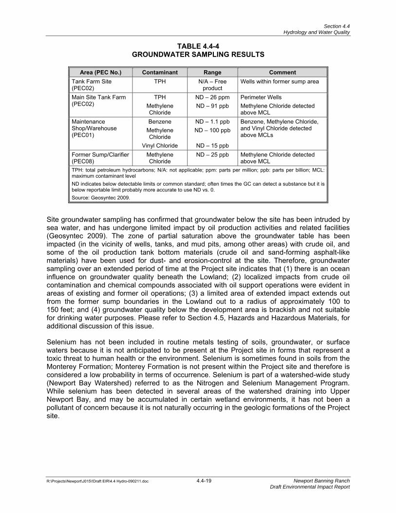
Groundwater sampling has been conducted at the Project site since 1986 to evaluate the potential impact of existing oil operations on groundwater quality. In 2000, a Site Environmental Assessment work plan was developed and subsequently implemented in 2001. The Environmental Assessment’s objective was to characterize the nature and extent of potential impacts to soil and groundwater at areas determined to be a potential environmental concern (PEC), and to evaluate location and potential volumes of impacted materials that may require remediation (Geosyntec 2009). Ten groundwater monitoring wells were established as a component of this Environmental Assessment; Table 4.4-4 presents the range of groundwater sampling results from the Project site associated with implementing the EA.
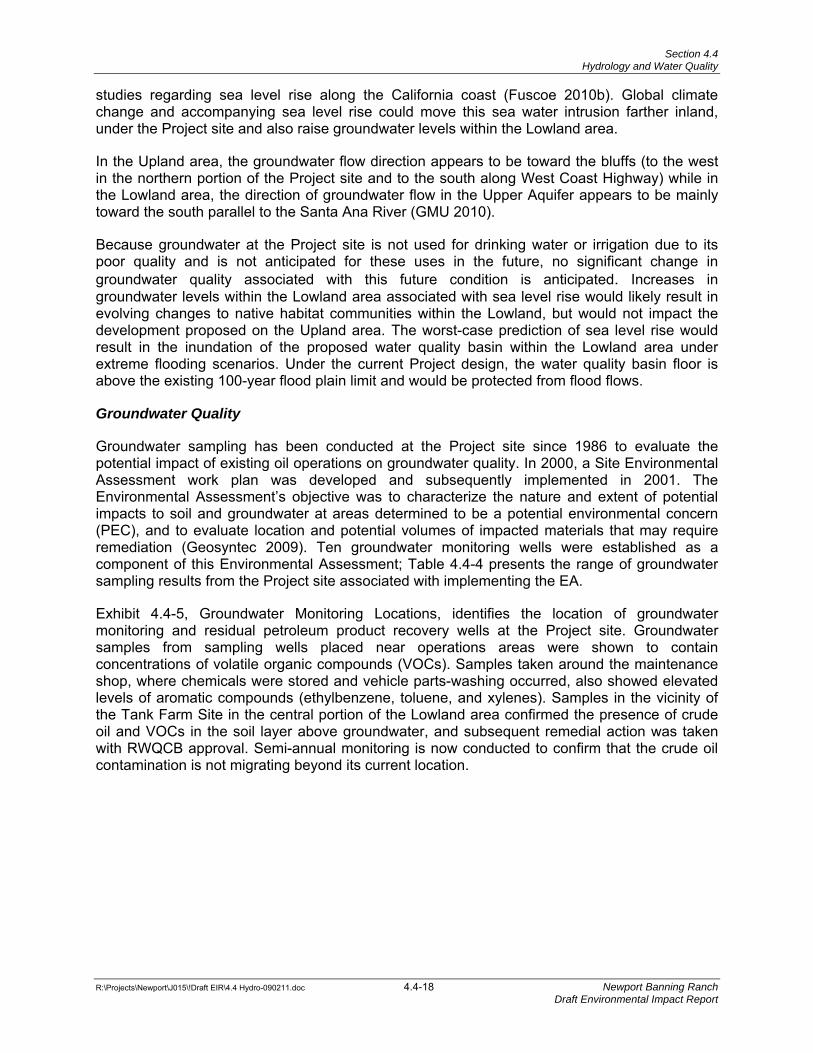
Exhibit 4.4-5, Groundwater Monitoring Locations, identifies the location of groundwater monitoring and residual petroleum product recovery wells at the Project site. Groundwater samples from sampling wells placed near operations areas were shown to contain concentrations of volatile organic compounds (VOCs). Samples taken around the maintenance shop, where chemicals were stored and vehicle parts-washing occurred, also showed elevated levels of aromatic compounds (ethylbenzene, toluene, and xylenes). Samples in the vicinity of the Tank Farm Site in the central portion of the Lowland area confirmed the presence of crude oil and VOCs in the soil layer above groundwater, and subsequent remedial action was taken with RWQCB approval. Semi-annual monitoring is now conducted to confirm that the crude oil contamination is not migrating beyond its current location.
West Coast Highway
West Coast Highway
19th St.19th St.19th St.
!<
!<
!<!<
!<
!<
!(
!>
!>
!>
!<?!A!A!A
!A
!<? !A
!A!A
!A
!A
!A
!A
!A!A!A
GW-2(1999)
C(1993)
B6(Date Uncertain; Pre-1992)
A(1993)
B(1993)
D1(1986)
H3(1986)
J5(1986)
06-GW-01(2001)
01-GW-003(2001)
01-GW-002(2001)
01-GW-001(2001)
08-GW-001(2001)
Groundwater Monitoring LocationsOverall Site Map
Newport Banning Ranch
Figure
1Project No: HR1018 September 2009
600 0 600 1,200300Feet
³
Legend
!AProduct Recovery Well (Year Installed)
!<?Interim Product Recovery Well(Year Installed)
!AGroundwater Monitoring Well(Year Installed)
!<Groundwater Monitoring Well(Year Installed)
!<Groundwater Monitoring Well(Year Installed)
!(Pacific Soils Boring B6(No Sampling)
!>Groundwater Monitoring Well(Year Installed)
Property Boundary Note: 1993 and 1999 groundwater monitoring well locations are approximated and were not surveyed.
Groundwater Monitoring Locations Exhibit 4.4-5Newport Banning Ranch EIR
(REV 082610 KFD) R:/Projects/Newport/J015/Graphics/EIR/Ex4.4-5_Groundwater_Monitoring.pdf
D:/P
roje
cts/
New
port/
J015
/Gra
phic
s/E
x_G
roun
dwat
er_M
onito
ring.
ai
Source: Geosyntec Consultants 2011
Section 4.4 Hydrology and Water Quality
R:\Projects\Newport\J015\!Draft EIR\4.4 Hydro-090211.doc 4.4-19 Newport Banning Ranch Draft Environmental Impact Report
TABLE 4.4-4 GROUNDWATER SAMPLING RESULTS
Area (PEC No.) Contaminant Range Comment
Tank Farm Site (PEC02)
TPH N/A – Free product
Wells within former sump area
Main Site Tank Farm (PEC02)
TPH Methylene Chloride
ND – 26 ppm ND – 91 ppb
Perimeter Wells Methylene Chloride detected above MCL
Maintenance Shop/Warehouse (PEC01)
Benzene Methylene Chloride
Vinyl Chloride
ND – 1.1 ppb ND – 100 ppb
ND – 15 ppb
Benzene, Methylene Chloride, and Vinyl Chloride detected above MCLs
Former Sump/Clarifier (PEC08)
Methylene Chloride
ND – 25 ppb Methylene Chloride detected above MCL
TPH: total petroleum hydrocarbons; N/A: not applicable; ppm: parts per million; ppb: parts per billion; MCL: maximum contaminant level ND indicates below detectable limits or common standard; often times the GC can detect a substance but it is below reportable limit probably more accurate to use ND vs. 0. Source: Geosyntec 2009.
Site groundwater sampling has confirmed that groundwater below the site has been intruded by sea water, and has undergone limited impact by oil production activities and related facilities (Geosyntec 2009). The zone of partial saturation above the groundwater table has been impacted (in the vicinity of wells, tanks, and mud pits, among other areas) with crude oil, and some of the oil production tank bottom materials (crude oil and sand-forming asphalt-like materials) have been used for dust- and erosion-control at the site. Therefore, groundwater sampling over an extended period of time at the Project site indicates that (1) there is an ocean influence on groundwater quality beneath the Lowland; (2) localized impacts from crude oil contamination and chemical compounds associated with oil support operations were evident in areas of existing and former oil operations; (3) a limited area of extended impact extends out from the former sump boundaries in the Lowland out to a radius of approximately 100 to 150 feet; and (4) groundwater quality below the development area is brackish and not suitable for drinking water purposes. Please refer to Section 4.5, Hazards and Hazardous Materials, for additional discussion of this issue.
Selenium has not been included in routine metals testing of soils, groundwater, or surface waters because it is not anticipated to be present at the Project site in forms that represent a toxic threat to human health or the environment. Selenium is sometimes found in soils from the Monterey Formation; Monterey Formation is not present within the Project site and therefore is considered a low probability in terms of occurrence. Selenium is part of a watershed-wide study (Newport Bay Watershed) referred to as the Nitrogen and Selenium Management Program. While selenium has been detected in several areas of the watershed draining into Upper Newport Bay, and may be accumulated in certain wetland environments, it has not been a pollutant of concern because it is not naturally occurring in the geologic formations of the Project site.
Section 4.4 Hydrology and Water Quality
R:\Projects\Newport\J015\!Draft EIR\4.4 Hydro-090211.doc 4.4-20 Newport Banning Ranch Draft Environmental Impact Report
4.4.5 PROJECT DESIGN FEATURES AND STANDARD CONDITIONS
Project Design Features
PDF 4.4-1 The Master Development Plan requires that two water quality basins (one in the Community Park and one in the Open Space Preserve) be constructed to treat off-site urban runoff from Costa Mesa and Newport Beach and Project runoff that drains into the Lowland area.
PDF 4.4-2 The Master Development Plan includes a water quality basin and a diffuser basin located within the Open Space Preserve to provide for storm water control, energy dissipation, and natural water quality treatment.
PDF 4.4-3 The Master Development Plan requires that public arterials and some selected collector roadways within the Project site be designed with “Green Street” and other Low Impact Development (LID) features, such as bioswales and bio-cells. Green Streets are designed to incorporate sustainable design elements such as narrower pavement widths, canopy street trees, traffic-calming features, and minimal use of street lighting. Landscaping along the street edges will be selectively used to treat storm water runoff from the streets and adjacent development areas.
PDF 4.4-4 The Master Development Plan requires that arroyos be planted with native riparian vegetation as part of the restoration effort to minimize potential erosion and to enhance the water-cleansing function.
PDF 4.4-5 The Master Development Plan requires development of a drainage plan to ensure that runoff systems from the Project site to West Coast Highway and the Semeniuk Slough will be stabilized and maintained through the Project’s drainage system.
PDF 4.4-6 The Master Development Plan requires the use of best management practices (BMPs) for erosion control, sediment control, wind erosion control, storm water and non-storm water management, and waste management/pollution control. These BMPs will be implemented to ensure that potential effects on local site hydrology, runoff, and water quality remain in compliance with all required permits, City policies, and the Project’s Water Quality Management Plan (WQMP), and Storm Water Pollution Prevention Plan (SWPPP).
Standard Conditions
SC 4.4-1 All landscape materials and irrigation systems shall be maintained in accordance with the approved Landscape Plan. All landscaped areas shall be kept in a healthy and growing condition and shall receive regular maintenance. All landscaped areas shall be kept free of weeds and debris. All irrigation systems shall be kept operable, including adjustments, replacements, repairs, and cleaning as part of regular maintenance.
SC 4.4-2 The development shall be kept free of litter and graffiti. The owner or operator shall provide for removal of trash, litter debris, and graffiti from the premises and on all abutting sidewalks.
Section 4.4 Hydrology and Water Quality
R:\Projects\Newport\J015\!Draft EIR\4.4 Hydro-090211.doc 4.4-21 Newport Banning Ranch Draft Environmental Impact Report
SC 4.4-3 Prior to the issuance of grading permits, an SWPPP and Notice of Intent (NOI) to comply with the General Permit for Construction Activities shall be prepared, submitted to the State Water Resources Control Board (SWRCB), and made part of the construction program. This SWPPP shall detail measures and practices that would be in effect during construction to minimize the Project’s impact on water quality and storm water runoff volumes.
SC 4.4-4 Prior to issuance of grading permits, the Project Applicant shall prepare and submit a Water Quality Management Plan (WQMP) for the project, subject to the approval of the Community Development Department, Building Division and Code and Water Quality Enforcement Division. The WQMP shall include appropriate BMPs to ensure project runoff is adequately treated.
SC 4.4-5 A list of “good housekeeping” practices shall be incorporated into the long-term post-construction operation of the site to minimize the likelihood that pollutants would be used, stored, or spilled on the site that could impair water quality. These may include frequent parking area vacuum truck sweeping, removal of wastes or spills, limited use of harmful fertilizers or pesticides, and the diversion of storm water away from potential sources of pollution (e.g., trash receptacles and parking structures). The WQMP shall list and describe all structural and non-structural BMPs. In addition, the WQMP must also identify the entity responsible for the long-term inspection, maintenance, and funding for all structural (and if applicable treatment-control) BMPs.
4.4.6 THRESHOLDS OF SIGNIFICANCE
Threshold criteria for evaluating hydrologic impacts have been developed based on a review of applicable provisions of the City of Newport Beach Environmental Checklist, the Regional MS4 Permit, and the DAMP. Significant adverse impacts to natural drainage systems created by altered hydrologic conditions of concern would occur if the proposed Project would:
Threshold 4.4-1 Violate any water quality standards or waste discharge requirements.
Threshold 4.4-2 Substantially deplete groundwater supplies or interfere substantially with groundwater recharge such that there would be a net deficit in aquifer volume or a lowering of the local groundwater table level (e.g. the production rate of pre-existing nearby wells would drop to a level which would not support existing land uses or planned uses for which permits have been granted).
Threshold 4.4-3 Substantially alter the existing drainage pattern of the site or area, including through the alteration of the course of a stream or river, in a manner which would result in substantial erosion or siltation on- or off-site.
Threshold 4.4-4 Substantially alter the existing drainage pattern of the site or area, including through the alteration of the course of a stream or river, or substantially increase the rate or amount of surface runoff in a manner in which would result in flooding on- or off-site.
Section 4.4 Hydrology and Water Quality
R:\Projects\Newport\J015\!Draft EIR\4.4 Hydro-090211.doc 4.4-22 Newport Banning Ranch Draft Environmental Impact Report
Threshold 4.4-5 Create or contribute runoff water which would exceed the capacity of existing or planned storm water drainage systems or provide substantial additional sources of polluted runoff.
Threshold 4.4-6 Otherwise substantially degrade water quality.
Threshold 4.4-7 Place housing within a 100-year flood hazard area as mapped on a federal Flood Hazard Boundary or Flood Insurance Rate Map or other flood hazard delineation map.
Threshold 4.4-8 Place within a 100-year flood hazard area structures which would impede or redirect flood flows.
Threshold 4.4-9 Expose people or structures to a significant risk of loss, injury or death involving flooding, including flooding as a result of the failure of a levee or dam.
Threshold 4.4-10 Cause inundation by seiche, tsunami, or mudflow.
Threshold 4.4-11 Result in significant alteration of receiving water quality during or following construction.
Threshold 4.4-12 Result in a potential for discharge of storm water pollutants from areas of material storage, vehicle or equipment fueling, vehicle or equipment maintenance (including washing), waste handling, or storage, delivery areas, loading docks or other outdoor work areas.
Threshold 4.4-13 Result in the potential for discharge of storm water to affect the beneficial uses of the receiving waters.
Threshold 4.4-14 Create the potential for significant changes in the flow velocity or volume of storm water runoff to cause environmental harm.
Threshold 4.4-15 Create significant increases in erosion of the project site or surrounding areas.
Threshold 4.4-16 Conflict with any applicable plan, policy, or regulation of an agency with jurisdiction over the project (including, but not limited to the general plan, specific plan, local coastal program, or zoning ordinance) adopted for the purpose of avoiding or mitigating an environmental effect.
4.4.7 ENVIRONMENTAL IMPACTS
The proposed Project would allow for the development of approximately 149 acres of the 401-acre Project site for residential, commercial, resort inn, mixed-use, and recreational land uses. Approximately 252 acres (63 percent) of the Project site would be retained as open space, with restored wetland and habitat areas located throughout the Lowland and Upland areas. The amount of impervious surfaces on the site would increase by approximately 45 percent overall as a result of the Project (Fuscoe 2010b). The proposed Runoff Management Plan and drainage design accounts for increases in runoff to specific natural site features.
Section 4.4 Hydrology and Water Quality
R:\Projects\Newport\J015\!Draft EIR\4.4 Hydro-090211.doc 4.4-23 Newport Banning Ranch Draft Environmental Impact Report
Proposed Project Drainage and Water Quality Management Elements
The Project would incorporate a Runoff Management Plan that includes water quality and drainage features designed to treat site runoff for water quality purposes and to reduce runoff volumes or rates where feasible. Water quality features would consist of LID features where feasible (e.g., bioswales, landscaping biocells, permeable pavement, and other improvements designed to promote soil-based infiltration processes) as well as source-control and treatment-control BMPs. Drainage improvements would minimize runoff to arroyos, redirect runoff away from bluffs, and reduce flow rates and volumes in the Semeniuk Slough. These drainage features would result in an improvement over existing site runoff conditions with respect to water quality, velocities, and volumes.
The Project incorporates Project Design Features (PDFs) (see Section 4.4.4) to minimize adverse Project effects to water quality, storm water runoff, and groundwater impacts. Site drainage patterns would remain generally consistent with the existing condition, with minor alterations proposed in site subwatershed boundaries in order to manage flows from the Project into Lowland area. The integration of LID features into the Project design would provide sustainable water quality and storm water management capabilities for the site.
Proposed Project Drainage Features
Storm Drains
On-site local drains would be provided to drain each of the on-site subwatersheds under developed conditions. As depicted on Exhibit 4.4-6, Master Drainage Plan, these systems are designated as Storm Drains A through G.
• Storm Drain A (Subwatershed A): These drains discharge flows to the existing Caltrans RCB storm drain under West Coast Highway. Storm Drain A (SD-A) is designed to reduce the tributary drainage area of this storm drain system over existing conditions to offset the increase in Project runoff in the proposed condition.
• Storm Drains B and C (Subwatershed A): These drains collect flows from the development areas adjacent to the Southern Arroyo and deliver these flows to a diffuser basin located downstream of the Arroyo adjacent to the Semeniuk Slough. The design of Storm Drains B and C (SD-B, SD-C) serves three primary functions: (1) to minimize the discharge of storm water flows directly to the Southern Arroyo in order to protect long-term channel stability; (2) to dissipate erosive energy before flows enter the Semeniuk Slough; and (3) to control sediment contributions to the Semeniuk Slough.
• Storm Drains D and E (Subwatershed C): These drains collect flows from the Project’s larger development areas and deliver storm flows to the Lowland. Under the existing conditions, a portion of the drainage from Storm Drain D (SD-D) is tributary to both the Southern Arroyo and Semeniuk Slough. The proposed drainage would specifically be designed to maximize the amount of flow that would be redirected towards the Lowland area in order to reduce the flood loading of the Semeniuk Slough. A second diffuser basin would be installed downstream of SD-D and Storm Drain E (SD-E) to reduce the rate of flows from the pipes and to distribute runoff to the Lowland in a manner that would enable habitat restoration efforts.
• Storm Drain F (Subwatershed B): This storm drain collects flows from the northernmost development area. The tributary drainage area has been designed to match existing runoff conditions to the Northern Arroyo. An energy dissipater would be
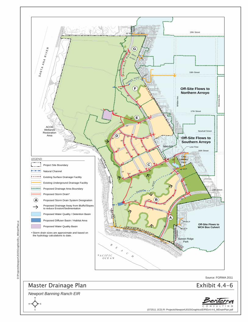
S A
N T
A A
N A
R
I V E
R
ACOEWetlands
RestorationArea
18th Street
Whi
ttier
Ave
.
Mon
rovi
a Av
e.
17th Street
Newhall Street
16th Street
15th Street
19th StreetBalb
oaSt
reet
Semeniuk
Slough
Sunset RidgePark
NMUSD
CityUtilities
Yard
Scenic Drive
'D' Stre
et
Resort Colony Road
Southern
Arro
yo
Northern
Arroyo
"V"-DITCH
"V"-DITCH
36" RCP
27" RCP
27" RCP30" RCP
18" CSP
14'W x 5'H
RC
B
12'x3
' GU
NIT
EC
HAN
NEL
8'W x 5'H RCB
5'W "V"-DITCH14'W x 5'H RCB
TRAP. C
HN
L
11'W x 5'H RCB
48" RCP
42" RCP
24" RCP
Low Flow
48"
24"
18"
60"
30"
24"
24"30"
54"
48"
24"
24"
24"
36"
30"
24"
24"
24"
42"
45"
30"36"
24"18"
36"
30"
24"
18"
54"
42"
30"
42"
24"
24"
24"
18"
24"
30"
36"
West Coast Highway
Off-Site Flows toNorthern Arroyo
Off-Site Flows toSouthern Arroyo
Off-Site Flows toWCH Box Culvert
G
F
E
D
C
B
A
No
r th
Bl u
f fR
oa
d MinorArroyo
È
È
È
È
È
È
È
LEGEND
Project Site Boundary
Natural Channel
Proposed Storm Drain*
Proposed Drainage Area Boundary
Existing Surface Drainage Facility
Existing Underground Drainage Facility
Proposed Water Quality / Detention Basin
Proposed Water Quality Basin
Storm drain sizes are approximate and based onthe hydrology calculations to date.
*
Proposed Diffuser Basin / Habitat Area
Proposed Storm Drain System Designation AProposed Drainage Away from Bluffs/Slopes to reduce Erosion/Sedimentation
È
Master Drainage Plan Exhibit 4.4-6Newport Banning Ranch EIR
Source: FORMA 2011
(072511 JCD) R: Projects\Newport\J015\Graphics\EIR\Ex4.4-6_MDrainPlan.pdf
D:\P
roje
cts\
New
port\
J015
\Gra
phic
s\E
x_M
Dra
inP
lan.
ai
Section 4.4 Hydrology and Water Quality
R:\Projects\Newport\J015\!Draft EIR\4.4 Hydro-090211.doc 4.4-24 Newport Banning Ranch Draft Environmental Impact Report
installed at the outlet to Storm Drain F (SD-F) to transition flows from erosive velocities to mild velocities, and to deliver non-erosive flows to the natural channel.
• Storm Drain G (Subwatershed D): This storm drain collects flows from the northernmost portion of the development area. Flow in Storm Drain G (SD-G) would be delivered to the Lowland via a culvert and a storm drain located in North Bluff Road.
Water Quality/Detention Basins
One water quality basin and one diffuser basin/habitat area are proposed in the Lowland within the Open Space Preserve. The diffuser basin/habitat area is proposed adjacent to the north Oil Consolidation area to provide treatment of storm water and detention of runoff flowing from on-site areas and off-site urban areas located to the east prior to discharging into the Lowland. The other basin is proposed in the Lowland near the North Family Village to provide energy dissipation of flows prior to entering the Semeniuk Slough. Both of these basins would be planted with native emergent marsh and riparian species to promote water quality cleaning and natural energy dissipation.
A second water quality/detention basin is proposed to intercept approximately 48 acres of off-site flows from the 16th Street Costa Mesa drainage area. These off-site flows enter the Project site via a 48-inch reinforced concrete pipe and discharge into the Southern Arroyo. In general, these flows contain urban runoff pollutants and also convey sediment from the eroding tributaries of the Southern Arroyo to the downstream end, ultimately discharging into the Semeniuk Slough during severe storms. The water quality/detention basin is proposed on the Project site at the southeast corner of 16th Street at the Project site boundary. The required basin capacity is estimated to be approximately 2.3 acre-feet, which can treat all dry weather and a portion of first-flush runoff from the off-site tributary as well as reduce a portion of peak flow discharge. The basin is also intended to reduce peak flow rates discharging into the Southern Arroyo to reduce erosion and scour potential. The reduction in peak discharges combined with the stabilization of the eroding tributaries of the Southern Arroyo would control the current sediment loads into the Semeniuk Slough.
Treatment-control BMPs are engineered systems similar to LID features as they are sized to capture, filter, and/or treat the required runoff volume or flow before it is discharged into a project’s receiving waters. Treatment-control BMPs treat fairly large flow volumes from large drainage areas. These features are located both internal to development areas and on the periphery of development and are identified in the Water Quality Management Plan as Community Water Quality Basins. Selection of treatment-control BMPs is based on the pollutants of concern from the Project site and the BMP’s ability to effectively mitigate those pollutants, in consideration of site conditions and constraints. The Project’s treatment-control BMPs would be designed to infiltrate, filter, and/or treat runoff volumes generated from the Project through the use of water quality basins. As depicted on Exhibit 4.4-7, Proposed Sub-Watershed Basins, three basins would be incorporated into the Project for water quality treatment, detention, and diffusion purposes. More detailed information about these basins is provided further later in this section as part of the discussion of Treatment Control BMPs.
Threshold 4.4-1 Would the project violate any water quality standards or waste discharge requirements?
Threshold 4.4-6 Would the project otherwise substantially degrade water quality?
Threshold 4.4-11 Would the project result in significant alteration of receiving water quality during or following construction?
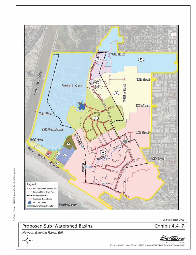
Proposed Sub-Watershed Basins Exhibit 4.4-7Newport Banning Ranch EIR
Source: Fuscoe 2011
(072511 JCD) R: Projects\Newport\J015\Graphics\EIR\Ex4.4-7_PropSubWatershed.pdf
D:\P
roje
cts\
New
port\
J015
\Gra
phic
s\E
x_P
ropS
ubW
ater
shed
.ai
Section 4.4 Hydrology and Water Quality
R:\Projects\Newport\J015\!Draft EIR\4.4 Hydro-090211.doc 4.4-25 Newport Banning Ranch Draft Environmental Impact Report
Threshold 4.4-12 Would the project result in a potential for discharge of storm water pollutants from areas of material storage, vehicle or equipment fueling, vehicle or equipment maintenance (including washing), waste handling, or storage, delivery areas, loading docks or other outdoor work areas?
Threshold 4.4-13 Would the project result in the potential for discharge of storm water to affect the beneficial uses of the receiving waters?
The proposed Project would create new types of pollutant sources associated with residential development and consequently alter the types of constituents or levels of pollutants contained in post-development site runoff. In order to reduce the amount of pollutants in storm water runoff from the Project and to minimize associated hydrologic and water quality impacts, BMPs are required to be implemented in accordance with city, State, and RWQCB standards and consistent with California Coastal Act policies.
Construction Impacts
Project construction impacts to water quality could occur from (1) grading and oil remediation; (2) utility and road construction; (3) building construction (e.g., residential units); (4) final stabilization and landscaping; and (5) equipment staging, operation and fueling. Clearing, grading, excavation, and construction activities associated with the proposed Project may impact water quality by induced sheet erosion of exposed soils and the subsequent deposition of particulates in local drainages. Grading activities and sediment stockpiles can lead to exposed areas of loose soil that are susceptible to uncontrolled sheet flow and wind erosion. Impacts can also occur from sediment laden runoff and mobilization of pollutants associated with vehicle staging and operation. Petroleum hydrocarbons may also contaminate local sediments and surface water in areas where the oil pipeline is removed. Remediation and grading is estimated to total approximately 2,500,000 cubic yards (cy) including approximately 900,000 cy of cut and fill and approximately 1,455,000 cy of corrective grading. (see Table 4.3-2, in Section 4.3, Geology and Soils, for more detailed breakdown of the grading quantities).
Construction Site Risk Assessment
The General Construction Permit uses a risk-based approach for controlling erosion and sediment discharges from construction sites because the rates of erosion and sedimentation can vary by site depending on factors such as duration of construction activities, climate, topography, soil condition, and proximity to receiving water bodies. Three levels of risk are identified within the General Construction Permit with corresponding monitoring and reporting requirements as well as differing and compulsory minimum BMP implementation requirements. These risk levels are designated within the General Construction Permit as Risk Levels 1, 2, and 3. Risk Level 1 is assigned to projects considered to have the lowest risk of water quality impact and therefore has the fewest permit requirements and Risk Level 3 is assigned to projects considered to have a fairly high risk or impact to water quality and has the most stringent permit requirements.
The Risk Assessment, prepared at the time of grading permit application, relies on the determination of two component risk factors for a project site: sediment risk (which is the general amount of sediment that could be discharged from a site) and receiving water risk (the risk that sediment discharges can pose to receiving waters). Although a detailed site-specific Risk Assessment would not be prepared until the exact details of Project implementation (e.g.,
Section 4.4 Hydrology and Water Quality
R:\Projects\Newport\J015\!Draft EIR\4.4 Hydro-090211.doc 4.4-26 Newport Banning Ranch Draft Environmental Impact Report
finalized phasing by timeframe), a preliminary Risk Assessment has been prepared for this EIR analysis (Fuscoe 2010b).
Sediment risk from a project site is determined using the Revised Universal Soil Loss Equation, which is a model developed by the U.S. Department of Agriculture and used by the USEPA for estimating rates of soil loss at construction sites during rain events. Sediment risk (the rate of sheet and rill erosion) considers: rainfall, soil erodibility characteristics, slopes, erosion controls, and management operations and support practices (sediment controls). The preliminary sediment risk assessment found that the proposed Project is considered a High Sediment Risk because its rate of sheet and rill erosion under bare ground conditions is anticipated to be greater than 75 tons per acre over the lifetime of the Project. This risk number is not based on the site-specific conditions nor does it account for the use of any erosion control, sediment control and scheduling controls when assigning the theoretical sediment risk value. A detailed discussion of this analysis may be found in Appendix C of this EIR.
The second risk factor, receiving water risk, is determined by the type of discharge and the Project’s proximity to any 303(d) listed impaired water bodies. Should the Newport Slough be listed in the future for bacteria, the listing would not affect the risk level designation for the Project site because the General Construction Permit only calculates receiving water risk based on listings of water bodies impaired for sediment. Receiving waters for the proposed Project –the Tidal Prism of the Santa Ana River and Newport Slough – are not listed on USEPA’s 303(d) list of impaired water bodies for sediment, and therefore are not subject to a TMDL requirement. In addition, the receiving water body does not contain the beneficial uses of SPAWN, COLD, and MIGRATORY (habitat-related water body uses). The Project can therefore be considered to have a Low Receiving Water Risk.
The proposed Project is preliminarily identified as a Risk Level 2, because the site would have a low receiving water risk and a high sediment risk, which intersects as a Risk Level 2. While this determination would not bind the Project for the purposes of permitting and it may be that further refinements in the Project design and analysis demonstrates a lesser risk, this determination is constitutes the more conservative conclusion for the purposes of environmental review at this time.
The General Construction Permit identifies requirements for Risk Level 2 dischargers. These requirements are summarized below and described in greater detail in Appendix C of this EIR.
• Implement minimum BMPs.
• Develop Rain Event Action Plans designed to protect exposed portions of the site for all phases of construction during predicted precipitation events.
• Implement Visual Monitoring (Inspection) requirements for qualifying rain events at minimum frequencies.
• Conduct storm water effluent sampling for pH and turbidity for qualifying rain events to determine whether any exceedances of numeric action levels have occurred.
• Conduct non-storm water discharge sampling where any non-storm water discharges occur. In the event that turbidity exceedances are observed during the required storm event monitoring, the site’s erosion and sediment controls would be evaluated to improve effectiveness. If necessary, Active Treatment Systems may be used to reduce sediment in storm water effluent. Active Treatment Systems are systems that are engineered to quantifiably control specific water quality parameters.
Section 4.4 Hydrology and Water Quality
R:\Projects\Newport\J015\!Draft EIR\4.4 Hydro-090211.doc 4.4-27 Newport Banning Ranch Draft Environmental Impact Report
In the event numeric action levels are not met on site, the Project may use Active Treatment Systems as a BMP to reduce sediment and/or turbidity from the site (regardless of Risk Level). However, it is not anticipated that the proposed Project would require the use of Active Treatment Systems; BMP efficiencies have been determined effective in meeting the requirements established by regulatory performance objectives. Requirements associated with the use of Active Treatment Systems include those listed below.
• Preparation and submittal of an Active Treatment Systems Plan to the SWRCB 14 days prior to operation that includes the preparation of the following:
– An Active Treatment Systems Operation and Maintenance Manual for all equipment;
– An Active Treatment Systems Monitoring, Sampling and Reporting Plan, including Quality Assurance (QA)/Quality Control (QC) information;
– An Active Treatment Systems Health and Safety Plan;
– An Active Treatment Systems Spill Prevention Plan;
– Project design where the Active Treatment Systems capture and treat a volume equivalent to the runoff from 10-year and 24-hour storm events;
– Site-specific treatment tests conducted with the required chemical residual and toxicity tests;
– Project design that ensures the Active Treatment Systems meets the turbidity Numeric Effluent Limits;
– Monitoring of Active Treatment Systems.
Prior to commencement of construction activities, the SWPPP would be prepared in accordance with site-specific sediment risk analyses based on the final grading plans and erosion and sediment controls proposed for construction. Grading and/or tract maps would identify the location and size of sediment basins; the maximum amount of soil disturbed at any one time as construction proceeds; and other control measures to accommodate all active soil disturbance areas and the monitoring and sampling plans.
Grading and Oil Remediation Activities
During grading, soil loss potential would be at its highest risk level to exceed numeric action level specified for Risk Level 2 sites. A combination of erosion and sediment controls would be implemented during this phase of construction to ensure sediment production from the construction site remain controlled and within accepted regulatory limits. Table 4.4-5 presents established guidelines for erosion and sediment control applications for this region.
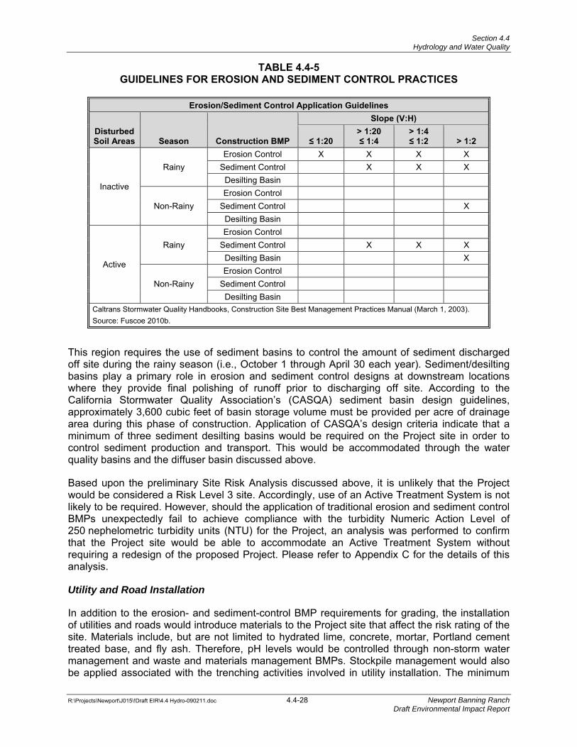
Section 4.4 Hydrology and Water Quality
R:\Projects\Newport\J015\!Draft EIR\4.4 Hydro-090211.doc 4.4-28 Newport Banning Ranch Draft Environmental Impact Report
TABLE 4.4-5 GUIDELINES FOR EROSION AND SEDIMENT CONTROL PRACTICES
Erosion/Sediment Control Application Guidelines
Disturbed Soil Areas Season Construction BMP
Slope (V:H)
≤ 1:20 > 1:20≤ 1:4
> 1:4 ≤ 1:2 > 1:2
Inactive
Rainy Erosion Control X X X X
Sediment Control X X X Desilting Basin
Non-Rainy Erosion Control
Sediment Control X Desilting Basin
Active
Rainy Erosion Control
Sediment Control X X X Desilting Basin X
Non-Rainy Erosion Control
Sediment Control Desilting Basin
Caltrans Stormwater Quality Handbooks, Construction Site Best Management Practices Manual (March 1, 2003). Source: Fuscoe 2010b.
This region requires the use of sediment basins to control the amount of sediment discharged off site during the rainy season (i.e., October 1 through April 30 each year). Sediment/desilting basins play a primary role in erosion and sediment control designs at downstream locations where they provide final polishing of runoff prior to discharging off site. According to the California Stormwater Quality Association’s (CASQA) sediment basin design guidelines, approximately 3,600 cubic feet of basin storage volume must be provided per acre of drainage area during this phase of construction. Application of CASQA’s design criteria indicate that a minimum of three sediment desilting basins would be required on the Project site in order to control sediment production and transport. This would be accommodated through the water quality basins and the diffuser basin discussed above.
Based upon the preliminary Site Risk Analysis discussed above, it is unlikely that the Project would be considered a Risk Level 3 site. Accordingly, use of an Active Treatment System is not likely to be required. However, should the application of traditional erosion and sediment control BMPs unexpectedly fail to achieve compliance with the turbidity Numeric Action Level of 250 nephelometric turbidity units (NTU) for the Project, an analysis was performed to confirm that the Project site would be able to accommodate an Active Treatment System without requiring a redesign of the proposed Project. Please refer to Appendix C for the details of this analysis.
Utility and Road Installation
In addition to the erosion- and sediment-control BMP requirements for grading, the installation of utilities and roads would introduce materials to the Project site that affect the risk rating of the site. Materials include, but are not limited to hydrated lime, concrete, mortar, Portland cement treated base, and fly ash. Therefore, pH levels would be controlled through non-storm water management and waste and materials management BMPs. Stockpile management would also be applied associated with the trenching activities involved in utility installation. The minimum
Section 4.4 Hydrology and Water Quality
R:\Projects\Newport\J015\!Draft EIR\4.4 Hydro-090211.doc 4.4-29 Newport Banning Ranch Draft Environmental Impact Report
BMPs are summarized later in Table 4.4-6. Should Numeric Action Levels be exceeded at any point in time, additional site management or “good housekeeping” BMPs would be implemented and the source of pollution controlled.
Vertical Construction
Upon completion of road construction and utility installation, sediment controls designed for these earlier stages of construction may no longer be applicable or functional due to the installment of curbs and gutters, catch basins, and/or storm drain infrastructure to convey runoff off site from the post-construction condition. BMPs at this stage of construction would therefore be more focused on construction-lot sediment-control BMPs and at discharge points (i.e., catch basin inlet protection). Erosion-control BMPs for manufactured slopes would be in place and would require periodic maintenance to retain their integrity. During vertical construction (e.g., construction of residences, etc.), construction materials would be delivered to the site, and wastes generated from the site would have the potential to negatively impact pH levels. Therefore, non-storm water management and waste and materials management BMPs would be required (Table 4.4-6).
Final Stabilization and Landscaping
During final stabilization and landscaping, minimal construction would take place and the majority of the Project site would be stabilized. The majority of activities would involve planting and landscaping lots and common areas. Finished slopes that have not been landscaped would also be planted. Sediment control at discharge locations and stockpile management would be of primary concern. Good housekeeping practices would continue.
Equipment Staging, Operation, and Fueling
During construction, materials would be delivered to the Project site, and wastes generated from the site have the potential to negatively impact pH levels; non-storm water management and waste and materials management BMPs would be used. BMPs at this stage would also be more focused on on-lot sediment control and discharge points.
Construction Dewatering
Based on the depths to groundwater within the proposed development areas within the Upland, construction dewatering is not anticipated to be required. Should groundwater be unexpectedly encountered that would require dewatering, the Project would apply for coverage and adhere to the monitoring and reporting program under Order No. R8-2009-0003. Dewatering may also be performed as part of localized remediation efforts within the Lowland area of the Project site, as guided by the regulatory agencies with appropriate jurisdiction. Any dewatering associated with the removal of oil facilities and associated remediation would be managed and properly disposed of in accordance with Order No. R8-2009-003 and the proposed Remedial Action Plan, as described later in this section. If techniques to remediate impacted soils would involve soil removal, dewatering may be required as a remediation element in order to enhance the geotechnical stability of the excavation for safety purposes. If this activity is required, it would be performed in accordance with the appropriate NPDES requirements under the Clean Water Act and the Dewatering Permit. Additional detail on the applicable BMPs for remediation activities is provided later in this section under the heading, Removal of Oil Facilities in the Lowland: Groundwater Quality Impacts.
Section 4.4 Hydrology and Water Quality
R:\Projects\Newport\J015\!Draft EIR\4.4 Hydro-090211.doc 4.4-30 Newport Banning Ranch Draft Environmental Impact Report
Compliance with the General Construction Permit
Potential construction impacts associated with construction grading/excavation; material stockpiling and/or dewatering; construction and use of access and haul roads; and equipment staging, operation, and fueling would be minimized through compliance with the General Construction Permit and, if necessary, the Orange County Dewatering Permit. The Project would be required to comply with the most current General Construction Permit and associated local NPDES regulations to ensure that the potential for construction-related erosion and adverse sedimentation is minimized. In accordance with the General Construction Permit (Order No. 2009-0009-DWQ), the following Permit Registration Documents would be completed and submitted to the SWRCB prior to issuance of a grading permit and commencement of construction activities:
• Notice of Intent (NOI),
• Risk Assessment (Standard or Site-Specific),
• Particle Size Analysis (if site-specific risk assessment is performed),
• Site Map,
• SWPPP,
• Active Treatment System Design Documentation (if an Active Treatment System is determined necessary)
• Annual Fee, and
• Certification.
These permits (i.e., the General Construction Permit and the Orange County Dewatering Permit, the later if determined necessary) also require development and implementation of a SWPPP, which would be prepared and implemented at the Project site and revised as necessary as administrative or physical conditions change. The SWPPP would (1) be made available for review on the State’s Storm Water Multiple Application and Report Tracking System; (2) would describe construction BMPs that address pollutant source reduction; and (3) provide measures/controls necessary to mitigate potential pollutant sources. These measures would include erosion controls, sediment controls, tracking controls, non-storm water management practices, materials and waste management, and good housekeeping practices.
Minimum Construction BMPs
The following BMPs would also be implemented at the construction site as appropriate to facilitate compliance with these updated permit requirements. An effective combination of erosion and sediment controls would be selected based on the specific site conditions in the area of construction grading disturbance. Good housekeeping practices, such as waste and materials management, non-storm water management, and tracking controls would be implemented at all times. Additional guidelines and minimum BMPs for active construction areas are outlined in the Watershed Assessment Report (Fuscoe 2010b).
Table 4.4-6 contains general guidelines for the minimum BMPs required at all active areas of construction within the Project site. A combination of erosion and sediment controls would be selected based on the specific site conditions, in particular during major soil-disturbing activities. The table identifies the minimum BMPs that are applicable to the proposed Project. The BMPs that are unmarked may be added later as necessary to enhance sediment/erosion and non-
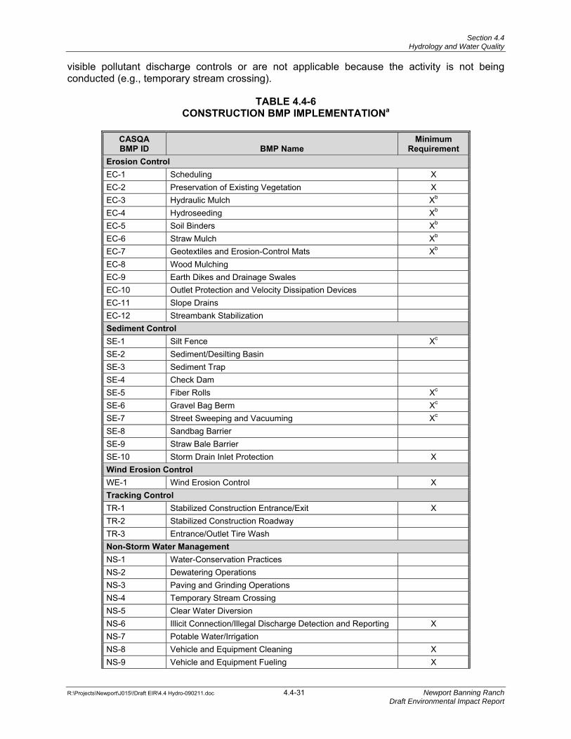
Section 4.4 Hydrology and Water Quality
R:\Projects\Newport\J015\!Draft EIR\4.4 Hydro-090211.doc 4.4-31 Newport Banning Ranch Draft Environmental Impact Report
visible pollutant discharge controls or are not applicable because the activity is not being conducted (e.g., temporary stream crossing).
TABLE 4.4-6 CONSTRUCTION BMP IMPLEMENTATIONa
CASQA BMP ID BMP Name
Minimum Requirement
Erosion Control EC-1 Scheduling X EC-2 Preservation of Existing Vegetation X EC-3 Hydraulic Mulch Xb EC-4 Hydroseeding Xb EC-5 Soil Binders Xb EC-6 Straw Mulch Xb EC-7 Geotextiles and Erosion-Control Mats Xb EC-8 Wood Mulching EC-9 Earth Dikes and Drainage Swales EC-10 Outlet Protection and Velocity Dissipation Devices EC-11 Slope Drains EC-12 Streambank Stabilization Sediment Control SE-1 Silt Fence Xc SE-2 Sediment/Desilting Basin SE-3 Sediment Trap SE-4 Check Dam SE-5 Fiber Rolls Xc SE-6 Gravel Bag Berm Xc SE-7 Street Sweeping and Vacuuming Xc SE-8 Sandbag Barrier SE-9 Straw Bale Barrier SE-10 Storm Drain Inlet Protection X Wind Erosion Control WE-1 Wind Erosion Control X Tracking Control TR-1 Stabilized Construction Entrance/Exit X TR-2 Stabilized Construction Roadway TR-3 Entrance/Outlet Tire Wash Non-Storm Water Management NS-1 Water-Conservation Practices NS-2 Dewatering Operations NS-3 Paving and Grinding Operations NS-4 Temporary Stream Crossing NS-5 Clear Water Diversion NS-6 Illicit Connection/Illegal Discharge Detection and Reporting X NS-7 Potable Water/Irrigation NS-8 Vehicle and Equipment Cleaning X NS-9 Vehicle and Equipment Fueling X
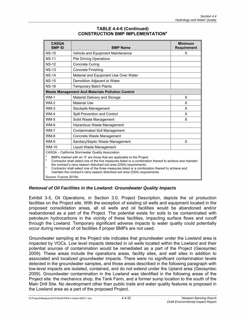
Section 4.4 Hydrology and Water Quality
TABLE 4.4-6 (Continued)
CONSTRUCTION BMP IMPLEMENTATIONa
R:\Projects\Newport\J015\!Draft EIR\4.4 Hydro-090211.doc 4.4-32 Newport Banning Ranch Draft Environmental Impact Report
CASQA BMP ID BMP Name
Minimum Requirement
NS-10 Vehicle and Equipment Maintenance X NS-11 Pile Driving Operations NS-12 Concrete Curing NS-13 Concrete Finishing NS-14 Material and Equipment Use Over Water NS-15 Demolition Adjacent to Water NS-16 Temporary Batch Plants Waste Management And Materials Pollution ControlWM-1 Material Delivery and Storage X WM-2 Material Use X WM-3 Stockpile Management X WM-4 Spill Prevention and Control X WM-5 Solid Waste Management X WM-6 Hazardous Waste Management WM-7 Contaminated Soil Management WM-8 Concrete Waste Management WM-9 Sanitary/Septic Waste Management X WM-10 Liquid Waste Management CASQA – California Stormwater Quality Association a BMPs marked with an ‘X’ are those that are applicable to the Project b Contractor shall select one of the five measures listed or a combination thereof to achieve and maintain
the contract’s rainy season disturbed soil area (DSA) requirements. c Contractor shall select one of the three measures listed or a combination thereof to achieve and
maintain the contract’s rainy season disturbed soil area (DSA) requirements. Source: Fuscoe 2010b.
Removal of Oil Facilities in the Lowland: Groundwater Quality Impacts
Exhibit 3-5, Oil Operations, in Section 3.0, Project Description, depicts the oil production facilities on the Project site. With the exception of existing oil wells and equipment located in the proposed consolidation areas, all oil wells and oil facilities would be abandoned and/or reabandoned as a part of the Project. The potential exists for soils to be contaminated with petroleum hydrocarbons in the vicinity of these facilities, impacting surface flows and runoff through the Lowland. Temporary significant adverse impacts to water quality could potentially occur during removal of oil facilities if proper BMPs are not used.
Groundwater sampling at the Project site indicates that groundwater under the Lowland area is impacted by VOCs. Low level impacts detected in oil wells located within the Lowland and their potential sources of contamination would be remediated as a part of the Project (Geosyntec 2009). These areas include the operations areas, facility sites, and well sites in addition to associated and localized groundwater impacts. There were no significant contamination levels detected in the groundwater samples, and those areas described in the following paragraph with low-level impacts are isolated, contained, and do not extend under the Upland area (Geosyntec 2009). Groundwater contamination in the Lowland was identified in the following areas of the Project site: the mechanics shop, the Tank Farm, and a former sump location to the south of the Main Drill Site. No development other than public trails and water quality features is proposed in the Lowland area as a part of the proposed Project.
Section 4.4 Hydrology and Water Quality
R:\Projects\Newport\J015\!Draft EIR\4.4 Hydro-090211.doc 4.4-33 Newport Banning Ranch Draft Environmental Impact Report
The on-site oil operations are currently subject to regulatory oversight by both the Santa Ana RWQCB and the Orange County Health Care Agency (OCHCA). Since about 1992, both agencies have been involved in overseeing certain aspects of cleanup activities and operations. Currently, the lead regulatory agency (Santa Ana RWQCB) for the Project site has approved a Remedial Action Plan (RAP) and is overseeing remediation efforts for an existing drill site in the northern portion of the proposed oil consolidation area (Geosyntec 2009). The draft Remedial Action Plan (dRAP) associated with the proposed Project is described and discussed in Section 4.5, Hazards and Hazardous Materials. The existing regulatory oversight structure, described further in Section 4.5 is expected to continue through the anticipated oilfield abandonment and remediation activities that would be necessary to implement the proposed Project.
Mitigation Measure (MM) 4.5-1 requires that a comprehensive final RAP be prepared and implemented on-site to address the removal and remediation of existing oil facilities on the Lowland, as discussed in Section 3.0, Project Description. The final RAP would be based upon the draft RAP (dRAP) and the existing clean-up and remediation activities on the Project site; would identify the remediation methods to be used that have been previously described in the dRAP; specify the cleanup levels for specific areas of the Project site depending upon the land uses proposed for those areas; and provide additional details regarding cleanup and remediation activities. The final RAP would be submitted to and approved by the Santa Ana RWQCB, OCHCA, and the Orange County Fire Authority prior to implementation.
In accordance with General Construction Permit criteria, additional BMPs would be implemented prior to, during, and after implementation of the final RAP until native vegetation is established and/or permanent BMPs are in place. In general, the process of plugging and abandoning wells would also include demolition and removing of the pipelines, utility poles and other related production equipment, buildings, and road surface materials, with the remediation process following shortly after the well demolition and abandonment process. During demolition, the site perimeter would be bermed with silt fencing (Construction BMP SE-1 on Table 4.4-6) or gravel bag berms (SE-6) to contain the area and limit erosion and runoff.5 Upstream runoff would be directed around the limits of work with the use of sediment and erosion control measures including berming and gravel bags (SE-6). Removed materials would be stockpiled in specified areas of the site and bermed and/or covered in accordance with stockpile management procedures (WM-3) until properly disposed of off-site or treated on-site in accordance with the final RAP. Additional construction BMPs would also be implemented in accordance with the Project SWPPP, including but not limited to: good housekeeping practices to contain potential construction materials (WM-1), leaks and maintenance activities for large equipment used on site (WM-4, NS-10), stabilized construction entrances, exits and roadways (TR-1, TR-2), and additional measures for management of contaminated soils (WM-7). Implementation of these BMPs would provide for the protection of surface water quality by avoiding and/or minimizing pollutant runoff into surface waters and provide for protection of groundwater quality by minimizing the introduction of pollutants into the groundwater table. Therefore, proposed Project’s impacts to groundwater and surface water associated with removal of oil facilities would be less than significant.
With the completion of permit documentation as described above and with the incorporation of specific BMPs required by the General Construction Permit associated with the Project Risk Level analysis, impacts to water quality from construction would be less than significant.
5 BMPs are provided in Table 4.4-6.
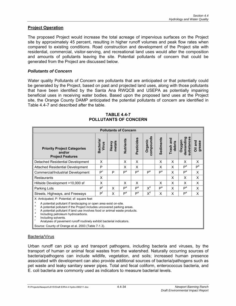
Section 4.4 Hydrology and Water Quality
R:\Projects\Newport\J015\!Draft EIR\4.4 Hydro-090211.doc 4.4-34 Newport Banning Ranch Draft Environmental Impact Report
Project Operation
The proposed Project would increase the total acreage of impervious surfaces on the Project site by approximately 45 percent, resulting in higher runoff volumes and peak flow rates when compared to existing conditions. Road construction and development of the Project site with residential, commercial, visitor-serving, and recreational land uses would alter the composition and amounts of pollutants leaving the site. Potential pollutants of concern that could be generated from the Project are discussed below.
Pollutants of Concern
Water quality Pollutants of Concern are pollutants that are anticipated or that potentially could be generated by the Project, based on past and projected land uses, along with those pollutants that have been identified by the Santa Ana RWQCB and USEPA as potentially impairing beneficial uses in receiving water bodies. Based upon the proposed land uses at the Project site, the Orange County DAMP anticipated the potential pollutants of concern are identified in Table 4.4-7 and described after the table.
TABLE 4.4-7 POLLUTANTS OF CONCERN
Pollutants of Concern
Priority Project Categories and/or
Project Features
Bac
teria
/ Vi
rus
Hea
vy
met
als
Nut
rient
s
Pest
icid
es
Org
anic
co
mpo
unds
Sedi
men
ts
Tras
h an
d de
bris
Oxy
gen
dem
andi
ng
subs
tanc
es
Oil
and
grea
se
Detached Residential Development X X X X X X X Attached Residential Development P X X X X Pa Pb Commercial/Industrial Development Pc P Pa Pa Pe Pa X Pa X Restaurants X X X X Hillside Development >10,000 sf X X X X X X X Parking Lots Pf X Pa Pa Xd Pa X Pa X Streets, Highways, and Freeways Pf X Pa Pa Xd X X Pa X X: Anticipated; P: Potential; sf: square feet a A potential pollutant if landscaping or open area exist on-site. b A potential pollutant if the Project includes uncovered parking areas. c A potential pollutant if land use involves food or animal waste products. d Including petroleum hydrocarbons. e Including solvents. f Analyses of pavement runoff routinely exhibit bacterial indicators. Source: County of Orange et al. 2003 (Table 7-1.3).
Bacteria/Virus
Urban runoff can pick up and transport pathogens, including bacteria and viruses, by the transport of human or animal fecal wastes from the watershed. Naturally occurring sources of bacteria/pathogens can include wildlife, vegetation, and soils; increased human presence associated with development can also provide additional sources of bacteria/pathogens such as pet waste and leaky sanitary sewer pipes. Total and fecal coliform, enterococcus bacteria, and E. coli bacteria are commonly used as indicators to measure bacterial levels.

Section 4.4 Hydrology and Water Quality
R:\Projects\Newport\J015\!Draft EIR\4.4 Hydro-090211.doc 4.4-35 Newport Banning Ranch Draft Environmental Impact Report
Heavy Metals
Metals are commonly found in paints, fuels, adhesives and coatings, and in structures and transportation facilities. Copper, lead, and zinc are the most common metals typically found in urban runoff, although other trace metals (such as cadmium, chromium, and mercury) may be also occur at low levels. Trace metals have the potential to cause toxic effects on aquatic life and are a potential source of groundwater contamination.
Nutrients
Nutrients are inorganic forms of phosphorous and nitrogen. The main sources of nutrients in urban areas include fertilizers in lawns, pet waste, failing septic systems, and atmospheric deposition from automobiles and industrial operations. The most common impact of excessive nutrient input is the eutrophication6 of the receiving water body, resulting in excessive algal production, adverse dissolved oxygen variations, fish kills, and potential releases of toxins from sediment due to changes in water chemistry.
Pesticides
Pesticides (including herbicides) are chemical compounds commonly used to control insects, rodents, plant diseases, and weeds. Excessive or inappropriate application of a pesticide may result in runoff containing toxic levels of these chemicals and other microorganisms flowing to receiving water bodies. The proposed Project would comply with the City’s standards and guidelines for Integrated Pest Management (IPM) in accordance with the Orange County DAMP and the MS4 Permit.
Organic Compounds
Organic compounds are typically found in pesticides, solvents, and hydrocarbons. Dirt, grease, and other particulates can also attract organic compounds in rinse water from cleaning objects, and can be harmful or hazardous to aquatic life either indirectly or directly.
Sediments
Increases in runoff velocities and volumes can cause excessive stream channel erosion and deposition, which upsets the balance of a natural channel system. Excessive suspension of fine sediment in water can impair aquatic life through reduced light transmission and temperature changes among other features.
Trash and Debris
Paper, plastics, and debris—including biodegradable organic matter such as leaves, grass cuttings, and food waste—can accumulate on the ground if not properly handled, and then become trapped in urban runoff. Transport of trash and debris can impair storm drain facilities, impact recreational enjoyment, and degrade downstream habitats.
Oxygen Demanding Substances
Oxygen-demanding substances include biodegradable organic material and chemicals that react with dissolved oxygen in water to form other compounds (e.g., proteins, carbohydrates, fats, ammonia, and hydrogen sulfide). The oxygen demand of a substance can lead to depletion 6 Eutrophication is a process where water bodies receive excess nutrients that stimulate excessive plant growth.
Section 4.4 Hydrology and Water Quality
R:\Projects\Newport\J015\!Draft EIR\4.4 Hydro-090211.doc 4.4-36 Newport Banning Ranch Draft Environmental Impact Report
of dissolved oxygen in a water body and possibly the development of conditions resulting in the growth of undesirable organisms, odor issues, and toxic releases.
Petroleum Hydrocarbons/Oil and Grease
The most common sources of oil and grease in urban runoff are from spilled fuels and lubricants, domestic and industrial wastes, atmospheric deposition, and runoff. Runoff can contain leachate from roads, break down of tires/rubber, and deposition of automobile exhaust. Hydrocarbons can bioaccumulate in organisms, and can persist in sediment for long periods of time in the environment reducing benthic7 biodiversity and abundance.
Site Design and Low Impact Development (LID) Best Management Practices
In order to minimize impacts and potential environmental harm from discharges containing these Pollutants of Concern (Table 4.4-7), the proposed Project has incorporated site design/LID strategies and source-control measures. LID features have been incorporated into the Project for storm water treatment and for reduction of runoff volumes. Throughout the Project site, the use of LID features would be implemented to meet water quality treatment requirements in concert with treatment-control BMPs. The Project approach relies on optimal use of LID features, supplemented with the treatment-control BMPs as secondary measures where LID measures are not feasible.
LID features would be sized for water quality treatment requirements according to the Santa Ana RWQCB’s sizing criteria, which are defined in the MS4 Permit for either flow-based or volume-based BMPs. The Project would integrate LID techniques throughout the development area to provide treatment of low-flow runoff directly at the source along with runoff reduction from small, frequent storm events. Final LID design features and sizing information would occur during development of construction-level documentation in the final WQMPs prior to issuance of grading permits by the City.
LID features would be implemented on the Project site and in transitional areas that lead into or out of the Project site. LID Project features to be installed on site would pre-treat storm water runoff and would remove large sediment, trash, and debris. These features could include cisterns and rain barrels, storm water planters, common area porous pavement, tree box fillers, and pocket rain gardens. Table 4.4-8 identifies the on-site design and LID features that would be incorporated into the Project design where feasible based upon proposed land uses.
7 The term benthic refers to organisms that reside within bottom sediments.
Section 4.4 Hydrology and Water Quality
R:\Projects\Newport\J015\!Draft EIR\4.4 Hydro-090211.doc 4.4-37 Newport Banning Ranch Draft Environmental Impact Report
TABLE 4.4-8 ON-SITE DESIGN AND LID BMPS
Project Category Application
Single-Family Residential SF-1: Incorporate landscaped areas on individual lots into overall site drainage design.
SF-2: Drain roof and driveway runoff into landscaped areas or pocket rain gardens.
SF-3: Use rain barrels to capture and store roof runoff for reuse as irrigation water.
SF-4: Use porous pavement in driveways and patios. Multi-Family Residential/Mixed-Use MF-1: Drain impervious areas into landscaped areas.
MF-2: Drain roof runoff into landscaping or cisterns for reuse as irrigation. MF-3: Direct runoff from sidewalks, common areas, and courtyards to pocket
rain gardens or landscaped areas. MF-4: Use porous pavement for sidewalks, courtyards, parking lots and low-
traffic drive aisles. Resort Inn and Commercial Use RC-1: Divert runoff from rooftops, sidewalks, courtyards and other
impervious areas to landscaping, storm water planters, and pocket rain gardens.
RC-2: Use cisterns to capture runoff from rooftops for reuse as irrigation. RC-3: Use porous pavement for parking stalls and drive aisles.
Source: Fuscoe 2010b.
Transitional Area LID Features
“Transitional areas” refer to primary streets and travel ways that lead into and out of the development areas. LID features within the transitional areas provide primary treatment of runoff filtering and removing pollutant-laden sediments. The primary water quality mechanism would be the use of integrated runoff treatment within “Green Streets” or sustainable travelways. Green Streets would include curbless edge conditions, parkway bioswales (biocells), trails, and/or biofiltration zones within the landscape setback areas for a variety of different sized streets within the Project site. This allows for the treatment of water quality at the source and for the reduction of peak storm water runoff volumes and rates. These streets would provide water quality treatment of flows generated from the streets; would provide treatment of adjacent development areas depending upon the volumes available within the LID landscaping features; and would deliver low flow runoff to these features. Several types of these features are listed in Table 4.4-9.
As previously noted, the identification and evaluation of the most effective Project BMPs would be completed during final development design, and would be provided in the Project’s WQMP. All LID site design features sized to handle the treatment requirements would be identified during final design and would be incorporated into water quality permit applications. These BMPs would ensure that Basin Plan standards are met through implementation.
Section 4.4 Hydrology and Water Quality
R:\Projects\Newport\J015\!Draft EIR\4.4 Hydro-090211.doc 4.4-38 Newport Banning Ranch Draft Environmental Impact Report
TABLE 4.4-9 TRANSITIONAL AREA LID FEATURES
LID
Feature Description
TA-1 Porous Pavement. Porous pavements allow precipitation and storm water runoff to infiltrate through void spaces within the pavement medium. Examples of porous pavement designs would include the use of pavers within common areas
TA-2 Tree Box Filters. Tree box filters are bioretention areas installed beneath trees. Runoff is directed to the tree box, where it is cleaned by vegetation and soil before entering a catch basin. The runoff collected in the tree-boxes also irrigates the trees.
TA-3 Vegetated Swales. Vegetated swales are treatment BMPs that provide filtration through a grass or vegetated bottom. The vegetation provides a mechanism for retarding surface runoff and filtering flows to drop sediments, fines, debris, and organics.
TA-4 Biocells. Biocells, also known as bioretention zones, are small, vegetated depressions to promote infiltration and soil-based filtering of storm water runoff. They combine shrubs, grasses, and flowering perennials in depressions that allow water to pool and infiltrate or evaporate within 24 to 48 hours. Bioswales can be incorporated into portions of the linear bioswales for additional treatment.
Source: Fuscoe 2010b.
Transitional Area LID Features: Landscaping Biocells
The use of the landscaping biocells in combination with other LID and Green Street features would provide substantial treatment and reduction of runoff at the source of the development areas (for detailed analysis, please see the Project’s Watershed Assessment Report). Each LID feature would be designed to accommodate the required treatment volume, and flow beyond this requirement would be designed to bypass the features for conveyance into the traditional storm drain system. In those instances where the proposed biocell features are not sufficient to handle treatment requirements independently, water quality calculations would quantify how much the additional treatment is required by the downstream water quality basins.
In order to determine the maximum treatment potential of the proposed subsurface biocells, the landscaping biocell areas within the parkway bioswale were evaluated to determine the appropriate volume they could treat based on the upstream tributary drainage areas. Results of the sizing analyses for the biocell sizing options are summarized in Table 4.4-10 and identify that the use of the landscaping biocells within the parkway bioswales in combination with other interior LID features would treat and reduce runoff from the development areas. Each biocell would be designed to accommodate the required treatment volume, and flow beyond this requirement would be designed to bypass the features for conveyance into the traditional storm drain system. In those instances where the LID features are not sufficient to handle treatment requirements independently, the next LID feature downstream would provide treatment. These analyses support the conclusion that the Project as proposed would sufficiently treat site requirements for storm water runoff water quality through landscaping biocell development. As needed, each LID feature designed into the Project in the downstream direction would be sized to accommodate flows from the upstream LID feature.
Section 4.4 Hydrology and Water Quality
R:\Projects\Newport\J015\!Draft EIR\4.4 Hydro-090211.doc 4.4-39 Newport Banning Ranch Draft Environmental Impact Report
TABLE 4.4-10 SUMMARY OF BMP SIZING FOR GREEN STREET FEATURES
Green Street Treatment Potential
Green Street with
Landscaping Biocells Area
Minimum Design Capture Volumeb
Minimum Treatment Capacityc BMP Type
Primary Treatment
Mechanism
Arterial Streets 19.42 acres 0.94 af ~0.94 af Green Street Biocells/Bioswales Bio-treatmentd
Collector Streets 4.14 acres 0.20 af ~0.2 af Green Street Biocells/Bioswales Bio-treatment
af: acre feet a Refer to Exhibit 4.4-7 for locations of the drainage boundaries used for BMP calculations. b Minimum design capture volume is the required SQDV for the contributing street drainage areas. Detailed
calculations are provided in Appendix E to the Watershed Assessment Report (see Appendix C of this EIR). c Minimum treatment capacity assumes approximately 25% of the proposed parkway bioswales include the biocell
sub-surface component at the downstream end of the swale, sufficient to treat the design capture volume for associated street runoff.. In some areas, the biocell sub-surface enhancements may be expanded to bio-treat additional areas beyond the street drainage where feasible.
d “Bio-treatment” is generally defined as soil and plant-based filtration BMPs, such as bioretention where the runoff volume is filtered through vegetation and soil filtration layers. Bio-treatment BMPs that release treated flows off-site are subject to feasibility criteria per OC DAMP and Countywide Model WQMP. Where feasible, infiltration of treated runoff would be used.
Source: Fuscoe 2010b.
Site Design BMPs
The Site Design BMPs presented in Table 4.4-11 (excerpted from the DAMP) intend to minimize storm water runoff, the Project’s impervious footprint, and any directly connected impervious areas; they also help to conserve natural areas. Priority projects as defined in the DAMP (of which the proposed Project is included) would also incorporate the design elements listed below, as appropriate (and as further refined within the Project’s WQMP and NPDES permit compliance documentation), and would incorporate site-design BMPs included in any regional or watershed program that the Project relies upon for treatment-control BMPs.
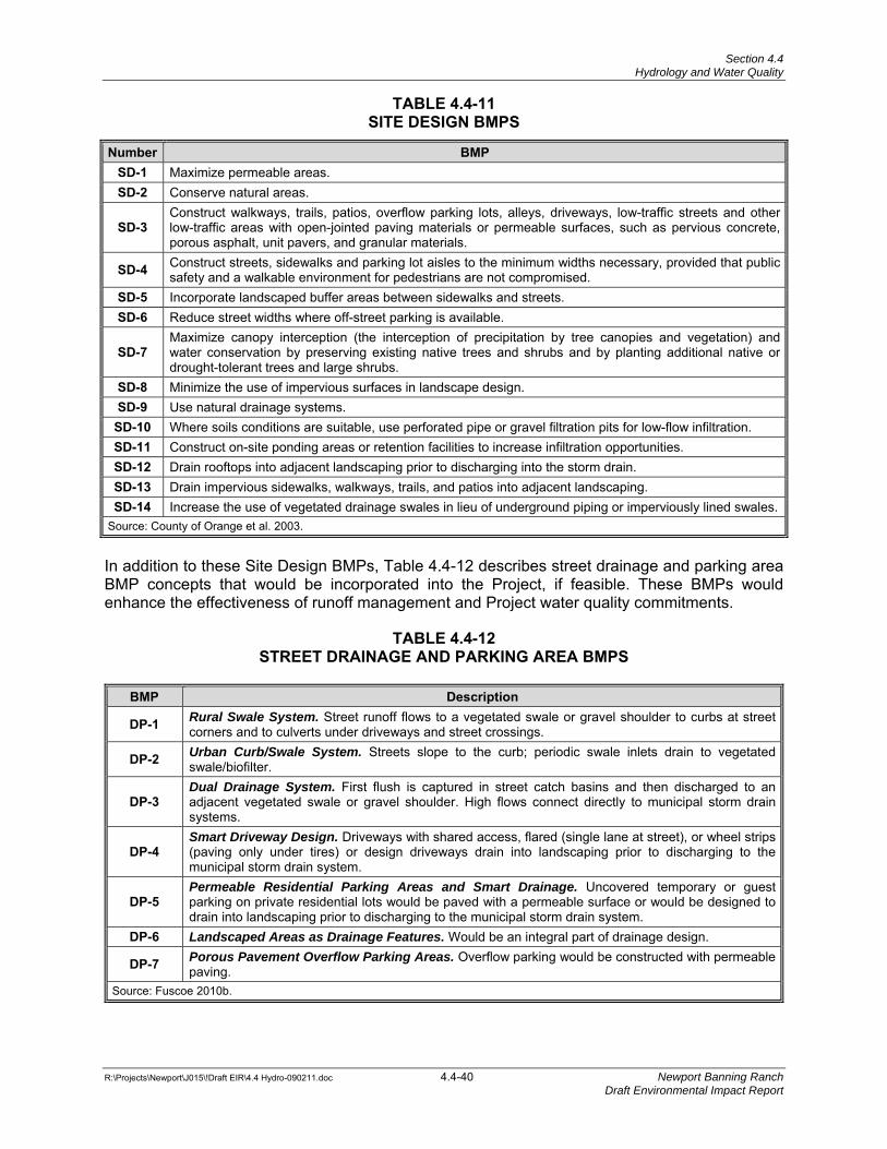
Section 4.4 Hydrology and Water Quality
R:\Projects\Newport\J015\!Draft EIR\4.4 Hydro-090211.doc 4.4-40 Newport Banning Ranch Draft Environmental Impact Report
TABLE 4.4-11 SITE DESIGN BMPS
Number BMPSD-1 Maximize permeable areas. SD-2 Conserve natural areas.
SD-3 Construct walkways, trails, patios, overflow parking lots, alleys, driveways, low-traffic streets and other low-traffic areas with open-jointed paving materials or permeable surfaces, such as pervious concrete, porous asphalt, unit pavers, and granular materials.
SD-4 Construct streets, sidewalks and parking lot aisles to the minimum widths necessary, provided that public safety and a walkable environment for pedestrians are not compromised.
SD-5 Incorporate landscaped buffer areas between sidewalks and streets. SD-6 Reduce street widths where off-street parking is available.
SD-7 Maximize canopy interception (the interception of precipitation by tree canopies and vegetation) and water conservation by preserving existing native trees and shrubs and by planting additional native or drought-tolerant trees and large shrubs.
SD-8 Minimize the use of impervious surfaces in landscape design. SD-9 Use natural drainage systems.
SD-10 Where soils conditions are suitable, use perforated pipe or gravel filtration pits for low-flow infiltration. SD-11 Construct on-site ponding areas or retention facilities to increase infiltration opportunities. SD-12 Drain rooftops into adjacent landscaping prior to discharging into the storm drain. SD-13 Drain impervious sidewalks, walkways, trails, and patios into adjacent landscaping. SD-14 Increase the use of vegetated drainage swales in lieu of underground piping or imperviously lined swales.
Source: County of Orange et al. 2003.
In addition to these Site Design BMPs, Table 4.4-12 describes street drainage and parking area BMP concepts that would be incorporated into the Project, if feasible. These BMPs would enhance the effectiveness of runoff management and Project water quality commitments.
TABLE 4.4-12 STREET DRAINAGE AND PARKING AREA BMPS
BMP Description
DP-1 Rural Swale System. Street runoff flows to a vegetated swale or gravel shoulder to curbs at street corners and to culverts under driveways and street crossings.
DP-2 Urban Curb/Swale System. Streets slope to the curb; periodic swale inlets drain to vegetated swale/biofilter.
DP-3 Dual Drainage System. First flush is captured in street catch basins and then discharged to an adjacent vegetated swale or gravel shoulder. High flows connect directly to municipal storm drain systems.
DP-4 Smart Driveway Design. Driveways with shared access, flared (single lane at street), or wheel strips (paving only under tires) or design driveways drain into landscaping prior to discharging to the municipal storm drain system.
DP-5 Permeable Residential Parking Areas and Smart Drainage. Uncovered temporary or guest parking on private residential lots would be paved with a permeable surface or would be designed to drain into landscaping prior to discharging to the municipal storm drain system.
DP-6 Landscaped Areas as Drainage Features. Would be an integral part of drainage design.
DP-7 Porous Pavement Overflow Parking Areas. Overflow parking would be constructed with permeable paving.
Source: Fuscoe 2010b.
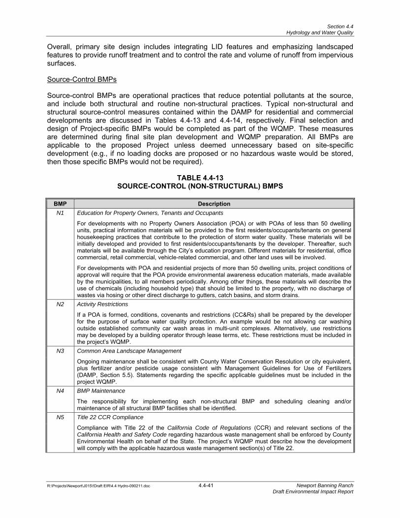
Section 4.4 Hydrology and Water Quality
R:\Projects\Newport\J015\!Draft EIR\4.4 Hydro-090211.doc 4.4-41 Newport Banning Ranch Draft Environmental Impact Report
Overall, primary site design includes integrating LID features and emphasizing landscaped features to provide runoff treatment and to control the rate and volume of runoff from impervious surfaces.
Source-Control BMPs
Source-control BMPs are operational practices that reduce potential pollutants at the source, and include both structural and routine non-structural practices. Typical non-structural and structural source-control measures contained within the DAMP for residential and commercial developments are discussed in Tables 4.4-13 and 4.4-14, respectively. Final selection and design of Project-specific BMPs would be completed as part of the WQMP. These measures are determined during final site plan development and WQMP preparation. All BMPs are applicable to the proposed Project unless deemed unnecessary based on site-specific development (e.g., if no loading docks are proposed or no hazardous waste would be stored, then those specific BMPs would not be required).
TABLE 4.4-13 SOURCE-CONTROL (NON-STRUCTURAL) BMPS
BMP DescriptionN1 Education for Property Owners, Tenants and Occupants
For developments with no Property Owners Association (POA) or with POAs of less than 50 dwelling units, practical information materials will be provided to the first residents/occupants/tenants on general housekeeping practices that contribute to the protection of storm water quality. These materials will be initially developed and provided to first residents/occupants/tenants by the developer. Thereafter, such materials will be available through the City’s education program. Different materials for residential, office commercial, retail commercial, vehicle-related commercial, and other land uses will be involved.
For developments with POA and residential projects of more than 50 dwelling units, project conditions of approval will require that the POA provide environmental awareness education materials, made available by the municipalities, to all members periodically. Among other things, these materials will describe the use of chemicals (including household type) that should be limited to the property, with no discharge of wastes via hosing or other direct discharge to gutters, catch basins, and storm drains.
N2 Activity Restrictions
If a POA is formed, conditions, covenants and restrictions (CC&Rs) shall be prepared by the developer for the purpose of surface water quality protection. An example would be not allowing car washing outside established community car wash areas in multi-unit complexes. Alternatively, use restrictions may be developed by a building operator through lease terms, etc. These restrictions must be included in the project’s WQMP.
N3 Common Area Landscape Management
Ongoing maintenance shall be consistent with County Water Conservation Resolution or city equivalent, plus fertilizer and/or pesticide usage consistent with Management Guidelines for Use of Fertilizers (DAMP, Section 5.5). Statements regarding the specific applicable guidelines must be included in the project WQMP.
N4 BMP Maintenance
The responsibility for implementing each non-structural BMP and scheduling cleaning and/or maintenance of all structural BMP facilities shall be identified.
N5 Title 22 CCR Compliance
Compliance with Title 22 of the California Code of Regulations (CCR) and relevant sections of the California Health and Safety Code regarding hazardous waste management shall be enforced by County Environmental Health on behalf of the State. The project’s WQMP must describe how the development will comply with the applicable hazardous waste management section(s) of Title 22.
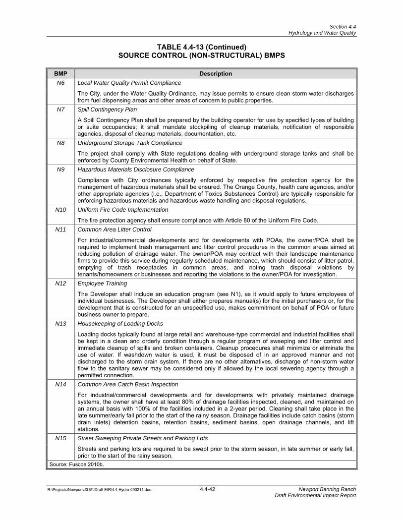
Section 4.4 Hydrology and Water Quality
TABLE 4.4-13 (Continued)
SOURCE CONTROL (NON-STRUCTURAL) BMPS
R:\Projects\Newport\J015\!Draft EIR\4.4 Hydro-090211.doc 4.4-42 Newport Banning Ranch Draft Environmental Impact Report
BMP DescriptionN6 Local Water Quality Permit Compliance
The City, under the Water Quality Ordinance, may issue permits to ensure clean storm water discharges from fuel dispensing areas and other areas of concern to public properties.
N7 Spill Contingency Plan
A Spill Contingency Plan shall be prepared by the building operator for use by specified types of building or suite occupancies; it shall mandate stockpiling of cleanup materials, notification of responsible agencies, disposal of cleanup materials, documentation, etc.
N8 Underground Storage Tank Compliance
The project shall comply with State regulations dealing with underground storage tanks and shall be enforced by County Environmental Health on behalf of State.
N9 Hazardous Materials Disclosure Compliance
Compliance with City ordinances typically enforced by respective fire protection agency for the management of hazardous materials shall be ensured. The Orange County, health care agencies, and/or other appropriate agencies (i.e., Department of Toxics Substances Control) are typically responsible for enforcing hazardous materials and hazardous waste handling and disposal regulations.
N10 Uniform Fire Code Implementation
The fire protection agency shall ensure compliance with Article 80 of the Uniform Fire Code. N11 Common Area Litter Control
For industrial/commercial developments and for developments with POAs, the owner/POA shall be required to implement trash management and litter control procedures in the common areas aimed at reducing pollution of drainage water. The owner/POA may contract with their landscape maintenance firms to provide this service during regularly scheduled maintenance, which should consist of litter patrol, emptying of trash receptacles in common areas, and noting trash disposal violations by tenants/homeowners or businesses and reporting the violations to the owner/POA for investigation.
N12 Employee Training
The Developer shall include an education program (see N1), as it would apply to future employees of individual businesses. The Developer shall either prepares manual(s) for the initial purchasers or, for the development that is constructed for an unspecified use, makes commitment on behalf of POA or future business owner to prepare.
N13 Housekeeping of Loading Docks
Loading docks typically found at large retail and warehouse-type commercial and industrial facilities shall be kept in a clean and orderly condition through a regular program of sweeping and litter control and immediate cleanup of spills and broken containers. Cleanup procedures shall minimize or eliminate the use of water. If washdown water is used, it must be disposed of in an approved manner and not discharged to the storm drain system. If there are no other alternatives, discharge of non-storm water flow to the sanitary sewer may be considered only if allowed by the local sewering agency through a permitted connection.
N14 Common Area Catch Basin Inspection
For industrial/commercial developments and for developments with privately maintained drainage systems, the owner shall have at least 80% of drainage facilities inspected, cleaned, and maintained on an annual basis with 100% of the facilities included in a 2-year period. Cleaning shall take place in the late summer/early fall prior to the start of the rainy season. Drainage facilities include catch basins (storm drain inlets) detention basins, retention basins, sediment basins, open drainage channels, and lift stations.
N15 Street Sweeping Private Streets and Parking Lots
Streets and parking lots are required to be swept prior to the storm season, in late summer or early fall, prior to the start of the rainy season.
Source: Fuscoe 2010b.
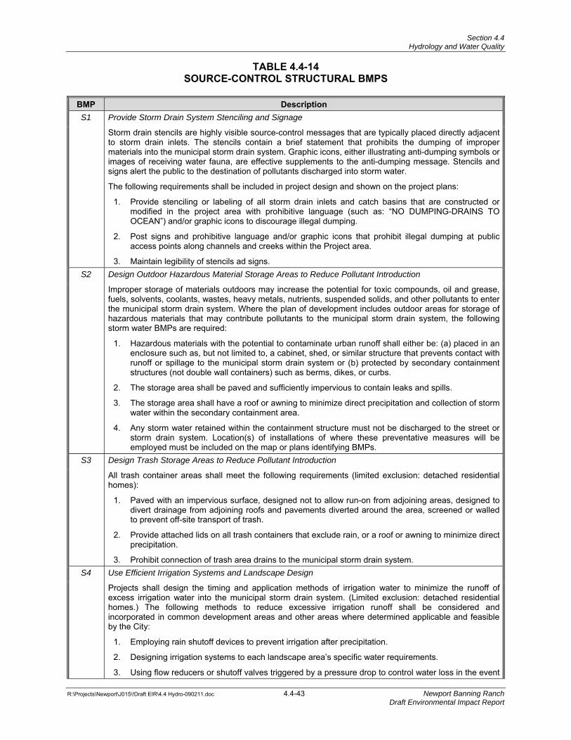
Section 4.4 Hydrology and Water Quality
R:\Projects\Newport\J015\!Draft EIR\4.4 Hydro-090211.doc 4.4-43 Newport Banning Ranch Draft Environmental Impact Report
TABLE 4.4-14 SOURCE-CONTROL STRUCTURAL BMPS
BMP DescriptionS1 Provide Storm Drain System Stenciling and Signage
Storm drain stencils are highly visible source-control messages that are typically placed directly adjacent to storm drain inlets. The stencils contain a brief statement that prohibits the dumping of improper materials into the municipal storm drain system. Graphic icons, either illustrating anti-dumping symbols or images of receiving water fauna, are effective supplements to the anti-dumping message. Stencils and signs alert the public to the destination of pollutants discharged into storm water.
The following requirements shall be included in project design and shown on the project plans:
1. Provide stenciling or labeling of all storm drain inlets and catch basins that are constructed or modified in the project area with prohibitive language (such as: “NO DUMPING-DRAINS TO OCEAN”) and/or graphic icons to discourage illegal dumping.
2. Post signs and prohibitive language and/or graphic icons that prohibit illegal dumping at public access points along channels and creeks within the Project area.
3. Maintain legibility of stencils ad signs. S2 Design Outdoor Hazardous Material Storage Areas to Reduce Pollutant Introduction
Improper storage of materials outdoors may increase the potential for toxic compounds, oil and grease, fuels, solvents, coolants, wastes, heavy metals, nutrients, suspended solids, and other pollutants to enter the municipal storm drain system. Where the plan of development includes outdoor areas for storage of hazardous materials that may contribute pollutants to the municipal storm drain system, the following storm water BMPs are required:
1. Hazardous materials with the potential to contaminate urban runoff shall either be: (a) placed in an enclosure such as, but not limited to, a cabinet, shed, or similar structure that prevents contact with runoff or spillage to the municipal storm drain system or (b) protected by secondary containment structures (not double wall containers) such as berms, dikes, or curbs.
2. The storage area shall be paved and sufficiently impervious to contain leaks and spills.
3. The storage area shall have a roof or awning to minimize direct precipitation and collection of storm water within the secondary containment area.
4. Any storm water retained within the containment structure must not be discharged to the street or storm drain system. Location(s) of installations of where these preventative measures will be employed must be included on the map or plans identifying BMPs.
S3 Design Trash Storage Areas to Reduce Pollutant Introduction
All trash container areas shall meet the following requirements (limited exclusion: detached residential homes):
1. Paved with an impervious surface, designed not to allow run-on from adjoining areas, designed to divert drainage from adjoining roofs and pavements diverted around the area, screened or walled to prevent off-site transport of trash.
2. Provide attached lids on all trash containers that exclude rain, or a roof or awning to minimize direct precipitation.
3. Prohibit connection of trash area drains to the municipal storm drain system. S4 Use Efficient Irrigation Systems and Landscape Design
Projects shall design the timing and application methods of irrigation water to minimize the runoff of excess irrigation water into the municipal storm drain system. (Limited exclusion: detached residential homes.) The following methods to reduce excessive irrigation runoff shall be considered and incorporated in common development areas and other areas where determined applicable and feasible by the City:
1. Employing rain shutoff devices to prevent irrigation after precipitation.
2. Designing irrigation systems to each landscape area’s specific water requirements.
3. Using flow reducers or shutoff valves triggered by a pressure drop to control water loss in the event
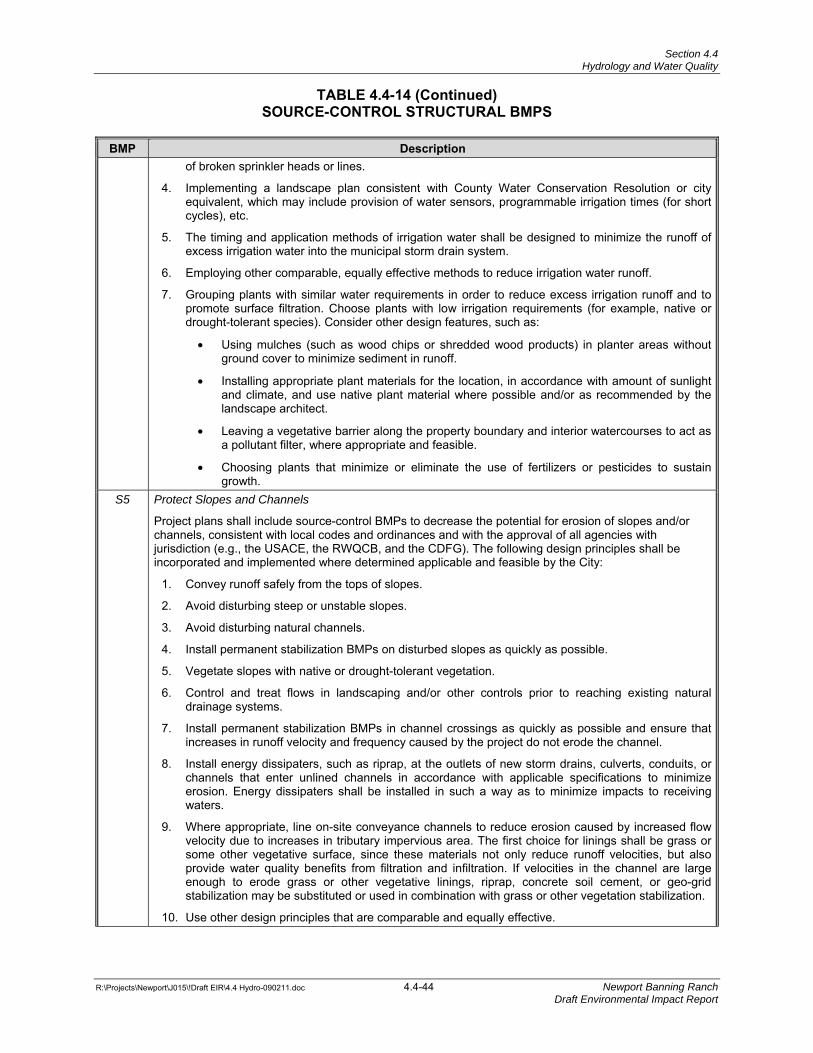
Section 4.4 Hydrology and Water Quality
TABLE 4.4-14 (Continued)
SOURCE-CONTROL STRUCTURAL BMPS
R:\Projects\Newport\J015\!Draft EIR\4.4 Hydro-090211.doc 4.4-44 Newport Banning Ranch Draft Environmental Impact Report
BMP Descriptionof broken sprinkler heads or lines.
4. Implementing a landscape plan consistent with County Water Conservation Resolution or city equivalent, which may include provision of water sensors, programmable irrigation times (for short cycles), etc.
5. The timing and application methods of irrigation water shall be designed to minimize the runoff of excess irrigation water into the municipal storm drain system.
6. Employing other comparable, equally effective methods to reduce irrigation water runoff.
7. Grouping plants with similar water requirements in order to reduce excess irrigation runoff and to promote surface filtration. Choose plants with low irrigation requirements (for example, native or drought-tolerant species). Consider other design features, such as:
• Using mulches (such as wood chips or shredded wood products) in planter areas without ground cover to minimize sediment in runoff.
• Installing appropriate plant materials for the location, in accordance with amount of sunlight and climate, and use native plant material where possible and/or as recommended by the landscape architect.
• Leaving a vegetative barrier along the property boundary and interior watercourses to act as a pollutant filter, where appropriate and feasible.
• Choosing plants that minimize or eliminate the use of fertilizers or pesticides to sustain growth.
S5 Protect Slopes and Channels
Project plans shall include source-control BMPs to decrease the potential for erosion of slopes and/or channels, consistent with local codes and ordinances and with the approval of all agencies with jurisdiction (e.g., the USACE, the RWQCB, and the CDFG). The following design principles shall be incorporated and implemented where determined applicable and feasible by the City:
1. Convey runoff safely from the tops of slopes.
2. Avoid disturbing steep or unstable slopes.
3. Avoid disturbing natural channels.
4. Install permanent stabilization BMPs on disturbed slopes as quickly as possible.
5. Vegetate slopes with native or drought-tolerant vegetation.
6. Control and treat flows in landscaping and/or other controls prior to reaching existing natural drainage systems.
7. Install permanent stabilization BMPs in channel crossings as quickly as possible and ensure that increases in runoff velocity and frequency caused by the project do not erode the channel.
8. Install energy dissipaters, such as riprap, at the outlets of new storm drains, culverts, conduits, or channels that enter unlined channels in accordance with applicable specifications to minimize erosion. Energy dissipaters shall be installed in such a way as to minimize impacts to receiving waters.
9. Where appropriate, line on-site conveyance channels to reduce erosion caused by increased flow velocity due to increases in tributary impervious area. The first choice for linings shall be grass or some other vegetative surface, since these materials not only reduce runoff velocities, but also provide water quality benefits from filtration and infiltration. If velocities in the channel are large enough to erode grass or other vegetative linings, riprap, concrete soil cement, or geo-grid stabilization may be substituted or used in combination with grass or other vegetation stabilization.
10. Use other design principles that are comparable and equally effective.
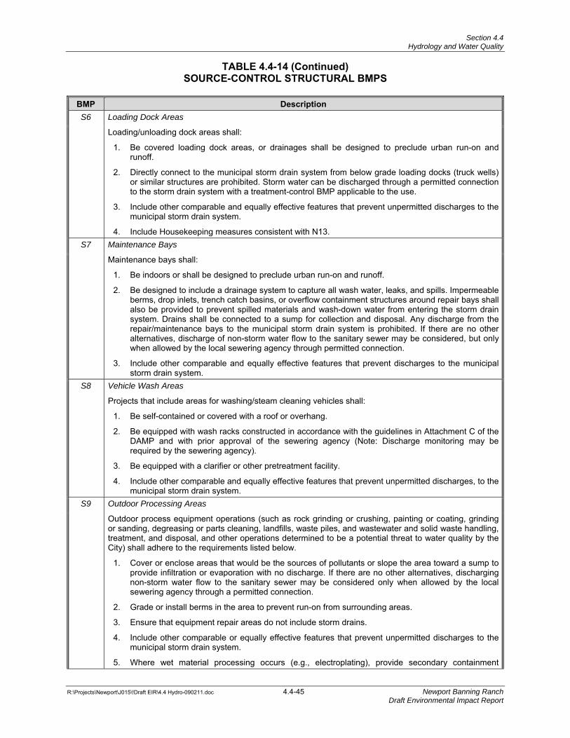
Section 4.4 Hydrology and Water Quality
TABLE 4.4-14 (Continued)
SOURCE-CONTROL STRUCTURAL BMPS
R:\Projects\Newport\J015\!Draft EIR\4.4 Hydro-090211.doc 4.4-45 Newport Banning Ranch Draft Environmental Impact Report
BMP DescriptionS6 Loading Dock Areas
Loading/unloading dock areas shall:
1. Be covered loading dock areas, or drainages shall be designed to preclude urban run-on and runoff.
2. Directly connect to the municipal storm drain system from below grade loading docks (truck wells) or similar structures are prohibited. Storm water can be discharged through a permitted connection to the storm drain system with a treatment-control BMP applicable to the use.
3. Include other comparable and equally effective features that prevent unpermitted discharges to the municipal storm drain system.
4. Include Housekeeping measures consistent with N13. S7 Maintenance Bays
Maintenance bays shall:
1. Be indoors or shall be designed to preclude urban run-on and runoff.
2. Be designed to include a drainage system to capture all wash water, leaks, and spills. Impermeable berms, drop inlets, trench catch basins, or overflow containment structures around repair bays shall also be provided to prevent spilled materials and wash-down water from entering the storm drain system. Drains shall be connected to a sump for collection and disposal. Any discharge from the repair/maintenance bays to the municipal storm drain system is prohibited. If there are no other alternatives, discharge of non-storm water flow to the sanitary sewer may be considered, but only when allowed by the local sewering agency through permitted connection.
3. Include other comparable and equally effective features that prevent discharges to the municipal storm drain system.
S8 Vehicle Wash Areas
Projects that include areas for washing/steam cleaning vehicles shall:
1. Be self-contained or covered with a roof or overhang.
2. Be equipped with wash racks constructed in accordance with the guidelines in Attachment C of the DAMP and with prior approval of the sewering agency (Note: Discharge monitoring may be required by the sewering agency).
3. Be equipped with a clarifier or other pretreatment facility.
4. Include other comparable and equally effective features that prevent unpermitted discharges, to the municipal storm drain system.
S9 Outdoor Processing Areas
Outdoor process equipment operations (such as rock grinding or crushing, painting or coating, grinding or sanding, degreasing or parts cleaning, landfills, waste piles, and wastewater and solid waste handling, treatment, and disposal, and other operations determined to be a potential threat to water quality by the City) shall adhere to the requirements listed below.
1. Cover or enclose areas that would be the sources of pollutants or slope the area toward a sump to provide infiltration or evaporation with no discharge. If there are no other alternatives, discharging non-storm water flow to the sanitary sewer may be considered only when allowed by the local sewering agency through a permitted connection.
2. Grade or install berms in the area to prevent run-on from surrounding areas.
3. Ensure that equipment repair areas do not include storm drains.
4. Include other comparable or equally effective features that prevent unpermitted discharges to the municipal storm drain system.
5. Where wet material processing occurs (e.g., electroplating), provide secondary containment
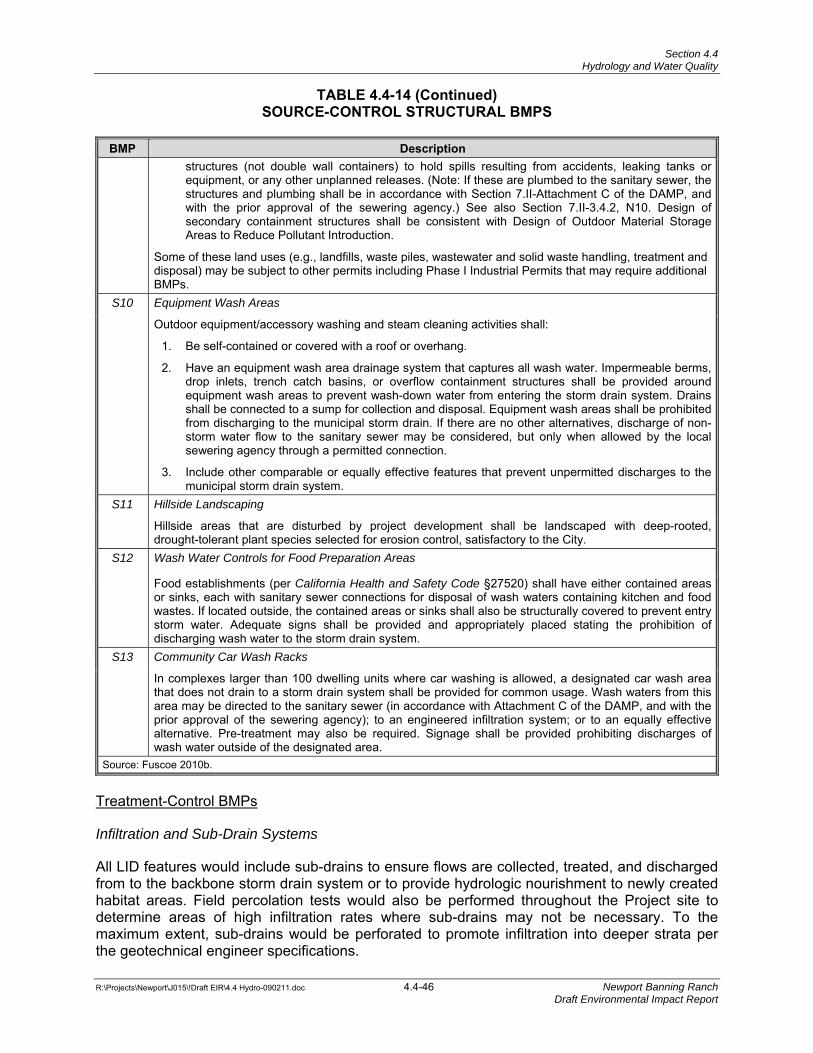
Section 4.4 Hydrology and Water Quality
TABLE 4.4-14 (Continued)
SOURCE-CONTROL STRUCTURAL BMPS
R:\Projects\Newport\J015\!Draft EIR\4.4 Hydro-090211.doc 4.4-46 Newport Banning Ranch Draft Environmental Impact Report
BMP Descriptionstructures (not double wall containers) to hold spills resulting from accidents, leaking tanks or equipment, or any other unplanned releases. (Note: If these are plumbed to the sanitary sewer, the structures and plumbing shall be in accordance with Section 7.II-Attachment C of the DAMP, and with the prior approval of the sewering agency.) See also Section 7.II-3.4.2, N10. Design of secondary containment structures shall be consistent with Design of Outdoor Material Storage Areas to Reduce Pollutant Introduction.
Some of these land uses (e.g., landfills, waste piles, wastewater and solid waste handling, treatment and disposal) may be subject to other permits including Phase I Industrial Permits that may require additional BMPs.
S10 Equipment Wash Areas
Outdoor equipment/accessory washing and steam cleaning activities shall:
1. Be self-contained or covered with a roof or overhang.
2. Have an equipment wash area drainage system that captures all wash water. Impermeable berms, drop inlets, trench catch basins, or overflow containment structures shall be provided around equipment wash areas to prevent wash-down water from entering the storm drain system. Drains shall be connected to a sump for collection and disposal. Equipment wash areas shall be prohibited from discharging to the municipal storm drain. If there are no other alternatives, discharge of non-storm water flow to the sanitary sewer may be considered, but only when allowed by the local sewering agency through a permitted connection.
3. Include other comparable or equally effective features that prevent unpermitted discharges to the municipal storm drain system.
S11 Hillside Landscaping
Hillside areas that are disturbed by project development shall be landscaped with deep-rooted, drought-tolerant plant species selected for erosion control, satisfactory to the City.
S12 Wash Water Controls for Food Preparation Areas
Food establishments (per California Health and Safety Code §27520) shall have either contained areas or sinks, each with sanitary sewer connections for disposal of wash waters containing kitchen and food wastes. If located outside, the contained areas or sinks shall also be structurally covered to prevent entry storm water. Adequate signs shall be provided and appropriately placed stating the prohibition of discharging wash water to the storm drain system.
S13 Community Car Wash Racks
In complexes larger than 100 dwelling units where car washing is allowed, a designated car wash area that does not drain to a storm drain system shall be provided for common usage. Wash waters from this area may be directed to the sanitary sewer (in accordance with Attachment C of the DAMP, and with the prior approval of the sewering agency); to an engineered infiltration system; or to an equally effective alternative. Pre-treatment may also be required. Signage shall be provided prohibiting discharges of wash water outside of the designated area.
Source: Fuscoe 2010b.
Treatment-Control BMPs
Infiltration and Sub-Drain Systems
All LID features would include sub-drains to ensure flows are collected, treated, and discharged from to the backbone storm drain system or to provide hydrologic nourishment to newly created habitat areas. Field percolation tests would also be performed throughout the Project site to determine areas of high infiltration rates where sub-drains may not be necessary. To the maximum extent, sub-drains would be perforated to promote infiltration into deeper strata per the geotechnical engineer specifications.
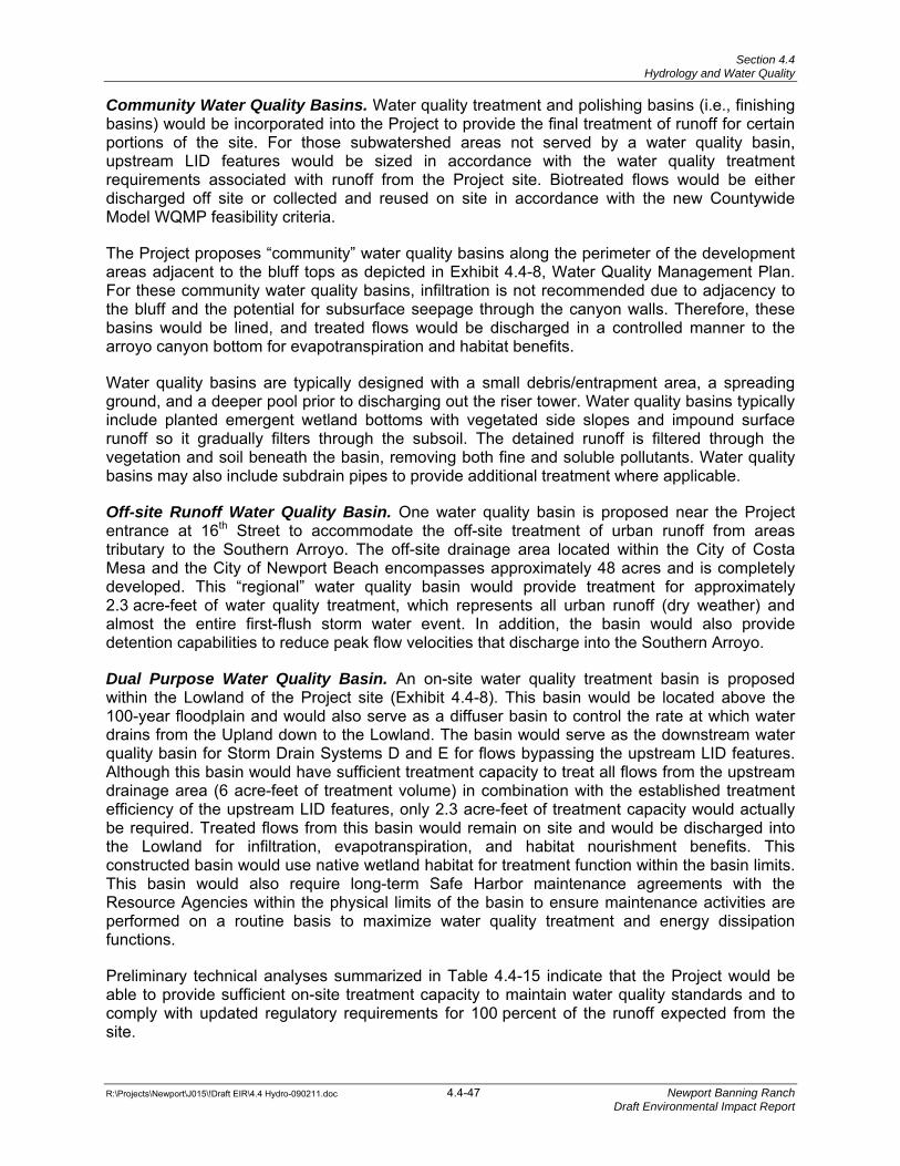
Section 4.4 Hydrology and Water Quality
R:\Projects\Newport\J015\!Draft EIR\4.4 Hydro-090211.doc 4.4-47 Newport Banning Ranch Draft Environmental Impact Report
Community Water Quality Basins. Water quality treatment and polishing basins (i.e., finishing basins) would be incorporated into the Project to provide the final treatment of runoff for certain portions of the site. For those subwatershed areas not served by a water quality basin, upstream LID features would be sized in accordance with the water quality treatment requirements associated with runoff from the Project site. Biotreated flows would be either discharged off site or collected and reused on site in accordance with the new Countywide Model WQMP feasibility criteria.
The Project proposes “community” water quality basins along the perimeter of the development areas adjacent to the bluff tops as depicted in Exhibit 4.4-8, Water Quality Management Plan. For these community water quality basins, infiltration is not recommended due to adjacency to the bluff and the potential for subsurface seepage through the canyon walls. Therefore, these basins would be lined, and treated flows would be discharged in a controlled manner to the arroyo canyon bottom for evapotranspiration and habitat benefits.
Water quality basins are typically designed with a small debris/entrapment area, a spreading ground, and a deeper pool prior to discharging out the riser tower. Water quality basins typically include planted emergent wetland bottoms with vegetated side slopes and impound surface runoff so it gradually filters through the subsoil. The detained runoff is filtered through the vegetation and soil beneath the basin, removing both fine and soluble pollutants. Water quality basins may also include subdrain pipes to provide additional treatment where applicable.
Off-site Runoff Water Quality Basin. One water quality basin is proposed near the Project entrance at 16th Street to accommodate the off-site treatment of urban runoff from areas tributary to the Southern Arroyo. The off-site drainage area located within the City of Costa Mesa and the City of Newport Beach encompasses approximately 48 acres and is completely developed. This “regional” water quality basin would provide treatment for approximately 2.3 acre-feet of water quality treatment, which represents all urban runoff (dry weather) and almost the entire first-flush storm water event. In addition, the basin would also provide detention capabilities to reduce peak flow velocities that discharge into the Southern Arroyo.
Dual Purpose Water Quality Basin. An on-site water quality treatment basin is proposed within the Lowland of the Project site (Exhibit 4.4-8). This basin would be located above the 100-year floodplain and would also serve as a diffuser basin to control the rate at which water drains from the Upland down to the Lowland. The basin would serve as the downstream water quality basin for Storm Drain Systems D and E for flows bypassing the upstream LID features. Although this basin would have sufficient treatment capacity to treat all flows from the upstream drainage area (6 acre-feet of treatment volume) in combination with the established treatment efficiency of the upstream LID features, only 2.3 acre-feet of treatment capacity would actually be required. Treated flows from this basin would remain on site and would be discharged into the Lowland for infiltration, evapotranspiration, and habitat nourishment benefits. This constructed basin would use native wetland habitat for treatment function within the basin limits. This basin would also require long-term Safe Harbor maintenance agreements with the Resource Agencies within the physical limits of the basin to ensure maintenance activities are performed on a routine basis to maximize water quality treatment and energy dissipation functions.
Preliminary technical analyses summarized in Table 4.4-15 indicate that the Project would be able to provide sufficient on-site treatment capacity to maintain water quality standards and to comply with updated regulatory requirements for 100 percent of the runoff expected from the site.
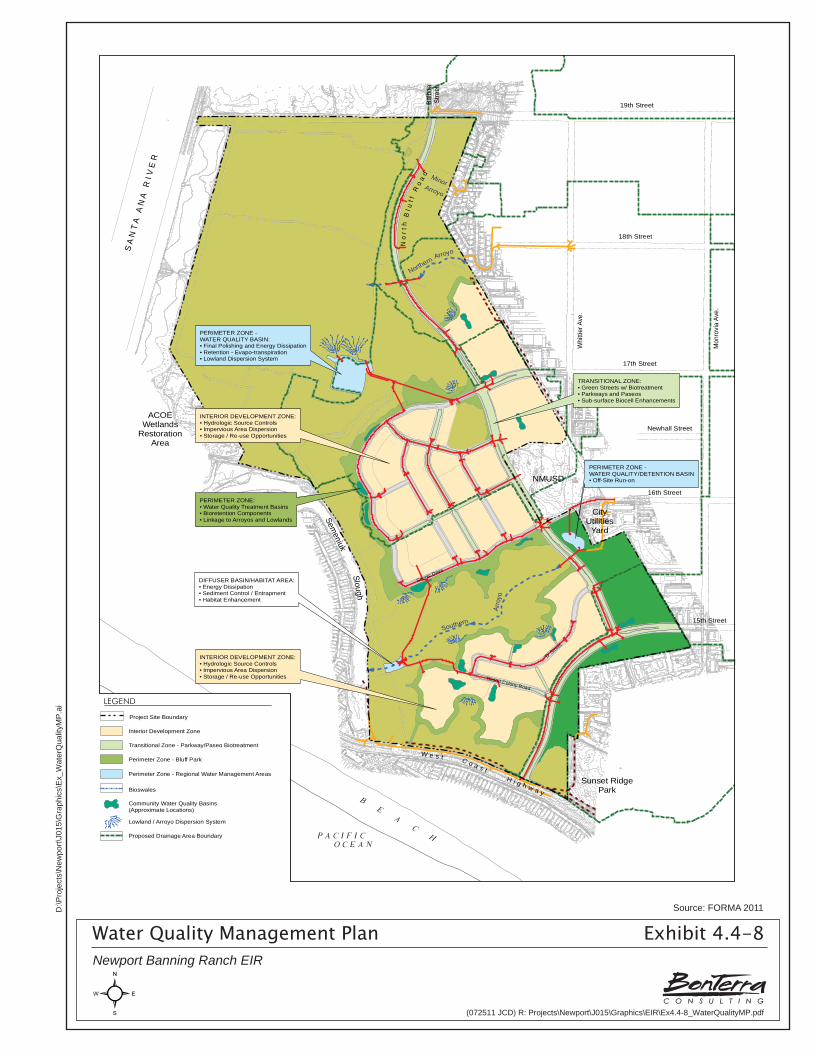
S A
N T
A A
N A
R
I V E
R
ACOEWetlands
RestorationArea
18th Street
Whi
ttier
Ave
.
Mon
rovi
a Av
e.
17th Street
Newhall Street
16th Street
15th Street
19th StreetBalb
oaSt
reet
W e s t C o a s tH i g h w a y
Semeniuk
Slough
Sunset RidgePark
NMUSD
CityUtilities
Yard
Scenic Drive
'D' Stre
et
Resort Colony Road
INTERIOR DEVELOPMENT ZONE:• Hydrologic Source Controls• Impervious Area Dispersion• Storage / Re-use Opportunities
TRANSITIONAL ZONE:• Green Streets w/ Biotreatment• Parkways and Paseos• Sub-surface Biocell Enhancements
PERIMETER ZONE:• Water Quality Treatment Basins• Bioretention Components• Linkage to Arroyos and Lowlands
PERIMETER ZONE -WATER QUALITY/DETENTION BASIN• Off-Site Run-on
PERIMETER ZONE -WATER QUALITY BASIN:• Final Polishing and Energy Dissipation• Retention - Evapo-transpiration• Lowland Dispersion System
DIFFUSER BASIN/HABITAT AREA:• Energy Dissipation• Sediment Control / Entrapment• Habitat Enhancement
Southern
Arro
yo
NorthernArroyo
MinorArroyo
No
r th
Bl u
f fR
oa
d
INTERIOR DEVELOPMENT ZONE:• Hydrologic Source Controls• Impervious Area Dispersion• Storage / Re-use Opportunities
LEGEND
Project Site Boundary
Bioswales
Perimeter Zone - Regional Water Management Areas
Community Water Quality Basins(Approximate Locations)
Interior Development Zone
Transitional Zone - Parkway/Paseo Biotreatment
Perimeter Zone - Bluff Park
Lowland / Arroyo Dispersion System
Proposed Drainage Area Boundary
Water Quality Management Plan Exhibit 4.4-8Newport Banning Ranch EIR
Source: FORMA 2011
(072511 JCD) R: Projects\Newport\J015\Graphics\EIR\Ex4.4-8_WaterQualityMP.pdf
D:\P
roje
cts\
New
port\
J015
\Gra
phic
s\E
x_W
ater
Qua
lityM
P.a
i
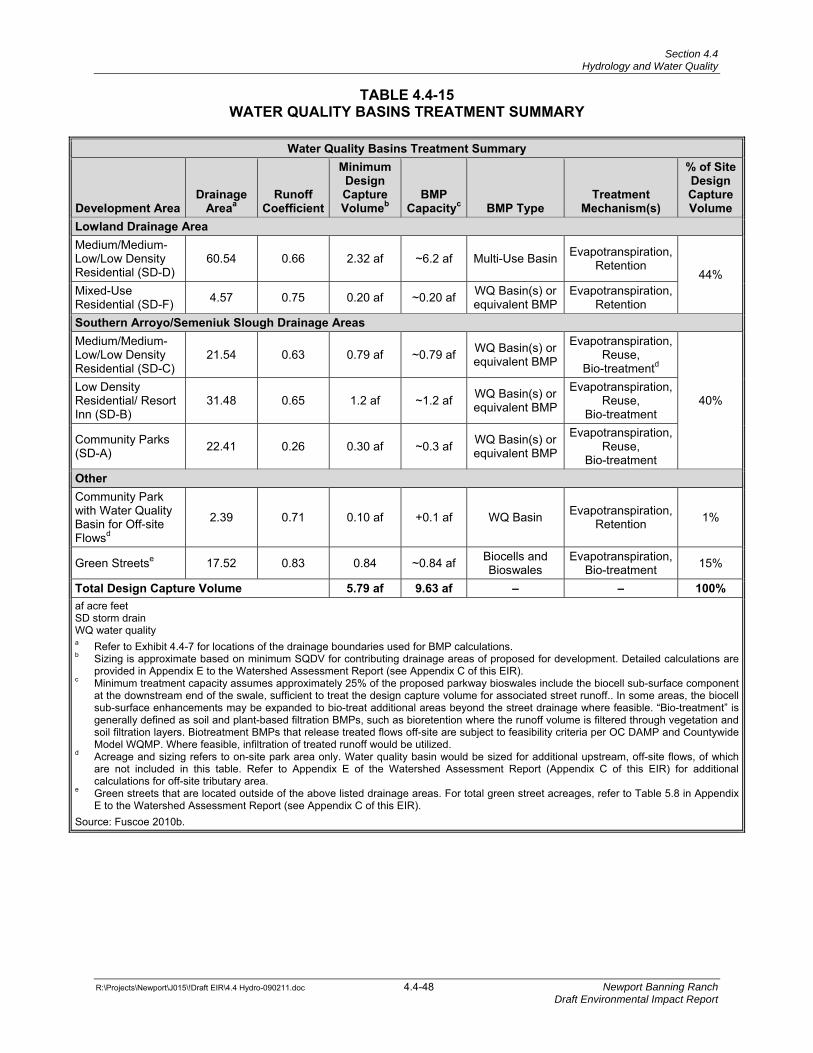
Section 4.4 Hydrology and Water Quality
R:\Projects\Newport\J015\!Draft EIR\4.4 Hydro-090211.doc 4.4-48 Newport Banning Ranch Draft Environmental Impact Report
TABLE 4.4-15 WATER QUALITY BASINS TREATMENT SUMMARY
Water Quality Basins Treatment Summary
Development Area Drainage
Areaa Runoff
Coefficient
Minimum Design Capture Volumeb
BMP Capacityc BMP Type
Treatment Mechanism(s)
% of Site Design Capture Volume
Lowland Drainage Area Medium/Medium-Low/Low Density Residential (SD-D)
60.54 0.66 2.32 af ~6.2 af Multi-Use Basin Evapotranspiration, Retention
44% Mixed-Use Residential (SD-F) 4.57 0.75 0.20 af ~0.20 af WQ Basin(s) or
equivalent BMPEvapotranspiration,
Retention Southern Arroyo/Semeniuk Slough Drainage AreasMedium/Medium-Low/Low Density Residential (SD-C)
21.54 0.63 0.79 af ~0.79 af WQ Basin(s) or equivalent BMP
Evapotranspiration, Reuse,
Bio-treatmentd
40% Low Density Residential/ Resort Inn (SD-B)
31.48 0.65 1.2 af ~1.2 af WQ Basin(s) or equivalent BMP
Evapotranspiration, Reuse,
Bio-treatment
Community Parks (SD-A) 22.41 0.26 0.30 af ~0.3 af WQ Basin(s) or
equivalent BMP
Evapotranspiration, Reuse,
Bio-treatment Other Community Park with Water Quality Basin for Off-site Flowsd
2.39 0.71 0.10 af +0.1 af WQ Basin Evapotranspiration, Retention 1%
Green Streetse 17.52 0.83 0.84 ~0.84 af Biocells and Bioswales
Evapotranspiration, Bio-treatment 15%
Total Design Capture Volume 5.79 af 9.63 af – – 100%af acre feet SD storm drain WQ water quality a Refer to Exhibit 4.4-7 for locations of the drainage boundaries used for BMP calculations. b Sizing is approximate based on minimum SQDV for contributing drainage areas of proposed for development. Detailed calculations are
provided in Appendix E to the Watershed Assessment Report (see Appendix C of this EIR). c Minimum treatment capacity assumes approximately 25% of the proposed parkway bioswales include the biocell sub-surface component
at the downstream end of the swale, sufficient to treat the design capture volume for associated street runoff.. In some areas, the biocell sub-surface enhancements may be expanded to bio-treat additional areas beyond the street drainage where feasible. “Bio-treatment” is generally defined as soil and plant-based filtration BMPs, such as bioretention where the runoff volume is filtered through vegetation and soil filtration layers. Biotreatment BMPs that release treated flows off-site are subject to feasibility criteria per OC DAMP and Countywide Model WQMP. Where feasible, infiltration of treated runoff would be utilized.
d Acreage and sizing refers to on-site park area only. Water quality basin would be sized for additional upstream, off-site flows, of which are not included in this table. Refer to Appendix E of the Watershed Assessment Report (Appendix C of this EIR) for additional calculations for off-site tributary area.
e Green streets that are located outside of the above listed drainage areas. For total green street acreages, refer to Table 5.8 in Appendix E to the Watershed Assessment Report (see Appendix C of this EIR).
Source: Fuscoe 2010b.
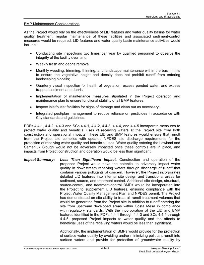
Section 4.4 Hydrology and Water Quality
R:\Projects\Newport\J015\!Draft EIR\4.4 Hydro-090211.doc 4.4-49 Newport Banning Ranch Draft Environmental Impact Report
BMP Maintenance Considerations
As the Project would rely on the effectiveness of LID features and water quality basins for water quality treatment, regular maintenance of these facilities and associated sediment-control measures would be required. LID features and water quality basin maintenance activities would include:
• Conducting site inspections two times per year by qualified personnel to observe the integrity of the facility over time;
• Weekly trash and debris removal;
• Monthly weeding, trimming, thinning, and landscape maintenance within the basin limits to ensure the vegetative height and density does not prohibit runoff from entering landscaping biocells;
• Quarterly visual inspection for health of vegetation, excess ponded water, and excess trapped sediment and debris;
• Implementation of maintenance measures stipulated in the Project operation and maintenance plan to ensure functional stability of all BMP features;
• Inspect inlet/outlet facilities for signs of damage and clean out as necessary;
• Integrated pest/plan management to reduce reliance on pesticides in accordance with City standards and guidelines.
PDFs 4.4-1, 4.4-2, 4.4-3 and SCs 4.4-1, 4.4-2, 4.4-3, 4.4-4, and 4.4-5 incorporate measures to protect water quality and beneficial uses of receiving waters at the Project site from both construction and operational impacts. These LID and BMP features would ensure that runoff from the Project site complies with updated NPDES site discharge requirements for the protection of receiving water quality and beneficial uses. Water quality entering the Lowland and Semeniuk Slough would not be adversely impacted once these controls are in place, and impacts from Project construction and operation would be less than significant.
Impact Summary: Less Than Significant Impact. Construction and operation of the proposed Project would have the potential to adversely impact water quality in downstream receiving waters through discharge of runoff that contains various pollutants of concern. However, the Project incorporates detailed LID features into internal site design and transitional areas for sediment, source, and treatment control. Additional site-design, structural, source-control, and treatment-control BMPs would be incorporated into the Project to supplement LID features, ensuring compliance with the Project Water Quality Management Plan and NPDES permit. The Project has demonstrated on-site ability to treat all runoff treatment volumes that would be generated from the Project site in addition to runoff entering the site from upstream developed areas within Costa Mesa in compliance with regulatory standards. With the incorporation of the LID and BMP features identified in the PDFs 4.4-1 through 4.4-3 and SCs 4.4-1 through 4.4-5, proposed Project impacts to water quality and the affects to beneficial uses of the receiving waters would be less than significant.
Additionally, the implementation of BMPs would provide for the protection of surface water quality by avoiding and/or minimizing pollutant runoff into surface waters and provide for protection of groundwater quality by
Section 4.4 Hydrology and Water Quality
R:\Projects\Newport\J015\!Draft EIR\4.4 Hydro-090211.doc 4.4-50 Newport Banning Ranch Draft Environmental Impact Report
minimizing the introduction of pollutants into the groundwater table. Therefore, proposed Project impacts to groundwater and surface water associated with removal of oil facilities, including in the Lowland, would be less than significant.
Threshold 4.4-2 Would the project substantially deplete groundwater supplies or interfere substantially with groundwater recharge such that there would be a net deficit in aquifer volume or a lowering of the local groundwater table level (e.g., the production rate of pre-existing nearby wells would drop to a level which would not support existing land uses or planned uses for which permits have been granted)?
Although the Project would increase the amount of impervious surfaces by approximately 45 percent compared to the existing oilfield conditions and would thus reduce the potential for groundwater percolation, treatment-control BMPs and LID features are proposed that would encourage infiltration of storm water runoff where feasible. In addition, the design of the structural BMPs and LID features would conform to the restrictions outlined in the MS4 Permit for North Orange County (Order R8-2009-0030). These measures would include having a vertical distance from the bottom of the infiltration system to the seasonal high groundwater (i.e., at least ten feet) and would provide impermeable liners with subdrain systems for areas with high groundwater levels, thereby eliminating the potential for groundwater contamination. Most pollutants in infiltrated water are effectively treated in the uppermost soil layers of infiltration type BMPs (Geosyntec 2009).
Groundwater recharge does occur at the Project site and would decrease under Project conditions due to a reduction in pervious surface area. However, infiltration BMPs would be incorporated into site design to ensure that site runoff continues to infiltrate to the maximum extent practicable. The Project site is not a designated recharge site for the City.
Local groundwater is not suitable for use as drinking water because of mixing with tidal waters. Consequently, the Project’s potable water needs would not impact local groundwater levels. Therefore, there would be no Project impact to groundwater table drawdown.
The Santa Ana RWQCB’s Basin Plan designates beneficial uses and water quality objectives to provide the foundation for various State-implemented regulatory programs. According to the Basin Plan, the Project site is located within the Orange County Groundwater Management Zone, which has specific water quality objectives set for total dissolved solids (TDS) and nitrates (N) for the protection of its beneficial uses.
Although specific objectives have been set by the Santa Ana RWQCB, the proposed Project is not anticipated to contribute excess concentrations of storm water pollutants into groundwater resources. BMPs that protect receiving waters and groundwater in the vicinity would be in place prior to, during, and, to a lesser degree, after implementation of the final RAP until native vegetation returns to the area. BMPs may include, but are not limited to, good housekeeping practices to contain potential construction materials, leaks and maintenance activities for large equipment used on site, containment measures for soil stockpiles and, potentially, treatment-control BMPs including lined and/or vegetated swales and retention basins to filter/manage runoff water from active work areas. Based on the incorporation of BMPs and LID features and preparation of the final RAP (see Section 4.5, Hazards and Hazardous Materials), no pollutants from the Project are expected to reach groundwater, and groundwater quality impacts are expected to be less than significant. The construction erosion and sediment control BMPs are also applicable for the oilfield site remediation procedures; no additional BMPs are currently
Section 4.4 Hydrology and Water Quality
R:\Projects\Newport\J015\!Draft EIR\4.4 Hydro-090211.doc 4.4-51 Newport Banning Ranch Draft Environmental Impact Report
proposed (see Table 4.4-6, BMP WM-7 for soil contamination management). It is acknowledge that the applicable regulatory agencies can impose additional conditions including BMPs related to remediation, construction, and operational activities at the Project site.
Impact Summary: Less Than Significant. Local groundwater is not suitable for use as drinking water; therefore, there would be no Project impact to groundwater table due to drawdown. Groundwater recharge does occur at the Project site and would decrease under Project conditions due to a reduction in pervious surface area. Infiltration BMPs would be incorporated into site design to ensure that site runoff continues to infiltrate to the maximum extent practicable. Proper design of structural BMPs and LID features would ensure separation of the volumes of water to be treated and the underlying groundwater table, which would ensure no adverse impact to groundwater quality from treatment-control BMPs and LID features. Infiltration BMPs would treat most pollutants within the uppermost soil layers of the BMP facility, reducing pollutant transfer to the groundwater table. Temporary construction impacts associated with removal of oil pipelines in the Lowland would be reduced to a less than significant level with the incorporation of BMPs set forth in this EIR. PDFs 4.4-3, the use of LID standards, and PDF 4.4-6, incorporation of BMPs, would ensure that Project impacts would be less than significant.
Threshold 4.4-3 Would the project substantially alter the existing drainage pattern of the site or area, including through the alteration of the course of a stream or river, in a manner which would result in substantial erosion or siltation on- or off- site?
Threshold 4.4-15 Would the project create significant increases in erosion of the project site or surrounding areas?
Construction
As discussed above in the impact discussion for Thresholds 4.4-1, 4.4-6, 4.4-11, 4.4-12, and 4.4-13, sediment-control BMPs would be installed to intercept and filter out soil particles that may have been mobilized by flows during construction activities before these flows discharge into receiving waters. These controls may include installing check dams, desilting basins, fiber rolls, and silt fencing, as well as revegetating landscaped areas. Per CASQA guidelines, a minimum of three desilting basins would be in operation during Project construction to control sediment moving off site. All storm drain inlets on the Project site and along streets immediately adjacent to the Project boundary would be protected with an impoundment (i.e., gravel bags) around the inlet and would be equipped with a sediment filter (i.e., fiber roll) to slow the velocity of moving water and to trap sediment particles prior to discharge into the inlet. These measures would also be placed around areas of soil-disturbing activities, such as grading or clearing, to retain sediments on site.
Erosion-control BMPs would be used during construction to protect the soil surface by covering and/or binding the soil particles together or to divert runoff away from exposed areas and into more suitable locations. These BMPs measures may include application of hydraulic mulch, soil binders, and the use of geotextiles and mats. Temporary earth dikes or drainage swales may also be used.
Section 4.4 Hydrology and Water Quality
R:\Projects\Newport\J015\!Draft EIR\4.4 Hydro-090211.doc 4.4-52 Newport Banning Ranch Draft Environmental Impact Report
The proposed Project is considered a Risk Level 2 site. Risk Level 2 dischargers that pose a medium risk to water quality are subject to technology-based Numeric Action Level for pH and turbidity. Should the Project exceed a pH range of 6.5–8.5 or turbidity of 250 nephelometric turbidity units (NTU), the discharger is required to immediately determine the source associated with the exceedance and to implement corrective actions if necessary to mitigate the exceedance. It is not anticipated that Active Treatment Systems would be needed for the Project.
Compliance with the General Construction Permit and the Orange County Dewatering Permit, the later if required, would minimize construction impacts from grading/excavation; material stockpiling and dewatering; construction and utilization of access and haul roads; and equipment staging, operation, and fueling. The Project would comply with the most current General Construction Permit and associated local NPDES regulations to ensure that the potential for construction-related erosion and adverse sedimentation effects are minimized through the identification and application of efficient sediment-control BMPs and construction site monitoring. These permits require development and implementation of an SWPPP, which would describe construction BMPs that address the measures and controls necessary to ensure that construction site effects on sedimentation and erosion are appropriately minimized and remain less than significant.
Project Operation
Oil operations in the Lowland have resulted in modifications to on-site subwatersheds proposed by the Project. Under existing conditions, Semeniuk Slough has an available capacity to store the 2-year storm event, and periodically floods as a result of a coincidence of high tides and larger storms. In order to preserve the 2-year flood protection limit of Semeniuk Slough, a portion of the on-site development tributary would be directed to Subwatershed C as identified in Table 4.4-16.
Overall site drainage patterns would largely remain the same upon Project completion; drainage would continue to flow from east to west across the site, through the existing arroyos and into either the Semeniuk Slough or the Lowland area. Minor variations in surface drainage patterns and discharge volumes would occur through the reduction in size of Subwatershed A by approximately 27 acres (-7.8 percent). Subwatershed B would decrease in size by approximately 14.5 acres (-10.73 percent). Subwatershed C would increase in size by approximately 34 acres (+53.45 percent) as a result of diversion of some of the Subwatershed A discharge away from the Semeniuk Slough into the Lowland.
The Lowland area currently receives runoff from approximately 63.6 acres, which would increase by approximately 34 acres under the proposed condition. Runoff rates would remain unchanged under the proposed condition to the Northern Arroyo since existing flow rates and volume would be maintained, resulting in no additional impact. The increased discharge to the Lowland would be delivered via the primary storm drains for this area (SD-D and SD-E), which would eliminate the potential for increased sediment transport within the existing natural channels. Flows carried by SD-D and SD-E (Drainage Area C) would be delivered to a water quality basin with energy dissipation measures to minimize local erosion within the basin footprint. The discharge of flows from the basin into the adjacent Lowland would also be diffused to minimize sediment transport impacts within the Lowland.
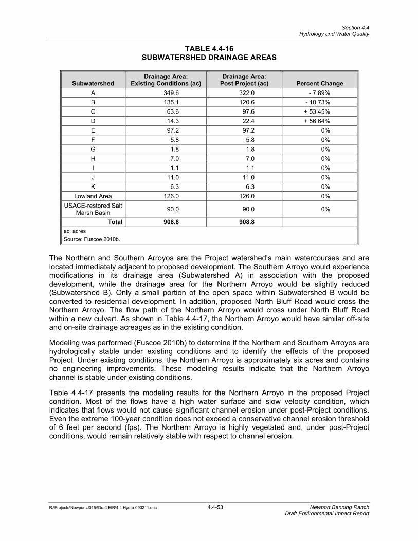
Section 4.4 Hydrology and Water Quality
R:\Projects\Newport\J015\!Draft EIR\4.4 Hydro-090211.doc 4.4-53 Newport Banning Ranch Draft Environmental Impact Report
TABLE 4.4-16 SUBWATERSHED DRAINAGE AREAS
Subwatershed Drainage Area:
Existing Conditions (ac) Drainage Area:
Post Project (ac) Percent Change A 349.6 322.0 - 7.89% B 135.1 120.6 - 10.73% C 63.6 97.6 + 53.45% D 14.3 22.4 + 56.64% E 97.2 97.2 0% F 5.8 5.8 0% G 1.8 1.8 0% H 7.0 7.0 0% I 1.1 1.1 0% J 11.0 11.0 0% K 6.3 6.3 0%
Lowland Area 126.0 126.0 0% USACE-restored Salt
Marsh Basin 90.0 90.0 0%
Total 908.8 908.8 ac: acres Source: Fuscoe 2010b.
The Northern and Southern Arroyos are the Project watershed’s main watercourses and are located immediately adjacent to proposed development. The Southern Arroyo would experience modifications in its drainage area (Subwatershed A) in association with the proposed development, while the drainage area for the Northern Arroyo would be slightly reduced (Subwatershed B). Only a small portion of the open space within Subwatershed B would be converted to residential development. In addition, proposed North Bluff Road would cross the Northern Arroyo. The flow path of the Northern Arroyo would cross under North Bluff Road within a new culvert. As shown in Table 4.4-17, the Northern Arroyo would have similar off-site and on-site drainage acreages as in the existing condition.
Modeling was performed (Fuscoe 2010b) to determine if the Northern and Southern Arroyos are hydrologically stable under existing conditions and to identify the effects of the proposed Project. Under existing conditions, the Northern Arroyo is approximately six acres and contains no engineering improvements. These modeling results indicate that the Northern Arroyo channel is stable under existing conditions.
Table 4.4-17 presents the modeling results for the Northern Arroyo in the proposed Project condition. Most of the flows have a high water surface and slow velocity condition, which indicates that flows would not cause significant channel erosion under post-Project conditions. Even the extreme 100-year condition does not exceed a conservative channel erosion threshold of 6 feet per second (fps). The Northern Arroyo is highly vegetated and, under post-Project conditions, would remain relatively stable with respect to channel erosion.
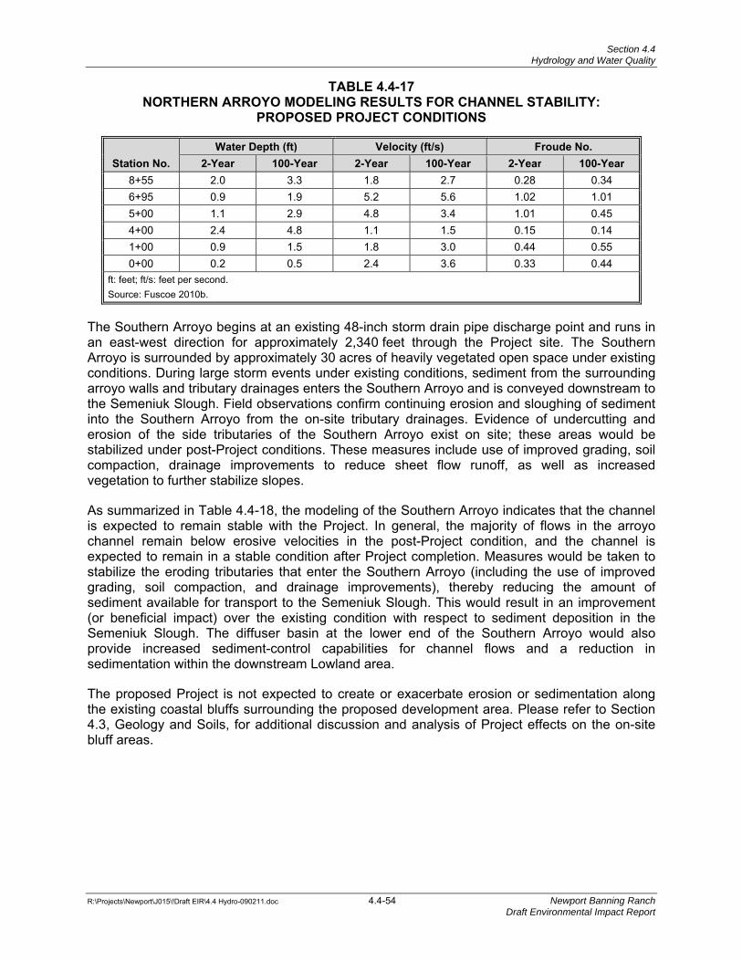
Section 4.4 Hydrology and Water Quality
R:\Projects\Newport\J015\!Draft EIR\4.4 Hydro-090211.doc 4.4-54 Newport Banning Ranch Draft Environmental Impact Report
TABLE 4.4-17 NORTHERN ARROYO MODELING RESULTS FOR CHANNEL STABILITY:
PROPOSED PROJECT CONDITIONS
Station No. Water Depth (ft) Velocity (ft/s) Froude No.
2-Year 100-Year 2-Year 100-Year 2-Year 100-Year8+55 2.0 3.3 1.8 2.7 0.28 0.34 6+95 0.9 1.9 5.2 5.6 1.02 1.01 5+00 1.1 2.9 4.8 3.4 1.01 0.45 4+00 2.4 4.8 1.1 1.5 0.15 0.14 1+00 0.9 1.5 1.8 3.0 0.44 0.55 0+00 0.2 0.5 2.4 3.6 0.33 0.44
ft: feet; ft/s: feet per second. Source: Fuscoe 2010b.
The Southern Arroyo begins at an existing 48-inch storm drain pipe discharge point and runs in an east-west direction for approximately 2,340 feet through the Project site. The Southern Arroyo is surrounded by approximately 30 acres of heavily vegetated open space under existing conditions. During large storm events under existing conditions, sediment from the surrounding arroyo walls and tributary drainages enters the Southern Arroyo and is conveyed downstream to the Semeniuk Slough. Field observations confirm continuing erosion and sloughing of sediment into the Southern Arroyo from the on-site tributary drainages. Evidence of undercutting and erosion of the side tributaries of the Southern Arroyo exist on site; these areas would be stabilized under post-Project conditions. These measures include use of improved grading, soil compaction, drainage improvements to reduce sheet flow runoff, as well as increased vegetation to further stabilize slopes.
As summarized in Table 4.4-18, the modeling of the Southern Arroyo indicates that the channel is expected to remain stable with the Project. In general, the majority of flows in the arroyo channel remain below erosive velocities in the post-Project condition, and the channel is expected to remain in a stable condition after Project completion. Measures would be taken to stabilize the eroding tributaries that enter the Southern Arroyo (including the use of improved grading, soil compaction, and drainage improvements), thereby reducing the amount of sediment available for transport to the Semeniuk Slough. This would result in an improvement (or beneficial impact) over the existing condition with respect to sediment deposition in the Semeniuk Slough. The diffuser basin at the lower end of the Southern Arroyo would also provide increased sediment-control capabilities for channel flows and a reduction in sedimentation within the downstream Lowland area.
The proposed Project is not expected to create or exacerbate erosion or sedimentation along the existing coastal bluffs surrounding the proposed development area. Please refer to Section 4.3, Geology and Soils, for additional discussion and analysis of Project effects on the on-site bluff areas.
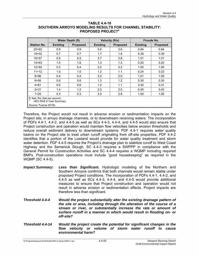
Section 4.4 Hydrology and Water Quality
R:\Projects\Newport\J015\!Draft EIR\4.4 Hydro-090211.doc 4.4-55 Newport Banning Ranch Draft Environmental Impact Report
TABLE 4.4-18 SOUTHERN ARROYO MODELING RESULTS FOR CHANNEL STABILITY:
PROPOSED PROJECTa
Station No. Water Depth (ft) Velocity (ft/s) Froude No.
Existing Proposed Existing Proposed Existing Proposed20+62 0.8 0.9 3.6 3.6 0.84 0.84 19+02 0.7 0.7 1.7 1.8 0.39 0.39 16+57 0.5 0.5 3.7 3.8 1.01 1.01 14+63 1.5 1.6 1.3 1.3 0.20 0.20 12+92 0.3 0.4 3.2 3.2 1.00 1.00 11+12 1.0 1.0 1.2 1.1 0.24 0.23 8+96 0.4 0.4 3.2 3.0 1.01 1.00 6+56 0.6 0.6 1.3 1.2 0.30 0.30 4+81 0.8 0.6 1.2 1.1 0.30 0.31 3+31 1.4 1.2 2.3 2.0 0.45 0.42 1+25 0.3 0.3 3.0 2.6 1.00 1.00
ft: feet; ft/s: feet per second. a HEC-RAS 2-Year Summary Source: Fuscoe 2010b.
Therefore, the Project would not result in adverse erosion or sedimentation impacts on the Project site, in arroyo drainage channels, or to downstream receiving waters. The incorporation of PDFs 4.4-1, 4.4-2, and 4.4-5 as well as SCs 4.4-3, 4.4-4, and 4.4-5 would also ensure that Project construction and operation would maintain flow velocities below erosion thresholds and reduce overall sediment delivery to downstream systems. PDF 4.4-1 requires water quality basins on the Project site to treat urban runoff originating from off-site properties. PDF 4.4-2 identifies that a portion of the Lowland would provide for water quality treatment and storm water detention. PDF 4.4-5 requires the Project’s drainage plan to stabilize runoff to West Coast Highway and the Semeniuk Slough. SC 4.4-3 requires a SWPPP in compliance with the General Permit for Construction Activities and SC 4.4-4 requires a WQMP including required BMPs. Post-construction operations must include “good housekeeping” as required in the WQMP (SC 4.4-5).
Impact Summary: Less than Significant. Hydrologic modeling of the Northern and Southern Arroyos confirms that both channels would remain stable under proposed Project conditions. The incorporation of PDFs 4.4-1, 4.4-2, and 4.4-5 as well as SCs 4.4-3, 4.4-4, and 4.4-5 would provide additional measures to ensure that Project construction and operation would not result in adverse erosion or sedimentation effects. Project impacts are therefore less than significant.
Threshold 4.4-4 Would the project substantially alter the existing drainage pattern of the site or area, including through the alteration of the course of a stream or river, or substantially increase the rate or amount of surface runoff in a manner in which would result in flooding on- or off-site?
Threshold 4.4-14 Would the project create the potential for significant changes in the flow velocity or volume of storm water runoff to cause environmental harm?
Section 4.4 Hydrology and Water Quality
R:\Projects\Newport\J015\!Draft EIR\4.4 Hydro-090211.doc 4.4-56 Newport Banning Ranch Draft Environmental Impact Report
Construction
Application of the BMPs, as discussed above in the impact analysis regarding erosion and sedimentation, would control flows on site and would ensure that impacts associated with construction would be properly managed. PDFs 4.4-1, 4.4-2, 4.4-3 and SCs 4.4-2, 4.4-3, 4.4-4, and 4.4-5 incorporate measures to protect water quality and beneficial uses of receiving waters at the Project site from both construction and operational impacts. These LID and BMP features would ensure that runoff from the Project site complies with NPDES site discharge requirements for the protection of receiving water quality and beneficial uses. Water quality entering the Lowland area and Semeniuk Slough would not be adversely impacted once these controls are in place. Construction BMPs also contain measures to be implemented to control construction site runoff and storm water.
Project Operation
Semeniuk Slough
Storm flows within the Semeniuk Slough are generally stored in the southerly portion of the USACE-restored salt marsh basin. The Semeniuk Slough’s drainage area is composed of primarily Subwatershed A, which encompasses about 350 acres, and the Newport Shores residential neighborhood along the Semeniuk Slough represented by Subwatersheds F through K, which encompass an additional 33 acres in total. The elevation of the channel bank on the southern side of the Slough channel (near the residences) is approximately five feet above msl. When the tidal gate in the Santa Ana River levee is completely closed (at 3.5 feet above msl), there is approximately 1.5 feet of remaining runoff storage capacity within the Semeniuk Slough and the USACE-restored salt marsh basin. Several habitat islands constructed within the USACE-restored salt marsh basin reduce this storage capacity to approximately 28 acre-feet, which is approximately equal to the 2-year rainfall event delivered to the Semeniuk Slough under existing conditions.
Recognizing the existing constraints posed by this storage deficit, the Project drainage plan was developed with the objective of avoiding any increase in storm water runoff conveyed to the Semeniuk Slough while preserving its 2-year storage capacity limit. Consequently, a portion of Subwatershed A has been diverted away from the Semeniuk Slough under the proposed Project’s drainage plan and would be discharged instead to the Lowland via proposed storm drain systems.
Tables 4.4-19 and 4.4-20 summarize the modeling results for the existing and proposed conditions under the 2-year and 100-year storm EV events. As the Semeniuk Slough functions both as a flood-conveyance and storage facility, both the runoff volumes and the peak flow rates are summarized in the following tables. The time of concentration (Tc) value has also been provided for the 2-year evaluation per the requirements of Section XII.D of the MS4 Permit.
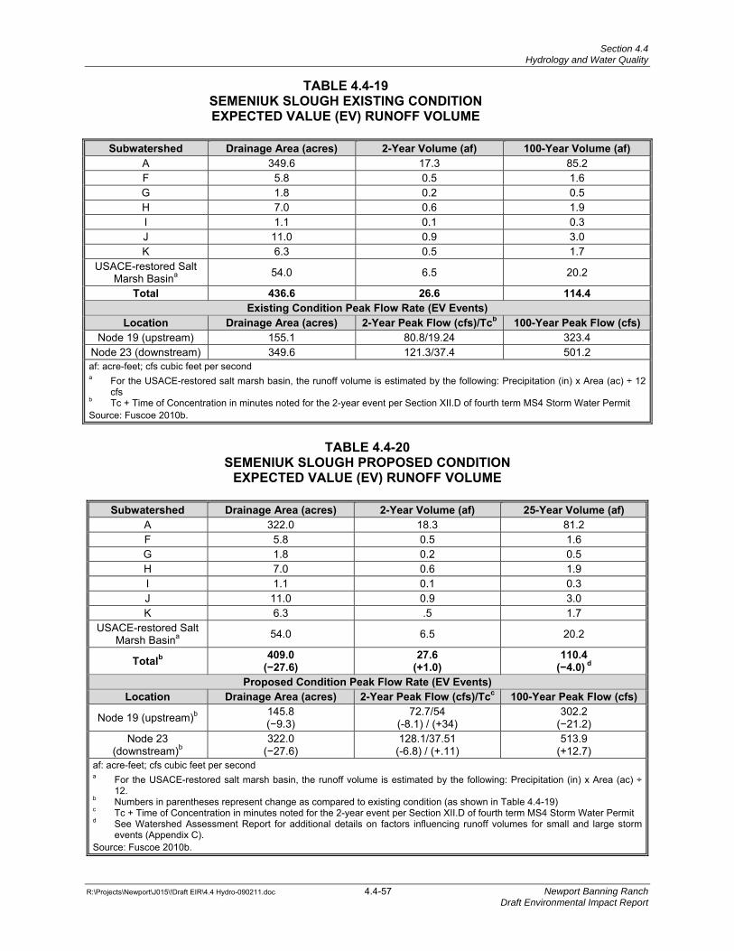
Section 4.4 Hydrology and Water Quality
R:\Projects\Newport\J015\!Draft EIR\4.4 Hydro-090211.doc 4.4-57 Newport Banning Ranch Draft Environmental Impact Report
TABLE 4.4-19 SEMENIUK SLOUGH EXISTING CONDITION EXPECTED VALUE (EV) RUNOFF VOLUME
Subwatershed Drainage Area (acres) 2-Year Volume (af) 100-Year Volume (af)
A 349.6 17.3 85.2 F 5.8 0.5 1.6 G 1.8 0.2 0.5 H 7.0 0.6 1.9 I 1.1 0.1 0.3 J 11.0 0.9 3.0 K 6.3 0.5 1.7
USACE-restored Salt Marsh Basina 54.0 6.5 20.2
Total 436.6 26.6 114.4Existing Condition Peak Flow Rate (EV Events)
Location Drainage Area (acres) 2-Year Peak Flow (cfs)/Tcb 100-Year Peak Flow (cfs)Node 19 (upstream) 155.1 80.8/19.24 323.4
Node 23 (downstream) 349.6 121.3/37.4 501.2 af: acre-feet; cfs cubic feet per second a For the USACE-restored salt marsh basin, the runoff volume is estimated by the following: Precipitation (in) x Area (ac) ÷ 12
cfs b Tc + Time of Concentration in minutes noted for the 2-year event per Section XII.D of fourth term MS4 Storm Water Permit Source: Fuscoe 2010b.
TABLE 4.4-20
SEMENIUK SLOUGH PROPOSED CONDITION EXPECTED VALUE (EV) RUNOFF VOLUME
Subwatershed Drainage Area (acres) 2-Year Volume (af) 25-Year Volume (af)
A 322.0 18.3 81.2 F 5.8 0.5 1.6 G 1.8 0.2 0.5 H 7.0 0.6 1.9 I 1.1 0.1 0.3 J 11.0 0.9 3.0 K 6.3 .5 1.7
USACE-restored Salt Marsh Basina 54.0 6.5 20.2
Totalb 409.0 (−27.6)
27.6(+1.0)
110.4
(−4.0) d
Proposed Condition Peak Flow Rate (EV Events) Location Drainage Area (acres) 2-Year Peak Flow (cfs)/Tcc 100-Year Peak Flow (cfs)
Node 19 (upstream)b 145.8 (−9.3)
72.7/54 (-8.1) / (+34)
302.2 (−21.2)
Node 23 (downstream)b
322.0 (−27.6)
128.1/37.51 (-6.8) / (+.11)
513.9 (+12.7)
af: acre-feet; cfs cubic feet per second a For the USACE-restored salt marsh basin, the runoff volume is estimated by the following: Precipitation (in) x Area (ac) ÷
12. b Numbers in parentheses represent change as compared to existing condition (as shown in Table 4.4-19) c Tc + Time of Concentration in minutes noted for the 2-year event per Section XII.D of fourth term MS4 Storm Water Permit d See Watershed Assessment Report for additional details on factors influencing runoff volumes for small and large storm
events (Appendix C). Source: Fuscoe 2010b.
Section 4.4 Hydrology and Water Quality
R:\Projects\Newport\J015\!Draft EIR\4.4 Hydro-090211.doc 4.4-58 Newport Banning Ranch Draft Environmental Impact Report
The Fourth Term MS4 Permit requires that the 2-year storm event be analyzed both with and without a project to determine the “hydrologic conditions of concern” (Order R8-2009-0030). Hydrologic conditions of concern occur when the volume and the time of concentration of storm water runoff for the post-development condition significantly exceeds those of the existing condition for a 2-year frequency storm event (a difference of 5 percent or less is considered less than significant). Results of the analysis indicate that, in compliance with permit requirements, the peak flow and time of concentration of storm water runoff for the post-Project 2-year storm would not exceed the existing condition and the 2-year volume increase is less than 5 percent, resulting in a less than significant impact. Therefore, the implementation of the Project does not pose hydrologic conditions of concern (HCOCs) (Fuscoe 2010b) and additional hydromodification controls for discharges into the Southern Arroyo and Semeniuk Slough are not required.
Lowland Area
As previously discussed, the proposed Project drainage area for Subwatershed A would be reduced by approximately 27 acres (-7.8 percent) from the existing condition. While the proposed Project runoff potential is anticipated to be slightly higher in the Project watershed, the overall results show that this reduction in drainage area maintains flow volumes similar to the existing condition. This is achieved largely through the preservation of open space on the Project site.
Modeling results of existing and proposed runoff volumes into the Lowland and USACE-restored salt marsh basin are presented in Tables 4.4-21 and 4.4-22, respectively. These modeling results indicate that the combined basin capacity (Lowland and USACE-restored salt marsh basin) can store existing flood volumes up to the 25-year frequency in its current capacity. As shown in Table 4.4-21, the existing condition 25-year runoff volume is 261.5 acre feet. Because this value is less than the combined flood storage capacity of the USACE–restored salt marsh basin and Lowland area (345 acre-feet), a 25-year level of protection is provided in the existing condition. The proposed condition 25-year runoff volume increases slightly to 264.9 acre-feet (Table 4.4-22). However, the proposed condition 25-year runoff volume would be less than the 345 acre-feet storage capacity of the combined USACE-restored salt marsh basin and Lowland area. This comparison demonstrates that a 25-year level of protection is provided after development in the proposed condition, and that mitigation is not needed to maintain the predevelopment level of protection.
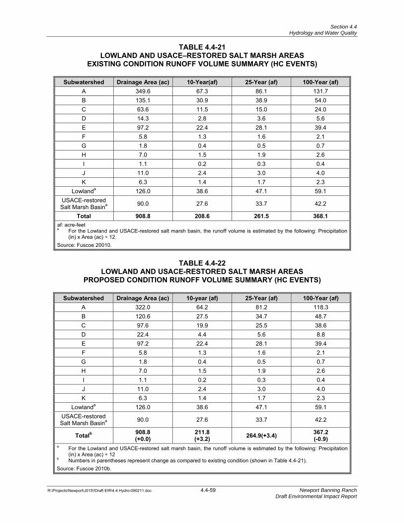
Section 4.4 Hydrology and Water Quality
R:\Projects\Newport\J015\!Draft EIR\4.4 Hydro-090211.doc 4.4-59 Newport Banning Ranch Draft Environmental Impact Report
TABLE 4.4-21 LOWLAND AND USACE–RESTORED SALT MARSH AREAS
EXISTING CONDITION RUNOFF VOLUME SUMMARY (HC EVENTS)
Subwatershed Drainage Area (ac) 10-Year(af) 25-Year (af) 100-Year (af)A 349.6 67.3 86.1 131.7 B 135.1 30.9 38.9 54.0 C 63.6 11.5 15.0 24.0 D 14.3 2.8 3.6 5.6 E 97.2 22.4 28.1 39.4 F 5.8 1.3 1.6 2.1 G 1.8 0.4 0.5 0.7 H 7.0 1.5 1.9 2.6 I 1.1 0.2 0.3 0.4 J 11.0 2.4 3.0 4.0 K 6.3 1.4 1.7 2.3
Lowlanda 126.0 38.6 47.1 59.1 USACE-restored Salt Marsh Basina 90.0 27.6 33.7 42.2
Total 908.8 208.6 261.5 368.1af: acre-feet a For the Lowland and USACE-restored salt marsh basin, the runoff volume is estimated by the following: Precipitation
(in) x Area (ac) ÷ 12. Source: Fuscoe 20010.
TABLE 4.4-22
LOWLAND AND USACE-RESTORED SALT MARSH AREAS PROPOSED CONDITION RUNOFF VOLUME SUMMARY (HC EVENTS)
Subwatershed Drainage Area (ac) 10-year (af) 25-Year (af) 100-Year (af)
A 322.0 64.2 81.2 118.3 B 120.6 27.5 34.7 48.7 C 97.6 19.9 25.5 38.6 D 22.4 4.4 5.6 8.8 E 97.2 22.4 28.1 39.4 F 5.8 1.3 1.6 2.1 G 1.8 0.4 0.5 0.7 H 7.0 1.5 1.9 2.6 I 1.1 0.2 0.3 0.4 J 11.0 2.4 3.0 4.0 K 6.3 1.4 1.7 2.3
Lowlanda 126.0 38.6 47.1 59.1 USACE-restored Salt Marsh Basina 90.0 27.6 33.7 42.2
Totalb 908.8 (+0.0)
211.8 (+3.2) 264.9(+3.4) 367.2
(-0.9) a For the Lowland and USACE-restored salt marsh basin, the runoff volume is estimated by the following: Precipitation
(in) x Area (ac) ÷ 12 b Numbers in parentheses represent change as compared to existing condition (shown in Table 4.4-21). Source: Fuscoe 2010b.
Section 4.4 Hydrology and Water Quality
R:\Projects\Newport\J015\!Draft EIR\4.4 Hydro-090211.doc 4.4-60 Newport Banning Ranch Draft Environmental Impact Report
Upland Area
All on-site curbs, gutters, and storm drains would be designed in accordance with City standards, thereby minimizing potential impacts of on-site development area flooding. Therefore, the proposed Project would slightly alter the existing drainage patterns from the requirement to reduce existing flow volumes into the Semeniuk Slough through minor modification in on-site subwatersheds as described above. These minor alterations are consistent with an overall Project storm water management strategy that directs flows to areas that have additional capacity (the Lowland) and decreases flows to areas with minimal or constrained capacity (Semeniuk Slough). Increase in storm water runoff volume delivered to the Lowland area would be accommodated by the storage capacity of the existing Lowland and USACE-restored salt marsh basin. Sheet flow runoff under the existing condition on the Project site would be replaced with storm drain systems to convey flows to the Lowland area, Semeniuk Slough, and the Caltrans storm drain. The incorporation of PDFs 4.4-1, 4.4-2, 4.4-4, 4.4-5, and 4.4-6 as well as SC 4.4-4 would provide additional measures to ensure that Project construction and operation would not result in adverse flooding as compared to existing conditions.
PDF 4.4-1 requires water quality basins on the Project site to treat urban runoff originating from off-site properties. PDF 4.4-2 identifies that a portion of the Lowland would provide for water quality treatment and storm water detention. PDF 4.4-4 requires that arroyos be planted with native riparian vegetation to limit potential erosion and to enhance the water cleansing function. PDF 4.4-5 requires the Project’s drainage plan to stabilize runoff to West Coast Highway and the Semeniuk Slough. PDF 4.4-6 requires the Project to incorporate BMPs for erosion control, sediment control, wind erosion control, storm water and non-storm water management, and waste management/pollution control. SC 4.4-4 requires a WQMP including required BMPs. Therefore, impacts relating to on-site or downstream flooding would be considered less than significant.
Global climate change and sea level rise was considered in Project design and impact analyses. It was determined that sea level rise would not negatively impact the Project’s ability to drain into the Lowland or the Semeniuk Slough based on the hydraulic grade lines of the proposed storm drain system. In severe instances, flood flows could back up further into the Lowland or in the Southern and Northern Arroyos, resulting in some limited localized impact to the performance of low-lying storm drain outlets should they become temporarily submerged. If this does occur, it would not impact the Project during this temporary condition.
Impact Summary: Less Than Significant. The Project-induced increase in impervious surfaces would result in an increase in peak flow runoff and runoff volumes from the site. Project drainage area modifications would be incorporated into a Runoff Management Plan to ensure that peak flow rates and volumes would not result in adverse flooding impacts to downstream systems. The incorporation of PDFs 4.4-1, 4.4-2, 4.4-4, 4.4-5, and 4.4-6 as well as SC 4.4-4 would provide additional measures to ensure that Project construction and operation would not result in adverse flooding as compared to existing conditions. Therefore, impacts relating to on-site or downstream flooding would be considered less than significant.
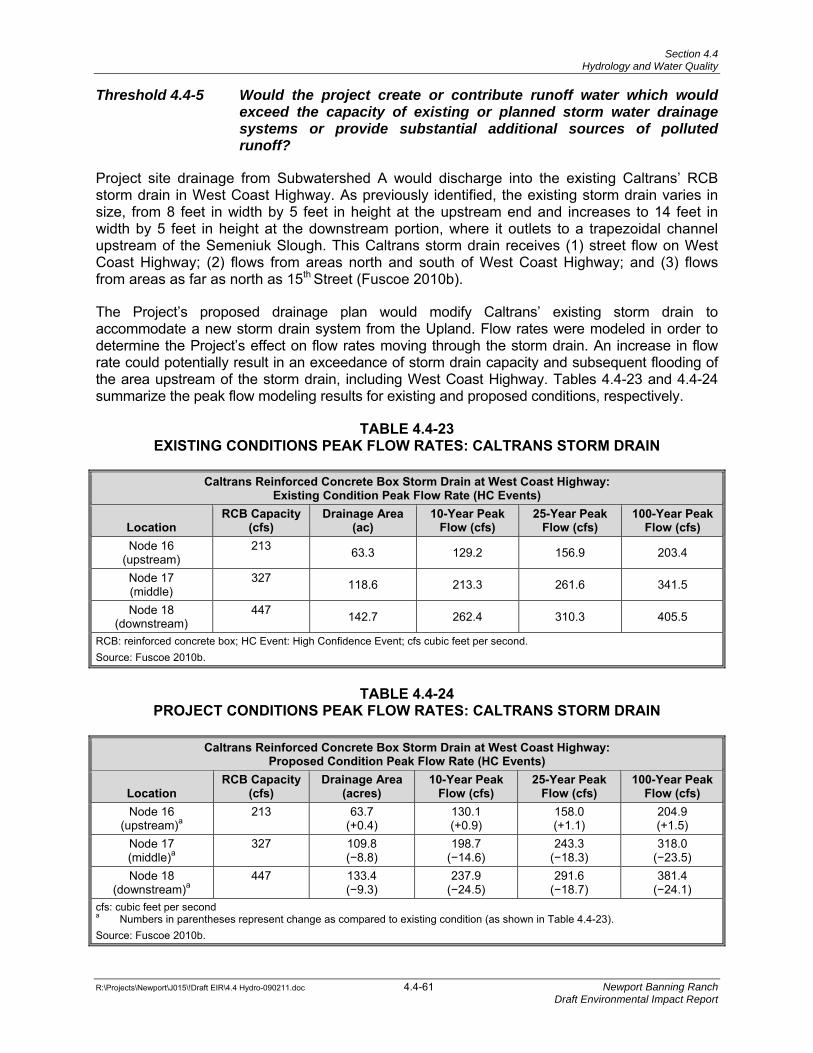
Section 4.4 Hydrology and Water Quality
R:\Projects\Newport\J015\!Draft EIR\4.4 Hydro-090211.doc 4.4-61 Newport Banning Ranch Draft Environmental Impact Report
Threshold 4.4-5 Would the project create or contribute runoff water which would exceed the capacity of existing or planned storm water drainage systems or provide substantial additional sources of polluted runoff?
Project site drainage from Subwatershed A would discharge into the existing Caltrans’ RCB storm drain in West Coast Highway. As previously identified, the existing storm drain varies in size, from 8 feet in width by 5 feet in height at the upstream end and increases to 14 feet in width by 5 feet in height at the downstream portion, where it outlets to a trapezoidal channel upstream of the Semeniuk Slough. This Caltrans storm drain receives (1) street flow on West Coast Highway; (2) flows from areas north and south of West Coast Highway; and (3) flows from areas as far as north as 15th Street (Fuscoe 2010b).
The Project’s proposed drainage plan would modify Caltrans’ existing storm drain to accommodate a new storm drain system from the Upland. Flow rates were modeled in order to determine the Project’s effect on flow rates moving through the storm drain. An increase in flow rate could potentially result in an exceedance of storm drain capacity and subsequent flooding of the area upstream of the storm drain, including West Coast Highway. Tables 4.4-23 and 4.4-24 summarize the peak flow modeling results for existing and proposed conditions, respectively.
TABLE 4.4-23 EXISTING CONDITIONS PEAK FLOW RATES: CALTRANS STORM DRAIN
Caltrans Reinforced Concrete Box Storm Drain at West Coast Highway: Existing Condition Peak Flow Rate (HC Events)
Location RCB Capacity
(cfs) Drainage Area
(ac) 10-Year Peak
Flow (cfs) 25-Year Peak
Flow (cfs) 100-Year Peak
Flow (cfs) Node 16
(upstream) 213 63.3 129.2 156.9 203.4
Node 17 (middle)
327 118.6 213.3 261.6 341.5
Node 18 (downstream)
447 142.7 262.4 310.3 405.5
RCB: reinforced concrete box; HC Event: High Confidence Event; cfs cubic feet per second. Source: Fuscoe 2010b.
TABLE 4.4-24
PROJECT CONDITIONS PEAK FLOW RATES: CALTRANS STORM DRAIN
Caltrans Reinforced Concrete Box Storm Drain at West Coast Highway: Proposed Condition Peak Flow Rate (HC Events)
Location RCB Capacity
(cfs) Drainage Area
(acres) 10-Year Peak
Flow (cfs) 25-Year Peak
Flow (cfs) 100-Year Peak
Flow (cfs) Node 16
(upstream)a 213 63.7
(+0.4) 130.1 (+0.9)
158.0 (+1.1)
204.9 (+1.5)
Node 17 (middle)a
327 109.8 (−8.8)
198.7 (−14.6)
243.3 (−18.3)
318.0 (−23.5)
Node 18 (downstream)a
447 133.4 (−9.3)
237.9 (−24.5)
291.6 (−18.7)
381.4 (−24.1)
cfs: cubic feet per second a Numbers in parentheses represent change as compared to existing condition (as shown in Table 4.4-23). Source: Fuscoe 2010b.
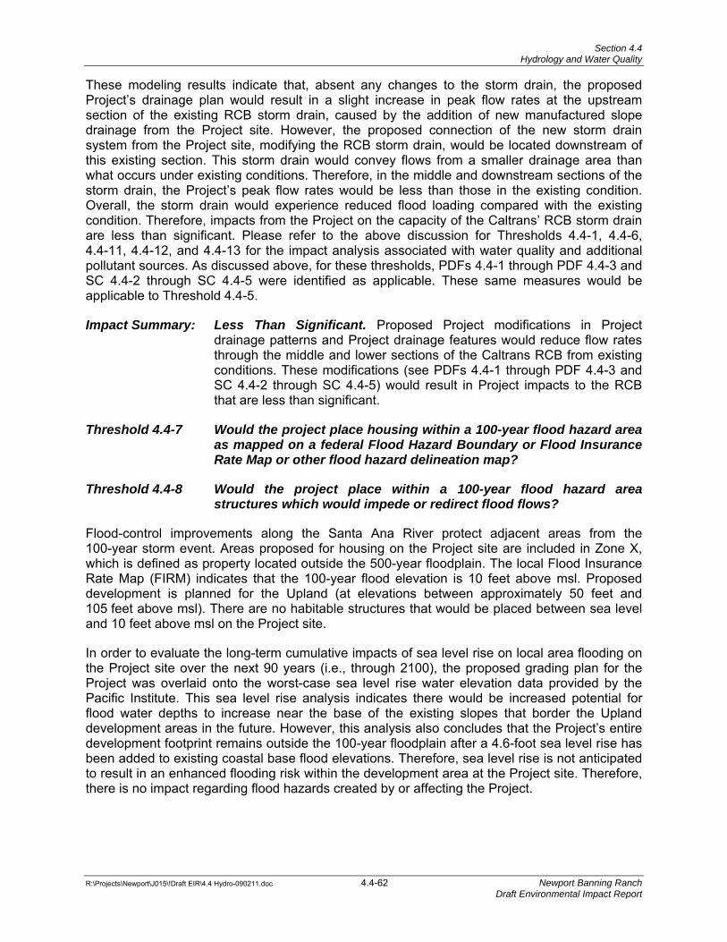
Section 4.4 Hydrology and Water Quality
R:\Projects\Newport\J015\!Draft EIR\4.4 Hydro-090211.doc 4.4-62 Newport Banning Ranch Draft Environmental Impact Report
These modeling results indicate that, absent any changes to the storm drain, the proposed Project’s drainage plan would result in a slight increase in peak flow rates at the upstream section of the existing RCB storm drain, caused by the addition of new manufactured slope drainage from the Project site. However, the proposed connection of the new storm drain system from the Project site, modifying the RCB storm drain, would be located downstream of this existing section. This storm drain would convey flows from a smaller drainage area than what occurs under existing conditions. Therefore, in the middle and downstream sections of the storm drain, the Project’s peak flow rates would be less than those in the existing condition. Overall, the storm drain would experience reduced flood loading compared with the existing condition. Therefore, impacts from the Project on the capacity of the Caltrans’ RCB storm drain are less than significant. Please refer to the above discussion for Thresholds 4.4-1, 4.4-6, 4.4-11, 4.4-12, and 4.4-13 for the impact analysis associated with water quality and additional pollutant sources. As discussed above, for these thresholds, PDFs 4.4-1 through PDF 4.4-3 and SC 4.4-2 through SC 4.4-5 were identified as applicable. These same measures would be applicable to Threshold 4.4-5.
Impact Summary: Less Than Significant. Proposed Project modifications in Project drainage patterns and Project drainage features would reduce flow rates through the middle and lower sections of the Caltrans RCB from existing conditions. These modifications (see PDFs 4.4-1 through PDF 4.4-3 and SC 4.4-2 through SC 4.4-5) would result in Project impacts to the RCB that are less than significant.
Threshold 4.4-7 Would the project place housing within a 100-year flood hazard area as mapped on a federal Flood Hazard Boundary or Flood Insurance Rate Map or other flood hazard delineation map?
Threshold 4.4-8 Would the project place within a 100-year flood hazard area structures which would impede or redirect flood flows?
Flood-control improvements along the Santa Ana River protect adjacent areas from the 100-year storm event. Areas proposed for housing on the Project site are included in Zone X, which is defined as property located outside the 500-year floodplain. The local Flood Insurance Rate Map (FIRM) indicates that the 100-year flood elevation is 10 feet above msl. Proposed development is planned for the Upland (at elevations between approximately 50 feet and 105 feet above msl). There are no habitable structures that would be placed between sea level and 10 feet above msl on the Project site.
In order to evaluate the long-term cumulative impacts of sea level rise on local area flooding on the Project site over the next 90 years (i.e., through 2100), the proposed grading plan for the Project was overlaid onto the worst-case sea level rise water elevation data provided by the Pacific Institute. This sea level rise analysis indicates there would be increased potential for flood water depths to increase near the base of the existing slopes that border the Upland development areas in the future. However, this analysis also concludes that the Project’s entire development footprint remains outside the 100-year floodplain after a 4.6-foot sea level rise has been added to existing coastal base flood elevations. Therefore, sea level rise is not anticipated to result in an enhanced flooding risk within the development area at the Project site. Therefore, there is no impact regarding flood hazards created by or affecting the Project.
Section 4.4 Hydrology and Water Quality
R:\Projects\Newport\J015\!Draft EIR\4.4 Hydro-090211.doc 4.4-63 Newport Banning Ranch Draft Environmental Impact Report
Impact Summary: No Impact. Proposed Project housing would be located on the Upland at elevations well outside the 100-year floodplain. No structures would be built within the Lowland between sea level and 10 feet above msl. There would no impacts to or from the 100-year flood zone.
Threshold 4.4-9 Would the project expose people or structures to a significant risk of loss, injury or death involving flooding, including flooding as a result of the failure of a levee or dam?
Improvements to the Santa Ana River implemented over recent years by the USACE in partnership with the Counties of Orange, Riverside, and San Bernardino include levee upgrades, improvements to Prado Dam, and construction of Seven Oaks Dam. These improvements protect surrounding residences and communities from the 100-year flood event. Because of its location at the lower end of the watershed, the Project site is not located within any dam inundation areas. Project development is proposed for the Upland area, which is located above the Santa Ana River’s 100-year floodplain. In the unlikely event that the Seven Oaks Dam in San Bernardino County or Prado Dam in Riverside County failed, the Project site would remain protected due to distance from the dams and elevation of the Upland. While flooding could affect the Lowland, no habitable structures are proposed in this area as a part of the Project. In addition, the City has an Emergency Management Plan, which includes procedures and evacuation plans to be implemented in the unlikely event of dam or levee failures. Therefore, impacts at the Project site due to flooding associated with failure of a dam or levee on the Santa Ana River are considered less than significant.
Impact Summary: Less than Significant. The Project is not located in a dam inundation area. The proposed development would be located on the Upland above the 100-year flood elevation. Project impacts would, therefore, be less than significant.
Threshold 4.4-10 Would the project be subject to inundation by seiche, tsunami, or mudflow?
There are no permanent standing water bodies in the Upland area and inundation by seiche or mudflow is not anticipated in the Upland area. Due to the Project’s proximity to the coast, inundation by tsunami is possible, and the Lowland is located within the tsunami warning area designated in the City’s General Plan. West Coast Highway and existing development lie between the Project site and the Pacific Ocean and. The proposed Project was also evaluated against a tsunami inundation map used for emergency preparedness (Newport Beach Quadrangle, CA Department of Conservation; March 15, 2009). The proposed development footprint remains out of the tsunami inundation area and the impacts from potential tsunami effects under a condition of future sea level rise are considered less than significant. It is also noted that the City has an Emergency Management Plan, which includes procedures and evacuation plans in the event of tsunamis. Therefore, risks to development areas on the Project site are considered less than significant.
Impact Summary: Less than Significant Impact. Inundation of the Project site by seiche or mudflow is not anticipated as there are no standing water bodies or high slopes in the Upland. Inundation by tsunami is not likely because Project development is not proposed in the Lowland. Therefore, impacts are less than significant.
Section 4.4 Hydrology and Water Quality
R:\Projects\Newport\J015\!Draft EIR\4.4 Hydro-090211.doc 4.4-64 Newport Banning Ranch Draft Environmental Impact Report
Threshold 4.4-16 Would the project conflict with any applicable plan, policy, or regulation of an agency with jurisdiction over the project (including, but not limited to the general plan, specific plan, local coastal program, or zoning ordinance) adopted for the purpose of avoiding or mitigating an environmental effect?
Tables 4.4-25 and 4.4-2611 evaluate the Project’s consistency with the applicable goals and policies of the City’s General Plan and the Coastal Act, respectively.
Impact Summary: No Impact. As identified in Tables 4.4-25 and 4.4-26, the proposed Project would be consistent with the intent of the hydrology- and water quality-related goals and policies of the City of Newport Beach General Plan.
4.4.8 MITIGATION PROGRAM
Project Design Features
The Project would be required to implement PDFs 4.4-1 through 4.4-6 with respect to hydrology and water quality.
Standard Conditions and Requirements
The following standard conditions are applicable to the Project with respect to hydrology and water quality: SC 4.4-1 through 4.4-5.
Mitigation Measures
No mitigation is required.
4.4.9 LEVEL OF SIGNIFICANCE AFTER MITIGATION
With the incorporation of the Project Design Features and Standard Conditions discussed above, Project impacts related to surface water runoff and water quality would be less than significant.
11 For ease of reading, the policy tables are located at the end of this section.
Section 4.4 Hydrology and Water Quality
R:\Projects\Newport\J015\!Draft EIR\4.4 Hydro-090211.doc 4.4-65 Newport Banning Ranch Draft Environmental Impact Report
TABLE 4.4-25 CITY OF NEWPORT BEACH GENERAL PLAN CONSISTENCY ANALYSIS
City of Newport Beach General Plan
Relevant Goals, Policies, and Programs Consistency Analysis Harbor and Bay Element Harbor and Bay Element Plan Goal HB 8Enhancement and protection of water quality of all natural water bodies, including coastal waters, creeks, bays, harbors, and wetlands. (Goal NR3)
The Project is consistent with this goal. The Project would comply with all water quality objectives set by the Regional Water Quality Control Board (RWQCB) in the Basin Plan and the City Council policies through the use of appropriate best management practices (BMPs) for Project construction and long-term operation. These BMPs would ensure compliance with the current National Pollutant Discharge Elimination System (NPDES) General Construction Permit; the County of Orange NPDES MS4 Permit; and the County of Orange Drainage Area Management Plan (DAMP). A Water Quality Management Plan (WQMP), which provides additional detail on water quality management features, shall be prepared as final design proceeds. Project storm drain features ensure that flows are treated by on-site biocells and treatment basins, such that flows entering Semeniuk Slough and the Lowland area maintain and/or enhance existing beneficial uses. Project Design Features (PDFs) 4.4-1, 4.4-2, 4.4-3 and SCs 4.4-3 and 4.4-4 provide for BMPs protecting water quality of receiving waters in the Lowland and Santa Ana River.
Policies HB Policy 8.1: Chemical Uses Impacting Water Quality Support regulations limiting or banning the use of insecticides, fertilizers, and other chemicals which are shown to be detrimental to water quality.
The Project is consistent with this policy. PDF 4.4-8 and SCs 4.4-4 and 4.4-5 provide for development of a Water Quality Management Plan and Good Housekeeping BMPs limiting the use of insecticides and fertilizers on the Project site, have been incorporated into the Project. In addition, specific restrictions are included when applying these chemicals regarding the occurrence of rainfall events, application techniques, and qualifications of the individual performing the application. A Pesticide and Fertilizer Management Plan would be prepared to further document the appropriate applications and uses of fertilizers and pesticides to protect existing water quality for Project receiving waters.
HB Policy 8.2: Water Pollution PreventionPromote pollution prevention and elimination methods that minimize the introduction of pollutants into natural water bodies. (Policy NR 3.2)
The Project is consistent with this policy. Construction management BMPs would be developed that ensure the risks from discharge and transport of pollutants from the construction site are minimized. Post-construction BMPs include source controls and a well-designed water quality program that reduce the likelihood of initial pollutant discharge and treats all runoff from the Project site prior to discharge into the Semeniuk Slough and/or the Lowland. Site design and LID BMPs further address storm water pollution prevention through site planning features and landscaping elements. The Project’s Green Building Program encourages use of natural treatment, bioswales, and arroyos for water quality treatment to improve water quality discharged into natural water bodies. The Project would provide wetlands restoration, creation, and enhancement. Please refer to Section 3.0, Project
Section 4.4 Hydrology and Water Quality
TABLE 4.4-25 (Continued)
CITY OF NEWPORT BEACH GENERAL PLAN CONSISTENCY ANALYSIS
R:\Projects\Newport\J015\!Draft EIR\4.4 Hydro-090211.doc 4.4-66 Newport Banning Ranch Draft Environmental Impact Report
City of Newport Beach General PlanRelevant Goals, Policies, and Programs Consistency Analysis
Description, and Section 4.6, Biological Resources. The Project would comply with all requirements set forth in the current NPDES General Construction Permit and the MS4 Permit, which includes preparation of a Storm Water Pollution Prevention Plan (SWPPP). The Project would also comply with the updated General Construction Permit and revised Water Quality Management Plan guidelines. PDFs have been incorporated into the Project design including Site Design and LID features and good housekeeping procedures consistent with the overall goal of preventing pollution occurrences and/or pollutant transport off the Project site.
HB Policy 8.3: Ground Water ContaminationSuspend activities and implement appropriate health and safety procedures in the event that previously unknown groundwater contamination is encountered during construction. Where site contamination is identified, implement an appropriate remediation strategy that is approved by the City and state agency with appropriate jurisdictions. (Policy NR 3.3)
The Project is consistent with this policy. Groundwater levels beneath the Project site are at approximately mean sea level, close to ground surface elevation within the Lowland. Project construction is not anticipated to encounter or impact groundwater levels, supply, or quality in the Upland. Removal of oil facilities within the Lowlandwould incorporate specific BMPs that would ensure the risk of groundwater contamination during these construction activities is minimized. In addition, construction BMPs have been incorporated into the Project including waste management and materials pollution control BMPs. Implementation of these measures would further reduce any risk of encountering or negatively impacting groundwater levels or quality.
HB Policy 8.4: Storm Drain Sewer System PermitRequire all development to comply with the regulations under the City’s municipal separate storm sewer system permit under the National Pollutant Discharge Elimination System. (Policy NR 3.4)
The Project is consistent with this policy. As addressed in Section 4.3, Geology and Soils, and this section of the EIR, the Project requires an NPDES permit. All requirements of the Orange County Drainage Area Management Plan shall be complied with through the development of a Project Water Quality Management Plan. Please also refer to Section 4.3, Geology and Soils.
HB Policy 8.5: Natural Water Bodies Require that development not result in the degradation of natural water bodies. (Policy NR 3.5)
The Project is consistent with this policy. The Project would comply with all water quality objectives set by the RWQCB in the Basin Plan and the City Council policies through the use of appropriate BMPs for Projectconstruction and long-term operation. These BMPs would ensure compliance with the current NPDES General Construction Permit; the MS4 Permit; and the County of Orange DAMP. A WQMP, which provides additional detail on water quality management features, shall be prepared as final design proceeds. Project storm drain features ensure that flows are treated by on-site biocells and treatment basins, such that flows entering Semeniuk Slough and the Lowland maintain and/or enhance existing beneficial uses. PDFs 4.4-1, 4.4-2, 4.4-3 and SCs 4.4-3 and 4.4-4 provide for BMPs protecting water quality of receiving waters in the Lowland and Santa Ana River.
HB Policy 8.9: Water Quality Management PlanRequire new development applications to include a Water Quality Management Plan (WQMP) to minimize runoff from rainfall events during construction and post-construction. (Policy NR 3.9)
The Project is consistent with this policy. A WQMP shall be prepared during final design consistent with revised guidelines contained in the Orange County DAMP. The Project proposes to ensure all site runoff is treated to a level protecting existing beneficial uses of downstream receiving waters of the Semeniuk Slough and Lowland.
Section 4.4 Hydrology and Water Quality
TABLE 4.4-25 (Continued)
CITY OF NEWPORT BEACH GENERAL PLAN CONSISTENCY ANALYSIS
R:\Projects\Newport\J015\!Draft EIR\4.4 Hydro-090211.doc 4.4-67 Newport Banning Ranch Draft Environmental Impact Report
City of Newport Beach General PlanRelevant Goals, Policies, and Programs Consistency Analysis
Implementation Program 7.1 is not applicable to the Project which requires the City to review building and construction codes for consistency with the General Plan.
The Project’s green building program encourages use of natural treatment techniques, LID features, Site Design BMPs and Source Control BMPs, to improve water quality discharged into natural water bodies. Please refer to Section 3.0, Project Description, and Section 4.6, Biological Resources. The Applicant would be responsible for ensuring that the Project is designed and constructed in accordance with all applicable codes. The application of appropriate BMPs for Project construction and long-term operation would ensure compliance.
HB Policy 8.10: Best Management PracticesImplement and improve upon Best Management Practices (BMPs) for residences, businesses, development projects, and City operations.
The Project is consistent with this policy. The Project proposes to implement a water quality program to protectexisting water quality and beneficial uses of receiving waters by treating site runoff and incorporating LID features into Project design. The Project’s green building program encourages use of natural treatment, bioswales, and arroyos for water quality treatment to improve water quality discharged into natural water bodies. The Project would provide wetlands restoration, creation, and enhancement. This EIR identifies the proposed BMPs that would be implemented as a part of the Project.
HB Policy 8.11: Site Design and Source ControlInclude site design and source control BMPs in all developments. When the combination of site design and source control BMPs are not sufficient to protect water quality as required by the National Pollutant Elimination System, structural treatment BMPs will be implemented along with site design and source control measures. (NR 3.11)
The Project is consistent with this policy. Site Design and Source Control BMPs have been incorporated into Project conceptual development and site design. This EIR identifies the proposed BMPs, including structural and non-structural BMPs, which would be implemented as a part of the Project.
HB Policy 8.13: Natural Wetlands Promote the use of natural wetlands to improve water quality. (Policy NR 3.13)
The Project is consistent with this Policy. The water quality treatment basins would use native wetland habitat for treatment function within the basin limits. This basin would also require long-term Safe Harbor maintenance agreements with the Resource Agencies within the physical limits of the basin to ensure maintenance activities are performed on a routine basis to maximize water quality treatment and energy dissipation functions.. Landscaping biocells through the Project site would also be used to improve water quality prior to discharge from the site into the Project storm drain system.
HB Policy 8.14: Runoff Reduction on Private Property Retain runoff on private property to prevent the transport of pollutants into recreational waters, to the maximum extent practicable. (Policy NR 3.14)
The Project is consistent with this policy. The Project incorporates structural and non-structural BMPs to reduce or and treat runoff from the Project site. Downstream biological systems and arroyo vegetation would be maintained by the Project through ensuring the provision of continued adequate runoff discharge volumes. Where feasible, infiltration on the Project site would be accomplished through LID and Site Design features.
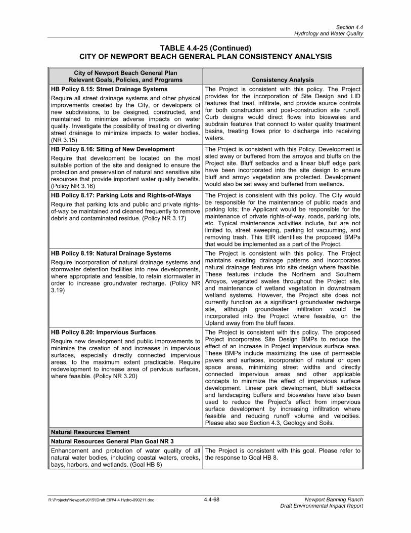
Section 4.4 Hydrology and Water Quality
TABLE 4.4-25 (Continued)
CITY OF NEWPORT BEACH GENERAL PLAN CONSISTENCY ANALYSIS
R:\Projects\Newport\J015\!Draft EIR\4.4 Hydro-090211.doc 4.4-68 Newport Banning Ranch Draft Environmental Impact Report
City of Newport Beach General PlanRelevant Goals, Policies, and Programs Consistency Analysis
HB Policy 8.15: Street Drainage SystemsRequire all street drainage systems and other physical improvements created by the City, or developers of new subdivisions, to be designed, constructed, and maintained to minimize adverse impacts on water quality. Investigate the possibility of treating or diverting street drainage to minimize impacts to water bodies. (NR 3.15)
The Project is consistent with this policy. The Project provides for the incorporation of Site Design and LID features that treat, infiltrate, and provide source controls for both construction and post-construction site runoff. Curb designs would direct flows into bioswales and subdrain features that connect to water quality treatment basins, treating flows prior to discharge into receiving waters.
HB Policy 8.16: Siting of New DevelopmentRequire that development be located on the most suitable portion of the site and designed to ensure the protection and preservation of natural and sensitive site resources that provide important water quality benefits. (Policy NR 3.16)
The Project is consistent with this Policy. Development is sited away or buffered from the arroyos and bluffs on the Project site. Bluff setbacks and a linear bluff edge park have been incorporated into the site design to ensure bluff and arroyo vegetation are protected. Developmentwould also be set away and buffered from wetlands.
HB Policy 8.17: Parking Lots and Rights-of-WaysRequire that parking lots and public and private rights-of-way be maintained and cleaned frequently to remove debris and contaminated residue. (Policy NR 3.17)
The Project is consistent with this policy. The City would be responsible for the maintenance of public roads and parking lots; the Applicant would be responsible for the maintenance of private rights-of-way, roads, parking lots, etc. Typical maintenance activities include, but are not limited to, street sweeping, parking lot vacuuming, and removing trash. This EIR identifies the proposed BMPs that would be implemented as a part of the Project.
HB Policy 8.19: Natural Drainage SystemsRequire incorporation of natural drainage systems and stormwater detention facilities into new developments, where appropriate and feasible, to retain stormwater in order to increase groundwater recharge. (Policy NR 3.19)
The Project is consistent with this policy. The Project maintains existing drainage patterns and incorporates natural drainage features into site design where feasible. These features include the Northern and Southern Arroyos, vegetated swales throughout the Project site, and maintenance of wetland vegetation in downstream wetland systems. However, the Project site does not currently function as a significant groundwater recharge site, although groundwater infiltration would be incorporated into the Project where feasible, on the Upland away from the bluff faces.
HB Policy 8.20: Impervious Surfaces Require new development and public improvements to minimize the creation of and increases in impervious surfaces, especially directly connected impervious areas, to the maximum extent practicable. Require redevelopment to increase area of pervious surfaces, where feasible. (Policy NR 3.20)
The Project is consistent with this policy. The proposed Project incorporates Site Design BMPs to reduce the effect of an increase in Project impervious surface area. These BMPs include maximizing the use of permeable pavers and surfaces, incorporation of natural or open space areas, minimizing street widths and directly connected impervious areas and other applicable concepts to minimize the effect of impervious surface development. Linear park development, bluff setbacks and landscaping buffers and bioswales have also been used to reduce the Project’s effect from impervious surface development by increasing infiltration where feasible and reducing runoff volume and velocities. Please also see Section 4.3, Geology and Soils.
Natural Resources Element Natural Resources General Plan Goal NR 3 Enhancement and protection of water quality of all natural water bodies, including coastal waters, creeks, bays, harbors, and wetlands. (Goal HB 8)
The Project is consistent with this goal. Please refer to the response to Goal HB 8.
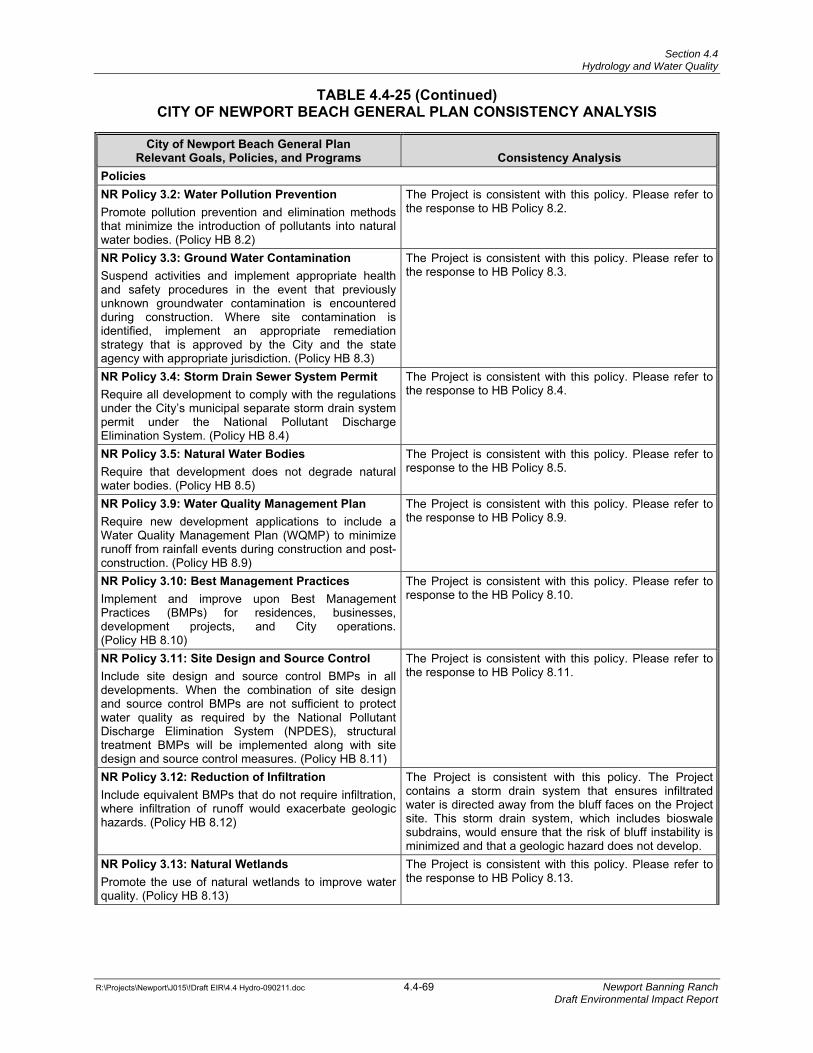
Section 4.4 Hydrology and Water Quality
TABLE 4.4-25 (Continued)
CITY OF NEWPORT BEACH GENERAL PLAN CONSISTENCY ANALYSIS
R:\Projects\Newport\J015\!Draft EIR\4.4 Hydro-090211.doc 4.4-69 Newport Banning Ranch Draft Environmental Impact Report
City of Newport Beach General PlanRelevant Goals, Policies, and Programs Consistency Analysis
Policies NR Policy 3.2: Water Pollution PreventionPromote pollution prevention and elimination methods that minimize the introduction of pollutants into natural water bodies. (Policy HB 8.2)
The Project is consistent with this policy. Please refer to the response to HB Policy 8.2.
NR Policy 3.3: Ground Water ContaminationSuspend activities and implement appropriate health and safety procedures in the event that previously unknown groundwater contamination is encountered during construction. Where site contamination is identified, implement an appropriate remediation strategy that is approved by the City and the state agency with appropriate jurisdiction. (Policy HB 8.3)
The Project is consistent with this policy. Please refer to the response to HB Policy 8.3.
NR Policy 3.4: Storm Drain Sewer System PermitRequire all development to comply with the regulations under the City’s municipal separate storm drain system permit under the National Pollutant Discharge Elimination System. (Policy HB 8.4)
The Project is consistent with this policy. Please refer to the response to HB Policy 8.4.
NR Policy 3.5: Natural Water Bodies Require that development does not degrade natural water bodies. (Policy HB 8.5)
The Project is consistent with this policy. Please refer to response to the HB Policy 8.5.
NR Policy 3.9: Water Quality Management PlanRequire new development applications to include a Water Quality Management Plan (WQMP) to minimize runoff from rainfall events during construction and post-construction. (Policy HB 8.9)
The Project is consistent with this policy. Please refer to the response to HB Policy 8.9.
NR Policy 3.10: Best Management PracticesImplement and improve upon Best Management Practices (BMPs) for residences, businesses, development projects, and City operations. (Policy HB 8.10)
The Project is consistent with this policy. Please refer to response to the HB Policy 8.10.
NR Policy 3.11: Site Design and Source ControlInclude site design and source control BMPs in all developments. When the combination of site design and source control BMPs are not sufficient to protect water quality as required by the National Pollutant Discharge Elimination System (NPDES), structural treatment BMPs will be implemented along with site design and source control measures. (Policy HB 8.11)
The Project is consistent with this policy. Please refer to the response to HB Policy 8.11.
NR Policy 3.12: Reduction of Infiltration Include equivalent BMPs that do not require infiltration, where infiltration of runoff would exacerbate geologic hazards. (Policy HB 8.12)
The Project is consistent with this policy. The Project contains a storm drain system that ensures infiltrated water is directed away from the bluff faces on the Project site. This storm drain system, which includes bioswale subdrains, would ensure that the risk of bluff instability is minimized and that a geologic hazard does not develop.
NR Policy 3.13: Natural Wetlands Promote the use of natural wetlands to improve water quality. (Policy HB 8.13)
The Project is consistent with this policy. Please refer to the response to HB Policy 8.13.
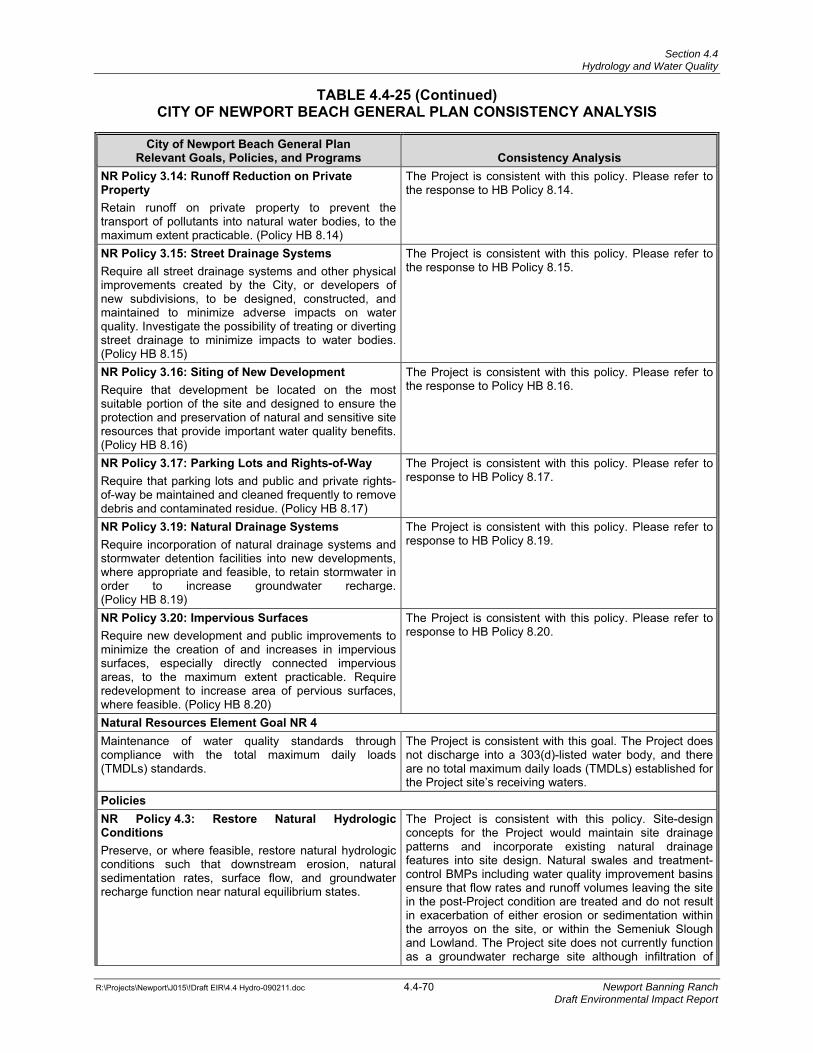
Section 4.4 Hydrology and Water Quality
TABLE 4.4-25 (Continued)
CITY OF NEWPORT BEACH GENERAL PLAN CONSISTENCY ANALYSIS
R:\Projects\Newport\J015\!Draft EIR\4.4 Hydro-090211.doc 4.4-70 Newport Banning Ranch Draft Environmental Impact Report
City of Newport Beach General PlanRelevant Goals, Policies, and Programs Consistency Analysis
NR Policy 3.14: Runoff Reduction on Private Property Retain runoff on private property to prevent the transport of pollutants into natural water bodies, to the maximum extent practicable. (Policy HB 8.14)
The Project is consistent with this policy. Please refer to the response to HB Policy 8.14.
NR Policy 3.15: Street Drainage SystemsRequire all street drainage systems and other physical improvements created by the City, or developers of new subdivisions, to be designed, constructed, and maintained to minimize adverse impacts on water quality. Investigate the possibility of treating or diverting street drainage to minimize impacts to water bodies. (Policy HB 8.15)
The Project is consistent with this policy. Please refer to the response to HB Policy 8.15.
NR Policy 3.16: Siting of New DevelopmentRequire that development be located on the most suitable portion of the site and designed to ensure the protection and preservation of natural and sensitive site resources that provide important water quality benefits. (Policy HB 8.16)
The Project is consistent with this policy. Please refer to the response to Policy HB 8.16.
NR Policy 3.17: Parking Lots and Rights-of-WayRequire that parking lots and public and private rights-of-way be maintained and cleaned frequently to remove debris and contaminated residue. (Policy HB 8.17)
The Project is consistent with this policy. Please refer to response to HB Policy 8.17.
NR Policy 3.19: Natural Drainage SystemsRequire incorporation of natural drainage systems and stormwater detention facilities into new developments, where appropriate and feasible, to retain stormwater in order to increase groundwater recharge. (Policy HB 8.19)
The Project is consistent with this policy. Please refer to response to HB Policy 8.19.
NR Policy 3.20: Impervious Surfaces Require new development and public improvements to minimize the creation of and increases in impervious surfaces, especially directly connected impervious areas, to the maximum extent practicable. Require redevelopment to increase area of pervious surfaces, where feasible. (Policy HB 8.20)
The Project is consistent with this policy. Please refer to response to HB Policy 8.20.
Natural Resources Element Goal NR 4 Maintenance of water quality standards through compliance with the total maximum daily loads (TMDLs) standards.
The Project is consistent with this goal. The Project does not discharge into a 303(d)-listed water body, and there are no total maximum daily loads (TMDLs) established for the Project site’s receiving waters.
Policies NR Policy 4.3: Restore Natural Hydrologic Conditions Preserve, or where feasible, restore natural hydrologic conditions such that downstream erosion, natural sedimentation rates, surface flow, and groundwater recharge function near natural equilibrium states.
The Project is consistent with this policy. Site-design concepts for the Project would maintain site drainage patterns and incorporate existing natural drainage features into site design. Natural swales and treatment-control BMPs including water quality improvement basins ensure that flow rates and runoff volumes leaving the site in the post-Project condition are treated and do not result in exacerbation of either erosion or sedimentation within the arroyos on the site, or within the Semeniuk Slough and Lowland. The Project site does not currently function as a groundwater recharge site although infiltration of
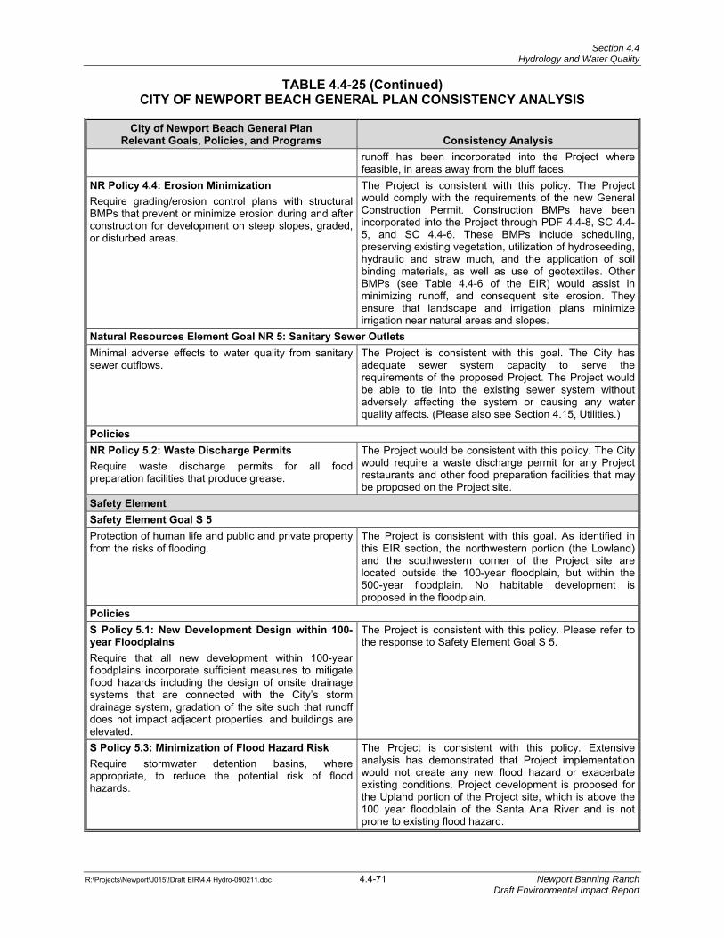
Section 4.4 Hydrology and Water Quality
TABLE 4.4-25 (Continued)
CITY OF NEWPORT BEACH GENERAL PLAN CONSISTENCY ANALYSIS
R:\Projects\Newport\J015\!Draft EIR\4.4 Hydro-090211.doc 4.4-71 Newport Banning Ranch Draft Environmental Impact Report
City of Newport Beach General PlanRelevant Goals, Policies, and Programs Consistency Analysis
runoff has been incorporated into the Project where feasible, in areas away from the bluff faces.
NR Policy 4.4: Erosion Minimization Require grading/erosion control plans with structural BMPs that prevent or minimize erosion during and after construction for development on steep slopes, graded, or disturbed areas.
The Project is consistent with this policy. The Project would comply with the requirements of the new General Construction Permit. Construction BMPs have been incorporated into the Project through PDF 4.4-8, SC 4.4-5, and SC 4.4-6. These BMPs include scheduling, preserving existing vegetation, utilization of hydroseeding, hydraulic and straw much, and the application of soil binding materials, as well as use of geotextiles. Other BMPs (see Table 4.4-6 of the EIR) would assist in minimizing runoff, and consequent site erosion. They ensure that landscape and irrigation plans minimize irrigation near natural areas and slopes.
Natural Resources Element Goal NR 5: Sanitary Sewer Outlets Minimal adverse effects to water quality from sanitary sewer outflows.
The Project is consistent with this goal. The City has adequate sewer system capacity to serve the requirements of the proposed Project. The Project would be able to tie into the existing sewer system without adversely affecting the system or causing any water quality affects. (Please also see Section 4.15, Utilities.)
Policies NR Policy 5.2: Waste Discharge PermitsRequire waste discharge permits for all food preparation facilities that produce grease.
The Project would be consistent with this policy. The City would require a waste discharge permit for any Project restaurants and other food preparation facilities that may be proposed on the Project site.
Safety Element Safety Element Goal S 5 Protection of human life and public and private property from the risks of flooding.
The Project is consistent with this goal. As identified in this EIR section, the northwestern portion (the Lowland) and the southwestern corner of the Project site are located outside the 100-year floodplain, but within the 500-year floodplain. No habitable development is proposed in the floodplain.
Policies S Policy 5.1: New Development Design within 100-year Floodplains Require that all new development within 100-year floodplains incorporate sufficient measures to mitigate flood hazards including the design of onsite drainage systems that are connected with the City’s storm drainage system, gradation of the site such that runoff does not impact adjacent properties, and buildings are elevated.
The Project is consistent with this policy. Please refer to the response to Safety Element Goal S 5.
S Policy 5.3: Minimization of Flood Hazard RiskRequire stormwater detention basins, where appropriate, to reduce the potential risk of flood hazards.
The Project is consistent with this policy. Extensive analysis has demonstrated that Project implementation would not create any new flood hazard or exacerbate existing conditions. Project development is proposed for the Upland portion of the Project site, which is above the 100 year floodplain of the Santa Ana River and is not prone to existing flood hazard.
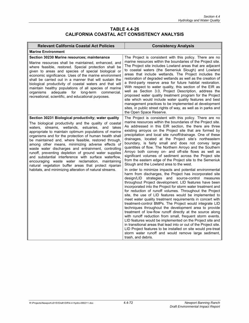
Section 4.4 Hydrology and Water Quality
R:\Projects\Newport\J015\!Draft EIR\4.4 Hydro-090211.doc 4.4-72 Newport Banning Ranch Draft Environmental Impact Report
TABLE 4.4-26 CALIFORNIA COASTAL ACT CONSISTENCY ANALYSIS
Relevant California Coastal Act Policies Consistency Analysis
Marine Environment Section 30230 Marine resources; maintenance Marine resources shall be maintained, enhanced, and where feasible, restored. Special protection shall be given to areas and species of special biological or economic significance. Uses of the marine environment shall be carried out in a manner that will sustain the biological productivity of coastal waters and that will maintain healthy populations of all species of marine organisms adequate for long-term commercial, recreational, scientific, and educational purposes.
The Project is consistent with this policy. There are no marine resources within the boundaries of the Project site. The Project site includes Lowland areas that are adjacent to coastal waters (the Semeniuk Slough) and Lowland areas that include wetlands. The Project includes the restoration of degraded wetlands as well as the creation of a third-party reserve area for future habitat restoration. With respect to water quality, this section of the EIR as well as Section 3.0, Project Description, address the proposed water quality treatment program for the Project site which would include water quality features and best management practices to be implemented at development sites, in public street rights of way, as well as in parks and the Open Space Reserve.
Section 30231 Biological productivity; water quality The biological productivity and the quality of coastal waters, streams, wetlands, estuaries, and lakes appropriate to maintain optimum populations of marine organisms and for the protection of human health shall be maintained and, where feasible, restored through, among other means, minimizing adverse effects of waste water discharges and entrainment, controlling runoff, preventing depletion of ground water supplies and substantial interference with surface waterflow, encouraging waste water reclamation, maintaining natural vegetation buffer areas that protect riparian habitats, and minimizing alteration of natural streams.
The Project is consistent with this policy. There are no marine resources within the boundaries of the Project site. As addressed in this EIR section, the there are three existing arroyos on the Project site that are formed by precipitation and local site runoff/drainage. One of these drainages, located at the Project site’s northeastern boundary, is fairly small and does not convey large quantities of flow. The Northern Arroyo and the Southern Arroyo both convey on- and off-site flows as well as significant volumes of sediment across the Project site from the eastern edge of the Project site to the Semeniuk Slough and the Lowland area to the west. In order to minimize impacts and potential environmental harm from discharges, the Project has incorporated site design/LID strategies and source-control measures throughout Project development. LID features have been incorporated into the Project for storm water treatment and for reduction of runoff volumes. Throughout the Project site, the use of LID features would be implemented to meet water quality treatment requirements in concert with treatment-control BMPs. The Project would integrate LID techniques throughout the development area to provide treatment of low-flow runoff directly at the source along with runoff reduction from small, frequent storm events. LID features would be implemented on the Project site and in transitional areas that lead into or out of the Project site. LID Project features to be installed on site would pre-treat storm water runoff and would remove large sediment, trash, and debris.
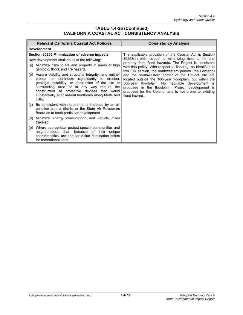
Section 4.4 Hydrology and Water Quality
TABLE 4.4-26 (Continued)
CALIFORNIA COASTAL ACT CONSISTENCY ANALYSIS
R:\Projects\Newport\J015\!Draft EIR\4.4 Hydro-090211.doc 4.4-73 Newport Banning Ranch Draft Environmental Impact Report
Relevant California Coastal Act Policies Consistency Analysis Development Section 30253 Minimization of adverse impacts New development shall do all of the following: (a) Minimize risks to life and property in areas of high
geologic, flood, and fire hazard. (b) Assure stability and structural integrity, and neither
create nor contribute significantly to erosion, geologic instability, or destruction of the site or surrounding area or in any way require the construction of protective devices that would substantially alter natural landforms along bluffs and cliffs.
(c) Be consistent with requirements imposed by an air pollution control district or the State Air Resources Board as to each particular development.
(d) Minimize energy consumption and vehicle miles traveled.
(e) Where appropriate, protect special communities and neighborhoods that, because of their unique characteristics, are popular visitor destination points for recreational uses.
The applicable provision of the Coastal Act is Section 30253(a) with respect to minimizing risks to life and property from flood hazards. The Project is consistent with this policy. With respect to flooding, as identified in this EIR section, the northwestern portion (the Lowland) and the southwestern corner of the Project site are located outside the 100-year floodplain, but within the 500-year floodplain. No habitable development is proposed in the floodplain. Project development is proposed for the Upland, and is not prone to existing flood hazard.

Section 4.4 Hydrology and Water Quality
R:\Projects\Newport\J015\!Draft EIR\4.4 Hydro-090211.doc 4.4-74 Newport Banning Ranch Draft Environmental Impact Report
This page intentionally left blank