4.17.1 Introduction - La Entrada Community · Coachella Valley Water District Regulations Governing...
58
LSA ASSOCIATES, INC. JULY 2013 DRAFT ENVIRONMENTAL IMPACT REPORT LA ENTRADA SPECIFIC PLAN CITY OF COACHELLA P:\CLA1201A\Draft EIR for circulation\4.17 Water Supply.doc «07/10/13» 4.17-1 4.17 WATER SUPPLY 4.17.1 Introduction The following section provides an analysis of the La Entrada Specific Plan’s (proposed project) potential impacts on water resources. Because water supply is an important issue for the project, this topic is addressed in a separate section. In accordance with the California Environmental Quality Act (CEQA), this analysis evaluates whether total projected water supplies available to the City of Coachella (City) during normal, single dry, and multiple dry years over a 20-year projection are sufficient to meet the projected water demands associated with the proposed project in addition to existing and planned future uses within the City’s service area, including agricultural and manufacturing uses. As further set forth below, this analysis also addresses several specific thresholds of significance under CEQA that apply specifically to water resources. The information, analyses, and conclusions in this section are based in part on information, analyses, and conclusions set forth in various regional and local water supply planning documents, including but not limited to the following: La Entrada Draft Water Supply Assessment (WSA) (TKE Engineering and Planning, July 5, 2013), which is included in Appendix M Final Coachella Valley Integrated Regional Water Management Plan (2010 IRWMP) (Coachella Valley Regional Water Management Group, December 2010) Coachella Valley Water District Coachella Valley Water Management Plan Update (2010 CVWMP Update) (December 2010) Coachella Valley Water District Coachella Valley Water Management Plan Update Final Subsequent Programmatic Environmental Impact Report (2011 SPEIR), State Clearinghouse (SCH) No. 1999041032, SCH No. 2000031027 (July 2011) Coachella Valley Water District 2010 Urban Water Management Plan (CVWD 2010 UWMP) (July 2011) City of Coachella 2010 Urban Water Management Plan (City 2010 UWMP) (July 2011) Coachella Valley Water District Regulations Governing Domestic Water Service (June 11, 2013) 2009 Memorandum of Understanding between the City of Coachella and Coachella Valley Water District (2009 MOU), which is appended to the WSA in Appendix M 2013 Memorandum of Understanding between the City of Coachella and Coachella Valley Water District (2013 MOU), which is appended to the WSA in Appendix M California Department of Water Resources 2011 Final State Water Project Delivery Reliability Report (June 2012) Metropolitan Water District of Southern California 2010 Regional Urban Water Management Plan (November 2010)
Transcript of 4.17.1 Introduction - La Entrada Community · Coachella Valley Water District Regulations Governing...
L S A A S S O C I A T E S , I N C . J U L Y 2 0 1 3
D R A F T E N V I R O N M E N T A L I M P A C T R E P O R T L A E N T R A D A S P E C I F I C P L A N
C I T Y O F C O A C H E L L A
P:\CLA1201A\Draft EIR for circulation\4.17 Water Supply.doc «07/10/13» 4.17-1
4.17 WATER SUPPLY
4.17.1 Introduction
The following section provides an analysis of the La Entrada Specific Plan’s (proposed project)
potential impacts on water resources. Because water supply is an important issue for the project, this
topic is addressed in a separate section. In accordance with the California Environmental Quality Act
(CEQA), this analysis evaluates whether total projected water supplies available to the City of
Coachella (City) during normal, single dry, and multiple dry years over a 20-year projection are
sufficient to meet the projected water demands associated with the proposed project in addition to
existing and planned future uses within the City’s service area, including agricultural and
manufacturing uses. As further set forth below, this analysis also addresses several specific thresholds
of significance under CEQA that apply specifically to water resources. The information, analyses, and
conclusions in this section are based in part on information, analyses, and conclusions set forth in
various regional and local water supply planning documents, including but not limited to the
following:
La Entrada Draft Water Supply Assessment (WSA) (TKE Engineering and Planning, July 5,
2013), which is included in Appendix M
Final Coachella Valley Integrated Regional Water Management Plan (2010 IRWMP) (Coachella
Valley Regional Water Management Group, December 2010)
Coachella Valley Water District Coachella Valley Water Management Plan Update (2010
CVWMP Update) (December 2010)
Coachella Valley Water District Coachella Valley Water Management Plan Update Final
Subsequent Programmatic Environmental Impact Report (2011 SPEIR), State Clearinghouse
(SCH) No. 1999041032, SCH No. 2000031027 (July 2011)
Coachella Valley Water District 2010 Urban Water Management Plan (CVWD 2010 UWMP)
(July 2011)
City of Coachella 2010 Urban Water Management Plan (City 2010 UWMP) (July 2011)
Coachella Valley Water District Regulations Governing Domestic Water Service (June 11, 2013)
2009 Memorandum of Understanding between the City of Coachella and Coachella Valley Water
District (2009 MOU), which is appended to the WSA in Appendix M
2013 Memorandum of Understanding between the City of Coachella and Coachella Valley Water
District (2013 MOU), which is appended to the WSA in Appendix M
California Department of Water Resources 2011 Final State Water Project Delivery Reliability
Report (June 2012)
Metropolitan Water District of Southern California 2010 Regional Urban Water Management
Plan (November 2010)

D R A F T E N V I R O N M E N T A L I M P A C T R E P O R T L A E N T R A D A S P E C I F I C P L A N C I T Y O F C O A C H E L L A
L S A A S S O C I A T E S , I N C . J U L Y 2 0 1 3
P:\CLA1201A\Draft EIR for circulation\4.17 Water Supply.doc «07/10/13» 4.17-2
Metropolitan Water District of Southern California 2010 Integrated Resources Plan (October
2010)
4.17.2 Methodology
Senate Bill (SB) 610, which was signed into law October 9, 2001, resulted in additions and
amendments to California Water Code (CWC) Sections 10910 through 10915 and Section 21151.9 of
the Public Resources Code (PRC). SB 610 provides that when a city or county determines that a
“project” as defined in CWC Section 10912 is subject to review under CEQA, the city or county must
identify the water supply agency that would provide retail water service to the project and request that
water supplier to prepare a WSA. Among other types of projects, a WSA is required for the
development of more than 500 residential dwelling units (DUs).1 The La Entrada Specific Plan
qualifies as a “project” under SB 610 because it is a proposed residential development with more than
500 DUs. As indicated above, generally a WSA must evaluate whether the total projected water
supplies available to the water supplier during normal, single dry, and multiple dry water years over a
20-year projection would meet the projected water demand associated with the proposed project, in
addition to the water supplier’s existing and planned future uses, which include agricultural and
manufacturing uses. In accordance with CWC Section 10911(b), the WSA must be included in the
CEQA document that is prepared for the proposed project.
As further set forth below, the City’s municipal water department, the Coachella Water Authority,
would provide retail water service for the proposed project. Accordingly, a WSA has been prepared
on behalf of the City in accordance with the requirements of SB 610. The WSA is included in
Appendix M and is relied upon and incorporated into this CEQA analysis.
The area covered by the proposed project was formerly called the McNaughton Specific Plan, which
is an approved specific plan comprising approximately 8,000 DUs, 250 acres (ac) of
commercial/hotel/resort, and two golf courses. The water demands of the proposed project have
previously been accounted for as part of the City’s 2006/2007 water supply planning process at a time
when the La Entrada Specific Plan was referred to as the McNaughton Specific Plan. Since that time,
the number of dwelling units for the project has been reduced by 200 DUs as part of the La Entrada
Specific Plan. The current project now has a lower total water demand than that projected in
2006/2007. Furthermore, and as discussed in greater detail below and in the WSA, the water demands
associated with the proposed project have been accounted for and are part of the projected growth
analyzed by CVWD in its recent 2010 CVWMP Update and 2011 SPEIR analyses.
4.17.3 Regulatory Setting
Federal Laws, Regulations and Policies. There are no particular federal laws, regulations, or
policies that apply specifically to water supply for the proposed project. However, the Federal
Endangered Species Act (FESA; referenced in Section 4.4, Biological Resources) and the Clean
Water Act (CWA; referenced in Section 4.9, Hydrology and Water Quality) can have direct and
indirect impacts on the overall availability and reliability of water supply in California. Moreover, the
Colorado River supplies that are available to the Coachella Valley are governed in part by federal
1 CWC Section 10912(a)(1). See also CEQA Guidelines Section 15155.

L S A A S S O C I A T E S , I N C . J U L Y 2 0 1 3
D R A F T E N V I R O N M E N T A L I M P A C T R E P O R T L A E N T R A D A S P E C I F I C P L A N
C I T Y O F C O A C H E L L A
P:\CLA1201A\Draft EIR for circulation\4.17 Water Supply.doc «07/10/13» 4.17-3
laws, regulations, and policies but do not apply directly to the City of Coachella as the retail water
provider for the proposed project. The relationship between federal law and the delivery of Colorado
River water to the Coachella Valley is further described below and fully analyzed in the WSA in
Appendix M.
Federal Safe Drinking Water Act (42 U.S.C Section 300f et seq.). The Federal Safe Drinking
Water Act (SDWA) is intended to protect public health by regulating the nation’s public drinking
water supply. The SDWA authorizes the United States Environmental Protection Agency (EPA) to
set national standards for drinking water supplied by public water systems to protect against both
naturally occurring and human-made contaminants. These National Primary Drinking Water
Regulations set enforceable maximum contaminant levels for particular contaminants in drinking
water or required ways to treat water to remove contaminants. Each standard also includes
requirements for water systems to test for contaminants in the water to make sure standards are
achieved. National Secondary Drinking Water Regulations are non-enforceable guidelines regulating
contaminants that may cause cosmetic effects (such as skin or tooth discoloration) or aesthetic effects
(such as taste, odor, or color) in drinking water. The EPA recommends secondary standards to water
systems, but does not require systems to comply. The most direct oversight of water systems is
conducted by State drinking water programs. States can apply to the EPA for “primacy” authority to
implement the SDWA within their jurisdictions. California has received primacy authority, and the
California Department of Public Health (CDPH) has the primary responsibility for implementing the
SDWA and related California drinking water laws and regulations. Title 22 of the California Code of
Regulations (CCR Division 4, Chapter 15, Domestic Water Quality and Monitoring Regulations)
provides the regulatory requirements for potable water quality in California.
State Laws, Regulations and Policies.
Urban Water Management Planning Act (Cal. Water Code Section 10610 to 10656). The
Urban Water Management Planning Act (UWMP Act), CWC Section 10610 et seq., is “intended
to provide assistance to water agencies in carrying out their long-term resource planning
responsibilities to ensure adequate water supplies to meet existing and future demands for
water.”1 The UWMP Act requires every “urban water supplier” to prepare and adopt an updated
Urban Water Management Plan (UWMP) at least once every 5 years by December 31st in years
ending in five and zero. For purposes of the UWMP Act, an “urban water supplier” is defined as
“a supplier, either publicly or privately owned, providing water for municipal purposes either
directly or indirectly to more than 3,000 customers or supplying more than 3,000 acre-feet of
water annually. An urban water supplier includes a supplier or contractor for water, regardless of
the basis of right, which distributes or sells for ultimate resale to customers.”2
According to the UWMP Act, a UWMP must address, among other things, projected water use,
the reliability of water supply sources, the potential for using reclaimed water and desalinated
water, water shortage contingency planning, comparisons of supply and demand, and water
conservation efforts.3 Specifically, the UWMP Act requires urban water suppliers to document
1 CWC Section 10610.2(b).
2 CWC Section 10617.
3 CWC Sections 10631–10635.
D R A F T E N V I R O N M E N T A L I M P A C T R E P O R T L A E N T R A D A S P E C I F I C P L A N C I T Y O F C O A C H E L L A
L S A A S S O C I A T E S , I N C . J U L Y 2 0 1 3
P:\CLA1201A\Draft EIR for circulation\4.17 Water Supply.doc «07/10/13» 4.17-4
water supplies available during normal, single dry, and multiple dry water years in 5-year
increments over a 20-year period or more, and the existing and projected future water demands
associated with forecasted population increases throughout the water provider’s service territory
over the same minimum 20-year period.1 A UWMP must describe the service area of the supplier,
including current and projected population, climate, and other demographic factors affecting the
supplier’s water management planning.2 The UWMP must quantify past and current water use
over 5-year increments, and projected water use, identifying the uses among various water use
sectors, including single-family residential, multifamily, commercial, industrial, institutional and
governmental, landscape, sales to other agencies, seawater intrusion barriers, groundwater
recharge, conjunctive use, or any combination thereof, and agricultural.3 A UWMP must also
describe the reliability of the water supply and its vulnerability to seasonal and climatic shortage,
and provide data, to the extent practicable, for average, single dry, and multiple dry water years.4
Given the level of detail and information required in a UWMP, such documents can significantly
reduce the burden of preparing a water supply analysis for purposes of CEQA compliance.5
Moreover, from a timing perspective, the preparation of this water supply analysis for the
proposed project coincides with the recent preparation and adoption of current UWMPs by the
City and CVWD, along with CVWD’s adoption of the 2010 CVWMP Update and 2011 SPEIR.
Accordingly, this analysis is based on the best and most current information available regarding
long-term water supply sufficiency in the areas surrounding the proposed project.
Water Conservation Act of 2009 (CWC Sections 10608–10608.64). The Water Conservation
Act of 2009 (often referred to as “SBx7-7” or the “20 by 2020 law”) establishes the goal of
achieving a 20 percent reduction in statewide urban per capita water use by December 31, 2020,
and the interim goal of achieving a 15 percent reduction by 2015. In an effort to achieve those
goals, SBx7-7 requires urban retail water suppliers to develop technical information (e.g.,
baseline daily per capita water use, water use targets, and interim water use targets) and to report
that information in their UWMPs. As further discussed below, two of the primary calculations
required by SBx7-7 are Base Daily Per Capita Water Use (average gallons per capita per day
[gpcd] used in prior years), and Compliance Water Use Targets (gpcd targets for 2015 and 2020).
The Base Daily Per Capita Water Use calculation is based on gross water use by an agency in
each year and can be based on a 10-year average ending no earlier than 2004 and no later than
2010, or on a 15-year average if 10 percent of the agency’s 2008 municipal demand was met by
recycled water. Using this Base Daily Per Capita Water Use figure, an urban retail water supplier
must then determine its urban water use target for 2020 and its interim water use target for 2015,
both in terms of “gpcd.” Section 10608.20(b) of SBx7-7 establishes four alternative methods for
calculating the Compliance Water Use Targets. Generally, the alternative methods are: (1) 80
percent of Base Daily Per Capita Water Use; (2) adherence to certain water use performance
standards; (3) 95 percent of the applicable State hydrologic region target as set forth in the State’s
draft 20 by 2020 Water Conservation Plan; or (4) the provisional target method and procedures
1 CWC Section 10631(a)–(e).
2 CWC Section 10631(a).
3 CWC Section 10631(e)(1).
4 CWC Section 10631(c)(1).
5 Vineyard, 40 Cal.4th 412 at 434.

L S A A S S O C I A T E S , I N C . J U L Y 2 0 1 3
D R A F T E N V I R O N M E N T A L I M P A C T R E P O R T L A E N T R A D A S P E C I F I C P L A N
C I T Y O F C O A C H E L L A
P:\CLA1201A\Draft EIR for circulation\4.17 Water Supply.doc «07/10/13» 4.17-5
developed by the Department of Water Resources pursuant to SBx7-7.1 Importantly, per capita
reductions under SBx7-7 can be accomplished through any combination of increased water
conservation, improved water use efficiency, and increased use of recycled water to offset potable
demands. Potable demand offsets can occur through direct reuse of recycled water, such as for
irrigation, or indirect potable reuse through groundwater recharge and reservoir augmentation.
SBx7-7 provides additional flexibility by allowing compliance on an individual agency basis or
through collaboration with other agencies in a region. The City of Coachella’s compliance with
and application of SBx7-7 requirements are further discussed below.
SB 610: Water Supply Planning (CWC Sections 10910 through 10915). Signed into law
October 9, 2001, SB 610 resulted in additions and amendments to CWC Sections 10910 to 10915
and PRC Section 21151.9. As noted above, SB 610 provides that when a city or county
determines that a “project” as defined in CWC Section 10912 is subject to review under CEQA,
the city or county must identify the water supply agency that would provide retail water service to
the project and request that water supplier to prepare a WSA.
Pursuant to CWC Section 10912, a “project” is specifically defined as development meeting any
of the following criteria:
A proposed residential development of more than 500 DUs
A proposed shopping center or business establishment employing more than 1,000 persons or
having more than 500,000 square feet (sf) of floor space
A proposed commercial office building employing more than 1,000 persons or having more
than 250,000 sf of floor space
A proposed hotel or motel, or both, having more than 500 rooms
A proposed industrial, manufacturing, or processing plant, or industrial park planned to house
more than 1,000 persons, occupying more than 40 acres (ac) of land, or having more than
650,000 sf of floor area
A mixed-use project that includes one or more of the projects specified in CWC Section
10912
A project that would demand an amount of water equal to, or greater than, the amount of
water required by a 500-dwelling unit project
In areas where the public water system has fewer than 5,000 service connections, any
proposed residential, business, commercial, hotel or motel or industrial development that
would account for an increase of 10 percent or more in the number of the public water
system’s existing service connections, or a mixed-use project that would demand an amount
of water equivalent to, or greater than, the amount of water required by residential
development that would represent an increase of 10 percent or more in the number of the
public water system’s existing service connections
1 CWC Section 10608.20(b).

D R A F T E N V I R O N M E N T A L I M P A C T R E P O R T L A E N T R A D A S P E C I F I C P L A N C I T Y O F C O A C H E L L A
L S A A S S O C I A T E S , I N C . J U L Y 2 0 1 3
P:\CLA1201A\Draft EIR for circulation\4.17 Water Supply.doc «07/10/13» 4.17-6
Based on the definitions above, the La Entrada Specific Plan meets the definition of a “project”
and thus the Coachella Water Authority, as the proposed water provider, has prepared a WSA that
is included in Appendix M and incorporated herein.1 As further indicated below, the WSA
concludes in accordance with the SB 610 standard that the total projected water supplies available
to the City during normal, single dry, and multiple dry water years over a 20-year projection are
sufficient to meet the projected water demand associated with the proposed project in addition to
the City’s existing and planned future uses, including agricultural and manufacturing uses. The
approval of a WSA does not create a right or entitlement to water service or impose, expand, or
limit any duty concerning the obligation of a public water system to provide certain service.2
SB 221: Water Supply Planning (California Business and Professions Code Section 11010
and California Government Code Sections 65867.5, 66455.3, and 66473.7). Similar to the
requirements of SB 610 discussed above, SB 221 requires the legislative body of a city, county,
or local agency to include as a condition in any Tentative Tract Map or development agreement
that includes a subdivision (defined as a residential development containing 500 or more dwelling
units) a requirement that a sufficient water supply is or will be available to serve the subdivision.3
The availability of a sufficient water supply must be based on a written verification from the
public water system that will provide water service to the proposed project.4 As with the standard
provided by SB 610, a “sufficient water supply” under SB 221 is the total water supplies
available to the water provider during normal, single dry, and multiple dry years over a 20-year
projection that will meet the projected demand of the proposed subdivision in addition to existing
and planned future uses, including agricultural and industrial uses.5 The water provider’s
verification must be based on substantial evidence such as water supply contracts, capital outlay
programs, and regulatory permits and approvals regarding the water provider’s right to and
capability of delivering the project supply.6 In accordance with SB 221, the approval of any
development agreement or Tentative Tract Map for the project that includes a subdivision must
be conditioned on obtaining a written verification from the Coachella Water Authority.
Water Conservation in Landscaping Act (California Government Code Section 65591
et seq). In September 2008, the Water Conservation in Landscaping Act was amended in
accordance with Assembly Bill (AB) 1881. Among other things, AB 1881 required the
Department of Water Resources to update the Model Water Efficient Landscape Ordinance
(Model Ordinance) in accordance with specified standards to reflect the recommendations of the
Landscape Task Force. In addition, AB 1881 required local agencies, no later than January 1,
2010, to adopt the updated Model Ordinance or a local landscape ordinance that is at least as
effective as the updated Model Ordinance in conserving water for specified landscape
applications. If a local agency fails to adopt the Model Ordinance or its own local landscape
ordinance, the Model Ordinance becomes applicable within that jurisdiction as a default measure.
1 CWC Section 10911(b).
2 CWC Section 10914.
3 Government Code Section 66473.7.
4 Ibid.
5 Ibid.
6 Ibid.
L S A A S S O C I A T E S , I N C . J U L Y 2 0 1 3
D R A F T E N V I R O N M E N T A L I M P A C T R E P O R T L A E N T R A D A S P E C I F I C P L A N
C I T Y O F C O A C H E L L A
P:\CLA1201A\Draft EIR for circulation\4.17 Water Supply.doc «07/10/13» 4.17-7
The Office of Administrative Law (OAL) approved the Department of Water Resources’ updated
Model Ordinance on September 10, 2009. The landscape ordinances and policies that have been
adopted by the City of Coachella and CVWD are discussed in further detail below.
Water Reuse (CWC Sections 13550 through 13557). These sections of the CWC provide that
recycled water should be used for nonpotable uses such as cemeteries, golf courses, parks,
highway landscaped areas, and industrial and irrigation uses if suitable recycled water is available
for such uses according to certain statutory standards.
Water Recycling in Landscaping Act (California Government Code Sections 65601 through
65607). Similar to the CWC provisions above, the Water Recycling in Landscaping Act provides
that if a recycled water producer determines that within 10 years it will provide recycled water
within the boundaries of a local agency that meets all of the conditions described in CWC Section
13550, the recycled water producer must notify the local agency, and identify the area that is
eligible to receive the recycled water and the necessary infrastructure that the recycled water
producer or retail water supplier will provide to support the delivery of recycled water.
California Administrative Code. Title 24 of the California Administrative Code includes the
California Building Standards, which in turn include the California Plumbing Code (Part 5),
which promotes water and water-related energy conservation. Section 25352 of the California
Administrative Code addresses pipe insulation requirements that reduce the amount of energy
needed to heat water and maintain water temperature before it reaches equipment and fixtures.
Title 20 CCR 1601(b) addresses public utilities and energy and includes appliance and efficiency
standards that promote water conservation. In addition, a number of State laws require water-
efficient plumbing fixtures in structures.
2010 California Green Building Standards Code (CALGreen Code) (Sec. 4.304) Irrigation
Controllers. The 2010 CALGreen Code now requires new residences to install weather or soil
moisture irrigation controllers starting in 2011. Studies have shown that these controllers result in
an additional 13 percent water savings. Beginning in 2011, all landscape irrigation demand for
future residential development should be reduced an additional 13 percent.
2010 California Green Building Standards Code for Non-Residential. The 2010 CALGreen
Code also includes standards for non-residential buildings. Separate meters or metering devices
must be installed to help reduce indoor water use. For example, for buildings in excess of
50,000 sf, separate submeters must be installed for each individual leased, rented, or other tenant
space within the building projected to consume more than 100 gallons per day (gpd). Submeters
must also be installed for spaces used for laundry or cleaners, restaurant or food service, medical
or dental office, laboratory, or beauty salon or barber shop projected to consume more than 100
gpd.

D R A F T E N V I R O N M E N T A L I M P A C T R E P O R T L A E N T R A D A S P E C I F I C P L A N C I T Y O F C O A C H E L L A
L S A A S S O C I A T E S , I N C . J U L Y 2 0 1 3
P:\CLA1201A\Draft EIR for circulation\4.17 Water Supply.doc «07/10/13» 4.17-8
California Urban Water Conservation Council Memorandum of Understanding. The
California Urban Water Conservation Council (CUWCC) was created to increase efficient water
use statewide through partnerships among urban water agencies, public interest organizations,
and private entities. The CUWCC’s goal is to integrate urban water conservation Best
Management Practices (BMPs) into the planning and management of California’s water
resources. The CUWCC MOU was signed by nearly 100 urban water agencies and environmental
groups in December 1991. Since then the CUWCC has grown to 389 members. The MOU is a
policy document that establishes guidelines to achieve a baseline water conservation level in
given water service areas. Signers of the MOU agree to set goals in an effort to meet standards
established by the MOU. The City became a signatory to the MOU in November 2000. The City
has established programs to reduce water demands, including residential water audits, residential
plumbing retrofits, and large landscape ordinances.
Legal Decisions Regarding Water Supply Analyses under CEQA. As further discussed below,
the California Supreme Court has provided additional guidance regarding a lead agency’s
consideration of water supplies for purposes of CEQA review.1 In reviewing the CEQA and WSA
analyses for a long-term, multiphase master-planned community, Vineyard states that CEQA does
not require assurances of certainty regarding future water supplies at the early phase of planning
and project approval, such as the approval of a specific plan without construction permits or a
subdivision map.2 The Court found that requiring water supply certainty at an initial approval
stage of a long-term, large-scale development project would likely be unworkable because water
planning would far outpace land use planning.3 Consequently, the certainty required for potential
water sources for a project varies with the stage of project approval, and is much lower when a
conceptual plan is approved than at the time when building permits are sought.4 Specifically, the
Court noted that a WSA prepared in connection with CEQA at the early stages of a master-
planned community is not required to provide the same level of water supply assurances that are
required in a Written Verification prepared under SB 221 at the subdivision map approval stage.5
Because the La Entrada Specific Plan is only in the early stages of planning approval, the
programmatic water resource analysis provided herein does not require the level of water supply
certainty that will be required for subsequent phasing approvals of the project.
Local and Regional Plans and Policies. Water resources in the Coachella Valley are subject to
comprehensive planning and management efforts. At the regional level, such efforts are carried out in
cooperation with the CVWD and the Desert Water Agency. At the subregional and local level, and
more specifically in and around the City of Coachella, water resources are cooperatively managed by
regional and retail water agencies such as CVWD, the Coachella Water Authority, the Indio Water
Authority, and others.
1 Vineyard Area Citizens for Responsible Growth, Inc. v. City of Rancho Cordova (2007) 40 Cal. 4th at 412.
2 Vineyard, 40 Cal. 4th at 432, 438.
3 Vineyard, 40 Cal. 4th at 432.
4 Vineyard, 40 Cal. 4th at 434.
5 Ibid.
L S A A S S O C I A T E S , I N C . J U L Y 2 0 1 3
D R A F T E N V I R O N M E N T A L I M P A C T R E P O R T L A E N T R A D A S P E C I F I C P L A N
C I T Y O F C O A C H E L L A
P:\CLA1201A\Draft EIR for circulation\4.17 Water Supply.doc «07/10/13» 4.17-9
In accordance with the UWMP Act (above), the Integrated Water Resources Management Planning
Act (CWC Sections 10530 through 10550), CEQA and other laws and policies, several water supply
planning documents have been prepared and adopted to ensure a sufficient and reliable long-term
water supply within CVWD, including the City and its Sphere of Influence (SOI). Those planning
documents include, but are not limited to:
City of Coachella 2010 Urban Water Management Plan (City 2010 UWMP);
Coachella Valley Water District 2010 Urban Water Management Plan (CVWD 2010 UWMP);
Coachella Valley Water District 2010 Coachella Valley Water Management Plan Update (2010
CVWMP Update);
Coachella Valley Water District Coachella Valley Water Management Plan Update Final
Subsequent Programmatic Environmental Impact Report (2011 SPEIR); and
Final Coachella Valley Integrated Regional Water Management Plan (2010 IRWMP).
In particular, the City 2010 UWMP, the CVWD 2010 UWMP, the 2010 CVWMP Update, and the
2011 SPEIR are each discussed in greater detail below as part of the Environmental Setting for the
proposed project.
City of Coachella General Plan Conservation Element (1996). The following goals,
objectives, and policies related to water supply are applicable to the proposed project:
Goal: The City shall protect surface and groundwater resources.
Objective: The City shall promote conservation efforts in order to provide an adequate
supply of domestic water.
Policy: Domestic water supplies should be conserved through use of Colorado River
water and reclaimed water for irrigation purposes.
The City is in compliance with the goal to protect surface and groundwater resources and is
providing an adequate water supply to its inhabitants through the implementation of its 2010
UWMP and participation in the 2010 CVWMP as analyzed in the 2011 SPEIR. The City’s 2010
UWMP establishes procedures with voluntary and mandatory provisions to reduce water
demands in accordance with the Urban Water Management Planning Act and SBx7-7 (both
described above), and the La Entrada Specific Plan would implement “Sustainable Community
Design Strategies” for water efficiency (refer to Section 4.17.6 below). In addition, and as
referenced herein, the WSA prepared for the proposed project concludes that the total projected
water supplies available to the City during normal, single dry, and multiple dry years over a
20-year projection are sufficient to meet the projected demand associated with the proposed
project in addition to the City’s existing and planned future uses in accordance with SB 610.
4.17.4 Existing Environmental Setting
The proposed project includes the development of a master-planned residential community located on
2,200 ac of undeveloped land south of Interstate 10 (I-10) and northeast of the Coachella Branch of
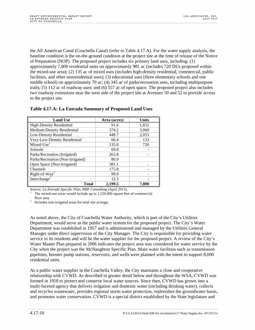
D R A F T E N V I R O N M E N T A L I M P A C T R E P O R T L A E N T R A D A S P E C I F I C P L A N C I T Y O F C O A C H E L L A
L S A A S S O C I A T E S , I N C . J U L Y 2 0 1 3
P:\CLA1201A\Draft EIR for circulation\4.17 Water Supply.doc «07/10/13» 4.17-10
the All American Canal (Coachella Canal) (refer to Table 4.17.A). For the water supply analysis, the
baseline condition is the on-the-ground condition at the project site at the time of release of the Notice
of Preparation (NOP). The proposed project includes six primary land uses, including: (1)
approximately 7,800 residential units on approximately 981 ac (includes 720 DUs proposed within
the mixed-use area); (2) 135 ac of mixed uses (includes high-density residential, commercial, public
facilities, and other nonresidential uses); (3) educational uses (three elementary schools and one
middle school) on approximately 70 ac; (4) 345 ac of parks/recreation uses, including multipurpose
trails; (5) 112 ac of roadway uses; and (6) 557 ac of open space. The proposed project also includes
two roadway extensions near the west side of the project site at Avenues 50 and 52 to provide access
to the project site.
Table 4.17.A: La Entrada Summary of Proposed Land Uses
Land Use Area (acres) Units
High-Density Residential 91.6 1,832
Medium-Density Residential 374.2 3,060
Low-Density Residential 448.7 2,055
Very-Low-Density Residential 66.4 133
Mixed-Use1 135.0 720
Schools 69.8 -
Parks/Recreation (Irrigated) 263.8 -
Parks/Recreation (Non-Irrigated) 80.9
Open Space (Non-Irrigated) 381.1 -
Channels 175.8 -
Right-of-Way2 99.9 -
Interchange2 12.3 -
Total 2,199.5 7,800
Source: La Entrada Specific Plan, RBF Consulting (April 2013). 1 The mixed-use areas would include up to 1,520,000 square feet of commercial
floor area. 2 Includes non-irrigated areas for total site acreage.
As noted above, the City of Coachella Water Authority, which is part of the City’s Utilities
Department, would serve as the public water system for the proposed project. The City’s Water
Department was established in 1957 and is administered and managed by the Utilities General
Manager under direct supervision of the City Manager. The City is responsible for providing water
service to its residents and will be the water supplier for the proposed project. A review of the City’s
Water Master Plan prepared in 2006 indicates the project area was considered for water service by the
City when the project was the McNaughton Specific Plan. Main water facilities such as transmission
pipelines, booster pump stations, reservoirs, and wells were planned with the intent to support 8,000
residential units.
As a public water supplier in the Coachella Valley, the City maintains a close and cooperative
relationship with CVWD. As described in greater detail below and throughout the WSA, CVWD was
formed in 1918 to protect and conserve local water sources. Since then, CVWD has grown into a
multi-faceted agency that delivers irrigation and domestic water (including drinking water), collects
and recycles wastewater, provides regional storm water protection, replenishes the groundwater basin,
and promotes water conservation. CVWD is a special district established by the State legislature and

L S A A S S O C I A T E S , I N C . J U L Y 2 0 1 3
D R A F T E N V I R O N M E N T A L I M P A C T R E P O R T L A E N T R A D A S P E C I F I C P L A N
C I T Y O F C O A C H E L L A
P:\CLA1201A\Draft EIR for circulation\4.17 Water Supply.doc «07/10/13» 4.17-11
governed by a five-member Board of Directors. While a large part of CVWD’s history is in
agricultural irrigation, today it meets the water-related needs of more than 107,000 homes and
businesses across 1,000 square miles in various areas of service, including: domestic water,
groundwater replenishment and imported water, wastewater treatment, recycled water, storm water
protection and flood control, agricultural irrigation and drainage, and water conservation. (Additional
information regarding CVWD is provided in Sections 1.4.2 through 1.4.4 of the WSA in
Appendix M.)
In September 2009, CVWD and the City signed an MOU (2009 MOU) to assist in ensuring a
sufficient and reliable water supply for development projects within the City and a major portion of
its SOI in a manner consistent with CVWD’s CVWMP as amended from time to time.1 Under the
terms of the 2009 MOU, various means are identified by which the City can provide for the supply of
supplemental water to offset the demands associated with development projects approved by the City.
For instance, under the 2009 MOU, the City can participate in funding CVWD’s acquisition of
supplemental water supplies to offset demands associated with newly approved projects within the
City’s SOI.2 In February 2013, CVWD and the City signed an additional MOU (2013 MOU)
regarding implementation of the 2009 MOU.3 Among other things, the 2013 MOU further specifies
the mechanism by which the City can finance and acquire supplemental water supplies from CVWD
to meet the projected demands of new development projects, and establishes a process for preparing
and adopting WSAs and Written Verifications for such projects. As further set forth below and in the
WSA (Appendix M), the 2013 MOU expressly acknowledges and applies to the proposed project, and
the supplemental water supplies referred to in the 2013 MOU have been analyzed by CVWD as part
of the 2010 CVWMP Update and related 2011 SPEIR.
Regional and Local Water Supply Planning and Management Setting. As indicated above, water
resources in the Coachella Valley are subject to comprehensive planning and management efforts. At
the regional level, such efforts are carried out in cooperation with CVWD and the Desert Water
Agency. For the areas within and around the City, several water supply planning documents have
been prepared and adopted to ensure a sufficient and reliable long-term water supply.
City of Coachella 2010 Urban Water Management Plan (City 2010 UWMP). As indicated
above, the City has completed its 2010 UWMP. At the time the City’s 2010 UWMP was
prepared, the City had been hit hard by the economic recession. As such, demand projections
contained in the City’s 2010 UWMP were very conservative and did not expressly anticipate the
increased growth generated by a project such as the La Entrada Specific Plan in the immediate
future. Population and housing projections had dropped from a high of 15 percent in 2006 to a
low of 1 percent in 2009. Notably, however, the water demands associated with the proposed
project have been accounted for as part of CVWD’s water supply planning efforts and have been
analyzed in CVWD’s 2010 CVWMP Update (where the project is referred to as the Lomas Del
Sol Specific Plan) and 2011 SPEIR, which are further discussed below.
1 A copy of the 2009 MOU is attached as Appendix B to the WSA.
2 See, e.g., CVWD 2010 CVWMP, p. 3-3.
3 A copy of the 2013 MOU is attached as Appendix C to the WSA.

D R A F T E N V I R O N M E N T A L I M P A C T R E P O R T L A E N T R A D A S P E C I F I C P L A N C I T Y O F C O A C H E L L A
L S A A S S O C I A T E S , I N C . J U L Y 2 0 1 3
P:\CLA1201A\Draft EIR for circulation\4.17 Water Supply.doc «07/10/13» 4.17-12
Although the City’s 2010 UWMP included very modest growth projections, it emphasized the
City’s ability to accommodate development through careful long-term water supply planning and
aggressive demand management. In accordance with SBx7-7 (discussed above), the City will
strictly manage its per capita water use throughout the year 2020 and beyond, and those
management activities will substantially enhance the City’s ability to ensure sufficient and
reliable water supplies and accommodate long-term growth. As set forth in the WSA, the City’s
base daily per capita water use for purposes of SBx7-7 was calculated as 191 gpcd, and its 2015
and 2020 targets were established as 186 gpcd and 181 gpcd, respectively.
The City’s 2010 UWMP includes various water supply planning data, future projects, and basin
management activities that are geared toward meeting the 20 percent reduction in per capita water
consumption under SBx7-7. For example, the City has prepared a draft Water Treatment Plant
Feasibility Study to evaluate alternative supply sources such as the Coachella Branch of the All
American Canal (the Canal). The City also participates in groundwater recharge activities with
CVWD through replenishment assessments, and has implemented a variety of water use
efficiency programs, including demand management measures and a Water Shortage
Contingency Plan that can be executed by the City Council during water shortages. The purpose
of the Plan is to provide procedures with voluntary and mandatory provisions to minimize the
effect of a water shortage to the City’s service area. The four stage approach to reducing demand
ranges from a voluntary 10 percent reduction in water use to a mandatory 50 percent reduction.
In accordance with its UWMP, the City is managing at least 14 different demand management
measures (DMMs), including but not limited to residential plumbing retrofits, system water
audits, leak detection, and repair, large landscape conservation programs and incentives, and
public information and school education programs. In addition, the City has adopted a landscape
irrigation policy as part of the City’s “Landscape Guidelines” that address all landscaping for
public parkways, median islands, and common area landscaping improvements for residential and
commercial developments in the City. As noted in the WSA, the City worked with the Coachella
Valley Association of Governments and adopted the Coachella Valley “Model Landscape
Ordinance” as a policy document. The guidelines used by the City encourage minimal turf areas,
use of native plant materials reminiscent of the “desert wash” plant palette which are used in all
of the newer residential common areas including retention basins, parkways and perimeter
landscaped planters. The City has also implemented a model of sustainability in landscaping its
largest public parks with smart irrigation systems and permeable pavers. The newly constructed
Rancho Las Flores Park, the expanded Bagdouma Park, and the re-designed De Oro Park all
incorporate a blend of native and drought-tolerant plants, trees and ground covers into an
attractive, low-maintenance, water-saving resource for the community. Additionally, the
Coachella Water Authority offers three water conservation programs to its residents. These
include the Turf Removal Rebate Program, the Indoor/Outdoor Water Fixture Kits, and the Toilet
Rebate Program.
Coachella Valley Water District 2010 Urban Water Management Plan. CVWD has also
completed its 2010 UWMP in accordance with the UWMP Act. The 2010 UWMP shows that
CVWD has instituted various planning efforts regarding water supply and infrastructure
opportunities. As discussed in this Chapter and throughout the WSA, a key component of
CVWD’s water management strategy is the acquisition of additional imported water supplies to

L S A A S S O C I A T E S , I N C . J U L Y 2 0 1 3
D R A F T E N V I R O N M E N T A L I M P A C T R E P O R T L A E N T R A D A S P E C I F I C P L A N
C I T Y O F C O A C H E L L A
P:\CLA1201A\Draft EIR for circulation\4.17 Water Supply.doc «07/10/13» 4.17-13
augment existing resources. As further set forth in CVWD’s 2010 CVWMP Update, CVWD may
seek to acquire up to 50,000 acre-feet per year of additional water supplies through either long-
term leases or entitlement purchases from willing parties. CVWD may also pursue water transfers
and exchanges, and has identified possible ways to develop new sources of water. CVWD also
anticipates the future use of local desalinated water as part of its water supply portfolio, whereby
CVWD could use treated agricultural drainage water for irrigation purposes. Such projects would
either make additional potable supplies available for municipal purposes or help offset
groundwater pumping in the basin.1
CVWD’s 2010 UWMP identifies recycled water as another significant local resource that can be
used to supplement the water supply of the Coachella Valley. Wastewater that is highly treated
and disinfected can be reused for a variety of landscape irrigation and other purposes. Recycled
water has been used for irrigation of golf courses and municipal landscaping in the Coachella
Valley since 1968. It is expected that golf course irrigation will remain the largest use of recycled
water in the future. Current and projected future uses of recycled water include irrigation of urban
landscape and golf course lands. Recycled water use is limited by the lack of urban development
in the east valley. As urbanization occurs in the future, a recycled water distribution system will
be developed to serve recycled water for golf course irrigation and municipal irrigation.2
Further, CVWD and DWA operate groundwater recharge programs in the Whitewater River and
Mission Creek subbasins. As part of the CVWMP, CVWD intends to significantly expand its
groundwater recharge program in the Whitewater River subbasin. CVWD recently completed
construction the Thomas E. Levy (Levy) Groundwater Replenishment Facility in the lower
Whitewater River Subbasin with a capacity to 40,000 acre-feet per year (afy). CVWD is presently
recharging approximately 32,500 afy at this facility. CVWD is also conducting pilot recharge
tests in the lower Whitewater River subbasin at the Martinez Canyon Pilot Recharge Facility.
CVWD completed construction of a pilot recharge facility and several monitoring wells in the
Martinez Canyon alluvial fan in March 2005. This facility is designed to recharge approximately
3,000 afy. According to the 2010 CVWMP (see further discussion below), CVWD plans to
construct a full-scale facility at Martinez Canyon to recharge 20,000 afy by 2025.3
As set forth throughout CVWD’s planning documents, water demands in the Coachella Valley
will continue to be met in a sustainable manner by using the groundwater basin as a conjunctive
use resource. In practice, that involves the use of groundwater wells to produce amounts that are
continually supplemented and recharged with Colorado River, State Water Project, and local
water supplies. As an overall water supply system, CVWD’s service area (including the City and
the proposed project) is uniquely insulated from drought conditions and is capable of ensuring
sufficient and reliable water supplies to meet demand because of the large storage volume of the
basin (about 25 million acre-feet). As noted in the WSA, CVWD is also planning ways to deliver
treated Colorado River water directly to the urban distribution system, and untreated Colorado
River water directly for landscape irrigation and other non-potable uses, both of which will
further reduce the need to rely on the groundwater basin.4
1 CVWD 2010 UWMP, p. 4-21.
2 CVWD 2010 UWMP, p. 4-23.
3 CVWD 2010 UWMP, p. 3-12.
4 CVWD 2010 UWMP, p. 4-31.
D R A F T E N V I R O N M E N T A L I M P A C T R E P O R T L A E N T R A D A S P E C I F I C P L A N C I T Y O F C O A C H E L L A
L S A A S S O C I A T E S , I N C . J U L Y 2 0 1 3
P:\CLA1201A\Draft EIR for circulation\4.17 Water Supply.doc «07/10/13» 4.17-14
As with the City, CVWD’s water conservation efforts are a critical component of its water
management strategy. CVWD has had a water conservation program since the 1960s and
recognizes the importance of conserving water to reduce demand on the groundwater supply and
decrease reliance on imported supplies. With the enactment of SBx7-7, CVWD’s demand
management measures (DMMs) have become even more comprehensive. As noted above, SBx7-
7 establishes the goal of achieving a 20 percent reduction in statewide urban per capita water use
by the year 2020, and the interim goal of achieving a 10 percent reduction by 2015. As a retail
water supplier, CVWD complies with SBx7-7 by establishing and implementing per capita water
use reduction targets, and by identifying present and future measures, programs, and policies to
help achieve the water use reductions required by SBx7-7. Among various other actions, CVWD
carries out the following DMMs:
Water survey program for single-family and multi-family residential customers;
Metering with commodity rates for all new connections and retrofit of existing connections
program;
Large landscape conservation programs and incentives program
Public information program;
School education program;
Conservation programs for CII accounts program;
Conservation pricing program;
Water conservation coordinator program;
Water waste prohibition program.
As noted in its 2010 UWMP, CVWD will continue existing water conservation programs and
implement new programs to enhance water conservation and meet reduced urban per capita water
consumption.1 While the City of Coachella and the La Entrada Project are not within CVWD’s
retail service area, the foregoing discussion of CVWD’s 2010 UWMP is provided to illustrate the
extraordinary water supply planning and demand management efforts that are undertaken by the
District in its role as an urban water supplier.
2010 Coachella Valley Water Management Plan. The 2010 CVWMP serves as a 35-year
blueprint for wise water management and the basis for all CVWD’s efforts to preserve the
valley’s groundwater resources. The basic goal of the CVWMP remains similar to that of
previous WMPs: “to reliably meet current and future water demands in a cost-effective and
sustainable manner.” New factors facing water resources managers throughout California have
led to refined objectives. The programs and projects identified in the 2010 CVWMP Update are
based on the following objectives:
1 CVWD 2010 UWMP, p. 6-3.

L S A A S S O C I A T E S , I N C . J U L Y 2 0 1 3
D R A F T E N V I R O N M E N T A L I M P A C T R E P O R T L A E N T R A D A S P E C I F I C P L A N
C I T Y O F C O A C H E L L A
P:\CLA1201A\Draft EIR for circulation\4.17 Water Supply.doc «07/10/13» 4.17-15
Meet current and future water demands with a 10 percent supply buffer;
Eliminate long-term groundwater overdraft;
Manage water quality;
Comply with state and federal regulations;
Manage future costs; and
Minimize potential adverse environmental impacts.
The 2010 CVWMP calls for a multifaceted approach to water management and water
conservation, including:
Increased water conservation by all types of water users;
Increased imported water supply from the Coachella Canal and State Water Project;
Increased use of the imported supply and recycled water, instead of groundwater, for
irrigation; and
Expanded groundwater replenishment efforts, especially in the East Valley.
The 2010 CVWMP Update identifies several water conservation measures with the goal to reduce
water consumption 20 percent by the year 2020 in accordance with SBx7-7, and the goal to
maintain this level of reduction through 2045. These measures include water efficient landscaping
and irrigation controls, water efficient plumbing, tiered or seasonal water pricing, public
information and education programs, alternative water supplies, water restrictive municipal
development policies, appointing a CVWD conservation coordinator, and refining the maximum
water allowance budgets for landscaped and recreational areas. The 2010 CVWMP Update shows
reduced reliance on groundwater sources over the long term by utilizing more Colorado River
water, SWP water and recycled water, by expanding source substitution, and through increased
water conservation.1
In developing the 2010 CVWMP, CVWD utilized the latest population projections developed by
Riverside County and adopted by the Southern California Association of Governments (SCAG).
Recent and current recessionary forces, which will continue to have downward effects on growth
in the region, were not anticipated in the SCAG projections. Thus, total population probably will
grow at a slower rate than previously forecasted.2 The result of this scenario, however, is that the
2010 CVWMP and 2011 SPEIR have assumed a higher total projected water demand through the
year 2045 than is likely to occur, and thus CVWD’s conclusions regarding short and long-term
water supply sufficiency are particularly conservative. Notably, the proposed La Entrada project
is identified in CVWD’s 2010 CVWMP (referred to then as the Lomas del Sol project).3
Accordingly, the demands associated with the proposed project have been accounted for as part
1 2010 CVWMP, pp. 6-3 to 6-13.
2 2011 SPEIR, pp. 1-8 to 1-9; see also Table 1-1, Summary of the 2010 Water Management Plan Update and
Implementation Plan, pp. 1-9 to 1-13. 3 2010 CVWMP, p. 3-3.

D R A F T E N V I R O N M E N T A L I M P A C T R E P O R T L A E N T R A D A S P E C I F I C P L A N C I T Y O F C O A C H E L L A
L S A A S S O C I A T E S , I N C . J U L Y 2 0 1 3
P:\CLA1201A\Draft EIR for circulation\4.17 Water Supply.doc «07/10/13» 4.17-16
of CVWD’s regional water supply planning efforts, which include population projections within
the City and the City’s SOI through the year 2045.1
The 2010 CVWMP Update emphasizes cooperation with municipalities, local water agencies,
and tribes in regional planning and implementation. The following are among some of the
recommended activities outlined in the update for the board of directors to consider over the next
35 years:2
Provide incentives and support to agricultural customers to conserve water, such as through
converting from flood/sprinkler irrigation to more efficient micro-sprinkler/drip systems;
Encourage existing golf courses to convert landscaping to meet the 2007 Landscape
Ordinance, requiring no more than 4 acres of grass per hole and 10 acres of grass per practice
area;
Expand landscape conversion rebates for domestic customers to encourage less grass and
more desert appropriate landscaping;
Complete construction on subsequent phases of the Mid-Valley Pipeline system to provide a
blend of recycled and Colorado River water to up to 50 golf courses in lieu of groundwater;
Turn the pilot Martinez Canyon replenishment facility into a full-scale facility with a capacity
of up to 40,000 acre-feet of replenishment annually, and implement East Valley source
substitution projects such as expansion of the Canal distribution system in the Oasis area;
Implement east valley source substitution projects such as expansion of the Can water
distribution system in the Oasis area to serve agricultural operations that are not currently
served with Canal water.
The 2010 CVWMP Update shows that CVWD has many current and future programs that are
designed to maximize the water resources available to the region, such as recharge of its Colorado
River and SWP supplies, expanded use of recycled water, desalinated agricultural drain water,
conversion of groundwater uses to Canal water and water conservation measures, including tiered
water rates, landscaping ordinance, outreach and education. The 2010 CVWMP Update and
CVWD’s Replenishment Assessment Programs establish a comprehensive and managed effort to
eliminate overuse of local groundwater while ensuring a sufficient and sustainable water supply
to meet projected demands. These programs allow CVWD to maintain the groundwater basin as
its primary urban water supply and to recharge the groundwater basin as its other supplies are
available.
The 2010 CVWMP Update presented a number of recommended programs and features to
enhance water supply development and reduce groundwater overdraft. The continuation and
expansion of existing projects and programs is summarized below.3
1 2010 CVWMP, pp. 3-3 to 3-4.
2 Coachella Valley Water District, 2010 Coachella Valley Water Management Plan Update (December
2010). 3 2010 CVWMP Section 8.
L S A A S S O C I A T E S , I N C . J U L Y 2 0 1 3
D R A F T E N V I R O N M E N T A L I M P A C T R E P O R T L A E N T R A D A S P E C I F I C P L A N
C I T Y O F C O A C H E L L A
P:\CLA1201A\Draft EIR for circulation\4.17 Water Supply.doc «07/10/13» 4.17-17
An agricultural conservation program including elements such as: training, system upgrades
and retrofits, economic incentives, and regulatory programs that can achieve up to a 14
percent reduction in consumptive use by 2020.
An urban conservation program including elements such as: installing automated meters,
extending landscape ordinances, implementing water budget-based tiered water rates, and
various rebate programs, all of which are aimed at achieving the State’s requirement for a 20
percent reduction in per capita use by 2020.
Continue and expand the golf course conservation program that is expected to achieve a
savings of 11,600 afy by 2045.
Additional water supply development programs such as: acquisition of additional imported
supplies, increased recycled water use, and development of desalinated drain water.
Groundwater recharge will increase over time at the existing Whitewater and Thomas E.
Levy Groundwater Replenishment Facilities, and the construction of the proposed Martinez
Canyon Recharge Facility.
Source substitution will continue to be an important element for offsetting groundwater use.
Examples of new projects and programs include: using canal water for urban irrigation,
implementing groundwater recharge in the Indio area, investigating groundwater storage
opportunities with IID, pursuing additional groundwater treatment for arsenic, developing a
salt/nutrient management plan, improved brine disposal, mitigation of canal water losses,
maintaining and developing improved drainage control, increasing storm water capture and
recharge, and developing local groundwater supplies for non-potable use.
As further set forth below, the 2010 CVWMP serves as a blueprint for ensuring a sufficient and
sustainable water supply to meet the needs of projected growth throughout the Coachella Valley,
including the City and the City’s sphere of influence, for the next 30 years and beyond.
2011 Coachella Valley Water Management Plan Subsequent Program Environmental
Impact Report and 2012 Final Subsequent Program Environmental Impact Report. As
noted above, CVWD first adopted the Coachella Valley Water Management Plan and the related
Program Environmental Impact Report (PEIR) in September 2002. The 2010 CVWMP defines
how the goals of the 2002 CVWMP will be met given changing conditions and new factors
affecting water supply reliability, water demands and evolving federal and state regulations. The
planning time horizon for the 2010 CVWMP Update is 35 years, from 2010 to 2045. As with the
2002 CVWMP, CVWD analyzed the potential environmental impacts associated with
implementing the 2010 CVWMP pursuant to the California Environmental Quality Act (CEQA).
That document is the 2011 Subsequent Program EIR (2011 SPEIR) (State Clearinghouse (SCH)
No. 1999041032, SCH No. 2000031027).1
As shown in Table 1-2 of the 2011 SPEIR, it has been determined that, overall, the 2010
CVWMP will have less than significant environmental impacts, and in certain key respects will
have beneficial effects. For example, in addressing regional groundwater overdraft issues, the
2010 CVWMP will result in decreasing annual overdraft conditions in the West and East Valley
1 2011 SPEIR, pp. 1-1 and 2-1.

D R A F T E N V I R O N M E N T A L I M P A C T R E P O R T L A E N T R A D A S P E C I F I C P L A N C I T Y O F C O A C H E L L A
L S A A S S O C I A T E S , I N C . J U L Y 2 0 1 3
P:\CLA1201A\Draft EIR for circulation\4.17 Water Supply.doc «07/10/13» 4.17-18
areas, and water levels will change at a slower rate than under current condition and will increase
in some areas.1
The goal of the 2010 CVWMP is to allow CVWD and other water agencies in the Valley to
reliably meet current and future water demands within their service areas in a cost effective and
sustainable manner for the period 2010 to 2045. As noted above, the programs and projects
identified in the 2010 CVWMP fulfill this goal by meeting the following objectives: meet current
and future water demands with a 10 percent supply buffer; reduce/eliminate long-term
groundwater overdraft; manage and protect water quality; comply with state and federal laws and
regulations; manage future costs; and minimize adverse environmental impacts. The 2010
CVWMP differs from the 2002 CVWMP in that a 10 percent supply buffer is applied to the
projected water demands while eliminating overdraft. This buffer compensates for potential
uncertainties such as demands higher than forecast or supplies that cannot be implemented or do
not deliver as much water as planned. The supply buffer would be established through a
combination of additional supplies and water conservation measures.2
The 2011 SPEIR identifies various external factors that have affected or may affect water
supplies available to the Coachella Valley. Key factors include: annual fluctuation in imported
State Water Project (SWP) supplies due to drought and environmental needs in the Sacramento-
San Joaquin Delta; recent environmental rulings to protect sensitive fish species in the delta that
restrict the State’s ability to move water through the delta to the SWP; preparation of the Bay-
Delta Conservation Plan, which is intended to restore the delta’s ecosystem and improve water
supply reliability; the Quantification Settlement Agreement (QSA), signed in 2003 to allocate
California’s allotment of Colorado River water and meet its contractual limitation; litigation
concerning the QSA; and effects of climate change on the long term availability and reliability of
SWP and Colorado River water supplies.3 These factors are addressed and analyzed in the 2011
SPEIR and are further described below and in the WSA for the proposed project.
The 2010 CVWMP Update identifies approaches for meeting future water needs in the study area
in light of changing environmental conditions and other water supply factors. To meet revised
future needs, the CVWMP includes new features in the areas of water conservation, source
substitution, new supplies and groundwater recharge.4 The 2010 CVWMP incorporates both a
“bookends” approach and “building block” approach to deal with potential uncertainties in future
demands and supplies. The Plan also incorporates enhanced cooperation and implementation
among cites, local water agencies, and tribes in the Coachella Valley.5 For example, the 2010
CVWMP Update includes an aggressive program of water conservation for urban, golf course
and agricultural water users. However, there are limits in terms of cost, effectiveness and
acceptability of water conservation activities. As those limits are reached, other Plan elements for
meeting future needs also can be adjusted. One source of supply is desalination of drain water, the
most expensive alternative for providing new supplies. This approach only will be implemented
as other sources of supplies reach practical limits. Therefore, the Plan includes a range of 55,000
1 2011 SPEIR, p. 1-25.
2 2011 SPEIR, pp. 1-2 and 2-12.
3 2011 SPEIR, p. 1-2.
4 2011 SPEIR, p. 1-7.
5 Ibid.

L S A A S S O C I A T E S , I N C . J U L Y 2 0 1 3
D R A F T E N V I R O N M E N T A L I M P A C T R E P O R T L A E N T R A D A S P E C I F I C P L A N
C I T Y O F C O A C H E L L A
P:\CLA1201A\Draft EIR for circulation\4.17 Water Supply.doc «07/10/13» 4.17-19
to 80,000 acre-feet per year for desalination of drain water. The actual amount of water from this
source will depend upon how much can be obtained first from other, lower cost sources.1
The 2010 CVWMP Update has the same five major elements as the 2002 CVWMP, but with a
building block approach for implementing elements to better respond to changes in the planning
environment. As indicated above, a key element is water conservation (urban, agricultural and
golf, but at higher rates than in the 2002 Plan). Urban measures are water efficient plumbing and
landscape water use audit programs. For golf, measures are scientific irrigation scheduling, water
audits and monitoring of maximum water allowance compliance, turf limitations for new course
as well as water audits. Agricultural water conservation methods include scientific irrigation
scheduling, salinity management, salinity field mapping, conversion to micro-irrigation,
distribution uniformity evaluations, grower training and engineering evaluations of irrigation
efficiency. Another element is additional water sources, including increasing surface supplies for
the Valley from outside sources (Colorado River and SWP transfers and leases), exchanges, dry-
year purchases, water development projects, storm water capture, and desalination. A third
element is source substitution of surface water supplies for groundwater. This may involve
providing recycled water or Canal water or other sources to additional urban, golf and agricultural
users to reduce groundwater pumping. Source substitution can also involve additional use of the
Mid-Valley Pipeline Project, Phase I of which was completed in 2009. The fourth element is
groundwater recharge, including: constructing and operating recharge basins to augment stored
groundwater; continued and increased recharge at the Whitewater Recharge Facility; construction
and operation of a new facility at Martinez Canyon; increased recharge at the Levy facility; and a
possible new City of Indio recharge facility at Posse Park. The fifth element is monitoring and
data management, which includes monitoring and evaluation of subsidence and groundwater
levels and quality to provide the information needed to manage the Valley’s groundwater
resources.2
In developing the 2010 CVWMP, CVWD utilized the latest population projections developed by
Riverside County and adopted by the Southern California Association of Governments (SCAG)
in 2008. CVWD does not develop population growth projections for use in water management
planning. The 2008 SCAG projections could not have taken into account the current recession,
which has slowed growth and will continue to have downward effects on growth in the near term.
Over the long term, growth will continue; however, population projections will need to be
adjusted in terms of the timing of growth. These realities necessitate adjustment of Plan
implementation to meet actual near term needs and continued updates of the CVWMP in the
future to reflect revised population projections.3
Implementation of the 2010 CVWMP Update has been divided into near-term elements and long-
term elements. Even with the current recession and lack of growth, continuation of existing
elements and some new elements are needed to reduce overdraft and its adverse affects. Ongoing
elements that will continue are: recharge at Whitewater Recharge Facility with SWP Exchange
water and SWP purchases; implementation of the QSA; levy facility recharge at current levels of
1 2011 SPEIR, p. 1-8.
2 2011 SPEIR, p. 1-8.
3 2011 SPEIR, pp. 1-8 to 1-9; see also Table 1-1, Summary of the 2010 Water Management Plan Update and
Implementation Plan, pp. 1-9 to 1-13.

D R A F T E N V I R O N M E N T A L I M P A C T R E P O R T L A E N T R A D A S P E C I F I C P L A N C I T Y O F C O A C H E L L A
L S A A S S O C I A T E S , I N C . J U L Y 2 0 1 3
P:\CLA1201A\Draft EIR for circulation\4.17 Water Supply.doc «07/10/13» 4.17-20
32,000 afy; Martinez Canyon recharge at current Pilot Facility Level of 3,000 afy; water
conservation programs at current levels, including implementation of the Landscape Ordinance;
effluent recycling in the West Valley; increased use of Canal water by golf courses with existing
Canal water connections to reduce groundwater pumping; conversion of East Valley agriculture
to Canal water, as opportunities arise, to reduce groundwater pumping; groundwater level/quality
monitoring; and subsidence monitoring.1
Assuming that the Coachella Valley study area growth rate remains relatively low, during the
next five years CVWD will focus on three new or expanded activities to improve groundwater
conditions, such as: increased use of the Mid-Valley Pipeline project to reduce overdraft in the
West Valley by connecting golf courses and reducing groundwater pumping by those courses;
implementation of additional water conservation measures, including the Landscape Ordinance,
in accordance with SBx7-7; and preparation of a salt/nutrient management plan for the Valley by
2014 to meet SWRCB Recycled Water Policy requirements to improve implementation of
wastewater effluent recycling. Of these three elements, only the increased use of the Mid-Valley
Pipeline would have a second tier CEQA document. Implementation of Proposed Project
elements, such as a desalination plant or additional water transfers, which would trigger second
tier CEQA documents, are anticipated after 2015.2
Due to potential variability associated with imported water supplies from the Colorado River and
the SWP, which are further discussed below and in the WSA, the 2010 CVWMP Update
evaluates an array of water supply scenarios to determine a likely range of future supply needs.
These scenarios assume different combinations of a delta conveyance solution and QSA validity
to determine the future amount of imported water available to the Valley.3 Based upon the
scenarios, additional water supplies and conservation would be required to meet projected
demands in 2045 while providing 10 percent supply buffer, eliminating groundwater overdraft
and improving the salt balance of the basin.4 The 2010 CVWMP Update evaluates a wide range
of water conservation and supply options based on potential yield, reliability, cost, water quality
and other feasibility factors. Based on this evaluation, a range of water supply mixes was
established for each planning scenario. Each scenario maximizes the use of local sources and
recycled water. Water conservation and drain water desalination are variable, based on the
availability of existing and future imported water supplies including potential water transfers and
acquisitions.5
Water conservation is a major component of water management in the Coachella Valley.
According to the 2010 CVWMP, agricultural water conservation remains the most cost-effective
approach for extending the existing water supplies of the Valley. Under the 2010 CVWMP, an
agricultural conservation program will be implemented that achieves up to a 14 percent reduction
in consumptive use by 2020. The savings would be achieved using a staged approach. Initially,
low cost, voluntary programs would be initiated followed by increasingly more expensive and
1 2011 SPEIR, p. 1-14.
2 2011 SPEIR, p. 1-14.
3 2011 SPEIR, p. 3-7.
4 Ibid.
5 2011 SPEIR, pp. 3-8 to 3-9.

L S A A S S O C I A T E S , I N C . J U L Y 2 0 1 3
D R A F T E N V I R O N M E N T A L I M P A C T R E P O R T L A E N T R A D A S P E C I F I C P L A N
C I T Y O F C O A C H E L L A
P:\CLA1201A\Draft EIR for circulation\4.17 Water Supply.doc «07/10/13» 4.17-21
mandatory programs.1 The following building blocks have been identified for implementation:
grower education and training (grower meetings and training programs combined with
confidential grower audits funded by the District); District-provided services (including scientific
irrigation scheduling, scientific salinity management, moisture monitoring and farm water
distribution evaluations funded by the District); irrigation system upgrades/retrofits (partial or full
funding and/or financial support of growers that convert from flood/sprinkler to micro-
sprinkler/drip irrigation systems); economic incentives (such as tiered pricing, water budget
pricing, or seasonal pricing); and regulatory programs (regulations that support and provide for
agriculture conservation, including farm management plans, mandatory drip/micro-spray systems
for new permanent crops, and conversion of existing crops over time).2
These program features will be incrementally expanded until the target reduction is achieved. To
achieve the maximum return on investment from conservation activities, initial emphasis will be
placed on those agricultural operations with the lowest irrigation efficiency. The agricultural
conservation program is anticipated to save about 39,500 afy of water by 2020. The savings are
projected to decrease to approximately 23,300 afy by 2045 as agricultural land transitions to
urban uses. CVWD is developing methods for tracking the effectiveness of agricultural water
conservation. These methods will include determining average water use per acre of farmed land
and average irrigation efficiency. The methods will reflect variations in annual/seasonal
evapotranspiration and cropping patterns. Progress toward meeting agricultural conservation
goals will be evaluated and reported annually.3
Urban conservation is also critical. Under the 2010 CVWMP, the urban water conservation
program will be expanded and enhanced to meet the requirements of SBx7-7. The baseline for
this reduction is the 10-year average per capita usage for the period of 1995 through 2004. This
will be accomplished by: continued public education and outreach programs promoting water
conservation; improved landscape irrigation scheduling and efficiency; implementation of
irrigation system retrofit rebates; implementation of appropriate water rate structures that provide
the economic incentives needed to encourage efficient water use; coordinated regional water
conservation programs involving Valley water purveyors, cities and Riverside County; continued
implementation of the CVWD Valley-wide Landscape Ordinance (Ordinance 1302-1; revised
Ordinance 1374); installation of automated or “smart” water meters; extension of the Landscape
Ordinance to include all landscaping regardless of size (current limit is 5,000 square feet or larger
for homeowner furnished landscaping); further decreases in the water allocations for landscape
irrigation consistent with good irrigation practices and desert landscaping; landscape retrofit
rebates (i.e., economic incentives for replacing high water use landscaping, also known as “cash
for grass”); restrictions on the total amount of turf allowed; audits of new development to assure
continued compliance with the Landscape Ordinance; plumbing retrofits for existing properties
including mandatory retrofit (ultra low flush toilets, showerhead replacement, etc.) prior to sale of
property; conservation rebates for high-efficiency clothes washers; compliance with California
Green Building Code Standards (California Code of Regulations Title 24, Part 11, 2010); and
water distribution system audits and loss reduction programs.4
1 2011 SPEIR, pp. 3-9 to 3-10.
2 Ibid.
3 2011 SPEIR, p. 3-10.
4 2011 SPEIR, p. 3-10 to 3-11.

D R A F T E N V I R O N M E N T A L I M P A C T R E P O R T L A E N T R A D A S P E C I F I C P L A N C I T Y O F C O A C H E L L A
L S A A S S O C I A T E S , I N C . J U L Y 2 0 1 3
P:\CLA1201A\Draft EIR for circulation\4.17 Water Supply.doc «07/10/13» 4.17-22
Once the conservation targets are achieved, continued implementation of those measures will
result in even greater savings per capita as new growth occurs. Projections indicate that continued
implementation of these measures in conjunction with the State’s 2010 CALGreen Code
requirements will result in per capita water use reduction of nearly 40 percent compared to the
baseline per capita use defined in SBx7-7. This could potentially result in additional water
savings of 55,000 afy by 2045 if growth occurs as projected. To provide the water supply buffer,
this target is increased to 73,500 afy by 2045. Additional water conservation beyond this amount
will be implemented if needed to offset unanticipated reductions in other water supplies during
the planning period. Pursuant to SBx7-7, Valley water agencies will track the effectiveness of
urban water conservation. Progress toward achieving the urban water conservation goals will be
evaluated annually and reported in UWMPs prepared on five-year intervals. If progress shows
that additional conservation is being achieved, then the water supply needs will be reassessed.1
The 2011 SPEIR identifies golf course conservation as key component of the management plan.
Under the 2010 CVWMP, Valley water agencies are expected to do the following: implement a
water conservation program to achieve a 10 percent reduction in water use by existing golf
courses (built prior to 2007) by 2020 (this would be accomplished through golf course irrigation
system audits and soil moisture monitoring services); encourage existing golf courses to reduce
water use by reducing their acreage of turf; implement the 2009 CVWD/CVAG Landscape
Ordinance objectives for all new golf courses (built in 2007 and later); conduct landscaping and
irrigation system plan checks to verify compliance; and develop and implement methods to
evaluate the effectiveness of golf course water conservation such as measuring water use per
irrigated acre. These measures are expected to achieve a savings of 11,600 afy by 2045.
Conservation by future courses has been incorporated into the water demand projections.
Progress toward meeting golf course conservation goals will be evaluated and reported annually.2
The 2010 CVWMP Update strategy for water supply development consists of a balanced
portfolio that retains flexibility to adapt to future changes in supply reliability. Sufficient water
supplies are planned to provide a 10 percent buffer on an average basis to meet unanticipated
reductions in existing supplies or difficulties in developing new supplies. The additional supplies
needed to provide the buffer would be implemented when required based on an on-going analysis
of projected demands and supplies.3 A summary of the water supply development efforts of the
2010 CVWMP is set forth in the WSA. (See Appendix M, pp. 15 to 24.)
Regional and Local Water Supply Setting. As indicated in the City 2010 UWMP, CVWD 2010
UWMP, the 2010 CVWMP Update and the 2011 SPEIR discussed above, the Coachella Valley relies
on a combination of local groundwater, Colorado River water, State Water Project (SWP) water,
surface water, recycled water and other developed supplies to meet current and projected water
demands.
1 2011 SPEIR, p. 3-11.
2 2011 SPEIR, pp. 3-11 to 3-12.
3 2011 SPEIR, p. 3-12.

L S A A S S O C I A T E S , I N C . J U L Y 2 0 1 3
D R A F T E N V I R O N M E N T A L I M P A C T R E P O R T L A E N T R A D A S P E C I F I C P L A N
C I T Y O F C O A C H E L L A
P:\CLA1201A\Draft EIR for circulation\4.17 Water Supply.doc «07/10/13» 4.17-23
Groundwater. The main groundwater source for the City of Coachella is the Coachella Valley
Groundwater Basin, Indio Subbasin, Basin Number 7-21-01, specifically, the Lower Whitewater
River Subbasin, which is continuously replenished at the local and regional level pursuant to a variety
of water supply projects and programs as discussed above, and below, and in the WSA. (See
generally, WSA Sections 1 and 4.) The Lower Whitewater River Subbasin is managed by CVWD,
which has statutory authority to replenish local groundwater supplies and collect assessments
necessary to support a groundwater replenishment program as provided in the County Water District
Law. As indicated in the referenced CVWD 2010 UWMP, CVWD 2010 CVWMP, and CVWD 2011
SPEIR, the Coachella Valley groundwater basin area serves as an expansive conjunctive use resource
that is capable of ensuring a sufficient and sustainable water supply to serve existing uses and
projected growth during normal, single-dry and multiple-dry years over an extended planning
horizon, currently established as the year 2045. Not only does the basin contain vast reserves of local
groundwater (approximately 25 million acre-feet), it has substantial available storage space that has
been utilized and will continue to be utilized to store millions of acre-feet of supplemental supplies
that become available during normal and above-normal years. Those surplus supplies are recharged to
the basin for later use during dry periods.
As discussed in Chapters 1 and 4 of the WSA, CVWD has determined that the total projected water
supplies available to the basin area during normal, single-dry and multiple-dry periods throughout the
year 2045 are sufficient to meet the needs of existing uses and projected growth.1 Moreover, the
potential environmental effects of implementing the projects and programs contained in the 2010
CVWMP have been analyzed in accordance with CEQA, and the determination has been made that
implementation of the 2010 CVWMP will have a beneficial effect on groundwater resources.2
CVWD, with assistance from other water agencies including the City’s Coachella Water Authority,
have been implementing water supply projects, programs and related management actions of the
CVWMPs since 2002. A notable requirement under the CVWMP is that the City (and other agency
producers) must pay a replenishment assessment charge (RAC) for each acre-foot of groundwater
produced. The current RAC is $24 per acre-foot of groundwater pumped. In 2010, the City produced
approximately 8,340 acre-feet of groundwater and paid approximately $200,000 in RAC. In addition
to the CVWMP process, in December 2010 the Coachella Valley Integrated Regional Water
Management Plan (IRWMP) was developed to promote a regional approach for addressing water
management issues and to enhance the region’s eligibility for state funding opportunities for water
resource projects. The IRWMP was created by the Coachella Valley Regional Water Management
Group (CVRWMG), which is a partnership of CWA, CVWD, DWA, Indio Water Agency, and the
Mission Springs Water District.
As noted in the WSA, the Agua Caliente Band of Cahuilla Indians recently filed a federal court
lawsuit against CVWD and DWA requesting the court to “judicially recognize, declare, quantify and
decree” the Tribe’s right to sufficient water underlying the Coachella Valley as necessary to fulfill the
purposes of the Tribe. The May 2013 lawsuit contends that the development of groundwater by
CVWD and DWA has adversely affected the quantity and quality of groundwater supplies underlying
the Coachella Valley and the Agua Caliente Reservation, and thus has injured and infringes upon the
rights of the Tribe and its members. Among other things, the lawsuit seeks the following: an
injunction to prevent CVWD and DWA from withdrawing groundwater from the Upper Whitewater
1 See, e.g., 2010 CVWMP, pp. 7-2 to 7-12; 2011 SPEIR, pp. 3-4 to 3-9.
2 See, e.g., 2010 CVWMP, pp. 7-20 to 7-32; 2011 SPEIR, pp. 3-23 to 3-33.
D R A F T E N V I R O N M E N T A L I M P A C T R E P O R T L A E N T R A D A S P E C I F I C P L A N C I T Y O F C O A C H E L L A
L S A A S S O C I A T E S , I N C . J U L Y 2 0 1 3
P:\CLA1201A\Draft EIR for circulation\4.17 Water Supply.doc «07/10/13» 4.17-24
and Garnet Hill subbasins of the Coachella Valley Groundwater Basin underlying the Agua Caliente
Reservation; an injunction to prevent CVWD and DWA from overdrafting the Upper Whitewater and
Garnet Hill subbasins; an injunction to prevent CVWD and DWA from recharging the Upper
Whitewater and Garnet Hill subbasins with imported water of lesser quality than pre-existing
groundwater without first treating the imported water; and an injunction preventing CVWD and
DWA from infringing on the Tribe’s “ownership interest” in the storage space underlying the
Reservation that is used to store the Tribe’s water rights.
The potential for the Agua Caliente lawsuit to affect the water supplies available to the City of
Coachella to serve the La Entrada Project cannot be determined at this time and are too speculative to
evaluate in relation to the Project and for purposes of this WSA. However, several factors suggest that
the lawsuit will not affect the availability, reliability or overall sufficiency of water supplies available
to the City to serve the Project. For example, the rights that the Tribe alleges to hold have not been
quantified, defined, substantiated or proven from an engineering or legal standpoint, and thus the
potential impacts to CVWD and DWA operations are very speculative at this preliminary stage of the
lawsuit. Second, as noted above, the City is not a party to the lawsuit and no injunctions are sought
against the City’s water production or any other water related activities conducted by the City. Third,
the lawsuit concerns groundwater production and storage activities in the Upper Whitewater and
Garnet Hill subbasins, whereas the City and the La Entrada Project are located in the Lower
Whitewater subbasin, which is far south of the Agua Caliente Reservation and separate from the
Upper Whitewater and Garnet Hill subbasins. (See WSA Figure 4-1.) Fourth, assuming only for the
sake of argument that the lawsuit was successful, it does not seek to prohibit the recharge of imported
and supplemental water in the Upper Whitewater and Garnet subbasins (which, again, the Project
does not utilize). Rather, the lawsuit demands that imported water of “inferior quality” be treated
before it is recharged to the Upper Whitewater or Garnet Hill subbasins. For these and other reasons,
it does not appear likely that the Agua Caliente lawsuit has the potential to affect the availability,
reliability or overall sufficiency of water supplies available to the City of Coachella to serve the
Project as set forth in this WSA.
State Water Project Supplies. CVWD and DWA are both State Water Contractors. CVWD’s
original right to SWP supply (Table A Allotment) was 23,100 afy and DWA’s original SWP Table A
allotment was 38,100 afy, for a combined Table A allotment of 61,200 afy. In 2004, CVWD
purchased an additional 9,900 afy of SWP water from the Tulare Lake Basin Water Storage District,
which brought CVWD’s SWP Table A Allotment to 33,000 afy. In 2007, CVWD and DWA made a
second purchase of SWP water from the Tulare Lake Basin Water Storage District. CVWD purchased
5,250 afy and DWA purchased 1,750 afy. Also in 2007, CVWD and DWA completed the transfer of
12,000 afy and 4,000 afy, respectively, from the Berrenda Mesa Water District. These acquisitions
brought CVWD’s annual SWP Table A Allotment to 50,250 afy, and DWA’s annual SWP Table A
Allotment to 43,850 afy. In addition to these amounts, CVWD and DWA have entered an agreement
with MWD whereby MWD has permanently transferred 88,100 afy and 11,900 afy of SWP Table A
Allotments to CVWD and DWA, respectively. Generally, the agreement enables MWD to call back
certain amounts during dry and critical dry years, where in other years CVWD and DWA recharge the
SWP supplies within the Coachella Valley Groundwater Basin. In sum, and subject to the discussion
in Section 4.3.1, up to 138,350 afy of SWP Table A Allotment is available to CVWD, and up to
55,750 afy is available to DWA. Table 4-3 of the WSA summarizes the CVWD and DWA total
allocations of Table A SWP water.
L S A A S S O C I A T E S , I N C . J U L Y 2 0 1 3
D R A F T E N V I R O N M E N T A L I M P A C T R E P O R T L A E N T R A D A S P E C I F I C P L A N
C I T Y O F C O A C H E L L A
P:\CLA1201A\Draft EIR for circulation\4.17 Water Supply.doc «07/10/13» 4.17-25
In addition to the SWP allotments discussed above, CVWD and DWA secured additional rights to
SWP supplies pursuant to a 2003 exchange agreement with the Metropolitan Water District of
Southern California (MWD). Historically, MWD has not made full use of its SWP Table A Amounts
in normal and wet years. Under the 2003 exchange agreement, CVWD and DWA acquired 100,000
afy of MWD’s SWP Table A water as a permanent transfer, commencing in 2005. The terms of the
agreement provide that MWD has the option to call back the transferred water under certain
conditions. This option must be exercised no later than April 30 of each year. MWD’s callback
options are to be exercised in two 50,000 AF blocks. To estimate conservatively the average supply
from this transfer, two scenarios are considered – without and with call-back. Without call-back,
CVWD and DWA can receive SWP exchange water based on the estimated DWR reliability (see
discussion below). With call-back, it is assumed that MWD would exercise its option to callback the
100,000 afy in four wet years out of every 10 years and the amount of water called back would be
deducted from average SWP exchange deliveries. The actual frequency of callback would depend on
the availability of MWD’s water supplies to meet its demands, the price of the callback water, and the
ability of MWD to store or use the callback water. Since 2005, MWD has exercised its call-back
option only once in 2005.
CVWD and DWA, as SWP contractors, have the ability to purchase additional SWP supplies on an
interruptible basis as the opportunity presents. Contractors may choose to offer their allocated Table
A water in excess of their needs, designated Turnback Pool water, to other contractors through two
pools (A and B) in February and March of a given year. This water can be purchased for 50 percent
(Pool A) or 25 percent (Pool B) of the Delta Water Charge plus the Variable OMP&R Transportation
and Off-Aqueduct Power Charges. The first significant purchase by CVWD and DWA occurred from
1996 through 1999 when large amounts of Turnback Pool water were available. Available Turnback
Pool water is allocated between interested parties based on their Table A amounts. During that period,
CVWD and DWA purchased 276,000 acre-feet of water for recharge at Whitewater.1
SWP contractors may also receive water under Article 21 of their contracts. Article 21 water is water
that SWP contractors may receive on a short-term basis in addition to their Table A water, if they
request it. Article 21 water is used by many SWP contractors to help meet demands when allocations
are less than 100 percent.2 Notably, Article 21 water is typically available only in wet yeas and when
aqueduct capacity is available. Article 21 water is apportioned to those contractors requesting it in the
same proportion as their Table A water. According to DWR, Article 21 water is available to a SWP
contractor only if the following conditions are met: “Excess water” is flowing through the delta; the
contractor is able to use the surplus water, such as by offsetting the use of groundwater that would
otherwise occur, or can store it in its own system; and delivering the water will not interfere with
Table A allocations, other SWP deliveries, or SWP operations.3 The cost of Article 21 water is the
Variable OMP&R Transportation and Off-Aqueduct Power Charges and any incremental DWR
power cost. CVWD and DWA purchased 35,600 acre-feet of Article 21 water in 2000 and 800 acre-
feet in 2002 and 2003.4 According to DWR, the estimated long-term average availability of Article
1 Mission Creek-Garnet Hill Subbasins Water Management Plan, Final Report, January 2013.
2 DWR 2011 Final SWP Delivery Reliability Report, p. 20.
3 DWR 2011 Report, pp. 20-21.
4 Mission Creek-Garnet Hill Subbasins Water Management Plan, Final Report, January 2013.

D R A F T E N V I R O N M E N T A L I M P A C T R E P O R T L A E N T R A D A S P E C I F I C P L A N C I T Y O F C O A C H E L L A
L S A A S S O C I A T E S , I N C . J U L Y 2 0 1 3
P:\CLA1201A\Draft EIR for circulation\4.17 Water Supply.doc «07/10/13» 4.17-26
21 water is 76,000 acre-feet per year under current conditions and 50,000 acre-feet per year under
future conditions, with variations according to average, dry-period and wet-period conditions.1
Another potentially available, intermittent source of SWP water to the Coachella Valley is the Yuba
River Accord Dry Year Water Purchase Program. In March 2008, CVWD and DWA entered into
separate agreements with DWR for the purchase and conveyance of supplemental SWP water under
the Yuba River Accord Dry Year Water Purchase Program, which provides dry year supply through a
water purchase agreement between DWR and Yuba County Water Agency (YCWA). The agreement
was part of the Lower Yuba River Accord, which settled long stranding operational and
environmental issues over instream flow requirements for the lower Yuba River. Yuba Accord water
transfers include both surface water and groundwater substitution transfers for an estimated total of
up to 140,000 afy. The available water is allocated among participating SWP contractors based on
their Table A Amounts. It is estimated that CVWD and DWA may be able to purchase up to 4 percent
of Table A or 5,600 afy, and 1.3 percent or 1,820 afy, respectively, for a total of 7,420 afy. The
amount of water available for purchase in a given year varies and will be based on DWR’s
determination of the Water Year Classification. These agreements provide for the exchange of these
supplies with the MWD for Colorado River water in accordance with existing exchange agreements.
CVWD and DWA obtained 1,836 AF in 2008 and 3,482 AF in 2009 from this program.2 Table 4-4 of
the WSA summarizes the historic initial and final allocations of SWP Table A water starting in 1991
and extending to 2011. Table 4-4 also shows imported water deliveries to the Lower Whitewater
Subbasin.
Since currently there is no conveyance facility to deliver SWP water to the Coachella Valley, CVWD
and DWA cannot directly receive their SWP supplies. Instead, pursuant to certain exchange
agreements, the CVWD and DWA SWP water is delivered to MWD, which in turn delivers an equal
amount of CRA water to CVWD and DWA to be recharged at the Levy, Whitewater and Mission
Creek recharge facilities. CVWD and DWA are required to pay for their respective SWP costs and
MWD is required to pay for its CRA costs. The original exchange agreements were entered in 1967.
In 1983, the agreements were extended to 2035 (CVWD-MWD, 1983; DWA-MWD, 1983).
CVWD has operated a pilot recharge facility at Dike 4 near Avenue 62 since 1997. Construction of
the full scale Levy facility was completed in mid-2009. Thereafter, substantially more recharge has
occurred in the Lower Whitewater Subbasin. The Levy facility has an estimated capacity to recharge
40,000 afy. In addition to the Levy facility, CVWD is planning construction of the Martinez Canyon
recharge facility that is expected to recharge between 20,000 and 40,000 afy on an average basis. The
2010 CVWMP considers alternative recharge scenarios to effectively recharge imported water at
Whitewater, Levy, and Martinez to provide the greatest benefit for the groundwater basin.
SWP Reliability. DWR issues the State Water Project Delivery Reliability Report every two
years, with the most recent final version issued in June 2012 (the DWR 2011 Report). In its last
several updates, DWR has projected reductions in average SWP water deliveries in comparison to
2005. The 2011 Report identifies several factors that have the potential to affect the availability
and reliability of SWP supplies. Although the 2011 Report presents an extremely conservative
1 DWR 2011 Report, pp. 52, 56.
2 2011 SPEIR, p. 3-7.
L S A A S S O C I A T E S , I N C . J U L Y 2 0 1 3
D R A F T E N V I R O N M E N T A L I M P A C T R E P O R T L A E N T R A D A S P E C I F I C P L A N
C I T Y O F C O A C H E L L A
P:\CLA1201A\Draft EIR for circulation\4.17 Water Supply.doc «07/10/13» 4.17-27
projection of SWP delivery reliability, it remains the best available information concerning the
SWP. As further discussed in Chapter 4 of the WSA, following is a brief summary of several
factors identified in the 2011 Report as having the potential to affect the availability and
reliability of SWP supplies. An additional analysis of factors having the potential to affect the
availability and reliability of SWP deliveries is attached as Appendix D to the WSA.
The United States Fish and Wildlife Service (USFWS) and the National Marine Fisheries
Service (NMFS) issued biological opinions (BOs) in December 2008 and June 2009,
respectively, setting forth each agency’s conclusions regarding the effects that the proposed
long-term coordinated operations of the SWP and Central Valley Project (CVP) would have
on threatened and endangered fish species in the delta. Each agency issued a “jeopardy
opinion” which in turn required each agency to prepare and adopt a Reasonable and Prudent
Alternative (RPA) to the proposed operations of the SWP and CVP. The RPAs developed
and adopted by USFWS and NMFS sought to impose various new restrictions and
requirements on SWP and CVP operations, which would reduce water exports from the delta.
As further discussed below, the RPA restrictions contained in the BOs have been expressly
accounted for in DWR’s 2011 Report and future projections of SWP deliveries. In addition,
several legal challenges have been filed against the USFWS and NMFS BOs, and should a
court conclude that the RPA restrictions are invalid, SWP exports could return to higher
levels.
In early 2009, the State Water Contractors, the San Luis Delta-Mendota Water Authority, and
several individual water agencies holding contracts for SWP and CVP supplies filed legal
challenges against the USFWS BO regarding delta smelt.1 In March 2011, the court issued a
final decision that invalidated the USFWS BO and RPA and ordered USFWS to prepare a
new BO. FWS and others appealed that decision to the Ninth Circuit Court of Appeals. The
appeal was argued in September 2012 and a written decision has not been issued. In
December 2012, a motion was filed with the court requesting an additional three years for
USFWS to prepare a new BO concerning delta smelt, which otherwise would have been due
in December 2013. Meanwhile, USFWS, DWR, and the Bureau of Reclamation (BOR)
continue to use the RPA measures as a guideline for restricting SWP and CVP operations to
protect delta smelt.2
After issuance of the NMFS BO in June 2009, the State Water Contractors and other water
agencies filed legal challenges against the BO.3 In September 2011, the court issued a final
decision that invalidated the NMFS BO and RPA and ordered NMFS to prepare a new BO.
NMFS and others appealed that decision to the Ninth Circuit Court of Appeals, where the
case remains pending. Similar to the USFWS BO, a motion has been filed with the court
requesting additional time to prepare the new NMFS BO. Meanwhile, NMFS, DWR, and the
1 Consolidated Delta Smelt Cases, E.D. Cal. 1:09-CV-00407-OWW-GSA.
2 On March 7, 2013, the Bay Delta Conservation Plan was released by the California Resources Agency,
detailing conservation strategies to restore delta smelt habitat. It recommends a 35-mile long twin
underground tunnel project that would replace the delta’s current pumping system. The Plan also calls for
the creation of over 100,000 ac of new habitat. Water contractors and federal and State officials indicate
that the twin tunnels and new habitat would improve the delta ecosystem, protect the delta from levee
failures and earthquakes, and strengthen the State’s water supply. 3 Consolidated Salmon Cases, E.D. Cal. 1:09-CV-1053-OWW-DLB.
D R A F T E N V I R O N M E N T A L I M P A C T R E P O R T L A E N T R A D A S P E C I F I C P L A N C I T Y O F C O A C H E L L A
L S A A S S O C I A T E S , I N C . J U L Y 2 0 1 3
P:\CLA1201A\Draft EIR for circulation\4.17 Water Supply.doc «07/10/13» 4.17-28
BOR continue to use the RPA measures as a guideline for restricting SWP and CVP
operations to protect listed species.
In July 2009 and September 2009, respectively, the California Department of Fish and
Wildlife (CDFW) issued “consistency determinations” that found that SWP and CVP
operations do not violate the California Endangered Species Act (CESA) to the extent that
such operations are in compliance with the RPAs set forth in the USFWS and NMFS BOs.
Because the consistency determinations are issued under State law, and thus could remain in
effect even if the federal BOs are overturned, the State Water Contractors and the Kern
County Water Agency filed legal challenges against the consistency determinations. The
cases are currently pending the final outcome of The Consolidated Delta Smelt Cases and The
Consolidated Salmon Cases, which as indicated above and in the WSA are both pending on
appeal before the Ninth Circuit.1
Regulatory actions related to longfin smelt also have the potential to affect the availability
and reliability of SWP supplies. In February 2009, CDFW issued Incidental Take Permit No.
2081-2009-001-03 to DWR, which imposes various terms and conditions on the ongoing and
long-term operations of SWP facilities in the delta. The Permit is based in large part on the
restrictions imposed on the SWP by the 2008 USFWS BO for delta smelt. DWR has not
indicated whether any particular reductions in SWP exports are likely to result from the
Permit. Since that time the issuance of the Incidental Take Permit was challenged, which puts
CDFW’s ability to enforce the Permit into question.
In November 2009, the California Legislature enacted SBX7-1 as part of a comprehensive
package related to water supply reliability, ecosystem health, and the delta.2 In August 2010,
the State Water Board adopted Resolution No. 2010-0039 approving its report entitled
“Development of Flow Criteria for the Sacramento-San Joaquin Delta Ecosystem” (Flow
Criteria). The State Board report concludes that substantially higher flows are needed through
the delta in order to benefit zooplankton and various fish species. In September 2010, CDFW
issued a draft report that came to a similar conclusion as the State Board. Both the State
Board and CDFW recognize their recommendations for increased flows in the delta do not
balance the public interest or the need to provide an adequate and reliable water supply, and
thus the recommendations may not be consistent with applicable law. The State Board and
CDFW also acknowledge that their recommended flow criteria do not have any regulatory or
adjudicatory effect on operations of the SWP or CVP and thus do not impact water deliveries.
DWR Final 2011 SWP Delivery Reliability Report. As indicated above and in the WSA, in
June 2012, DWR released its Final 2011 SWP Delivery Reliability Report. According to the 2011
Report, the average delivery of contractual SWP Table A supply is projected to be 61 percent
under current conditions and 60 percent under future conditions over the 20-year projection.3
1 See, e.g., State Water Contractors v. Cal. Dept. of Fish and Game, Sac. Sup. Ct. Case No. 34-2010-
80000552; State Water Contractors v. Cal. Dept. of Fish and Game, Sac. Sup. Ct. Case No. 34-2010-
80000560. 2 SBx7-1 became effective February 3, 2010, and adds Division 35 to the California Water Code
(commencing with Section 85300). Division 35 is referred to as the Sacramento-San Joaquin Delta Reform
Act of 2009. 3 DWR 2011 Report at 50, 55-56, Tables 6-3, 6-4, 7-2 and 7-3.

L S A A S S O C I A T E S , I N C . J U L Y 2 0 1 3
D R A F T E N V I R O N M E N T A L I M P A C T R E P O R T L A E N T R A D A S P E C I F I C P L A N
C I T Y O F C O A C H E L L A
P:\CLA1201A\Draft EIR for circulation\4.17 Water Supply.doc «07/10/13» 4.17-29
Within that long-term average, SWP Table A deliveries can range from 9 percent (single dry
year) to 70 percent (single wet year) of contractual amounts under current conditions, and from
11 percent (single dry year) to 98 percent (single wet year) under future conditions.1 Under
current conditions, contractual amounts are projected to range from 35 to 38 percent during
multiple-dry year periods, and from 69 to 72 percent during multiple wet periods.2 Under future
conditions, contractual amounts are projected to range from 30 to 35 percent during multiple-dry
year periods, and from 72 to 95 percent during multiple wet periods.3
To ensure a conservative analysis, the DWR 2011 Report expressly assumes and accounts for the
institutional, environmental, regulatory, and legal factors affecting SWP supplies, including but
not limited to: water quality constraints, fishery protections, other D-1641 requirements, and the
operational limitations imposed by the FWS and NMFS BiOps that are discussed above. The
2011 Report also considers the potential effects of delta levee failures and other seismic or flood
events.4 Notably, the 2011 Report assumes that all of these restrictions and limitations will remain
in place over the next 20-year period and that no actions to improve the delta will occur, even
though numerous legal challenges, various delta restoration processes, and new legal
requirements for delta improvements are currently underway (i.e., Bay Delta Conservation Plan,
Delta Vision, Delta Plan, etc.). Finally, DWR’s long-term SWP delivery reliability analyses
incorporate assumptions intended to account for potential supply shortfalls related to global
climate change.5 These and other factors result in DWR presenting an extremely conservative
projection of SWP delivery reliability in its 2011 Report.
DWR’s most recently published SWP Delivery Reliability Report (2012) demonstrates that the
projected long-term average delivery amounts of contractual SWP Table A supplies are
essentially the same as those projected in the final 2009 Report (e.g., 60%). As noted, the
projections developed by DWR are predicated on extremely conservative assumptions, which
make the projections useful from a long-range urban water supply planning perspective.6 Indeed,
recent legal rulings and other factors described above, among others, support higher estimates of
average annual SWP deliveries than projected in the 2011 Report. While this may lead DWR to
increase its projections in its next scheduled Report, the 2011 Report remains the best available
information concerning the long-term delivery reliability of SWP supplies.
As explained in the WSA, even though the DWR 2011 Report demonstrates an average 60
percent delivery reliability for SWP Table A supplies over the next 20-year projection, the 2010
CVWMP is even more conservative in its assumptions. Indeed, notwithstanding the 2011 Report,
the 2010 CVWMP assumes future SWP Table A deliveries to the Coachella Valley to be only 50
percent of Table A to account for potential water reductions that could occur in the absence of
programs to balance delta environmental concerns and water supply needs, the DWR 2011 Report
1 DWR 2011 Report at 50, 55-56, Tables 6-3, 6-4, 7-2 and 7-3.
2 Ibid.
3 Ibid.
4 See, e.g., DWR 2011 Report at 33-36.
5 See, e.g., DWR 2011 Report at 28-32, Technical Addendum.
6 See, e.g., Sonoma County Water Coalition v. Sonoma County Water Agency (2010) 189 Cal.App.4th 33;
Watsonville Pilots Association v. City of Watsonville (2010) 183 Cal.App.4th 1059; Vineyard Area Citizens
for Responsible Growth v. City of Rancho Cordova (2007) 40 Cal.4th 412.

D R A F T E N V I R O N M E N T A L I M P A C T R E P O R T L A E N T R A D A S P E C I F I C P L A N C I T Y O F C O A C H E L L A
L S A A S S O C I A T E S , I N C . J U L Y 2 0 1 3
P:\CLA1201A\Draft EIR for circulation\4.17 Water Supply.doc «07/10/13» 4.17-30
was not available during the CVWMP preparation.1 In light of the SWP reliability discussion
presented above, in particular the BDCP implementation program, the CVWMP 50 percent
reliability assumption is extremely conservative.
Colorado River Supplies. Colorado River supplies are important to the Coachella Valley for two
primary reasons. First, and as further discussed below, a substantial portion of California’s share
of Colorado River water is allocated directly to CVWD. Second, much of the replenishment
supplies used in the Valley come from MWD’s allocation of Colorado River water, via the
exchange agreement for SWP supplies as discussed above.
Colorado River water has been a major source of supply for the Coachella Valley since 1949 with
the completion of the Coachella Canal.2 The Colorado River is managed and operated in
accordance with the Law of the River, the collection of interstate compacts, federal and state
legislation, various agreements and contracts, an international treaty, a U.S. Supreme Court
decree, and federal administrative actions that govern the rights to use of Colorado River water
within the seven Colorado River Basin states. The Colorado River Compact, signed in 1922,
apportioned the waters of the Colorado River Basin between the Upper Colorado River Basin
(Colorado, Wyoming, Utah, and New Mexico) and the Lower Basin (Nevada, Arizona, and
California). The Colorado River Compact allocates 15 million afy of Colorado River water: 7.5
million afy to the Upper Basin and 7.5 million afy to the Lower Basin, plus up to 1 million afy of
surplus supplies. The Lower Basin’s water was further apportioned among the three Lower Basin
states by the Boulder Canyon Project Act in 1928 and the 1964 U.S. Supreme Court decree in
Arizona v. California. Arizona’s basic annual apportionment is 2.8 million afy, California’s is 4.4
million afy, and Nevada’s is 0.3 million afy. California has been diverting up to 5.3 million afy in
recent years, using the unused portions of the Arizona and Nevada entitlements. Mexico is
entitled to 1.5 million afy of the Colorado River under the 1944 United States-Mexico Treaty for
Utilization of Waters of the Colorado and Tijuana Rivers and of the Rio Grande. However, this
treaty did not specify a required quality for water entering Mexico. In1973, the United States and
Mexico signed Minute No. 242 of the International Boundary and Water Commission requiring
certain water quality standards for water entering Mexico.3
California’s apportionment of Colorado River water is allocated by the 1931 Seven Party
Agreement among Palo Verde Irrigation District (PVID), Imperial Irrigation District (IID),
CVWD and MWD. The three remaining parties, the City and the County of San Diego and the
City of Los Angeles, are now part of MWD. The allocations defined in the Seven Party
Agreement are shown in Table 4.17.B. In its 1979 supplemental decree in the Arizona v.
California case, the United States Supreme Court also assigned “present perfected rights” to the
use of river water to a number of individuals, water districts, towns and Indian tribes along the
river. These rights, which total approximately 2,875,000 afy, are charged against California’s 4.4
million afy allocation and must be satisfied first in times of shortage. Under the 1970 Criteria for
Coordinated Long-Range Operation of the Colorado River Reservoirs (Operating Criteria), the
1 2010 CVWMP Update, Section 4.3.3, SWP Delivery Availability; see also 2011 SPEIR, pages 3-6 to 3-7.)
2 2010 CVWMP, pp. 4-11 to 4-12.
3 Ibid.
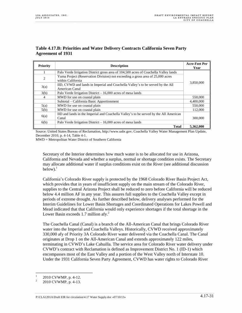
L S A A S S O C I A T E S , I N C . J U L Y 2 0 1 3
D R A F T E N V I R O N M E N T A L I M P A C T R E P O R T L A E N T R A D A S P E C I F I C P L A N
C I T Y O F C O A C H E L L A
P:\CLA1201A\Draft EIR for circulation\4.17 Water Supply.doc «07/10/13» 4.17-31
Table 4.17.B: Priorities and Water Delivery Contracts California Seven Party
Agreement of 1931
Priority Description Acre-Feet Per
Year
1 Palo Verde Irrigation District gross area of 104,500 acres of Coachella Valley lands
3,850,000
2 Yuma Project (Reservation Division) not exceeding a gross area of 25,000 acres
within California
3(a) IID, CVWD and lands in Imperial and Coachella Valley’s to be served by the All
American Canal
3(b) Palo Verde Irrigation District – 16,000 acres of mesa lands
4 MWD for use on coastal plain 550,000
Subtotal – California Basic Apportionment 4,400,000
5(a) MWD for use on coastal plain 550,000
5(b) MWD for use on coastal plain 112,000
6(a) IID and lands in the Imperial and Coachella Valley’s to be served by the All American
Canal 300,000
6(b) Palo Verde Irrigation District – 16,000 acres of mesa lands
Total 5,362,000
Source: United States Bureau of Reclamation, http://www.usbr.gov; Coachella Valley Water Management Plan Update,
December 2010, p. 4-14, Table 4-1.
MWD = Metropolitan Water District of Southern California
Secretary of the Interior determines how much water is to be allocated for use in Arizona,
California and Nevada and whether a surplus, normal or shortage condition exists. The Secretary
may allocate additional water if surplus conditions exist on the River (see additional discussion
below).1
California’s Colorado River supply is protected by the 1968 Colorado River Basin Project Act,
which provides that in years of insufficient supply on the main stream of the Colorado River,
supplies to the Central Arizona Project shall be reduced to zero before California will be reduced
below 4.4 million AF in any year. This assures full supplies to the Coachella Valley except in
periods of extreme drought. As further described below, delivery analyses performed for the
Interim Guidelines for Lower Basin Shortages and Coordinated Operations for Lakes Powell and
Mead indicated that that California would only experience shortages if the total shortage in the
Lower Basin exceeds 1.7 million afy.2
The Coachella Canal (Canal) is a branch of the All-American Canal that brings Colorado River
water into the Imperial and Coachella Valleys. Historically, CVWD received approximately
330,000 afy of Priority 3A Colorado River water delivered via the Coachella Canal. The Canal
originates at Drop 1 on the All-American Canal and extends approximately 122 miles,
terminating in CVWD’s Lake Cahuilla. The service area for Colorado River water delivery under
CVWD’s contract with Reclamation is defined as Improvement District No. 1 (ID-1) which
encompasses most of the East Valley and a portion of the West Valley north of Interstate 10.
Under the 1931 California Seven Party Agreement, CVWD has water rights to Colorado River
1 2010 CVWMP, p. 4-12.
2 2010 CVWMP, p. 4-13.
D R A F T E N V I R O N M E N T A L I M P A C T R E P O R T L A E N T R A D A S P E C I F I C P L A N C I T Y O F C O A C H E L L A
L S A A S S O C I A T E S , I N C . J U L Y 2 0 1 3
P:\CLA1201A\Draft EIR for circulation\4.17 Water Supply.doc «07/10/13» 4.17-32
water as part of the first 3.85 million afy allocated to California. CVWD is in the third priority
position along with IID.1
Quantification Settlement Agreement. Although the rights and relative priorities to Colorado
River supplies as discussed above remain established under the Law of the River, an additional
framework applies in California. In 2003, CVWD, IID and MWD successfully completed
negotiation of the Quantification Settlement Agreement (QSA). The QSA quantifies the Colorado
River water allocations of California’s agricultural water contractors for the next 75 years and
provides for the transfer of water between agencies.
Specific programs under the QSA include lining portions of the All-American and Coachella
Canals, which conserve approximately 96,000 acre-feet annually. As a result, about 80,000 acre-
feet of conserved water is delivered to the San Diego County Water Authority (“SDCWA”) by
exchange with MWD. MWD also takes delivery of 16,000 acre-feet annually that will be made
available for the benefit of the La Jolla, Pala, Pauma, Rincon and San Pasqual Bands of Mission
Indians, the San Luis Rey River Indian Water Authority, the City of Escondido and the Vista
Irrigation District, upon completion of a water rights settlement, expected in 2013. An
amendment to the 1988 Conservation Agreement between MWD and IID and an associated 1989
Approval Agreement among MWD, IID, CVWD and PVID, extended the term of the 1988
Conservation Agreement and limited the single year amount of water used by CVWD to 20,000
acre-feet. Also included under the QSA is the Delivery and Exchange Agreement between MWD
and CVWD that provides for MWD to deliver annually up to 35,000 acre-feet of MWD’s State
Water Project contractual water to CVWD by exchange with MWD’s available Colorado River
supplies. In calendar year 2011, under a supplemental agreement with CVWD, MWD delivered
105,000 acre-feet which consisted of the full 35,000 acre-feet for 2011 plus advance delivery of
the full contractual amounts for 2012 and 2013.2
Under the QSA, CVWD has a base allotment of 330,000 afy. In accordance with the QSA,
CVWD has entered into water transfer agreements with MWD and IID that increase CVWD
supplies by an additional 129,000 afy as shown in Table 4.17.C.3
As of 2010, CVWD receives 368,000 afy of Colorado River water deliveries under the QSA
(see Table 4.17.C). This includes the base entitlement of 330,000 afy, MWD/IID Approval of
20,000 afy, 12,000 afy of IID/CVWD First transfer, and 35,000 afy of MWD/SWP transfer. It
also includes the 26,000 afy transferred to San Diego County Water Authority (SDCWA) as part
of the Coachella Canal lining project and the 3,000 afy transfer to Indian Present Perfected Rights
(PPRs). CVWD’s allocation will increase to 459,000 afy of Colorado River water by 2026 and
remain at that level for the 75 year term of the QSA. After deducting conveyance and distribution
losses, approximately 428,000 afy will be available for CVWD use.4 As further discussed below,
legal challenges were filed against the QSA in 2003.
1 2010 CVWMP, pp. 4-13 to 4-14.
2 MWD 2013 Preliminary Official Statement, Water Revenue Refunding Bonds, Appendix A, p. A-16.
3 2010 CVWMP, p. 4-14.
4 Ibid.

L S A A S S O C I A T E S , I N C . J U L Y 2 0 1 3
D R A F T E N V I R O N M E N T A L I M P A C T R E P O R T L A E N T R A D A S P E C I F I C P L A N
C I T Y O F C O A C H E L L A
P:\CLA1201A\Draft EIR for circulation\4.17 Water Supply.doc «07/10/13» 4.17-33
Table 4.17.C: CVWD Deliveries under the QSA
Component 2010 Amount (afy) 2045 Amount (afy)
Base Allotment 330,000 330,000
1988 MWD/IID Approval Agreement 20,000 20,000
Coachella Canal Lining (to SDCWA) -26,000 -26,000
To Miscellaneous/Indian PPRs -3,000 -3,000
IID/CVWD First Transfer 12,000 50,000
IID/CVWD Second Transfer 0 53,000
MWD/SWP Transfer 35,000 35,000
Total Diversion at Imperial Dam 368,000 459,000
Less Conveyance Losses[1] -31,000 -31,000
Total Deliveries to CVWD 337,000 428,000
Source: Coachella Valley Water Management Plan Update, December 2010, p. 4-14, Table 4-2. 1 Assumed losses after completion of canal lining projects.
afy = acre-feet per year
While several of the issues have been resolved, the litigation continues and will likely take
several more years to complete.
Factors Affecting Colorado River Supplies. Several factors have the potential to affect the
long-term availability and reliability of Colorado River supplies in the Coachella Valley. Among
those factors are drought conditions in the Colorado River Basin, water requirements for
endangered species and habitat protection, potential climate change impacts, and lawsuits
challenging the validity of the QSA. A detailed discussion of these factors, as set forth in the
WSA, is presented below.
Drought Conditions and Interim Guidelines. Drought conditions in the Colorado River Basin
are well documented. The period from 2000 through 2007 was the driest eight-year period in the
100-year historical record of the Colorado River. This drought in the Colorado River Basin
reduced Colorado River system storage, while demands for Colorado River water supplies
continued to increase. From October 1, 1999 through September 30, 2007, storage in Colorado
River reservoirs decreased from 55.8 million AF (approximately 94 percent of capacity) to 32.1
million AF (approximately 54 percent of capacity), and was as low as 29.7 million AF
(approximately 52 percent of capacity) in 2004. In November 2010, Lake Powell and Lake Mead
were at 62 percent and 38 percent of their storage capacities, respectively (Reclamation, 2010b).
Although slightly above normal snowpack conditions existed in the Colorado River basin in
2008, the years 2009 and 2010 saw a return of below normal runoff conditions. Consequently, the
potential for continued drought conditions exists.1
In January 2001, the Secretary of the Interior adopted guidelines (the “Interim Surplus
Guidelines”) for use through 2016 in determining if there is surplus Colorado River water
available for use in California, Arizona and Nevada. The Interim Surplus Guidelines were
amended in 2007, with the new Guidelines extending through 2026. The Interim Surplus
1 2010 CVWMP, p. 4-26.
D R A F T E N V I R O N M E N T A L I M P A C T R E P O R T L A E N T R A D A S P E C I F I C P L A N C I T Y O F C O A C H E L L A
L S A A S S O C I A T E S , I N C . J U L Y 2 0 1 3
P:\CLA1201A\Draft EIR for circulation\4.17 Water Supply.doc «07/10/13» 4.17-34
Guidelines contain a series of benchmarks for reductions in agricultural use of Colorado River
water within California by set dates.1
The purposes of the Guidelines are to: (1) improve Reclamation’s management of the Colorado
River by considering trade-offs between the frequency and magnitude of reductions of water
deliveries, and considering the effects on water storage in Lake Powell and Lake Mead, where
Reclamation will also consider the effects on water supply, power production, recreation, and
other environmental resources; (2) provide mainstream United States users of Colorado River
water, particularly those in the Lower Division states, a greater degree of predictability with
respect to the amount of annual water deliveries in future years, particularly under drought and
low reservoir conditions; and (3) provide additional mechanisms for the storage and delivery of
water supplies in Lake Mead to increase the flexibility of meeting water use needs from Lake
Mead, particularly under drought and low reservoir conditions.2
As a result of the interim guidelines, recipients of Colorado River water, including CVWD, will
receive deliveries with a higher degree of reliability. Information presented in the Bureau of
Reclamation’s 2007 Final Environmental Impact Statement (“EIS”) for the Interim Guidelines
indicates that California would only experience shortages if the total shortage in the Lower Basin
exceeds 1.7 million AF. Due to California’s Colorado River priority system, all delivery
shortages would be borne by MWD, which has a lower priority than CVWD (Reclamation,
2007). Consequently, no reduction in CVWD’s Colorado River supplies is projected at this time.3
Protected Species and Other Environmental Issues. Federal and state environmental laws
protecting fish species and other wildlife species have the potential to affect Colorado River
operations. A number of species that are on either “endangered” or “threatened” lists under the
ESAs are present in the area of the Lower Colorado River, including among others, the bonytail
chub, razorback sucker, southwestern willow flycatcher and Yuma clapper rail. To address this
issue, a broad-based state/federal/tribal/private regional partnership that includes water,
hydroelectric power and wildlife management agencies in Arizona, California and Nevada have
developed a multi-species conservation program for the main stem of the Lower Colorado River
(the Lower Colorado River Multi-Species Conservation Program or “MSCP”). The MSCP allows
MWD to obtain federal and state permits for any incidental take of protected species resulting
from current and future water and power operations of its Colorado River facilities and to
minimize any uncertainty from additional listings of endangered species. The MSCP also covers
operations of federal dams and power plants on the river that deliver water and hydroelectric
power for use by MWD and other agencies. The MSCP covers 27species and habitat in the Lower
Colorado River from Lake Mead to the Mexican border for a term of 50 years. Over the 50 year
term of the program, the total cost to MWD will be about $88.5 million (in 2003 dollars), and
annual costs will range between $0.8 million and $4.7 million (in 2003 dollars).4
1 2010 CVWMP, p. 4-26.
2 Ibid.
3 Ibid.
4 MWD 2013 Preliminary Official Statement, Water Revenue Refunding Bonds, Appendix A, pp. A-20 to
A-21.
L S A A S S O C I A T E S , I N C . J U L Y 2 0 1 3
D R A F T E N V I R O N M E N T A L I M P A C T R E P O R T L A E N T R A D A S P E C I F I C P L A N
C I T Y O F C O A C H E L L A
P:\CLA1201A\Draft EIR for circulation\4.17 Water Supply.doc «07/10/13» 4.17-35
The non-profit conservation organization Grand Canyon Trust filed litigation in December 2007
against the Bureau of Reclamation in the United States District Court for the District of Arizona,
alleging that the Bureau of Reclamation’s planning for, and operation of, the Glen Canyon Dam
in the Upper Basin of the Colorado River system (which impounds Lake Powell) does not comply
with requirements of NEPA and the Federal ESA. MWD, IID, the seven basin states, and several
water and energy agencies intervened in this case. On March 29, 2011, the trial court issued a
final judgment upholding the Bureau of Reclamations’ prior decisions for Glen Canyon Dam
operations. The Grand Canyon Trust appealed. On August 13, 2012, the United States Court of
Appeals for the Ninth Circuit affirmed the decision of the Arizona district court.1
Potential Climate Change Impacts. Climate change has the potential to affect imported water
supplies. Potential effects of global warming could also increase water demand within the
Coachella Valley. Precise estimates of potential future impacts of climate change on runoff
throughout the Colorado River basin are not currently available.2 These impacts may include
decrease in annual flow and increased variability, including more frequent and more severe
droughts. Furthermore, even without precise knowledge of the effects, increasing temperatures
alone would likely increase losses due to evaporation and sublimation, resulting in reduced
runoff.3
According to DWR, increased air temperature will result in earlier snow melt runoff and a greater
proportion of runoff due to rainfall. Because reservoir storage in the Colorado River basin is so
large in comparison to annual basin runoff (roughly four times average runoff), a change in the
timing of annual runoff would not be expected to significantly affect basin yield.4 Potential
changes in the amount of precipitation received by the Colorado River basin could affect basin
yield. Warmer temperatures could also be expected to increase water demands and increase
evaporation from reservoirs and canals. While changes in any particular location will likely be
small, the aggregate change for the basin could be significant because so much land is involved.
No reliable quantitative estimates of potential changes in precipitation (or increased demand) are
available, according to the referenced 2007 BOR guidelines.
Potential climate changes impacts were evaluated in the Environmental Impact Study (EIS) on
the referenced BOR guidelines. The guidelines extend through 2026, providing the opportunity to
gain valuable operating experience through the management of Lake Powell and Lake Mead,
particularly for low flow reservoir conditions, and to improve the bases for making additional
future operational decisions during the interim period and thereafter.
The shortage sharing guidelines are crafted to include operational elements that would respond if
potential impacts of climate change and increased hydrologic variability occur. The guidelines
include coordinated operational elements that allow for adjustment of Lake Powell releases to
1 MWD 2013 Preliminary Official Statement, Water Revenue Refunding Bonds, Appendix A, p. A-21.
2 Colorado River Interim Guidelines for East Basin Shortages and Coordinated Operations for Lakes Powell
and Mead, U.S. Bureau of Reclamation, 2007. 3 2010 CVWMP, p. 5-15.
4 Progress on Incorporating Climate Change into Management of California’s Water Resources, Technical
Memorandum Report, California Department of Water Resources, October 2006.

D R A F T E N V I R O N M E N T A L I M P A C T R E P O R T L A E N T R A D A S P E C I F I C P L A N C I T Y O F C O A C H E L L A
L S A A S S O C I A T E S , I N C . J U L Y 2 0 1 3
P:\CLA1201A\Draft EIR for circulation\4.17 Water Supply.doc «07/10/13» 4.17-36
respond to low average storage conditions in Lake Powell or Lake Mead. In addition, the
guidelines enhance conservation opportunities in lower basin and retention of water in Lake
Mead.1 Although the potential impacts from climate change cannot be quantified at this time, the
interim guidelines should provide additional protection against impacts of shortage sharing at
least through 2026, and likely for extended periods. Coachella Valley water supplies are uniquely
protected from potential impacts of climate change and corresponding shortages by (1)
California’s first priority for Colorado River water supplies in the lower Colorado River basin,
and (2) Coachella’s high priority for Colorado River supplies among California users of Colorado
River water.2
QSA Litigation. As further discussed in the WSA, various lawsuits were filed against the QSA in
2003. The litigation continued for several years, and in 2010 the trial court ruled that the QSA
agreements were invalid under the funding provisions of the State Constitution.3 In March 2010,
CVWD, IID, MWD, SDCWA and others appealed that ruling. In December 2011, the Court of
Appeal reversed the trial court and ruled that the original environmental litigation against the
QSA could be resumed. In June 2013, the trial court issued a decision that upheld the QSA and
denied the environmental claims. Among other things, the court determined that the potential air
quality impacts to the Salton Sea were adequately analyzed under CEQA. The court also found
that the selected baseline was appropriate to measure the impacts of the long-term water transfers,
and that other decisions made by the water agencies were supported by the record. As further
discussed in the WSA, other legal challenges have been filed against the QSA and those matters
are ongoing. Whether that separate litigation might affect CVWD’s access to Colorado River
supplies under the QSA is speculative and cannot be determined at this time.4
Colorado River Basin Study. In December 2012, the Bureau of Reclamation (BOR) issued its
Colorado River Basin Water Supply and Demand Study (2012 Study). According to BOR, the
2012 Study was prepared to address the complex issues of ensuring a sustainable water supply
and meeting future demand in the Colorado River system. The 2012 Study recognizes that
because of the Colorado River system’s ability to store approximately 60 million acre-feet of
water (or nearly four years of average natural flow of the River), all requested deliveries have
been met in the Lower Basin, despite recently experiencing the worst 11-year drought in the last
century.5 The 2012 Study concludes that, without additional future water management actions
among the Upper and Lower Basin states, a wide range of future imbalances is plausible,
primarily due to uncertainties inherent in future water supply.6 Comparing the median long-term
water supply projections against the median long-term water demand projections, and accounting
for the many factors having the potential to affect the availability and reliability of River supplies
1 2010 CVWMP, p. 5-15.
2 Ibid.
3 2010 CVWMP, p. 4-26; MWD 2013 Preliminary Official Statement, Water Revenue Refunding Bonds,
Appendix A, p. A-18. 4 2010 CVWMP, p. 4-26; MWD 2013 Preliminary Official Statement, Water Revenue Refunding Bonds,
Appendix A, p. A-18 to A-19. 5 2012 Study, Executive Summary, p. ES-1.
6 2012 Study, Executive Summary, p. ES-6.

L S A A S S O C I A T E S , I N C . J U L Y 2 0 1 3
D R A F T E N V I R O N M E N T A L I M P A C T R E P O R T L A E N T R A D A S P E C I F I C P L A N
C I T Y O F C O A C H E L L A
P:\CLA1201A\Draft EIR for circulation\4.17 Water Supply.doc «07/10/13» 4.17-37
and demands (such as climate change, species and other environmental issues, social trends,
economic and legal forces, and technical capabilities), the 2012 Study shows that a long-term
projected imbalance of 3.2 million acre-feet or more could occur by the year 2060.1 To address
potential long-term imbalances, the 2012 Study identifies and discusses a broad range of options
to resolve the differences between water supply and demand. During the study period, over 150
options were received and organized into four groups: (1) those that increase Basin water
supplies; (2) those that reduce Basin water demands; (3) those that focus on modifying
operations; and (4) those that focus primarily on Basin governance.2 Moreover, recognizing that
no single option is likely sufficient to resolve potential water supply and demand imbalances, the
2012 Study developed groups and portfolios of options to reflect different adaptive strategies.3
Importantly, the 2012 Study recognizes that complete elimination of Basin vulnerability is not
likely obtainable, yet concludes that implementation of various adaptive management options
results in a significant reduction in vulnerability (e.g., the percentage of future scenarios resulting
in Lake Mead elevations being less than 1,000 feet msl is reduced from 19 percent to only 3
percent).4 Indeed the 2012 Study states that implementation of management portfolios are
projected to be successful in significantly improving the resiliency of Basin resources to
vulnerable hydrologic conditions.5 Similar to the extraordinary conservation and management
efforts being undertaking throughout the Coachella Valley (discussed above), the 2012 Study
concludes that supply augmentation, water reuse and conservation will be critical tools in
managing potential supply and demand imbalances.6
Other Supplies. As noted in this Chapter and throughout the WSA, groundwater from the Lower
Whitewater River Subbasin is the primary source of supply used by the City to meet existing and
projected demands. The groundwater basin is a comprehensively managed conjunctive use system
that is continuously replenished with supplemental imported supplies, the rights and access to which
are fully discussed herein and in the WSA. Aside from native groundwater and imported supplies, the
WSA identifies local and other water supply projects and programs that are being carried out and/or
planned by the City and CVWD.7 As detailed in the City 2010 UWMP, the CVWD 2010 UWMP, the
2010 CVWMP and 2011 SPEIR, examples of such local and other supplies are water transfers and
exchange opportunities, desalinated agricultural drain flows, recycled water, and treated Canal water.
4.17.5 Project Design Features
As summarized in Chapter 3.0, Project Description, the proposed Specific Plan includes components
that are referred to as Project Design Features. Primary Project Design Features related to water
supply include:
1 2012 Study, Executive Summary, p. ES-6.
2 2012 Study, Executive Summary, p. ES-7.
3 2012 Study, Executive Summary, p. ES-11.
4 2012 Study, Executive Summary, p. ES-14.
5 Ibid.
6 Ibid.
7 WSA, Chapters 1 and 4.
D R A F T E N V I R O N M E N T A L I M P A C T R E P O R T L A E N T R A D A S P E C I F I C P L A N C I T Y O F C O A C H E L L A
L S A A S S O C I A T E S , I N C . J U L Y 2 0 1 3
P:\CLA1201A\Draft EIR for circulation\4.17 Water Supply.doc «07/10/13» 4.17-38
The Specific Plan proposes three aboveground steel water storage tanks and associated pipelines
and booster stations for distribution of potable water.
4.17.6 Thresholds of Significance
The following thresholds of significance criteria are based on Appendix G of the CEQA Guidelines.
Based on these thresholds, implementation of the proposed project would have a significant adverse
impact related to water supply if it would:
Threshold 4.17.1 Not have sufficient water supplies available to serve the project from existing
entitlements and resources, or are new or expanded entitlements needed;
Threshold 4.17.2 Require or result in the construction of new water or wastewater treatment or
collection facilities or expansion of existing facilities, the construction of
which could cause significant environmental effects; or
Threshold 4.17.3: Substantially deplete groundwater supplies or interfere substantially with
groundwater recharge such that there would be a net deficit in aquifer
volume or a lowering of the local groundwater table level (e.g., the
production rate of pre-existing nearby wells would drop to a level which
would not support existing land uses or planned uses for which permits have
been granted).
4.17.7 Project Impacts
The proposed La Entrada project includes 7,800 dwelling units on approximately 2,200 acres of
vacant land located within the northeast section of the City of Coachella, south of Interstate 10 and
northeast of the All American Canal. The proposed project is located within the City limits and sphere
of influence. The Coachella Water Authority (CWA), which is part of the City’s Utilities Department,
will serve as the public water system for the Project.
As indicated above, the water demands associated with the proposed project have already been
specifically accounted for as part of CVWD’s water supply planning process and determinations of
short and long-term water supply sufficiency for the City and its sphere of influence.1 The WSA
identifies that CVWD’s updated water use factors can be applied to the proposed La Entrada project.
CVWD’s updated factors are consistent with the per capita water use reduction goals of SBx7-7,
whereas the City’s historic water use factors were adopted prior to the enactment of SBx7-7 and are
in the process of being updated. Furthermore, and as further discussed below, the project applicant
has committed to ensuring that buildout of the proposed project will occur in a manner consistent
with CVWD’s efficient landscape ordinance. Indeed, the 2009 and 2013 MOUs between the City and
CVWD illustrate that projects relying on CVWD’s Supplemental Water Supply program must strive
to achieve consistency with the conservation programs identified in CVWD’s 2010 CVWMP and the
water use factors developed by CVWD for the use of supplemental water. Moreover, CVWD’s
updated water use factors have already been applied to new development projects within CVWD’s
retail service area and have proven to be achievable for development such as the proposed project.
1 See, e.g., 2010 CVWMP, pp. 3-3 to 3-4.
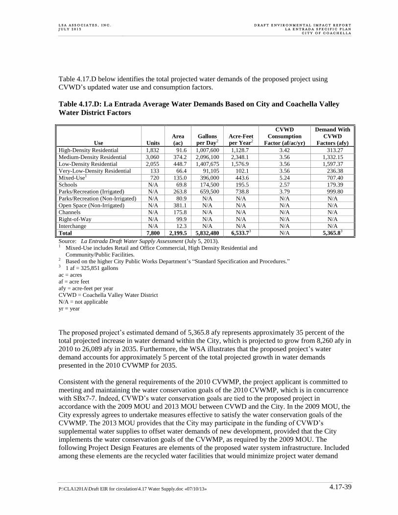
L S A A S S O C I A T E S , I N C . J U L Y 2 0 1 3
D R A F T E N V I R O N M E N T A L I M P A C T R E P O R T L A E N T R A D A S P E C I F I C P L A N
C I T Y O F C O A C H E L L A
P:\CLA1201A\Draft EIR for circulation\4.17 Water Supply.doc «07/10/13» 4.17-39
Table 4.17.D below identifies the total projected water demands of the proposed project using
CVWD’s updated water use and consumption factors.
Table 4.17.D: La Entrada Average Water Demands Based on City and Coachella Valley
Water District Factors
Use Units
Area
(ac)
Gallons
per Day2
Acre-Feet
per Year2
CVWD
Consumption
Factor (af/ac/yr)
Demand With
CVWD
Factors (afy)
High-Density Residential 1,832 91.6 1,007,600 1,128.7 3.42 313.27
Medium-Density Residential 3,060 374.2 2,096,100 2,348.1 3.56 1,332.15
Low-Density Residential 2,055 448.7 1,407,675 1,576.9 3.56 1,597.37
Very-Low-Density Residential 133 66.4 91,105 102.1 3.56 236.38
Mixed-Use1 720 135.0 396,000 443.6 5.24 707.40
Schools N/A 69.8 174,500 195.5 2.57 179.39
Parks/Recreation (Irrigated) N/A 263.8 659,500 738.8 3.79 999.80
Parks/Recreation (Non-Irrigated) N/A 80.9 N/A N/A N/A N/A
Open Space (Non-Irrigated) N/A 381.1 N/A N/A N/A N/A
Channels N/A 175.8 N/A N/A N/A N/A
Right-of-Way N/A 99.9 N/A N/A N/A N/A
Interchange N/A 12.3 N/A N/A N/A N/A
Total 7,800 2,199.5 5,832,480 6,533.73 N/A 5,365.83
Source: La Entrada Draft Water Supply Assessment (July 5, 2013). 1 Mixed-Use includes Retail and Office Commercial, High Density Residential and
Community/Public Facilities. 2 Based on the higher City Public Works Department’s “Standard Specification and Procedures.” 3 1 af = 325,851 gallons
ac = acres
af = acre feet
afy = acre-feet per year
CVWD = Coachella Valley Water District
N/A = not applicable
yr = year
The proposed project’s estimated demand of 5,365.8 afy represents approximately 35 percent of the
total projected increase in water demand within the City, which is projected to grow from 8,260 afy in
2010 to 26,089 afy in 2035. Furthermore, the WSA illustrates that the proposed project’s water
demand accounts for approximately 5 percent of the total projected growth in water demands
presented in the 2010 CVWMP for 2035.
Consistent with the general requirements of the 2010 CVWMP, the project applicant is committed to
meeting and maintaining the water conservation goals of the 2010 CVWMP, which is in concurrence
with SBx7-7. Indeed, CVWD’s water conservation goals are tied to the proposed project in
accordance with the 2009 MOU and 2013 MOU between CVWD and the City. In the 2009 MOU, the
City expressly agrees to undertake measures effective to satisfy the water conservation goals of the
CVWMP. The 2013 MOU provides that the City may participate in the funding of CVWD’s
supplemental water supplies to offset water demands of new development, provided that the City
implements the water conservation goals of the CVWMP, as required by the 2009 MOU. The
following Project Design Features are elements of the proposed water system infrastructure. Included
among these elements are the recycled water facilities that would minimize project water demand
D R A F T E N V I R O N M E N T A L I M P A C T R E P O R T L A E N T R A D A S P E C I F I C P L A N C I T Y O F C O A C H E L L A
L S A A S S O C I A T E S , I N C . J U L Y 2 0 1 3
P:\CLA1201A\Draft EIR for circulation\4.17 Water Supply.doc «07/10/13» 4.17-40
and, therefore, further reduce, avoid, or offset potential water supply impacts, which have already
been determined to be less than significant.
The La Entrada Specific Plan employs a multifaceted approach to water efficiency. As further set
forth below, this chapter concludes that potential impacts to water resources are less than significant
therefore no CEQA mitigation is required. Nevertheless, the proposed land use plan identifies a
variety of areas that are intended to accommodate storm water conveyance facilities, bioswales, and
water quality treatment facilities designed to improve water quality on site and limit downstream
water quality impairments from the proposed development. Coupled with this, the La Entrada
Specific Plan proposes the efficient use of potable water through mandated building and site design
requirements. In addition, the site layout would be able to accommodate an on-site sewer/reclaimed
water treatment facility, if necessary, to create non-potable water supplies and utilize canal water for
`irrigation purposes. The La Entrada project will incorporate a series of Sustainable Community
Design Features that would further reduce the water demand associated with project buildout. These
Sustainable Community Design Strategies include:
Utilize drought tolerant landscaping; non-potable reclaimed, well, or canal water for irrigation
purposes (when available); and high-efficiency plumbing fixtures and appliances throughout the
project;
Utilize high-efficiency plumbing and fixtures that meet or exceed the CALGreen Code (most
current adopted version) for all residential, commercial, mixed use, public facility and park and
open space areas;
Utilize “smart” irrigation controls throughout the project that can manage an unlimited number of
controllers and sites from anywhere in the world using an internet connected computer. Users
should be able to alter irrigation schedules, manually water zones and program irrigation holds
from a remote location.
Reduce the amount of irrigated turf in parks to those uses dependent upon turf areas; Areas
dependent on turf include school sports fields and on-site park and recreation areas.
Implement an integrated storm water collection and conveyance system designed to treat and
convey development-related runoff; provide 100-year flood protection to flood prone areas;
increase groundwater recharge through on-site retention basins; and improve water quality on site
and downstream through on-site water quality basins;
Implement dual plumbing within the recreation areas, landscaped medians, common landscaped
areas, mixed-use/commercial planning areas, and parks to allow for the use of reclaimed water
when available; and
Install “purple pipe” throughout the La Entrada project for the use of reclaimed water when it
becomes available.
Landscaping within La Entrada Specific Plan would complement the surrounding desert environment
as well as provide areas for outdoor enjoyment and activity. The plant palette proposed for the
Specific Plan identifies appropriate plant types that have low water requirements, minimize turf,
provide shade, and which reduce the urban heat island effect. In conjunction with the proposed
landscape design, the La Entrada Specific Plan proposes the use of Low Impact Development (LID)
techniques to control storm water flows on site (see list below). LID is an ecologically friendly
approach to site development and storm water management that aims to mitigate development
L S A A S S O C I A T E S , I N C . J U L Y 2 0 1 3
D R A F T E N V I R O N M E N T A L I M P A C T R E P O R T L A E N T R A D A S P E C I F I C P L A N
C I T Y O F C O A C H E L L A
P:\CLA1201A\Draft EIR for circulation\4.17 Water Supply.doc «07/10/13» 4.17-41
impacts to land, water, and air. The approach emphasizes the integration of site design and planning
techniques that conserve natural systems and hydrologic functions on-site. Sustainable Community
Design Strategies for Landscape Design within La Entrada include:
Increase access to fresh produce and through the promotion of community-based food production
within the project. This can be achieved through Covenants, Conditions and Restrictions
(CC&Rs) that do not prohibit local food production, establishment of neighborhood gardens,
community-supported agriculture, and/or promotion of a Farmer’s Market within the project;
Utilize native and drought tolerant plants throughout the development that complement the
existing flora and fauna found on site;
Develop a plant palette that focuses on shading within the developed portions of the site and in
those areas of pedestrian activity. An increase in shading within the development will promote
greater walkability and reduce the urban heat island effect. Both of these will assist in the
reduction of greenhouse gas emissions associated with the proposed development;
The Project landscape plan includes tree-lined streets that will encourage walking, biking, and
transit use, and reduce urban heat island effects;
Minimize turf throughout the development to the greatest extent possible Utilize artificial turf
and/or xeriscaping to reduce water demand and be responsive to existing climatic conditions
within the project area;
Reduce the heat island effect through the minimization of impervious surfaces and incorporation
of landscaping within the development that provides shading of developed areas within 5 years of
occupancy;
Preserve open space and minimize land disturbance within the Specific Plan, which reduces
impacts to local terrestrial plants and animals and preserves the integrity of the ecological and
biological systems on site;
Incorporate natural site elements (significant rock outcroppings, drainage corridors, bioswales) as
design features; and protect natural systems and processes (drainage ways, vegetation, soils,
sensitive areas);
Reduce municipal infrastructure and utility maintenance costs (streets, curbs, gutters, sidewalks,
storm sewer) by reexamining the use and sizing of traditional site infrastructure (lots, streets,
curbs, gutters, sidewalks) and customizing infrastructure design to each planning area;
Incorporate decentralized and micromanaged storm water and/or water quality facilities close to
the source within each planning area, protecting site and regional water quality by reducing
sediment and nutrient loads to water bodies on-site and downstream;
Construct bioswales within private development areas and street rights of way where grades
permit;
Mimic the predevelopment site hydrology by using site design techniques that store, infiltrate,
evaporate, and retain runoff to reduce off-site runoff and facilitate groundwater recharge; and
Ensure that receiving waters experience fewer negative impacts in the volume, frequency, and
quality of runoff by maintaining base flows and more closely approximating predevelopment
runoff conditions.

D R A F T E N V I R O N M E N T A L I M P A C T R E P O R T L A E N T R A D A S P E C I F I C P L A N C I T Y O F C O A C H E L L A
L S A A S S O C I A T E S , I N C . J U L Y 2 0 1 3
P:\CLA1201A\Draft EIR for circulation\4.17 Water Supply.doc «07/10/13» 4.17-42
The landscaping of the public spaces, including the community gateways, street medians and
parkways, parks, community centers, plazas, paseos, trails, and open spaces is a major component of
the overall community design envisioned for La Entrada. Complementary to the unifying architectural
themes, these landscaped places would form the heart of the community. They provide an important
aesthetic element; enhance community gathering places; encourage recreational opportunities; enable
the use of alternative transportation such as walking, bicycling, and neighborhood electric vehicles
(NEV); and minimize and mitigate impacts to the environment.
The La Entrada Specific Plan landscape design guidelines expand upon and enhance design
requirements and recommendations found in the City of Coachella General Plan, Parks and
Recreation Master Plan, Landscape Development Guidelines and Specifications, Street Median
Development Guidelines, CVAG Non-motorized Transportation Plan, 2010 Urban Water
Management Plan and Ordinance No. 1302 Landscape Irrigation System Design Criteria. Individual
development projects would address regulations and guidelines contained in the documents listed
above. Where inconsistencies occur, Specific Plan guidelines and regulations would govern. As set
forth in the Specific Plan, the La Entrada landscaping is intended to incorporate natural and drought-
tolerant vegetation to create a “shady oasis” concept. The overall community landscaping comprises
five distinct landscape zones to create an overall landscape framework. Landscape zones are as
follows:
Community Gateway and Entry Monumentation
Community Streetscapes
Parks and Recreation
Open Space
Buffers, Edge Treatments, and Transitional Areas
As stated in the Specific Plan, the following guiding principles set the general direction for design of
the landscaped places of the La Entrada community:
Implement a landscape concept, using a drought tolerant plant pallet, that is low-water use and
well adapted to the desert environment.
Incorporate the latest design principles of environmental sensitivity, conservation, and
sustainability into landscape planning and design..
Incorporate eco-friendly design approaches that relate to site, landscape, and building design,
including optimizing building orientation; reducing potable water use for landscape irrigation;
implementing shade strategies; and using photovoltaic arrays on building roofs or parking lot
shade structures.
Maximize vibrant streetscapes with an emphasis on the pedestrian experience by providing shade,
engaging amenities, and efficient connectivity.
Capitalize on the Parks and Recreation Master Plan potentials. Develop consistent with the goals
and objectives of the 2006 Parks and Recreation Master Plan to help define this area of the City’s
image, character and recreational goals.

L S A A S S O C I A T E S , I N C . J U L Y 2 0 1 3
D R A F T E N V I R O N M E N T A L I M P A C T R E P O R T L A E N T R A D A S P E C I F I C P L A N
C I T Y O F C O A C H E L L A
P:\CLA1201A\Draft EIR for circulation\4.17 Water Supply.doc «07/10/13» 4.17-43
Provide community-gathering spaces, such as a true downtown community core and extension of
the heart of Coachella.
Enhance public domains by providing structured, pedestrian-friendly streets, bicycle lanes,
sidewalks, parks, and public gathering spaces that facilitate walking and biking to local
employment, retail, and entertainment uses.
Provide opportunities to collect and treat urban runoff.
Utilize turf grass only in active park areas and other important public gathering places.
Streetscapes will utilize desert-adapted and native plant materials to minimize irrigation needs.
Landscape concepts will utilize permeable materials such as decomposed granite and
rocks/cobble to reduce irrigation demands.
All planting areas will be irrigated with a high-efficiency automatic irrigation system.
Parks, parkways, Homeowners Association (HOA) landscaped areas, and other common areas
will utilize reclaimed water to reduce demands on domestic as it becomes available.
Irrigation systems should be zoned for exposure (south and west exposures together), topography,
and varying water requirements of plant material.
The proposed project’s plant palette incorporates native and desert-adapted trees, shrubs, and
groundcover to provide the envisioned landscape character. Plant palettes are designated to reflect the
intended character of each landscape zone while expanding upon and enhancing design requirements
and recommendations from the City’s approved plant list as noted in the City’s Landscape
Guidelines, the City‘s Approved Plant List, and the Street and Median Development Guidelines. The
proposed project would specifically implement the following landscape standards:
All plantings within the La Entrada community will be selected from the palette of plants listed in
this document, or as modified in the subsequent private builder-level Design Guidelines, with
final landscaping plans subject to approval by the City of Coachella as part of the design/site plan
review.
Landscaping within the La Entrada development will be designed in substantial conformance
with this Specific Plan.
The Master Developer will coordinate efforts with the City and the utility companies, which
maintain easements through the property, in order to implement the landscape improvements
proposed by the Plan.
Nontoxic, noninvasive, drought-tolerant vegetation will be utilized adjacent to all public open
space areas except for limited turf areas within active parks.
The Master Developer or individual builders will install all entry improvements concurrently with
the street on which they front.
Final landscape concept plans and construction plans for community entry treatments,
streetscapes, park and open spaces, and edge/buffer treatments shall be prepared by a licensed
landscape architect and reviewed and approved by the City.
Maximum slope in required landscape setbacks will be 2:1, with 3:1 preferred.
D R A F T E N V I R O N M E N T A L I M P A C T R E P O R T L A E N T R A D A S P E C I F I C P L A N C I T Y O F C O A C H E L L A
L S A A S S O C I A T E S , I N C . J U L Y 2 0 1 3
P:\CLA1201A\Draft EIR for circulation\4.17 Water Supply.doc «07/10/13» 4.17-44
Although the proposed project’s water demands can be accommodated by existing and projected City
water availability, all new development is required to comply with State law regarding water
conservation measures. As discussed above and in the WSA, water conservation is a major
component of future water management in the Coachella Valley. Both the City and CVWD are
committed to reducing per capita urban water use in accordance with SBx7-7. Agricultural
conservation will also be a focus within CVWD. As set forth above and as detailed in the La Entrada
Specific Plan, the proposed project includes conservation strategies that would further reduce project
demands on the City’s water supplies. The project site has been designed to accommodate an on-site
sewer/reclaimed water treatment facility, if necessary, to create nonpotable water supplies and utilize
Coachella Canal water for irrigation purposes, consistent the 2010 CVWMP Update and the CVWD’s
Landscape Ordinance. The proposed project would also incorporate additional design features to
achieve extraordinary water conservation, including but not limited to:
Utilize landscaping, non-potable reclaimed well or Coachella Canal water for irrigation, and
install high-efficiency plumbing fixtures and appliances throughout the project to reduce potable
water demand;
Utilize high-efficiency plumbing and fixtures throughout the project that meet or exceed the
CALGreen Code (most current adopted version);
Utilize “smart” irrigation controllers to reduce water demand associated with landscaped areas
throughout the project site;
Reduce the amount of irrigated turf in parks to those uses dependent upon turf areas;
Implement an integrated storm water collection and conveyance system designed to treat and
convey development-related runoff; provide 100-year flood protection to flood prone areas;
increase groundwater recharge through on-site retention basins, and implement on-site water
quality basins to improve water quality on site and downstream;
Implement dual plumbing within recreation areas, landscaped medians, common landscaped
areas, mixed-use/commercial planning areas, and parks to allow for use of reclaimed water; and
Support the development of reclaimed water supplies in the City and the proposed project in an
effort to reduce overall potable water consumption. Landscaping within the Specific Plan will
complement the desert environment and will use plant types that have low water requirements in
accordance with the 2010 CVWMP.
Threshold 4.17.1: Have sufficient water supplies available to serve the project from
existing entitlements and resources, or are new or expanded entitlements
needed
Threshold 4.17.3: Substantially deplete groundwater supplies or interfere substantially
with groundwater recharge such that there would be a net deficit in
aquifer volume or a lowering of the local groundwater table level (e.g.,
the production rate of pre-existing nearby wells would drop to a level
which would not support existing land uses or planned uses for which
permits have been granted)
Less than Significant Impact. The discussion below addresses Thresholds 4.17.1 and 4.17.3
together because the standards are closely related in regard to how water service is provided in the

L S A A S S O C I A T E S , I N C . J U L Y 2 0 1 3
D R A F T E N V I R O N M E N T A L I M P A C T R E P O R T L A E N T R A D A S P E C I F I C P L A N
C I T Y O F C O A C H E L L A
P:\CLA1201A\Draft EIR for circulation\4.17 Water Supply.doc «07/10/13» 4.17-45
City of Coachella. As noted above, the Coachella Water Authority (CWA) utilizes groundwater
produced from the Coachella Valley Groundwater Basin (specifically, the Lower Whitewater River
Subbasin) to serve water within the City (Threshold 4.17.1). At the same time, however, the City’s
2010 UWMP, the CVWD 2010 UWMP, CVWD 2010 CVWMP and 2011 SPEIR all demonstrate that
the groundwater basin and supplies that are used by CWA are cooperatively managed by the City,
CVWD and others as an expansive conjunctive use resource, where the City and CVWD use
entitlements to imported water and other resources to replenish local groundwater supplies on an
ongoing basis (Threshold 4.17.3). (See generally, WSA Sections 1 and 4.)
The analysis provided herein regarding potential water supply impacts under Thresholds 4.17.1 and
4.17.3 adheres to the standards established by the California Supreme Court in Vineyard Area
Citizens for Responsible Growth, Inc. v. City of Rancho Cordova (2007) 40 Cal.4th 412. As noted
above, Vineyard provides that CEQA does not require the same assurances of certainty regarding
future water supplies at the early stages of project planning and approval that are required at later
stages, such as approval of a subdivision map or construction permits.1 The Court found that requiring
water supply certainty at an initial approval stage of a long-term, large-scale development project
would likely be unworkable because water planning would far outpace land use planning.2
Specifically, the Court noted that a WSA prepared under SB 610 in connection with CEQA at the
early stages of a master planned community is not required to provide the same level of water supply
assurances that are required in a Written Verification prepared under SB 221 at the subdivision map
approval stage.3
Consistent with these holdings, the Supreme Court in Vineyard identified four principles for
conducting a water supply analysis in an EIR: (1) an EIR cannot ignore or assume a solution to water
supply; (2) an EIR cannot limit the water supply analysis to the first stage of a project; (3) future
water supplies identified and analyzed must bear a likelihood of actually being available; and (4) if
the uncertainties inherent in long-term land use and water planning make it impossible to confidently
identify future water supply sources, the EIR should discuss the uncertainty of the future water supply
sources, reasonably foreseeable alternatives (including alternative water sources and the option of
restricting future phases of development if sufficient water is not available for future phases), and the
significant foreseeable environmental impacts of each alternative water supply source and related
mitigation measures to reduce each impact, if any.4 The information and analyses of this Section 4.17
address and comport with each of these principles from the Vineyard case in analyzing the potential
water supply impacts of the proposed project.
In accordance with the first principle of Vineyard, the water supply analysis provided herein and in
the WSA does not ignore or assume a solution to water supply. As noted above, the main source of
supply for the City’s CWA is the Coachella Valley Groundwater Basin, specifically the Lower
Whitewater River Subbasin, which is continuously replenished at the local and regional level
pursuant to a variety of water supply projects and programs discussed above and in the WSA. (See
generally, WSA Sections 1 and 4.) The information and analyses in the City’s 2010 UWMP, the
CVWD 2010 UWMP, the 2010 CVWMP and 2011 SPEIR show that the Coachella Valley
1 Vineyard, 40 Cal.4th at 432, 438.
2 Vineyard, 40 Cal.4th at 432.
3 Vineyard at 434.
4 Vineyard, 40 Cal.4th at 431-434.

D R A F T E N V I R O N M E N T A L I M P A C T R E P O R T L A E N T R A D A S P E C I F I C P L A N C I T Y O F C O A C H E L L A
L S A A S S O C I A T E S , I N C . J U L Y 2 0 1 3
P:\CLA1201A\Draft EIR for circulation\4.17 Water Supply.doc «07/10/13» 4.17-46
Groundwater Basin area serves as an expansive conjunctive use resource that is capable of ensuring a
sufficient and sustainable water supply to serve existing uses and projected growth during normal,
single-dry and multiple-dry years over an extended planning horizon, currently established as the year
2045. Not only does the basin contain vast reserves of local groundwater (approximately 25 million
acre-feet), it has substantial available storage space that has been utilized and will continue to be
utilized to store millions of acre-feet of supplemental supplies that become available during normal
and above-normal years. Those surplus supplies are recharged to the basin for later use during dry
periods.
More specifically, as discussed in Chapters 1 and 4 of the WSA, CVWD has determined that the total
projected water supplies available to the Lower Whitewater River Subbasin area during normal,
single-dry and multiple-dry periods throughout the year 2045 are sufficient to meet the water needs of
existing uses and projected growth, specifically including the future water needs within the City and
its sphere of influence.1 Indeed, the proposed La Entrada project is identified in the 2010 CVWMP
(referred to then as the Lomas del Sol project), and the demands associated with the proposed project
have been accounted for as part of CVWD’s regional water supply planning efforts and conclusions
of water supply sufficiency through the year 2045.2
CVWD, with assistance from other water agencies including the CWA, have been implementing
water supply projects, programs and related management actions of the CVWMPs since 2002. A
notable requirement under the CVWMP is that the City (and other agency producers) must pay a
replenishment assessment charge (RAC) for each acre-foot of groundwater produced. The current
RAC is $24 per acre-foot of groundwater pumped. RAC funds are utilized, for instance, to purchase
SWP entitlements already held by CVWD and other supplemental supplies for which entitlements
previously have been established, including but not limited to additional SWP supplies, Colorado
River water, recycled water supplies, desalinated agricultural drain water, and Coachella Canal water.
As discussed above and in the WSA, key components of the water management actions also include
various urban and irrigation conservation measures, tiered water rates, landscaping ordinances and
policies, outreach and education. The CVWD groundwater replenishment programs establish a
comprehensive and managed effort to eliminate overuse of local groundwater resources. These
programs allow the City, CVWD and others to maintain the groundwater basin as a primary water
supply and to recharge the basin to meet existing and projected demands and eliminate the overuse of
local groundwater supplies. A complete discussion on existing and planned groundwater recharge
facilities is included within the 2010 CVWMP, which is hereby incorporated by reference.3
Importantly, the potential environmental impacts of securing additional water supplies and
entitlements, and implementing the water supply projects and programs contained in the 2010
CVWMP have been analyzed in accordance with CEQA, and the determination has been made that
implementation of the 2010 CVWMP will have a beneficial effect on groundwater resources.4 Among
other things, the 2011 SPEIR also concluded that: primary health-based drinking water quality
standards would not be exceeded due to implementation of the 2010 CVWMP projects and programs;
impacts to Colorado River flows, erosion, siltation, and salinity will be less than significant; the
1 See, e.g., 2010 CVWMP, pp. 7-2 to 7-12; 2011 SPEIR, pp. 3-4 to 3-9.
2 2010 CVWMP, pp. 3-3 to 3-4.
3 2010 CVWMP, pp. 3-12; 4-12 thru 4-13.
4 See, e.g., 2010 CVWMP, pp. 7-20 to 7-32; 2011 SPEIR, pp. 3-23 to 3-33.

L S A A S S O C I A T E S , I N C . J U L Y 2 0 1 3
D R A F T E N V I R O N M E N T A L I M P A C T R E P O R T L A E N T R A D A S P E C I F I C P L A N
C I T Y O F C O A C H E L L A
P:\CLA1201A\Draft EIR for circulation\4.17 Water Supply.doc «07/10/13» 4.17-47
volume of water delivered through the Coachella Canal will increase to a minor degree, but will
remain within Canal capacity, and impacts will be less than significant; and impacts on SWP supplies
will be less than significant, although the Department of Water Resources will be responsible for
evaluating and approving future water transfers in subsequent CEQA documents. As indicated above,
the potential environmental impacts of securing additional water supplies and entitlements, and
implementing the water supply projects and programs contained in the 2010 CVWMP, have been
analyzed by CVWD in accordance with CEQA.1 The City of Coachella considered the 2011 SPEIR
as a responsible agency under CEQA, and accordingly the 2011 SPEIR discussion and analyses are
incorporated herein by reference.2
CVWD’s supplemental water supplies and entitlements, as analyzed in its 2010 CVWMP and 2011
SPEIR, are specifically available to the proposed La Entrada project. As mentioned above, CVWD
and the City signed a Memorandum of Understanding in September 2009 (the 2009 MOU) to assist in
ensuring a sufficient and reliable water supply for development projects within the City and its sphere
of influence (SOI). Under the terms of the 2009 MOU, various means are identified by which the City
can provide for the supply of supplemental water to offset the demands associated with new
development projects approved by the City. In particular, the City can participate in funding CVWD’s
acquisition of supplemental water supplies to offset demands associated with newly approved projects
within the City’s SOI.3 Also discussed above, CVWD and the City signed an additional
Memorandum of Understanding in February 2013 (the 2013 MOU) regarding implementation of the
2009 MOU. Among other things, the 2013 MOU further specifies the mechanism by which the City
can finance and acquire supplemental water supplies from CVWD to meet the projected demands of
new development projects.
Specifically, the 2013 MOU states: “For new development projects under consideration by the City
that will rely on [supplemental water supplies] pursuant to the [2009 MOU], the City will impose on
the project, as a condition of recordation of a final subdivision map or parcel map, or prior to the first
water meter connection, whichever comes first, the City’s then current [supplemental water supply
charge] through an approved phasing plan that is comparable to CVWD fee-collection policies in
effect at that time. Within 30 days of receiving a [supplemental water supply charge] payment from
developer, City will remit CVWD’s portion of the [supplemental water supply charge] to CVWD.”4
Furthermore, the 2013 MOU provides: “Any [supplemental water supply charge] funds remitted by
the City to CVWD shall be deemed used for the acquisition of [supplemental water supplies] needed
to supply the demands of the development project for which the [supplemental water supply charge]
is paid. CVWD will hold entitlement and deliver such [supplemental water supplies] for the benefit of
the City as the retail water supplier for the project.”5 The 2013 MOU expressly acknowledges and
applies to the proposed La Entrada project6 and, as discussed above and throughout the WSA, the
1 CVWMP 2011 SPEIR, State Clearinghouse No. 2007091099.
2 Copies of the EIR documents and technical appendices are available on the Coachella Valley Water District
website at http://www.cvwd.org/news/publicinfo.php?doc=er&years=all and at the District offices at 5-995
Avenue 52, Coachella; and 75-515 Hovley Lane East, Palm Desert, California. 3 See, e.g., CVWD 2010 CVWMP, p. 3-3.
4 2013 MOU, Section 1(c).
5 2013 MOU, Section 1(d).
6 2013 MOU, Section 3(c).
D R A F T E N V I R O N M E N T A L I M P A C T R E P O R T L A E N T R A D A S P E C I F I C P L A N C I T Y O F C O A C H E L L A
L S A A S S O C I A T E S , I N C . J U L Y 2 0 1 3
P:\CLA1201A\Draft EIR for circulation\4.17 Water Supply.doc «07/10/13» 4.17-48
supplemental water supplies and entitlements referred to in the 2013 MOU have been analyzed by
CVWD as part of the 2010 CVWMP and related 2011 SPEIR.
In accordance with the second Vineyard principle, the water supply analysis provided herein and in
the WSA does not limit the water supply analysis to the first stage of a project. To the contrary, the
analyses expressly assume that all phases of the proposed La Entrada project will be developed and,
accordingly, the analyses are based on a total projected water demand of approximately 5,365.8 acre-
feet per year for the project. As indicated above, the 2010 CVWMP also assumes that the proposed
project will be constructed, and the projected water demand associated with La Entrada has already
been specifically accounted for as part of CVWD’s water supply planning efforts and conclusions of
short and long-term water supply sufficiency within the City and its sphere of influence. Using the
total projected water demand figure of 5,365.8 acre-feet per year, the WSA concludes in accordance
with the SB 610 standard that the total projected water supplies available to the City during normal,
single dry and multiple dry water years during a 20-year projection are sufficient to meet the
projected water demand associated with the proposed project in addition to the City’s existing and
planned future uses, including agricultural and manufacturing uses.
Pursuant to the third Vineyard principle, the water supply analyses contained herein and in the WSA
demonstrate that the existing and future water supplies identified and analyzed as part of the 2010
CVWMP bear a likelihood of actually being available. Taken together, the City’s 2010 UWMP, the
CVWD 2010 UWMP, the 2010 CVWMP, the 2011 SPEIR, this Section 4.17 and the WSA provide
an exhaustive set of information and analyses regarding the projected availability and reliability of
local groundwater supplies, and SWP supplies, Colorado River water, recycled water, agricultural
drain water, Canal water, and other sources used to supplement and recharge the Lower Whitewater
River Subbasin of the Coachella Valley Groundwater Basin. Indeed the 2011 SPEIR analyzed the
potential impacts associated with the groundwater production and recharge plan set forth in the 2010
CVWMP. That analysis was adopted and certified in accordance with CEQA and was not challenged.
As indicated above, the Vineyard case establishes that lesser degree of water supply certainty is
required for this type of analysis, wherein the proposed La Entrada project is in its early stages of
planning and approval and only a programmatic EIR is being prepared at this time. Nevertheless, the
information and analyses provided in support of this Section 4.17 demonstrate with a substantial
degree of certainty that the existing and future water supplies identified and analyzed as part of the
2010 CVWMP bear a likelihood of actually being available.
Under the fourth Vineyard principle, based on the comprehensive information and analyses of the
City’s 2010 UWMP, the CVWD 2010 UWMP, the 2010 CVWMP, the 2011 SPEIR, this Section 4.17
and the WSA, inherent uncertainties do not exist in the long-term land use and water planning record
that make it impossible to confidently identify future water supply sources for the proposed project in
addition to other existing and planned future uses. Thus, in accordance with Vineyard, this analysis is
not required to identify reasonably foreseeable alternatives (including alternative water sources and
the option of restricting future phases of development if sufficient water is not available for future
phases), and the significant foreseeable environmental impacts of each alternative water supply
source and related mitigation measures to reduce any such impact. As noted above and in the WSA,
CVWD has determined that the total projected water supplies available to the Lower Whitewater
River Subbasin area during normal, single-dry and multiple-dry periods throughout the year 2045 are
sufficient to meet the water needs of existing uses and projected growth, specifically including the

L S A A S S O C I A T E S , I N C . J U L Y 2 0 1 3
D R A F T E N V I R O N M E N T A L I M P A C T R E P O R T L A E N T R A D A S P E C I F I C P L A N
C I T Y O F C O A C H E L L A
P:\CLA1201A\Draft EIR for circulation\4.17 Water Supply.doc «07/10/13» 4.17-49
future water needs within the City and its sphere of influence.1 Moreover, the potential environmental
impacts of securing additional water supplies and entitlements, and implementing the water supply
projects and programs contained in the 2010 CVWMP have been analyzed in accordance with CEQA,
and the determination has been made that implementation of the 2010 CVWMP will have a beneficial
effect on groundwater resources.2 In addition to these determinations, a key feature of the 2010
CVWMP is that it has been developed to ensure the City, CVWD and other water suppliers within
CVWD are able to meet current and future water demands with a 10 percent supply buffer. The buffer
serves as one of several conservative mechanisms that support the water supply sufficiency
conclusions prepared by the City and CVWD.
Based on the foregoing, the proposed project would not substantially deplete groundwater such that
there would be a net deficit in aquifer volume or a lowering of the local groundwater table level.
Water supplies and entitlements needed to support implementation of the 2010 CVWMP have been
identified and analyzed, and it has been shown that that the total projected water supplies available to
the City during normal, single dry and multiple dry water years during a 20-year projection are
sufficient to meet the projected water demand associated with the proposed project in addition to the
City’s existing and planned future uses, including agricultural and manufacturing uses. Furthermore,
the project would incorporate elements of both the City and CVWD water conservation plans. These
include conservation elements for indoor and outdoor use for both multifamily residential and mixed-
use development, and as demonstrated in the project’s sustainable design features, the proposed
project would not interfere with groundwater recharge. In addition, pursuant to SB 221 the approval
of any development agreement or tentative tract map for the project that includes a subdivision must
be conditioned on obtaining a written verification from the Coachella Water Authority. Accordingly,
potential impacts related to groundwater levels and sufficient water supplies and entitlements would
be less than significant with applicable water management practices and features included in the
project design, and no mitigation is required.
Construction Impacts. Due to the depth to groundwater on site (greater than 50 ft below ground
surface [bgs]), it is not anticipated that the groundwater table would be encountered during
excavation of the proposed project. Therefore, dewatering of groundwater is not anticipated
during construction. Grading and construction activities would compact soil, and construction of
structures would increase the impervious area, which can decrease infiltration during
construction. However, construction activities would be temporary, and the reduction in
infiltration during construction would not be substantial. Therefore, construction of the proposed
project would not substantially deplete groundwater or interfere with groundwater recharge such
that there would be a net deficit in aquifer volume or a lowering of the local groundwater table
level. Construction impacts related to groundwater supplies would be less than significant, and no
mitigation is required.
The proposed project is a Specific Plan project that when implemented, would result in the
development of residential, mixed-use, school, parks/recreation, and open space uses on an
approximately 2,200 ac site. Project development would result in an increase in water demand in
both the short and long-term during construction phases of the proposed project. The proposed
project is phased over years and would not all be constructed at the same time. Demands for
1 See, e.g., 2010 CVWMP, pp. 7-2 to 7-12; 2011 SPEIR, pp. 3-4 to 3-9.
2 See, e.g., 2010 CVWMP, pp. 7-20 to 7-32; 2011 SPEIR, pp. 3-23 to 3-33.
D R A F T E N V I R O N M E N T A L I M P A C T R E P O R T L A E N T R A D A S P E C I F I C P L A N C I T Y O F C O A C H E L L A
L S A A S S O C I A T E S , I N C . J U L Y 2 0 1 3
P:\CLA1201A\Draft EIR for circulation\4.17 Water Supply.doc «07/10/13» 4.17-50
construction water may occur during demolition, excavation, grading, and other construction
activities. Water demand for soil watering (fugitive dust control), cleanup, masonry, painting, and
other activities would be temporary and would cease at project build out.
It is estimated that a total of approximately 530.6 million gallons of water (approximately 1,628
acre-feet) will be used for construction purposes over build out of the entire project. This
calculation is based on a construction water use factor of 30 gal/cu yd x 17,687,000 yards (entire
proposed project). As previously stated, the project includes five development phases. Therefore,
water usage for construction purposes would be phased in conjunction with project development,
with an average construction water demand of approximately 325 acre-feet per phase. As noted
in the analyses above and in the WSA, the main source of supply for the proposed project is the
Coachella Valley Groundwater Basin, specifically the Lower Whitewater River Subbasin, which
is continuously replenished at the local and regional level pursuant to a variety of water supply
projects and programs. (See generally, WSA Sections 1 and 4.) The information and analyses in
the City’s 2010 UWMP, the CVWD 2010 UWMP, the 2010 CVWMP and 2011 SPEIR show that
the total projected water supplies available to the Lower Whitewater River Subbasin area during
normal, single-dry and multiple-dry periods throughout the year 2045 are sufficient to meet the
water needs of existing uses and projected growth, specifically including the future water needs
within the City and its sphere of influence, including the proposed project.1 Moreover, it must be
noted that specific building approvals are not being sought for any phase of the proposed project
at this time. The discussion above explains that, pursuant to SB 221, the approval of any future
tentative tract maps for the project that include a subdivision must be conditioned on obtaining a
written verification from the Coachella Water Authority. In addition to the information and
analyses provided herein, the construction water demands of each phase of the proposed project
will be further analyzed at the project specific level in accordance with CEQA and the
requirements of SB 221.
Therefore, impacts associated with short-term construction activities are considered less than
significant, and no mitigation is required.
Threshold 4.17.2 Require or result in the construction of new water or wastewater
treatment or collection facilities or expansion of existing facilities, the
construction of which could cause significant environmental effects
Less than Significant Impact. See the discussions for Thresholds 4.17.1 and 4.17.3 above. The City
supplies 100 percent of its potable water from eight City-owned and -operated active groundwater
wells. As stated above, the 2010 annual production from the City’s eight wells was approximately
2,700 million gallons. The proposed project’s projected demand of 5,365.8 afy equates to
approximately 1,748 million gallons annually, which, when added to the current annual production of
2,700 million gallons, is still within the production capacity of the City’s existing wells
(approximately 18 million gpd or 6,570 million gallons annually). The closest existing City water
system facility is located near Tyler Street and 48th Avenue. The facility consists of a 5 million gallon
reservoir, well, and booster station. The booster pump station delivers water storage to the 150 Zone
system. An existing 16-inch transmission main along Tyler Street carries flows from this
1 See, e.g., 2010 CVWMP, pp. 3-3 to 3-4; 7-2 to 7-12; 2011 SPEIR, pp. 3-4 to 3-9.
L S A A S S O C I A T E S , I N C . J U L Y 2 0 1 3
D R A F T E N V I R O N M E N T A L I M P A C T R E P O R T L A E N T R A D A S P E C I F I C P L A N
C I T Y O F C O A C H E L L A
P:\CLA1201A\Draft EIR for circulation\4.17 Water Supply.doc «07/10/13» 4.17-51
reservoir/well/booster facility to the City’s water system to the west and north. The proposed project
would supplement the City facilities with two off-site production wells for potable use. The first
would be located south of 50th Avenue between Polk Street and Fillmore Street. The second proposed
well would be located north of 52nd
Street between Fillmore Street and Pierce Street. The closest
existing City well is located north of 48th
Avenue, East of Tyler Street, approximately 3/4 of a mile
from the closest proposed well. This distance exceeds the CVWD standard that requires a minimum
distance of 1,000 ft between well sites. The proposed project would also install five booster stations
and four pressure reducing stations; a total storage volume of 14 million gallons in storage reservoirs
(tanks); and new water pipelines, including larger transmission mains sized at 14 and 18 inches for
conveyance of water from the reservoirs and booster stations. The project would be integrated into the
City’s water facilities system.
As part of the storage and project’s transmission system, three to four aboveground water tanks are
proposed, having a total storage capacity of approximately 14 million gallons. The on-site water
system would utilize a three-zone pressure system (450 Zone, 560 Zone and 620 Zone). The closest
point of connections for water service is located along Avenue 48 and Tyler Street, where there is a
water reservoir, well, and booster station. This facility serves the 150 Zone pressure system. The
Conceptual Water Plan (La Entrada Specific Plan Exhibit 2-10 and Figure 4.17.1) indicates two
24-inch water mains would be extended from the City’s 150 Zone system to serve the project site.
The 24-inch water main would be extended from Polk Street into the project area and would be
transferred into a booster station for the 450 Zone system. A series of 24-inch mains in Streets A, B,
and C would handle water flows and would eventually terminate at the 450 Zone reservoir(s) in the
northwest portion of the Specific Plan area. The 450 Zone pressure system would serve the lower
elevations of the project area (140–310 feet [ft] in elevation). From the 450 Zone reservoir(s), a
booster station would pump water to a 560 Zone 5 million gallon capacity reservoir(s) located in the
northeastern portion of the project site. The 560 Zone pressure system would accommodate pad
elevations between 310 and 440 ft. Water mains from the 560 Zone would be routed to a 620 Zone
pressure system booster station located the southeast portion of the project site. This booster station
would pump water to a 1 million gallon capacity reservoir(s). The 620 Zone would serve pads in the
450–500 ft elevation.
The Specific Plan indicates that well and booster sites would be located at an off-site location to
maintain water quality. Two separate pipelines would be routed from these wells and boosters across
the Coachella Canal along Avenue 50 and Avenue 52 to a common booster station on the project site
to serve all three pressure zones.
The ultimate size and location for the project reservoirs and pipelines would be based on balancing
deliveries throughout the project. Water reservoir and booster station locations/elevations are
approximate and may change to reflect final grading, hydraulics, and fire suppression/code
requirements. The timing of these improvements would coincide with the number of homes under
construction to ensure that adequate pressures are addressed. The physical disturbance of
undeveloped land on site associated with the proposed project has been evaluated in the EIR in
Sections 4.1, Aesthetics, 4.2 Agriculture, 4.3 Air Quality, 4.4 Biological Resources, 4.5 Cultural and
Paleontological Resources, 4.6 Geology and Soils, 4.8 Hazards and Hazardous Materials, 4.9
Hydrology and Water Quality, and 4.12 Noise . Because the proposed project would be served by the
existing water and proposed infrastructure, impacts related to construction of new water facilities are
considered less than significant, and no mitigation is required. It is not feasible to determine the scope

D R A F T E N V I R O N M E N T A L I M P A C T R E P O R T L A E N T R A D A S P E C I F I C P L A N C I T Y O F C O A C H E L L A
L S A A S S O C I A T E S , I N C . J U L Y 2 0 1 3
P:\CLA1201A\Draft EIR for circulation\4.17 Water Supply.doc «07/10/13» 4.17-52
of the impacts of any off-site water infrastructure improvements because the footprint of those
improvements is not known at this time. Any off-site improvements that are a result of the extension
of water infrastructure would be subject to CEQA at such time as the improvement plans are
submitted to the City for review and approval.
See Section 4.14, Public Services and Utilities, for a discussion of impacts related to wastewater
facilities.
4.17.8 Project Impact Summary on Water Supply
As noted in this Section 4.17 and throughout the WSA, the supply and demand analyses for the
proposed La Entrada project are based in part on the City’s 2010 UWMP, CVWD’s 2010 UWMP and
CVWD’s 2010 CVWMP and 2011 SPEIR. The UWMPs were prepared in accordance with the Urban
Water Management Planning Act, as most recently amended by SBx7-7. Among other analyses, the
UWMPs and the 2010 CVWMP and 2011 SPEIR identify total projected water demands in the area,
and demonstrate that total projected water supplies will be sufficient to meet those demands through
2035 and beyond. As noted above, the proposed project is identified in CVWD’s 2010 CVWMP
(referred to then as the Lomas del Sol project), and the water demands associated with the proposed
project have been accounted for as part of CVWD’s regional water supply planning efforts and water
supply sufficiency conclusions, which include population projections within the City and the City’s
sphere of influence through the year 2045.1 Also discussed above, through the 2009 and 2013 MOUs
the City and CVWD have identified ways to ensure that sufficient water supplies will be available to
serve growth throughout the City’s service area, including its sphere of influence, and specifically
including the proposed project.
Although substantial growth has been forecasted for the Coachella Valley, the rate of growth has
slowed in recent years due to widespread economic downturn. As the economy recovers and as
development returns, other changes may occur in the region. For example, the area may continue to
experience a transition from agricultural to urban land uses. As agricultural land converts to urban
uses, the characteristics of water demands and infrastructure will also change. The 2010 CVWMP
Update specifically accounts for these changes and the different ways that water will be used. The
analyses show that as urban development occurs, Canal water that is currently used for irrigation
could be used for groundwater replenishment to serve urban uses, could be treated for direct indoor
use, or left untreated for urban non-potable use. As outlined above and as analyzed in the WSA, water
conservation is a major component of future water management in the Coachella Valley. Both the
City and CVWD are committed to reducing their per capita urban water demand in accordance with
SBx7-7, and agricultural conservation will also be a focus within CVWD.
Other than Canal water, recycled water and desalinated agricultural drain water, all water delivered to
end users is obtained from the groundwater basin, which is continuously recharged with supplemental
imported supplies as discussed above. Also noted above, the groundwater basin has a capacity of
approximately 28.8 million acre-feet and currently contains about 25 million acre-feet and acts as a
very large conjunctive use reservoir. As provided throughout this Section, the WSA, and in the 2010
CVWMP and 2011 SPEIR, the managed basin is capable of ensuring a sufficient and sustainable
1 2010 CVWMP, pp. 3-3 to 3-4.

L S A A S S O C I A T E S , I N C . J U L Y 2 0 1 3
D R A F T E N V I R O N M E N T A L I M P A C T R E P O R T L A E N T R A D A S P E C I F I C P L A N
C I T Y O F C O A C H E L L A
P:\CLA1201A\Draft EIR for circulation\4.17 Water Supply.doc «07/10/13» 4.17-53
water supply to meet existing water demands and the demands associated with projected growth
throughout the region (specifically including the City and the proposed La Entrada project) during
normal, single-dry and multiple-dry periods throughout the 20-year projection and beyond. Moreover,
it has been determined in accordance with CEQA that implementation of the 2010 CVWMP will have
a beneficial effect on groundwater resources.1 The 2010 CVWMP and CVWD replenishment
assessment programs, in which the City fully participates, establish a comprehensive and managed
effort to eliminate the overuse of local groundwater supplies.
The analysis herein and in the WSA evaluate whether the total projected water supplies available to
the Coachella Water Authority, by virtue of its membership and participation in the regional efforts of
the 2010 CVWMP, are sufficient to meet the water demands of the proposed project in addition to
other existing and planned future uses within the City, including agricultural and manufacturing uses.
The supply and demand assessment includes three scenarios over the 20-year projection as required
by SB 610: normal water years, single-dry years, and multiple-dry years. As presented in Section 3 of
the WSA, the City’s water demands are projected to grow from 8,709 afy in 2010 to 26,089 afy in
2035. As shown in Section 2 of the WSA, the estimated water demands of the proposed project are
5,374 afy, representing approximately 31 percent of the City’s projected growth. Tables 4.17.E,
4.17.F, and 4.17.G outline the water supply and demand scenarios for normal, single-dry and
multiple-dry years respectively.
Table 4.17.E: Normal Water Years 2010–2035 (afy)
2010 2015 2020 2025 2030 2035
Supply Totals 8,260 10,558 14,228 18,181 22,135 26,089
Demand Totals 8,260 10,558 14,228 18,181 22,135 26,089
Difference 0 0 0 0 0 0
Difference as % of Supply 0.0% 0.0% 0.0% 0.0% 0.0% 0.0%
Difference as % of Demand 0.0% 0.0% 0.0% 0.0% 0.0% 0.0%
Table 4.17.F: Single-Dry Water Years 2010–2035 (afy)
2010 2015 2020 2025 2030 2035
Supply Totals 8,260 10,558 14,228 18,181 22,135 26,089
Demand Totals 8,260 10,558 14,228 18,181 22,135 26,089
Difference 0 0 0 0 0 0
Difference as % of Supply 0.0% 0.0% 0.0% 0.0% 0.0% 0.0%
Difference as % of Demand 0.0% 0.0% 0.0% 0.0% 0.0% 0.0%
1 See, e.g., 2010 CVWMP, pp. 7-20 to 7-32; 2011 SPEIR, pp. 3-23 to 3-33.

D R A F T E N V I R O N M E N T A L I M P A C T R E P O R T L A E N T R A D A S P E C I F I C P L A N C I T Y O F C O A C H E L L A
L S A A S S O C I A T E S , I N C . J U L Y 2 0 1 3
P:\CLA1201A\Draft EIR for circulation\4.17 Water Supply.doc «07/10/13» 4.17-54
Table 4.17.G: Multiple-Dry Water Years 2010-2035 (afy)
2010 2015 2020 2025 2030 2035
Multiple-Dry
Year 1st
Year Supply1
Supply totals 8,260 10,558 14,228 18,181 22,135 26,089
Demand totals 8,260 10,558 14,228 18,181 22,135 26,089
Difference 0 0 0 0 0 0
Difference as % of Supply 0.0% 0.0% 0.0% 0.0% 0.0% 0.0%
Difference as % of Demand 0.0% 0.0% 0.0% 0.0% 0.0% 0.0%
Multiple-Dry
Year 2nd
Year Supply2
Supply totals 7,847 10,030 13,517 17,272 21,028 24,785
Demand totals 7,847 10,030 13,517 17,272 21,028 24,785
Difference 0 0 0 0 0 0
Difference as % of Supply 0.0% 0.0% 0.0% 0.0% 0.0% 0.0%
Difference as % of Demand 0.0% 0.0% 0.0% 0.0% 0.0% 0.0%
Multiple-Dry
Year 3rd Year
Supply3
Supply totals 7,021 8,974 12,094 15,454 18,815 22,176
Demand totals 7,021 8,974 12,094 15,454 18,815 22,176
Difference 0 0 0 0 0 0
Difference as % of Supply 0.0% 0.0% 0.0% 0.0% 0.0% 0.0%
Difference as % of Demand 0.0% 0.0% 0.0% 0.0% 0.0% 0.0% 1 No demand reductions are expected during a single dry year. Typically, there are no demand reduction measures during
single dry years. It isn’t until back to back dry years are recognized that demand reduction measures are implemented. 2 Based on an assumed 5% reduction in demand based on Stage I Water Alert. 3 Based on an assumed 15% reduction in demand based on Stage II Water Alert.
Based on the information, analysis, and conclusions documented in this analysis and in the WSA,
substantial evidence supports a determination that the total projected water supplies available to the
City’s CWA during normal, single dry, and multiple dry water years during a 20-year projection (and
beyond) are sufficient to meet the projected water demand associated with the proposed project, in
addition to the City’s existing and planned future uses, including agricultural and manufacturing uses.
This conclusion is based on, among other things, the volume of water available in the regional
aquifer, the City’s current and planned local water management programs and projects, and CVWD’s
current and planned local and regional management programs and water supply projects to
supplement and sustain regional groundwater supplies. Furthermore, as set forth in this analysis, the
WSA and the La Entrada Specific Plan, the proposed project will incorporate various water
conservation elements adopted by the City and/or CVWD in accordance with SBx7-7. These include
conservation elements for indoor and outdoor uses throughout the proposed project.
4.17.9 Mitigation Measures
Impacts on water supply and groundwater were determined to be less than significant, and no
mitigation is required.
4.17.10 Cumulative Impacts
The cumulative impact area for water demand and supply includes the project site and the service
territory of the City and CVWD. The planned future uses within the City and CVWD over the next
20-year period have decreased due to economic slowdown and related market factors. Thus, the water
demand associated with those uses is much less than the forecasted demand associated with projected
growth rates in population as set forth in CVWD’s 2010 planning documents and in regional and

L S A A S S O C I A T E S , I N C . J U L Y 2 0 1 3
D R A F T E N V I R O N M E N T A L I M P A C T R E P O R T L A E N T R A D A S P E C I F I C P L A N
C I T Y O F C O A C H E L L A
P:\CLA1201A\Draft EIR for circulation\4.17 Water Supply.doc «07/10/13» 4.17-55
County forecasts. Nevertheless, the project’s WSA provided the most conservative analysis of water
supply sufficiency by comparing the City’s and CVWD’s total projected water supplies to forecasted
demand associated with State- and Southern California Association of Governments (SCAG)-based
growth projections. The result of this conservative analysis is that the WSA evaluated potential water
supply impacts of the proposed project against a greater long-term water demand than is required by
SB 610 and CEQA.
Based on the conclusions documented in the La Entrada WSA, the total projected water supplies
available to the City during normal, single-dry, and multiple-dry water years during a 20-year
projection are sufficient to meet the projected water demand associated with the proposed La Entrada
Project, in addition to the City’s existing and planned future uses, including agricultural and
manufacturing uses. In addition, CVWD has concluded in its 2010 CVWMP that the total projected
water supplies available to the Lower Whitewater River Subbasin area during normal, single-dry and
multiple-dry periods throughout the year 2045 are sufficient to meet the water needs of existing uses
and projected growth throughout CVWD, specifically including the future water needs within the
City and its sphere of influence.1 Further, the proposed La Entrada project is identified in the 2010
CVWMP (referred to then as the Lomas del Sol project), and the demands associated with the
proposed project have been accounted for as part of CVWD’s regional water supply planning efforts
and conclusions of water supply sufficiency through the year 2045.2
These conclusions are based on, among other things, the volume of water available in the regional
aquifer, the City’s current and planned local water management programs and projects, and CVWD’s
current and planned local and regional management programs and water supply projects to
supplement and sustain regional groundwater supplies. CVWD analyzed the potential environmental
impacts associated with implementing the 2010 CVWMP pursuant to CEQA. (State Clearinghouse
(SCH) No. 1999041032, SCH No. 2000031027). The 2011 SPEIR concludes that implementation of
the 2010 CVWMP will have a beneficial effect on groundwater resources.3 In addition to these
determinations, a key feature of the 2010 CVWMP is that it has been developed to ensure the City,
CVWD and other water suppliers within CVWD are able to meet current and future water demands
with a 10 percent supply buffer. The buffer serves as one of several conservative mechanisms that
support the water supply sufficiency conclusions prepared by the City and CVWD.
Based on data shown in Table 4.17.D, the proposed project’s water demand is anticipated to be
5,365.8 afy. As stated previously, the project’s water demand represents 5 percent of the total growth
in water demand presented in the 2010 CVWMP Update for 2035. In addition, the principal focus of
the CVWMP is to overcome overdraft by replacing water that is withdrawn or by reducing
withdrawal. The CVWMP is by nature growth-accommodating, rather than growth-inducing, since
approval of growth in the Coachella Valley is under the authority of Riverside County and the
Coachella Valley cities. The WSA found the proposed project to be consistent with the CVWMP and
the City’s UWMP; therefore, the proposed project’s contribution to water demand in the City would
not be cumulatively considerable, and no mitigation is required.
1 See, e.g., 2010 CVWMP, pp. 7-2 to 7-12; 2011 SPEIR, pp. 3-4 to 3-9.
2 2010 CVWMP, pp. 3-3 to 3-4.
3 See, e.g., 2010 CVWMP, pp. 7-20 to 7-32; 2011 SPEIR, pp. 3-23 to 3-33.

D R A F T E N V I R O N M E N T A L I M P A C T R E P O R T L A E N T R A D A S P E C I F I C P L A N C I T Y O F C O A C H E L L A
L S A A S S O C I A T E S , I N C . J U L Y 2 0 1 3
P:\CLA1201A\Draft EIR for circulation\4.17 Water Supply.doc «07/10/13» 4.17-56
4.17.11 Significant Unavoidable Adverse Impacts
The proposed project would not result in a significant unavoidable adverse impact related to water
supply and demand.
L S A A S S O C I A T E S , I N C . J U L Y 2 0 1 3
D R A F T E N V I R O N M E N T A L I M P A C T R E P O R T L A E N T R A D A S P E C I F I C P L A N
C I T Y O F C O A C H E L L A
P:\CLA1201A\Draft EIR for circulation\4.17 Water Supply.doc «07/10/13» 4.17-57
Figure 4.17.1: Conceptual Water Plan
D R A F T E N V I R O N M E N T A L I M P A C T R E P O R T L A E N T R A D A S P E C I F I C P L A N C I T Y O F C O A C H E L L A
L S A A S S O C I A T E S , I N C . J U L Y 2 0 1 3
P:\CLA1201A\Draft EIR for circulation\4.17 Water Supply.doc «07/10/13» 4.17-58
This page intentionally left blank