4.17 Water Resources, Water Quality, and...
26
VTA’s BART Silicon Valley—Phase II Extension Project SEIS/SEIR 4.17-1 December 2016 4.17 Water Resources, Water Quality, and Floodplains 4.17.1 Introduction This section describes the affected environment and environmental consequences related to water resources, water quality, and floodplains from operation of the NEPA Alternatives. The discussion of existing conditions below is based on information from VTA’s BART Silicon Valley—Phase II Extension Project Hydrology and Water Quality Technical Report (WRECO 2016a) and VTA’s BART Silicon Valley—Phase II Extension Project Location Hydraulic Study (WRECO 2016b). 4.17.2 Existing Conditions and Regulatory Setting 4.17.2.1 Environmental Setting This section discusses existing conditions related to water resources, water quality, and floodplains in the study area. Surface Water Hydrology Creek and River Crossings The BART Extension is within four watersheds: Lower Silver Creek, Coyote Creek, Guadalupe River, and Los Gatos Creek. All four watersheds within the study area limits ultimately discharge to South San Francisco Bay. The alignment would cross four water bodies: Lower Silver Creek, Coyote Creek, Los Gatos Creek, and the Guadalupe River (receiving water bodies for the stations) (Figure 4.17-1, Table 4.17-1) (WRECO 2016b).
Transcript of 4.17 Water Resources, Water Quality, and...

VTA’s BART Silicon Valley—Phase II Extension Project SEIS/SEIR
4.17-1 December 2016
4.17 Water Resources, Water Quality, and Floodplains
4.17.1 Introduction
This section describes the affected environment and environmental consequences related to
water resources, water quality, and floodplains from operation of the NEPA Alternatives.
The discussion of existing conditions below is based on information from VTA’s BART
Silicon Valley—Phase II Extension Project Hydrology and Water Quality Technical Report
(WRECO 2016a) and VTA’s BART Silicon Valley—Phase II Extension Project Location
Hydraulic Study (WRECO 2016b).
4.17.2 Existing Conditions and Regulatory Setting
4.17.2.1 Environmental Setting
This section discusses existing conditions related to water resources, water quality, and
floodplains in the study area.
Surface Water Hydrology
Creek and River Crossings
The BART Extension is within four watersheds: Lower Silver Creek, Coyote Creek,
Guadalupe River, and Los Gatos Creek. All four watersheds within the study area limits
ultimately discharge to South San Francisco Bay. The alignment would cross four water
bodies: Lower Silver Creek, Coyote Creek, Los Gatos Creek, and the Guadalupe River
(receiving water bodies for the stations) (Figure 4.17-1, Table 4.17-1) (WRECO 2016b).


Santa Clara Valley Transportation Authority
Water Resources, Water Quality, and Floodplains
VTA’s BART Silicon Valley—Phase II Extension Project Draft SEIS/SEIR
4.17-3 December 2016
Table 4.17-1: Creek and River Crossings
Approximate
Creek Crossing
Station Waterway
Drainage Area 1% Flood Dischargea
(cubic feet per second) (square miles) (acres)
S1 581+00 Lower Silver Creek 44 28,160 2,670
S1 644+00 Coyote Creek 247 158,080 12,500
S1 725+50 Guadalupe River 144 92.160 10,000
S1 732+25 Los Gatos Creek 54.8 35,072 7,980
Source: WRECO 2016b.
a. Federal Emergency Management Agency’s Santa Clara County Flood Insurance Study.
Coyote Creek
The Coyote Creek watershed is the largest watershed in the Santa Clara Basin. It drains
approximately 247 square miles (158,080 acres) from the Diablo Range on the east side of
the Santa Clara Basin. Coyote Creek originates in the mountains northeast of the City of
Morgan Hill, then flows northwest for 42 miles before flowing into Lower San Francisco
Bay. At the base of the Diablo Range, Coyote Creek is impounded by two dams that form
Coyote Reservoir and Anderson Reservoir.
Lower Silver Creek
Lower Silver Creek is one of the tributaries that drain to Coyote Creek. The Lower Silver
Creek watershed drains approximately 44 square miles (28,160 acres). Lower Silver Creek
originates near Silver Creek Road in San Jose and flows northerly to the Lake Cunningham
area. It then flows in a northwesterly direction to its confluence with Coyote Creek in the
City of San Jose.
The Santa Clara Valley Water District (SCVWD), in cooperation with the Natural Resources
Conservation Service and the Guadalupe Coyote Resource Conservation District, proposed
an approximately 4.4-mile-long section of Lower Silver Creek between its confluence with
Coyote Creek and Lake Cunningham to provide flood protection from a 1 percent annual
chance event. The construction for Reach 1 through Reach 3 of this six-reach flood control
project was completed in 2006. As a result of this flood protection effort, the area northeast
of the US 101/Lower Silver Creek crossing is no longer within a floodplain. However, the
area south of the Lower Silver Creek remains within the base floodplain because this area is
within the commingled floodplain of both Lower Silver Creek and Coyote Creek. Upon
completion of all six reaches and Lake Cunningham, SCVWD and the City of San Jose will
be able to demonstrate to FEMA that all homes and businesses subject to the 1 percent
annual chance flood from Lower Silver Creek have been protected. Work on Reaches 4–6 are
on-going and according to SCVWD will run through December 2017.

Santa Clara Valley Transportation Authority
Water Resources, Water Quality, and Floodplains
VTA’s BART Silicon Valley—Phase II Extension Project Draft SEIS/SEIR
4.17-4 December 2016
Guadalupe River
The Guadalupe River watershed drains approximately 144 square miles (92,160 acres). It
originates in the eastern Santa Cruz Mountains near the summit of Loma Prieta in Los Gatos.
The Guadalupe River begins on the valley floor at the confluence of Alamitos Creek and
Guadalupe Creek, just downstream of Coleman Road in San Jose. It then flows north for
approximately 14 miles before discharging into the Lower South San Francisco Bay from
Alviso Slough.
Los Gatos Creek
Los Gatos Creek, which originates in the Santa Cruz Mountains at an elevation of 3,483 feet,
follows State Route (SR) 17 as it winds through the mountains. Upstream of the SR 17
crossing, the creek flows primarily in a natural channel; however, downstream of the crossing,
some portions of the channel have been straightened. Downstream of SR 85, the creek
continues parallel to SR 17 until it outfalls into the Guadalupe River in downtown San Jose.
Drainage Patterns
Runoff from the study area drains to an existing conveyance system, which consists of pipes,
culverts, inlets, earth ditches, and natural swales and ponds. This existing conveyance system
is tied to local rivers and creeks, which ultimately drain to South San Francisco Bay.
Flooding
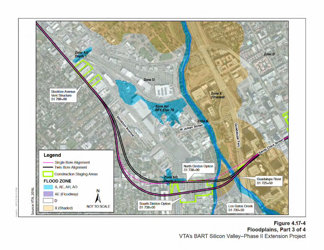
Federal Emergency Management Agency (FEMA) Flood Insurance Rate Maps (FIRMs)
were used to identify the base floodplain, or the area with a 1 percent annual chance of an
exceedance event, within the limits of the BART Extension Alternative. The BART
Extension Alternative area contains all FIRM Special Flood Hazard Area (SFHA) categories
(i.e., zones AE, AO, A, AH, D, X [shaded], and X [unshaded]), as shown in Figures 4.17-2
through 4.17-5. Zone AE is within the 100-year floodplain zone and represents areas with
a 1 percent chance of flooding. Zone AO is within the 100-year floodplain zone and
represents areas with a 1 percent chance of shallow flooding (usually sheet flow on sloping
terrain), with specified flood depths of 1 to 3 feet. Zone A represents areas with a 1 percent
annual chance of flooding (base flood elevations have not been determined for this zone).
Zone AH is within the 100-year floodplain zone and represents areas with a 1 percent annual
chance of shallow flooding, with specified flood depths of 1 to 3 feet. There are also portions
of the BART Extension Alternative within Zone D, Zone X (shaded), and Zone X
(unshaded). Possible but undetermined flood hazards can occur within Zone D; this area is
not considered a SFHA, and no analysis of flood hazards has been conducted. Zone X
(unshaded) includes areas where minimal flooding can occur, with elevations higher than
areas with a 0.2 percent annual chance of flood event. Zone X (shaded) is an area with a
moderate flood hazard, usually the area between the limits of 100- and 500-year floods
(includes areas affected by a 0.2 percent annual chance of flood) (WRECO 2016b).

Santa Clara Valley Transportation Authority
Water Resources, Water Quality, and Floodplains
VTA’s BART Silicon Valley—Phase II Extension Project Draft SEIS/SEIR
4.17-5 December 2016
FEMA’s 2009 Flood Insurance Study: Santa Clara County and Incorporated Areas was used
to obtain existing floodplain information and supplement data provided by the FIRMs. The
flood insurance study (FIS) provides hydrologic information and explains the methods of
analysis that were used to generate the floodplain shown on the FIRMs. The FIS also
includes profiles of the floodplain elevations. Table 4.17-2 summarizes the hydrologic,
hydraulic, and base floodplain information.
Table 4.17-2: Floodplain Information
Approximate
Floodplain
Station Flood Source
FIRM
Number
Flood
Hazard
Zone FIRM Panel Date
100-year
Flood
Depth
(feet)
100-year
Water
surface
elevation
(feet)
555+00 Coyote Creek 06085C0251J
06085C0232H
AE February 19, 2014
May 18, 2009
-- --
555+00 Coyote Creek 06085C0251J AE (Floodplain)
February 19, 2014 -- 82–83
565+00 Lower Silver
Creek
06085C0251J AH February 19, 2014 -- 87
581+00 Lower Silver
Creek
06085C0251J A February 19, 2014 -- --
605+00 Lower Silver
Creek/Coyote
Creek
06085C0251J AH/AO February 19, 2014 1 89
725+00 Guadalupe River 06085C0234H A May 18, 2009 -- --
732+50 Los Gatos Creek 06085C0234H A May 18, 2009 -- --
745+00 N/A 06085C0234H AO May 18, 2009 1 —
880+00 N/A 06085C0234H
06085C0227H
AH/A May 18, 2009
May 18, 2009
— 63–66


Santa Clara Valley Transportation Authority
Water Resources, Water Quality, and Floodplains
VTA’s BART Silicon Valley—Phase II Extension Project Draft SEIS/SEIR
4.17-10 December 2016
Groundwater Hydrology
The BART Extension Alternative is located within the Santa Clara Valley groundwater basin
and the Santa Clara subbasin (the subbasin is also known as Coyote Valley). The Santa Clara
subbasin occupies a structural trough parallel to the northwest-trending Coast Ranges. To the
north, the inland valley is drained by tributaries to San Francisco Bay, including Coyote
Creek, the Guadalupe River, and Los Gatos Creek. The Coyote Valley region of the Santa
Clara subbasin is fairly shallow, extending to a maximum depth of approximately 500 feet
(California Department of Water Resources 2004).
Historically, water level declines from groundwater pumping have induced subsidence in the
Santa Clara subbasin and caused degradation of the aquifer adjacent to the bay from saltwater
intrusion. As a result of increases in recharge and decreases in pumping, groundwater levels
have generally increased since 1965. According to VTA’s BART Silicon Valley—Phase II
Extension Project Geotechnical Memorandum (PARIKH 2014), groundwater has been
detected at depths averaging between 14 and 18 feet below ground surface (bgs) in the study
area (WRECO 2016a).
4.17.2.2 Water Quality
Water Quality Objectives/Standard Beneficial Uses
The San Francisco Bay Basin (Region 2) Water Quality Control Plan (Basin Plan) identifies
narrative and numerical water quality objectives for the region. The general objectives for the
region involve bacteria, bioaccumulation, biostimulatory substances, color, dissolved
oxygen, floating material, oil and grease, population and community ecology, pH,
radioactivity, salinity, sediment, settleable material, suspended material, sulfide, taste and
odor, temperature, toxicity, turbidity, and unionized ammonia.
Beneficial uses are critical to water quality management in California. According to state
law, the beneficial uses of California’s water that may be protected against quality
degradation include, but are not limited to, “domestic, municipal, agricultural and industrial
supply, power generation, recreation, aesthetic enjoyment, navigation, and preservation and
enhancement of fish, wildlife, and other aquatic resources or preserves” (Water Code
Section 13050). Protection and enhancement of existing and potential beneficial uses are
primary goals of water quality planning.
The Basin Plan identifies beneficial uses for water bodies within its jurisdiction. Runoff from
the BART Extension Alternative area would drain into storm drainage systems of Santa Clara
and San Jose. Existing and potential beneficial uses for water bodies in the BART Extension
Alternative limits are listed in Table 4.17-3.

Santa Clara Valley Transportation Authority
Water Resources, Water Quality, and Floodplains
VTA’s BART Silicon Valley—Phase II Extension Project Draft SEIS/SEIR
4.17-11 December 2016
Table 4.17-3: Existing and Potential Beneficial Uses
Water Body MU
N
FR
SH
GW
R
CO
MM
CO
LD
MIG
R
RA
RE
SP
WN
WA
RM
WIL
D
RE
C-1
RE
C-2
Coyote Creek E E E E E E E E E E
Lower Silver Creek E E E E
Guadalupe River E E E E E E E E E
Los Gatos Creek E E E E P E P E E E P
SOURCE: San Francisco Bay Regional Water Quality Control Board 2015.
MUN = municipal and domestic supply
FRSH = freshwater replenishment
GWR = groundwater recharge
COMM = commercial and sport fishing
MIGR= fish migration
RARE = preservation of rare and endangered species
SPWN = fish spawning
WARM = warm freshwater habitat
WILD = wildlife habitat
REC-1 = water contact recreation
REC-2 = noncontact water recreation
E = existing beneficial use
P = potential beneficial use
The Basin Plan identifies general narrative and numerical water quality objectives for the
region.
Existing Water Quality
The BART Extension Alternative site is located within in developed areas of the Cities of
San Jose and Santa Clara. The majority of the ground surface is covered by pavement (roads
and parking lots) and structures (office and commercial buildings).
Common sources of stormwater pollution in urban areas include construction sites, parking
lots, large landscaped areas, and household and industrial sites. Street surfaces are the
primary source of pollutants in stormwater runoff in urban areas. Grease, oil, hydrocarbons,
and metals deposited by vehicles and heavy equipment can accumulate on streets and paved
parking lots and be carried into storm drains by runoff.
Polychlorinated biphenyls (PCBs) are listed as 303(d) impairments in the Lower
San Francisco Bay. PCBs can be found in automobile engines and other common items in
urban areas. In addition, pesticides, herbicides, fungicides, and fertilizers for landscape
maintenance can be washed into storm drains when irrigation exceeds the rate of soil
infiltration and plant uptake or when these chemicals are applied in excess. Grading and
earthmoving activities associated with new construction can accelerate soil erosion.
Table 4.17-4 shows 303(d)-listed impairments for Coyote Creek, Lower Silver Creek, and
the Guadalupe River, based on the 2010 California Integrated Report (State Water Resources
Control Board 2011). As shown in the table, diazinon, a pesticide; trash; and mercury are
listed as 303(d) impairments in water bodies within the BART Extension Alternative area.
Paints, solvents, soap products, and other toxic materials may be inadvertently or deliberately
deposited in storm drains in residential and industrial areas. Trash can threaten aquatic life

Santa Clara Valley Transportation Authority
Water Resources, Water Quality, and Floodplains
VTA’s BART Silicon Valley—Phase II Extension Project Draft SEIS/SEIR
4.17-12 December 2016
and recreational beneficial uses designated by the Basin Plan. Trash and litter can collect in
storm drain inlets and ultimately be discharged into nearby waterways.
Table 4.17-4: 303(d)-Listed Water Bodies
Water Body Pollutant
Expected TMDL
Completion Date
EPA TMDL
Approved Date Potential Sources
Coyote Creek
Diazinon 5/16/2007 Urban runoff/storm sewers
Trash 2021 Illegal dumping
Trash 2021 Urban runoff/storm sewers
Lower Silver Creek Trash 2021 Urban runoff/storm sewers
Trash 2021 Illegal dumping
Guadalupe River
Diazinon 5/16/2007 Urban runoff/storm sewers
Mercury 2008 Mine tailings
Trash 2021 Urban runoff/storm sewers
Trash 2021 Illegal dumping
EPA = U.S. Environmental Protection Agency; TMDL = total maximum daily load
SOURCE: State Water Resources Control Board 2011.
The receiving water bodies ultimately discharge into the South San Francisco Bay, which is
identified on the 303(d) list for the region (see Table 4.15-5 for listed pollutants).
Table 4.17-5: 303(d)-Listed Water Body – South San Francisco Bay
Water
Body Pollutant
Expected TMDL
Completion Date
EPA TMDL
Approved Date Potential Sources
San
Francisco
Bay,
South
Chlordane 2013 Nonpoint source
DDT 2013 Nonpoint source
Dieldrin 2013 Nonpoint source
Dioxin compounds
(including 2,3,7,8-TCDD) 2019 Atmospheric deposition
Furan Compounds 2019 Atmospheric deposition
Invasive Species 2019 Ballast water
Mercury 2/29/2008 Nonpoint source
Mercury 2/29/2008 Municipal point sources
Mercury 2/29/2008 Industrial point sources
Mercury 2/29/2008 Atmospheric deposition
Mercury 2/29/2008 Natural sources
Mercury 2/29/2008 Resource extraction
PCBs 2008 Unknown nonpoint source
PCBs (dioxin-like) 2008 Unknown nonpoint source
Selenium 2019 Domestic use of
groundwater
DDT = dichlorodiphenyltrichloroethane

Santa Clara Valley Transportation Authority
Water Resources, Water Quality, and Floodplains
VTA’s BART Silicon Valley—Phase II Extension Project Draft SEIS/SEIR
4.17-13 December 2016
Groundwater
In Santa Clara County, almost half of all water used comes from groundwater. In general,
groundwater quality in the Santa Clara Valley is good. Throughout most of the region,
groundwater quality is suitable for most urban and agricultural uses, with the exception of
a few local impairments.
Designated beneficial uses identified for the Santa Clara Valley groundwater basin include
municipal and domestic water supply (MUN), industrial process water supply (PROC), and
industrial service water supply (IND).
Under existing law, the San Francisco Bay Regional Water Quality Control Board regulates
waste discharges to land that could affect water quality, including both groundwater and
surface water quality. Waste discharges that reach groundwater are regulated to protect
both groundwater and any surface water in continuity with groundwater. Waste discharges
that affect groundwater and are in continuity with surface water cannot cause violations of
any applicable surface water standards. In July 2012, the Santa Clara Valley Water District
(SCVWD) Board of Directors approved the 2012 Groundwater Management Plan, which
describes SCVWD’s groundwater basin management objectives.
Groundwater Quality
Groundwater contamination can be the result of historical industrial activities, soil
contamination, or underground storage tank releases of hazardous materials. According to
GeoTracker, leaking underground storage tank cleanup sites are found along the BART
Extension, which has a history of soil contamination. A Department of Toxic Substances
Control (DTSC) cleanup site is located within the study area (State Water Resources Control
Board 2015a).
Baseline Environmental Consulting prepared initial site assessment, which characterized
groundwater contamination within the BART Extension Alternative area. The assessment
listed 12 known hazardous material release sites and 11 potential hazardous materials that
could affect the soil and/or groundwater within the BART Extension Alternative limits.
Groundwater monitoring results show that water quality ranges from good to excellent for all
major zones in the Santa Clara Basin. In general, contaminants are not detected. However, in
some areas, groundwater that has been contaminated by hazardous material releases has
spread underneath the railroad corridor. SCVWD has been largely successful in its efforts to
prevent groundwater overdraft, curb land subsidence, and protect water quality (WRECO
2016a)
4.17.2.3 Regulatory Setting
The federal regulations discussed below are applicable to the study area. Executive Order
(EO) 13690, which amends EO 11988, Floodplain Management, directs all federal agencies
to avoid conducting, allowing, or supporting construction in the base floodplain. EO 13690
also directs federal agencies to take action to reduce the risk of flood loss; minimize the

Santa Clara Valley Transportation Authority
Water Resources, Water Quality, and Floodplains
VTA’s BART Silicon Valley—Phase II Extension Project Draft SEIS/SEIR
4.17-14 December 2016
impact of floods on human safety, health, and welfare; and restore and preserve the natural
and beneficial values served by the floodplain. The primary federal law for regulating water
quality is the federal Clean Water Act (CWA). The U.S. Environmental Protection Agency
(EPA) has delegated enforcement of the CWA in California to the State Water Resources
Control Board (State Water Board) and its nine Regional Water Quality Control Boards
(Regional Water Boards). All BART Extension-related activities need to be in compliance
with, at a minimum, the CWA, the California Water Code’s Porter-Cologne Water Quality
Control Act (Porter-Cologne Act), and the Basin Plan (San Francisco Bay Regional Water
Quality Control Board 2015). Chapter 6, Section 6.15, Water Resources, provides further
details regarding state and local regulations related to water resources.
Federal
Clean Water Act
Several sections of the CWA pertain to regulating impacts on waters of the United States. The
CWA sections discussed below pertain to the BART Extension. The term waters of the United
States essentially refers to all surface waters, such as navigable waters and their tributaries, all
interstate waters and their tributaries, all wetlands adjacent to these waters, and all
impoundments of these waters. The EPA is the overarching authority for protecting the quality
of waters of the United States. However, the State Water Board regulates waters of the United
States and State under CWA Sections 303, 401 and 402, and the U.S. Army Corps of
Engineers (USACE) has jurisdiction over waters of the United States under CWA Section 404.
CWA Sections 303 and 402 apply to the BART Extension because of potential effects on
water quality. CWA Sections 404 and 401 apply to wetlands and other waters of the United
States and are not discussed further because the BART Extension would not involve work
within water features.
Section 303—Impaired Waters
The state of California adopts water quality standards to protect beneficial uses of waters of
the state, as required by Section 303(d) of the CWA and the Porter-Cologne Act. Section
303(d) of the CWA established the total maximum daily load (TMDL) process to guide the
application of state water quality standards (refer to the discussion of state water quality
standards below). To identify candidate water bodies for TMDL analysis, a list of water
quality–limited segments was generated by the State Water Board. These stream or river
segments are impaired by the presence of pollutants such as sediment and are more sensitive
to disturbance because of this impairment.
In addition to the impaired water body list required by CWA Section 303(d), CWA Section
305(b) requires states to develop a report for assessing statewide surface water quality. Both
CWA requirements are being addressed through development of a 303(d)/305(b) Integrated
Report, which will address both an update to the 303(d) list and a 305(b) assessment of
statewide water quality. The State Water Board developed the statewide 2010 California

Santa Clara Valley Transportation Authority
Water Resources, Water Quality, and Floodplains
VTA’s BART Silicon Valley—Phase II Extension Project Draft SEIS/SEIR
4.17-15 December 2016
Integrated Report, which was based on the integrated reports from each of the nine Regional
Water Boards. The 2010 California Integrated Report was approved by the State Water
Board on August 4, 2010, and approved by EPA on November 12, 2010. The 2012 California
Integrated Report with 303(d) listings was adopted by the State Water Board on April 8,
2015 (Resolution 2015-0021).
Drainage from the BART Extension Alternative area ultimately discharges into the San
Francisco Bay. The 303(d)-listed impairments for the Lower San Francisco Bay are shown in
Table 4.17-3.
Section 402—National Pollutant Discharge Elimination System
The 1972 amendments to the federal Water Pollution Control Act established the National
Pollutant Discharge Elimination System (NPDES) permit program to control discharges of
pollutants from point-source discharges, or discharges that one can point to as a known
source of pollutants. NPDES is the primary federal program that regulates point-source and
nonpoint-source discharges to waters of the United States.
The 1987 amendments to the CWA created a new CWA section, which is devoted to
stormwater permitting (Section 402). EPA has granted the state of California primacy in
administering and enforcing the provisions of the CWA and NPDES within state boundaries.
NPDES permits are issued by one of the nine Regional Water Boards. Section 402(p) requires
permits for discharges of stormwater from industrial, construction, and Municipal Separate
Storm Sewer Systems (MS4s). The following NPDES permits are relevant to the BART
Extension Alternative:
San Francisco Bay Municipal Regional Permit (for City owned areas)
Small Municipal Separate Storm Sewer System General Permit (for VTA property)
Construction General Permit
Industrial General Permit (for Newhall Maintenance Facility)
Utility Vault and Dewatering Permit (for operations as needed)
San Francisco Bay Municipal Regional Permit
This permit ensures attainment of applicable water quality objectives and protection of the
beneficial uses of receiving waters and associated habitat and applies to City-owned areas
that may be impacted by the BART Extension. This permit requires that discharges shall not
cause exceedances of water quality objectives nor shall they cause certain conditions to occur
that create a condition of nuisance or water quality impairment in receiving waters.
Accordingly, the State Water Board is requiring that these standard requirements be
addressed through the implementation of technically and economically feasible control
measures to reduce pollutants in stormwater discharges to the maximum extent practicable as
provided in section 402(p) of the CWA. In addition, this permit contains water quality-based
effluent limitations to implement TMDLs. Compliance with the Discharge Prohibitions,

Santa Clara Valley Transportation Authority
Water Resources, Water Quality, and Floodplains
VTA’s BART Silicon Valley—Phase II Extension Project Draft SEIS/SEIR
4.17-16 December 2016
Receiving Water Limitations, and Provisions of this permit is deemed compliance with the
requirements of this permit. If these measures, in combination with controls on other point
and nonpoint sources of pollutants, do not result in attainment of applicable water quality
objectives, the State Water Board may invoke Provision C.1 and C.18 to impose additional
conditions that require implementation of additional control measures.
Each of the Permittees is individually responsible for adoption and enforcement of
ordinances and policies, for implementation of assigned control measures or best
management practices (BMPs) needed to prevent or reduce pollutants in stormwater, and for
providing funds for the capital, operation, and maintenance expenditures necessary to
implement such control measures/BMPs within its jurisdiction. Each Permittee is also
responsible for its share of the costs of the area-wide component of the countywide program
to which the Permittee belongs. Enforcement actions concerning non-compliance with the
permit will be pursued against individual Permittee(s) responsible for specific violations of
the permit.
Small Municipal Separate Storm Sewer Systems General Permit
The State Water Board’s Waste Discharge Requirements for Stormwater Discharges from
Small Municipal Separate Storm Sewer Systems (General Permit) (Order No. 2013-0001-
DWQ [Phase II MS4 Permit]) regulates stormwater discharges from municipalities and
agencies that are not covered under an individual MS4 permit or Phase I MS4 permit. The
State Water Board has identified VTA and BART as non-traditional small MS4s that are
covered under the Phase II MS4 Permit. The State Water Board or the Regional Water Board
issues NPDES permits for 5 years; permit requirements remain active until a new permit has
been adopted.
Construction General Permit
The State Water Board’s NPDES Permit for Stormwater Discharges Associated with
Construction and Land Disturbance Activities (Order No, 2009-0009-DWQ, as amended by
subsequent orders), or commonly known as the Construction General Permit (CGP),
regulates stormwater discharges from construction sites that result in a disturbed soil area
of 1 acre or greater. For all projects that are subject to the CGP, applicants are required to
develop and implement an effective Stormwater Pollution Prevention Plan (SWPPP). The
SWPPP must list BMPs that the discharger will use to protect stormwater runoff and
document the placement and maintenance of those BMPs. Additionally, the SWPPP must
contain a visual monitoring program; a chemical monitoring program for “non-visible”
pollutants, to be implemented in case of a BMP failure; and a monitoring plan for turbidity
and pH for projects that meet defined risk criteria (State Water Resources Control Board
2015b). The requirements of the SWPPP are based on the construction design
specifications detailed in the final design plans for a project and the hydrology and geology
expected to be encountered during construction. The local or lead agency requires proof of
coverage under the CGP prior to issuance of the building permit. The SWPPP is submitted

Santa Clara Valley Transportation Authority
Water Resources, Water Quality, and Floodplains
VTA’s BART Silicon Valley—Phase II Extension Project Draft SEIS/SEIR
4.17-17 December 2016
to the State Water Board, and a copy is kept at the jobsite where it is updated during
different phases of construction.
The CGP separates projects into risk levels 1, 2, or 3. The determination of risk level is based
on the potential for erosion and sediment transport to receiving waters. Requirements are
applied according to the risk level determined. Because the area of land disturbance would be
greater than 1 acre, a CGP would be required for activities.
It was determined that all four watersheds, Coyote Creek, Lower Silver Creek, Los Gatos,
and the Guadalupe River, were risk level 2 and therefore subject to temporary construction
site BMP implementation and visual monitoring requirements. Additionally, risk level 2
projects are subject to Numeric Action Levels for pH and turbidity associated with
stormwater runoff. The BART Extension risk levels will be further evaluated and verified
during the plans, specifications, and estimate phase.
Industrial General Permit
The State Water Board and Regional Water Boards regulate all specified industrial activities
under the Waste Discharge Requirements for Discharges of Stormwater Associated with
Industrial Activities, Excluding Construction Activities (Industrial General Permit, State
Water Board Order No. 97-03-DQ, NPDES General Permit No. CAS000001). On April 1,
2014, the State Water Board adopted the new statewide Industrial General Permit (WQO
No. 2014-0057-DWQ), which became effective on July 1, 2015, and supersedes the existing
Industrial General Permit (97-03-DWQ). The Industrial General Permit requires the
implementation of management measures that achieve the performance standard of best
available technology economically achievable (BAT) and best conventional pollutant control
technology (BCT). The Industrial General Permit also requires development of a SWPPP and
a monitoring plan. Through the SWPPP, sources of pollutants are identified, and the means
for managing the sources and reducing stormwater pollution are described. Any Industrial
General Permit noncompliance constitutes a violation of the CWA and the Porter-Cologne
Act and is grounds for (a) enforcement action; (b) Industrial General Permit termination,
revocation and reissuance, or modification; or (c) denial of an Industrial General Permit
renewal application. The BART Extension would be a Category 8 industrial discharger
because of the associated maintenance facilities (Category 8 includes transportation facilities
that conduct any type of vehicle maintenance, such as fueling, cleaning, repairing, etc.) and
therefore subject to conditions of the Industrial General Permit.
Utility Vault and Dewatering Permit
This permit is intended to authorize short-term intermittent discharges of pollutants to surface
waters from dewatering of utility vaults and underground structures. The BART Extension
would likely involve dewatering of vaults during operations. To be covered, discharges must
meet the following criteria: pollutant concentrations in the discharge do not cause, have
a reasonable potential to cause, or contribute to an exceedance in a receiving water of any
applicable criterion established by the EPA pursuant to CWA Section 303; pollutant

Santa Clara Valley Transportation Authority
Water Resources, Water Quality, and Floodplains
VTA’s BART Silicon Valley—Phase II Extension Project Draft SEIS/SEIR
4.17-18 December 2016
concentrations in the discharge do not cause, have a reasonable potential to cause, or
contribute to an exceedance in a receiving water of any water quality objective adopted by
the State Water Board or Regional Water Boards including prohibitions of discharge for the
receiving water; and the discharge does not cause acute or chronic toxicity in the receiving
water.
National Flood Insurance Program
In response to increasing costs of disaster relief, Congress passed the National Flood
Insurance Act (NFIP) of 1968 and the Flood Disaster Protection Act of 1973. FEMA
administers the NFIP to provide subsidized flood insurance to communities that comply with
FEMA regulations to limit development in floodplains. A FIRM is the official FEMA-
prepared map of a community; it delineates both the special flood hazard areas and flood risk
premium zones that are applicable to the community.
The BART Extension Alternative contains all FEMA-designated flood zones (i.e., zones AE,
AO, A, AH, D, X [shaded], and X [unshaded]). More information is provided in Section
4.17.2.1, Environmental Setting.
4.17.3 Methodology
For the analysis of impacts on hydrology and water resources, an adverse effect
determination means the BART Extension would contribute to a violation of regulatory
standards or an exceedance of the capacity of existing facilities.
4.17.4 Environmental Consequences and Mitigation Measures
This section identifies impacts and evaluates whether they would be adverse according to the
National Environmental Policy Act (NEPA), using the criteria (i.e., context and intensity)
identified in Section 4.17.3, Methodology. This section also identifies design commitments,
BMPs, and other measures to avoid, minimize, or mitigate impacts.
4.17.4.1 No Build Alternative
The No Build Alternative consists of the existing transit and roadway networks and planned
and programmed improvements (see Chapter 2, Section 2.2.1, NEPA No Build Alternative,
for a list of these projects). Under the No Build Alternative, the effects of the current built
environment on surface waters would continue, including effects from continued operation of
roads, transit vehicles, highways, and transit facilities. Higher vehicle traffic is expected,
which could degrade water quality because of increased pollutants in stormwater from
roadways and associated vehicular use. Projects planned under the No Build Alternative
would most likely include BMPs to reduce pollutants from stormwater runoff that are
consistent with the Santa Clara Valley Urban Runoff Pollution Prevention Program NPDES
permits, the NPDES General Industrial Stormwater Permit, MS4 permits, and/or General

Santa Clara Valley Transportation Authority
Water Resources, Water Quality, and Floodplains
VTA’s BART Silicon Valley—Phase II Extension Project Draft SEIS/SEIR
4.17-19 December 2016
Waste Discharge Requirements. Projects under the No Build Alternative would be designed
in accordance with regulatory requirements and agency criteria from FEMA, SCVWD
criteria and engineering guidelines, and the municipal codes of the local cities. Projects
planned under the No Build Alternative would undergo separate environmental review to
define effects on water resources and quality.
4.17.4.2 BART Extension Alternative
Potential impacts on water resources (i.e., surface waters, groundwater, floodplains) and
water quality are discussed below. Potential erosion impacts are also discussed because they
have the potential to affect the BART Extension.
Surface Waters
Surface water quality may be affected by polluted stormwater runoff from station areas,
parking lot structures, kiss-and-ride facilities, access roads, the Newhall Maintenance
Facility, and other sites that have impervious surfaces. Runoff from impervious surfaces
could contain nonpoint-source pollution, which is typical of urban settings and commonly
associated with automobiles, trash, cleaning solutions, and landscaped areas. Grease, oil,
hydrocarbons, and metals deposited by vehicles and heavy equipment can accumulate on
streets and paved parking lots and be carried into storm drains by runoff. Stormwater would
be drained by a combination of new and existing pipes, drainage inlets, and other storm drain
facilities. Runoff from the BART Extension would be conveyed to local storm drain systems
and ultimately to South San Francisco Bay.
The BART Extension would be designed in accordance with the Phase II MS4 Permit,
Section F.5.g, for post-construction stormwater management. BART would operate the
system in accordance with the Phase II MS4 Permit for the guideway and systems and other
facilities that they would be operating. VTA would apply the MS4 Permit for the station
campuses and other facilities where BART is not the operator.
VTA developed a Stormwater and Landscaping Design Criteria Manual (effective June 30,
2015) to assist VTA engineers with incorporating the post-construction stormwater
requirements of the small MS4 permit into VTA operated facilities. Following VTA’s
Stormwater and Landscaping Design Criteria Manual, VTA would implement BMPs and
post-construction stormwater treatment measures because the BART Extension would
replace or create more than 5,000 square feet of impervious surfaces. The criteria and
standards are similar to those of the Santa Clara Valley Urban Runoff Pollution Prevention
Program guidelines. Stormwater treatment designs would preferentially utilize site design
measures, source-control BMPs, and Low-Impact Development (LID) treatment features.
Generally, the LID measures would include vegetative improvements, which must comply
with VTA’s Sustainable Landscaping Policy.

Santa Clara Valley Transportation Authority
Water Resources, Water Quality, and Floodplains
VTA’s BART Silicon Valley—Phase II Extension Project Draft SEIS/SEIR
4.17-20 December 2016
To minimize any adverse effects on water quality due to stormwater runoff, stormwater
management measures are included as part of the design. These would utilize LID techniques
to reduce pollutant discharges and BMPs to reduce pollutants from stormwater runoff,
consistent with VTA’s Stormwater and Landscaping Design Criteria Manual, the Santa
Clara Valley Urban Runoff Pollution Prevention Program stormwater handbook, City of
San Jose and Santa Clara NPDES permits, MS4 permits, and/or General Waste Discharge
Requirements as applicable. In the design phase, specifications and design details would be
further developed to include site-specific source control, LID, and post-construction
stormwater treatment measures.
A new drainage system may be required to capture stormwater throughout the BART
Extension Alternative area. The drainage system may include detention basins, which detain
water temporarily to reduce peak discharges before slowly releasing the water to the storm
sewer system by gravity flow. Regardless of whether water is released to the storm sewer
system through the detention basins or through direct discharge, the BART Extension would
comply with applicable NPDES and/or MS4 permit requirements and include BMPs to
reduce pollutants from stormwater runoff. In addition, BMPs and LID measures would be
implemented to minimize erosion, siltation, and/or flooding (WRECO 2016a).
No effects on surface waters are anticipated because of the depth of the tunnels, which would
be constructed below the water table, at an average depth of 40 feet below ground at the
crown (i.e., top of the tunnel) for the Twin-Bore Option and an average depth of 70 feet
below ground at the crown for the Single-Bore Option. The track alignment would be
underground until the End-of-the-Line Maintenance Yard. The Twin-Bore Option would
pass approximately 25 feet below Coyote Creek, under the retaining wall at the Guadalupe
River (at the lowest point in the tunnel alignment, approximately 45 feet below the
Guadalupe River), and approximately 20 feet below Los Gatos Creek (WRECO 2016a).
Under the Phase II MS4 Permit, the BART Extension Alternative would be required to use
BMPs and permanent erosion control measures because it would replace or create more than
5,000 square feet of impervious surfaces. With application of the Phase II MS4 Permit, the
BART Extension Alternative would not contribute any detectable concentrations of diazinon
or mercury to any watercourses within the study area that have been identified as impaired by
the Regional Water Board, pursuant to Section 303(d) of the federal CWA. The BART
Extension Alternative would not violate water quality standards or waste discharge
requirements or provide substantial additional sources of polluted runoff. No adverse effect
related to surface waters would result. No mitigation is required.
Groundwater
The BART Extension would add approximately 44.99 net acres of impervious area (WRECO
2016a). Compared with existing conditions, the increase in impervious areas at the stations,
structured parking, kiss-and-ride facilities, and other sites would be limited. These sites are
already developed and therefore would have minimal adverse effect on groundwater

Santa Clara Valley Transportation Authority
Water Resources, Water Quality, and Floodplains
VTA’s BART Silicon Valley—Phase II Extension Project Draft SEIS/SEIR
4.17-21 December 2016
recharge. However, to facilitate groundwater recharge, if necessary, engineered methods that
either allow for infiltration or reduce impervious cover would be included in the BART
Extension design.
Dewatering would be necessary inside retained cuts, underground stations, and tunnels
during operations to keep the facilities dry. The quantity of water to be removed is
anticipated to be minimal, and no detectable changes to the groundwater supply would occur.
The retained cuts and underground stations would be designed to prevent water intrusion, and
the tunnels would be sealed. Landscape design features at station areas and potentially the
BART trackways that are being considered include planting native, drought-resistant plants;
using low-flow fixtures; increasing pervious surfaces with use of porous paving and unit
pavers; capturing surface flow with bioretention basins and rain gardens, and using soil-water
separators and other filters.
A dewatering plan would be required as part of the Contractor’s SWPPP for any dewatering
proposed up to 10,000 gallons per day. Water quality sampling and analysis would be
required prior to any discharge into the sanitary sewer, storm drainage system, or
downstream receiving water bodies. For areas of known contamination and where pumping
will exceed 10,000 gallons per day, the CGP may not be used for dewatering, and a separate
NPDES permit for Structural Dewatering, VOC contaminated groundwater, and/or a project-
specific Waste Discharge Requirements (WDR) permit would be needed to address potential
contamination of groundwater and treatment needed prior to discharge.
Tunnel structures and underground stations may affect groundwater flow direction and
pathways, resulting in the diversion of the normal flow of groundwater, the mounding of
groundwater upgradient of the aforementioned facilities, or a localized rise in the water table.
To minimize these adverse effects, highly permeable gravel channels and/or slotted PVC
pipes would be placed in areas where water would be routed around a sealed tunnel to
minimize effects on groundwater paths and directions. In addition, tunnels would be
constructed below the water table, at a minimum depth of 20 feet below ground at the tunnel
crown (WRECO 2016a). Therefore, groundwater would be able to flow above and below the
tunnel structure, and the mounding of groundwater upgradient from the tunnel structure is not
anticipated. If any fill material this is placed during construction fails to provide adequate
permeability, additional drainage design features could be applied.
The BART Extension would comply with the SCVWD 2012 Groundwater Management
Plan. The BART Extension would not affect groundwater supply and would have minimal
effects on groundwater recharge. It would not alter groundwater flow directions or pathways.
There would be no adverse effect on groundwater. No mitigation is required.
Floodplains
Several areas in the vicinity of the alignment crossing for the Alum Rock/28th Street Station are
within the base floodplain. Ground parking, system facilities, and station entrances and
roadway improvements are entirely within the floodplain of Coyote Creek/Lower Silver Creek
Santa Clara Valley Transportation Authority
Water Resources, Water Quality, and Floodplains
VTA’s BART Silicon Valley—Phase II Extension Project Draft SEIS/SEIR
4.17-22 December 2016
and occupy a total of approximately 9.25 acres. However, the BART Extension Alternative
would remove adjacent buildings that currently occupy approximately 2.77 acres and are also
entirely within the same floodplain. The station improvements would add approximately
2.54 acres of added impervious area (AIA) to the floodplain area. The removal of structures
(light industrial warehouses) helps with the reducing/offsetting floodplain risk. In addition, it is
anticipated that the roadway improvements would not significantly change the existing grade.
The Alum Rock/28th Street Station is located within Zone AH, with a base flood elevation of
89 feet (NAVD) and a Zone AO depth of 1 foot. Station features would have a floor elevation
of 2 to 3 feet above the base flood elevation, depending on whether the feature is deemed non-
critical or critical per Executive Order 13690. Critical facilities such as traction power
substations, gap breaker stations, train control and communication buildings, and vent shaft
openings, would be set above the 0.2 percent annual storm event. Minimization measures at
this station would include balancing pre-fill and post-fill in the floodplain to minimize the
amount of fill and prevent flood storage from being lost. Balancing the pre-fill and post-fill
would result in no effect because flooding would not be exacerbated as a result of the project.
The floodflow pattern would be maintained as much as possible by incorporating and
providing a flow-through area in the station campus, especially in the parking areas. Storage
and detention would be implemented as necessary to make up for storage lost as a result of the
BART Extension (WRECO 2016b).
The area of the structures within the base floodplain is insignificant compared with the
overall floodplain area for Coyote Creek/Lower Silver Creek (approximately 28,160 acres).
Therefore, the BART Extension Alternative would not significantly change the base
floodplain water surface elevation (WSE) at Alum Rock/28th Street Station. Although there
would be fill in the floodplain as a result of the Alum Rock/28th Street Station, with the
minimization measures mentioned above, such as balancing the fill and storage capacity and
providing a flow-through area to ensure floodflow is maintained, mitigation measures will
not be required (WRECO 2016b). Therefore, floodplain impacts as a result of the BART
Extension Alternative would be minimal at Alum Rock/28th Street Station. In addition, after
completion of work at all six reaches of the Lower Silver Creek Flood Protection Project,
SCVWD and the City of San Jose will be able to demonstrate to FEMA that all homes and
businesses that are subject to a 1 percent annual chance flood from Lower Silver Creek have
been protected.
The BART Extension would be designed to withstand 10 percent annual storm events, and
specific facilities would be designed to withstand 1 percent and 0.2 percent annual storm
events, as required by BART Facility Standards (Bay Area Rapid Transit 2011). In addition,
the design of critical facilities would comply with Executive Order 13690.
The Newhall Maintenance Facility is a critical facility and would be designed in accordance
with the standards and requirements for critical facilities. The Newhall Maintenance Facility
would add approximately 2.16 acres of structures, and the AIA would be 41.86 acres, within
Zones D and Zone X (shaded). These areas are not considered a base floodplain. According
to the Hydraulic Study (WRECO 2016b), critical facilities, including traction power, train

Santa Clara Valley Transportation Authority
Water Resources, Water Quality, and Floodplains
VTA’s BART Silicon Valley—Phase II Extension Project Draft SEIS/SEIR
4.17-23 December 2016
control, and communications buildings, are to be set a minimum of 1 foot above the
0.2 percent WSE, with an overland flood release path that ensures that no more than 1 foot of
ponding can develop. The Newhall Maintenance Facility would not be located within any
base floodplain. Therefore, there would be no effect on floodplains as a result of the BART
Extension Alternative at this location. Mitigation is not required.
Some of the station options (Alum Rock/28th Street Station, Downtown San Jose Station East
Option and Downtown San Jose West Option, and Diridon Station South Option and Diridon
Station North Option) would be underground and therefore would not extend into floodplain.
The Downtown San Jose Station East Option would add 0.72 acre of structures, such as
system facilities and transit plazas, and 0.10 acre of AIA. The Downtown San Jose Station
West Option would add approximately 0.40 acre of structures, such as system facilities and
transit plazas, and 0.03 acre of AIA. However, the BART Extension Alternative would
remove adjacent buildings that currently occupy approximately 0.16 acre. There would be
approximately 0.24 acre of additional building structures within Zone D. Within Zone D,
flooding is undetermined but possible; this zone is not considered an SFHA or a base
floodplain. The station would not be located within any base floodplain. The Diridon Station
South Option would add approximately 1.08 acres of structures, such as system facilities and
transit plazas (station entrances). However, the BART Extension Alternative would remove
adjacent buildings that currently occupy approximately 0.21 acre. The AIA to this station is
negligible (WRECO 2016b). The Diridon Station North Option would add acreage similar to
the Diridon Station South Option.
The track alignment would not encroach upon any base floodplains because it would not be
within any base floodplain areas or would be underground within a bored tunnel. As a result,
there would be no effect on the base floodplain, and there would be no floodplain effects as
a result of the BART Extension Alternative. Mitigation is not required.
The Santa Clara Station would be aboveground and would add approximately 4.61 acres of
structures in Zone X (shaded, an area of moderate flood hazard) and approximately 0.46 acre
of AIA to the floodplain. However, the BART Extension would remove the adjacent building
that currently occupies approximately 3.42 acres, which is also entirely within the same
floodplain. Localized and temporary flooding and ponding may result in areas with added
impervious cover during storm events. The station would not be located within any base
floodplain. Therefore, there would be no adverse effect in terms of the floodplain as a result
of the BART Extension at this location. Mitigation is not required.
The BART Extension would not change the land use of the study area. Currently, all of the
BART Extension Alternative area within the floodplain is developed, partially developed, or
zoned for development. Some of the projected base floodplain development would occur
regardless of the BART Extension. In general, the BART Extension would be consistent with
development plans for the area and would not significantly change the land use in the area
because it is currently developed or zoned for development. The base floodplain impacts as
a result of the BART Extension are summarized in Table 4.17-6.

Santa Clara Valley Transportation Authority
Water Resources, Water Quality, and Floodplains
VTA’s BART Silicon Valley—Phase II Extension Project Draft SEIS/SEIR
4.17-24 December 2016
Table 4.17-6: Summary of Base Floodplain Impacts
BART
Extension
Alternative
Element
Flood
Hazard
Zone
Impervious
Area per
Feature (ac)
Total
Impervious
Area (ac)
Added
Impervious
Area (ac)
Existing
Building
to be
Removed Impacts Watershed
Watershed
Drainage
Area (ac)
Increase
Area to
Watershed
(ac) Notes
Mabury Road
CSA
AE/AE
(Floodplain) 4.29
25.25
-- 0.00 Minimal Coyote
Creek 158,080 N/A
AH 20.96 -- 3.74 Minimal
Alum Rock
CSA A/AH/AO 0.71 9.96 -- 0.00 Minimal Lower
Silver
Creeka
28,160 0.01% 1 Alum Rock/28th
Street Station AH/AO 9.25
48.62
2.54 2.77 Minimal
Downtown San
Jose Station
East Option
D 0.77 0.01 0.00 No Impact
Guadalupe
Riverb 92,160 0.05% 2
Downtown San
Jose Station
West Option
D 0.40 0.03 0.16 No Impact
Newhall
Maintenance
Facilities
D/X
(Shaded) 43.86 41.86 0.00 No Impact
Santa Clara
Station X (Shaded) 3.59 0.46 3.42 No Impact
Diridon Station
(South and
North Options)
D 3.47 3.47 Negligible 0.21 No Impact Los Gatos
Creek 35,072 N/A
a Improvements to Lower Silver Creek by SCVWD and the Natural Resources Conservation Service could result in changes to the FIRM. b Improvements to Guadalupe River by the USACE and SCVWD could result in changes to the FIRM.
ac = acres; CSA = Construction Staging Area

Santa Clara Valley Transportation Authority
Water Resources, Water Quality, and Floodplains
VTA’s BART Silicon Valley—Phase II Extension Project Draft SEIS/SEIR
4.17-25 December 2016
The change in WSE would be minimal because there would be minimal fill in the base
floodplains with proper minimization measures (WRECO 2016b). The BART Extension
would not expose people or structures to the risk of flooding, create floodplains, or result in
an increase in the base flood elevation. Natural and beneficial floodplain values would not be
affected by the BART Extension. In addition, the BART Extension Alternative would not
create or contribute runoff that would exceed the capacity of existing or planned drainage
systems. There would be no adverse effect. No mitigation is necessary.
4.17.5 NEPA Conclusion
The BART Extension Alternative would not expose people or structures to the risk of
flooding, create floodplains, or result in an increase in the base flood elevation. The BART
Extension Alternative would result in no adverse effect on water resources. With the
implementation of minimization measures and measure in compliance with regulations, the
BART Extension would result in no adverse effect. No additional mitigation is required.
Santa Clara Valley Transportation Authority
Water Resources, Water Quality, and Floodplains
VTA’s BART Silicon Valley—Phase II Extension Project Draft SEIS/SEIR
4.17-26 December 2016
This page intentionally left blank.