4 - Home - Locality Neighbourhood Planning
59
Transcript of 4 - Home - Locality Neighbourhood Planning


2
Contents 1. Introduction ................................................................................................................................................ 4
About this toolkit ..................................................................................................................................... 4
The importance of good design and the role of neighbourhood planning ........... 4
Toolkit structure ....................................................................................................................................... 5
2. The principles of good design ......................................................................................................... 6
What are the principles of good design? .................................................................................. 6
1. Function well and add to the overall quality of the area ............................................. 8
2. Be visually attractive ........................................................................................................................ 9
3. Be sympathetic to local character and history ................................................................ 10
4. Establish or maintain a strong sense of place ................................................................... 11
5. Ensure an appropriate amount and mix of development ......................................... 12
6. Be safe, inclusive and accessible and which promote health and well-being 13
7. Be adaptable and resilient .......................................................................................................... 14
How does good design respond to context? ........................................................................ 16
Things to consider when you’re thinking about context .................................................. 17
3. Tools available to promote good design in neighbourhood plans ........................... 19
Introduction .............................................................................................................................................. 19
Step 1: Tools for defining the special qualities of your area .......................................... 21
Step 2: Tools for defining how new development should be designed .................. 28
Step 3: Writing design policies ........................................................................................................ 41
Evidence needed to support design policies .................................................................... 41
Existing evidence .............................................................................................................................. 41
Presenting your evidence ............................................................................................................. 41
How to write design policies ...................................................................................................... 42
Character area specific policy ................................................................................................ 45
Site-specific policy ......................................................................................................................... 47
Step 4: Tools for securing good design after the plan is made ................................... 51
Uppingham – achieving better design through neighbourhood planning ........ 51
Poole Quays Forum ....................................................................................................................... 53
4. What other resources are available to help? ...................................................................... 55
National design guidance .......................................................................................................... 55
Organisations .................................................................................................................................... 55

3
Acknowledgements ................................................................................................................................. 57
Advisory group ..................................................................................................................................... 57
Images ........................................................................................................................................................58

4
1. Introduction
About this toolkit This toolkit has been prepared to support groups involved in neighbourhood planning to locally define and promote good design.
Neighbourhood planning gives great power to communities to influence the design of new development in their area. Communities throughout the country have strong ideas about the design of new homes and public spaces, and are demonstrating that development is more welcomed if local people have influenced it.
At the same time, it is clear that many communities find it difficult to express what they mean by ‘good design’; questions like “what does good design mean specifically in your village or neighbourhood?” can be difficult to answer. Communities often know which parts of their area are popular and work well, but cannot always express how the features that people appreciate can be replicated in new development. It is impossible to decide and describe what you want in the future if you don’t know what you’ve got now.
This toolkit aims to introduce groups involved in neighbourhood planning to a range of tools, techniques and resources that can help them to define and promote good design. The toolkit is not intended as a guide to design theory and practice, although chapter 2 does introduce some principles of good design in order to set the scene and put the tools in context. Sources of good design guidance are also signposted.
The toolkit is aimed at all neighbourhood planning groups, and in particular those looking to influence the design of development in their area. This could range from groups just looking to ensure that householder extensions and small infill development are in-keeping with the context to those proposing, or seeking to extract maximum benefit from, major growth; the basics of the process, like the principles of good urban design, are broadly the same in many cases.
The importance of good design and the role of neighbourhood planning The National Planning Policy Framework (NPPF, 2018) places good design at the heart of the planning system, noting that “good design is a key aspect of sustainable development, creates better places in which to live and work and helps make development acceptable to communities” (paragraph 124).

5
Research, such as The Value of Good Design for the Government’s Commission for Architecture and the Built Environment (now part of the Design Council) has shown that good design of buildings and places can:
• Improve health and well-being;
• Increase civic pride and cultural activity;
• Reduce crime and anti-social behaviour;
• Support economic activity; and
• Reduce pollution.
The NPPF goes on to root neighbourhood planning at the heart of the drive for quality development: “Design policies should be developed with local communities so they reflect local aspirations, and are grounded in an understanding and evaluation of each area’s defining characteristics. Neighbourhood plans can play an important role in identifying the special qualities of each area and explaining how this should be reflected in development” (paragraph 125).
This toolkit shows how.
Toolkit structure The remainder of this document is structured in the following way:
• Chapter 2 introduces the principles of good design that can be applied anywhere, according to context;
• Chapter 3 contains the tools that you use yourself or seek help on; and
• Chapter 4 suggests further sources of help and information.

6
2. The principles of good design
What are the principles of good design? ‘Good design’ is a multi-faceted concept, going well beyond the architectural style of buildings. It also includes, amongst other factors:
• open space and the spaces between buildings;
• social, environmental, cultural, ecological and economic well-being;
• functionality; and
• long-term management and maintenance.
Thinking about good design means thinking about how, why and what buildings and spaces are used for – both now and in the future. By being clear about what you expect from new development at the outset, it is easier for everyone involved to understand what is required, and then to test whether that development is successful when complete.
There is a wealth of information on good design but there are essentially seven key principles which consider all of the factors identified above. The first six draw directly upon guidance set out in paragraph 127 of the NPPF; the seventh has been included as it is also important to consider.
They are all to be considered in the specific context of the neighbourhood, village or town in question. What is set out below is not an exhaustive checklist but includes signposts to what you might want to think about when considering whether a place is going to be successful or not.
Well-designed places should:
1. Function well and add to the overall quality of the area, not just for the short term but over the lifetime of the development (paragraph 127a of the NPPF);
2. Be visually attractive as a result of good architecture, layout and appropriate and effective landscaping (paragraph 127b);
3. Be sympathetic to local character and history, including the surrounding built environment and landscape setting, while not preventing or discouraging appropriate innovation or change (such as increased densities) (paragraph 127c);
4. Establish or maintain a strong sense of place, using the arrangement of streets, spaces, building types and materials to create attractive, welcoming and distinctive places to live, work and visit (paragraph 127d);

7
5. Optimise the potential of the site to accommodate and sustain an appropriate amount and mix of development (including green and other public space) and support local facilities and transport networks (paragraph 127e);
6. Create places that are safe, inclusive and accessible and which promote health and well-being, with a high standard of amenity for existing and future users; and where crime and disorder, and the fear of crime, do not undermine the quality of life or community cohesion and resilience (paragraph 127f); and
7. Be adaptable and resilient, able to adapt to changing social, cultural, economic and environmental circumstances, and lend themselves to good maintenance and stewardship.
Each of these is introduced below.

8
1. Function well and add to the overall quality of the area Places which are fit for purpose will be pleasant and convenient for all users, and easy to maintain and manage. This means ensuring developments are easily accessible from the street and surrounding areas, and that buildings and spaces are designed appropriately for their intended use and users, not just for the short term but also over the lifetime of the development.
Well-designed places (either an individual building or space or collection of buildings and spaces):
• Meet the needs of all users.
• Encourage healthy lifestyles and positively contribute to residents’ physical and mental wellbeing.
• Feel safe to live in and use.
• Are easy to get to on foot, by cycle, public transport or private car (in that order of priority).
• Are easy to maintain and manage, not just in the short term but also the long term.
• Are convenient for deliveries and the required service vehicles (e.g. waste removal) to get to.
• Take into account specific environmental circumstances (e.g. levels of daylight/overshadowing, risk of flooding).
Figure 2.1: Great Kneighton, Cambridge, includes a contemporary take on the enduringly popular terraced house typology and pedestrian-friendly street design.

9
2. Be visually attractive Understanding what is attractive is often the hardest aspect to get consensus on as everyone has different views. It goes beyond just the architectural style of the development, but that is often the part that people focus on.
It is a combination of physical, social, cultural and environmental factors – how a place fits in with its surroundings (buildings, streets and landscape), how it feels at different times of the day and season, how it is maintained and cleaned, and how well used it is by people.
Well-designed places:
• Fit in well with the surrounding buildings, streets and landscape of quality; they are in scale/proportion with their surroundings.
• Have different parts of the development working well with, or alongside, each other – in terms of style, proportion, connecting open spaces, ease of movement.
• Have design that is influenced by a local style of building, material or detailing, drawing upon the best design elements of those without replicating every detail.
• Have a pleasing pattern, repetition or symmetry (e.g. rooflines, windows, building heights), where appropriate.
Figure 2.2: Boston Spa, Leeds, creates unity in design by use of local materials and styles, with variety added by irregular building- and roof-lines.

10
3. Be sympathetic to local character and history What makes a place feel unique and special is related to a range of physical and social factors, and varies from person to person in a community, making it hard to pinpoint.
Physical factors might include what the local street patterns, local building styles and materials are like, as well as the landscape, wildlife and landform and how they have influenced the character of the place.
Social factors might include what the current uses or occupiers of the buildings and spaces are, and what historically was there, and what it might become in the future.
New development in a historic environment doesn’t necessarily need to mean recreating a replica of existing buildings.
Well-designed places:
• May feel and look different to other places, which could be to do with the buildings – how they are arranged or look – or with the local landscape, or who uses/has used the place before.
• Have a distinct and special feel. You should define how you want new development to fit in with this.
• Have new development that is influenced by the best elements of the area.
• Celebrate or enhance views of important local landmarks.
Figure 2.3: The Malings, Newcastle-upon-Tyne, updates the traditional ‘Tyneside flat’ typology in a contemporary style whilst also responding to the riverside context – all homes benefit from a river view.

11
4. Establish or maintain a strong sense of place Public spaces such as streets, parks, village greens and squares are important as everyone uses them when they move through an area and can help to create a strong sense of place.
They connect buildings and spaces together, provide space for communities to gather, and create a visual identity and brand for a particular place, so their appearance, layout and design are important. Successful public spaces are well used by people.
Well-designed places:
• Sit comfortably within the context of surrounding buildings, routes and other spaces.
• Have inclusive spaces that can be used by everybody.
• Feel safe to use.
• Contribute positively to the identity of the area.
• Are easily accessible on foot, by cycle, public transport or private car (in that order of priority).
• Are appealing in terms of planting, paving and street furniture (e.g. benches, lighting, fencing, play equipment, litter bins) and easy to maintain.
Figure 2.4: Houlton, Rugby, places natural play space on the main route between the school and key development facilities.

12
5. Ensure an appropriate amount and mix of development Successful places can support a range of uses, businesses or activities in the same space over a day, week or season. The right mix of uses can create a sense of liveliness and purpose to an area without unnecessary conflict between the different users.
Some combinations of uses, businesses or activities work better together than others. For example, places of worship and community spaces, or nursery schools near homes, where you can make the most of physical and social connections.
Other combinations may require you to think more carefully about how to manage the different needs of different users, including for example, industrial uses near homes, but which can still work successfully together.
Well-designed places:
• Have a mix of uses in the neighbourhood that cater for all its users’ different needs, whatever their stage in life/requirements are.
• Include different uses that support one another or allow each other to operate separately at different times of day, week or season.
• Ensure that potential conflict between different uses/users can be managed or designed out (e.g. separate access arrangements).
Figure 2.5: Tibby’s Triangle, Southwold, includes shops and cafes amongst new housing.

13
6. Be safe, inclusive and accessible and which promote health and well-being Well-designed places should be well connected and easy for people to get to from surrounding areas, and easy to move around in, regardless of their mobility or mode of transport (with priority for pedestrians).
Routes between places should feel safe and convenient for everyone to use - at any time of day or season - and there should be a choice of routes. Buildings should also be safe and easy for everyone to move around in.
Well-designed places:
• Are well connected through good physical, social and digital infrastructure
• Are easy to understand how to get into or around.
• Can be easily accessed by all users, whatever their mobility or mode of transport.
• Incorporate step-free routes and meet the needs of visually impaired users.
• Have routes that feel safe to use.
• Enable users to get to where they want to go quickly and directly.
• Have streets and paths that prioritise the most vulnerable users first – pedestrians, then cyclists and public transport users, and motor vehicles last of all.
Figure 2.6: Horsted Park, Chatham, accommodates cars but is not designed in a way that allows the unimpeded movement of them to dominate, and not at the expense of greenery.

14
7. Be adaptable and resilient Successful buildings and spaces should be able to accommodate changes of use over time as economic, demographic and social trends and lifestyles continue to change. This means creating buildings and places flexible enough to accommodate new or shared uses, without needing to make expensive or unnecessary structural alterations.
Buildings and places also need to be able to withstand any potential changes to our climate, for example heatwaves or increased risk of flash floods, and should be easy to maintain in the long-term.
Thinking about how buildings and spaces will be managed in the long-term, and by whom – particularly community assets such as parks and community centres – should be considered at the planning stages at the outset.
Ensuring that these assets are looked after properly should benefit the whole community – also known as stewardship – and will vary from place to place depending on who is delivering the development, the local community and stakeholders such as the local authority.
Well-designed places:
• Have a network of streets, paths and building plots that have been designed to be adaptable – to potentially accommodate very different types of development in the long term, e.g. bigger or smaller buildings, or additional dedicated bus lanes.
• In new places, are the result of design that considers the potential impacts of climate change, e.g. temperature extremes or increased risk of flash floods.
• Can be adapted easily over time in line with changing living, working and lifestyle trends, e.g. subdividing spaces, adding in lifts, adopting Lifetime Homes standards.
• Include robust materials and detailing that will stand the test of time and are easy to manage and maintain.
• Have a clear management plan.

15
Figure 2.7: New housing in rural or edge of settlement locations needs to be designed sensitively but this does not mean that features to reduce environmental impact should be overlooked.

16
How does good design respond to context? ‘Good design’ means different things in different places; it is about local character and being a good neighbour. The starting point should be gaining a clear and collective understanding about what makes a particular place unique or special, different to other places.
Observing the characteristics of the local area in terms of local architectural style (vernacular), historical assets or landmarks, green spaces and surrounding landscape, can help you to establish the context.
Figure 2.8: Contemporary extension in Norfolk using modern construction methods but drawing design influences from the historic dwelling such as roof line, building height and form.

17
Things to consider when you’re thinking about context
• What type of built environment is your place – e.g. a built up, inner urban area; a more dispersed rural settlement; a market town; or something else?
• What are the different land uses in the area and how do they relate to each other?
• Is there a clear network of streets, open spaces and defined centre(s)?
• Do local buildings (either as a whole or in particular groups or clusters) have shared features e.g. common local stone or similar architectural detailing? Do local open spaces and streets use the same materials e.g. paving, railings, lighting, planting?
• Are there any historical designations in the area including conservation areas or listed buildings and how do they influence the design of the build form?
• How do buildings typically relate to the streets, shared open spaces and surrounding natural/semi-natural areas and routes – e.g. do houses have deep or shallow front gardens, or none at all?
• What is the current typical density and what might be appropriate for new development? This relates to the amount of development on a particular piece of land and is often a contentious issue. There are benefits and disadvantages to higher and lower densities in terms of demand and pressure on space, infrastructure and local services. Further information is provided below.
By understanding what you have already, you can begin to talk about what type of development you might want in the future. Development can help preserve the character you already have, enhance it, or even add some contrast and variety to it.

18
Understanding density
Good quality development depends on balancing a number of factors: context; character; and density. But what is density? Density is typically expressed as dwellings per hectare (dph), habitable rooms per hectare (hrh) or plot ratio. It is a measure but no specific design qualities or characteristics are implied, and development can vary in form. There are two ways of measuring density:
• Gross density – this is at the neighbourhood scale and includes housing plots plus all roads, pavements, open spaces, and landscaped areas;
• Net density – this is at the more local level and just includes the housing plots plus site specific roads, pavements and spaces within the layout.
Fig 2.9 (below): A range of different net densities to help illustrate some of the typical ranges that you may come across.
Approx. 30dph (Trumpington Meadows, Cambridge)
Approx. 50dph (Newhall, Harlow)
Approx. 100dph (Woodside Square, London)
Over 200dph (Clapham Park, London)

19
3. Tools available to promote good design in neighbourhood plans
Introduction There is not a one size fits all approach to addressing design in neighbourhood planning and the design tools you use will depend on your design objectives and the complexity of your needs. This section summarises the tools that are available for you to use.
This section assumes that a high level of community engagement is a prerequisite of a good neighbourhood plan and that the design toolkit is used in the context of the advice provided in the Locality toolkit on how to consult with your community. That toolkit, which is a must-read for all neighbourhood planners, advocates an approach that puts people at the heart of the engagement process, allowing them to take an active role in deciding the future of their community.
As noted in chapter 2, ‘good design’ can mean different things to different people and in different places. The NPPF (para 125) highlights the important role that neighbourhood plans can play in identifying the special qualities of an area and explaining how they should be reflected in development.
Remembering that you will need to demonstrate that any assertions have been generated by and/or tested with the wider community, you should be able to find a technique that works for you. Approaches range from small scale and low tech to labour intensive and online. Some of them will require skilled professionals or volunteers to do effectively.
Figure 3.1 illustrates a process from starting out to promoting design quality after your plan has been made, and forms the structure of the remainder of the toolkit. You should select the tools that work best for your circumstances; you certainly would not be expected to do them all.

20
Figure 3.1: Design toolkit process diagram, highlighting the tools available at each stage of the process and the external inputs that you can draw upon. Some of the tools appear twice as they are useful in more than one step, although they are only described once in the pages below.
The remainder of the toolkit walks through the 4 steps in the diagram, introducing the activities you can do and the outputs you can produce at each step, before concluding with a summary of sources of support.

21
Step 1: Tools for defining the special qualities of your area The tools that you can choose from for defining the special qualities of your area include:
Asking a simple question: At the start of the neighbourhood planning process, get out to any local events where people are congregating – a shopping parade, a school fete, the pub, a place of worship – and ask them a couple of simple questions. For example, ‘what do you like about the village/town/area?’ and ‘what would you change?’ will give you a good basis for understanding how people feel about the intrinsic qualities of the place.
Doing it in the places where people are going about their everyday lives avoids you just hearing from the local enthusiasts. These people are crucial to neighbourhood planning but so are all other members of the community and you need to engage people who are representative of the diversity within your area.
Questionnaires: Many neighbourhood plans start with a questionnaire. This can be a great way of finding out the views of a large pool of people on a wide range of topics, from the comfort of their own home or smartphone.
You can do door-to-door (in which case make sure you set aside the time to knock and collect) or online, using websites or apps such as www.surveymonkey.co.uk and www.surveygizmo.com.
For questions on matters of character or design, neighbourhood planning groups often find open-ended questions, like the ‘what do you like’ one above, a good starting point. The Locality toolkit on how to write and conduct social surveys to gather data for your neighbourhood plan is full of useful advice, including sample questions.
Online surveys: This is a more visual or spatial variation on the traditional questionnaire. A DIY approach is to post images of typical or valued townscapes and landscapes on your website, publicise and seek comments. Or, you could use one of the well-established apps or online tools, such as www.confers.com and www.commonplace.is, that have a sophisticated and user friendly interface for users to pinpoint and comment on any aspect of their neighbourhood.

22
Figure 3.2: The Commonplace online tool for engaging pinpointing issues and policy ideas has been used by a number of neighbourhood planning groups. West Hampstead residents used Commonplace to create a public heat-map of needs and opinions about their neighbourhood. The Neighbourhood Forum reports that the tool reached a younger demographic than other forms of engagement, meaning that the neighbourhood planning process was more representative. On the map above, dominance of red shows an appetite for change.
Community walkabouts: There is nothing like getting out and about with your neighbours, hitting the pavements of the place you feel passionate about. All participants need is a map, a pen, a camera or smartphone and good shoes! Split into groups to cover the plan area, and mark the answers to the simple questions above wherever something strikes you. Pool responses onto a map of the whole area.

23
Figure 3.3: Mapping the findings of your community walkabout provides a powerful visual record of the event. Contact any local secondary schools or colleges to see if any students can help out with graphic design tasks.
Placecheck claims to be “the simplest way of finding out what a place and its people can tell us”. It is based around a structured walkabout and the questions:
• What do we like about this place?
• What do we dislike about this place?
• What do we need to work on?
It is straightforward to organise and can be driven by a web app that is free to community and neighbourhood organisations. See https://placecheck.info/en/ for information, including case studies of where it has been used to kickstart neighbourhood planning.
Workshops: Getting people together in a room to debate and hopefully reach consensus on any design topic can be very powerful, particularly if representatives of different stakeholders are present. There are countless ways to run a workshop and numerous techniques to try; as with most of the tools introduced here, they can be as simple or complex as you like.
Workshops can usually delve into issues in greater depth than the tools introduced above but will usually involve less and more self-selecting people, so outcomes are best verified with a wider public before being embedded in your neighbourhood plan.

24
Figure 3.4: The Scottish Place Standard tool provides a simple framework to structure conversations about place and includes elements that work well in a workshop. It is available as an app and an online resource at https://www.placestandard.scot/

25
Technical reports: All neighbourhood plans need to be backed up by a defensible evidence base, which can include a suite of technical reports. A character assessment is the usual way of defining the unique qualities of your area. Your group can undertake a character assessment, or you may want to engage a consultant.
Character assessments are used to describe and articulate what is special and distinctive about a place, identifying recognisable patterns of elements or characteristics that make one place different from another. They are intended to support policies in the neighbourhood plan that inform development and design so the focus should be on the character of existing settlement, the rural fringe (where applicable) and areas allocated in the local plan or neighbourhood plan.
The information generated through the process of characterisation can be used as evidence to support the planning and design process. In doing so, policies can ensure that development responds to local character and history, and reflects the identity of local surroundings and materials, while not preventing or discouraging appropriate innovation. For further guidance, see the RTPI Planning Aid publication on how to prepare a character assessment to support policy within a neighbourhood plan.
Chapters you may want to include in your study
Context – general introduction, approach, planning policy context and historical development.
Character assessment – landscape designations (Areas of Outstanding National Beauty, National Parks), review of existing landscape character assessments, key characteristics, general descriptions of the following supported by maps and photos:
• Geology and soils Explain how bedrock and soil quality etc contribute to character.
• Topography and hydrology Explain how watercourses, coastal areas, ridgelines etc contribute to character.
• Movement and connectivity Describe the key gateways and nodes, primary and secondary routes into and across the area. Draw out the relationship between different elements and tie back into the historical development of the area.
• Land use Describe the different land uses within the area and how these relate to the other aspects. Consider focusses of activity, where uses are mixed and where there are quiet areas.

26
• Urban structure and built form Describe the structure of the townscape with respect to the arrangement of streets, the relationship of buildings to streets, open space and countryside. Summarise the age and architectural style of buildings and vernacular materials and details and explain whether this results in regular patterns, monotony, vibrancy etc. Discuss building height and the effect that this has on enclosure/openness etc.
• Heritage assets Describe heritage assets and archaeological features and how these relate to the existing townscape/landscape. Refer to registered parks, listed buildings, scheduled ancient monuments and conservation areas etc.
• Green space and public realm Describe the key areas of public green space and how these relate to the streets, buildings and other components of the townscape/landscape. Discuss the contribution of private front gardens and Tree Preservation Orders where relevant. Discuss the relationship between the public realm and streets and buildings and materials and detailing. Discuss overall networks of green infrastructure if these exist and connections to the wider area.
• Views Describe any protected views first. Describe how the elements describe above and the relationship between these (e.g. the spaces between buildings or across open space) give rise to open, framed, panoramic views etc. There is no need to describe every view, but key views should be identified. Identify local landmarks and heritage assets and how these feature/contribute to key views.
• Cultural associations Discuss the importance of the area to the following: art, literature, events, myths, legends/folklore, music, famous people/historical figures, media.
A complex assessment may break the study area down into discrete character areas.
Managing change – Consider the various factors which may influence change and inform the policies set out in the neighbourhood plan.
• Positive aspects Identify positive aspects of character which should be sustained, reinforced or enhanced e.g. high-quality open space, architecture or

27
connections. Identify issues which could be addressed through new development or active management e.g. loss of historic street pattern, way-finding, buildings not addressing the street, loss of private gardens to development, quality of public open space, derelict or vacant sites.
• Sensitivity to change Identify elements which are particularly sensitive to change e.g. landmark features and their settings, areas of woodland and mature trees.
• Character management principles Include a list of management principles considering the key characteristics, issues, qualities and sensitivities described above. Clearly state what new development should contribute. Principles included here should be specific to development and capable of being interpreted to define policies on heritage and character e.g. future development should sustain and reinforce the historic and cultural links with the settlement.
Figure 3.5: The Hayle Heritage and Character Assessment includes eight distinct character areas, with a different approach to design expected in each, see the full document here.

28
Step 2: Tools for defining how new development should be designed Once you have an appreciation of the special qualities of your area, the tools that you can choose from for defining how new development should be designed includes:
Design charrettes and co-design workshops: A design charrette is a specific type of interactive workshop. Usually, but not always, for a specific site or sub-area, they are hands-on and interactive, based around gaining a shared understanding of the site’s opportunities and constraints, and the drawing up of design and development options.
Lasting up to three days (although they can be done in a couple of hours, and so less reliant on the availability of participants), they involve members of the community, other stakeholders and an inter-disciplinary team of built-environment professionals. It takes a particular set of skills to facilitate a design charrette so they are usually run by a paid professional planner or designer, or a skilled volunteer.
If you would like to run your own event, this outline agenda could be a useful starting point:
Assume 3-4 busy hours with groups of about 6 people reporting back to the room after each activity
• Site familiarisation – walkover, briefing from landowner or knowledgeable individual
• Vision – picture yourself in 10 years’ time and describe the successful place that you now live in
• Site issues – constraints and opportunities, including clarity on the issues that the community can and cannot influence
• Design principles – define the design priorities for the site to make the vision a reality, for example approach to open space, energy efficiency, material, mix of uses, type of housing
• Options – sketches and notes on plans (get your ideas down, they don’t need to be works of art!)
After the session, take stock. Collate ideas, identify areas of consensus and think about which ideas to carry forward to include in your neighbourhood plan. Share with participants and other interested parties.

29
If you don’t want to run your own charrette or workshop, seek out a local consultant (see chapter 4 below).
Alternatively, there are some well-established ‘products’ that you can consider, such as:
• Planning for Real, a nationally recognised community planning process based on a 3D model. See http://www.planningforreal.org.uk
• Beauty in my Backyard (BIMBY), run by the Prince’s Foundation, which takes communities through three workshops to produce a Housing Manual. See https://neighbourhoodplanning.org/beauty-in-my-backyard/
Figure 3.6: A co-design workshop in Buckfastleigh, Devon was used to generate design ideas for bringing a brownfield site back into use to meet housing need and stimulate the local economy.

30
Exhibitions: Staffed, heavily-publicised exhibitions can be a good way of collecting the views of a wide range of people, particularly if you are holding it in a place like a market, street corner or shopfront, where passers-by can stumble across it, and at a time convenient to everyone.
As envisaged here, they are to receive feedback, not just to give information, so make them interactive - get the sticky notes out! Giving people something to react to, like design options or photos of comparable developments, can work well. If you are asking specific questions, remain focused to make sure that the answers can directly be used in your neighbourhood plan.
Figure 3.7: Baldock’s busy street fair provided an opportunity too good to miss for pulling a wide group of people into the preparation of a neighbourhood plan design guide.
Engaging with applicants: You may wish to actively engage with applicants on larger planning applications. Good planning is a collaborative, not combative process, and there are many examples of communities that have constructively engaged with developers achieving a greater influence on development than those who simply fight proposals.
You can meet them to explain what the (possibly emerging) policies in your neighbourhood plan mean to their project and how your expectations are based on meaningful community engagement. Engage at an early stage, where you can

31
have most influence, and be prepared for a professional discussion. Do ensure, though, that they are not simply paying lip service to your inputs and do alert the local planning authority if you suspect that this is happening.
Design guides: Design guides usually cover the whole neighbourhood plan area. They typically describe the special character of the area before progressing to set out how new design proposals should respond to it.
Linked to a design policy, they can be appended to your neighbourhood plan to provide more detail and illustration than can be included in the plan itself. They can be applied at all scales, from householder extensions to major growth and regeneration.
As with other tools, a design guide can be very simple (some words and photos) or very sophisticated (with diagrams and drawings). They are often prepared by professionals but the sample structure below may help you if you would like to prepare your own – make sure it is full of photos explaining what design is appropriate and why.

32
Chapters in your simple design guide could include:
Context – general introduction, allocated sites, planning policy context.
Character analysis – similar to character assessment above (a heavily illustrated summary of what makes the area special), but in less detail.
Design guidelines – detail on what you would like to see developed, illustrated with photos, sketches, plans and diagrams:
• Movement and connectivity For example: How will connections into and through the area be improved? How can safe walking and cycling be encouraged?
• Green space and views For example: How should open space be integrated with new development? Which special views should be protected and why?
• Pattern and layout of buildings For example: How should new buildings be laid out to reflect the existing patterns in the area?
• Boundary treatments For example: What should be the approach to hedges, walls, fences and the interfaces between public and private space?
• Building heights and roofline For example: How many storeys would be acceptable? To reflect the area, should rooflines be varied or regular?
• Household extensions For example: How should extensions relate to the existing building? Should there be any particular guidelines for roof extensions?
• Materials and building details For example: What is the palette of materials that architects should be guided by? What is distinctively local?
• Car parking For example: How should car parking be accommodated in new housing development?
• Public realm For example: Are there streets and spaces that could be improved? How should public space be incorporated into new development?
• Contemporary design For example: How can contemporary design be encouraged in the context of your area?

33
Delivery – how will the various users of the guide (applicants, community, local planning authority etc.) be expected to use it?
Fig 3.8: This neighbourhood plan design guide uses photographs and a small amount of text to show and describe what is expected from new development. This approach could be taken by anyone with an interest in their local area.
Masterplans: Masterplans do something similar to design guides but for specific sites. As defined in the Government’s Planning Practice Guidance, masterplans can be used to set out the strategy for new development including its general layout and scale and other aspects that may need consideration.
They are a very useful addition to neighbourhood plans because they can clearly illustrate how the policies might be implemented, such as by showing the preferred distribution of open space, access points and community facilities, and how new development should relate to existing communities and environments.
They can also bring life to policies on things like town centre improvements and green links, particularly if sketches or visualisations are deployed. Masterplanning studies can also be used to test the capacity of sites and the impacts of particular policies. Like design guides, masterplans (or development frameworks
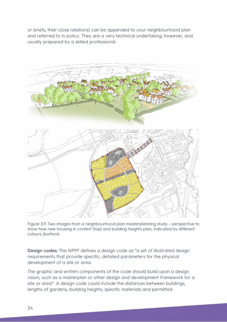
34
or briefs, their close relations) can be appended to your neighbourhood plan and referred to in policy. They are a very technical undertaking, however, and usually prepared by a skilled professional.
Figure 3.9: Two images from a neighbourhood plan masterplanning study – perspective to show how new housing in context (top) and building heights plan, indicated by different colours (bottom).
Design codes: The NPPF defines a design code as “a set of illustrated design requirements that provide specific, detailed parameters for the physical development of a site or area.
The graphic and written components of the code should build upon a design vision, such as a masterplan or other design and development framework for a site or area”. A design code could include the distances between buildings, lengths of gardens, building heights, specific materials and permitted

35
approached to car parking. Because of the need for there to usually be a masterplan or framework in place, and because they really should be prepared by a skilled professional, few neighbourhood planning groups have decided to go down the design code route.
It is usually more appropriate to include a set of locally-specific design principles in your polices (see step 3 below) or to produce a design guide, which differs from a code by being much less rigid and capable of being applied for flexibly (see above). Whichever approach is chosen – design guide, masterplan or design code – the document can be appended to the neighbourhood plan and embedded through relevant design policy or policies.

36
Figure 3.10a: Extract from a neighbourhood plan design code, showing acceptable design approaches in different situations

37
Figure 3.10b: Extract from a neighbourhood plan design code, showing acceptable design approaches in different situations

38
Building for Life 12 (BfL12), which is referenced in the NPPF (paragraph 129), proposes design prompts grouped under 12 questions to help shape the key components in a new development.
The BfL12 handbook is an excellent guide to what to look for in the layout and design of new housing and describes an assessment process based on a simple traffic light system that should be suitable for an informed group of users. BfL12 is widely used and appreciated by those neighbourhood planning groups that are active in promoting good design, as well as local authorities, urban designers and developers.
Some made neighbourhood plans reference BfL12 in their design policies, such as Poole Quays which states that “to be supported, development proposals must…..demonstrate how they aim to achieve Building for Life 12 (or successor) standards where they include a significant residential component”. Schemes can also ask for independent verification that they have achieved the standards expected by Building for Life and display this as Built for Life accreditation, post planning approval.

39
Figure 3.11: the Building for Life 12 questions, which are presented with recommendations on how to achieve the necessary standard. Your neighbourhood plan could usefully add detail about what each question means in your area.

40
Figure 3.12: BfL12 operates an associated quality mark and the website http://www.builtforlifehomes.org/ contains an inspirational illustrated library of schemes that have achieved it.

41
Step 3: Writing design policies Evidence needed to support design policies Locality’s a step-by-step guide, Neighbourhood Plans Roadmap (2018 edition), sets out how to produce your neighbourhood plan. The Roadmap suggests that, once the area has been designated, the next stages are to gather evidence and engage with the community.
Building your evidence base for a design policy is the same as for any other policy: first, review the existing evidence; and second, identify and develop any further evidence that may be required.
Neighbourhood planning policies can only influence development that requires a planning application. Most new buildings will fall under this category, but some additions to buildings, such as a small porch, are deemed to be ‘permitted development’ and do not require planning permission.
Likewise, some public realm interventions do not qualify as development unless they are part of a wider scheme that does require planning permission. If in doubt, check with your local planning authority.
Existing evidence Everything you do under steps 1 and 2 above is part of your evidence base. In addition, there should already be some existing evidence prepared by your local planning authority which would have informed the local plan or emerging local plan, and these should be readily available on most council websites. Documents include:
• Site allocation development plan documents;
• Local design guides or supplementary planning documents covering aspects of design;
• Landscape character studies;
• Conservation area appraisals and management strategies;
• Existing masterplans prepared by the council, local community or developers; and
• Existing plans for an area such as a community plan, parish plan or village design statement.
Presenting your evidence Once you have identified your evidence, you will need to review it and decide how to present it. It is not necessary to include all of your design evidence in the neighbourhood plan but a few selected images can be helpful to illustrate the point you are trying to make. You can choose to:

42
• Include a few selected, relevant images and/or maps within your plan;
• Include a summary of analysis in an appendix;
• Include your analysis or report on your website; or
• Provide a few brief bullet points within your justification text for the relevant policy.
An example is shown in figure 3.13 from the Wisborough Green Neighbourhood Plan which provides a concise summary of the site’s context, key attributes, location plan and proposed plan, followed by its policy.
Fig 3.13: Wisborough Green Neighbourhood Plan 2014-2029 (made in March 2016) where a concise summary of a site’s context is provided, followed by its design policy.
How to write design policies Once you have organised your evidence base to understand the issues and how they may be addressed, you need to embed it in policies to include in your neighbourhood plan.
Locality’s Writing Planning Policies document sets out guidance to help you link your vision and objectives to policies, but you do have a lot of flexibility when it comes to deciding what to cover in the design policies. They can be general or prescriptive, depending on the level of detail you want to include. It will, however,

43
be important to ensure that your policies are locally specific to your neighbourhood.
More generic design policies will have already been set by existing national and local planning policies, so your neighbourhood plan does not need to repeat these. It should instead seek to either increase the effectiveness of local plan policies by adding locally specific criteria by taking local context into account or propose a policy where there was previously none.
We have set out examples below for different approaches you can take for design policies, taken from a range of ‘made’ neighbourhood plans from across the UK.
• Generic, neighbourhood area-wide policies – you could set generic, overarching policies which cover the whole plan area. They can cover more general topics, like quality of design, or different types of land use, like residential development.
• By character area – if you have identified there are different character areas within your neighbourhood and defined what these are, then you could set out a specific policy or set of policies tailored to each area.
• Site-specific – for key sites, you could set out your aspirations within design policies, clearly defining your expectations for development. Again, the level of detail is up to you and may vary according to the importance or size of a particular site.
For each of the policies set out below, we have included a link to the neighbourhood forum website where you can view earlier drafts and their evidence base, and a link to the made versions on the local planning authority’s website.
Generic, neighbourhood area-wide policies
The Poole Quays Neighbourhood Plan (made February 2017) presents a number of policies to facilitate good of new development throughout the area.
Policy PQF1: Public Realm requires new development proposals that will influence the public realm to demonstrate how they are achieving a specific set of design principles. Similarly, Policy PQF2: Open Space offers requirements for the design and improvement of open spaces and Policy PQF3 High Quality Design offers fifteen quite detailed design requirements for new developments that must be conformed with in order for new developments to gain support.
Policy PQF3: High Quality Design
New development should deliver sustainable high-quality urban design. To be supported development proposals must:

44
• Respond positively to the area’s character, scale, grain and identity, creating or reinforcing local distinctiveness. Raising the standard of architecture, landscape and
• design within the Plan area;
• Conserve or enhance the Plan area’s important built and archaeological heritage assets and their settings;
• Respond to the key existing development aspects of the Plan area’s layout, landscape, density, mix, height, massing, details and materials;
• Promote accessibility and permeability by creating places that connect with each other and are easy to move through;
• Promote legibility through the provision of recognisable and understandable places, routes, intersections and points of reference;
• Deliver a coherently structured, integrated and efficient built form that clearly defines public and private space;
• Analyse and protect/enhance strategic views defined as (1) St James Church Tower from Dee Way (2) Brownsea Island from Poole Quay (3) Poole Quay from Poole Harbour;
• Deliver a safe, healthy, attractive, usable, durable and well-managed built environment comprising high quality inclusive buildings and spaces that integrate with green infrastructure;
• Create a multi-functional, lively and well-maintained public realm that sensitively integrates different modes of transport, parking and servicing;
• Encourage the delivery of permanent and temporary public art;
• Safeguard the amenity and context of existing development and create a high-quality environment for future occupiers;
• Promote diversity and choice through the delivery of a balanced mix of compatible buildings and uses;
• Create buildings and spaces that are adaptable to changing social, technological, economic and
• environmental conditions;
• Incorporate design features that deter crime or disorder and the fear of crime,
• Demonstrate how they aim to achieve Building For Life 12 (or successor) standards where they include a significant residential component, and
• Incorporate flood risk management measures.

45
Character area specific policy The Ascot, Sunninghill and Sunningdale Neighbourhood Plan 2011-2026 (made version, February 2014) uses the character areas approach, informed by a Townscape Assessment which the Royal Borough of Windsor and Maidenhead had carried out.
A Townscape Assessment, sometimes known as a Townscape Character Assessment, provides a description of an area’s townscape with maps and photographs to show how a place has evolved over time.
This policy was also supported by the group’s own list of heritage assets, nominated landmark buildings and key views (included in the plan’s appendices as a series of maps and photographs). An example of their policy relating to townscape in each of its character areas is shown below.

46
Policy NP/DG1 – Respecting the Townscape:
NP/DG1.1 Development proposals should respond positively to the local townscape.
Development proposals should use the RBWM Townscape Assessment report, and specifically its sections “Key Characteristics” and “Description”, to inform the design approach in a planning application. The extent to which this is demonstrated in the development proposals should determine whether the proposal is in keeping with the character of an area.
NP/DG1.2 In Townscape Assessment zones Leafy Residential Suburbs, Villas in a Woodland Setting and Executive Residential Estates, residential development should comprise low or very low density developments of detached houses, unless it can be satisfactorily demonstrated that other forms of development would retain the identified character of the area. In the context of this policy, these houses are defined as being dwellings for occupation typically by a single household, each house sitting in its own plot with a garden for its exclusive use. This policy shall apply even in areas within these zones where other types of dwellings may also exist.
NP/DG1.3 Development proposals in Townscape Assessment zones Leafy Residential Suburbs and Villas in a Woodland Setting should retain and enhance the sylvan, leafy nature of the area, which, where possible and appropriate, should include the planting of trees and/or shrubs along the street and neighbouring sites boundaries.
NP/DG1.4 Development proposals in Townscape Assessment zones
Victorian Villages must respect the form and character of the street and of the surrounding area.
NP/DG1.5 In Townscape Assessment zones Inter-War Suburbs, Post-War Suburbs (to 1960) and Late 20th Century Suburbs (to 1960), Late 20th Century Suburbs (1960s onwards) and Post-War Residential Flats, development proposals for houses or flats of high quality design and which enhance the character of the local area may be appropriate, even if not fully reflective of their Townscape Assessment classification.
NP/DG1.6 Throughout the Neighbourhood Area, development proposals
should comprise high quality design and seek to demonstrate how they will enhance the character of the local area.

47
Site-specific policy A site-specific policy can have as little or as much detail as you see fit, depending on how important you think that site is. The policy below was informed by a site analysis, a transport paper prepared by the group, and Mole Valley District Council’s Built Up Areas Character Appraisal. The Ashtead Neighbourhood Development Plan 2015-2026 (made version, May 2017) has a simple approach to one site:
The Altrincham Town Centre Neighbourhood Business Plan 2015 to 2030 (made version, November 2017) adds a locally specific criterion for its town centre as an alternative approach. This particular design policy was informed by public consultation including an open urban design workshop, and an initial Strategic Environmental Assessment.
Policy AS-H1: The Land at Murreys Court
Residential development of the Murreys Court site should include the provision of a new public footpath that will connect The Murreys and the site with the existing footpath between Agates Lane and Skinners Lane.
Policy ‘D’ Design and Quality:
D4 Proposals that improve an historic town centre ginnel will be encouraged and supported. Any proposals that would result in the loss of an historic town centre ginnel will be resisted.

48
But a site-specific policy can also be highly prescriptive, as shown below in an example taken from the Broadstone Neighbourhood Plan 2013-2033 (made version, June 2018) which included a design policy for its Central Shopping Area. Policy BP7 was informed by the group’s characterisation study of the area (field and desktop work), site analysis, and consultation.
Written design policies can be supplemented with images – either photos of development you would or would not like to see, key views you wish to preserve or enhance, and/or plans, diagrams or sketches showing suggested layouts and types of development.
BP7 Development principles for the Central Shopping Area:
Development proposals in the Central Shopping Area shown in Figure 3.6 will be expected to adhere to the following principles:
(i) Respect the scale, height, mass and grain of surrounding development, and harmonise with the architecture of the existing building where alterations or extensions are proposed
(ii) Create distinctive, legible, well-designed frontages and features to ensure vitality to the shopping area is retained
(iii) Where appropriate, does not prevent future comprehensive development of adjoining sites
(iv) Does not exceed 4 storeys in height, except where it can be demonstrated that the proposal would contribute positively to the character of the village centre
(v) Unless it is demonstrated that they are not feasible, improvements to the public realm should form part of the overall design scheme.

49
Fig 3.14: The Boston Spa Neighbourhood Development Plan 2012-2028 (made in October 2017) included a plan showing key views within the neighbourhood area to support Policy H1 Protection of key views.
Fig 3.15: The North Loose Neighbourhood Development Plan 2015-2031 (made in May 2013) included images of developments they do not think reflect local character.

50
Fig 3.16: The Fortune Green & West Hampstead Neighbourhood Plan (made in September 2015) included a set of photographs showing key views within the neighbourhood area.

51
Step 4: Tools for securing good design after the plan is made As statutory consultees for planning applications or in advisory roles, neighbourhood planning groups are increasingly involved in assessing the quality of design proposals once they have been made or as they emerge. The latter is preferable as there is still time to influence, as opposed to just approving, objecting or commenting. The tools include:
Design review: Government Planning Practice Guidance describes design review as “a tried and tested method of promoting good design and … an effective way to improve quality”. It is where a panel of experts from the built environment disciplines and others such as health and crime prevention assesses proposals usually before they are submitted for planning.
It is most common for a design review panel to be run by or on behalf of a local planning authority (there are over 20 in London alone). Contact your local authority to see what is available to you. It is important that local views are represented so ask if you can join the panel when it reviews schemes in your patch. More information can be found on the Design Council’s website.
Building for Life 12: Introduced in Step 2, BfL12 is often used to assess proposals, ensuring that the designers have applied the basic rules of urban design. In this way, it provides a structured framework to evaluate schemes at the planning stage.
Once your plan is made you will need to continue to be active to ensure your design policies are being applied in the way you had hoped and that your design aspirations are being realised. Here are two examples below of groups continuing to work on design after their plans have been made.
Uppingham – achieving better design through neighbourhood planning The Uppingham Neighbourhood Plan was made in January 2016. The plan was developed by the Uppingham First Community Partnership on behalf of Uppingham Town Council.
Policy 8 requires developers to demonstrate in a Design and Access Statement (a document that needs to be submitted with planning applications) how their proposed development reinforces Uppingham’s character and heritage. It also requires that new developments proposing over 25 homes or buildings exceeding 3000 square metres are subject to a design review process instigated by Uppingham Town Council. This is undertaken by a qualified independent body (OPUN East Midlands).

52
Uppingham First regularly engages with the community and key stakeholders through meetings of the Uppingham Vanguard Board, a group of organisations comprising local businesses, schools, developers, the Town Council and local community groups that each have a role in the future development of Uppingham.
Vanguard Board meetings enable a collaborative approach to development in the town, facilitating active discussions of key issues and providing a platform for the Uppingham community to liaise directly with developers. The meetings allow for developers to update the group on the progress of current development sites and to present future growth plans, thus enabling the group to identify issues and influence future development.
The Uppingham First Community Partnership hosted a Design Workshop event in February 2018 which sought to gather the preferences and opinions of local people to inform the design and development of an ‘Under 35’s’ affordable housing proposal.
The event involved young people working in small groups in close collaboration with an architect, to help gather views and preferences on internal and external building design, character, features, private and shared spaces, car and cycle parking provision, security measures and sustainability.
Design workshops such as these will inform development and design of a final scheme and work to ensure that the new development responds to the needs of the community it will serve. With the support of Uppingham Town Council, the Partnership is currently developing a Housing Trust to progress the development of affordable housing at this and other future sites.
Fig 3.17: The Under 35’s design workshop will assist in achieving a scheme that is aesthetically attractive to local residents and incorporates the suggested design features.

53
Poole Quays Forum Continuing to engage the community in pursuit of good design after the plan is made
The Poole Quays Neighbourhood Plan was made and formally adopted by the Borough of Poole in February 2017. The plan presents a number of policies that are influencing the design of new development in the area. Since the plan was made, the Forum has remained very active in promoting good design.
The Forum has hosted regular meetings and presentations regarding a planning application to demolish a series of former warehouses and a Grade II listed brick pier gate in order to develop over 500 residential units on a high profile waterfront site which has been the subject of a few failed planning applications over the years.
Widespread concerns about design quality by the community led to important issues being raised with the developers. Meetings organised by the Forum included a design workshop, ‘Reimaging the Waterfront’, facilitated by a number of local professionals including Poole-based architecture and planning firm ECA.
The workshop enabled discussions between built environment professionals and local people, the findings of which were fed back to the developer in an attempt to influence the redevelopment of this major waterfront brownfield site. Discussions focused on the importance of high-quality design and sustainability in new developments. The Forum is currently investigating the potential for a Neighbourhood Development Order on this site.

54
Fig 3.18: The 'Reimagining the Waterfront' workshop gathered the views and preferences of around 90 attendees, allowing the group to directly influence the design development process.

55
4. What other resources are available to help? Our conversations with neighbourhood planning groups who have strived to improve the quality of design in their areas have pointed to a number of resources that they have benefitted from, in addition to those highlighted above. A selection of these are highlighted below:
National design guidance
• The Government’s Planning Practice Guidance covers the basics of good design.
• The Design Council, which incorporates the Commission for Architecture and the Built Environment, has a searchable archive of useful guides. See also the seminal Urban Design Compendium.
• The Design Companion for Planning and Placemaking (not available online) is a comprehensive primer in urban design good practice. It was prepared by Urban Design London (but definitely has national relevance), and is accompanied by the equally useful Councillor’s Companion for Design in Planning.
• Local or sub-regional guidance is available for different areas and usually relevant beyond. Check with your local planning authority. Notable examples that set out design expectations in a detailed but accessible way include Essex Design Guide and Huntingdonshire Design Guide.
• The Housing Design Awards is a partnership between Government and all the industry’s key professions that have been running since the late 1940s to disseminate insights into the best new developments. Each year a large multidisciplinary panel of judges visits dozens of schemes in the search for the best. A long shortlist and a shorter roll-call of winners are detailed online on hdawards.org that also streams (free of charge) a collection of filmed case studies, each about 5 minutes long explaining who won and why. These films frequently include insightful interviews with residents about their new homes.
Organisations
• Locality is the first port of call for any neighbourhood planning needs. Under a programme funded by MHCLG, we offer grants and free technical support, including the production of design guides, codes and

56
masterplans, to eligible groups. There is also a suite of toolkits sitting alongside this one.
• There is a network of design and architecture centres across all the English regions, co-ordinated by the Design Network. They all offer support in different ways, including design review, training, workshop facilitation and promotion of Building for Life 12.
• RTPI Planning Aid may be able to offer the support of a qualified local volunteer
• Your local planning authority has a statutory duty to support and constructively engage with the community throughout the neighbourhood plan process. Ask then how they can help.
• Universities that offer planning, architecture and related courses can often offer free assistance as it provides useful experience for their students. A number of neighbourhood planning groups have benefitted from fresh ideas in this way.
• If you are able to pay someone, planning and design consultants can help. Ask around other groups or try the Royal Town Planning Institute’s directory and refer to the Locality toolkit on commissioning consultants. The directory will be helpful, but it is worth remembering that it is a general directory, so when approaching consultants make sure they have suitable relevant neighbourhood planning experience. If you can’t find a suitable consultant, ask your local authority for some tips, or other neighbouring neighbourhood planning groups.

57
Acknowledgements
This toolkit has been informed by an advisory group of neighbourhood planners, who came together, along with representatives from MHCLG and Locality, for a workshop early in the process and later reviewed a draft. Their input was invaluable.
Advisory group Elaine Paterson Berwick, Northumbria
Hilary Kolinsky Hoe, Devon
John Orchard Hook, Hampshire
Nicky Joshua Kelvedon, Essex
Peter Sandover Kingsbridge, Devon
Martin Fitton Kington, Herefordshire
Colin Smith Leek Wootton, Warwickshire
Martha Covell Poole Quays, Dorset
Nancy Mayo Redington Frognal, London
Henry Peterson St Quintin and Woodlands, London

58
Chris Edwards Stradbroke, Suffolk
Ron Simpson Uppingham, Rutland
Claire Milne Windsor, Berkshire
John Greenwood Yetminster and Ryme Intrinseca, Dorset
Ian Mackay Leeds City Council
The toolkit has been written by Ben Castell and Vanessa Adams, with inputs from Laura Fogarty, Luis Juarez and Emma van der Velde, all of AECOM, and Francis Shaw of Locality.
Images All images AECOM apart from:
Figures 2.2, 2.3, 2.4, 2.6, 3.15 and 3.16: Design for Homes
Figure 2.5: Ash Sakula
Figure 2.9 (Woodside Square): Pollard Thomas Edwards
Figure 3.2: www.commonplace.is
Figure 3.3: www.dpnf.org.uk
Figure 3.4: www.placestandard.scot
Figure 3.13: http://www.wisboroughgreen.org/neighbourhood-plan/
Figure 3.14: http://www.bostonspapc.org.uk/Boston-Spa-Parish-Council/Default-4480.aspx
Figure 3.15: http://www.northloose.co.uk/neighbourhood-plan/
Figure 3.16: http://www.ndpwesthampstead.org.uk/docs.htm
Figure 3.17: Uppingham First
Figure 3.18: ECA

End Page
Locality is the national membership network supporting community organisations to be strong and successful.
Text
locality.org.uk
Locality 33 Corsham Street, London N1 6DR 0345 458 8336 Locality is the trading name of Locality (UK) a company limited by guarantee, registered in England no. 2787912 and a registered charity no. 1036460. ©Locality The content of this guidance is for your general information and use only. It is subject to change without notice. Neither we nor any third parties provide any warranty or guarantee as to the accuracy, timeliness, performance, completeness or suitability of the information offered in this guidance for any particular purpose. You acknowledge that such information may contain inaccuracies or errors and we expressly exclude liability for any such inaccuracies or errors to the fullest extent permitted by law. Your use of this guidance is entirely at your own risk, for which we shall not be liable. It shall be your own responsibility to ensure that this guidance meets your specific requirements. For formal Government guidance on Neighbourhood planning please visit gov.uk
Unlock the power in your community with us