
3ODQQLQJ &RPPLWWHH 6HSWHPEHU 5HSRUW RI WKH …
41
Planning Committee 21 September 2021 Report of the Planning Manager Planning Ref: 21/00656/OUT Applicant: Richborough Estates Ward: Ambien Site: Stoke Fields Farm Hinckley Road Stoke Golding Proposal: Residential development up to 70 dwellings with associated access, landscaping, open space and drainage infrastructure (Outline - access to be considered) © Crown copyright. All rights reserved Hinckley & Bosworth Borough Council LA00018489 Published 2006 1. Recommendations 1.1. Grant planning permission subject to: The completion within 3 months of this resolution a S106 agreement to secure the following obligations: On-site Open Space minimum requirement of 1176sqm casual/informal play spaces and a 20 year maintenance cost (minimum of £12,700.80), a minimum of 2800sqm of natural green space along with a 20 year maintenance cost (minimum of £39,760.00) Off-site equipped children’s play space contribution of £45,846.36 towards site STG10 and 10 year maintenance of £22,125.60 and
Transcript of 3ODQQLQJ &RPPLWWHH 6HSWHPEHU 5HSRUW RI WKH …

Planning Committee 21 September 2021 Report of the Planning Manager Planning Ref: 21/00656/OUT Applicant: Richborough Estates Ward: Ambien Site: Stoke Fields Farm Hinckley Road Stoke Golding Proposal: Residential development up to 70 dwellings with associated access, landscaping, open space and drainage infrastructure (Outline - access to be considered)
© Crown copyright. All rights reserved Hinckley & Bosworth Borough Council LA00018489 Published 2006
1. Recommendations
1.1. Grant planning permission subject to:
The completion within 3 months of this resolution a S106 agreement to secure the following obligations:
On-site Open Space minimum requirement of 1176sqm casual/informal play spaces and a 20 year maintenance cost (minimum of £12,700.80), a minimum of 2800sqm of natural green space along with a 20 year maintenance cost (minimum of £39,760.00)
Off-site equipped children’s play space contribution of £45,846.36 towards site STG10 and 10 year maintenance of £22,125.60 and

outdoor sports provision contribution of £24,326.40 towards site STG10 and 10 year maintenance contribution of £11,558.40.
40% Affordable Housing (28 units) with a split of 75% of the units as social/affordable rented and 25% of the units as intermediate tenure
Affordable rented mix shall comprise: 6 x 1 bedroomed 2 person maisonettes or quarter houses, 8 x 2 bed 4 person houses and 7 x 3 bedroomed 5 person houses.
The intermediate tenure should consist of a mixture of 2 and 3 bedroomed houses.
Location connection requirement for the affordable housing and cascade mechanism.
£3,467 civic amenity contribution towards Barwell Household Waste Recycling Centre
£2,120 towards provision of additional resources at Hinckley Library, Lancaster road, Hinckley.
£417,039.81 towards Education facilities (St Margaret’s Church of England Primary School Stoke Golding £306,432.00, Redmoor Academy £65,962.44 and Hinckley Academy and John Cleveland Sixth Form Centre £44,645.37).
1 x travel pack per dwelling along with provision of application forms for 2 x 6 month bus passes (currently Arriva)
Replacement flags at the nearest two bus stops on Hinckley Road opposite Greenwood Road and outside number 87 (ID's 2571 & 2566).
Planning conditions outlined at the end of this report
1.2. That the Planning Manager be given powers to determine the final detail of planning conditions.
1.3. That the Planning Manager be given delegated powers to determine the final details of the S106 agreement including trigger points and claw back periods.
2. Planning application description
2.1. The application seeks outline planning permission for up to 70 dwellings with associated works. The only matter to be determined at this stage is access. The proposal includes a new access from Hinckley Road, opposite number 91 Hinckley Road. The proposal includes areas of open space, including a Local Area of Play (LAP), community orchard and flood attenuation basin. The proposal includes ecological enhancements to the site.
2.2. The application is supported by:
Illustrative Layout Design and Access Statement Planning Statement Tree Survey and Constraints Advice Geophysical Survey Report Desk Study Report (geotechnical) Flood Risk Assessment Preliminary Ecological Appraisal Report (March 2021) Addendum to the Preliminary Ecological Appraisal Report (May 2021)

Heritage Statement Biodiversity Calculation Metric Tool results Landscape and Visual Assessment (LVA) Statement of Community Involvement Transport Assessment Transport Plan
2.3. During the application a revised LVA was sought from the applicant and was received 31/8/21.
2.4. The applicant sought pre-application advice from the Local Planning Authority on the proposal under reference 21/10049/PREMAJ in March 2021. Before written advice could be provided the applicant chose to submit this current application.
2.5. The applicant has confirmed that the site will be brought forward in a timely manner to help deliver the housing needs of the Borough. The applicant has offered that the standard 3 year period for the submission of a reserved matters application, could be reduced to 2 years for that reason.
3. Description of the site and surrounding area
3.1. The site is a roughly rectangular parcel of agricultural land, 2.92 hectares in size. The site is located on the southern side of Hinckley Road, Stoke Golding. The site abuts Hinckley Road to the north, agricultural land and Skokefields Farm (farm house and farm buildings) to the east, 1, 2 and 3 The Stables Pine Close and caravan storage and telecoms mast to the south and a solar farm, Telephone Exchange and telecoms mast and number 66 Hinckley Road to the west. Adjacent to the site on Hinckley Road is an existing bus stop and shelter.
3.2. Along the eastern boundary is a row of overhead electricity power lines. The site boundaries are mostly hedgerows interspersed with a few trees. The site is relatively level ground.
3.3. The site is outside the defined settlement boundary of Stoke Golding and therefore is open countryside. The site is within a SSSI Impact Risk Zone and Mineral Consultation Area. The site is within the impact zone of a great crested newt breeding pond, located to the east.
3.4. The site is within the area covered by the Stoke Golding Neighbourhood Plan (SGNP). The SGNP is an emerging plan and has progressed to examination stage. The SGNP was submitted to the Borough Council in May 2021 and consultation was undertaken in June/July 2021. The examination began on 2 August 2021 and the Report on Independent Examination was received on 6 September 2021. In accordance with the NPPF paragraph 48, weight may be given to policies in emerging plans according to the stage of preparation, the extent of unresolved objections and the degree of consistency between the policies in the emerging plan and the NPPF. This is discussed in further detail within this report.
4. Relevant planning history
02/01413/GDO
ERECTION OF POLE BARN, GDO, 06.02.2003
08/00893/GDO
PROPOSED AGRICULTURAL BUILDING, GDO, 08.10.2008

5. Publicity
5.1. The application has been publicised by sending out letters to local residents. A site notice was also posted within the vicinity of the site and a notice was displayed in the local press.
5.2. 33 letters of objection have been received in total (at 25/8/21) 30 from addresses within the village, raising the following issues:
1) Site is not identified in the Neighbourhood Plan. 2) The Village has met its housing needs - 65 permitted on Roseway and 55 at
Wykin Lane. 3) Village has grown from 738 households (201 census) by 272 dwellings 37% 4) Outside the village boundary 5) Infrastructure cannot cope with 70 more dwellings (schools oversubscribed,
doctors busy and bus service not in the evening, 1 small shop and post office, play areas at capacity, policing)
6) Traffic increase and Hinckley Road is already busy/congested/dangerous at peak times
7) Wish to see brownfield development not greenfield 8) Environmental impact of building on greenfield 9) Rural historical villages are not the place for large developments 10) Countryside is being decimated. 11) Flooding and drainage concerns – land drain adjacent to the site 12) Utilities are at capacity and there are regular power cuts, low water pressure
and slow broadband speeds. 13) Noise pollution would increase 14) Impact of construction vehicles on the rural roads and older houses 15) Concerns about the capacity of and impact on Main Street (parking and
safety). 16) Would ruin views to Hinckley 17) More housing would destroy the rural feel of the village 18) Will ruin natural habitats 19) Residents will have to travel out of the village for schools, shopping, work,
post office, leisure/sports. 20) No sustainable transport options 21) Piecemeal development will not deliver infrastructure 22) Green spaces required on the edges within the development 23) Village separation to Dadlington and Wykin is being eroded. 24) TPO required on the mature oak on the site. 25) New residents will need to drive to schools elsewhere, increasing car usage 26) This field is an important natural feature/landscape on this side of the road
and transition point to open countryside
6. Consultation
6.1. No objection, some subject to conditions/informatives have been received from:
Environmental Services (conditions) Leicestershire Fire and Rescue Service LCC Ecology (conditions) LCC Highways (conditions) HBBC Drainage (conditions) Leicestershire Police LLFA (conditions) HBBC Waste (condition) HBBC Conservation

HBBC Planning Policy Cadent Gas (informative)
6.2. No response has been received from:
NHS England Cycling UK Severn Trent Water Stoke Golding Heritage Group Western Power Distribution
6.3. Stoke Golding Parish Council object for the following reasons:
1) Overdevelopment 2) The village has already exceeded its housing allocation in the Core Strategy 3) The Neighbourhood Plan consultation supported development on brownfield
not greenfield 4) The Neighbourhood Plan should be taken into consideration 5) More pressure on services such as the school and doctors surgery
6.4. S106 Officer - The scheme includes a community orchard and a LAP, the legal agreement would need to ensure the relevant square-metreage is secured according to the number of dwellings proposed. The Parish Council could be nominated to own and control the open spaces or a management company used. Off-site contribution required towards to the open space at the convent site to make the necessary improvements and or additional provision to the equipped element and outdoor sports to the nearest place within the development location.
6.5. HBBC Affordable Housing - Requirement for 40% of the housing to be affordable (28 homes). 75% social or affordable rent and 25% intermediate tenure. An indicative mix of properties for the affordable rented housing on this site would currently be for 6 x 1 bedroomed 2 person maisonettes or quarter houses, 8 x 2 bed 4 person houses and 7 x 3 bedroomed 5 person houses. The intermediate tenure should consist of a mixture of 2 and 3 bedroomed houses. As this site is in the rural area, the section 106 agreement will contain a requirement for applicants in the first instance to have a local connection to Stoke Golding, with a cascade in the second instance for a connection to the Borough of Hinckley and Bosworth.
6.6. LCC Developer Contributions request:
£3,467.00 towards civic amenities at Barwell £2,120.00 towards library services at Hinckley Library on Lancaster Road £306,432.00 primary school contribution for the area £65,962.44 secondary school contribution towards Redmoor Academy £44,645.37 post-16 contribution towards Hinckley Academy and John
Cleveland Sixth Form Centre or other school in the locality.
6.7. LCC Archaeology – Recommend that trial trenching is undertaken prior to a decision on the planning application so that an informed decision can be made, and the application refused or modified in the light of the results as appropriate.
7. Policy
7.1. Stoke Golding Neighbourhood Plan 2020-2039 (submission version May 2021) (as proposed to be amended by the Report of the Inspector)
Emerging policies:
SG1: Housing Requirement SG2: Housing Reserve Site SG3: Windfall Housing Development

SG4: Housing Mix SG5: Affordable Housing SG6: Countryside SG10: Locally Important Views SG11: Ecology and Biodiversity SG12: Trees and Hedgerows SG15: Design SG19: Infrastructure Policies Map
7.2. Core Strategy (2009)
Policy 7: Key Rural Centres Policy 11: Key Rural Centres Stand Alone Policy 14: Rural Areas: Transport Policy 15: Affordable Housing Policy 16: Housing Density, Mix and Design Policy 19: Green Space and Play Provision
7.3. Site Allocations and Development Management Policies DPD (2016)
Policy DM1: Presumption in Favour of Sustainable Development Policy DM3: Infrastructure and Delivery Policy DM4: Safeguarding the Countryside and Settlement Separation Policy DM6: Enhancement of biodiversity and geological interest Policy DM7: Preventing Pollution and Flooding Policy DM10: Development and Design Policy DM11: Protecting and Enhancing the Historic Environment Policy DM12: Heritage Assets Policy DM13: Preserving the Borough’s Archaeology Policy DM17: Highways and Transportation Policy DM18: Vehicle Parking Standards
7.4. National Planning Policies and Guidance
National Planning Policy Framework (NPPF) (2021) Planning Practice Guidance (PPG) National Design Guide (2019)
7.5. Other relevant guidance/documents
Good Design Guide SPD (2020) Landscape Institute Technical Guidance Note ‘Reviewing Landscape and
Visual Impact Assessments and Landscape and Visual Appraisals’ January 2020.
Hinckley and Bosworth Landscape Character Assessment 2017. Stoke Golding Neighbourhood Plan Site Assessment Framework Results and
Site Selection and Evaluation Process Stoke Golding Parish Neighbourhood Plan – Report of the Independent
Examination (6/9/21)
8. Appraisal
8.1. Key Issues
Assessment against strategic planning policies Housing mix and density Design and impact upon the character of the area (inc. landscape)

Impact upon heritage assets Impact upon neighbouring residential amenity Impact on ecology and trees Impact upon highway safety Flood risk and Drainage
Assessment against strategic planning policies
The Development Plan
8.2 Paragraph 2 of the National Planning Policy Framework (NPPF) July 2021) states that planning law requires that applications for planning permission must be determined in accordance with the development plan unless material considerations indicate otherwise and that the NPPF is a material consideration in determining applications. Paragraph 12 of the NPPF confirms that the presumption in favour of sustainable development does not change the statutory status of the Development Plan as the starting point for decision making.
8.3 Paragraph 11 of the National Planning Policy Framework (NPPF) and Policy DM1 of the Site Allocation and Development Management Policies Development Plan Document (SADMP) set out a presumption in favour of sustainable development, and state that development proposals that accord with the development plan should be approved unless other material considerations indicate otherwise. The development plan in this instance consists of the adopted Core Strategy (2009) (CS) the Site Allocations and Development Management Policies DPD (2016) (SADMP). The Stoke Golding Neighbourhood Plan is not yet part of the Development Plan as it has not been made.
8.4 The Emerging Local Plan for 2020-39 has reached Regulation 18 draft stage (June-August 2021) and thus can be given only limited weight at this stage as it will be further revised before submission. The Emerging Local Plan sets out a presumption that each key rural centre (including Stoke Golding) will provide for a minimum of 200 dwellings (paragraph 4.19). This draft requirement can be given limited weight at this stage.
8.5 The CS sets out the settlement hierarchy for the Borough. The urban area is the focus for development and within the rural area the hierarchy of settlements is as follows; Key Rural Centres, Rural Villages and rural Hamlets. Policy 11 of CS identifies Stoke Golding as a Key Rural Centre. To support local services and maintain rural population levels, the policy states that the Council will allocate land for at least 60 new homes. Developers will be required to demonstrate that the number, type and mix proposed will meet the needs of the village, taking account of the latest evidence, in line with policies 15 and 16 of the CS. These policies are considered in later sections of this report.
8.6 The SADMP explains that at 1 September 2014, the 60 dwelling minimum had been met and so no housing sites were allocated in that plan.
8.7 The site is located outside the settlement boundary of the village as set out in the SADMP inset map and the emerging Stoke Golding Neighbourhood Plan. Policy DM4 of the SADMP states that the countryside will first and foremost be safeguarded from unsustainable development, to protect its intrinsic value, beauty, open character and landscape character. The policy sets out the circumstances (a to e) where development in the countryside will be considered sustainable and such development needs to also meet certain criteria (i to v). The proposed development does not meet any of the criteria a to e.
8.8 The Stoke Golding Neighbourhood Plan (SGNP) has reached examination stage and the Report of Independent Examination (RIE) has been received. The report

recommends that the SGNP proceed to referendum. Paragraph 48 of the NPPF states that Local Planning Authorities may give weight to relevant policies in emerging plans according to: (a) the stage of preparation, (b) the extent to which there are unresolved objections to relevant policies, and (c) the degree of consistency of the relevant policies in the emerging plan to the NPPF. The Good Practice Guidance refers to section 70(2) of the Town and Country Planning Act 1990 (as amended) which states: that in dealing with an application for planning permission, the local planning authority shall have regard to a post-examination draft neighbourhood development plan, so far as material to the application. The Guidance also states that where the local planning authority publishes notice of a referendum, the emerging neighbourhood plan should be given more weight, while also taking account of the extent of unresolved objections to the plan and its degree of consistency with the NPPF.
8.9 Emerging policy SG1 of the Submission Draft SGNP sets a housing requirement of 57 dwellings minimum in the period 2020 to 2039. This will be met by the committed development of 65 dwellings at Roseway (20/00779/OUT) and windfall development in accordance with policy SG3. The emerging SGNP allocates a reserve site at Mulberry Farm for around 25 dwellings. The RIE recommends that the housing requirement is increased to 158 dwellings, as per the Borough Council’s suggestion. Paragraph 94 of the RIE states:
“I am satisfied it is appropriate for Policy SG1 to indicate the scale of development that is being planned for and that this should reflect the method of calculation recommended by the Borough Council. I am satisfied the policy will not preclude sustainable development schemes in accordance with Policy SG3 that result in the achievement of a greater total number of dwellings. This is consistent with the fact the Neighbourhood Plan places no cap or limit on the number of dwellings that can be provided within the Settlement Boundary nor on the number of dwellings that can be provided outside the Settlement Boundary subject to it being of types that are consistent with Policy SG2 or Policy SG6 of the Neighbourhood Plan, and national and strategic planning policy. In the context of the characteristics of the Neighbourhood Area those policies relevant to housing provision will significantly boost the supply of housing.”
8.10 The RIE recommends that the reserve housing site (policy SG2) should be identified as available for development now, and that as a consequence:
“As a matter of planning judgement, on the basis of the scale of allocation and other provision for new housing made in the Neighbourhood Plan, I am content there is no necessity to allocate housing sites or reserve housing sites additional to those in the Neighbourhood Plan, as recommended to be modified, to meet emerging evidence of housing need.” (RIE paragraph 97)
8.11 Emerging policy SG3 of the SGNP (as proposed to be amended by the RIE) states that windfall housing development outside the settlement boundary will be limited. The proposed development does not meet any of the 7 circumstances as set out in the policy.
8.12 Emerging policy SG6 of the SGNP states that the countryside (land outside the settlement boundary) will be protected for the sake of its intrinsic character, beauty, heritage and wildlife, the wealth of its natural resources and to ensure it may be enjoyed by all. The policy is proposed to be amended by the RIE, with new wording and criteria to set out what development is supported in countryside locations. The submission version of the wording, would not permit the current housing proposal. The policy as proposed to be amended by the RIE, would allow:

“4. Development that is otherwise in accordance with: national policies; or strategic planning policies or allocations; or with the other policies of the Neighbourhood Plan.” (RIE paragraph 143)
8.13 This is an important change to the policy, as it would support development that conflicts with this policy, but otherwise accords with national policy.
8.14 The housing requirement position for Stoke Golding is illustrated below in table 1.
Table 1: Housing requirement for Stoke Golding and delivery position
Minimum housing requirement identified for the Borough 2020-39
Minimum requirement for Stoke Golding 2020-39 (inc. 10% buffer)
Windfall allowance for 2020-39
Permissions granted and emerging allocation SG2
8,588 158 (38 dwellings provided 2006-2020 = 2.7 per year)
51 dwellings in the period 2020-39
East of Roseway (20/00779/OUT) = 65 dwellings
Wykin Lane (19/01324/OUT) = 55 dwellings
SG2 allocation = 25 dwellings
TOTAL requirement: 158 158-51=
107
107- (65+55+25) =
38 dwellings in excess of the minimum requirement
8.15 The above table shows that, taking account of anticipated windfall development, permissions granted and the emerging allocation, the minimum 158 requirement for Stoke Golding will be exceeded by 38 dwellings.
8.16 It is considered that significant weight can be given to the SGNP at this stage in its production, as the RIE has recommended that the plan is modified and should proceed to referendum. It is considered that it can be given significant weight because the plan is unlikely to change any further, there were hardly any public objections to the plan at submission stage and so is likely to be ‘made’ at the referendum, and the RIE resolves the objections and concludes that the plan has had regard to national policy.
8.17 It is noted that the earlier pre-submission version of the SGNP (Dec 2020) included the northern part of the application site as a reserve housing site for 25 dwellings. The site was identified using a site assessment process and the results were published in the Site Assessment Framework Results Nov 2019. The site (AS540) was ranked 3rd of 15 in the assessment. This demonstrates that the site was considered to have good development potential by the Neighbourhood Plan Advisory Committee. The RIE has not recommended that the site be allocated within the SGNP.
The presumption in favour of sustainable development
8.18 The Council acknowledges that it cannot currently demonstrate a 5 year housing land supply. On 25th March 2021, ONS published the latest median housing price to median gross annual workplace based earnings ratio used in step 2 of the standard method for calculating local housing need as set out in paragraph 2a-004

of the PPG. The application of the new ratio means that the local housing need for the Borough is now 450 dwellings per annum (rather than 452 dwellings per annum using the previous ratio). In addition to this on 7th May 2021 the Sketchley Lane appeal (APP/K2420/W/20/3260227) discounted some large sites included within the trajectory. Therefore, the Council can only demonstrate a 4.23 year housing land supply.
8.19 Footnote 8 to paragraph 11 of the 2021 NPPF states that the housing policies are considered to be out-of-date where local planning authorities cannot demonstrate a five year supply of deliverable housing sites and therefore paragraph 11(d) of the NPPF is triggered. The NPPF is a material consideration. Paragraph 11(d) states:
“Plans and decisions should apply a presumption in favour of sustainable development.
For decision taking this means:
(d) Where there are no relevant development plan policies, or the policies which are most important for determining the application are out-of-date, granting permission unless
i. the application of policies in this Framework that protect areas or assets of particular importance provides a clear reason for refusing the development proposed; or
ii. any adverse impacts of doing so would significantly and demonstrably outweigh the benefits, when assessed against the policies in this Framework taken as a whole.”
8.20 Paragraph 219 of the Framework states that existing policies should not be considered out-of-date simply because they were adopted prior to the publication of the Framework. Due weight should be given to them according to their degree of consistency with the Framework (the closer the policies in the plan to the policies in the Framework, the greater the weight that may be given). Furthermore, it is recognised by the courts that out-of-date policies can still be given some weight, particularly where their overall strategic aims might be designed to operate on a longer time scale than a particular plan period.
8.21 Both the CS and the SADMP are over 5 years old, and paragraph 33 of the NPPF states that policies in local plans and spatial development strategies should be reviewed to assess whether they need updating at least once every five years, and should then be updated as necessary. Therefore, this report sets out the relevant CS and SADMP polices and refers to the NPPF and notes any inconsistencies between them.
Strategic policies conclusion
8.22 In conclusion, the proposed development is outside the village boundary of Stoke Golding and the village has exceeded the 60 dwelling minimum for 2006-26 as set out in CS policy 11. The proposal is contrary to policy DM4 of the SADMP as it does not meet any of the criteria (a to e) to be considered sustainable development in the countryside.
8.23 The proposal is also contrary to emerging policies SG1 and SG3 (as proposed to be modified by the RIE) of the SGNP. Policy SG6 (as proposed to be modified by the RIE) of the SGNP, would support development outside the settlement boundary where it is in accordance with national policies.
8.24 The emerging SGNP (as proposed to be modified by the RIE) can be given significant weight at this stage, and the Development Plan is out of date. The

emerging Local Plan for 2020-39 is at an early stage of production and can be given very little weight.
8.25 The NPPF in paragraph 49(b) advises that arguments that an application is premature are unlikely to justify a refusal of planning permission other than in the limited circumstances where both the following are met:
(a) “the development proposed is so substantial, or its cumulative effect would be so significant, that to grant permission would undermine the plan-making process by predetermining decisions about the scale, location or phasing of new development that are central to an emerging plan; and
(b) the emerging plan is at an advanced stage but is not yet formally part of the development plan for the area.”
8.26 The current proposal for 70 dwellings is not considered to undermine the plan-making process. The allocations in the emerging SGNP are committed, and emerging policy SG2 will make a further allocation. Emerging policy SG6 (as proposed to be modified by the RIE) supports development in the countryside that is in accordance with national policies.
8.27 The presumption in favour of sustainable development part (d) ‘the tiled balance’ applies. Paragraph 14 of the NPPF states that when this applies, the adverse impact of allowing development that conflicts with the neighbourhood plan is likely to significantly and demonstrably outweigh the benefits, provided that all parts (a to d) apply. However, as the SGNP is not yet ‘made’ (likely to occur in December 2021), the SGNP cannot satisfy criterion (a). NPPF paragraph 14 therefore does not apply.
8.28 The presumption in favour of sustainable development in paragraph 11d of the NPPF ‘the tiled balance’ applies. Therefore, in principle, planning permission should be granted unless the presumption in favour of sustainable development can be displaced by any adverse impacts that would significantly and demonstrably outweigh the benefits of the proposal. To achieve sustainable development, the NPPF states that the planning system has three overarching objectives; economic, social and environmental, which are interdependent. The housing delivery position as set out in table 1 above is a material consideration in the planning balance.
Housing mix and density
8.29 Policy 16 of the CS requires a mix of housing types and tenures to be provided on all sites of 10 or more dwellings, taking account of the type of provision that is likely to be required, based upon table 3 in the CS and informed by the most up to date housing needs data. All developments of 10 or more dwellings are also required to meet a ‘very good’ rating against Building for Life, unless unviable. A minimum density of 30 dwellings per hectare is required in rural areas, a lower density may be required where individual site circumstances dictate and are justified.
8.30 The Good Design Guide SPD advocates the use of the Building for Life assessment.
8.31 Emerging policy SG4 of the SGNP (as proposed to be modified by the RIE) requires that developments of more than 4 dwellings shall provide for a mix of house types that reflect the recommendations of the Housing Needs Study 2019, or other variations where justified.
8.32 Paragraph 62 of the NPPF states that the size, type and tenure of housing needed for different groups in the community should be assessed and reflected in planning policies. The above policy allows for the most recent evidence to be taken into account in decisions and thus policy 16 is considered up to date in this regard.

8.33 The Planning Statement states that the final number and mix of dwellings will be determined at reserved matters stage, but the Illustrative Layout shows that the mix of 1 to 4 bed units could be accommodated. The density proposed is 38 dwellings per hectare (based upon the site area of 1.82ha). The density is higher than the surrounding dwellings and above the 30dph policy requirement, but this reflects the local and national policy changes and the need to make best use of the land available. The development is for up to 70 dwellings and the appropriate density and layout will be determined at reserved matters stage. The eastern edge of the development will be the village edge and should be softened by landscaping, and less dense and with a varied building line.
8.34 The applicant has undertaken a brief Building for Healthy Life Assessment (the replacement for Building for Life). The assessment is noted and a further detailed assessment should be provided at reserved matters stage.
8.35 In conclusion the illustrative layout shows that a mix of dwellings can be provided on site and a detailed scheme for housing mix can be secured by condition to be submitted at reserved matters stage, to secure compliance with policy 16 of the CS and emerging policy SG4 of the SGNP.
Affordable Housing provision
8.36 Policy 15 of the CS sets out that a minimum of 2,090 affordable homes will be provided in the Borough from 2006 to 2026. At least 480 dwellings will be in the rural areas, at a rate of 40%.
8.37 Emerging policy SG5 of the SGNP (as proposed to be modified by the RIE) requires 40% affordable provision on sites of over 10 dwellings. A local connection will be required for affordable homes when allocated or sold.
8.38 The Borough has an unmet affordable housing need and this is given significant weight in the planning balance. The Housing Needs Study (2019) identifies a Borough need for 271 affordable dwellings per annum (179 in the urban area and 92 in the rural area) for the period 2018-36. The Study states this is not a target, but that affordable housing delivery should be maximised where opportunities arise.
8.39 The development will meet the 40% requirement (28 homes) and the affordable housing officer has no objection to the proposal. The housing officer requires 75% social or affordable rent and 25% intermediate tenure. An indicative mix of properties for the affordable rented housing on this site would currently be for 6 x 1 bedroomed 2 person maisonettes or quarter houses, 8 x 2 bed 4 person houses and 7 x 3 bedroomed 5 person houses. The intermediate tenure should consist of a mixture of 2 and 3 bedroomed houses.
8.40 The location of the site is adjacent to the existing settlement boundary and the design and access statement shows that the site is close to local facilities, for example approximately 300m from the surgery and village hall, 400m from the park and play area and 750m to shops and pubs.
8.41 The application will deliver 40% affordable housing and therefore meets the requirements of policy 15 of the CS and emerging policy SG4. The affordable housing provision will be secured by the S106 agreement. As this site is in the rural area, the section 106 agreement will contain a requirement for applicants in the first instance to have a local connection to Stoke Golding, with a cascade in the second instance for a connection to the Borough of Hinckley and Bosworth.
Design and impact upon the character of the area (including landscape)
8.42 Policy DM10(c), (d) and (e) of the SADMP seeks to ensure that development complements or enhances the character of the surrounding area with regard to

scale, layout, density, mass, design, materials and architectural features and the use and application of building materials respects the materials of existing, adjoining/neighbouring buildings and the area generally and incorporates a high standard of landscaping.
8.43 The Good Design Guide SPD provides guidance upon how to design an appropriate new residential development. This includes appraising the context, creating appropriate urban structures through blocks, streets, enclosure, open space and landscaping, parking, amenity space and design detailing. The SPD advocates the use of a Building for Life Assessment. The SPD sets out minimum separation distances between dwellings and a general guideline for garden sizes of 7.0m minimum length and size of 60sqm for a 2 bed house, and 80sqm for a 3 bed house. The SPD states the design objectives for Stoke Golding including to protect the setting of the canal and battlefield; the northern and western approaches that mark the entrance to the village.
8.44 Emerging policy SG10 of the SGNP identifies important local views. Proposals will not be supported if potential impacts on landscape cannot be adequately mitigated through design and landscaping. The local views have been included and assessed in the submitted Landscape and Visual Appraisal. The RIE recommends the removal of viewpoints B and D from the policy.
8.45 Emerging policy SG12 of the SGNP states that new and existing trees should be integrated into new developments, and the RIE proposes to add ‘unless this is demonstrated not to be possible’.
8.46 Emerging policy SG15 of the SGNP states that only development that reflects the traditional character of Stoke Golding will be supported unless the development is of exceptional quality or innovative design. The policy has 12 criteria the development must comply with. The policy is proposed to be largely unaltered by the RIE.
8.47 Paragraph 134 of the NPPF states development that is not well designed should be refused, especially where it fails to reflect local design policies and government guidance on design, taking into account any local design guidance. Local policy is considered to accord with the NPPF.
8.48 The site is located in open countryside. The development to the north and west of the site consists of a mixture of detached bungalows and two storey dwellings. Materials used in the locality are red brick and render, with roofs of brown tile and brown or white windows. The existing pattern of development in this part of the village has a spacious feel with dwellings set back from the road behind landscaping and parking areas. The site itself is relatively flat, with a rise of only 3.0m from south to north.
8.49 The application is supported by a Design and Access Statement (DAS) and a Landscape and Visual Assessment (LVA). The DAS identifies the site as adjacent an area of post 1955 housing. The illustrative layout focuses the housing to the north of the site adjacent to the existing dwellings on the northern and western boundaries. The layout provides a landscaped edge to the east facing the open fields. The south of the site contains open space, landscaping, flood attenuation and trees. Existing trees on the site boundaries are retained.
8.50 The Landscape and Visual Appraisal has been revised in light of comments made by the case officer in relation to the content and clarity of the original report. The Appraisal has been assessed using the Landscape Institute Technical Guidance Note ‘Reviewing Landscape and Visual Impact Assessments and Landscape and Visual Appraisals’ January 2020.

8.51 The revised Appraisal sets out that the site is not subject to any landscape designations. The Appraisal identifies a study area and a zone of theoretical visibility (based upon a maximum height of 8.5m above ground level), based on a desk based assessment and the topography of the area. The site is located within the Leicestershire Vales National Character Area and is in pastoral use, typical to this area. The site is within the Stoke Golding Rolling Farmland character area, as identified in the Council’s Landscape Character Assessment 2017. The features of the character area that the site exhibits are its small rectilinear field pattern divided by low hedgerows and mature hedgerow trees, with sporadic farmsteads on the outer edges of villages.
8.52 The Appraisal concludes that the site has a medium susceptibility to the landscape change proposed. In terms of value, there is nothing associated with the site that makes this land as a whole more than ordinary and valued no higher than of local importance. The main way in which the site could be considered locally valued is in the role the boundary hedgerows play within the wider green infrastructure network surrounding the village. The site is undeveloped and ‘open’ but public views are limited by the boundaries. Combining the susceptibility and value of the landscape of the site, the landscape on-site is considered to be of medium sensitivity to change as it has some aspects of positive landscape character, a small number of locally valued aspects (historic field boundaries that contribute to the green infrastructure network and its currently open farmed use). The proposed development would be consistent with the existing scale, pattern, grain and land use of the prevailing character immediately adjoining the site, although mitigation would be appropriate to enhance assimilation so as to respect the character of the landscape to the south and east. The Appraisal therefore recommends the following (at paragraph 2.35):
Retain existing hedgerows and hedgerow trees and manage them using traditional methods, a feature of the character area
Incorporate a landscape buffer to the south to protect the rural character of the adjoining countryside and filtering views from the south and providing a softened edge to the settlement
Maintain any visibility of the Church spire within the internal layout Include new tree planting Prioritise local distinctiveness Consider prominent buildings at corners Include buildings fronting the pavements or behind brick boundary walls
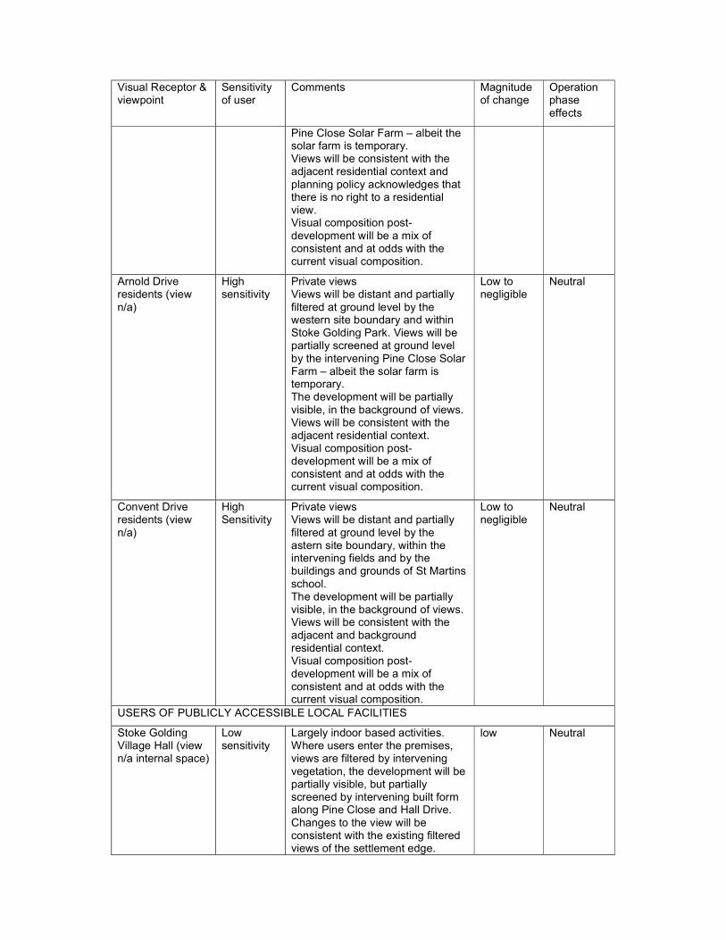
8.53 The visual appraisal identifies that the site is much less visible than the theoretical zone of visibility suggested. The fieldwork analysis undertaken showed that there is little opportunity to view the site from anywhere other than close proximity locations. 20 viewpoints within the zone were identified, and all were external spaces within the public domain, and not from buildings or private spaces. Overall, this represents a very limited visual envelope and a small number of potential visual receptors. The Appraisal notes (para 3.11) that when the site is visible, it is viewed within a context of the adjacent Pine Close Solar Farm and the housing at Hinckley Road and Pine Close. The site is also well contained by its own boundary vegetation, and where more distant visibility does occur, intervening trees serve to filter views. There are no views within which the site is seen as an important component of the landscape in its current usage, and even for the more sensitive of visual receptors, the development of the site would still only represent a slight foreshortening of views rather than a loss of any important scenic qualities or valued visual features. Table 2 below summarises the results of the visual appraisal.

Table 2: Summary of visual appraisal (taken from pages 32-35 and paragraph 6.31 of the Landscape Visual Appraisal)
Visual Receptor & viewpoint
Sensitivity of user
Comments Magnitude of change
Operation phase effects
RECREATIONAL USERS
Users of footpath U2 to east of site (views 3 & 5)
High sensitivity
Most of site visible. Views partially filtered by intervening vegetation. Views are sequential and changes to the view will be consistent with the backdrop of the existing residential edge of Stoke Golding, albeit brought closer to the foreground of users. Visual composition post-development will be a mix of consistent and at odds with the current visual composition.
High Moderate adverse
Stoke Golding Park (view 13)
High sensitivity
Partially visible. Views partially filtered by intervening vegetation. Changes to the view will be consistent with the existing backdrop of views from this location, which feature filtered views of the settlement edge of Stoke Golding. Visual composition post-development will be a mix of consistent and at odds with the current visual composition.
Low to negligible
Neutral
PRIVATE RESIDENTS
Hinckley Road residents (views 1-4)
High sensitivity
Private views. Most of the site visible in close proximity. Views will be direct and partially filtered at ground floor level. Views will be consistent with the adjacent residential context and planning policy acknowledges that there is no right to a residential view. Visual composition post-development will be consistent with the current visual composition but there will be an inevitable curtailment of views across the field on site for users directly opposite the site.
High to medium
Moderate adverse
Pine Close residents (view 8)
High sensitivity
Private views. Most of the site visible in close proximity. Views will be direct and partially filtered at ground level by site boundary for a small number of residents. Partially screened at ground level by the intervening
Medium to low
Moderate adverse
Visual Receptor & viewpoint
Sensitivity of user
Comments Magnitude of change
Operation phase effects
Pine Close Solar Farm – albeit the solar farm is temporary. Views will be consistent with the adjacent residential context and planning policy acknowledges that there is no right to a residential view. Visual composition post-development will be a mix of consistent and at odds with the current visual composition.
Arnold Drive residents (view n/a)
High sensitivity
Private views Views will be distant and partially filtered at ground level by the western site boundary and within Stoke Golding Park. Views will be partially screened at ground level by the intervening Pine Close Solar Farm – albeit the solar farm is temporary. The development will be partially visible, in the background of views. Views will be consistent with the adjacent residential context. Visual composition post-development will be a mix of consistent and at odds with the current visual composition.
Low to negligible
Neutral
Convent Drive residents (view n/a)
High Sensitivity
Private views Views will be distant and partially filtered at ground level by the astern site boundary, within the intervening fields and by the buildings and grounds of St Martins school. The development will be partially visible, in the background of views. Views will be consistent with the adjacent and background residential context. Visual composition post-development will be a mix of consistent and at odds with the current visual composition.
Low to negligible
Neutral
USERS OF PUBLICLY ACCESSIBLE LOCAL FACILITIES
Stoke Golding Village Hall (view n/a internal space)
Low sensitivity
Largely indoor based activities. Where users enter the premises, views are filtered by intervening vegetation, the development will be partially visible, but partially screened by intervening built form along Pine Close and Hall Drive. Changes to the view will be consistent with the existing filtered views of the settlement edge.
low Neutral

Visual Receptor & viewpoint
Sensitivity of user
Comments Magnitude of change
Operation phase effects
Visual composition will be in harmony with the existing.
St Martin’s Catholic Voluntary Academy (view n/a internal space)
Low sensitivity
Largely indoor based activities. Where users enter the premises and use the grounds, views will be distant and partially filtered at ground level by the intervening vegetation. The development will be partially visible, in the background of views. Views will be consistent with the adjacent and background residential context. Visual composition will be in harmony with the existing.
Low to negligible
Neutral
USERS OF LOCAL ROADS (transitional users)
Hinckley Road (views 1-4)
Low sensitivity
Development will be visible to the side whilst users travel along a short length of the Hinckley Road. Residential development along the route is a common and frequent component, so the visual composition post-development will be in harmony with the existing.
medium Minor adverse
Stoke Road (views 12 & 16)
Low sensitivity
Development will be distantly visible, partially visible beyond intervening field boundaries. The development will be viewed against the backdrop of the existing settlement edge that that extends along Hinckley Road already. The visual composition post-development will be in harmony with the existing.
low neutral
USERS OF BUSINESS PREMISES
Pine Close Solar Farm (views 6 & 7)
Low sensitivity
Views will be direct and in close proximity, partially filtered by the hedgerow vegetation along the southern and western site boundaries. The view/overall visual amenity is unlikely to be part of the receptor’s experience or reasons for being there and therefore is of low susceptibility to the development proposed. The proposed development will curtail existing views northwards beyond the site towards the existing settlement edge along Hinckley Road, therefore bringing development into closer proximity. Given the backdrop, and lack of focus on the landscape for visual amenity reasons from these users, this change is considered to be
High to medium
Neutral
Caravan storage facility (views 6 & 7)
Low sensitivity
High to medium
Neutral

Visual Receptor & viewpoint
Sensitivity of user
Comments Magnitude of change
Operation phase effects
Consistent with the existing composition of their views.
AGRICULTURAL USERS
Stokefields Farm (view n/a private land)
Medium sensitivity
Views will be direct and in close proximity. Parts of the development will be filtered by intervening hedgerow vegetation along the western site boundary. Views across the site play a lesser part in the reason for the receptor being there as the primary function for this receptor is work-based as opposed to on an appreciation of the wider landscape. The proposed development would be viewed against the existing backdrop of housing along Pine Close and Hinckley Road. Although in closer proximity, the view post-development would not be inconsistent existing.
medium Minor adverse
8.54 From the site visit, it is considered that the key views of the site have been assessed. As shown in table 2 above, the greatest impacts (a moderate adverse impact) will be on public footpath users immediately to the east of the site and residents/users of Hinckley Road and Pine Close.
8.55 Overall the visual element of the Appraisal recommends (paragraph 3.19):
Retain existing visual screening features (hedgerow and hedgerow trees) The development frontage onto Hinckley Road should respect the adjoining
street-scene, the prevailing vernacular style of the village, and comply with the Townscape Strategies for the Stoke Golding Urban Character Area.
Retention the existing roadside hedgerow and front properties onto Hinckley Road, with landscaped entrance
Minimise views from the south through the retention of the established southern boundary hedgerow and add landscape buffer area and open space to transition from urban development to adjoining countryside to the south of the site.
8.56 The Appraisal includes a review of relevant national and local policy and recommendations are made to inform the future development (paragraph 4.28). The recommendations include using a local materials palette, reflect local densities and planting new trees.
8.57 The Appraisal concludes that the magnitude of landscape change to the site itself will be high, but that the magnitude of change to the landscape character area will be neutral as the development will complement the local townscape edge, and will only result in a localised loss of an area of land exhibiting typical, but not notable, characteristics. From the site visit it is considered that this is a fair assessment.
8.58 The revised Appraisal acknowledges that the site context will change in the future as the adjacent solar farm is a temporary 25 year permission (12/00873/FUL) after which time it will be removed and the permitted developments at Wykin Lane (19/01324/OUT) and East of Roseway (20/00779/OUT) will be built out. The
Appraisal assesses these cumulative impacts and concludes that there will be no change to most viewpoints. View 13 (from the playing fields) will change but not enough to result in any increased effects. The effect on landscape character will remain the same.
8.59 The final design of the development is not to be determined at this stage, as all matters except access are reserved matters and would be subject to a further application. It is considered that the illustrative layout could be further improved by:
Locating the play space more centrally in the scheme so it is better connected to the village and more accessible for all village residents
Softening the eastern edge of the scheme (lower density, further landscaping, with a varied building line and dwellings facing east)
Bring built development away from the existing hedgerows boundaries and trees
Tree lined streets and additional hedgerow planting, for example for boundary treatments
Minimise use of frontage parking in the street scene. Maximum height of 2 storey to reflect the local context unless fully justified.
8.60 In conclusion, the proposal will have a limited impact on the landscape character of the area, and a moderate adverse impact on local views of the site. The impacts can be minimised and mitigated by the recommended measures as set out in the Landscape and Visual Appraisal. Therefore, subject to a condition to secure the compliance with the Landscape and Visual Appraisal, the proposal is considered to comply with policy DM10 (c, d & e), emerging policies SG10, 12 and 15, the Good Design Guide SPD and the NPPF.
Impact upon heritage assets
8.61 Sections 72 of the Planning (Listed Buildings and Conservation Areas) Act 1990 places a duty on the local planning authority when determining applications to pay special attention to the desirability of preserving or enhancing the character or appearance of any Conservation Area. Section 66 of the same Act places a duty on the local planning authority when determining applications that affect a listed building or its setting, to have special regard to the desirability of preserving the building or its setting or any features of special architectural or historic interest which it possesses. Policy DM11 states that the Council will protect, conserve and enhance the historic environment throughout the Borough. Development with the potential to affect a heritage asset or its setting will be required to demonstrate and understanding of the significance of the asset and its setting, the impact of the proposal on the asset and its setting, how benefits of the proposal may outweigh any harm caused and any impact on archaeology in accordance with policy DM13.
8.62 Policy DM12 states that development proposals which adversely affect the Bosworth Battlefield or its setting should be wholly exceptional.
8.63 Policy DM13 states that where a proposal has the potential to impact a site of archaeological interest, developers should set out in their application an appropriate desk-based assessment and, where applicable, the results of a field evaluation detailing the significance of any affected asset.
8.64 Emerging policy SG14 of the SGNP identifies features of local heritage interest. None are within or close to the site. The proposed amendments in the RIE do not impact the application.
8.65 The NPPF requires applicants to describe the significance of any heritage assets affected, including any contribution made by their setting. The NPPF states that considering the impact of a proposed development on the significance of a
designated heritage asset, great weight should be given to the asset’s conservation (the more important the asset, the greater weight should be given to the asset’s conservation). The effect of an application on the significance of a non-designated heritage asset should be taken into account in determining the application.
8.66 There are no designated heritage assets within the site. The Stoke Golding Conservation Area is approximately 430m west of the site and the Ashby Canal Conservation Area is approximately 640m north-west of the site. The Scheduled Monument Hlaew and Medieval farmstead immediately south west of Park House (NHLE 1017678) is located within the historic core of the village of Stoke Golding approximately 540m to the west and the Battle of Bosworth Field Registered Battlefield (EHLE 1000004) is to the north-west of Stoke Golding approximately 560m north-west of the site. There are Listed Buildings within the village, including the Church of St Margaret (Grade I Listed Building) located approximately 540m north-west of the site.
8.67 The application is accompanied by an Archaeological desk-based assessment and a Geophysical Survey Report and a Heritage Statement.
8.68 The Heritage Statement considers that the site is not inter-visible with the Conservation Areas, Scheduled Monument, Battlefield or Listed Buildings and, there is no indication that the site has any historic functional association with any designated heritage assets. As such, no designated assets were assessed as sensitive to development within the study site, and these assets are were not considered further.
8.69 The Conservation Officer considers that the Heritage Statement is proportionate and agrees with the conclusions regarding the potential impact of the proposal upon designated heritage assets. There is no inter-visibility between the application site and any of the designated heritage assets identified above, nor is there any known key historic, functional or other relevant relationships between the application site and these heritage assets. The application site is therefore not considered to fall within their setting and due to the form of the proposal it is considered that none of the designated heritage assets would be sensitive to or affected by appropriate development within the application site. It is therefore considered that the proposal will have no effect upon the significance of any designated heritage assets.
8.70 The Heritage Statement concludes that based on the results of the geophysical survey within the site, the LiDAR data and the archaeological data for the surrounding area, the site is considered to have a low/negligible potential for significant (i.e. non-agricultural) archaeological remains of all periods. Any such evidence that is present would be significant for its evidential value and is likely be of local importance depending on its potential to contribute to relevant research agendas.
8.71 The County Archaeologist welcomes the submitted information. Although the survey has not identified any positive evidence for archaeological activity here, it has not established their absence either. The report shows a number of linear anomalies for which an archaeological origin has not been ruled out by the surveyor, which should be tested by trial trenching. The aim of this work is to identify and locate any archaeological remains of significance, and propose suitable treatment to avoid or minimise damage by the development. Without the information that such a programme of trial trenching would provide, it would be difficult in their view for the planning authority to assess the archaeological impact of the proposals. The applicant is not willing to undertake trial trenching of the site prior to determination of this outline application. The County Archaeologist considers that in this circumstance the application should be refused.

8.72 Taking account of the information submitted, it is considered that a trial trenching condition is certainly required, but that this could secure that trial trenching is undertaken prior to the submission of the reserved matters application, to inform the layout and design of the scheme. A formal brief for the trial trenching would be provided by the County Archaeologist and a Specification for the Assessment would be subject to approval.
8.73 In this instance, with the imposition of conditions to secure appropriate trial trenching investigation, the application is considered to meet policies DM11, DM12 and DM13 and national policy in the NPPF.
Impact upon neighbouring residential amenity
8.74 Policy DM10 (a) and (b) of the SADMP states development will be permitted provided that it would not have a significant adverse effect on the privacy and amenity of nearby residents and occupiers of adjacent buildings, including matters of lighting and noise and that the amenity of occupiers would not be adversely affected by activities with in the vicinity of the site.
8.75 The Good Design Guide SPD outlines that development will need to provide high quality internal amenity space as this is critical to the quality of life of residents. The guide states that new developments should meet minimum standards of garden sizes and separation distances between dwellings. The National Design Guide also promotes a healthy, comfortable and safe internal and external environment.
8.76 Emerging policy SG15(5) of the SGNP requires that the amenities of residents in the area should not be significantly adversely affected, including by loss of daylight/sunlight, privacy, air quality, noise and light pollution. No amendments to this part of the policy are recommended by the RIE.
8.77 Paragraph 130 of the NPPF states that decisions should create places that are safe, inclusive and accessible and which promote health and well-being, with a high standard of amenity for existing and future users; and where crime and disorder, and the fear of crime, do not undermine the quality of life or community cohesion and resilience.
8.78 Paragraph 185 of the NPPF states that decisions should ensure that new development is appropriate for its location taking into account the likely effects (including cumulative effects) of pollution on health, living conditions and the natural environment, as well as the potential sensitivity of the site or the wider area to impacts that could arise from the development. Development should mitigate and reduce to a minimum potential adverse impacts resulting from noise from new development, and avoid noise giving rise to significant adverse impacts on health and the quality of life.
8.79 Paragraph 187 of the NPPF states that decisions should ensure that new development can be integrated effectively with existing businesses and community facilities. Existing businesses and facilities should not have unreasonable restrictions placed on them as a result of development permitted after they were established. Where the operation of an existing business or community facility could have a significant adverse effect on new development (including changes of use) in its vicinity, the applicant (or ‘agent of change’) should be required to provide suitable mitigation before the development has been completed.
8.80 The nearest residential properties to the site are number 66 Hinckley Road to the west, dwellings on Hinckley Road to the north and Stokefields farm house to the west. The Illustrative layout demonstrates that 70 dwellings can be accommodated on the site and that the minimum standards in the SPD can be achieved.

8.81 The proposed dwellings on the site could be impacted by existing neighbouring uses. The site is adjacent to the telecoms station and solar farm to the west, Stokefields Farm to the east and caravan storage, agricultural storage and stables to the south. The farm and uses to the south may generate some noise and light that could impact the new dwellings, but the illustrative layout shows that the dwellings could be located away from these uses, minimising any potential impacts.
8.82 The Environmental Health officer raises no objection to the proposal and suggests conditions to secure noise and light attenuation measures.
8.83 The public comments have raised concerns about the impact of construction traffic on the village. The Environmental Health officer recommends a Construction Environment Management Plan is secured by condition, and specified working hours.
8.84 With the imposition of conditions, the proposal is considered to meet policies DM10(a) and (b) of the SADMP, the Good Design Guide SPD, and emerging policy SG15 of the SGNP and national policy in the NPPF.
Impact upon ecology and trees
8.85 Policy DM6 of the SADMP requires development proposals to demonstrate how they conserve and enhance features of nature conservation. If the harm cannot be prevented, adequately mitigated against or appropriate compensation measures provided, planning permission will be refused.
8.86 Emerging policy SG11 states that development should not harm the network of local ecological features and habitats. The policy is proposed to be amended by the RIE to read ‘To be supported, development proposals that cannot avoid harm to the biodiversity or the geological significance of the following sites must include adequate mitigation, or as a last resort compensate for that harm:’. The list of sites in the policy, does not include the application site or any adjoining land.
8.87 Paragraph 174 of the NPPF states that development proposals should contribute to and enhance the natural environment by minimising impacts on and providing net gains for biodiversity.
8.88 The presence of protected species is a material consideration in any planning decision, it is essential that the presence or otherwise of protected species, and the extent to which they are affected by proposals is established prior to planning permission being granted. Furthermore, where protected species are present and proposals may result in harm to the species or its habitat, steps should be taken to ensure the long-term protection of the species, such as through attaching appropriate planning conditions.
8.89 Public comments have raised concerns regarding the development of greenfield land, the loss of countryside, the impact on habitats and the potential loss of mature trees.
8.90 The applicant has submitted a Tree Survey and a Preliminary Ecological Appraisal Report (PEAR) and Addendum and Biodiversity Impact Appraisal. A revised PEAR was submitted in September 2021 which corrected a typo error to the numbering of the hedgerows. The PEAR concludes that the site is formed of improved grassland, with hedgerow boundaries with scattered trees and a ditch along the southern and western boundaries. The hedgerow boundaries quality as HPIs (habitats of principal importance under Section 41 of the NERC Act 2006). The site lies within 1.2km of Kendall’s Meadow SSSI and 4.3km of Burbage Common and Woods. The site has some connectivity to the wider landscape via hedgerows along the site boundary; which are commuting and foraging habitat and nesting habitat. It is likely that badgers are using the site for foraging, that reptiles

may use the site and that hedgehogs and brown hare may use the site also. The report recommends mitigation measures for the hedgerows (3m buffer from wet ditches and 1m root protection zone during construction and avoid loss where possible), a sensitive bat lighting strategy, and precautionary measures for reptiles, badgers and small mammals. The ecology addendum concludes that the risk of an offence regarding great crested newts (GCN) resulting from the proposals is unlikely. To ensure a net gain for biodiversity, the PEAR recommends mixed species hedgerow and tree planting, bat and bird boxes and hedgehog holes in fencing.
8.91 The addendum to the PEAR concludes the trees with bat roost potential (2 trees on the southern boundary and 1 to the western boundary) should be avoided and buffers provided if roosts are present. A precautionary Method of Works for GCN is suggested.
8.92 County Ecology advise that the biodiversity net gain calculations provided are satisfactory and show a net gain in biodiversity. The strategic masterplan shows where and how proposed enhancements will be achieved within the site boundary. A detailed Landscape and Ecological Management plan will be required at reserved matters in order to ensure delivery of net gain. This can be secured by condition. The lack of buffer for H4 (the western hedgerow boundary) is disappointing, but acceptable on the grounds that it appears to currently be in poor condition, and the development is providing an overall net gain in biodiversity. County Ecology agree as the site is dominated by managed grassland and c. 100m away from the nearest pond. The addendum recommends that a precautionary Method of Works for GCN is produced, and this can be secured by condition. In addition, the recommendations from the ecology report (Table 10) for the production of a sensitive bat lighting strategy and an update to the badger survey prior to works commencing can also be secured by condition.
8.93 The hedgerow boundaries are important to the landscape and the biodiversity of the site and therefore their retention, with a 5m buffer to the north, east and south boundaries will be secured by condition for those reasons.
8.94 The submitted Tree Survey identified 14 trees on and around the site, 5 tree groups and 5 hedgerows. Of these, 2 ash trees are recommended for removal (T4 and T6 on the southern boundary) and T1 (oak on the eastern boundary) and T5 (oak on the southern boundary) and T13 (ash with 66 Hinckley Road) are category A and B meaning they are of high and moderate retention priority. All hedgerows are in fair condition recommended to be retained. A public comment was received that queried if the mature oak should be protected by a Tree Preservation Order (TPO).
8.95 The Arboricultural Officer advises that T1 and T5 are suitable for a TPO and the other trees should be retained as per the Survey. The tree retention and their protection during construction can be secured by condition. In addition, a TPO has been drafted for consultation.
8.96 In conclusion, subject to the conditions, the proposal is considered to satisfy policy DM6 of the SADMP, emerging policy SG11 and paragraph 174 of the NPPF.
Impact upon highways safety
8.97 Policy DM17 of the SADMP supports development that makes best use of public transport, provides safe walking and cycling access to facilities, does not have an adverse impact upon highway safety. All proposals for new development and changes of use should reflect the highway design standards that are set out in the most up to date guidance adopted by the relevant highways authority (currently this is the Leicestershire Highway Design Guide (LHDG)).

8.98 Policy DM18 of the SADMP seeks to ensure parking provision appropriate to the type and location of the development. Developments within the town centre should demonstrate that they would not exacerbate existing problems in the vicinity with increased on-street parking. Policy DM10(g) states that where parking is to be provided, charging points for electric or low emission vehicles should be included, where feasible. This would be assessed and secured at reserved matters stage.
8.99 Paragraph 111 of the NPPF (2019) outlines that development should only be prevented or refused on highways grounds if there would be an unacceptable impact on highway safety, or the residual cumulative impacts on the road network would be severe. Paragraph 112(e) of the NPPF states development should be designed to enable charging of plug-in and other ultra-low emission vehicles in safe, accessible and convenient locations.
8.100 The emerging SGNP notes issue of congestion, parking issues and road safety concerns at the school and inconsiderate parking. The objections to the application also raise concerns about the increase in traffic on Hinckley Road and Main Street which is already busy/congested/dangerous at peak times. Comments also raise concern about the lack of sustainable transport options for the site.
8.101 The applicant has submitted a Transport Statement and Travel Plan in support of the proposal. The applicant submitted a road safety audit and provided vehicle tracking for a refuse vehicle. The site access is proposed from Hinckley Road which has a 30mph limit. The access design and visibility splays (2.4m by 73m in each direction) are considered suitable by the Highways Authority.
8.102 The Local Highways Authority (LHA) notes 4 personal injury collisions occurred in Stoke Golding 1/1/15 to 31/12/20 with one serious close to the proposed access. The Highways Authority consider that the proposals are unlikely to exacerbate an existing road safety concern within the area.
8.103 The LHA accept that the development would generate approximately 45 two-way vehicular trips in the AM peak and 42 two-way trips in the PM peak. The analysis indicates that 62% of development traffic would head east on Hinckley Road to/from the site access and the remaining 38% would head to/from the west. Of the 62% that are expected to head east, 58% would then head south on Stoke Road. All 38% of traffic predicted to head west from the site would continue in a westerly direction along Main Street then Station Road. The Transport Assessment considered the impact of the additional traffic the development could generate may have on the following junctions during the peak hours:
1. Site access/ Hinckley Road/ Greenwood Road staggered junction
2. Hinckley Road/Stoke Road mini roundabout
8.104 The assessment also considered the impact of other nearby development (Land east of Roseway 20/00779/OUT 65 dwellings, Land at Wykin Lane 19/01324/OUT 55 dwellings, Mulberry Farm draft allocation in the SGNP 25 dwellings and Land at Normandy Way Hinckley 15/00188/OUT 850 dwellings). The LHA is therefore satisfied both of the above junctions will operate within capacity with little impact on queuing or delays.
8.105 The Applicant is proposing a 2m wide footway across the site frontage as detailed on Hub drawing number T21511.001 Rev D, which is welcomed by the LHA. This would also improve connectivity to the existing nearby Public Right of Way which connects to Stoke Road.
8.106 The Applicant has submitted a TP outlining measures to encourage sustainable travel to and from the site. While this is welcomed by the LHA and the Applicant is encouraged to implement the measures proposed, the LHA are unable to condition

the TP as the quantum of development proposed is below the threshold set out in Part 2, Table PDP1 of the LHDG (i.e. 80 dwellings).
8.107 Bus stops serving an hourly bus service between Hinckley and Nuneaton are an approximate 120 metre walk from the centre of the site. St Margaret's C of E Primary School is an approximate 800 metre walk along with other amenities such as a church and a public house. In order to encourage sustainable travel, the LHA would require the provision of 1 x travel pack per dwelling along with provision of application forms for 2 x 6 month bus passes (currently Arriva) as part of any future Section 106 agreement. The LHA also advises replacement flags should be provided at the nearest two bus stops on Hinckley Road opposite Greenwood Road and outside number 87 (ID's 2571 & 2566).
8.108 The LHA advise that the impacts of the development on highway safety would not be unacceptable, and when considered cumulatively with other developments, the impacts on the road network would not be severe. Based on the information provided, the development therefore does not conflict with the National Planning Policy Framework, subject to the conditions to secure a construction traffic management plan, the access, pedestrian footway improvements, visibility splays, site drainage details and the permanent closure of the redundant access and planning obligations to secure travel packs and 6 month bus passes for new residents and improvements to the two nearest bus stops.
8.109 The concerns of the local residents are noted. However, with the suggested conditions and the S106 obligations the proposal is considered to satisfy policies DM17 and DM18 of the SADMP and the NPPF.
Flood risk and Drainage
8.110 Policy DM7 of the SADMP seeks to prevent development from resulting in adverse impacts on flooding by ensuring that development does not create or exacerbate flooding.
8.111 Paragraph 167 of the NPPF states that when determining planning applications local planning authorities should ensure that flood risk is not increased elsewhere. Paragraph 169 states that major developments should incorporate sustainable drainage systems unless there is clear evidence that this would be inappropriate. The systems used should take account of advice from the LLFA, have appropriate proposed minimum operating standards, have maintenance arrangements for the lifetime of the development and where possible provide multifunctional benefits.
8.112 The site is located within flood zone 1 indicating a low risk of surface water flooding. The public comments have raised concerns regarding the flooding and drainage and note that there is a land drain adjacent to the site.
8.113 The applicant has submitted a Flood Risk Assessment (FRA) dated May 2021. The site slopes gradually from the northeast down towards the southwest with a high point of approximately 109mAOD and a low point at approximately 106mAOD (excluding ditches). A ditch runs along the southern boundary, flowing from West to East. This is set at a lower elevation than the remainder of the developable site and accepts existing greenfield flows from the site. It does not pose a significant risk to the site and is proposed as the surface water outfall for the site, mimicking the existing flow direction. A surface water drainage strategy has been produced and it is proposed that on-site attenuation is provided up to the 1 in 100 year plus climate change event in an open attenuation basin, using sustainable drainage systems with a network of pipes to provide suitable flow transmittance and attenuation prior to discharging to an existing ordinary watercourse via a swale for the provision of additional water treatment prior to outfall. It is proposed that the basin and swale be incorporated into a single, multifunctional SUDS feature incorporating permanent
water for additional water treatment and ecological benefit. This is to be located to the south of the site. Detailed design will be considered at reserved matters stage.
8.114 The FRA recommends that finished floor levels of dwellings should be set at 150mm above surrounding ground levels to deter any overland flow from entering dwellings and that ground levels should be profiled to encourage pluvial runoff and overland flows away from the built development and towards the nearest drainage point. This should provide sufficient mitigation to address any residual groundwater risks.
8.115 The FRA states that foul drainage is proposed via a pumping station to the existing foul sewer to the north of the site.
8.116 The LLFA advise that the proposals are acceptable and conditions are recommended to secure details of a surface water drainage scheme, surface water management, long-term maintenance details and infiltration testing. The Borough Councils Drainage Officer also recommends the similar conditions.
8.117 Therefore, subject to the conditions, the proposal is considered to accord with policy DM7 and national policy in the NPPF.
S106 Obligations
8.118 Policy DM3 of the adopted SADMP requires development to contribute towards the provision and maintenance of necessary infrastructure to mitigate the impact of additional development on community services and facilities.
8.119 The request for any planning obligations (infrastructure contributions) must be considered alongside the requirement contained within the Community Infrastructure Levy Regulations 2010 (CIL). The CIL Regulations and paragraph 57 of the NPPF state that planning obligations must only be sought where they meet all of the following tests:
a) necessary to make the development acceptable in planning terms; b) directly related to the development; and c) fairly and reasonably related in scale and kind to the development.
The contributions sought are detailed below.
8.120 Emerging policy SG19 of the SGNP states that major new development will be supported by the provision of new or improved infrastructure, together with financial contributions for off-site infrastructure where appropriate. The RIE amends the text of the policy to read ‘Any locally determined element of developer contributions will be utilised for new or improved infrastructure relating to the following:’. Off-site infrastructure is listed in the policy as the primary school, surgery, recreation ground and village hall, environmental improvements to the village centre, open spaces typologies, green infrastructure and community infrastructure.
Play and Open Space
8.121 Policy 19 of the Core Strategy identifies standards for play and open space within the borough. Developments should accord with the policy and provide acceptable open space within the development, or if that is not possible contribute towards the provision and maintenance of open space off site. The Open Space and Recreation Study 2016, updates these standards and also identifies the costs for off-site and on-site contributions. In line with the up to date standards identified in the 2016 study the table below identified the requirements for open space, which is provided on site and what would be the requirements off site.

Table 3: Open space requirements
8.122 The Open Space and Recreation Study (2016) requires developments of 10-200 dwellings to provide equipped open space on site with all dwellings within 100m of a LAP and 400m of a LEAP. The Open Space and Recreation Study (2016), highlights that deficiency in formal open space, amenity green space and facilities for teenagers in Stoke Golding.
8.123 The illustrative site layout shows that the residents of the development would be within 400m of an existing LEAP and so on-site only a LAP is provided. The other areas of open space on site are areas of casual/informal play and accessible green space.
8.124 The policy requirement would be for 252sqm of on-site equipped play, but there is existing provision nearby (STG10 – Hall Drive Park) with a quality score below the required 80%. Therefore, a financial contribution towards that site, plus maintenance is recommended.
8.125 The policy requirement of 1176sqm is to be overprovided on site, and will include a LAP. An on-site maintenance contribution is applicable for the 1276sqm of provision.
8.126 No on-site outdoor sports provision is made and so a contribution is required towards off-site provision at STG10 – Hall Drive Park plus maintenance, which has a quality score below the required 80%.
8.127 The majority of the open space on site is to consist of accessible natural green space. A total of 2800sqm is required from 70 dwellings, but 5050sqm is to be
Policy requirement per dwelling (sqm) based upon 2.4 people per dwelling using Census average
Requirement of open space for the proposed development of 70 dwellings (sqm)
Provided on site
On site maintenance contribution (20 years)
Provision contribution
Off site maintenance (10 years)
Equipped children's play space 3.6 252 0 0
Yes, £45,846.36 towards site STG10 £22,125.60
Casual/ informal play spaces 16.8 1176
1276 (includes LAP) £13,780.80 0 0
Outdoor sports provision 38.4 2688 0 0
Yes, £24,326.40 towards STG10 £11,558.40
Accessibility natural green space 40 2800 5050 £71,710.10 0 0
provided. An on-site maintenance contribution is applicable for the 5050sqm of provision.
8.128 Given that the application is for outline planning permission, the sums of money
above are indicative and will be dependant of final layout submissions, however, any agreed s.106 would obligate the developer to provide the minimum policy requirements.
8.129 The developer will also be obligated to provide and then transfer the on-site open space area to a management company, or, in the alternative, request that either the Borough Council or the Parish Council maintain it. If the land is transferred to the Borough Council or Parish Council, the open space area would be transferred to the relevant authority together with a maintenance contribution.
8.130 The provision of Play and Open Space is required for compliance with Policies 11 and 19 of the Core Strategy and Policy DM3 of the adopted SADMP. These Policies are consistent with the NPPF in helping to achieve the social objective of sustainable development through promoting healthy and safe communities as addressed in section of 8 of the NPPF. The provision of play and open space helps support communities health, social and cultural well-being and is therefore necessary. Core Strategy Policy 11 requires development in Stoke Golding to address existing deficiencies in the quality, quantity and accessibility of green space and play provision. Policy 19 sets out the standards to ensure all residents within the borough, including those in new development have access to sufficient high quality accessible green spaces. The indicative only layout of the proposed development suggests the provision of open space around the site to include a LAP, causal informal play and a large area of natural green space.
8.131 Using the adopted Open Space and Recreation Study (2016) the obligations and contributions directly relate to the proposed development. The extent of the Open Space and Recreation contribution and provision is directly related in scale and kind to the development and its impacts upon surrounding publicly accessible open spaces. The delivery of these obligations is policy compliant and has been applied fairly as with all development of this typology, the developer is not obligated to provide anything above policy compliant position and therefore the contribution relates in scale and kind.
Civic Amenity
8.132 LCC Waste Management requested a contribution of £3,467.00 towards Barwell Household Waste Recycling Centre. It is calculated that the proposed development would generate over 14 tonnes per annum of additional waste and the contribution is to maintain level of services and capacity for the residents of the proposed development.
8.133 This contribution is necessary in meeting Policy DM3 of the SADMP and achieving the environmental objectives of the Framework in ensuring this facility can continue to efficiently and sustainably manage waste. The contribution directly relates the proposal as the contribution is calculated from the tonnage of waste the development is likely to generate and is directed towards the nearest facility to the proposal. The contribution fairly relates in scale and kind as the contribution is requested using a formula applied to developments of the scale and typology across the County.
Libraries
8.134 LCC Library services have requested a sum of £2,120.00 towards provision of additional resources at Hinckley Library, Lancaster road, Hinckley, which is the nearest local library facility to the development.

8.135 The contribution towards addressing the impact of the development upon library
facilities is required for compliance with Policy DM3 of the adopted SADMP and addressed the impacts of the development on essential infrastructure within the local area. The Hinckley Library is within 3.98km of the site, the request states that the proposed development will add 210 to the existing library’s catchment population which would have a direct impact upon the local library facilities, this is accepted in this instance as the library is a reasonable distance away and bus access is available from the site boundary, therefore the contribution directly relates to the proposal. The contribution is calculated using a methodology that is attributed to all developments of this typology across the county and relates to the number of dwellings proposed, therefore the contribution relates fairly and reasonably in scale and kind.
Education
8.136 LCC Children and Family Services has requested a contribution towards primary and secondary school education, based on a formula using the average cost per pupil place, against the anticipated likely generation of additional school places from the proposed development. Capacity at the nearest schools to the proposal for each sector of education (early years, primary, secondary and SEN) is then considered and it is determined whether the proposal would create demands upon these services. The total contribution is £417,039.81 to be used to accommodate the capacity issues created by the proposed development by improving, remodelling or enhancing existing facilities at St Margaret’s Church of England Primary School Stoke Golding (£306,432.00), Redmoor Academy (£65,962.44) and Hinckley Academy and John Cleveland Sixth Form Centre (£44,645.37).
8.137 The contribution towards addressing the impact of the development upon education is required for compliance with Policy DM3 of the adopted SADMP and would address the impacts of the development on essential infrastructure within the local area. This helps to meet the overarching social objectives within the NPPF helping to contribute to sustainable development, thus is necessary. The contribution is calculated by attributing a monetary value to the number of additional pupil places generated directly from the development and then requesting the money towards each sector of the education sector where there is an identified deficit of places, therefore the contribution directly relates to the proposal. The contribution is calculated using a methodology that is attributed to all developments of this typology across the county and has only been requested where there is an identified deficit of places. Therefore the contribution relates fairly and reasonably in scale and kind.
NHS West Leicestershire CCG – Health Care
8.138 No contributions have been requested.
Affordable Housing
8.139 See details in earlier section above.
Highways
8.140 See details in earlier section above.
Viability issues
8.141 The applicant has not raised viability as an issue for this proposed development.
Other matters
8.142 The Environmental Health Officer recommends the imposition of contaminated land conditions.

8.143 HBBC’s Agricultural Quality of Land Surrounding the Settlements in the Hinckley and Bosworth District Report (2020) states that the site is estimated to be mostly grade 2 agricultural land, with grade 3a and 3b land to the east of the site. Grade 2 is very good quality land with minor limitations which affect crop yield, cultivations or harvesting. Housing and the flood attenuation will be located on this land. In Stoke Golding this land is slightly limited by draughtiness, as the soils have limited moisture storage capacity which can lead to reduced crop yields in dry years. Grade 3a and 3b land is good and moderate quality land with moderate/strong limitations that affect the crop, timing and type of cultivation/harvesting or level of yield. Grade 3a land can produce moderate to high yields of a narrow range of crops or moderate yields of a wide range of crops. In Stoke Golding the moderately high topsoil clay content of the topsoil in combination with the impeded drainage of the lower subsoil can cause land access restrictions for spring cultivations during wet years. Grade 3b land produces moderate yields of a narrow range of crops, low yields of a wide range of crops and high yields of grass. In Stoke Golding the high clay content of the topsoil and impeded drainage of this land combine to restrict access by farm machinery in spring, constraining arable land use to autumn-sown crops in most years. The housing and landscaped areas will be on the grade 3a/3b land. The loss of this land should be weighed in the balance of the merits of the scheme.
Planning Balance
8.144 Section 38(6) of the Planning and Compulsory Purchase Act 2004 and S70(2) of the Town and Country Planning Act 1990 require that applications for planning permission must be determined in accordance with the development plan unless material considerations indicate otherwise.
8.145 The Council cannot demonstrate a 5 year housing land supply and the housing policies in the adopted Core Strategy and the adopted SADMP are considered to be out of date as they focussed on delivery of a lower housing requirement than now required. Therefore, the ‘tilted’ balance in paragraph 11(d) of the NPPF applies and planning permission should be granted unless any adverse impacts of doing so would significantly and demonstrably outweigh the benefits, when assessed against the policies in the Framework taken as a whole.
8.146 In principle, the proposed housing development is outside the settlement boundary of Stoke Golding and is thus contrary to policies 7 and 11 of the CS and DM4 of the SADMP. Although out of date, these policies are in accordance with the Framework and have significant weight. The proposal is also contrary to emerging policies SG1 and SG3 of the SGNP (as proposed to be modified by the RIE) as the minimum housing needs of the area have been met and the development does not meet any of the specified circumstances where development in the countryside will be supported. However, emerging policy SG6 of the SGNP (as proposed to be modified by the RIE) would support development outside the settlement boundary where it is in accordance with national policies. The emerging SGNP is not yet ‘made’ but can be given significant weight, in accordance with paragraph 48 of the NPPF.
8.147 The emerging Local Plan for 2020-39 proposes a higher housing target than that in the emerging SGNP, but the plan is at an early stage of production and can thus be given very little weight.
8.148 Weighed against the conflict with the Development Plan is the Government’s commitment to significantly boosting the supply of housing through the Framework. The proposal would result in the delivery of up to 70 houses (including up to 28 affordable homes). These additional houses and affordable housing have significant
weight in the planning balance as they would assist in boosting the supply of housing in the borough.
8.149 The proposal, whilst involving development in the countryside, could be designed to be appropriate to the area, and it would have a limited impact on landscape character and a moderate adverse impact upon local views of the site. This would accord with policy DM10 of the SADMP and emerging policies SG10, 12 and 15, the Good Design Guide SPD and the NPPF.
8.150 With the imposition of conditions and S106 contributions, the development will secure an appropriate mix and density of housing and provide 40% affordable housing. This would accord with policies 15 and 16 of the CS and emerging policy SG4 of the SGNP.
8.151 The proposal will not have any impact on designated heritage assets of their setting. The site has not been subject to trial trenching investigation at this stage, so the archaeological impact of the proposals are based upon the desk-based assessment and geophysical survey report. It is considered that trial trenching is not necessary at this stage, but should be secured before reserved matters submission. This would accord with policies DM11, DM12 and DM13 of the SADMP and the NPPF.
8.152 The ecological impact of the proposal has been assessed and a net gain in biodiversity can be achieved. Existing trees and hedgerows will be retained. This would accord with policy DM6 of the SADMP, emerging policy SG11 of the SGNP and paragraph 174 of the NPPF.
8.153 The site is a mix of grade 2 and grade 3a and 3b agricultural land. The loss of this land is weighed in the balance of the merits of the scheme.
8.154 Therefore, although there is clear conflict with strategic policies 7 and 11 of the Core Strategy and DM4 and DM10 of the adopted SADMP, there has only been minor harm found.
8.155 On balance, the limited adverse impacts on the landscape character and moderate adverse impact upon local views are not considered to significantly and demonstrably outweigh the benefits of the development.
9. Equality implications
9.1 Where No Known Implications Section 149 of the Equality Act 2010 created the public sector equality duty. Section 149 states:-
(1) A public authority must, in the exercise of its functions, have due regard to the need to:
(a) eliminate discrimination, harassment, victimisation and any other conduct that is prohibited by or under this Act;
(b) advance equality of opportunity between persons who share a relevant protected characteristic and persons who do not share it;
(c) foster good relations between persons who share a relevant protected characteristic and persons who do not share it.
9.2 Officers have taken this into account and given due regard to this statutory duty in the consideration of this application. The Committee must also ensure the same when determining this planning application.
9.3 There are no known equality implications arising directly from this development.
9.4 The decision has been taken having regard to all relevant planning legislation, regulations, guidance, circulars and Council policies, including General Data Protection Regulations (2018) and The Human Rights Act (1998) (HRA 1998) which

makes it unlawful for the Council to act incompatibly with Convention rights, specifically Article 6 (right to a fair hearing); Article 8 (right to respect for private and family life); Article 1 of the First Protocol (protection of property) and Article 14 (prohibition of discrimination).
10. Conclusion
10.1 Section 38(6) of the Planning and Compulsory Purchase Act 2004 and S70(2) of the Town and Country Planning Act 1990 require that applications for planning permission must be determined in accordance with the development plan unless material considerations indicate otherwise.
10.2 The Council cannot demonstrate a 5 year housing land supply and the housing policies in the adopted Core Strategy and the adopted SADMP are considered to be out of date as they focussed on delivery of a lower housing requirement than now required. Therefore, the ‘tilted’ balance in paragraph 11(d) of the NPPF applies and planning permission should be granted unless any adverse impacts of doing so would significantly and demonstrably outweigh the benefits, when assessed against the policies in the Framework taken as a whole.
10.3 In principle, the proposed housing development is outside the settlement boundary of Stoke Golding and is thus contrary to policies 7 and 11 of the CS and DM4 of the SADMP. Although out of date, these policies are in accordance with the Framework and have significant weight. The proposal is also contrary to emerging policies SG1 and SG3 of the SGNP (as proposed to be modified by the RIE) as the minimum housing needs of the area have been met and the development does not meet any of the specified circumstances where development in the countryside will be supported. However, emerging policy SG6 of the SGNP (as proposed to be modified by the RIE) would support development outside the settlement boundary where it is in accordance with national policies. The emerging SGNP is not yet ‘made’ but can be given significant weight, in accordance with paragraph 48 of the NPPF.
10.4 The emerging Local Plan for 2020-39 proposes a higher housing target than that in the emerging SGNP, but the plan is at an early stage of production and can thus be given very little weight.
10.5 Weighed against the conflict with the Development Plan is the Government’s commitment to significantly boosting the supply of housing through the Framework. The proposal would result in the delivery of up to 70 houses (including up to 28 affordable homes). These additional houses and affordable housing have significant weight in the planning balance as they would assist in boosting the supply of housing in the borough.
10.6 The proposal, whilst involving development in the countryside, could be designed to be appropriate to the area, and it would have a limited impact on landscape character and a moderate adverse impact upon local views of the site. This would accord with policy DM10 of the SADMP and emerging policies SG10, 12 and 15, the Good Design Guide SPD and the NPPF.
10.7 With the imposition of conditions and S106 contributions, the development will secure an appropriate mix and density of housing and provide 40% affordable housing. This would accord with policies 15 and 16 of the CS and emerging policy SG4 of the SGNP.
10.8 The proposal will not have any impact on designated heritage assets of their setting. The site has not been subject to trial trenching investigation at this stage, so the archaeological impact of the proposals are based upon the desk-based assessment and geophysical survey report. It is considered that trial trenching is

not necessary at this stage, but should be secured before reserved matters submission. This would accord with policies DM11, DM12 and DM13 of the SADMP and the NPPF.
10.9 The proposed development will not have an unacceptable impact upon amenity and would accord with policy DM10(a) and (b) of the SADMP, the Good Design Guide SPD, and emerging policy SG15 of the SGNP and national policy in the NPPF.
10.10 The ecological impact of the proposal has been assessed and a net gain in biodiversity can be achieved. Existing trees and hedgerows will be retained. This would accord with policy DM6 of the SADMP, emerging policy SG11 of the SGNP and paragraph 174 of the NPPF.
10.11 The highways impact of the proposed development and the proposed access is acceptable and this would accord with policies DM17 and DM18 of the SADMP and the NPPF.
10.12 The development will not have an adverse impact on flooding and surface water and foul drainage can be satisfactorily accommodated. This would accord with policy DM17 and the NPPF.
10.13 The site is a mix of grade 2 and grade 3a and 3b agricultural land. The loss of this land is weighed in the balance of the merits of the scheme.
10.14 The proposed development will secure on-site and off-site open space provision, and contributions to civic amenity provision, libraries, local education services and highways infrastructure. This would accord with policy DM3 of the SADMP and emerging policy SG19 of the SGNP and the NPPF.
10.15 Therefore, although there is clear conflict with strategic policies 7 and 11 of the Core Strategy and DM4 and DM10 of the adopted SADMP, there has only been minor harm found.
10.16 On balance, the limited adverse impacts on the landscape character and moderate adverse impact upon local views are not considered to significantly and demonstrably outweigh the benefits of the development. Therefore, in accordance with paragraph 11(d) of the NPPF, it is considered that planning permission should be granted, subject to the conditions and S106 contributions set out in this report.
11. Recommendation
11.1 Grant planning permission subject to:
The completion within 3 months of this resolution a S106 agreement to secure the following obligations:
On-site Open Space minimum requirement of 1176sqm casual/informal play spaces and a 20 year maintenance cost (minimum of £12,700.80), a minimum of 2800sqm of natural green space along with a 20 year maintenance cost (minimum of £39,760.80)
Off-site equipped children’s play space contribution of £45,846.36 towards site STG10 and 10 year maintenance of £22,125.60 and outdoor sports provision contribution of £24,326.40 towards site STG10 and 10 year maintenance contribution of £11,558.40.
40% Affordable Housing (28 units) with a split of 75% of the units as social/affordable rented and 25% of the units as intermediate tenure
Affordable rented mix shall comprise: 6 x 1 bedroomed 2 person maisonettes or quarter houses, 8 x 2 bed 4 person houses and 7 x 3 bedroomed 5 person houses.
The intermediate tenure should consist of a mixture of 2 and 3 bedroomed houses.
Location connection requirement for the affordable housing and cascade mechanism.
£3,467 civic amenity contribution towards Barwell Household Waste Recycling Centre
£2,120 towards provision of additional resources at Hinckley Library, Lancaster road, Hinckley.
£417,039.81 towards Education facilities (St Margaret’s Church of England Primary School Stoke Golding £306,432.00, Redmoor Academy £65,962.44 and Hinckley Academy and John Cleveland Sixth Form Centre £44,645.37).
1 x travel pack per dwelling along with provision of application forms for 2 x 6 month bus passes (currently Arriva)
Replacement flags at the nearest two bus stops on Hinckley Road opposite Greenwood Road and outside number 87 (ID's 2571 & 2566).
Planning conditions outlined at the end of this report
11.2 That the Planning Manager be given powers to determine the final detail of planning conditions.
11.3 That the Planning Manager be given delegated powers to determine the terms of the S106 agreement including trigger points and claw back periods.
11.4 Conditions and Reasons
1. Application for the approval of reserved matters shall be made within three years from the date of this permission and the development shall be begun not later than two years from the date of approval of the last of the reserved matters to be approved.
Reason: To comply with the requirements of Section 92 of the Town and Country Planning Act 1990 as amended by the Planning and Compulsory Purchase Act 2004.
2. No development shall be commenced until plans and particulars of "the reserved matters" referred to in the above conditions relating to the:-
a) Appearance of the development including the aspects of a building or place that determine the visual impression it makes, including proposed materials and finishes
b) Landscaping of the site including treatment of private and public space to enhance or protect the site's amenity through hard (boundary treatments) and soft measures and details of boundary planting to reinforce the existing landscaping at the site edges
c) Layout of the site including the location of electric vehicle charging points, the way in which buildings, routes and open spaces are provided and the relationship of these buildings and spaces outside the development. This should include a design statement that sets out how consideration has been given to lower density to edges of site and higher density along main routes.
d) Scale of each building proposed in relation to its surroundings have been submitted to and approved, in writing, by the Local Planning Authority. The development shall be carried out in accordance with the approved details.

Reason: To ensure a satisfactory form of development in accordance with Policies DM1 and DM10 of the adopted Site Allocations and Development Management Policies Development Plan Document (2016).
3. Any reserved matters application shall be accompanied by a scheme which details the proposed housing mix for the development which should be in accordance with the Council's adopted Development Plan and the housing needs of the area. The development shall then be completed in accordance with the approved details.
Reason: To ensure an appropriate housing mix to meet the housing needs of the locality is provided in accordance with Policy 16 of the Core Strategy 2009.
4. The development hereby permitted shall not be carried out otherwise than in complete accordance with the submitted application details, as follows:
Location Plan 001-A received 19/5/21 Proposed site Access Layout T21511.001 Rev D (page 52 of the Transport
Assessment, Hub Transport Planning, Ref: T21511, 5/5/21) received 19/5/21 Landscape and Visual Appraisal Rev A received 31/8/21 Desk Study Report (PJS Geotechnical Engineers 14/3/21 ref: PJSG21-08-
R01) received 19/5/21 Flood Risk Assessment (PJS Land Development May 2021 ref: PJSL21-02-
FRA-01) received 19/5/21 Preliminary Ecological Appraisal (Ramm Sanderson ref: RSE_4704_R1_V2,
March 2021) received 3/9/21 Addendum Ecological Impact Assessment and Biodiversity Impact Appraisal
(Ramm Sanderson 14/5/21) received 19/5/21 Tree Survey and Constraints Advice (Midland Forestry 9/4/21) received
19/5/21
Reason: To ensure a satisfactory form of development in accordance with Policies DM1 and DM10 of the adopted Site Allocations and Development Management Policies Development Plan Document (2016).
5. The layout submitted at reserved matters shall provide a natural vegetation buffer zone of at least 5 metres alongside all retained hedgerows.
Reason: To retain the historic landscape features, provide a soft edge to the development and to secure a net gain in biodiversity in accordance with DM6 and DM10 of the Site Allocations and Development Management Policies DPD.
6. The existing hedges along the southern, eastern and northern boundaries of the site shall be retained at a minimum height of not less than two metres and any trees or plants which die, are removed or become seriously damaged or diseased within 5 years from the completion of the development shall be replaced in the next planting season with others of similar size and the same species, unless the Local Planning Authority gives written consent to any variation. All existing trees as specified The Tree Survey and Constraints Advice (Midland Forestry, 9/4/21) received 19/5/21, other than T4 and T6, shall be retained.
Reason: To provide an effective and attractive screen for the development in the interests of visual amenity and to accord with policies DM6 and DM10 of the Site Allocations and Development Management Policies DPD.
7. No development shall commence on site until such time as the existing and proposed ground levels of the site, and proposed finished floor levels have been submitted to and agreed in writing by the local planning authority. The development shall then be implemented in accordance with the approved details.
Reason: To ensure that the development has a satisfactory appearance and in the interests of visual amenity in accordance with Policy DM10 of the adopted Site Allocations and Development Management Policies Development Plan Document (2016).
8. Any reserved matters application shall be accompanied by an updated Badger Survey. The findings of the survey including a method statement for the clearance of the site, shall be submitted to and approved in writing by the local planning authority. The site clearance shall be carried out in accordance with the approved details.
Reason: To ensure that the development does not cause harm to any protected species or their habitats in accordance with DM6 and DM10 of the Site Allocations and Development Management Policies DPD and the NPPF.
9. Any reserved matters application shall be accompanied by a Building for Healthy Life Assessment of the proposal.
Reason: To ensure the development is appropriate to the local area and meets amenity standards in accordance with policy DM10 of the Site Allocations and Development Management Policies DPD and the Good Design Guide SPD.
10. Any reserved matters application shall be in accordance with the recommendations in the Landscape and Visual Appraisal (Rev A received 31/8/21).
Reason: To ensure the development complements and enhances the character of the area and the local landscape and incorporates a high standards of landscaping in accordance with policy DM10 of the Site Allocations and Development Management Policies DPD and the NPPF.
11. No development shall take place/commence until a programme of archaeological work, comprising further post-determination trial trenching, specific metal-detecting and as necessary targeted archaeological investigation. The full programme and timetable will be detailed within a Written Scheme of Investigation, submitted to and approved by the local planning authority in writing. The scheme shall include an assessment of significance and research questions; and:
The programme and methodology of site survey, investigation and recording (including assessment of results and preparation of an appropriate mitigation scheme)
The programme for post-investigation assessment Provision to be made for analysis of the site investigation and recording Provision to be made for publication and dissemination of the analysis,
interpretation and presentation of the site investigation Provision to be made for archive deposition of the analysis and records
of the site investigation Nomination of a competent person or persons/organisation to undertake
the works, with particular reference to the metal detecting survey, as set out within the Written Scheme of Investigation.

No development shall take place other than in accordance with the Written Scheme of Investigation approved through condition. The programme of archaeological work shall be undertaken prior to the submission of any reserved matters application and the post investigation assessment submitted with any reserved matters application.
Reason: To allow proper investigation and recording of the site, which is potentially of archaeological and historic significance in accordance with Policies DM11, DM12 and DM13 of the adopted Site Allocations Development Management Policies Development Plan Document (2016).
12. The development shall not be occupied until the site investigation and post investigation assessment has been completed in accordance with the programme set out in the Written Scheme of Investigation approved under condition 11 and provision has been made for analysis, publication and dissemination of results and archive deposition has been secured. This part of the condition shall not be discharged until these elements have been fulfilled in accordance with the programme set out in the WSI.
Reason: To ensure satisfactory archaeological investigation and recording in accordance with Policies DM11, 12 and 13 of the adopted adopted Site Allocations and Development Management Policies Development Plan Document (2016).
13. A landscape and Ecological management plan, including long term objectives, management responsibilities and maintenance schedules for all landscape areas, other than small privately owned, domestic gardens, shall be submitted to and approved in writing by the Local Planning Authority prior to the occupation of the development or any phase of the development, whichever is the sooner, for its permitted use. The management plan shall be in accordance with the approved Preliminary Ecological Appraisal (v2 Ramm Sanderson March 2021, received 3/9/21), the Addendum Ecological Impact Assessment and Biodiversity Impact Appraisal (Ramm Sanderson 14/5/21, received 19/5/21) and the Landscape and Visual Appraisal (Rev A received 31/8/21). The landscape management plan shall be carried out as per the approved details.
Reason: To ensure that the work is carried out within a reasonable period and thereafter maintained in accordance with Policy DM10 of the adopted Site Allocations and Development Management Policies Development Plan Document (2016).
14. Prior to the commencement of the development hereby approved, including any demolition and any works of site clearance, a method of works for great crested newts, shall be submitted to and approved in writing by the Local Planning Authority. Thereafter, the method of works shall be carried out in accordance with the approved details.
Reason: To ensure that the development does not cause harm to any protected species or their habitats in accordance with Policy DM6 of the Site Allocations and Development Management Policies DPD 2016 and Government guidance contained within the National Planning Policy Framework.
15. No external lighting of the site shall be installed until details have been submitted to and approved in writing by the Local Planning Authority. This information shall include a layout plan with beam orientation and a schedule of equipment proposed in the design (luminaire type, mounting height, aiming
angles and luminaire profiles) and demonstrate that the lighting will not cause harm to protected species or their habitats (bats). The lighting shall be installed, maintained and operated in accordance with the approved details unless the Local Planning Authority gives its written consent to the variation.
Reason: To protect the appearance of the area, the environment and local residents from nuisance from artificial light in accordance with Policies DM6, DM7 and DM10 of the adopted Site Allocations and Development Management Policies Development Plan Document (2016).
16. During the construction period, the existing tree(s) to be retained (as identified in the Tree Survey and Constraints Advice (Midland forestry 9/4/21) received 19/5/21) have been protected in accordance with the Tree Protection Plan that has been submitted to and approved in writing by the Local Planning Authority. The barriers shall be erected before any equipment, machinery or materials are brought onto the site for the purposes of development and shall be maintained until all equipment machinery and surplus material has been removed from the site. Nothing shall be stored or placed within the areas protected by the barriers erected in accordance with this condition and the ground levels within those areas shall not be altered, nor shall any excavations be made, without the written consent of the Local Planning Authority.
Reason: To ensure the continued health of retained trees/hedges and to ensure that they are not adversely affected by the construction works, in the interests of the visual amenity of the area, to ensure the integration of the development into the existing landscape in accordance with policy DM6 and DM10 of the Site Allocations and Development Management Policies DPD.
17. No development shall commence on site until a scheme that makes provision for waste and recycling storage and collection across the site has been submitted in writing to and approved in writing by the Local Planning Authority. The details should address accessibility to storage facilities and adequate collection point space at the adopted highway boundary. The approved scheme shall be implemented in accordance with the agreed details.
Reason: To ensure the bin storage on site is not detrimental to the street scene and overall design of the scheme in accordance with Policy DM10 of the adopted Site Allocations and Development Management Policies Development Plan Document (2016).
18. No development approved by this permission shall be commenced until a scheme for the investigation of any potential land contamination on the site has been submitted in writing to and agreed in writing by the Local Planning Authority which shall include details of how any contamination shall be dealt with. The approved scheme shall be implemented in accordance with the agreed details and any remediation works so approved shall be carried out prior to the site first being occupied.
Reason: To ensure that risks from land contamination to the future users of the land and neighbouring land are minimised in accordance with Policy DM7 of the adopted Site Allocations and Development Management Policies Development Plan Document (2016).
19. If during development, contamination not previously identified is found to be present at the site, no further development shall take place until an addendum to the scheme for the investigation of all potential land contamination is submitted in writing to and approved in writing by the Local Planning Authority

which shall include details of how the unsuspected contamination shall be dealt with. Any remediation works so approved shall be carried out prior to the first dwelling being occupied.
Reason: To ensure that risks from land contamination to the future users of the land and neighbouring land are minimised in accordance with Policy DM7 of the adopted Site Allocations and Development Management Policies Development Plan Document (2016).
20. Upon completion of the remediation works a verification report shall be submitted to and approved by the Local Planning Authority. The verification report shall include details of the proposed remediation works and quality assurance certificates to show that the works have been carried out in full in accordance with the approved methodology. Details of any post-remedial sampling and analysis to show the site has reached the required clean-up criteria shall be included in the verification report together with the necessary documentation detailing what waste materials have been removed from the site.
Reason: To ensure that risks from land contamination to the future users of the land and neighbouring land are minimised in accordance with Policy DM7 of the adopted Site Allocations and Development Management Policies Development Plan Document (2016).
21. Development shall not begin until a scheme for protecting the proposed dwellings from noise from the adjacent solar farm and commercial/agricultural uses has been submitted to and approved by the Local Planning Authority; and all works which form part of the scheme shall be completed before any of the permitted dwellings are first occupied.
Reason: To ensure that the proposed use does not become a source of annoyance to nearby residents in accordance with Policy DM10 of the adopted Site Allocations and Development Management Policies Development Plan Document (2016).
22. Development shall not begin until a scheme for protecting the proposed dwellings from light from the adjacent solar farm and commercial/agricultural uses has been submitted to and approved by the Local Planning Authority. All works which form part of the scheme shall be completed before any of the permitted dwellings are first occupied.
Reason: To protect the appearance of the area, the environment and local residents from nuisance from artificial light in accordance with Policies DM7 and DM10 of the adopted Site Allocations and Development Management Policies Development Plan Document (2016).
23. Prior to commencement of development a Construction Environmental Management Plan shall be submitted to and agreed in writing by the Local Planning Authority. The plan shall detail how, during the site preparation and construction phase of the development, the impact on existing and proposed residential premises and the environment shall be prevented or mitigated from dust, odour, noise, smoke, light and land contamination. The plan shall detail how such controls will be monitored. The plan will provide a procedure for the investigation of complaints. The agreed details shall be implemented throughout the course of the development.
Site preparation and construction shall be limited to the following hours;
Monday - Friday 07:30 - 18:00 Saturday 08:00 - 13:00
No working on Sundays and Bank Holidays
Reason: To minimise disruption to the neighbouring residents in accordance with Policy DM7 and DM10 of the adopted Site Allocations and Development Management Policies Development Plan Document (2016).
24. No development approved by this planning permission shall take place until such time as a surface water drainage scheme has been submitted to, and approved in writing by the Local Planning Authority.
Reason: To prevent flooding by ensuring the satisfactory storage and disposal of surface water from the site in accordance with Policy DM7 of the adopted Site Allocations and Development Management Policies Development Plan Document (2016).
25. No development approved by this planning permission shall take place until such time as details in relation to the management of surface water on site during construction of the development has been submitted to, and approved in writing by the Local Planning Authority.
Reason: To prevent an increase in flood risk, maintain the existing surface water runoff quality, and to prevent damage to the final surface water management systems though the entire development construction phase in accordance with Policy DM7 of the adopted Site Allocations and Development Management Policies Development Plan Document (2016).
26. No occupation of the development approved by this planning permission shall take place until such time as details in relation to the long-term maintenance of the surface water drainage system within the development have been submitted to and approved in writing by the Local Planning Authority.
Reason: To establish a suitable maintenance regime that may be monitored over time; that will ensure the long-term performance, both in terms of flood risk and water quality, of the surface water drainage system (including sustainable drainage systems) within the proposed development in accordance with Policy DM7 of the adopted Site Allocations and Development Management Policies Development Plan Document (2016).
27. No development approved by this planning permission shall take place until such time as infiltration testing has been carried out (or suitable evidence to preclude testing) to confirm or otherwise, the suitability of the site for the use of infiltration as a drainage element, has been submitted to and approved in writing by the Local Planning Authority.
Reason: To demonstrate that the site is suitable (or otherwise) for the use of infiltration techniques as part of the drainage strategy in accordance with Policy DM7 of the adopted Site Allocations and Development Management Policies Development Plan Document (2016).
28. No development shall commence on the site until such time as a construction traffic management plan, including as a minimum details of the routing of construction traffic, wheel cleansing facilities, vehicle parking facilities, and a timetable for their provision, has been submitted to and approved in writing by the Local Planning Authority. The construction of the development shall thereafter be carried out in accordance with the approved details and timetable.
Reason: To reduce the possibility of deleterious material (mud, stones etc.) being deposited in the highway and becoming a hazard for road users, to ensure that construction traffic does not use unsatisfactory roads and lead to

on-street parking problems in the area in accordance with policy DM17 of the adopted Site Allocations and Development Management Policies DPD and the NPPF.
29. No part of the development hereby permitted shall be occupied until such time as the access arrangements shown on Hub drawing number T21511.001 Rev D have been implemented in full.
Reason: To ensure that vehicles entering and leaving the site may pass each other clear of the highway, in a slow and controlled manner, in the interests of general highway safety and in accordance with policy DM17 of the adopted Site Allocations and Development Management Policies DPD and the NPPF.
30. No part of the development shall be occupied until such time as the offsite works (pedestrian footway improvements) shown on Hub drawing number T21511.001 Rev D have been implemented in full.
Reason: To mitigate the impact of the development, in the general interests of highway safety and in accordance with policy DM17 of the adopted Site Allocations and Development Management Policies DPD and the NPPF.
31. No part of the development hereby permitted shall be occupied until such time as vehicular visibility splays of 2.4 metres by 73 metres have been provided at the site access. These shall thereafter be permanently maintained with nothing within those splays higher than 0.6 metres above the level of the adjacent footway/verge/highway.
Reason: To afford adequate visibility at the access to cater for the expected volume of traffic joining the existing highway network, in the interests of general highway safety, and in accordance with policy DM17 of the adopted Site Allocations and Development Management Policies DPD and the NPPF.
32. No part of the development hereby permitted shall be occupied until such time as site drainage details have been provided to and approved in writing by the Local Planning Authority. Thereafter surface water shall not drain into the Public Highway and thereafter shall be so maintained.
Reason: To reduce the possibility of surface water from the site being deposited in the highway causing dangers to road users in accordance with policy DM17 of the adopted Site Allocations and Development Management Policies DPD and the NPPF.
33. The new vehicular access hereby permitted shall not be used for a period of more than one month from being first brought into use unless the existing vehicular access on Hinckley Road that becomes redundant as a result of this proposal has been closed permanently and reinstated in accordance with details first submitted to and agreed in writing by the Local Planning Authority.
Reason: In the interests of highway and pedestrian safety in accordance with policy DM17 of the adopted Site Allocations and Development Management Policies DPD and the NPPF.
34. Prior to the commencement of development, a scheme for the delivery of full fibre broadband connections to serve each dwelling on the application site shall be submitted to and approved in writing by the local planning authority. The approved scheme shall be implemented in full.
Reason: To ensure the provision of a high quality and reliable communications infrastructure network to serve the development to accord with paragraph 112 of the NPPF (2019).
![6YHQ 6FKDGH (XURSHDQ &RPPLVVLRQ '* 5HVHDUFK … · 6yhq 6fkdgh (xurshdq &rpplvvlrq '* 5hvhdufk dqg,qqrydwlrq 6wudwhjlf 3odqqlqj &r fuhdwlrq +rul]rq (xursh](https://static.fdocuments.us/doc/165x107/603bf0d3268d5e2a5a30b7d6/6yhq-6fkdgh-xurshdq-rpplvvlrq-5hvhdufk-6yhq-6fkdgh-xurshdq-rpplvvlrq.jpg)


![ITC-Brochour2u 35263(&786 ,7& ,QWHQVLYH 7UDLQLQJ &RXUVH UG 6HSWHPEHU ± WK 1RYHPEHU ,,3 0XPEDL UG 6HSWHPEHU ± WK 1RYHPEHU ,,3 'HOKL VW -DQXDU\ ± VW 0DUFK ,,3 .RONDWD v } Ç ] ] }](https://static.fdocuments.us/doc/165x107/5ff0de555a3e8367fb0ca909/itc-brochour2-u-35263786-7-qwhqvlyh-7udlqlqj-rxuvh-ug-6hswhpehu.jpg)


