3.6 GEOLOGY AND SOILS - City of Merced
13
3.6 GEOLOGY AND SOILS
Transcript of 3.6 GEOLOGY AND SOILS - City of Merced
3.6 GEOLOGY AND SOILS
Merced Vision 2030 General Plan August 2010 Draft Program Environmental Impact Report Page 3.6-1
3.6 Geology and Soils The potential for geologic hazards (including soil erosion, seismicity, landsliding, and liquefaction) is the focus of this section. This section also describes the existing geological setting and geologic hazards in the vicinity of the planning area, and identifies any specific geological impacts that are likely to result from implementation of the project along with feasible mitigation measures to address those impacts. A Geologic, Geohazards and Environmental Health Hazards Evaluation Report was prepared by Geocon Consultants, Inc. to evaluate geologic, geohazards, and environmental health hazards information for the areas within the City’s proposed SUDP/SOI boundaries, but outside of the City’s existing SUDP boundaries. Information from this report is used in the environmental setting and impact analysis sections of this EIR. The full text of the report is found in Appendix J of this EIR. During the Notice of Preparation (NOP) period no comments were received regarding geology and soils. 3.6.1 SETTING Environmental Setting The City of Merced is located approximately 150 miles southeast of San Francisco along the west side of the southern portion of the Great Valley Geomorphic Province, more commonly referred to as the San Joaquin Valley. The valley is a broad lowlands bounded by the Sierra Nevada to the east and the Coast Ranges to the west. The San Joaquin Valley has been filled with a thick sequence of sedimentary deposits of Jurassic to recent age. A review of the geologic map indicates that the area around Merced is primarily underlain by the Pleistocene Modesto and Riverbank Formations with Holocene alluvial deposits in the drainages. Miocene-Pliocene Mehrten and Pliocene Laguna Formation materials are present in outcrops on the east side of the SUDP/SOI. Modesto and Riverbank Formation deposits are characterized by sand and silt alluvium derived from weathering of rocks deposited east of the SUDP/SOI. The Laguna Formation is made up of consolidated gravel sand and silt alluvium and the Mehrten Formation is generally a well consolidated andesitic mudflow breccia conglomerate. FAULTS AND SEISMICITY A fault, or a fracture in the crust of the earth along which rocks on one side have moved relative to those on the other side, are an indication of past seismic activity. It is assumed that those that have been active recently are the most likely to be active in the future, although even inactive faults may not be “dead.” “Potentially Active” faults are those that have been active during the past two million years or during the Quaternary Period. “Active” faults are those that have been active within the past 11,000 years. Earthquakes originate as movement or slippage occurring along an active fault. These movements generate shock waves that result in ground shaking. Based on review of geologic maps and reports for the area, there are no known active or potentially active faults, or Alquist-Priolo Earthquake Fault Zones (formerly referred to as a Special Studies Zone) in the SUDP/SOI. In order to determine the distance of known active
Merced Vision 2030 General Plan August 2010 Draft Program Environmental Impact Report Page 3.6-2
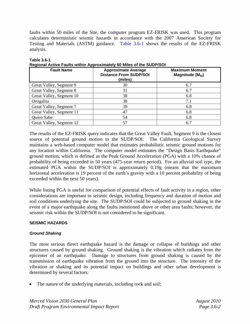
faults within 50 miles of the Site, the computer program EZ-FRISK was used. This program calculates deterministic seismic hazards in accordance with the 2007 American Society for Testing and Materials (ASTM) guidance. Table 3.6-1 shows the results of the EZ-FRISK analysis. Table 3.6-1 Regional Active Faults within Approximately 60 Miles of the SUDP/SOI
Fault Name Approximate Average Distance From SUDP/SOI
(miles)
Maximum Moment Magnitude (MW)
Great Valley, Segment 9 30 6.7 Great Valley, Segment 8 31 6.7 Great Valley, Segment 10 38 6.8 Ortigalita 38 7.1 Great Valley, Segment 7 39 6.8 Great Valley, Segment 11 47 6.8 Quien Sabe 54 6.8 Great Valley, Segment 12 57 6.7
The results of the EZ-FRISK query indicates that the Great Valley Fault, Segment 9 is the closest source of potential ground motion to the SUDP/SOI. The California Geological Survey maintains a web-based computer model that estimates probabilistic seismic ground motions for any location within California. The computer model estimates the “Design Basis Earthquake” ground motion, which is defined as the Peak Ground Acceleration (PGA) with a 10% chance of probability of being exceeded in 50 years (475-year return period). For an alluvial soil type, the estimated PGA within the SUDP/SOI is approximately 0.19g (means that the maximum horizontal acceleration is 19 percent of the earth’s gravity with a 10 percent probability of being exceeded within the next 50 years). While listing PGA is useful for comparison of potential effects of fault activity in a region, other considerations are important in seismic design, including frequency and duration of motion and soil conditions underlying the site. The SUDP/SOI could be subjected to ground shaking in the event of a major earthquake along the faults mentioned above or other area faults; however, the seismic risk within the SUDP/SOI is not considered to be significant. SEISMIC HAZARDS Ground Shaking The most serious direct earthquake hazard is the damage or collapse of buildings and other structures caused by ground shaking. Ground shaking is the vibration which radiates from the epicenter of an earthquake. Damage to structures from ground shaking is caused by the transmission of earthquake vibration from the ground into the structure. The intensity of the vibration or shaking and its potential impact on buildings and other urban development is determined by several factors: • The nature of the underlying materials, including rock and soil;
Merced Vision 2030 General Plan August 2010 Draft Program Environmental Impact Report Page 3.6-3
• The structural characteristics of a building; • The quality of workmanship and materials used in its construction; • The location of the epicenter and the magnitude of the earthquake; and • The duration and character of the ground motion. As PGA is a measure of the ground motion severity experienced at a site due to an earthquake. The PGA of 0.19g applicable to the area within the SUDP/SOI means that the maximum horizontal acceleration is 19 percent of the earth’s gravity with a 10 percent probability of being exceeded within the next 50 years. Ground shaking can cause such indirect effects as ground failure, seiche, and dam failure. While listing PGA is useful for comparison of potential effects of fault activity in a region, other considerations are important in seismic design, including frequency and duration of motion and soil conditions underlying the SUDP/SOI. The area within the SUDP/SOI boundary could be subjected to ground shaking in the event of a major earthquake along the faults mentioned above or other area faults; however, the seismic risk within the SUDP/SOI is not considered to be significant. Liquefaction Liquefaction is a phenomenon in which the strength and stiffness of the soil is reduced by earthquake shaking or other rapid loading. Liquefaction and related phenomena have been responsible for tremendous amounts of damage in earthquakes around the world. Liquefaction of granular soils can be caused by strong vibratory motion due to earthquakes. Soils that are highly susceptible to liquefaction are loose, granular and saturated. The liquefaction of soils causes surface distress, loss of bearing capacity, and settlement of structures that are founded on the soils. Based on the predicted seismic accelerations, and soil and groundwater conditions typically encountered in the region, general liquefaction potential is low within the SUDP/SOI. Slope Stability and Erosion The area within the City’s SUDP/SOI is generally level to gently sloping. Slopes potentially subject to failure are not generally present within the SUDP/SOI where development is likely to have a significant impact. The currently stable conditions may be changed by slope alterations due to cuts or fills, and changes to drainage patterns. In general, the potential for land sliding or slope failure in the SUDP/SOI in its current condition is very low. The USDA generally describes the soils in the SUDP/SOI as having slight erosion potential. Naturally occurring soils in the plan are can be seen in Figure 3.6-1. Seiche and Dam Failure A seiche is a wave occurring in confined bodies of water, such as lakes, reservoirs, or bays, and can be initiated by winds, seismic events, or landslides. Earthquakes can also cause a tsunami (i.e., tidal waves) in large bodies of water.

Merced Vision 2030 General Plan August 2010 Draft Program Environmental Impact Report Page 3.6-4
Dam failures can result from a number of natural or man-made causes such as earthquakes (creating a “seiche” or an overtopping of a dam), erosion, improper siting, rapidly rising flood waters, and structural/design flaws. There are three general types of dams: earth and rockfill, concrete arch or hydraulic fill, and concrete gravity. Each of these types of dams has different failure characteristics. Merced is presently in the inundation area of two dams, Bear Reservoir Dam and Lake Yosemite Dam. Both of these dams are earthen-fill which makes them more flexible and, therefore, more earthquake resistant. However, they are more likely to fail if over-topped. An earthen dam will fail gradually due to erosion of the breach created during the over-topping; the flood wave will build gradually to peak and then decline until the reservoir is empty. A dam failure can cause loss of life, damage to property, and other ensuing hazards, as well as displacement of residents, the loss or partial loss of critical mass care facilities, and the destruction of bridges (evacuation routes) in the inundation path. The effects of a possible dam failure upon the City of Merced, and the ability of the local community to respond, seem to vary greatly by which dam would fail. Lake Yosemite’s inundation area covers a large portion of the City’s SUDP/SOI in North Merced (reference Figure 3.8-2 in the Hydrology and Water Quality section). The Merced Streams Group Project and Flood Control Plan authorized by Congress in 1970, but not as yet completed due to lack of local matching funds, would divert the flood waters from the flood control canals which created problems in 1968, thus reducing the risk of Yosemite Dam failure. Castle Dam is complete, and a diversion structure, which diverts more than 1,200 cubic feet of water per second from MID’s main canal is also complete. This reduces the flow in Fahrens Creek, thus reducing the likelihood of flooding within a given event. The Bear Reservoir Dam inundation area covers a good portion of the City’s SUDP/SOI east to west as shown in Figure 3.8-2. The dam, also being earthen, would fail gradually due to the erosion of the breach. The flood wave would build gradually to a peak and then decline until the reservoir is empty. Expansive Soils Expansive soils are those soils that shrink and swell in response to changes in moisture content potentially causing serious damage to overlying structures. Soils in the area are generally moderate to deep, silty and clayey loams. Some gravely and cobbley loams are also present, primarily concentrated in the stream drainages. The soils listed are not generally considered to be expansive, have a generally low to moderate erosion potential, and are generally considered suitable for wastewater disposal using conventional septic systems. Subsidence Differential settlement, resulting in the compaction of loose, less cohesive soils, may be caused by earthquakes and could occur in the City’s SUDP/SOI. The most likely areas are those in

YbA
HtA
YbA
LaA
SbA
ScA
WnA
BaA
YbA
WnA
LeA
WnA
ReB
YbA
YbA
SdA
RbA
WhB
ReB
YbA
WoA
YbA
WnA
RsA
ReB
CgB
LaA
LpA
HwA
WnA
YaA
ReB
SdA
LfA
ReB
LfA
LaA
YcA
YbA
LeA
WoA
WnA
ReB
CgB
LeA
SbAW
nA
LoA
LeA
WoA
ReB
LaA
SdA
ScA
ScB
WrALeA
WnA
LeA
RaA
YaA
WoA
YbA
WnA
MgA
ReB
LhA
YbA
RdA
HwA
SbB
WnA
YbA
CgB
WrA
LaA
LaA
GfA
YbA
LeA
YbA
WnA
RtA
LpA
CgB
MrB
SbA
SdA
LgA
ScA
SbB
4HB
ReB
WoA
ScB
LfA
LoA
LeA
WoA
LaA
HtA
ReB
LoA
BpA
LpA
LpA
LaA
HtA
2HB
LeA
LaA
AaA
RaA
3HB
W
LfA
RbA
LeA
SbB
LeA
CgB
RbA
ReB
LnA
WnA
MfA
AaA
LfA
RbA
LbA
LeA
LfA
LaA
SdA
RbA
WnA
WrA
LpA
ScA
LeA
LeA
2HB
BpA
SdA
SdA
SdA
WoA
LeA
WoA
SbA
RsA
ReB
LeA
RgB
RgA
RgB
LgA
MfA
RsA
YbA
YbA
LbA
MrB
LeA
AcA
LeA
3HA
BcA
2HB
WnA
WoA
WnA
WrA
2HB
AaA
SdA
3HA
RaA
RsA
ReB
LgA
LaA
RgA
SbA
YbA
WoA
YbA
WhB
HtA
RgB
SbA
AaA
2HB
HxA
ReB
ReB
3HB
BkA
YbA
YbA
MrA
WnA
HwA
SdA
2HB
WnA
ReB
LeA
3HA
2HB
BdA
SbA
WoA
LfA
YbA
WhB
BrA
W
LfA
MeA
BaA
BnA
RsA
4HB
CgB
RsA
LaA
ReB
LdA
SdA
LhA
ScB
YdA
WoA
WoA
CkB
WnA
BcA
BnA
PhD
SbA
ReD
SdA
WhB
ScA
WnA
LaA
LoA
RbA
SdA
RaA
SbA
WoA
ReB
WoA
HtA
LfA
RsA
AaA
SdA
2HB
W
WnA
PnB
ReB
BrA
RaB
BnALeA
SbB
LbA
WmB2
PwA
SbA
RbA
LrA
SbB
SdA
LpA
CgB
WoA
HwA
MrB
LeA
LaA
WrA
MrB
BnA
WoA
3HB
LoA
ReB
LgA
CkB
3HARbB
WnA
BpA
ReB
SdA
SbAScA
CkB
W
BkA
RaA
CgB
LfA
MrA
HwA
RaA
RsB
MrB
RbA
LpA
MrB
SbB
AaA
BpA
CkB
LaA
WoA
LaA
LaA
ScB
SbB
BkA
LaA
3HB
2HB
HuA
SbB
SbB
LbA
MfA
ReB
RgA
WhB
BpA
WoA
LpA
LpA
WhB
LeA
YbA
SbA
WrA
3HA
SdA
BpA
RtA
WnA
SbA
WmB2
2HB
RbA
ReD
4HB
LaARbA
3HA
SbB
MfA
RsA
RbA
ScB
SdA
ScB
ReB
RbA
MrA
LaA
ScB
W
LhA
ReB
RbA
PhB
LaA
4HB
CgB
WnA
SbB RkB2
LoA
RsA
KaB
RbA
Tg
LaA
SbB
MfA
AaA
RaB
SbA
RaA
AaA
ReBMrB
LaA
LfA
BgA
PmD
PkD
ReB
RbA
ScB
RbB
LeA
SbB
HtA
AaA
SdA
YaA
4HB
AaA
LeA
RaA
AaA
HwA
BnA
AaA
BpA
ReB
ReB ReB
AaA
CgB
LfA
WnA
ReB
LaA
RaA
AaA
LeA
RbA
ReB
ReB
AaA
ScA
SbB
WoA
MrB ReB
LaA
2HB
RbA
AaA
RbA
ReB
RbA
WoA
RaA
LaA
MrA
3HA
BcA
AcA
ReB
LeA
WrA
AaA
YbA
LaA
AaA
LoA
CgB
BrA
RbA
PmD CgB
BpA
RaA
SbB
SbA
LaA
YbA
AaA
WhB
AaA
W
BnA
LaA
BpA
BnA
CgB
LoA
LaA
RsA
LoA
AaA
CgB
PkD
ReB
BpA
SbB
WrA
WoA
CgB
LrA
3HB
ReB
LrA
BcA
CgB
Job No.: 060429
Source: USGS, 2009 / USDA, 2009 / City of Merced, 2009 / Quad Knopf, 2009
MERCED VISION 2030 GENERAL PLAN EIRSOILS MAP
Figure 3.6-1
0 0.5 1 1.5 2
Miles
LegendMerced City Limit
Proposed Sphere of Influence (SOI)
Soils2HB, Hopeton clay, 0 to 8 percent slopes
3HA, Hopeton clay loam, 0 to 3 percent slopes
3HB, Hopeton clay loam, 3 to 8 percent slopes
4HB, Hopeton gravelly clay loam, 0 to 8 percent slopes
AaA, Alamo clay, 0 to 1 percent slopes
AcA, Anderson gravelly soils, channeled, 0 to 3 percent slopes
BaA, Bear Creek clay loam, 0 to 3 percent slopes
BcA, Bear Creek loam, 0 to 3 percent slopes
BdA, Bear Creek soils, 0 to 3 percent slopes
BkA, Burchell silt loam, slightly saline-alkali, 0 to 1 percent slopes
BnA, Burchell silty clay loam, 0 to 1 percent slopes
BpA, Burchell silty clay loam, slightly saline-alkali, 0 to 1 percen slopes
BrA, Burchell silty clay loam, moderately saline-alkali, 0 to 1 percent slopes
CgB, Corning gravelly loam, 0 to 8 percent slopes
CkB, Corning gravelly sandy loam, 0 to 8 percent slopes
GfA, Greenfield sandy loam, deep over hardpan, 0 to 3 percent slopes
HtA, Honcut silt loam, 0 to 1 percent slopes
HuA, Honcut silt loam, deep over hardpan, 0 to 1 percent slopes
HwA, Honcut silty clay loam, 0 to 1 percent slopes
HxA, Honcut silty clay loam, deep over hardpan, 0 to 1 percent slope
KaB, Keyes gravelly clay loam, 0 to 8 percent slopes
LaA, Landlow clay, 0 to 1 percent slopes
LbA, Landlow clay, slightly saline-alkali, 0 to 1 percent slopes
LeA, Landlow silty clay loam, 0 to 1 percent slopes
LfA, Landlow silty clay loam, slightly saline-alkali, 0 to 1 percent slopes
LgA, Lewis clay, slightly saline-alkali, 0 to 1 percent slopes
LhA, Lewis clay, moderately saline-alkali, 0 to 1 percent slopes
LoA, Lewis silty clay loam, slightly saline-alkali, 0 to 1 percent slopes
LpA, Lewis silty clay loam, moderately saline-alkali, 0 to 1 percent slopes
LrA, Lewis silty clay loam, strongly saline-alkali, 0 to 1 percent slopes
MfA, Marguerite silty clay loam, 0 to 1 percent slopes
MgA, Marguerite silty clay loam, deep over hardpan, 0 to 1 percent slopes
MrA, Montpellier coarse sandy loam, 0 to 3 percent slopes
MrB, Montpellier coarse sandy loam, 3 to 8 percent slopes
PhB, Pentz clay loam, 0 to 8 percent slopes
PhD, Pentz clay loam, 8 to 30 percent slopes
PkD, Pentz gravelly loam, 8 to 30 percent slopes
PmD, Pentz loam, 8 to 30 percent slopes
PnB, Peters clay, 0 to 8 percent slopes
PwA, Porterville clay, o to 3 percent slopes
RaA, Raynor clay, 0 to 3 percent slopes
RaB, Raynor clay, 3 to 8 percent slopes
RbA, Raynor cobbly clay, 0 to 3 percent slopes
RbB, Raynor cobbly clay, 3 to 8 percent slopes
RdA, Redding gravelly loam, poorly drained variant, 0 to 3 percent slopes
ReB, Redding gravelly loam, 0 to 8 percent slopes
ReD, Redding gravelly loam, 8 to 30 percent slopes
RgA, Rocklin loam, 0 to 3 percent slopes
RgB, Rocklin loam, 3 to 8 percent slopes
RkB2, Rocklin sandy loam, 3 to 8 percent slopes, eroded
RsA, Ryer clay loam, 0 to 2 percent slopes
RsB, Ryer clay loam, 3 to 8 percent slopes
RtA, Ryer silt loam, 0 to 3 percent slopes
SbA, San Joaquin loam, 0 to 3 percent slopes
SbB, San Joaquin loam, 3 to 8 percent slopes
ScA, San Joaquin sandy loam, 0 to 3 percent slopes
ScB, San Joaquin sandy loam, 3 to 8 percent slopes
SdA, San Joaquin-Alamo complex, 0 to 3 percent slopes
Tg, Terrace escarpments
W, Water
WhB, Whitney fine sandy loam, 3 to 8 percent slopes
WmB2, Whiney and Rocklin soils, 3 to 8 percent slopes, eroded
WnA, Wyman clay loam, deep over hardpan, 0 to 1 percent slopes
WoA, Wyman clay loam, 0 to 3 percent slopes
WrA, Wyman loam, 0 to 3 percent slopes
YaA, Yokohl clay, 0 to 3 percent slopes
YbA, Yokohl clay loam, 0 to 3 percent slopes
YcA, Yokohl loam, 0 to 3 percent slopes
Merced Vision 2030 General Plan August 2010 Draft Program Environmental Impact Report Page 3.6-5
which the groundwater surface is deep (otherwise liquefaction would be more likely), the soils are loose to medium-dense, and the soil profile includes strata of loose and uniformly graded sand. The potential for ground subsidence due to earthquake motion is largely dependent on the magnitude, duration, and frequency of the earthquake waves. Unlike tectonic or seismically stimulated subsidence which occurs suddenly, most of the various cases of subsidence happen slowly over a long period of time. The west side of the San Joaquin Valley has been recognized as the world’s largest area of subsidence due to groundwater withdrawal. Until recently, the County’s subsiding area has been in the vicinity of Los Banos; however, a new subsiding area has been discovered near El Nido east of the San Joaquin River. No known subsidence has occurred in the Merced planning area or has accompanied groundwater withdrawal. Lurch Cracking and Lateral Spreading Lurch cracking and lateral spreading are processes that result in free face failures during a seismic event. No significant free face failures were observed within the SUDP/SOI and the potential for lurch cracking and lateral spreading is, therefore, very low in the SUDP/SOI in its current condition. Seismic Settlement Due to the moderate- to well-drained and generally consolidated nature of the geologic materials within the SUDP/SOI area, the risk of seismic settlement is considered to be low. Naturally Occurring Asbestos Potentially naturally occurring asbestos (NOA) containing rock formations are not known to be present in the San Joaquin Valley. Potentially NOA-containing rock formations do occur in the Western Sierra from which the sediments underlying the City of Merced are derived; however, the probability that materials containing NOA concentrations at or above the current regulated level of 0.25% is very low. Volcanism The City of Merced is located in a sedimentary basin that is well over 100 million years old, and has not been volcanically active in that time. Volcanic deposits less than 10 million years old indicative of a latent volcanic hazard are not present in the SUDP/SOI. The closest significant potential area of volcanism to the SUDP/SOI is the Mono Lakes and Mammoth areas approximately 50 miles east. Although it is likely that at some time in the future volcanism will resume in the region, it is unlikely that this will occur in the next millennia.

Merced Vision 2030 General Plan August 2010 Draft Program Environmental Impact Report Page 3.6-6
Regulatory Setting FEDERAL U.S. Uniform Building Code (UBC) The U.S. Uniform Building Code (UBC) has design criteria for excavations and structures under static and dynamic loading conditions. STATE California Building Code The California Building Code is another name for the body of regulations known as the California Code of Regulations (C.C.R.), Title 24, Part 2, which is a portion of the California Building Standards Code. Title 24 is assigned to the California Building Standards Commission, which, by law, is responsible for coordinating all building standards. Under state law, all building standards must be centralized in Title 24 or they are not enforceable (Bolt, 1988). Published by the International Code Council, the International Building Code (IBC) is a widely adopted model building code in the United States. The California Building Code incorporates by reference the IBC with necessary California amendments. About one-third of the text within the California Building Code has been tailored for California earthquake conditions. Alquist-Priolo Earthquake Fault Zoning Act The Alquist-Priolo Earthquake Fault Zoning Act (formerly the Alquist-Priolo Special Studies Zone Act), signed into law December 1972, requires the delineation of zones along active faults in California. The purpose of the Alquist-Priolo Act is to regulate development on or near active fault traces to reduce the hazards associated with fault rupture and to prohibit the location of most structures for human occupancy across these traces. Cities and counties must regulate certain development projects within the zones, which includes withholding permits until geologic investigations are conducted in order to demonstrate that development sites are not threatened by future surface displacement (Hart, 1997). Surface fault rupture is not necessarily restricted to the area within an Alquist-Priolo Zone. Seismic Hazards Mapping Act The Seismic Hazards Mapping Act was developed to protect the public from the effects of strong groundshaking, liquefaction, landslides, or other ground failure/hazards caused by earthquakes. This act requires the State Geologist to delineate seismic hazard zones and requires cities, counties, and other local permitting agencies to regulate certain development projects within these zones. Before a development permit is granted for a site within a seismic hazard zone, a geotechnical investigation of the site has to be conducted and appropriate mitigation measures incorporated into the project design.
Merced Vision 2030 General Plan August 2010 Draft Program Environmental Impact Report Page 3.6-7
California Department of Transportation Caltrans has developed roadway design standards including those for seismic safety. Consideration of earthquake hazards in roadway design is detailed in the Highway Design Manual published by Caltrans (1995). Modifications to local highways and roads would be required to adhere to Caltrans engineering standards to minimize settlement. Government Code Section 65302(g) Government Code Section 65302(g) discusses the significant issues that a General Plan must address in its Safety Element. Among these issues are the potential for seismically induced surface rupture, groundshaking, ground failure, seiche, tsunami, slope instability, and subsidence. Seismic and geologic hazards must be considered in determining design and building standards, and the location of future development, in order to minimize or mitigate the risk of injury, death and property damage which could result from natural and man-made hazards. LOCAL General Plan Consistency The Merced Vision 2030 General Plan contains a number of policies that apply to geological/soils related impacts in conjunction with ultimate build-out of the City in accordance with the General Plan. The specific policies listed below contained in the Parks, Open Space, and Conservation and Safety Elements of the General Plan are designed to ensure that geological/soils related impacts are minimized as development occurs in accordance with the Merced Vision 2030 General Plan. Open Space, Conservation, and Recreation Policies: OS-5.2 Protect soil resources from the erosive forces of wind and water. Safety Policies: S-2.1 Reduce the potential danger from earthquake and seismic-related activity from
existing buildings where necessary.
S-2.2 Encourage the improvement of all public facilities and infrastructure such as natural gas, fuel, sewer, water, electricity, and railroad lines and equipment with up-to-date seismic safety features.
S-2.3 Restrict urban development in all areas with potential ground failure characteristics.
3.6.2 THRESHOLDS OF SIGNIFICANCE According to Appendix G of the CEQA Guidelines, the proposed project is considered to have a significant impact on the environment if it will:

Merced Vision 2030 General Plan August 2010 Draft Program Environmental Impact Report Page 3.6-8
• Expose people or structures to potential substantial adverse effects, including the risk of loss, injury, or death involving:
Rupture of a known earthquake fault, as delineated on the most recent Alquist-Priolo
Earthquake Fault Zoning Map issued by the State Geologist for the area or based on other substantial evidence of a known fault. Refer to Division of Mines and Geology Special Publication 42
Strong seismic ground shaking Seismic-related ground failure, including liquefaction Landslides
• Result in substantial soil erosion or the loss of topsoil • Be located on a geologic unit or soil that is unstable, or that would become unstable as a
result of the project, and potentially result in on- or off-site landslide, lateral spreading, subsidence, liquefaction or collapse
• Be located on expansive soil, as defined in Table 18-1-B of the Uniform Building Code
(1994), creating substantial risks to life or property • Have soils incapable of adequately supporting the use of septic tanks or alternative waste
water disposal systems where sewers are not available for the disposal of waste water 3.6.3 IMPACTS AND MITIGATION MEASURES Impact #3.6-1: Expose people or structures to potential substantial adverse
effects from seismic hazards Discussion/Conclusion: Merced County is divided into two major geologic provinces: the Sierra Nevada Mountains and the Central Valley. The City of Merced is located in the northeastern portion of the County, in the Central Valley geologic province. Although the City of Merced is situated in proximity to several fault groups (see Table 3.6-1), it is not identified to be located in a delineated Alquist-Priolo Earthquake Fault Zone. Isolated portions of the County may be subject to strong seismic groundshaking. These locations are primarily located to the south, east, and west of the City of Merced. The nearest faults of major historical significance are the San Andreas Fault, 58 miles to the west; the Hayward and Calaveras faults to the northwest; and the White Wolf, Garlock, and Sierra faults to the south. These seem to be the most likely to shake the City of Merced again in the future. The probability of soil liquefaction actually occurring in the County, including within the City of Merced, is considered to be a low to moderate hazard; however, detailed geotechnical engineering investigations at a site specific level would be necessary to more accurately evaluate liquefaction potential in specific areas. Policies included in the proposed General Plan to provide for the safety of all residents from earthquake and other geologic hazards include Policies S-2.1, S-2.2 and S-2.3 which call for the City to reduce the potential danger from earthquake and seismic-related activity from existing buildings where necessary; to encourage the improvement of all public facilities and
Merced Vision 2030 General Plan August 2010 Draft Program Environmental Impact Report Page 3.6-9
infrastructure; and restrict urban development in all areas with potential ground failure characteristics. Implementing actions of each of these policies provide further guidance and actions for reducing seismic related hazards in the City of Merced (2.1.a, 2.1.b, 2.1.c, 2.1.d, 2.1.e, 2.1.f, 2.2.a, 2.2.b, 2.3.a and 2.3.b). As stated above, the City will implement a variety of policies and implementing actions designed to address public health and safety issues resulting from seismic hazards. Therefore, implementation of the proposed General Plan, adherence to the Alquist-Priolo Act, and enforcement of the California Building Standards Code would result in a less than significant impact. Mitigation Measures No mitigation measures are required. Impact #3.6-2: The proposed project would not result in substantial soil erosion
or the loss of topsoil Discussion/Conclusion: Erosion is a normal and inevitable geologic process whereby earth materials are loosened, worn away, decomposed or dissolved, and are removed from one place and transported to another location. Precipitation, running water, and wind are all factors that contribute to erosion. Ordinarily, erosion proceeds very slowly as to be imperceptible, but when the natural equilibrium of the environment is changed, the rate of erosion can be greatly accelerated. Accelerated erosion within an urban area can cause damage by undermining structures, blocking storm sewers and depositing silt, sand, or mud in roads and tunnels. Consequently, these erosion effects can result in a variety of aesthetic and engineering problems. Additionally, eroded materials are eventually deposited into local waterways where the carried silt remains suspended for some time, constituting a pollutant and altering the normal balance of a waterway ecosystem. The City’s topography is relatively flat, with soil conditions that exhibit minimal potential for erosion impacts. Development activities resulting from buildout of the proposed General Plan could accelerate the erosion rate through both an increase in short-term construction-related activities and an overall increase in the amount of impervious surfaces. Development in the City would be subject to local and State codes and requirements for erosion control and grading. In addition, project sites encompassing an area of one or more acres would require compliance with a NPDES permit and consequently the development and implementation of a Storm Water Pollution Prevention Plan (SWPPP). Consequently, erosion-related effects can be minimized through implementation of the policies and implementing actions provided as part of the Open Space, Conservation and Recreation Element. Policy OS-5.2 calls for the City to protect soil resources from the erosive forces of wind and water. Implementing Actions 5.2.a and 5.2.c of Policy OS-5.2 call for the City to reduce the soil erosion potential of new development, and maintain adequate vegetation along the banks of urban streams and storm water drainage channels. With implementation of the

Merced Vision 2030 General Plan August 2010 Draft Program Environmental Impact Report Page 3.6-10
policies and implementing actions and adherence to applicable federal, state and local regulations as noted above, this impact is considered less than significant. Mitigation Measures No mitigation measures are required.
Impact #3.6-3: The proposed project would not be located on a geologic unit or soil that is unstable, or that would become unstable as a result of the project, and potentially result in on-or off-site landslide, lateral spreading, subsidence, liquefaction, or collapse
Discussion/Conclusion: The Foothill and Mountain areas of the County are more likely to experience landslides than the Valley area. The City of Merced is located in the Valley area of the County and is therefore less likely to experience landslides than other areas in the County. Susceptible areas include areas where fractured and steep slopes are present or where inadequate ground cover accelerates erosion. The probability of soil liquefaction actually taking place anywhere in the City of Merced is considered to be a low hazard. Soil types in the area are not conducive to liquefaction because they are either too coarse or too high in clay content. No significant free face failures were observed within the SUDP/SOI and the potential for lurch cracking and lateral spreading is, therefore, very low in the SUDP/SOI in its current condition. As stated above and under Impacts #3.6-1 and #3.6-2, the City will implement a variety of policies and implementing actions (policies OS-5.2 and S-2.3, and Implementing Actions 5.2.a, 5.2.b, 5.2.c, 2.3.a and 2.3.b) designed to address public health and safety issues resulting from an unstable geologic unit. Therefore, implementation of the proposed General Plan, adherence to the Alquist-Priolo Act, and enforcement of the California Building Standards Code would result in a less than significant impact. Mitigation Measures No mitigation measures are required. Impact #3.6-4: The proposed project could be located on expansive soils
creating substantial risks to life or property Discussion/Conclusion: Expansive soils are those possessing clay particles that react to moisture changes by shrinking (when they dry) or swelling (when they become wet). Expansive soils can also consist of silty to sandy clay. The extent of shrinking and swelling is influenced by the environment, including the extent of wet or dry cycles, and by the amount of clay in the soil. This physical change in the soils can react unfavorably with building foundations, concrete walkways, swimming pools, roadways, and masonry walls. Soils in the area are generally moderate to deep, silty and clayey loams. Some gravely and cobbley loams are also present, primarily concentrated in the stream drainages. The soils listed are not generally considered to be expansive, have a generally low to moderate erosion potential, and are generally considered suitable for wastewater disposal using conventional septic systems.

Merced Vision 2030 General Plan August 2010 Draft Program Environmental Impact Report Page 3.6-11
As stated above, Policy S-2.3 calls for the City to restrict urban development in all areas with potential ground failure characteristics. Implementing Action 2.3.a of this policy says that the City will investigate the feasibility of performing an inventory of areas with generally unstable ground within the SUDP/SOI area and work with the County to restrict or prohibit their development. In the Merced planning area, most of the unstable ground are in old streams beds, near embankments, and adjacent to streams with sufficient velocities to erode the bank. This policy and the other policies noted previously under Impacts #3.6-1 through #3.6-3 are designed to address public health and safety issues resulting from an unstable geologic unit, including expansive soils. Therefore, implementation of the proposed General Plan, adherence to the Alquist-Priolo Act, and enforcement of the California Building Standards Code would result in a less than significant impact. Mitigation Measures No mitigation measures are required. Impact #3.6-5: Have soils incapable of adequately supporting the use of septic
tanks or alternative waste water disposal systems where sewers are not available for the disposal of waste water
According to the Geologic, Geohazards and Environmental Health Hazards Evaluation Report (Geocon Consultants, Inc.), the soils in the SUDP/SOI are not generally considered to be expansive, have a generally low to moderate erosion potential, and are generally considered suitable for wastewater disposal using conventional septic systems. The impact is less than significant. Mitigation Measures No mitigation measures are required. CUMULATIVE IMPACT ANALYSIS Regional development would increase the number of people and structures subject to geologic and soils-related risks. The policies contained in the proposed General Plan, along with compliance with federal, State and local regulations addressing building construction, run-off and erosion, reduce the potential project-level impact associated with geology and soils to a less than significant level. Development in other communities and unincorporated areas in Merced County would also be required to comply with federal, State and local regulations that are designed to protect increases in people and structures from hazards related to such issues as earthquakes, landslides and soil erosion. As a result, conformance with adopted California building codes, and other measures to protect people and structures from geologic hazards, would reduce this impact to a less than significant level. The project’s incremental contribution to these impacts will be less than cumulatively considerable.