3.3 Bunbury: Dalyellup Beach and the Preston River Delta
9
40 3.3 Bunbury: Dalyellup Beach and the Preston River Delta a. Setting of transects Bunbury has a climate which can be classified as sub-humid, warm mediterranean (Wilde&Walker,1982). It is located in the south of the Drummond Botanical Subdistrict (Beard 1980) or the Swan Coastal Plain Biogeographical Region (IBRA, 2000). The mean annual rainfall is approximately 872 mm with an annual evaporation of 1554 mm (Roelands weather station, Bureau of Meteorology, 2002). Winter rain is generally reliable and the growing season averages about seven months (Beard, 1990a). There is a land and sea breeze pattern of winds up to 20 km/hr from the SE to NE and SW respectively in summer (Semeniuk et al., 1989). The project area lies in the southern region of the Perth Basin (Playford et al., 1976) on the Swan Coastal Plain. The Holocene beachridges and shore-normal, high relief parabolic dunes immediately adjacent to the coast at Dalyellup (transect B1) are part of the Quindalup to Leschenault sector of the Quindalup Dunes (Semeniuk et al.,1989) and consist of Safety Bay Sand. The Spearwood Dunes adjoining the latter inland (and often underlying the Quindalup Dunes closer to the shoreline) are largely Pleistocene aeolianite (Tamala Limestone) with some quartz and calcareous sands. The Preston River Delta (transect B2) is situated adjoining Koombana Bay in the City of Bunbury (Fig 15) and was once part of the Leschenault Inlet Estuary (see Fig 1 of Semeniuk, 2000 for an aerial view of the original delta). Natural landforms of this area have been extensively modified in recent years by local industry. What was once the tide-dominated delta of the Preston River, draining freshwater from the hinterland (including the Leschenault Inlet) to the ocean, is now a marine embayment cut off from the river and the inlet by landfill.The Leschenault Inlet now drains to the ocean by a man-made channel colloquially know as “The Cut”. The habitat, physiognomy and biogeographical aspects of the mangrove population on the site are described in (Semeniuk et al., 2000) and this information is summarized below. The tides in the area are generally diurnal and microtidal with a mean spring range of 0.5m and maximum range
Transcript of 3.3 Bunbury: Dalyellup Beach and the Preston River Delta

40 3.3 Bunbury: Dalyellup Beach and the Preston River Delta a. Setting of transects
Bunbury has a climate which can be classified as sub-humid, warm mediterranean
(Wilde&Walker,1982). It is located in the south of the Drummond Botanical Subdistrict (Beard
1980) or the Swan Coastal Plain Biogeographical Region (IBRA, 2000). The mean annual
rainfall is approximately 872 mm with an annual evaporation of 1554 mm (Roelands weather
station, Bureau of Meteorology, 2002). Winter rain is generally reliable and the growing season
averages about seven months (Beard, 1990a). There is a land and sea breeze pattern of winds up
to 20 km/hr from the SE to NE and SW respectively in summer (Semeniuk et al., 1989).
The project area lies in the southern region of the Perth Basin (Playford et al., 1976) on the Swan
Coastal Plain. The Holocene beachridges and shore-normal, high relief parabolic dunes
immediately adjacent to the coast at Dalyellup (transect B1) are part of the Quindalup to
Leschenault sector of the Quindalup Dunes (Semeniuk et al.,1989) and consist of Safety Bay
Sand. The Spearwood Dunes adjoining the latter inland (and often underlying the Quindalup
Dunes closer to the shoreline) are largely Pleistocene aeolianite (Tamala Limestone) with some
quartz and calcareous sands.
The Preston River Delta (transect B2) is situated adjoining Koombana Bay in the City of
Bunbury (Fig 15) and was once part of the Leschenault Inlet Estuary (see Fig 1 of Semeniuk,
2000 for an aerial view of the original delta). Natural landforms of this area have been
extensively modified in recent years by local industry. What was once the tide-dominated delta of
the Preston River, draining freshwater from the hinterland (including the Leschenault Inlet) to the
ocean, is now a marine embayment cut off from the river and the inlet by landfill.The
Leschenault Inlet now drains to the ocean by a man-made channel colloquially know as “The
Cut”.
The habitat, physiognomy and biogeographical aspects of the mangrove population on the site are
described in (Semeniuk et al., 2000) and this information is summarized below. The tides in the
area are generally diurnal and microtidal with a mean spring range of 0.5m and maximum range

41 of 0.9m. Tidally-aligned shoals and emergent islands occur amongst the channels with emergent
surfaces located between mean sea level to just above the highest astronomical tide. The shoals
and islands of the delta are comprised of shelly and quartz deltaic sands, with sandy crests
flanked by deltaic mud to about 50cm in depth. There is a large accumulation of vegetation
detritus in the bioturbated mud of the mangrove-inhabited zones. The ground water is generally
in the order of marine salinity in the mangrove zones and brackish in the centre of islands where
sandy crest elevation is sufficient to allow rainfall recharge. Hypersaline soil conditions occur on
some shoals and high tidal platforms which are isolated from regular marine flushing
b. Results of transect surveys
Surface sediments at Dalyellup Beach, (Table 10) were cream-coloured, medium to coarse
quartz and calcareous sands (with a little more quartz than calcareous grains). The stratigraphy
and water salinity of the Preston River Delta is comprehensively described elsewhere (see above)
and was not further investigated in this study.
Table 10: Dalyellup transect surface sediments.
Position on foredune Description
Incipient foredune Cream and white, medium to coarse, quartz and calcareous sand. Break of foredune slope (midslope) Humic, medium to coarse quartz and calcareous sand. Crest of foredune. Cream and white, medium to coarse, quartz and calcareous sand.
At Dalyellup Beach, the vegetation comprises heaths and scrub of tall, Holocene dunes adjacent
to the coast juxtaposed in a mosaic with a woodland of Eucalyptus gomphocephala (Tuart) on the
Pleistocene hinterland (Fig 14). The recent dunes have encroached inland for variable distances
over the older ridges but their vegetation has a floristic composition very similar to the
understorey of the latter. The incipient foredune is the only unit which has significantly different
floristic elements. Otherwise, most taxa (notably Spyridium globulosum, Diplolaena dampieri,
Acacia cochlearis and many native herbs) are present throughout the vegetation from the
foredune to the hinterland ridges. Vegetation structure (i.e. heath, scrub and woodland) generally
correlates with topography and distance from the shoreline. The Holocene dune vegetation was
surveyed in detail at the Dalyellup transect and variations in this correspond with small scale
landforms comprising the incipient foredune, seaward lower slopes, the break of slope (mid

42 slope) and the upper slope and crest of a tall dune. A total of 48 indigenous and 17 alien flora
taxa were recorded in and immediately adjacent to the Dalyellup transect (Appendix 2 & 5) with
Poaceae (9 spp.), Asteraceae (5 spp.) and Papilionaceae (4 spp.) being the best represented
families.
The vegetation of the Preston River Delta (Fig 15) comprises low closed forest to low open
shrubs of the Avicennia marina (White Mangrove), Juncus kraussii closed rushes, halophyte
assemblages, a sand bar assemblage and degraded sand dune flora of the hinterland dunes. These
assemblages vary with subtle changes in height above sea level which corresponds with substrate
type (from mud in the lowest lying areas through to sand on the highest crests), soil and
groundwater salinity and frequency of marine inundation. The mangroves form a well-developed,
low closed forest to closed scrub along with Sarcocornia quinqueflora subsp. quinqueflora in the
zone between mean sea level and mean high tide where they receive daily marine flooding. In
high tidal platform, muddy settings where there is no fresh water seepage the mangroves are
confined to small scattered shrubs amongst halophytes such as Halosarcia halocnemoides subsp.
halocnemoides. Juncus kraussi generally proliferates on higher ground such as the slopes or
crests of low shoals where groundwater is brackish. Cliffed shorelines of the channels are
inhabited by a woodland of Casuarina obesa with an understorey of Melaleuca viminea, Gahnia
trifida, Halosarcia indica ssp. bidens and Atriplex sp.. Tidal pools are generally bare of
vegetation and fringed by prostrate Sarcocornia quinqueflora subsp. quinqueflora. Serious weeds
have invaded some areas with *Schinus terebinthifolia (Japanese Pepper Tree) and *Asparagus
asparagoides (Bridal Creeper) forming dense isolated stands . The sandy crests of shoals above
the highest tide are inhabited by an assemblage typical of beachridges of the area including
Olearia axillaris. The hinterland of the saltmarsh has been developed with picnic facilities and
sculpture displays however the beachridge vegetation is severely degraded and consists largely of
*Avena barbata, *Lupinus consentii and Acacia saligna. A total of 41 indigenous and 16 alien
flora taxa were recorded in and around the Preston River Delta transect (Appendix 2& 5) with
the most numerous families being Poaceae (8 spp. including 6 alien spp.), Asteraceae (6 spp.)
and Chenopodiaceae (5 spp.).
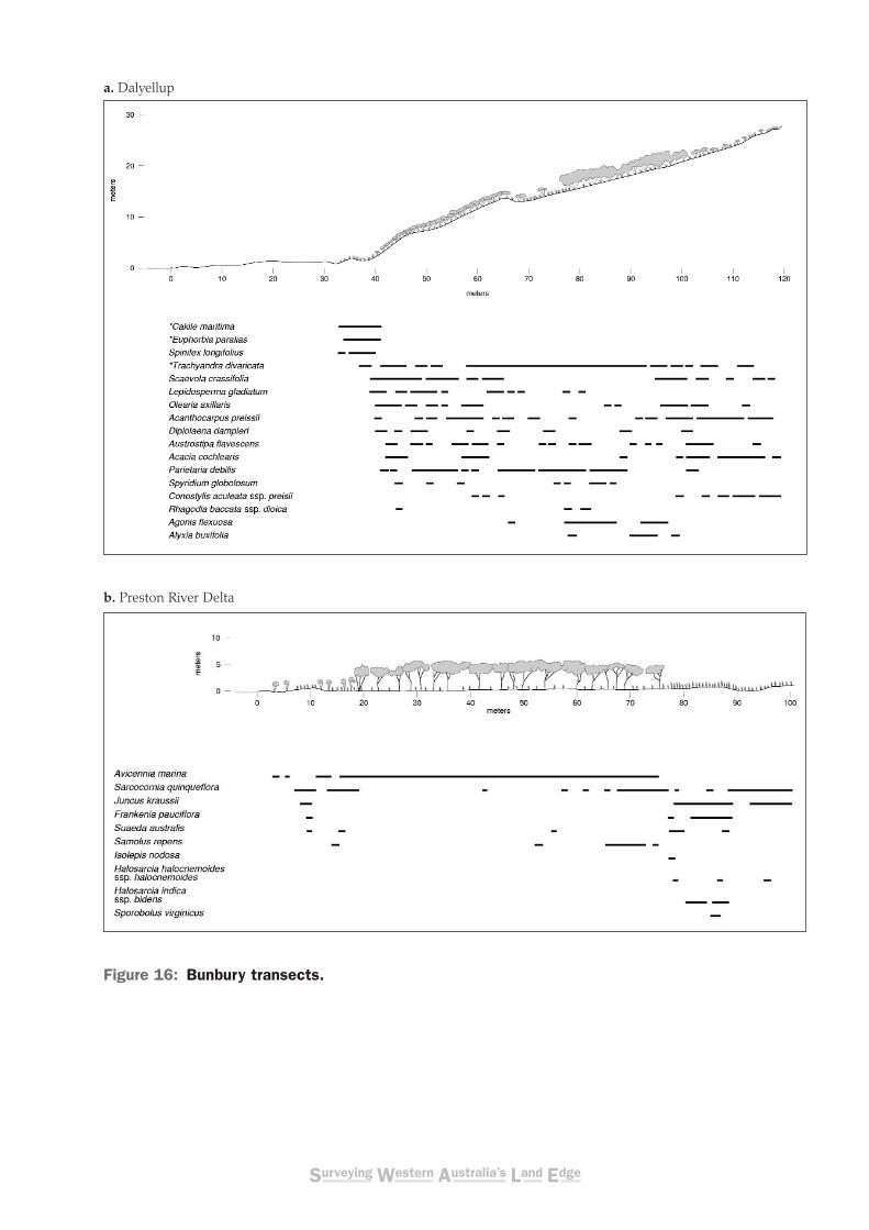
At Dalyellup Beach, *Euphorbia paralias, Spinifex longifolius and *Cakile maritima are the
major components of the incipient foredune and the blowouts near the shore (Fig 16 and Fig 17a).
*Vulpia fasciculata, *Pelargonium capitatum, *Trachyandra divaricata, *Bromus diandrus and

43 *Tetragonia decumbens inhabit the narrow swale at the base of the foredune. The steep lower
slopes of the foredune are subject to erosion in places but are generally covered by a diverse and
attractive closed heath including Scaevola crassifolia, Acacia cochlearis, Olearia axillaris,
Diplolaena dampieri, Spyridium globulosum, Hibbertia cuneiformis and Lepidosperma
gladiatum with the grasses Poa poiformis, Austrostipa flavescens and Bromus arenarius and
herbs Calandrinia brevipedata and Parietaria debilis. This heath is generally in very good
condition with few weeds except the occasional *Erharhta longiflora, *Dischisma arenarium and
*Trachyandra divaricata.
The mid slope zone of the transect is a closed scrub of Agonis flexuosa var. flexuosa (Peppermint)
with Spyridium globulosum, Rhagodia baccata subsp. dioica and Diplolaena dampieri
(Fig 17b). This has a mesic understorey of indigenous herbs and grasses including Parietaria
debilis, Daucus glochidiatus, Caladenia latifolia (Pink Fairies), Triglochin sp.B, Calandrinia
brevipedata, Hydrocotyle pilifera var. glabrata, Pterostylis brevisepala ms and Austrostipa
flavescens. The flatter areas of this zone appear more degraded (possibly due to grazing). Here
the Peppermint canopy is disrupted and there is a high cover of *Trachyandra divaricata and
*Erharhta longiflora as well as the indigenous herbs and grasses.
An open heath of Olearia axillaris, Scaevola crassifolia and Acacia cochlearis inhabits the upper
slope and crest of the dune ( Fig 17c). Associated with these are: Acanthocarpus pressii,
Carpobrotus virescens, Conostylis aculeata subsp. preissii, Jacksonia furcellata, Opercularia
vaginata, Scaevola anchusifolia and Senecio lautus subsp. maritimus.
At the Preston River Delta transect (Fig 16), Avicennia marina inhabits the edges of the shoals
where it forms low, open columnar shrubs which grade into a low closed scrub to low closed
forest with little understorey except occasional sparse Sarcocornia quinqueflora subsp.
quinqueflora, Suaeda australis and Samolus repens. Inland of the mangroves, a high tide
platform is inhabited by Halosarcia halocnemoides subsp. halocnemoides, Halosarcia indica
subsp. bidens , Sarcocornia quinqueflora subsp. quinqueflora, Suaeda australis, Frankenia
pauciflora with some sparse Juncus kraussii and Sporobolus virginicus. A bare tidal pool nearby
(Fig 17) is fringed by Sarcocornia quinqueflora subsp. quinqueflora and occasionally Lawrencia
spicata. A low sand dune emergent from the wetland is fringed by Isolepis nodosa, Triglochin
mucronata, Apium prostratum var. prostratum (Sea Celery), Cotula cotuloides, Myoporum
44 caprarioides and occasionally the orange-flowered *Romulea obscura. The sandy crest flora
comprises the shrubs Olearia axillaris, Exocarpus sparteus (Broom Ballard), the lemon-yellow
flowered Eremophila glabra subsp. albicans and Hibbertia cuneiformis as well as Sporobolus
virginicus and an assemblage of herbs, including *Melilotus indicus, *Sonchus oleraceus and
Senecio lautus subsp. maritimus. The remainder of the wetland is generally closed rushes of
Juncus kraussii with some patchy small closed stands of Poa poiformis ( both to about 1.1m in
height), Lobelia alata and *Symphyotrichum subulatum to 1.2m in height.

Figure 14: Aerial view of Dalyellup Beach, Bunbury with location of transect B/1.
Key: 1. Foredune and blowouts with
*Euphorbia paralias, *Cakilemaritima, and Spinifex longifolius.
2. Steep seaward slopes: closed heathto heath including Scaevolacrassifolia, Lepidosperma gladiatum,Hibbertia cuneiformis, Spyridiumglobulosum, Poa poiformis andDiplolaena dampieri.
3. Agonis flexuosa closed heath toscrub over herbs includingParietaria debilis and *Trachyandradivaricata in the more shelteredsites beyond the break of the steepseaward slope.
4. Upper slopes and crests: heath toopen heath of Acacia cochlearis,Scaevola anchusifolia, and Oleariaaxillaris often with emergent tallshrubs of Agonis flexuosa andSpyridium globulosum.
5. Valleys and lower slopes: Lowclosed forest to tall open shrubs ofAgonis flexuosa with Spyridiumglobulosum and Diplolaena dampieri.
6. Deep valleys near the beach and inthe hinterland: Eucalyptusgomphocephala (Tuart) woodland toopen forest over scrub of Agonisflexuosa, Spyridium globulosum,Diplolaena dampierii and Acaciacochlearis.

Surveying Western Australia’s Land Edge
Key:1. Avicennia marina low closed mangrove forest to open heath.
2. Various halophyte assemblages (e.g. Sarcocornia quinqeflora, Halosarcia halocnemoides ssp halocnemoides,Wilsonia humilis, Frankenia pauciflora) sometimes with low open shrubs of Avicennia marina.
3. Juncus kraussii closed rushes with Poa poiformis.4. Casuarina obesa woodland.5. Tidal pool.6. Alien taxa ( *Schinus terebinthifolia/ *Asparagus asparagoides).7. Sand bar with Olearia axillaris, Eremophila glabra ssp albicans ms, Hibbertia cuneiformis, Isolepis nodosa.
8. Degraded dune vegetation dominated by alien taxa.
Figure 15: Aerial view of the southern end of Leschenault Inlet and Koombana Bay at Bunbury showing human modification of the Preston River Delta and location of transect B/2.
Surveying Western Australia’s Land Edge
Figure 16: Bunbury transects.
a. Dalyellup
b. Preston River Delta

Figure 17: Vegetation of Dalyellup Beach and the Preston River Delta.
c. Closed scrub of the mangrove Avicennia marina and salt marsh at the Preston RiverDelta transect.
a. Dalyellup Beach foredune.
d. Agonis flexuosa closed scrub on the slope above Dalyellup Beach.
b. Crest of hill at the Dalyellup transect.


![249 INDEX. [] · 249 INDEX. Names and Places ... Isaac, vicar of Preston, 97. Richard, vicar of Ormskirk, 94, ... Bulkeley, Margery, 19. Richard, 19, 45- Bunbury, 34, 159.](https://static.fdocuments.us/doc/165x107/5b8827347f8b9aa0218e7db2/249-index-249-index-names-and-places-isaac-vicar-of-preston-97.jpg)