3.11.1 Affected Environment
19
National Ocean Service Surveying and Mapping Projects in U.S. Waters for Draft Programmatic Environmental Impact Statement Coastal and Marine Data Acquisition 404 3.11 CULTURAL AND HISTORIC RESOURCES This section discusses cultural and historic resources associated with the underwater marine and freshwater areas and coastal areas included in the action area for the Proposed Action. The Advisory Council on Historic Preservation regulations at 36 CFR 800.16(l)(1) define the term ‘historic property’ (or historic resource) as any prehistoric or historic district, site, building, structure, or object included in, or eligible for inclusion in, the NRHP maintained by the Secretary of the Interior. This term includes artifacts, records, and remains that are related to and located within such properties and also includes properties of traditional religious and cultural importance to an Indian tribe or Alaska Native or Native Hawaiian Organization and that meet the National Register criteria. As described in Section 3.3, Regulatory Background, federal agencies are directed by the NHPA and NMSA to manage and maintain historic properties in ways that consider the preservation of their historic, archeological, architectural, and cultural values before undertaking a project. National marine sanctuaries were established, among other conservation purposes, to protect shipwrecks, downed aircraft, and other cultural and historic resources such as lighthouses, archaeological sites, and the cultural history of native communities. National marine sanctuaries are designated under the NMSA, as discussed in Section 3.3. Through site-specific legislation and regulations, national marine sanctuaries are afforded varying levels of protection from activities that would be potentially harmful to the natural and cultural resources they contain. Section 3.3 also discusses the role of SHPOs and THPOs in the Section 106 process. SHPOs are responsible for reviewing undertakings for their impact on historic properties and evaluating and nominating historic buildings, sites, structures, and objects to the National Register. In accordance with the NHPA, a THPO is the designated tribal preservation official of a federally-recognized Indian Tribe. A THPO is responsible for the administration of any or all of the functions of a SHPO with respect to tribal land, which refers to all lands within the exterior boundaries of any Indian reservation and all dependent Indian communities. 3.11.1 Affected Environment The types of cultural and historic resources that could be present in locations where NOS’s Proposed Action is conducted include: 1) Submerged cultural and historic resources (such as shipwrecks); 2) Areas where traditional or tribal fishing rights are held and subsistence fishing and hunting are practiced, including Traditional Cultural Places; 3) Historic coastal infrastructure such as piers; and 4) Viewsheds of nearshore historic properties. These resources are discussed below. 3.11.1.1 Submerged Cultural and Historic Resources Submerged cultural and historic resources are objects found on the sea floor, lake beds, or river beds with historic, pre-historic, or culturally significant values (NPS, No Date-a). Archaeological sites present within the action area may include submerged isolated artifacts (e.g., fragments of tools, arrow points, stone bowls) from prehistoric or historic voyages, resources submerged as a result of sea level rise, downed aircraft, and historic shipwrecks. Based on research of federal and state agency sites, historical databases, and other informational sources, there are myriad inundated cultural and historic resources present throughout the extensive action area. Although these resources would be too numerous to list in this
Transcript of 3.11.1 Affected Environment
National Ocean Service Surveying and Mapping Projects in U.S. Waters for Draft Programmatic Environmental Impact Statement Coastal and Marine Data Acquisition
404
3.11 CULTURAL AND HISTORIC RESOURCES This section discusses cultural and historic resources associated with the underwater marine and freshwater areas and coastal areas included in the action area for the Proposed Action. The Advisory Council on Historic Preservation regulations at 36 CFR 800.16(l)(1) define the term ‘historic property’ (or historic resource) as any prehistoric or historic district, site, building, structure, or object included in, or eligible for inclusion in, the NRHP maintained by the Secretary of the Interior. This term includes artifacts, records, and remains that are related to and located within such properties and also includes properties of traditional religious and cultural importance to an Indian tribe or Alaska Native or Native Hawaiian Organization and that meet the National Register criteria. As described in Section 3.3, Regulatory Background, federal agencies are directed by the NHPA and NMSA to manage and maintain historic properties in ways that consider the preservation of their historic, archeological, architectural, and cultural values before undertaking a project. National marine sanctuaries were established, among other conservation purposes, to protect shipwrecks, downed aircraft, and other cultural and historic resources such as lighthouses, archaeological sites, and the cultural history of native communities. National marine sanctuaries are designated under the NMSA, as discussed in Section 3.3. Through site-specific legislation and regulations, national marine sanctuaries are afforded varying levels of protection from activities that would be potentially harmful to the natural and cultural resources they contain. Section 3.3 also discusses the role of SHPOs and THPOs in the Section 106 process. SHPOs are responsible for reviewing undertakings for their impact on historic properties and evaluating and nominating historic buildings, sites, structures, and objects to the National Register. In accordance with the NHPA, a THPO is the designated tribal preservation official of a federally-recognized Indian Tribe. A THPO is responsible for the administration of any or all of the functions of a SHPO with respect to tribal land, which refers to all lands within the exterior boundaries of any Indian reservation and all dependent Indian communities.
3.11.1 Affected Environment The types of cultural and historic resources that could be present in locations where NOS’s Proposed Action is conducted include:
1) Submerged cultural and historic resources (such as shipwrecks);
2) Areas where traditional or tribal fishing rights are held and subsistence fishing and hunting are practiced, including Traditional Cultural Places;
3) Historic coastal infrastructure such as piers; and
4) Viewsheds of nearshore historic properties.
These resources are discussed below.
3.11.1.1 Submerged Cultural and Historic Resources Submerged cultural and historic resources are objects found on the sea floor, lake beds, or river beds with historic, pre-historic, or culturally significant values (NPS, No Date-a). Archaeological sites present within the action area may include submerged isolated artifacts (e.g., fragments of tools, arrow points, stone bowls) from prehistoric or historic voyages, resources submerged as a result of sea level rise, downed aircraft, and historic shipwrecks. Based on research of federal and state agency sites, historical databases, and other informational sources, there are myriad inundated cultural and historic resources present throughout the extensive action area. Although these resources would be too numerous to list in this
National Ocean Service Surveying and Mapping Projects in U.S. Waters for Draft Programmatic Environmental Impact Statement Coastal and Marine Data Acquisition
405
Draft PEIS, this subsection provides an overview of the types of submerged archaeological resources present throughout the action area. The Office of Coast Survey’s Public Wrecks and Obstructions database (also known as the Automated Wreck and Obstruction Information System, or AWOIS) contains information on identified submerged wrecks within the maritime boundaries of the U.S. Information within the database includes the position of each feature (latitude and longitude) along with a brief description. However, AWOIS records have not been updated since 2014 and are not comprehensive. A United Nations Educational, Scientific, and Cultural Organization (UNESCO) webpage includes information on numerous databases and maps of underwater cultural heritage sites maintained by external institutions worldwide (UNESCO, 2017). Although these and many other such databases, including the NRHP, provide valuable information on the nature and location of submerged historic and cultural resources, there is no one clearinghouse for the coordinates of the locations of all known wrecks.
3.11.1.1.1 Greater Atlantic Region
In the Greater Atlantic Region, prehistoric archaeological sites may be present in or on the continental shelf. At the beginning of the Early Archaic period 10,000 years ago, the relative sea level was approximately 25-26 m (81-85 ft) lower than at present. Prehistoric archaeological deposits could potentially exist if landforms beneath the sea floor are well preserved. There is also the potential for historic archaeological resources to be present. For example, data sources maintained by the recreational SCUBA diving community in the New Jersey area estimate between 4,000 and 7,000 shipwreck sites off the coast of New Jersey. The majority of these wrecks are located along the coastline (NSF and USGS, 2011). Between Truro and Wellfleet, Massachusetts, for example, more than 1,000 wrecks have occurred (NPS, 2019d). Stellwagen Bank National Marine Sanctuary, established in 1992, encompasses the historic shipping routes and fishing grounds for numerous ports around Massachusetts. These ports have been centers of maritime activity in New England for hundreds of years. Historic use of the national marine sanctuary is evidenced by the remains of several historic shipwrecks on the sea floor (ONMS, No Date-a). There are 7,290 km (4,530 mi) of coastline along the five Great Lakes. The Great Lakes region contains one national marine sanctuary (Thunder Bay in Lake Huron in northeastern Michigan) and two proposed national marine sanctuaries (Wisconsin-Lake Michigan and Lake Ontario). To date, nearly 100 shipwrecks have been discovered within the 11,137-km2 (4,300-mi2) Thunder Bay National Marine Sanctuary. The waters of Thunder Bay contain evidence of human use dating back thousands of years. Geological and archaeological evidence suggests a high probability of prehistoric archaeological sites that have yet to be discovered (ONMS, 2017). Northeastern Michigan’s maritime landscape includes hundreds of shipwrecks located on the bottomlands of Lake Huron. It also encompasses all of the cultural and natural features related to maritime heritage, such as lighthouses, commercial fishing camps, and working ports. The proposed 2,784-km2 (1,075-mi2) Wisconsin–Lake Michigan National Marine Sanctuary would protect 37 shipwrecks and related underwater cultural resources with historic, archaeological, and recreational value (ONMS, No Date-b). The area in eastern Lake Ontario being considered for designation as a national marine sanctuary includes approximately 4,403 km2 (1,700 mi2) of lake waters and bottomlands in the state of New York. These waters and bottomlands contain 21 known shipwrecks and one military aircraft. Based on historical records, an additional 47 shipwrecks and two aircraft are also likely located there. The area being considered for designation also includes a separate area surrounding the HMS Ontario, which
National Ocean Service Surveying and Mapping Projects in U.S. Waters for Draft Programmatic Environmental Impact Statement Coastal and Marine Data Acquisition
406
is both the oldest confirmed shipwreck (1780) and the only fully intact British warship discovered in the Great Lakes (ONMS, 2020).
3.11.1.1.2 Southeast Region
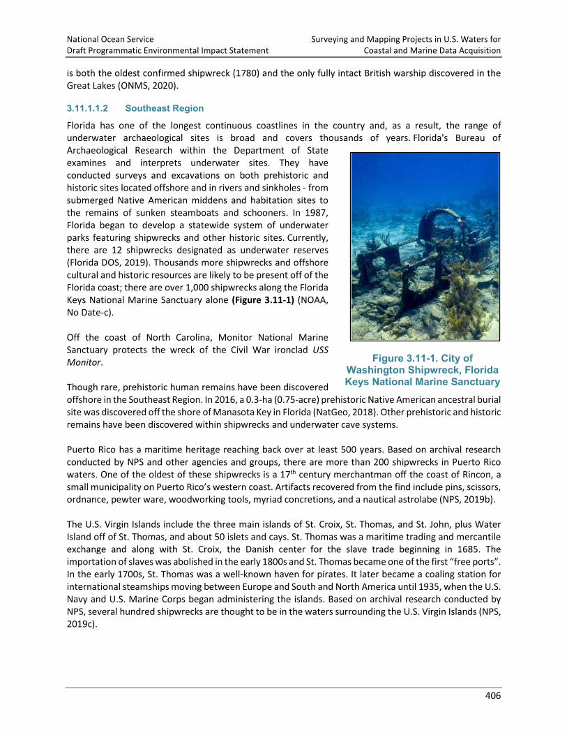
Florida has one of the longest continuous coastlines in the country and, as a result, the range of underwater archaeological sites is broad and covers thousands of years. Florida's Bureau of Archaeological Research within the Department of State examines and interprets underwater sites. They have conducted surveys and excavations on both prehistoric and historic sites located offshore and in rivers and sinkholes - from submerged Native American middens and habitation sites to the remains of sunken steamboats and schooners. In 1987, Florida began to develop a statewide system of underwater parks featuring shipwrecks and other historic sites. Currently, there are 12 shipwrecks designated as underwater reserves (Florida DOS, 2019). Thousands more shipwrecks and offshore cultural and historic resources are likely to be present off of the Florida coast; there are over 1,000 shipwrecks along the Florida Keys National Marine Sanctuary alone (Figure 3.11-1) (NOAA, No Date-c). Off the coast of North Carolina, Monitor National Marine Sanctuary protects the wreck of the Civil War ironclad USS Monitor. Though rare, prehistoric human remains have been discovered offshore in the Southeast Region. In 2016, a 0.3-ha (0.75-acre) prehistoric Native American ancestral burial site was discovered off the shore of Manasota Key in Florida (NatGeo, 2018). Other prehistoric and historic remains have been discovered within shipwrecks and underwater cave systems. Puerto Rico has a maritime heritage reaching back over at least 500 years. Based on archival research conducted by NPS and other agencies and groups, there are more than 200 shipwrecks in Puerto Rico waters. One of the oldest of these shipwrecks is a 17th century merchantman off the coast of Rincon, a small municipality on Puerto Rico’s western coast. Artifacts recovered from the find include pins, scissors, ordnance, pewter ware, woodworking tools, myriad concretions, and a nautical astrolabe (NPS, 2019b). The U.S. Virgin Islands include the three main islands of St. Croix, St. Thomas, and St. John, plus Water Island off of St. Thomas, and about 50 islets and cays. St. Thomas was a maritime trading and mercantile exchange and along with St. Croix, the Danish center for the slave trade beginning in 1685. The importation of slaves was abolished in the early 1800s and St. Thomas became one of the first “free ports”. In the early 1700s, St. Thomas was a well-known haven for pirates. It later became a coaling station for international steamships moving between Europe and South and North America until 1935, when the U.S. Navy and U.S. Marine Corps began administering the islands. Based on archival research conducted by NPS, several hundred shipwrecks are thought to be in the waters surrounding the U.S. Virgin Islands (NPS, 2019c).
Figure 3.11-1. City of Washington Shipwreck, Florida Keys National Marine Sanctuary
National Ocean Service Surveying and Mapping Projects in U.S. Waters for Draft Programmatic Environmental Impact Statement Coastal and Marine Data Acquisition
407
3.11.1.1.3 West Coast Region
In 2011, BOEM conducted a study to identify the locations of known and reported submerged cultural resources, potential inundated prehistoric sites, coastal properties that are listed or eligible for listing on the NRHP, and Traditional Cultural Places (TCPs) on the west coast of the U.S., including California, Oregon, and Washington. The study area for this effort stretched from the U.S./Canadian border to the U.S./Mexican border and extended 322 km (200 mi) west of the U.S. EEZ. The study discovered archaeological resources such as shell middens (an archaeological feature consisting mainly of mollusk shells that contain debris associated with human activity), lithic sites, rock art, burial grounds, and caves/rock shelters, and located records on hundreds of shipwrecks in the Pacific OCS area (BOEM, 2013). The remains of prehistoric seafaring trading expeditions along the Pacific Coast (including travel to the Channel Islands) has resulted in artifacts such as soapstone bowls recovered and preserved from the offshore areas; at least 25 individual sites have been reported between Ventura Beach and Point Conception in California alone (Foster, 2019). Known historic archaeological resources in the southern California area consist of submerged shipwrecks and submerged aircraft. The most common causes of the wrecks were burning, collision, or stranding (NSF and USGS, 2011). Approximately 100 shipwrecks have been documented in the Channel Islands National Park in California (NPS, 2016).
3.11.1.1.4 Alaska Region
According to GIS data, Alaska has 71,000 km (44,117 mi) of coastline and comprises almost half the total U.S. coastline. The numbers of both identified and potential submerged cultural resources in this area is vast. The U.S. Department of the Interior Minerals Management Service (MMS, now BOEM) estimated the presence of more than 4,000 shipwrecks off the coast of Alaska. In addition to marine vessels, Alaska waters contain numerous historic aircraft, many of which were associated with World War II military activities, battles, and campaigns (McMahan, 2007). MMS maps indicate that known shipwrecks are scattered throughout the Western Gulf of Alaska, with the heaviest concentration in Chignik Bay (NSF and USGS, 2011). At Point Belcher near Wainwright, Alaska, 30 ships were frozen in the ice in September 1871; 13 others were lost in other incidents off Icy Cape and Point Franklin. Another seven wrecks are known to have occurred off Cape Lisburne and Point Hope. From 1865 to 1876, 76 whaling vessels were lost due to ice and battleship raids, which also caused the loss of 21 whaling ships near the Bering Strait during the Civil War (OCM, 2016a).
3.11.1.1.5 Pacific Islands Region
NOAA’s Pacific Islands Region includes Hawaii, Guam, Northern Mariana Islands, and American Samoa. The high-energy marine surf environment of Hawaii is capable of breaking apart wooden vessels and eventually destroying even iron and steel-constructed boats and ships. The volcanic shorelines and exposed coasts of the islands do not feature many naturally protected bays or harbors. These conditions, combined with the fringing or barrier reefs and sharp submerged lava rocks in nearshore waters, have led to a great number of shipwrecks in Hawaii. An initial examination by BOEM of the reported positions of shipwrecks reveals clusters around the locations of historic landings (BOEM, 2017b). In the Hawaiian Archipelago alone, there are over 80 submerged U.S. Navy ships and submarines, and over 1,500 Navy aircraft. Many of these sites are war graves associated with major historic events that shaped the region (ONMS, 2017). Several maritime archaeology projects have been conducted on coastal fishing and aquaculture sites in the Hawaiian Islands, as part of a course offered by the University of Hawaii. One resulted in the mapping
National Ocean Service Surveying and Mapping Projects in U.S. Waters for Draft Programmatic Environmental Impact Statement Coastal and Marine Data Acquisition
408
of an accumulation of hundreds of fishing lures (artificial fishing bait designed to attract a fish's attention) surrounding specific topographical reef features offshore from Waikiki beach on Oahu. The distribution of lost lures suggests hundreds of years of fishing activity at this specific location and submerged reef feature (BOEM, 2017b). In June 2007, NOAA’s ONMS completed an initial maritime heritage resource document inventory for American Samoa. Known maritime heritage resources in American Samoa include historic shipwrecks, World War II naval aircraft and fortifications, gun emplacements, and coastal pillboxes; archaeological sites associated with the ancient past; and marine/coastal natural resources associated with the legends and folklore of American Samoa. Ten historic shipwrecks are known to exist in American Samoan waters, the earliest dating to 1828; 43 naval aircraft are known to have been ditched or crashed into American Samoan waters between 1942 and 1944; and countless marine archaeological resources such as whet stones (used to sharpen the edge of steel tools), petroglyphs (prehistoric rock carvings), and grinding holes/bait cups (small depressions ground into bedrock) are known to exist in American Samoan waters (ONMS, 2007). In Guam, due to the region’s substantial number of historic military activities, there are various underwater sites associated with World War II occupation and combat. From historical records and discovery, there are many known aircraft, ships, construction equipment, cargo, and supplies submerged throughout Micronesia. World War II-affiliated sites within and south of Guam’s Apra Harbor include areas where the U.S. military dumped equipment or supplies; Japanese boats sank; or remnants of Japanese aircraft exist. One of Guam’s most popular fishing sites, Ritidian, includes the remains of an ancient fish camp, where indigenous people gathered to process and cook fish (Auyong, 2016). More than four dozen documented shipwrecks have occurred in the waters of the Northern Mariana Islands. Two of the earliest known losses are the Santa Margarita in 1601 and the Nuestra Senora de la Concepción in 1635. Six other ships are reported to have been lost during the Spanish colonial period. The majority of shipwrecks are from World War II. Due to their location between Hawaii and the Philippines, the Northern Mariana Islands played an important role in several World War II battles. As a result, the waters of the Northern Mariana Islands contain sunken warships, auxiliaries, airplanes, tanks, and other military related debris (NPS, 2019a).
3.11.1.2 Subsistence Hunting and Fishing Areas, Including Traditional Cultural Places State and federal laws define subsistence as the customary and traditional uses of wild resources for food, clothing, fuel, transportation, construction, art, crafts, sharing, and customary trade. Subsistence fishing, hunting, trapping, and gathering are important sources of employment and nutrition in many rural coastal communities and have cultural importance. In general, these rights are based on the legal foundations of tribal sovereignty, treaty provisions, and the "reserved rights" doctrine, which holds that Native Americans retain all rights not explicitly revoked in treaties or other legislation (NCAI, No Date). From 1778 to 1871, the federal government’s relations with Indian tribes were conducted largely through the treaty-making process. These treaties recognized the sovereignty of Indian tribes and established rights, benefits, and conditions for the treaty-making tribes that agreed to cede millions of acres of their land to the U.S. in return for recognition of property rights and federal protections. These rights are also known as “reserved rights.” Treaties with Indian tribes cover reserved rights such as the right to hunt, fish, and gather both on land ceded by tribes and on land retained by tribes. Although treaty-making ended in 1871, federal treaties with Indian tribes ratified by Congress remain the law, though treaties have been
National Ocean Service Surveying and Mapping Projects in U.S. Waters for Draft Programmatic Environmental Impact Statement Coastal and Marine Data Acquisition
409
supplemented by federal legislation such as land claims settlement acts and E.Os. (ACHP, 2019). Under the U.S. Constitution, treaties carry the same legal weight as federal statutes and bind both the federal government and the signing Indian tribe or tribes. This means that federal agencies must ensure that their actions do not conflict with tribal treaty rights (ACHP, 2019). Though not all federally-recognized tribes are located along the coastline, unless specifically revoked by the U.S., tribes have rights to fish at all “usual and accustomed places”, which are not typically specifically defined regions (JRank, No Date). Subsistence harvest practices have been documented in many studies over the last several decades. A wide array of natural resources is harvested throughout the year in a regular cycle of seasonal efforts timed for availability, access, and condition of the resources. The composition of subsistence harvests includes many species of fish, land mammals, marine mammals, and invertebrates, terrestrial invertebrates, waterfowl, berries, roots, and fuel gathering. Communities express and reproduce their unique identities based on the enduring connections between current residents, those who used harvest areas in the past, and the wild resources of the land (MMS, 2010). The role of subsistence hunting and fishing and traditional fishing rights in each region are described below. Relevant laws, treaties, and organizations are noted throughout the next sections.
3.11.1.2.1 Greater Atlantic Region
The Greater Atlantic Region includes the east coast states of Maine, New Hampshire, Massachusetts, Rhode Island, Connecticut, New York, New Jersey, Delaware, and Maryland, and the states surrounding the Great Lakes (Indiana, Michigan, Minnesota, and Wisconsin). There are 17 federally-recognized tribes within the east coast states (four in Maine, two in Massachusetts, one in Rhode Island, two in Connecticut, and eight in New York) and 31 federally-recognized tribes in the states surrounding the Great Lakes (one in Indiana/Michigan, 11 in Michigan, eight in Minnesota, and 11 in Wisconsin). The Maine Department for Inland Fisheries and Wildlife recognizes Maine Native American traditional fishing rights and issues a set number of trapping and fishing licenses for individuals belonging to the four federally-recognized tribes in Maine: the Passamaquoddy Tribe, Penobscot Nation, Houlton Band of Maliseet Indians, and Aroostook Band of Micmacs or Aroostook Micmac Council. Two tribal organizations, the Great Lakes Indian Fish and Wildlife Commission and the Chippewa Ottawa Resources Authority, manage traditional fishing rights and resources in the Great Lakes. The Great Lakes Indian and Wildlife Commission is an agency of 11 Ojibwe nations in Minnesota, Wisconsin, and Michigan that manages traditional fishing rights in Lake Superior for individuals belonging to these nations (GLIFWC, 2019). The Chippewa Ottawa Resource Authority manages fishing rights for five different tribal organizations under 1836 Treaties (CORA, 2019).
3.11.1.2.2 Southeast Region
The Southeast Region includes the states of Virginia, North Carolina, South Carolina, Georgia, Florida, Alabama, Mississippi, Louisiana, and Texas. It also includes Puerto Rico and the U.S. Virgin Islands. There are 23 federally-recognized tribes across all of these states (seven in Virginia, four in North Carolina, one in South Carolina, zero in Georgia, two in Florida, one in Alabama, one in Mississippi, four in Louisiana, and three in Texas); tribes in Puerto Rico and the U.S. Virgin Islands are not federally-recognized. Fishing is an important component of the culture and livelihood of many individuals on the U.S. Caribbean islands, whether commercial, recreational, or subsistence, and is tied directly and indirectly to many of the island’s residents and businesses. Fisheries are woven into the cultural fabric of local communities and make an important contribution to attainment of food and nutrition security. A significant portion of
National Ocean Service Surveying and Mapping Projects in U.S. Waters for Draft Programmatic Environmental Impact Statement Coastal and Marine Data Acquisition
410
fishermen in these areas retain a portion of their landings for their own or their family’s consumption, and, as such, engage in subsistence fishing. In the U.S. Virgin Islands, for example, approximately 11 percent of fishermen reported that they did not sell any of their catch in 2011. (NOAA, 2014b).
3.11.1.2.3 West Coast Region
There are more than 40 federally-recognized tribes with treaties and tribal fishing rights in place in NOAA’s Northwest Region, which includes Washington, Oregon, California, and Idaho (NMFS, No Date-af). The Northwest Indian Fisheries Commission helps support natural resources management for 20 treaty Indian tribes in coastal Washington (NWIFC, 2016). The Olympic Coast National Marine Sanctuary on the coast of Washington is entirely encompassed by the traditional harvest areas of the Hoh, Makah, and Quileute tribes, and the Quinault Indian Nation. Along with the state of Washington and the Olympic Coast National Marine Sanctuary, these tribes created the Olympic Coast Intergovernmental Policy Council in January 2007, which provides a regional forum for the collective management of resources within the Olympic Coast National Marine Sanctuary (NOAA, 2017a).
3.11.1.2.4 Alaska Region
The MMPA and the ESA acknowledge, and have exemptions for, pre-existing rights for Alaska Native groups to hunt and fish specific protected species. Under the MMPA (16 U.S.C. § 1371(b)) and the ESA (16 U.S.C. § 1539(e)), for example, Alaska Natives are allowed to harvest marine mammals as subsistence resources (OCM, 2016a). Subsistence hunting of marine mammals, including seals, sea lions, walruses, and whales, occurs throughout Alaska all year long and is critical to the nutrition, food security, and economic stability of Alaska Natives. The Alaska Region includes subsistence use areas of traditional cultural significance to Alaska Peninsula Native people, who are ancestors of the maritime hunting cultures of Pacific and Yupi‘k Eskimos and Aleuts. Their primary subsistence activity is fishing all five species of Pacific salmon, halibut, cod, and other fish species. (NSF and USGS, 2011). Section 3.13, Environmental Justice includes a description of Alaska Native populations that hunt marine mammals and fish for subsistence use, including the cultural, nutritional, and spiritual importance of each marine animal as well as where, when, and how it is hunted or fished for subsistence use. The subsistence heritage of rural Alaskans is the basis for Title VIII of the Alaska National Interest Lands Conservation Act (ANILCA), which states that continuation of the subsistence way of life by rural Alaskans is essential to their physical, economic, traditional, cultural, and social existence. This applies not only to Indians, Eskimos, and Aleuts, but to non-Native rural residents as well (USFS, 2010). The federal subsistence priority means that subsistence uses by rural residents of Alaska are given priority over non-subsistence uses (commercial or sport). On October 1, 1999, the Secretaries of the Interior and Agriculture published regulations (36 CFR 242 and 50 CFR 100) to provide for federal management of subsistence fisheries on Alaska rivers and lakes and limited marine waters within and adjacent to federal public lands. The USFWS is the lead agency for federal subsistence management. The Alaska Department of Fish and Game regulations continue to apply statewide to all commercial, sport, personal use, and subsistence fisheries, unless otherwise superseded by federal regulations. Federal subsistence fisheries often occur in the same area as state of Alaska fisheries. Federal regulations apply only on federal public lands and waters (USFWS, 2019b). The Federal Subsistence Board oversees the Federal Subsistence Management Program. The Board members include the agency heads for Alaska of the USFWS, NPS, Bureau of Land Management, Bureau of Indian Affairs, and U.S. Forest Service. There are also three public members appointed by the Secretaries of the Interior and Agriculture: the Chair of the Federal Subsistence Board and two public members who possess personal knowledge of and direct experience with subsistence uses in rural Alaska (USFWS, 2019b).
National Ocean Service Surveying and Mapping Projects in U.S. Waters for Draft Programmatic Environmental Impact Statement Coastal and Marine Data Acquisition
411
3.11.1.2.5 Pacific Islands Region
Fishing continues to contribute to the cultural integrity and social cohesion of Pacific island communities and support island economies (WPRFMC, 2016). In Hawaii, a substantial portion of the local population participates in recreational and subsistence fishing. Fishing in Guam and the Mariana Islands is important not only in terms of contributing to the subsistence needs of the Chamorro people but also in preserving their history and identity. Fishing perpetuates traditional knowledge of marine resources and maritime heritage of the ancient Chamorro culture (Ka’ai’ai, 2016). In American Samoa, fish brought to shore continue to be distributed within Samoan villages according to age-old ceremonial traditions. Similar traditions are still practiced in Hawaii, the Northern Mariana Islands, and Guam. These sociocultural attributes of fishing are at least as important as the contributions made to the nutritional or economic wellbeing of island residents (WPRFMC, 2016).
3.11.1.2.6 Traditional Cultural Places
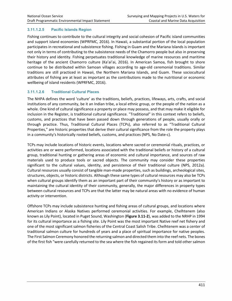
The NHPA defines the word ‘culture’ as the traditions, beliefs, practices, lifeways, arts, crafts, and social institutions of any community, be it an Indian tribe, a local ethnic group, or the people of the nation as a whole. One kind of cultural significance a property or place may possess, and that may make it eligible for inclusion in the Register, is traditional cultural significance. "Traditional" in this context refers to beliefs, customs, and practices that have been passed down through generations of people, usually orally or through practice. Thus, Traditional Cultural Places (TCPs), also referred to as “Traditional Cultural Properties,” are historic properties that derive their cultural significance from the role the property plays in a community's historically rooted beliefs, customs, and practices (NPS, No Date-c). TCPs may include locations of historic events, locations where sacred or ceremonial rituals, practices, or activities are or were performed, locations associated with the traditional beliefs or history of a cultural group, traditional hunting or gathering areas of economic and cultural importance, and sources of raw materials used to produce tools or sacred objects. The community may consider these properties significant to the cultural values, identity, and persistence of their traditional culture (NPS, 2012a). Cultural resources usually consist of tangible man-made properties, such as buildings, archeological sites, structures, objects, or historic districts. Although these same types of cultural resources may also be TCPs when cultural groups identify them as an important part of their community's history or as important to maintaining the cultural identity of their community, generally, the major differences in property types between cultural resources and TCPs are that the latter may be natural areas with no evidence of human activity or intervention. Offshore TCPs may include subsistence hunting and fishing areas of cultural groups, and locations where American Indians or Alaska Natives performed ceremonial activities. For example, Chelhtenem (also known as Lily Point), located in Puget Sound, Washington (Figure 3.11-2), was added to the NRHP in 1994 for its cultural importance as a fishing site. Lily Point was the most important Native reef net fishery and one of the most significant salmon fisheries of the Central Coast Salish Tribe. Chelhtenem was a center of traditional salmon culture for hundreds of years and a place of spiritual importance for native peoples. The First Salmon Ceremony honored the returning salmon and directed them into the reef nets. The bones of the first fish "were carefully returned to the sea where the fish regained its form and told other salmon
National Ocean Service Surveying and Mapping Projects in U.S. Waters for Draft Programmatic Environmental Impact Statement Coastal and Marine Data Acquisition
412
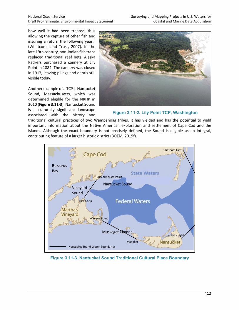
how well it had been treated, thus allowing the capture of other fish and insuring a return the following year." (Whatcom Land Trust, 2007). In the late 19th century, non-Indian fish traps replaced traditional reef nets. Alaska Packers purchased a cannery at Lily Point in 1884. The cannery was closed in 1917, leaving pilings and debris still visible today. Another example of a TCP is Nantucket Sound, Massachusetts, which was determined eligible for the NRHP in 2010 (Figure 3.11-3). Nantucket Sound is a culturally significant landscape associated with the history and traditional cultural practices of two Wampanoag tribes. It has yielded and has the potential to yield important information about the Native American exploration and settlement of Cape Cod and the Islands. Although the exact boundary is not precisely defined, the Sound is eligible as an integral, contributing feature of a larger historic district (BOEM, 2019f).
Figure 3.11-3. Nantucket Sound Traditional Cultural Place Boundary
Figure 3.11-2. Lily Point TCP, Washington

National Ocean Service Surveying and Mapping Projects in U.S. Waters for Draft Programmatic Environmental Impact Statement Coastal and Marine Data Acquisition
413
3.11.1.3 Coastal Infrastructure and Communities and Nearshore Historic Properties Coastal infrastructure refers to structures, systems, and facilities built along the coastline. This includes harbors, marinas, piers, and other types of development. A pier (Figure 3.11-4) is a raised structure in a body of water, typically supported by piles or pillars. Piers may support bridges, buildings, and walkways. Their open structure allows waves, tides, and currents to flow relatively unhindered. Piers can be categorized according to their principal purpose and include working piers, pleasure piers, and fishing piers. There are many piers listed or eligible for listing on the NRHP throughout the U.S. as either individual resources or as contributing elements of an historic district. Hanalei Pier in Hawaii, for example, is a typical finger pier constructed in the 1920s. The structure was used seasonally, primarily to transport rice from Hanalei to Honolulu. It is one of approximately a dozen remaining structures of this type in the state and is listed on the NRHP for its historical significance as one of the last remaining vestiges of the rice industry in Hanalei (NPS, 1979). Other cultural and historic resources located along the coastline include fishing communities, whaling villages, and Native American settlements. A fishing community is a social or economic group whose members reside in a specific location and share a common dependence on commercial, recreational, or subsistence fishing or on directly related fisheries dependent services and industries (for example, boatyards, ice suppliers, tackle shops) (50 CFR 600.345). Point Hope, Alaska, is one of the oldest continuously inhabited settlements in North America. Its whaling traditions extend back thousands of years, and Tikigaq – its Inupiaq name – is considered to be one of the most traditional villages in Alaska. The people hunt caribou, moose, seals, walrus, birds, fish, beluga whales, and polar bear, but the bowhead whale remains the focus of the annual subsistence cycle (AEWC, No Date). In addition to the cultural and historic resources described above, there are many historic properties located near the shoreline that are listed or eligible for listing on the NRHP. Countless archaeological sites and cultural remains are also present along the coastline that provide evidence of the prehistory and history of coastal communities. These sites often contain lithic assemblages comprised of materials such as shell and midden refuse, fire cracked rock, quartz and basalt flakes, and chert points.
3.11.1.4 Visual Resources Associated with Historic Properties Under Section 106 of the NHPA, the potential visual impacts from a proposed project or activity are considered with respect to the integrity of setting, feeling, and/or association of historic properties.
Figure 3.11-4. Tide Gauge on a Pier
National Ocean Service Surveying and Mapping Projects in U.S. Waters for Draft Programmatic Environmental Impact Statement Coastal and Marine Data Acquisition
414
Setting is the physical environment of a historic property and can include natural or human-made elements, such as topographic features, vegetation, paths, or fences, and, importantly, the relationships between buildings and other features or open space. Feeling is a property’s expression of the aesthetic or historic sense of a particular period of time. It results from the presence of physical features that convey the property’s historic character. Association is the direct link between an important historic event or person and a historic property. A property retains association if it is the place where the event or activity occurred and is sufficiently intact to convey that relationship to an observer (Sullivan et. al, 2018). Some historic properties are or include “designed cultural landscapes” that may include purposefully designed views or vistas. In a designed cultural landscape, the view itself is a significant characteristic of the historic property. Therefore, changes to these designed views, vistas, or view corridors may adversely affect the integrity of the property’s design, not simply causing visual effects on integrity of setting, feeling, or association (NPS, No Date-b). Many coastal resources listed on the NRHP derive all or part of their significance from their historic maritime setting. These resources include TCPs, coastal fortifications, parks and seashores, residential estates, lighthouses, life-saving stations, breakwaters, marinas, fishing and resort communities, and shore lodgings of all kinds, including hotels, motels, inns, seasonal cottages, and permanent residences. Some TCPs, for example, derive their importance from unobstructed views toward the rising sun (Klein et al., 2012). In 2012, BOEM directed the preparation of a GIS database of known cultural resources and historic properties that could be impacted by the introduction of off-shore energy facilities along the entire east coast of the U.S. Based on existing data, each resource was assessed with respect to its maritime setting and view to the sea. In total, 9,175 resources were considered to have a historically significant maritime setting and 1,108 were considered to have a historically significant view toward the open sea (Klein et al., 2012).
3.11.2 Environmental Consequences for Cultural and Historic Resources This discussion includes analysis of potential impacts to submerged cultural and historic resources; areas where traditional or tribal fishing rights are held and subsistence fishing and hunting are practiced, including TCPs; and coastal infrastructure listed or eligible for listing on the NRHP. Activities described in Sections 2.3.1 through 2.3.13 that occur on NOS projects and that could be expected to impact cultural and historic resources include: (1) anchoring; (2) bottom sampling; (3) installation, maintenance, and removal of tide gauges and buoys; and (4) installation of GPS reference stations. NOS has prepared this PEIS to inform the NHPA Section 106 consultation for the Proposed Action. In addition to the NHPA, NOAA will also engage as needed in tribal consultation pursuant to EO 13175, Consultation and Coordination with Indian Tribal Governments. NOS intends to initiate consultation after the publication of the Draft PEIS. Note that this Draft PEIS considers the impacts to historic and cultural resources from NOS data collection. The potential effects resulting from the release of collected data are outside the scope of this Draft PEIS. NOAA, like other federal agencies, is required to comply with Section 304 of the NHPA, which protects certain sensitive information about historic properties from disclosure to the public when such disclosure could result in a significant invasion of privacy, damage to the historic property, or impede the use of a
National Ocean Service Surveying and Mapping Projects in U.S. Waters for Draft Programmatic Environmental Impact Statement Coastal and Marine Data Acquisition
415
traditional religious site by practitioners. NOS would comply with Section 304 of the NHPA in the course of creating public data products.
3.11.2.1 Methodology The factors from NOS activities that could impact the cultural and historic environment include: (1) placement or dragging of equipment directly on or along the sea floor; (2) the presence of vessels operated by NOS within areas with activity restrictions, such as subsistence hunting and fishing areas, TCPs, and national marine sanctuaries; (3) placement of equipment on historic nearshore properties; (4) the discovery of archaeological resources during the installation of tide gauges, buoys, and GPS reference stations. These potential impact causing factors and their associated impacts on cultural resources are discussed below. As discussed in Section 3.2.2, significance criteria were developed for each resource to provide a structured framework for assessing impacts from the Proposed Action and the significance of the impacts. The significance criteria for cultural resources are shown in Table 3.11-1.
Table 3.11-1. Significance Criteria for the Analysis of Impacts to Cultural Resources
Impact Descriptor Context, Intensity, and Likelihood
Significance Conclusion
Negligible
The action would disturb a submerged archaeological resource or the sediment surrounding a submerged cultural or historic resource but would not have a measurable or perceptible impact. The action may occur in traditional subsistence hunting or fishing areas but would not disturb these practices.
Insignificant Minor
The action would have a measurable or perceptible impact on a submerged cultural resource or historic resource’s location, design, setting, materials, feeling, or association, but would not cause the loss of diagnostic features or research potential. The action would cause a temporary (lasting a few days) interference with traditional subsistence hunting and fishing practices.
Moderate
The action would diminish the integrity of a submerged cultural or historic resource or a historic property's location, design, setting, materials, workmanship, feeling, or association, resulting in the loss of diagnostic features or research potential. The action would temporarily interfere with traditional subsistence hunting and fishing practices during peak seasons or times.
Major
The action would permanently damage or destroy a submerged cultural or historic resource or historic property, resulting in the unrecoverable loss of the resource or property’s historic value, diagnostic features, research potential, or integrity. The action would result in a prolonged disturbance of traditional subsistence
Significant
National Ocean Service Surveying and Mapping Projects in U.S. Waters for Draft Programmatic Environmental Impact Statement Coastal and Marine Data Acquisition
416
Impact Descriptor Context, Intensity, and Likelihood
Significance Conclusion
hunting and fishing practices during peak seasons or times.
3.11.2.1.1 Projects with No Potential to Cause Effects to Historic Properties
On December 20, 2017, following guidance from the Advisory Council on Historic Preservation (ACHP), NOS prepared a Statement on Surveying and Mapping Activities with No Potential to Cause Effects to Historic Properties (“Statement”) (NOS, 2017b). This Statement identifies NOS projects that have no potential to cause effects to historic properties, assuming such historic properties were present, per 36 CFR 800.3(a)(1). These projects, listed below, do not require consultation under Section 106 of the NHPA. The sections of this Draft PEIS in which these activities are described in detail are also included below in parentheses. The full Statement includes justification for each NOS determination based on the potential for each method or technology to interact with the sea floor, where cultural and historic resources might be present. Actions that were determined to have no potential to cause effects to historic properties include:
• Operation of manned vessels (Section 2.4.1); • Operation of remotely operated vehicles and unmanned/autonomous systems (Section 2.4.3); • Use of echo sounders (Section 2.4.4); • Use of acoustic doppler current profilers (Section 2.4.5); • Use of acoustic communication systems (Section 2.4.6); • Use of sound speed data collection equipment (Section 2.4.7); • Operation of drop/towed cameras and video systems (Section 2.4.8); and • Use of passive listening systems (Section 2.4.10).
However, other activities performed under the Proposed Action (such as anchoring and bottom sampling) are not included in the Statement and could potentially damage cultural resources. These substrate-disturbing activities and their potential impacts are discussed in the following sections.
3.11.2.2 Alternative A: No Action - Conduct Surveys and Mapping for Coastal and Marine Data Collection with Current Technology and Methods, at Current Funding Levels
Although the survey effort under Alternative A would vary by year (see Table 3.4-6), the greatest number of nautical miles surveyed over the six-year period would be in the Southeast Region (over 50 percent). The survey effort in each of the other four regions would be of a similar order of magnitude, approximately 10 percent in each region over six years, although slightly greater in the Alaska Region, where the survey effort would be approximately 16 percent over six years. Survey effort in the Great Lakes would be less than one percent of the total survey effort. In general, it is expected that level of effort and overall impacts trend together (i.e., greater impacts where the survey effort is higher), but there are other factors, such as location and depth of surveys, that add nuance to this trend. Overall, NOS projects would comprise a very small part of all ocean activities as vessels used by NOS would represent a very small proportion of all vessel traffic in the action area (as discussed in Section 2.4.1). Additionally, whenever possible, the location and timing of a given project would be purposefully coordinated to ensure that areas are not repeatedly surveyed. This ensures that the potential environmental impacts directly resulting from proposed NOS activities would not be exacerbated by repeated surveys within a given area.

National Ocean Service Surveying and Mapping Projects in U.S. Waters for Draft Programmatic Environmental Impact Statement Coastal and Marine Data Acquisition
417
3.11.2.2.1 Anchoring
Approximately 20 percent of NOS crewed vessel projects involve anchoring, so under Alternative A, NOS would undertake or fund approximately 55 projects with a planned anchoring component annually. Anchoring is described in Section 2.4.2. When a vessel is not collecting data, it may anchor either within the project area or nearby. While smaller boats used by NOS would not typically anchor except in an emergency, larger vessels conducting multi-day efforts may anchor within or near the project area to reduce the transit time to the project area and to save fuel. Although anchoring has the potential to impact submerged isolated artifacts (e.g., fragments of tools, arrow points, stone bowls) from prehistoric or historic voyages, resources submerged as a result of sea level rise, or undocumented downed aircraft or shipwrecks, the likelihood of an anchor landing on a historic resource is low. Vessel operators would select the anchor location based on depth, protection from seas and wind, and bottom type. Preferred bottom types are sticky mud or sand, as those characteristics allow the flukes of the anchor to dig into the bottom and hold the chain in place. When working in an un-surveyed area or in an area that has not been surveyed in many years, the ship would try to anchor in bays where data have already been collected, providing the ship with better information on where to drop the anchor. These practices would continue to minimize the potential for adverse impacts to submerged cultural or historic resources. Thus, adverse impacts would be unlikely, given that the submerged cultural or historic resources likely to be present in any one area compared to the enormous extent of the action area, continued adherence to NOS protocols, and the relatively small number of projects planned that would involve anchoring. Impacts to cultural resources from anchoring under Alternative A would continue to be adverse and permanent and would range from negligible to moderate, depending upon the extent of damage the anchor caused to the resource and the cultural significance of the resource damaged. Anchoring could diminish the integrity of a submerged cultural or historic resource, resulting in the loss of diagnostic features or research potential. Impacts in general would be unlikely; impacts that would be moderate or higher would be very unlikely. It is far more likely that impacts would continue to be insignificant.
3.11.2.2.2 Bottom Sampling
Under Alternative A, NOS would undertake or fund approximately 54 projects that require collection of bottom samples, annually. Bottom sampling is described in detail in Section 2.4.9. NOS would continue to use previously surveyed areas when available if anchoring were required for collection of the bottom sample. This would help to ensure that bottom samples are not collected near any documented or potential historic properties. When sampling the sea floor, crews would typically use a 6” by 6” clamshell bottom snapper or similar type of grab sampler or sediment corer to obtain samples. Samples would be obtained from only the top few inches of sediment. This is unlikely to disturb any objects that may be present, as it is likely that there is a thick layer of sediment over long-buried objects. At most, a few cups of sediment would be collected during each bottom sampling activity. Samples would not be collected in waters deeper than 80 m (263 ft). In areas surveyed within the last 30 years, samples may not need to be collected at all. In keeping with NOS protocol, samples would not be collected on coral reefs, shipwrecks, obstructions, or hard bottom areas. These practices would continue to minimize the potential for adverse impacts to archaeological resources.
National Ocean Service Surveying and Mapping Projects in U.S. Waters for Draft Programmatic Environmental Impact Statement Coastal and Marine Data Acquisition
418
However, if collection of a sample results in the discovery of an object that may be eligible for listing in the NRHP, the coordinates of the discovery would be noted and provided to the appropriate SHPO along with photographs of the sample and, if practicable, the recovered object itself. In the event of inadvertent resource discovery, effects from bottom sampling under Alternative A could be adverse or beneficial. Adverse impacts would occur if the resource were damaged or destroyed during sample collection and would range from negligible to minor (less than those that could result from anchoring activities due to the nature and smaller size of the grab sampler) and would be permanent. Beneficial impacts would occur if a resource were discovered that led to the identification of a culturally-significant artifact, group of artifacts, or previously undocumented historic site. Impacts in general would be unlikely; impacts that could be moderate or higher would be very unlikely. It is far more likely that impacts would continue to be insignificant.
3.11.2.2.3 Installation, Maintenance, and Removal of Tide Gauges, Buoys, and GPS Reference Stations
Tide gauge stations consist of a sensor, data collection platform, solar panels, and satellite transmitter. Tide gauge installation would continue to occur primarily out of the water at existing piers, docks, bulkheads, and similar locations. Images of tide gauge stations are included in Section 2.4.12. Under Alternative A, NOS would undertake or fund approximately 32 projects that include tide gauge installations and 305 projects that include tide gauge maintenance visits, annually. NOS would undertake or fund approximately 12 projects that include GPS reference system installation annually. As related to the Proposed Action, in accordance with 36 CFR 800.5, potential adverse effects from the installation of tide gauges on historic properties could include, but are not limited to:
i. Physical destruction of or damage to all or part of the property;
ii. Alteration of a property, including restoration, rehabilitation, repair, and maintenance…that is not consistent with the Secretary's standards for the treatment of historic properties (36 CFR part 68) and applicable guidelines;
iii. Removal of the property from its historic location;
iv. Change of the character of the property's use or of physical features within the property's setting that contribute to its historic significance; and
v. Introduction of visual, atmospheric or audible elements that diminish the integrity of the property's significant historic features.
Impacts to coastal structures could occur if the installation of tide gauges and GPS reference stations affected the view of or from the coastal structure that would affect the integrity of the structure’s location, design, setting, materials, workmanship, feeling, or association, as described in Section 3.11.1.4. Installation of tide gauges and GPS reference stations also have the potential to damage the historic structures on which they are being placed. Pier-mounted acoustic sensors, pressure-sensor tide gauge stations, microwave sensors and instruments, shore-based GPS reference stations, and, to a lesser extent, GPS tide buoys installed within the viewshed of a nearshore historic property or designed cultural landscape have the potential to impact cultural and historic resources. Changes to these designed views, vistas, or view corridors could impact the integrity of the property’s design, not simply cause visual effects on the integrity of a historic property’s setting or other historic characteristics.
National Ocean Service Surveying and Mapping Projects in U.S. Waters for Draft Programmatic Environmental Impact Statement Coastal and Marine Data Acquisition
419
If a sensor or station were proposed for installation on any coastal structure or would be anticipated to cause ground disturbance, NOS would continue to confer with the appropriate SHPO prior to installation. Adherence to this protocol would continue to minimize or avoid potential impacts to coastal structures listed or eligible for listing on the NRHP. Since NOS would continue to confer with the SHPO prior to the installation of tide gauges or GPS reference stations on properties listed or eligible for listing on the NRHP, adverse impacts to historic piers and viewsheds would be very unlikely, given the enormous extent of the action area compared to the small number of tide gauge and GPS reference station installations planned annually and the likely avoidance of historic sites during the site selection process or avoidance of impacts to historic coastal structures following communication with the SHPO. Impacts would be very unlikely; however, if a historic resource were inadvertently damaged during installation of tide gauges or GPS reference stations, impacts would continue to be adverse, short-term or long-term (depending on whether the installation is temporary or more permanent), would occur only to the historic resource or the viewshed of the historic resource, and would continue to range from negligible to minor. Impacts would therefore be insignificant.
3.11.2.2.4 Impacts on Subsistence Hunting and Fishing Areas, Including TCPs
Where relevant, the THPO assumes oversight of the Section 106 process from the state, providing the tribe with review authority over federal undertakings (NPS, 2012b). E.O. 13175, Consultation and Coordination with Indian Tribal Governments (November 6, 2000), requires each federal agency to establish procedures for meaningful consultation and coordination with tribal officials in the development of federal policies that have tribal implications. The procedures outlined in the NOAA Procedures for Government-to-Government Consultation with Federally Recognized Indian Tribes and Alaska Natives (NOAA Tribal Consultation Handbook) provide guidance to NOAA to support a consistent, effective, and proactive approach to communicating with Tribes. Examples of actions with the potential to trigger communication with Tribes include but are not limited to:
• An action that would have effects within a reservation or Alaska Native village. • An action that may impact tribal trust resources or the rights of a federally-recognized Tribe. • An action affecting a facility or entity owned or operated by a tribal government. • An action that affects Tribes, tribal governments, or a Tribe’s traditional way of life. • An action that affects TCPs or Traditional Use Areas.
E.O. 13175 and the NOAA Tribal Consultation Handbook provide required procedures for consultation with federally-recognized Tribes in recognition of the sovereignty of federally-recognized Tribes and the federal government’s trust responsibility to those tribes. NOAA also communicates with many non-recognized tribes and tribal coalition groups who have interests regarding NOAA's activities. In recent years in Alaska, the potential for NOS work to interfere with subsistence hunting has been the primary issue of concern identified by Tribes during meetings. In the Pacific Northwest, the primary issues of concern from Tribes have been the potential for NOS activities to affect ecotourism and to contribute to commercial vessel traffic. Concerns about the potential for NOS work to damage or alter historically or culturally significant sites have not been routinely identified in either location by Tribal representatives.
National Ocean Service Surveying and Mapping Projects in U.S. Waters for Draft Programmatic Environmental Impact Statement Coastal and Marine Data Acquisition
420
NOS would continue to attempt to coordinate projects that would occur in traditional hunting and fishing areas in Alaska and the Pacific Northwest to avoid peak hunting and fishing seasons (e.g., whale, seal, and salmon seasons) or times of year to the extent possible, based on information obtained from the Tribes. The effects of NOS’s projects on subsistence hunting and fishing practices of Alaska Natives and indigenous tribes are discussed in further detail in Section 3.13.2. Any impacts to subsistence hunting or fishing that might occur if traditional hunting and fishing areas cannot be avoided during peak seasons are also described in Section 3.13.2. Activities planned to occur in any NRHP-listed TCP would continue to comply with federal regulations related to the protection of these culturally significant places. The Section 106 review process is mandated for any federal projects that might affect a TCP; consultation with the affected traditional community may also be required (NPS, No Date-c). With the legal protection afforded to listed TCPs by the Section 106 review process, the effects of NOS activities in these areas under Alternative A are expected to be adverse, short-term (lasting only the duration of the activity), negligible to minor, and insignificant. NOS would continue to facilitate Tribal involvement related to planned projects throughout the action area. For example, regional Coast Survey representatives (“Navigation Managers”) for Alaska and the Pacific Northwest would continue to discuss survey plans for the upcoming year during meetings open to the public. It is anticipated that these meetings would continue to be attended by Tribal leadership or members. Meetings in the Pacific Northwest (Harbor Safety Committee meetings) would continue to take place approximately once every two months. In Alaska, meetings would continue to occur six to eight times per year. Following meetings, meeting minutes would continue to be developed and posted online. Although NOS projects under Alternative A could temporarily interfere with traditional subsistence hunting and fishing practices during peak seasons or times, with ongoing communication between NOS and THPOs and attempted avoidance of these areas during peak times to the extent practicable, impacts under Alternative A of projects on subsistence hunting and fishing areas, including TCPs, would continue to be adverse, short-term (lasting only the duration of the activity), negligible to moderate, and insignificant.
3.11.2.2.5 Conclusion
The effects of impact causing factors on cultural resources range from negligible to moderate; thus, the overall impact of Alternative A on cultural resources, including impacts to submerged cultural or historic resources; coastal infrastructure; viewsheds of nearshore historic properties and designed cultural landscapes; and subsistence hunting and fishing areas, including TCPs, would continue to be adverse and moderate. Therefore, impacts of Alternative A to cultural and historic resources would continue to be insignificant.
3.11.2.3 Alternative B: Conduct Surveys and Mapping for Coastal and Marine Data Collection with Equipment Upgrades, Improved Hydroacoustic Devices, and New Tide Stations
The same impact causing factors on cultural resources considered under Alternative A are considered under Alternative B. Under Alternative B, all of the activities and equipment operations proposed in Alternative A would continue but at a higher level of effort, although the percentage of nautical miles covered by projects in each region would be the same as under Alternative A. Total survey effort for Alternative B in each region for the six-year timeframe is shown in Table 3.4-7. The greatest number of nautical miles surveyed over the six-year period would be in the Southeast Region (over 50 percent). The
National Ocean Service Surveying and Mapping Projects in U.S. Waters for Draft Programmatic Environmental Impact Statement Coastal and Marine Data Acquisition
421
survey effort in each of the other four regions is of a similar order of magnitude (approximately 10 percent in each region over the six-year period), although slightly greater in the Alaska Region (approximately 16 percent). Survey effort in the Great Lakes over the six-year period would represent less than one percent of the overall survey effort. As described under Alternative A, it is generally expected that level of effort and overall impacts trend together (i.e., greater impacts where the survey effort is higher), but there are other factors, such as location and depth of surveys, that add nuance to this trend. Survey activities under Alternative B would take place in the same geographic areas and timeframes as under Alternative A; however, Alternative B would include more projects and activities and thus more nautical miles traveled than Alternative A. Overall, there would be an additional 331,868 nm (614,619 km) of survey effort under Alternative B as compared to Alternative A. The types and mechanisms of impacts would remain the same in Alternative B as discussed for Alternative A. Therefore, the difference between the two alternatives is a matter of scale with an increased activity level, although distributed unevenly among the different types of activities, leading to a corresponding, incremental increase in the potential for effects under Alternative B as compared to Alternative A. Impacts of Alternative B on cultural resources, including submerged cultural or historic resources; coastal infrastructure; viewsheds of nearshore historic properties and designed cultural landscapes; and subsistence hunting and fishing areas, including TCPs, would be the same or slightly, but not appreciably, larger than those discussed above under Alternative A for each impact causing factor. Overall, impacts on cultural resources under Alternative B would be adverse, moderate, and insignificant.
3.11.2.4 Alternative C: Upgrades and Improvements with Greater Funding Support The same impact causing factors for cultural resources considered under Alternatives A and B are considered under Alternative C. Under Alternative C, all of the activities and equipment operation proposed in Alternatives A and B would continue but at an even greater level of effort than Alternative B, given the overall funding increase of 20 percent relative to Alternative B. However, the percentage of linear nautical miles of survey effort in each region would be the same as under Alternatives A and B. Total survey effort for Alternative C in each region for the six-year timeframe is shown in Table 3.4-8. The greatest number of nautical miles surveyed over the six-year period would be in the Southeast Region (over 50 percent). The survey effort in each of the other four regions would be of a similar order of magnitude (approximately 10 percent in each region over six years), although slightly greater in the Alaska Region (approximately 16 percent over six years). Survey effort in the Great Lakes over the six-year period would be less than one percent of the overall survey effort. As described under Alternatives A and B, it is generally expected that level of effort and overall impacts trend together (i.e., greater impacts where the survey effort is higher), but there are other factors, such as location and depth of surveys, that add nuance to this trend. Survey activities under Alternative C would take place in the same geographic areas and timeframes as under Alternatives A and B; however, Alternative C would include more projects and activities and thus more nautical miles traveled than Alternatives A and B. Overall, there would be an additional 331,868 nm (614,619 km) of survey effort under Alternative C as compared to Alternative B, and an additional 663,736 nm (1,229,238 km) as compared to Alternative A. The types and mechanisms of impacts would remain the same in Alternative C as discussed for Alternatives A and B. Therefore, the difference between the alternatives is a matter of scale with an increased activity level, although distributed unevenly among the different types of activities, leading to a corresponding, incremental increase in effects under Alternative C as compared to Alternatives A and B.

National Ocean Service Surveying and Mapping Projects in U.S. Waters for Draft Programmatic Environmental Impact Statement Coastal and Marine Data Acquisition
422
The potential for impacts to cultural resources from Alternative C, including impacts to submerged cultural or historic resources; coastal infrastructure; viewsheds of nearshore historic properties and designed cultural landscapes; and subsistence hunting and fishing areas, including TCPs, would be the same or somewhat, but not appreciably, greater than those discussed above under Alternative A for each impact causing factor. Overall, impacts on cultural resources under Alternative C would be adverse, moderate, and insignificant.