3.0 WATERSHED ACTIVITIES 3.1 CHINO BASIN … · As shown in Figure 3-1, the Chino Basin Watershed...
46
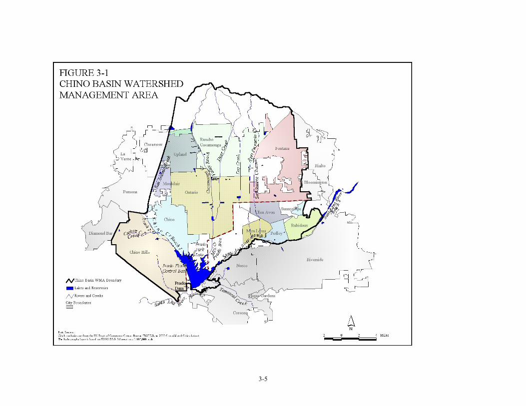
3-1 3.0 WATERSHED ACTIVITIES The following sections provide descriptions of Regional Board activities in each of the ten watershed management areas (WMAs) identified in Section 1.0. 3.1 CHINO BASIN WATERSHED Overview As shown in Figure 3-1, the Chino Basin Watershed covers about 405 square miles and lies largely in the southwestern corner of San Bernardino County, though a small part of Los Angeles County (Pomona area) and part of western Riverside County are included. Surface drainage is generally southward, from the San Gabriel Mountains toward the Santa Ana River and Prado Flood Control Basin. Major waterbodies in the Chino Basin Watershed include: - San Antonio Creek - Chino Creek - Cucamonga Creek - Mill Creek - Santa Ana River, Reach 3 - Chino I, II and III Groundwater Subbasins - Cucamonga Groundwater Subbasin - Prado Park Lake Although originally developed as an agricultural area, the watershed is being steadily urbanized. Cities in the Chino Basin Watershed include Pomona, Chino Hills, La Verne, Upland, Montclair, Claremont, Ontario, Rancho Cucamonga, Rialto, Chino, Fontana, and Norco. In addition, there are several pockets of urbanized unincorporated county areas. The 1995 population of the watershed was approximately 1.1 million people. The principal remaining agricultural area is the Chino Dairy Preserve. Located in the south-central part of the watershed, the Preserve contains approximately 340,000 cows, which generate the waste equivalent of more than two million people. Since the Preserve is unsewered, dairy operations have significantly affected the quality of the water resources in the area. The major water resource in the Watershed is the 5 to 6 million acre-feet of groundwater in storage in Chino Basin. Groundwater basins and sub-basins, generally, drain south toward the Santa Ana River. Groundwater bodies within the watershed include Claremont Heights, Pomona and Canyon Basins (plus the Live Oak Basin and part of the Spadra Basin), which are located primarily in Los Angeles County, and the Cucamonga and Chino Basins, which are located primarily in San Bernardino County. A small portion of Chino Basin is located in Riverside County. The Metropolitan Water District of Southern California provides imported water to the area through local wholesalers including Inland Empire Utilities Agency (IEUA), Three Valleys Municipal Water District, and Western Municipal Water District. Water Quality Concerns The quality and quantity of the area's water supply are major concerns. In 1978, the Chino Groundwater Basin was adjudicated by the California State Superior Court. The Basin serves as the primary source of water for the basin’s cities, industry, and remaining agriculture. Historic and existing agricultural operations have severely degraded surface water and groundwater quality in several parts of the watershed. This degradation is a major concern for the Regional Board.
Transcript of 3.0 WATERSHED ACTIVITIES 3.1 CHINO BASIN … · As shown in Figure 3-1, the Chino Basin Watershed...
3-1
3.0 WATERSHED ACTIVITIES
The following sections provide descriptions of Regional Board activities in each of the ten watershed management areas (WMAs) identified in Section 1.0. 3.1 CHINO BASIN WATERSHED Overview As shown in Figure 3-1, the Chino Basin Watershed covers about 405 square miles and lies largely in the southwestern corner of San Bernardino County, though a small part of Los Angeles County (Pomona area) and part of western Riverside County are included. Surface drainage is generally southward, from the San Gabriel Mountains toward the Santa Ana River and Prado Flood Control Basin. Major waterbodies in the Chino Basin Watershed include: - San Antonio Creek - Chino Creek - Cucamonga Creek - Mill Creek - Santa Ana River, Reach 3 - Chino I, II and III Groundwater Subbasins - Cucamonga Groundwater Subbasin - Prado Park Lake Although originally developed as an agricultural area, the watershed is being steadily urbanized. Cities in the Chino Basin Watershed include Pomona, Chino Hills, La Verne, Upland, Montclair, Claremont, Ontario, Rancho Cucamonga, Rialto, Chino, Fontana, and Norco. In addition, there are several pockets of urbanized unincorporated county areas. The 1995 population of the watershed was approximately 1.1 million people. The principal remaining agricultural area is the Chino Dairy Preserve. Located in the south-central part of the watershed, the Preserve contains approximately 340,000 cows, which generate the waste equivalent of more than two million people. Since the Preserve is unsewered, dairy operations have significantly affected the quality of the water resources in the area. The major water resource in the Watershed is the 5 to 6 million acre-feet of groundwater in storage in Chino Basin. Groundwater basins and sub-basins, generally, drain south toward the Santa Ana River. Groundwater bodies within the watershed include Claremont Heights, Pomona and Canyon Basins (plus the Live Oak Basin and part of the Spadra Basin), which are located primarily in Los Angeles County, and the Cucamonga and Chino Basins, which are located primarily in San Bernardino County. A small portion of Chino Basin is located in Riverside County. The Metropolitan Water District of Southern California provides imported water to the area through local wholesalers including Inland Empire Utilities Agency (IEUA), Three Valleys Municipal Water District, and Western Municipal Water District. Water Quality Concerns The quality and quantity of the area's water supply are major concerns. In 1978, the Chino Groundwater Basin was adjudicated by the California State Superior Court. The Basin serves as the primary source of water for the basin’s cities, industry, and remaining agriculture. Historic and existing agricultural operations have severely degraded surface water and groundwater quality in several parts of the watershed. This degradation is a major concern for the Regional Board.
3-2
Wastewater recycling, industrial operations, hazardous materials spills and other sources of pollution have also affected groundwater quality in more localized areas. Treated wastewater is discharged to tributaries of the Santa Ana River, along with rising groundwater, non-point source discharges and seasonal rainfall runoff. The River flows into Orange County where it recharges the groundwater basin and is put through another cycle of use. To maintain a balance of use between the upper (inland) and lower (coastal) basins of the Santa Ana Watershed, the quality and quantity of water flowing in the Santa Ana River through Prado Dam is adjudicated, Several significant studies of water quality and water supply in the Chino Basin have been completed in the past few decades. The 1975 Water Quality Control Plan (Basin Plan), produced under contract by the Santa Ana Watershed Project Authority (SAWPA), was based largely on the results of computer simulations using a model called the Basin Planning Procedure (BPP). Serious groundwater degradation was predicted unless major cleanup and management efforts were undertaken promptly. Those recommended actions were not taken. The 1983 Basin Plan basically confirmed the findings of the 1975 plan. The BPP was revised and refined, and was used in a large 1989 study which concluded that present and near-future water quality were even worse than previously thought. Consequently, the Regional Board imposed further restrictions on reclamation and wastewater recharge projects. More recently, a new computer model, the Chino Basin Integrated Ground and Surface Water Model (CIGSM), was developed as part of the Chino Basin Water Resources Management Study. The Regional Board and SAWPA have been active participants in all these studies. SAWPA is also coordinating a study sponsored by the Nitrogen/TDS Task Force, a consortium of water supply and wastewater management agencies in the Region. The Task Force is supporting Regional Board participation in the study, which is being conducted for the Santa Ana River watershed as a whole, including the Chino Basin. The study is investigating questions related to nitrogen and TDS management in the watershed, including groundwater subbasin water quality objectives, subbasin boundaries, and regulatory approaches to wastewater reclamation and recharge. The study findings recommended changes in objectives and subbasin boundaries that would substantially affect the Chino Basin. Basin Plan amendments to incorporate these changes will likely be considered by the Regional Board in 2002-03. Water quality issues identified for purposes of the Chino Basin Watershed Management Initiative focus on:
1) Quality and quantity of the groundwater supply, 2) Stormwater runoff and related water quality impacts, 3) Effects of wastewater recycling, and 4) Effects of agricultural operations, especially dairies, on water quality.
Making significant water quality improvements in the Chino Basin Watershed will depend on many factors, which must be thoroughly evaluated before efforts begin.
3-3
Stakeholder Agencies:
– Santa Ana Watershed Project Authority (SAWPA)
– Monte Vista Water District (MVWD)
– Inland Empire Utilities Agency (IEUA) – Fontana Union Water Company (FUWC)
– Western Municipal Water District (WMWD) – Fontana Water Company (FWC) – Three Valleys Municipal Water District (TVMWD)
– Cities of:
– Chino Basin Watermaster (CBWM) Ontario – Chino Basin Water Conservation District (CBWCD)
Rancho Cucamonga
– Santa Ana River Watershed Group (SARWG) Chino – Orange County Water District (OCWD) Chino Hills – Milk Producers Council (MPC) Upland – Western United Dairymen (WUD) Montclair – United States Army Corps of Engineers Rialto – San Bernardino County Transportation and Flood Control District (SBCTFCD)
Fontana Pomona
– Riverside County Flood Control and Water Conservation District (RCFCWCD)
Claremont La Verne
– Cucamonga County Water District (CCWD) Norco – Jurupa Community Services District (JCSD)
Regional Board Program Activities Funded activities in the Chino Basin WMA for each of the eight program areas incorporated into the WMI are listed below.
Program Activities TMDLs
TMDL development and implementation tasks including monitoring and assessment,
preliminary analyses, implementation planning, and stakeholder participation
Nonpoint Source
Program
Working with stakeholders to develop potential 205(j), 319(h), and Prop 13 grant proposals and oversight/management of grants
Work with stakeholders to develop dairy BMPs Develop dairy education/outreach activities Coordinate Prop 13 Water Bond activities for Chino Basin area
Monitoring
&Assessment
Collect and compile surface water monitoring data maintained by stakeholder agencies including OCWD, SAWPA, Chino Basin Watermaster, Riverside County and San Bernardino County flood control districts, and local water purveyors.
Review monitoring well data from Chino Basin Watermaster for general water quality trend analysis; especially with reference to nitrate and TDS
Conduct periodic surface water sampling and analysis for nutrients, pathogens, and general minerals following storm events
Groundwater sampling at private wells for chlorinated solvents and general minerals
Core
Regulatory
Conduct regular NPDES, WDR, and stormwater inspections, reviews, and audits. Issue informal and formal enforcement actions as necessary for permit violations.
Pursue additional CAFO enforcement actions Monitor manure removal from CAFOs (and basin) and management of wastewater
Watershed Management
Continued participation in implementing the court-ordered Chino Basin Optimum Basin Management Plan, required in part, to address NPS issues.
Interaction with stakeholders in developing water resource and non–point source management projects.
3-4
Program Activities Standards/
Basin Planning
Regional Board expected to consider Basin Plan amendments to incorporate revised water quality objectives/subbasin boundaries
Wetlands
Participate in discussions with other agencies pertaining to wetlands enhancement efforts
Coordinate with local, state, and federal agencies on endangered species and wetland permitting issues
Develop general WDRs (equivalent to 401 water quality certification) for sediment control projects
Process 401 Water Quality Certification requests
Groundwater
Solvent plumes will continue to be monitored by the SLIC unit, along with the oversight of ongoing plume investigations and cleanups. Nitrate and TDS in groundwater are being evaluated using Chino Basin Watermaster well data and GIS tools.
The Regional Board will continue to participate in the N/TDS task force, which is evaluating issues related to N/TDS management, including groundwater quality objectives and subbasin boundaries in the Chino Basin.
Selected Reference Documents:
Dairies and Their Relationship to Water Quality Problems in the Chino Basin, (Dairy Report), by Santa Ana Regional Water Quality Control Board (SARWQCB), 1990
Chino Basin Water Resources Management Study – Final Summary Report, by Chino Basin Water Resources Management Task Force, 1995
Optimum Basin Management Plan, (OBMP), by Chino Basin Watermaster, 1999 Peace Agreement – Chino Basin, by Chino Basin Watermaster, 2000 Dairy Waste Management, (Webb Report), Webb and Associates for SAWPA, 1974
Watershed Coordinator The Regional Board watershed coordinator for the Chino Basin WMA is Bill Rice: (909) 782-4459.
3-5
3-6
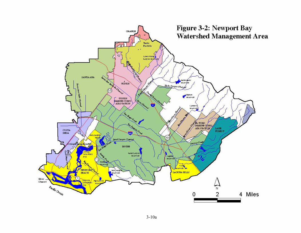
3.2 NEWPORT BAY WATERSHED MANAGEMENT AREA Revised May 2004 Overview The Newport Bay watershed encompasses an area of approximately 154 square miles (Figure 3-2). The watershed is bounded to the north by the Santiago Hills (Loma Ridge) and to the south by the San Joaquin Hills. The Tustin Plain, a broad alluvial valley, occupies the major portion of the watershed. It is currently estimated that about 10 percent of the land use in the watershed is agricultural, while 70 percent of the watershed area is occupied by various urban land uses. The remaining area (20 percent) is termed ‘vacant’. The San Diego Creek watershed, with an area of 119 square miles, is the largest system draining into Upper Newport Bay. The Santa Ana-Delhi Channel drains 17 square miles and Big Canyon Wash drains 2 square miles. The remaining 16 square miles are divided among several small watersheds tributary to the lower Bay. Cities in the Newport Bay Watershed include Newport Beach, Irvine, and portions of Costa Mesa, Santa Ana, Orange, Tustin, Lake Forest and Laguna Hills. The following major waterbodies are in the Newport Bay Watershed.
- Newport Bay, Lower - Newport Bay, Upper (includes Newport Bay Ecological Reserve) - San Diego Creek, Reaches 1 and 2 - Peters Canyon Channel - Serrano Creek - San Joaquin Freshwater Marsh - Santa Ana Delhi Channel, - Big Canyon Wash - Irvine groundwater subbasins
Newport Bay is divided into upper and lower Bays by the Pacific Coast Highway bridge. The area surrounding Lower Newport Bay is heavily developed, and the local economy is dependent on the housing and tourist industry. Approximately 10,000 small craft are registered in Newport Bay. In contrast to the dense development in the lower Bay, Upper Newport Bay is one of the few remaining undeveloped coastal estuaries in California, the largest in Region 8, and is home to several federal or state-listed rare or endangered species. The California Department of Fish and Game owns and manages the upper part of Upper Newport Bay as a State Ecological Reserve. Upper Newport Bay has been designated a Critical Coastal Area because this critical ecosystem is a receiving water for Clean Water Act Section 303(d) impaired flows. Water Quality Concerns A number of water quality problems adversely impact the designated beneficial uses of San Diego Creek and Newport Bay. These problems can be divided into four categories: sedimentation, eutrophication, bacterial contamination, and toxic contamination.
Sedimentation: Erosion in the Newport Bay watershed and resultant sediment deposition in the Bay is a continual threat to the designated beneficial uses of the Bay. Most deposition occurs during major storm events and originates from construction activities, channel erosion, and erosion of agricultural land. The sediment TMDL adopted by the Regional Board in 1998, requires implementation of sediment control measures to ensure that sediment discharges to Newport Bay will not significantly change the existing acreages of aquatic, wildlife, and rare and endangered species habitat, and maintain the navigational and non-contact recreational uses of the Bay.
3-7
Eutrophication: Newport Bay has exhibited signs of nutrient enrichment for over 25 years. The nutrient enrichment and resulting algae growth caused adverse impacts to the designated beneficial uses of the Bay. In addition, existing numeric water quality objectives for total inorganic nitrogen in San Diego Creek were not being achieved. These factors prompted the development of a nutrient TMDL for the Newport Bay watershed. The Regional Board adopted the nutrient TMDL in April 1998. The TMDL specifies compliance schedules for implementation of the TMDL. Bacterial Contamination: Bacterial objectives established to protect the designated beneficial uses of Newport Bay are rarely achieved. Because of consistently high levels of total coliform bacteria, the upper portion of Upper Newport Bay has been closed to water-contact recreation, while shellfish harvesting has been prohibited in the entire Upper Bay since 1978. A prioritized, phased approach to the control of bacterial quality in the Bay is specified in the Fecal Coliform TMDL, adopted by the Regional Board in 1999. The phased approach is intended to allow for additional monitoring and assessment to address areas of uncertainty and for future revision and refinement of the TMDL as warranted by these studies. Toxic Substance Contamination: Toxic substances, including pesticides, metals, and organics, are present in the Newport Bay Watershed at concentrations that adversely impact attainment of water quality standards. In January 2001, the Regional Board published a document that reviewed available chemistry data from water column samples, sediment, fish, and shellfish tissue, and water column toxicity tests to identify the substances that were causing water quality impairments. More recently USEPA has conducted its own evaluation of the data and has formulated a list of chemicals for which TMDLs will be developed. The Regional Board is currently developing TMDLs for diazinon, chlorpyrifos, and selenium, while USEPA is developing TMDLs for the remaining metals, pesticides, and priority organics.
In addition to the water quality related concerns, there are resource-related concerns, particularly for the Upper Newport Bay Ecological Reserve and San Joaquin Freshwater Marsh. Regional Board priority activities include watershed management, toxics TMDL development, nutrient, sediment and pathogen TMDL implementation, and wetlands protection. Serrano Creek: An area of special activity within the Newport Bay Watershed is Serrano Creek, a tributary to San Diego Creek, located in Lake Forest and Irvine, and a major contributor to the total sediment load reaching Newport Bay. Serrano Creek has sustained substantial erosion due to storms over the past decade. In particular, the 1997-98 “El Nino” storm severely impacted the creek, with substantial down-cutting, bank and stream bottom erosion, loss of vegetation, and damage to an existing recreational and flood control facilities. In 1999, businesses and homeowners formed the Serrano Creek Conservancy (SCC), with the goal of reducing erosion, enhancing the ecological resources, and restoring the aesthetic values of Serrano Creek. The SCC has conducted small restoration projects in Serrano Creek using funding obtained from federal and state competitive grant programs, and is planning to implement a larger stabilization project in 2002. Stakeholders Stakeholders in the Newport Bay watershed have organized the Newport Bay Watershed Management Committee to serve as a forum for addressing water quality issues. The committee originated during cooperative efforts to manage sediment problems in the 1980s but has since broadened its focus. The management committee meets on a monthly basis to share information and plan strategies for addressing the water quality concerns in the watershed.
3-8
Fiscal Year 02-03 and 03-04 Program Activities Funded activities in the Newport Bay WMA for each of the eight program areas incorporated into the WMI are listed below.
Program Activities
TMDLs
Implement established nutrient, sediment, and fecal coliform TMDLs Develop implementation plans for chlorpyrifos, diazinon, selenium TMDLs and
other metals, pesticides and priority organics
Nonpoint Source Program
Manage eleven 319(h), Prop. 13, and other grant contracts Work with stakeholders to develop potential 319 and prop. 13 grant proposals,
educational materials for toxics, pathogen, nutrient and sediment control, and an education curriculum for grades k-12
Critical Coastal Area monitoring and coordination with CCA Committee Monitoring
&Assessment Oversee implementation of the regional monitoring plan
Core Regulatory Conduct regular NPDES, WDR, and stormwater inspections, reviews, and audits. Issue informal and formal enforcement actions as necessary for permit violations
Watershed Management
Continued participation on Newport Bay Watershed Committees and subcommittees, and Newport Bay Coordinating Committee and other ad-hoc groups
Standards/ Basin Planning
Complete review of San Diego Creek (reaches 1&2) total inorganic nitrogen Basin Plan Objective (as part of the nutrient TMDL implementation plan)
Regional Board consideration of Basin Plan amendment, if necessary, to incorporate revised objectives
Wetlands
Coordinate with local, state, and federal agencies on endangered species and wetland permitting issues
Develop general WDRs (equivalent to 401 water quality certification) for sediment control projects
Process 401 Water Quality Certification requests Participate in discussions with other agencies pertaining to wetlands enhancement
efforts
Groundwater Develop workplan to address the nitrate, arsenic, and selenium content of shallow groundwater.
The Regional Board is currently managing 12 projects in the Newport Bay Watershed with a total contract value of over 3 million dollars. These contracts are funded through various sources, including the state general fund, EPA grant programs, Prop 13 bond funds, and Regional Board funds derived from fines and unused program budgets.
Title Subcontractor Amount Description SDC Metals Toxicity SCCWRP $70,000 Perform toxicity tests to determine if
metals are causing toxicity in San Diego Creek
Revise SDC TIN Objectives SCCWRP $115,000 Modeling and experimental studies to better define the relationship between nutrient concentrations and macro-algal growth
Agricultural Management Plan
UC-Riverside $349,793 Improve quality/reduce quantity of agricultural runoff through education, monitoring, and BMP Implementation
3-9
Title Subcontractor Amount Description Urban Runoff Reduction Orange County
Water District $100,000 Quantify water quality benefits from
use of more efficient residential irrigation management
Newport Bay Toxics Modeling
RMA $30,000 Model current and projected loading of toxic substances to Newport Bay under various hydrodynamic conditions
Shallow Groundwater Sampling
UC-Riverside $200,000 Sampling to determine nutrient, selenium, and arsenic concentrations in shallow groundwater and loading to surface water
Sediment Toxicity Study SCCWRP $n/a Perform sediment and pore water toxicity tests in Newport Bay
Fish Bioaccumulation Study SCCWRP $n/a Study bioaccumulation of toxic substances in representative Newport Bay fish species
Reconstruction of Sediment Basin and Weir in Lower SDC
OCPFRD $816,259 Modify existing weir at Jamboree Rd; modify invert and basin elevation of in-channel Basin 2
Serrano Creek Stabilization OCPFRD $570,000 Identify stream stabilization work for Reach 1 of Serrano Creek
Shedding Studies City of Newport Beach
$400,000 Fecal Coliform TMDL: Determine Sources of Bacterial Contamination at Beaches in Newport Bay
Viral Testing --- $250,000 Fecal Coliform TMDL Department of Pesticide Regulation Water Quality Projects in the Newport Bay Watershed Pesticide Sales and Use Survey
UC-Davis $95,150 Collect sales data, determine residential pesticide use patterns, and measure homeowner knowledge of pest management
Urban Runoff Reduction Orange County Water District
$205,000 Quantify pesticide water quality benefits from use of more efficient residential irrigation management
RIFA Monitoring DPR $n/a Monitor runoff water quality from RIFA pesticide usage sites
3-10
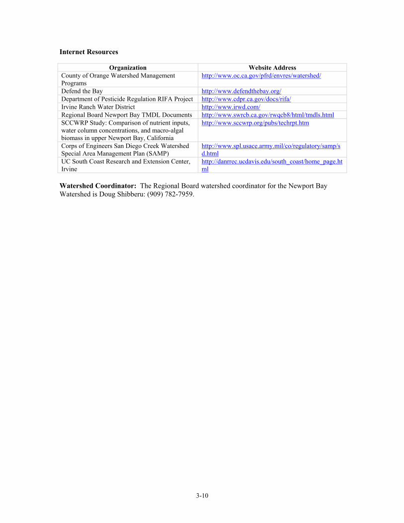
Internet Resources
Organization Website Address County of Orange Watershed Management Programs
http://www.oc.ca.gov/pfrd/envres/watershed/
Defend the Bay http://www.defendthebay.org/ Department of Pesticide Regulation RIFA Project http://www.cdpr.ca.gov/docs/rifa/ Irvine Ranch Water District http://www.irwd.com/ Regional Board Newport Bay TMDL Documents http://www.swrcb.ca.gov/rwqcb8/html/tmdls.html SCCWRP Study: Comparison of nutrient inputs, water column concentrations, and macro-algal biomass in upper Newport Bay, California
http://www.sccwrp.org/pubs/techrpt.htm
Corps of Engineers San Diego Creek Watershed Special Area Management Plan (SAMP)
http://www.spl.usace.army.mil/co/regulatory/samp/sd.html
UC South Coast Research and Extension Center, Irvine
http://danrrec.ucdavis.edu/south_coast/home_page.html
Watershed Coordinator: The Regional Board watershed coordinator for the Newport Bay Watershed is Doug Shibberu: (909) 782-7959.
3-10a
3-11
3.3 LAKE ELSINORE/SAN JACINTO RIVER WATERSHED MANAGEMENT AREA
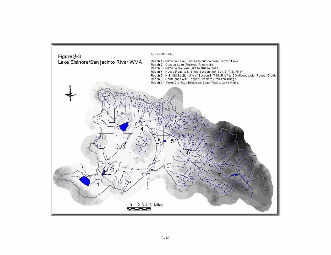
Overview As shown in Figure 3-3, the Lake Elsinore/ Lower San Jacinto River Watershed Management Area is located in Riverside County and includes the following major waterbodies:
- Lake Elsinore - Canyon Lake - Fulmore Lake - Strawberry Creek - Lake Hemet - San Jacinto River, all reaches - San Jacinto Groundwater Basins
Lake Elsinore is the natural low point of the San Jacinto River watershed. The Lake acts as a sink for the River and overflows only infrequently. Over 90 percent of the Lake Elsinore watershed drains to Canyon Lake, upstream of Lake Elsinore. Almost all of the water that enters Lake Elsinore comes from overflows from Canyon Lake. Cities in the Lake Elsinore/San Jacinto River Watershed include Lake Elsinore, Canyon Lake, Hemet, Perris, Moreno Valley, San Jacinto, Lakeview, Menifee, Sun City, Idyllwild and portions of Beaumont. The valley surrounding Lake Elsinore is bordered on the south and west by the Santa Ana Mountains and the Cleveland National Forest, and on the north and east by the San Jacinto Mountains. The bottom elevation of Lake Elsinore is 1,223 feet and its natural spill elevation is approximately 1,260 feet. Currently, Lake Elsinore has a surface area of more than 3600 acres, a maximum depth of 37 feet and a volume greater than 100,000 acre-feet at maximum capacity. The outlet channel was modified by the US Army Corp of Engineers and Riverside County Flood Control District and the sill elevation is at 1255 feet above sea level. The semi-arid climate in southern California causes the water level of Lake Elsinore to fluctuate significantly as a result of infrequent periods of flooding, followed by prolonged periods of drying out. In turn, this hydrologic pattern causes wide swings in the lake’s water quality. During dry periods, the lake levels drop, and evaporative losses cause TDS concentrations to increase well above the Basin Plan Objective. As a result of the lake level fluctuations, the Lake Elsinore Management Project was initiated. The goal of the Project is to develop strategies to achieve a stable lake level by providing make-up water and to develop projects that would minimize flooding during wet years. Lake Elsinore is currently included on the 303(d) list of impaired waterbodies due to excessive levels of nutrients, siltation as well as unknown toxicity. The nutrients are responsible for algae blooms that cause low dissolved oxygen levels, in turn leading to numerous fish kills. The algae blooms also impair the recreational uses of the lake. The nutrients arise from nonpoint source inputs from the watershed. Sediments in the Lake serve as a significant source of nutrients as well. Canyon Lake, which is designated MUN (municipal drinking water supply) is also included on the 303(d) list of impaired waterbodies due to nutrients and pathogens. The excessive nutrient input has caused algal blooms and low dissolved oxygen. The low DO has caused high concentration of manganese and iron. The Canyon Lake Water Treatment Plant had to be shut
3-12
down due to high algal production.The primary sources identified at this time are nonpoint sources. There are approximately 40 confined animal feeding operations (CAFOs) within the San Jacinto River Watershed Management Area. These facilities, along with widespread agricultural operations throughout the watershed above Canyon Lake, are believed to contribute significantly to eutrophication problems in both Canyon Lake and Lake Elsinore. It is believed that failure to implement best management practices (BMPs) at these facilities continues to exacerbate water quality problems in the lower portions of the watershed. In coordination with local stakeholders, a regional monitoring program is being implemented to assess water quality conditions and to identify and quantify sources of pollutant inputs to the lakes. A sediment study was conducted to characterize the nutrient distribution in sediment of Lake Elsinore and to quantify sources of nutrients. A water quality model was conducted to simulate the algal response to the current nutrient budget. A similar study is underway for Canyon Lake. A comprehensive toxicity monitoring program is conducted to identify the sources of toxicity in Lake Elsinore. A study to identify the trend and sources of pathogens is also being conducted. All the data collected will be used in the development of TMDLs for the lakes. Work on these TMDLs is in progress and is expected to be complete by 2004. In the absence of TMDLs, waste discharge requirements must be established to control pollutants of concern in discharges to 303(d) listed waters. Discharges cannot cause or contribute to water quality or beneficial use impairment. To address these requirements, on January 19, 2001, a watershed-wide NPDES permit (Order No. 01-34, NPDES No. CAG618005) was adopted. This Order regulates pollutants in discharges of storm water associated with new developments (storm water discharges) to surface waters from areas tributary to Lake Elsinore and Canyon Lake (San Jacinto Watershed). Order No. 01-34 is similar to the State Water Resources Control Board’s General Storm Water Construction Activity Permit (Water Quality Order No. 99-08-DWQ) (State Board’s General Construction Permit) except for the following changes:
a) Monitoring and reporting requirements have been added; b) Storm Water Pollution Prevention Plans (SWPPPs), Monitoring Programs, and post-
construction Management Plans must be submitted for approval in advance of construction activities; and,
c) Offset provisions have been added. The Hemet/San Jacinto Groundwater Association and Eastern Municipal Water District are in the process of developing a Groundwater Management Plan for the Hemet and San Jacinto subbasins. The objective of the Management Plan is to optimize use and management of groundwater resources in the Hemet and San Jacinto groundwater subbasins through the cooperative efforts of an association of the major basin pumpers. Eastern Municipal Water District is cooperating with a number of entities to collect water quality and quantity data, land use information, and data on basin hydrogeology, and to develop appropriate planning tools. A Management Plan will be developed and will include plans or programs designed to maximize the groundwater resources and ensure future water supplies. To protect other subbasins in the San Jacinto watershed, including Perris, Menifee, Lakeview, Winchester, and San Jacinto Lower Pressure, Eastern Municipal Water District has initiated efforts to develop a Groundwater Management Plan pursuant to the requirements of Assembly Bill (AB) 3030. The goal of the program is to develop regional strategies for the protection and management of local groundwater sources. Some of the issues that will be considered include overdraft,
3-13
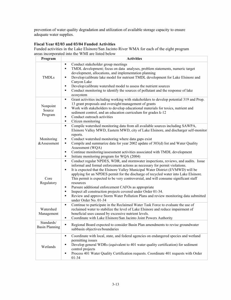
prevention of water quality degradation and utilization of available storage capacity to ensure adequate water supplies. Fiscal Year 02/03 and 03/04 Funded Activities Funded activities in the Lake Elsinore/San Jacinto River WMA for each of the eight program areas incorporated into the WMI are listed below
Program Activities
TMDLs
Conduct stakeholder group meetings TMDL development; focus on data analyses, problem statements, numeric target
development, allocations, and implementation planning Develop/calibrate lake model for nutrient TMDL development for Lake Elsinore and
Canyon Lake Develop/calibrate watershed model to assess the nutrient sources Conduct monitoring to identify the sources of pollutant and the response of lake
ecosystem
Nonpoint Source
Program
Grant activities including working with stakeholders to develop potential 319 and Prop. 13 grant proposals and oversight/management of grants
Work with stakeholders to develop educational materials for toxics, nutrient and sediment control, and an education curriculum for grades k-12
Conduct outreach activities Citizen monitoring
Monitoring &Assessment
Compile watershed monitoring data from all available sources including SAWPA, Elsinore Valley MWD, Eastern MWD, city of Lake Elsinore, and discharger self-monitor reports.
Conduct watershed monitoring where data gaps exist Compile and summarize data for year 2002 update of 303(d) list and Water Quality
Assessment (WQA) Continue monitoring/assessment activities associated with TMDL development Initiate monitoring program for WQA (2004)
Core Regulatory
Conduct regular NPDES, WDR, and stormwater inspections, reviews, and audits. Issue informal and formal enforcement actions as necessary for permit violations.
It is expected that the Elsinore Valley Municipal Water District (EVMWD) will be applying for an NPDES permit for the discharge of recycled water into Lake Elsinore. This permit is expected to be very controversial, and will consume significant staff resources
Pursure additional enforcement CAFOs as appropriate Inspect all construction projects covered under Order 01-34. Review and approve Storm Water Pollution Plans and review monitoring data submitted
under Order No. 01-34
Watershed Management
Continue to participate in the Reclaimed Water Task Force to evaluate the use of reclaimed water to stabilize the level of Lake Elsinore and reduce impairment of beneficial uses caused by excessive nutrient levels.
Coordinate with Lake Elsinore/San Jacinto Joint Powers Authority Standards/
Basin Planning
Regional Board expected to consider Basin Plan amendments to revise groundwater subbasin objectives/boundaries
Wetlands
Coordinate with local, state, and federal agencies on endangered species and wetland permitting issues
Develop general WDRs (equivalent to 401 water quality certification) for sediment control projects
Process 401 Water Quality Certification requests. Coordinate 401 requests with Order 01-34
3-14
Groundwater Participate in the Lakeview subbasin AB 3030 program Advisory Committee Review the Hemet/San Jacinto area AB 3030 groundwater study project
reports/management plan The Regional Board is currently managing five projects in the Lake Elsinore/San Jacinto Watershed with a total contract value of approximately 370,000 dollars. These contracts are funded through various sources, including the state general fund, EPA grant programs, Prop 13 bond funds, and Regional Board funds derived from fines and unused program budgets.
Title Subcontractor Amount Description TMDL stakeholder group meeting
SAWPA $20,000 Facilitate TMDL stakeholder meetings, send out meeting notices and prepare meeting notes for all TMDL meetings
Lake Elsinore nutrient cycles and budget
UC Riverside $72, 292 Conduct field and lab tests to determine the nutrient cycles, determine nutrient budget and conduct water quality modeling to simulate the algal response
Canyon Lake nutrient cycles and nutrient budget
UC Riverside $57,000 Conduct field and lab tests to determine the nutrient cycles, determine nutrient budget and conduct water quality modeling to simulate the algal response
Canyon Lake pathogen TMDL
UC Riverside $20,000 Assess the occurrence and distribution of indicator organisms in and near Canyon Lake
San Jacinto River watershed management plan
SAWPA $200, 000
Development a watershed management plan to control nutrients, provide flood control
Funds Administered by Other Agencies: Lake Elsinore nutrient assessment modeling
SAWPA $181,303 Conduct watershed modeling to assessment nutrient loads from all land use sources, calculate total nutrient load to Lake Elsinore and Canyon Lake under different hydrologic conditions
San Jacinto River Watershed Council
Anza-Murrieta-Elsinore RCD
$57,000 Compile all resources list in the San Jacinto River watershed, form a watershed council that include all interest parties in the San Jacinto watershed
Lake Elsinore and Canyon Lake TMDL monitoring
SAWPA $660,000 Conduct water quality monitoring in Lake Elsinore, Canyon Lake and San Jacinto River watershed, to install stream gauging stations to support the TMDL development
Stakeholders The stakeholders that have been participating in the TMDL development efforts in the Lake Elsinore/San Jacinto Watersheds include Elsinore Valley, Eastern MWD, Cities of Lake Elsinore and Canyon Lake, Riverside County Flood Control District, Farmers Bureau of Riverside, Milk Producers Council, Western United Dairyman, Murrieta-Anza_San Jacinto RCD, and other interested individuals.
Funded by the Proposition 13, a joint power authority was formed and charged with $15 million to restore the water quality Lake Elsinore and San Jacinto Watershed. Various projects have been
3-15
proposed and environmental documents are being prepared. The proposed projects include TMDL monitoring program, Lake Elsinore fishery management, alum application, island well retrofit, aeration, and Canyon Lake Oxygenation, and de-siltation. A grant from the State was obtained by the Anza-Murrieta-Elsinore RCD to compile a database of all the resources from all agencies and form a watershed council. The database is accessible on the website of SAWPA. Watershed Coordinator The Regional Board watershed coordinator for the Lake Elsinore\San Jacinto WMA is Cindy Li: (909) 782-4906.
3-16
3-17
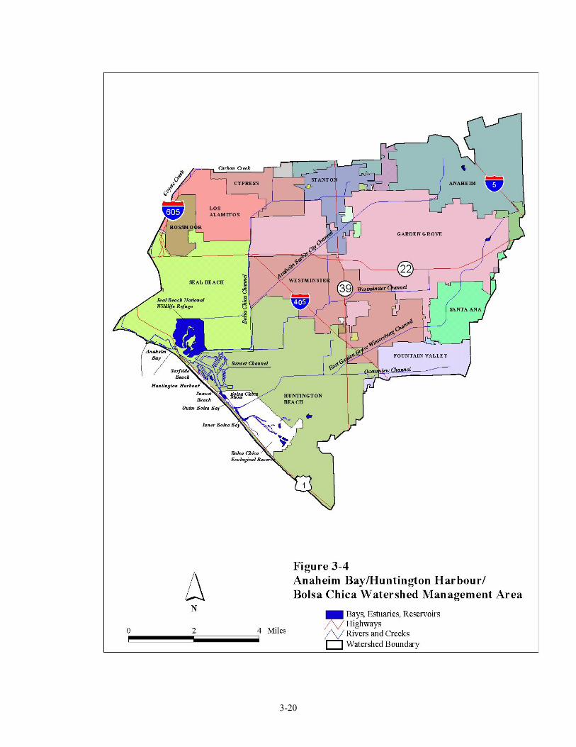
3.4 ANAHEIM BAY, HUNTINGTON HARBOUR, AND BOLSA CHICA WATERSHED MANAGEMENT AREA
Overview As shown in Figure 3-4, the Anaheim Bay/Huntington Harbour/Bolsa Chica Watershed Management area is located in coastal North Orange County. Waterbodies in this watershed include the following:
- Anaheim Bay-Seal Beach National Wildlife Refuge - Anaheim Bay - Surfside Beach - Sunset Beach - Huntington Harbour - Bolsa Bay - Bolsa Chica Ecological Reserve - Bolsa Chica State Beach
Cities in the Anaheim Bay, Huntington Harbour, Bolsa Chica Watershed include Westminster, Seal Beach, Garden Grove and portions of Huntington beach, Fountain Valley, Santa Ana, Anaheim, Stanton, Cypress, and Los Alamitos. Anaheim Bay/Huntington Harbour: The 1998 303(d) list of impaired waters includes Anaheim Bay (for metals and pesticides) and Huntington Harbour for metals, pesticides and pathogens. Toxics threaten the water quality and beneficial uses of the Anaheim Bay/Huntington Harbour/Bolsa Chica Watershed Management Area. Two major storm drains, the Bolsa Chica Channel and the East Garden Grove Wintersburg Channel, as well as their tributaries, drain into the Anaheim Bay/Huntington Harbour complex (Figure 3-4). Inputs of stormwater and urban nuisance flows via these channels appear to be significant sources of pollutants. Concentrations of trace metals have decreased over a 13-year period. In studies conducted by the Regional Board in 1992/93, metals concentrations met established water quality criteria. However, there was an unidentified nonpolar organic compound that was found to be acutely toxic to test species. Pathogens also threaten water quality in the Anaheim Bay/Huntington Harbour complex. Anaheim Bay (inland of Pacific Coast Highway bridge) and Huntington Harbour are designated as no discharge areas for vessel sanitary wastes. Pumpout facilities are in place throughout the Harbour to facilitate compliance, however illegal vessel discharges may still occur. Funds received from the settlement of a coastal oil spill are being used to conduct an extensive monitoring program in the Anaheim Bay/Huntington Harbour area to assess conditions and provide data needed for the development of appropriate TMDLs. Bolsa Chica: The Bolsa Chica lowlands are comprised of 880 acres of degraded wetlands. The wetlands had been developed for petroleum production, but were deeded to the State Lands Commission in 1997. The wetlands are being restored to provide mitigation for wetlands that will be lost during the expansion projects for the Port of Los Angeles and the Port of Long Beach The Regional Board is providing oversight for the clean up of the Bolsa Chica lowlands, through an interagency agreement. The interagency agreement includes the Resources Agency of the State
3-18
of California, the California Department of Fish and Game, the California State Lands Commission, USEPA, the National Oceanic and Atmospheric Administration, and the United States Fish and Wildlife Service. This project only affects the 880-acre Bolsa Chica lowland wetlands site deeded to the state in 1997. A grant from USEPA will fund the Regional Board’s Bolsa Chica cleanup oversight activities at the rate of 1.1 PY/year, through October 2001. The overall restoration project is expected to take 15 to 20 years to complete. The Regional Board’s current role in the Bolsa Chica wetlands project, as defined in the interagency agreement, includes: serving on the technical advisory committee to the project Steering Committee, providing clean up oversight, and considering and deciding clean up related issues, through October 2001. The Steering Committee will be selecting the preferred wetlands restoration alternative, with a goal of providing high quality tidal and inter-tidal wildlife habitat. This selection process involves coordination with Orange County and local agencies and authorities to address concerns regarding the quality and quantity of dry weather and wet weather flow entering and potentially entering the restored wetlands from the tributary watershed. The Regional Board’s involvement in this project will assist in the restoration of the wetlands to robust habitat with high environmental value. Cleanup activities in Bolsa Chica are proceeding at a much slower rate than originally anticipated. Based on an assessment of FY 98-99 expenditures, Board staff does not expect to expend all USEPA funding by October 2001. In addition, activities related to cleanup are likely to increase in 2002. Therefore, for Regional Board staff to continue in the oversight role beyond October 2001, a funding augmentation and a time extension to the USEPA agreement is needed. Stakeholders
California Coastal Commission Orange Coast Watch California Department of Fish and Game
Orange County Environmental Health
City of Huntington Beach Orange County PFRD City of Seal Beach Orange County Sanitation District County of Orange Orange County Sheriff Harbor Patrol State Lands Commission National Marine Fisheries U.S. Army Corps of Engineers NGOs
Fiscal Year 01-02 and 02-03 Program Activities Funded activities in the Anaheim Bay, Huntington Harbour, and Bolsa Chica WMA for each of the eight program areas incorporated into the WMI are listed below.
Program Activities
TMDLs Conduct stakeholder group meetings
3-19
Program Activities
Nonpoint Source
Program
319 and Prop 13. grant activities including working with stakeholders to develop potential 319 and Prop. 13 grant proposals and oversight/management of grants
Work with stakeholders to educate and implement NPS Management Measures Conduct Caulerpa taxifolia presentations, create/distribute outreach material, and attend
Southern California Caulerpa Action Team (SCCAT) meetings Work with stakeholders to develop education/curriculum for k-12. Work with stakeholders
to develop education materials for toxics and pathogen control Conduct outreach activities
Monitoring &Assessment
Initiate monitoring and assessment activities on 3 sites identified as “Candidate Toxic Hot Spots” in the Region’s BPTC program (Proposed Regional Toxic Hot Spot Cleanup Plan, December, 1997)
Water Quality Assessment monitoring at Anaheim Bay and Huntington Harbour Initiate monitoring and assessment activities on 3 sites identified as “Candidate Toxic Hot
Spots” in the Region’s BPTC program (Proposed Regional Toxic Hot Spot Cleanup Plan, December, 1997)
Core Regulatory
Conduct regular NPDES,WDR, and stormwater inspections, reviews, and audits. Issue informal and formal enforcement actions as necessary for permit violations
Watershed Management
Continue participation in the quarterly meetings of the Huntington Harbour Water Quality Issues Committee
Educate and mentor development of watershed management plans Standards/
Basin Planning
No specific activities planned
Wetlands
Participation on the Bolsa Chica Technical Advisory Committee Oversight and coordination of the multi-agency Bolsa Chica Wetlands cleanup activities Coordinate with local, state, and federal agencies on endangered species and wetland
permitting issues Develop general WDRs (equivalent to 401 water quality certification) for sediment control
projects Process 401 Water Quality Certification requests
Groundwater No specific activities planned Selected References California State Water Resources Control Board, California Ocean Plan California State Water Resources Control Board, Water Quality Control Policy for Enclosed Bays
and Estuaries of California Watershed Coordinator The Regional Board watershed coordinator for the Anaheim Bay, Huntington Harbour, And Bolsa Chica WMA is Stephanie Gasca: (909) 782-3221.
3-20
3-21
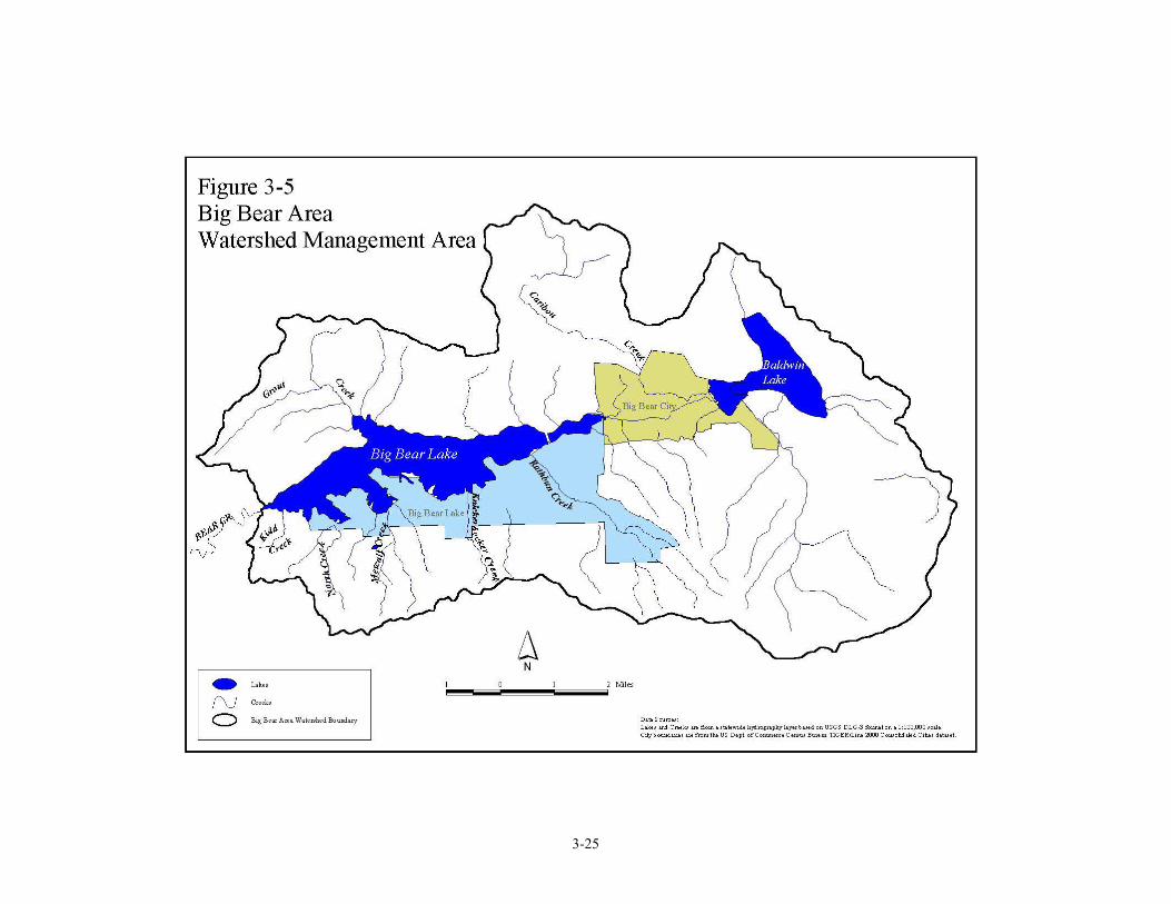
3.5 BIG BEAR AREA WATERSHED Overview As shown in Figure 3-5, the Big Bear Area watershed is located in the San Bernardino Mountains. Major waterbodies in this watershed include: Big Bear Lake Baldwin Lake Stanfield Marsh Shay Meadows Rathbone (Rathbun) Creek Summit Creek Grout Creek Cities in the Big Bear Area Watershed include Big Bear Lake and Big Bear City. Big Bear Lake is a high mountain reservoir occupying a relatively small, east to west oriented basin. The lake was created in 1885 by the construction of a single arch dam across Bear Creek, a tributary to the Santa Ana River. The dam was enlarged to its present size in 1911. The spillway altitude is 6,744 feet and the lake has a surface area of 3,000 acres, a storage capacity of 73,300 acre-feet and an average depth of 24 feet, with the deepest point of 72.3 feet at the dam. The Big Bear Lake drainage basin encompasses about 38.5 square miles and is drained by more than ten streams. Most tributaries to Big Bear Lake have lengths of one to two miles with the exception of Grout and Rathbone (Rathbun) Creeks which are over three miles long. Baldwin Lake has no through-flowing streams and is an ephemeral lake. The Baldwin Lake drainage basin encompasses approximately 34.3 square miles. Precipitation varies widely from west to east. The west end near the dam receives an average of 38 inches/year, while easterly of Baldwin Lake the average is 10 inches/year. The Big Bear Lake basin is dominated by yellow pine and white fir, with pinon pine and junipers on the higher slopes. The area supports a variety of sensitive habitats, including wet meadows containing several endangered plant species that are remnants of the glacial episodes of the region. The lake itself supports habitat for endangered Bald Eagles during the winter season. The Big Bear Lake basin supports a large number of recreational activities. Lake recreational activities include fishing, swimming, boating and water skiing. Areas adjacent to the lake are used for camping, skiing, hiking, equestrian trails and other outdoor activities. In addition to the 15,000 permanent residents in Big Bear Valley, over 4 million people visit Big Bear Valley annually. In 1990, a total of 8,681 boat permits were issued to permanent residents and seasonal and daily visitors. Summer sports, as well as the operation of two major ski areas, make Big Bear Valley a highly utilized year-round resort; 120,000 to 180,000 visitors come to this area every weekend. The 1998 303(d) list designated the following waterbodies as impaired: Big Bear Lake, due to nutrients, copper, mercury, metals, and siltation; Grout Creek for metals and nutrients; Summit Creek due to nutrients; Knickerbocker Creek for pathogens and metals; and Rathbone Creek due to nutrients and siltation. The problem pollutants have been identified as coming from nonpoint sources. In conjunction with local stakeholders, work is underway to develop TMDLs for these pollutants. The TMDLs are expected to be complete by 2004/2005.
3-22
Studies conducted from 1968 to the present have found that Big Bear Lake is moderately eutrophic. During the summer months, deeper water may exhibit severe oxygen deficits. Increased shallow areas resulting in greater light availability have lead to an increased abundance of nuisance aquatic plants which have impaired the fishing, boating, and swimming uses of the lake. These plants uptake nutrients from the sediment and during die-off, release nutrients and organics. Phosphorus has been identified as the nutrient limiting algae growth. Approximately 42% of the phosphorus load emanates from Rathbone Creek as identified in 1992 in the Clean Lakes Study. The large amount of precipitation in Southern California during 1993 resulted in more runoff from the Big Bear Lake tributaries and an increased input of nutrients. For instance, the total phosphorus load increased between 1992 to 1993 by a factor of 2, and the total nitrogen load increased by a factor of 100. To control the vegetation in the Lake mechanical harvesters are used to remove aquatic plants, including the roots. However, given the increasing abundance of nuisance aquatic plants, harvesting of aquatic vegetation may not be effective much longer. It is therefore appropriate to implement methods to control and limit the growth of nuisance aquatic plants and to implement control measures for reducing the input of nutrients from the major tributaries, Rathbone Creek, Summit Creek and Grout Creek. In addition, internal loading of nutrients needs to be estimated and controlled. Toxics may be entering the Big Bear Lake watershed and accumulating in aquatic organisms and bottom sediments at concentrations that are of concern, not only for the protection of aquatic organisms, but for the protection of human health as well. Past Toxic Substances Monitoring Program data have indicated the presence of copper, lindane, mercury, and zinc in fish tissue. Mercury and copper concentrations measured in the Lake and in several of the tributaries (1992-93 Clean Lake study) exceeded water quality criteria. Additionally, zinc and manganese sediment concentrations exceeded proposed sediment guidelines for most of the lake and tributary stations during the 1992 monitoring. At the same time, however, chronic toxicity bioassays were inconclusive as to whether the presence of metals was causing a toxic response in test organisms. Additional investigations should be done to both pinpoint the source(s) of metals into the Lake and determine if metal concentrations are causing toxicity. Once that is accomplished, appropriate source control measures can be implemented. Fish tissue sampling conducted between November 8 and November 10, 2000 showed that both fish flesh and fish livers contained low concentrations of metals. These concentrations were well below amounts documented as leading to reduced survival rates or growth. Future fish sampling will be conducted to determine if the results from November 2000 are representative of the conditions in the lake. Also planned in the next year are sediment analyses for both metals and nutrient constituents that will enable determinations of internal loading. In September 2000, local Big Bear Lake stakeholders retained a consultant to assist Regional Board staff in the development of the Big Bear Lake TMDLs. The stakeholders and consultants have spent the first half of the fiscal year developing cooperative agreements and funding strategies. The second half of the fiscal year will be spent conducting monitoring. Therefore, some of the activities of the Board staff have been modified as a result of stakeholder participation. Staff’s activities have been modified to reviewing proposed monitoring plans, assisting in monitoring activities, coordinating and attending meetings with stakeholders, contract management, and summarizing historical data. The Big Bear Watershed Management Council consists of Big Bear Municipal Water District, City of Big Bear Lake, San Bernardino County Flood Control District, Snow Summit Ski Resort, Bear Mountain Ski Resort, California Department of Fish and Game, East Valley Resource Conservation District, Santa Ana Regional Water Quality Control Board, Big Bear Area Regional
3-23
Wastewater Agency, Big Bear Community Services District, CalTrans, US Forest Service and other local agencies and community members. Fiscal Year 02/03 and 03/04 Funded Activities Funded activities in the Newport Bay WMA for each of the eight program areas incorporated into the WMI are listed below. Currently unfounded activities include monitoring for the Big Bear Lake Water Quality Assessment (2004).
Program Activities
TMDLs
Conduct stakeholder group meetings Conduct watershed modeling Initiate development of TMDL, identify numeric targets, allocations, and implementation
program Evaluate feasibility of appropriate lake model for nutrient TMDL development
Nonpoint Source
Program
Grant activities including working with stakeholders to develop potential 319 and Prop 13 grant proposals and oversight/management of grants
Participation on the Rathbone Creek Technical Advisory Committee Participation in the Big Bear Lake CRMP meetings Work with stakeholders to implement ski MMs and erosion MMs Conduct outreach activities
Monitoring &Assessment
Monitoring associated with TMDL development Compile and summarize data for year 2002 update of 303(d) list and the Water Quality
Assessment
Core Regulatory
Conduct regular NPDES,WDR, and stormwater inspections, reviews, and audits. Issue informal and formal enforcement actions as necessary for permit violations
Watershed Management Participation in the Big Bear Lake TMDL and Rathbone creek TAC meetings
Standards/ Basin Planning No specific activities planned
Wetlands
Coordinate with local, state, and federal agencies on endangered species and wetland permitting issues
Develop general WDRs (equivalent to 401 water quality certification) for sediment control projects
Process 401 Water Quality Certification requests Groundwater No specific activities planned
Selected references for the Big Bear Area Watershed: Ball, Orville P., and Associates. 1987. Lake management and rehabilitative recommendations – Big Bear Lake. El Cajon, CA. City of Big Bear Lake. 1999. General Plan. Big Bear Lake, CA. Courtier, Michelle and Hope Smythe. 1994. Investigation of toxics and nutrients in Big Bear Lake. Santa Ana Regional Water Quality Control Board, Clean Lakes Study –Phase I Final Report. Irwin, G.A. and M. Lemons. 1974. A water quality reconnaisance of Big Bear Lake, San Bernardino County, California, 1972-73. USGS Water Resources Investigations, Rept. No. 276-01.
3-24
Neste, N.A., J.R. Brudin, and R.V. Stone. 1975. Draft EIR. Wastewater facilities plan Big Bear area, collection, treatment, disposal and reclamation for Big Bear Area Regional Wastewater Agency. San Bernardino, CA. Pearson, Elmer G., and George A. Irwin. 1972. Limnological studies of Big Bear Lake, California. USGS Water Resources Division, Open-File Report. Siegfried, Clifford A., Perry L. Herrgesell, Alan P. Pickard, John R. Gustafson, and William E. Loudermilk. 1977. Limnological studies of Big Bear Lake California: November 1976-April 1977. California Department of Fish and Game, Big Bear Lake Limnological Laboratory, Report No. 77-1. Siegfried, C. A.,William E. Loudermilk, Alan P. Pickard, and Perry L. Herrgesell. 1978. Limnology of Big Bear Lake in 1977, A drought year. California Department of Fish and Game, Big Bear Lake Limnological Laboratory, Report No. 78-1. Siegfried, Clifford A., Perry L. Herrgesell, and William E. Loudermilk. 1979. The aquatic macrophytes of Big Bear Lake. California Department of Fish and Game, Big Bear Lake Limnological Laboratory, Technical Paper No. 79-4. Siegfried, C. A. and P. L. Herrgesell. 1979. Macronutrients in the Big Bear Lake ecosystem. Calif. Dept. Fish and Game, Big Bear Lake Limno. Lab., Technical Paper No. 79-5. Watershed Coordinator The watershed coordinator for the Big Bear Area Watershed Management Area is Heather Boyd and can be reached at [email protected] or (909) 320-2006.
3-25
3-26
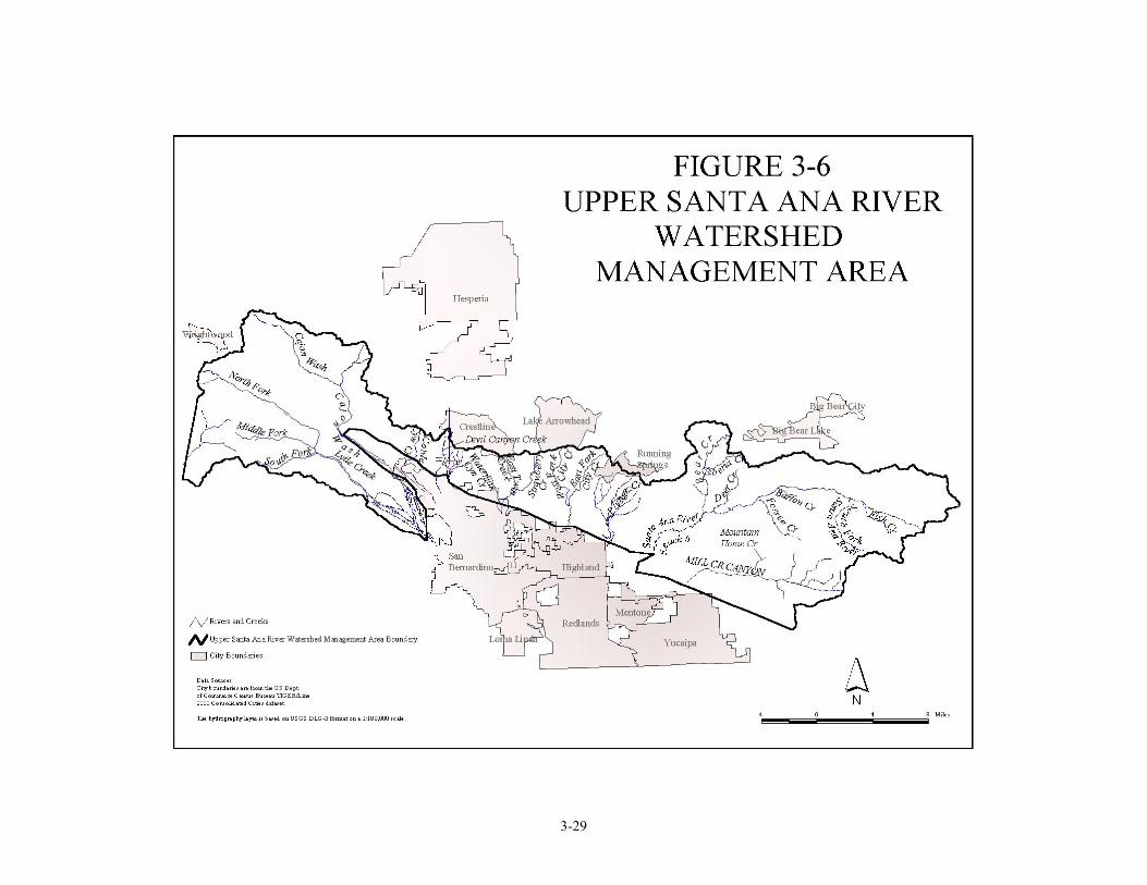
3.6 UPPER SANTA ANA RIVER WATERSHED MANAGEMENT AREA Overview The Upper Santa Ana Watershed Management Area consists of the following drainages located in the San Bernardino Mountains: the uppermost (mountain) reach of the Santa Ana River (reach 6), mountain reaches of several tributaries to the Middle Santa Ana River Watershed, and Mill Creek and its tributaries. In addition, Lytle Creek and Cajon Creek, originating in the San Gabriel Mountains, are considered part of the Upper Santa Ana Watershed Management Area. (The Big Bear/Baldwin Lake Drainage Area, while part of the Upper Santa Ana River Drainage, is considered as a separate Watershed Management Area. This area contains the most populated communities in the Upper Santa Ana River Drainage, as well as Big Bear Lake Reservoir and the ephemeral Baldwin Lake, and, as a result, has unique water quality issues that are discussed under the Big Bear Lake Watershed Management Area Section in this document.) Major waterbodies in the Upper Santa Ana Watershed Management Area include:
• Santa Ana River, Reach 6. • Bear Creek, which flows from Big Bear Lake to Reach 6 of the Santa Ana River. • Siberia Creek, which flows into Bear Creek. • Forsee Creek, Deer Creek, Barton Creek, and Fish Creek which flow into Reach 6 of the
Santa Ana River. • The mountain reach of Mill Creek. • Tributaries to Mill Creek including Mountain Home Creek, Mountain Home Creek East
Fork, and several smaller creeks. • The mountain reaches of Cajon Creek, Cable Creek, Devil Canyon Creek, Waterman
Canyon Creek, East Twin and Strawberry Creeks, City Creek, and Plunge Creek. • The mountain reaches of Lytle Creek.
In this Management Area there are several smaller tributaries to the above listed water bodies. In addition, there are several mountain meadows and other minor streams. The geography of the area is typified by tall peaks, steep slopes, and rugged canyons. Elevations range in the San Gabriel Mountains from 10,064 feet above sea level (feet) on Mount San Antonio and 8859 feet on Cucamonga Peak, to approximately 2200 feet where the tributaries reach the valley. In the San Bernardino Mountains, elevations range from 11,502 feet on Mt. San Gorgonio to approximately 1,500 feet where City Creek flows into the valley near the City of San Bernardino. Precipitation, often consisting of heavy snowfall at higher elevations in the winter, is much greater than in the adjacent valley areas. The higher elevations are covered with coniferous forests; lower elevations and south facing slopes support the chaparral plant community. Some of the waterways support federally and state listed rare, threatened, or endangered species such as the mountain yellow-legged frog, the speckled dace, and the slender-horned spineflower. The area is generally contained in the San Bernardino National Forest under the jurisdiction of the United States Forest Service. However, there are several areas of private property located in the watershed area. The economy of the area is generally based on recreation. There are numerous church, school, and other group camps located throughout the area, as well as private vacation cabins. In addition, a substantial number of residents live year round in the area. Recreational activities include hiking, camping, picnicking, site seeing, cross country skiing, and general snow play. In addition, hunting and fishing are popular in the area. Several of the larger streams support native and stocked rainbow trout, as well as introduced brown trout. Communities in the area include Lytle Creek, Running Springs, Angelus Oaks, and Forest Falls.

3-27
The Seven Oaks Dam has been recently constructed on the Santa Ana River at the base of the San Bernardino Mountains to control flooding and is operated by the United States Army Corps of Engineers. Water is diverted on several of the streams in the watershed and used for municipal and agricultural uses. On Lytle Creek, Reach 6 of the Santa Ana River, and Mill Creek, water is diverted to produce hydroelectric power, as well. Stakeholders Stakeholders include governmental agencies, citizen groups, water agencies, and a hydro-electric producer. Government agencies include the United States Forest Service, the County of San Bernardino, United States Army Corps of Engineers, California Department of Fish and Game, United States Fish and Wildlife Service, and the Regional Water Quality Control Board. Citizen groups include Audubon Society, Cal Trout, Fish Resource Volunteer Crew, and the Lytle Creek Community Citizen Group. The producer of hydro-electric power is Southern California Edison. Water agencies include the following: Fontana Union Water Company and West San Bernardino County Water District, which receive water from Lytle Creek; Bear Valley Mutual Water Company, Crafton Water Company, City of Redlands, North Fork Water Company, Lugonia Water Company, and San Bernardino Valley Municipal Water District, which receive water from Mill Creek and the Santa Ana River; Plunge Creek Mutual Water Company, which owns the water rights to this creek; Running Springs Water District, which receives some of its water supply from local wells and operates a sewage treatment plant near Fredalba Creek; and East Valley Water District, which receives water from City Creek. Water Quality The water quality in this watershed area is generally good. Precipitation falls in this mostly rural area and flows as groundwater and surface flow through granitic soils creating water of high quality. However, there have been impacts to water quality resulting from faulty subsurface sewage systems in some of the mountain communities. Mill Creek, Reach 1 and 2, and Mountain Home Creek, and Mountain Home Creek East Fork were listed (in 1998) as impaired water bodies (for pathogens) under the Clean Water Act Section 303 (d). Fiscal Year 02-03 and 03-04 Program Activities Funded activities in the Upper Santa Ana WMA for each of the eight program areas incorporated into the WMI are listed below.
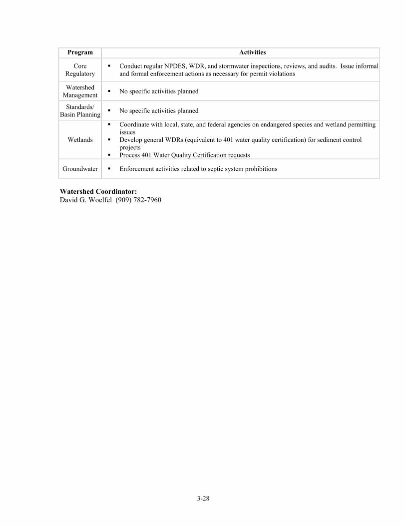
Program Activities
TMDLs No specific activities planned
Nonpoint Source
Program No specific activities planned
Monitoring &Assessment No specific activities planned
3-28
Program Activities
Core Regulatory
Conduct regular NPDES, WDR, and stormwater inspections, reviews, and audits. Issue informal and formal enforcement actions as necessary for permit violations
Watershed Management No specific activities planned
Standards/ Basin Planning No specific activities planned
Wetlands
Coordinate with local, state, and federal agencies on endangered species and wetland permitting issues
Develop general WDRs (equivalent to 401 water quality certification) for sediment control projects
Process 401 Water Quality Certification requests
Groundwater Enforcement activities related to septic system prohibitions
Watershed Coordinator: David G. Woelfel (909) 782-7960
3-29
3-30
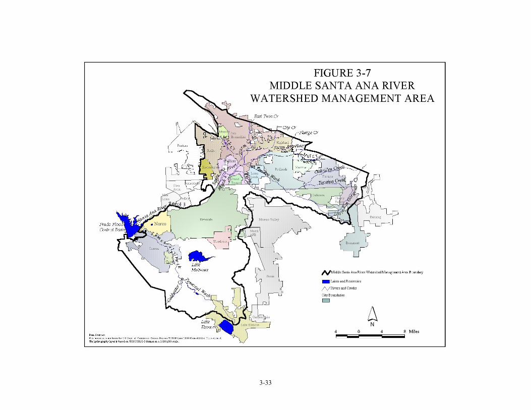
3.7 MIDDLE SANTA ANA RIVER WATERSHED MANAGEMENT AREA Overview As shown in Figure 3-7, the Middle Santa Ana River Watershed Management Area extends from Prado Dam to the foothills of the San Bernardino and San Gabriel Mountains and includes the following major waterbodies:
Santa Ana River, Reaches 3, 4 and 5 San Timoteo Basin Temescal Creek Bunker Hill Basin – I, II, and Pressure San Timoteo Creek Rialto–Colton Basin Mill Creek – Reach 1 Riverside Basin – I, II, and III Lytle Creek Arlington Basin Warm Creek Temescal Basin Plunge Creek Bedford Basin City Creek Lee Lake Basin Yucaipa Creek Coldwater Basin Reche Canyon Creek
Cities in the Middle Santa Ana River Watershed include Corona, Norco, Riverside, Colton, San Bernardino, Grand Terrace, Highland, Loma Linda, Redlands, Calimesa, Yucaipa, and portions of Beaumont. The 1975, 1983 and 1995 Basin Plans reported that the most serious problem in the Santa Ana River Basin is the buildup of dissolved minerals, or salts, in the ground and surface waters. Sampling and computer modeling of groundwaters showed that the levels of dissolved minerals (TDS) were exceeding water quality objectives or would do so in the future unless appropriate controls were implemented. Nitrogen levels in the Santa Ana River, largely in the form of nitrate, were likewise projected to exceed objectives. These high levels of TDS and nitrate adversely affect the beneficial uses of ground and surface waters. In addition, mineralization problems in the Middle Santa Ana River WMA significantly affect the potential of reclamation activities. As discussed in Section 2.1, SAWPA is coordinating a study sponsored by the Nitrogen/TDS Task Force, a consortium of water supply and wastewater management agencies in the Region. The Task Force is supporting Regional Board participation in the study, which is being conducted for the Santa Ana River watershed as a whole. The Task Force is investigating questions related to nitrogen and TDS management in the watershed, including groundwater subbasin water quality objectives, subbasin boundaries, and regulatory approaches to wastewater reclamation and recharge. The Task Force recommends changes in objectives and subbasin boundaries that would substantially affect the Middle Santa Ana River. Basin Plan amendments to incorporate these changes will likely be considered by the Regional Board in 2001-02. Non–native plants, specifically Giant Reed (Arundo donax) (hereafter Arundo) and Saltceder (Tamarix sp.), have significantly affected the beneficial uses of the Santa Ana River and its tributaries. Throughout the Santa Ana River Watershed, particularly the middle portions, Arundo and Saltcedar have invaded and destroyed riparian, endangered species, and aquatic habitat. Arundo’s effect is more serious because it consumes water at a much higher rate than native species. Approximately 8,000 acres of Arundo have been identified along the Santa Ana River watershed. To address the Arundo problem, a number of local, federal and state agencies have formed “Team Arundo”, with the intent to develop an Arundo eradication management plan and to initiate the eradication process. Education of local landowners and the nursery and landscape industry is also an important component of the eradication process.
3-31
Stakeholders – Santa Ana Watershed Project Authority – San Bernardino Valley Municipal Water District – San Bernardino County Transportation and Flood Control District – Riverside County Flood Control and Water Conservation District – San Bernardino Valley Water Conservation District – Metropolitan Water District of Southern California – East Valley Resource Conservation District – West San Bernardino County Water District – Western Municipal Water District – Inland Empire Utilities Agency – US Army Corps of Engineers – Fontana Water Company – Fontana Union Water Company – Cucamonga County Water District – Riverside Highland Water Company – San Gorgonio Pass Water Agency – Western Heights Water Company – East Valley Water District – Upper Santa Ana Water Resources Association – San Bernardino Regional Water Resources Authority – Santa Ana Watershed Association of Resource Conservation Districts – Team Arundo – Cities of San Bernardino, Riverside, Corona, Norco, Redlands, Yucaipa, Beaumont, Highland, Grand Terrace, Colton, Rialto, Loma Linda, Calimesa, Fontana. Fiscal Year 02-03 and 03-04 Program Activities Funded activities in the Newport Bay WMA for each of the eight program areas incorporated into the WMI are listed below. Unfunded activities include reconsideration of site-specific objectives (SSOs) for the middle Santa Ana River and certain tributaries for copper, cadmium, lead and un-ionized ammonia to address new scientific information. These SSOs are included in the 1995 Basin Plan but the USEPA has reserved action on their approval, given the new scientific information indicating that the objectives may be inappropriate.
Program Activities
TMDLs (See Chino Basin activities for Santa Ana River – Reach 3 TMDL activities)
Nonpoint Source
Program
Grant activities involve working with stakeholders to develop potential 205(j), 319(h), and Prop 13 grant proposals and oversight/management of grants
Work collaboratively with the Resource Conservation Districts and San Bernardino County to address and develop education/outreach material
Conduct outreach activities Monitoring
&Assessment Conduct Santa Ana River monitoring at Prado Dam (pursuant to Basin Plan) and
prepare assessment report for the Board and public
3-32
Program Activities
Core Regulatory
Conduct regular NPDES,WDR, and stormwater inspections, reviews, and audits. Issue informal and formal enforcement actions as necessary for permit violations
Watershed Management
Participate in the Santa Ana Watershed Association (SAWA) Interaction with stakeholders in developing water resource management projects. Participate in Santa Ana Sucker coordination meetings
Standards/ Basin
Planning
Regional Board expected to consider Basin Plan amendments to incorporate revised water quality objectives/subbasin boundaries
Wetlands
Coordinate with local, state, and federal agencies on endangered species and wetland permitting issues
Develop general WDRs (equivalent to 401 water quality certification) for sediment control projects
Identify and assess wetlands in middle Santa Ana River Wetland monitoring Process 401 Water Quality Certification requests
Groundwater Groundwater issues include development, by the Nitrogen/TDS Task Force, of guidelines for recycled water recharge projects that could affect groundwater.
Watershed Coordinator The Regional Board designated watershed coordinator for the Middle Santa Ana River WMA is Bill Rice: (909) 782-4459.
3-33
3-34
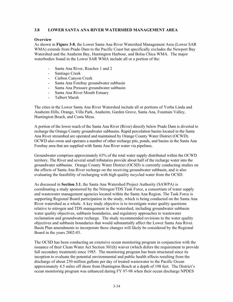
3.8 LOWER SANTA ANA RIVER WATERSHED MANAGEMENT AREA Overview As shown in Figure 3-8, the Lower Santa Ana River Watershed Management Area (Lower SAR WMA) extends from Prado Dam to the Pacific Coast but specifically excludes the Newport Bay Watershed and the Anaheim Bay, Huntington Harbour, and Bolsa Chica WMA. The major waterbodies found in the Lower SAR WMA include all or a portion of the:
- Santa Ana River, Reaches 1 and 2 - Santiago Creek - Carbon Canyon Creek - Santa Ana Forebay groundwater subbasin - Santa Ana Pressure groundwater subbasin - Santa Ana River Mouth Estuary - Talbert Marsh
The cities in the Lower Santa Ana River Watershed include all or portions of Yorba Linda and Anaheim Hills, Orange, Villa Park, Anaheim, Garden Grove, Santa Ana, Fountain Valley, Huntington Beach, and Costa Mesa. A portion of the lower reach of the Santa Ana River (River) directly below Prado Dam is diverted to recharge the Orange County groundwater subbasins. Rapid percolation basins located in the Santa Ana River streambed are operated and maintained by Orange County Water District (OCWD). OCWD also owns and operates a number of other recharge pits, ponds, and basins in the Santa Ana Forebay area that are supplied with Santa Ana River water via pipelines. Groundwater comprises approximately 63% of the total water supply distributed within the OCWD territory. The River and several small tributaries provide about half of the recharge water into the groundwater subbasins. Orange County Water District (OCSD) is currently conducting studies on the effects of Santa Ana River recharge on the receiving groundwater subbasin, and is also evaluating the feasibility of recharging with high quality recycled water from the OCSD. As discussed in Section 3.1, the Santa Ana Watershed Project Authority (SAWPA) is coordinating a study sponsored by the Nitrogen/TDS Task Force, a consortium of water supply and wastewater management agencies located within the Santa Ana Region. The Task Force is supporting Regional Board participation in the study, which is being conducted on the Santa Ana River watershed as a whole. A key study objective is to investigate water quality questions relative to nitrogen and TDS management in the watershed, including groundwater subbasin water quality objectives, subbasin boundaries, and regulatory approaches to wastewater reclamation and groundwater recharge. The study recommended revisions to the water quality objectives and subbasin boundaries that would substantially affect the Lower Santa Ana River. Basin Plan amendments to incorporate these changes will likely be considered by the Regional Board in the years 2002-03. The OCSD has been conducting an extensive ocean monitoring program in conjunction with the issuance of their Clean Water Act Section 301(h) waiver (which defers the requirement to provide full secondary treatment) since 1985. The monitoring program has been structured since its inception to evaluate the potential environmental and public health effects resulting from the discharge of about 230 million gallons per day of treated wastewater to the Pacific Ocean approximately 4.5 miles off shore from Huntington Beach at a depth of 198 feet. The District’s ocean monitoring program was enhanced during FY 97-98 when their ocean discharge NPDES
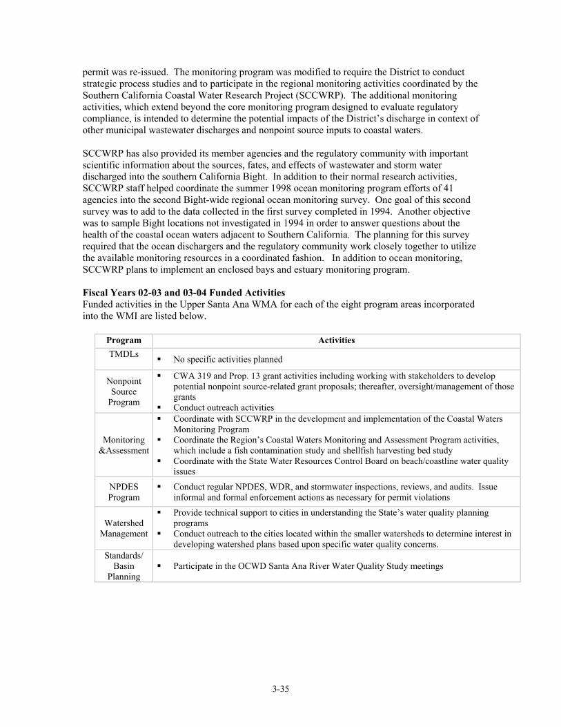
3-35
permit was re-issued. The monitoring program was modified to require the District to conduct strategic process studies and to participate in the regional monitoring activities coordinated by the Southern California Coastal Water Research Project (SCCWRP). The additional monitoring activities, which extend beyond the core monitoring program designed to evaluate regulatory compliance, is intended to determine the potential impacts of the District’s discharge in context of other municipal wastewater discharges and nonpoint source inputs to coastal waters. SCCWRP has also provided its member agencies and the regulatory community with important scientific information about the sources, fates, and effects of wastewater and storm water discharged into the southern California Bight. In addition to their normal research activities, SCCWRP staff helped coordinate the summer 1998 ocean monitoring program efforts of 41 agencies into the second Bight-wide regional ocean monitoring survey. One goal of this second survey was to add to the data collected in the first survey completed in 1994. Another objective was to sample Bight locations not investigated in 1994 in order to answer questions about the health of the coastal ocean waters adjacent to Southern California. The planning for this survey required that the ocean dischargers and the regulatory community work closely together to utilize the available monitoring resources in a coordinated fashion. In addition to ocean monitoring, SCCWRP plans to implement an enclosed bays and estuary monitoring program. Fiscal Years 02-03 and 03-04 Funded Activities Funded activities in the Upper Santa Ana WMA for each of the eight program areas incorporated into the WMI are listed below.
Program Activities TMDLs
No specific activities planned
Nonpoint Source
Program
CWA 319 and Prop. 13 grant activities including working with stakeholders to develop potential nonpoint source-related grant proposals; thereafter, oversight/management of those grants
Conduct outreach activities
Monitoring &Assessment
Coordinate with SCCWRP in the development and implementation of the Coastal Waters Monitoring Program
Coordinate the Region’s Coastal Waters Monitoring and Assessment Program activities, which include a fish contamination study and shellfish harvesting bed study
Coordinate with the State Water Resources Control Board on beach/coastline water quality issues
NPDES Program
Conduct regular NPDES, WDR, and stormwater inspections, reviews, and audits. Issue informal and formal enforcement actions as necessary for permit violations
Watershed Management
Provide technical support to cities in understanding the State’s water quality planning programs
Conduct outreach to the cities located within the smaller watersheds to determine interest in developing watershed plans based upon specific water quality concerns.
Standards/ Basin
Planning Participate in the OCWD Santa Ana River Water Quality Study meetings
3-36
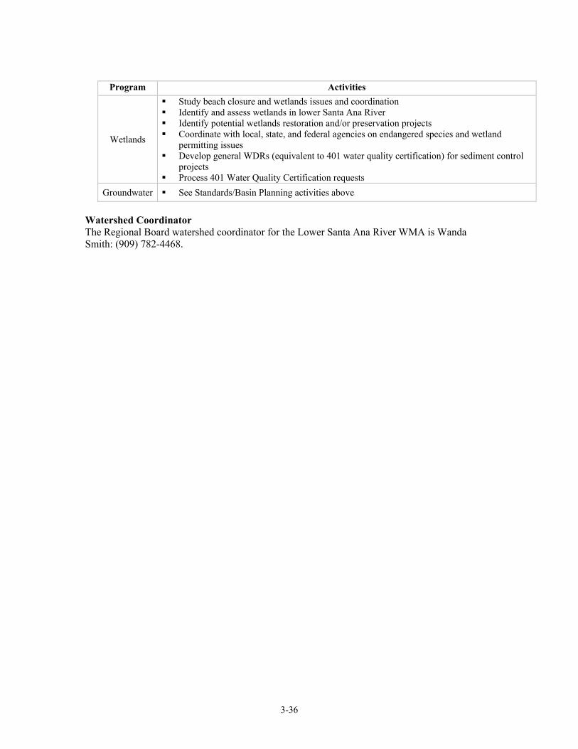
Program Activities
Wetlands
Study beach closure and wetlands issues and coordination Identify and assess wetlands in lower Santa Ana River Identify potential wetlands restoration and/or preservation projects Coordinate with local, state, and federal agencies on endangered species and wetland
permitting issues Develop general WDRs (equivalent to 401 water quality certification) for sediment control
projects Process 401 Water Quality Certification requests
Groundwater See Standards/Basin Planning activities above
Watershed Coordinator The Regional Board watershed coordinator for the Lower Santa Ana River WMA is Wanda Smith: (909) 782-4468.
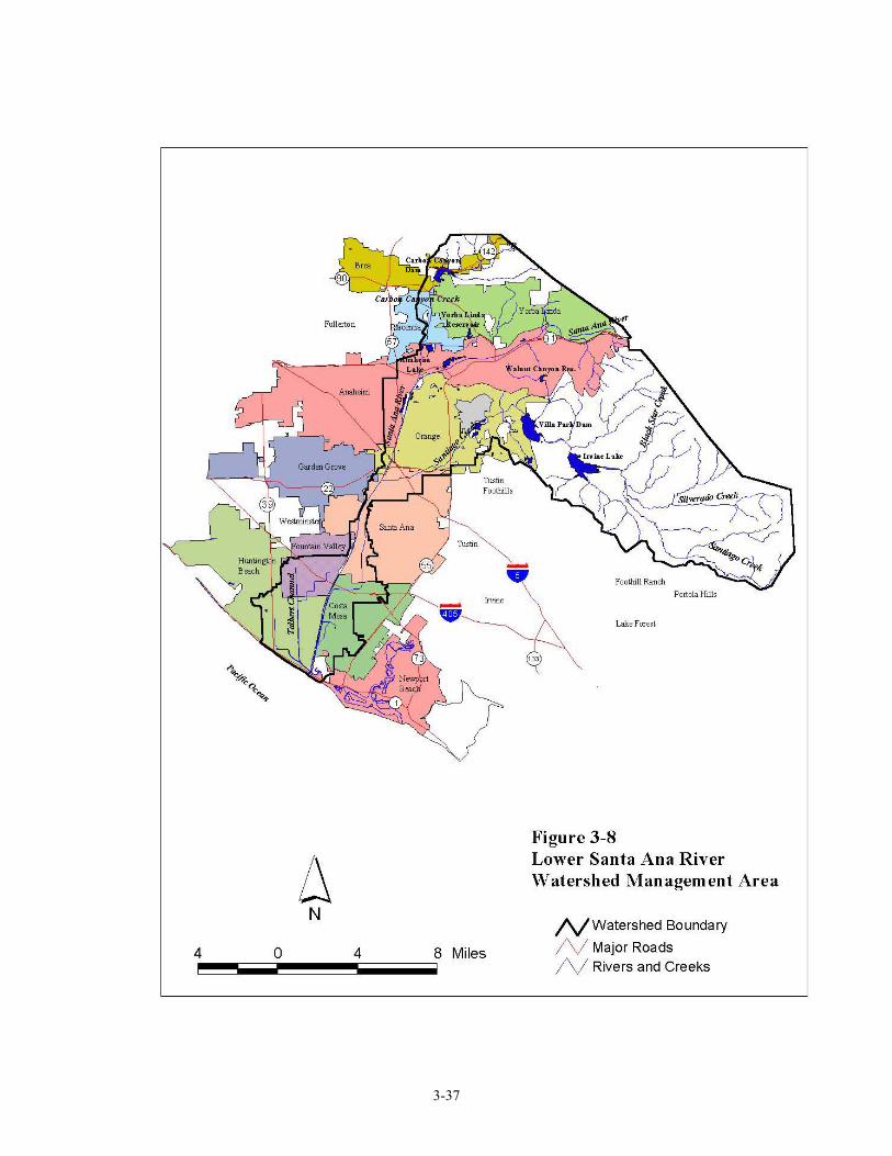
3-37
3-38
3.9 NEWPORT COAST WATERSHED MANAGEMENT AREA Revised May 2004
Overview: The Newport Coast watershed extends along Pacific Coast Highway from Corona Del Mar Beach to north of Laguna Beach. Cities in the Newport Coast Watershed include portions of Newport Beach, Corona Del Mar, Irvine, and an unincorporated portion of Orange County. The Newport Coast Watershed is comprised of a number of subwatersheds. The following waterbodies are included in the Newport Coast Watershed:
- Corona Del Mar Beach - Little Corona Beach - Morning Canyon - Buck Gully Creek - Newport Beach Marine Life Refuge, State Water Quality Protection Area (SWQPA),
formerly Area of Special Biological Significance (ASBS) - Irvine Coast Marine Life Refuge, State Water Quality Area, formerly ASBS - Pelican Point Creek - Pelican Point Middle Creek - Pelican Hill Waterfall - Los Trancos Creek (Crystal Cove Creek) - Muddy Creek
Buck Gully Creek, Pelican Point Creek, Los Trancos (Crystal Cove Creek) and Muddy Creek are impaired due to total and fecal coliform. Each of these waterbodies are in violation of one or more of the following beneficial uses: REC 1, REC 2, and MUN. The source of the pollutants are unknown, however, urban runoff is a possible source. The Newport Coast WMA incorporates the coastline and several small watersheds from Corona Del Mar southwest to Muddy Canyon Creek, which constitutes the border with Region 9. This coastline is entirely bounded by two State Water Quality Protection Areas (SWQPAs; formerly Areas of Special Biological Significance), and these two SWQPAs have been designated with adjacent coastal land as Critical Coastal Areas (CCAs): the Irvine Coast Marine Wildlife Refuge (CCA #71, shared with Region 9), and the contiguous, smaller Newport Beach Marine Life Refuge (CCA #70) extending from Pelican Point north to the end of Poppy Street in Corona del Mar. The sites are designated by the State Water Resources Control Board as requiring protection of species or biological communities to the extent that alteration of natural water quality is undesirable. The entire watershed, if left untreated, could ultimately drain into these SWQPAs/CCAs. The California Ocean Plan states that the discharge of wastes into these designated areas is prohibited. On November 16, 2000 the Santa Ana RWQCB issued Cease and Desist Order (CDO) No. 00-87 to the Irvine Company, California Department of Parks and Recreation, and the California Department of Transportation. The above-mentioned parties were in violation of the California Ocean Plan for discharging wastes into ASBS designated areas. The CDO requires the existing discharges of wastes to the ASBS (now State Water Quality Protection Areas and Critical Coastal Areas) to be eliminated two years from the date of issuance of the CDO and prohibits new discharges of waste, including storm water and non-storm water runoff from developed areas to discharge into ASBS/SWQPA/CCA sites.
3-39
Buck Gully: The Buck Gully subwatershed (part of the larger Newport Coast Watershed) is approximately 1,190 acres. It starts at Signal Peak and extends four miles towards the ocean. Buck Gully has two outlets; the major fork discharges onto Little Corona Beach, meandering its way through the sand to the ocean. The second discharge is at Morning Canyon Beach. In May 2001, the State Water Resources Control Board awarded the City of Newport Beach $222,025 for their proposed project “Little Corona/Buck Gully/Badham Marine Reserve Water Improvement Project”. The overall goal of this project is to reduce health risks to bathers and negative impacts on marine life by improving the water quality in Buck Gully. The methodology by which this project will be executed will be by creating a series of filtering ponds, revegetating the creek banks with native plants, improving and adding a recreation area for hiking and trails, and installing storm drain filters. Newport Coast Planned Community: The Newport Coast Planned Community (NCPC) is a 9,493 acre project in the unincorporated coastal foothills of southwestern Orange County (extending into San Diego RWQCB jurisdiction). The NCPC is located in the coastal zone between the Newport Beach to the north, the San Joaquin Hills to the east, the city of Laguna Beach to the south, and the Pacific Ocean to the west. The NCPC includes residential and commercial development, public facilities, open space, and the Pelican Hill Golf Club. The NCPC is currently underway developing Phases IV-3 and IV-4, which consists of residential units, private recreational facilities, associated roadways, open space, trails, and drainage channel modifications, including detention basins. The Santa Ana RWQCB has required The Irvine Community Development Company to execute a detailed monitoring and reporting program for the runoff associated with this current phase of development (Phases IV-3 and IV-4). Monitoring will occur at various points in Los Trancos Creek, Muddy Creek, Emerald Creek (San Diego RWQCB jurisdiction), Basin 6, Basin 2, and Area 3A of the proposed development. Sampling for water quality, marine ecology, and microbiology will yield results that dictate the developments effect upon water quality and micro and marine organisms. The results will provide data about the developments impacts on the associated creeks and Irvine Coast SWQPA/CCA. Crystal Cove State Park: Crystal Cove State Park, located along the coastline between Newport Beach and Laguna Beach, is currently comprised of 2,791 acres of undeveloped wooded canyons and open bluffs, and 3.25 miles of beach. The offshore waters are designated as an underwater park. The Crystal Cove Historic District lies within Crystal Cove State Park at the midpoint of the State Park’s 3.25-mile coastline. Located at the mouth of Los Trancos Canyon, the Crystal Cove Historic District is 12.3 acres, comprised of natural open space terraces and coastal bluffs. The Department of Parks and Recreation is currently working on the Crystal Cove Historic District Preservation and Public Use Plan. This Plan will suggest recommendations to restore and preserve the cultural and natural resources of this area. The overall plan will take into consideration, the State Parks mission and purpose, socio-economic, natural and cultural resources, regulatory, financial, and programmatic constraints. In the mean time, CDPR is the lead agency for the Crystal Cove Historic District Investigations and Interim Protection Plan that will manage the Crystal Cove Historic District for the interim while the Preservation and Public Use Plan is being developed. The Santa Ana RWQCB is providing comments on both the Crystal Cove Historic District Preservation and Public Use Plan and the Crystal Cove Historic District Investigations and Interim Protection Plan.
3-40
Stakeholders California Coastal Commission Orange County Coastkeeper California Department of Fish and Game Orange County Health Care Agency California Department of Parks and Recreation Orange County Sanitation District City of Newport Beach Surfrider-Newport Beach Chapter County of Orange The Irvine Company Irvine Ranch Water District U.S. Army Corps of Engineers Fiscal Year 02-03 and 03-04 Program Activities Funded activities in the Newport Bay WMA for each of the eight program areas incorporated into the WMI are listed below. Unfunded activities include work with stakeholders to implement NPS Management Measures and to develop and implement education/outreach material.
Program Activities
TMDLs Conduct stakeholder group meetings
Nonpoint Source
Program
Oversight and management of Buck Gully Prop. 13 grant; meet with stakeholders to develop potential 319(h) and Prop. 13 grant proposals two NPS contracts
Work with stakeholders to educate and implement Management Measures Work with stakeholders to develop and implement education/outreach material Conduct outreach activities Critical Coastal Area monitoring and coordination with CCA Committee
Monitoring &Assessment Monitor Crystal Cove development runoff at Los Trancos Creek and Muddy Creek
Core Regulatory
Conduct regular NPDES, WDR, and stormwater inspections, reviews, and audits. Issue informal and formal enforcement actions as necessary for permit violations
Watershed Management
Continue participation with the Newport Harbor Water Quality Citizens Advisory Committee
Educate and mentor development of watershed management plans
Standards/ Basin Planning
Include Morning Canyon, Buck Gully Creek, Pelican Point Creek, Pelican Point Middle Creek, Pelican Hill Waterfall, Los Trancos Creek (Crystal Cove Creek), Muddy Creek in the Basin Plan and assign the following beneficial uses to the waterbodies: MUN, REC 1, REC2, and WARM
Wetlands Coordinate with local, state, and federal agencies on endangered species and wetland
permitting issues Process 401 Water Quality Certification requests
Groundwater No specific activities planned
3-40a
Available References California State Water Resources Control Board, Areas of Special Biological Significance, 1976 California State Water Resources Control Board, California Ocean Plan, 1997 State of California Regional Water Quality Control Board Santa Ana Region, Cease and Desist
Order No. 00-87, 2000 Watershed Coordinator The Regional Board watershed coordinator for the Newport Coast WMA is Doug Shibberu: (909) 782-7959.
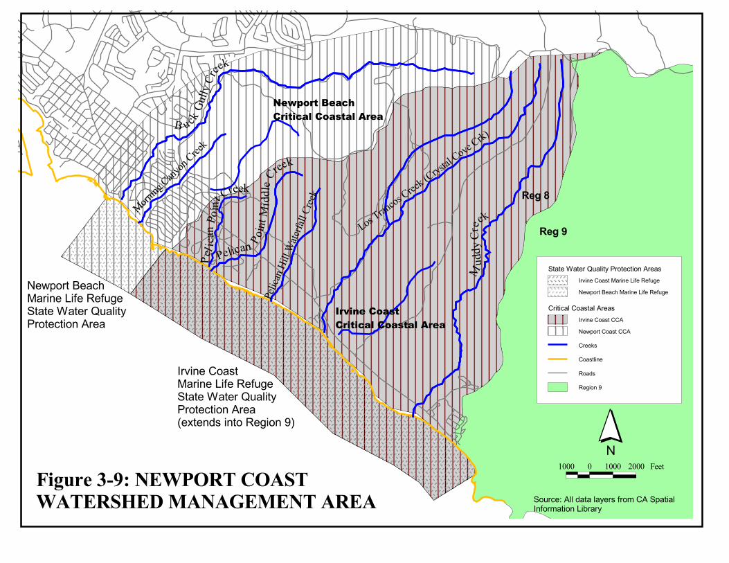
�������
������
����
�������
����
������
���� �����
���������������������
��
�� ��
�����
������
���������
�����
����
���
� �������� �
��
���� ��
�
������������� � �����������
��� ���������� � �����������
�����
�����
������������� ���� ���������������������� ��������� ������
��� ���������� ���� ���������������������� ��������� �������� ���!�� ������� ���"#
������������ ���������� ������������������������
���� � ���� ���� ��
������������� ��������� ���������� ���������� ���� ������������������������ ���� ����������
�� � ��������������� ���������������������������
����$�
����� ��
��!�
��� ���"�
�����%�����!�����������&������� �������&� ���� '���
3-42
3.10 COYOTE / CARBON CREEK WATERSHED MANAGEMENT AREA
Overview The Coyote / Carbon Creek Watershed Management Area lies in the northwestern corner of Orange County and adjacent Los Angeles County. Major waterbodies in Orange County include Coyote Creek, Brea Creek Channel, Fullerton Creek Channel, Imperial Channel, and Carbon Creek. These water ways drain the cities of La Habra, Brea, Fullerton, Buena Park, La Palma, and parts of Placentia, Anaheim, Los Alamitos, and Cypress. Coyote Creek, for most of its length, flows along or near the Los Angeles County/Orange County line. Several tributaries to Coyote Creek drain the Los Angeles County cities of La Mirada, Cerritos, eastern section of Norwark, Whittier, La Habra Heights, and sections of Diamond Bar. Any area located in Los Angeles County is under the jurisdiction the Los Angeles Regional Water Quality Control Board and therefore is not considered in the Santa Ana Regional Water Quality Control Board’s Coyote Creek Watershed Management Area. The geography of the Coyote Creek Watershed Management Area includes hills in the northern section and coastal plains in the southern section. Surface drainages generally originate in the East Coyote Hills, West Coyote Hills, and the Puente Hills and flow towards the southwest eventually joining the main stem of Coyote Creek. Coyote Creek empties into the San Gabriel River in Los Angeles County just west of the city of Los Alamitos. There are several flood control and retarding basins located along several of the waterways. These include Fullerton Reservoir, Brea Dam, Raymond Retarding Basin, Crescent Basin, and Gilbert Retarding Basin. The Management Area is largely urbanized, however, the hilly, northern area contains some areas of open space, which are mostly in oil production. The Coyote Creek Watershed Management Area suffers from several water quality standards related problems. These include poor water quality, lost aquatic species, lost and degraded wetlands, in-stream and terrestrial habitats, channel degradation and erosion, reduced natural recharge, infestation of invasive species, flood damage, and devalued recreation experience. The creek is listed as an impaired water body for nitrogen and related effects (such as pH, alga growth, etc.) under the Clean Water Act Section 303 (d). Stakeholders of this watershed include the Army Corps of Engineers, Los Angeles and Orange Counties, local cities, California Department of Fish and Game, United States Fish and Wildlife Service, the Los Angeles (Region 4) and the Santa Ana (Region 8) Regional Water Quality Control Boards, the San Gabriel and Lower Los Angeles Rivers and Mountains Conservancy, the Los Angeles and San Gabriel Rivers Watershed Council, the Friends of the San Gabriel River, the County Sanitation Districts of Los Angeles, local water and sewer agencies, Los Angeles and Orange County flood control departments, among others. The Coyote Creek Watershed Management Plan funded by Proposition 13 will soon be initiated for the entire Coyote Creek Watershed. The objective of the plan is to develop a Watershed Management Plan to maintain, restore and enhance a healthy Coyote Creek Watershed. The project applicants are the County of Orange Public Facilities and Resources Department (PFRD) and the Los Angeles County Department of Public Works. The project director is Kathie Matsuyama of the County of Orange PFRD. She can be reached at (909) 834-6662. Fiscal Year 02-03 and 03-04 Program Activities Funded activities in the Upper Santa Ana WMA for each of the eight program areas incorporated into the WMI are listed below
3-43
Program Activities
TMDLs No specific activities planned
Nonpoint Source
Program No specific activities planned
Monitoring &Assessment No specific activities planned
Core Regulatory
Conduct regular NPDES, WDR, and stormwater inspections, reviews, and audits. Issue informal and formal enforcement actions as necessary for permit violations
Watershed Management No specific activities planned
Standards/ Basin Planning No specific activities planned
Wetlands Coordinate with local, state, and federal agencies on endangered species and wetland
permitting issues Process 401 Water Quality Certification requests
Groundwater No specific activities planned
Watershed Management Area Coordinator: David G. Woelfel (909) 782-7960.
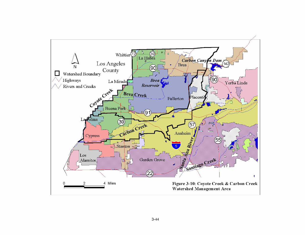
3-44