3.0-Human Geography Canada’s People Chapter 3 · NL 405 212 510 600 1.26 ppl/km2 PEI 5 660 145...
44
Chapter 3 Canada’s People 3.0-Human Geography Socials Studies
Transcript of 3.0-Human Geography Canada’s People Chapter 3 · NL 405 212 510 600 1.26 ppl/km2 PEI 5 660 145...

Chapter 3Canada’s People
3.0-Human Geography
Socials Studies

Physical Geography
Study of the natural features of the Earth’s surface including landforms, climate, ocean currents and flora and fauna

Human Geography
Study of people and their communities, cultures, economies and interactions with the environment

Physical Environment Determines Human Settlement Patterns● The physical environment of a region
determines whether it is a good place to settle based on its natural resources such as soil, water supply and/or its climate.
● Fishing, logging, and farming are all examples of how the physical environment would influence human settlement to a particular area.

Physical Environment Determines Human Settlement Patterns● Appalachian Mountain region: fishing,
lumbering and shipbuilding● Great Lakes-St. Lawrence Lowlands: good
for farming, now site for many of Canada’s major cities.
● Interior Plains: Wheat farming and ranching
● Western Cordillera: Logging, Farming and Fishing
● Arctic Lowlands: few people live there because of poor soil and climate

Human Activities Change The Physical Environment● The introduction of the automobile● Clear cutting forests● Mountain mining● Global warming

Human Activities Changing The Physical Environment

3.1 Rural and Urban Communities● Create a t-chart on what you already know
about Rural and Urban Communities. In your chart you should think of an example, and the characteristics of that example.
Urban Rural

Rural● Areas that are often agricultural and located
outside towns and cities.
● What are some local and national examples?

Urban● Towns and cities with a population with 1000
or more. Or, with a population density of at least 400 people per square km.
● What are some local and national examples?

Population Distribution● Population distribution is how we describe
where people choose to live in a country.

World Population Distributionhttp://sevencolors.org/images/photo/origina
l/earth_lights.jpg

Archipelago Effect● This is simply an analogy (comparison) of
how the population of Canada is pockets of settlements, that looks like a group of islands (a group of islands is called an archipelago).
● See figure 3.1, page 42-43

Population Density● A measure of how closely people live
together in a given country OR area.● Example:
● The houses in downtown St. John’s are very close together.
● The houses on Marine Drive are farther apart.
● See figure 3.3 on page 44.

How to calculate Population DensityPopulation of an area= ASize of an area in square kilometers=B
A/B=population density= ppl/km2
Example: YOU CALCULATE!!!Population of Town is 10 000Size of area in square kilometers is 2000
square kilometers
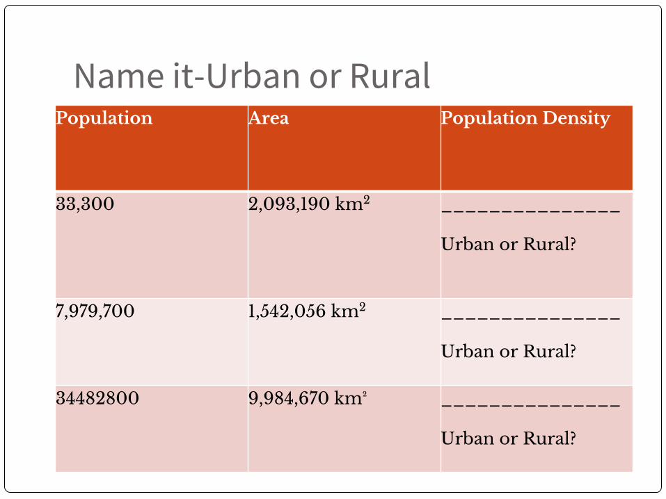
Name it-Urban or RuralPopulation Area Population Density
33,300 2,093,190 km2 _______________
Urban or Rural?
7,979,700 1,542,056 km2 _______________
Urban or Rural?
34482800 9,984,670 km² _______________
Urban or Rural?

Create the chart in your notebooksProvinces Area Population Population
Density
NL
PEI
NS
NB
QUE
ONT
ETC (fill in remainder of the provinces yourself)


Provinces Area (km2) Population Population Density
NL 405 212 510 600 1.26 ppl/km2
PEI 5 660 145 900 25.7 ppl/km2
NS 5 284 945 400 17.1 ppl/km2
NB 72 908 755 500 10.3 ppl/km2
QUE 1 542 056 7 905 700 5.1 ppl/km2
ONT 1 076 395 13 373 000 12.4 ppl/km2
AB 661 848 3 779 400 5.7 ppl/km2
MB 647 797 1 234 500 1.9 ppl/km2
SK 651 036 1 057 900 1.6 ppl/km2
BC 944 735 4 573 300 4.8 ppl/km2

Questions1. Where is Canada most thinly populated?2. Which area is most densely populated?3. Name two other highly populated areas. How do
these highly populated areas relate to the location of Canada’s main urban centers?
4. How accurate is it to say that Canada’s population is mainly concentrated along the US/Canada border (islands of population-Archipelago)
5. Why can’t you only examine population density when studying population distribution (see Canada vs Netherlands example on page 44)

Settlement Patterns● The people who lived in Canada prior to
European settlement were the Aboriginal or Indigenous groups.
● Europeans were attached to the areas that were inhabited by the aboriginal group because of the site (physical) and situation (site’s relationship to other places) factors.

Aboriginal/Indigenous Populations● Inuit-Live in Arctic Canada (Nunavut,
NWT, Lab, Que). Inuktitut is the language of the Inuit.
● Metis-are of First Nations and European ancestry. Live primarily on the Prairies, and in Ontario and the NWT.
● First Nations-use this term when referring to more than one group of indigenous people.

3.2 Make a value Judgement!● Overtime there has been a decline in
traditional activities of Aboriginal peoples. In your opinion, who should take responsibility for these changes?

3.2 Account for the growth and decline of settlements
● Site Factors: ● Features of the physical landscape that attract
people.● What are some physical features that
attracted people to Halifax?• Military outpost (easy to protect)
• Ice-free port
• Protected harbour
• Railway hub (late 1800s)

3.2 Account for the growth and decline of settlements● Situational Factors
● A sites relationship to other places. ● Things about the area attract people to the spot. (Like
Halifax)• Railway hub in the 1800’s
• Shipping centre for goods (coming in from Europe and going out from Canada)
• Regional Centre of Gov’t and services
• all these required workers, who moved to the area for jobs
• lots of workers encouraged manufacturing jobs in area (this declined as manufacturing could be done elsewhere for cheaper)

3.2 Classification of Communities● A look at communities that reflect growth or
decline over the years, such as through services:● Villages/small towns
● Small stores● Limited products or competition (ie. Only 1 gas station in
town)● Small doctor’s office● Small schools, or go to larger towns for high school● Must travel for larger stores, shopping, etc.
● Cities● Hospitals, universities, large banks, government offices● Specialized services for large populations (ie. ENT doctors,
etc.)● Specialty stores
● Some services may spread outside a city, expanding to reach other local areas and increase their size.

Growth and DeclineSettlements GROW because: Settlements DECLINE because:
Changes in service• building of hospitals / schools / fire dept. / government services
Rural to Urban drift• move from rural towns to larger centers • move from agriculture to urban (technology / resource depletion / etc)
Transportation• new bridge / road / highway in area
Economic downturn• loss of jobs locally
Climate• better weather patterns• local weather (ie. Less snow)
Lack of services• lack of services / quality of services• change in needs (older people need more health care vs education)
Economics• new industries / manufacturing / construction resulting in more jobs

3.3 Canada: A Regional Perspective ● Regional analysis is a tool used by geographers to help
bring order to their study. It involves breaking the whole into smaller parts to aid investigation and understanding.
● Identifying regions is a useful way to discuss the role played by natural and human resources on prosperity across Canada.
● In Canada regional identities are influenced by geographic factors.
● Canada has 5 geographic regions. Can you name them?

Characteristics of Regions can be divided in 4 Categories
● 1. Location
● 2. Physical and Cultural Characteristics
● 3. Political Perspective
● 4 Hierarchy

1. Location ● Communities within a region share a
geographic location, often expressed in the regional name selected, such as Atlantic Canada or the Prairies.

2. Physical and Cultural Characteristics● Regions have clearly defined physical and
cultural characteristics. For example, the physical geography of the Prairies defines this location as regionally different from the Canadian Shield.

3.Political Perspective● Geographic and political boundaries are not the same. For
example, southern Ontario has the same kind of physical geography and economy as the Midwest region in the U.S. Together, they form one large region in North America. Similarly, Atlantic Canada and New England share common physical geography and culture. However, there are important political differences between the areas on either side of Canada –U.S. border.

Introduction of Canada’s Regions● There are different ways to categorize regions in
Canada. ● In this section you will learn about Canada’s 5 regional
political divisions (figure 3.11, page 53).● Can you name the 5 regions on this map?

4. HierarchyRegions contain smaller regions within them. This is called hierarchy. Just as Canada can be divided into regions to gain an understanding of the country, regions can be divided into smaller regions for study purposes. For example, if you were to analyze your province, you could first divide it into smaller regions. Department of tourism do this to promote tourism in different areas of a province. These 2 pictures are of N.S.

Canada’s Political Regions (page 54)● In your exercise, complete the t-chart on
the political regions of Canada
Region Location Physical/Cultural Attributes
Political Perspective
Hierarchy
1.
2.
3.
4.
5.

The Core and the Periphery
● Interaction among the 5 regions is a key factor in investigating the growth and prosperity of Canada.
● A tool that geographers use to understand this relationship is the concept of core and periphery and the relationships that develop between them.

Core● The core is the nucleus of a geographic region,
containing its most developed area, greatest wealth, and highest population density. Toronto is an example of a core.
● Over half of Canada’s population lives in Southern Ontario and southern Quebec.

Periphery● The periphery is all the areas outside the core.
It is sometimes referred to as the “hinterland”.● It supplies raw material, and provides a market
for its manufactured products and services.

Windsor-Quebec City Corridor ● Over time, this corridor became the centre
of Canada’s financial services and the hub of transportation systems.
● This areas sends more Members of Parliament to Ottawa. Why? What affect does this have?

Core Cities in Canada● Using the table on page 56, group and map
the cities by region. ● What patterns begin to emerge?
City Population, 2010
Main Function
Toronto
Montreal

Questions● What factors have contributed to the
development of the Windsor-Quebec City corridor as Canada’s core? Is there a core within a core?
● What are some of the challenges to growth and prosperity for cities of the periphery?
● Where do you see yourself living in 20 years? Why?

3.4 Regional Identities● Many regional identities are associated
with local industries. What industries and identities are depicted below?

Three Jolly Fishermen
http://www.cbc.ca/news/canada/newfoundland-labrador/story/2011/10/14/nl-fishermen-postcard-114.html (see video)