30 1984 · The fine sand is a mixture of quartz, calcium carbonate, ... the shells are commonly ......
12
Vol. 30 May 1984 No. 2 THE MIDDLE AND LATE PLEISTOCENE STRATIGRAPHY OF THE OUTER COASTAL PLAIN, SOUTHEASTERN VIRGINIA Pamela C. Peebles, Gerald H. Johnson, and C. R. Berquist Late Cenozoic deposits of the outer Coastal Plain of southeastern Virginia consist of the Shirley formation (Johnson and Berquist, in preparation), which is middle Pleistocene in age, and the Tabb Formation (Johnson, 1976, and Peeblea, in re par at ion), of late Pleistocene age. Each of these formations, which consists of various l i t h o f a c ies , is bounded above and below by an unconformity. Accordingly, each is an alloformation. An alloformation is defined by the North American Commission on Stratigraphic Nomenclature (1983) as, ". . . the fundamental unit in allostratigraphic nomenclature.. . An allostratigraphic unit is a mappable stratiform body of sedimentary rock that is defined and identified on the basis of its bounding discont inuit i es ." Sediments which were deposited in embayed areas landward of. barriers and along rivers exhibit upward-fining texture. When sea level fell and the sediments became emergent, a terrace (flat or rise) was created. The abandoned shoreline along the mainland (fastland) and rivers formed a scarp. Subsequent marine transgressions eroded the sediments under lying the older terraces and scarps mark the most landward extent of each marine transgression. Economically valuable sand, gravel and fill material may be found at the base of the upward-fining sequences. The fornat ions as defined herein provide a framework for predicting the locat ion of these resources. The stratigraphic framework is simpler, more accurate, and consequently more useful than the previous classifications. The authors wish to express their deep appreciation to Mary Keith Garrett, U.S. Fish and Wildlife; Patricia Gamon, U.S. Geological Survey; Page Herbert, Herbert and Associates; Eugene Rader, Virginia Division of Mineral Resources; R. Mixon and W. Newel1 of the U.S. Geological Survey for constructive criticism; and numerous pit operators who contributed to this paper. STRATIGRAPHY Deposits ranging in age from early Pliocene to late Pleistocene crop out in the outer Coastal Plain of southeastern Virginia. The stratigraphic succession under study includes the Yorktow~~, Chowan River, Shirley, and Tabb formations (Figure 2). Coch (1968, 19711, Oaks and Coch (19731, Ray and others (19681, Johnson (19761, Mixon and others (19821, Johnson and others (19811, and Darby (19831 discussed the Great Bridge, Norfolk, Kempsville, Londonbridge, and Sand Bridge
Transcript of 30 1984 · The fine sand is a mixture of quartz, calcium carbonate, ... the shells are commonly ......

Vol . 30 May 1984 No. 2
THE MIDDLE AND LATE PLEISTOCENE STRATIGRAPHY OF THE OUTER COASTAL PLAIN, SOUTHEASTERN VIRGINIA
Pamela C. Peebles, Gerald H. Johnson, and C. R. Berquist
L a t e Cenozoic d e p o s i t s of t h e o u t e r C o a s t a l P l a i n o f s o u t h e a s t e r n V i r g i n i a c o n s i s t o f t h e S h i r l e y formation (Johnson and B e r q u i s t , i n p r e p a r a t i o n ) , which i s m i d d l e P l e i s t o c e n e i n a g e , and t h e Tabb Formation (Johnson, 1976, and P e e b l e a , i n re par at i o n ) , of l a t e P l e i s tocene age. Each o f t h e s e f o r m a t i o n s , which c o n s i s t s o f v a r i o u s l i t h o f a c i e s , is bounded above and below by an unconformity. Accordingly, each i s a n a l l o f o r m a t i o n . An a l l o f o r m a t i o n is defined by t h e North American Commission on S t r a t i g r a p h i c Nomenclature (1983) a s , ". . . t h e fundamental u n i t i n a l l o s t r a t i g r a p h i c nomenc la tu re . . . An a l l o s t r a t i g r a p h i c u n i t i s a m a p p a b l e s t r a t i f o r m b o d y o f s e d i m e n t a r y r o c k t h a t i s d e f i n e d and i d e n t i f i e d on t h e b a s i s o f i t s bound ing d iscont i n u i t i e s ."
Sediments which w e r e d e p o s i t e d i n embayed a r e a s landward of . b a r r i e r s and along r i v e r s exh ib i t upward-fining t e x t u r e . When s e a l e v e l f e l l a n d t h e s e d i m e n t s became emergent, a t e r r a c e ( f l a t o r r i s e ) was c r e a t e d . The abandoned s h o r e l i n e along t h e mainland ( f a s t l a n d ) and r i v e r s formed a s c a r p . Subsequent m a r i n e t r a n s g r e s s i o n s eroded t h e sediments u n d e r l y i n g t h e o l d e r t e r r a c e s and scarps mark t h e most landward e x t e n t of each marine t r ansg re s s ion .
Economically va luable sand, g r ave l and
f i l l m a t e r i a l may be found a t t h e b a s e of t h e upward-fining sequences. The fo rna t ions a s def ined he re in p r o v i d e a framework f o r p r e d i c t i n g t h e l oca t ion of t h e s e resources . The s t r a t i g r a p h i c framework i s s i m p l e r , more accu ra t e , and consequently more u s e f u l than t h e previous c l a s s i f i c a t i o n s .
The au thors wish t o express t h e i r deep a p p r e c i a t i o n t o Mary K e i t h G a r r e t t , U.S. F i s h and W i l d l i f e ; P a t r i c i a Gamon, U.S. Geological Survey; Page H e r b e r t , H e r b e r t a n d A s s o c i a t e s ; Eugene R a d e r , V i r g i n i a Div is ion of Mineral Resources; R . Mixon and W. Newel1 of t h e U.S. Geological Survey f o r c o n s t r u c t i v e c r i t i c i s m ; and numerous p i t ope ra to r s who con t r ibu t ed t o t h i s paper .
STRATIGRAPHY
D e p o s i t s r a n g i n g i n a g e f rom e a r l y P l iocene t o l a t e P l e i s t o c e n e c r o p o u t i n t h e o u t e r C o a s t a l P l a i n o f s o u t h e a s t e r n V i r g i n i a . The s t r a t i g r a p h i c s u c c e s s i o n unde r s t u d y i n c l u d e s t h e Yorktow~~, Chowan River , S h i r l e y , and Tabb formations (F igure 2). Coch ( 1 9 6 8 , 1 9 7 1 1 , Oaks a n d Coch (19731 , Ray and o t h e r s ( 1 9 6 8 1 , J o h n s o n (19761 , Mixon and o t h e r s (19821, Johnson a n d o t h e r s ( 1 9 8 1 1 , a n d D a r b y ( 1 9 8 3 1 d i s c u s s e d t h e G r e a t B r i d g e , N o r f o l k , Kempsville, Londonbridge, and Sand Br idge

DIVISION OF MINERAL RESOURCES Vol. 30
Table. Comparison of stratigraphic units used previously and i n th is report.
Ser i es
Upper Ple istocene
Middle Ple istocene
Upper P I i ocene
Th is repo r t
Tabb Fm., Poquoson Mbr.
Tabb Fm., Lynnhaven Mbr.
Tabb Fm., Sedgefield Mbr.
Sh i r l ey Fm.
Chowan River. Fm.
* i n p a r t
Darby (1983)
Not covered i n repo r t
Nor fo lk Fm.
(Upper Ple istocene)
Not present
Great Br idge Fm.
(Upper ? Ple istocene)
Mixoh, Szabo and Owens
(1982)
Sand Br idge Fm.*
Sand Br idge Fm.*
Kempsvil le Fm.*
Kempsvil le Fm.*
Nor fo lk Fm. ( type area)
Nor fo lk Fm. (West o f
Suf fo lk scarp) (Upper
Ple istocene)
Great Br i dge Fm.
(Upper Pleistocene)
formations i n t h e i r r e p o r t s . By iden t i fy ing unconformit i e s and mapping s t r a t i g r a p h i c u n i t s a t t h e s c a l e o f 1 : 2 4 , 0 0 0 , new c o r r e l a t i o n s be tween s e l e c t e d u n i t s have b e e n made p o s s i b l e . T h i s n e c e s s i t a t e s a r e v i s i o n of t h e current ly-used nomenclature which was i n t r o d u c e d by Coch (1968, 1971) and Oaks and Coch (1973). The Grea t Br idge Fo rma t ion (Oaks and Coch, 1973; Mixon and o t h e r s , 1982; and Darby , 1983) i s h e r e i n shown t o b e p a r t o f t h e Chowan R i v e r Fo rma t ion ( B l a c k w e l d e r , 1 9 8 1 ) o f l a t e P l iocene age and t h e Tabb Format ion of l a t e P l e i s tocene age. The Nor fo lk Format i o n of Oaks and Coch (1973) i s now considered t o comprise two d i s t i n c t formations separated by a n u n c o n f o r m i t y : t h e Sh i r l ey formation (Johnson and Berquist , i n p r e p a r a t i o n ) and t h e Tabb Format ion (Johnson, 1976; Peebles , i n p r e p a r a t i o n ) . Sed imen t s o f t h e Sand B r i d g e , K e m p s v i l l e , a n d L o n d o n b r i d g e f o r m a t i o n s o f Oaks and Coch ( 1 9 7 3 ) a r e h e r e i n c o n s i d e r e d t o be f a c i e s wit-hin t h e
Johnson ( 1976) Johnson, Berquist,
Ramsey and Peebles (1981)
Oaks and Coch (1973)
Coch( 1968,1971)
Tabb Fm., Poquoson Mbr.
Tabb Fm., Lynnhaven Mbr.
Tabb Fm., Sedgefield Mbr.
Great Br idge
present (Upper P l e i stocene)
Sand Br idge Fm. *
Sand Br idge Fm. *
Kempsvil le Fm.*
Nor fo lk Fm.*
Sand Br idge Fm. *
Kempsvl l l e Fm.*
Londonbridge Fm.* Nor fo lk Fm.*
Great Br idge Fm.*
Nor fo lk Fm. (Upper
Ple istocene)
S e d g e f i e l d and Lynnhaven members of t h e Tabb Format i o n ( P e e b l e s , i n prepara t ion) . Because o f t h i s c o n f u s i o n , w e recommend d r o p p i n g t h e use of Great Bridge, Norfolk, Kempsville, Sand Br idge , and Londonbr i dge a s s t r a t i g r a p h i c terms.
Nor fo lk Fm. (clayey sand
fac ies)
YORKTOWN FORMATION
W i t h i n s o u t h e a s t e r n V i r g i n i a , t h e Yorktown Formation (Clark and M i l l e r , 1906) c o n s i s t s of f o s s i l i f e r o u s marine s i l t y f i n e sand and crossbedded, b i o f r a g m e n t a 1 s and . L o c a l l y , t h e Yorktown u n d e r l i e s t h e Chowan River , S h i r l e y , and Tabb f o r m a t i o n s . The Y o r k t o w n F o r m a t i o n i s ' e a r l y t o middle P l i o c e n e ( A k e r s , 1 9 7 2 ; M i x o n , w r i t t e n comrnunicat ion) .
The s i l t y sand f a c i e s ( Johnson, 1969, 1972, and 1976) is composed of bluish-gray t o g r e e n i s h - g r a y f i n e s and i n t e r c a l a t e d w i t h c l a y e y s i l t . T h e f i n e s a n d i s a mixture of qua r t z , c a l c i u m c a r b o n a t e , and

No. 2 VIRGINIA MINERALS 15
s u b o r d i n a t e amounts o f g l a u c o n i t e , c l a y ,
@ heavy m i n e r a l s , and p h o s p h a t e . B e d d i n g v a r i e s f rom m a s s i v e t o t h i c k , and scour- a n d - f i l l s t r u c t u r e s a r e common. The sand i s ex t ens ive ly b io tu rba t sd . Weathering of t h i s f a c i e s removes t h e c a l c i u m c a r b o n a t e and l e a v e s a s o f t , g r a y , c l a y e y f i n e sand r e s i d u e which i s m o t t l e d y e l l o w i s h t o reddish-brown. The fauna of t h e s i l t y sand f a c i e s i s d o m i n a t e d b y m o l l u s k s , and i n c l u d e s d i v e r s e mar ine v e r t e b r a t e and i n v e r t e b r a t e a s s e m b l a g e s . A l t h o u g h a m a j o r i t y o f t h e b i v a l v e s a r e d i s a r t i c u l a t e d , t h e s h e l l s a r e commonly whole and e x h i b i t l i t t l e o r no evidence of abras ion .
The c r o s s b e d d e d c o q u i n a f a c i e s i s exposed i n t h e Yadkin and Chuckatuck p i t s a n d a l s o u n d e r l i e s younger u n i t s i n t h e D i s m a l Swamp a n d o n t h e Y o r k - J a m e s P e n i n s u l a . T h i s f a c i e s c o n s i s t s o f yellowish-brown t o bluish-gray , crossbedded b i o f r a g m e n t a l s and . The c r o s s b e d u n i t s range i n t h i ckness from 3 t o 20 f e e t , and d i p w e s t w a r d . S m a l l e r s c a l e c r o s s b e d s commonly d i p n o r t h e a s t . C a r b o n a t e c o n t e n t i n t h e c r o s s b e d d e d c o q u i n a f a c i e s may exceed 90 p e r c e n t by w e i g h t . G l a u c o n i t e , i r o n o x i d e , c l a y , a n d q u a r t z a r e a l s o p re sen t . Although t h e coquina i s t y p i c a l l y f r i a b l e , i t is l o c a l l y indurated wi th i r o n oxide , s i d e r i t e , and c a l c i t e . The coqu ina w e a t h e r s t o a s p o n g y , l i g h t brown t o reddish-brown c layey s i l t .
CHOWAN RIVER FORMATION
T h e C h o w a n R i v e r F o r m a t i o n ( B l a c k w e l d e r , 1981) o f l a t e P l iocene age c o n s i s t s of i n t e r b e d d e d s i l t y f i n e s a n d , c l a y e y s i l t , a n d b i o f r a g m e n t a l s a n d . Deposi ts of t h e Chowan River Format ion a r e we 11 e x p o s e d a l o n g t h e Chowan R i v e r i n Nor th C a r o l i n a ; however t h e s e d e p o s i t s o c c u r o n l y l o c a l l y i n t h e s u b s u r f a c e of southeas te rn Virg in ia . Because o f t h e r a r e e x p o s u r e s of t h e Chowan River and because leaching of t h e s h e l l s w i t h i n t h e Chowan R i v e r F o r m a t i o n r e n d e r s t h e s e d i m e n t s s i m i l a r t o those of t h e Yorktown and Tabb fo rma t i o n s , p r e v i o u s worke r s have placed Chowan River depos i t s i n t h e G r e a t Br idge (Oaks and Coch, 1973; Mixon and o t h e r s , 1982; Darby, 1983) o r i n t h e Yorktown (oaks and Coch, 1973; Barker and Bjorken, 1978). The format ion r e s t s unconformably on t h e Yorktown and i s unconformably o v e r l a i n by t h e Tabb Formation and , l o c a l l y , Holocene d e p o s i t s . The Chowan River is sporadic i n d i s t r i b u t i o n , i t s t h i c k n e s s r a n g i n g from
12 City Line 13 Elbow Farm
SCARPS-ticks m upr/ws - Suffolk
Figure 1. Location map with morphology and cross- section lines.
n e a r z e r o e a s t o f t h e S u f f o l k s c a r p t o a p p r o x i m a t e l y 20 f e e t a t t h e Gomez p i t (F igure 1 ) . Oaks and Coch (1973) repor ted a t h i c k n e s s of t h e G r e a t B r i d g e (Chowan R i v e r ) o f g r e a t e r t h a n 50 f e e t i n t h e e a s t e r n Virg in ia Beach a r ea .
T h e b a s e o f t h e Chowan R i v e r i s cha rac t e r i zed by a d iscont inuous p e b b l y t o bouldery sand t h a t r e s t s on t h e leached and l o c a l l y oxidized sediments of t h e Yorktown F o r m a t i o n . T h e l a r g e s t b o u l d e r s have a maximum d i a m e t e r o f 3 f e e t and t h e b a s a l
Figure 2. Generalized geologic map of southeastern Virginia.

, ,. 7-
16 D I Y I S I O K OF MINERAL RESOURCES Vol. 30
BIG BETHEL
YORKTOWN FM.
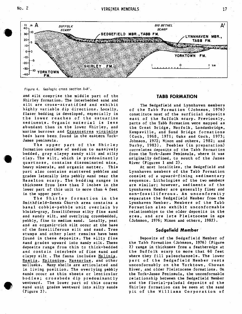
Figure 3. Geologic cross sec t i on 5 - 5 ' .
l a g d e p o s i t i n t h e l o w e r Chowan R i v e r The S h i r l e y formation i s t h e s u r f i c i a l includes a d ive r se s u i t e of rocks- f rom t h e depos i t between t h e H a z e l t o n and S u f f o l k P iedmont , Blue Ridge, and Valley and Ridge s c a r p s , a n d i s 1 , o c a l l y f o u n d i n t h e p r o v i n c e s . S e p t a t e n o d u l e s , f e r r i c r e t e : subsurface e a s t of t h e S u f f o l k s c a r p . The c l a s t s , broken iron-oxide-cement ed burrows, f o r m a t i o n r a n g e s i n t h i c k n e s s f r o m a and phosphate p e b b l e s , which were e roded fea theredge aga ins t t h e H a z e l t o n s c a r p t o f r o m t h e York town F o r m a t i o n , a r e a l s o more t h a n 80 f e e t i n p a l e o c h a n n e l s . The present (V ic to r , 1983). S h i r l e y r e s t s d i s c o n f o r m a b l y upon o l d e r
The b a s a l u n i t o f t h e Chowan R i v e r P l e i s tocene format ions i n t h e o u t e r Coastal g r a d e s upward i n t ~ f i n e t o medium s a n d , P l a i n and on p rog re s s ive ly o l d e r sed iments i n t e r b e d d e d s i l t y s a n d , c l a y e y s i l t , and of t h e Chesapeake and Pamunkey groups up b i o f r a g m e n t a l s and . The c l a y e y s i l t a n d t h e James River and o t h e r ma jo r r i v e r s of s i l t y s a n d c o n t a i n b i v a l v e g h o s t s and t h e C o a s t a l P l a i n . S h i r l e y s e d i m e n t s b u r r o w s . T h e b i o f r a g m e n t a l s a n d s a r e e x h i b i t an o v e r a l l upward-f i n i n g t r e n d crossbedded and con ta in a d ive r se , shallow- e x c e p t i n t h e Smi thf i e l d b a r r i e r deposi ts water fauna inc luding A r n o ~ e c t e n e b o r e u s , (Figure 3 ) . G l y c y m e r i s s u b o v a * , O s _ t r e a compressirostra , No~;-ig l i m a t u l a , R a n ~ i a , Corbicu l a , and Mercenar i a .
SHIRLEY FORMATION l a rges t c l a s t s i n t h e s e depos i
The S h i r l e y f o r m a t i o n i s o l d e r than i n diameter. P lanar a ~ d c r o s s t h e t y p e Nor fo lk Fo rma t ion ( Johnson a n d o t h e r s , 1 9 8 1 ; Mixon and o t h e r s , 1982; Johnson and Berquist , i n prepara t i o n ) , b u t o f t h e f o r m a t i o n . A l though o t h e r s (Oaks and Coch, 1973) have mapped it q u a r t z o s e , t h e s a n d s a s t h e clayey-sand, s i l ty -sand , and c o a r s e f e l d s p a t h i c . Trough and p sand f a c i e s o f t h e Norfolk Formation. The s e t s a s much a s 4 f e e t i Sh i r l ey formation i s named f o r exposures i n t h e Lone S t a r p i t s a t S h i r l e y P l a n t a t i o n ( Johnson and B e r q u i s t , i n p r e p a r a t i o n ) o c l a s t s u p p o r t e D e p o s i t s o f t h e S h i r l e y f o r m a t i o n i n t h e cemented by i r o n Williams Corporation of Virgin s a n d p i t s ( F i g u r e 1) a r e d lower S h i r l e y (Figure r e f e r e n c e s e c t i o n s . The r e v t i n u o u s l a m i n a t e d t nomenc la tu re i n t h i s a r e a was because type Norfolk sediments w westward and were found t o t r u depos i t s . These o l d e r d e p o s i t m a p p e d a s N o r f o l k , b u t wh r e c o g n i z e a s S h i r l e y . T h i s r p r e v i o u s l y h a s c o n f o u n d e d c o r r e l a t i o n i n t o southeas te rn
No. 2 VIRGINIA MINERALS
Figure 4. Geologic cross section A-A'.
and s i l t compr i se t h e m i d d l e p a r t o f t h e S h i r l e y format ion. The i n t erbedded sand and s i l t a r e c r o s s - s t r a t i f i e d a n d e x h i b i t h i g h l y v a r i a b l e d i p d i r e c t i o n s . Loca l ly , f l a s e r bedding is developed, e s p e c i a l l y i n t h e l o w e r r e a c h e s o f t h e e s t u a r i n e s e d i m e n t s . O r g a n i c m a t e r i a l i s l e s s a b u n d a n t t h a n i n t h e lower S h i r l e y , and marine burrows and C r a s s o s t r e a b i n i c a beds have been found i n t h e e a s t e r n York- James peninsula .
T h e u p p e r p a r t o f t h e S h i r l e y format ion c o n s i s t s of medium t o m a s s i v e l y bedded , g r a y c l a y e y sandy s i l t and s i l t y c l a y . The s i l t , which i s p r e d o m i n a n t l y q u a r t z o s e , c o n t a i n s d i s s e m i n a t e d m i c a , heavy minera ls , and o r g a n i c m a t t e r . T h i s p a r t a l s o c o n t a i n s s c a t t e r e d pebbles and grades l a t e r a l l y i n t o pebbly sand n e a r t h e H a z e l t o n s c a r p . T h e b e d d i n g r a n g e s i n t h i ckness from l e s s t h a n 2 i n c h e s i n t h e lower p a r t of t h i s u n i t t o more than 4 f e e t i n t h e upper p a r t .
T h e S h i r l e y f o r m a t i o n i n t h e Smi th f i e ld -Benns Church a r e a c o n t a i n s a b a s a l c o b b l e - p e b b l e u n i t o v e r l a i n b y bluish-gray, f o s s i l i f erous s i l t y f i n e s and and sandy s i l t , and over ly ing crossbedded, pebbly, f i n e t o medium sand. Loca l ly , peat and a n o rgan ic - r i ch s i l t occur a t t h e base of t h e f o s s i l i f e r o u s s i l t and s a n d . T r e e s tumps and o t h e r p l a n t r e m a i n s have been found i n t h e s e d e p o s i t s . The s i l t y f i n e sand g r a d e s upward i n t o sandy s i l t . These d e p o s i t s r a n g e f rom t h i n t o th ick-bedded a n d c o n t a i n i n t e r b e d s of f i n e sand and c layey s i l t . The fauna i n c l u d e s M u l i n i a , N o e t i a , Q i t o n i u m , Nassa r iu s - , and o t h e r mollusks. Many s h e l l s a r e a r t i c u l a t e d and i n l i v i n g p o s i t i o n . The o v e r l y i n g pebbly sands occur a s t h i n s h e e t s o r l e n t i c u l a r b o d i e s ; c r o s s b e d s d i p p r e d o m i n a n t l y westward. The lower p a r t o f t h i s c o a r s e sand u n i t grades westward i n t o s i l t y sands (F igure 3 ) .
TABB FORMATION
The Sedgefield and Lynnhaven members o f t h e Tabb F o r m a t i o n ( J o h n s o n , 1976) c o n s t i t u t e most of t h e s u r f i c i a l d e p o s i t s e a s t o f t h e S u f f o l k s c a r p . P r e v i o u s l y , p a r t s of t h e Tabb Formation were mapped a s t h e G r e a t B r i d g e , N o r f o l k , Londonbridge, K e m p s v i l l e , and Sand B r i d g e f o r m a t i o n s ( C o c h , 1968, 1971; Oaks and Coch, 1973; Johnson, 1972; Mixon and o t h e r s , 1982; and D a r b y , 1983) . P e e b l e s ( i n p r e p a r a t i o n ) c o r r e l a t e s depos i t s o f t h e Tabb Format i o n from t h e York-James Peninsula , where it was o r i g i n a l l y def ined , t o s o u t h o f t h e James River (F igures 1 and 2 ) .
A t most l o c a l i t i e s , t h e Sedgefield and Lynnhaven members o f t h e Tabb Forma t ion c o n s i s t o f a upward-f i n i n g s e d i m e n t a r y s equence . L i t h o l o g i e s o f t h e two members a r e s i m i l a r ; however, s e d i m e n t s o f t h e Lynnhaven Member a r e g e n e r a l l y f i n e r and n o n - f o s s i l i f e r o u s . An u n c o n f o r m i t y s e p a r a t e s t h e S e d g e f i e l d Member from t h e Lynnhaven #ember . Members o f t h e T a b b F o r m a t i o n a l s o e x h i b i t u n c o n f o r m a b l e r e l a t i o n s h i p s t o t h e o l d e r d e p o s i t s i n t h e a r e a , a n d a r e l a t e P l e i s t o c e n e i n a g e (Johnson, 1976; Mixon and o t h e r s , 1982).
Sedgefield Member
Deposi ts of t h e S e d g e f i e l d Member o f t h e Tabb Formation (Johnson, 1976) (F igure 2) range i n th ickness from a fea theredge a t t h e Suf f o l k s c a r p t o more t h a t 60 f e e t where t hey f i l l p a l e o c h a n n e l s . The lower p a r t o f t h e S e d g e f i e l d Member r e s t s unconformably o n t h e York town , Chowan River , and o lde r P l e i s tocene formations. On t h e York-James Peninsula , t h e unconformable r e l a t i o n s h i p between t h e Sedgefield Member and t h e f l u v i a l - p a l u d a l d e p o s i t s o f t h e S h i r l e y f o r m a t i o n c a n be seen a t t h e sand p i t o f t h e W i l l i a m s C o r p o r a t i o n o f

DIVISION OF MINERAL RESOURCES Vol. 30
f t m C SUFFOLK 5Orl5 ?, SCARP
FEN TRESS RISE
YORKTOWN F
RKTOWN FM.
Figure 5. Geologic cross section C-C'.
V i r g i n i a . The unconfo rmab le r e l a t i o n s h i p be tween t h e S e d g e f i e l d Member a n d t h e Chowan R i v e r F o r m a t i o n c a n b e s e e n a t Yadkins, C i ty Line, Elbow Farm, and Gomez s a n d p i t s ( F i g u r e 1 ) . The unconfo rmab le r e l a t i o n s h i p between t h e Sedgef i e l d Member and t h e Yorktown Formation can be observed a t t h e Williams Corporat ion of Vi rg in ia and A . B. S o u t h a l l sand p i t s on t h e York-James Peninsula and a l s o i n s u b s u r f a c e b o r i n g s t h r o u g h o u t most o f t h e s tudy a r ea .
A t t h e base of t h e Sedgef i e l d Member a r e paleochannels ranging i n width up t o 30 f e e t a n d i n d e p t h a s much a s 6 0 f e e t ( F i g u r e 5 ) . E x c e l l e n t examples o f t h e s e f e a t u r e s a r e preserved a t t h e Gomez, C i t y L i n e , a n d E l b o w Fa rm s a n d p i t s . T h e p a l e o c h a n n e l s a r e l i n e d w i t h p e b b l y t o c o b b l y , f i n e t o coarse sand and a r e f i l l e d wi th an organic-r ich s i l t y c l a y c o n t a i n i n g t r e e t r u n k s i n l i v i n g p o s i t i o n a s w e l l a s t r e e branches and stems. I n i t s upper p a r t , t h i s o r g a n i c - r i c h s i l t y c l a y c o n t a i n s Cras sos t r ea , P-olyni$es, and C v r t o p l e u r a , - a l o n g w i t h wood f r a g m e n t s . L o c a l l y t h e s e valley-f ill d e p o s i t s a r e t runca t ed by f i n e t o medium sand o r by f o s s i l i f e r o u s pebbly t o cobbly, g ine t o coarse sand. The p e b b l y t o c o b b l y , f i n e t o c o a r s e sand e x r e n d s l a t e r a l l y a s a d i scont inuous basa l s h e e t up t o 2 f e e t t h i c k t h r o u g h o u t t h e a e r i a l ex t en t of t h e Sedgef i e l d Member.
Sediments o v e r l y i n g t h e coarse b a s a l p o r t i o n o f t h e S e d g e f i e l d Member v a r y geographical ly. Between t h e Suf f o l k and Big B e t h e l s c a r p s , t h e b a s a l p e b b l y t o b o u l d e r y , coarse sand grades upward i n t o a f i n e t o medium sand which g r a d e s upward i n t o a f ine-sandy, c l ayey s i l t . The middle p a r t of t h e Sedgefield Member i s a f i n e t o medium, g ray t o yellowish-brown qua r t z sand which v a r i e s i n t h i c k n e s s up t o 1 0 f e e t . W h e r e t h e s e s a n d s a r e w e l l - d r a i n e d , f e r r i c r e t e and manganese o x i d e zones form
a t t h e w a t e r t a b l e . T h e o v e r l y i n g fine-sandy clayey s i l t , which i s a s much a s 2 f e e t t h i c k , i s g e n e r a l l y l i g h t gray with ye l lowish-brown m o t t l i n g , and t y p i c a l l y lacks any d i s c e r n i b l e bedding.
Sediments of t h e Sedgef i e ld Member a r e a l s o p r e s e n t i n t h e t h e F e n t r e s s r i s e , Oceana r i d g e , and i n t h e subsur face e a s t of t h e B ig B e t h e l s c a r p . U n d e r l y i n g t h e Fen t r e s s r i s e , t h e b a s a l cobbly t o bouldery c o a r s e sand g r a d e s upward i n t o a f i n e t o medium q u a r t z sand c o n t a i n i n g a modera te amoun t o f h e a v y m i n e r a l s . Wi th in t h e s e sands t h e r e a r e h o r i z o n t a l , f o s s i l i f e r o u s beds dominated by Mercenarji. ge rcena r i a and s e r p u l i d worm b iohe rms , b o t h i n l i v i n g p o s i t ion. An exce l l en t example of t h i s zone can be seen a t t h e Gomez sand p i t . Where g r o u n d w a t e r h a s l e a c h e d f o s s i l s h e l l s , a b u n d a n t g h o s t f o s s i l s a r e v i s i b l e ; some t i m e s t h e p e r i o s t r a c u m of l eached M e r c e n a r i a s h e l l s i s p r e s e r v e d ( D a r b y , -- 1 9 8 3 ) . The f i n e t o medium sand g r a d e s upward i n t o p e b b l y , f i n e t o v e r y c o a r s e s a n d i n c r o s s b e d s w h i c h d i p up t o 1 0 degrees t o t h e southeas t . L a t e r a l l y , t h e r e a r e l o c a l m u l t i d i r e c t i o n a l crossbeds which d i p a s much a s 30 d e g r e e s . The sed imen t s o v e r l y i n g t h e crossbedded sands cons is t of l o c a l l y channel ized, i n d i s t i n c t h o r i z o n t a l beds of f i n e sand, c l a y and s i l t ; the f ine- g r a i n e d s e d i m e n t s c o m m o n l y c o n t a i n s c a t t e r e d pebbles.
I n t h e s u b s u r f a c e e a s t o f t h e Big B e t h e l s c a r p , s ed imen t s of t h e Sedgef i e l d Member u n d e r l y i n g t h e M t . P l e a s a n t f l a t a l s o c o n s i s t of a pebbly t o cobbly, f i n e t o coa r se - sandy b a s a l z o n e o v e r l a i n by a C r a s s o s t r g g - r i c h zone and g rad ing upward i n t o a l i g h t gray , f o s s i l i f e r o u s f i n e sand. T h e f a u n a l a s semblage i n c l u d e s Busvcon, Sp i su l a , P o l v n i c e s , M e r c e n a r i a , Anadara, c h e i l o s t o m a t o u s b r y o z o a n s , and abundant echinoderm fragments. T h e s e f o s s i 1s o c c u r

No. 2 VIRGINIA MINERALS
i n abundance a t t h e C i t y Line and abandoned Womack p i t s , bu t on ly i n t h i n zones i n t h e Elbow Farm sand p i t where t hey a r e mostly leached.
Lynnhaven Member
The L y n n h a v e n Member o f t h e T a b b F o r m a t i o n ( J o h n s o n , 1 9 7 6 ) c o m p r i s e s s u r f i c i a l d e p o s i t s e a s t o f t h e Big B e t h e l s c a r p and a r e a s much a s 11 f e e t t h i c k . Near t h e Big Bethel scarp on t h e York-James Peninsula , t h e Lynnhaven Member i s composed of gray , f i n e t o coarse sand which commonly c o n t a i n s abundant p e b b l e s , c o b b l e s , and boulders . East of t h e Big B e t h e l s c a r p on t h e York - James P e n i n s u l a t h e Lynnhaven Member c o n s i s t s of a sporadic b a s a l c o b b l y o r pebbly, f i n e t o coarse sand which grades upward i n t o a c l a y e y f i n e sand and s i l t u n i t w i t h s c a t t e r e d c o a r s e s a n d a n d pebbles. The cobbly zone is t y p i c a l l y o n l y one c l a s t t h i c k , and r e s t s d i r e c t l y upon t h e leached o r oxid ized s i l t y sand f a c i e s of t h e Yorktown Formation. However, where t h i s basa l por t ion over l i e s t h e f l u v i a l and p a l u d a l c h a n n e l - £ i l l d e p o s i t s o f t h e Sh i r l ey format ion , t h e sediments c o n s i s t of pebbly, f i n e t o medium sand. The c l a s t s a r e l i t h o l o g i c a l l y s i m i l a r t o ' t h o s e i n t h e S e d g e f i e l d Member b u t a r e n o t c o a t e d o r s t a ined w i t h i r o n o x i d e . The b o u l d e r and cobb le - r i c h p a r t e x h i b i t s poorly developed p lanar bedding and grades upward i n t o l i g h t brown t o l i g h t gray , t h i n t o medium-bedded, pebbly, f i n e sand. Heavy mineral laminae up t o 1 . 5 i n c h e s t h i c k o c c u r i n t h e crossbedded sands.
pou th o f t h e James R i v e r , t h e b a s a l p a r t o f t h e Lynnhaven Member g e n e r a l l y c o n s i s t s of much f i n e r - g r a i n e d sediments than i t does on t h e York-James P e n i n s u l a . Nea r t h e B ig B e t h e l s c a r p s o u t h of t h e James R i v e r , t h e b a s a l p o r t i o n o f t h e Lynnhaven Member c o n s i s t s l o c a l l y of gray , f i n e t o medium sand, b u t most commonly i t i s compr ised of g r a y , s i l t y f i n e sand o r fine-sandy s i l t . Only one channel h a s been o b s e r v e d a t t h e b a s e o f t h e Lynnhaven Member; t h i s c h a n n e l i s a p p r o x i m a t e l y 30 f e e t w i d e , c l e a r l y t r u n c a t e s bur rowed, c l a y e y s i l t o f t h e u p p e r p a r t o f t h e S e d g e f i e l d Member, and i s f i l l e d w i t h crossbedded f i n e t o coarse sand where beds d i p 3 0 t o 45 d e g r e e s s o u t h e a s t . T h i s channel was observed a t Yadkins p i t (F igure 1 ) .
The b a s a l p a r t of t h e Lynnhaven Member g r a d e s upward i n t o s i l t y f i n e sand and s i l t y c l a y . Loca l ly , t h e r e a r e i n t e rbeds of
s i l t y c l a y , s i l t y f i n e sand, and f i n e sandy s i l t ; f i n e - g r a i n e d s e d i m e n t s commonly c o n t a i n s c a t t e r e d pebbles. Deposi ts of t h e Lynnhaven Member u n c o n f o r m a b l y o v e r l i e d e p o s i t s o f t h e Sedge f i e ld Member e a s t of t h e Big Bethel s ca rp and a t t h e t o e o f t h e F e n t r e s s r i s e , O c e a n a r i d g e , Land-of- Promise r i d g e , and Pungo r i d g e (F igure 5 ) .
GEOLOGIC HISTORY
The Yorktown and Chowan River , S h i r l e y a n d T a b b f o r m a t i o n s r e c o r d t ransgress ive- regress ive cyc l e s d u r i n g t h e l a t e Cenozoic. During each low stand of s ea l e v e l f o l l o w i n g r e g r e s s i o n o f t h e s e a , s t r e a m s c u t v a l l e y s i n t o o l d e r C o a s t a l P l a i n d e p o s i t s a n d f l u v i a l d e p o s i t s accumula t ed i n po r t i ons of t h e s e lowlands. Subsequent m a r i n e t r a n s g r e s s i o n s lowered t h e g r a d i e n t s o f s t r e a m s , t r a p p i n g t h e f l u v i a l s e d i m e n t s and a l l o w i n g p a l u d a l d e p o s i t s t o accumula t e on t h e f r i n g e s of t h e r e c e n t l y drowned v a l l e y s . A s t h e s e a continued t o t r a n s g r e s s landward, e s t u a r i e s developed and t h e p a l u d a l d e p o s i t s g r a d e d upward i n t o e s t u a r i n e c l a y , s i l t , and f i n e sand. Consequen t ly , p a l e o c h a n n e l s , which a r e f i l l e d w i t h f l u v i a l , p a l u d a l , and e s t u a r i n e d e p o s i t s , a r e commonly found a t t h e b a s e of l a t e P l i o c e n e and middle and l a t e P l e i s t o c e n e f o r m a t i o n s . T h e b a s a l d e p o s i t s o f t h e s e paleochannel f i l l s r e s t upon t runca ted o lde r depos i t s .
D u r i n g e a c h m a r i n e t r a n s g r e s s i o n , d e p o s i t s o f p e b b l y t o b o u l d e r y , f i n e t o c o a r s e sand accumula t ed a s d i s con t inuous b a s a l s h e e t s a s s h o r e l i n e s a d v a n c e , d l a n d w a r d . S e d i m e n t s e r o d e d f rom o l d e r d e p o s i t s were reworked along t h e s h o r e 1 i n e d u r i n g t h e m a r i n e t r a n s g r e s s i o n . Whereas t h e f iner-grained sediments were winnowed, t h e c o a r s e r s e d i m e n t s remained a s a b a s a l lag depos i t which ex t ended landward a s a d i s c o n t i n u o u s s h e e t d u r i n g m a r i n e t r ansg re s s ion .
The c o a r s e b a s a l lag depos i t s of each P l e i s t o c e n e f o r m a t i o n g r a d e upward i n t o r e l a t i v e l y f i n e r - g r a i n e d sediments which a c c u m u l a t e d i n p r o t e c t e d e m b a y m e n t s landward of b a r r i e r s . During high s t ands of s e a l e v e l t h e s e p r o t e c t e d embaymen t s c o n t i n u e d t o f i l l i n w i t h sed iments . The s i l t y f i n e sands and fine-sandy s i l t s which o c c u r a t t h e t o p o f t h e g r a d a t i o n a l s equence found i n e a c h P l e i s t o c e n e u n i t accumulated i n marshes and t i d a l f l a t s . The uppe r s u r f a c e o f t h e s e d e p o s i t s became t e r r a c e s when sea l e v e l dropped.
Dur ing t h e e a r l y P l i o c e n e , t h e s e a

D I V I S I O N OF MINERAL RESOURCES V o l . 30
t r a n s g r e s s e d t h e Coas ta l P l a i n , depos i t i ng t h e s i l t y f i n e sand f a c i e s of t h e Yorktown F o r m a t i o n . D i f f e r e n t i a l movement of t h e o u t e r C o a s t a l P l a i n a l o n g d e e p l y b u r i e d , s t e e p l y i n c l i n e d f a u l t s produced a major l i n e a r s h o a l i n t h e Chuckatuck-Yorktown-Yadkin a r e a (Johnson and P e e b l e s , 19831, where a c r o s s b e d d e d c o q u i n a f a c i e s a c c u m u l a t e d . A f t e r r e g r e s s i o n o f t h e Y o r k t o w n s e a , t h e emergent C o a s t a l P l a i n was weathered and d i s s e c t e d by streams.
I n l a t e P l i o c e n e t i m e , t h e advancing Chowae River sea reworked t h e o l d e r mar ine and f l u v i a l sediments c r e a t i n g a b a s a l lag concent ra te . F o s s i l i f e r o u s f i n e s a n d s and c r o s s b e d d e d b i o f r a g m e n t a l s a n d s w e r e depos i ted i n a r e l a t i v e l y warm, s h a l l o w , n e a r s h o r e m a r i n e e n v i r o n m e n t . F a u n a l a s semblages i n d i c a t e a b r a c k i s h w a t e r i n £ l u e n c e l o c a l l y . Subsequently, sediments o f e a r l y t o midd le P l e i s t o c e n e age w e r e d e p o s i t e d d u r i n g s e v e r a l m a r i n e t r ansg re s s ions .
During t h e middle P l e i s tocene , f l u v i a l and pa luda l sediments began t o accumula t e i n c h a n n e l s which had been c u t i n t o o lde r Coas ta l P l a i n depos i t s during t h e preceding low s tand of sea l eve l . Pebbly t o bouldery, c o a r s e sand a c c u m u l a t e d u n d e r f l u v i a l c o n d i t i o n s a t t h e b a s e a n d a l o n g t h e marg ins o f t h e c h a n n e l s . T h e s e c o a r s e d e p o s i t s graded upward i n t o f i n e sand ,pea t , a n d o r g a n i c - r i c h s i l t a n d c l a y w h i c h accumula t ed i n t h e channels a s a r e s u l t of s t ream g rad ien t reduct ion during s e a l e v e l r i s e . A s sea l e v e l approached 45 t o 50 f e e t i n e l e v a t i o n , t h e Hazelton sca rp (Oaks and Coch, 1973) was c u t p a r a l l e l t o r i v e r s a s we l l a s along t h e oceanic s h o r e l i n e . Basa l c o a r s e l a g d e p o s i t s a c c u m u l a t e d a s a d i s c o n t i n u o u s s h e e t a s t h e S h i r l e y s h o r e l i n e advanced landward . Local s p i t s a n d b a r r i e r s , s u c h a s t h e S m i t h f i e l d b a r r i e r , f o rmed a l o n g t h e s h o r e l i n e . A b a r r i e r system ex i s t ed f a r t h e r e a s t d u r i n g t h i s t ime, allowing f iner-grained sediments t o accumulate above t h e c o a r s e b a s a l l a g d e p o s i t s . T h i s r e s u l t e d i n t h e u p w a r d - f i n i n g s e q u e n c e w h i c h n o w c o n s t i t u t e s t h e S h i r l e y formation.
D u r i n g t h e s u b s e q u e n t m a r i n e r e g r e s s i o n , s t r e a m s c u t i n t o t h e S h i r l e y and o l d e r format ions. Stream g rad ien t s were a g a i n r educed d u r i n g t h e next r i s e of s ea l e v e l , and f l u v i a l , pa luda l , and e s t u a r i n e d e p o s i t s accumula t ed i n t h e channels . The upper p a r t of t h e channel f i l l d e p o s i t s i s p a r t i a l l y t r u n c a t e d by t h e c o a r s e , ba sa l lag d e p o s i t s which formed a s t h e Sedgefield
s e a t r a n s g r e s s e d landward, reworking o l d e r P l e i s t o c e n e and T e r t i a r y d e p o s i t s . T h i s b a s a l s h e e t of lag d e p o s i t s a l s o t r u n c a t e s t h e Chowan River Formation a t t h e Gomez and Yadkin s and p i t s . A t most o t h e r exposures i n t h e a r e a t h e c o a r s e b a s a l d e p o s i t s of t h e S e d g e f i e l d Member b e v e l York town s e d i m e n t s . E x c e p t i n p a r t s o f t h e York - James P e n i n s u l a w h e r e t h e b a s a l d e p o s i t s t r u n c a t e paleochannel d e p o s i t s o f f t h e S h i r l e y f o r m a t i o n , S e d g e f i e l d c h a n n e l - f i l l d e p o s i t s g r a d e upward i n t o f o s s i l i f e r o u s f i n e sand and s i l t of t h e a n c e s t r a l Chesapeake Bay. I n t h e Gomez and New L i g h t sand p i t s , t i d a l i n l e t channel sediments and bedding s t r u c t u r e s i n d i c a t e a b a r r i e r o r i g i n f o r t h e s e d e p o s i t s . These b a r r i e r s ands m i g r a t e d landward c o v e r i n g t h e a n c e s t r a l Chesapeake Bay depos i t s . East of t h e Fen t r e s s r i s e , t h e b a r r i e r sand o f t h e Sedgefield Member grades l a t e r a l l y i n t o f o s s i l i f e r o u s , nearshore marine f i n e s a n d . The f auna l assemblage wi th in t h i s f i n e sand i s i n d i c a t i v e of a warm, s h a l l o w s h e l f . West o f t h e S e d g e f i e l d b a r r i e r complex , f i ne r -g ra ined s e d i m e n t s accumula ted i n a q u i e t e n b a y m e n t . T h e s e f i n e r - g r a i n e d s e d i m e n t s c o n s t i t u e t h e upward - f i n i n g s e q u e n c e o f t h e S e d g e f i e l d Member which u n d e r l i e s t h e Churchland f l a t .
T h e F e n t r e s s r i s e became sed imen t - s t a rved wi th t h e development of t h e Oceana r i d g e . I t i s e v i d e n t t h a t S e d g e f i e l d s e d i m e n t s u n d e r l i e t h e O c e a n a r i d g e , because t h e s e b a r r i e r sediments in te r tongue wi th Sedgef ie ld bay sediments t o t h e w e s t . T i d a l m a r s h s e d i m e n t s c o n s e q u e n t l y accumulated above t h e b a r r i e r s ed imen t s of t h e F e n t r e s s r i s e . A s s e a l e v e l f e l l , s t r e a m s e roded i n t o t h e S e d g e f i e l d a n d o l d e r d e p o s i t s . The s u b s e q u e n t Lynnhaven m a r i n e t r a n s g r e s s i o n r e d u c e d s t r e a m g r a d i e n t s and a l l owed f l u v i a l depos i t s t o a c c u m u l a t e i n c h a n n e l s w h i c h had b e e n c a r v e d d u r i n g t h e p r e c e e d i n g m a r i n e r eg re s s ion . The d i s c o n t i n u o u s b a s a l s h e e t o f l a g d e p o s i t s of t h e Lynnhaven Member is c o a r s e r and t h i c k e r o n t h e York - James P e n i n s u l a t h a n s o u t h o f t h e James River. A l s o , t h e Big B e t h e l s c a r p i s n o t a s prominent s o u t h o f t h e James; apparent ly , t h e Fen t r e s s r i s e , Oceana r i d g e , Land-of- Promise r i d g e , and Pungo r i d g e served a s a b a r r i e r complex, p r o t e c t i n g t h e f a s t l and f rom s h o r e l i n e e r o s i o n . On t h e York-James Peninsula and south of t h e James River , t h e c o a r s e b a s a l d e p o s i t s o f t h e Lynnhaven g r a d e upward i n t o a s i l t y f i n e s a n d t o s i l t y c l ay which accumulated t o th icknesses o f up t o 11 f e e t i n a b a c k - b a r r i e r

No. 2 V I R G I N I A MINERALS 2 1
e n v i r o n m e n t p r o t e c t e d by t h e s e e a s t e r n @ r i dges .
S t r a t i g r a p h i c r e l a t i o n s h i p s o b s e r v e d i n t h e o u t e r Coas ta l P l a i n of southeas te rn V i r g i n i a r e c o r d two P l i o c e n e a n d t h r e e m i d d l e t o l a t e P l e i s t o c e n e m a r i n e t r ansg re s s ive - r eg re s s ive cyc les . Sediments o f t h e Yorktown, Chowan River and S h i r l e y formations and t h e Sedgefield and Lynnhaven members o f t h e Tabb Formation accumulated d u r i n g m a r i n e t r a n s g r e s s i o n s . T h e s e s t r a t i g r a p h i c u n i t s a r e unconformable with r e spec t t o each o t h e r .
Sediments w i th in t h e S h i r l e y formation and t h e Sedgefield and Lynnhaven members o f t h e Tabb Formation gene ra l ly e x h i b i t an u p w a r d - f i n i n g s e q u e n c e w i t h c h a n n e 1 d e p o s i t s . o c c u r r i n g l o c a l l y a t t h e base of each sequence. The channels a r e f i l l e d with f l u v i a l d e p o s i t s and g r a d e upward i n t o p a l u d a l a n d e s t u a r i n e d e p o s i t s w h i c h a c c u m u l a t e d when s t r e a m g r a d i e n t s were r educed d u r i n g m a r i n e t r a n s g r e s s i o n . A d i s c o n t i n u o u s shee t of pebbly t o bouldery, f i n e to . coa r se sand p a r t i a l l y t r u n c a t e s t h e c h a n n e l - f i l l d e p o s i t s and o c c u r s a t t h e base of each marginal-marine sequence . The c o a r s e b a s a l d e p o s i t s formed a s t h e s e a t r a n s g r e s s e d l a n d w a r d , e r o d i n g a n d r e w o r k i n g o l d e r d e p o s i t s . F i n e r - g r a i n e d sediments f rom t h e s e o l d e r d e p o s i t s were winnowed, w h i l e c o a r ser-grained sediments remained as a shee t of lag depos i t s .
T h e c o a r s e b a s a l d e p o s i t s o f e a c h s t r a t i g r a p h i c u n i t g e n e r a l l y g r a d e upward t h r o u g h f i n e t o medium sand and i n t o s i l t y f i n e sand o r s i l t y c l ay . B a r r i e r s e x i s t i n g t o t h e e a s t during each P l e i s tocene marine t r ansg re s s ion crea ted p ro t ec t ed embayments where f iner-grained depos i t s accumulated.
Recognit i o n of f a c i e s r e l a t i o n s h i p s w i t h i n e a c h s t r a t i g r a p h i c u n i t a l lows an i n t e g r a t e d , c o n s i s t e n t a p p r o a c h t o u n r a v e l l i n g t h e s t r a t i g r a p h y i n t h e ou t e r C o a s t a l P l a i n o f s o u t h e a s t e r n V i r g i n i a . T h i s p e r s p e c t i v e p e r m i t s a more accu ra t e r e v i s i o n of t h e s t r a t i g r a p h i c nomenc la tu re used i n t h i s a r ea . The S h i r l e y formation is informal ly recognized, and sediments of t h e S e d g e f i e l d and Lynnhaven members o f t h e Tabb Formation u n d e r l y i n g t h e York-James P e n i n s u l a a r e c o r r e l a t e d wi th d e p o s i t s of o t h e r a r e a s i n s o u t h e a s t e r n V i r g i n i a . Unconf o m i t i e s s epa ra t ing t h e va r ious u n i t s have been d e l i n e a t e d , and p r e d i c t a b l e ,
@ r e c o g n i z a b l e s ed imen ta ry sequences w i th in e a c h s t r a t i g r a p h i c u n i t h a v e b e e n descr ibed .
REFERENCES
Akers , W.H., 1972, P lanktonic Foraminifera and b i o s t r a t i g r a p h y o f some Neogene f o r m a t i o n s o f n o r t h e r n F l o r i d a and A t l a n t i c Coas ta l P l a i n : T u l a n e S t u d i e s i n Geology and Paleontology, v. 9 , 139 p.
Ba rke r , W . J . , and B j o r k e n , E . D . , 1 9 7 8 , Geology of t h e Norfolk South quadrangle, Vi rg in ia : Vi rg in ia D i v i s i o n o f Minera 1 Resources Pub l i ca t i on 9.
Blackwelder, B.W., 1981 , S t r a t i g r a p h y o f U p p e r P l i o c e n e and Lower P l e i s t o c e n e m a r i n e a n d e s t u a r i n e d e p o s i t s o f n o r t h e a s t e r n N o r t h C a r o l i n a a n d southeas te rn V i r g i n i a : U.S. G e o l o g i c a l Survey Bul le t i n 1502-B, p . B1-B16.
Coch, N.K. , 1968 , Geology o f t h e Benns C h u r c h , S m i t h f i e l d , W i n d s o r , a n d C h u c k a t u c k q u a d r a n g l e s , V i r g i n i a : V i r g i n i a D i v i s i o n o f M i n e r a l Resources Report of Inves t iga t ions 17, 40 p.
, 1971, Geology of t h e Newport News S o u t h a n d Bowers H i l l q u a d r a n g l e s , V i r g i n i a : V i r g i n i a Div is ion of Mineral Resources Report of I n v e s t i g a t i o n s 28, 26 P
D a r b y , D . A . , 1 9 8 3 , S e d i m e n t o l o g y , d i a g e n e s i s a n d s t r a t i g r a p h y o f P l e i s t o c e n e c o a s t a l d e p o s i t s i n southeas te rn Virg in ia : V i rg in i a Geologic F i e l d Conference, 15 th Annual Conference, Old Dominion Univers i ty , 37 p.
Johnson, G.H., 1969, Geology o f t h e lower York-James P e n i n s u l a and t h e south bank of t h e James River: C o l l e g e o f Wi l l i am and Mary Department of Geology Guidebook no. 1, 33 p.
, 1972, Geology o f t h e Yorktown, P o q u o s o n W e s t , a n d P o q u o s o n E a s t quadrangles , Vi rg in ia : Vi rg in ia Div is ion o f M i n e r a l R e s o u r c e s R e p o r t o f Inves t iga t ions 30, 57 p.
, 1976, Geology o f t h e M u l b e r r y I s I a n d , Newpor t News, a n d Hampton quadrangles , Vi rg in ia : V i rg in i a Div is ion o f M i n e r a l R e s o u r c e s R e p o r t o f I n v e s t i g a t i o n s 41, 72 p .
Johnson , G.H. , Berquis t , C.R., Ramsey, K . , and P e e b l e s , P.C., 1981 , Guidebook t o t h e L a t e Cenozoic g e o l o g y o f t h e lower York-James Peninsula: College of William and Mary Department of Geology Guidebook no. 3 , 58 p.
J o h n s o n , G . H . , and P e e b l e s , P.C., 1983 , C l a s t i c - c a r b o n a t e r e l a t i o n s h i p s i n t h e Yorktown Forma t ion ( e a r l y P l i o c e n e ) of southeas te rn Virg in ia : Geological Socie ty of America Southeastern Sec t ion Abs t r ac t s wi th Programs, 32nd Annual Meet ing , p . 107.

2 2 DIVISION OF MINE
Mixon, R.B., Szabo, B.J . , and Owens, J . B . , 1982 , Uranium s e r i e s d a t i n g of mollusks a n d c o r a l s , a n d a g e o f P l e i s t o c e n e d e p o s i t s , Chesapeake Bay a r e a , V i rg in i a and Mary land: U.S. G e o l o g i c a l S u r v e y P r o f e s s i o n a l Paper 11067-E, p. El-E18.
North American Commission on S t r a t i g r a p h i c N o m e n c l a t u r e , 1 9 8 3 , N o r t h A m e r i c a n S t r a t i g r a p h i c Code, American A s s o c i a t i o n o f P e t r o l e u m Geologis t s B u l l e t i n , v. 67, no. 5 , p. 841-875.
O a k s , R . Q . , a n d C o c h , N . K . , 1 9 7 3 , Post-Miocene s t r a t i g r a p h y and morphology, sou thea s t e rn Vi rg in ia : V i rg in i a D iv i s i on of Mineral Resources B u l l e t i n 82 , 135 p.
Ray, C.E., Wetmore, A . , Dunkle, D.H., and Drez, P., 1968, F o s s i l v e r t e b r a t e s f rom t h e m a r i n e P l e i s t o c e n e o f s o u t h e a s t e r n V i r g i n i a : S m i t h s o n i a n I n s t i t u t i o n M i s c e l l a n e o u s C o l l e c t i o n s , v . 1 5 3 , P u b l i c a t i o n 4742, 25 p.
V i c t o r , A.E., 1983 , A l l o c h t h o n o u s c l a s t a occu r r i ng i n t h e Chowan R i v e r Format i o n (Upper P l iocene) of sou thea s t e rn V i rg in i a ( ab s ) : V i r g i n i a J o u r n a l o f S c i e n c e , v . 34, no. 3 , p. 177.
MINERAL UPDATE GOLD - SILVER REDISCOVERED IN
OLD AMHERST COUNTY MINE
D. Allen Penick, Jr. and Palmer C. Sweet
A g o l d - s i l v e r mine p rev ious l y unreported i n Amherst County records has r e c e n t l y been i nves t i ga ted by t he w r i t e r s . The mine, r e f e r r e d t o as t he Buck Mountain mine i n t h i s repo r t , was brought t o the a t t e n t i o n o f the V i r g i n i a D i v i s i o n o f Minera l Resources by M r . Herber t L. Grow o f Rockbridge County. Add i t i ona l i n fo rma t i on was provided by M r . W i l l i am Sandidge o f Amherst and M r . Jasper Tomlin o f Vesuvius. Very l i t t l e i s known about the h i s t o r y o f the mine except t h a t i t was i n opera t ion f o r a b r i e f pe r i od about 60 years ago. According t o M r . Tomlin the ore was hauled down the steep mountain on horseback and t ranspor ted by wagon over the Blue Ridge t o Buena V is ta , a d is tance of about 8 mi les . The d e s t i n a t i o n of the ore from t h i s p o i n t i s n o t known. M r . Sandidge r e c a l l s t h a t t he low p r i c e o f s i l v e r dur ing t h i s pe r i od precluded f u r t h e r development o f the mine.
The Buck Mountain mine i s l oca ted i n Amherst County about 4.65 mi les n o r t h of the Forks o f B u f f a l o i n t he northwestern corner
IRAL RESOURCES Vol. 30
Buck Mtn.
Figure 1. Location of Buck Mountain mine, Amherst County.
o f t he Forks o f B u f f a l o 7.5-minute quad- rangle. The s p e c i f i c l o c a t i o n i s about 1 m i l e nor theas t o f U.S. Highway 60, 0.2 mi les southeast o f s t a t e road 634 and on the northwest s i de o f Buck Mountain a t an e leva- t i o n o f about 2,640 f e e t (F igure 1). The p rope r t y i s owned by Jasper Tomlin of Vesuvius. The mine represents one of the few occurrences o f go ld -s i 1 ver minera l i z a - t i o n s i n t he Blue Ridge prov ince from which ore was a c t u a l l y shipped.
The mine was developed by a 10- foot square v e r t i c a l s h a f t 15 f e e t deep and an a d i t nor theas t o f the s h a f t which was c u t i n t o the h i l l s i d e f o r about 20 fee t . The s h a f t and a d i t workings a r e n o t connected, a l though t h i s appeared t o be the o r i g i n a l
Figure 2. Steeply dipping shear zone (14 inches thick) exposed a t ad i t entrance.

No. 2 VIRGINIA MINERALS 23
Figure 3. Underground contact between shear zone ( r i g h t ) and country rock conta in ing disseminated s u l f i d e minera l iza t ion .
plan. There i s about 14 inches o f black, a l t e red , m e t a l l i c s u l f i d e m i n e r a l i z a t i o n exposed i n the s h a f t as w e l l as i n t he a d i t tunnel t o t he nor theast (F igure 2) . The main ore zone appears t o be concentrated i n ed t h i s 14-inch t h i c k shear zone. However, disseminated mineral i z a t i o n was observed i n the country rock up t o a th ickness o f 3 f ee t , d i r e c t l y adjacent t o the shear zone. This contac t shows up w e l l i n the underground workings (Figure 3 ) . A grab sample o f t h i s combined ma te r i a l was taken and sent t o B a r r i nger Resources, Inc., i n Sparks, Nevada, f o r f i r e assay analys is ; t he r e p o r t i nd i ca tes 5.4 ounces o f s i l v e r per t on and 0.070 ounces o f go ld per ton.
The host rock associated w i t h t h e Buck Mountain m i n e r a l i z a t i o n i s a g r a n i t i c type rock t h a t appears t o be a charnocki te conta in ing hypersthene as the c h i e f maf ic cons t i t uen t . Th is rock i s p a r t l y an i n t r u s i v e and p a r t l y a g r a n u l i t e f ac ies o f a metamorphic rock. This hos t rock, which f a l l s w i t h i n t he Pedlar Complex (Precambrian) appears t o be q u i t e s i m i l a r t o t h a t found a t t h e I r i s h Creek t i n depos i t some 10 mi les t o t he nor th.
The p r i n c i p a l minerals found associated w i t h t he minera l ized zone and v e r i f i e d by X-ray analys is , a re f l u o r i t e , p y r i t e , quartz, mi cay gypsum, arsenopyri t e , and scorodi t e . Arsenopyri t e and scorodi t e (F igure 4) a re two arsen ic minerals which, t o date, have n o t been repor ted from Amherst County. There i s a good p o s s i b i l i t y t h a t the a o l d - s i l v e r m i n e r a l i z a t i o n i s associated w i th - these two minerals. Both go ld and s i l v e r have been repor ted t o occur i n a rsenopyr i te veins a t I r i s h Creek. (Glass, J. J., Koschmann, H. A. Vhay, J. S., 1958,
abundance a t I r i s h Creek. I n general, t h e count ry rock and minera ls associated w i t h t he Buck Mountain mine are s i m i l a r t o t he rocks and minera ls a t t h e I r i s h Creek deposi t , a l though t i n minera ls have n o t been observed a t Buck Mountain.
LORA ROBINS GALLERY EXHIBITION
The Lora Robins Ga l l e ry has announced t h a t an e x h i b i t i o n o f gems, jewe l ry , minerals, and f o s s i l s w i l l be he ld October 19-21, 1984 a t t he Robins Center on the U n i v e r s i t y o f Richmond campus. The hours w i l l be Friday, noon t o 9:00 p.m.; Saturday 10:OO a.m., t o 9:00 p.m.; and Sunday 10:OO a.m. t o 6:00 p.m. Admission i s t o be $2.50 (persons under 12 and students f r e e ) .
THE LORA ROBINS GALLERY was es tab l ished i n 1977 as a Learning Resource o f the U n i v e r s i t y o f Richmond. The Gal l e r y houses co l l e c t i o n s o f gems, jewe l ry , rocks, minerals, and f o s s i l s , which are e x h i b i t e d
Figure 4. Primary s u l f i d e minera ls - -pyr i te and i n both s c i e n t i f i c groupings and w i t h arsenopyri t e (upper arrow). Lower arrow shows c a v i t i e s d isp lays o f c u l t u r a l a r t i f a c t s r e l a t i n g f i l l e d w i t h the secondary mineral scorod i te ( i r o n na tu ra l h i s t o r y t o count r ies and cu l t u res .
6 arsenate). Scorodi te occurs as small green bo t r yo ida l masses w i t h drewsy c r y s t a l l i n e surfaces. Gold-s i lver The Ga l l e ry i s loca ted i n t he Boatwr ight m ine ra l i za t i on may occur w i t h i n these two areas L i b r a r y and i s open t o t h e p u b l i c w i thou t (Photograph by Dave Hubbard). charge dur ing 1 i bra ry hours.

Virginia Division of Mineral Box 3667 Charlottesvil le, VA 22903
Resources Virginia Minerals Second-class postage paid at Charlottesvil ley Virginia ISSN 0042-6652
Return Postage Guaranteed
M I N E R A L RESOURCE N E W S
The value of Virginia's nonfuel mineral production in 1982 was 263.18 million dollars, and in 1983 preliminary figures indicate an increase of more than 20 million dollars to 283.19 million dollars. Per capita nonfuel mineral production value in Virginia for 1983 was $51.68 per person. The value is about four times larger than the fishing industry. The 1982 figures for Virginia including coal, oil, and gas (1.7 billion dollars) are about 25 times the value of the fishing industry. Tourism amounts to about 3 bi 1 1 ion do1 lars per year in Virginia.
The economic slowdown that developed during the later part of 1979 continued through 1982 but turned around in 1983, with the majority of the value increase in cement and clay. The commodities of clay, sand and gravel, and stone decreased during the years 1979-1982 with these commodities increasing in total value in 1983. The State led the Nation in the production of kyanite; was the only producer of a feldspar marketed as "Virginia aplite'" and was one of three states mining vermiculite. Several mineral commodi ties--iron oxide pigments, 1 i thium carbonate, magnetite, manganese, mica, per1 i te, and vanadium pentoxide (until
Virginia Minerals, Vol. 30 No. 2, May 1984
mid-1982) were imported into the State and processed.
Luck Stone Corporation has moved their portable plant from El kton, Rockingham County to their Greene County site near Ruckersville. The plant has been set up and is presently crushing. The company is also seeking rezoning of a 432-acre tract near Dutoy Creek in eastern Powhatan County for mining and mineral extraction uses. They have been turned down twice in the past by the Powhatan Planning Comnission.
Virginia Polytechnic Institute and State University has concluded a six-month study to determine the extent of contamination from the old American Cyanamid plant site at Piney River in Amherst-Nelson counties and developed recommendations on how to deal with it. The State Water Control Board paid $35,000 for the study. The report offered alternatives ranging from eliminating any large fish kills to putting the problem away forever; range of costs varies from $500,000 to $5 million. Six major fish kills have taken place in the nearby Piney and Tye rivers from 1977-1981. The State of Virginia is suing current and former owners of the site to determine who is responsible for financing the cleanup.
U.S. Gypsum Company has acquired the high-calcium operation of Gold Bond Building Products, Division of National Gypsum Company at Kimballton in Giles County. The company plans on some renovative work and to continue to run the operation as before.


![Braunton Burrows[1]](https://static.fdocuments.us/doc/165x107/55158f62497959f31d8b4e0a/braunton-burrows1.jpg)