3 d Triangulation
2
Altitude from Triangulation Triangulation is a technique that has been used since antiquity to measure distances or dimensions of objects that are too large or inaccessible to measure directly. In basic triangulation, a baseline and two angles are measured. The geometric properties are then used to calculate the desired quantity. Two common cases are illustrated below, measuring the height of a flagpole and, measuring the distance to a landmark on the other side of a body of water. Triangulation is commonly taught as a means to measure the apogee of a model rocket in K-12 rocketry events. The distance from the launch stand to the inclinometer is measured and then the angle when the rocket is at apogee is measured. The major assumption is that the rocket flies straight up from the launch stand, which i s rarely the case. The resultant altitude calculations can be way off. A second method is to have two inclinometers on oppos ite sides of the launch stand. The assumption in this case is that the rocket will remain in the plane determined by the line between the inclinometers and the normal to the ground. Again, this assumption is rarely true, but the error is normally less for this assumption than for the single- inclinometer assumption. With two or three inclinometers, one can measure both the azimuth and elevation angles and project the lines in 3-space to find the intersection of the two or three lines. One can then use trigonometry or analytic geometry to calculate the altitude at apogee. However, unless the measurements are extremely accurate or r eally lucky, the projected lines will never intersect. One needs a method to determine the locations where the lines have their nearest approach. The remainder of this paper explains one method for determining these points. One of the simplest ways to describe a line in 3-space is with the following parametric vector equation: ! r = ! r 1 + ! at (1.1)
-
Upload
anjaiah19945 -
Category
Documents
-
view
217 -
download
0
Transcript of 3 d Triangulation
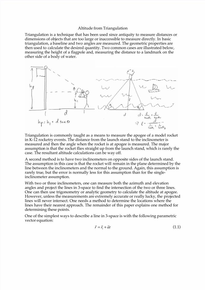
Altitude from Triangulation
Triangulation is a technique that has been used since antiquity to measure distances ordimensions of objects that are too large or inaccessible to measure directly. In basictriangulation, a baseline and two angles are measured. The geometric properties arethen used to calculate the desired quantity. Two common cases are illustrated below,measuring the height of a flagpole and, measuring the distance to a landmark on theother side of a body of water.
Triangulation is commonly taught as a means to measure the apogee of a model rocketin K-12 rocketry events. The distance from the launch stand to the inclinometer ismeasured and then the angle when the rocket is at apogee is measured. The majorassumption is that the rocket flies straight up from the launch stand, which is rarely thecase. The resultant altitude calculations can be way off.
A second method is to have two inclinometers on opposite sides of the launch stand.The assumption in this case is that the rocket will remain in the plane determined by theline between the inclinometers and the normal to the ground. Again, this assumption israrely true, but the error is normally less for this assumption than for the single-inclinometer assumption.
With two or three inclinometers, one can measure both the azimuth and elevationangles and project the lines in 3-space to find the intersection of the two or three lines.One can then use trigonometry or analytic geometry to calculate the altitude at apogee.However, unless the measurements are extremely accurate or really lucky, the projectedlines will never intersect. One needs a method to determine the locations where thelines have their nearest approach. The remainder of this paper explains one method fordetermining these points.
One of the simplest ways to describe a line in 3-space is with the following parametricvector equation:
!
r =!
r 1+
!
at (1.1)

where!
r = ( x, y, z) is the position vector of the points on the line,!
r1 = ( x1, y
1, z1) is theposition vector of one known point on the line, and
!
a = (! ," ,# ) is the direction cosines
(or a multiple of the direction cosines) of the line with respect to x , y , and z . The vectorexpression is equivalent to the three algebraic equations
x = x 1+! t , (1.2)
y = y1+ ! t , (1.3)
z = z1+ ! t . (1.4)
For a set of two lines,!
r =!
r 1+
!
a1t , and
!
q =!
r2+
!
a2s , we can define the distance between
the point at t and the point at s is d =!
r !!
q , which is the usual square root of the sumof squares. The endpoints of the minimum distance line segment are given by thevalues of t and s at which
!d
!t = 0 (1.5)
and
!d
!s= 0 (1.6)
simultaneously. The derivative equations are a bit long, but are linear in t and s . Oneplugs in the derived values for t and s into the original equations to find the two pointsat which the lines are closest to each other. The distance can be found as d =
!
r !!
q .
If one only needs the minimum distance, it can be calculated directly as
d =
!
r2!!
r1( )•
!
a1"
!
a2( )
!
a1"
!
a2
(1.7)