3-023-0809 Final Open Spaces Needs Assessment · LONDON BOROUGH OF CROYDON OPEN SPACE NEEDS...
104
Integrity, Innovation, Inspiration 1-2 Frecheville Court off Knowsley Street Bury BL9 0UF T 0161 764 7040 F 0161 764 7490 E [email protected] www.kkp.co.uk LONDON BOROUGH OF CROYDON OPEN SPACE NEEDS ASSESSMENT FINAL REPORT AUGUST 2009
Transcript of 3-023-0809 Final Open Spaces Needs Assessment · LONDON BOROUGH OF CROYDON OPEN SPACE NEEDS...

Integrity, Innovation, Inspiration 1-2 Frecheville Court ����off Knowsley Street ����Bury BL9 0UF
TTTT 0161 764 7040 ����FFFF 0161 764 7490 ����EEEE [email protected] ����www.kkp.co.uk
LONDON BOROUGH OF CROYDON OPEN SPACE NEEDS ASSESSMENT FINAL REPORT AUGUST 2009

Quality assurance Name Date
Report origination Helen Jones 1.07.09
Quality control Claire Fallon 14.07.09
Client comments Helen Jones 17.08.2009
Final approval Claire Fallon 19.08.09

LONDON BOROUGH OF CROYDON OPEN SPACE NEEDS ASSESSMENT
August 2009 3-023-0809 Draft report: Knight Kavanagh & Page 3
PART 1: INTRODUCTION................................................................................................4
Report structure ............................................................................................................4
Context .........................................................................................................................5
PART 2: METHODOLOGY...............................................................................................8
Background information ................................................................................................8
Auditing local provision..................................................................................................9
Identifying local need ..................................................................................................11
Categorising open spaces by function and/or size.......................................................14
PART 3: ALL OPEN SPACES ........................................................................................18
Civic space..................................................................................................................26
Green corridors ...........................................................................................................28
PART 4: PARKS AND GARDENS ..................................................................................32
Introduction .................................................................................................................32
Key issues...................................................................................................................32
Parks and gardens summary.......................................................................................43
PART 5: NATURAL AND SEMI-NATURAL GREENSPACES.........................................44
Introduction .................................................................................................................44
Key issues...................................................................................................................44
Natural and semi-natural greenspace summary ..........................................................55
PART 6: AMENITY GREENSPACE................................................................................56
Introduction .................................................................................................................56
Key issues...................................................................................................................56
Amenity greenspace summary....................................................................................64
PART 7: PROVISION FOR CHILDREN AND YOUNG PEOPLE ....................................65
Introduction .................................................................................................................65
Key issues...................................................................................................................65
Provision for children and young people summary ......................................................81
PART 8: ALLOTMENTS, COMMUNITY GARDENS AND CITY FARMS ........................82
Introduction .................................................................................................................82
Key issues...................................................................................................................82
Allotments summary....................................................................................................93
PART 9: CEMETERIES, CHURCHYARDS AND BURIAL GROUNDS ...........................94
Introduction .................................................................................................................94
Key issues...................................................................................................................94
Cemeteries summary ................................................................................................ 101
PART 10: WHERE NEXT ............................................................................................. 102
APPENDIX ONE: Open Space Consultee List.............................................................. 103

LONDON BOROUGH OF CROYDON OPEN SPACE NEEDS ASSESSMENT
August 2009 3-023-0809 Draft report: Knight Kavanagh & Page 4
PART 1: INTRODUCTION This is the draft Open Space Assessment prepared by Knight Kavanagh & Page (KKP). It focuses on reporting the findings of the extensive research, consultation, site assessments, data analysis and GIS mapping that underpins the study. This factual report provides an audit based assessment of both quantitative and qualitative open space in accordance with Planning Policy Guidance Note 17 and the Companion Guide entitled ‘Assessing Needs and Opportunities’ published in September 2002. The specific objectives of this audit and assessment are to provide: � A comprehensive audit of existing provision of different types of open space detailing
quantity, quality, accessibility and wider value to the community. � An accurate assessment of supply and demand for open space provision. � A robust evidence base to enable London Borough of Croydon (LBC) to develop
planning policies as part of the Local Development Framework (LDF) and other local development documents in order to meet future demand given forecasted population predictions.
Report structure This report considers the supply and demand issues for open space facilities in Croydon. Each part contains relevant typology specific data. Further description of the methodology on open spaces can be found in Part 2. The report as a whole covers the predominant issues for all the typologies defined in ‘Assessing Needs and Opportunities: A Companion Guide to PPG 17’ and is structured as follows: Part 3: All open spaces, incorporating civic space and green corridors. Part 4: Public parks. Part 5: Natural and semi-natural greenspaces. Part 6: Amenity greenspace. Part 7: Provision for children and young people. Part 8: Allotments. Part 9: Cemeteries, churchyards and other burial grounds.

LONDON BOROUGH OF CROYDON OPEN SPACE NEEDS ASSESSMENT
August 2009 3-023-0809 Draft report: Knight Kavanagh & Page 5
Context PPG17 describes the role of the planning system in assessing opportunities and needs for sport and recreation provision and safeguarding open space that has recreational value. The guidance observes that it is part of the function of the planning system to ensure that, through the preparation of development plans, adequate land and water resources are allocated for organised sport and informal recreation. It states that local planning authorities should take account of the community’s need for recreational space, having regard to current levels of provision and deficiencies and resisting pressures for development of open space where such development would conflict with the wider public interest. It discusses the role of all levels of plan, planning agreements, and the use of local authority land and compulsory purchase powers. ‘Assessing Needs and Opportunities: A Companion Guide to PPG17’ reflects the Government policy objectives for open space, sport and recreation, as set out in PPG17. The long term outcomes of PPG17 aim to deliver: � Networks of accessible, high quality open spaces and sport and recreation facilities,
in both urban and rural areas, which meet the needs of residents and visitors, are fit for purpose and economically and environmentally sustainable.
� An appropriate balance between new provision and the enhancement of existing provision.
� Clarity and reasonable certainty for developers and landowners in relation to the requirements and expectations of local planning authorities in respect of open space and sport and recreation provision.
This assessment covers the following open space typologies as set out in ‘Assessing Needs and Opportunities: A Companion Guide to PPG17’ Table 1.1: PPG17 definitions PPG17 typology Primary purpose
Parks and gardens Accessible, high quality opportunities for informal recreation and community events.
Natural and semi-natural greenspaces
Wildlife conservation, biodiversity and environmental education and awareness.
Green corridors Walking, cycling or horse riding, whether for leisure purposes or travel, and opportunities for wildlife migration.
Amenity greenspace Opportunities for informal activities close to home or work or enhancement of the appearance of residential or other areas.
Provision for children and young people
Areas designed primarily for play and social interaction involving children and young people, such as equipped play areas, ball courts, skateboard areas and teenage shelters.
Greenspaces
Allotments Opportunities for those people who wish to do so to grow their own produce as part of the long term promotion of sustainability, health and social inclusion.

LONDON BOROUGH OF CROYDON OPEN SPACE NEEDS ASSESSMENT
August 2009 3-023-0809 Draft report: Knight Kavanagh & Page 6
PPG17 typology Primary purpose
Cemeteries, disused churchyards and other burial grounds
Quiet contemplation and burial of the dead, often linked to the promotion of wildlife conservation and biodiversity.
Civic spaces
Civic and market squares and other hard surfaced areas designed for pedestrians including the promenade
Providing a setting for civic buidings, public demonstrations and community events.
Open Space Strategies: Best Practice Guidance, Mayor of London and CABE Space, 2009 Open space and parks in London have been planned and provided for many hundreds of years, and open space provision has been a key component of spatial planning in London since the early 19th century, with the ongoing evolution of approaches to open space provision. The London Plan is the current strategic plan for London setting out an integrated social, economic and environmental framework for future development. The Plan sets out a benchmark standard for the provision of a range of public open spaces across London from Regional to Local parks. The document offers guidance on how to prepare an open space strategy and within it presents the London public open space hierarchy that should be applied in London to provide a consistent approach for identifying broad areas of deficiency in provision. In order to integrate the two methodologies of PPG17 and The London Plan, we present this report by PPG17 typology but have also categorised open spaces by the London open space hierarchy. We have also applied, where this fits with findings of our consultation and local needs assessment, the effective catchment areas outlined within the London Plan. Table 1.2: London’s public open space hierarchy
Open space categorisation Size guideline
Distances from homes
Regional Parks
Large areas, corridors or networks of open space, the majority of which will be publicly accessible and provide a range of facilities and features offering recreational, ecological, landscape, cultural or green infrastructure benefits. Offer a combination of facilities and features that are unique within London, are readily accessible by public transport and are managed to meet best practice quality standards.
400 hectares 3.2 to 8 kilometres

LONDON BOROUGH OF CROYDON OPEN SPACE NEEDS ASSESSMENT
August 2009 3-023-0809 Draft report: Knight Kavanagh & Page 7
Open space categorisation Size guideline
Distances from homes
Metropolitan Parks
Large areas of open space that provide a similar range of benefits to Regional Parks and offer a combination of facilities and features at the sub-regional level, are readily accessible by public transport and are managed to meet best practice quality standards.
60 hectares 3.2 kilometres
District Parks
Large areas of open space that provide a landscape setting with a variety of natural features providing for a wide range of activities, including outdoor sports facilities and playing fields, children’s play for different age groups and informal recreation pursuits.
20 hectares 1.2 kilometres
Local Parks and Open Spaces
Providing for court games, children’s play, sitting-out areas and nature conservation areas.
2 hectares 400 metres
Small Open Spaces
Gardens, sitting-out areas, children’s play spaces or other areas of a specialist nature, including nature conservation areas.
Under 2 hectares
Less than 400 metres
Pocket Parks
Small areas of open space that provide natural surfaces and shaded areas for informal play and passive recreation that sometimes have seating and play equipment.
Under 0.4ha Less than 400 metres
Linear Open Spaces
Open spaces and towpaths alongside the Thames, canals and other waterways; paths; disused railways; nature conservation areas; and other routes that provide opportunities for informal recreation. Often characterised by features or attractive areas which are not fully accessible to the public but contribute to the enjoyment of the space.
Variable Wherever feasible

LONDON BOROUGH OF CROYDON OPEN SPACE NEEDS ASSESSMENT
August 2009 3-023-0809 Draft report: Knight Kavanagh & Page 8
PART 2: METHODOLOGY Background information An extensive range of background information has been reviewed and incorporated into the assessment of key issues for each typology. Background documentation reviewed for the study is listed below: � Co-ordinating play space development: Croydon Council. � Croydon Metropolitan Centre Area Action Plan Issues and Options Report 2008, LDF
Consultation Document, Croydon Council, 2008. � Croydon Open Space Strategy 2005 – 2010, Croydon Council with Scott Wilson,
2004. � Croydon Open Space Strategy – Technical Report, Croydon Council with Scott
Wilson, 2004. � London Strategic Parks Project Report, Greater London Authority, 2006. � Play Strategy 2006 – 2009, London Borough of Croydon. � South Norwood Conservation Area Appraisal and Management Plan, Supplementary
Planning Document, Croydon Council. � Wandle Park Super Park Application Form, London Borough of Croydon, 2009. � Woodland Management in Croydon, Forestry Commission England. � Best Value General User Survey. Research Study Conducted for Croydon Borough
Council Ipsos MORI2006/7. � London Strategic Parks Project Report May 2006, a report by EDAW for the Greater
London Authority. � Open Space Strategies: Best Practice Guidance September 2009, a Joint
Consultation Draft by the Mayor of London and CABE Space.

LONDON BOROUGH OF CROYDON OPEN SPACE NEEDS ASSESSMENT
August 2009 3-023-0809 Draft report: Knight Kavanagh & Page 9
Auditing local provision Database development All information relating to open spaces across Croydon is collated in the project open space database (supplied as an electronic file). Sites were originally identified by LBC in a previous audit carried out 2004/05. Additional sites identified during consultation have also been added to the audit by KKP. Each site has been classified according to both its PPG17 typology and its GLA classification, based on its primary open space purpose, so that each type of space is counted only once. Sites under 0.2 hectares were originally excluded from the audit as they are deemed to have less recreational value. However, where sites were identified during consultation as being of high value to residents, they have been included, e.g., all allotments and all play areas have been included due to their important contribution to overall provision. Sites are identified by official site names and road names/locations where possible. However, for some typologies, e.g., amenity greenspaces and natural and semi natural sites which, in the main, do not have official names anyway, this has not been possible and the nearest road name is used. In total 242 sites are identified within the audit, falling within one of the following PPG17 typologies: � Allotments. � Amenity greenspace. � Cemeteries. � Provision for children and young people. � Parks and gardens. � Natural/semi natural greenspace. Please note that green corridors and civic spaces are excluded from the audit, as these spaces are being covered through other LBC studies such as the Green Infrastructure Study. Site assessments Site assessments were carried out to evaluate the quality and value of sites. The 2004/05 LBC audit included a quality assessment of amenity greenspace, parks and natural/semi natural greenspace. KKP used this as basis to carry out a further assessment of the value of each site. In addition, we also assessed the remaining typologies of allotments, cemeteries and provision for children and young people for quality and value. Analysis of quality Data collated from site visits has been utilised to calculate a quality score for each site visited. Scores in the database are presented as total and percentage figures. Open space criteria The criteria used to assess open spaces by KKP (allotments, cemeteries and play areas) are summarised below. LBC used marginally different criteria for their audit in 2004/05. Therefore, for consistency purposes, a cross typology comparison is not recommended.

LONDON BOROUGH OF CROYDON OPEN SPACE NEEDS ASSESSMENT
August 2009 3-023-0809 Draft report: Knight Kavanagh & Page 10
The criteria used by KKP are based upon those used for Green Flag (national standard for parks and green spaces in England and Wales, operated by the Civic Trust) and ‘Green Space Strategies: A Good Practice Guide’, published by CABESpace (2008).
Open space site visit criteria for quality (summary)
� Physical access, e.g., public transport links, directional signposts.
� Access-social, e.g., appropriate minimum entrance widths.
� Parking, e.g., disabled parking.
� Information signage, e.g., presence of up to date site information.
� Equipment and facilities, e.g., assessment of both adequacy and maintenance of provision such as seats, benches, bins, toilets.
� Location value, e.g., proximity of housing, other greenspace.
� Site problems, e.g., presence of vandalism, graffiti.
� Healthy, safe and secure, e.g., staff on site.
� Maintenance and cleanliness, e.g., condition of landscape.
� Typology specific profile, e.g., presence of environmental education facilities (natural/semi-natural provision).
� Groups that the site meets the needs of, e.g., elderly, young people.
� Site potential.
The scoring is tailored to reflect the individual characteristics of different open spaces and a scoring system (i.e. different maximum scores) is applied to each typology to provide a more meaningful evaluation. Analysis of value The value of sites has been assessed by analysis of two sets of criteria: (i) site visit assessment data; and (ii) other data and information as detailed in the table below. As stated earlier, scores in the database are presented as total and percentage figures. PPG17 describes site value in relation to the following three issues: � Context of the site, i.e., its accessibility, scarcity value and historic value. � Level and type of use. � The wider benefits it generates for people, biodiversity and the wider environment. The criteria used to assess open spaces are summarised below.
Value - site visit criteria (summary)
� Level of use (observations only).
� Context of site in relation to other open spaces.
� Structural and landscape benefits.
� Ecological benefits.
� Educational benefits.
� Social inclusion and health benefits.
� Cultural and heritage benefits.
� Amenity benefits and a sense of place.
� Economic benefits.

LONDON BOROUGH OF CROYDON OPEN SPACE NEEDS ASSESSMENT
August 2009 3-023-0809 Draft report: Knight Kavanagh & Page 11
Value - non site visit criteria (summary)
� Designated site such as LNR or SSSI.
� Educational programme in place.
� Historic site.
� Listed building or historical monument on site.
� Registered 'friends of group' to the site.
Weighting and scoring system KKP utilises one site visit assessment sheet to assess all open space typologies. It’s weighting and scoring system takes account of the individual typologies and reflects their different natures and characteristics (each typology will therefore have a different maximum score). For example, the maximum score for allotments does not include one for picnic benches. Similarly, the maximum score for amenity greenspace does not include scores for toilets. Maximum scores achievable for each typology are set out below together with the equivalent data for value. Table 2.1: Maximum scores for quality and value of open spaces in Croydon
Typology Quality - maximum score
Value – maximum score
Allotments 124 30
Amenity greenspace 121 25
Cemeteries 161 25
Children’s play areas 97 20
Parks and Gardens 159 30
Semi / Natural greenspaces 117 35
On the assessment form itself some elements receive a direct score (1 – 5 scale) and other elements simply have a tick option if present (receiving a score of 3 for every tick). Some tick options are simply collated and analysed as additional data, receiving no score. Identifying local need The presentation of key issues emerging from the local needs assessment is driven by a broad understanding of open space. KKP brings a pragmatic approach to consultation in order to manage the expectations of stakeholders and present a realistic picture of issues, together with the aspirations of residents and users. Local need has been assessed via: � User consultation (face-to-face or telephone interviews and focus groups) with key
stakeholders such as officers, agencies and local interest groups and associations. � Residents survey. Please note that although green corridors and civic spaces were excluded from the audit, some findings from the consultation emerged about these spaces, and as such a summary of these key issues can be found in Part 3.

LONDON BOROUGH OF CROYDON OPEN SPACE NEEDS ASSESSMENT
August 2009 3-023-0809 Draft report: Knight Kavanagh & Page 12
User consultation The core of this phase focused around extensive consultation with over 100 stakeholders, including key individuals, interest and community groups, sports clubs, LBC officers, and agencies working in and around Croydon. Qualitative in-depth interviews were conducted either face-to-face or by telephone with a list of consultees provided by the clients along with those uncovered by KKP during consultation. A list of consultees is included in Appendix One. The key findings of the stakeholder consultation are presented under key issues within the individual typology sections. Issues covered include the following: � Attitudes towards open spaces in terms of quality of provision. � Opinions towards open spaces in terms of the amount of provision. � Time taken/distance travelled to open spaces. � Attitudes towards open spaces in terms of how accessible provision is. � Future provision and what it should look like. Residents survey LBC distributes a survey to citizen panel members: Talkabout Croydon. KKP has recently (April 2009) included questions regarding open space, sport and recreation facilities to identify with the attitudes and needs of the broader local community. In total, 1,446 surveys were sent out to members and 797 were completed and returned. The results have been weighted to provide analysis of all 1,446 surveys distributed. Responses are split between areas for greater local area analysis as follows: � North – 509. � Central – 480. � South – 457. The data obtained is particularly useful to inform accessibility in terms of walk/cycle/drive-time catchments. Key issues covered include the following: � Current usage of open spaces. � Reasons for usage/non-usage of open spaces. � Time taken/distance travelled to open spaces. � Attitudes to open spaces (e.g., adequacy, quality, accessibility). Survey results (generic issues, which cut across more than one typology) have been analysed and are presented in graphic format with relevant commentary below. Questions relevant to individual typologies are covered in the specific sections of the report. Results are provided for the descriptions used in the survey itself. For example, the survey refers to ‘nature areas’ as opposed to ‘natural and semi natural greenspace’ in order to simplify the definition for respondents. The minimum age for survey participants is 16 years old. Consultation with children and young people for the study was covered through other consultation with user groups, agencies and LBC officers.

LONDON BOROUGH OF CROYDON OPEN SPACE NEEDS ASSESSMENT
August 2009 3-023-0809 Draft report: Knight Kavanagh & Page 13
Analysis areas Croydon has been divided into eight analysis areas (shown below), which match those areas used for the Indoor Facilities Assessment Report for consistency. The division of the Borough into these eight areas is led by the distribution of school catchments and Building Schools for the Future (BSF) developments. This means that a more localised assessment of provision and examination of open space/facility surplus and deficiencies at a local level. Use of analysis areas also allows local circumstances and issues to be taken into account. Figure 2.1: Analysis areas in Croydon
LAMBETH
MERTON
SUTTON
BROMLEY
REIGATE AND BANSTEAD
TANDRIDGE
Purley & Coulsdon
Selsdon & Sanderstead
Addington
& Fieldway
Shirley/East Central
Central
North
West Central
West
CroydonPopulation density per square mile
28,700 to 41,900
25,300 to 28,700
21,900 to 25,300
18,100 to 21,900
15,300 to 18,100
12,600 to 15,300
10,100 to 12,600
7,900 to 10,100
5,500 to 7,900
1,100 to 5,500

LONDON BOROUGH OF CROYDON OPEN SPACE NEEDS ASSESSMENT
August 2009 3-023-0809 Draft report: Knight Kavanagh & Page 14
Categorising open spaces by function and/or size There are over 200 parks and open spaces in Croydon. Some are urban parks, often with facilities such as benches or playgrounds. Those parks are usually fenced and can be locked at night. Croydon also has a large number of wild open spaces used for walking and watching wildlife, but which have no facilities. The exception to this is South Norwood Country Park which has a visitor centre and other facilities. It is useful to categorise open space by function so that deficiencies can be identified, such as those in play space or allotments. PPG17 sets out typologies of open space which is based on function. Recognising the importance of multifunctional open spaces, PPG17 suggests the typology is used to identify the primary function of spaces and adapted to local variations as needed. This refinement is done by adding sub-categories to each of the PPG17 types, which will maintain a coherent strategic context, facilitate cross boundary working and allow benchmarking between authorities. Generally speaking the larger an open space, the more varied the potential for recreational opportunities and the further people will travel to visit. It is therefore also useful to categorise open spaces by size. How spaces are categorised depends on local circumstances. The London Plan sets out a hierarchy of public open spaces, shown below, which should be applied in London. 242 sites are identified within the audit of open spaces in Croydon. These have been classified according to PPG17 typologies and the GLA London’s public open space hierarchy. Table 2.2: Categorisation of open spaces in Croydon
London classification PPG17 typology Size of site Catchment area
Regional parks 400 hectares 3.2 to 8 kilometres
Metropolitan parks 60 hectares 3.2 kilometres
District parks
Parks and gardens
20 hectares 1.2 kilometres
Local Parks and open spaces
Parks and gardens
Amenity greenspace
Natural greenspace
Allotments
2 hectares 400 metres
Small open spaces Amenity greenspace
Natural greenspace
Allotments
Under 2 hectares Less than 400
metres
Pocket parks Parks and gardens
Amenity greenspace
Natural greenspace
Under 0.4 hectares
Less than 400 metres
Linear open spaces Green corridors Variable Wherever feasible
LONDON BOROUGH OF CROYDON OPEN SPACE NEEDS ASSESSMENT
August 2009 3-023-0809 Draft report: Knight Kavanagh & Page 15
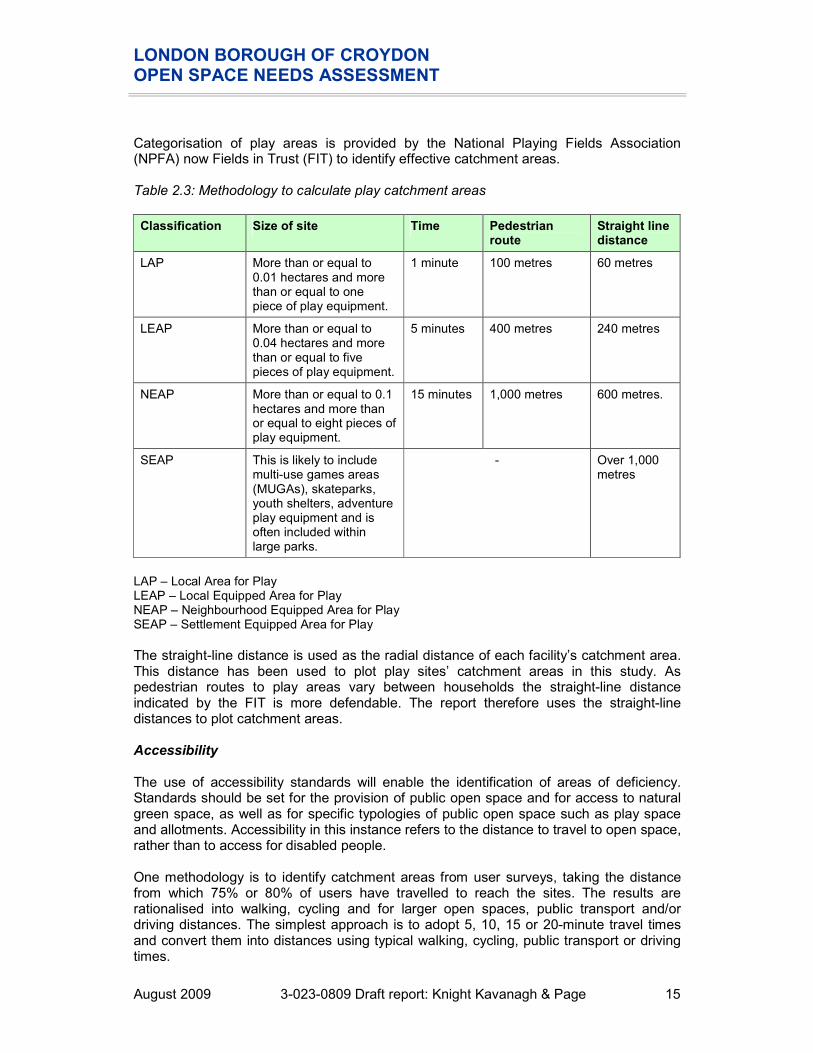
Categorisation of play areas is provided by the National Playing Fields Association (NPFA) now Fields in Trust (FIT) to identify effective catchment areas. Table 2.3: Methodology to calculate play catchment areas
Classification Size of site Time Pedestrian route
Straight line distance
LAP More than or equal to 0.01 hectares and more than or equal to one piece of play equipment.
1 minute 100 metres 60 metres
LEAP More than or equal to 0.04 hectares and more than or equal to five pieces of play equipment.
5 minutes 400 metres 240 metres
NEAP More than or equal to 0.1 hectares and more than or equal to eight pieces of play equipment.
15 minutes 1,000 metres 600 metres.
SEAP This is likely to include multi-use games areas (MUGAs), skateparks, youth shelters, adventure play equipment and is often included within large parks.
- Over 1,000 metres
LAP – Local Area for Play LEAP – Local Equipped Area for Play NEAP – Neighbourhood Equipped Area for Play SEAP – Settlement Equipped Area for Play
The straight-line distance is used as the radial distance of each facility’s catchment area. This distance has been used to plot play sites’ catchment areas in this study. As pedestrian routes to play areas vary between households the straight-line distance indicated by the FIT is more defendable. The report therefore uses the straight-line distances to plot catchment areas. Accessibility The use of accessibility standards will enable the identification of areas of deficiency. Standards should be set for the provision of public open space and for access to natural green space, as well as for specific typologies of public open space such as play space and allotments. Accessibility in this instance refers to the distance to travel to open space, rather than to access for disabled people. One methodology is to identify catchment areas from user surveys, taking the distance from which 75% or 80% of users have travelled to reach the sites. The results are rationalised into walking, cycling and for larger open spaces, public transport and/or driving distances. The simplest approach is to adopt 5, 10, 15 or 20-minute travel times and convert them into distances using typical walking, cycling, public transport or driving times.

LONDON BOROUGH OF CROYDON OPEN SPACE NEEDS ASSESSMENT
August 2009 3-023-0809 Draft report: Knight Kavanagh & Page 16
In London, the London Plan sets standards for the accessibility of each category of open space. It requires that every Londoner should have a small or local park (less than 20 ha) within 400m of their home, a district park (20-60ha) within 1.2km and a metropolitan scale park (60-400ha) within 3.2 km. This benchmark should be applied across London to ensure that the provision for Londoners is consistent. The table below presents the resident survey responses and London hierarchy recommended distance thresholds by PPG17 typology. Taking both into account, we have then recommended a distance threshold to apply (if any) in Croydon. This standard has then been used to map each type of open space and identify deficiencies. Table 2.4: Summary of survey responses and proposed accessibility standards
PPG17 typology Resident survey responses London recommendation
Recommended distance threshold in Croydon
Allotments Although the majority (51%) of respondents were unable to provide an answer, 40% would walk to access provision and of these, the majority (21%) would walk 15 minutes.
400 metres (sites over 2 hectares)
15 minute walk to access good quality provision
Amenity greenspace
Although the majority (58%) of respondents were unable to provide an answer, 29% would walk to access provision. However, there are a similar proportion of respondents willing to walk either 1, 5, 10 or 15 minutes.
400 metres (sites over 2 hectares)
GLA
Cemetery/churchyard
There are no significant differences as to whether respondents would walk or travel by transport to access provision (30% and 29% respectively). However, the majority (20%) would walk 15 minutes.
None To be driven by the need for burial capacity.
Civic space The majority (43%) of respondents would walk to access provision. Of these, the majority (24%) would travel 15 minutes.
None Deficiencies to be identified through consultation
Natural/semi natural greenspace
Reflecting the location of current provision, the majority (44%) of users would drive or use public transport to access provision. Of these, 34% would travel up to 30 minutes. However, 24% would also walk 15 minutes to access provision.
400 metres (sites over 2 hectares)
GLA

LONDON BOROUGH OF CROYDON OPEN SPACE NEEDS ASSESSMENT
August 2009 3-023-0809 Draft report: Knight Kavanagh & Page 17
PPG17 typology Resident survey responses London recommendation
Recommended distance threshold in Croydon
Parks and gardens
The majority (70%) of respondents would walk to access provision. Of these, the majority (35%) would travel 15 minutes.
Various depending on size
GLA
Provision for children
The majority of respondents would walk to access provision. Of these, the majority would travel either 10 or 15 minutes.
FIT:
LAP - 1 minute
LEAP - 5 minute
NEAP - 15 minute
FIT
Provision for young people
Although the majority (58%) of respondents were unable to provide an answer, 32% would walk to access provision.
FIT:
SEAP - 20 minute
FIT
Green corridors Reflecting the high levels of usage of this type of provision, 68% of respondents would walk to access provision. Of these, the majority (24%) would travel 15 minutes.
None Deficiencies to be identified through consultation

LONDON BOROUGH OF CROYDON OPEN SPACE NEEDS ASSESSMENT
August 2009 3-023-0809 Draft report: Knight Kavanagh & Page 18
PART 3: ALL OPEN SPACES Consultation with users and non-users of open spaces across Croydon covered many issues. Typology and site specific issues are covered in the relevant sections of this report. This section describes the generic issues that cut across more than one type of open space, including a summary of the Talkabout survey. This section also includes a summary of civic space and green corridors as although these spaces were excluded from the audit, some findings from the consultation emerged about these spaces. Usage The most popular typologies visited in the last twelve months by residents of Croydon are public parks/gardens (88%) and footpaths/cycle paths (76%). Only very small proportions have, in the last year, visited an allotment (10%) or a play area for teenagers (15%). This is consistent with the findings from other local authority areas and reflects the user profile of these types of open spaces. Figure 3.1: Types of open spaces visited in the previous 12 months
10%
44% 46%
15%
74% 76%
66%
88%
32%
58%
45%
0%
10%
20%
30%
40%
50%
60%
70%
80%
90%
100%
Allotm
ent
Churchyard/
cemetery
Play area for
children
Play area for
teenagers
Civic space/non-
green space
Footpath/cyclepath
Nature area
Public Park
Grassed area on
housing estate
Indoor sports
facilities
Outdoor recreation
facilities
The Talkabout survey found that the most popular open space to visit in Croydon is Lloyd Park with 43% of respondents visiting the site in the previous 12 months.

LONDON BOROUGH OF CROYDON OPEN SPACE NEEDS ASSESSMENT
August 2009 3-023-0809 Draft report: Knight Kavanagh & Page 19
Figure 3.2: Spaces used in the past 12 months
23%
4%
43%
20%
8%
13%
5%
14% 13%
25%
4%
0%
5%
10%
15%
20%
25%
30%
35%
40%
45%
50%South Norwood
Country Park
Ashburton Playing
Fields/ Stroud Green
Amenity Area
Lloyd Park
Addington Hills
Shirley Heath
Selsdon Wood/
Foxshaw/Courtwood
Kings Wood
Riddlesdown
Coulsdon Common
Farthing Downs/
Happy Valley/New
Hill
No answer
The most popular reason for visiting open spaces in Croydon is to keep fit/good for health; two thirds of respondents (66%) cite this. This reflects those typologies with higher levels of usage, such as parks and gardens and footpaths/cycle paths. The role of open spaces in providing social interaction is also reflected in the results, with just over fifth (21%) using open spaces to meet with friends. Figure 3.3 Reasons for usage of open space in the previous 12 months
4% 3%
66%
21%
13%
0%
10%
20%
30%
40%
50%
60%
70%
Participate in team
sports
Participate in
individual sport
Keep fit/good for
health
To meet friends No answer

LONDON BOROUGH OF CROYDON OPEN SPACE NEEDS ASSESSMENT
August 2009 3-023-0809 Draft report: Knight Kavanagh & Page 20
Respondents were asked why they have not accessed provision in the last 12 months. The main reason given is lack of time (24%), and using open spaces outside the Croydon area (11%). Other factors highlighted include feeling that facilities are too far away (9%), facilities in poor condition (8%), and unsure where facilities are (7%). Figure 3.4 Reasons for non-usage of open spaces
2%
5% 6%
9%7%
24%
8%
3%1% 2%
11%
1%
43%
0%
5%
10%
15%
20%
25%
30%
35%
40%
45%
50%
No interest in
this type of
activity
Too old/poor
health
Mobility/access
problems
Facilities too
far away
Unsure of
where facilities
are
Lack of spare
time
Facilities are in
poor condition
Don't provide
the typeof
activities I'm
Sites are all
too busy
Not open at the
times most
convenient for
Use facilities
outside the
Croydon area
Too expensive
No answer
Responses indicate that the main action required to encourage greater usage of open spaces by current non-users is ensuring a greater awareness of both local provision and those sites which could be regarded as “destinations”. The Downlands Project is primarily based in Surrey but also covers sites in Croydon, including Hutchinsons Bank and Coulsdon Common. An outreach officer for the project, funded by Heritage Lottery Fund (HLF), will be in post in spring 2009 and will be tasked with increasing community involvement in natural and semi natural green spaces, particularly BME groups and those from deprived areas. In order to increase usage, users suggest that open spaces could be made more interesting with an increase of public art/areas where people can gather, sit and ‘contemplate’. A general lack of natural features was also highlighted; one suggestion for the planting of a woodland grove which could include sculptures in the woods which can be climbed on etc (possibly at Park Hill Park) or the creation of a wildlife sanctuary. The Council's annual Green Space survey was carried out in November 2008 and involved a random sample of around 800 residents. The data showed that the percentage of people who felt 'very unsafe' in Croydon's parks (2%) has dropped below the national average of 3%.
LONDON BOROUGH OF CROYDON OPEN SPACE NEEDS ASSESSMENT
August 2009 3-023-0809 Draft report: Knight Kavanagh & Page 21
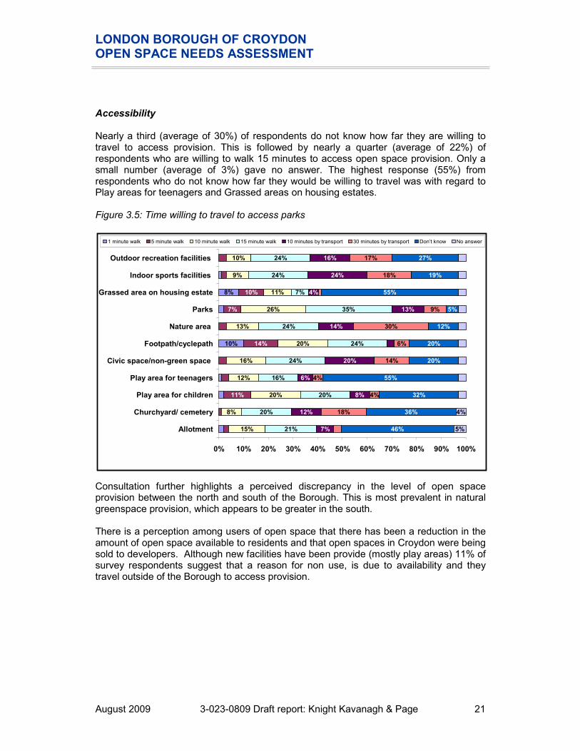
Accessibility Nearly a third (average of 30%) of respondents do not know how far they are willing to travel to access provision. This is followed by nearly a quarter (average of 22%) of respondents who are willing to walk 15 minutes to access open space provision. Only a small number (average of 3%) gave no answer. The highest response (55%) from respondents who do not know how far they would be willing to travel was with regard to Play areas for teenagers and Grassed areas on housing estates. Figure 3.5: Time willing to travel to access parks Consultation further highlights a perceived discrepancy in the level of open space provision between the north and south of the Borough. This is most prevalent in natural greenspace provision, which appears to be greater in the south. There is a perception among users of open space that there has been a reduction in the amount of open space available to residents and that open spaces in Croydon were being sold to developers. Although new facilities have been provide (mostly play areas) 11% of survey respondents suggest that a reason for non use, is due to availability and they travel outside of the Borough to access provision.
10%
8%
11%
14%
7%
10%
15%
8%
20%
12%
16%
20%
13%
26%
11%
9%
10%
21%
20%
20%
16%
24%
24%
24%
35%
7%
24%
24%
7%
12%
8%
6%
20%
14%
13%
4%
24%
16%
18%
4%
4%
14%
6%
30%
9%
18%
17%
46%
36%
32%
55%
20%
20%
12%
5%
55%
19%
27%
5%
4%
0% 10% 20% 30% 40% 50% 60% 70% 80% 90% 100%
Allotment
Churchyard/ cemetery
Play area for children
Play area for teenagers
Civic space/non-green space
Footpath/cyclepath
Nature area
Parks
Grassed area on housing estate
Indoor sports facilities
Outdoor recreation facilities
1 minute walk 5 minute walk 10 minute walk 15 minute walk 10 minutes by transport 30 minutes by transport Don’t know No answer

LONDON BOROUGH OF CROYDON OPEN SPACE NEEDS ASSESSMENT
August 2009 3-023-0809 Draft report: Knight Kavanagh & Page 22
Quality The table below summarises the results of all the quality assessment for open spaces across Croydon. The threshold for assessing high and low quality is set at 60%. Table 3.1: Quality scores for all open space typologies
QUALITY Scores Number at:
Below
60%
Above
60%
Analysis area
Maximum score
Lowest score
MEAN score
Highest score
Spread
Allotments 124 0% 46% 78% 78% 14 7
Amenity greenspace 121 41% 63% 80% 39% 12 24
Cemeteries 161 60% 63% 68% 8% 0 7
Children’s play areas 97 30% 79% 92% 63% 4 63
Parks and Gardens 159 43% 56% 65% 23% 36 12
Natural/semi natural greenspace
117 0% 49% 70% 70% 52 11
The audit of parks undertaken by LBC, rates a almost half (49%) of sites as poor quality based on a 60% threshold. The only typologies where the number of sites being rated as poor quality, is higher than the number being rated as high quality, is allotments, parks and semi natural greenspaces. However, please note that the criteria used to assess allotments are different from that used to assess parks and semi natural greenspaces. Consultation highlights a general perception that the maintenance of open spaces carried out by LBC is lower than it has been for many years, which may be affecting the level of usage. Fly tipping is noted as a particular problem in many types of open spaces. Best Value Performance Indicators (BVPIs) were part of the performance management framework for local authorities, which the Government started to introduce in 1997. BVPIs were designed to monitor service improvement with regard to the efficiency, effectiveness and economy of service delivery. These perception-based performance indicators were collected triennially. This has now been replaced with National Indicators. The Place Survey is a biennial survey which asks local people for their perceptions about the area in which they live. The results of the survey provide data for 20 of the new National Indicators and compares it to previous BVPIs. It shows: � There has been a 15% decline since 2003/04 in satisfaction with parks and open
spaces, from 85% to 70%. � There has been a 10% decline since 2003/04 in the view that parks and open spaces
make somewhere a good place to live, from 42% to 32%. � The daily and weekly usage of parks and open spaces have both declined since
2003/04, by 6% for daily (from 20% to 14%) and 11% for weekly (36% to 25%). The Ipsos Mori research also found that resident satisfaction with Croydon’s parks and open spaces is at 70%, which is just below the average for outer London boroughs. If considering park users in isolation, satisfaction increases further still to three quarters of residents. Seven in ten residents feel that, as a service, the Borough’s parks and open spaces have not changed since 2003/04 and slightly more feel they have improved (15%)

LONDON BOROUGH OF CROYDON OPEN SPACE NEEDS ASSESSMENT
August 2009 3-023-0809 Draft report: Knight Kavanagh & Page 23
than think they have worsened (13%). Park users aged 55 and over and users with a disability are most satisfied (both 85%). Although the majority (average of 37%) of respondents do not know how satisfied or dissatisfied they are with provision, nearly a quarter (average of 22%) of respondents are satisfied with provision, whilst the same percentage (average of 22%) of respondents is neither satisfied nor dissatisfied with recreation provision. Parks are the typology respondents are most fairly satisfied (48%) with, whilst allotments (67%) are the typology most respondents do not know how they would rate with regard to being satisfied or dissatisfied. Figure 3.6 Quality of provision of open spaces
6%
18%
22%
9%
30%
28%
33%
48%
10%
24%
17%
15%
25%
20%
15%
31%
27%
17%
18%
19%
26%
24%
4%
4%
11%
7%
8%
13%
5%
10%
7%
8%
10%
67%
42%
35%
60%
22%
20%
33%
5%
55%
30%
39%
7%
10%
7%
0% 10% 20% 30% 40% 50% 60% 70% 80% 90% 100%
Allotment
Churchyard/ cemetery
Play area for small/young children
Play area for teenagers
Civic space/non-green space
Footpath/cyclepath
Nature area (e.g., wildlife site)
Park
Grassed area on housing estate
Indoor sports
Outdoor sports
Very satisfied Fairly satisfied Neither satisfied nor dissatisfied Fairly dissatisfied Very dissatisfied Don’t know No answer

LONDON BOROUGH OF CROYDON OPEN SPACE NEEDS ASSESSMENT
August 2009 3-023-0809 Draft report: Knight Kavanagh & Page 24
Value The methodology for assessing value is set out in Part 2 (Methodology). The table below summarises the results of the value assessment for open spaces across Croydon. A score of 20% or less is considered to indicate that a site has low value. Table 3.2: Value scores for all open space typologies
VALUE Scores Number at:
Below
20%
Above
20%
Analysis area
Maximum score
Lowest score
MEAN score
Highest score
Spread
Allotments 30 13% 25% 33% 20% 3 18
Amenity greenspace 25 4% 21% 40% 36% 20 16
Cemeteries 25 20% 21% 28% 8% 0 7
Children’s play areas 20 5% 65% 95% 90% 2 65
Parks and Gardens 30 3% 47% 47% 43% 14 33
Semi / Natural greenspaces
35 3% 43% 43% 40% 47 16
A high value site is considered to be one that is well used by the local community, well maintained (with a balance for conservation), provides a safe environment and has features of interest; for example play equipment, landscaping. Sites that provide for a cross section of users and are multi-functional are considered higher value than those that are bland, unattractive and offer limited functions. There are around 23‘friends of groups’ in Croydon, and those consulted to date are happy with the level of support provided by LBC. This type of community engagement and ownership in open spaces increases the value of provision to residents. Most Talkabout survey respondents (91%) view open spaces to be very or fairly important. This highlights the high value placed on such provision by respondents, and the reasons for continued investment in open spaces by the Council and other providers. Only a small proportion of respondents (5%) viewed open space and sports recreation facilities to be not very important.

LONDON BOROUGH OF CROYDON OPEN SPACE NEEDS ASSESSMENT
August 2009 3-023-0809 Draft report: Knight Kavanagh & Page 25
Figure 3.7: Importance of open spaces
63%
28%
5%
0%2% 2%
0%
10%
20%
30%
40%
50%
60%
70%
Very important Fairly important Not very
important
Not at all
important
Don't know No answer

LONDON BOROUGH OF CROYDON OPEN SPACE NEEDS ASSESSMENT
August 2009 3-023-0809 Draft report: Knight Kavanagh & Page 26
Civic space The typology of civic space, as set out in PPG17: A Companion Guide includes civic and market squares and other hard surfaced areas designed for pedestrians, providing a setting for civic buildings, public demonstrations and community events. LBC has chosen not to include an audit of civic space within its assessment. However, the residents’ survey did ask questions relating to civic spaces and is therefore presented below. Usage Just over a third (34%) of Talkabout survey respondents visits a civic space less than once a month, whilst 19% visit once a month. Only 10% of respondents are unable to state how often they visit civic spaces. Just under a fifth (17%) has not visited civic spaces in the last 12 months. Figure 3.8: Usage frequency of civic space/non-green spaces in the previous 12 months
4%
7%
10%
19%
34%
17%
10%
0%
5%
10%
15%
20%
25%
30%
35%
40%
More than
once a week
Once a week 2-3 times a
month
Once a
month
Less than
once a
month
Never visited Don’t know /
no answer
Accessibility Under a half (43%) of respondents are willing to walk to reach civic spaces, with 24% of respondents willing to walk 15 minutes. However, 44% of respondents will travel by transport in order to access provision. Nearly a quarter (23%) are unable to state how far they would be willing to travel to access civic spaces.

LONDON BOROUGH OF CROYDON OPEN SPACE NEEDS ASSESSMENT
August 2009 3-023-0809 Draft report: Knight Kavanagh & Page 27
Figure 3.9: Time prepared to travel to reach a civic space/non-green space
0%
3%
16%
24%
20%
14%
20%
3%
0%
5%
10%
15%
20%
25%
30%
1 minute
walk
5 minute
walk
10 minute
walk
15 minute
walk
10 minutes
by
transport
30 minutes
by
transport
Don’t know No answer
A third (33%) of Talkabout survey respondents are satisfied (very/fairly) with the quality of provision of civic spaces. However, a quarter is unable to offer a comment regarding quality, which means that the remaining 31% are neither satisfied nor dissatisfied with provision. Figure 3.10: Quality of civic spaces
3%
30%31%
8%
4%
22%
3%
0%
5%
10%
15%
20%
25%
30%
35%
Very satisfied Fairly
satisfied
Neither
satisfied nor
dissatisfied
Fairly
dissatisfied
Very
dissatisfied
Don’t know No answer

LONDON BOROUGH OF CROYDON OPEN SPACE NEEDS ASSESSMENT
August 2009 3-023-0809 Draft report: Knight Kavanagh & Page 28
Green corridors The typology of green corridors/linear open spaces, as set out in PPG17: A Companion Guide includes sites that offer opportunities for ‘walking, cycling or horse riding, whether for leisure purposes or travel and opportunities for wildlife migration’. It also covers river and canal banks, road and rail corridors, cycling routes within towns and cities, pedestrian paths within towns and cities, rights of way and permissive paths. LBC has chosen not to include an audit of green corridors within its assessment as this provision is being covered within other studies such as the Green Infrastructure Study. However, the residents’ survey did ask questions relating to this type of provision and is therefore presented below. Management There has, in previous years, been no Public Right Of Way (PROW) officer in post. However this is expected to be rectified in autumn 2009 with an officer appointed to coordinate delivery of the ROWIP (currently in draft) and deal with daily issues. The development of the green corridor network is being driven through the LBC Planning, Regeneration and Conservation Department. A recent LBC study, ‘Connecting to Croydon’s Parks’ identifies the following key issues: � Central Croydon – lack of East to West linkages. � North Croydon – deficient in access to open space and nature. � There is a need to reduce car dependency, and increase choice by providing
opportunities to use different modes of transport. � GLA Strategic Parks report identifies Croydon as the southern terminus of the
proposed Wandle Valley Regional Park. Improvements to selected linear open spaces will be made through projects such as the ‘Connect 2: Croydon Park Links’. Developed in partnership with Sustrans (an environmental transport charity), the project aims to develop links from central Croydon to Wandle Park, the Wandle Trail and open spaces to the east of the Borough such as South Norwood Country Park, Ashburton Park and Addiscombe Railway Park. The Urban Design and Conservation team and the Space Syntax consultants are looking at how people travel/move throughout the Borough. Presently, it is focused on local centres but the network could be developed to show how people travel between green spaces. A project which could help improve access and links between open spaces is The Emerald Necklace (part of Architect Will Alsop’s proposals for Croydon Town Centre) which has a vision that Queens Gardens, Wandle Park, Duppas Hill and Park Hill should be connected via a network, or necklace of green spaces encircling the town centre.

LONDON BOROUGH OF CROYDON OPEN SPACE NEEDS ASSESSMENT
August 2009 3-023-0809 Draft report: Knight Kavanagh & Page 29
Usage Most (23%) respondents visit a footpath/cycle path less than once a month. However, one in five (20%) visit a footpath/cycle path more than once a week. Similar proportions of respondents use footpaths/cyclepaths once a week (8%), 2-3 times a month (10%) and once a month (15%). 17% of respondents have not visited a footpath/cycle path in the last 12 months. Figure 3.11: Frequency of usage of footpaths/cyclepaths in the previous 12 months
20%
8%
10%
15%
23%
17%
8%
0%
5%
10%
15%
20%
25%
More than
once a week
Once a week 2-3 times a
month
Once a
month
Less than
once a
month
Never visited Don’t know /
no answer
There are a number of bridleways which run through the Borough and in general, bridleways are well provided and highly valued by users. Those highlighted during consultation include: � The permissive bridleway on the perimeter of Hutchinsons Bank, which is to be
resurfaced because the neighbouring natural area is due to be fenced to allow grazing livestock (goats and sheep), as part of the Old Surrey Downs Project.
� There is now a permissive bridleway in place through Littleheath Woods which is the result of recent campaigning and joint working between the local riders and the friends of group.
� Users feel there is no safe crossing for horses at Gravel Hill. This has been exacerbated since the tram link was built, which impinges on the bridleway.
LONDON BOROUGH OF CROYDON OPEN SPACE NEEDS ASSESSMENT
August 2009 3-023-0809 Draft report: Knight Kavanagh & Page 30
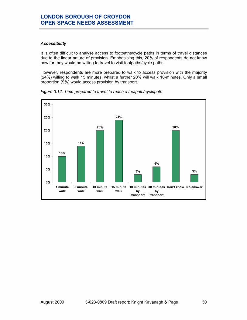
Accessibility It is often difficult to analyse access to footpaths/cycle paths in terms of travel distances due to the linear nature of provision. Emphasising this, 20% of respondents do not know how far they would be willing to travel to visit footpaths/cycle paths. However, respondents are more prepared to walk to access provision with the majority (24%) willing to walk 15 minutes, whilst a further 20% will walk 10-minutes. Only a small proportion (9%) would access provision by transport. Figure 3.12: Time prepared to travel to reach a footpath/cyclepath
10%
14%
20%
24%
3%
6%
20%
3%
0%
5%
10%
15%
20%
25%
30%
1 minute
walk
5 minute
walk
10 minute
walk
15 minute
walk
10 minutes
by
transport
30 minutes
by
transport
Don’t know No answer

LONDON BOROUGH OF CROYDON OPEN SPACE NEEDS ASSESSMENT
August 2009 3-023-0809 Draft report: Knight Kavanagh & Page 31
Quality The majority (33%) of respondents are satisfied (very/fairly) with provision, whilst only 18% are dissatisfied. Just over a quarter (27%) are neither satisfied nor dissatisfied with the provision of footpaths/cycle paths. One in five (20%) were unable to answer. Figure 3.13: Quality of green corridors
5%
28%27%
13%
5%
20%
2%
0%
5%
10%
15%
20%
25%
30%
Very satisfied Fairly
satisfied
Neither
satisfied nor
dissatisfied
Fairly
dissatisfied
Very
dissatisfied
Don’t know No answer
Consultation highlights that the provision of signage is mixed, with some routes well provided for and others with little information. The Downlands Trust suggests that there is potential to establish a circular walk through Hutchinsons Bank from New Addington tram station.

LONDON BOROUGH OF CROYDON OPEN SPACE NEEDS ASSESSMENT
August 2009 3-023-0809 Draft report: Knight Kavanagh & Page 32
PART 4: PARKS AND GARDENS Introduction The typology of parks and gardens, as set out in PPG17: A Companion Guide, covers urban parks, country parks and formal gardens (including designed landscapes), which provide ‘accessible high quality opportunities for informal recreation and community events.’ Key issues Current provision 48 sites are identified within the audit as park and gardens (according to PPG17 typology) provision in Croydon, totalling almost 322 hectares (ha). Table 4.1: Distribution of all parks and gardens by analysis area
Parks and gardens Analysis area
Number Size (ha)
Addington & Fieldway 3 31.93
Central 10 106.87
North 5 37.47
Purley & Coulsdon 7 38.60
Selsdon & Sanderstead 4 19.88
Shirley/East Central 5 25.69
West 10 39.44
West Central 4 21.78
CROYDON 48 321.66

LONDON BOROUGH OF CROYDON OPEN SPACE NEEDS ASSESSMENT
August 2009 3-023-0809 Draft report: Knight Kavanagh & Page 33
Usage Nearly a third of all Talkabout respondents (30%) state they visit a park less than once a month. 21% state they visit 2-3 times a month, whilst a further 18% visit once a month. A small number (10%) of respondents have not visited a public park in the last 12 months. However, only 1% of respondents provide no answer to the question, suggesting that usage/awareness of parks in Croydon is high. Figure 4.1: Frequency of usage of parks in the past 12 months
7%
12%
21%
18%
30%
10%
1%
0%
5%
10%
15%
20%
25%
30%
35%
More than
once a week
Once a week 2-3 times a
month
Once a
month
Less than
once a
month
Never visited Don’t know /
no answer
The LBC annual green space survey was carried out in November 2008 to a random sample of around 800 residents. The results found that: � The percentage of people who felt 'very unsafe' in Croydon's parks (2%) has dropped
below the national average of 3%. � The percentage of Borough residents who use LBC parks and open spaces is 8%
above the national average and that just over half of users are female. � Reasons for visiting the parks include relaxing (18.6%), observing wildlife (11.1%)
and exercise (2.6%). Almost one fifth of visits involve children playing or family days out.

LONDON BOROUGH OF CROYDON OPEN SPACE NEEDS ASSESSMENT
August 2009 3-023-0809 Draft report: Knight Kavanagh & Page 34
Accessibility Overall, 70% of Talkabout respondents would be willing to walk to access a public park. Of which, just over a third of respondents (35%) would be willing to walk up to 15 minutes, and just over a quarter (26%) for 10 minutes. In addition, 22% of respondents would be prepared to travel by transport, such as a car or bus to access provision. This again, enforces the value of parks and gardens to local residents. Only 8% were unable to state how long they would be willing to travel in order to access a public park. Figure 4.2: Time prepared to travel to access a park
2%
7%
26%
35%
13%
9%
5%
3%
0%
5%
10%
15%
20%
25%
30%
35%
40%
1 minute
walk
5 minute
walk
10 minute
walk
15 minute
walk
10 minutes
by
transport
30 minutes
by
transport
Don’t know No answer
The LBC annual green space survey was carried out in November 2008 to a random sample of around 800 residents. It also found that seventy-three per cent of all respondents use a Croydon park, with over a fifth visiting daily. Seventy-nine per cent always walk and this is 14% above the national average. The effective catchments of parks and gardens have been identified using data from the street survey (see Figure 4.2) and guidance issued by the Greater London Authority (GLA). The following catchments are therefore used in the mapping to identify the coverage of current provision: � Metropolitan parks – 3,200 metres. � District parks – 1,200 metres. � Local parks – 400 metres.

LONDON BOROUGH OF CROYDON OPEN SPACE NEEDS ASSESSMENT
August 2009 3-023-0809 Draft report: Knight Kavanagh & Page 35
Figure 4.3: All parks mapped against population density
REIGATE AND BANSTEAD
MERTON
SUTTON
TANDRIDGE
LAMBETH
BROMLEY
3
139
80
81
14
133
31
28
21
70
75
71
34 101
78109103
4140
6664
131
46
117
1
104
119
125
123
118
128
13
87
92
130
88
91
105
17
93
102
44
113
4
106107
12
2
Croydon
Small Open Space
Pocket Park
Local Park
District Park
400 m catchment
1,200 m catchment
Population density per square mile
28,700 to 41,900
25,300 to 28,700
21,900 to 25,300
18,100 to 21,900
15,300 to 18,100
12,600 to 15,300
10,100 to 12,600
7,900 to 10,100
5,500 to 7,900
1,100 to 5,500
Key to sites mapped:
KKP Ref
Site Analysis area GLA classification
Quality Value
78 North Down Addington & Fieldway Local Park
80 Milne Park Addington & Fieldway Local Park
81 Addington Vale Addington & Fieldway Local Park
3 Ashburton Playing Fields Central District Park
139 South Norwood Country Park
Central District Park
1 Ashburton Park Central Local Park
2 Addiscombe Recreation Ground
Central Local Park
104 Boulongne Road Play Ground
Central Local Park
LONDON BOROUGH OF CROYDON OPEN SPACE NEEDS ASSESSMENT
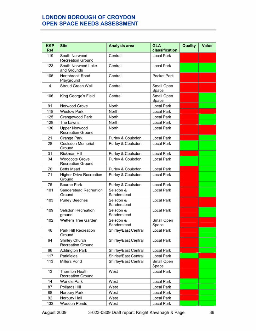
August 2009 3-023-0809 Draft report: Knight Kavanagh & Page 36
KKP Ref
Site Analysis area GLA classification
Quality Value
119 South Norwood Recreation Ground
Central Local Park
123 South Norwood Lake and Grounds
Central Local Park
105 Northbrook Road Playground
Central Pocket Park
4 Stroud Green Well Central Small Open Space
106 King George’s Field Central Small Open Space
91 Norwood Grove North Local Park
118 Westow Park North Local Park
125 Grangewood Park North Local Park
128 The Lawns North Local Park
130 Upper Norwood Recreation Ground
North Local Park
21 Grange Park Purley & Coulsdon Local Park
28 Coulsdon Memorial Ground
Purley & Coulsdon Local Park
31 Rickman Hill Purley & Coulsdon Local Park
34 Woodcote Grove Recreation Ground
Purley & Coulsdon Local Park
70 Betts Mead Purley & Coulsdon Local Park
71 Higher Drive Recreation Ground
Purley & Coulsdon Local Park
75 Bourne Park Purley & Coulsdon Local Park
101 Sanderstead Recreation Ground
Selsdon & Sanderstead
Local Park
103 Purley Beeches Selsdon & Sanderstead
Local Park
109 Selsdon Recreation ground
Selsdon & Sanderstead
Local Park
102 Wettern Tree Garden Selsdon & Sanderstead
Small Open Space
46 Park Hill Recreation Ground
Shirley/East Central Local Park
64 Shirley Church Recreation Ground
Shirley/East Central Local Park
66 Addington Park Shirley/East Central Local Park
117 Parkfields Shirley/East Central Local Park
113 Millers Pond Shirley/East Central Small Open Space
13 Thornton Heath Recreation Ground
West Local Park
14 Wandle Park West Local Park
87 Pollards Hill West Local Park
88 Narbury Park West Local Park
92 Norbury Hall West Local Park
133 Waddon Ponds West Local Park

LONDON BOROUGH OF CROYDON OPEN SPACE NEEDS ASSESSMENT
August 2009 3-023-0809 Draft report: Knight Kavanagh & Page 37
KKP Ref
Site Analysis area GLA classification
Quality Value
12 Trumble Gardens West Small Open Space
17 Canterbury Road Recreation Ground
West Small Open Space
44 The Queen's Gardens West Small Open Space
107 Wilford Road West Small Open Space
40 Haling Grove West Central Local Park
41 South Croydon Recreation Ground
West Central Local Park
131 Duppas Hill West Central Local Park
93 Rotary Field West Central Small Open Space
Catchment mapping, based on all current provision, shows that the densely populated areas of Croydon are generally well served by parks and gardens. However, there are some gaps where residents do not have access to provision, for example: � The south of Selsdon and Sanderstead analysis area. � Boundary of Purley and Coulsdon and West Central Croydon analysis area. � West of West Croydon analysis area. There are, however, other typologies in these areas which go some way to meeting these catchment gaps. For example, Purley Way Playing Fields has been classed as amenity greenspace but may be perceived to function in a similar way to park provision and therefore seeking new provision in the area is not a priority. Management The LBC Greenspaces Team is responsible for the management and development of amenity land within Croydon. LBC grounds maintenance of parks is delivered by external contractors: Continental Landscapes, monitored by LBC. Green Flag The Green Flag Award scheme is managed by a consortium consisting of Keep Britain Tidy, BTCV and GreenSpace. The scheme provides national standards for parks and greenspaces across England and Wales. Public service agreements, identified by the Department for Communities and Local Government (DCLG) highlight the importance placed on Green Flag status as an indicator of high quality parks. This in turn impacts upon the way parks and gardens are managed and maintained. There are eight parks and greenspaces in the Borough that currently (2009) hold the Green Flag Award: � Farthing Downs. � Coulsdon Common. � Riddlesdown Common. � Kenley Common. � Wettern Tree Garden. � Happy Valley Park.

LONDON BOROUGH OF CROYDON OPEN SPACE NEEDS ASSESSMENT
August 2009 3-023-0809 Draft report: Knight Kavanagh & Page 38
� Coombe Wood. � Haling Grove. New submissions for 2009 included Haling Grove, South Norwood Lake and Coulsdon Memorial Ground. Despite different criteria being used to assess the sites, the following parks scored highly in the quality assessments and could therefore be considered for Green Flag submission in the future: � Wandle Park (following redevelopment). � Ashburton Park. � Trumble Gardens. Quality The methodology for assessing quality is set out in Part 2 (Methodology). The table below summarises the results of the quality assessment for parks and gardens in Croydon as carried out by LBC. The threshold for assessing high and low quality is set at 60%. Table 4.2: Quality ratings for parks and garden sites by analysis area
QUALITY Scores Number at:
Below
60%
Above
60%
Analysis area
Maximum score
Lowest score
MEAN score
Highest score
Spread
Addington & Fieldway 159 50% 56% 62% 12% 2 1
Central 159 50% 56% 65% 16% 8 2
North 159 44% 51% 56% 11% 5 0
Purley & Coulsdon 159 43% 54% 63% 19% 5 2
Selsdon & Sanderstead 159 55% 58% 60% 4% 4 0
Shirley/East Central 159 43% 54% 63% 20% 4 1
West 159 49% 59% 65% 16% 5 5
West Central 159 43% 54% 61% 18% 3 1
CROYDON 159 43% 56% 65% 23% 36 12
Quality scores for parks and gardens range from just 43% (Addington Park) to 82% (South Norwood Lake and Grounds). 12 sites scored above 60%, indicating high standards. Consultation suggests that in general improvements to the quality of parks are required in terms of toilets, seating and bins. Nearly a third (58%) of respondents rate the provision of public parks as being satisfactory (very/fairly), and only relatively a small percentage (16%) rate provision as being dissatisfactory (fairly/very). 18% are neither satisfied nor dissatisfied with the rate of provision.

LONDON BOROUGH OF CROYDON OPEN SPACE NEEDS ASSESSMENT
August 2009 3-023-0809 Draft report: Knight Kavanagh & Page 39
Figure 4.4: Quality of provision of parks
10%
48%
18%
10%
6% 5%
2%
0%
10%
20%
30%
40%
50%
60%
Very satisfied Fairly
satisfied
Neither
satisfied nor
dissatisfied
Fairly
dissatisfied
Very
dissatisfied
Don’t know No answer
However, recent research has shown serious dissatisfaction with some of Croydon’s services including some aspects of parks and green spaces. The research showed that two MOSAIC groups (‘secure suburbia’ and ‘community perspectives’) were the most seriously dissatisfied. Details of the findings can be seen below. Table 4.3: findings of research by Croydon Council
What Findings
Focus groups � Croydon was praised for having lots of parks and open spaces but residents were concerned about the absence of park keepers/wardens which they felt led to increased vandalism in open spaces and parks.
� Concern that open spaces in Croydon were being sold to developers.
� Some new facilities had been provided e.g. new playgrounds but some residents travelled out of the Borough to visit parks and open spaces as their local facilities were inadequate or considered dangerous
Biennial “Place Survey”
December 2008
Satisfaction with parks and open spaces (interim stage)
� Very satisfied – 21%
� Fairly satisfied – 49%
� Neither satisfied or dissatisfied – 20%
� Fairly dissatisfied – 9%
� Very dissatisfied – 2%

LONDON BOROUGH OF CROYDON OPEN SPACE NEEDS ASSESSMENT
August 2009 3-023-0809 Draft report: Knight Kavanagh & Page 40
What Findings
RSe Mosaic customer analysis and research
“Community perspectives” and “secure suburbia” make up 52% of the Borough’s population and are the most dissatisfied of residents overall. They:
� Typically see parks and open spaces as really important to them.
� Parks and green spaces are critical for them, and what they judge the local authority on.
� Consider crime in parks and open spaces as their biggest issue. There are a number of friends of groups and voluntary organisations in Croydon which are helping to improve the quality of the natural/semi natural green spaces. The majority of these groups were formed because the sites had significantly decreased in quality. Issues to emerge from consultation with the various groups include: � Friends of Thornton Heath Recreation Ground were formed because of the decrease
in quality at the site, caused by an increase in misuse, such as loitering and drinking. Dog fouling was reported to be a particular issue. Located in an area of deprivation, it provides an important resource for the local community. The FoG has been working to raise funds to make improvements and has been successful in the past through an Award for All grant. The money was spent on promoting the park, and increasing the planting and liaison with local schools. The group would like to see the presence of a regular park ranger. The FoG has also identified the possibility of developing an allotment/community garden space on site.
� Friends of Wandle Park was formed with the aim of suggesting the way in which a £1 million pound windfall (s106) should be spent in the park. The windfall is part of a new Barratt Homes development which is being built on the site of the old gas works that backs on to the park. Wandle Park has also won £400,000 from the Mayor of London’s “help a London park scheme” in spring 2009. The Friends of Wandle Park working alongside the council worked tirelessly to get over 5300 votes for Wandle Park; the second highest number of votes in the whole competition of 47 London parks. This award, will help pay for the regeneration plans for the park, which are detailed below.
Improvements There are a number of planned improvements to parks and gardens in the Borough, including: � Wandle Park is subject to extensive funding including £1m Section 106 contributions
and £400,000 from the Mayor of London’s Help a Park fund for restorations including improving the playground, building a new skate park and restoring the River Wandle. More details can be seen later in the section.
� Norbury Park is also a key site with planned improvements/requirements, including developing a riverside footpath and providing wheelchair-friendly footpaths.
� The Metropolitan Gardens Association offers match funding for a number of projects and has had recent involvement in Littleheath Woods, Norwood Park, Biggin Wood and Waddon Ponds.
It is proposed to make available £1.5m of Local Public Service Agreement money to kick start the LBC Parks to be Proud of project. This involves providing targeted support for six to nine key green spaces in each area (north, central and south) of the Borough. At least one park in each area will seek to become a ‘destination park’ with the aim of widening its
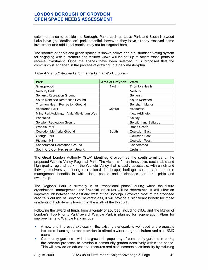
LONDON BOROUGH OF CROYDON OPEN SPACE NEEDS ASSESSMENT
August 2009 3-023-0809 Draft report: Knight Kavanagh & Page 41
catchment area to outside the Borough. Parks such as Lloyd Park and South Norwood Lake have got “destination” park potential, however, they have already received some investment and additional monies may not be targeted here . The shortlist of parks and green spaces is shown below, and a customised voting system for engaging with customers and visitors views will be set up to select those parks to receive investment. Once the spaces have been selected, it is proposed that the community is engaged in the process of drawing up a park master-plan. Table 4.5: shortlisted parks for the Parks that Work program.
Park Area of Croydon Ward
Grangewood Thornton Heath
Norbury Park Norbury
Selhurst Recreation Ground Selhurst
South Norwood Recreation Ground South Norwood
Thornton Heath Recreation Ground
North
Bensham Manor
Ashburton Park Ashburton
Milne Park/Addington Vale/Mickleham Way New Addington
Parkfields Shirley
Selsdon Recreation Ground Selsdon and Ballards
Wandle Park
Central
Broad Green
Coulsdon Memorial Ground Coulsdon East
Grange Park Coulsdon East
Rickman Hill Coulsdon West
Sanderstead Recreation Ground Sanderstead
South Croydon Recreation Ground
South
Croham
The Great London Authority (GLA) identifies Croydon as the south terminus of the proposed Wandle Valley Regional Park. The vision is for an innovative, sustainable and high quality regional park in the Wandle Valley that is easily accessible, with a rich and thriving biodiversity, offering recreational, landscape, heritage, cultural and resource management benefits in which local people and businesses can take pride and ownership. The Regional Park is currently in its “transitional phase” during which the future organisation, management and financial structures will be determined. It will allow an improved link between the east and west of the Borough. However, most of the proposed area falls outside of Croydon; nevertheless, it will provide a significant benefit for those residents of high density housing in the north of the Borough. Following the award of funds from a variety of sources; including s106, and the Mayor of London’s ‘Top Priority Park’ award, Wandle Park is planned for regeneration. Plans for improvements to Wandle Park include: � A new and improved skatepark - the existing skatepark is well-used and proposals
include enhancing current provision to attract a wider range of skaters and also BMX users.
� Community gardens - with the growth in popularity of community gardens in parks, the scheme proposes to develop a community garden sensitively within the space. This will provide an educational resource and also increase sustainability by reducing

LONDON BOROUGH OF CROYDON OPEN SPACE NEEDS ASSESSMENT
August 2009 3-023-0809 Draft report: Knight Kavanagh & Page 42
food-miles. Croydon’s youth offending team has already shown an interest to utilise this space to increase local opportunity for employment. The Friends of Wandle Park are also investigating the potential for providing BBQ facilities, an indoor kitchen and also picnic tables for dining.
� New toilets - the reinstatement of toilet facilities will mean that people are able to visit the park for longer. The addition of this facility will enable school groups to arrange nature trips to Wandle Park. It is proposed that new toilets are provided in the pavilion.
� Establish a lake island – this will provide a haven for wildlife to inhabit, birds in particular.
� Litter and dog litter bins – currently there are seven litter bins and eight dog-litter bins in the park and more bins will be placed at regular intervals so there will be no excuse to drop litter.
� Restoring the original Victorian water fountain. � Playspace - the scheme proposes to provide a large range of creative play facilities
for a wider age range. � Performance space - the performance space is positioned where the bandstand was
located in Victorian times. A programme of events is planned to increase participation in culture and the arts and will also increase access and enjoyment of the open space.
� Restoration of the rose garden. � Potential café - consultation has found that cafe would be a highly popular addition. � River and lake restoration. Value The methodology for assessing value is set out in Part 2 (Methodology). The table below summarises the results of the value assessment for parks and gardens in Croydon. A score of 20% or less is considered to indicate that a site has low value. Table 4.4: Value scores for parks and garden sites by analysis area
VALUE Scores Number at:
Below
20%
Above
20%
Analysis area
Maximum score
Lowest score
MEAN score
Highest score
Spread
Addington & Fieldway 30 13% 26% 33% 20% 1 2
Central 30 7% 17% 30% 23% 7 3
North 30 13% 21% 27% 13% 2 3
Purley & Coulsdon 30 20% 22% 27% 7% 0 7
Selsdon & Sanderstead 30 3% 13% 23% 20% 2 2
Shirley/East Central 30 7% 23% 37% 30% 1 4
West 30 13% 29% 47% 33% 2 8
West Central 30 27% 28% 30% 3% 0 4
CROYDON 30 3% 22% 47% 43% 15 33
In terms of value, the average score across the Borough is 22%, ranging from 47% for Wandle Park to just 3% for Wettern Tree Garden and Purley Beeches. This reflects the quality scores gained by these sites. Fifteen sites are identified as low value; it is thought

LONDON BOROUGH OF CROYDON OPEN SPACE NEEDS ASSESSMENT
August 2009 3-023-0809 Draft report: Knight Kavanagh & Page 43
that if their quality was increased it could potentially increase their value to local residents. A number of parks and gardens, including South Norwood Country Park and Wandle Park are used for ‘Walking the Way to Health’ led by qualified volunteer walk leaders. This type of activity/event is a major contributor to increasing the value, and usage of parks to the residents of Croydon. LBC recognises the value of community engagement and ownership and aspires to encourage and support the formation of ‘friends of’ groups (FoG) for the key sites. A number of parks and gardens already have active FoGs, which receive assistance and guidance from LBC officers. Parks and gardens summary
� 48 sites are identified within the audit as park and gardens provision in Croydon, totalling almost 322 hectares (ha). Seven parks and green spaces in the Borough that currently (2008/9) hold the Green Flag Award
� Overall, 70% of Talkabout respondents would be willing to walk to access a public park. Of which, just over a third of respondents (35%) would be willing to walk up to 15 minutes, and just over a quarter (26%) for 10 minutes.
� Based on GLA guidance, accessibility mapping shows that the densely populated areas of Croydon are generally well served by parks and gardens. However, there are some gaps in provision particularly South of the Borough. There are, however, other typologies in these areas which go some way to meeting these catchment gaps.
� Following the award of funds from a variety of sources; including s106, and the Mayor of London’s ‘Top Priority Park’ award, Wandle Park is planned for regeneration.
� Consultation suggests that in general improvements to the quality of parks are required in terms of toilets, seating and bins.
� There are a number of friends of groups and voluntary organisations in Croydon which are helping to improve the quality of the natural/semi natural green spaces. The majority of these groups were formed to help improve conditions for wildlife and visitors – some are now tackling issues about parks facilities and events.
� Most parks and gardens are assessed as being of high value to users and the local community, recognising the high social inclusion and health benefits, ecological value and amenity and sense of place. Fifteen sites are identified as low value; it is thought that if their quality was increased it could potentially increase their value to local residents.

LONDON BOROUGH OF CROYDON OPEN SPACE NEEDS ASSESSMENT
August 2009 3-023-0809 Draft report: Knight Kavanagh & Page 44
PART 5: NATURAL AND SEMI-NATURAL GREENSPACES Introduction The typology of natural and semi natural greenspaces, as set out in PPG17: A Companion Guide includes woodland (coniferous, deciduous, mixed) and scrub, grassland (e.g. downland, meadow), heath or moor, wetlands (e.g. marsh, fen), open running water, wastelands (including disturbed ground), and bare rock habitats (e.g. cliffs, quarries, pits). These provide ‘wildlife conservation, biodiversity and environmental education and awareness.’ Key issues Current provision 63 sites are identified within the audit as natural and semi natural provision (according to PPG17 typology), totalling almost 900 hectares (ha). Table 5.1: Distribution of natural and semi-natural greenspaces by analysis area
Natural/semi- natural greenspaces Analysis area
Number Size (ha)
Addington & Fieldway 5 45.44
Central 4 12.84
North 7 21.19
Purley & Coulsdon 20 405.15
Selsdon & Sanderstead 13 255.55
Shirley/East Central 12 144.19
West 1 0.46
West Central 1 14.01
CROYDON 63 898.83
LBC identifies 75 sites of important natural conservation in Croydon. This includes sites of metropolitan importance, site of special scientific interest (SSSIs) and ancient woodland. The largest site is 252 acres of SSSI (Happy Valley), which is near Farthing Downs and Coulsdon Common (also SSSIs). The promotion of access to sensitive sites such as the LNRs and SSSIs is carefully managed in to protect and promote the wildlife habitats. It is thought that Addington Hills, which has one of the largest areas of lowland heath habitat in London and Hutchinson’s Bank may have merit to be designated as SSSIs, but this is not being prioritised by Natural England. In 1996, English Nature (now Natural England) recommended that there should be one hectare of designated LNR per 1,000 population. To put this into local context, with a population of 339,531 (mid 2007 estimate), across the Borough there should be provision of least 340 hectares of LNR. Current provision equates to 158.5 hectares, which is a shortfall of 181.5 hectares. However large areas (400 acres of the borough) are de facto nature reserves, eg Happy Valley, Farthing Downs, Coulsdon Common , Riddlesdown.

LONDON BOROUGH OF CROYDON OPEN SPACE NEEDS ASSESSMENT
August 2009 3-023-0809 Draft report: Knight Kavanagh & Page 45
Usage Over a third (38%) of respondents visits a nature area less than once a month, whilst 23% of respondents have not visited a nature area in the last 12 months. Lower percentages are seen for high frequency visits; more than once a week (5%), once a week (5%) and two to three times a month (6%). Only 11% are unable to state how often they have visited a nature area in the last 12 months. Figure 5.1: Frequency of usage of natural areas in the previous 12 months
5% 5%6%
12%
38%
23%
11%
0%
5%
10%
15%
20%
25%
30%
35%
40%
More than
once a week
Once a week 2-3 times a
month
Once a
month
Less than
once a
month
Never visited Don’t know /
no answer
There are a number of projects and organisations within the Borough which are working to improve the awareness of natural and semi natural sites, as well as educate people regarding their benefits. For example, Birch and Rowdown Woods were chosen as one of the six Capital Woodlands Project flagship sites (located along the Croydon/Bromley boundary). The wood was used illegally for motorcycling with regular burnt out vehicles, fly tipping and arson being severe problems to the wildlife and posed significant risk to users. Addington Conservation Team has improved security in the wood, installing vehicle-proof fencing and removing some heavy-duty litter. Heathfield Ecology was founded in September 1997, and its members comprise dedicated nature conservationists and volunteers. The centre encourages an awareness of Croydon's green heritage thereby helping to preserve its bio-diversity for future generations to appreciate. The panel of conservationists is available to assist and advise environmental groups and individuals throughout the Borough, and the centre has links to local schools and local groups. The Downlands Countryside Management Project (the Project) is a partnership between six local authorities, the Countryside Agency and English Nature. Its activities cover an area of 130 sq km of suburban countryside. Much of the project area is of high landscape value, partly within the Surrey Hills Area of Outstanding Natural Beauty (AONB). Project

LONDON BOROUGH OF CROYDON OPEN SPACE NEEDS ASSESSMENT
August 2009 3-023-0809 Draft report: Knight Kavanagh & Page 46
activity prioritises management of the rare chalk downland within its area. Sheep and goats successfully graze the chalk downland as part of a long term management regime. Other work includes development of an extensive series of trails, including contributing to the ‘London Loop’ walking route, improvements to and signposting of rights of way, heathland and woodland management and pond restoration. The project also runs a wide ranging programme of guided walks. Awareness and usage of natural sites in Croydon is high. The importance placed on provision, demonstrated through the current portfolio of projects and funding which sites have seen, suggests that residents place a high value on all provision (even where the quality of sites can be improved). Accessibility There is no significant difference between how respondents will travel, with 44% of respondents willing to travel by transport, whilst 40% are willing to walk. However, 30% are willing to travel 30 minutes by transport and 24% are willing to walk 15 minutes to access a nature area. Only 15% are unable to comment how far they would be willing to travel. Figure 5.2: Time prepared to travel to reach a nature area
0%
3%
13%
24%
14%
30%
12%
3%
0%
5%
10%
15%
20%
25%
30%
35%
1 minute
walk
5 minute
walk
10 minute
walk
15 minute
walk
10 minutes
by
transport
30 minutes
by
transport
Don’t know No answer

LONDON BOROUGH OF CROYDON OPEN SPACE NEEDS ASSESSMENT
August 2009 3-023-0809 Draft report: Knight Kavanagh & Page 47
The effective catchments have been identified using data from the street survey (see Figure 5.2) and guidance issued by the Greater London Authority (GLA). The following 400 metre catchments are therefore used in the mapping to identify the coverage of current provision. Figure 5.3: Natural and semi-natural greenspaces (North West) mapped against population density
Key to sites mapped:
KKP Ref
Site Analysis area GLA classification
Quality Value
9 Long Lane Woods Central Local Park
11 Long Lane Bird Sanctuary
Central Small Open Space
137 Brickfield Meadow Central Local Park
140 Land At Love Lane Central Small Open Space
LAMBETH
REIGATE AND BANSTEAD
SUTTON
MERTON BROMLEY
TANDRIDGE
30
132
6
10
119
140
142
137
120
124
127
121
129126
136
Croydon
Semi / Natural greenspaces
400m Catchment
Population density per square mile
28,700 to 41,900
25,300 to 28,700
21,900 to 25,300
18,100 to 21,900
15,300 to 18,100
12,600 to 15,300
10,100 to 12,600
7,900 to 10,100
5,500 to 7,900
1,100 to 5,500

LONDON BOROUGH OF CROYDON OPEN SPACE NEEDS ASSESSMENT
August 2009 3-023-0809 Draft report: Knight Kavanagh & Page 48
KKP Ref
Site Analysis area GLA classification
Quality Value
120 Beaulieu Heights North Local Park
121 Stambourne Woodland Walk
North Small Open Space
124 Whitehorse Meadow 1 North Small Open Space
126 Beulah Hill Pond North Pocket Park
127 Biggin Wood North Local Park
129 Convent Wood North Local Park
142 Whitehorse Meadow 2 North Local Park
136 Land adjacent to 149 Wingaet Crescent
West Small Open Space
Figure 5.4: Natural and semi-natural greenspaces (South East) mapped against population density
TANDRIDGE25
2022
141 24
45
37
74
19
7333
35
72 49
95
9767
68
32
29
26
69
110
60
53
57
38
178
61
99
96
98
112
77
50
51145
144
14386
85
146
56
114116
115
48
30
132
6
Croydon
Semi / Natural greenspaces
400m Catchment
Population density per square mile
28,700 to 41,900
25,300 to 28,700
21,900 to 25,300
18,100 to 21,900
15,300 to 18,100
12,600 to 15,300
10,100 to 12,600
7,900 to 10,100
5,500 to 7,900
1,100 to 5,500

LONDON BOROUGH OF CROYDON OPEN SPACE NEEDS ASSESSMENT
August 2009 3-023-0809 Draft report: Knight Kavanagh & Page 49
Key to sites mapped:
KKP Ref
Site Analysis area GLA classification
Quality Value
85 Birch and Rowdown Woods
Addington & Fieldway Local Park
86 Birchwood and Castle Hill Ruffs
Addington & Fieldway Local Park
143 Lower Ruff Field Addington & Fieldway Local Park
144 Birch and Rowdown Woods
Addington & Fieldway Local Park
145 Addington Boundary Woods
Addington & Fieldway Small Open Space
19 The Avenue Purley & Coulsdon Local Park
20 Land East of Parsons Pightle
Purley & Coulsdon Small Open Space
22 Lacy Green/Coulsdon Road
Purley & Coulsdon Pocket Park
24 Woodland Rear of the Glades
Purley & Coulsdon Small Open Space
25 Farthing Downs / Happy Valley / New Hill`
Purley & Coulsdon Metropolitan Park
26 Land north of Woodhatch Spinney
Purley & Coulsdon Small Open Space
29 Land South of Woodhatch Spinney
Purley & Coulsdon Small Open Space
30 Copse Hill Spinney Purley & Coulsdon Small Open Space
32 Stoneyfield Shaw Purley & Coulsdon Small Open Space
33 Dollypers Hill Purley & Coulsdon Local Park
35 Coulsdon Coppice Purley & Coulsdon Local Park
37 Kenley Common Purley & Coulsdon District Park
45 Coulsdon Common Purley & Coulsdon District Park
49 Hawkhirst Purley & Coulsdon Local Park
67 Riddlesdown Purley & Coulsdon District Park
68 Foxley Wood and Sherwood Oaks, Kenley
Purley & Coulsdon Local Park
72 Wood East of Haydn Avenue / Roffey Close
Purley & Coulsdon Local Park
73 Land West of Pondfiled Road
Purley & Coulsdon Local Park
74 Land opposite Elmgrove Cotts, Old Lodge
Purley & Coulsdon Small Open Space
141 Inwood, Woodland Rear of the Glade
Purley & Coulsdon Local Park

LONDON BOROUGH OF CROYDON OPEN SPACE NEEDS ASSESSMENT
August 2009 3-023-0809 Draft report: Knight Kavanagh & Page 50
KKP Ref
Site Analysis area GLA classification
Quality Value
38 Croham Hurst Selsdon & Sanderstead
District Park
50 Threecorner Grove Selsdon & Sanderstead
Small Open Space
51 Hutchinsons Bank Selsdon & Sanderstead
District Park
60 Bramley Bank Selsdon & Sanderstead
Local Park
69 Littleheath Wood Selsdon & Sanderstead
District Park
77 Gushybank Shaw Selsdon & Sanderstead
Small Open Space
95 Ansley Berry Shaw Selsdon & Sanderstead
Local Park
96 Sanderstead Pond Selsdon & Sanderstead
Small Open Space
97 Ragged Grove Selsdon & Sanderstead
Small Open Space
98 King's Wood Selsdon & Sanderstead
District Park
99 Sanderstead Plantation
Selsdon & Sanderstead
Local Park
110 The Ruffet Selsdon & Sanderstead
Small Open Space
112 Selsdon Wood / Foxshaw / Courtwood
Selsdon & Sanderstead
Metropolitan Park
6 Former Tree Nursery, Shirley Oaks
Shirley/East Central Small Open Space
10 Glade Wood Shirley/East Central Small Open Space
48 Pinewoods Shirley/East Central Local Park
53 Heathfield Shirley/East Central Local Park
56 Three Halfpenny Wood
Shirley/East Central District Park
57 Addington / Shirley Hills
Shirley/East Central District Park
61 Coombe Wood Shirley/East Central Local Park
114 Foxes Wood Shirley/East Central Local Park
115 Spring Park Wood Shirley/East Central Local Park
116 Temple Avenue Copse Shirley/East Central Small Open Space
146 Shirley Heath Shirley/East Central Local Park
178 Royal Russel School Woodland Area
Shirley/East Central District Park
132 Purley Way West West Central Local Park
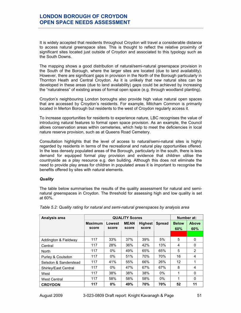
LONDON BOROUGH OF CROYDON OPEN SPACE NEEDS ASSESSMENT
August 2009 3-023-0809 Draft report: Knight Kavanagh & Page 51
It is widely accepted that residents throughout Croydon will travel a considerable distance to access natural greenspace sites. This is thought to reflect the relative proximity of significant sites located just outside of Croydon and associated to this typology such as the South Downs. The mapping shows a good distribution of natural/semi-natural greenspace provision in the South of the Borough, where the larger sites are located (due to land availability). However, there are significant gaps in provision in the North of the Borough particularly in Thornton Heath and Central Croydon. As it is unlikely that new natural sites can be developed in these areas (due to land availability) gaps could be achieved by increasing the “naturalness” of existing areas of formal open space (e.g. through woodland planting). Croydon’s neighbouring London boroughs also provide high value natural open spaces that are accessed by Croydon’s residents. For example, Mitcham Common is primarily located in Merton Borough but residents to the west of Croydon regularly access it. To increase opportunities for residents to experience nature, LBC recognises the value of introducing natural features to formal open space provision. As an example, the Council allows conservation areas within cemeteries, which help to meet the deficiencies in local nature reserve provision, such as at Queens Road Cemetery. Consultation highlights that the level of access to natural/semi-natural sites is highly regarded by residents in terms of the recreational and natural play opportunities offered. In the less densely populated areas of the Borough, particularly in the south, there is less demand for equipped formal play provision and evidence that children utilise the countryside as a play resource e.g. den building. Although this does not eliminate the need to provide play areas for children in populated areas it is important to recognise the benefits offered by sites with natural elements. Quality The table below summarises the results of the quality assessment for natural and semi-natural greenspaces in Croydon. The threshold for assessing high and low quality is set at 60%. Table 5.2: Quality rating for natural and semi-natural greenspaces by analysis area
QUALITY Scores Number at:
Below
60%
Above
60%
Analysis area
Maximum score
Lowest score
MEAN score
Highest score
Spread
Addington & Fieldway 117 33% 37% 39% 5% 5 0
Central 117 28% 36% 42% 13% 4 0
North 117 0% 49% 65% 65% 5 2
Purley & Coulsdon 117 0% 51% 70% 70% 16 4
Selsdon & Sanderstead 117 41% 55% 66% 26% 12 1
Shirley/East Central 117 0% 47% 67% 67% 8 4
West 117 38% 38% 38% 0% 1 0
West Central 117 58% 58% 58% 0% 1 0
CROYDON 117 0% 49% 70% 70% 52 11

LONDON BOROUGH OF CROYDON OPEN SPACE NEEDS ASSESSMENT
August 2009 3-023-0809 Draft report: Knight Kavanagh & Page 52
The audit of provision undertaken by LBC, rates a significant proportion of sites (83%) as poor quality based on a 60% threshold. The majority of these are in Purley & Coulsdon. These are generally classified as such due to poor overall quality. Fly tipping is an issue at open spaces across the Borough. Springwood Park has previously suffered from this, probably due to the close proximity to housing on one side of its boundary, but this has now been cleared. Enforcement is difficult and LBC hopes that improving the quality of sites will help to reduce the likelihood of regular fly tipping. The illegal use motorbikes and quad bikes on natural areas is also a continuing issue. As noted earlier, the police have recently sought to respond to this issue through the use of off-road motorcycle units to provide a fast response to reported problems. Hutchinsons Bank (LNR) is managed by the London Wildlife Trust. The site has an area of disused land on its perimeter which suffers from misuse, including fly tipping, vandalism and abandoned cars. There is concern that this misuse could eventually impact upon the quality of the LNR. The majority (40%) of respondents are satisfied (very/fairly) with the provision of nature areas, whilst only a small proportion (8%) is dissatisfied (fairly/very). Just over a third (35%) of respondents are unable to comment on the quality of provision. 17% are neither satisfied nor dissatisfied with provision. Figure 5.5: Quality of nature areas
7%
33%
17%
5%
3%
33%
2%
0%
5%
10%
15%
20%
25%
30%
35%
Very satisfied Fairly
satisfied
Neither
satisfied nor
dissatisfied
Fairly
dissatisfied
Very
dissatisfied
Don’t know No answer
There are a number of friends of groups and voluntary organisations in Croydon which are helping to improve the quality of the natural/semi natural green spaces. The majority of these groups were formed to help improve conditions for wildlife and visitors – some are now tackling issues about parks facilities and events.

LONDON BOROUGH OF CROYDON OPEN SPACE NEEDS ASSESSMENT
August 2009 3-023-0809 Draft report: Knight Kavanagh & Page 53
Issues to emerge from consultation with the various groups include: � Friends of Springwood Park – Croydon’s piece of Spring Park Wood is hidden behind
houses on all sides. It has three different entrances, the main one located off Bridle Road in Shirley. It is surrounded by houses and there have been instances of fly tipping and substantial littering. The FoG, which was formed in March 2003, has helped to reduce this. The aim is to manage this area of woodland, by reintroducing old traditional skills. By using this management, the group has brought back a staggered age re-growth structure, which is rejuvenating the life cycles once again of everything, ranging from the trees, insects, and native flowers.
� The Friends of Littleheath Woods meet weekly and carry our projects such as coppicing and replanting; the FoG’s main aim is to maintain a balance of species within the woodland. The FoG is hoping to work with BTCV in summer 2009 to improve the pathways. There were two large map boards stolen from the site in 2007 which have yet to be replaced. The group also feel that the site would benefit from dog litter bins. There have been reports of fly tipping and abandoned cars, which the volunteers have helped remove.
� Sanderstead Plantation Volunteers (SPV) helps to maintain the Sanderstead Plantation and have a constitution and action plan and conduct an annual risk assessment. Misuse is not reported to be a major issue; however, there are no dog foul bins on site: SPV have repeatedly requested three bins to be installed but with no avail. SPV report that the site is increasingly valued by the local community, and use has increased since the group cleared significant areas of bramble. It is thought that the woodland quality would quickly reduce without SPV help.
� Bradmore Green has a working group which has been operational since c2006. The group formed because the pond required management and had a high level of weeds. The group have been able to clear this problem and are continuing to improve the area.
� Friends of Farthing Downs are seeking to install a visitor centre on the site to service the significant archaeological interest in the site. LBC is working in conjunction with the City of London to provide resources for its development.
LBC Green Spaces unit provides a liaison officer in post to advise and offer assistance to groups when applying for grants and funding, as well as the best uses for money. This is considered by FoGs to be a very valuable service. In addition, there is a forum: Green Link which all voluntary groups are invited to attend and meets approximately three times a year. The forum provides an opportunity for knowledge share and support with funding ideas.

LONDON BOROUGH OF CROYDON OPEN SPACE NEEDS ASSESSMENT
August 2009 3-023-0809 Draft report: Knight Kavanagh & Page 54
Value The table below summarises the results of the value assessment for natural and semi-natural greenspaces in Croydon. A score of 20% or less is considered to indicate that a site has low value. Table 5.3: Value rating for natural and semi-natural greenspaces by analysis area
VALUE Scores Number at:
Below
20%
Above
20%
Analysis area
Maximum score
Lowest score
MEAN score
Highest score
Spread
Addington & Fieldway 35 11% 13% 14% 3% 5 0
Central 35 14% 24% 43% 29% 2 2
North 35 9% 24% 40% 31% 1 6
Purley & Coulsdon 35 3% 7% 17% 14% 20 0
Selsdon & Sanderstead 35 3% 12% 23% 20% 10 3
Shirley/East Central 35 3% 9% 26% 23% 9 3
West 35 26% 26% 26% 0% 0 1
West Central 35 26% 26% 26% 0% 0 1
CROYDON 35 3% 12% 43% 40% 47 16
Due to the often, poor level of access, almost three quarters of natural/semi-natural open spaces scored as low value. However, all sites were recognised for their landscape and ecological benefits. As well as providing important nature conservation and biodiversity value, many sites, classified as natural/semi-natural open spaces are well used for recreational purposes, such as dog walking and exercise and are a valuable open space resource for communities across Croydon. LBC recognises the value of community engagement and ownership and aspires to encourage and support the formation of ‘friends of’ groups (FoG) for the key sites. A number of natural greenspaces already have active FoGs, which receive assistance and guidance from LBC officers.

LONDON BOROUGH OF CROYDON OPEN SPACE NEEDS ASSESSMENT
August 2009 3-023-0809 Draft report: Knight Kavanagh & Page 55
Natural and semi-natural greenspace summary
� 63 sites are identified within the audit as natural and semi natural provision in Croydon, totalling almost 899 hectares (ha).
� LBC identifies 78 sites of important natural conservation in Croydon. This includes sites of metropolitan importance, site of special scientific interest (SSSIs) and ancient woodland. The largest site is c250 acres of SSSI (Happy Valley).
� According to standards set by Natural England, there should be provision of least 340 hectares of Local Nature Reserve. Current provision equates to 158.5 hectares, which is a shortfall of 181.5 hectares.
� Awareness and usage of natural sites in Croydon is high. The importance placed on provision, demonstrated through the current portfolio of projects and funding which sites have seen, suggests that residents place a high value on all provision.
� It is widely accepted that residents throughout Croydon will travel a considerable distance to access natural greenspace sites. The majority (44%) of users would drive or use public transport to access provision. Of these, 34% would travel up to 30 minutes. However, 24% would also walk 15 minutes to access provision. Therefore, GLA recommended catchments are used to assess accessibility.
� The mapping shows a good distribution of natural/semi-natural greenspace provision in the South of the Borough, where the larger sites are located (due to land availability). However, there are significant gaps in provision in the North of the Borough particularly in Thornton Heath and Central Croydon. As it is unlikely that new natural sites can be developed in these areas (due to land availability) gaps could be achieved by increasing the “naturalness” of existing areas of formal open space (e.g. through woodland planting).
� The audit of provision undertaken by LBC, rates a significant proportion of sites (83%) as poor quality based on a 60% threshold. The majority of these are in Purley & Coulsdon.
� Fly tipping is a reported issue throughout the Borough, particularly in natural greenspaces

LONDON BOROUGH OF CROYDON OPEN SPACE NEEDS ASSESSMENT
August 2009 3-023-0809 Draft report: Knight Kavanagh & Page 56
PART 6: AMENITY GREENSPACE Introduction The typology of amenity greenspace, as set out in PPG17: A Companion Guide, defines sites as offering ‘opportunities for informal activities close to home or work or enhancement of the appearance of residential or other areas’. These include informal recreation spaces, housing green spaces, village greens and other incidental space.’ Key issues Current provision There are 42 amenity greenspace sites, totalling nearly 447 hectares across Croydon. They are most often found in housing estates and function as informal recreation spaces or as open spaces along highways that provide a visual amenity. Table 6.1: Distribution of amenity greenspace sites by analysis area
Amenity greenspace Analysis area
Number Size (ha)
Addington & Fieldway 6 7.30
Central 5 18.21
North 3 14.45
Purley & Coulsdon 7 147.24
Selsdon & Sanderstead 9 92.85
Shirley/East Central 6 120.92
West 3 4.85
West Central 3 40.87
CROYDON 42 446.69

LONDON BOROUGH OF CROYDON OPEN SPACE NEEDS ASSESSMENT
August 2009 3-023-0809 Draft report: Knight Kavanagh & Page 57
Usage Over half (56%) of respondents have never visited an amenity greenspace in the last 12-months, whilst only one fifth (20%) of respondents visit a grassed area on a housing estate less than once a month. 10% of respondents were unable to state how many times they had visited this typology in the last 12 months. Figure 6.1: Frequency of usage of grassed areas on housing estates
2% 2%4% 4%
20%
56%
10%
0%
10%
20%
30%
40%
50%
60%
More than
once a week
Once a week 2-3 times a
month
Once a
month
Less than
once a
month
Never visited Don’t know /
no answer

LONDON BOROUGH OF CROYDON OPEN SPACE NEEDS ASSESSMENT
August 2009 3-023-0809 Draft report: Knight Kavanagh & Page 58
Accessibility The majority of respondents (58%) were unable to comment how far they would be willing to travel access grassed areas’ on housing estates. A total of 36% of respondents would be willing to walk in order to access a site of this typology, with most (11%) willing to walk 10 minutes. Only 5% would be willing to access through transport, whilst 3% did not provide an answer. Figure 6.2: Time prepared to travel to reach a grassed area on housing estates
8%10% 11%
7%
4%
1%
55%
3%
0%
10%
20%
30%
40%
50%
60%
1 minute
walk
5 minute
walk
10 minute
walk
15 minute
walk
10 minutes
by
transport
30 minutes
by
transport
Don’t know No answer
The effective catchments for amenity greenspaces have been identified using data from the street survey (see Figure 6.2) and guidance issued by the Greater London Authority (GLA). The following 400 metre catchments are therefore used in the mapping to identify the coverage of current provision.

LONDON BOROUGH OF CROYDON OPEN SPACE NEEDS ASSESSMENT
August 2009 3-023-0809 Draft report: Knight Kavanagh & Page 59
Figure 6.3: Amenity greenspace mapped against population density
REIGATE AND BANSTEAD
SUTTON
MERTON
LAMBETH
BROMLEY
TANDRIDGE
169
65
526255
54
168
563
138
108
7
161
89
149
39
82
84
79
5847
83
111
94
42
134
175
15
18
27
177
8
122
90
23
36
Croydon
Amenity greenspace
400 m Catchment
Population density per square mile
28,700 to 41,900
25,300 to 28,700
21,900 to 25,300
18,100 to 21,900
15,300 to 18,100
12,600 to 15,300
10,100 to 12,600
7,900 to 10,100
5,500 to 7,900
1,100 to 5,500
Key to sites mapped:
KKP Ref
Site Analysis area GLA classification
Quality Value
47 Land Fronting 89-119 King Henry's Drive, New Addin
Addington & Fieldway
Pocket Park
58 Forestdale Amenity Space Addington & Fieldway
Local Park
79 Lands south of pitch and putt course
Addington & Fieldway
Small Open Space
82 Comport Green, New Addington
Addington & Fieldway
Pocket Park
83 Land fronting 61-91 North Downs Road, New Addingto
Addington & Fieldway
Pocket Park
84 Land Fronting 327 - 373 King Henry's Drive, New Ad
Addington & Fieldway
Small Open Space

LONDON BOROUGH OF CROYDON OPEN SPACE NEEDS ASSESSMENT
August 2009 3-023-0809 Draft report: Knight Kavanagh & Page 60
KKP Ref
Site Analysis area GLA classification
Quality Value
7 Land at Chaucer Green, Ashburton
Central Small Open Space
8 Land at Greenview Avenue, Monks Orchard.
Central Pocket Park
108 Heavers Meadow Central Local Park
122 South Norwood Lake Central Local Park
138 Woodside Green Central Small Open Space
89 Land at Norbury Close, Norbury
North Pocket Park
90 Nettlefold Field North Local Park
161 Green Lane Sports Ground North Local Park
18 Land Rear of Hilliars Heath Road
Purley & Coulsdon
Pocket Park
23 Lacy Green Purley & Coulsdon
Small Open Space
27 Stoats Nest Green Purley & Coulsdon
Small Open Space
36 Bradmore Green Purley & Coulsdon
Small Open Space
94 Woodcote Village Green Purley & Coulsdon
Small Open Space
177 Kenley Airfield Purley & Coulsdon
Metropolitan Park
52 Falconwood Meadow Selsdon & Sanderstead
Small Open Space
54 Land r/o 42-100 Addington Village Road
Selsdon & Sanderstead
Small Open Space
55 Land between Farnborough Ave, Broadcoombe and Heat
Selsdon & Sanderstead
Small Open Space
62 The Green, Featherbed Lane Selsdon & Sanderstead
Small Open Space
65 Land at Copse View Selsdon & Sanderstead
Pocket Park
111 Queenhill Road Playspace Selsdon & Sanderstead
Small Open Space
169 John Ruskin Playing Field Selsdon & Sanderstead
Local Park
5 Amenity land at Shirley Oaks Village
Shirley/East Central
Local Park
39 Normanton Meadow Shirley/East Central
Pocket Park
63 Land at Shirley Avenue, Shirley
Shirley/East Central
Pocket Park
168 Coombe Lodge Playing Field Shirley/East Central
Local Park
15 Public Open Space West of Franklin Way
West Small Open Space
42 Fairfield Gardens West Small Open

LONDON BOROUGH OF CROYDON OPEN SPACE NEEDS ASSESSMENT
August 2009 3-023-0809 Draft report: Knight Kavanagh & Page 61
KKP Ref
Site Analysis area GLA classification
Quality Value
Space
175 Galpins Road - Open Lane for Sports
West Local Park
134 Land at Denning Avenue, Waddon
West Central Small Open Space
149 Purley Way Playing Fields West Central District Park
There are significant gaps in the provision of amenity greenspace, particularly in the North of the Borough, in for example, East Croydon, Thornton Heath and Broad Green. It is likely that residents will travel further to access the larger sites located in the North of the Borough and that these will go some way towards meeting deficiencies in Central Croydon. However, new provision should be sought in Thornton Heath and Broad Green. Quality The table below summarises the results of the quality assessment for amenity greenspace in Croydon. The threshold for assessing high and low quality is set at 60%. Table 6.2: Quality ratings for amenity greenspaces by analysis area
QUALITY Scores Number at:
Below
60%
Above
60%
Analysis area
Maximum score
Lowest score
MEAN score
Highest score
Spread
Addington & Fieldway 121 55% 62% 71% 16% 2 4
Central 121 41% 62% 78% 37% 2 3
North 121 49% 56% 68% 19% 2 1
Purley & Coulsdon 121 51% 66% 73% 23% 2 4
Selsdon & Sanderstead 121 56% 64% 72% 16% 2 5
Shirley/East Central 121 60% 67% 80% 20% 0 4
West 121 46% 56% 70% 23% 2 1
West Central 121 71% 72% 72% 1% 0 2
CROYDON 121 41% 63% 80% 39% 12 24
Amenity greenspaces are popular sites for recreational dog walking. The associated issue of dog foul is a common concern. Other users of such space highlight that the problem impacts negatively on site usage, particularly by children for informal play. There is demand for greater provision of dog foul bins, and/or greater education and awareness of them, along with increased enforcement. However, the resource implications of providing bins are significant, as they need to be emptied on a regular basis, particularly in summer. As dog waste is no longer considered hazardous it can now be disposed off in ordinary litterbins. Awareness of this could be raised to encourage responsible behaviour by dog owners. LBC recognises that the issue of dog foul has a significant impact on the quality and usage of sites in the area and is being proactive to address the problem.

LONDON BOROUGH OF CROYDON OPEN SPACE NEEDS ASSESSMENT
August 2009 3-023-0809 Draft report: Knight Kavanagh & Page 62
A significant proportion of the amenity greenspace in the Borough is composed of grassed areas and verges adjacent to housing or lining roads leading into settlements. Consultation identifies that residents consider this type of open space provision to be particularly valuable. Once again the majority (58%) of respondents were unable to comment how satisfied or dissatisfied they were with the provision of amenity greenspace. Nearly one in five (19%) were neither satisfied nor dissatisfied with provision. 13% and 11% of respondents commented as being satisfied (very/fairly) and dissatisfied (fairly/very) with provision respectively. Figure 6.4: Quality of grassed area on housing estate
3%
10%
19%
7%
4%
55%
3%
0%
10%
20%
30%
40%
50%
60%
Very satisfied Fairly
satisfied
Neither
satisfied nor
dissatisfied
Fairly
dissatisfied
Very
dissatisfied
Don’t know No answer

LONDON BOROUGH OF CROYDON OPEN SPACE NEEDS ASSESSMENT
August 2009 3-023-0809 Draft report: Knight Kavanagh & Page 63
Value The table below summarises the results of the value assessment for amenity greenspaces in Croydon. A score of 20% or less is considered to indicate that a site has low value. Table 6.3: Value ratings for amenity greenspaces by analysis area
VALUE Scores Number at:
Below
20%
Above
20%
Analysis area
Maximum score
Lowest score
MEAN score
Highest score
Spread
Addington & Fieldway 25 16% 25% 40% 24% 3 3
Central 25 28% 34% 40% 12% 0 5
North 25 28% 33% 40% 12% 0 3
Purley & Coulsdon 25 4% 11% 24% 20% 5 1
Selsdon & Sanderstead 25 4% 13% 16% 12% 7 0
Shirley/East Central 25 8% 10% 12% 4% 4 0
West 25 32% 35% 36% 4% 0 3
West Central 25 16% 26% 36% 20% 1 1
CROYDON 25 4% 21% 40% 36% 20 16
As stated earlier, a significant proportion of the amenity greenspace in the Borough is composed of grass verges adjacent to housing. Playing fields and recreation grounds also form an intrinsic aspect of the supply. Consultation identifies that residents consider this type of open space provision to be particularly valuable for the visual environs of housing estates and residential areas. Site assessments also recognise this with the vast majority (92%) scoring highly. Supporting the views of residents that amenity greenspaces are a valuable community resource, a large proportion of sites assessed score for social inclusion and health benefits, particularly due to the play opportunities offered.

LONDON BOROUGH OF CROYDON OPEN SPACE NEEDS ASSESSMENT
August 2009 3-023-0809 Draft report: Knight Kavanagh & Page 64
Amenity greenspace summary
� There are 36 amenity greenspace sites, totalling just over 447 hectares across Croydon. They are most often found in housing estates and function as informal recreation spaces or as open spaces along highways that provide a visual amenity. Consultation identifies that residents consider this type of open space provision to be particularly valuable for the visual environs of the areas.
� Although the majority (58%) of survey respondents were unable to provide an answer, 29% would walk to access provision. However, there are a similar proportion of respondents willing to walk either 1, 5, 10 or 15 minutes. Therefore, GLA recommended catchments are used to assess accessibility.
� There are significant gaps in the provision of amenity greenspace, particularly in the North of the Borough, in for example, East Croydon, Thornton Heath and Broad Green. It is likely that residents will travel further to access the larger sites located in the North of the Borough and that these will go some way towards meeting deficiencies in Central Croydon. However, new provision should be sought in Thornton Heath and Broad Green.
� Amenity greenspaces are popular sites for recreational dog walking. The associated issue of dog foul is a common concern. Other users of such space highlight that the problem impacts negatively on site usage, particularly by children for informal play. There is demand for greater provision of dog foul bins and enforcement.

LONDON BOROUGH OF CROYDON OPEN SPACE NEEDS ASSESSMENT
August 2009 3-023-0809 Draft report: Knight Kavanagh & Page 65
PART 7: PROVISION FOR CHILDREN AND YOUNG PEOPLE Introduction The typology of provision for children and young people, as set out in PPG17: A Companion Guide includes ‘areas designated primarily for play and social interaction involving children and young people, such as equipped play areas, ball courts, skateboard areas and teenage shelters.’ Key issues Current provision 68 sites in Croydon are classified as provision for children and young people, totalling just over 19 hectares. The table below shows the distribution of play areas in Croydon by analysis area. This, along with the mapping illustrates the higher levels of provision in the Central analysis area and the relatively low provision in Addington & Fieldway and Shirley/East Central analysis areas. Table 7.1: Distribution of play areas by analysis area
Children’s play areas Analysis area
Number Size (ha)
Addington & Fieldway 6 1.52
Central 11 2.14
North 7 0.87
Purley & Coulsdon 9 0.86
Selsdon & Sanderstead 9 2.39
Shirley/East Central 6 7.51
West 10 2.74
West Central 10 1.28
CROYDON 68 19.31
Play areas are classified in the following ways utilising Fields In Trust (FIT) guidance to identify their effective catchment (how far residents are willing, on average, to travel to access the different types). � A local area for play (LAP). This area must be more than or equal to 0.01 hectares
and contain more than or equal to one piece of play equipment. � A local equipped for play (LEAP). This area must be more than or equal to 0.04
hectares and contain more than or equal to five pieces of play equipment. � A neighbourhood equipped area for play (NEAP). This area must be more than or
equal to 0.1 hectares and contain more than or equal to eight pieces of play equipment. This area may contain MUGA, skateparks, youth shelters, adventure play equipment and is often included within large park sites.
� A settlement equipped play area (SEAP) caters for all ages and contains more than or equal to ten pieces of play equipment. This is likely to include multi-use games areas (MUGAs), skateparks, youth shelters, adventure play equipment and is often included within large park sites.

LONDON BOROUGH OF CROYDON OPEN SPACE NEEDS ASSESSMENT
August 2009 3-023-0809 Draft report: Knight Kavanagh & Page 66
� Skateboard/basketball/teenage shelter. This includes areas providing only provision for young people.
Management LBC owns 59 play areas in Croydon. The vast majority of which are located within parks or other open spaces. A ROSPA inspection is undertaken annually together with a monthly technical inspection. In addition, six play areas are managed by LBC Housing and six play areas are managed by housing associations. There are 15 purpose built MUGAs, most of which can be used for basketball and five-a-side football, as well as informal sports. In addition to these, there are 11 sites with access to basketball courts. There are two skateboard ramps (Rotary Field, Purley and Purley Way Playing Fields, Waddon) which can be used for in-line skates and skateboards. There is also a purpose built skate park at Wandle Park, which is scheduled to be upgraded. There is also a civic space on Fairfield Gardens which is popular with young people for skateboarding. Young people reportedly travel from outside the Borough to use the area. It has not been included in the audit as it is not a formal space for young people. The LBC Housing Department has installed youth shelters alongside MUGAs at Fieldway, Duppas Hill and adjacent to Waddon Youth Centre. A shelter has also been installed beside the skate ramp on Purley Way Playing Field. Considering all provision across Croydon, regardless of provider, the LBC Play Strategy outlines aims and objectives for the development of play across the Borough. The Play Strategy for Croydon 2006 - 2009 One of the driving forces in LBC producing a play strategy was the recognition that Croydon needs safe places to play and meet friends. The Strategy aims to assess and validate the opportunities to improve this position and identify programmes, projects and delivery mechanisms which will deliver these improvements. The Council has a vision that all Croydon's children and young people have access to a variety of good quality play environments which offer challenge and stimulus. In order to achieve this vision, the strategy has the following seven objectives: � Promote the importance of play to children and young people’s health and well-being,
and to their learning, to all those working with children, and to parents and carers. � Support schools, childcare providers and other children and young people’s services
to recognise the value of play within their provision. � Work to ensure that all parks, thoroughfares, housing estates and other public
spaces within the Borough are as conducive as possible to play. � Develop and maintain a variety of local and accessible dedicated play spaces. � Aim to offer all children and young people the chance to encounter acceptable risks
in stimulating and challenging play environments. � Work towards ensuring that a wider range of play opportunities is available to
disabled children and young people, and that all provision aims towards becoming fully inclusive and accessible.

LONDON BOROUGH OF CROYDON OPEN SPACE NEEDS ASSESSMENT
August 2009 3-023-0809 Draft report: Knight Kavanagh & Page 67
� Work to ensure that play providers actively seek to address the needs of children and young people from “hard-to-reach” communities and those at risk from social exclusion.
The Croydon Play Strategy found that: � Most children of all ages are most likely to play in the parks. � All children like to participate in some sort of sporting activity, closely followed by
being engaged in playing games. � The older child prefers to be out meeting friends. � Most 5-10 year olds would like more play areas. � The 11- 16 year olds would like more activities. � 44% of parents would like more playgrounds. � The 16 plus age-group requested areas to “hang-out” and more things to do. LBC is committed to improving provision for children and young people and the table below shows the areas of work and ideas for the future through which play provision will be improved in the future. Table 7.2: Place space development in Croydon, ongoing and future work.
Ongoing/planned work Proposals/Ideas for the future
� Local Development Framework (LDF):
� Facilities Improvement Study and Building Schools for the Future, Parks development, Planning.
� LDF Outdoor Play and Recreation Space Supplementary Planning Document.
� Revision of Planning Obligations (Section 106) Guidance Note.
� Wandle Park – opportunity to introduce natural and creative play through the Heritage Lottery Fund.
� Design play equipment that is fun for children and pleasing to the eye.
� Create a list of spaces where play opportunities could be developed.
� Working with architects and sculptors to produce imaginative designs.
� Sustainable Communities Strategy – play in context of obesity, explore what other contexts are applicable.
� Playbuilder 2008-9 programme.
� Support 60+ groups that deliver childcare/playwork.
� Develop play areas that meet the needs of all children.
� Encourage out of school staff to share knowledge around places to play.
� Promote the importance of play using Playwork principles.
� Support Playwork qualifications.
� Involve staff in developing and implementing the play strategy.
� Mobile Playworker Team.
� Playbuilder 2009-11.
� Community use of schools (Extended Schools Core Offer) Primary Capital Programme.
� Revisit Play Strategy with the development of Play Team.

LONDON BOROUGH OF CROYDON OPEN SPACE NEEDS ASSESSMENT
August 2009 3-023-0809 Draft report: Knight Kavanagh & Page 68
Ongoing/planned work Proposals/Ideas for the future
� Coulsdon Memorial Playground opens on 17 January (Lottery-funded Play for All).
� Duppas Hill Playground Gym (Playbuilder, Section 106 and Community Improvement Fund).
� Thornton Heath Recreation Ground Play Area and Community Garden (Playbuilder).
� Continued improvement to a number of sites, including:
� Little Road PA
� Trumble Gardens PA
� Parkhill Play Area
� Addiscombe Recreation Ground PA
� Wilford Road Recreation Ground PA
� Mayfield Road PA
� Boulogne Road PA
� Apsley Road PA
� Ashburton Park Play/Skate Park.
� Play Rangers.
� Play for All (Lottery funded).
� Whitehorse Road ‘The Boat’ – play and sports.
� Walton Green Playground.
� Longheath Gardens – under 12s play.
� Longheath Gardens – over 12s play and sports.
� Croydon Triangle – Handcroft and Leighton Grove – play and sports Playbuilder.
� Tollers Lane, Coulsdon Playground.
� Edgecoombe, Monks Hill – under 12s play.
� Shrublands Firtree Gardens – under 12s play.
� Oak Wood, Auckland Rise – woodland walk, play and trim trail.
� Neighbourhood Wardens/school links – examples of good practice.
� Supervised play on all housing estates.
� Adult/all physical offer, e.g. street gyms, sheltered blocks.
� Go to meetings of Play England, Play London, Skills Active to keep updated on play.
� Encourage all voluntary organisations to include play in their policies if they have contact with children.
� Provides after school and holiday. playschemes with trained playwork staff
� Take part in Play Day.
� Community Play Bus.
� Network with voluntary organisations particularly around inclusion.
� Toys to You Bus (Play for All).
� Adventure Playgrounds – at least two inclusive areas in north and south of the Borough.
� Funding for Play workers to work in adventure play.
� All schools involved in Play Day.
� Involve Play England and Skills Active in architecture and design.
� Develop a more playful environment in Croydon High Street.

LONDON BOROUGH OF CROYDON OPEN SPACE NEEDS ASSESSMENT
August 2009 3-023-0809 Draft report: Knight Kavanagh & Page 69
Ongoing/planned work Proposals/Ideas for the future
� Informal, free unstructured play – streets, Croydon College.
� Parks that Work (Placemaking Initiative).
� Increase maintenance budget for play space.
� Use recycled materials in play space.
� More opportunities for imaginative play, such as rope swings.
� Safe routes to parks from schools and children’s centres.
� Increase play value in public sphere, e.g. North End shopping street.
Usage The majority (52%) of respondents have never visited a play area for children (PAC) in the last 12 months, whilst 26% only visit less than once a month. With regard to play areas for teenagers (PFT) only 12% visit less than once a month, whilst the majority (80%) never visit. This is not surprising as only those aged 16+ are interviewed. Figure 7.1: Frequency of usage of play areas for children and teenagers in the last 12 months
2%6%
8%4%
26%
52%
4%0% 1% 1% 1%
12%
80%
5%
0%
10%
20%
30%
40%
50%
60%
70%
80%
90%
More than
once a week
Once a week 2-3 times a
month
Once a
month
Less than
once a
month
Never visited Don’t know /
no answer
Play area for children Play area for teenagers
Consultation highlights that misuse of children’s play areas by teenagers and ‘undesirables’ impedes ‘genuine’ usage by young children and their parents. Users identify a number of play areas that are perceived to be ‘hot-spots’ for anti-social behaviour and misuse e.g. Wandle Park. The skate ramps at Wandle Park are also areas of congregation, and consultation with users reveals that the equipment is not used by skateboarders because of the large number of non-users and those using BMX bikes.

LONDON BOROUGH OF CROYDON OPEN SPACE NEEDS ASSESSMENT
August 2009 3-023-0809 Draft report: Knight Kavanagh & Page 70
The play area located at Thornton Heath Recreation ground is reportedly a popular congregation point for large groups of young people and as a result it suffers from high levels of litter. Parents report that they are often deterred from taking their children to play here for fear of encountering foul language and intimidation. Consultation also reveals that children are beginning to use natural and semi natural sites, such as Spring Park Woods, for ‘free play’ although there is still a perception that these sites can be ‘scary’ if unsupervised. There is some concern amongst local young people that the non greenspace on Fairfield Gardens (near to Fairfield Halls) will be given to housing development, and subsequently that a popular skateboarding site will be lost. Whilst this is not a formal area for young people, it is considered a valuable resource and has reportedly been used for skateboarding for over 30 years. Local users have established a petition and have met with LBC officers, which recognise the site’s importance. There are concerns that the skate facility in Wandle Park is too secluded. There is a perception that there are no suitable areas for young people to convene in Croydon Town Centre and previous research conducted by LBC highlights a need for a youth area around the clock-tower. It is important that should this go ahead, users are involved in the design and style in order to create a sense of belonging and ownership. Accessibility The Croydon Play Strategy investigates ‘barriers to play’ which in Croydon often includes, fear for safety from traffic and bullying. Parents believe these often prevent children from accessing a park or meeting point unless accompanied by an adult. This dependence on adult availability and inclination, results in children not accessing provision as often as they would like. The Strategy also found that 38% of parents perceive that there is nowhere for their children to play. Parents identified poor physical accessibility for wheelchair users and those with a physical disability, lack of adapted playground equipment and concerns about safety and security were barriers to outdoor play. It also identified the main barrier to play is the lack of information about such provision. Lack of choice and limited number of spaces and days allocated were also stated. Fears of road safety and perceived ‘stranger danger’ were identified as having a significant impact on the access to play facilities. It suggests that there is a local responsibility to provide help-points, improve lighting, prioritise traffic calming, develop safer routes to play areas and encourage the development of “Home Zones. Consultation also reveals the extent of negative attitudes many members of the public have towards children and young people. In some cases these attitudes prevent children from moving freely around their local community. Barriers faced by children are often linked with “territories”. Consultation highlights a perception that provision in Thornton Heath, for example is “undesirable” and there are issues with territorialism. This is thought to restrict children and young people from neighbouring areas using these play areas.

LONDON BOROUGH OF CROYDON OPEN SPACE NEEDS ASSESSMENT
August 2009 3-023-0809 Draft report: Knight Kavanagh & Page 71
It is essential that parents, carers and members of the public are made aware of the importance of play and of children’s rights to play in their local communities. Creative and innovative ways need to be found to involve all sectors of the community in better understanding play. Just over half (53%) of respondents will walk to access a PAC, with most (20% and 20%) willing to walk 10 and 15 minutes respectively. Only a small proportion (12%) of respondents is willing to travel by transport in order to reach a PAC. The majority of respondents (35%) are unable to state how far they would be willing to travel to visit a PAC. Consultation identifies that the majority of parents expect to be able to access a children’s play area within a 5 to15 minute walk. Figure 7.2: Time prepared to travel to reach a children’s play area
2%
11%
20% 20%
8%
4%
32%
3%
0%
5%
10%
15%
20%
25%
30%
35%
1 minute
walk
5 minute
walk
10 minute
walk
15 minute
walk
10 minutes
by transport
30 minutes
by transport
Don’t know No answer
Nearly a third (32%) of respondents would be willing to walk to reach a PFT. Half of these (16%) would walk 15 minutes in order to access a PFT. The majority (58%) of respondents are unable to state how far they would be willing to travel to access a PFT. This reflects the low usage level amongst respondents, again not uncommon as the survey respondents have to be over 16 to take part.

LONDON BOROUGH OF CROYDON OPEN SPACE NEEDS ASSESSMENT
August 2009 3-023-0809 Draft report: Knight Kavanagh & Page 72
Figure 7.3: Time prepared to travel to reach a teenage play area
1%3%
12%
16%
6%4%
55%
3%
0%
10%
20%
30%
40%
50%
60%
1 minute
walk
5 minute
walk
10 minute
walk
15 minute
walk
10 minutes
by
transport
30 minutes
by
transport
Don’t know No answer
Catchment areas for equipped play areas are assessed through the following distances and walking times, provided by the National Playing Fields Association (NPFA) now Fields in Trist (FIT): Table 8.2: Methodology to calculate catchment areas:
Facility Time Pedestrian route Straight line distance
LAP 1 minute 100 metres 60 metres
LEAP 5 minutes 400 metres 240 metres
NEAP 15 minutes 1,000 metres 600 metres.
SEAP Over 1,000 metres
The straight-line distance is used as the radial distance of each facility’s catchment area. This distance, plotted from the centre of the site, has been used to plot the play sites’ catchment areas in this study. As outlined by FIT, pedestrian routes to play areas vary between households and it is therefore difficult to assume which route would be taken. The report therefore uses the straight-line distances to plot catchment areas. Findings from the street survey also justify the use of these recognised standards. The map below demonstrates the catchment coverage of the existing provision within Croydon.

LONDON BOROUGH OF CROYDON OPEN SPACE NEEDS ASSESSMENT
August 2009 3-023-0809 Draft report: Knight Kavanagh & Page 73
Figure 7.4: Provision for children and young people mapped population density
Key to sites mapped:
KKP Ref
Site FIT classification
Analysis area Quality Value
81.1 Hares Bank MUGA LEAP Addington & Fieldway
81.2 Hares Bank Play Area LEAP Addington & Fieldway
81.3 Queen Elizaberth's Drive Play Area
LEAP Addington & Fieldway
78.1 North Downs Crescent Play Area
NEAP Addington & Fieldway
80.1 Milne Park, Ball Court NEAP Addington & Fieldway
80.2 Milne Park, Play Area NEAP Addington & Fieldway
MERTON
LAMBETH
REIGATE AND BANSTEAD
SUTTON
BROMLEY
TANDRIDGE
71.1
71.2
185
75.1
31.1
31.228.1
25.1
21.1
100.2
80.1
80.2
81.2
81.1
81.378.1
59.1
109.2
109.1
100.1
66.1
76.1
100.393.1
180
41.1
40.1
149.1
184 131.3
131.1
131.2
46.1
14.1
107.1 179
43.1
133.1
17.1
2.1
3.1
1.1
106.1
64.1
117.1
119.2
119.1
139.1
183
104.1
12.1
13.1
135.1
105.1
13.2
122.1
125.2
125.1
128.1
181
182
88.2 118.1
88.1
CroydonPlay areas by sub-typology
LAP
LEAP
NEAP
LAP 60m catchment
LEAP 240m Catchment
NEAP 600m Catchment
Population density per square mile
28,700 to 41,900
25,300 to 28,700
21,900 to 25,300
18,100 to 21,900
15,300 to 18,100
12,600 to 15,300
10,100 to 12,600
7,900 to 10,100
5,500 to 7,900
1,100 to 5,500

LONDON BOROUGH OF CROYDON OPEN SPACE NEEDS ASSESSMENT
August 2009 3-023-0809 Draft report: Knight Kavanagh & Page 74
KKP Ref
Site FIT classification
Analysis area Quality Value
105.1 Northwood Road Play Area LAP Central
1.1 Ashburton Park, Play Area LEAP Central
2.1 Addiscombe Recreation Ground, Play Area
LEAP Central
3.1 Asburton Playing Fields, Play Area
LEAP Central
104.1 Boulogne Road Playground, Play Area
LEAP Central
119.1 South Norwood Recreation Ground, MUGA
LEAP Central
119.2 South Norwood Recreation Ground, Play Area
LEAP Central
139.1 South Norwood Country Park, Play Area
LEAP Central
179 Little Road Play Area LEAP Central
183 Apsley Road Play Area LEAP Central
106.1 King George's Field, Gloucester Road MUGA
NEAP Central
88.2 Norbury Park, Play Area LEAP North
118.1 Westow Park, Play Area LEAP North
122.1 South Norwood Lake, Play Area
LEAP North
125.1 Grangewood Park, Play Area LEAP North
125.2 Grangewood Park, MUGA LEAP North
128.1 The Lawns, Spa Hill Play Area
LEAP North
182 Northwood Road Recreation Ground Play Area
LEAP North
185 Roke Playspace, Purley Vale LAP Purley & Coulsdon
21.1 Grange Park, Play Area LEAP Purley & Coulsdon
25.1 Ellis Road Play Area LEAP Purley & Coulsdon
31.1 Rickman Hill Play Area LEAP Purley & Coulsdon
28.1 Coulsdon Memorial Ground Play Area
NEAP Purley & Coulsdon
71.1 Higher Drive Recreation Ground Play Area
NEAP Purley & Coulsdon
71.2 Higher Drive Play Area
NEAP Purley & Coulsdon
75.1 Higher Drive Recreation Ground MUGA
NEAP Purley & Coulsdon
59.1 Courtwood Play Area, Wood Lane
LEAP Selsdon & Sanderstead
76.1 Edgecoombe Play Area LEAP Selsdon & Sanderstead
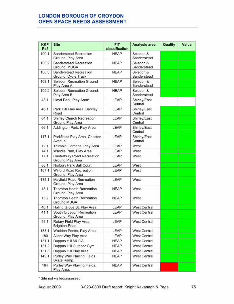
LONDON BOROUGH OF CROYDON OPEN SPACE NEEDS ASSESSMENT
August 2009 3-023-0809 Draft report: Knight Kavanagh & Page 75
KKP Ref
Site FIT classification
Analysis area Quality Value
100.1 Sanderstead Recreation Ground, Play Area
NEAP Selsdon & Sanderstead
100.2 Sanderstead Recreation Ground, MUGA
NEAP Selsdon & Sanderstead
100.3 Sanderstead Recreation Ground, Cycle Track
NEAP Selsdon & Sanderstead
109.1 Selsdon Recreation Ground Play Area A
NEAP Selsdon & Sanderstead
109.2 Selsdon Recreation Ground, Play Area B
NEAP Selsdon & Sanderstead
43.1 Lloyd Park, Play Area* LEAP Shirley/East Central
46.1 Park Hill Play Area, Barclay Road
LEAP Shirley/East Central
64.1 Shirley Church Recreation Ground Play Area
LEAP Shirley/East Central
66.1 Addington Park, Play Area LEAP Shirley/East Central
117.1 Parkfields Play Area, Cheston Avenue
LEAP Shirley/East Central
12.1 Trumble Gardens, Play Area LEAP West
14.1 Wandle Park, Play Area LEAP West
17.1 Canterbury Road Recreation Ground Play Area
LEAP West
88.1 Norbury Park Ball Court LEAP West
107.1 Wilford Road Recreation Ground, Play Area
LEAP West
135.1 Mayfield Road Recreation Ground, Play Area
LEAP West
13.1 Thornton Heath Recreation Ground, Play Area
NEAP West
13.2 Thornton Heath Recreation Ground MUGA
NEAP West
40.1 Haling Grove St. Play Area LEAP West Central
41.1 South Croydon Recreation Ground, Play Area
LEAP West Central
93.1 Rotary Field Play Area, Brighton Road.
LEAP West Central
133.1 Waddon Ponds, Play Area LEAP West Central
180 Allder Way Play Area LEAP West Central
131.1 Duppas Hill MUGA NEAP West Central
131.2 Duppas Hill Outdoor Gym NEAP West Central
131.3 Duppas Hill Play Area NEAP West Central
149.1 Purley Way Playing Fields Skate Ramp.
NEAP West Central
184 Purley Way Playing Fields, Play Area.
NEAP West Central
* Site not visited/assessed.

LONDON BOROUGH OF CROYDON OPEN SPACE NEEDS ASSESSMENT
August 2009 3-023-0809 Draft report: Knight Kavanagh & Page 76
The mapping above highlights that although play provision is well distributed and each significant settlement area has access to at least one play area, there are still gaps in provision. Meeting these deficiencies should be a priority in the more densely populated areas in the North. There appears to be a lack of larger, NEAP sized play areas in the North and increasing the size of existing sites in the area will increase the accessibility to these sites to help meet deficiencies. LBC Housing reportedly has received a number of complaints concerning the playing of ball games in areas designated “No Ball Games”. Consultation highlights a perception that provision of play facilities on housing land is particularly poor. This could further highlight a lack of informal play space for young people. Quality The table below summarises the results of the quality assessment for play areas in Croydon. The threshold for assessing high and low quality is set at 60%. Table 7.3: Quality ratings for play areas by analysis area
QUALITY Scores Number at:
Below
60%
Above
60%
Analysis area
Maximum score
Lowest score
MEAN score
Highest score
Spread
Addington & Fieldway 97 78% 84% 90% 11% 0 6
Central 97 61% 79% 88% 27% 0 11
North 97 75% 82% 90% 15% 0 7
Purley & Coulsdon 97 66% 83% 91% 25% 0 9
Selsdon & Sanderstead 97 54% 76% 91% 37% 2 7
Shirley/East Central 97 82% 86% 92% 10% 0 4
West 97 58% 76% 90% 32% 1 9
West Central 97 30% 76% 90% 60% 1 9
CROYDON 97 30% 78% 92% 63% 4 62
Consultation and site assessments identify that quality of play areas varies significantly across the Borough from only 30% for Purley Way Playing Fields (KKP Ref 84) to 92% for Addington Park (KKP Ref 66.1). Only four sites are marked as poor quality play areas. Only two play areas scored poorly for general site appearance during the audit: � King Georges Field. � Boulogne Road Playground. One play areas scored poorly for surface quality during the audit: � South Norwood Recreation Ground. RoSPA reports indicate the condition of play areas at the time of inspection. Subsequent events such as weather conditions, usage, or vandalism etc. may affect its overall condition. A risk assessment of faults and standard failures is given in terms of low,

LONDON BOROUGH OF CROYDON OPEN SPACE NEEDS ASSESSMENT
August 2009 3-023-0809 Draft report: Knight Kavanagh & Page 77
medium and high. As a general principle items marked as “low” only require monitoring. Items marked as “medium” require appropriate action within resources and individual site assessment. Items marked as “high” require urgent action. Those sites deemed to be of high or medium/high risk following the play area safety inspection report (2008) carried out by RoSPA can be found below. These sites will require additional funds for repairs and maintenance. � Ashburton Park – Tenterton Road � Boulogne Road Playground � Hares Bank � Lloyd Park � Rickman Hill � South Norwood Recreation Ground � Thornton Heath Recreation Ground � Ellis Road � Valley Park � Wandle Park The Big Lottery funded play programme is being utilised in the Borough. There are seven play spaces either established or being developed under this program, which are: � South Norwood Country Park. � Coulsdon Memorial Ground. � Handcroft Road/Croydon Grove. � Longheath Gardens. � Walton Green. � Whitehorse Estate. � Gingerbread Corner, Grenaby Avenue, CR0.
Section 106 (s106) funding is secured on a fairly regular basis. However, LBC Leisure and Culture have to react to funding opportunities from Planning and find it difficult to plan how best to spend the money. There is often a caveat to spend the money to serve the new development within a reasonable distance. The Department is keen to put future s106 monies toward destination facilities but the current policy is quite restrictive, and would benefit from development in order to better direct money where it is needed. Despite this, s106 funds have been set aside to improve the following play areas by 2011: � Wilford Avenue Recreation Ground. � Boulogne Road Play Area. � Mayfield Road Recreation Ground. There will also be additional monies available through the Playbuilder scheme in the next two years to those sites listed below. All the spaces are for refurbishment works rather than creating new play areas and essentially the sites identified are low in play value and choice particularly for 8-13 year olds, who are the key priority group as defined by DCSF. This extensive list further highlights the need for improvements to play areas throughout Croydon.

LONDON BOROUGH OF CROYDON OPEN SPACE NEEDS ASSESSMENT
August 2009 3-023-0809 Draft report: Knight Kavanagh & Page 78
Table 7.4: Playbuilder investment
Site Ward/area Description of plans
Birchfield and Southlands Play area
Coulsdon East To transform an urban landscape into an area of vibrant, sustainable play and community activity
Courtwood Playground
Heathfield Refurbishment of existing play area and introduction of new play opportunities within Courtwood Playground
Croftleigh Estate Play Area
Kenley To transform an urban landscape into an area of vibrant, sustainable play and community activity
Fieldway Estate Play Area
Fieldway To transform an urban landscape into an area of vibrant, sustainable play and community activity
Green Lane Estate Play Area
Upper Norwood To transform an urban landscape into an area of vibrant, sustainable play and community activity
Haling Grove Croham Refurbishment of existing play area and introduction of new play opportunities within Haling Grove.
Monks Hill Urban Play Area
Heathfield To transform an urban landscape into an area of vibrant, sustainable play and community activity
Parkfields Shirley Refurbishment of existing play area and introduction of new play opportunities within Parkfields
Pawsons Road Estate Play Area
Bensham Manor
To transform an urban landscape into an area of vibrant, sustainable play and community activity
Rees Gardens Estate (and Beckford Road) Play Area
Woodside To transform an urban landscape into an area of vibrant, sustainable play and community activity
Rickman Hill Recreation Ground
Coulsdon West.
Refurbishment of existing play area and introduction of new play opportunities within Rickman Hill
Shrublands Estate Play Area
Shirley To transform an urban landscape into an area of vibrant, sustainable play and community activity
South Norwood Recreation Ground
South Norwood Refurbishment of existing play area and introduction of new play opportunities within South Norwood Recreation Ground
Waddon Estate Play Area
Waddon To transform an urban landscape into an area of vibrant, sustainable play and community activity
Wandle Park Playspace
Broad Green (adjoining Waddon ward)
Provide well designed, fun, unique, creatively stimulating and exhilarating play opportunities for 8-13 year olds
Westow Park South Norwood Refurbishment of existing play area and introduction of new play opportunities within Westow Park
Addiscombe Recreation Ground
Ashburton Refurbishment of existing play area and introduction of new play opportunities within Addiscombe Recreation Ground
Bourne Park Kenley Refurbishment of existing play area and introduction of new play opportunities within Bourne Park
Grangewood Park Thornton Heath Refurbishment of existing play area and introduction of new play opportunities within Grangewood Park
The Lawns Upper Norwood Refurbishment of existing play area and introduction of new play opportunities within The Lawns

LONDON BOROUGH OF CROYDON OPEN SPACE NEEDS ASSESSMENT
August 2009 3-023-0809 Draft report: Knight Kavanagh & Page 79
Site Ward/area Description of plans
Queen Elizabeth's Drive Playground
New Addington Refurbishment of existing play area and introduction of new play opportunities within Queen Elizabeth's Drive Playground
Quality issues raised include unofficial use of sites and in particular Mayfield Road Play Area has high levels of dog fouling. Consultation supports this and there are reports that a number of play areas are not considered to be secure, and as a result are suffering from misuse, including use in dog fighting damage. The Council is aware of the problem and is working with local residents and police community support officers to help reduce occurrences. Sites of concern include: � King George V play area, Sydenham Road, Croydon. � Parkfields, Chesterton Avenue, Shirley. The Croydon Play Strategy identified a significant level of dissatisfaction about the quality of equipment and cleanliness of play areas. In particular, there is a perceived problem with graffiti and vandalism. The Strategy suggests that this can be alleviated by the inclusion of areas specifically designed for teenagers, including further provision of youth shelters. There is a perception amongst users that Thornton Heath Recreation Ground suffers from vandalism, particularly to the basketball courts where hoops have previously been broken. Consultation also highlights high levels of litter/glass on the site. Despite this, the play area and sports facilities remain well used. The majority of respondents are unable to rate the quality of provision for a PAC (35%) or PFT (60%). Just over a quarter (26%) are satisfied (very/fairly) with the provision of PACs, whilst only 16% are dissatisfied (fairly/very). One in five of respondents (20%) are neither satisfied nor dissatisfied with the provision of PAC. 15% of respondents are neither satisfied nor dissatisfied with PFTs. The percentage of respondents satisfied (very/fairly) is the same, 10%, as those that are dissatisfied (fairly/very).

LONDON BOROUGH OF CROYDON OPEN SPACE NEEDS ASSESSMENT
August 2009 3-023-0809 Draft report: Knight Kavanagh & Page 80
Figure 7.5: Quality of provision of children’s and teenage play areas
4%
22%20%
11%
5%
35%
3%1%
9%
15%
7%
3%
60%
4%
0%
10%
20%
30%
40%
50%
60%
70%
Very satisfied Fairly
satisfied
Neither
satisfied nor
dissatisfied
Fairly
dissatisfied
Very
dissatisfied
Don’t know No answer
Play area for children Play area for teenagers
Value The table below summarises the results of the value assessment play areas in Croydon. A score of 20% or less is considered to indicate that a site has low value. Table 7.5: Value ratings for play areas by analysis area
VALUE Scores Number at:
Below
20%
Above
20%
Analysis area
Maximum score
Lowest score
MEAN score
Highest score
Spread
Addington & Fieldway 20 60% 69% 90% 30% 0 6
Central 20 50% 75% 90% 40% 0 11
North 20 55% 74% 95% 40% 0 7
Purley & Coulsdon 20 5% 59% 85% 80% 1 8
Selsdon & Sanderstead 20 10% 47% 60% 50% 1 8
Shirley/East Central 20 65% 73% 75% 10% 0 4
West 20 45% 73% 95% 50% 0 10
West Central 20 20% 56% 80% 60% 0 10
CROYDON 20 5% 63% 95% 90% 2 65
The vast majority of play areas in Croydon are assessed as high value, reflecting the consultation, which suggests that residents place high value upon play facilities. It is also important to recognise the benefits that play provides in terms of health, active lifestyles, social inclusion and interaction between children plus their developmental and
LONDON BOROUGH OF CROYDON OPEN SPACE NEEDS ASSESSMENT
August 2009 3-023-0809 Draft report: Knight Kavanagh & Page 81
educational value. There may be demand for the introduction of greater interactive, dynamic and natural play opportunities including elements of touch, sound and sight e.g. play panels, talk tubes, water based play, sand as consultation has found there is a perception of a lack of equipment for children with disabilities. In general, it is felt that play areas across Croydon have low play value with “dull” fixed play equipment, such as kit, fence and carpet (KFC), which are negatively stereotyped. For example KFCs are considered unable to provide opportunities for children to play imaginatively. This can affect the perceived value of play provision. There is a lack of zoning and poor quality equipment is an issue due to a perceived lack of revenue investment. Provision for children and young people summary
� 68 sites in Croydon are classified as provision for children and young people, totalling just over 19 hectares.
� Young people reportedly travel from outside the Borough to use Fairfield Gardens as a skate boarding area.
� Consultation highlights that misuse of children’s play areas by teenagers and ‘undesirables’ impedes ‘genuine’ usage. Users identify a number of play areas that are perceived to be ‘hot-spots’ for anti-social behaviour and misuse including Wandle Park.
� The majority of survey respondents would walk to access provision. Of these, the majority would travel either 10 or 15 minutes. Accessibility catchments have been determined using FIT recommended standards.
� Although play provision is well distributed and each significant settlement area has access to at least one play area, there are still gaps in provision. Meeting these deficiencies should be a priority in the more densely populated areas in the North. There appears to be a lack of larger, NEAP sized play areas in the North and increasing the size of existing sites in the area will increase the accessibility to these sites to help meet deficiencies.
� LBC Housing receives a number of complaints concerning the playing of ball games in areas designated “No Ball Games”. Consultation highlights a perception that provision of play facilities on housing land is particularly poor. This could further highlight a lack of informal play space for young people.
� In the main, play areas in Croydon are of average quality. Reportedly, LBC play areas tend to comprise old, dated equipment (some up to 20 years old). Consultation identifies that the majority of play provision in Borough is of poor quality, which is exacerbated by a lack of capital investment for repairs.

LONDON BOROUGH OF CROYDON OPEN SPACE NEEDS ASSESSMENT
August 2009 3-023-0809 Draft report: Knight Kavanagh & Page 82
PART 8: ALLOTMENTS, COMMUNITY GARDENS AND CITY FARMS Introduction The typology of allotments, community gardens and city farms set out in PPG17: A Companion Guide includes sites, which provide ‘opportunities for those people who wish to do so to grow their own produce as part of the long term promotion of sustainability, health and social interaction.’ Allotment gardening is one of the only recreational activities which has its own legislation. The main points of legislation are laid out in the Small Holdings and Allotments Act 1908 (the principal statute on allotments for England and Wales), points include: � Section 23 - refers to an evidenced demand for allotments, which activates the
mandatory obligation of provision and letting, by a local authority. � Section 25 - powers of compulsory acquisition of land for allotments on a local
authority. � Section 27 - provides for letting to a co-operative. Moreover: where land cannot be let
as allotments, it can be let for any other purpose; provided that it can be brought back into allotment use on 12 months notice.
� Section 30 - where a local authority discovers that a tenant lives more than one mile outside the area for which the allotments are provided; the local authority can serve notice; and one month after any such notice the tenancy determines automatically, by effluxion of time .
� Section 32 - proceeds of sale of allotment land to be used to acquire, adapt and improve other land for allotments.
� Section 39 (2) and (7) - (read in conjunction with Section 25) provides for compulsory hiring of land for allotments.
Key issues Current provision 20 sites are classified as allotments in Croydon (according to PPG17), equating to over 47 hectares. Table 8.1: Distribution of allotment sites by analysis area
Allotments Analysis area
Number Size (ha)
Addington & Fieldway 1 1.87
Central 4 8.69
North 3 11.56
Purley & Coulsdon 3 5.08
Selsdon & Sanderstead 1 1.44
Shirley/East Central 2 1.93
West 4 10.29
West Central 2 6.71
CROYDON 20 47.57

LONDON BOROUGH OF CROYDON OPEN SPACE NEEDS ASSESSMENT
August 2009 3-023-0809 Draft report: Knight Kavanagh & Page 83
Usage Reflecting the specialist interest/usage of allotment sites across Croydon only 10% of respondents to the survey (which covered both users and non users of various open spaces) have visited allotments. It is interesting to note that the majority of users only visit their plot less than once a month, suggesting that work could be done to increase the frequency of use in order to ensure that plots are being fully utilised in such a high demand area. However, further consultation with the allotment associations and other users found that the majority of plot holders visit their site once a week. Figure 8.1: Frequency of usage allotments in the previous 12 months
1% 1% 1% 1%
6%
83%
7%
0%
10%
20%
30%
40%
50%
60%
70%
80%
90%
More than
once a week
Once a week 2-3 times a
month
Once a
month
Less than
once a
month
Never visited Don’t know /
no answer

LONDON BOROUGH OF CROYDON OPEN SPACE NEEDS ASSESSMENT
August 2009 3-023-0809 Draft report: Knight Kavanagh & Page 84
Accessibility Reflecting the low usage level amongst respondents (not uncommon for this type of provision) just over half (51%) are unable to state how far they would be willing to travel; of those that did, the majority (21%) are willing to walk 15 minutes to access provision. A total of 40% of respondents are willing to walk to access provision, whilst only 10% would access by transport. This also reflects that residents expect allotments to be locally available. Figure 8.2: Time prepared to travel to access an allotment
2% 2%
15%
21%
7%
3%
46%
5%
0%
5%
10%
15%
20%
25%
30%
35%
40%
45%
50%
1 minute
walk
5 minute
walk
10 minute
walk
15 minute
walk
10 minutes
by
transport
30 minutes
by
transport
Don’t know No answer
The effective catchments for allotments have been identified using data from the street survey (see Figure 8.2) and guidance issued by the Greater London Authority (GLA). The following 15 minute walk time catchments are therefore used in the mapping to identify the coverage of current provision.

LONDON BOROUGH OF CROYDON OPEN SPACE NEEDS ASSESSMENT
August 2009 3-023-0809 Draft report: Knight Kavanagh & Page 85
Figure 8.3: Allotment sites mapped against population density
Key to sites mapped:
KKP Ref
Site Analysis area GLA classification
Quality Value
186 Mickleham Way Allotments
Addington & Fieldway
Small Open Space
154 Enmore Road allotments Central Small Open Space
159 Heavers Farm allotments
Central Local Park
163 Glenthorne Ave allotments, Ashbur
Central Local Park
192 Aylesford Allotments Central Small Open Space
148 Spa Hill allotments North Local Park
155 Maberley Road North Small Open
REIGATE AND BANSTEAD
SUTTON
MERTON
LAMBETH
BROMLEY
TANDRIDGE
187170
150
158
164
189
167
186
191
163188
192154159190
165
152
155
148
176
160
Croydon
Allotments
15 min walk
Population density per square mile
28,700 to 41,900
25,300 to 28,700
21,900 to 25,300
18,100 to 21,900
15,300 to 18,100
12,600 to 15,300
10,100 to 12,600
7,900 to 10,100
5,500 to 7,900
1,100 to 5,500

LONDON BOROUGH OF CROYDON OPEN SPACE NEEDS ASSESSMENT
August 2009 3-023-0809 Draft report: Knight Kavanagh & Page 86
KKP Ref
Site Analysis area GLA classification
Quality Value
allotments Space
176 Biggin Wood allotments North Small Open Space
150 Hartley Down allotments Purley & Coulsdon
Local Park
158 Godstone Road allotments (disused)
Purley & Coulsdon
Small Open Space
170 Smitham allotments Purley & Coulsdon
Small Open Space
167 Sanderstead Allotments (Purley Oaks Road)
Selsdon & Sanderstead
Small Open Space
188 Orchard Avenue Allotments
Shirley/East Central
Small Open Space
191 Park Hill Allotments Shirley/East Central
Small Open Space
152 Bert Road allotments West Small Open Space
160 Norbury Park allotments West Local Park
165 Pawsons Road allotments
West Local Park
190 Thornton Heath Allotments
West Local Park
164 Pampisford Road Allotments
West Central Local Park
189 South Croydon Allotments
West Central Local Park
Although provision exists in all analysis areas, mapping shows that there is a lack of provision in Old Coulsdon, Selsdon, Addington and Waddon in particular. Furthermore, demand for provision is generally higher where an allotment is situated within a 20 minute walk of an area without provision. Management Most allotment sites in Croydon are managed (in terms of plot allocations, rent collection and waiting list management) by allotment associations/societies. There are three types of management in Croydon, as detailed in Table 8.2. All allotments within Croydon are members of the Croydon and District Federation of Allotment and Garden Societies. The current LBC allotments officer is a part time post and only deals with direct let sites with leasehold sites going through LBC Estates. Users suggest that the post in under resourced. A full LBC plot (10 rods) is 250 square metres and is designed to feed a family of four all year round. Leasing a full plot from LBC costs c£37 per year. Plots leased from organisations other than LBC start at around £45 per year. Council allotments, including those leased to associations offer the following discounts: � A 50% discount to senior citizens, the unemployed and registered disabled people.

LONDON BOROUGH OF CROYDON OPEN SPACE NEEDS ASSESSMENT
August 2009 3-023-0809 Draft report: Knight Kavanagh & Page 87
� A 50% reduction in the first year on some plots if these have not been let for 12 months and are overgrown.
Costs of renting plots from the private and leasehold sites vary between c£40 - c£70 a year, depending on water rates and management fees. Aylesford Avenue and Mabberley allotments are owned and managed by Bromley Borough Council. This is because of a historic authority boundary which has been changed. It is not thought that Croydon residents use Aylesford Avenue but approximately half of the Mabberley Allotment plot holders are Croydon residents. The sites have small waiting lists of around five but the lists have recently been closed. Table 8.2: Management and ownership of allotments in Croydon
Allotment site Site ownership Management
South Norwood Private South Norwood Allotment Holders Association
Glenthorne Avenue Private Addiscombe, Woodside and Shirley Leisure Gardens
Mickleham Way Allotments LBC (direct let) LBC
Midday Sun Allotments LBC (direct let) LBC
Orchard Avenue Allotments LBC (direct let) LBC
Hartley Down Allotments LBC (direct let) LBC
Pampisford Road Allotments LBC (direct let) LBC
Sanderstead Allotments LBC (direct let) LBC
Bensham Manor LBC (leasehold) Behsham Manor Allotment Society
Biggin Wood LBC (leasehold) Upper Norwood District Plotholders Society
South Croydon Allotments LBC (leasehold) South Croydon Allotment Society
Smitham Allotments LBC (leasehold) Smitham Allotment Society
Heavers Farm LBC (leasehold) Selhurst and South Norwood Allotment Society
Norbury Park Allotments LBC (leasehold) Norbury Park Horticultural Society
Thornton Heath Allotments LBC (leasehold) Thornton Heath and Norbury Horticultural Society
Park Hill Allotments LBC (leasehold) Park Hill Allotments and Gardens Society
Spa Hill Allotments LBC (leasehold) Spa Hill Allotment Society
Park Hill Allotments is a slight anomaly as the site is on land which is owned by the Whitgift Foundation, which leases it to LBC, which in turn lease it to the allotment association. The Federation work with, and help associations/societies, and their plot holders, by providing information and guidance; such as templates for conditions of tenancy, and assistance when developing/expanding associations. The Federation also have competitions which are well regarded and help maintain a high standard of allotments through out the year. There is a general consensus that there is a lack of strategic management in terms of maintenance and development of allotments across the Borough. Recognising this, LBC is currently writing an allotment strategy. The strategy will look at all elements of food
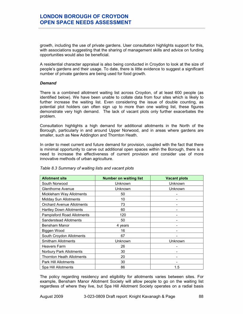
LONDON BOROUGH OF CROYDON OPEN SPACE NEEDS ASSESSMENT
August 2009 3-023-0809 Draft report: Knight Kavanagh & Page 88
growth, including the use of private gardens. User consultation highlights support for this, with associations suggesting that the sharing of management skills and advice on funding opportunities would also be beneficial. A residential character appraisal is also being conducted in Croydon to look at the size of people’s gardens and their usage. To date, there is little evidence to suggest a significant number of private gardens are being used for food growth. Demand There is a combined allotment waiting list across Croydon, of at least 600 people (as identified below). We have been unable to collate data from four sites which is likely to further increase the waiting list. Even considering the issue of double counting, as potential plot holders can often sign up to more than one waiting list, these figures demonstrate very high demand. The lack of vacant plots only further exacerbates the problem. Consultation highlights a high demand for additional allotments in the North of the Borough, particularly in and around Upper Norwood, and in areas where gardens are smaller, such as New Addington and Thornton Heath. In order to meet current and future demand for provision, coupled with the fact that there is minimal opportunity to carve out additional open spaces within the Borough, there is a need to increase the effectiveness of current provision and consider use of more innovative methods of urban agriculture. Table 8.3 Summary of waiting lists and vacant plots
Allotment site Number on waiting list Vacant plots
South Norwood Unknown Unknown
Glenthorne Avenue Unknown Unknown
Mickleham Way Allotments 50 -
Midday Sun Allotments 10 -
Orchard Avenue Allotments 73 -
Hartley Down Allotments 60 -
Pampisford Road Allotments 120 -
Sanderstead Allotments 50 -
Bensham Manor 4 years -
Biggen Wood 16 -
South Croydon Allotments 67 -
Smitham Allotments Unknown Unknown
Heavers Farm 26 -
Norbury Park Allotments 30 -
Thornton Heath Allotments 20 -
Park Hill Allotments 30 -
Spa Hill Allotments 86 1.5
The policy regarding residency and eligibility for allotments varies between sites. For example, Bensham Manor Allotment Society will allow people to go on the waiting list regardless of where they live, but Spa Hill Allotment Society operates on a radial basis

LONDON BOROUGH OF CROYDON OPEN SPACE NEEDS ASSESSMENT
August 2009 3-023-0809 Draft report: Knight Kavanagh & Page 89
and prioritises those within a 1km radius. Restricting allotment allocation to local residents and vacation of plots if tenants move outside the town/settlement boundary could help to reduce waiting lists (although the demand will still exist). During consultation, little specific demand was expressed for raised plots. The Dalpark Community Allotment Club operating at Spa Hill Allotments provide raised beds. Demand maybe a function of supply and may also be due to the lack of plots for users with disabilities. This is an area that LBC and the allotment associations should consider investigating further to ensure that there is fully inclusive provision. This could take the form of a policy stating that if demand for raised beds arose, LBC would endeavour to provide for that demand if and where possible. As is not an uncommon national trend, there has also been a sharp increase in the uptake of plots by women. This tends to lead to an increase in demand for toilet provision, but the provision of toilets at local authority sites in Croydon is noted to be good. However, there are exceptions; such as Thornton Heath Allotments who are campaigning for a toilet on site. LBC Officers believe there may be some potential to develop a community garden at Love Lane, South Norwood, where there is also an active working group. Consultation highlights the possibility of reinstating a number of unused allotment sites across Croydon, which would help alleviate demand. Sites include: � The old allotment site at South Norwood Lake, near Sylven Hill which reportedly has
capacity for c40 full size plots. There is some woodland on site, but the Federation believe this to be statutory allotment land.
� Top of Pollards Hill, Norbury. � Mickelham Way Allotments. The site was significantly reduced in size in the 1980s,
due to a lack of demand; however, it is thought that this site could be reinstated to its former size and help meet demand for plots in the area.
Vacant plot management In general, vacant plot management is efficient and vacant plots are allocated to meet waiting list demand as and when they become available. In some instances, tenants report that plots may fall out of use while still under lease and this can lead to them becoming neglected and overgrown. There are very few vacant plots in the Borough; and because of the high level of demand the associations/LBC are quick to reinstate any vacant plots. An allotment strategy/assessment paper is currently being produced by LBC. This will provide guidance on better plot management for direct let sites, in order to increase take by those that have expressed demand. User consultation suggests that large plot sizes and tenants renting more than one plot are isolated issues. Hartley Down Allotments, Stoats Nest Road, Purley has c140 plots. Although a third of the plots are well maintained, the remainder are poorly kept or vacant/overgrown. The site is a direct let site with no association/society. The Federation is working with plot holders and the Council to try and establish an association but there are issues with a lack of communal meeting area and available/willing personnel. LBC is also working with plot holders at Midday Sun Allotments, Pampisford Way and Mickleham Way Allotments to enable some level of self management (waiting lists etc).

LONDON BOROUGH OF CROYDON OPEN SPACE NEEDS ASSESSMENT
August 2009 3-023-0809 Draft report: Knight Kavanagh & Page 90
Quality The table below summarises the results of the quality assessment for allotments in Croydon. The threshold for assessing high and low quality is set at 60%. Table 8.2: Quality ratings for allotments by analysis area
QUALITY Scores Number at:
Below
60%
Above
60%
Analysis area
Maximum score
Lowest score
MEAN score
Highest score
Spread
Addington & Fieldway 124 - - - - - -
Central 124 29% 49% 67% 38% 2 2
North 124 60% 70% 78% 18% - 3
Purley & Coulsdon 124 24% 40% 52% 28% 3 -
Selsdon & Sanderstead 124 53% 53% 53% 0% 1 -
Shirley/East Central 124 52% 52% 52% 0% 1 -
West 124 42% 52% 62% 20% 3 1
West Central 124 76% 76% 76% 0% - 1
CROYDON 124 24% 46% 78% 54% 10 7
Although the majority of sites score as low value, the mean scores across the Borough are relatively healthy. When assessed against a threshold of 60% only seven sites score as high quality. A number of allotment associations consider their sites to be of high quality. For example, Bensham Manor allotments are reportedly thriving and have recently undergone a new lease of life thanks to an increase in popularity of growing your own food. This is attributed to the increase in national initiatives available. The Council has stopped providing skips for the allotments throughout the Borough, due to cost issues. However, this means that the various associations now have to find alternative arrangements or fund the provision themselves. A number of consultees have reported that this is becoming expensive and a significant drain on association funds. The policy for allowing sheds/greenhouses on individual plots also varies between sites. For example, Bensham Manor does not allow sheds etc but there is a lock up where plot holders can store equipment. In order to supplement income, a number of sites have trading posts, including Bensham Manor, Biggen Wood and South Croydon allotments. The monies raised through the sale of goods, such as grow bags and equipment, and produce are reinvested in the sites for maintenance. Only a small proportion of respondents (5%) are dissatisfied (fairly/very) with the quality of provision of allotments, whilst 11% are satisfied (very/fairly). 15% of respondents are neither satisfied nor dissatisfied. The majority (70%) are unable to comment on the quality of provision of allotments, not uncommon for the low usage level amongst respondents.

LONDON BOROUGH OF CROYDON OPEN SPACE NEEDS ASSESSMENT
August 2009 3-023-0809 Draft report: Knight Kavanagh & Page 91
Figure 8.4: Quality of provision of allotments
5% 6%
15%
4%1%
67%
3%
0%
10%
20%
30%
40%
50%
60%
70%
80%
Very satisfied Fairly
satisfied
Neither
satisfied nor
dissatisfied
Fairly
dissatisfied
Very
dissatisfied
Don’t know No answer
Value The table below summarises the results of the value assessment for allotments in Croydon. A score of 20% or less is considered to indicate that a site has low value. Table 8.3: Value ratings for allotments by analysis area
VALUE Scores Number at:
Below
20%
Above
20%
Analysis area
Maximum score
Lowest score
MEAN score
Highest score
Spread
Addington & Fieldway 30 30% 30% 30% 0% 0 1
Central 30 23% 28% 33% 10% 0 4
North 30 27% 28% 30% 3% 0 3
Purley & Coulsdon 30 20% 24% 27% 7% 0 3
Selsdon & Sanderstead 30 20% 20% 20% 0% 0 1
Shirley/East Central 30 20% 23% 27% 7% 0 2
West 30 13% 21% 30% 17% 2 2
West Central 30 27% 27% 27% 0% 0 2
CROYDON 30 13% 25% 33% 20% 3 18
The majority (86%) of allotments are assessed as high value. This is due to their associated social inclusion and health benefits and also the amenity benefits and sense of place offered by provision. The value of allotments in Croydon is further enhanced by the reasonable rental cost, which although differs across sites (due to the variation in plot
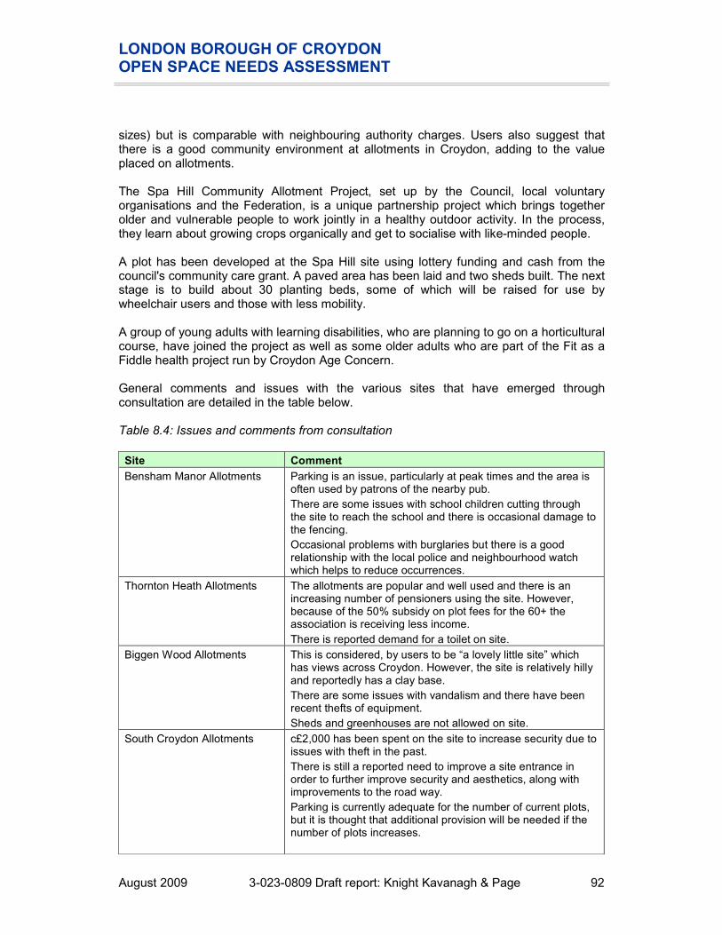
LONDON BOROUGH OF CROYDON OPEN SPACE NEEDS ASSESSMENT
August 2009 3-023-0809 Draft report: Knight Kavanagh & Page 92
sizes) but is comparable with neighbouring authority charges. Users also suggest that there is a good community environment at allotments in Croydon, adding to the value placed on allotments. The Spa Hill Community Allotment Project, set up by the Council, local voluntary organisations and the Federation, is a unique partnership project which brings together older and vulnerable people to work jointly in a healthy outdoor activity. In the process, they learn about growing crops organically and get to socialise with like-minded people. A plot has been developed at the Spa Hill site using lottery funding and cash from the council's community care grant. A paved area has been laid and two sheds built. The next stage is to build about 30 planting beds, some of which will be raised for use by wheelchair users and those with less mobility. A group of young adults with learning disabilities, who are planning to go on a horticultural course, have joined the project as well as some older adults who are part of the Fit as a Fiddle health project run by Croydon Age Concern. General comments and issues with the various sites that have emerged through consultation are detailed in the table below. Table 8.4: Issues and comments from consultation
Site Comment
Bensham Manor Allotments Parking is an issue, particularly at peak times and the area is often used by patrons of the nearby pub.
There are some issues with school children cutting through the site to reach the school and there is occasional damage to the fencing.
Occasional problems with burglaries but there is a good relationship with the local police and neighbourhood watch which helps to reduce occurrences.
Thornton Heath Allotments The allotments are popular and well used and there is an increasing number of pensioners using the site. However, because of the 50% subsidy on plot fees for the 60+ the association is receiving less income.
There is reported demand for a toilet on site.
Biggen Wood Allotments This is considered, by users to be “a lovely little site” which has views across Croydon. However, the site is relatively hilly and reportedly has a clay base.
There are some issues with vandalism and there have been recent thefts of equipment.
Sheds and greenhouses are not allowed on site.
South Croydon Allotments c£2,000 has been spent on the site to increase security due to issues with theft in the past.
There is still a reported need to improve a site entrance in order to further improve security and aesthetics, along with improvements to the road way.
Parking is currently adequate for the number of current plots, but it is thought that additional provision will be needed if the number of plots increases.

LONDON BOROUGH OF CROYDON OPEN SPACE NEEDS ASSESSMENT
August 2009 3-023-0809 Draft report: Knight Kavanagh & Page 93
Site Comment
Spa Hill Allotments The Association has recently introduced a 2km radial buffer to their waiting list because of the demand for plots. There is also a prioritisation for residents within 1km of the site.
The water piping has recently been upgraded and replaced where necessary.
The site has issues with litter and fly tipping. There is CCTV on site but this does not cover the whole area.
Dalpark Community Allotment Club has recently received funding from the Lottery to develop provision (raised beds, wheel chair friendly pathways) for disabled users.
The Association also offer training courses for 1 day up to 12 weeks to educate both existing users and those on the waiting list about allotment use. Consultation has found that these courses are attended by people from inside and outside the Borough.
Allotments summary
� 20 sites are classified as allotments in Croydon, equating to just over 47 hectares.
� Consultation suggests that there is a combined allotment waiting list across Croydon, of at least 600 people. This high demand for allotments cannot be met by existing provision. The lack of vacant plots only further exacerbates the problem.
� Although the majority (51%) of survey respondents were unable to provide an answer, 40% would walk to access provision and of these, the majority (21%) would walk 15 minutes. Therefore, accessibility catchments have been determined using GLA recommended standards.
� Although provision exists in all analysis areas, accessibility mapping shows that there is a lack of provision in Old Coulsdon, Selsdon, Addington and Waddon in particular.
� Consultation highlights a high demand for additional allotments in the North of the Borough, particularly in and around Upper Norwood, and in areas where gardens are smaller, such as New Addington and Thornton Heath.
� In terms of quality, just over a third (35%) of allotments within the LBC audit are rated as good. No significant problems or issues were raised with regard to the general quality of provision. Sites currently not in use or with a significant number of vacant plots are generally those rated as poor quality.
� In order to meet current and future demand for provision, coupled with the fact that there is minimal opportunity to carve out additional open spaces within the Borough, there is a need to increase the effectiveness of current provision and consider use of more innovative methods of urban agriculture.
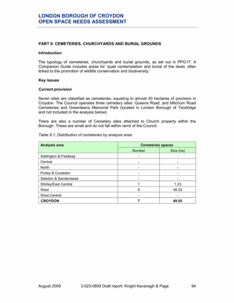
LONDON BOROUGH OF CROYDON OPEN SPACE NEEDS ASSESSMENT
August 2009 3-023-0809 Draft report: Knight Kavanagh & Page 94
PART 9: CEMETERIES, CHURCHYARDS AND BURIAL GROUNDS Introduction The typology of cemeteries, churchyards and burial grounds, as set out in PPG17: A Companion Guide includes areas for ‘quiet contemplation and burial of the dead, often linked to the promotion of wildlife conservation and biodiversity.’ Key issues Current provision Seven sites are classified as cemeteries, equating to almost 50 hectares of provision in Croydon. The Council operates three cemetery sites: Queens Road, and Mitchum Road Cemeteries and Greenlawns Memorial Park (located in London Borough of Tandridge and not included in the analysis below). There are also a number of Cemetery sites attached to Church property within the Borough. These are small and do not fall within remit of the Council. Table 9.1: Distribution of cemeteries by analysis area
Cemeteries spaces Analysis area
Number Size (ha)
Addington & Fieldway - -
Central - -
North - -
Purley & Coulsdon - -
Selsdon & Sanderstead - -
Shirley/East Central 1 1.23
West 6 48.32
West Central - -
CROYDON 7 49.55
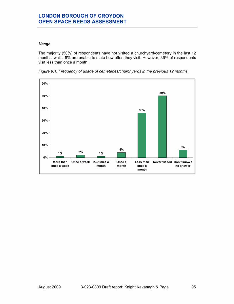
LONDON BOROUGH OF CROYDON OPEN SPACE NEEDS ASSESSMENT
August 2009 3-023-0809 Draft report: Knight Kavanagh & Page 95
Usage The majority (50%) of respondents have not visited a churchyard/cemetery in the last 12 months, whilst 6% are unable to state how often they visit. However, 36% of respondents visit less than once a month. Figure 9.1: Frequency of usage of cemeteries/churchyards in the previous 12 months
1% 2% 1%
4%
36%
50%
6%
0%
10%
20%
30%
40%
50%
60%
More than
once a week
Once a week 2-3 times a
month
Once a
month
Less than
once a
month
Never visited Don’t know /
no answer

LONDON BOROUGH OF CROYDON OPEN SPACE NEEDS ASSESSMENT
August 2009 3-023-0809 Draft report: Knight Kavanagh & Page 96
Accessibility There is an even spread of responses regarding time willing to travel with walking (29%) and travel by transport (30%) having similar rates. However, most respondents (40%) are unable to state how far they would be willing to travel to access churchyards/cemeteries. Figure 9.2: Time prepared to travel to reach a cemetery/churchyard
01%
8%
20%
12%
18%
36%
4%
0%
5%
10%
15%
20%
25%
30%
35%
40%
1 minute
walk
5 minute
walk
10 minute
walk
15 minute
walk
10 minutes
by
transport
30 minutes
by
transport
Don’t know No answer

LONDON BOROUGH OF CROYDON OPEN SPACE NEEDS ASSESSMENT
August 2009 3-023-0809 Draft report: Knight Kavanagh & Page 97
Figure 9.3: Cemeteries sites mapped against settlement areas
Key to sites mapped:
KKP Ref
Site Analysis area
GLA classification
Quality Value
151 St. John's Church, Shirley Shirley/East Central
Small Open Space
156 Mitcham Road Cemetery 2 West Local Park
157 Mitcham Road Cemetery 1 West Local Park
171 St. John's Memorial Garden (east)
West Pocket Park
172 St. John's Memorial Garden (south)
West Pocket Park
173 St. John's Memorial Garden (north)
West Pocket Park
193 Queen's Road Cemetery West Local Park
REIGATE AND BANSTEAD
SUTTON
MERTON
LAMBETH
BROMLEY
TANDRIDGE
151
193
156
157
172173
171
Croydon
Cemeteries
Population density per square mile
28,700 to 41,900
25,300 to 28,700
21,900 to 25,300
18,100 to 21,900
15,300 to 18,100
12,600 to 15,300
10,100 to 12,600
7,900 to 10,100
5,500 to 7,900
1,100 to 5,500

LONDON BOROUGH OF CROYDON OPEN SPACE NEEDS ASSESSMENT
August 2009 3-023-0809 Draft report: Knight Kavanagh & Page 98
Mapping shows provision in the vast majority of settlements. The need for additional cemetery provision should be driven by the need for burial space. However, LBC Bereavement team report that there is no spare burial space in the North of the Borough and only reclaimed graves are available. Greenlawns Memorial Park only has provision for two more years of new burials. Due to a lack of opportunity to carve out additional open spaces in Croydon, LBC is currently in discussion with Tandridge Borough Council (TBC) to extend Greenlawns Memorial Park. Although LBC own the land, TBC is reluctant to grant planning permission and change of use until LBC has provided evidence that there are no other sites in Croydon that could provide the additional space. Although LBC recognises the increase in demand for woodland burial, it is not currently offered by the Council. Currently, this demand is met via Dorking Cemetery (outside of Croydon), which meets some demand from Croydon residents but is charged at a premium price. If an extension is granted at Greenlawns Memorial Park, a woodland burial site could be accommodated. Management LBC Bereavement Services is based at Mitcham Road Cemetery, along with the Crematorium and its two chapels and also the Croydon Public Mortuary. There are 30 staff, which includes the management team, office staff, cemetery operatives, the memorial safety team, horticultural and general assistants, the mortuary team and crematorium technicians. Most staff are able to cross perform aspects of another role e.g.; general assistants can also provide cleaning and maintenance as well as cremation training. The service operates within a delineated budget, and is a member of the Institute of Cemeteries and Crematorium Management (ICCM). Grave purchase gives exclusive burial rights for 50 years (previously in perpetuity) and the Council is now identifying graves for reclaim use of remaining burial space to assist with the shortage. This requires extensive checking of records and publicity to ensure graves are only reused if: � It is not being visited. � It is over 75 years since the last burial. � There is no response from the owner after repeated attempts. This also allows the Council to identify Heritage Graves of particular interest or artistic merit for purchase.

LONDON BOROUGH OF CROYDON OPEN SPACE NEEDS ASSESSMENT
August 2009 3-023-0809 Draft report: Knight Kavanagh & Page 99
Quality The methodology for assessing quality is set out in Part 2 (Methodology). The table below summarises the results of the quality assessment for cemeteries in Croydon. The threshold for assessing high and low quality is set at 60%. Table 9.2: Quality ratings for cemeteries by analysis area
QUALITY Scores Number at:
Below
60%
Above
60%
Analysis area
Maximum score
Lowest score
MEAN score
Highest score
Spread
Addington & Fieldway 161 0% 0% 0% 0% 0 0
Central 161 0% 0% 0% 0% 0 0
North 161 0% 0% 0% 0% 0 0
Purley & Coulsdon 161 0% 0% 0% 0% 0 0
Selsdon & Sanderstead 161 0% 0% 0% 0% 0 0
Shirley/East Central 161 60% 60% 60% 0% 0 1
West 161 60% 64% 68% 8% 0 6
West Central 161 0% 0% 0% 0% 0 0
CROYDON 161 60% 63% 68% 8% 0 7
All cemeteries are rated as good quality. No significant problems or issues were raised with regard to the general quality of provision. To further support this, consultation suggests that LBC appears to visit its main sites once a week to undertake maintenance, and users accept this as adequate frequency. The Green Flag Award is not restricted to recognising high quality parks but is available to all open space provision, including cemeteries. According to the audit, Mitcham Road Cemetery could be considered in the future. It has also been landscaped and subsequently won the London Spade. The Council operates a number of initiatives for quality and social procurement partnership. For example, the social procurement partnership with the Shaw Trust has held the maintenance contract for Croydon Cemetery since 2005. The public reportedly prefer a site such as Croydon Cemetery to be maintained by a permanent onsite team as this provides a sense of security especially for the elderly and social inclusion for the staff, and enables relationships to be developed within the local community. This also allows for a greater level of flexibility and allows maintenance to be carried out when required, as opposed to when it is scheduled. The Shaw Trust hopes to develop a centre of excellence for local authority horticultural ground maintenance and illustrates the viability of operating a community initiative whilst performing within budget levels. At present 15 people with learning difficulties attend at the cemetery to gain an accredited horticultural training and be given the opportunity to progress with care management and job coaching support to achieve their potential.

LONDON BOROUGH OF CROYDON OPEN SPACE NEEDS ASSESSMENT
August 2009 3-023-0809 Draft report: Knight Kavanagh & Page 100
It recognises this initiative requires LBC Bereavement Services to be innovative and entrepreneurial, but it is thought to be a successful partnership, illustrated by being awarded the Croydon in Bloom award for excellence for three successive years. Memorial safety is a concern for LBC officers and it has formed a dedicated team to identify unsafe memorials. The team is not permitted to repair headstones, but is able to conduct remedial work to make the area safe. LBC retains its in house staff for all grave digging to ensure continuity and quality control, and for grounds maintenance at Queens Road Cemetery and Greenlawns Memorial Park to ensure quality and minimise complaints. Consultation reveals that when these sites were maintained by contractors, the amount of complaints was unacceptable, as were the standards of the grounds. Visitors to the sites did not feel safe, especially the elderly, however, staff presence is now twelve hours a day, seven days a week. There have been instances of theft from buildings and there are minimal reports of vandalism/misuse. However, there are a number of expensive brass plaques at Greenlawns Memorial Park and CCTV has been installed to deter theft (this has happened at other cemeteries in the London area). The majority (45%) of respondents are unable to rate the quality of provision of churchyards/cemeteries. 25% are satisfied (very/fairly), along with a further 25% who are neither satisfied nor dissatisfied with the quality of provision. Only a small number (4%) are fairly dissatisfied. Figure 9.4: Quality of churchyards/cemeteries
7%
18%
25%
4%
0
42%
3%
0%
5%
10%
15%
20%
25%
30%
35%
40%
45%
Very satisfied Fairly
satisfied
Neither
satisfied nor
dissatisfied
Fairly
dissatisfied
Very
dissatisfied
Don’t know No answer

LONDON BOROUGH OF CROYDON OPEN SPACE NEEDS ASSESSMENT
August 2009 3-023-0809 Draft report: Knight Kavanagh & Page 101
Value The methodology for assessing value is set out in Part 2 (Methodology). The table below summarises the results of the value assessment for cemeteries in Croydon. A score of 20% or less is considered to indicate that a site has low value. Table 9.3: Value ratings for cemeteries by analysis area
VALUE Scores Number at:
Below
20%
Above
20%
Analysis area
Maximum score
Lowest score
MEAN score
Highest score
Spread
Addington & Fieldway 25 - - - - - -
Central 25 - - - - - -
North 25 - - - - - -
Purley & Coulsdon 25 - - - - - -
Selsdon & Sanderstead 25 - - - - - -
Shirley/East Central 25 28% 28% 28% 0% 0 1
West 25 20% 20% 20% 0% 0 6
West Central 25 - - - - - -
CROYDON 25 20% 21% 28% 8% 0 7
All cemetery provision is assessed as high value, reflecting that provision has high cultural/heritage value and provides a sense of place to the local community. In addition, environmental cremations using natural coffin materials are promoted in Croydon and conservation sites have been set up to encourage local fauna and flora. Cemeteries summary
� Seven sites are classified as cemeteries, equating to almost 50 hectares of provision in Croydon. In addition, Greenlawns Memorial Park is located outside the borough in Tandridge District Council.
� There is an even spread of responses regarding time willing to travel with walking (29%) and travel by transport (30%) having similar rates. However, an accessibility standard is not recommended and the need for cemetery provision should be driven by the need for burial space.
� There is a lack of burial space in the North of the Borough with only reclaimed graves are available. Greenlawns Memorial Park has provision for two more years of new burials.
� The vast majority of cemeteries are rated as good quality. No significant problems or issues were raised with regard to the general quality of provision. Mitcham Road Cemetery could be considered in the future for a Green Flag Award.
� Cemetery provision is generally assessed as being of high value, reflecting that provision has cultural/heritage value and provides a sense of place to the local community.

LONDON BOROUGH OF CROYDON OPEN SPACE NEEDS ASSESSMENT
August 2009 3-023-0809 Draft report: Knight Kavanagh & Page 102
PART 10: WHERE NEXT This Needs Assessment considers the supply and demand issues for open spaces in the Borough of Croydon. It identifies local need from consultation highlighting the predominant issues for open spaces. This will form the basis of discussions to inform the development of standards and strategies and actions to address key issues. Strategic recommendations and policy objectives and will follow on from this report.

LONDON BOROUGH OF CROYDON OPEN SPACE NEEDS ASSESSMENT
August 2009 3-023-0809 Draft report: Knight Kavanagh & Page 103
APPENDIX ONE: OPEN SPACE CONSULTEE LIST
Name Organisation
Alec Baxter-Brown Downlands Countryside Management Project
Allan Webber LBC Head of Policy And Strategy
Andrew Beedham LBC Head of urban Design and Conservation
Andy Williams LBC Biodiversity and Open Spaces
Barry Lambton LBC Green Spaces Manager
Catherine Radziwonik LBC Project Officer, Assets and Facilities Management
Chris Hyde Friends of Littleheath Woods
Chris Parker Friends of Foxley
Cindy Stott Bensham Manor Allotment Society
Cllr Chris Wright Friends of Bradmore Green Pond
Cllr Maria Gatland Friends of Croham Hurst
Dave Coram South Croydon Allotment Society
David Carlisle LBC Assistant Planner
Dawn Fazackerly British Horse Society
Dawn Gibbons Friends of Selsdon Wood
Emma Peters LBC Executive Director Planning, Regeneration and Conservation
Helen Lomansey LBC Allotment Officer
Ian Marshall LBC Head of Youth Service
Jack Dudley Swale Spa Hill Allotment Society
Jeanne Mitchell Upper Norwood District Plot Holders Society
John Russell
Kirstie Pursey
Addington Conservation Team
John Taylor Friends of Kings Wood
Joyce Bellamy Metropolitan Gardens Association
Julie Christie LBC Strategic project manager, Croydon children's trust
Lawrence Kennedy North Downs Residents Group
Linda Wright LBC Head of Service, Youth and Social Inclusion
Mary-Ann Winterman LBC Technical Manager, Community Services, Green Spaces
Michael Lishmund Sanderstead Plantation Partners
Mike Murphy LBC
Mr R Akers Monks Orchard Residents Association
Pearl Durling Friends of Miller Pond
Peter Newbury Croydon Allotment Federation
Robert Ramsey Thornton Heath and Norbury Horticultural Society
Robert Sowter Friends of Spring Park Wood
Rosemarie Green Selhurst and South Norwood Allotment Society

LONDON BOROUGH OF CROYDON OPEN SPACE NEEDS ASSESSMENT
August 2009 3-023-0809 Draft report: Knight Kavanagh & Page 104
Name Organisation
Sascha Khan Friends of Thornton Heath Recreation Ground
Sian Foley LBC Housing Support Services Manager
Sue Maclauglin LBC Active Lifestyles Manager
Tina Norris Grangewood and Whitehorse Residents Association
Tony Middleton LBC Director of Regeneration and Asset Management
Valerie Jarvis Norbury Park Allotments
Victoria Taylor-Ross Friends of Beulah Hill Pond
Wendy Bell LBC Senior Planner - Policy And Environment/Project Steering Group