22 Ind. Ci. Corn. 92 - Oklahoma State...
44
22 Ind. Ci. Corn. 92 IRA SYLVESTER GODFROY , WILLIAM ALLOLLA GODFROY, JOHN A. OWENS, on relation of THE MIAXI INDIkd TRIBE and MUMI TRIBE OF INDIAXA, and esch on behalf of others similarly situated and on behalf of THE MIAMI IWIAN TRISE and various bznds and groups of each of theii, comprising the MIAMI TRIBE AND NATION, Plaintiffs, THE PEORLA TRIBE OF INDIAES OF OKLAtiOMA and AMOS ROBINSON SKYE on behalf of the WEA NATION, Plaintiffs, THE UNITED STATES OF AMERICA, Defendant. Decided: November 26, 1969 Appearances : Edwin A. Rothschild, Louis L. Rochmes, Attorneys for Plaintiffs in Docket No. 253 Jack Joseph, Attorney for Plaintiffs in Docket No. 314-D Walter H. Maloney, David L. Kiley, Albert C. Harker and Robert C. Bell, Jr., Attorneys :or ?laictiffs in Docket KO. 131 David M. Marshall with whom was Mr. Assistant Attorney General, Clyde 0. Martz, Attorneys for Defendant.
Transcript of 22 Ind. Ci. Corn. 92 - Oklahoma State...

22 Ind. C i . Corn. 92
IRA SYLVESTER GODFROY , WILLIAM ALLOLLA GODFROY, JOHN A. OWENS, on relation of THE MIAXI INDIkd TRIBE and MUMI TRIBE OF INDIAXA, and esch on behalf of others similarly situated and on behalf of THE MIAMI IWIAN TRISE and various bznds and groups of each of theii, comprising the MIAMI TRIBE AND NATION,
Plaintiffs,
THE PEORLA TRIBE OF INDIAES OF OKLAtiOMA and AMOS ROBINSON SKYE on behalf of the WEA NATION,
Plaintiffs,
THE UNITED STATES OF AMERICA,
Defendant.
Decided: November 26, 1969
Appearances : Edwin A. Rothschild, Louis L. Rochmes, Attorneys for Plaintiffs in Docket No. 253
Jack Joseph, Attorney for Plaintiffs in Docket No. 3 1 4 - D
Walter H. Maloney, David L. Kiley, Albert C. Harker and Robert C. Bell, Jr., Attorneys :or ?laictiffs in Docket KO. 131
David M. Marshall with whom was Mr. Assistant Attorney General, Clyde 0. Martz, Attorneys for Defendant.

22 Ind. C l . Corn. 92
OPINION
Commissioner P ierce de l ivered the opinion of the Commission.
This dec i s ion supplements the c om mission's dec i s ion of June 4 ,
1957, i n Docket Nos. 253, 131, 314, 15-H, 317, 307, and 29-P, 5 Ind.
C 1 . Com. 180, holding t h a t t he p l a i n t i f f s here , t he Miami and Wea
Tr ibes of Indians , were authorized t o prosecute claims f o r compen-
s a t i o n f o r t h r e e t r a c t s of land i n Indiana ceded t o t he United S t a t e s
by the t r e a t i e s c i t e d below. The Comiss ion must now determine the
va lue of t he lands so ceded, whether the p l a i n t i f f s have a r i g h t t o
compensation, and, i f so , the amount thereof under the Ind ian C l a i m s
Commission Act (60 S t a t . 1049). I n add i t i on , t h e i n t e r e s t of t h e
r e s p e c t i v e p l a i n t i f f s i n t h e sepa ra t e t r a c t s he re involved must be
determined.
I n a r e g u l a r l y scheduled hearing the re fo r , t he p a r t i e s presented - testimony and e x h i b i t s r e l a t i n g t o the va lua t ion of t he l ands and
t h e cons ide ra t ion paid by the United S t a t e s f o r t he lands. I n a
subsequent hear ing , testimony and e x h i b i t s r e l a t i n g t o t h e i n t e r e s t
of t h e r e s p e c t i v e p a r t i e s i n the sepa ra t e t r a c t s were presented and
l a t e r a s h o r t hearing on o f f s e t s was held.
I n t h e t i t l e dec is ion i n t h i s case , 5 Ind. C 1 . Corn. 180 supra,
t h e Commission found t h a t on August 3 , 1795, t h e United S t a t e s
en t e red i n t o t h e Greenevi l le Treaty with a number of Indian t r i b e s
i nc lud ing t h e Potawatomis, Miamis, Eel-River, Weas, and Kickapoos
(7 S t a t . 4 9 ) . A r t i c l e I I I o f . the t r e a t y f ixed the genera l boundary

2 2 Ind. C 1 . Comm. 92
l i n e between the lands of he Unite5 Sts res and t h e l ands of t h e
s igna to ry Indian t r i b e s .
Under A r t i c l e I V of the t r e a t y , t he United S t a t e s r e l i n q u i s h e d ,
s u b j e c t t o s p e c i f i c except ions, i t s c l a i m t o Indian lands norch of
t he Ohio River, e a s t of t he Miss i s s ipp i River , and west and south of
t h e Grea t Lakes. Under A r t i c l e V, t he Indians agreed n o t K O s e l l o r
d i spose of t h e i r l ands except t o the United S t a t e s .
I n i t s dec i s ion of June 4, 1957, the Coinmission he ld t h a t by
A r t i c l e s I V and V of t he Greenevi l le Trea ty , t h e United S t a t e s recognized
t h e r i g h t of each of t h e Indian t r i b e s s ign ing t h e t r e a t y t o i t s l a n d s
but t h e United S t a t e s was unable then t o confirm a d i v i s i o n of t h e
f Indian t e r r i t o r y among t h e r e spec t ive t r i b e s o r t o e s t a b l i s h s e p a r a t e
boundaries of t h e s igna to ry t r i b e s . 5 Ind. C 1 . Comm. 181, 188
The Commission found f u r t h e r t h a t i t was t h e po l i cy of the United
S t a t e s t o purchase Indian lands recognized by t h e Greenev i l l e T rea ty
by a s e r i e s of t r e a t i e s under which ind iv idua l Indian t r i b e s ceded
t o t h e United S t a t e s s p e c i f i c t r a c t s of land f o r which t h e t r i b e s
were compensated; and t h a t these t r e a t i e s confirmed t h e boundaries
of t h e land recognized a s belonging t o t he va r ious t r i b e s by t h e
Greenev i l l e T-reaty . Ey t h e Trea ty of Grouseland, Indiana T e r r i t o r y , en t e red i n t o
August 21, 1805 ( 7 S t a t . 91) , the United S t a i e s confirmed t h e bound-
a r i e s of l and (Royce Area 56) ceded t o the United S t a t e s which had
been recognized by the Greenevi l le Treaty a s belonging t o t h e

22 Ind. C 1 . Corn. 92
p l a i n t i f f s . 5 Ind. C 1 . Comm. 195
By t h e Treaty of September 30, 1809, a t Fort Wayne with t h e
Miami, Eel River, Delaware and P o t a w a t a i T r ibes (7 S t a t . 113, 115) ,
t he Miaini and Eel River Tr ibes ceded cwo c r a c t s (Royce Areas 7 1 and
72) t o t h e United S t a t e s . 5 Ind. C 1 . Comm. 195, 196 Under a
s e p a r a t e agreement with t h e Wea Tr ibe a t Vincennes on October 26, 1809
(7 S t a t . 116) , the Weas agreed t o t h e ces s ion of Royce Area 71. 5 Ind.
C1. Comm. 196, These t r a c t s a r e w i t h i n t h e t e r r i t o r y re l inquished
by t h e United S t a t e s t o t he Indians under t he Greenevi l le Treaty.
(The above cess ions a r e shown as Areas 56, 7 1 and 72 on the Indiana
I map i n Royce, Indian Land Cessions i n t h e United S t a t e s , P a r t 2 ,
1 8 t h Annual Report of t he Bureau of American Ethnology (1899)). The
t r a c t s w i l l be r e f e r r ed t o by t h e s e a r e a numbers he rea f t e r .
I n t h e dec is ion of June 4, 1957, t he Cormnission found t h a t t h e
Miami Tr ibe of Oklahoma and t h e Eel River Tr ibe , p l a i n t i f f s i n Docket
No. 253; t h e Peoria Tr ibe of Indians of Oklahoma, a c t i n g f o r and on
behal f of t h e Wea Nation of Indians , p l a i n t i f f s i n Docket No. 314;
and t h e M i a m i Tr ibe of Indiana, p l a i n t i f f s i n Docket No. 131, were
a u t h o r i z e d by the Indian Claims Commission Act of August 13, 1946,
(60 S t a t . 1049) t o prosecute t h e claims f o r conpensation s e t f o r t h i n
t h e i r r e s p e c t i v e p e t i t i o n s which a r o s e out of the cess ions t o defendant
of i ands by t h e p l a i n t i f f s i n s a i d dockets under the Grouseland Trea ty ,
and t h e T r e a t y of September 30, 1809, supra, known a s the F o r t Wayne
Trea ty ; t h a t the p l a i n t i f f , t h e M i a m i Tr ibe of Oklahoma, and t h e

2 2 Ind . C1. C m . 9 2 9 6
p l a i n t i f f s , t h s xisr,i Tr ibe of Indiana , c o ~ ~ s c i t u t e and r e p r e s e n t zil
/ descendants of members cf the a a m i Tribe of Americsn I n a k n s . - The Comiss ion found t h a t the Eel River T r i j e was o r i g i n a l l y and 2c
a l l t imes here in r e f e r r e d t o , a p a r t of t he M i a m i . The Wea TrLbe ~ Z S
o r i g i n a l l y a l s o a p a r t of the Miami Tr ibe b u t a f t e r 1805 se2arateC from
the Mizmi.
Each of the p l a i n t i f f s c laims compensa~ion under s e c t i o n 2 ( 3 )
of the Indian Claims Commission ~ c t on the ground t h a t t h e cons idera-
t i o n pa id by the United S t a t e s f o r t h e land was unconscionable.
A t t h e o u t s e t , t h e i n t e r e s t of the r e spec t ive p l a i n t i f f s i n t h e
s e p a r a t e areas w i l l be determined.
The Miamis, the Eel River, t he Weas, t h e Deiawares, and Potawatomis
were p a r t i e s t o t h e Trea ty of Grouseland, supra, r a t i f i e d A p r i l 24,
1806.
The Miaini and Eel River T r ibes , p l a i n t i f f s i n Docket Eo. 253,
t he M i a m i Tr ibe of Indiana ( the M i a m i Ind ian Tr ibe ) , p l a i n t i f f s i n
1/ A number of complaints consol ida ted f o r hearing on t h e ques t ion of - t i t l e have been el iminated from t h i s proceeding. In che d e c i s i o n of June 4 , 1957, the Commission dismissed the p e t i t i o n of t h e C i t i z e n Band of Potawatomi and the Potawatomi Nation, Docket 307, a s t h e s e p l a i n t i f f s amended t h e i r p e t i t i o n and e l imina ted a i l c iaim t o lands ceded by che 1805 and 1809 t r e a t i e s . The p e t i t i o n of t he Kickapoo T r i b e of i k n s a s , e t a l . , 3ocket So. 317, was d i s n i s s e d , they having o f f e r e d no proof and having s t a t e d in the opening hearing before the Comrr.issioa t h z t they were i n ~ e r e s t e d only i n boycr Area 73 which was e l imina ted f rn cons ide ra t ion i n t h i s proceeding. The Bannahville Indian Comdnicy e t a l . , Docket 29-F, o f f e red no prsof i n the t i t l e proceeding. Con- sequent ly t h e i r claim was dismissed. The p e t i t i o n i n Docket 15-H by the Pottawatomi Tr ibe of Indians , the P r a i r i e Band of t he PotCawatmi Tr ibe of Indians e t a l . , was a l s o dismissed.
22 Ind. C 1 . Comm. 9 2 97
Docket No. 131, and the Wea Tr ibe , p l a i n t i f f s i n Docket No. 314-D,
owned Royce Area 56 when it was ceded t o t h e defendant by the Treaty
of Grouseland. A s f a r a s a v a i l a b l e evidence i n d i c a t e s , no p a r t i c u l a r -.
por t ion of Area 56 belonged exc lus ive ly t o any one of i h e t h r e e t r i b e s .
I n A r t i c l e I V of t he Treaty of Grouseland, t he United S t a t e s
acknowledged and recognized t h a t i n 1805 t h e Miamis, Eel River, and
Wea Tr ibes were formerly and s t i l l considered themselves one na t ion .
A s assurance t h a t the United S t a t e s recognized these th ree t r i b e s a s
j o i n t owners of a l l t he country on t h e Wabash and i t s waters above t h e
Vincennes t r a c t which had not been ceded t o t h e United S t a t e s , t h e
un i t ed S t a t e s agreed t h a t i t would not purchase any p a r t of t he s a i d
country wi thout t he consent of each of t he t r i b e s .
By t h e Trea ty of September 30, 1809, t h e Miami and Eel River T r ibes
(and t h e Delawares and potawatomis a s t h e i r a l l i e s ) ceded t o t h e United
S t a t e s Royce Areas 71 and 72 f o r which the United S t a t e s agreed t o pay
t h e M i a m i s and the Eel River Tr ibe an annui ty . I n a supplementary
Trea ty of September 30, 1809, with t h e M i a m i and Eel River Tr ibes ,
t h e United S t a t e s agreed t o furn ish a d d i t i o n a l compensation (domestic
animals worth $500 f o r 3 separa te yea r s ) , as the g r e a t e r p a r t of t h e
lands (Areas 71 and 72) which was ceded on t h i s da t e was recognized
a s the e x c l u s i v e property of these Indians.
The f i f t h A r t i c l e of the Treaty of September 30, 1809, s t a t e d t h a t
t he consent of the Wea Tribe t o the ces s ion would be necessary t o
complete t i t l e t o Area 71 and provided f o r a separa te agreement
bezween t h e Wea Tribe and the k i t e d S t a t e s f o r t h a t purpose. By t h e

22 I n d . C i . Corn. 9 2 9 8
T r e a t y of October 2 6 , 1&09, t h e Wea T r i b e c o z s s n t e d t o che c e s s i o n by
t h e Miami and Eel River T r i b e s under rne T;eaty of September 30, 1809,
and r e l i n q u i s h e d t o t h e United S t a t e s t h e i n t e r e s t o f t h e Weas i n
Area 71.
I n t h e t i t l e phase o f t h i s c a s e t h e Commission found t h a t t h e
Wea T r i b e s e p a r a t e d f r m t h e Mianli T r i b e a f t e r 1805. The Commission
a l s o found t h a t w i t h i n Area 71, t h e Wea e x c l u s i v e l y dominated o r
c o n t r o l l e d 549,081 a c r e s t h e r e o f , be ing t h e p o r t i o n l y i n g west o f t h e
b l u e l i n e shown on p l a i n t i f f ' s E x h i b i t 83 i n Docket No. 253 ( F i n d i n g
1 2 , 5 Ind . C l . Corn. 180, 196. 1
The Commission d i d n o t make s e p a r a t e f i n d i n g s a b o u t Area 56 o r
Area 72 b u t found (Finding 13, 5 Ind . C 1 . Comm. L.80, 197) t h a t t h e
Miami, E e l R iver , and Wea T r i b e s had e x c l u s i v e t i t l e t o t h e l a n d s
d e s c r i b e d i n Royce Areas 56, 71, and 72 a t t h e t ime of t h e c e s s i o n s
t h e r e o f t o t h e United S t a t e s by t h e t r e a t i e s of 1805 and 1809.
The last mentioned f i n d i n g does n o t n o t e t h a t when Area 72 was
ceded by t h e T r e a t y of September 30, 1809, no i n t e r e s t o f t h e Wea
T r i b e i n t h a t a r e a was i n d i c a t e d i n t h e t r e a t y o r r e l a t e d documents.
There i s no evidence b e f o r e t h e C o m i s s i o n t h a t t h e Wea T r i b e had a n
i n t e r e s t i n Area 72 i n 1809 when i t w a s ceded t o t h e Uni ted S t a t e s
and we do n o t t h i n k ~ h a i Finding 13 was k t e n d e d t o h o l d o t h e r w i s e .
2 1 The l o c a t i o n and q u a n ~ i t y of Wea l a n d s w i t h i n Area 7 1 were z g r e e d - to by t h e p a r t i e s h e r e i n by s t i p u l a t i o n d a t e d November 1 7 , 1954, and f i l e d on November 18, 1954.

22 Ind. C 1 . Corn. 92 99
The use of the t e n "exc lus ive t i t l e " i n Finding 13 may have r e f e r r e d
t o t he f a c t t h a t the unsuccessful p l a i n t i f f s i n the t i t l e proceeding
(Potawatomis, Kickapoos, Hannahville Indian Community, s e e Note 1)
were not au thor ized t o prosecute claims f o r compensation i n t h i s pro-
ceeding because only t h e M i a m i s , Eel River , and Wea Ind ians had
recognized t i t l e t o t he t r a c t s he re involved. I f so, t h e phrase,
"exclusive t i t l e " had no bearing on the ques t ion of t he i n t e r e s t of
t he Weas, a s cornpased wi th the Eel River and Miamis ia t h e s e p a r a t e
t r a c t s . We read the term "exclusive t i t l e " i n Finding 1 3 as r e f e r r i n g
t o t h e unsuccessful p l a i n t i f f s i n t h e t i t l e proceeding.
Our Finding 14 i s intended t o c l a r i f y t h e matter by de f in ing t h e
ownership i n t e r e s t of t h e r e spec t ive p l a i n t i f f s i n t h e s e p a r a t e t r a c t s
as recognized i n t he t r e a t i e s ceding the t r a c t s . The t r e a t i e s i n d i c a t e
t h a t the M i a m i , Eel River, and Wea Tr ibes owned Areas 56 and 7 1 when
these t r a c t s were ceded t o the United S t a t e s i n 1805 and 1809. The
M i a m i and Eel River Tr ibes owned Area 72 i n 1809 a t t h e t ime of i t s
ces s ion t o t h e United S t a t e s . There i s no evidence of Wea ownership
of Area 72 when t h a t t r a c t was ceded.
We conclude t h a t a t t he time of ce s s ion of Areas 71 and 72 , t h e
Weas had Ind ian t i t l e t o the western po r t ion of Area 71 a s descr ibed
by t h e Commission i n Finding 12 i n t he t i t l e opinion i n t h i s proceeding,
5 Ind . C 1 . Comm. 180, 196-197. The Miami and E e l River T r ibes owned
the e a s t e r n po r t ion of Area 71 and a l l of Area 72. The Weas d i d no t
own the e a s t e r n po r t ion of Area 71 o r any of Area 72.
2 2 I n d . C 1 . Corn. 92
We t u r n now L O s a t t e r s a f f e c t i n g t h e v s l u e of t h e s e Royce Areas
on e v a i u e ~ i o n d a t e s .
The S t a t e of I n d i a n a , i n t h e e a s t n o r t h c e n t r a l Uni ted S t a t e s , i s
bounded on t h e s o u t h by t h e Ohio R i v e r , and , a l o n g a s u b s a n t i & l ? ~ r ~ l o n
of i t s w e s t e r n boundary, by t h e Wabash River. Wny s t r e a m s i n t h e
n o r t h e r n p a r t of t h e s t a t e a r e interwoven w i t h r i v e r s which r u n i n t o
Lake Michigan a long p a r t of I n d i a n a ' s n o r t h e r n boundary and i n t o
Lake E r i e t o the east i n Ohio. The system of s t r e a m s from n o r t h e r n
I n d i a n a wes t p rov ided , a t t imes of h i g h w a t e r , a n a v i g a b i e waterway
between t h e G r e a t Lakes and t h e M i s s i s s i p p i R iver .
The n o r t h e r n t h r e e - f i f t h s of t h e s t a t e i s g e n e r a l l y l e v e l ,
f e r t i i e t i l l p l a i n o r r o l l i n g p l a t e a u which has been h e a v i l y g l a c i a t e d ,
t h e s o i l s o f which a r e d e r i v e d c h i e f l y from g l a c i a l t i l l . The s o i l s a r e
m o s t l y loams o r c l a y loams, w e l l - s u i t e d t o t h e p r o d u c t i o n o f s t a p l e
c r o p s such as corn , o a t s , and w i n t e r wheat. E igh ty p e r c e n t o f
I n d i a n a l a n d i s used f o r a g r i c u l t u r e , and I n d i a n a farms y i e l d w e l l .
The Ohio River a l o n g t h e s o u t h e r n boundary of I n d i a n a i s
bordered by a b e l t of b l u f f s and knobs, known as t h e Ohio h i l l s .
The s o u t h e r n t w o - f i f t h s of Ind iana i s rougher and h i l l i e r t h a n t h e
n o r t h e r n p o r t i o n and i s a n u n g l a c i a t e d e x t e n s i o n of t h e Appalachien
P l a t e z u , z n a r e a wi th s o i l s which a r e g e n e r a l l y s h a l l o w e r and less
prodr;ccLve ~ k i a n those i n n o r t h e r n &rid cent:-zl 1;ldiana. There is
good farming land i n t h i s p s r t of t h e s Late, however, and i n p i o n e e r
d a y s , t h e l a n d was g e n e r a l l y f a i r l y p r o d u c t i v e .

2 2 Ind. C 1 . Comm. 9 2
Climate and Health
The c l imate i n aoyce Areas 56, 7 1 , and 72 i s s i m i l a r t o t h a t i n
o t h e r po r t ions of t he no r th c e n t r a l United S t a t e s . The lands a r e i n
t h e temperate zone with seasonal v a r i a t i o n s t y p i c a l of t hese a r e a s .
Having growing seasons from 170 t o 180 days, t h e average mean summer
temperatures range from 70 t o 90 degrees Farenhei t and win te r temperatures
average from 28 t o 30 degrees. Winters , though cold, were considered
by t r a v e l e r s i n pioneer days t o be mild i n comparison wi th mew England
w i n t e r s .
Indiana i s f r equen t ly descr ibed a s humid, having an annual r a i n -
f a l l of 40" f a i r l y evenly d i s t r i b u t e d throughout t he s t a t e . The average
a l t i t u d e i s 700 f e e t above sea l e v e l .
The prevalence of i l l n e s s and l a c k of medical a i d were o b s t a c l e s
i n t h e e a r l y se t t lement of Indiana. Not inf requent ly , e n t i r e f a m i l i e s
and most of t h e r e s i d e n t s of a community became s i c k and were unable
t o o b t s i n proper ca re .
Loca t ion and Acreage
The d e s c r i p t i o n of Royce Area 56 i n t h e Treaty of Grouseland i s
quoied i n Finding 9 i n the t i t l e dec i s ion i n t h i s case (5 fnd. C1.*
Corn. 194) and the d e s c r i p t i o n i n t h e Trea ty of September 30, 1809,
of Areas 71 and 72 i s contained i n Finding 11 i n the t i t l e dec i s ion .
5 I n d . C1. Corn. i95.
Area 72, o f t e n r e fe r r ed t o a s t he Twelve-mile S t r i p because i t s
width approximates 1 2 miles along i t s 70-mile length i s a long, narrow

22 Ind. C 1 . C m . 92
t r a c t c l o s e t o t h e e a s t e r n boundary of south-cent ra l Indiane. The
sma l l e s t of t he t h r e e t r a c t s he re involved, i t conta ins 547,630 a c r e s .
Area 56, a l a r g e i r r e g u l a r t r a c t containing 1,537,366 a c r e s a d j o i n s
t h e southern boundary of Area 72 i n e a s t south-cent ra l Ind iana , con-
t i n u i n g south t o t h e Ohio River which forms i t s southern boundary f o r
about 35 miles . The t r a c t extends i r r e g u l a r l y northwest t o south-
c e n t r a l Indiana where i t a d j o i n s Area 71.
Area 71, known a s Har r i son ' s Purchase, i s a n i r r e g u l a r t r a c t
extending northwest d i agona l ly from south-central Indiana nea r
Brownstown t o t h e Wabash River. Its western boundary f o r 60 m i l e s i s
t h e Wabash River from 20 m i l e s nor th of Vincennes no r th t o t h e mouth
of Big Racoon Creek. The no r the rn boundary of Area 71 i s a d iagonal
extending sou theas t from t h e mouth of Big Racoon Creek t o a p o i n t
on the White River about 3 miles n o r t h of Brownstown i n sou th -cen t r a l
Ind iana . Area 71 con ta ins 2,095,688 acres .
The t h r e e t r a c t s , being contiguous, from a n i r r e g u l a r V-shaped
area extending ac ros s t h e width of t h e s t a t e , d iv id ing i t i n two
through south-cent ra l Ind iana , wi th Area 72 on the e a s t , 56 i n t h e
c e n t e r , and 71 on the west. (See Appendix A, Royce Map of Indiana
o u t l i n i n g t h e s e a r e a s . )
H i s t o r i c a l Background
A t t h i s po in t w e no te b r i e f l y a number of background m a t t e r s
r e l a t i n g t o t h e va lue of Royce Areas 56, 71, and 72 on t h e e v a l u a t i o n
d a t e s .
22 Ind. C1. Corn. 92 103
The Northwest Territory, often referred to as the Old Northwest,
th2 area between the Ohio and Mississippi Rivers and touching on the
Great Lakes, includes the present states of Ohio, Indiana, Illinois,
Michigan, Wisconsin, and part of Minnesota.
Indiana as part of the Northwest Territory was claimed by France
in the early 18th century but was ceded to England in 1762-1763, and
became a part of the United States in 1783. The whole Northwest Terri-
tory was organized as a single territory for governmental purposes by
the Ordinance of 1787.
The boundary line between Indian lands and those of the United
States defined by the Greeneville Treaty of August 3, 1795, supra,
designated virtually all of present day Indiana as Indian land with
the exception of Vincennes and other French and European settlements,
Indian title to which had been extinguished. In addition, a small
narrow triangular tract of land now in the southeasternmost part of
Indiana known as the ''Gore" was a part of the Northwest Territory ceded
to the United States along with much of Ohio under the Greeneville
Treaty. (See Royce Area 11, Indiana Map 1.) The Gore was added to
Indiana Territory at thetime the boundaries of the State of Ohio were
established by the Act of April 30, 1802 (2 Stat. 173-174) enabling the
people of the eastern division of the Northwest Territory to organize
as a state and to form a state government. The western boundary of the
Gore is the eastern boundary of Area 72 and Area 56 (~oyce Area 11,
Indiana Map 1, Appendix A).

-
22 I n d . C 1 . Comn. 92
Land P o l i c i e s of the Ea t ioca l Government
From c o l o n i a l tines u n t i l 1788, a f r equec t zetkod of s e l l L q I ~ r n ? ‘z
t r a c t s of publ ic land was t o g r a n t them t o ~ r l v a t e Jevelopzent cox-
p a n i e s o r wealthy ind iv idua l s who couid a f fo rd t o open i h a t o s e t t l e -
ment. The United S t a t e s has not s o l d land f o r r e s a l e e t p r i v a t e p r o f i t
s i n c e then but i n 1788, l a r g e t r a c t s of pub l i c domain i n present Zay
Ohio ( p a r t s of which had been claimed by seve ra l of the o r i g i n a l colo-
n i e s and ceded t o the United S t a t e s ) were disposed of i n v s r ious wzys.
The United S t a t e s so ld seve ra l l a r g e t r a c t s i n southern and western
Ohio t o two p r i v a t e companies, t he Ohio Company and the Sc io to Company,
and t o a p r i v a t e land developer, John Symmes, f o r development and -. , .
1 j r e s a l e . The Ohio Company, a f a i r l y succes s fu l venture, e s t a b l i s h e d
..-? -- M a r i e t t a i n 1788, t he f i r s t s e t t l emen t i n Ohio. The Sc io to company's
bus ines s was an i n f l a t e d specu la t ion which co l lapsed before long and
many persons who t r i e d t o o b t a i n land through Symmes l o s t s u b s t a n t i a l
amounts. Congress passed s p e c i a l l e g i s l a t i o n on a number of occas ions
t o p r o t e c t purchasers i n t h e i r a t tempts t o o b t a i n land through p r i v a t e
deve lope r s . (See Acts of March 3 , 1801, and May 1, 1802 [2 S t a t . 112,
1791 g r a n t i n g preemption r i g h t s t o c e r t a i n persons who cont rac ted t o
a c q u i r e l and through Symnes .)
The system of disposing of huge t r a c t s of publ ic domain t o p r i v a t e
pe r sons f o r development came i n t o d i s r e p u t e because of f raud and n i s - 3 1 -
management, and was not used a f t e r t h e n a t i o n a l Government provided
31 See n o t e 6 The Miami Tr ibe of Oklahoma, e t a1 v. The United S t a t e s , - 1 4 6 C t . C 1 . 421, 467 ( l959) , regarding the r epu ta t ion of land specu- l a t i n g companies during t h i s period.

22 Ind. C 1 , Comm. 92 105
t h a t i t would s e l l d i r e c t l y t o s e t t l e r s the unreserved area i n the
Northwest Terr i tory by the Act of May 18, 1796 (1 S t a t . 464). Under
the 1796 Act, public land i n the Northwest Terr i tory could be sold
a t $2.00 an acre a f t e r survey according t o what amounts, s u b s t a n t i a l l y ,
t o the present rectangular system of survey of the public lands. Only
lands i n the present S ta te of Ohio were sold under the 1796 s t a t u t e .
The s t a tu to ry minimum price of $2.00 an ac re f o r public land adopted
i n 1796 continued u n t i l 1820.
The Act of May 10, 1800 (2. S t a t . 73), i n i t i a t e d the system of d i s -
pos i t ion of public domain lands through land o f f i ces located i n de-
f ined land d i s t r i c t s . Four land o f f i c e s were located i n the T e r r i t o r y
of Ohio through which Greeneville Treaty and other Ohio lands were
so ld f o r the benef i t of the United S ta tes . The land o f f i c e s s o es-
tabl ished were located a t Cincinnati , Chil l icothe, Mariet ta , and
Steubenvil le . Lands i n the Gore ( in southeastern Indiana T e r r i t o r y
a f t e r 1802) and lands i n Royce Area 72 were sold from the Cincinnat i
Land Office. (See Sec. 2, Act of March 3, 1805, 2 S t a t . 343 . )
Unt i l 1800, the minimum amount of public land avai lable f o r pur-
chase was 320 acres. The Act of May 10, 1800, reduced the minimum
purchase t o 160 acres. The 1800 Act a l s o permitted, upon payment of
one-quarter of the purchase p r i ce down, payment of the remainder of
t h e p r i c e on c r e d i t within four years i n equal yearly ins ta l lments , 41 -
with a discount of 8% for advance payments. A 320-acre farm could be
41 Under t h e Act of March 26, 1804 (2 S t a t . 277, 281), providing f o r - t h e d isposal of public lands i n Indiana Terr i tory , no i n t e r e s t was re - quired on the installments if punctually paid (see Sec. I1 of t h e Act) .
22 Ind. C i . Comm. 92 106
bought f o r $160 cash and payment of the remainder within four years .
S e t t l e r s s t rongly favored the c r e d i t and l i b e r a l i z e d payment pro-
v i s i o n s of the 1800 Act under which they could, by making payinents
without delay, purchase land f o r $1.64 an acre.
Public lands were no t open t o set t lement and purchase u n t i l a f t e r
survey under the Acts of May 18, 1796, May 10, 1800, and subsequent
s t a t u t e s governing s a l e of the ~ u b l i c domain. However, s e t t l e r s
( squa t t e r s ) took up land much as they wished, i e ly ing on the l a t e r
enactment of preemption laws and public opinion t o p ro tec t t h e i r
choice of land from s a l e t o another bidder a t public auct ion a f t e r
t h e land was opened o f f i c i a l l y f o r s a l e . For example, lands i n Area --">
-3 72, p a r t i c u l a r l y i n the region of the Whitewater River, were s e t t l e d
- 9 by pioneers a s e a r l y a s 1803 and 1804 though Indian t i t l e was not ex-
t inguished u n t i l 1810 when the t r e a t y ceding the area was r a t i f i e d .
The i n t e r e s t of the Federal Government i n encouraging t h e s e t t l e -
ment.and development of public lands i n the Northwest T e r r i t o r y was
evidenced by the enactment of the+-s ta tu tes summarized above and by t h e
enactment l a t e r of numerous specia l a c t s t o r e l i e v e s e t t l e r s from the
penal ty provis ions of the law f o r s a l e and f o r f e i t u r e upon d e f a u l t i n
payment of the purchase p r i ce (see Finding 24). I n addi t ion , the con-
t inued nego t i a t ion by representa t ives of the Federal Government t o
ar range f o r t h e cession t o the United S ta tes of Indian lands i n f r o n t i e r
a reas and t h e grants by the Federal Government f o r public roads and
publ ic schools were a c t s indica t ing t h a t when these lands were ceded

22 Ind. C 1 . Corm. 92 107
vigorous p o l i t i c a l and soc ia l forces favored the set t lement and
development of f r o n t i e r ereas.
P o l i t i c a l and Economic Background
The evaluation dates are April 24, 1806, f o r Area 50,and
January 16, 1810, fo r Areas 7 1 and 7 2 . Indiana T e r r i t o r y was no t
s t a t i c i n those years. By 1802, when Ohio was organized as a sepa-
r a t e S t a t e and what remained of the Northwest T e r r i t o r y became Indiana
Ter r i to ry , the movement of s e t t l e r s northwest from the e a s t and south
reinforced pressures leading to the Louisiana purchase of 1803, l a t e r
t o the War of 1812, and the fu r the r expansion and development of a g r i -
cu l tu re and industry i n the north cen t ra l United S ta tes .
A t the end of the Revolutionary War, the Miss iss ippi River was t h e
western boundary of the lands which formerly had been English. S e t t l e r s
moving across the Alleghenies in to the Ohio Valley wanted a f r e e water
route to the Gulf. One of the pr incipal motives f o r the purchase of
Louisiana from France was f o r t h i s country t o acquire control of t h e
Por t of New Orleans, prevent r e s t r i c t i o n on export t rade by a fo re ign
power, and keep France out. Our control of the Miss iss ippi River and
the Port of New Orleans through the Louisiana purchase was favorable
f o r t rade and fu r the r stimulated migration i n t o Indiana T e r r i t o r y
which i n t u r n affected the value of land i n the Terr i tory . I n addi t ion ,
the purchase added to the country the western ha l f of one of t h e
r i c h e s t a g r i c u l t u r a l r ive r basins i n the world and gave g rea t impetus
t o the d e v e l o p e n t of the Northwest Ter r i to ry ,
The p r inc ipa l spokesman of s e t t l e r s i n the Northwest T e r r i t o r y

- 22 Ind. C 1 . Corn. 92
was Indiana's T e r r i t o r i a l Governor, William Henry Xarrison, l a t e r a
Congressman and the President of the United States. He demanded t ha t
Indian occupancy of lands i n t h i s f r o n t i e r area be ended, i n p a r t t o
open the land to increasingly large numbers of s e t t l e r s and i n par t
because the Indians cooperated with the Bri t i sh who were s t i l l occu-
pying Detroi t and other set t lements (contrary t o the peace t r e a t y of
17831, t o fu r the r Br i t i sh i n t e r e s t s i n the f u r trade. These were
among the important soc ia l and p o l i t i c a l conditions which a f fec ted the
demand and a v a i l a b i l i t y of f r o n t i e r land, including tha t i n the North-
west Terr i tory . -
Economic conditions a f fec t ing land prices i n the Northwest Ter r i - -- -
-\ J;
t o ry when Areas 56, 71, and 72 were ceded were, i n the main, the -2
4.? f a c t o r s which affected the market p r ices f o r agr icu l tu ra l products
from the region, a s agr icu l tu re was the basis of the economy of the
Northwest Terr i tory . The bar te r system had developed f o r much l oca l
t r ad ing because of the scarc i ty of money. Trading beyond l o c a l markets
was mostly the shipnent of agr icu l tu ra l products by f l a tboa t down the
Ohio River t o New Orleans.
Before the adoption of the Embargo Act i n 1807, prices f o r American
a g r i c u l t u r a l produce were high a s a r e s u l t of the European demand during
t h e years of the ear ly Napoleonic wars. I n 1805 and 1806 American
fanners , merchants, and shipowners were extremely prosperous, exports
of a g r i c u l t u r a l products approximating an annual average of $30,000,000.
A f t e r a depression i n 1807-1808, when exports of agr icul tura l products
f e l l t o $5,000,000 because of the Embargo Act, the United S t a t e s went

22 Ind. C 1 . Corn. 92
through a mild revival i n business between 1809 and 1812.
American trade with Europe had been h u r t by French end English
f ight ing, each country t ry ing t o cut off the foreign t r ade of the
other. Because of in ter ference with American shipping t o fo re ign
por ts , Congress, on ~ e f f e r s o n ' s recommendation, passed the Embargo
Act on December 22, 1807, prohibit ing the s a i l i n g of any s h i p from
the United S ta tes to any fore ign port. The protes t and ob jec t ions
aga ins t the A c t were so general--(the shipping indust ry might be
ruined, unemployment resul ted i n the commercial s t a t e s , and agr icu l -
t u r a l production declined i n o ther areas)-- that the Act was repealed
i n 1809 by the Nonintercourse Act which prohibited t rade wi th France
and Great Br i t a in u n t i l they discontinued t h e i r object ionable pract ices .
I n May 1810 the Nonintercourse Act was repealed, but was revived again
i n 1811 a f t e r more trouble with ~ r a n c e ' s se izure of American ships.
With the repeal of the Embargo Act, commerce and shipping quickly
revived. I n 1810 the value of foreign trade was t h r e e - f i f t h s t h a t of
1807.
I n surmnary, business boomed i n 1805-1806, the va lua t ion d a t e f o r
Area 56, and a condition of mixed prosperi ty and depression e x i s t e d
i n 1810, the valuation da te f o r Areas 71 and 72. Wholesale p r i c e s i n
t h e United S t a t e s were r e l a t i v e l y high i n both 1806 and 1810.
Population Movement and Settlement
Among t h e most important f ac to r s af fec t ing the value of lands
l i k e the th ree t r a c t s here involved were the population movement and
r a t e of set t lement of nearby areas which indicated the demand f o r land
-.
22 Ind. C l . Comm. 92 110
by persons wanting t o s e t t l e end meke t h e i r l ive l ihood i n the area.
The record shows t h a t i n 1806 and i n 1810 there was an increas ing
movement i n t o Indiana T e r r i t o r y of s e t t l e r s from eas te rn and southern
s t a t e s . It was the search f o r good farm land by these migrants from
es tab l i shed s t a t e s which provided a strong and steady demand f o r lands
i n Indiana T e r r i t o r y during the va lua t ion years, the bes t lands i n
Ohio having been purchased and s e t t l e d before t h i s time. The popu-
l a t i o n of non-Indians i n Indiana, est imated a t most t o be a few
thousand, increased t o 24,520 i n 1810, and desp i t e the War of 1812
It should be noted t h a t the amount of public land ava i l ab le f o r
. f s a l e a t the valuat ion dates was much l e s s extensive than the quanti- -
t ies ceded by Indian t r e a t i e s up t o the time would indicate. Occupancy
of o r claims t o p a r t s of the Northwest T e r r i t o r y by Indians who were
n o t p a r t i e s t o ex i s t ing cession agreements, the uncertainty about
t i t l e s i n many a reas formerly occupied by the French, the lack of
t r a n s p o r t a t i o n f a c i l i t i e s , the i n a c c e s s i b i l i t y , even f o r s&ey, of
l a r g e p a r t s of the public domain, and Indian h o s t i l i t i e s i n f r o n t i e r
a r e a s a r e among the f a c t o r s which g r e a t l y l imi ted the choices of the
pioneer. (See Finding 31.)
The record ind ica tes t h a t Indians l i v i n g near the subject a reas
complained t o American o f f i c i a l s t h a t s e t t l e r s were taking lands which
had been guaranteed to the Indians under t h e Greeneville Treaty,
i n d i c a t i n g , of course, t h a t Indian lands i n t h i s area were a t once
a c c e s s i b l e and des i rable t o pioneer s e t t l e r s . I f the supply of
22 Ind. C1. C m . 92 ill
s u i t a b l e land had been abundant o r unlimited f o r pioneer s e t t l e r s
f ron the e a s t end the south, the praceice of s e t t l e r s ' d h t u r b i n g
Indians i n t h e i r occupancy of lands w5Lch had been recognized a s be-
longing to them by the United Sta tes would have been l e s s c m o n ,
presumably, than chis record indicates , (See Note 8, Finding 3i.)
Although land was s t i l l avai lable i n the eas tern s t a t e s a t f a i r l y
cheap pr ices during the valuation years, land i n New England was not
very good farm land nor well adapted to agr icul ture . S t o r i e s of
opportunity i n the Northwest Terr i tory a t t r a c t e d many s e t t l e r s . The
Indian Agent a t Fort Wayne described Areas 71 and 72, ceded i n 1809,
a s containing some of the f i n e s t land i n the United Sta tes . Lands on
the Wabash had long been renowned f o r t h e i r productiveness. The
descr ip t ions of Indiana lands by t r ave le r s i n the years antedat ing
va lua t ion da tes commonly emphasized the f e r t i l i t y of the s o i l , t h e
f i n e p r a i r i e s , fo res t and water resources.
The increasing movement of s e t t l e r s t o the Northwest T e r r i t o r y
a f t e r 1800 was ref lec ted i n public land s a l e s which reached a peak of
over ha l f a mi l l ion acres i n the Ter r i to ry i n the years 1805 and 1806.
From 1804 through 1810 s e t t l e r s moved continually from Kentucky, t h e
Carolinas, and Pennsylvania in to the Gore and on in to Area 72.
The s i z e and population of settlements along the Ohio River i n
Area 56 a l s o increased great ly between 1800 and 1810. After the
separa t ion of the I l l i n o i s Terri tory from Indiana i n 1809, the T e r r i -
t o r y of Indiana continued to develop separately a s a Sta te . By 1810,
Clark County i n southeastern Indiana with the Ohio River a s i t s

--
22 Ind. C1. Corn. 92
southern boundary, Karrison County i n the south-central p a r t of the
s t a t e , and Dearbon County along the s t a t e ' s eas tern boundary, con-
ta ined almost 70% of the s t a t e ' s population. Ere population was
centered i n the southern ha l f of Indiana p a r t l y because navigable
streams made t h i s p a r t of the s t a t e more access ib le to s e t t l e r s from
es tabl ished t r anspor ta t ion routes and pa r t ly because the United S t a t e s
obtained cessions from the Indians of lands i n the southern p a r t of
Indiana before the northern and c e n t r a l port ions of the s t a t e were
ceded. By 1812 more than 250,000 people l ived i n Ohio, and the whole
region nor th and west of the Greenevil le Treaty l i n e ( in Indiana T e r r i -
tory) was described a s beginning t o resemble an eas te rn state with -. -.
roads and towns and extensive ac res of cu l t iva ted f i e l d s , although
- -7 -Y
Indian t i t l e t o much of i t had been extinguished only a few years
e a r l i e r . Travel by road between t h e northern p a r t of Area 72 (near
Richmond), and Cincinnati was reasonably comfortable through a country-
s i d e of developed fanu lands.
Transpor ta t ion and Trade
A c c e s s i b i l i t y from southern and eas tern s t a t e s and successful
e a r l i e r se t t lement i n the v i c i n i t y were important i n determining t h e
demand f o r Royce Areas 56, 71, and 72.
Migrat ion from eas te rn United S t a t e s t o the west depended upon
t r a v e l rou tes available. I n 1769, Daniel Boone found the Cumberland
Gap, opened Wilderness Road, and 70,000 people passed through t h e Gap
and used t h e road between 1774 and 1790, They s e t t l e d i n the Missis-
s i p p i Valley south of the Northwest Ter r i to ry , t o which they migrated

22 Ind. C1. Comm. 92 113
in increasing numbers after 1800. From 1788 on, the Ohio River was
used commonly by settlers in the northwest from Neg England, Pennsyl-
venia, and the east. Explorers and settlers in the frontier generally
followed Indian and buffalo treils and the dry beds of streams in
addition to the common use of waterways for routes of travel.
Most roads were hazardous, dangerous, unimproved, and overflowed
in wet seasons. The cost of transportation overland was so great as
to limit settlements any great distance from navigable waters.
In 1806, Congress, which had considered a national road as
early as 1802, authorized survey of a road from Cumberland, Maryland,
to the Ohio River. The route, which followed the old Braddock trail
much of the way, went through Uniontown, Pennsylvania, to the Ohio
River at Wheeling. Though actual construction was not begun until
long after the evaluation dates, survey and plans for building a good
wagon road to the Ohio River which would increase the accessibility of
Indiana Territory to settlers from the east coast was a stimulating
factor on the value of lands in the portions of Areas 56 and 72 which 5 1 -
were accessible from the Ohio. In the Act of April 30, 1802, supra,
enabling the people of the eastern division of the Northwest Territory
5 1 In a report to Congress in 1808, Albert Gallatin recommended - Federal expenditures for a system of internal improvements for east- west and north-south connections by a system of rivers, canals, and roads, including a canal around the falls of the Ohio and good roads from Pittsburgh to Detroit, to St. Louis and to New Orleans. In January 1810, a bill was introduced in Congress to authorize a system of internal improvements substantially the same as that recommended by Gallatin. Action was not taken, and the War of 1812 required postponement of Federal internal improvement projects.

-- 22 Ind. C 1 . Corn. 92
t o organize for admission to the Union, Congress agreed to s e t aside
5% of the proceeds of the public land sales i n the scate fo r a fund
fo r constructing roads to the west i f the s t a t e would not tax public
lands fo r 5 years a f t e r sale , In 1803 Congress amended t h i s provision
and granted to the State of Ohio 3% of the proceeds of the public land
sa les i n the s t a t e fo r the construction of public roads. Such pro-
vis ions were intended to stimulate f ron t i e r settlement.
Indiana Territory contained many miles of navigable waters which
were the basis of the early transportation system. The Ohio River
flows along the southern boundary of Indiana fo r 472 miles. The
Wabash i s navigable fo r 470 miles; the White River and i t s forks, f o r
160; both the Blue River and Whitewater River, for 40 miles. A s i n
-, many areas, the ear ly Indiana settlements were along the navigable
r ivers , the oldest and most populous of these being Vincennes on the
Wabash River, Clarksville, Jeffersonville, and Madison along the Ohio,
and Connersville on the Whitewater.
The Great Lakes region, accessible from Canada, was important
t o the f u r trade i n the 17th and ear ly 18th century. With trading
posts fror;. Quebec through the Great Lakes region and Wabash val ley
down the Kississippi River the fu r trade was an important fac tor i n
the conf l i c t s leading to the War of 1812. On the evaluation dates,
Knox County, i n which Vincennes i s located, was the oldest and most
populous pa r t of Indiana. Vincennes was established as a f u r trading
center about 1727 and the fur trade long continued to be i t s chief
source of income. About 1816, the f u r business i n Vincennes was

valued a t approximately $2 5,000 annually. (During the evaluation
years, Vincennes was important a lso as the capi tol of the Indiana
Ter r i to r i a l Government,)
Produce for markets frani the f ront ie r settlements i n Indiana
was sent by f la tboa t to New Orleans. Before the steamboat, keel
boats with sail or oars and poles were used for moving goods up the
r iver . Though there were frequent delays from floods, ice, obstacles
i n the r iver , or low water, and though transportation upstream was
often a l l but impossible, the f la tboats , keels and numerous small
boats carrying persona and f re ight down the Wabash and the Ohio and
the i r t r ibutary s treama made extensive use of Indiana' 3 navigable
r ivers for transportation,
The success of the steamboat on the Hudson i n 1807 was not
universally regarded as applicable t o the Ohio u n t i l in 1811 the
f i r s t steamboat went down the Ohio from Pittsburgh - on t o New Orleans.
From then on, steamboats were used extensively on the Ohio. Both
f re ight rates and passenger fares from Pittsburgh t o New Orleans
were decreased by more than one-half after the steamboat came into
use. By 1818, thirty-one steamboats were carrying passengers and
freight on the Mississippi and Ohio.
The Secretary of the Treasury reported that for I m b n a
Territory for 1810, the estimated value of manufacturers was
$300,000. Since most of the population lived in the southern portion
of the s tate , the manufacturing presumably took place i n and close to

22 Ind. C1. C m . 92 1 1 6
Royce Area 56 near the Ohio River, or n e a r Vincennes on the Wabash
o r near the s e t t l e m e n t s of Area 72 within 30 m i l e s o f Cinc innat i .
The repor t shows that substantial q u a n t i t i e s of textiles (cotton,
l i n e n , woolen, and mixed goods) were manufac tured at that time.
S p i n n i n g wheels, n o i l e r i e s , t a n n e r i e s , d i s t i l l e r i e s , and gunpowder
manufac t l r re rs were a l s o 1Ls ted, rill b e i n g products t o supp ly a local
a g r i c u l t u r a l economy.
P h y s i c a l ( :ha rc tc te r iu t i c s - S o i l and R e l a t e d Resources
I n choos ing a place t o l i v e , f e r t i l i t y of t h e l and was of para-
mount importance to s e t t l e r s , though n o t always easily recognized.
Oac i n d i c a t i o n r e l i e d on was whether vegetation grew on the land in
its n a t i v e s t a t e , L a n d s covered with trees and f o r e s t s were u s u a l l y
regarded a s f e r t i l e by s e t t l e r s i i z the Sorthwest T e r r i t o r y . I n a d d i -
t i o n , n s u p p l y of good timber IJLIS valuable as m a t e r i a l for cons t ruc t i ng
hotlscs, b a r n s , f ences , and household a r t i c l e s , The u s e of wood as
f u e l by thc pioneers greatly increased the value of wooded lands t o
thorn, and thcy considered forested areas nore valuable than the prairie
for s e t t l e m e n t . Thcrc was n o t , however, a commercial market for timber
from the I n d i a n a frontier on v~lucltion d a t e s .
The X i a m i s were , r e p u t e d l y , p r o p r i e t o r s of excel lent lands and
cul t ivated large q u e n t i t ies of I n d i m corn . Travelers reported that
soils i n I n ~ i i i l n a on l a n d s ceded by the Xiamis, p a r t i c u l a r l y those nea r
the Wabash and other r i v e r v a l l e y s , were rich and fertile, often for
many feet deep . A t r ave le r i n 1817 observed tha t the best proof of
22 ind. C:. Corn. 92 117
the excellence of the land on the upper Wabash was the circumstance
t h a t i t was the locat ion of many Indians, adding t h a t the Indians a r e
good judges of land, a re ra re ly i f ever found on barren s o i l .
Approximately the northern three-fourths of Area 72 ( t h e s ~ l l e s t
and easternmost of the three Royce areas here involved) i s wi th in the
r i c h till p la in of northern and cen t ra l Indiana. The f e r t i l e ag r i -
c u l t u r a l lands of the Whitewater River va l l ey are i n t h i s port ion of
Area 72. The southern quarter of Area 72 is rougher than the northern
por t ion of the t r a c t but contains some good upland plateau and v a l l e y
lands. (See Finding 45.)
North and west of the Ohio River, the western port ion of Area 56
and the e a s t e r n port ion of Area 71 contain rough end rugged lands bu t
both t r a c t s a l s o contain good agr icu l tu ra l lands i n stream and r i v e r
va l l eys and va l l ey lands cal led the Scottsburg lowland which open up
between spurs of the knobstone escarpment extending west above the 6 / -
Ohio River.
The bottom lands of the White and Muscatatuck Rivers along the
western boundary of Area 56 and the eas tern boundary of Area 71 and
t h e t r i b u t a r i e s of these r i v e r s as well as the val ley lands of a
number of streams which flow i n t o the Ohio from twenty t o t h i r t y
6 1 S o i l s tud ies of these areas i n recent times emphasize t h a t the - produc t iv i ty of s o i l s which now a r e c lass i f i ed as l e s s than very good may have di f fered during the evaluation years. Product iv i ty of lands now subject t o severe erosion was often described a s q u i t e good dur ing f r o n t i e r times before the f o r e s t s had been eliminated from much of the land. Compared t o New England s o i l s , these lands wi th r i c h leaf humus top s o i l may have seemed very f e r t i l e t o pioneer s e t t l e r s .

-
22 Ind. C 1 . Corn;;,. 92
miles inland i n Area 50 contain f e r t i l e , a l l u v i a l s o i l . (See
Finding 43.)
The Wabash lowland, a g r e a t lowland t r a c t , genera l ly l e v e l with
a few upland h i l l s comprises about one-third of Area 71. I t conta ins 7 / -
deep s i l t loams, among the b e s t a g r i c u l t u r a l land i n southern Indiana,
and extensive depos i t s of bituminous coal which under l i e the Wabash
lowland. Early writers described these lands a s being of unsurpassed
f e r t i l i t y covered wi th f i n e g rass , the s o i l of which was s a i d t o
produce from 80 t o 100 bushels of corn per acre per year . An a s s i s t a n t
i n the survey of land near Terre Haute bordering the Wabash descr ibed
i t as exceeding anything hd had ever beheld f o r r i chness of s o i l and
3 i
beauty of s i t u a t i o n . Another descr ip t ion of Indiana lands published .--.
i n 1819 s t a t e d t h a t the common depth of the s o i l is from two t o th ree
f e e t but i n cons t ruct ing we l l s along the Wabash, the s o i l was found
t o be twenty-two f e e t .
Almost the whole S t a t e of Indiana was formerly covered wi th f i n e
f o r e s t s . A s noted above, wood was important t o pioneer sett lers f o r
f u e l and f o r bui ld ing. I n addi t ion , both nu t and f r u i t trees were
valued by the pioneers a s important sources of food supply f o r people
and f o r farm animals.
7 / Both p a r t i e s submitted i n evidence surveyors' f i e l d no tes of lands - i n these Royce areas . The conclusion i n surveyors' f i e l d notes on sec t ion l i n e c h a r a c t e r i s t i c s a re q u i t e cons is tent wi th the c l a s s i f i - ca t ion and s o i l s tud ies of these lands made i n recent years . (See Findings 46 , 47.)

22 Ind. C l . Corn. 92 119
Indiana i s r i c h i n coal but t h i s was not shown t o have affected
the value of the lznd a t the t ine of evalustion.
Par ts of Areas 71 and 56 contain excel lent limestone, eas i ly
accessible. The deposits were not developed commercially a t valuation
dates , but limestone was used fo r various construction purposes from
the very e a r l i e s t times of settlement i n Indiana.
Land Values
Whether the defendant i s l i ab l e under sect ion 2(3) of the Indian
Claims Commission Act depends upon whether the consideration paid was
so much l e s s than the f a i r market value of the land a t the time of
cession a s t o make the consideration grossly inadequate and therefore
unconscionable . Fai r market value i s " the highes t pr ice e s timated
i n terms of money which land w i l l bring i f exposed fo r s a l e i n the
open market f o r highest and best use a t the time of taking." Osage
Nation of Indians v. United States, 3 Ind. C l . Comm. 231, 236 (1954)d
Highest and bes t use commonly means that use which w i l l produce the
grea t e s t r e turn from the land.
Defendant introduced i n evidence the repor t of an experienced
r e a l e s t a t e appraiser, Richard B. Hall, who arrived a t h i s estimate
of the f a i r market value of each of the three separate Royce areas
here involved from the viewpoint of a prudent, experienced, and
informed land speculator l iv ing a t the times of the cessions, who
intended t o buy a l l of Area 56 on April 24, 1806, and a l l of Areas 71
and 72 on January 16, 1810. Among the factors which defendant's
22 Ind. C 1 . Corn. 92 12 0
appraiser assumed such a land speculator would consider were the
prices paid for land in very large t r ac t s , competitive lands
available, the ava i l ab i l i t y of cap i ta l and c red i t , the costs of
carrying the land for a long period of time, the access ib i l i ty of
the lands and the e f f e c t on resa le of Indian h o s t i l i t i e s i n the
Indiana Terri tory . The report emphasized the d i f f i cu l ty of obtaining
financing for purchasing and developing the land and the cos t of
holding i t pending resale . It assumed tha t the purchaser would have
t o dispose of the respective areas within 10 to 15 years and t h a t the
r e t a i l demand for the lands would be small so tha t a purchaser of the
- . '. whole t r a c t would have paid a very low r i s k price in each instance.
- $ -3 The appraisal report noted tha t Area 56 would have been the
l e a s t a t t r ac t ive of the three areas; that there was no special
a t t rac t ion t o lands fronting the Ohio River. Based on a l l the f ac to r s
which the appraiser considered pertinent, the report concluded t h a t
the 1806 land speculator would not have paid more than 15 cents an
acre for the land i n Area 56 on April 24, 1806, th i s amount being
one-fif th of 75 cents per acre which the appraiser concluded was the
average r e t a i l price for which the land could have been disposed of
under a comprehensive sales program within a reasonable time a f t e r
i ts purchase.
The appraisal report noted tha t Area 71 had a number of des i rab le
features a t the time of valuation, being bounded on the e a s t by the
White River, on the west by the Wabash, and with the west fork of the

22 Ind. C 1 . Comm. 92 12 1
White River meandering from north t o south through the middle of the
area. The report pointed out tha t portions of the eas tern and
southern par ts of the area were h i l l y and rough but t ha t the Wabash
lowlands would have been considered desirable farmland t o a po ten t ia l
purchaser. Despite h i s more favorable opinion of Area 71, defendant's
appraiser concluded t ha t i t s f a i r market value i n 1810 was iden t ica l
with the land i n Area 56, or 15 cents per acre.
The appraiser had a higher opinion of Area 72 because of i t s
locat ion near older settlements i n the Gore and i n western Ohio, i t s
favorable t e r ra in , and because i t s smaller s i z e would have made i t
ea s i e r f o r a speculator t o obtain cash fo r the purchase p r ice and f o r
exp lo i t ing the land. The appraiser assumed tha t h i s purchaser could
have expected to dispose of t h i s land within 10 years fo r an average
p r i ce of $1.25 an acre and therefore concluded that on January 16,
1810, t h i s land had a f a i r market value of one-quarter the r e sa l e
p r ice , or 31 1/4 cents per acre. . ' It was noted abwe tha t the defendant's appraiser assumed tha t
a s ing le purchaser would buy the whole of each of the areas. I n d i s -
cussing the purchase price of large t rac t s of land, the defendant's
appraisa l repor t re l i ed primarily on sa les of huge t r ac t s t o land
companies and speculators. Many of these sa les antedated the enact-
ment of Federal s t a tu tes governing the price and ava i l ab i l i t y of the
pub1 i c domain i n the Northwest Terri tory.

22 Ind. C 1 . Corm. 92 122
Sales of s t a t e lands or of l a rge t r a c t s t o p r iva te land compmies
and speculztors f o r development and resa le re fe r red to by the defend-
a n t ' s appraiser d i f fered from the s a l e s of Royce Areas 56, 71, and
72 i n Indiana Terr i tory i n a number of ways. The dates of purchase
o r acqu is i t ion of lands re l i ed on by the appraiser a r e , i n the main,
s o much e a r l i e r (1787-1798) tnan the valuat ion dates f o r these t r a c t s
(1806-1810) t ha t the comparisons have l imi ted i f any meaning. In
addi t ion, the s a l e o r t ransfer of l a rge t r a c t s t o p r iva te developers
i n the 18th century of ten required only a token payment, i f any, no t
payment o r financing f o r the e n t i r e t r a c t by the developer. And a t
- - the time the t r e a t i e s ceding Royce Areas 56, 71, and 72 were r a t i f i e d , i
d -2
most of the be s t agr icu l tu ra l land i n the three areas was avai lable
t o s e t t l e r s . The lands offered i n the l a t e 1700's by the various
land developers a re not shown t o have been comparable i n resources,
product iv i ty , or general de s i r ab i l i t y f o r homesite and ag r i cu l t u r a l
development with the Royce areas here under consideration. A f u r t h e r
d i f fe rence was that t i t l e s t o purchasers from some land developers
were defec t ive of ten enough to c a s t d isrepute on pr ivate land developers
and no t infrequently Federal l eg i s l a t i on was required t o prevent t o t a l
l o s s of lands t o s e t t l e r s as a r e s u l t of mismanagement by land
specula tors . (See Finding 20.) The pos s ib i l i t y of t i t l e d i f f i c u l t i e s
tended t o lower the value of land avai lable from pr ivate developers
a s compared with land purchased from the Government.

22 Ind. C 1 . Corn. 92
Moreover, tne defendant's appraisal gzeatly mininizes the demand
for land by s e t t l e r s in Indiana Terr i tory on the evaluation dates.
The hypothetical purchaser re l ied on by the appraisal report d i s -
regards the increase i n Indiana' s population during those years,
the ear ly organization, under t e r r i t o r i a l law, of Indiana in to
counties, the f a c t tha t there were permanent settlements i n and near
these Royce areas before the land was offered for sale by the United
S ta tes and even before i t was ceded by the Indians, and similar evi-
dence of a strong and continuing demand fo r land by s e t t l e r s migrating
from eastern and southern s ta tes . The defendant's appraiser a l so
assumed tha t huge quanti t ies of public lands were competitive with
Royce Areas 56, 71, and 72 and were available for settlement by
pioneers on evaluation dates. The record does not support such an
assumption. The lands i n Royce Areas 56, 71, and 72 were both ehe
most accessible and the most su i tab le for settlement and development
of small farins of any areas i n Indiana Terr i tory t o which Indian
t i t l e had been extinguished on the evaluation dates.
The d is t inc t ions noted above between the sa le of a huge t r a c t
during the 18th century to private land speculators and developers
and the hypothetical sa le of each of the subject areas as an e n t i r e
t r a c t , the underes timate in the defendant ' s appraisal report of the
demand by s e t t l e r s for land i n Indiana Terri tory, and the exaggeration
of the amount of land which was accessible, suitable, and avai lable

2 2 Ind. C 1 . C m . 92 124
f o r settlement on the evaluat ion dates a r e the primary reasoris f o r
concluding tha t the defendant 's appra iser valued Royce Arsas 56, 7 1 ,
and 72 a t unduly low amounts.
The p l a i n t i f f s did not subni t an appra i sa l r epor t b u t r e l i e d
on p r i ces of s a l e s of public land i n Ohio, i n the Gore i n Indiana
T e r r i t o r y , and on sa les of pr iva te lands i n the area about the d a t e s
of evaluat ion i n support of t h e i r pos i t ion t h a t the $2.00 s t a t u t o r y
minimum pr ice was the f a i r market value of the land i n Royce Areas 56,
71, and 72 on the valuat ion dates. P l a i n t i f f s a l s o submitted both
technica l and general evidence regarding the s o i l and o t h e r f a c t o r s
A. - 7.. a f f e c t i n g land value. D r . John Long, an Associate Professor of
) History and Associate Dean of the School of Humanities and Sciences -+=
a t Southern Methodist University was offered by p l a i n t i f f s a s an
e x p e r t on h i s t o r y and geography of the M i a m i Indians based on yea r s
of s p e c i a l study i n these areas. Among other matters r e l a t i n g t o
the va lue of the land, he t e s t i f i e d a t length a t the hear ing a s t o
land types and s o i l s i n Royce Areas 56, 71, and 72. The m a t e r i a l
upon which Hs testimony was based and o ther documents r e l a t i n g t o
s o i l and land types were submitted by the p a r t i e s a s e x h i b i t s . These
furnished the most sa t i s fac to ry evidence, summarized above, of land
and s o i l types of these areas. (See Findings 42-47.)
The s e l l i n g prices of lands comparable i n qua l i ty and q u a n t i t y
t o those i n Aress 56, 71, and 72 made a t about the time of the
22 Ind. C 1 . Comm. 92 125
evaluation dates a r e among the bes t indicators of the market value
of the land i n these ereas.
P l a i n t i f f s ' evidence indicated t ha t a t about the time of
evaluation some public lands near Areas 56 and 72 i n the Gore i n
Indiana and other lands i n the Cincinnati D i s t r i c t sold a t more than
$2.00 an acre.
P l a i n t i f f s ' evidence shows fu r the r t h a t between 1805 and 1808
almost 3,000 acres of reserved public land i n Ohio and Indiana of the
same type and qua l i ty as nearby unreserved public domain were sold a t
the s t a t u to ry minimum of $8.00 an acre. This amounted t o about 1% of
the reserved land then avai lable . The minimum pr ice of reserved lands
was' reduced t o $4.00 an ac re by the Act of February 29, 1808, 2 S t a t .
470. Between 1808 and 1816 more than 116,000 acres of reserved lands
i n Ohio and Indiana, representing 38.9% of the reserved acreage
ava i lab le , were sold a t or above the $4.00 minimum pr ice . (See
Finding 61.)
P l a i n t i f f s ' summary of a tabulat ion of deed records of p r iva te
s a l e s has been noted, but we cannot place much re l i ance on i t i n
determining f a i r market value of the t r a c t s i n question. The deed
records involved a period from 1811 through 1818, some one t o e i gh t
years a f t e r the valuation da te involved. The sa les involved small
parcels (40 acres or more) which included improvements. The estimated
average value of improvements ($1.41 per acre) i s based on conjecture
--
22 Ind. C 1 . Comm. 92
and speculat ion. A wide variance i n the zathematical computations
can be produced by using other essumed f igures . For example, the
same improvements (a log czbin and 30 cleared acres) would a l s o have
been present on an 80-acre farm. And ac tua l ly 80 acres was the
preferred s i z e among the ear ly s e t t l e r s . Applying improvements of
$215.00 t o an 80 acre s a l e would have produced an average per ac re
value f o r improvements of $2.42. One could ea s i l y add other va l i d
Wrovement items such as wells, fences, e t c .
The Ccmnission has a l so noted the contemporaneous wr i t ings , and
we have entered f indings on some of the per t inent repor ts . But t h a t
mater ia l generally referred t o a period a f t e r our valuat ion dates ,
and the wr i t e r s were usually promoters of t he i r area. The lands
re fe r red t o were mostly the choicest avai lable and, of course, cannot
be considered indicative of the average value of the mil l ions of ac res
t o be valued i n the subject cases. We have, however, found the ev i -
dence he lp fu l i n indicating a top value fo r the very b e s t lands i n
the t r a c t s . The evidence a l so shows t ha t the general area was growing
i n d e s i r a b i l i t y , and land values were increasing.
Rates of Sale
Ohio lands within the Cincinnati Land D i s t r i c t northwest of the
Ohio and below the ~ i t t l e Miami River, ceded t o the United S t a t e s by
the Greeneville Treaty of August 3 , 1795, a re comparable i n a number
of ways here relevant to many of the lands within Royce Areas 56, 71,

22 Ind. C 1 . Comm. 92 12 7
and 72. The Indiana lands i n Royce Areas 56, 71, and 72, and the
Greeneville Treaty lands in the Cincinnati Laad D i s t r i c t a r e adjacent
lands located within the va l l ey of the Ohio River o r one of i t s p r inc ipa l
t r i bu t a r i e s . Royce Areas 56, 71, and 72 and the Greenevil le Treaty
lands i n the Cincinnati D i s t r i c t have s im i l a r climates. The rou tes
and means of transportat ion t o and the acce s s ib i l i t y of the respec t ive
areas i n Ohio and Indiana f o r pioneer s e t t l e r s did no t d i f f e r g r e a t l y
though Ohio was c loser than Indiana, of course, t o e a s t e rn s t a t e s .
I The time of opening the lands f o r purchase from the United S t a t e s was
about 1801 fo r the Greeneville Treaty lands and 1808, 1811, and 1816
f o r Royce Areas 56, 72, and 71 respect ively .
The average annual r a t e of s a l e between 1800 and 1818 of lands
wi thin the Cincinnati Land D i s t r i c t ceded t o the United S t a t e s under
the Greenevil le Treaty was about 4%.
The average annual r a t e of s a l e of Royce Areas 56, 71, and 72
f o r the f i r s t few years a f t e r the t r a c t s were placed on the market
compared favorably with the average annual r a t e of s a l e of the Greene-
v i l l e lands wi thin the Cincinnati Land D i s t r i c t during the ea r l y years
they were on the market despi te the g rea te r distance of the Royce
Areas from the s e t t l e d portions of the country than most of the
Greenevil le Treaty lands.
A s pointed out already, the pre-war years, 1806-1810, were mixed
times of business prosperity and depression, with 1806 being a boom
year and 1810 being a year of rev iva l a f t e r a severe depression.

22 Ind. C 1 . Corn. 92 128
The War of i812 presumbly resul ted i n a declice of land s a l e s i n
Indiana Terr i tory bu t wnere new lands were offered f o r s a l e a s were
Area 72 lands from the Cincinnati land o f f i ce , s a l e s increased
spectacular ly 2ron t h a t o f f i c e from i 8 l l through 1812 and ~ o r ~ t i n u e d
t o increase through the war years, 1813-1814. One wr i t e r concludes
t h a t the e f f e c t of the War of 1812 on s a l e s of public lands was s l i g h t ;
t h a t Indian campaigns were nothing new on the f r o n t i e r and were n o t
p a r t i c u l a r l y detr imental t o hameseeking and settlement unless d i r e c t l y
on the o u t s k i r t s of a set t lement.
Considering a l l the circumstances, we conclude t h a t the con-
s t a n t l y increasing number of people moving in to the Northwest T e r r i -
tory from the time of i t s organization i n 1787 t o the va lua t ion d a t e s ,
being mainly persons looking f o r lands on which t o settle and make
t h e i r l i v i n g , would ind ica te t o an informed buyer of Royce Areas 56,
71, and 72 t h a t the market f o r lands f o r homesteads could be
expected t o be a t l e a s t a s good f o r Indiana lands as i t had been f o r
Ohio lands , and t h a t the steady pr ice rise i n lands around Cincinnat i
between 1790 and 1806 could be expected t o prevail a s t o the good
a g r i c u l t u r a l lands i n Indiana, assuming a continuation of the i n f l u x
of s e t t l e r s i n t o Indiana.
The r a p i d i t y of set t lement of these Royce Areas during the
years a f t e r they were f i r s t opened and the quick development of
Indiana from a t e r r i t o r y t o statehood a re convincing evidence of the
s t rong demand fo r the lands i n sa les of r e la t ive ly small t r a c t s t o

22 Ind. C 1 . Corn. 92 129
individuals. That prices subs t a n t i a l l y above the s t a tu to ry minimum
were paid for the most desirable portions of t h i s land when sold i n
small acreages i s persuasive evidence of the value of smell t r a c t s
i n these areas. However, Royce Areas 71 and 56 were very large
t r a c t s and Area 72 much larger than any of tne t r a c t s the sa les
prices of which were submitted i n support of p l a i n t i f f s ' posi t ion
tha t the value of a l l of the lands here under consideration was
$2.00 per acre on valuation dates. A prospective purchaser of the
more than two mill ion acres i n Area 71 would have t o weigh the g r e a t
demand and high pr ice obtainable f o r good agr icu l tu ra l land i n about
one-third of the area against the f a c t t h a t perhaps one-third of the
area was not good farm land. Other possible uses of the l e s s f e r t i l e
land, f o r fo res t ry or timber cul ture , f o r example, would not be a s
p rof i t ab le a s use of the land f o r homesites, a s there was not a
comerc i a l market fo r Indiana timber a t the time of valuation. The
p l a i n t i f f s ' evidence of prices paid during and shor t ly a f t e r
evaluation years_ f . . or re la t ive ly small parcels of good land by
s e t t l e r s i n and near these Royce areas i n support of the asse r t ion
tha t the f a i r market value of a l l of the lands on the evaluaaion
date was $2.00 per acre does not make allowance fo r the f a c t t h a t
the s i z e of these Royce Areas is much greater than t h a t of the lands
sold to s e t t l e r s . Moreover, none of the Royce areas here involved
contained uniformly good land whereas i t can be assumed tha t the
smaller t r a c t s sold by land off ices during the ear ly years of

22 Ind. C 1 . Corn. 92 130
sett lement of I idiaaa were tne lands tha t seemed most desirable
20 the ezr ly pioneers. A coasideration of these factors leads us
t o conclude tha t the p l a i n t i f f s overestimated the per-acre value
of the subject Royce areas.
F a i r Market Value
The Commission has found tha t the highest and best use of the
subject areas a t the valuation dates was fo r honesite settlement and
ag r i cu l t u r a l development, involving the s a l e of re la t ive ly small
acreages t o a large number of buyers.
Upon the bas i s of the e n t i r e record i n t h i s case and of the
matters discussed herein and i n the findings regarding Area 56, we --- .2 -2 - conclude t ha t the f a i r market value of Area 56 on April 24, 1806,
was $1,615,000.00 fo r the en t i r e t r a c t or about $1.05 an acre.
On the basis of the en t i re record, the findings, and the mat ters
discussed herein, we conclude t ha t the f a i r market value of Area 71
a s an e n t i r e t r a c t on January 16, 1810, was $2,620,000 or about
$1.2 5 an acre . Using the acreage found by the Commission i n the
t i t l e proceeding i n t h i s case as belonging t o the Weas, the f a i r market
value of the Weas' land i n Area 71 was approximately $686,400.00
and of the Miami and Eel River lands i n Area 71 approximately
$1,933,300.00. (See Findings 65 and Conclusions of Law, Area 71.)
Considering the whole record, rhe findings herein, and f o r the
reasons discussed i n t h i s decision, we find that the f a i r market
22 Ind. C 1 . Comm. 92 131
value of Area 72 on January 16, 1810, was $850,000.00, o r about
$1.55 an acre.
Consideration
The par t ies agree tha t the to ta l consideration which the United
States paid under the Treaty of Grouseland to the Miami, Eel River,
and Wea Indians fo r Royce Area 56 was $22,000; tha t the consideration
paid to the Weas under the Treaty of October 26, 1809 f o r t h e i r
i n t e r e s t in Area 71 was $7,500; and tha t the consideration paid t o
the Miami and Eel River Indians fo r Areas 71 and 72 under the Treaty
of September 30, 1809, was $18,728.00.
The consideration paid t o the p l a i n t i f f s as owners of Area 56
was about 1.4 cents an acre.
The consideration paid t o the Weas (p l a in t i f f s i n Docket No. 314-D)
fo r the i r i n t e r e s t i n Area 71 amounted t o l e s s than a cent and one-
half per acre.
The Treaties of September 30, 1809, with the M i a m i and Eel River
Indians for the cession of Areas 71 and 72 made no d i s t i nc t ion
between the two areas i n paying for them but agreed t o provide goods
and annuities as i f for a single t rac t . Nowever, the ownership
i n t e r e s t of the p l a in t i f f s herein is not the same with respect t o
each of the t rac t s and i n t h i s proceeding the value of Area 71 and 72
as separate t rac t s must be determined. Accordingly, the t o t a l con-
s iderat ion paid to the M i a m i and the Eel River Indians f o r Areas 71

- 22 Ind. C 1 . C m . 52
aad 72 under t he TreaCies of S ~ ? t e t i j e r 5 0 , 1609, was a?portioned
k c w e e n :he ~ w o cr-c;s o r :ts bzsis 35 : n ~ L r r e ~ p e c t i - , ~ e x i s a g e s i n
order C O deterr,inc the coasLSeratioz pzFd f o r c c h of the t r c c t s
separa te ly . (See l?indicg 65.) We heve found t h a t the p r i ce paid
by the United S t a t e s to the Miami and Eel River Tribes f o r t h e i r
i n t e r e s t i n Area 71 was approximately $13,764.80 and f o r Area 72 was
approximately $4,875.00. The per-acre p r i ce which the Miami and Eel
River Tribes were paid f o r t h e i r i n t e r e s t i n Area 71 and f o r Area 72
was approximately s.0089, l e s s than a cent. (See Finding 65 and Con-
c lus ions of Law, Area 71.)
Conclusion
'2.
:5 The considerat ion paid by the United S t a t e s , $22,000.00 f o r a l l - f
of Area 56 a t a t i m e when i t s f a i r market value was approximately
$1,615,000.00 was s o gross ly inadequate as t o be unconscionable.
Accordingly, the p l a i n t i f f s a re e n t i t l e d undsr sec t ion 2 (3) of the
Indian Claims Commission Act t o compensation f o r the d i f ference between
the a c t u a l considera t ion paid and the f a i r market value of the t r a c t .
This amounts t o $1,593,000, o r $531,000 f o r p l a i n t i f f i n Docket 314-D
and $1,062,000 t o the p l a i n t i f f s i n Dockets 253 and 131 on behalf of
the Miami and Eel River Tribes.
A t the time of cession of Area 71, the United S t a t e s pcid the
Weas, p l a i n t i f f s in Docket No. 314-D, $7,500 f o r t h e i r i n t e r e s t i n
lands i n the western p a r t of Area 71. We have found t h a t the f a i r
market value of those lands on the evaiuation date was approximately
$686,400.00. We conclude upon comparing the f a i r market value of the
22 Ind. C 1 . C a m . 92
lands wizh the cons idera t ion pa id , t h a t the cons ide ra t ion was so
g r o s s l y inadequate as t o be unconscionable. P l a i n t i f f i n Docket
No. 314-1) i s e n t i t l e d , therefore, under s e c t i o n 2 ( 3 ) of the Indian
Ciains Commission Act t o coinpensation f o r -he dif ference between the
f a i r market value of i t s lands i n Area 71 and the considerat ion paid
f o r those lands. This emounts t o $678,900.00.
The Miami and Eel River Tribes, p l a i n t i f f s i n Dockets 253 and
131, were paid approximately $13,766.80 f o r t h e i r i n t e r e s t on the I
eva luat ion date i n the eas tern port ion of Area 71, the f a i r market
value of which was approximately $1,933,300.00 on the bas i s of $1.25
per acre . We find that the considerat ion paid by the United S t a t e s
was so gross ly inadequate i n comparison wi th the f a i r market va lue
of the land a s t o be unconscionable. Accordingly, the p l a i n t i f f s i n
Dockets 253 and 131 a re e n t i t l e d t o compensation f o r the d i f fe rence
between the f a i r market value of t h e i r lands i n Area 71 and the
considera t ion paid fo r those lands. This amounts, a t $1.25 an ac re ,
t o $1,919,535.20 t o be awarded these p l a i n t i f f s .
The United Sta tes paid the Miami and Eel River Tribes, p l a i n t i f f s
i n Dockets 253 and 131, approximately $4,875 as considerat ion f o r
Area 72. On the evaluation date , the f a i r market value of the land
was $850,000. We have found t h a t the d i f fe rence between the con-
s i d e r a t i o n paid and the f a i r market value of the t r a c t i s so g r e a t
a s t o make the considerztion unconscionable. These p l a i n t i f f s a r e ,
22 Ind. C 1 . Corn. 92
accordingly, e n ~ i t l e d t o co;n?ensation under sec t ion 2 (3) of the
Indian Claims Commission Act f o r the d i f fe rence betxeen the f a i r
market value of Area 72 and the considerat ion paid by the United
S t a t e s . That amounts t o $845,125.00, t o be awarded p l a i n t i f f s i n
Dockets 253 and 131 on behalf of the Miami and Eel River Tribes.
(See Findings 14, 65,and Conclusions of Law, Area 72 .)
An order t h a t the p l a i n t i f f s a re e n t i t l e d t o recover the amounts
here s e t f o r t h w i l l be entered. There a r e no o f f s e t s t o be deducted
i n t h i s case. The Delaware Tribe of Indians and the Absentee Delaware
Tr ibe of Oklahoma, 21 Ind. C1. Comm. 18 (1969).
-curr ing : V
Commissioner Vance did not p a r t i c i p a t e i n t h i s decision.
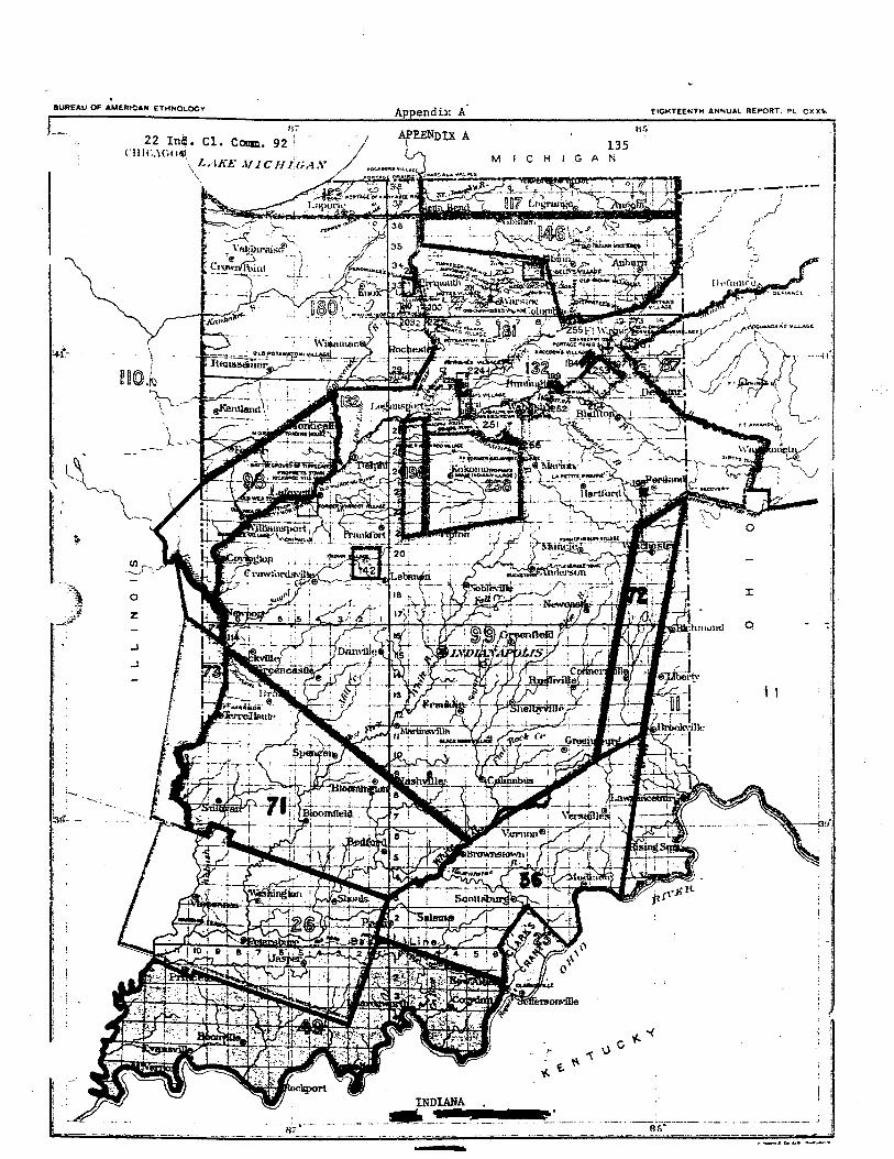
BUREAU W AMERICAN ETHIIOLDCI
t Appendix A- EIGHTEEHTU ANCUAL REPORT. -L C X X ~