(213) 387-6528 phone Sierra Club comments1 Suite 320 Los ...
80
1 2 3 4 043-SierraClub_081209 Sierra Club comments1 3435 Wilshire Boulevard Suite 320 Los Angeles, CA 90010-1904 August 12, 2009 U. S. Army Corps of Engineers Ventura Field Office Attn: Aaron O. Allen 2131 Alessandro Drive, Suite 110 Ventura, CA 93001 California Department of Fish and Game Newhall Ranch EIS/EIR Project Comments c/o Dennis Bedford 4949 Viewridge Avenue San Diego, CA 92123 TITLE Newhall Ranch Resource Management and Development Plan (RMDP) And the Spineflower Conservation Plan (SCP) COMMENTS As both residents of the Santa Clarita Valley and members of the Sierra Club, we are extremely concerned about the ramifications of the “Newhall Ranch Resource Management and Development Plan.” The proposed build-out of 21,000 homes along the Santa Clara River near Piru, California is absolutely shocking when one considers the economic, environmental, and societal pressures of the times. The same also applies to the “Spineflower Conservation Plan;” all of which applies to the “Newhall Ranch Specific Plan” area and the proposed development. The proposed Newhall Ranch project will substantially degrade the quality of the environment in northern Los Angeles County. It will substantially reduce the habitat of numerous plant and wildlife species. It will also threaten and/or eliminate species from the area due to loss of habitat. This is because the proposed development will drastically interfere with the movement of wildlife species within the Santa Susana watershed. The proposed development area is part of a major wildlife linkage corridor. A recent trend of development corporations consists of attempts (and many have been successful) to redefine southern California by creating new cities and large developments in the midst of our most beautiful remaining open spaces. The proposed Newhall Ranch development area is one of these open spaces. It is situated between the Santa Clarita Valley (Los Angeles County) and Ventura County. If the proposed Newhall Ranch development plan succeeds, our part of the state will lose much of its natural charm and beauty, qualities that continue to attract tourists and the citizens of our own country. (213) 387-6528 phone (213) 387-5383 fax www.sierraclub.org
Transcript of (213) 387-6528 phone Sierra Club comments1 Suite 320 Los ...

1
2
3
4
043-SierraClub_081209
Sierra Club comments1 3435 Wilshire Boulevard
Suite 320 Los Angeles, CA 90010-1904
August 12, 2009 U. S. Army Corps of Engineers Ventura Field Office Attn: Aaron O. Allen 2131 Alessandro Drive, Suite 110 Ventura, CA 93001 California Department of Fish and Game Newhall Ranch EIS/EIR Project Comments c/o Dennis Bedford 4949 Viewridge Avenue San Diego, CA 92123
TITLE Newhall Ranch Resource Management and Development Plan (RMDP)
And the Spineflower Conservation Plan (SCP)
COMMENTS
As both residents of the Santa Clarita Valley and members of the Sierra Club, we are extremely concerned about the ramifications of the “Newhall Ranch Resource Management and Development Plan.” The proposed build-out of 21,000 homes along the Santa Clara River near Piru, California is absolutely shocking when one considers the economic, environmental, and societal pressures of the times. The same also applies to the “Spineflower Conservation Plan;” all of which applies to the “Newhall Ranch Specific Plan” area and the proposed development. The proposed Newhall Ranch project will substantially degrade the quality of the environment in northern Los Angeles County. It will substantially reduce the habitat of numerous plant and wildlife species. It will also threaten and/or eliminate species from the area due to loss of habitat. This is because the proposed development will drastically interfere with the movement of wildlife species within the Santa Susana watershed. The proposed development area is part of a major wildlife linkage corridor. A recent trend of development corporations consists of attempts (and many have been successful) to redefine southern California by creating new cities and large developments in the midst of our most beautiful remaining open spaces. The proposed Newhall Ranch development area is one of these open spaces. It is situated between the Santa Clarita Valley (Los Angeles County) and Ventura County. If the proposed Newhall Ranch development plan succeeds, our part of the state will lose much of its natural charm and beauty, qualities that continue to attract tourists and the citizens of our own country.
(213) 387-6528 phone (213) 387-5383 fax www.sierraclub.org

8
7
6
5
4
043
Sierra Club comments2
When one speaks to members of the general public about this development plan, residents are appalled at the lack of foresight and feel that this project should have died a natural death years ago when it was first suggested and met with immediate dislike. The long life of the project to date indicates the project’s weakness and the public’s general disapproval. Unfortunately, it persists. Therefore, we now submit new commentsconcerning the project. • Water Resources
Water Resources Section 4.3 In 2003 the Sierra Club, along with two other organizations, signed a settlement agreement to abandon its appeal of the approval of the Newhall Ranch Specific Plan1. However, the terms of this agreement specifically stated2 that:
“This settlement is a compromise of disputed claims, and neither this settlement nor any term thereof shall be construed as any type of admission on the part of any party to this settlement.”
The Sierra Club had and continues to have serious concerns over the ability of local water agencies to serve this project in addition to the approximately 30,000 units already approved but unbuilt in the Santa Clarita Valley. Compliance with the Settlement Agreement Both the Conditions of Approval of the Specific Plan3 and the Settlement Agreement require the production of various reports and data. Since this information is vital to a discussion of whether sufficient water supplies exist to provide for these projects, this information should be included in the EIR/EIS for review. Information that is required but not found in this document includes: • Annual Reports of Water in the Semitropic Ground Water Banking and Storage
Facility The Plan depends on this water for supplies in future drought years. It is logical for the project proponent to provide documents proving the availability of this water. • Water Quality Reports for Alluvial Wells used to serve the project. The Specific Plan requires agricultural wells used to serve the project to meet drinking water standards. The Settlement Agreement requires that those reports be provided to the petitioners. A water quality report appears in the appendix but most of the data is from 2004 “pending” wells. The only recent report (2008) is for Well E-15. E-15 appears to serve 1 Signed Agreement attached 2 Settlement Agreement Pg. 2, Purpose - Section 2 3 EIR/EIS p. 4.3-4

15
14
13
12
11
10
9
8
Sierra Club comments3
current customers in the Valencia Commerce Center. Please provide the required water quality reports for the wells that will serve this project. Also, please indicate which wells will serve the project. • The amount of water that will be provided from fallowing of farmland. This information should indicate which crops will be fallowed from which areas and how much water will be available from each of those crops specific to the area in which they were planted. Agricultural return water should be deducted from the total amount, as no return will occur once the area is urbanized. Ammonium Perchlorate Pollution In 1997 ammonium perchlorate contamination was discovered in the Saugus and alluvial aquifers of the Santa Clarita Valley. Since that time, six municipal drinking water wells have been closed down4, some of them permanently. Since the Saugus Aquifer is the drinking water supply long depended on in Santa Clarita as the emergency drought back up as well as a major source of daily supply, its contamination has been a blow to the reliability of local water supplies. Ammonium perchlorate adversely affects thyroid gland function, causing hypothyroidism. Reduced thyroid function in pregnant women may cause retardation in the fetus. In 2000 the Castaic Lake Water Agency (CLWA) and other local purveyors filed litigation against the Whittiker Bermite project to force them to clean up the water supply or pay for the clean up. Several years later a settlement agreement was reached that provided for funding to clean up two of the Saugus wells polluted by this contamination and one of the Alluvial wells. In 2004, the Sierra Club and Friends of the Santa Clara River won an appellate court decision requiring disclosure of the ammonium perchlorate pollution and requiring a time line for the clean up in CLWA’s Urban Water Management Plan5. Since then the Sierra Club has remained concerned that the facilities to provide this clean up continue to be delayed while thousands of additional housing units are approved. These facilities are still not operating as of the date of this letter. In addition to these delays, it was previously represented that the two wells designated to provide “capture” and clean up of the ammonium perchlorate (Saugus Well 1 and 2) would be returned to their previous production levels. However, CLWA found that production was significantly reduced by 50% in those two wells by the clean up process.6
4 Stadium Well, Valencia Well Q2, Valencia Well 157, Saugus 1 and 2, NCWD 11 5 Friends of the Santa Clara River v. Castaic Lake Water Agency et al., 2004, CalAp5 6 See attached chart of Saugus Well Production Chart

21
19
20
18
17
16
Sierra Club comments4
Due to these significant delays and reductions in water supply, the Angeles Chapter of the Sierra Club passed a resolution7 calling for the halt to housing approvals until the ammonium perchlorate treatment facilities are functioning to provide the community with its Transfer of Nickels Water for Newhall Ranch The EIR/EIS claims that Environmental Documents exist for this water transfer project and references a certified EIR from Kern County in its appendices8. Upon further review of this certified document, it is evident that this only refers to a Kern River Restoration Project, not a transfer of water to the Newhall Ranch project. Therefore, it appears that no environmental documentation has been produced, reviewed or certified for the Newhall Ranch water transfer. This fact should be disclosed in the EIS and the required studies should be conducted. Although Newhall Land and Farming has purchased an option for water from the Nickels family in Kern County, that water is only delivered to the Tubman turnout in Kern County.9 The Department of Water Resources does not allow “wheeling” of private water in the state water aqueduct, a public facility. The EIR/EIS should discuss how this water would be delivered to Valencia Water Co. It is a well-know fact that Valencia Water Co. is wholly owned by Newhall Land and Farming, the project proponent. Additionally, Valencia Water Co. has managed the contracts for the yearly Water Supply Report since their inception in 1999, directing and paying the consultants. That fact creates a conflict of interest. We believe an independent source should provide the water supply information for this company’s projects in order to ensure their accuracy. All agencies should carefully review the water supply information for errors or omissions. The Sierra Club believes private ownership of water resources may create serious problems for our society. The potential unwanted outcome may lead to poor planning, direction of water resources to only certain projects or water hoarding that impedes communities in their efforts to fairly distribute this precious resource. Such serious ethical issues should be held in mind as this project is reviewed and addressed by the decision makers. • Agricultural Production in California
The drought in the San Joaquin Valley and elsewhere has caused great losses of agricultural production in the state. California, the number one state in agricultural production, has started to lose billions of dollars of income a nnually from this sector of the economy. Nevertheless, agricultural land, both actual and potential, bordering the 7 Resolution approved 7-23-06, attached 8 The EIS directs the reader to the Nickels Water Appendix in the Landmark EIR 9 Landmark Village DEIR, Volume VI, Appendix 4.10f, Nickels water contracts, Pages 2 and 5 of Contract between Nickels and NLF pdf pages 121,124

27
26
25
24
23
22
21
Sierra Club comments5
Santa Clara River at the location of the project stands to be developed and placed under buildings, concrete, and asphalt. The project may even end up polluting river water and harming some of the states most valuable farmlands located down river from the project all the way to the Oxnard Plains and Ventura Valley. The almost continuous rich belt of agriculture serviced by the groundwater and rich soils of the Santa Clara River and its bordering lands have existed for decades from the Oxnard to Piru and beyond almost to U.S. Highway 5. Placing a town on the river in the midst of the agricultural belt will not be good for agricultural production or the scenic quality of California. • Infrastructure
Since year 2007, California has not needed 21,000 new homes especially in newer towns such as Santa Clarita. If anything, people should be moving into homes in more urban areas where there are more jobs, public transportation, etc. Foreclosures, bankruptcies, and losses of adequately paying jobs have resulted in a surplus of unoccupied homes; including new homes. Many new homes and small businesses in the Santa Clarita Valley remain uncompleted and/or empty because of the recession, a sick economy, state and federal deficits, and a long-term lack of demand for more new homes. California has the worse debt and economy of any state in the country. Citizens have lost much income and savings over the last year and the project may soon be asking them to spend and buy in an isolated, remote area. Due to the troubling economic times, many schools in the Santa Clarita Valley have seen a huge drop in enrollment and thus have lost state A.D.A. monies in addition to the extremely detrimental budget cuts coming from both the state and federal government. This has meant that local school districts have had to halt the building of new schools, increase class-sizes, and have either pink-slipped and or let-go of qualified teachers. How would a new development of 21,000 homes make any of these problems better? • Biology
Newhall Ranch is a major wildlife linkage corridor and the animals that exist on or utilize the property will be losing their habitat and foraging grounds. Native habitat will be destroyed and many of the few pockets of open space will be just that, “islands” within the development. How will this be of any use to the animal species that frequent this wildlife corridor? This makes no sense. Animals that transition through the area (looking for food and water, etc.) will have nowhere to go. Communities are scattered around so as to create obstructions to any wildlife corridors. Why is this? The proposed project would encroach on the floodplain of the last major wild river in Southern California and would therefore permanently transform the habitat of numerous endangered species. A notable example is the California condor (the United States most famous endangered bird species) which has been seen feeding on the proposed development site. If allowed to be built, this project would sever the natural transition

32
31
30
29
28
Sierra Club comments6
zones in the area prohibiting animals from crossing through necessary wildlife corridors. It would also destroy portions of an irreplaceable eco-region. The upper stretch of the Santa Clara River is part of one of five areas in the world with a Mediterranean-type habitat. It includes more imperiled species than any other region in the continental United States and as such is biodiversity hotspot. This 12,000 acre project will irrevocably transform the habitat of many endangered species into row after row of urban sprawl. There are numerous significant impacts to mountain lions, burrowing owls, arroyo toads etc…(30 plus rare/endangered species who in many cases are already declining in numbers). However, the impacts always seem to be mitigated to non-significant levels by such things as: monitoring of property by a qualified biologist, relocation of animals (arroyo toad), and limitations on human and pet access. We ask who the biologist would be? How often would the biologist be checking the property? Is he/she going to walk in front of the bulldozers to see if arroyo toads are about to be squished? Where would these animals be relocated to? How would relocating an animal(s) effect the biology of the relocation area and its native species? How can the limiting of human and pet access be enforced? In other words, what the EIR promises in mitigations for endangered or rare species is basically not possible. One such example of an animal species in peril is that of the Black-tailed jackrabbit:
Years ago, one of our Sierra Club members, Don Mullally, was one of a group of people allowed on the land of the proposed project by Newhall Land and Farm to examine natural features and conditions. He was surprised to discover jackrabbits on land proposed for the housing project.
Apparently the hares existed on the part of the project located near the river due to much relatively level and gently sloping open land supporting brush, grasses, and herbs. Steep slopes of the Santa Susana Mountains with woodlands located a short distance south of the project are not inhabited by jackrabbits. In fact, jackrabbits have never been observed by myself or associates on the steep slopes and their canyons in the middle and upper parts of the Santa Susana Mountain Range of Los Angeles County. Similarly, equivalent parts of the Santa Monica Mountains, San Gabriel Mountains, and Verdugo Mountains are also devoid of jackrabbits. Tongues of large valleys such as the San Fernando Valley extend into foothill canyons were formerly habitat for jackrabbits. However, for the most part those have been developed, and jackrabbits are now absent from them. The Newhall project bordering the river is an exception because the level and gently sloping land has yet to be developed.
Jackrabbits were formerly common in all the large valleys of southern California. Don Mullally knows this because he observed the animals. Unfortunately, the California Department of Fish and Game, the Army Corps of Engineers, and the

37
36
35
34
33
32
Sierra Club comments7
United States Fish and Wildlife Service, and the systems of state and county parks stood by doing nothing while the jackrabbits went extinct in the Santa Clarita Valley, San Fernando Valley, Los Angeles Basin, and the San Gabriel Valley. A few may continue to survive in the low hills and canyons on the northern side of the Simi Valley and in undeveloped locations in valleys east of San Gabriel Valley. The once hare-infested area of Cucamonga also seems to now be devoid of jackrabbits.
Presently the question is – What will be the fate of the jackrabbits on and near the Newhall Ranch project? How far will the people of the Los Angeles greater area need to travel to see a common jackrabbit? Incidentally, the collapse of the noted populations of jackrabbits led to the disappearance of Golden eagles in the Los Angeles Basin and greater area.
As mentioned above, the proposed project would result in the loss of suitable foraging habitat for a variety of species (including mammals such as mountain lions/mule deer, birds such as condors/raptors, reptiles, amphibians, etc.), and the direct loss of special status plant species. It is easy to see that the impacts on animal and plant species will be drastic. However, the EIR is very inconsistent when describing potential mitigation measures and other solutions to the problem. When mitigation measures are mentioned they are weak or vague. Case in point, the EIR states repeatedly that the effects of development will be significant and ultimately unavoidable. One such mitigation is referred to in SP 4.6-17 where it is stated that there will be “limitations on human and pet access.” How can this be monitored? Who will be checking on secondary impacts: the use of bird-feeders (which attract non-native species), domestic cats (which kill 1,000,000 birds a day), human disturbance (people off-trail), trash build-up, etc. (American Bird Conservancy). In other Newhall Land and Farming projects that currently exist in the Santa Clarita Valley rodent bait is placed along trails. This is of course very harmful to the environment. Rodents that eat the bait eventually die and are eaten by scavenging birds, coyotes, bobcats, etc. and then these animals are poisoned. Also, non-rodents eat the bait as well. Along Bridgeport, American Coots have been singled out and eliminated because they are a “disturbance to the community.” When birds looking for a place to water and feed are not permitted to exist in open space how can anyone reading this EIR believe that the mitigations stated would or could ever be enforced. Stating that the impacts to wildlife are unavoidable is not acceptable and the mitigation measures suggested are not enough. • Sprawl Development

42
41
40
39
38
Sierra Club comments8
The Newhall Ranch Project is a huge leapfrog development. Once completed it will be an urban town located in a riverside agricultural belt. Several miles to the east of the project the historic and famous Rancho Camulos, a Mexican land grant of the 1840s, once thrived and subsisted on various types of agriculture. Its grapes, wines and brandy were avidly sought by travelers; particularly during the years of the Gold Rush. If the proposed project succeeds, other developments will in time occur on vacant land located up and down the sides of the river. Agriculture will be phased out. • Traffic
People inhabiting the town potentially created by Newhall Ranch Development Plan will, for the most part, probably have employment at well paying jobs in distant cities. Each day many thousands of workers and their automobiles will be leaving or returning to the town from these cities. This proposed development will bring 357,000 additional car trips a day onto our freeways and surface streets and increase air pollution which is already some of the worst in the nation. Despite the claims of the Newhall Ranch developers to the contrary, most people who buy homes in the proposed development will simply not be able to work and live in the same community. Jobs in the service sector of local small towns will not yield sufficiently high salaries and wages to meet monthly house payments and other necessary costs. All highways leading to big cities offering high wages will become more crowded with automobiles than they are at present. Traffic congestion was much worse before the poor economy and recession. Traffic on surface streets and along Interstate 5, Highway 14, and along the 126 could become literally unbearable. A new town is not the answer to the needs and wishes of the people living in Santa Clarita Valley and neighboring areas. Traffic congestion is a major concern of the residents of the surrounding areas.
EIR Section 4.8 Traffic The following DEIR quote is meant to show that trips going outside the project will be reduced. “4.8.6.2 Trip Distribution Future travel patterns in relation to the Project are a function of the Project land uses as described above for each of the Project alternatives, and the land uses surrounding the Project site, particularly centers of employment or commercial activity. This geographic context can be seen from Figure 4.8-11, which shows the major activity centers surrounding the Project area. In addition to the VCC, which is estimated to provide approximately 30,500 jobs upon build-out, making the VCC a major source of employment for Specific Plan and other area residents, just east of I-5 is the Valencia Industrial Center and the Valencia Corporate Center, which, together, are expected to provide approximately 27,500 jobs. The Six Flags Magic Mountain Amusement Park provides around 3,360 full-time and part-time jobs. Other centers in the vicinity of the Project site include California Institute of the Arts and the Valencia Town Center, the latter providing a major regional shopping center for the Valley.”

47
46
45
44
43
Sierra Club comments9
The project proponent has been claiming for at least 15 years now that the project will reduce traffic because of local trips to local businesses replacing trips out of the area. This is just balderdash. The existing businesses and job distribution is such that lower wage jobs are local and better jobs are mostly out of the area. So low wage earners must commute in and higher wage earners must commute out. So we have more and longer trips creating more v/c > 1 situations especially on I5. These false assumptions are placed into the traffic model and they soften the intersections with LOS = F. Another reason to be wary of the traffic model is that the project proponent basically built it themselves and can control what data goes in and what stays out. On p.8-42 is the following curious statement: “As shown on Table 4.8-7, Alternative 2 Significantly Impacted Roadway Segments, although this alternative would result in significant impacts at multiple off-site locations, no on-site roadway segments were identified as significantly impacted under this alternative. Therefore, the on-site transportation network developed under Alternative 2 would provide adequate roadway capacity to accommodate the traffic generated under this alternative, and the RMDP component of Alternative 2 would not result in significant indirect on-site impacts.” Are we therefore to conclude that cumulative negative impacts outside the project area are OK? Knowing the huge impact on I5 caused by this project, mitigations are put in place. These consist mainly of HOV and truck lanes. Even with these improvements, traffic on the I5 will achieve more v/c > 1 situations. To remove these traffic restrictions, the best project alternate is to reduce density.
We also feel that Newhall Land must fund some of the improvements to the freeways that CalTrans would otherwise have to make since this proposed development will have such a huge impact on freeway traffic. These huge development projects should be paying for themselves, not putting it all on the tax payers.
• Geology and Paleontology
The proposed development is situated in an area prone to extreme tectonic activity (at the same rate of uplift as that which created the Himalaya Mountains). The site is bordered on the south by layers of rock that are actually upside down due to the intense pressure and movement in that area. Directly south of the project is an area prone to landslides. Additionally, the proposed site is bordered by not one, but two, major earthquake faults including the San Cayetano Holser fault system to the north and the Santa Susana fault system to the south. Much of the area of the proposed development consists of ductile (i.e., easily deformed) siltstone and is sandwiched between the aforementioned two
53
52
51
50
49
48
47
Sierra Club comments10
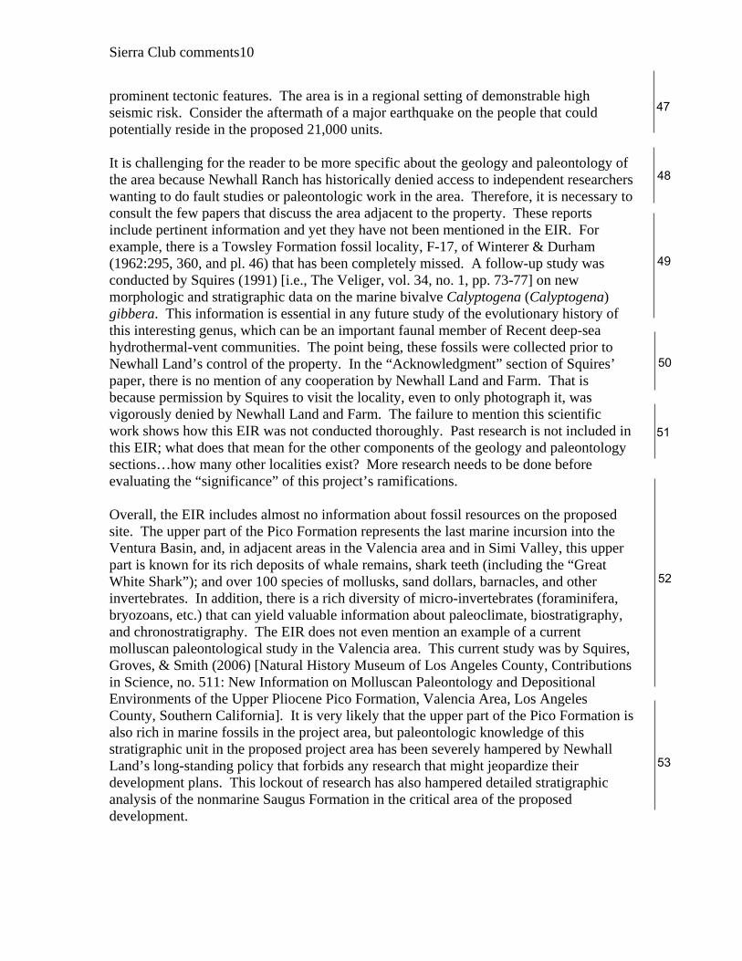
prominent tectonic features. The area is in a regional setting of demonstrable high seismic risk. Consider the aftermath of a major earthquake on the people that could potentially reside in the proposed 21,000 units. It is challenging for the reader to be more specific about the geology and paleontology of the area because Newhall Ranch has historically denied access to independent researchers wanting to do fault studies or paleontologic work in the area. Therefore, it is necessary to consult the few papers that discuss the area adjacent to the property. These reports include pertinent information and yet they have not been mentioned in the EIR. For example, there is a Towsley Formation fossil locality, F-17, of Winterer & Durham (1962:295, 360, and pl. 46) that has been completely missed. A follow-up study was conducted by Squires (1991) [i.e., The Veliger, vol. 34, no. 1, pp. 73-77] on new morphologic and stratigraphic data on the marine bivalve Calyptogena (Calyptogena) gibbera. This information is essential in any future study of the evolutionary history of this interesting genus, which can be an important faunal member of Recent deep-sea hydrothermal-vent communities. The point being, these fossils were collected prior to Newhall Land’s control of the property. In the “Acknowledgment” section of Squires’ paper, there is no mention of any cooperation by Newhall Land and Farm. That is because permission by Squires to visit the locality, even to only photograph it, was vigorously denied by Newhall Land and Farm. The failure to mention this scientific work shows how this EIR was not conducted thoroughly. Past research is not included in this EIR; what does that mean for the other components of the geology and paleontology sections…how many other localities exist? More research needs to be done before evaluating the “significance” of this project’s ramifications. Overall, the EIR includes almost no information about fossil resources on the proposed site. The upper part of the Pico Formation represents the last marine incursion into the Ventura Basin, and, in adjacent areas in the Valencia area and in Simi Valley, this upper part is known for its rich deposits of whale remains, shark teeth (including the “Great White Shark”); and over 100 species of mollusks, sand dollars, barnacles, and other invertebrates. In addition, there is a rich diversity of micro-invertebrates (foraminifera, bryozoans, etc.) that can yield valuable information about paleoclimate, biostratigraphy, and chronostratigraphy. The EIR does not even mention an example of a current molluscan paleontological study in the Valencia area. This current study was by Squires, Groves, & Smith (2006) [Natural History Museum of Los Angeles County, Contributions in Science, no. 511: New Information on Molluscan Paleontology and Depositional Environments of the Upper Pliocene Pico Formation, Valencia Area, Los Angeles County, Southern California]. It is very likely that the upper part of the Pico Formation is also rich in marine fossils in the project area, but paleontologic knowledge of this stratigraphic unit in the proposed project area has been severely hampered by Newhall Land’s long-standing policy that forbids any research that might jeopardize their development plans. This lockout of research has also hampered detailed stratigraphic analysis of the nonmarine Saugus Formation in the critical area of the proposed development.

59
58
57
56
55
54
Sierra Club comments11
Another major concern is the misused stratigraphic nomenclature. The “strata vs. formations” terminology is not accurate and misleading (e.g., “5 distinct strata” should read “five distinct formations”). The term “intermingle” is not used by professional geologists. The proper term is “interfinger.” Also, cultural features (e.g., names of canyons) are not labeled, and the Google Earth features are too faint. The geologic map is nearly impossible for the reader to use because it does not show elevation contours nor section lines. The preparator(s) of the maps evidently were not aware that topographic map information can now be overlaid on the Google Earth features. The term “Sawtooth Ridge” is used as a label, but this is an unofficial in-house term. The Pico formation is misidentified as being lagoonal and the non-marine Saugus formation is deemed marine. That the magnetostratigraphy of the area was not mentioned is an unbelievable oversight, especially given the fact that Newhall Land and Farm allowed Levi and Yates (1993) [Tectonics, vol. 12, no. 3, pp. 688-702] to publish their very useful and important information dealing with the paleomagnetic signature of the Saugus Formation rocks in the vicinity of “Sawtooth Ridge.” This paleomagnetic analysis did not involve any fault studies nor any paleontological studies. Their type of paleo-magnetic work needs to be extended into the underlying upper Pico Formation rocks, thereby allowing better geologic age refinement of the Pico Formation. There is also a potential for finding volcanic ash layers in the area, and radiometric age dating of these layers would greatly refined our knowledge of the initiation of the uplift that formed the Santa Susana Mountains. On the northeast flank of the Newhall-Potrero Anticline next to the Santa Clara River (see Dibblee’s 1993 geologic map), there appears to be a continuous stratigraphic section between the shallow-marine (fossiliferous?) upper Pico Formation and the nonmarine Saugus Formation. A portion of this outcrop area must be left intact for future paleomagnetic studies by geologists. As their scientific tools improve with time, stratigraphic sections like the one proposed will be invaluable. This is Newhall Land’s opportunity to differ from the typical developer. They can leave a legacy that demonstrates they are a progressive corporation, much like the Tejon Ranch owners of the newly approved Tejon Ranch projects. The paleontologic part of the EIR is riddled with redundant and generalized non-informative statements. Details are sorely lacking, and these details are definitely needed before the merits of the EIR can be determined by the readers of this document. It is extremely self-serving to mention the rich diversity of fossils in the various stratigraphic units and then to provide no details because independent researchers have been denied access to the area for decades. The proposed project is excessively massive, and the impact on the geological and paleontological resources are permanent and unforgiving. Every effort must be made to preserve as much pristine area as possible. Where will the fossils that are found during grading be stored? It is stated in the EIR that fossils can be stored at the Natural History Museum of Los Angeles County. The

64
63
62
61
60
59
Sierra Club comments12
developer should pay for the storage space and storage cabinets, or else do not destroy the original localities. Has the Natural History Museum of Los Angeles County been contacted about receiving the material? Do they, in fact, have the space? There needs to be a guarantee that the paleo-monitors have a degree in geology and have had a course in paleontology/paleontology lab whereby they have learned to recognize invertebrate fossils. Hiring untrained paleo-monitors who have never had a course in the identification of invertebrate fossils would be unacceptable. • Air Quality
Another serious concern with the EIR is the substantial effect the proposed development would have on the worsening air quality that we have in our area. It is obvious that the cumulative air pollutant emissions in the area would contribute to the degradation of local and regional air quality. The Santa Clarita Valley already has some of the worst air quality in the nation. Katherine Squires, a local teacher, sees the effects of poor air quality on the children in her Canyon Country classroom. Each year she sees more and more students who suffer from asthma. The SCV already exceeds Federal air pollution standards for particulate matter generated from dust and diesel pollution. Additionally, according to AQMD guidelines no residences should be built with 150’ feet from the roadway. This means no development should occur directly on Highway 126 which is a major transportation corridor for truck and vehicle traffic. Also, where development begins (150 feet from roadway) there should be berms and landscaping to reduce pollution. In addition, there would be long term effects resulting from the additional traffic on our local roads and freeways. Climatologists agree that greenhouse gases are causing global warming and even the Supreme Court, in its decision several months ago, said that EPA must address Carbon Dioxide as a pollutant. These two facts alone suggest that further discussion of global warming should appear in this EIR. The project should not be approved without making public transportation available to its future residents.
EIR Section 4.7 Air Quality Construction emissions have a finite lifetime – operational emissions will just keep increasing with significant unavoidable impacts. A doubling of truck traffic on I5 by 2020 will make things even worse. The DEIR does exhaustive analysis of the many impacts of emissions on air quality. The bottom line is summed up by the following quotes from the DEIR. “4.7.12 SIGNIFICANT UNAVOIDABLE IMPACTS Mitigation measures are recommended and/or have been incorporated to reduce the magnitude of construction and operational emissions to the extent feasible. No feasible

67
66
65
64
• Green Building Standards
The Sierra Club requests that green building standards be included as conditions of any approval that might be considered. • Parks, Recreation and Trails
EIR Section 4.16 Parks, Recreation and Trails
If we take away the high country area, the project planned parklands are exactly the Quimby law minimum of 3 acres per 1000 people. The adjacent city of Santa Clarita has a standard of 5 acres of parkland per 1000 people. This should be the indicator of how much parkland the project should generate. A look at the largest planned community park shows that it is covered by power transmission lines and sits on a steep slope. Some community park! Furthermore the open area on the northwest part of the project is merely the placeholder for another power line.
Sierra Club comments13
mitigation exists, however, that would reduce these emissions to below the SCAQMD's daily mass emissions thresholds. Therefore, the Project-specific construction and operational emissions would be significant and unavoidable under Significance Criterion AQ-2 for VOC, NOx, CO, PM10, and PM2.5.” “The LST analysis shows that maximum 24-hour PM10 and PM2.5 concentrations and the maximum one hour NO2 concentrations would exceed the localized significance thresholds established by the SCAQMD during each of the modeled development years. However, the one-hour CO and eight-hour CO concentrations would not exceed their respective localized significance thresholds during any of the modeled development years. The estimated PM10 emissions already assume compliance with the requirements of SCAQMD Rule 403, which contain best available control measures for controlling fugitive dust from construction sites. No feasible mitigation measures exist that would provide a sufficient reduction in PM10, PM2.5, and NOX emissions to meet the respective LST thresholds. Under Significance Criterion AQ-2 and AQ-4, the PM10, PM2.5, and NOX impacts would be significant and unavoidable.” A huge number of mitigations are developed to lessen these impacts but they do not come anywhere near meeting SCAQMD thresholds. All the tables show that the impacts FAR exceed the thresholds on all alternatives > 1. Because the problem is mobile sources, eliminating noxious emissions from them would be the way to go. However this project does not control the mobile sources. The best the project can do is to eliminate as many mobile sources as it can. It would do this by significantly reducing the project density. The detailed analysis shows that this would be the best alternative.

72
71
70
69
68
Sierra Club comments14
A way to create more park space is to remove some of the development south of the river on the east end of the project and convert it to parkland. This would also eliminate the concomitant geological and water hazards which would be produced by development in that area. After the Northridge Earthquake the State geologists took aerial photos of the Santa Susanas which revealed a plethora of land slides. The geologists concluded simply, “Don’t build houses in the Santa Susana Mountains.” Whatever trails are built (a number are planned) should not negatively impact the river, say by requiring more bank stabilization and/or removing the appropriate buffer areas.
• Protecting Spineflowers and Sage Scrub Species of Spineflower typically exist and colonize hot, dry, well drained open land supporting minimal amounts of competing vegetation. To more or less preserve San Fernando Valley Spineflowers on the project site, an adequate acreage of such land on the site of the project needs to be reserved for the plant. Reserved land should not be altered by cultivating, bulldozing, irrigation, vegetation clearance, planting of any vegetation, reduction of sunlight or other disturbance of the soil and natural environment. Highest priority should be given to sites already colonized by Spineflower. Such areas should be fenced-off to prevent public access and usage. An employee should be assigned the tasks of monitoring the plants and maintaining their natural environment. After the town is situated alien plants and suffocating weeds could become a problem if not removed. The “Jepson Manual of Higher Plants of California” edited by Hickman, and “A California Flora” by Munz state that Chorizanthe parryi Wats exists in dry sandy places in Coastal Sage Scrub. Our members have observed both of these environmental aspects on the site of the planned community. Loose, sandy soil is common near the river and in shallow ravines leading to the river. Coastal Sage Scrub represented by stands of California sagebrush exist outside the Riparian Zone of the river, on the banks of shallow, sandy ravines, and on hillsides. Hillsides frequently have firm surfaced soil rather than loose sand. Firm soils tend to shed rather than absorb rainfall. Firmness is due to the presence of much clay.
CONCLUSION
The Sierra Club is concerned that if the proposed Newhall Ranch Resource Management and Development Plan succeeds with county government, the entire region between Santa Clarita (Los Angeles County) and Ventura County along much of Highway 126 will become nearly continuous urban and suburban development. The water situation could become unbelievably serious. Furthermore, many of the values of southern California will be forever lost (the last wild river, scenic open spaces, habitat for wildlife etc.). The Newhall Ranch Resource Management and Development Plan could set in place a dangerous precedent. The National Sierra Club has a policy against urban sprawl

75
74
73
Sierra Club comments15
projects such as this one due to their unsustainability and wasteful use of resources. It is requested that mitigation (including green building standards, a corridor for wildlife movement and public transportation for commuters that will live in the project) be provided that would reduce the disclosed impacts. Unfortunately, the Newhall Ranch Company has a very poor track record regarding such mitigations. As of this point in time, 59 mitigation measures have been previously discussed and approved for other projects they have created but have yet to be acted-on. This is especially disconcerting considering the ramifications of this development and the necessity for many mitigations. At this time the Sierra Club favors alternative 7. We want to ensure reduced density and to be guaranteed that our environmental concerns (lack of water and infrastructure, traffic, air quality, wildlife corridors, non-channelization of the river, etc.) are sufficiently addressed. Sincerely, Katherine Squires Conservation Chair, Santa Clarita Group The Sierra Club hereby includes by reference all comments and concerns by other environmental organizations. several researchers contributed to this document including biologist Don Mullally and Dr. Richard Squires
Attachments:
1.Settlement Agreement Between Respondents, Newhall Land and Farming and County of Los Angeles and Petitioners, Sierra Club et al., 2003
2.Saugus Well Production Chart from information provided by Castaic Lake Water Agency
3.Sierra Club Resolution 7-23-06

-----Original Message-----From: Katherine Squires [mailto:[email protected]] Sent: Monday, August 24, 2009 5:27 PM To: Allen, Aaron O SPL; [email protected] Subject: Sierra Club EIR Comments--Newhall Ranch
Hello,
The attached files include the Sierra Club's EIR comment letter for the proposed Newhall Ranch project along with several additional attachments.
Thank you,
Katherine Squires Conservation Chair Santa Clarita Sierra Club
file:///X|/Carpenter/EIS-EIR%20RTC/Comments%20to%20Corps/AOA%20082409/SierraClub_082409_Emailcover.txt [8/27/2009 4:56:13 PM]

ORIGINALORIGINAL ININ THETHE
CourtCourt ofofAppealAppeal ofof thethe StateState ofof CaliforniaCalifornia
ININ ANDAND FORFOR THETHE
FifthFifth AppellateAppellate DistrictDistrict
FiFTFJFT COURTCOURT OFOF APPEALAPPEAL API"ELLATEHH A~~LLA~E,DISTRICTDISTRICT
r;;nn rei]1'- u ~, ~ [[JJI, U lb, 1[:: 0
AP,RAP,R -- 11 20042004
FRAUENHOLTZ KAYKAY fRAUENHOlTZ MINrSTRATOR .~~----:-_rRATO:."""
CLERK/ADY__-ysy Cl"~sBB
Deputy
SIERRASIERRA CLUBCLUB etet aI., aL, PlaintiffsPlaintiffs andand Appellants,Appellants,
v,v. COUNTYCOUNTY OFOF LOSLOS ANGELESANGELES etet aI.,aI.,
DefendantsDefendants andand Respondents,Respondents, THETHE NEWHALLNEWHALL LANDLAND && FARMINGFARMING COMPANYCOMPANY etet aI.,aI.,
RealReal PartiesParties inin InterestInterest andand Respondents.Respondents. F044638F044638 KernKern CountyCounty No.No. 239324239324
BYBY THETHE COURT:COURT:
PursuantPursuant to to writtenwritten stipulationstipulation of of the the parties parties hereto,hereto, IT IT IS IS HEREBYHEREBY ORDEREDORDERED thatthat thethe appealappeal inin thethe above-entitledabove-entitled causecause is is dismissed, dismissed.
~~ 1.1. EachEach partyparty to to bear bear hishis oror herher ownown costs.costs. L-~ 2. 2. TheThe remittitur remittitur shall shall issueissue forthwith. forthwith.
3. 3, NoneNone of of thethe above.above.

ORIGINALORIGINAL
5TH5TH CIVILCIVIL NO.NO. F044638F044638
ININ THETHE COURTCOURT OFOF APPEALAPPEAL OFOF THETHE STATESTATE OFOF CALIFORNIACALIFORNIA FIFTHFIFTH APPELLATEAPPELLATE DISTRICTDISTRICT
UnitedUnited WaterWater ConservationConservation District,District, )) ))
Petitioner,Petitioner, )) v.v. )) COURTCOURT OFOf APPEALAPPEAL
) FIFTHfIFTH APPELLATEAPPELLATE n
DISTRICTDISTRICT ) CountyCounty ofofLosLos Angeles,Angeles, etet at., al., )) [F rrr:LLlE[] lE IDl
Respondents.Respondents. ))-----------------) ------------~--------------) MRI\PR -- 11 20042004
))TheThe NewhallNewhall LandLand andand FarmingFarming Company,Company, etet al., aI., KAYKAY FRAUENHOLTZFRAUENHOLTZ)) CLERK/ADMINISTRATORCLERK/ADMINISTRATORRealReal PartiesParties inin Interest.Interest. )) 8y__8y__ ))
-----------------------------) ----------------) DeputyDeputy
Related )AndAnd Related Cases.Cases. )))
AppealAppeal FromFrom TheThe JudgmentJudgment ofof TheThe KernKern CountyCounty SuperiorSuperior COUliCOUli
TheThe HonorableHonorable RogerRoger D.D. Randall,Randall, PresidingPresiding (Kern(Kern CountyCounty Superior Superior CourtCourt No.No. 239324-RDR239324-RDR
[Consolidated[Consolidated withwith CaseCase Nos.Nos. 239325,239325, 239326239326 andand 239327-RDR])239327-RDR])
NOTICENOTICE OFOF SETTLEMENTSETTLEMENT ANDAND DISMISSALDISMISSAL OFOF APPEALAPPEAL
Lloyd Lloyd W. W. Pellman, Pellman, CountyCounty CounselCounsel JohnJohn T.T. BuseBuse PeterPeter J. J. Gutierrez,Gutierrez, Sr. Sf. DeputyDeputy CountyCounty CounselCounsel Environmental Em'ironmentalDefenseDefense CenterCenter 652652 KennethKenneth HahnHahn HallHall of of Administration Administration 20212021 Sperry Sperry Avenue,Avenue, SuiteSuite 18 18500 500 West West Temple Temple Street Street Ventura, Ventura, CA CA 93003 93003Los Los Angeles, Angeles, CA CA 90012-2713 90012-2713 Telephone: Telephone: (805) (805) 677-2570 677-2570Telephone: Telephone: (213) (213) 974-1857 974-1857 Fax: Fax: (805) (805) 677·2577 677-2577Fax: Fax: (213) (213) 617-7182 617-7182
Jan Jan Chatten-BrownChatten-BrownAttorneys Attorneys for for Respondents, Respondents, the the County County of of Los LosChatten-Brown and AssociatesAngeles Angeles and and its Chatten-Brown and Associatesits Board Board of of Supervisors Supervisors3250 3250 Ocean Ocean Park Park Boulevard, Boulevard, Suite Suite 300 300
Mark Mark J. J. Dillon Dillon (State (State Bar Bar No.1 No.1 08329) 08329) Santa Santa Monica, Monica, Califomia California 90405 90405Michael Michael S. S. Haberkom Haberkorn (State (State Bar Bar No. No. 159266) 159266) Telephone: Telephone: (310) (310) 314-8040314-8040Heather Heather S. S. Riley Riley (State (State Bar Bar No. No. 214482) 214482) Fax: Fax: (310) (310) 314-8050 314-8050Gatzke Gatzke Dillon Dillon & & Ballance Ballance LLP LLP1921 1921 Palomar Palomar Oaks Oaks Way, Way, Suite Suite 200 200 Attorneys Attorneys for for Petitioners/Plaintiffs, Petitioners/Plaintiffs, Sierra Sierra Club,Club,
Carlsbad, California Friends of the Santa Clara River, and Santa ClaritaCarlsbad, California 92008 92008 Friends of the Santa Clara River, and Santa Clarita
Telephone: Organization for Planning the EnvironmentTelephone: (760) (760) 431-950 431-9501 I Organization for Planning the Environment
Fax: Fax: (760) (760) 431-9512 431-9512Attomeys Attomeys for for Real Real Parties Parties in in Interest/Respondents, Interest/Respondents,The The Newhall Newhall Land Land and and Fanning Farming Company, Company, er el af.al.

NOTICE NOTICE OF OF SETTLEMENT SETTLEMENT(APPELLA(APPELLATE TE COURT COURT CASE CASE NO.NO. F044638) F044638)
The The partiesparties toto thisthis settlementsettlement ("the("the Parties"),Parties"), asas defineddefined below,below, throughthrough theirtheir
respectiverespective counsel,counsel, havehave agreedagreed asas follows:follows:
I. I. THE THE PARTIES PARTIES AND AND PURPOSE PURPOSE
A. A. THE THE P P ARTIES/EFFECTIVE ARTIES/EFFECTIVE DATE DATE
1.I. The The SierraSierra Club,Club, FriendsFriends of of thethe SantaSanta ClaraClara River River and and Santa Santa Clarita Clarita
Organization Organization for for Planning Planning the the Environment Environment ("Appellants") ("Appellants") are are represented represented byby JohnJohn T.T.
BuseBuse ofof thethe EnvironmentalEnvironmental DefenseDefense Center Center and and Jan Jan Chatten-BrownChatten-Brown of of Chatten-Brown Chatten-Brown
and and Associates Associates inin thethe NewhallNewhall RanchRanch litigationlitigation andand thisthis appeal appeal (United (United Water Water
Conservation Conservation District District v. v. CountyCounty ofof Los Los Angeles, Angeles, et et al., al., CaseCase No.No. 239324-RDR 239324-RDR
[Consolidated [Consolidated with with Case Case Nos. Nos. 239325, 239325, 239326 239326 and and 239327-RDR], 239327-RDR], 5th5th CivilCivil No.No.
17044638) F044638) ("Newhall("Newhall RanchRanch Litigation").Litigation").
2.2. TheThe AppellantsAppellants filedfiled thethe "Notice"Notice Of Of Appeal Appeal FromFrom OrderOrder GrantingGranting
MotionMotion To To DischargeDischarge Peremptory Peremptory WritWrit Of Of Mandate" Mandate" ("Notice ("Notice of of Appeal") Appeal") onon DecemberDecember
19,2003 19,2003 inin connectionconnection withwith thethe NewhallNewhall RanchRanch Litigation.Litigation. The The Judgment Judgment appealed appealed frOn1frOn1
disposed disposed of of all all claimsclaims andand causescauses of of action action betweenbetween thethe Parties.Parties.
3.3. TheThe CountyCounty of of LosLos AngelesAngeles andand itsits Board Board of of SupervisorsSupervisors ("the ("the
County") County") are are represented represented in in the the NewhallNewhall Ranch Ranch LitigationLitigation byby LloydLloyd W. W. Pellman, Pellman, County County
Counsel, Counsel, and and Peter Peter J. J. Gutierrez, Gutierrez, Scnior Senior Deputy Deputy County County Counsel. Counsel. The The County County isis notnot aa
party party to to this this settlement, settlement, because becausc there there arc arc nono settlement settlement provisions provisions that that requirerequire any any action action
to to be be taken taken by by the the County COLlnty to to implement implement the the settlemcnt. seTtlemcnt. Nonetheless, Nonetheless, the the County County will will
benefit benefit by by this this settlement settlement due due to to the the dismissal dismissal of of thisthis appeal, appeal, as as discussed discLlssed below. below. In In
addition, addition, the the counsel counsel for for the the County County has has reviewed reviewed this this Notice, Notice, and and hashas nono objectionobjection toto thethe
settlement.settlement.
4.4. TheThe NewhallNewhall LandLand and and Farming Farming Company, Company, a a California California limitedlimited
partnership,partnership, ValenciaValencia Corporation,Corporation, thethe NewhallNewhall Ranch Ranch Company, Company, Newhall Newhall Management Management
Limited Limited Partnership Partnership and and The The NewhallNewhall LandLand and and Farming Farming Company, Company, a a California California

corporation corporation ("Newhall")("Newhall") areare representedrepresented in in the the Newhall Newhall Ranch Ranch Litigation Litigation by by Mark Mark J. J.
DillonDillon andand MichaelMichael S. S. HaberkornHaberkorn of of GatzkeGatzke DillonDillon && BallanceBallance LLP. LLP.
5. 5. TheThe effectiveeffective date date of of this this settlement settlement will will bebe MarchMarch 29,29, 20042004
("Effective ("Effective Date"). Date").
B. B. PURPOSE PURPOSE
I.I. TheThe purpose purpose of of this this settlement settlement isis to to set set forth forth the the Parties'Parties' agreement,agreement,
whichwhich shallshall resultresult in in the the final final settlement settlement of of the the NewhallNewhall Ranch Ranch Litigation Litigation (United(United Water Water
Conservation Conservation DistrictDistrict v. v. County County ofof LosLos Angeles,Angeles, etet al.,al., Case Case No.No. 239324-RDR239324-RDR
[Consolidated[Consolidated withwith CaseCase Nos.Nos. 239325,239325, 239326239326 andand 239327-RDR]239327-RDR] 5th5th CivilCivil No. No.
F044638),F044638), thethe effecteffect of of whichwhich willwill bebe aa complete complete dismissal, dismissal, with with prejudice, prejudice, of of the the appeal,appeal,
pursuantpursuant toto RuleRule 20 20 of of the the CaliforniaCalifomia RulesRules of of Court. Court.
2. 2. ThisThis settlementsettlement isis aa compromisecompromise of of disputeddisputed claims,claims, andand neitherneither thisthis
settlementsettlement nornor anyany termterm thereofthereof shallshall bebe construedconstrued asas anyany typetype of of admissionadmission on on the the part part of of
any any party party to to this this settlement. settlement.
II. II. TERMS TERMS OFOF SETTLEMENTIDISMISSAL SETTLEMENT/DISMISSAL
A. A. AGRICULTURALAGRICULTURAL WATERWATER SUPPLY SUPPLY
1.1. As As statedstated inin thethe RevisedRevised AdditionalAdditional AnalysisAnalysis (Volume(Volume VIII;VIII; MayMay 2003),2003), thethe
actualactual amountamount of of groundwatergroundwater pumpedpumped fromfrom thethe basinbasin toto irrigateirrigate Newhall'sNewhall's agriculturalagricultural
landslands is is calculated calculated by by utilizing utilizing Southern Southern California California Edison Edison ("SCE") ("SCE") pump pump test test data. data.
For For pumps pumps powered powered by by electricity, electricity, SCE SCE pump pump tests tests are are used used to to calculate calculate thethe actualactual
amountamount of of waterwater pumpedpumped fromfrom thethe basin.basin. TheThe actualactual waterwater pumpingpumping is is calculated calculated byby
multiplyingmultiplying the the total total kilowatt-hourskilowatt-hours (kwh)(kwh) of of energyenergy usedused per per wellwell perper year,year, by by the the
kilowatt-hourskilowatt-hours perper acreacre footfoot (kwh/(kwh/AF),AF), whichwhich isis derivedderived fromfrom thethe annualannual pumppump teststests
performedperformed by by SCE, SCE, Hydrologic Hydrologic Scrvices Services Division.Division. These These pumppump teststests areare performedperformed byby
SCESCE on on an an annualannual basis,basis, whichwhich isis customary customary inin the the agricultural agricultural industry.industry. NewhallNewhall alsoalso
requests rcquests that that SeE SeE perform perform these these well well pump pump tests tcsts for for purposes purposes of of monitoring monitoring wellwell
efficiencyefficiency andand energyenergy costs.costs.
ForFor pumpspumps poweredpowered byby dieseldiesel andand naturalnatural gas,gas, the the actual actual water water pumping pumping is is
calculated calculated by by multiplyingmultiplying thethe actualactual runningrunning hourshours fromfrom engineengine hourhour metersmeters byby thethe acre-acre
22

feet feet pumped pumped per per hour. hour. The The acre-feet acre-feet pumped pumped per per hour hour is is determined determined by by the the gallonsgallons perper
minuteminute thatthat eacheach unitunit is is designed designed to to pump. pump.
The The total total water water pumped pumped from from all all NewhallNewhall agricultural agricultural wells, wells, utilizing utilizing the the SCE SCE and and
other other data, data, is is summarized summarized in in Exhibit Exhibit II to to thethe letterletter report,report, dateddated MarchMarch 7, 7, 2003, 2003, fromfrom
Underhill Underhill Engineering, Engineering, Inc.Inc. TheThe UnderhillUnderhill report,report, whichwhich waswas containedcontained in in Appendix Appendix AB AB
in in the the NewhallNewhall RanchRanch FinalFinal Additional Additional Analysis Analysis (Volume (Volume IV;IV; March March 2003) 2003) included included Los Los
Angeles Angeles CountyCounty agriculturalagricultural water water use use data data over over a a five-year five-year period period (1996-2000). (1996-2000). In In
addition, addition, actual actual resultsresults of of pump pump tests tests from from SCE SCE were were included included as as Appendix Appendix AQ AQ in in the the
NewhallNewhall RanchRanch FinalFinal AdditionalAdditional AnalysisAnalysis (Volume(Volume VII;VII; MayMay 2003).2003). AtAt pagepage 2.5-l36 -2.5-136
2.5-139,2.5-139, thethe RevisedRevised Additional Additional Analysis Analysis (Volume (Volume VIII; VIII; May May 2003) 2003) was was revisedrevised to to
clarify clarify the the above above information. information. In In addition, addition, at at page page 2.5-140,2.5-140, the the RevisedRevised Additional Additional
Analysis Analysis included included revised revised TableTable 2.5-32, 2.5-32. whichwhich depicteddepicted Newhall's NewhalJ's waterwater useuse for for its its
agricultural agricultural lands lands in in Los Los Angeles Angeles County. County.
As As shown shown onon revisedrevised TableTable 2.5-32, 2.5-32, usingusing thethe actualactual SCESCE pump pump test test data, data, a a fivefive
year year annual annual average average of of 7,246 7,246 acre-feet acre-feet of of water water per per yearyear waswas pumped pumped by by Newhall Newhall and and
utilized utilized for for irrigation irrigation of of its its crops crops in in Los Los Angeles Angeles County. County. In In addition, addition, the the County County andand
NewhallNewhall usedused adjustedadjusted datadata fromfrom thethe CaliforniaCalifornia Irrigation Irrigation ManagementManagement InformationInformation
SystemSystem ("CIMIS"),("CIMIS"), whichwhich is is provided provided by by the the University University of of California. California. The The adjusted adjusted
CIMIS CIMIS data data was was used used as as a a "cross "cross check" check" to to corroborate corroborate Newhall's Newhall's allocation allocation of of the the total total
amount amount of of water water actually actually pumped,pumped, as as calculated calculated from from the the SCE SCE pump pump test test and and other other data. data.
Using Using the the adjustedadjusted CIMIS CIMIS data data to to compare compare to to actual actual pUl11page, pumpage, a a total total of of 7,038 7,038 acre-feet acre-feet
of of water water per per year year was was determined determined to to be be the the average aVICrage amount amount of of water water used used on on Newhall's Newhall's
agricultural agricultural landslands in in Los Los Angeles Angeles County County from from 1996-2000. 1996-2000. The The revised revised Additional Additional
Analysis Analysis used used the the lower lower (and (and more more conservative) conservative) of of the the two two methodsmethods toto determinedetermine thethe
actualactual amountamount of of groundwater groundwater pumped pumped and and delivered delivered to to Newhall's Newhall's agricultural agricultural lands lands in in
Los Los Angeles Angeles CountyCounty (i.e.,(i.e., 7,038 7,038 AFY). AFY).
2. 2. Newhall Newhall shall shall do do the the following: following:
(a)(a) Groundwater Groundwater UsclLimitations. UselLimitations. Groundwater Groundwater historically historically andandpresently presently used used for for crop crop irrigation irrigation on on the the NewhallNewhall RanchRanch Specific Specific Plan Plan
33

sitesite andand elsewhereelsewhere inin LosLos AngelesAngeles CountyCounty shallshall bebe made made availableavailable byby Newhall,Newhall, oror itsits assignee,assignee, toto partially partially meetmeet the the potable potable water water demandsdemands of of the the Newhall Newhall Ranch Ranch Specific Specific Plan. Plan. The The amount amount ofof groundwatergroundwater pumpedpumped forfor thisthis purposepurpose shallshall notnot exceedexceed 7,0387,038 AFY.AFY. NewhallNewhall representsrepresents that that thisthis is is the the amount amount of of groundwatergroundwater pumped pumped historicallyhistorically andand presentlypresently byby NewhallNewhall in in LosLos AngelesAngeles CountyCounty to to supportsupport its itsagricultural agricultural operations, operations, and and that that pumping pumping this this amount amount willwill notnot resultresult in in aa netnet increaseincrease in in groundwatergroundwater useuse in in the the Santa Santa Clarita Clarita Valley. Valley.
(b) (b) Reporting. Reporting. ToTo monitormonitor groundwatergroundwater use,use, Newhall, Newhall, or or its its assignee,assignee, shallshall provide provide the the County County an an annual annual report report indicating indicating the the amountamount of ofgroundwatergroundwater usedused in in LosLos AngelesAngeles CountyCounty andand thethe specificspecific landland uponupon whichwhich that that groundwatergroundwater was was historically historically used used for for irrigation. irrigation. After Aftersubmitting submitting the the annual annual report report toto the the County, County, Newhall, Newhall, or or its its designee, designee,will will promptly promptly provide provide the the Appellants Appellants with with a a copy copy ofof suchsuch report, report,provided provided thatthat thethe Appellants Appellants make make a a written written request request to to Newhall Newhall for for aa copycopy of of suchsuch report.report.
(c)(c) Verification. Verification. For For agricultural agricultural landland locatedlocated off off the the NewhallNewhall RanchRanch SpecificSpecific PlanPlan sitesite inin LosLos AngelesAngeles County,County, atat thethe time time agriculturalagricultural groundwatergroundwater is is transferred transferred from from agricultural agricultural uses uses on on that that land land to toSpecific Specific Plan Plan uses, uses, Newhall, Newhall, or or its its assignee,assignee, shall shall provide provide a a verified verifiedstatement statement to to the the County's County's Department Department of of Regional Regional PlanningPlanning andand Appellants Appellants that that Alluvial Alluvial aquiferaquifer waterwater rightsrights onon thatthat land land willwill nownow be beusedused toto meetmeet SpecificSpecific PlanPlan demand.demand.
(d)(d) On-GoingOn-Going Docnmentation. Docnmentation. BeginningBeginning with with the the filing filing of of the the first firstsubdivision subdivision map map allowing allowing construction construction on on the the Specific Specific PlanPlan site site and andwith with the the filingfiling of of each each subsequent subsequent subdivision subdivision map map allowing allowingconstruction, construction, Newhall,Newhall, oror itsits designee,designee, shallshall provide provide documentation documentation to tothe the County County of of LosLos AngelesAngeles andand AppellantsAppellants identifyingidentifying thethe specificspecific portiones)portiones) of of irrigated irrigated farmlandfarmland in in the the County County proposed proposed to to be be retired retiredfrom from irrigated irrigated production production toto makemake agriculturalagricultural waterwater availableavailable toto serveserve thethe subdivision.subdivision. ThisThis documentationdocumentation shallshall includeinclude thethe locationlocation of of the the irrigated irrigated agriculturalagricultural fieldsfields toto bebe retiredretired andand thethe typestypes of ofplanted planted crops crops on on such such land land for for the the baseline baseline five-year five-year period period 199619962000. 2000. As As a a condition condition of of subdivisionsubdivision approval,approval, Newhall,Newhall, or01' its itsdesignee, designee, shall shall provide provide proof proof to to the the County County that that the the agricultural agricultural land landhas has been been retired retired prior prior to to issuance issuance of of buildingbuilding permitspermits forfor thethe subdivision.subdivision. AA copycopy of of the the infol1113tion infol111ation provided provided to to the the County County shall shallalso also bebe providedprovided toto Appellants.Appellants.
44

B. B. AGRICULTURAL AGRICULTURAL WATER WATER QUALITY QUALITY
1. 1. The The Newhall Newhall Ranch Ranch Final Final Additional Additional AnalysisAnalysis (Volume(Volume IV;IV; MarchMarch 2003)2003)
included included water water quality quality data data from from one one of of Newhall's Newhall's existingexisting agriculturalagricultural wells,wells, alongalong withwith
a a map map depicting depicting its its location location ("C-("C-Well Well "). "). The The waterwater qualityquality testingtesting datadata waswas consideredconsidered
representative representative of of Newhall's Newhall's other other existing existing agricultural agricultural wells.wells. AdditionalAdditional agrieulturalagricultural
water water quality quality data data was was presented presented in in the the 2001 2001 UpdateUpdate Report,Report, HydrogeologicHydrogeologic ConditionsConditions
in in the the Alluvial Alluvial and and Saugus Saugus Formation Formation Aquifer Aquifer Systems,Systems, JulyJuly 2002,2002, preparedprepared byby RichardRichard C.C.
Slade Slade & & Associates. Associates. The The 2001 2001 Update Update Report Report waswas includedincluded asas AppendixAppendix 2.5(1)2.5(1) toto thethe
Newhall Newhall Ranch Ranch Revised Revised Draft Draft Additional Additional Analysis Analysis (Volume(Volume II;II; NovemberNovember 2002).2002).
In In addition, addition, in in response response to to public public comments, comments, NewhallNewhall providedprovided waterwater qualityquality
sampling sampling from from six six additional additional Newhall Newhall agricultural-supply agricultural-supply wells.wells. TheThe datadata waswas takentaken
from from sampling sampling that that occurred occurred in in 2000 2000 and and 200 200 I.I. TheThe additionaladditional waterwater qualityquality datadata waswas
included included in in the the Newhall Newhall Ranch Ranch Additional Additional Administrative Administrative RecordRecord (AAR(AAR 107:116214107:116214
276). 276). The The data data was was consistent consistent with with the the prior prior sampling sampling datadata fromfrom thethe C-C-WellWell location.location.
2. 2. Newhall Newhall shall shall do do the the following: following:
(a) (a) ASR ASR Program. Program. The The Saugus Saugus Groundwater Groundwater Banking/ASRBanking/ASR programprogram injection injeetion water water must must meet meet the the water water qualityquality requirementsrequirements ofof thethe StateState Regional Regional Water Water Quality Quality Control Control Board,Board, LosLos AngelesAngeles Region.Region. TheThe water water extracted extraeted for for use use on on the the Specific Specific PlanPlan sitesite shallshall meetmeet thethe TitleTitle 22 22 drinking drinking water water standards standards of of thethe StateState DepalimentDepaliment ofof HealthHealth Services. Services.
(b) (b) Title Title 22 22 Standards. Standards. The The agricultural agriculturill groundwatergroundwater usedused toto meetmeet thetheneeds needs of of the the Specific Specific Plan Plan shall shall meetmeet thethe drinkingdrinking waterwater qualityquality standards standards required required under under Titlc Title 22 22 priorprior toto usc.usc. AsAs partpart ofof thethe CEQACEQAreview review for for the the first first tract tract map map of of NewhallNewhall Ranch,Ranch, NewhallNewhall shallshall provide provide data data showing showing that that the the agricultural agri<,;ullural groundwatergroundwater willwill meetmeet thethe Title Title 22 22 standards standards and and describe describe thethe treatmenttreatment measures,measures, ifif any,any, necessary necessary to to meet meet these these standards. standards.
C. C. FEES/COSTS FEES/COSTS
I. I. Newhall Newhall shall shall pay pay Appellants' Appellants' counsel counsel aa lumplump sumsum inin thethe totaltotal amountamount ofof
$43,000.00, $43,000.00, provided provided that that this this notice notice of of settlement settlement andand aa separateseparate noticenotice ofof abandonmentabandonment
of of this this appeal appeal is is filed filed and and served served with with the the appropriateappropriate courts,courts, whichwhich resultsresults inin thethe
55

dismissaldismissal ofof thethe pendingpending appealappeal inin thethe NewhallNewhall RanchRanch Litigation,Litigation, consistentconsistent withwith RuleRule 2020
of of the the CaliforniaCalifornia RulesRules ofof COUli,COUli, withinwithin threethree courtcourt daysdays fromfrom thethe EffectiveEffective DateDate ofofthisthis
settlement. settlement.
2.2. Newhall'sNewhall's paymentpayment toto Appellants'Appellants' counselcounsel shallshall bebe mademade withinwithin thirtythirty daysdays
of of the the court'scourt's OrderOrder dismissingdismissing thethe pendingpending appeal.appeal.
3. 3. The The County County shallshall notnot bebe responsibleresponsible forfor thethe paymentpayment ofofanyany feesfees oror costscosts ofof
any any kind kind whatsoever whatsoever arisingarising fromfrom thisthis settlement.settlement.
D. D. DISMISSAL DISMISSAL
I. I. Pursuant Pursuant toto CaliforniaCalifornia RulesRules ofof Court,Court, RuleRule 20,20, thethe AppellantsAppellants requestrequest thatthat
this this Court Court (5th (5th Civil Civil No. No. F044638) F044638) enterenter thethe Order,Order, below,below, dismissingdismissing thethe appealappeal andand thethe
entire entire action action with with prejudice. prejudice. Remittitur Remittitur toto bebe issuedissued forthwith.forthwith.
E. E. OTHER OTHER PROVISIONS PROVISIONS
I. I. The The execution execution of of this this settlementsettlement shallshall notnot bebe construedconstrued byby anyany partyparty asas anan
admission admission of of liability liability or or an an admission admission as as to to the the truthtruth oror falsityfalsity ofof anyany claim,claim, allegation,a!legation,
defense defense or or fact, fact, which which is is the the subject subject of of this this settlement. settlement.
2. 2. This This settlement settlement shall shall have have no no force force oror effecteffect unlessunless andand untiluntil thethe courtcourt
issues issues an an order order dismissing dismissing the the pending pending appeal appeal in in thethe NewhallNewhall RanchRanch Litigation.Litigation.
3. 3. All All Parties Parties to to this this settlement settlement represent represent andand warrantwarrant thatthat theythey areare thethe ownerowner
of of the the claims claims which which are are the the subject subject of of this this settlement, settlement, and and that that suchsuch claimsclaims havehave notnot beenbeen
assigned assigned or or transferred transferred to to any any person person or or entity, entity, whether whether voluntarily voluntarily oror involuntarily,involuntarily, byby
operation operation of of law law or or otherwise. otherwise. This This representation representation and and warranty warranty shallshall survivesurvive executionexecution
and and performance performance ofthis of this settlement. settlement.
4. 4. All All Parties Parties fUliher fUliher wa11'ant wa11'ant and and represent represent that that the the individual individual executingexecuting thisthis
settlement settlement on on behalf behalf of of each each patiy patiy has has full full authority authority to to bind bind the the party party to to thethe termsterms andand
conditions conditions of ofthe the settlement. settlement. The The governing governing bodies, bodies, boards boards of of directors directors or or officersofficers ofof thethe
Parties Parties to to this this settlement settlement have have approved approved the the terms terms set set forth forth in in this this settlement, settlement, toto thethe extentextent
such such approval approval is is required required by by the the rules, rules, regulations, regulations, articles articles of of'incorporation,incorporation, by-laws by-laws and and
any any other othergoverning governing documents documents of ofany any patiy patiy to to the the settlement. settlement.
66

EDCEDC8£155772577805577257703/18/2004 03:2903:2983/18!2004
5.5. ThisThis settlementsettlement shallshall bebe construed construed andand enforced enforced inin.accordanceaccordance withwith thethe lawslaws
of of The the State State of of California.California. TheThe KernKern CountyCounty SuperiorSuperior CourtCourt shallshall be be the the appropriateappropriate
venuevenue forfor thethe resolutionresolution ofof anyany disputesdisputes arisingarising from from this this settlement.settlement.
6. 6. Except Except asas providedprovided inin thisthis settlement,settlement, the the Parties Parties shallshall bearbear theirtheir ownown
attorneys'attorneys' feesfees andand costscosts inin connectionconnection withwith thethe entire entire NewhallNewhall Ranch Raneh Litigation.Litigation.
7.7. ThisThis settlementsettlement maymay be be executedexecuted by by facsimile facsimile signaturessignatures andand in in multiple multiple
counterparts, counterparts, eacheach of of which which shallshall bebe deemeddeemed toto constituteconstitute anan original,original, andand allall of of which which
taken taken. together together shallshall constituteconstitute oneone inin thethe samesame document.document. ThisThis settlementsettlement shallshall bebe
effectiveeffective onon thethe EffectiveEffective DateDate shownshown above.above.
Environmental Environmental DefenseDefense CenterCenter
~~By:----'I~.By :------\,.....--T.T. BuseBuse
8u~~'K-- Chatten-BrownChatten-Brown andand AssociatesAssociates
MarchMarch _,_, 2004 2004 By:By: ~, " ~ _ --~.~--~~'------~----
JanJan ChaT,ten-BrownCh~tten-Brown
Attorneys Attorneys forfor Appellants,Appellants, SierraSierra Club,Club, FriendsFriends ofof thethe SantaSanta ClaraClara River R~ver and and Sallta SaD.ta ClatitaClaritaOrganizationOrganization forfor PlanningPlanning the the EnvironmentEnvironment
Gatzke Gatzke Dmon Dinon && Ballance Ballance LLP LLP
March By:_By:_....March ____,' 2004 2004 _~--:--:-- __-:-:-~______ . __ _ _MarkMark J.J. Dillon Dillon
Attorneys Attorneys for for RealReal PartiesParties inin Interest,Interest, TheThe NewhallNewhall Land Land andand Fannjng Fanning Company, Company, et et atal.
MarchMarch .1J?,1P,20042004
77

043
83/38/200483/38/2004 11:4311:43 31031480503103148050 CHATTEN-BROWN&r~SOCICHATTEN-BROWN&r~SOCI PAGEPAGE ~L/~~~L/~~
5. 5. This This settlement settlement shall shall be be construed construed andand enforcedenforced inin accordanceaccordance withwith thethe lawslaws
of of the the State State of of California. California. The The Kern Kern County County SuperiorSuperior CourtCourt shalJ shall bebe thethe appropriateappropriate
venue venlle for for the the resolution resolution of of any any disputes disputes arising arising fromfrom thisthis settlement.settlement.
6. 6. Except Except as as provided provided in in this this settlement, settlement, thethe PartiesParties shallshall bearbear theirtheir ownown
attorneys' attorneys' fees fees and and costs costs in in connection connection with with the the entireentire NewhallNewhall RanchRanch Litigation.Litigation.
7. 7. This This settlement settlement may may be be executed executed byby facsimilefacsimile signaturessignatures andand inin multiplemultiple
counterparts, counterparts, each each of of which which shall shall be be deemed deemed toto constituteconstitute anan original,original, andand allall ofof whichwhich
taken taken together together shall shall constitute constitute one one in in the the samesame document.document. ThisThis settlementsettlement shallshall bebe
effective effective on on the the Effective Effective Date Date shown shown above. above.
Env.ironmental Env.ironmental DefenseDefense CenterCenter
MarchMarch_' _, 2004 2004 By:_c::-:----:::-::-By:_-,::-:---:::-::c_________ JohnJohn T.T. BuseBuse
Chatten-Brown Chatten-Brown andand AssociatesAssociates
MllIchMllIch Ja 200420043.a ByBY:(~: ( JanJan Chatten-BrownChatten-Brown :z:.cc-:£2.7Z
Attorneys Attorneys forfor Appellants,Appellants, SierraSierra Club,Club, FriendsFriends of of thethe SantaSanta ClaraClara RiYerRiver andand SantaSanta ClaritaClarita Organization Organization fOJ:fOJ: PlanningPlanning thethe EnvironmentEnvironment
Gatzke Gatzke DillonDillon && BallanceBallance LLPLLP
MarchMarch_, _, 2004 2004 By:_:-::--:--::-...,,-By:_:-c:--:-:_...."..._~~____ _ MarkMark I.J. DillonDillon
Attorneys Attorneys fOI"fOI" RealReal PartiesParnes inin Interest,Interest, TheThe Newhall Newhall LandLand andand FarmingFarming Company,Company, etet al.at.
77

5. 5. ThisThis settlementsettlement shallshall bebe construedconstrued andand enforced enforced in in accordanceaccordance withwith thethe lawslaws
of of thethe StateState ofof California.California. TheThe KernKern CountyCounty SuperiorSuperior CourtCourt shallshall bebe thethe appropriateappropriate
venuevenue forfor thethe resolutionresolution ofof anyany disputesdisputes arisingarising fromfrom thisthis settlement.settlement.
6. 6. ExceptExcept asas provided provided in in this this settlement,settlement, thethe Parties Parties shallshall bearbear theirtheir ownown
attorneys'attorneys' feesfees andand costscosts inin connectionconnection withwith thethe entireentire NewhallNewhall Ranch Ranch Litigation.Litigation.
7.7. ThisThis settlementsettlement maymay bebe executed executed byby facsimilefacsimile signaturessignatures andand inin mUltiplemultiple
counterparts, counterparts, eacheach ofof whichwhich shallshall bebe deemeddeemed toto constituteconstitute anan original, original, andand allall ofof whichwhich
takentaken togethertogether shallshall constituteconstitute oneone in in thethe samesame document.document. ThisThis settlementsettlement shallshall bebe
effectiveeffective onon thethe EffectiveEffective Date Date shownshown above. above.
Environmental Environmental DefenseDefense CenterCenter
MarchMarch _, _' 20042004 By:By:. __~-=~_______________ _JohnJohn T. T. BuseBuse
Chatten-BrownChatten-Brown andand AssociatesAssociates
MarchMarch ,2004,2004 By: By:.Ian Jan Chatten-BrownChatten~Brown
Attorneys Attorneys for for Appellants, Appellants, Sierra Sierra Club,Club, FriendsFriends of of thethe SantaSanta ClaraClara RiverRiver andand SantaSanta ClaritaClarita OrganizationOrganization forfor PlanningPlanning thethe EnvironmentEnvironment
Gatzke Dillon & Ballance LLP ......,
II March 1)0 , 2004March})O,2004
Attorneys Attorneys forfor RealReal PartiesParties inin Interest,Interest, TheThe NewhallNewhall LandLand andand FarmingFarming Company,Company, etet al.al.
77

ORDER ORDER
THE THE COURT: COURT:
Pursuant Pursuant to to the the above above Notice Notice of of Settlement, Settlement, thethe appealappeal inin thisthis actionaction (5th(5th CivilCivil No.No.
F044638) F044638) is is dismissed, dismissed, with with prejudice, prejudice, and and without without appealappeal costscosts toto anyany party.party. RemittiturRemittitur
to to issue issue forthwith. forthwith.
_____________,2004 ,2004AssociateAssociate JusticeJustice
88

ATTORNEYS:ATTORNEYS:
Mark Mark J.J. DillonDillon (State(State Bar Bar No.1 No. 108329) 08329)MichaelMichael S. S. Haberkol11Haberkol11 (State(State BarBar No.No. 159266)159266) Heather Heather S.S. RileyRiley (State (State BarBar No.No. 214482) 214482)Gatzke Gatzke Dillon Dillon & & Ballance Ballance LLPLLP 1921 1921 PalomarPalomar OaksOaks Way,Way, Suite Suite 200 200Carlsbad, Carlsbad, California Califol11ia 92008 92008Telephone: Telephone: (760)(760) 431-9501431-9501 CivilCivil No.No. F F 044638 044638Facsimile:Facsimile: (760)(760) 431-9512 431-9512 (Superior(Superior CourtCourt No.No. 239324-RDR) 239324-RDR)
DECLARATION DECLARATION OFOF SERVICE SERVICE BY BY OVERNIGHTOVERNIGHT MAILMAIL (C.c.P. (C.c.P. Sections Sections 1013a1013a and and 2015.5) 2015.5)
II amam aa residentresident of of thethe CountyCounty ofof SanSan Diego;Diego; II amam overover thethe ageage ofof 18 18 yearsyears and and not not a a partyparty toto thethe withinwithin entitledentitled action; action; my my businessbusiness address: address: 19211921 PalomarPalomar Oaks Oaks Way, Way, Suite Suite 200,200, Carlsbad,Carlsbad, California Califol11ia 92008.92008.
OnOn March March 30,30, 2004,2004, I I servedserved the the attachedattached docllments:documents: NOTICENOTICE OF OF SETTLEMENTSETTLEMENT AND ANDDISMISSAL DISMISSAL OFOF APPEAL APPEAL by byplacing placing a a tme true copycopy thcreof,thereof, enclosedenclosed inin aa sealed sealed envelope, envelope, addressed addressedasas follows:follows:
SEE SEE ATTACHEDATTACHED SERVICE SERVICE LISTLIST
ServiceService ofthe ofthe attachedattached document document waswas accomplished accomplished inin the the following following manner: manner: I I placedplaced suchsuch envelope(s)envelope(s) addressed addressed as as shown shown onon thethe attachedattached serviceservice listlist forfor collectioncollection andand deliverydelivery byby GoldenGolden StateState Ovel11ight Overnight withwith deliverydelivery feesfees paid paid or or provided provided forfor in in accordance accordance with with this this office'soffice's practice. practice. II amam readilyreadily familiar familiar withwith thisthis office's office's practicepractice for for processingprocessing con·cspondence cOn'cspondence fol' for deliverydelivery thethe following following dayday by by GoldenGolden StateState Ovel11ight.Ovemight.
II declaredeclare underunder penaltypenalty ofofperjperj my ury underunder thethe lawslaws oftheofthc StateState ofof CaliCali fomiafomia thatthat thethe foregoingforegoing isis true tme andand correct. correct.
Executed Executed onon MarchMarch 30, 30,2004, 2004, atat CarCar 9ad,9ad, Califol11ia.California.

-~~_······ci-------------
ATTACHMENT ATTACHMENT TOTO DECLARATION DECLARATION OF OF SERVICESERVICE BY BY OVERNIGHTOVERNIGHT MAILMAIL
Civil Civil No.No. FF 4463844638 (Superior(Superior CourtCourt No.No. 239324239324 -- RDR)RDR)
Lloyd Lloyd W. W. Pellman,Pellman, CountyCounty CounselCounsel Attorneys Attorneys forfor Respondents,Respondents, the the CountyCounty ofofLosLas PeterPeter J. J. Gutien-ez, Gutienez, Sr. Sr. DeputyDeputy CountyCounty CounselCounsel AngelesAngeles and and itsits Board Board of of SupervisorsSupervisors 652652 KennethKenneth Hahn Hahn HallHall of of Administration Administration500 500 WestWest Temple Temple StreetStreet Los Los Angeles,Angeles, CACA 90012-2713 900 12-27 13Telephone: Telephone: (213) (213) 974-1857974-1857 Fax:Fax: (213) (213) 617-7182617-7182
John John T. T. BuseBuse Attorneys Attomeys forfor PetitionerslPlaintiffs, Petitioners/Plaintiffs, Siena Si~rra
EnvironmentalEnvironmental Defense Defense Center Center Club, Club, Friends Friends of of thethe SantaSanta ClaraClara River,River, and and20212021 Sperry Speny Avenue, Avenue, SuiteSuite 1818 SantaSanta Clarita Clarita Organization Organization forfor PlanningPlanning thetheVentura, Ventura, CACA 93003 93003 Environment Environment

ATTACHMENT ATTACHMENT TOTO DECLARATIONDECLARATION OFOF SERVICESERVICE BYBY OVERNIGHT OVERNIGHT MAIL MAIL
Civil Civil No. No. FF 4463844638 (Superior(Superior CourtCourt No.No. 239324239324 -- RDR)RDR)
,, Lloyd Lloyd W. W. Peilman, Pellman, County County Counsel Counsel Attorneys Attorneys for for Respondents, Respondents, thethe County County ofofLos LosPeter Peter J. J. Gutierrez,Gutierrez, Sr. Sr. Deputy Deputy CountyCounty Counsel Counsel Angeles Angeles and and itsits Board Board of of Supervisors Supervisors652 652 Kenneth Kenneth Hahn Hahn Hail Hall of of Administration Administration500500 West West TempleTemple Street StreetLos Los Angeles, Angeles, CA CA 90012-2713 90012-2713Telephone: Telephone: (213)(213) 974-1857 974-1857Fax:Fax: (213)(213) 617-7182 617-7182
JohnJohn T. T. Buse Buse Attomeys Attomeys forfor Petitioners/Plaintiffs, Petitioners/Plaintiffs, Sierra SierraEnvironmentalEnvironmental Defense Defense CenterCenter Club, Club, FriendsFriends of of the the SantaSanta ClaraClara River,River, andand 20212021 SperrySperry Avenue,Avenue, Suite Suite 1818 SantaSanta ClaritaClarita OrganizationOrganization forfor PlanningPlanning thethe Ventura,Ventura, CA CA 93003 93003 EnvironmentEnvironment Telephone: Telephone: (805) (805) 677-2570 677-2570Fax: Fax: (805) (805) 677-2577 677-2577
Jan Jan Chatten-Brown Chatten-Brown Attorneys Attorneys forfor Petitioners/Plaintiffs, Petitioners/Plaintiffs, SierraSierra Chatten-Brown Chatten-Brown and and Associates Associates Club,Club, FriendsFriends of of thethe SantaSanta Clara Clara River,River, andand 3250 3250 Ocean Ocean Park Park Boulevard, Boulevard, Suite Suite 300 300 SantaSanta ClaritaClarita OrganizationOrganization forfor PlanningPlanning thethe Santa Santa Monica,Monica, CaliforniaCalifornia 9040590405 EnvironmentEnvironment Telephone:Telephone: (310)(310) 314-8040 314-8040Fax: Fax: (310) (310) 314-8050 314-8050
The The Honorable Honorable RogerRoger D. D. Randall RandallDepartment Department 6 6Kern Kern County County Superior Superior Court Court1415 1415 Truxtun Truxtun Avenue AvenueBakersfield, Bakersfield, CaliforniaCalifornia 93301-521693301-5216
22

3435 Wilshire Boulevard (213) 3876528 phone Suite 320 (213) 3875383 fax
Los Angeles, CA 900101904 www.sierraclub.org
043
Resolution of the Executive Committee of the Angeles Chapter
The Angeles Chapter opposes additional land use approvals in Santa Clarita that rely on water from the contaminated Saugus aquifer until clean up facilities to remove the ammonium perchlorate, NDMA and other pollutants from this ground water source are functioning.
Approved unanimously 7-23-06

LostLost RestoredRestored
WellWell CapacityCapacity ActionAction TakenTaken :: CapacityCapacity
(gpm)(gpm) (gpm)(gpm)
,,
NNG·"G·".... 1~11~1 ....~~....~.~-~.~-\\
TotalTotal 7,9007,900 3,9003,900

Responses to Comments
RMDP/SCP Final EIS/EIR RTC-043-1 June 2010
043. Letter from Sierra Club Santa Clarita Group (Katherine Squires), dated August 12, 2009
Response 1
The comment states that the proposed construction of 21,000 homes is not appropriate given "economic,environmental, and societal pressures of the times." To clarify, build-out of the Newhall Ranch SpecificPlan would not place 21,000 homes along the Santa Clara River. Please see the Draft EIS/EIR, ExecutiveSummary, for information regarding project location; and see Figures ES-2 through ES-7, for graphicillustrations of the location of proposed development in relation to the Santa Clara River. The DraftEIS/EIR analyzes the environmental effects of the proposed Project and identifies mitigation measures toreduce the proposed Project's environmental impacts to the extent feasible. The comment does notspecify the type of economic and societal issues to which it refers, but economic and social effects of aproposed Project need not be treated as significant effects on the environment in an EIS/EIR unless theycause or are related to a physical effect on the environment (see Cal. Code Regs., tit. 14, § 15131; 40C.F.R. § 1508.14). The comment will be included as part of the record and made available to the decisionmakers prior to a final decision on the proposed Project.
Response 2
The comment states that the proposed Spineflower Conservation Plan (SCP) applies to the NewhallRanch Specific Plan, and that implementation of the Specific Plan will substantially reduce plant andwildlife habitat and threaten and/or eliminate species from the areas due to habitat loss. To clarify, theproposed Spineflower Conservation Plan applies to the Valencia Commerce Center (VCC) and Entradaplanning areas as well as the Newhall Ranch Specific Plan project area. Impacts to habitat and individualplant and animal sensitive species in each of these areas received extensive analysis in the Draft EIS/EIR,including Section 4.5, Biological Resources. The comment does not raise any specific issues regardingthe analysis provided in the Draft EIS/EIR; therefore, no additional response is provided. The commentwill be included as part of the record and made available to the decision makers prior to a final decisionon the proposed Project.
Response 3
The comment states that the proposed Project will interfere with wildlife movement in the Project region.The wildlife movement impacts of the proposed Project (Alternative 2) and Alternatives 3 through 7 arediscussed in detail in the Draft EIS/EIR, Subsection 4.5.5.2.4.3, Impacts to Wildlife Corridors. Theimpacts to wildlife movement between the Santa Susana Mountain and watershed and the TehachapiMountains is reduced to less than significant for Alternatives 2 through 7, through the dedication of theHigh Country Special Management Area (SMA), the Salt Creek Corridor and the Santa Clara River SMA.Wildlife movement and linkage corridors are discussed in greater detail in Topical Response 12:Wildlife Habitat Connectivity, Corridors and Crossings.
In addition to preservation of these wildlife corridors, Mitigation Measure BIO-59 specifies that thewildlife crossing under Highway 126 across from the Salt Creek Corridor be enhanced through vegetationto provide wildlife with access to the Santa Clara River and the Salt Creek Corridor. In addition, awildlife movement corridor plan be prepared and implemented to reduce vehicle collisions. The planwould include design criteria for road crossings and methods to encourage passage, such as lighting,bubblers, and vegetation planting. Signs also must be installed along roadways, indicating potential

Responses to Comments
RMDP/SCP Final EIS/EIR RTC-043-2 June 2010
wildlife crossings. Other road under-crossings, in addition to the Salt Creek crossing, would be built inaccordance with current wildlife corridors used by wildlife; and, as such, would accommodate a variety ofwildlife.
Response 4
The comment expresses concern regarding the use of open space areas for urban development and theresulting loss of "natural charm and beauty." The comment also expresses the opinion that the publicdoes not support the proposed Project. The U.S. Army Corps of Engineers (Corps) and CaliforniaDepartment of Fish and Game (CDFG) appreciate the comment and it will be included as part of therecord and made available to the decision makers prior to a final decision on the proposed Project.Because the comment does not address the content or adequacy of the Draft EIS/EIR, no further responseis provided.
Response 5
The Corps and CDFG appreciate your comments and they will be made available to the decision makersprior to a final decision on the proposed Project. These comments do not address the adequacy of theinformation or impact analysis provided in the Draft EIS/EIR and no additional response is provided.
Response 6
The ability of local water agencies to provide water for the proposed Project and other cumulativedevelopment in the Santa Clarita Valley is addressed in the Draft EIS/EIR, Section 4.3, Water Resources,and Section 6.0, Cumulative Impacts. As demonstrated in those sections, an adequate supply of waterexists to serve the proposed Project and other cumulative development in the Santa Clarita Valley. Foradditional responsive information, please refer to Topical Response 4: Nickel Water; Topical Response5: Water Litigation and Regulatory Action Update; Topical Response 6: CLWA's 41,000 AFYWater Transfer; Topical Response 7: Perchlorate Treatment Update; Topical Response 8:Groundwater Supplies and Overdraft Claims; and Topical Response 9: State Water Project SupplyReliability.
Response 7
As noted in the comment, the water-related mitigation measures adopted by the County of Los Angeles(County) in connection with the Specific Plan require various reports and data, which are triggered basedon each of the specified Specific Plan mitigation measures. (Please see the Draft EIS/EIR, pp. 4.3-120-4.3-125, for a listing of the mitigation measures adopted by the County as conditions of approval for theNewhall Ranch Specific Plan.) In addition, these Specific Plan mitigation measures are a part of theCounty-adopted Mitigation Monitoring Plans for both the Specific Plan and the Newhall Ranch WaterReclamation Plant (WRP); as such, the County is the agency responsible for ensuring implementation andenforcement of the adopted Specific Plan mitigation measures. Nonetheless, please refer to AppendixF4.3 of the Final EIS/EIR for the referenced settlement agreement, letters from the applicant complyingwith the water-related Specific Plan mitigation measures, and two declarations from Steven D. Zimmer(applicant representative) regarding compliance with such measures, which were filed in connection withthe applicant's bankruptcy proceedings.

Responses to Comments
RMDP/SCP Final EIS/EIR RTC-043-3 June 2010
As to the request in the comment for status reports of water stored in the Semitropic Water StorageDistrict groundwater bank, the applicant has provided a status report to the County indicating that theamount of water placed in the Semitropic groundwater bank under the applicant's stored water account is18,828 acre-feet as of December 31, 2009. The applicant's letter to the County, dated April 22, 2010,along with a letter, dated February 22, 2010, from the Semitropic Water Storage District, is found inAppendix F4.3 of the Final EIS/EIR.
Response 8
The comment requests water quality reports for Alluvial wells used to serve the proposed Project. Thecomment also indicates that such reports are required by a "Notice of Settlement and Dismissal ofAppeal" (Notice of Settlement) filed on April 1, 2004, in the Newhall Ranch state court litigation. (Acopy of the Notice of Settlement is found in Appendix F4.3 of the Final EIS/EIR.) To clarify, the Noticeof Settlement does not require that agricultural water quality reports for Alluvial wells be provided to theparties that settled the Newhall Ranch litigation. (See Final EIS/EIR, Appendix F4.3 [Notice ofSettlement, p. 5].)
Nonetheless, as stated in the Notice of Settlement, the Newhall Ranch Final Additional Analysis, VolumeIV (March 2003), included water quality data from one of the applicant's existing agricultural wells, alongwith a map depicting its location ("C-Well"). The water quality testing data was consideredrepresentative of the applicant's other existing agricultural wells. Additional agricultural water qualitydata was presented in the 2001 Update Report Hydrogeologic Conditions in the Alluvial and SaugusFormation aquifer systems, prepared by Richard C. Slade and Associates (July 2002). The 2001 UpdateReport was incorporated by reference in the Draft EIS/EIR, Section 4.3, Water Resources, pages 4.3-6-4.3-7. The latest 2008 Santa Clarita Valley Water Report (April 2009), pages 3-14-3-18, also includes thefollowing information:
3.5 Water Quality -- General
Water delivered by the Purveyors consistently meets drinking water standards set by theEnvironmental Protection Agency (EPA) and the California Department of Public Health(DPH). An annual Water Quality Report is provided to all Santa Clarita Valley residentswho receive water from one of the four water retailers. There is detailed information inthat report about the results of quality testing of the groundwater and treated SWP watersupplied to the residents of the Santa Clarita Valley during 2008.
Please see the 2008 Water Report (April 2009), which is found in Appendix F4.3 of the Final EIS/EIR.
In addition, the applicant provided further water quality sampling from six additional Newhallagricultural-supply wells in response to public comments on the Newhall Ranch Final AdditionalAnalysis (May 2003). The additional water quality data was included in the Newhall Ranch AdditionalAdministrative Record (AAR-107:116214-276), which is provided in Appendix F4.3 of the FinalEIR/EIR. See Topical Response 8: Groundwater Supplies and Overdraft Claims, for additionalresponsive information. The data shows that the agricultural groundwater will meet the drinking waterquality standards required under Title 22 prior to use.
Responses to Comments
RMDP/SCP Final EIS/EIR RTC-043-4 June 2010
Further, the Draft EIS/EIR contained specific reporting of the quality of water (including groundwater)used in the Santa Clarita Valley. (Please see Draft EIS/EIR, pp. 4.3-56-4.3-67.) As stated in the DraftEIS/EIR, page 4.3-56:
"The groundwater quality of the Alluvial aquifer and the Saugus Formation consistentlymeets drinking water standards set by the USEPA and DPH. The water is delivered bythe local retail purveyors in the CLWA service area for domestic use without treatment,although the water is disinfected prior to delivery. Existing water quality conditions forurban water uses in the CLWA service area are documented in the Santa Clarita ValleyWater Quality Report (SCVWP 2005). That report provides the cumulative results ofthousands of water quality tests performed in the Santa Clarita Valley area on CLWA'sand the local purveyors' water supplies. The annual Santa Clarita Valley Water Reportaddresses water quality as well (see, for example, 2007 Santa Clarita Valley WaterReport (April 2008), pp. III-13 - III-17 [EIS/EIR, Appendix 4.3])." (Draft EIS/EIR, p.4.3-56.)
The Draft EIS/EIR also included a reporting of the quality of groundwater from wells near the SpecificPlan site, which are expected to serve the Newhall Ranch Specific Plan. As stated in the Draft EIS/EIR,pages 4.3-64-4.3-65:
"Groundwater Quality Near the Specific Plan Site. The quality of the groundwateravailable from the Alluvial aquifer near the Specific Plan site has been tested. Resultsfrom laboratory testing conducted for VWC wells expected to serve the Specific Plan siteare provided in Appendix 4.3 of this EIS/EIR. The wells expected to be used areapproved by DPH and are located just northeast of the Specific Plan site in the ValenciaCommerce Center. Laboratory testing indicates that all constituents tested were atacceptable levels for drinking water under Title 22. Tests conducted for perchlorateindicated non-detect.
VWC also investigated the future risk of perchlorate contamination on its new wells. Insummary, the approach used to investigate the potential capture of perchlorate-impactedgroundwater by the new wells involved three sequential steps: identification of local andregional groundwater flow patterns in the Alluvium, the aquifer in which all four wellsare located; application of a single layer groundwater flow model to examine the capturezone of the four-well "well field" under planned operating conditions; and interpretationof potential capture of perchlorate via examination of the wells' theoretical independentcapture zone relative to the known occurrence of perchlorate in the Alluvium. The latterstep was subsequently augmented by considering other factors, such as the locations andmagnitude of pumping between the new wells and the known occurrence of perchlorate,which affect the potential capture of perchlorate by the new wells.
Given that the groundwater resources from the Alluvial aquifer for the Specific Planwould be produced from wells located along Castaic Creek and over four miles west ofthe area known to be contaminated with perchlorate (i.e., the former Whittaker-Bermitefacility), such supplies are not considered to be at risk as a result of perchloratecontamination released from the former Whittaker-Bermite facility." (Draft EIS/EIR, pp.4.3-64-4.3-65, italics added.)

Responses to Comments
RMDP/SCP Final EIS/EIR RTC-043-5 June 2010
As stated above, the Draft EIS/EIR, Appendix 4.3, included MWH Laboratories' results from lab testingof groundwater available from the Alluvial aquifer for Valencia Water Company. The lab testing was ofthe wells expected to serve the Newhall Ranch Specific Plan site (Wells E-14 through E-17). The labtesting data indicated that all constituents tested were at acceptable levels for drinking water under Title22 and that the tests conducted indicated "non-detect" for perchlorate.
Additional water quality testing data was conducted at Well E-15 in July 2009. The data indicates that allconstituents tested were at acceptable levels for drinking water under Title 22 and that tests conductedindicated non-detect for perchlorate. This additional lab testing data was from "CLWA - Water QualityLaboratory" for Valencia Water Company (July 2009). Please refer to Appendix F4.3 of the FinalEIS/EIR for this additional data.
Response 9
The applicant has provided a letter and attachments from Alex Herrell, Director, CommunityDevelopment, to Sam Dea, Supervising Regional Planner, Los Angeles County Department of RegionalPlanning, dated April 7, 2009. The letter and attachments were provided to the County in compliancewith Newhall Ranch Specific Plan Mitigation Measure 4.11-15. The attachments included: (a) a chartentitled, "Los Angeles County Agricultural Water Use," showing the amount of irrigation water used onthe applicant's Los Angeles County farm fields for crop seasons 2001-2008, using the same methodologythat was used in the Newhall Ranch Revised Additional Analysis (May 2003); (b) Revised Table 2.5-32,page 2.5-140, from the Newhall Ranch Final Additional Analysis (May 2003), which shows the originalinformation for the years 1996-2000, which served as the baseline for determining the estimated annualaverage usage of 7,038 acre-feet; and (c) a figure from FORMA entitled, "Newhall Land HistoricallyIrrigated Agricultural Areas within Los Angeles County" showing the specific land in Los AngelesCounty where the groundwater was historically used. The April 7, 2009 letter and attachments are foundin Appendix F4.3 of the Final EIS/EIR.
In addition, the applicant has provided the County with additional reporting responsive to Specific PlanMitigation Measure 4.11-22. This mitigation measure called for providing the County withdocumentation identifying the specific portion(s) of irrigated farmlands in the County proposed to beretired from irrigated production to make agricultural water available to serve each subdivision within theNewhall Ranch Specific Plan. In response to that mitigation measure, the applicant has provided threereports entitled, "Retired Irrigated Farmland" for Landmark Village, Mission Village, and HomesteadVillage within the Newhall Ranch Specific Plan. Each report is accompanied by two exhibits ("ExhibitsA and B"). Exhibits A are figures depicting the Newhall Ranch irrigated farmland proposed to be retiredfor Landmark Village, Mission Village, and Homestead Village. Exhibits "B" are tables describing theirrigated farmlands to be retired for each village. These tables also describe the types of planted crops tobe retired. Please refer to Appendix F4.3 of the Final EIS/EIR for this data.
The comment also states that "agricultural return water should be deducted from the total amount, as noreturn will occur once the area is urbanized." For the reasons explained in Topical Response 8:Groundwater Supplies and Overdraft Claims, reduced recharge to the portion of the Alluvial aquiferdirectly underlying former agricultural land parcels will not have an appreciable effect on the water tableelevation or the amount of Alluvial aquifer groundwater available for water supply .

Responses to Comments
RMDP/SCP Final EIS/EIR RTC-043-6 June 2010
Response 10
The Draft EIS/EIR provided extensive information and analysis concerning the ammonium perchlorate(perchlorate) found in portions of the groundwater basin in the Santa Clarita Valley. (Please refer to theDraft EIS/EIR, pages 4.3-46-4.3-55.) The Draft EIS/EIR also included specific reporting of the quality ofgroundwater relative to perchlorate and other constituents. (See Draft EIS/EIR, pages 4.3-56 through 4.3-67.) For additional responsive information, please refer to Topical Response 7: Perchlorate TreatmentUpdate; and Topical Response 8: Groundwater Supplies and Overdraft Claims.
Response 11
Please refer to Response 10, above.
Response 12
The comment describes litigation over the 2000 Urban Water Management Plan (UWMP) for the SantaClarita Valley, which was replaced by the adopted 2005 UWMP. Following the referenced court decisionin 2004, Castaic Lake Water Agency (CLWA) and the purveyors amended the 2000 UWMP, and theamendment addressed the perchlorate issue and the anticipated time for remediation. As stated, since thattime, CLWA and the retail purveyors in the Santa Clarita Valley have adopted the 2005 UWMP.
As reported in the Draft EIS/EIR, the 2005 UWMP was the subject of litigation and an associated appeal;however, the parties to that litigation (California Water Impact Network and Friends of the Santa ClaraRiver) settled with CLWA and the retail purveyors. The settlement resulted in a dismissal of the 2005UWMP litigation in October 2008. As reported in the Draft EIS/EIR, page 4.3-13, the 2005 UWMPremains valid and is no longer subject to any litigation.
The court decision referenced in this comment, was reported in the following published decision, Friendsof the Santa Clara River v. Castaic Lake Water Agency (2004) 123 Cal.App.4th 1. A copy of thisdecision is provided in Appendix F4.3 of the Final EIS/EIR. For further information generallyresponsive to this comment, please see Response 10, above.
Response 13
The Draft EIS/EIR analyzed the groundwater quality of both the Alluvial aquifer and the SaugusFormation, including perchlorate contamination. The analysis did not identify any significant impacts togroundwater quality associated with the perchlorate-impacted wells in the Santa Clarita Valley. (See DraftEIS/EIR, pp. 4.3-57-4.3-65.) The Draft EIS/EIR also identified the perchlorate treatment technology,which is effective in treating perchlorate in water in order to meet drinking water standards. (See DraftEIS/EIR, pp. 4.3-63-4.3-64.) Based on the results of CLWA's investigation of perchlorate removaltechnologies, approval of ion exchange treatment technology in other settings by the CaliforniaDepartment of Public Health (DPH), and the successful wellhead treatment installed at Valencia WaterCompany's Well Q2, CLWA is currently utilizing the ion exchange technology for the restoration ofimpacted capacity (wells) in accordance with the permitting, testing, and installation process as describedin the 2005 UWMP and other published reports issued by CLWA. (See Draft EIS/EIR, p. 4.3-64.)

Responses to Comments
RMDP/SCP Final EIS/EIR RTC-043-7 June 2010
The Draft EIS/EIR analyzed the direct, indirect, and secondary impacts on water supplies associated withthe proposed Project and alternatives based on the significance criteria, including the perchlorate criterion(Significance Criterion 3, discussed above). (See Draft EIS/EIR, p. 4.3-76-4.3-116.)
As detailed in the 2005 UWMP, the ongoing inactivation of one Alluvial well (the SCWD Stadium Well)due to perchlorate contamination does not limit the purveyors' ability to produce groundwater from theAlluvium in accordance with the groundwater operating plan set forth in the 2005 UWMP. In addition,the ongoing characterization and plan for control and cleanup of perchlorate in the local basin has focusedon the Saugus Formation. On-site cleanup and control activities that began in 2006 and continuedthrough 2008 include continuing soil cleanup on the former Whittaker-Bermite site, and continuing thepump and treatment program in the Northern Alluvium on site. This pump and treat program, intended toeffect perchlorate containment in the Northern Alluvium, became operational in October 2007.
Work toward the ultimate remediation of perchlorate contamination, including the restoration of impactedgroundwater supply continued to progress in 2008-2010, with the focus on construction of facilities toimplement a jointly-developed plan to pump and treat contaminated water from two of the originallyimpacted wells to stop migration of the containment plume, and to deliver treated water to partiallyreplace impacted well capacity. Construction of facilities and pipelines necessary to implement the pumpand treat program and to also restore inactivated well capacity began in November 2007. Constructionand operational start-up occurred in 2009-2010. (See Final EIS/EIR, Appendix F4.3 [2008 Santa ClaritaValley Water Report, pp. ES-3-ES-4].) For additional responsive information, please refer to TopicalResponse 7: Perchlorate Treatment Update.
Response 14
The comment refers to perchlorate contamination in water wells referred to as "Saugus Well 1 and 2."Please refer to Topical Response 7: Perchlorate Treatment Update for additional informationregarding the Saugus Formation municipal-supply wells and the status of ongoing perchloratecontamination remediation efforts.
Response 15
This comment indicates that water supplies have been reduced due to perchlorate contamination. Pleaserefer to Topical Response 7: Perchlorate Treatment Update, for additional information regarding thestatus of ongoing perchlorate contamination remediation efforts and the effects of the contamination onlocal water supplies. As stated, the Draft EIS/EIR analyzed the groundwater quality of both the Alluvialaquifer and the Saugus Formation, including perchlorate contamination and did not identify anysignificant groundwater quality impacts associated with the perchlorate-impacted wells in the SantaClarita Valley. (See Draft EIS/EIR, pp. 4.3-57-4.3-65.) The Draft EIS/EIR also identified the perchloratetreatment technology, which is effective in treating perchlorate in water in order to meet drinking waterstandards. (See Draft EIS/EIR, pp. 4.3-63-4.3-64.) Based on the results of CLWA's investigation ofperchlorate removal technologies, approval of ion exchange treatment technology in other settings byDPH, and the successful wellhead treatment installed at Valencia Water Company's Well Q2, CLWA iscurrently utilizing the ion exchange technology for the restoration of impacted capacity (wells) inaccordance with the permitting, testing, and installation process as described in the 2005 UWMP andother published reports issued by CLWA. (See Draft EIS/EIR, p. 4.3-64.)

Responses to Comments
RMDP/SCP Final EIS/EIR RTC-043-8 June 2010
The Draft EIS/EIR then analyzed the direct, indirect, and secondary impacts on water supplies associatedwith the proposed Project and alternatives based on the significance criteria, including the perchloratecriterion (Significance Criterion 3, discussed above). (See Draft EIS/EIR, p. 4.3-76-4.3-116.) Thatanalysis concluded the Specific Plan would not result in net increase in groundwater use, and the basinknown to be impacted by perchlorate is over four miles from the Specific Plan area. Therefore, nosignificant impact relative to the perchlorate-impacted groundwater would occur as a result ofimplementing the previously approved Specific Plan.
Response 16
The comment indicates that the Angeles Chapter of the Sierra Club passed a resolution calling for thesuspension of housing approvals until perchlorate treatment facilities are functioning. The Corps andCDFG acknowledge the Sierra Club's resolution. Please refer to Topical Response 7: PerchlorateTreatment Update, for additional information regarding the status of ongoing perchlorate contaminationremediation efforts.
Response 17
This comment claims that no environmental documentation has been completed addressing the transfer ofNickel water out of Kern County to serve the Newhall Ranch Specific Plan. As explained in TopicalResponse 4: Nickel Water, the Nickel water transfer was evaluated thoroughly in the previously certifiedNewhall Ranch Revised Additional Analysis (May 2003). As indicated in that analysis, Nickel acquiredthe Nickel water as a result of the Kern County Water Agency's (KCWA's) Restoration Program, whichwas approved by KCWA in September 2000. As part of the approved Restoration Program and thesupporting contractual documents, the Nickel water will be transported in the California Aqueduct to thefull extent of the KCWA's right to use the Aqueduct; and KCWA agreed to schedule deliveries with theDepartment of Water Resources (DWR) at the same time and in the same manner as KCWA schedulesdeliveries of its State Water Project (SWP) water to KCWA's Member Units. A copy of the Initial Studyand Negative Declaration prepared for the Restoration Program, dated July 27, 2000, as well as thesubsequent Negative Declaration addressing the transfer of water to Nickel, are included in the NewhallRanch Revised Additional Analysis (May 2003), Appendix 2.5. The Newhall Ranch Revised AdditionalAnalysis was incorporated by reference in the Draft EIS/EIR and was available for public review duringnormal business hours at the County of Los Angeles Public Library, Valencia Branch, 23743 WestValencia Boulevard, Santa Clarita, California 91355-2191. This environmental analysis concluded thatno significant environmental impacts (e.g., the de-watering of aquifers in Kern County) would occur.
Response 18
The transfer of water through DWR facilities is allowed under the California Water Code section 1810and the Monterey Agreement/Amendments. As stated in the Newhall Ranch Revised Additional Analysis,Section 2.5, Water Resources (May 2003), page 2.5-141, the water would be delivered throughKCWA/CLWA, utilizing the SWP system operated by DWR. As previously reported, a point of deliveryagreement between DWR and CLWA would be required to transmit the water between the KCWA andCLWA service areas. Please see Topical Response 4: Nickel Water, for further responsive information.

Responses to Comments
RMDP/SCP Final EIS/EIR RTC-043-9 June 2010
Response 19
The Valencia Water Company provides water service to the western portion of the Santa Clarita Valley,including land other than that owned by the Project applicant. The Valencia Water Company is a waterutility regulated by the California Public Utilities Commission (CPUC) and, therefore, is considered anindependent reviewing entity. Based on this information and the oversight provided by the CPUC, noconflict of interest exists. The Final EIS/EIR reflects the lead agencies' independent judgment andanalysis with respect to all issue areas, including water supply.
Response 20
Water supplies that serve development in the Santa Clarita Valley are provided by public water agencies(CLWA) and other entities regulated by the CPUC (Valencia Water Company). The Corps and CDFGappreciate your comments and they will be made available to the decision makers prior to a final decisionon the proposed Project. Because the comments do not address the adequacy of the information or impactanalysis provided in the Draft EIS/EIR, and no additional response is provided.
Response 21
The comment provides background information related to agricultural operations in the San JoaquinValley and other locations in California, and the economic value of agricultural operations to the State ofCalifornia. The comment does not address the adequacy of the environmental review provided in theDraft EIS/EIR, but will be included as part of the record and made available to the decision makers priorto a final decision on the proposed Project.
The comment also states that the proposed Project would result in the conversion of agricultural landlocated on the Project site. The impact of the proposed Project on agricultural resources receivedextensive analysis in Draft EIS/EIR, Section 4.12, Agricultural Resources. The analysis concluded thateven with the implementation of feasible mitigation measures, infrastructure provided by the Project andurban development on the Project site would result in significant and unavoidable project-specific andcumulative impacts resulting from the loss of agricultural soils that have been classified as prime, uniqueand of statewide importance. The Corps and CDFG will consider this information in making a finaldecision on the proposed Project.
Response 22
The comment states that the Project may result in water quality impacts that may affect agriculturaloperations downstream of the Project site. The potential for water quality impacts received extensiveanalysis in Draft EIS/EIR, Section 4.4, Water Quality. The analysis provided in that section concludedthat with implementation of feasible mitigation measures, the Project's on- and off-site water qualityimpacts would be reduced to a less-than-significant level, both on a project-specific and cumulative basis.As a result, the proposed Project would not result in significant adverse water-quality related impacts todownstream agricultural operations. The comment does not raise any specific issues regarding theanalysis provided in the Draft EIS/EIR; therefore, no additional response is provided. The comment willbe included as part of the record and made available to the decision makers prior to a final decision on theproposed Project.

Responses to Comments
RMDP/SCP Final EIS/EIR RTC-043-10 June 2010
The comment also implies that the Project could affect groundwater supplies, which would result inimpacts to surrounding agricultural operations. The proposed Project's effect on groundwater suppliesreceived extensive analysis in Draft EIS/EIR, Section 4.3, Water Resources. The analysis concluded thatadequate water supplies are available to meet the potable and non-potable water demands of the proposedProject without resulting in significant adverse environmental impacts to the Santa Clara River, the localgroundwater basins, or downstream users in Ventura County. Therefore, the proposed Project would notresult in significant adverse ground water supply impacts to downstream agricultural operations.
Response 23
The comment addresses general concerns related to the proposed Project's impacts to agriculturalresources and visual/aesthetic conditions. Both of these environmental issue areas received extensiveanalysis in the Draft EIS/EIR, including Section 4.12, Agricultural Resources; and Section 4.15 , VisualResources. The analysis of impacts to agricultural resources concluded that the Project-related loss of on-site agricultural soils would result in significant and unavoidable impacts; however, the Project would notresult in significant impacts to agricultural resources or operations located off of the Project site. Theanalysis of the Project's impacts to visual resources concluded that the proposed Project would result insignificant and unavoidable direct impacts associated with the construction of new bridges across theSanta Clara River, and significant and unavoidable indirect impacts resulting from the build-out of thepreviously approved Newhall Ranch Specific Plan. The Corps and CDFG will consider this informationin making a final decision on the proposed Project. Because the comment does not raise any specificissues regarding the analysis provided in the Draft EIS/EIR, no additional response is provided. Thecomment will be included as part of the record and made available to the decision makers prior to a finaldecision on the proposed Project.
Response 24
The comment states that there is no longer any demand for the land use development contemplated by thepreviously adopted Newhall Ranch Specific Plan due to the current economic crisis. It also states thatCalifornia has the worse debt and economy of any state in the country, and the commentor objects to theproposed Project because residents would spend and buy in an isolated, remote area.
Economic and social effects of a proposed Project need not be treated as significant effects on theenvironment in an EIS/EIR unless they cause or are related to a physical effect on the environment. (SeeCal. Code Regs., tit. 14, § 15131 ["Economic or social effects of a project shall not be treated assignificant effects on the environment."]; 40 C.F.R. § 1508.14.) The comment does not suggest, nor isthere any evidence, that the proposed Project would result in economic or social effects that would have aphysical effect on the environment.
Further, the development of residences on the Project site would be facilitated by implementing theproposed RMDP and SCP Project, and the new residences are intended to help meet the regional demandfor housing in Los Angeles County caused by an increasing population base. For example, the CaliforniaDepartment of Finance estimated that the population of Los Angeles County in April 2000 was9,519,330, and by January 1, 2009, the County-wide population was 10,393,185. Population projectionsprepared by the Department of Finance indicate that by 2040, the population of Los Angeles County willgrow to 12,491,606, an increase of 2,098,421 when compared to the County's 2009 population.

Responses to Comments
RMDP/SCP Final EIS/EIR RTC-043-11 June 2010
The subsequent development of residences on the previously approved Newhall Ranch Specific Plan siteand in the Entrada planning area would be a long-term project, with an anticipated build out period ofapproximately 20 years, depending on economic and market conditions (Draft EIR at page 1.0-11). Overthe anticipated Project build out period, short-term economic conditions will not substantially affect thelong-term need for additional housing in Los Angeles County caused by population growth. Based onpopulation projections prepared by the State, it is reasonable to anticipate that there will be a long-termneed for additional housing in Los Angeles County.
The Corps and CDFG will consider relevant economic and social issues in making a final decision on theproposed Project.
As to the comment related to the Project site being located in an isolated and remote area, please note thatthe Project site is located adjacent to major transportation corridors and other urban areas, including theCity of Santa Clarita, and development on the site would result in a mixed-use community comprised ofresidential, retail, commercial and other non-residential land uses. As such, the Project site is notconsidered isolated or remote. The Corps and CDFG appreciate your comment, and it will be included aspart of the record and made available to the decision makers prior to a final decision on the proposedproject. Because the comment does not raise an environmental issue, no further response is provided.
Response 25
The comment indicates that many schools have experienced decreases in enrollment and a correspondingdecrease in Average Daily Attendance (ADA) monies, and asks how the proposed Project would makeany of these problems better. Declining student enrollments and ADA funding in the Santa Clarita area isnot an effect of the proposed Project; however, the Corps and CDFG appreciate the comment, and it willbe included as part of the record and made available to the decision makers prior to a final decision on theproposed Project. The proposed Project's school enrollment impacts were evaluated in the Draft EIS/EIR,Section 4.18, Public Services. That analysis concluded that the Project's impacts would be reduced toless-than-significant levels with the implementation of mitigation measures that were previously adoptedby Los Angeles County in conjunction with the approval of the Newhall Ranch Specific Plan. Thosemitigation measures require that specified school sites be reserved on the Specific Plan site (MitigationMeasure SP-4.16-1) and require compliance with funding agreements that were reached with local schooldistricts (Mitigation Measures SP-4.16-2, SP-4.16-3, SP-4.16-4, and SP-4.16-5). As to the commentregarding area-wide declines in student enrollment and corresponding decreases in ADA funds, studentsgenerated by the proposed Project would be expected to offset those effects with a corresponding increasein ADA payments to school districts.
Response 26
The comment states that Newhall Ranch is a major wildlife linkage corridor and that wildlife will belosing habitat and foraging areas. The comment states that native habitat will be "islands" within a fewpockets of open space and that development areas are scattered around to create obstructions, leavingwildlife "nowhere to go."
The Draft EIS/EIR addressed wildlife habitat connectivity and wildlife corridors at three separate scales,including wildlife landscape habitat linkages, local wildlife corridors, and site-specific wildlife crossings.As part of the analysis, wildlife species were assigned to different guilds based on their similar abilities to

Responses to Comments
RMDP/SCP Final EIS/EIR RTC-043-12 June 2010
move across the landscape, with the assumption that different guilds would interact differently with thehabitat linkages, corridors, and crossings. These guilds are discussed in detail in Subsection 4.5.5.2.4.1on pages 4.5-261 through 4.5-271 of the Draft EIS/EIR. For example, coyotes and deer are highly mobilespecies that can move quickly through marginal habitat, while small rodents and most reptiles are low-mobility species that are mostly confined to small areas supporting suitable habitat. The analysis in theDraft EIS/EIR indicates that, for many species of wildlife, development would result in the direct loss offoraging and breeding habitat and concluded that impacts to landscape habitat linkages and wildlifecrossings would be adverse but not significant under Alternatives 2 through 7. Impacts to wildlifecorridors would be significant absent mitigation under Alternatives 2 through 7. The Draft EIS/EIRconcluded that impacts to wildlife corridors would be reduced to less than significant under Alternatives 2through 7 with the implementation of Mitigation Measures SP-4.6-1 through SP-4.6-17, SP-4.6-21 throughSP-4.6-26, SP-4.6-29 through SP-4.6-32, SP-4.6-36 through SP-4.6-42, SP-4.6-56, SP-4.6-63, BIO-1through BIO-16, BIO-19 through BIO-21, BIO-59, BIO-63, BIO-69, BIO-72 BIO-73, BIO-85, and BIO-87. These mitigation measures include the dedication and management of the approximately 6,300-acreHigh Country SMA, Salt Creek area, and River Corridor SMA.
The comment asserts that open space habitat will be "islands" within developed land. However, the DraftEIS/EIR analyzed the potential impacts of the proposed Project (Alternative 2) on wildlife landscapehabitat linkages in Subsection 4.5.5.2.4.2 on pages 4.5-574 through 4.5-576. While the proposed Projectwould constrain movement within the developed portions of the Project area (the "islands" of open spacereferred to in the comment), as shown in Figure 4.5-40, the contiguous and unfragmented High CountrySMA, Salt Creek area, and River Corridor SMA, comprising approximately 6,300 acres, would remainfunctional after build-out of the proposed Project. The High Country SMA, Salt Creek area, and RiverCorridor SMA will provide both internal connectivity and connections to areas beyond the Project area,including the Angeles National Forest to the east, Ventura County SOAR open space to the southwest, theSanta Susana Mountains to the south, and the Los Padres National Forest and Angeles National Forest tothe north. The combined High Country SMA and Salt Creek area provide a direct connection between theRiver Corridor SMA and large uplands areas south of the River (Figure 4.5-22) and are part of theeastern arm of the conceptual linkage design identified by Penrod et al. (2006), which is about 4.5 miles(23,760 feet) wide, with the narrowest portion of the High Country SMA and Salt Creek areaapproximately 4,000 feet wide (Figure 4.5-22). Post-development, this minimum 4,000-foot wide zonewill provide adequate buffer and core habitat for wildlife species. Post-development, the River CorridorSMA floodplain would be 1,000 feet wide to 2,000 feet wide, providing substantial lateral buffer forwildlife moving through the River Corridor.
The comment also stated that wildlife moving through these areas would not have access to food or water.To evaluate potential impacts to wildlife, the analysis in the Draft EIS/EIR considered the life historycharacteristics of the wildlife present in the Project area, including the species requirements for food,water, and shelter. Although implementation of the proposed Project would adversely affect some species,these impacts would be mitigated through the dedication of the High Country SMA, Salt Creek SMA, andRiver Corridor SMA. These large contiguous parcels support perennial water, foraging, and shelteringhabitat and mitigate impacts of the proposed Project. The Draft EIS/EIR concluded that these impactswould be less than significant under Alternatives 2 through 7 with implementation of the mitigationmeasures listed above. With the large, unfragmented open space system proposed, wildlife movementthrough the region would not be dependent on the constrained wildlife corridors within the urbandevelopment areas, and species would retain access to foraging, watering, and sheltering sites.
Responses to Comments
RMDP/SCP Final EIS/EIR RTC-043-13 June 2010
The comment will be included as part of the record and made available to the decision makers prior to afinal decision on the proposed Project. For additional information regarding the movement of wildlife,please refer to Topical Response 12: Wildlife Habitat Connectivity, Corridors, and Crossings.
Response 27
The commentor states that the proposed Project would encroach on the floodplain of the last major wildriver in southern California and would permanently affect the habitat of endangered species, citing theCalifornia condor.
The Draft EIS/EIR presented analyses of the potential impacts of the proposed Project and Alternativeson the Santa Clara River and associated floodplain. As described in Section 4.2, Geomorphology andRiparian Resources, the existing floodplain of the Santa Clara River in the Project area is a naturalalluvial river system with multiple channels (braided channels). The analysis of the floodplain takes intoconsideration the episodic nature of the system. The River's morphology, stability, and character isalmost entirely determined by "reset" events from large, El Niño-driven precipitation events that occur inthe watershed every 5 to 15 years (see Subsection 4.2.3.1.1, Erosion and Sedimentation).
Subsection 4.5.5.3, Impacts to Special-Status Species, of the Draft EIS/EIR also evaluated potentialimpacts to the special-status species, including threatened and endangered species, known to inhabit orpotentially inhabit the Santa Clara River and its associated floodplains. One species identified by thecommentor is the California condor. The California condor has been observed foraging on the Project siteand is known to routinely overfly the area. The Draft EIS/EIR concluded that impacts to potential condorforaging habitat would be less than significant due to a lack of prey and limited foraging opportunities inthe Project development area. However, potential impacts to individuals and secondary impacts would besignificant absent mitigation because individual condors may come into contact with humans duringconstruction and post-development. The Draft EIS/EIR concluded that these potential impacts toCalifornia condor would be reduced to less than significant under Alternatives 2 through 7 with theimplementation of Mitigation Measures SP-4.6-29 through SP-4.6-33, SP-4.6-36 through SP-4.6-42,BIO-19 through BIO-21, BIO-63, BIO-69, BIO-81, and BIO-82. While the loss of foraging habitat forCalifornia condors was determined to be less than significant, the dedication of the High Country SMA,Salt Creek area, and River Corridor SMA would provide suitable foraging habitat for the species.
Section 4.2, Geomorphology and Riparian Resources, of the Draft EIS/EIR concluded that the proposedProject would have permanent effects on the Santa Clara River and floodplain resulting from theconstruction of Project infrastructure, including buried bank stabilization and bridges. This would includehabitat for a variety of special-status species, including threatened and endangered wildlife that wereanalyzed in Subsection 4.5.5.3, Impacts to Special-Status Species. However, the analysis in Section 4.2,Geomorphology and Riparian Resources, determined that impacts to geomorphic function and potentialscour impacts to riparian resources in the River Corridor would be less the significant (see pp. 4.2-64through 4.2-73 of the Draft EIS/EIR). The Draft EIS/EIR concluded that bank stabilization, bridges, andturf-reinforced mats would not cause significant scouring and would not alter the amount and pattern ofriparian vegetation communities along the River within the Project area. In addition, there would not be asignificant difference in flow depths or total shear in existing riparian communities post-development.The River Corridor would retain sufficient width to allow natural fluvial processes to continue in theProject area. In addition, in Section 4.2, Geomorphology and Riparian Resources, the Draft EIS/EIRdetermined that, with the implementation of mitigation, the construction of the proposed Project would

Responses to Comments
RMDP/SCP Final EIS/EIR RTC-043-14 June 2010
not result in significant impacts to water flows, velocities, depth, sedimentation, or floodplain and channelconditions within the Santa Clara River downstream of the Project area. Based on the geomorphology andriparian resource analyses presented in Section 4.2, Geomorphology and Riparian Resources, Section 4.5,Biological Resources analyzed the effect of these potential Project infrastructure impacts on special-statusspecies. The Draft EIS/EIR determined that, because the mosaic of riparian habitats in the River thatsupport special-status species would be maintained, the populations of the species within and immediatelyadjacent to the River Corridor would not be significantly affected (see Subsection 4.5.5.3, Impacts toSpecial-Status Species).
The Corps and CDFG appreciate the comment provided in your letter. Your opinion regarding theproposed Project and its effects on the River Corridor will be included as part of the record and madeavailable to decision makers prior to a final decision on the proposed Project.
Response 28
The commentor states that the proposed Project would prevent wildlife from crossing through necessarywildlife corridors.
Thank you for providing comments regarding wildlife movement and corridors. As discussed inResponse 26, above, the Draft EIS/EIR addressed wildlife landscape habitat connectivity, wildlifecorridors, and wildlife crossings, and concluded that impacts to landscape habitat linkages and wildlifecrossings would be adverse but not significant under Alternatives 2 through 7. Impacts to wildlifecorridors would be significant absent mitigation under Alternatives 2 through 7. The Draft EIS/EIRconcluded that impacts to wildlife corridors would be reduced to less than significant under Alternatives 2through 7 with the implementation of Mitigation Measures SP-4.6-1 through SP-4.6-17, SP-4.6-21 throughSP-4.6-26, SP-4.6-29 through SP-4.6-32, SP-4.6-36 through SP-4.6-42, SP-4.6-56, SP-4.6-63, BIO-1through BIO-16, BIO-19 through BIO-21, BIO-59, BIO-63, BIO-69, BIO-72, BIO-73, BIO-85, and BIO-87. These mitigation measures include the dedication and management of the approximately 6,300-acreHigh Country SMA, Salt Creek area, and River Corridor SMA.
For further information related to wildlife corridors and wildlife movement, please see Response 26 andrefer to Topical Response 12: Wildlife Habitat Connectivity, Corridors, and Crossings .
For information describing the Project area and its location within a Mediterranean ecoregion, please seeResponse 29 below.
Response 29
The comment states that the proposed Project would destroy portions of an irreplaceable ecoregion,characterizing the upper Santa Clara River as part of one of the five areas in the world with aMediterranean-type habitat and including more imperiled species than any other region in the continentalUnited States. The commentor states that the proposed Project will affect the habitat of many endangeredspecies. The comment does not address the adequacy of the environmental analysis provided in the DraftEIS/EIR.

Responses to Comments
RMDP/SCP Final EIS/EIR RTC-043-15 June 2010
Mediterranean type climates are characterized by modest annual precipitation, mostly falling in winter,with warm, often extended, dry summers and relatively mild winters.1 These conditions are characteristicof five regions worldwide, exhibiting convergence in habitat types, high species diversity, and also highhuman populations and consequent land use conversions.2 Thus, Myers and coauthors3 designated the fiveMediterranean ecosystem regions as "biodiversity hotspots" in a much-cited report identifying a total of25 "biodiversity hotspot" regions worldwide with high species diversity and regional endemism as highestpriorities for global conservation planning. The "California Floristic Province" (i.e., the western part ofCalifornia and parts of adjacent Oregon and Baja California4) was included among them.
The Santa Clara River is within the California Floristic Province and, therefore, is a part of thebiodiversity hotspot Myers and coauthors5 identified, though it is only a small portion of its total area.The California Floristic Province does support exceptionally high biodiversity, including many threatenedand endangered plant and animal species, although only a small portion of these species are known orhave potential to occur on or near the proposed Project site. Impacts of the proposed Project to biologicalresources on the Newhall Ranch site (i.e., representative of the regional Mediterranean-type habitat),including potential impacts to rare, threatened, or endangered plants and animals of the region, wereanalyzed in the Draft EIS/EIR, Section 4.5, Biological Resources. The analysis in Section 4.5 of theDraft EIS/EIR concluded that impacts to all biological resources except impacts to San Fernando Valleyspineflower (federal candidate for listing, state-listed as endangered, CNPS List 1B.1), southwestern pondturtle (California species of concern) and San Emigdio blue butterfly (California special animal) of theproposed Project (Alternative 2) would be reduced to less-than-significant levels with implementation ofthe proposed mitigation measures. All biological resource impacts of Alternatives 3 through 7 would bereduced to less-than-significant levels with implementation of the proposed mitigation measures.
Please see Response 73, below, for a discussion of urban sprawl.
Response 30
The comment expresses concerns regarding how significant impacts to numerous special-status speciesincluding mountain lions, arroyo toads, and burrowing owls would be mitigated to less-than significantlevels. The commentor has requested information on who would be the monitoring biologist; how
1 Cody, M. L. 1986. "Diversity, rarity, and conservation in Mediterranean-climate regions." InConservation Biology: The Science of Scarcity and Diversity, M.E. Soule (ed.), 122–152. Sunderland,Massachusetts: Sinauer Associates, Inc.; Minnich, R. A. 2007. "Climate, paleoclimate, andpaleovegetation." In Terrestrial Vegetation of California, M. G. Barbour, T. Keeler-Wolf, and A. A.Schoneherr (eds.), 43–70. Berkeley, California: University of California Press.2 Cody, M. L. 1986. "Diversity, rarity, and conservation in Mediterranean-climate regions." InConservation Biology: The Science of Scarcity and Diversity, M.E. Soule (ed.), 122–152. Sunderland,Massachusetts: Sinauer Associates, Inc.3 Myers, N., R. A. Mittermeier, C. G. Mittermeier, G. A. B. daFonseca, and J. Kent. 2000."Biodiversity hotspots for conservation priorities." Nature 403:853–858.4 Hickman, J. C. 1993. The Jepson Manual: Higher Plants of California. Berkeley, California:University of California Press.5 Myers, N., R. A. Mittermeier, C. G. Mittermeier, G. A. B. daFonseca, and J. Kent. 2000."Biodiversity hotspots for conservation priorities." Nature 403:853–858.
Responses to Comments
RMDP/SCP Final EIS/EIR RTC-043-16 June 2010
monitoring during construction would be conducted, where animals would be relocated to, and how therelocation of wildlife would affect the relocation area and the species that occur at that location; and howlimiting human and pet access can be enforced.
The comment expresses skepticism that impacts would be mitigated to less-than-significant levels. TheCDFG and Corps recognize that impacts associated with the development of large-scale land use projectsare complex in both describing the context and intensity of the effect and demonstrating that the effects ofthe proposed Project can be adequately mitigated to less-than-significant levels through the application ofmitigation. Section 4.5, Biological Resources, of the Draft EIS/EIR provided information and analysisregarding the potential impacts to biological resources from the proposed Project and Alternatives,including mountain lions, arroyo toads, and burrowing owls. Subsection 4.5.5.3, Impacts to Special-Status Species, of the Draft EIS/EIR identified mitigation that would reduce impacts of the proposedProject to biological resources to less-than-significant levels for Alternatives 3 through 7. Furthermore,the Draft EIS/EIR concluded that impacts to mountain lions, arroyo toads, and burrowing owls would beless than significant with mitigation (see Subsection 4.5.5.3, Impacts to Special-Status Species).However, impacts under Alternative 2 remain significant and unavoidable even with the implementationof mitigation for three species: San Fernando Valley spineflower, southwestern pond turtle, and SanEmigdio blue butterfly. However, impacts to these species would be mitigated to less-than-significantlevels for Alternatives 3 through 7. As required under CEQA, these effects were disclosed and mitigatedin the Draft EIS/EIR in Subsection 4.5.5.3, Impacts to Special-Status Species.
The commentor also questioned how the implementation of the proposed mitigation strategy wouldreduce impacts to species such as the arroyo toad. Although arroyo toads were not detected in the Projectarea, the Draft EIS/EIR concluded that impacts to this species may occur as the species is cryptic and hasbeen recorded in portions of the Santa Clara River upstream of the Project area. For this and other species,Subsection 4.5.5.3, Impacts to Special-Status Species, of the Draft EIS/EIR presented a mitigationstrategy that included habitat conservation, habitat avoidance and restoration, pre-construction surveys,the capturing and relocation of specific wildlife, construction monitoring, and subsequent post-construction monitoring and reporting to determine success. For arroyo toads, the use of pre-constructionsurveys and biological monitors to capture and relocate the species prior to construction is a commonmethod employed to reduce or avoid impacts. These types of measures are routine permit requirementsused by state and federal wildlife agencies and require that only qualified biologists perform thefieldwork. The Draft EIS/EIR considers the implementation of pre-construction surveys and biologicalmonitors to capture and relocate species prior to construction as a component of the overall strategy toreduce impacts to arroyo toads.
Each of these measures presented in Subsection 4.5.5.3, Impacts to Special-Status Species, of the DraftEIS/EIR was developed as one component of the overarching mitigation strategy used to reduce effects toindividual species. The intent of the measures is to provide several mechanisms to reduce or avoidimpacts to the species and does not rely on monitoring or relocation alone. Analysis presented inSubsection 4.5.5.3, Impacts to Special-Status Species, of the Draft EIS/EIR concluded that impacts toarroyo toads would be mitigated to less than significant for Alternatives 2 through 7.
Several measures that require the completion of pre-construction surveys and monitoring were presentedin Subsection 4.5.5.3, Impacts to Special-Status Species, of the Draft EIS/EIR. In some cases, mitigationmeasures are highly prescriptive and detailed. For example, the construction-related monitoringrequirements for arroyo toad referenced in the comment are very specific, as illustrated in Mitigation

Responses to Comments
RMDP/SCP Final EIS/EIR RTC-043-17 June 2010
Measure BIO-17. These measures provide specificity regarding the qualifications of the biologists; thetiming and location of the surveys; the actions required by the monitors; where and how the specieswould be collected; and the identification of potential relocation sites. In this mitigation measure, theapplicant is required to develop a plan containing these elements subject to review and approvals by U.S.Fish and Wildlife Service (USFWS) and CDFG.
The commentor also expresses concern that relocation of wildlife (i.e., arroyo toad, or other species) mayaffect populations of wildlife that occur within the proposed relocation site. As described in MitigationMeasure BIO-17 of the Draft EIS/EIR, "Any arroyo toads found during clearance surveys or otherwiseremoved from work areas will be placed in nearby suitable, undisturbed habitat. The authorized biologistwill determine the best location for their release, based on the condition of the vegetation, soil, and otherhabitat features and the proximity to human activities. Clearance surveys shall occur on a daily basis inthe work area". To ensure that diseases are not spread among populations, handling during relocationwould be conducted according to the fieldwork code of practice developed by the Declining AmphibianPopulations Task Force.6 These actions would be conducted by a qualified biologist approved by theUSFWS. In addition, the potential effects of specific mitigation on wildlife were considered in theevaluation of impacts presented in Subsection 4.5.5.3, Impacts to Special-Status Species, of the DraftEIS/EIR.
The comment also questions the enforcement of restrictions on human and pet access to open space areas.In this case, analysis in Subsection 4.5.5.3, Impacts to Special-Status Species, of the Draft EIS/EIRevaluated the effectiveness of mitigation measures previously adopted by the County of Los Angeles forthe Newhall Ranch Specific Plan addressing restrictions on use of the trail system (i.e., SP-4.6-17, SP-4.6-29 through SP-4.6-31, and SP-4.6-39). (Newhall Ranch Specific Plan mitigation measures areidentified in the Draft EIS/EIR as "SP" measures.)
Although the performance standards of the mitigation measure are clear, the mechanics of enforcementwould depend on the entity ultimately responsible for enforcement. In association with MitigationMeasure SP-4.6-17, Mitigation Measure SP-4.6-26 specifies the future disposition of the River CorridorSMA, including ownership and management. Mitigation Measure SP-4.6-38 specifies the futuredisposition of the High Country SMA, including ownership and management.
The actual plan for enforcement of the standards in SP-4.6-17 (i.e., details of who will be responsible forenforcement and how it will be conducted), is an element of management, and must be provided to theCounty of Los Angeles prior to recordation of the River Corridor SMA Conservation and Public AccessEasement. The County of Los Angeles would be responsible for enforcement of SP-4.6-17 within theRiver Corridor SMA. Mitigation Measure SP-4.6-41 states that recreation within and conservation of theHigh Country SMA will be the responsibility of a joint powers authority (JPA) of the County of LosAngeles, the City of Santa Clarita, and the Santa Monica Mountains Conservancy. The JPA would beresponsible for enforcement of SP-4.6-41 within the High Country SMA. The Salt Creek area would bemanaged in conjunction with the High Country SMA (BIO-19).
6 DAPTF (Declining Amphibian Populations Task Force). "The Declining Amphibian Task ForceFieldwork Code of Practice." http://www.fws.gov/ventura/speciesinfo/protocols_guidelines/docs/DAFTA.pdf (accessed April 27, 2010).

Responses to Comments
RMDP/SCP Final EIS/EIR RTC-043-18 June 2010
Upon project approval, CDFG would also adopt a mitigation monitoring or reporting program, pursuantto Public Resources Code section 21081.6, to ensure that the mitigation measures and project revisions ithas adopted to mitigate or avoid significant impacts of the project are implemented, consistent withCDFG's regulatory jurisdiction under the California Endangered Species Act (CESA) and California Fish& Game Code section 1600 et seq.
Response 31
The comment states that mitigation measures identified in the Draft EIS/EIR for rare and endangeredspecies are not possible.
As discussed in Response 30, above, the Draft EIS/EIR identifies adequate and feasible mitigationmeasures for endangered and rare species. The comment does not present any substantial evidence thatthese measures would not be feasible. The Corps and CDFG appreciate your concerns and the commentwill be included as part of the record and made available to the decision makers prior to a final decisionon the proposed Project.
Response 32
The comment states that the San Diego black-tailed jackrabbit is an example of a species for which thecommentor believes that the proposed mitigation is not possible. The commentor provides anecdotalinformation and observations about the black-tailed jackrabbit as supporting evidence for this statement,including reports from others of observations of jackrabbits in the flatter and gently sloping terrain in theProject area. The commentor also asserts that this formerly common species is now extinct in the SantaClarita Valley, San Fernando Valley, Los Angeles Basin, and San Gabriel Valley (although thecommentor acknowledges that a few may occur in the Simi Valley and undeveloped locations east of theSan Gabriel Valley). The commentor asks what will happen to jackrabbits on and near Newhall Ranch.The commentor also attributes the disappearance of golden eagles in the Los Angeles Basin and greaterarea to a collapse of the jackrabbit population.
The black-tailed jackrabbit occupies diverse habitats, but the species is more commonly found in aridregions supporting short-grass habitats or open scrub communities. Black-tailed jackrabbits are commonin grasslands that are overgrazed by cattle, and they are well adapted to using low-intensity agriculturalhabitats (Lechleitner 1959). This behavior and locations of reported observations are consistent with thelow number of recorded sightings within the foothills and mountainous areas described by thecommentor.
The commentor also indicated that regulatory agencies and local governments have not acted to preventthe decline of black-tailed jackrabbit. The CDFG monitors threats to this species and is aware that coastalpopulations of black-tailed jackrabbit have declined with urbanization. The black-tailed jackrabbit is notextinct in the Santa Clarita Valley, San Fernando Valley, Los Angeles Basin, and San Gabriel Valley;however, populations of this species, which were once more widespread, have declined and, in someareas, local populations have been extirpated. The subspecies San Diego black-tailed jackrabbit (Lepuscalifornicus bennettii), which is likely the subspecies occurring in the Project area (Impact Sciences2005), has been designated a "Species of Special Concern" by the CDFG (CDFG 2008C). The goal ofdesignating species as "Species of Special Concern" is to halt or reverse their decline by calling attentionto their plight and addressing the issues of concern early enough to secure their long term viability.

Responses to Comments
RMDP/SCP Final EIS/EIR RTC-043-19 June 2010
The commentor also expresses concern about effects of proposed Project or alternatives on this species inlight of the commentor's belief that the proposed mitigation is not possible. The black-tailed jackrabbit isknown to occur in the Project area and was observed by Impact Sciences on the proposed Project site in2005 (Impact Sciences 2005). This species was also observed southeast of Castaic Lake less than a milewest of San Francisquito Creek in 2005 (CDFG 2007A). In order to evaluate potential effects to thisspecies, Subsection 4.5.5.3, Impacts to Special-Status Species, of the Draft EIR/EIS presentedinformation on the life history, ecology, and potential for black-tailed jackrabbits to occur in the Projectarea. The Draft EIS/EIR described the existing threats to black-tailed jackrabbits, their known/expectedrange, and evaluated how construction of the proposed Project would affect this species and its habitat.The Draft EIS/EIR identified feasible mitigation measures (including SP-4.6-1 through SP-4.6-16, SP-4.6-18, SP-4.6-19, SP-4.6-21 through SP-4.6-27, SP-4.6-36 through SP-4.6-42, SP-4.6-63, BIO-1 throughBIO-16, and BIO-19 through BIO-21) that would result in a large, permanent open space system thatwould conserve habitat for this species. This open space will be conserved in three main interconnectedareas: the River Corridor SMA, the High Country SMA, and the Salt Creek area (Figure 4.5-3). Theanalysis in the Draft EIS/EIR then concluded that, with mitigation, impacts to this species would be lessthan significant for Alternatives 2 through 7.
The commentor also attributes the decline of golden eagle to the "collapse" of black-tailed jackrabbitpopulations in the Los Angeles Basin and vicinity. The CDFG currently tracks the threats and status ofgolden eagles, and this species is designated a Fully Protected species by the State of California underFish & Game Code section 3511. The decline of golden eagle populations has occurred for a variety ofreasons, including the widespread conversion of foraging habitat, urbanization, and human disturbance ofnest sites. Subsection 4.5.5.3, Impacts to Special-Status Species, of the Draft EIS/EIR presented detailedinformation regarding the status, threats, and ecology of golden eagles. While this species is known toforage on black-tailed jackrabbits; golden eagles prey on a variety of species, including other rabbits,hares, and squirrels, and it will also feed on reptiles, birds, and sometimes carrion (Olendorff 1976;Johnsgard 1990). Golden eagles were detected within the High Country SMA and are expected to foragein the proposed Project area. Analysis in the Draft EIS/EIR concluded that impacts to golden eagles andtheir foraging habitat would be mitigated to less-than-significant levels for Alternatives 2 through 7(Subsection 4.5.5.3, Impacts to Special-Status Species).
Response 33
The commentor states that the proposed Project would result in loss of suitable foraging habitat for avariety of special-status species and direct loss of habitat for special-status species.
Section 4.5, Biological Resources, of the Draft EIS/EIR provided an analysis of the potential impacts tobiological resources that have the potential to occur in the proposed Project area, including rare plants,mountain lions, mule deer, condors, raptors, reptiles, amphibians, and other special-status species. TheDraft EIS/EIR also presented mitigation to reduce these impacts. This analysis included an evaluation ofhow the proposed Project would affect species from the loss of foraging habitat to both common wildlifeand special-status species. Impacts of habitat loss (including direct loss and indirect loss due todegradation) were assessed in a variety of ways, including the guild method, as well as consideration ofthe habitat needs of individual special-status species. For additional discussion regarding potentialimpacts to plants and wildlife, please see Response 34, below.

Responses to Comments
RMDP/SCP Final EIS/EIR RTC-043-20 June 2010
Response 34
The commentor states that the Draft EIS/EIR is "very inconsistent" in describing potential mitigationmeasures and other solutions to a problem and that the mitigation measures are weak or vague. As anexample, the commentor indicates that the Draft EIS/EIR states repeatedly that the effects of developmentwill be significant and ultimately unavoidable.
This comment expresses a general concern about inconsistency and weakness or vagueness of themitigation measures proposed in the Draft EIS/EIR and links this concern to statements in the DraftEIS/EIR that the effects of development will be significant and unavoidable as an example of thisinconsistency, weakness, or vagueness.
Statements in the Draft EIS/EIR describing the significance of Project effects inform decision makers ofthe environmental consequences of the proposed Project. Generally, analysis in the Draft EIS/EIRconsiders whether various effects of the proposed Project would result in significant adverse effects andwhether, with mitigation, significant adverse effects would be avoided or reduced to less-than-significantlevels. In addition, please see discussion above in Response 30 for an example of prescriptive mitigationmeasures identified in the Draft EIS/EIR. The Draft EIS/EIR identified feasible mitigation to reduceimpacts of the proposed Project to special-status species, including endangered and rare species.Comment 35 provides a specific example of the commenter's concern and is responded to in Response35, below.
The commentor states that the Draft EIS/EIR repeatedly indicates that the effects of the proposed Projectwill be significant and unavoidable even with the implementation of mitigation. Subsection 4.5.8,Significant Unavoidable Impacts, of the Draft EIS/EIR identifies the significant and unavoidable impactsassociated with the proposed Project. Only Alternative 2 (the proposed Project) would result insignificant and unavoidable impacts to three species (listed below). However, while many potentialimpacts were found to be significant, the Draft EIS/EIR identifies feasible mitigation to reduce otherimpacts to biological resources to less than significant (see Tables 4.5-72 through 4.5-75 in Subsection4.5.7, Summary of Significance Findings). Significant and unavoidable impacts (i.e., impacts that cannotbe reduced, minimized, or mitigated to a level less than significant) under the proposed Project(Alternative 2) were found for only three species, of the more than 90 species analyzed in the DraftEIS/EIR. Impacts to San Fernando Valley spineflower, southwestern pond turtle, and San Emigdio bluebutterfly would be significant and unavoidable under Alternative 2.
Response 35
The commentor questions the feasibility of Mitigation Measure SP-4.6-17 that limits public access andpets in the River Corridor SMA and asks how this mitigation measure can be monitored with regard tosecondary impacts, such as use of bird feeders (which attract non-native species), domestic cats, humandisturbance, and trash build-up.
To clarify, Mitigation Measure SP-4.6-17 was previously approved and adopted by the County of LosAngeles for the Newhall Ranch Specific Plan Program EIR. These measures were incorporated into theproposed Project.

Responses to Comments
RMDP/SCP Final EIS/EIR RTC-043-21 June 2010
Upon project approval, CDFG would also adopt a mitigation monitoring or reporting program, pursuantto Public Resources Code section 21081.6, to ensure that the mitigation measures and project revisions ithas adopted to mitigate or avoid significant impacts of the Project are implemented, consistent withCDFG's regulatory jurisdiction under CESA and California Fish & Game Code section 1600 et seq.
For additional discussion regarding enforcement, please see Response 30.
Regarding the monitoring of residential bird feeders, the measures identified in the Draft EIS/EIR do notdirectly address the commentor's concern about the use of bird feeders by individual homeowners.Although Mitigation Measure BIO-63 requires each HOA to supply educational information to futureresidents regarding wildlife, the intent of the measure is to ensure that homeowners have access toeducational information that will include guidelines for how to avoid attracting nuisance and non-nativespecies and how to minimize the chance of bird feeders (and bird baths) spreading diseases such asTrichomoniasis. It is highly unlikely that covenants, conditions and restrictions (CC&Rs) will placerestrictions on homeowner's use of backyard bird feeders or bird baths. However, the analysis presentedin the Draft EIS/EIR considered the impacts of the proposed Project from these effects and deemed thatthe existing mitigation was adequate to reduce impacts to less than significant from these secondaryeffects.
Response 36
The comment states a concern about the effect of rodent bait on non-target species that may ingest the baitdirectly or consume contaminated prey, and states that other Newhall Land and Farming projects placerodent bait along trails. The commentor also states that American coots along Bridgeport have beeneliminated because they are a disturbance to the community. The commentor restates the concern themitigation measures would not be enforced.
The concern about the use of rodent bait (rodenticides) is addressed in the analysis of secondary impactsin the Draft EIS/EIR for many of the special-status species that may be vulnerable to direct poisoning orsecondary poisoning from ingesting contaminated prey. Analysis in the Draft EIS/EIR concluded thatthese impacts would be less than significant with the implementation of Mitigation Measure BIO-64. Thismeasure addresses the use of pesticides, including rodenticides, and requires the development of anintegrated pest management (IPM) plan that addresses the use of pesticides (including rodenticides andinsecticides) on site. The IPM will be prepared prior to the issuance of building permits for the initial tractmap, and the preparation of the CC&Rs for each tract map shall include language that prohibits the use ofanticoagulant rodenticides in the Project site. The removal of American coots has not been proposed as acomponent of this Project. The removal of any native bird species would require compliance with theMigratory Bird Treaty Act and Fish & Game Code sections 3503, 3503.5, and 3513. The comment will beincluded as part of the record and made available to the decision makers prior to a final decision on theproposed Project.
Response 37
The comment suggests that birds will not be allowed to persist in open space and indicates that statingthat impacts to wildlife are unavoidable is not acceptable and the proposed mitigation measures are notadequate.

Responses to Comments
RMDP/SCP Final EIS/EIR RTC-043-22 June 2010
Section 4.5, Biological Resources, of the Draft EIS/EIR considered impacts to both common and special-status species that have the potential to occur in the proposed Project area. With the dedication of theRiver Corridor SMA, Salt Creek area, and High Country SMA, large continuous open space areas wouldbe preserved that would support a variety of wildlife, including American coots and other birds. Asdiscussed in Subsection 4.5.5.2.3.4, Impacts to Common Wildlife, the Draft EIS/EIR analysis concludedthat impacts to common nesting birds would be mitigated to less-than-significant levels. The analysis inSubsection 4.5.5.3, Impacts to Special-Status Species, concluded that impacts to special-status birdswould also be mitigated to less-than-significant levels.
Subsection 4.5.8 of the Draft EIS/EIR contains a detailed description of the significant and unavoidableimpacts associated with the proposed Project (Alternative 2) or Alternatives 3 through 7. While manypotential impacts were found to be significant, absent mitigation, almost all are either avoidable or can bereduced, minimized, or mitigated to a level less than significant with appropriate mitigation measures.Significant and unavoidable impacts (i.e., impacts that cannot be reduced, minimized, or mitigated to alevel less than significant) under the proposed Project (Alternative 2) were found for only three species:San Fernando Valley spineflower, southwestern pond turtle, and the San Emigdio blue butterfly.Significant and unavoidable impacts to these and other special-status species would not occur underAlternatives 3 through 7.
The Corps and CDFG appreciate your comments and they will be made available to the decision makersprior to a final decision on the proposed Project.
Response 38
The comment states that the Newhall Ranch Specific Plan is a "leapfrog development." The term"leapfrog development" is used to describe a development project that skips over land located adjacent tourban or other developed areas, and instead is located in an outlying area. When this occurs, urbaninfrastructure required to serve the new development, such as roads, sewer and water lines, must beextended from the existing urbanized area across undeveloped land. This type of development pattern isoften considered to be "growth inducing" because infrastructure extensions required to serve the newdevelopment may also facilitate the development of properties located between the existing urban areaand the new development site.
The proposed Project is adjacent to urbanized areas located to the east and northeast, includingdevelopment that has occurred adjacent to the Interstate 5 (I-5) corridor and the previously developedportions of the Valencia Commerce Center adjacent to State Route 126 (SR-126). In addition,infrastructure required to serve the Project site would not be extended across any intervening undevelopedareas. Therefore, the proposed Project is not considered "leapfrog development." Subsection 7.2 of theDraft EIS/EIR evaluated the growth inducing impacts of the proposed Project. That evaluation concludedthat the Project would not result in significant growth inducing impacts that were not previously identifiedby the EIR prepared for the Newhall Ranch Specific Plan.
The comment will be included as part of the record and made available to the decision makers prior to afinal decision on the proposed Project.

Responses to Comments
RMDP/SCP Final EIS/EIR RTC-043-23 June 2010
Response 39
The comment notes that the Project site is several miles east of Rancho Camulos. As indicated by thiscomment, a small portion (approximately 40 acres) of the larger Rancho Camulos site is a designatedhistorical landmark. This area is located over two miles east of Piru, and due to the distance that separatesthe Rancho Camulos and the Project site, the proposed Project would not result in any significant impactsto Rancho Camulos. The comment does not address the adequacy of the environmental review providedin the Draft EIS/EIR, but will be included as part of the record and made available to the decision makersprior to a final decision on the proposed Project.
The comment also expresses opinions regarding development patterns that may occur in the Projectregion if the proposed Project is approved, and states that such development would phase out agriculturaluses. The Draft EIS/EIR, Section 4.12, Agricultural Resources, concluded that the Project-related loss ofon-site agricultural soils would result in a significant and unavoidable impact; however, the Project wouldnot result in significant impacts to agricultural resources or operations located off of the Project site. TheDraft EIS/EIR, Section 7.0, Significant Irreversible Changes, Growth Inducing Impacts, and FederalImpact Considerations, also discussed the growth inducing effects of the proposed Project andalternatives. (See Draft EIS/EIR, Section 7.0, pages 7.0-1-7.0-8.) The potential for reasonablyforeseeable development to result in impacts to agricultural resources was also evaluated in Section 6.0,Cumulative Impacts, of the Draft EIS/EIR. That analysis concluded the Project would contribute to asignificant and unavoidable cumulative impact to agricultural resources. Because the comment expressesan opinion regarding the Project and does not address the adequacy or content of the Draft EIS/EIR, noadditional response is provided. The opinions regarding the proposed Project will be included as part ofthe record and made available to the decision makers prior to a final decision on the proposed Project.
Response 40
The results of the traffic impacts analysis are consistent with the comment that most people who buyhomes in the proposed development will not live and work in the same community. The analysisdetermined that 78 percent of the Project's residential home-to-work tripends will be for external trips,i.e., the destination will be off the Project site, while 22 percent of the Project's residential home-to-worktripends will be for internal trips, i.e., the destination will be on site. (See Topical Response 10: VehicleTrip Distribution Methodology, for a detailed explanation of the trip distribution methodology utilizedto conduct the traffic impacts analysis.)
Response 41
The Corps and CDFG recognize that traffic congestion is a major concern of the residents in thesurrounding areas. In that regard, the Draft EIS/EIR determined that while the proposed Project wouldresult in an increase in the amount of vehicle traffic on I-5, SR-126, and the surrounding roadwaysresulting in significant impacts, these impacts would be reduced to a less-than-significant level withimplementation of the recommended mitigation measures, which include such measures as the design andconstruction of Magic Mountain Parkway west of Westridge Parkway as an eight-lane roadway, whichwill provide substantial additional vehicle capacity to the area. (Draft EIS/EIR, p. 4.8-104, MitigationMeasure TR-1.) (See also, e.g., Draft EIS/EIR, Subsection 4.8.8.2 , Impacts of Alternative 2 (ProposedProject); Subsection 4.8.9, Mitigation Measures; and, Subsection 4.8.10, Summary of SignificanceFindings.) As shown on Draft EIS/EIR Tables 4.8-28 and 4.8-29, implementation of the proposed

Responses to Comments
RMDP/SCP Final EIS/EIR RTC-043-24 June 2010
mitigation measures, in combination with implementation of other roadway improvements madenecessary by cumulative development, would result in each of the impacted roadway segments operatingat acceptable conditions as a result of the increased capacity attributable to the roadway improvementmitigation. The increased capacity would accommodate the increased traffic and, thereby, reduce impactsto a level below significant. (Draft EIS/EIR, pp. 4.8-107-111.)
Response 42
Please see Response 40, above.
Response 43
Please see Response 40, above. With respect to the comment regarding control of the traffic model data,the traffic model used for the Draft EIS/EIR traffic study is jointly maintained by the City of Santa Claritaand the County of Los Angeles. Inputs to the traffic model are conducted with the oversight of City andCounty transportation engineering staff. Please see Topical Response 10: Vehicle Traffic DistributionMethodology, for additional information regarding the traffic model.
Response 44
The purpose of the referenced excerpt is to explain that Alternative 2 would not result in significantimpacts to the roadways within the on-site transportation network, to be distinguished from the off-siteroadways, which the EIS/EIR determined would be significantly impacted by this alternative. (DraftEIS/EIR, pp. 4.8-46 - 47.) The excerpt neither states nor implies that "cumulative negative impactsoutside the project area are OK." However, as noted in Response 41, above, the Draft EIS/EIR includesmitigation measures that would reduce the identified impacts to off-site roads to a less-than-significantlevel. (Draft EIS/EIR, Subsection 4.8.10 , Summary of Significance Findings.)
Response 45
A reduced density alternative would result in fewer significant impacts to I-5, as analyzed in the DraftEIS/EIR. The Draft EIS/EIR analyzed five development alternatives, each of which would result in areduced density relative to the proposed Project. As shown on Draft EIS/EIR, Table 4.8-5, the proposedProject (Alternative 2) would result in 22,610 residential dwelling units (DUs) and 9.4 million square feet(msf) of non-residential development. Alternatives 3 through 7 would result in a range of DUs between17,323 (Alternative 7) and 21,846 (Alternative 4), and non-residential uses ranging between 3.8 msf(Alternative 7) and 9.3 msf (Alternative 3). Draft EIS/EIR, Table 4.8-25 summarizes the significantimpacts under the proposed Project and each alternative. As shown on the table, Alternative 7, the lowestdensity alternative, would result in substantially fewer significantly impacted segments of I-5 than theproposed Project.
However, the mitigation measures included in the Draft EIS/EIR relative to the I-5 are based on animprovement project designed and approved by Caltrans to reduce traffic congestion on the roadway.With implementation of the recommended improvements, the affected segments of I-5 would operate atacceptable levels of service. (See, Draft EIS/EIR, Table 4.8-28 and Table 4.8-29.) As noted in the DraftEIS/EIR, page 4.8-38, under the No Action/No Project Alternative, I-5 would operate under deficientconditions as a result of cumulative background traffic unrelated to the proposed Project.

Responses to Comments
RMDP/SCP Final EIS/EIR RTC-043-25 June 2010
Response 46
As noted in the Draft EIS/EIR, pages 4.8-105 to 4.8-106, the mitigation measures proposed for the I-5require that the Project applicant (i.e., Newhall) contribute its fair-share of the costs to construct plannedroadway improvements that would reduce the Project's impacts on I-5 to a less-than-significant level.
Response 47
The comment provides background information regarding the existing geological setting of the Projectsite and neighboring vicinity, and requests that the analysis consider the potential aftermath of anearthquake to Project-related residents within the Specific Plan area and Entrada planning area. The DraftEIS/EIR, Section 4.13, addresses the geology and geologic hazards. The section analyzes whether theproposed Project and alternatives would have the potential to expose people or structures to significantgeological hazards, such as fault rupture, ground motion, liquefaction and landslides. The analysisconcludes that, with implementation of previously adopted mitigation measures, all potential impactswould be reduced to less-than-significant levels.
Because the comment does not raise any specific issue regarding the analysis of geological impacts in theDraft EIS/EIR, no more specific response can be provided. In general, however, please note that thecomment's characterization of the geological conditions in the Project area is of a general nature andcould be applied to nearly all of southern California. Over time, areas within southern California have andcontinue to warp upwards (uplift) while other areas have and continue to warp downward (subsidence).Most of these changes in elevation occur slowly over long geologic time intervals (i.e., such changes arenot perceptible or measurable by a single lifetime) and over relatively broad areas. Except for offsets onactive faults during earthquakes, these slow changes in elevation are only recorded by regional surveysand do not result in significant impacts to urban development.
The comment also states that the Project site is bordered on the south by layers of rock that are actuallyupside down due to the intense pressure and movement in that area. Some folds in the regional area havesequences of older strata that do have limbs that are tilted beyond vertical. The majority of thisdeformation is documented to have occurred prior to the Pleistocene age (i.e., more than a million yearsago). Therefore, it is unlikely that these geologic forces would have a significant effect on the proposedurban development on the Project site.
As noted in the comment, portions of the Project site are susceptible to landslides. The existingenvironmental conditions associated with landslides are addressed in the Draft EIS/EIR, Subsection4.13.4.6.3, Slope Failure/Landslides, which provides in part:
"Areas susceptible to landslides are typically characterized by steep, unstable slopes witha history of previous slope failure. Numerous landslides, ranging from shallow surficialfailures to large landslides are present in the Project area. The larger landslides aredepicted on Figures 4.13-1 through 4.13-3. Many of the larger identified landslides areon the south side of Salt Creek Canyon, which is designated as open space. There arenumerous existing landslides located on the eastern, southern, and northwest portions ofthe Project area. A total of 112 landslides were mapped on the Homestead portion of theSpecific Plan site, including 20 at the proposed Chiquito Business Park, 20 at theChiquito Estate lots, 20 at Homestead Central, 17 at Homestead West, nine at Potrero

Responses to Comments
RMDP/SCP Final EIS/EIR RTC-043-26 June 2010
Ridge, 15 at Long Canyon, and 11 at Mesa West. An additional 52 landslides weremapped on the Mission Village portion of the Specific Plan site. No landslides werefound at the Landmark Village, WRP, or Onion Field areas of the Specific Plan site."(Draft EIS/EIR, p. 4.13-27.)
When assessing whether significant environmental impacts would result from the landslide prone areaswithin the Project site, the analysis concluded that:
"At least several hundred landslides have been mapped within the Specific Plan site.Numerous landslides were reactivated during the Northridge earthquake and duringsubsequent heavy winter rains. North of the River between the Project area's westernboundary and Chiquito Canyon, extensive landslides have been mapped (Figure 4.13-1).These known landslide areas present a slope failure risk. This potential movement isconsidered a significant impact and would potentially result in damage to RMDPinfrastructure, and people. These significant direct impacts would be reduced through theapplication of mitigation measures adopted for the Specific Plan because the landslideswould be stabilized, removed, or avoided in compliance with Los Angeles CountyDepartment of Public Works codes and policies. The requirements of the Specific Planmitigation measures are summarized in Table 4.13-1 and presented in Subsection 4.13.7of this EIS/EIR. Therefore, landslide hazard impacts resulting from development on theSpecific Plan site that is facilitated by proposed RMDP infrastructure improvements canbe reduced to a less-than-significant level under Significance Threshold 1." (DraftEIS/EIR, p. 4.13-36.)
With respect to seismicity, the existing environmental conditions associated with earthquake-relatedevents were addressed in the Draft EIS/EIR, Subsection 4.13.4.6, Geologic Hazards, and under theanalysis of direct impacts for each Project alternative. The analysis provided in the Draft EIS/EIRconcluded, in part:
"Within the Specific Plan area, there are several locales where potentially active faultsoccur; although no faults designated as active per Alquist-Priolo criteria have beenidentified. These faults include the potentially active Del Valle and Salt Creek faults,which are located on the western one-half of the Project area, and faulting associated withthe Holser Structural Zone, which are located in the northeast corner of the Project areacurrently known as Mission Village (i.e., designated as the Saddle and Airport Mesalineaments). Movement along these faults would have the potential to result in significantadverse impacts to RMDP infrastructure and people. These significant direct impactswould be reduced through the application of mitigation measures previously adopted forthe Specific Plan. The requirements of the Specific Plan mitigation measures aresummarized in Table 4.13-1 and are provided in Subsection 4.13.7 of this EIS/EIR.These mitigation measures will reduce the significant ground rupture impacts of theSpecific Plan to a less-than-significant level under Significance Threshold 1 becauseSpecific Plan Mitigation Measures SP-4.1-51, 52, 53 and 54 require site investigations tolocate fault-related features and to avoid placing structures on or near faults." (DraftEIS/EIR, pp. 4.13-38 - 4.13-39.)

Responses to Comments
RMDP/SCP Final EIS/EIR RTC-043-27 June 2010
Faults referred to by this comment are considered to be active by the U.S. Geological Survey (USGS),which can designate active or potentially active faults as being part of an Alquist-Priolo Zone. However,the eastern portion of the San Cayetano-Holser fault, east of Fillmore, is not considered to be active and isnot subject to the building setback and other requirements of the Alquist-Priolo Act. The Holser fault doesnot have Pleistocene activity/ movement, as it does not cut Pleistocene older alluvium, Pleistocene-Recentalluvium, or landslides. The Santa Susana fault system is subject to the Alquist-Priolo Act. However, theSanta Susana fault system is well to the south of the Project site.
The comment will be included as part of the record and made available to the decision makers prior to afinal decision on the proposed Project.
Response 48
The comment states that it is challenging to provide specific comments regarding the geological andpaleontological characteristics of the Project site because the applicant has denied access to independentresearchers wanting to study conditions on the Project site. The Draft EIS/EIR addresses the referencedenvironmental topics in Section 4.13, Geology and Geologic Hazards, and Section 4.11, PaleontologicalResources. Relevant geology and paleontology papers studying areas adjacent to the Project site, as wellas regional papers, were consulted and used in the development of the paleontological resource mitigationmeasures presented in the Draft EIS/EIR. (See Draft EIS/EIR Subsection 4.11.7.) The geology of theProject area is well documented in the referenced geologic maps and scientific literature. Allinvestigations of the Project site to assess geological conditions and related impacts to urbandevelopment, and to evaluate paleontological resources and potential impacts, were conducted byqualified professionals that had full access to the entire Project site. There is no requirement that site-specific studies prepared by appropriate professionals be confirmed by independent researchers. Theanalyses prepared as part of the Draft EIS/EIR and the certified Newhall Ranch Specific Plan ProgramEIR are complete and supported by appropriate field studies conducted by experts. Therefore, theanalysis provided in the Draft EIS/EIR is adequate.
Response 49
The comment states that the Towsley Formation fossil locality was omitted from the Draft EIS/EIR.However, the Draft EIS/EIR, Subsection 4.11.4.1, Stratigraphy, provides the following informationregarding the Towsley Formation:
"Towsley Formation. Exposures of the Towsley Formation are located in Salt Canyonand High Country areas in the southern portion of the Project area. The TowsleyFormation is a late Miocene to early Pliocene (eight to four million years ago) marinedeposit. The shales, sandstones, and conglomerates of the Towsley Formation weredeposited in a gradually shallowing marine basin. Portions of this unit were deposited assubmarine sediment flows, bringing sand and rocks (some as large as boulders) into thedeep seas. Fossil marine vertebrates and invertebrates are known from exposures of thisformation east of the Project area, along State Route 14. At these locations, the remainsof fossil whales, sea cows (manatees), a distant relative of the walrus, and numerousinvertebrates have been collected. These fossils occur in locally abundant concentrationsor horizons. Although this unit has been examined in only a few locations, it appears thatfossils occur throughout the deposit. Therefore, this formation is assigned a high

Responses to Comments
RMDP/SCP Final EIS/EIR RTC-043-28 June 2010
paleontological potential." (Draft EIS/EIR, p. 4.11-7; see also p. 4.11-9 [the TowsleyFormation is not located within either the VCC or Entrada planning areas].)
The Draft EIS/EIR found that "[e]xposures of the Towsley Formation on the Specific Plan area arerestricted to future open areas where no surface disturbance would occur." (Id. at p. 4.11-11.) Becauseno surface disturbance would occur, impacts were found to be less than significant within this formation.(Id.)
While not expected, in light of the avoidance of surface disturbance, if found on the Project site in thefuture, specimens of Calyptogena (Calyptogena) gibbera would be salvaged and made available for studyas part of the mitigation measure presented in the Draft EIS/EIR, Subsection 4.11.7. Specifically,Mitigation Measures SP 4.3-4, PR-5 and PR-7 prescribe requirements for the treatment of fossils that maybe found on the Project site.
Because the Towsley Formation is not located in an area that would be subjected to development activity,"[w]ith the implementation of proposed mitigation measures, potential impacts resulting from eachProject alternative would be reduced to a less-than-significant level. None of the Project alternativeswould result in secondary (off-site) impacts to paleontological resources." (See, Draft EIS/EIR, p. 4.11-27.)
Response 50
The comment claims that the applicant has denied researchers access to its property and that fossils werecollected on the Project site prior to the time at which the applicant assumed control of the property. Theapplicant's control of its private property is not relevant to the analysis in the Draft EIS/EIR. RMWPaleo, the paleontological consultant for the Draft EIS/EIR, was provided complete access to the Projectsite, and the analysis of paleontological resources in Draft EIS/EIR, Section 4.11 is supported bysubstantial evidence. Additionally, no fossils were collected prior to Newhall Land's control of theproperty as the applicant has controlled the Project site since before the referenced studies wereconducted. Because the comment does not address the adequacy of the information or analysis providedin the Draft EIS/EIR, no additional response can be provided.
Response 51
The comment states that additional research needs to be conducted to better assess the significance of theproposed Project's impacts to paleontological resources. As described in Responses 47 through 50,above, appropriate and complete paleontological studies were conducted as part of the Draft EIS/EIR,Section 4.11, Paleontological Resources. The Draft EIS/EIR has provided adequate information to informthe public and decision-makers that paleontological resources exist on the Project site, the Project has thepotential to result in impacts to those resources, and that the proposed mitigation measures would reducethe potential for significant impacts to paleontological resources to less-than-significant levels. CEQAdoes not require that an evaluation of the environmental effects of a proposed project be exhaustive (SeeCal. Code Regs., tit. 14, § 15151 [Standards of Adequacy of an EIR]). As a result, the EIS/EIR is notrequired to review all past studies that may provide further detail regarding the paleontological resourcesof the Project site. The Draft EIS/EIR has described the Project's possible impacts to paleontologicalresources and has fulfilled its full-disclosure and impact analysis requirements. The comment will be

Responses to Comments
RMDP/SCP Final EIS/EIR RTC-043-29 June 2010
included as part of the record and made available to the decision makers prior to a final decision on theproposed Project.
Response 52
The comment states that the Pico Formation is known for its rich fossil deposits and that a current studywas not mentioned in the Draft EIS/EIR. The Draft EIS/EIR, Section 4.11, Paleontological Resources,acknowledged the fossil resources on the Project site and, specifically, in the Pico Formation. As stated inthe Draft EIS/EIR:
"Pico Formation. The Pico Formation is exposed along Potrero Canyon, Salt Canyon,Graves Canyon, Chiquito Canyon, and portions of San Martinez Grande Canyon. ThePico Formation was deposited in a shallowing marine basin. The base of the PicoFormation was deposited in deep waters, while the top of the formation was deposited inshallow marine or lagoonal waters. The top of the Pico Formation and the overlyingSaugus Formation intermingle. The siltstones, sandstones, and conglomerates of thisformation span the period from the early to the late Pliocene (four to two million yearsago). This unit contains the remains of numerous invertebrates and occasionalvertebrates. Extensive invertebrate fauna and at least one vertebrate have been recordedimmediately adjacent to the Project area. Within the Project area, numerous invertebrateshave been recovered from locations within Potrero Canyon, Long Canyon, and ChiquitoCanyon. A fragmentary fossilized bone was discovered in the transition zone between thePico Formation and the Saugus Formation, near the mouth of Long Canyon. Therefore,this formation is assigned a high paleontological potential." (Draft EIS/EIR, p. 4.11-7 -4.11-8.)
The findings of the certified Newhall Ranch Specific Plan environmental documentation echoed thisassessment:
"The Newhall Ranch Revised Draft EIR (March 1999) found that the Pico Formation andSaugus Formation within the development area of the Specific Plan site have a highpotential to yield paleontological resources and that there is potential for the exposure ofsignificant fossils in areas of these geologic units that are proposed for grading.Moreover, where Quaternary terrace deposits and Quaternary older alluvium exist in thedevelopment area, there is a moderate potential for yielding paleontological resourcesbecause there is potential for the exposure of significant fossils in areas of these geologicunits. Therefore, the Specific Plan's grading activities could have significant impacts onthe site's paleontological resources." (Draft EIS/EIR, p. 4.11-1.)
The Specific Plan environmental documentation also identified mitigation measures that would reduce thepotential impacts to a level below significant. (Draft EIS/EIR, p. 4.11-2.) The Draft EIS/EIRrecommended adoption of additional mitigation specifically pertaining to the Pico Formation to ensurethat impacts remain less than significant:
PR-1 A qualified paleontologist shall be retained to monitor and salvage scientifically significantfossil remains. The duration of these inspections depends on the potential for the discovery offossils, the rate of excavation, and the abundance of fossils.

Responses to Comments
RMDP/SCP Final EIS/EIR RTC-043-30 June 2010
(a) The Saugus and Pico Formations have a high potential to yield paleontologicalresources and will require continuous monitoring during all grading activities. Thismay require use of multiple paleontologists working on the site at the same time ifsimultaneous ground disturbing activities are occurring over an extensive area toassure all areas of excavation are being fully monitored for the presence ofpaleontological resources. The number of required monitors shall be determined byProject's monitoring paleontologist. . . . (Draft EIS/EIR, p. 4.11-25.)
The Squires study cited in the comment does not provide any information that contradicts the conclusionsin the Draft EIS/EIR. The comment will be included as part of the record and made available to thedecision makers prior to a final decision on the proposed Project.
Response 53
Please see Responses 48 and 50 through 52, above, for responsive information. The comment will beincluded as part of the record and made available to the decision makers prior to a final decision on theproposed Project.
Response 54
The comment states that the Draft EIS/EIR "misused stratigraphic nomenclature." However, the termsidentified in the comment (i.e., "strata vs. formations;" "intermingle;" "Sawtooth Ridge") are consideredappropriate and not misleading because they are commonly used geological terms or terms commonlyused to describe a prominent geographical feature of the Project site. Further, the Draft EIS/EIR'sanalysis of potential impacts to geology and geological resources is adequate and provides a sufficientlevel of detail to permit full assessment of significant environmental impacts by reviewing agencies andmembers of the public. The EIS/EIR is intended as a public disclosure document, not a technical study.The comment also raises various concerns relating to the adequacy of figures presented in the DraftEIS/EIR. The illustrations in the Draft EIS/EIR (see Figures 4.13-1 through 4.13-3) were prepared tomake them accessible to the general public. With respect to the identification of the Pico Formation, onthe Oat Mountain Quadrangle7, Dibblee (1992) describes the Pico Formation as, in part, lagoonal. If thePico Formation interfingers with the non-marine Saugus (as shown on Dibblee's map) then the PicoFormation has shallow water, shoreline, and possibly lagoonal environments. There are geologists thatconsider this transitional marine to non-marine strata as part of the Saugus Formation. The vast majorityof the Saugus is non-marine and will continue to be shown as such. The comment will be included as partof the record and made available to the decision makers prior to a final decision on the proposed Project.
Response 55
The comment states that the magnetostratigraphy of the area should have been discussed in the DraftEIS/EIR. As explained above, the Draft EIS/EIR's analysis of potential impacts to geology andgeological resources is adequate and provides a sufficient level of detail to permit full assessment ofsignificant environmental impacts by reviewing agencies and members of the public. The EIS/EIR isintended as a public disclosure document, not a technical study. A discussion of magnetostratigraphy is
7 The Oat Mountain Quadrangle is a topographical map showing geological formations prepared byThomas Dibblee, a renowned California geologist.

Responses to Comments
RMDP/SCP Final EIS/EIR RTC-043-31 June 2010
not required under CEQA or NEPA to permit meaningful evaluation of the proposed Project's significanteffects to geology and geological resources, and the comment provides no information that contradicts orundermines the analysis in the EIS/EIR.
Response 56
The comment requests that the Project applicant leave a portion of the referenced outcrop area intact forfuture paleomagnetic studies. The gradational and inter-tonguing contact between the Pico and SaugusFormations stretches for many miles along the flank of the Santa Susanna Mountains, all the way fromTowsley Canyon to the Santa Clara River and beyond. As mentioned above, Squires studied the contactin the Towsley Canyon area and geologists Levi & Yeats have studied the overlying Saugus Formation inthe vicinity of "Sawtooth Ridge." Response 52 , above, provides information regarding mitigationprovided in the Draft EIS/EIR that requires procedures to follow in the event additional resources arefound in the future. As discussed in Section 4.13 of the Draft EIS/EIR, impacts to geologic resourceswould be less than significant with the mitigation identified in the EIS/EIR. Therefore, there is norequirement to identify additional mitigation measures or leave the requested portion of the outcrop areaintact.
Response 57
As discussed above, the Draft EIS/EIR's analysis of potential impacts to geology and geological resourcesis adequate and provides a sufficient level of detail to permit full assessment of significant environmentalimpacts by reviewing agencies and members of the public. The EIS/EIR is intended as a publicdisclosure document, not a technical study, and the level of detail in the analysis of geologic resources isappropriate for this type of document. Further, the analysis is supported by substantial evidence andreflects the independent judgment of the lead agencies.
Response 58
The comment states that the size of the proposed Project requires preservation of as much natural area aspossible. As discussed in Sections 4.11 and 4.13 of the Draft EIS/EIR, impacts to geologic andpaleontologic resources would be less than significant with the mitigation identified in the EIS/EIR.Therefore, there is no requirement to preserve additional land. Because the comment does not address theadequacy of the information or impact analysis provided in the Draft EIS/EIR, no additional response isprovided. The comment will be included as part of the record and made available to the decision makersprior to a final decision on the proposed Project.
Response 59
The comment requests information regarding where fossils that may be discovered on the Project sitewould be stored. As provided by a mitigation measure recommended in the Draft EIS/EIR:
PR-5 Scientific specimens are to become the property of a public, nonprofit educational institution,such as the Los Angeles County Museum of Natural History (or similar institution). Mostinstitutions are now requiring, as conditions for accepting the materials, that significant fossilsbe prepared, identified to a reasonable level, and catalogued before donation. Therefore, tomeet these requirements, prior to the start of Project-related grading, an agreement shall bereached with a suitable scientific repository regarding acceptance of the fossil collection.

Responses to Comments
RMDP/SCP Final EIS/EIR RTC-043-32 June 2010
(Draft EIS/EIR, p. 4.11-26.) Because the comment does not raise any specific issue regarding the analysisprovided in the Draft EIS/EIR, no more specific response is provided. The comment will be included aspart of the record and made available to the decision makers prior to a final decision on the proposedProject.
Response 60
The comment states that there must be a guarantee that the paleontological resource monitors have adegree in geology and have taken a course in paleontology. The mitigation measures recommended in theDraft EIS/EIR require that a "qualified paleontologist" be retained to monitor and salvage significantfossil remains:
PR-1 A qualified paleontologist shall be retained to monitor and salvage scientifically significantfossil remains. The duration of these inspections depends on the potential for the discovery offossils, the rate of excavation, and the abundance of fossils.
(a) The Saugus and Pico Formations have a high potential to yield paleontologicalresources and will require continuous monitoring during all grading activities. Thismay require use of multiple paleontologists working on the site at the same time ifsimultaneous ground disturbing activities are occurring over an extensive area toassure all areas of excavation are being fully monitored for the presence ofpaleontological resources. The number of required monitors shall be determinedby Project's monitoring paleontologist.
(b) The older dissected Pleistocene formations have a moderate potential to yieldpaleontological resources and will require half-time monitoring during all gradingactivities by a qualified paleontologist(s).
Because of the large size and long duration of this Project, it will be necessary to periodicallyreview the paleontological potential assigned to each rock unit. This shall be done at the endof each phase of grading. This reassessment of potential will be used to develop mitigationplans for future phases of development. If fossil production is lower than expected, theduration of the monitoring efforts should be reduced to less than continuous monitoring duringall grading activities.
PR-2 The paleontologist, in consultation with the grading contractor, developer, and Los AngelesCounty inspector, shall have the power to divert temporarily or direct grading efforts in thearea of an exposed fossil to allow evaluation and, if necessary, salvage of exposed fossils.
Accordingly, the comment's concerns regarding monitors are addressed in the Draft EIS/EIR. Thecomment will be included as part of the record and made available to the decision makers prior to a finaldecision on the proposed Project.
Response 61
The Draft EIS/EIR presents a comprehensive analysis of air pollution, including its health effects, inSection 4.7, Air Quality, of the Draft EIS/EIR. (Please also see revised Section 4.7 of the Final EIS/EIR.)A description of pollutants is presented in Draft EIS/EIR Subsection 4.7.2.6, Criteria Pollutants,

Responses to Comments
RMDP/SCP Final EIS/EIR RTC-043-33 June 2010
including the health effects of those pollutants. Subsection 4.7.2.7, Toxic Air Contaminant Emissions,provides a description of toxic air contaminants from both new and existing sources, and specifically thehealth effects of these contaminants (see Subsection 4.7.2.7.3, Health Effects from Toxic AirContaminants). The Draft EIS/EIR also includes a Health Risk Assessment (HRA) in Subsection 4.7.8,which provides a detailed analysis of the health effects associated with air pollution, including toxic aircontaminants.
The cumulative impacts associated with the Project are presented in Subsection 6.5.7, Air Quality. InSubsection 6.5.7, Air Quality, of the Draft EIS/EIR, an analysis of the Project's cumulative air qualityimpacts is provided using methodology recommended by the South Coast Air Quality ManagementDistrict (SCAQMD). Based on this methodology, the Draft EIS/EIR determined that the Project wouldresult in significant cumulative air quality impacts. In Section 4.7, Air Quality, of the Draft EIS/EIR,ambient concentrations of particulate matter for the Project area, based on data from monitoring stationsoperated by the SCAQMD, are reported. The data indicates that the ambient air quality standards forparticulate matter have been exceeded in the local area. In addition, the Draft EIS/EIR states that theSouth Coast Air Basin, which includes the Project area, is designated as nonattainment for particulatematter.
With respect to asthma and air pollution levels, the California Air Resources Board (CARB)acknowledges that "air pollution plays a well-documented role in asthma attacks."8 However, CARB alsoacknowledges that "the role air pollution plays in initiating asthma is still under investigation and mayinvolve a very complex set of interactions between indoor and outdoor environmental conditions andgenetic susceptibility."9 CARB has conducted health-based research studies and continues to do so tounderstand the relationship between air pollution and asthma. According the CARB website:10
Most notably, the ARB-funded Children's Health Study at the University of SouthernCalifornia found that children who participated in several sports and lived in communitieswith high ozone levels were more likely to develop asthma than the same active childrenliving in areas with less ozone pollution. In another ARB-funded study, researchers at theUniversity of California, Irvine found a positive association between some volatileorganic compounds and symptoms in asthmatic children from Huntington Park.Additional ARB studies are underway and many will focus on the role of particulatematter pollution on asthma. In the Central Valley the ARB F.A.C.E.S. project isexamining the role of particulate matter pollution in the exacerbation of childhoodasthma.
Because the role of particulate matter in asthma is still under scientific research, it would be speculativefor the Draft EIR/EIS to draw any conclusions regarding the incidents or severity of new cases asthmathat may or may not arise due to the construction and operation of the proposed Project. Pursuant to theCEQA Guidelines, a physical change that is "speculative or unlikely to occur is not reasonablyforeseeable." (Cal. Code Regs., tit. 14, § 15064, subd. (d)(3).) In evaluating the significance of a project,
8 California Air Resources Board, "Asthma and Air Pollution," http://www.arb.ca.gov/research/asthma/ asthma.htm (last viewed April 28, 2010).9 Ibid.10 Ibid.

Responses to Comments
RMDP/SCP Final EIS/EIR RTC-043-34 June 2010
"lead agencies shall consider direct physical changes in the environment which may be caused by theproject and reasonably foreseeable indirect physical changes in the environment which may be caused bythe project." (Cal. Code Regs., tit. 14, § 15064, subd. (d).) Therefore, it is appropriate that the DraftEIS/EIR not speculate as to the incidents or severity of new cases asthma that may or may not arise due tothe construction and operation of the proposed Project.
These comments do not address the adequacy of the information or impact analysis provided by the DraftEIS/EIR and no additional response is required.
Response 62
The comment states that SCAQMD guidelines indicate that no residences should be built within 150 feetfrom a roadway, in particular SR-126. The comment also states that berms and landscaping should beused to reduce pollution. The comment does not provide a citation for the specific guidelines referencedin the comment. However, this topic has been addressed in CARB's "Air Quality and Land UseHandbook" (CARB Handbook)11 and SCAQMD's "Guidance Document for Addressing Air QualityIssues In General Plans and Local Planning" (SCAQMD Guidance Document).12 This response assumesthat the comment is referring to the CARB Handbook and SCAQMD Guidance Document.13
The CARB Handbook addresses the siting of sensitive land uses, specifically schools and schoolyards,parks and playgrounds, daycare centers, nursing homes, hospitals and residential communities, nearspecific sources of air pollution, including high traffic freeways and roadways. (CARB Handbook, pp. 1-2.) However, as noted in the CARB Handbook, the agency's "recommendations are advisory. Land useagencies have to balance other considerations, including housing and transportation needs, economicdevelopment priorities, and other quality of life issues." (CARB Handbook, p. 4.) CARB alsoacknowledged that its "recommendations are only guidelines and are not designed to substitute for morespecific information if it exists." (Id. at p. 3.)
With respect to the topic raised in the comment, the CARB Handbook recommends that lead agenciesavoid siting new sensitive land uses within 500 feet of a freeway, urban roads with 100,000 vehicles/day,or rural roads with 50,000 vehicles/day." (CARB Handbook, p. 4.) This recommendation is based on: (i)findings from other reports summarized in the CARB Handbook, including a 1999 Knape study showingthat traffic-related pollutant concentrations declined with distance from the roadway, and primarily withinthe first 500 feet; and (ii) CARB staff's internal air quality modeling and risk analysis. (Id. at p. 9.) TheCARB Handbook further states that while state law restricts the siting of new schools within 500 feet of
11 California Air Resources Board, "Air Quality and Land Use Handbook: A Community HealthPerspective" (April 2005), which is incorporated by reference and available for public review athttp://www.arb.ca.gov/ch/handbook.pdf (last visited April 28, 2010).12 South Coast Air Quality Management District, "Guidance Document for Addressing Air QualityIssues In General Plans and Local Planning" (May 6, 2005), which is incorporated by reference andavailable for public review at http://www.aqmd.gov/prdas/aqguide/doc/aq_guidance.pdf (last visited April28, 2010).13 The response also assumes that the comment incorrectly referred to a minimum separationdistance of "150 feet," and intended to refer to 500 feet/150 meters, which is the separation distancediscussed in the CARB Handbook and SCAQMD Guidance Document.

Responses to Comments
RMDP/SCP Final EIS/EIR RTC-043-35 June 2010
certain roadways, "no such requirements apply to the siting of residences, day care centers, playgrounds,or medical facilities." (Id. at p. 10.)
The SCAQMD Guidance Document was prepared by SCAQMD as a reference for cities and countieswithin its jurisdiction, and provides suggested policies that local governments may use to prevent orreduce potential air pollution impacts. "The use of this document by local governments is strictlyvoluntary." (SCAQMD Guidance Document, p. i.)
Similar to the CARB Handbook, the SCAQMD Guidance Document evaluates the relationship betweensensitive receptors and toxic air contaminants (TACs), and notes that the "potential impacts of newfacilities on sensitive sites will depend on a variety of factors including the amount and toxicity ofpollutants emitted, the type of air pollution control equipment at the facility, design features of thefacility, the distance from the source of emissions to the sensitive receptor, and local meteorology."(SCAQMD Guidance Document, pp. 2-3 - 2-4.) The SCAQMD Guidance Document specificallyaddresses the siting of public schools by local school districts, and identifies limitations on such sitingestablished by the California Education Code and Public Resources Code. (Id. at p. 2-5.) Specifically,the SCAQMD Guidance Document notes that if a proposed school is located within 500 feet of the edgeof a freeway or traffic corridor with minimum average daily traffic counts, "the school district is requiredto determine through specified risk assessment and air dispersion modeling that neither short-term norlong-term exposure poses significant health risks to pupils." (Ibid.)
The SCAQMD Guidance Document also sets forth general conclusions regarding the relationshipbetween cancer risk and the distance from a pollution source:
"Generally, cancer risk will drop off with distance from a ground level pollution source,such as a freeway. Freeways and busy traffic corridors are defined as traffic volume ofover 100,000 vehicles per day in urban areas and 50,000 vehicles per day in rural areas(Education Code Section 17312). CARB studies show that air pollution levels can besignificantly higher within 500 feet (150 meters) of freeways or busy traffic corridors andthen diminish rapidly. Actual concentration of diesel particulate matter will vary at aparticular location depending on traffic volume, vehicle mix, prevailing winds and othervariables."
(SCAQMD Guidance Document, p. 2-5.) Although SCAQMD notes that a minimum distance separatingdiesel emission sources from nearby receptors effectively reduces cancer risk, the agency also "recognizesthat physical separation of the receptors from the pollution sources is not always reasonable or feasible."(Id. at p. 2-6.)
A portion of the residential development on the Project site would be situated near SR-126. Specifically,in the northernmost portion of the Landmark Village development within the Specific Plan, the minimumdistance between the SR-126 roadway edge and the nearest residential property line would beapproximately 75 feet; however, the average daily traffic would not exceed the advisoryrecommendations of either CARB or SCAQMD. These issues were disclosed and analyzed in the DraftEIS/EIR:
Portions of the proposed Project will be located adjacent to State Route 126 (SR-126), aneast-west route traveled by heavy-duty transportation trucks as well as other motor

Responses to Comments
RMDP/SCP Final EIS/EIR RTC-043-36 June 2010
vehicles. These trucks are a source of diesel exhaust particulate matter, which CARB hasdesignated as a TAC. In addition, motor vehicle emissions of criteria pollutants(primarily PM10, CO, NOx) can contribute to health effects, which have been found to beelevated near roadways. CARB's Air Quality and Land Use Handbook states, "Airpollution studies indicate that living close to high traffic and the associated emissionsmay lead to adverse health effects beyond those associated with regional air pollution inurban areas." The Air Quality and Land Use Handbook, which is intended to serve as ageneral reference guide for planning agencies to evaluate and reduce air pollution impactsassociated with new projects that go through the land use decision-making process,contains general recommendations that may reduce potential health impacts byestablishing a buffer zone or setback between sensitive land uses and sources of toxic aircontaminants. Specifically with respect to land uses located near freeways and otherheavily traveled roadways, CARB recommends the following:
Avoid siting new sensitive land uses within 500 feet of a freeway, urban roads with100,000 vehicles/day, or rural roads with 50,000 vehicles/day.
As SR-126 in the project vicinity would be categorized as an urban road when the projectarea is fully developed, the recommendation in the Air Quality and Land Use Handbooksuggests that sensitive receptors sited within 500 feet of SR-126 may be exposed tohigher than normal health impacts if motor vehicle traffic along the roadway wouldexceed the volumes mentioned above. However, the average daily traffic along SR-126 inthe area adjacent the proposed project would not exceed 100,000 vehicles per day basedon traffic levels associated with development of the Specific Plan, the VCC and Entradaplanning areas, and neighboring areas. The maximum average daily traffic volume (i.e.,long-range cumulative volume) along SR-126 in the vicinity of the proposed Project is85,000 vehicles per day, which is less than the level in CARB's recommendation (seeFigure 14 and Appendix C of Newhall RMDP and SCP EIR/EIS Traffic Analysis, whichis found in Appendix 4.8).
(Draft EIS/EIR, pp. 4.7-35 - 4.7-36.)
Moreover, Subsection 4.7.8, Health Risk Assessment, of the Draft EIS/EIR evaluated health impactsassociated with the emissions of diesel exhaust particulate matter (DPM) that would occur duringconstruction activities related to the proposed Project and the development facilitated on the Specific Plansite, VCC, and a portion of the Entrada planning area. The conclusions of that analysis follow below:
"Based on the SCAQMD's thresholds of significance, the HRA finds that the maximumanticipated cancer risks associated with the unmitigated project-related constructionactivities range from 0.7 to 4.6 in one million at maximally impacted residential,workplace, and sensitive receptors. These estimated cancer risks would not exceed thesignificance threshold of 10 in one million. The HRA also finds that the chronic hazardindices for noncancer health impacts are well below 1.0 (the SCAQMD threshold fornoncancer health impacts) at the maximally exposed receptors under this constructionscenario. The health impacts associated with construction are less than the significancecriterion for cancer risk and noncancer hazard index and are, therefore, less thansignificant (Significance Criteria AQ-2 and AQ-4)."

Responses to Comments
RMDP/SCP Final EIS/EIR RTC-043-37 June 2010
(Draft EIS/EIR, p. 4.7-107.) Therefore, while certain development facilitated by Project approval wouldbe in close proximity to roadways, the analysis provided in the Draft EIS/EIR determined that health-related impacts would not be significant. In addition, as recommended in the comment, residential areaslocated near SR-126 would be provided with buffer features, including walls buffering residential areas.(See Landmark Village Recirculated Draft EIR (SCH No. 2004021002), Section 1.0, Project Description,p. 1.0-85, and Section 4.8, Noise, pp. 4.8-43-4.8-45, including Figure 4.8-5.) The Landmark VillageRecirculated Draft EIR is incorporated by reference and available for public review athttp://planning.lacounty.gov/lmv (last visited April 28, 2010).
In summary, the comment's concerns regarding the siting of residential development in proximity to SR-126 have been disclosed and analyzed. As shown by the projected roadway traffic volume levels andhealth risk assessment results, environmental impacts would not be significant.
Response 63
The comment states that the Project would have long-term effects resulting from the additional traffic onlocal roads and freeways. It also states that EIS/EIR should discuss global climate change as the U.S.Supreme Court ruled that USEPA must address carbon dioxide as a pollutant. Additionally, the commentstates that the Project should not be approved without making public transportation available to its futureresidents.
The EIS/EIR provides an analysis of the long-term operational air quality impacts associated with theproposed Project in Section 4.7, Air Quality, which analyzes the criteria pollutant emissions due toadditional motor vehicles traveling on local roads and freeways in accordance with the methodologiesprescribed by SCAQMD.
Section 8.0, Global Climate Change, analyzed the greenhouse gas emissions, including carbon dioxide,that would be attributable to Project-related motor vehicles traveling on local roads and freeways andother sources (i.e., vegetation; construction; residential and nonresidential buildings; municipal operations(e.g., water transport and treatment); golf course operations; recreational pools; and miscellaneous areasources). Section 8.0 specifically identified the existing state of science and regulatory setting; presentsquantified emission inventories for the proposed Project and each alternative; assesses the significance ofthose emissions by considering whether achievement of the State of California's emissions reductionmandate -- as established by Assembly Bill 32 -- would be impaired; finds that project-specific andcumulative impacts would not be significant; and, recommends the incorporation of project designfeatures that result in greenhouse gas emission reductions. In short, the Draft EIS/EIR includedinformation and analysis, supported by substantial evidence, to facilitate meaningful review by the publicand agencies, and informed decision making. For further information, please see Topical Response 13:Global Climate Change Update, and revised Section 8.0 of the Final EIS/EIR.
Please note that Section 8.0 described project design features that are consistent with other greenhousegas mitigation measures that have been recommended by other state agencies and offices, such as theOffice of the Attorney General and CARB. Several of these features include the development of publictransportation facilities (e.g., park-and-ride lot; bus stops; the regional trail network; right-of-way forMetrolink extension; paseos; etc.) that would serve Project residents, as well the development of bicycleand pedestrian facilities. Furthermore, consistent with the mitigation measures adopted in connection withthe Newhall Ranch Specific Plan Program EIR, the Project would incorporate a variety of shuttle services

Responses to Comments
RMDP/SCP Final EIS/EIR RTC-043-38 June 2010
to and from residential, commercial, and business park land uses throughout the Specific Plan area. TheCity of Santa Clarita also provides demand-responsive service using a fleet of 16 ADA-compliantparatransit vans and small buses; and curb-to-curb services are available to the elderly, disabled, andgeneral public every day of the week.14 Refer to Section 8.0 for additional information regardingtransportation-related measures in the EIS/EIR and how these measures are a key element of the globalclimate change analysis.
Response 64
The commentor provides an opinion regarding potential impacts and states that the Draft EIS/EIRincludes an exhaustive analysis of the many impacts of air emissions. The commentor states that the"huge number" of mitigation measures incorporated into the Draft EIS/EIR would not reduce theconstruction and operational impacts to a level that is less than the SCAQMD thresholds of significance.The commentor also states that reducing the project density would reduce emissions, particularly mobilesource emissions. As stated in Section 4.7, Air Quality, feasible mitigation measures are recommendedthat would reduce construction- and operational-related emissions. However, as stated in Section 4.7,feasible mitigation does not exist to reduce these emissions to a sufficient degree, such that theconstruction- and operational-related emissions would be below the SCAQMD's emissions-basedthresholds of significance. CEQA does not require that project's mitigate impacts to a less-than-significantlevel. Rather, CEQA requires all feasible mitigation measures to be applied. Section 4.7 also provides ananalysis of the emissions associated with the identified Project alternatives. As shown in the DraftEIS/EIR, Alternative 7 would generally result in the fewest emissions. However, it should be noted thatthe significant impacts identified for the proposed Project (Alternative 2) would remain significant underAlternative 7. Section 5.0, Alternatives, of the EIS/EIR summarizes the impacts associated with eachalternative.
Response 65
The comment requests that green building standards be used to develop the proposed Project. Please notethat Section 8.0, Global Climate Change, of the Draft and Final EIS/EIR provides numerous mitigationmeasures to reduce the environmental impacts of the proposed Project to the extent feasible. Themitigation measures include the following provisions that are required to reduce the Project's energy useand to further reduce its contribution to global climate change impacts:
GCC-1 All residential buildings on the Project applicant's land holdings that are facilitated byapproval of the proposed Project shall be designed to provide improved insulation andducting, low E glass, high efficiency air conditioning units, and radiant barriers in attic spacesas needed, or equivalent to ensure that all residential buildings operate at levels fifteen percent(15%) better than the standards presently required by the version of Title 24 (2005) applicableat the time the building permit applications are filed.
GCC-2 All commercial and public buildings on the Proposed applicant's land holdings that arefacilitated by approval of the proposed Project shall be designed to provide improvedinsulation and ducting, low E glass, high efficiency HVAC equipment, and energy efficient
14 Refer to the City of Santa Clarita website: http://www.santa-clarita.com/cityhall/admin/Transit/AAC.asp (last visited April 28, 2010).

Responses to Comments
lighting design with occupancy sensors or equivalent to ensure that all commercial and publicbuildings operate at levels fifteen percent (15%) better than the standards presently requiredby the version of Title 24 (2005) applicable at the time the building permit applications arefiled.
GCC-3 The Project applicant or designee shall produce or purchase renewable electricity, equivalentto the installation of one 2.0 kilowatt photovoltaic (i.e., solar) power system, whenundertaking the design and construction of each single-family detached residential unit on itsland holdings that is facilitated by approval of the proposed Project; or, at the applicant'soption, prior to commencing construction of any new phase of any individual subdivision, theapplicant shall secure offsets or credits for carbon dioxide equivalents from either the ClimateAction Reserve of the California Climate Action Registry, the Chicago Climate Exchange, orsimilar reserve/exchange; or, alternatively, at the applicant's option, the applicant may pay tothe South Coast Air Quality Management District (District) the equivalent amount of fundsthat would be due to buy credits from the Climate Action Reserve, Chicago ClimateExchange, or similar reserve/exchange for greenhouse gas emission mitigation purposes. Inany case, installation of individual photovoltaic systems shall be considered when undertakingthe design and construction of residential buildings on the Project site.
GCC-4 The Project applicant or designee shall produce or purchase renewable electricity equivalent tothe installation of one 2.0 kilowatt photovoltaic system on each 1,600 square feet ofnonresidential roof area provided on the Project site; or, at the applicant's option, prior tocommencing construction of any new phase of any individual subdivision, the applicant shallsecure offsets or credits for carbon dioxide equivalents from either the Climate Action Reserveof the California Climate Action Registry, the Chicago Climate Exchange, or similarreserve/exchange; or, alternatively, at the applicant's option, the applicant may pay to theSouth Coast Air Quality Management District (District) the equivalent amount of funds thatwould be due to buy credits from the Climate Action Reserve, Chicago Climate Exchange, orsimilar reserve/exchange for greenhouse gas emission mitigation purposes. In any case,installation of individual photovoltaic systems shall be considered when undertaking thedesign and construction of nonresidential buildings on the Project site.
GCC-5 Consistent with the Governor's Million Solar Roofs Plan, the Project applicant or designee,acting as the seller of any single-family residence constructed as part of the development of atleast 50 homes that are intended or offered for sale, shall offer a solar energy system option toall customers that enter negotiations to purchase a new production home constructed on landfor which an application for a tentative subdivision map has been deemed complete on or afterJanuary 1, 2011. . The seller shall disclose the total installed cost of the solar energy systemoption, and the estimated cost savings.
GCC-6 The Project applicant or designee shall use solar water heating for each of the pools located atthe recreation centers that would by facilitated by approval of the proposed Project (i.e., thepools that would be located at the forty recreation centers within the Specific Plan area, andthe two recreation centers within the Entrada planning area).
RMDP/SCP Final EIS/EIR RTC-043-39 June 2010

Responses to Comments
RMDP/SCP Final EIS/EIR RTC-043-40 June 2010
GCC-7 The Project applicant or designee, in accordance with Los Angeles County requirements, willdesign and construct all municipal facilities (i.e., fire stations) facilitated by approval of theproposed Project so as to achieve LEED silver certification.
Therefore, the Draft EIS/EIR identifies green building standards as mitigation for the proposed Project.The comment will be included in the record and made available to decision makers prior to a decision onthe proposed Project.
Response 66
This comment expresses the opinion that the Project should provide a five-acre per 1,000 person parklandarea requirement, similar to the City of Santa Clarita, and that the on-site High Country SMA should notbe counted towards this ratio. This comment does not address the adequacy of the information or analysisprovided in the Draft EIS/EIR, but will be included as part of the record and made available to thedecision makers prior to a final decision on the proposed Project. Additional information related to thecomment is provided below.
The proposed High Country SMA would encompass 4,205 acres, which comprises approximately one-third of the 11,999-acre Specific Plan area. As such, the High Country SMA comprises a substantialportion of the Project site, and this substantial amount of open space and recreation facilities (hikingtrails) that would be dedicated for public use is properly included when determining the Project'scompliance with Quimby Act requirements.
The Specific Plan's Quimby Act requirements and land dedication/facility improvement credits aredepicted on Draft EIS/EIR, Table 4.16, Estimated Specific Plan Quimby Act Parkland DedicationCredits. The table indicates that 2,093 acres of the 4,205-acre High Country SMA would be countedtowards fulfilling the Specific Plan's Quimby Act requirements and that in total, 2,669 acres of parklandwould be provided on the Specific Plan site. The table also indicates that based on the County'srequirement of providing three acres of parkland for every 1,000 people residing on the Specific Plan site,at least 174 acres of parkland must be provided.
If, as the comment suggests, the High Country SMA parkland dedication credit of 2,093 acres was notcounted towards fulfilling the Specific Plan's parkland requirement, the Specific Plan would still provide576 acres of parkland (2,699 total acres of parkland provided minus the 2,093-acre credit allowed for theHigh Country SMA). The amount of parkland that would be provided under this scenario would be morethan three times the County's Quimby Act requirement of 174 acres. For comparison purposes, if a 5-acreper 1,000 population parkland standard were to be applied to the Specific Plan, the Project's parklanddedication requirement would be approximately 298 acres (59,707 on-site population divided by 1,000then multiplied by five). Even without consideration of the High Country SMA acreage, the SpecificPlan parkland dedication of 576 acres would be almost twice the acreage required by the City of SantaClarita's five acre per 1,000 population parkland dedication requirement.
Response 67
The comment provides an opinion that the proposed community park site located in the southwesternportion of the Specific Plan site is not appropriate because it is located in a sloping area and atransmission line corridor. This community park site would be developed within a large area designated

Responses to Comments
RMDP/SCP Final EIS/EIR RTC-043-41 June 2010
as "Open Area," which also accommodates right-of-way for Southern California Edison (SCE)transmission lines. This possible constraint to park development, along with site-specific grading plans,will be considered when detailed park improvement plans are proposed in conjunction with the permittingand review of the Potrero Canyon portion of the Specific Plan. Furthermore, the location of this park sitewas approved by Los Angeles County when the Newhall Ranch Specific Plan was approved. Asindicated by the approved Newhall Ranch Specific Plan, each of the three community parks that would beprovided on the Specific Plan site would provide a variety of active and passive facilities and amenities,including open turf areas, parking, restrooms, ball fields and sport courts, play equipment and accessorystructures. Given the large size of the proposed Open Area in which the community park would belocated, it is expected that the required community park components can be feasibly provided.
Response 68
The comment expresses the opinion that a park should be provided south of the Santa Clara River in theeastern portion of the Specific Plan site, and that such a park location would minimize possible geologicaland water hazards. It is assumed that the comment is referring to geological hazards such as liquefaction.
Please note that Draft EIS/EIR, Figure 2.0-7, Specific Plan Land Use Plan, indicates that a communitypark site has been designated on the south side of the River in the eastern portion of the Specific Plan site.As to minimizing potential geological impacts that may affect this portion of the Specific Plan site, theDraft EIS/EIR has acknowledged that the Project site may be affected by fault rupture, ground shaking,liquefaction and landslides, and these hazards have been described in the Draft EIS/EIR, Section 4.13,Geology and Geologic Hazards. Specifically, these hazards are described in Subsection 4.13.4.6.1(Ground Rupture), Subsection 4.13.4.6.2 (Ground Motion/Shaking), Subsection 4.13.4.6.3 (SlopeFailure/Landslides), and Subsection 4.13.4.6.4 (Liquefaction). The effects of these hazards on theproposed Project were also evaluated in the Draft EIS/EIR, and it was determined that potentiallysignificant impacts would be reduced to a less-than-significant level with implementation of mitigationmeasures previously adopted in connection with approval of the Newhall Ranch Specific Plan.
Response 69
This comment states that proposed trails should not adversely impact the Santa Clara River by requiringbank stabilization or encroaching into buffer areas. The precise location of all trails located on theSpecific Plan site will be determined when individual tract maps are prepared; however, bankstabilization would not be required to construct the trails. Further, trails would not negatively impact therequired buffer areas because, in most cases, trails would be sited on top of bank between developmentand the transition area/buffer zone, as illustrated in Draft EIS/EIR, Figure 2.0-26, Conceptual Design/SoilCement/Bank Stabilization, and Figure 2.0-28, Photo Depicting Soil Cement Installation andRevegetation. In these illustrations, the trails are sited between the natural vegetation buffer area anddevelopment, and actually provide additional buffer between the natural vegetation associated with theRiver and adjacent urban development, helping to prevent some of the potential adverse edge effects ofdevelopment located adjacent to natural open space, such as irrigation runoff, invasive plant species, anddomestic animals.

Responses to Comments
RMDP/SCP Final EIS/EIR RTC-043-42 June 2010
Response 70
The comment describes typical habitat for spineflower species and suggests that spineflower preservesshould not be altered by disturbance, including cultivation, bulldozing, vegetation clearance, irrigation,and planting of vegetation, reduction of sunlight, or other disturbances. The comment suggests thatspineflower preserves should be fenced off and monitored. The comment states that adequate acreage ofappropriate habitat should be preserved for spineflower and that alien plants could become a problem forSan Fernando Valley spineflower.
San Fernando Valley spineflower is a state-listed endangered species that occurs on the proposed Projectsite. The Draft EIS/EIR evaluates the direct impacts of implementing the applicant's proposedSpineflower Conservation Plan (SCP) in the context of the applicant's proposed development plan and arange of alternative development plans. The proposed Project (Alternative 2) would set aside 68.6 percentof cumulative occupied spineflower habitat occurring on the proposed Project site within a series of fivespineflower preserves, to be managed in accordance with the SCP. Other alternatives (Alternatives 3through 7) analyzed in the Draft EIS/EIR would set aside higher proportions of spineflower cumulativeoccupied habitat in preserves. Project impacts to spineflower and mitigation strategy are summarized inSubsection 4.5.3.3 of the Draft EIS/EIR, and Section 8.0 of the Draft SCP includes a description of theproposed spineflower preserves under Alternative 2, the applicant's proposed Project, describingvegetation, soils, geology, slope, aspect, and elevation for each preserve.
San Fernando Valley spineflower habitat within proposed spineflower preserves would be managed andmaintained for spineflower, as described in the Revised SCP (see Final EIS/EIR, Appendix F1.0).Preserve management activities are discussed below. SCE would continue to conduct routine andongoing maintenance activities under the terms of its existing easement in the Entrada preserve.Examples of utility maintenance activities include vehicle access, minor grading to maintain the accessroad, and periodic cleaning of towers and power lines. No shade structures or other features that wouldreduce sunlight are proposed.
Vegetation clearing would not be permitted within spineflower preserves, with the exception of habitatmanagement activities (see Subsection 4.5.5.3 of the Draft EIS/EIR on page 4.5-1746), and SCE routineand ongoing maintenance activities. As the commentor notes, control of invasive alien plants will likelybe necessary. Weed control would be implemented, for the purpose of improving spineflower habitat.Invasive weeds (mainly Eurasian grasses and herbs) cover much of the available habitat within proposedspineflower preserves. Detrimental effects of these invasive plants to rare native plants are welldocumented for numerous other species and are a primary threat to spineflower within the proposedpreserves at the proposed Project site. Weed control would be an essential management activity in thespineflower preserves. The SCP (see Subsection 9.2.10 of the Revised SCP, and Appendix E of theRevised SCP) directs spineflower preserve managers to evaluate several methods of weed control,including herbicide use.
Fencing would be installed along the outside edge of spineflower preserves where adjacent to proposeddevelopment (see Subsection 4.5.5.3 of the Draft EIS/EIR on page 4.5-1747).
Regarding irrigation in proximity to spineflower preserves, mitigation measures described in Subsection4.5.5.3 of the Draft EIS/EIR on page 4.5-1748 require that pre-development hydrology conditions mustbe maintained in the spineflower preserves, and irrigation of manufactured slopes adjacent to spineflower

Responses to Comments
RMDP/SCP Final EIS/EIR RTC-043-43 June 2010
preserves must be temporary and must be designed so that the pre-development hydrology of thespineflower preserves is not altered.
Regarding long-term monitoring and management of spineflower preserves, under the Draft SCP, aspineflower preserve manager would be contracted and funded to ensure that the long-term monitoringand management activities are carried out (see Subsection 4.5.5.3 of the Draft EIS/EIR on page 4.5-1741;and Section 12.0, Funding, of the Revised SCP).
Regarding the preservation of adequate habitat for the spineflower, as described in Subsection 4.5.5.3 ofthe Draft EIS/EIR on page 4.5-1741, 68.6 percent of the known spineflower cumulative occupied areawould be preserved and managed on site under Alternative 2; however, analysis in the Draft EIS/EIRconcluded that impacts to spineflower would be significant and unavoidable under Alternative 2.Alternatives 3 through 7 would set aside higher proportions of spineflower cumulative occupied habitat:Alternative 3 would set aside 77.5 percent; Alternative 4 would set aside 82.5 percent; Alternative 5would set aside 84.2 percent, Alternative 6 would set aside 88.5 percent; Alternative 7 would set aside98.2 percent. Analysis in the Draft EIS/EIR concluded that impacts to spineflower would be less thansignificant with mitigation under Alternatives 3 through 7. In addition, Section 8.0 of the Draft SCPincludes a description of the proposed spineflower preserves for the proposed Project, describing thefollowing spineflower ecological indicators for each proposed preserve: vegetation, soils, geology, slope,aspect, and elevation.
Response 71
The comment cites descriptions of Chorizanthe parryi habitat published in regional floras and notes thatboth "dry sandy places" and "coastal sage scrub" occur on the proposed Project site. Furthermore, thecomment provides brief descriptions of wash and upland soils.
The species Chorizanthe parryi includes two varieties, C. parryi var. parryi and var. fernandina (Parry'sspineflower and San Fernando Valley spineflower, respectively). The habitat description quoted in thecomment above is from Munz's A California Flora (1959, p. 329) and his Flora of Southern California(1974, p. 673). In both books, this description applies to C. parryi var. parryi (Parry's spineflower), aclose relative of San Fernando Valley spineflower; Parry's spineflower is not known from the SantaClarita Valley area. Munz did not provide a habitat description more specific to San Fernando Valleyspineflower. Similarly, the Jepson Manual (Hickman 1993, p. 859) describes Chorizanthe parryi habitatas "sandy places, gen[erally] in coastal or desert scrub." The Jepson Manual does not provide morespecific habitat description of San Fernando Valley spineflower except to say, "habitat of sp[ecies]."
Section 4.6 of the Draft SCP, pages 21 through 22, describes San Fernando Valley spineflower habitat atLaskey Mesa and Newhall Ranch (the two known extant locations). Spineflower is associated with avariety of soil types, including but not limited to sandy and gravelly silt and clay loams. Furthermore, theDraft SCP summarizes all information on spineflower habitat available in December 2007 when it wasprepared. This information includes sources cited by the commentor (above) and numerous, more recentreports, including work contracted by the Ahmanson Land Company and Newhall Land and FarmingCompany. All of these information sources are cited in Section 18 of the Draft SCP. Analysis in the DraftEIS/EIR considered the habitat requirements for spineflower (var. fernandina), which cannot be assumedto be identical to the spineflower variety (var. parryi) identified in the comment.

Responses to Comments
RMDP/SCP Final EIS/EIR RTC-043-44 June 2010
During fieldwork for the Draft EIS/EIR, botanists surveyed upland and wash habitats throughout theproposed Project area for spineflower and other special-status plants (see Subsection 4.5.3.2, Methods, ofthe Draft EIS/EIR). Spineflower was found only at the locations mapped in the Draft EIS/EIR (seeFigures 4.5-25 through 4.5-30), and were found at those locations in multiple surveys conducted from2002 to 2007. Field surveys for spineflower and other special-status plants as described in the DraftEIS/EIR provide an adequate basis for evaluating impacts to spineflower, and to identify appropriatemitigation for those impacts.
Response 72
The comment expresses a concern that implementation of the proposed Project would result in off-siteurban development along the SR-126 corridor, and implies that the County will approve the RMDP.Whereas Los Angeles County approved the Newhall Ranch Specific Plan in 2003, the Corps and CDFGare the lead agencies for the RMDP. The Draft EIS/EIR, Section 4.12, Agricultural Resources, concludedthat while the Project-related loss of on-site agricultural soils would result in a significant andunavoidable impact, the Project would not result in significant impacts to agricultural resources oroperations located off of the Project site. The Draft EIS/EIR, Section 7.0, Significant IrreversibleChanges, Growth Inducing Impacts, and Federal Impact Considerations, also discussed the growthinducing effects of the proposed Project and alternatives. That evaluation concluded that the Projectwould not result in significant growth inducing impacts that were not previously identified by the EIRprepared for the Newhall Ranch Specific Plan. (See Draft EIS/EIR, Section 7.0, pages 7.0-1-7.0-8.)Because the comment expresses an opinion regarding the Project and does not address the content oradequacy of the Draft EIS/EIR, no additional response is provided. The comment will be included as partof the record and made available to the decision makers prior to a final decision on the proposed Project.
The comment also expresses a concern that additional off-site urban development would result in impactsrelated to water supply, "the last wild river," scenic open space, and wildlife habitat. As to the commentthat the Santa Clara River is the "last wild river" in southern California, impacts of the proposed Projecton water resources are addressed in Draft EIS/EIR Section 4.3 , Water Resources. Please also refer toResponses 5 through 20, above, regarding water supply impacts, Response 4, above, regarding visualimpacts, and Responses 26 through 37, above, regarding wildlife habitat. The potential forenvironmental impacts resulting from reasonably foreseeable off-site urban development was alsoevaluated in Section 6.0, Cumulative Impacts, of the EIS/EIR. The concern of the commentor thatsimilar impacts could occur at off-site locations in the future will be included as part of the record andmade available to the decision makers prior to a final decision on the proposed Project.
Response 73
This comment states that the proposed Project would result in "urban sprawl." This comment does notaddress the adequacy of the information or impact analysis provided in the Draft EIS/EIR; however, thefollowing response is provided regarding the urban sprawl concern expressed in the comment.
The environmental impacts of extending urban development onto the Newhall Ranch Specific Plan sitewere previously evaluated by the Newhall Ranch Specific Plan Program EIR, which was certified by theLos Angeles County Board of Supervisors in May 2003. The environmental effects of implementing theSpecific Plan also have been evaluated by the Draft EIS/EIR. Through these review efforts, the

Responses to Comments
RMDP/SCP Final EIS/EIR RTC-043-45 June 2010
environmental effects of the proposed Project and the resulting extension of urban land uses onto theProject site have been analyzed and disclosed in a comprehensive manner.
There are many definitions of what constitutes "urban sprawl." A representative example comes from a1998 Sierra Club Sprawl Report (http://www.sierraclub.org/sprawl/report98/), which defined urbansprawl as:
"Sprawl is low-density development beyond the edge of service and employment, whichseparates where people live from where they shop, work, recreate, and education -- thusrequiring cars to move between zones."
As indicated by this definition, urban sprawl results in the development of low-density residential landuses, which in the Project region, has often consisted of single-family, suburban-type developmentpatterns. As indicated on Draft EIS/EIR, Table 3.0-10, Development Facilitated by RMDP Componentof the Proposed Project (Alternative 2), implementation of the proposed Project would facilitate thedevelopment of 9,081 single-family dwellings and 11,804 multi-family dwelling units on the NewhallRanch Specific Plan project site. On the Entrada portion of the Project site, 428 single-family units and1,297 multi-family dwelling units would be provided. As proposed, more than one-half (58 percent) ofthe residential units facilitated by the implementation of the proposed Project would be multi-familyunits. Since a majority of the residential units that would be provided on the Project site would be multi-family units, the development facilitated by the Project would not reflect the low-density developmentpatterns that have been typically associated with urban sprawl in the past.
One of the objectives of the RMDP and SCP is to facilitate the development of the Newhall RanchSpecific Plan, and an objective of the Specific Plan is to meet the regional demand for housing and jobs.The demand for jobs created by the development of the Specific Plan would be partially met with thebuild-out of the Valencia Commerce Center portion of the proposed Project, and by new commercialdevelopment that would be provided on the Specific Plan and Entrada project sites. In addition toproviding employment opportunities on the Project site, essential public services such as schools,shopping and recreation facilities would also be provided. By including employment centers and publicservice land uses in the design of the proposed Project, automobile trips and total vehicle miles traveledresulting from work-related commute trips and trips to access public services would be minimized.
The proposed Project site is located adjacent to I-5 and SR-126. Locating new urban developmentadjacent to these major transportation facilities eliminates the need for major roadway facility extensions,which has been a characteristic of urban sprawl in the past.
In conclusion, the proposed Project would facilitate development of the Newhall Ranch Specific Plan,which was previously approved by Los Angeles County. The proposed new development wouldincorporate design elements that minimize the adverse environmental effects that have been commonlyassociated with urban sprawl.
The comment also requests that the proposed Project include mitigation measures requiring theimplementation of green building standards, a corridor for wildlife movement, and public transportation.Mitigation measures related to green building standards, wildlife movement have been included in theDraft EIS/EIR. Please refer to Response 65, above, regarding implementation of green buildingstandards and the mitigation measures that have been required to reduce energy use by the proposed

Responses to Comments
RMDP/SCP Final EIS/EIR RTC-043-46 June 2010
Project. With implementation of project design features and mitigation measures, the proposed Projectwould not have a significant unavoidable impact on global climate change. (Draft EIS/EIR, Section 8.0,Global Climate Change.) Therefore, no additional mitigation measures are necessary. (Cal. Code Regs.,tit. 14, § 15126.4, subd. (a).) As to a mitigation measure pertaining to wildlife corridors, please note thatSection 4.5, Biological Resources, of the Draft EIS/EIR provided extensive analysis of wildlife corridorimpacts and also provided proposed mitigation measures to reduce the Project's impacts to a less-than-significant level. For example, proposed Mitigation Measure BIO-19(a) includes provisions to enhancethe existing wildlife habitat connectivity function of the Salt Creek area in relation to the Santa ClaraRiver. Therefore, no additional mitigation measures are necessary.
The comment does not suggest any additional feasible mitigation measures for impacts to wildlifecorridors. As to the request to provide mitigation for public transportation, the Draft EIS/EIR describesthe Project's impacts on transit service. For example, the Draft EIS/EIR, Section 4.8, Traffic, providedthe following analysis:
"Development of Alternative 2 would result in the need for additional transit services toserve the newly developed area. As discussed in Subsection 4.8.4.2, the study area isserved primarily by two major transit carriers, the Santa Clarita Valley Transit Systemand Metrolink. SCT recently completed a Transportation Development Plan for the yearsthrough 2015. (See Appendix 4.8, December 2008 Traffic Report.) The Plan identifiesthe need to provide future services to the Project areas, and includes the following busroute recommendations for the medium-term timeframe, defined as five to 10 years in thefuture:
Routes 3/7: Extend route west on Magic Mountain Parkway and ValenciaBoulevard; and
Route 11: Establish a potential hybrid route to serve the Newhall RanchLandmark Village along Henry Mayo Drive/SR-126, Commerce Center Drive,and Magic Mountain Parkway.
As the Project site is developed further over the years, periodic adjustments to theavailability of transit service will be required to serve the subsequently developed areas.Alternative 2 would not result in significant impacts relative to the provision of transitservice." (Draft EIS/EIR, p. 4.8-47.)
In addition to providing transit services described above, the following text is from the "Mobility Plan"component of the Newhall Ranch Specific Plan (May, 2003) and describes the development of aMetroLink station on the Project site:
"The Mobility Plan anticipates the eventual extension of a MetroLink line along the SR-126 corridor, linking Los Angeles and Ventura Counties. A continuous transit corridorhas been incorporated into the plan to permit future transit/rail options. A potential sitefor a future transit station has also been identified in Planning Area RW 36…which couldbe used a possible park-and-ride site as an interim use." (Newhall Ranch Specific Plan,page 2-70.)

Responses to Comments
RMDP/SCP Final EIS/EIR RTC-043-47 June 2010
Since impacts to on the provision of transit service were determined to be less than significant, no furthermitigation is required. (Cal. Code Reg., tit. 14, § 15126.4, subd. (a).) The comment will be included aspart of the record and made available to the decision makers prior to a final decision on the proposedProject.
Response 74
The comment asserts that the Newhall Land and Farming Company "has a very poor track recordregarding such mitigations" and that 59 mitigation measures that apply to other Newhall Land andFarming projects "have yet to be acted-on." The comment does not describe these 59 mitigation measuresor identify the specific projects to which they apply. Therefore, a detailed response to this comment is notprovided. To the extent the comment may refer to the 57 proposed projects of the Natural RiverManagement Plan (NRMP) and associated mitigation measures, please see Topical Response 3: NaturalRiver Management Plan Projects and Mitigation.
Response 75
The comment indicates that the Sierra Club favors implementation of Alternative 7 as it would reducedensity on the Project site, and minimize environmental concerns such as water supply, infrastructureimpacts, traffic, air quality, wildlife corridors, and alterations to the River. All of these resources areanalyzed in the Draft EIS/EIR. The Corps and CDFG appreciate the Sierra Club's comments, and theywill be included as part of the record and made available to the decision makers prior to a final decisionon the proposed Project.

![[Concord] [Warrior Series 6528] Waffen-SS in Action (2009)](https://static.fdocuments.us/doc/165x107/577cd63e1a28ab9e789beaae/concord-warrior-series-6528-waffen-ss-in-action-2009.jpg)