
21 September 2020 DRILLING TRIPLES MINERALISED ......2020/09/21 · Mineralised envelope has...
18
Sovereign Metals Limited | ASX : SVM T: +61 8 9322 6322 | F: +61 8 9322 6558 | E: [email protected] | www.sovereignmetals.com.au Level 9, 28 The Esplanade, PERTH WA 6000 | ABN: 71 120 833 427 DRILLING TRIPLES MINERALISED AREA AT KASIYA Sovereign Metals Limited (the Company or Sovereign) is pleased to announce Phase 7 drill results from Kasiya, the Company’s flagship, large, high-grade rutile deposit in Malawi. This substantial batch of drill-holes has tripled the rutile-mineralised footprint to ~66km 2 . HIGHLIGHTS Phase 7 drilling has substantially extended the strike length of the rutile-mineralised envelope to over 16km with widths of up to 6km (previously ~7.5km by up to 3km) Mineralised envelope has tripled in footprint size to ~66km 2 (previously ~22km 2 ) Numerous new areas of high-grade rutile defined (see highlight results on page 2) Figure 1. Kasiya drill plan showing rutile-mineralised envelope with the new extended areas identified in the Phase 7 extensional drill-holes. 21 September 2020 For personal use only
Transcript of 21 September 2020 DRILLING TRIPLES MINERALISED ......2020/09/21 · Mineralised envelope has...

Sovereign Metals Limited | ASX : SVM
T: +61 8 9322 6322 | F: +61 8 9322 6558 | E: [email protected] | www.sovereignmetals.com.au
Level 9, 28 The Esplanade, PERTH WA 6000 | ABN: 71 120 833 427
DRILLING TRIPLES MINERALISED AREA AT KASIYA
Sovereign Metals Limited (the Company or Sovereign) is pleased to announce Phase 7 drill results from Kasiya, the Company’s flagship, large, high-grade rutile deposit in Malawi. This substantial batch of drill-holes has tripled the rutile-mineralised footprint to ~66km2.
HIGHLIGHTS
Phase 7 drilling has substantially extended the strike length of the rutile-mineralised envelope to
over 16km with widths of up to 6km (previously ~7.5km by up to 3km)
Mineralised envelope has tripled in footprint size to ~66km2 (previously ~22km2)
Numerous new areas of high-grade rutile defined (see highlight results on page 2)
Figure 1. Kasiya drill plan showing rutile-mineralised envelope with the new extended areas identified in the
Phase 7 extensional drill-holes.
21 September 2020
For
per
sona
l use
onl
y

Page 2 OF 18
21 September 2020
Key Phase 7 extensional and infill hand auger rutile drilling results include;
Extensional drill-hole results
9m @ 1.02% inc. 4m @ 1.30% rutile 13m @ 1.01% inc. 3m @ 1.32% rutile
8m @ 1.43% inc. 5m @ 1.60% rutile 10m @ 1.41% inc. 4m @ 1.88% rutile
8m @ 1.15% inc. 4m @ 1.73% rutile 9m @ 1.00% inc. 4m @ 1.25% rutile
14m @ 0.96% inc. 4m @ 1.66% rutile 11m @ 1.05% inc. 5m @ 1.36% rutile
13m @ 1.02% inc. 5m @ 1.30% rutile 12m @ 0.79% inc. 4m @ 1.15% rutile
12m @ 1.47% inc. 4m @ 2.00% rutile 12m @ 1.07% inc. 4m @ 1.63% rutile
8m @ 0.81% inc. 4m @ 1.08% rutile 12m @ 0.99% inc. 2m @ 1.30% rutile
14m @ 0.86% inc. 4m @ 1.24% rutile 12m @ 1.07% inc. 8m @ 1.18% rutile
Infill drill-hole results
12m @ 1.01% inc. 4m @ 1.24% rutile 16m @ 1.16% inc. 4m @ 1.60% rutile
9m @ 1.27% inc. 2m @ 2.00% rutile 6m @ 1.17% inc. 2m @ 2.18% rutile
10m @ 1.19% inc. 2m @ 1.31% rutile 7m @ 1.27% inc. 2m @ 1.92% rutile
13m @ 0.94% inc. 3m @ 1.76% rutile 8m @ 1.47% inc. 2m @ 1.60% rutile
Sovereign’s Managing Director Dr Julian Stephens commented:
“This is an incredible outcome with a three-fold increase of the rutile-mineralised footprint to over 66km2. These new drill results show a step-change increase in the potential size of Kasiya and highlight that it could well develop into one of the largest rutile deposits in the world. In conjunction with the recent exceptional metallurgical outcomes, these results confirm our view that Kasiya is quickly becoming a globally significant rutile deposit.”
ENQUIRIES
Dr Julian Stephens (Perth) Managing Director +61(8) 9322 6322
Sam Cordin (Perth) +61(8) 9322 6322
Sapan Ghai (London) +44 207 478 3900
For
per
sona
l use
onl
y

Page 3 OF 18
21 September 2020
KASIYA DRILLING – PHASE 7
The Phase 7 results include extensional and infill drilling comprising a further 82 hand-auger holes (50 extensional and 32 infill) for a total of 819m. With the inclusion of Phase 7 the total number of holes reported from Kasiya to date is now 233 with 2,298m drilled.
This drilling has substantially extended the strike length of the rutile-mineralised envelope to over 16km and expanded the width to up to 6km (Figures 1, 2 and 3) from the previous 7.5km by up to 3km.
In terms of area, the mineralised envelope has approximately tripled in footprint size to ~66km2 from the previous ~22km2. The mineralised envelope continues to remain open along strike to the north and south, and laterally at its widest zone to the east.
A number of the extensional holes were drilled to the east, north and south-east of the core mineralised zone at a nominal 400m x 400m drill spacing and fall within the targeted area for the upcoming Mineral Resource Estimate (MRE) (Figure 2). These extensional holes have provided a significant expansion to the widest, central core zone of high-grade rutile mineralisation. A significant number of high-grade rutile drill intercepts from surface were encountered in these holes.
Figure 2. Close-up of the central zone of Kasiya showing the area designated for consideration in the maiden MRE.
For
per
sona
l use
onl
y

Page 4 OF 18
21 September 2020
The infill drilling results continue to show high rutile grades from surface, as expected, with the infill drill holes limited to the central portion of the main resource target area.
The Phase 7 drill results continue to show high-grade rutile from surface to as deep as 16m. Significant rutile enrichment is generally present in the 0-8m from surface range. In most cases, drill depth was restricted by the hand-auger drilling equipment capacity and it is assumed that free-dig rutile mineralisation should continue vertically to the base of saprolite estimated at approximately 25m depth from surface.
These results continue to validate the Company’s geological exploration model and provide a step-change in the potential size of Kasiya. It is now clear that Sovereign’s geological team has the ability to predict, with some accuracy, new areas of rutile mineralisation prior to any on-ground soil sampling or drilling. If the Company’s geological exploration model continues to hold true regionally, the rutile potential across Sovereign’s exploration licences in Malawi is immense.
Figure 3. Kasiya map outlining the extensional mineralisation outside of the area under consideration for the MRE and showing the considerable expansion of the mineralised footprint.
For
per
sona
l use
onl
y

Page 5 OF 18
21 September 2020
CONCLUSIONS & FORWARD PLAN
In a step-change for Kasiya, this substantial batch of the Phase 7 drill results has increased the mineralised footprint area three-fold. The results continue to build on the previous phases of drilling with high-grade rutile consistently intercepted from surface across the now 66km2 mineralisation footprint.
The central zone of ~30km2, where the nominal drill spacing is 400m x 400m or closer, will be under consideration for the maiden MRE. The Company’s objective is to delineate a large rutile resource that could support a long-life, large-scale rutile operation.
Additionally, Sovereign has recently achieved exceptional outcomes from its bulk scale metallurgy program. Premium chemical and sizing parameters were produced with over 98% recovery, via simple, conventional “off the shelf” processing methods. This continues to consolidate our view that we have discovered a potentially globally significant rutile deposit at Kasiya in Malawi that forms part of a new rutile province.
The ongoing work programs for Kasiya and the other prospects within the Company’s large ground package include;
Reporting of one further batch of mainly infill drill holes over the coming weeks ahead of the maiden Mineral Resource Estimate for Kasiya targeted for Q4 2020;
Step-out and extensional drilling at Kasiya and the broader surrounding area to identify extensions and discover new regional mineralised zones;
Push-tube drilling at Kasiya to twin hand-auger holes and to obtain cored samples for specific gravity (SG) determination and initial geotechnical and mining studies;
Mining and tailings studies continue and will feed into a future Scoping Study targeted for H1 2021;
Feedback from rutile product sample assessment by major industry end-users to be incorporated into marketing studies in support of the upcoming Scoping Study; and
Investigation of the potential for a coarse-flake graphite by-product from Kasiya.
Figure 4. Sovereign’s field team hand-auger drilling for rutile.
For
per
sona
l use
onl
y

Page 6 OF 18
21 September 2020
A NEW RUTILE PROVINCE
The Central Malawi Rutile Project (Project) features two confirmed, discrete rutile mineralisation styles hosted saprolite (soft, friable weathered material) and sand. Both styles are amenable to conventional processing.
In addition to the flagship Kasiya, the Company has identified numerous other saprolite-hosted rutile prospects and targets. The Bua Channel is the Company’s high-grade, rutile dominant, sand-hosted placer prospect along a 50km length of a fluvial channel system. Drilling in the southern part of the Bua Channel over ~8km confirmed excellent rutile grades with accessory ilmenite.
Figure 5. Map of the broader Kasiya and Bua Channel area showing the multiple rutile prospects and targets and their proximity to the Nacala Rail Corridor.
This potentially globally significant rutile province is located in Malawi, a stable, transparent jurisdiction. Malawi is increasingly attracting international investment with substantial potential for mining to contribute to the country’s economic growth and development. Central Malawi boasts excellent existing infrastructure including grid power and an excellent sealed road network. The Project is strategically located in close-proximity to the capital city of Lilongwe, providing access to a skilled workforce and mining and industrial services. The location provides access to the operating Nacala Rail Corridor linking to the Indian Ocean port of Nacala in Mozambique, providing a low-cost transport solution and access to major international markets.
For
per
sona
l use
onl
y
Page 7 OF 18
21 September 2020
DRILL RESULTS
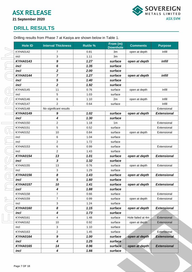
Drilling results from Phase 7 at Kasiya are shown below in Table 1.
Hole ID Interval Thickness Rutile % From (m) Downhole
Comments Purpose
KYHA0142 7 0.81 3m open at depth Infill
incl 3 1.11 3m
KYHA0143 9 1.27 surface open at depth infill
incl 6 1.35 surface
incl 2 2.00 surface
KYHA0144 7 1.27 surface open at depth infill
incl 5 1.40 surface
incl 2 1.92 surface
KYHA0145 11 0.76 surface open at depth Infill
incl 5 1.03 surface
KYHA0146 6 1.10 2m open at depth Infill
KYHA0147 2 0.64 surface Infill
KYHA0148 No significant results Extensional
KYHA0149 9 1.02 surface open at depth Extensional
incl 4 1.30 surface
KYHA0150 2 1.18 1m Extensional
KYHA0151 5 0.52 surface Extensional
KYHA0152 10 0.84 surface open at depth Extensional
incl 6 1.04 surface
incl 2 1.72 surface
KYHA0153 6 0.99 surface Extensional
incl 2 1.43 surface
KYHA0154 13 1.01 surface open at depth Extensional
incl 3 1.32 surface
KYHA0155 13 0.76 surface open at depth Extensional
incl 3 1.29 surface
KYHA0156 8 1.43 surface open at depth Extensional
incl 5 1.60 surface
KYHA0157 10 1.41 surface open at depth Extensional
incl 4 1.88 surface
KYHA0158 7 0.66 surface Extensional
KYHA0159 7 0.99 surface open at depth Extensional
incl 3 1.24 surface
KYHA0160 8 1.15 surface open at depth Extensional
incl 4 1.73 surface
KYHA0161 4 1.48 surface Hole failed at 4m Extensional
KYHA0162 10 0.92 surface open at depth Extensional
incl 3 1.10 surface
KYHA0163 2 1.45 surface Extensional
KYHA0164 9 1.00 surface open at depth Extensional
incl 4 1.25 surface
KYHA0165 14 0.96 surface open at depth Extensional
incl 4 1.66 surface
For
per
sona
l use
onl
y

Page 8 OF 18
21 September 2020
Hole ID Interval Thickness Rutile %
From (m) Downhole
Comments Purpose
KYHA0166 5 1.25 surface Extensional
KYHA0167 7 0.69 surface Extensional
KYHA0168 No significant results Extensional
KYHA0169 10 1.19 surface open at depth infill
incl 2 1.31 surface
KYHA0170 13 1.02 surface open at depth Extensional
incl 8 1.20 surface
incl 5 1.30 surface
KYHA0171 8 1.47 1m open at depth infill
incl 2 1.60 1m
KYHA0172 5 0.91 surface Extensional
KYHA0173 12 1.47 surface open at depth Extensional
incl 7 1.72 surface
incl 4 2.00 surface
KYHA0174 3 0.69 surface Extensional
KYHA0175 6 0.94 surface Extensional
incl 2 1.28 surface
KYHA0176 10 0.97 1m open at depth Extensional
incl 5 1.07 1m
incl 2 1.24 1m
KYHA0177 11 1.05 surface open at depth Extensional
incl 7 1.20 surface
incl 5 1.36 surface
KYHA0178 6 0.83 1m open at depth Extensional
incl 2 1.13 1m
KYHA0211 9 0.74 surface open at depth Extensional
KYHA0212 4 0.70 surface Extensional
KYHA0213 8 0.81 surface Extensional
incl 4 1.08 surface
KYHA0214 No significant results Extensional
KYHA0215 8 0.70 surface Extensional
KYHA0216 5 0.56 surface open at depth Extensional
KYHA0217 2 0.70 surface Extensional
KYHA0218 12 0.79 surface open at depth Extensional
incl 8 0.94 from 4m
incl 4 1.15 from 8m
KYHA0219 14 0.86 surface open at depth Extensional
incl 8 0.96 surface
incl 4 1.24 surface
KYHA0220 11 0.96 surface open at depth Extensional
incl 8 1.02 surface
incl 4 1.18 surface
KYHA0221 5 0.65 surface Extensional
KYHA0222 9 0.77 surface Extensional
incl 5 0.96 surface
KYHA0223 No significant results Extensional
For
per
sona
l use
onl
y

Page 9 OF 18
21 September 2020
Hole ID Interval Thickness Rutile %
From (m) Downhole
Comments Purpose
KYHA0224 3 0.53 surface Extensional
KYHA0225 12 1.07 surface open at depth Extensional
incl 8 1.23 surface
incl 4 1.63 surface
KYHA0226 3 0.74 surface open at depth Extensional
KYHA0227 5 0.82 surface Extensional
incl 2 1.18 surface
KYHA0228 12 0.99 surface open at depth Extensional
incl 2 1.30 surface
KYHA0229 8 0.95 surface open at depth Infill
incl 5 1.19 surface
incl 2 1.76 surface
KYHA0230 12 1.01 surface open at depth Infill
incl 4 1.24 surface
KYHA0231 16 1.16 surface open at depth Infill
incl 8 1.35 surface
incl 4 1.60 surface
KYHA0232 14 0.91 surface open at depth Infill
incl 8 1.08 surface
incl 4 1.23 surface
KYHA0233 6 0.70 surface open at depth Infill
KYHA0234 11 0.92 surface open at depth extensional
incl 3 1.24 surface
KYHA0235 10 0.84 surface extensional
incl 5 1.11 surface
KYHA0236 12 1.07 surface open at depth extensional
incl 8 1.18 surface
KYHA0237 6 0.81 surface open at depth Infill
incl 2 1.18 surface
KYHA0238 No significant results Infill
KYHA0239 4 0.56 surface Infill
KYHA0240 3 1.57 surface Hole failed at 3m Infill
KYHA0241 4 1.39 surface Infill
KYHA0242 2 0.71 surface Infill
KYHA0243 7 0.65 surface open at depth Infill
incl 2 0.85 surface
KYHA0244 6 0.87 surface open at depth Infill
incl 2 1.20 surface
KYHA0245 4 1.29 surface open at depth Infill
incl 2 1.83 surface
KYHA0246 9 0.91 surface open at depth Infill
incl 5 1.00 surface
incl 2 1.27 surface
KYHA0247 6 1.17 surface Infill
incl 2 2.18 surface
KYHA0248 5 0.88 surface open at depth Infill
For
per
sona
l use
onl
y

Page 10 OF 18
21 September 2020
Hole ID Interval Thickness Rutile %
From (m) Downhole
Comments Purpose
incl 2 1.15 surface
KYHA0249 6 1.10 surface open at depth Infill
incl 2 1.70 surface
KYHA0250 2 1.15 surface Infill
KYHA0251 13 0.94 surface Infill
incl 7 1.13 surface
incl 3 1.76 surface
KYHA0252 5 1.38 surface Infill
KYHA0253 4 0.77 surface Infill
KYHA0254 10 0.74 surface open at depth Infill
incl 4 1.16 surface
KYHA0255 7 0.76 surface open at depth Infill
incl 3 0.97 surface
KYHA0240 3 1.57 surface Hole failed at 3m Infill
KYHA0241 4 1.39 surface Infill
KYHA0242 2 0.71 surface Infill
KYHA0243 7 0.65 surface open at depth Infill
incl 2 0.85 surface
KYHA0244 6 0.87 surface open at depth Infill
incl 2 1.20 surface
KYHA0245 4 1.29 surface open at depth Infill
incl 2 1.83 surface
KYHA0246 9 0.91 surface open at depth Infill
incl 5 1.00 surface
incl 2 1.27 surface
KYHA0247 6 1.17 surface Infill
incl 2 2.18 surface
KYHA0248 5 0.88 surface open at depth infill
incl 2 1.15 surface
KYHA0249 6 1.10 surface open at depth infill
incl 2 1.70 surface
KYHA0250 2 1.15 surface infill
KYHA0251 13 0.94 surface infill
incl 7 1.13 surface
incl 3 1.76 surface
KYHA0252 5 1.38 surface infill
KYHA0253 4 0.77 surface infill
KYHA0254 10 0.74 surface open at depth infill
incl 4 1.16 surface
KYHA0255 7 0.76 surface open at depth infill
incl 3 0.97 surface
For
per
sona
l use
onl
y
Page 11 OF 18
21 September 2020
Competent Person’s Statement
The information in this report that relates to Exploration Results is based on information compiled by Dr Julian Stephens, a Competent Person who is a member of the Australian Institute of Geoscientists (AIG). Dr Stephens is the Managing Director of Sovereign Metals Limited and a holder of ordinary shares and unlisted options in Sovereign Metals Limited. Dr Stephens has sufficient experience that is relevant to the style of mineralisation and type of deposit under consideration and to the activity being undertaken, to qualify as a Competent Person as defined in the 2012 Edition of the 'Australasian Code for Reporting of Exploration Results, Mineral Resources and Ore Reserves'. Dr Stephens consents to the inclusion in the report of the matters based on his information in the form and context in which it appears.
Forward Looking Statement
This release may include forward-looking statements, which may be identified by words such as "expects", "anticipates", "believes", "projects", "plans", and similar expressions. These forward-looking statements are based on Sovereign’s expectations and beliefs concerning future events. Forward looking statements are necessarily subject to risks, uncertainties and other factors, many of which are outside the control of Sovereign, which could cause actual results to differ materially from such statements. There can be no assurance that forward-looking statements will prove to be correct. Sovereign makes no undertaking to subsequently update or revise the forward-looking statements made in this release, to reflect the circumstances or events after the date of that release.
This ASX Announcement has been approved and authorised for release by the Company’s Managing Director, Julian Stephens.
For
per
sona
l use
onl
y

Page 12 OF 18
21 September 2020
APPENDIX 1: DRILL HOLE DATA
Hole ID East North RL Depth (m)
KYHA0142 540800 8478800 1108 16
KYHA0143 542000 8479600 1119 11
KYHA0144 542400 8479600 1122 8
KYHA0145 541200 8478800 1115 11
KYHA0146 541600 8478800 1116 8
KYHA0147 542000 8478800 1112 7
KYHA0148 539600 8476800 1094 12
KYHA0149 541200 8477600 1100 11
KYHA0150 542400 8476800 1106 11
KYHA0151 543200 8476800 1117 11
KYHA0152 544000 8476800 1124 10
KYHA0153 543200 8479600 1129 10
KYHA0154 544000 8481600 1143 14
KYHA0155 544000 8481200 1144 13
KYHA0156 544000 8480800 1145 8
KYHA0157 544000 8480400 1146 10
KYHA0158 544000 8480000 1144 12
KYHA0159 544000 8479600 1145 9
KYHA0160 543200 8480000 1132 8
KYHA0161 543200 8482400 1123 7
KYHA0162 544000 8482400 1135 11
KYHA0163 542400 8481600 1115 4
KYHA0164 543200 8481600 1129 11
KYHA0165 541600 8482400 1113 15
KYHA0166 542400 8482400 1117 11
KYHA0167 540000 8482400 1109 11
KYHA0168 540800 8482400 1104 10
KYHA0169 542400 8480400 1122 10
KYHA0170 543200 8480400 1135 13
KYHA0171 542400 8480000 1125 10
KYHA0172 544800 8478800 1142 12
KYHA0173 543200 8478000 1127 12
KYHA0174 544000 8478000 1129 8
KYHA0175 544800 8478000 1136 13
KYHA0176 544000 8478800 1145 11
KYHA0177 543200 8478800 1134 11
KYHA0178 542400 8478000 1108 8
KYHA0211 546400 8487200 1113 9
KYHA0212 546400 8486800 1113 11
KYHA0213 546400 8486400 1115 12
KYHA0214 546400 8486000 1117 12
KYHA0215 546400 8485600 1116 12
KYHA0216 546400 8484800 1108 5
KYHA0217 544000 8485600 1103 6
For
per
sona
l use
onl
y

Page 13 OF 18
21 September 2020
Hole ID East North RL
Depth (m)
KYHA0218 544000 8484800 1116 12
KYHA0219 544000 8484000 1124 14
KYHA0220 544000 8483200 1118 11
KYHA0221 536400 8473600 1112 7
KYHA0222 537200 8473600 1119 12
KYHA0223 537999 8473602 1104 6
KYHA0224 538800 8473600 1108 6
KYHA0225 539600 8473600 1125 12
KYHA0226 540400 8473600 1123 13
KYHA0227 541200 8473600 1114 8
KYHA0228 542000 8473600 1115 12
KYHA0229 540400 8478400 1095 8
KYHA0230 540800 8478400 1103 12
KYHA0231 541200 8478400 1110 16
KYHA0232 541600 8478400 1110 14
KYHA0233 542000 8478400 1103 6
KYHA0234 540800 8478000 1099 11
KYHA0235 541200 8478000 1106 15
KYHA0236 541600 8478000 1103 11
KYHA0237 540400 8480400 1090 6
KYHA0238 540800 8480400 1091 11
KYHA0239 541200 8480400 1095 10
KYHA0240 541600 8480400 1102 3
KYHA0241 542000 8480400 1112 8
KYHA0242 539200 8480800 1083 6
KYHA0243 539600 8480800 1084 7
KYHA0244 540000 8480800 1086 6
KYHA0245 540400 8480800 1090 4
KYHA0246 540800 8480800 1095 9
KYHA0247 541200 8480000 1103 11
KYHA0248 541600 8480000 1105 5
KYHA0249 542000 8480000 1116 6
KYHA0250 540400 8481200 1101 10
KYHA0251 540800 8481200 1104 15
KYHA0252 541200 8481200 1103 14
KYHA0253 541600 8481200 1103 10
KYHA0254 542000 8481200 1106 10
KYHA0255 542400 8481200 1110 7
* All holes were vertical.
For
per
sona
l use
onl
y

Page 14 OF 18
21 September 2020
APPENDIX 2: JORC CODE, 2012 EDITION – TABLE 1
SECTION 1 - SAMPLING TECHNIQUES AND DATA
Criteria JORC Code explanation Hand Auger Drilling Commentary
Sampling Techniques
Nature and quality of sampling (e.g. cut channels, random chips, or specific specialised industry standard measurement tools appropriate to the minerals under investigation, such as down hole gamma sondes, or handheld XRF instruments, etc). These examples should not be taken as limiting the broad meaning of sampling.
A total of 82 hand auger holes for 819m were drilled at Kasiya to obtain samples for quantitative mineralogical determination. Samples were composited based on regolith boundaries and chemistry generated by hand-held XRF, generally at 3, 4 or 5m intervals.
Include reference to measures taken to ensure sample representivity and the appropriate calibration of any measurement tools or systems used.
Drilling and sampling activities were supervised by a suitably qualified Company geologist who was present at all times. All bulk 1-metre drill samples were geologically logged by the geologist at the drill site Each 1m sample was sun dried and homogenised. Sub-samples were carefully riffle split to ensure representivity. ~1.5kg composite samples were processed. Extreme care is taken to ensure an equivalent mass is taken from each 1m sample to make up the composite. The primary composite sample is considered representative for this style of rutile mineralisation.
Aspects of the determination of mineralisation that are Material to the Public Report. In cases where ‘industry standard’ work has been done this would be relatively simple (e.g. ‘reverse circulation drilling was used to obtain 1 m samples from which 3 kg was pulverised to produce a 30 g charge for fire assay’). In other cases more explanation may be required, such as where there is coarse gold that has inherent sampling problems. Unusual commodities or mineralisation types (e.g. submarine nodules) may warrant disclosure of detailed information.
Logged mineralogy percentages, lithology information and TiO2% obtained from handheld XRF were used to determine compositing intervals. Care is taken to ensure that only lithological units with similar geological and grade characteristics are composited together.
Drilling Techniques
Drill type (e.g. core, reverse circulation, open‐hole hammer, rotary air blast, auger, Bangka, sonic, etc) and details (e.g. core diameter, triple or standard tube, depth of diamond tails, face‐sampling bit or other type, whether core is oriented and if so, by what method, etc).
Hand-auger drilling with 62mm diameter spiral bits with 1-metre long steel rods. Each 1m of drill sample is collected into separate sample bags and set aside. The auger bits and flights are cleaned between each metre of sampling to avoid contamination.
Drill Sample Recovery
Method of recording and assessing core and chip sample recoveries and results assessed.
Samples are assessed visually for recoveries. Overall, recovery is very good. Drilling is ceased when recoveries become poor once the water table has been reached.
Measures taken to maximise sample recovery and ensure representative nature of the samples.
The Company’s trained geologists supervise auger drilling on a 1 team 1 geologist basis and are responsible for monitoring all aspects of the drilling and sampling process.
Whether a relationship exists between sample recovery and grade and whether sample bias may have occurred due to preferential loss/gain of fine/coarse material.
No bias related to preferential loss or gain of different materials has occurred.
Logging Whether core and chip samples have been geologically and geotechnically logged to a level of detail to support appropriate Mineral Resource estimation mining studies and metallurgical studies.
All individual 1-metre auger intervals are geologically logged, recording relevant data to a set template using company codes. A small representative sample is collected for each 1-metre interval and placed in appropriately labelled chip trays for future reference.
Whether logging is qualitative or quantitative in nature. Core (or costean, channel, etc.) photography.
All logging includes lithological features and estimates of basic mineralogy. Logging is generally qualitative.
The total length and percentage of the relevant intersection logged
100% of samples are geologically logged.
Sub-sampling techniques
If core, whether cut or sawn and whether quarter, half or all core taken.
Not applicable – no core drilling conducted.
For
per
sona
l use
onl
y

Page 15 OF 18
21 September 2020
Criteria JORC Code explanation Hand Auger Drilling Commentary
Sub-sampling techniques and sample preparation
If non-core, whether riffled, tube sampled, rotary split, etc. and whether sampled wet or dry.
Samples from the 82 auger holes drilled were composited. Each 1m sample was sun dried and homogenised. Sub-samples were carefully riffle split to ensure sample representivity. ~1.5kg composite samples were processed. Extreme care is taken to ensure an equivalent mass is taken from each 1m sample to make up the composite. The primary composite sample is considered representative for this style of rutile mineralisation and is consistent with industry standard practice.
For all sample types, the nature, quality and appropriateness of the sample preparation technique.
Use of the above compositing and sampling technique is deemed appropriate given the dry nature of the samples.
Quality control procedures adopted for all sub-sampling stages to maximise representivity of samples.
The sampling equipment is cleaned after each sub-sample is taken.
Measures taken to ensure that the sampling is representative of the in situ material collected, including for instance results for field duplicate/second-half sampling.
Extreme care is taken to ensure an equivalent mass is taken from each 1m sample to make up each composite.
Whether sample sizes are appropriate to the grain size of the material being sampled.
The sample size is considered appropriate for the material sampled.
Quality of assay data and laboratory tests
The nature, quality and appropriateness of the assaying and laboratory procedures used and whether the technique is considered partial or total.
The Malawi onsite laboratories sample preparation methods are considered quantitative to the point where a heavy mineral concentrate (HMC) is generated. Final results generated are for recovered rutile i.e. the % mass of the sample that is rutile that can be recovered to a heavy mineral concentrate. The following workflow for the samples was undertaken on-site in Malawi;
Dry sample in oven for 1 hour at 105℃
Soak in water and lightly agitate
Wet screen at 5mm, 600mm and 45µm to remove oversize and slimes material
Dry +45µm -600mm (sand fraction) in oven for 1 hour at 105℃
The following workflow for the samples was then undertaken at Perth based Laboratories.
Split ~150g off Sand fraction for Heavy Liquid Separation (HLS) at a specific gravity of SG 2.96g/cc undertaken at Diamantina Laboratories.
Magnetic separation of the THM Sinks by Carpco magnet @ 16,800G (2.9Amps) into a magnetic (M) and non-magnetic (NM) fraction. Work undertaken at Allied Mineral Laboratories (AML) in Perth.
The NM fractions were sent to Intertek Genalysis Perth for quantitative XRF analysis.
Rutile is reported as: rutile mineral recovered to the total NM concentrate fraction as a % of the total primary, dry raw sample mass.
QEMSCAN mineralogy is used as a check against the chemical results of the NM concentrate to validate that >99% of TiO2 units are in the form of rutile.
For geophysical tools, spectrometers, handheld XRF instruments, etc., the parameters used in determining the analysis including instrument make and model, reading times, calibrations factors applied and their derivation, etc.
Acceptable levels of accuracy and precision have been established. No handheld methods are used for quantitative determination.
Nature of quality control procedures adopted (e.g. standards, blanks, duplicate, external laboratory checks) and whether acceptable levels of accuracy (i.e. lack of bias) and precision have been established.
Intertek Genalysis used internal XRF standards and duplicates. The overall quality of QA/QC is considered to be good.
Verification of sampling & assaying
The verification of significant intersections by either independent or alternative company personnel.
Significant mineralisation intersections were verified by qualified, alternative company personnel.
The use of twinned holes. No twin holes have been used.
Documentation of primary data, data entry procedures, data verification, data storage (physical and electronic) protocols.
All data was collected initially on paper logging sheets and codified to the Company's templates. This data was hand entered to spreadsheets and
For
per
sona
l use
onl
y
Page 16 OF 18
21 September 2020
Criteria JORC Code explanation Hand Auger Drilling Commentary
validated by Company geologists. This data was then imported to a Microsoft Access Database then validated automatically and manually.
Discuss any adjustment to assay data.
Rutile is reported as: rutile mineral recovered to the total NM concentrate fraction as a % of the total primary, dry raw sample mass.
Location of data points
Accuracy and quality of surveys used to locate drill holes (collar and down-hole surveys), trenches, mine workings and other locations used in Mineral Resource estimation.
A Trimble R2 Differential GPS was used to pick up the hand auger collars.
No downhole surveying of auger holes is completed. Given the vertical nature and shallow depths of the auger holes drill hole deviation is not considered to significantly affect the downhole location of samples.
Specification of the grid system used. WGS84 UTM Zone 36 South.
Quality and adequacy of topographic control. DGPS pickups are considered to be high quality topographic control measures.
Data spacing & distribution
Data spacing for reporting of Exploration Results.
The hand auger collars are spaced at approximately 400m along the extensional drill-lines and 200m along the infill lines. All extensional holes are designed to provide systematic strike and width extension of the anomalous lines of hand auger drilling previously reported along this same trend. It is deemed that these holes should be broadly representative of the mineralisation style in the general area. More work is required to accurately determine the variability of the mineralisation in the Kasiya region.
Whether the data spacing and distribution is sufficient to establish the degree of geological and grade continuity appropriate for the Mineral Resource and Ore Reserve estimation procedure(s) and classifications applied.
Not applicable, no Mineral Resource or Ore Reserve estimations are covered by new data in this report.
Whether sample compositing has been applied. Individual 1-metre auger intervals have been composited over a determined interval of interest for the 82 auger holes drilled in order to obtain a primary sample of ~1.5kg mass for mineralogical analysis.
Orientation of data in relation to geological structure
Whether the orientation of sampling achieves unbiased sampling of possible structures and the extent to which this is known considering the deposit type
No bias attributable to orientation of sampling has been identified.
If the relationship between the drilling orientation and the orientation of key mineralised structures is considered to have introduced a sampling bias, this should be assessed and reported if material.
All holes were drilled vertically as the nature of the mineralisation is horizontal. No bias attributable to orientation of drilling has been identified.
Sample security
The measures taken to ensure sample security Samples were stored in secure storage from the time of drilling, through gathering, compositing and analysis. The samples were sealed as soon as site preparation was completed, and again securely stored during shipment and while at Australian laboratories.
Audits or reviews
The results of any audits or reviews of sampling techniques and data
It is considered by the Company that industry best practice methods have been employed at all stages of the exploration.
SECTION 2 - REPORTING OF EXPLORATION RESULTS
Criteria Explanation Commentary
Mineral tenement & land tenure status
Type, reference name/number, location and ownership including agreements or material issues with third parties such as joint ventures, partnerships, overriding royalties, native title interests, historical sites, wilderness or national park and environment settings.
The Company owns 100% of 8 Exclusive Prospecting Licences (EPLs) in Malawi. EPL0355 renewed in 2019 for 2 years, EPL0372 (under renewal application) and EL0413 renewed in 2019 for 2 years. EPL0492 and EPL0528 were granted in 2018 for an initial period of three years (renewable). EPL0537 and EPL0545 were granted in 2019 for an initial period of three years (renewable). EL0561 was granted in January 2020 for an initial 3 years (renewable) with field work permits subject to an acceptable Environmental and Social Management Plan – a new requirement under the Mining Act 2019.
The security of the tenure held at the time of reporting along with any known impediments to obtaining a licence to operate in the area.
The tenements are in good standing and no known impediments to exploration or mining exist.
For
per
sona
l use
onl
y

Page 17 OF 18
21 September 2020
Criteria Explanation Commentary
Exploration done by other parties
Acknowledgement and appraisal of exploration by other parties.
No other parties were involved in exploration.
Geology Deposit type, geological setting and style of mineralisation
The rutile deposit type could be termed a residual placer formed by the intense weathering of rutile-rich basement paragneisses.
Rutile occurs in a mostly topographically flat area west of Malawi’s capital known as the Lilongwe Plain where a deep tropical weathering profile is preserved. A typical profile from top to base is generally soil (“SOIL” 0-1m) ferruginous pedolith (“FERP”, 1-4m), mottled zone (“MOTT”, 4-7m), pallid saprolite (“PSAP”, 7-9m), saprolite (“SAPL”, 9-25m), saprock (“SAPR”, 25-35m) and fresh rock (“FRESH” >35m).
Drill hole information
A summary of all information material to the understanding of the exploration results including a tabulation of the following information for all Material drill holes: easting and northings of the drill hole collar; elevation or RL (Reduced Level-elevation above sea level in metres of the drill hole collar); dip and azimuth of the hole; down hole length and interception depth; and hole length
All collar and composite data is provided in the body and Appendices of this report. All holes were drilled vertically.
If the exclusion of this information is justified on the basis that the information is not Material and this exclusion does not detract from the understanding of the report, the Competent Person should clearly explain why this is the case
No information has been excluded.
Data aggregation methods
In reporting Exploration Results, weighting averaging techniques, maximum and/or minimum grade truncations (e.g. cutting of high-grades) and cut-off grades are usually Material and should be stated.
All results reported are of a length-weighted average. The results reported in the body of the report are on a lower cut-off of 0.5% Rutile.
Where aggregate intercepts incorporate short lengths of high-grade results and longer lengths of low grade results, the procedure used for such aggregation should be stated and some typical examples of such aggregations should be shown in detail.
No significant aggregate intercepts have been reported.
The assumptions used for any reporting of metal equivalent values should be clearly stated.
No metal equivalent values are used in this report.
Relationship between mineralisation widths & intercept lengths
These relationships are particularly important in the reporting of Exploration Results.
It is considered that the mineralisation lies in laterally extensive, near surface, flat “blanket” style bodies in areas where the entire weathering profile is preserved and not significantly eroded.
If the geometry of the mineralisation with respect to the drill hole angle is known, its nature should be reported.
The mineralisation lies in laterally extensive, near surface, flat “blanket” style bodies.
If it is not known and only the down hole lengths are reported, there should be a clear statement to this effect (e.g. 'down hole length, true width not known'.
Downhole widths approximate true widths. Some mineralisation currently remains open at depth.
Diagrams Appropriate maps and sections (with scales) and tabulations of intercepts should be included for any significant discovery being reported. These should include, but not be limited to a plan view of the drill collar locations and appropriate sectional views.
Refer to figures in the body of this report.
Balanced reporting
Where comprehensive reporting of all Exploration Results is not practicable, representative reporting of both low and high-grades and/or widths should be practiced to avoid misleading reporting of exploration results.
All results have been reported in this report.
For
per
sona
l use
onl
y
Page 18 OF 18
21 September 2020
Criteria Explanation Commentary
Other substantive exploration data
Other exploration data, if meaningful and material, should be reported including (but not limited to: geological observations; geophysical survey results; geochemical survey results; bulk samples - size and method of treatment; metallurgical test results; bulk density, groundwater, geotechnical and rock characteristics; potential deleterious or contaminating substances.
Rutile has been determined to be the major TiO2-bearing mineral at and around several rutile prospects and within Sovereign’s ground package. The company continues to examine all areas within the large tenement package for rutile mineralisation.
Further work The nature and scale of planned further work (e.g. test for lateral extensions or depth extensions or large-scale step-out drilling).
Laboratory processing of 2020 drilling samples on the saprolite prospects continues.
Drilling is ongoing at the Kasiya prospect to further expand the area of known rutile mineralisation.
Diagrams clearly highlighting the areas of possible extensions, including the main geological interpretations and future drilling areas, provided this information is not commercially sensitive.
Refer to diagrams in the body of this report.
For
per
sona
l use
onl
y


