20/Tides, Waves, and · PDF filethe ocean, you can check the tide tables published in your...
29
When you have finished this chapter, you should be able to: EXPLAIN the forces that cause the different kinds of tides. DISCUSS the effects of changing tides on marine organisms. DESCRIBE wave characteristics and different types of waves. DISCUSS the causes, and importance, of ocean currents. The ocean is always in motion. Massive currents of water circulate around the globe. Waves crash on the beach. Seawater is pushed and pulled by the tides. What makes the ocean water move so much? The tides, waves, and currents result from the interaction of many forces and factors, such as conditions in Earth’s atmosphere, the movement of our planet in space, and even Earth’s interactions with other bodies in our solar system. In this chapter, you will learn about tides, waves, and cur- rents; and you will see the strong effect they have on life in marine and coastal environments. 485 20.1 The Tides 20.2 Ocean Waves 20.3 Ocean Currents Tides,Waves,andCurrents ENERGY IN THE OCEAN 20 20
Transcript of 20/Tides, Waves, and · PDF filethe ocean, you can check the tide tables published in your...

When you have finished this chapter, you should be able to:
EXPLAIN the forces that cause the different kinds of tides.
DISCUSS the effects of changing tides on marine organisms.
DESCRIBE wave characteristics and different types of waves.
DISCUSS the causes, and importance, of ocean currents.
The ocean is always in motion. Massive currents of water circulatearound the globe. Waves crash on the beach. Seawater is pushed andpulled by the tides.
What makes the ocean water move so much? The tides, waves,and currents result from the interaction of many forces and factors,such as conditions in Earth’s atmosphere, the movement of our planetin space, and even Earth’s interactions with other bodies in our solarsystem. In this chapter, you will learn about tides, waves, and cur-rents; and you will see the strong effect they have on life in marineand coastal environments.
485
20.1The Tides
20.2Ocean Waves
20.3Ocean Currents
Tides,Waves,andCurrents
ENERGY IN THE OCEAN
2020
20.1 THE TIDES
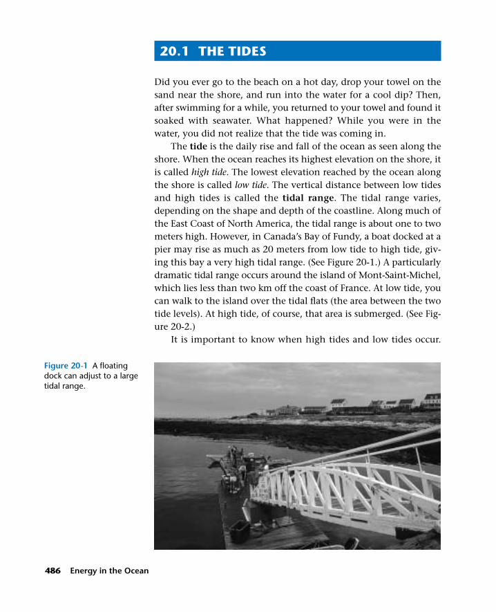
Did you ever go to the beach on a hot day, drop your towel on thesand near the shore, and run into the water for a cool dip? Then,after swimming for a while, you returned to your towel and found itsoaked with seawater. What happened? While you were in thewater, you did not realize that the tide was coming in.
The tide is the daily rise and fall of the ocean as seen along theshore. When the ocean reaches its highest elevation on the shore, itis called high tide. The lowest elevation reached by the ocean alongthe shore is called low tide. The vertical distance between low tidesand high tides is called the tidal range. The tidal range varies,depending on the shape and depth of the coastline. Along much ofthe East Coast of North America, the tidal range is about one to twometers high. However, in Canada’s Bay of Fundy, a boat docked at apier may rise as much as 20 meters from low tide to high tide, giv-ing this bay a very high tidal range. (See Figure 20-1.) A particularlydramatic tidal range occurs around the island of Mont-Saint-Michel,which lies less than two km off the coast of France. At low tide, youcan walk to the island over the tidal flats (the area between the twotide levels). At high tide, of course, that area is submerged. (See Fig-ure 20-2.)
It is important to know when high tides and low tides occur.
486 Energy in the Ocean
Figure 20-1 A floatingdock can adjust to a largetidal range.

For example, the best time to schedule a field trip to observe livingcreatures along the shore is at low tide. Storms hitting the coast athigh tide cause much more damage than they do at low tide. Butships coming into port at low tide have to wait in deeper water forhigh tide before docking, to prevent their running aground.
Time and Tides
How do you know when it is high tide or low tide? If you live nearthe ocean, you can check the tide tables published in your localnewspaper. Look at the tide table shown in Table 20-1. Pick one ofthe locations and determine the time difference between high tideand low tide. The time between consecutive high tides and low tidesis approximately six hours and 20 minutes. (This time may varyslightly from place to place because of differences in the shape of
Tides, Waves, and Currents 487
TABLE 20-1 TIDE TABLE
Location High Tide Low Tide High Tide Low Tide
Sandy Hook, N.J. 12:48 A.M. 6:33 A.M. 1:29 P.M. 7:49 P.M.
Port Jefferson, N.Y. 4:36 A.M. 10:56 A.M. 4:59 P.M. 11:19 P.M.
Shinnecock Inlet, N.Y. 1:14 A.M. 7:34 A.M. 1:56 P.M. 8:16 P.M.
Fire Island, N.Y. 1:15 A.M. 7:35 A.M. 1:51 P.M. 8:11 P.M.
Montauk Point, N.Y. 2:26 A.M. 8:46 A.M. 2:52 P.M. 9:12 P.M.
Stamford, Conn. 4:35 A.M. 10:55 A.M. 5:00 P.M. 11:20 P.M.
Figure 20-2 Mont-Saint-Michel at low tide (left)and at high tide (right).
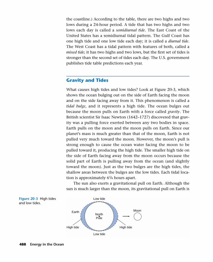
the coastline.) According to the table, there are two highs and twolows during a 24-hour period. A tide that has two highs and twolows each day is called a semidiurnal tide. The East Coast of theUnited States has a semidiurnal tidal pattern. The Gulf Coast hasone high tide and one low tide each day; it is called a diurnal tide.The West Coast has a tidal pattern with features of both, called amixed tide; it has two highs and two lows, but the first set of tides isstronger than the second set of tides each day. The U.S. governmentpublishes tide table predictions each year.
Gravity and Tides
What causes high tides and low tides? Look at Figure 20-3, whichshows the ocean bulging out on the side of Earth facing the moonand on the side facing away from it. This phenomenon is called atidal bulge, and it represents a high tide. The ocean bulges outbecause the moon pulls on Earth with a force called gravity. TheBritish scientist Sir Isaac Newton (1642–1727) discovered that grav-ity was a pulling force exerted between any two bodies in space.Earth pulls on the moon and the moon pulls on Earth. Since ourplanet’s mass is much greater than that of the moon, Earth is notpulled very much toward the moon. However, the moon’s pull isstrong enough to cause the ocean water facing the moon to bepulled toward it, producing the high tide. The smaller high tide onthe side of Earth facing away from the moon occurs because thesolid part of Earth is pulling away from the ocean (and slightlytoward the moon). Just as the two bulges are the high tides, theshallow areas between the bulges are the low tides. Each tidal loca-tion is approximately 61/4 hours apart.
The sun also exerts a gravitational pull on Earth. Although thesun is much larger than the moon, its gravitational pull on Earth is
488 Energy in the Ocean
Low tide
Low tide
High tide
Earth MoonNorthPole
High tide
Figure 20-3 High tidesand low tides.

much less than that of the moon, because it is farther away fromEarth. However, twice each month, when the sun, moon, and Earthare aligned, the pulling forces are combined to produce the highestand lowest tides, called spring tides. (See Figure 20-4.) The springtides get their name not from that season of the year, but from theold German word springan, which means “to rise or leap.” Springtides occur during the new moon and full moon, which are exactlytwo weeks apart.
When the moon is in first-quarter and third-quarter phases,between the new moon and the full moon, the pull of the moonand pull of the sun on Earth are at right angles, and as a result, thetides are not as high or low as at other times of the month. Theseweaker tides are called neap tides. (See Figure 20-5.)
When is the tide highest during the year? The moon’s orbitaround Earth is not a perfect circle, but is elliptical. The point atwhich the moon comes closest to Earth is called the perigee, and thepoint at which it is farthest away is called the apogee. The highesttides occur when the moon is at perigee. If the moon is at perigeeduring the new moon or full moon, the tide is at its highest. In its
Tides, Waves, and Currents 489
Pull of moonand sun
working insame direction
Spring tides
Lowtide
Lowtide
Hightide
Hightide
Newmoon
Fullmoon
Ocean water
SunEarth
Lowtide
High tide
High tide
Lowtide
Ocean water
Neap tides
Pull of sunacting againstpull of moon
Sun
Moon (First quarter)
Moon (Last quarter)
Earth
Figure 20-4 Spring tides.
Figure 20-5 Neap tides.

orbit around the sun, Earth moves closest to the sun in January,called perihelion, and farthest away in July, called aphelion. Duringperihelion, when Earth is closest to the sun, the tides are higher.The combination of perigee and perihelion produces the very high-est of all tides.
Life Cycles and Tides
The incoming tide signals the final chapter in the life cycle of manymarine organisms as their remains are washed up on the shore. Butthe rising tide also heralds the beginning of life for other life-forms.For the grunion (Leuresthes tenuis), a small fish (15 cm) that inhabitscoastal waters in southern California, life begins at high tide. Duringthe spring and summer, thousands of these silvery fish swim uponto the sandy beaches, carried in by the high tide. This so-calledgrunion run occurs at night during the new moon and full moonwhen the tide is highest. People flock to the beaches and wait withflashlights for the grunions to appear between 10:00 P.M. and 2:00A.M. The female grunions wiggle into the sand and lay thousandsof eggs as the males deposit sperm around them. Afterward, the fishare swept back into the sea by the water. The spawning is timed soexactly that it occurs only on the second, third, and fourth daysthat follow a new or full moon.
After the grunion eggs are fertilized, they incubate in the sandfor two weeks until the next new or full moon occurs. At that time,the waters of the high spring tides will reach the eggs and washthem out of the sand. The eggs then begin hatching into tinygrunions as they are carried seaward by the outgoing tide.
Another marine animal whose life cycle is timed to the rhythmof the tides is the horseshoe crab (Limulus polyphemus). (See Figure20-6.) During late May and early June, vast numbers of horseshoecrabs congregate in shallow bays, marshes, and inlets along theAtlantic and Gulf coasts, waiting to come up on the beaches tospawn. The signal to begin is provided by the moon. During thenew and full moons, when the tide is at its highest, the horseshoecrabs come ashore. They are usually in pairs, with the smaller maleattached to the back of the female’s abdomen. The female producesa cluster of several hundred tiny pale green eggs on her abdomen.The eggs are fertilized by the male’s sperm, and then deposited in a
490 Energy in the Ocean
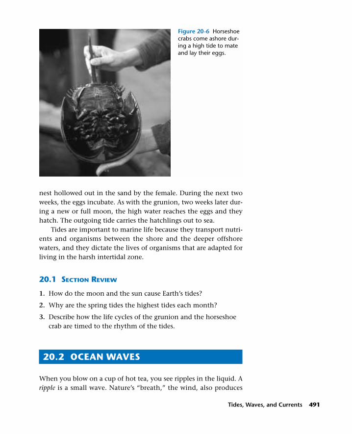
nest hollowed out in the sand by the female. During the next twoweeks, the eggs incubate. As with the grunion, two weeks later dur-ing a new or full moon, the high water reaches the eggs and theyhatch. The outgoing tide carries the hatchlings out to sea.
Tides are important to marine life because they transport nutri-ents and organisms between the shore and the deeper offshorewaters, and they dictate the lives of organisms that are adapted forliving in the harsh intertidal zone.
20.1 SECTION REVIEW
1. How do the moon and the sun cause Earth’s tides?
2. Why are the spring tides the highest tides each month?
3. Describe how the life cycles of the grunion and the horseshoecrab are timed to the rhythm of the tides.
20.2 OCEAN WAVES
When you blow on a cup of hot tea, you see ripples in the liquid. Aripple is a small wave. Nature’s “breath,” the wind, also produces
Tides, Waves, and Currents 491
Figure 20-6 Horseshoecrabs come ashore dur-ing a high tide to mateand lay their eggs.

waves when it blows across the surface of the ocean. (See Figure20-7.) A wave is an up-and-down movement of the ocean surface.Most waves are caused by wind. How does the wind produce a wave?When the wind blows, it pushes on the ocean surface, causing thewater to lift. A gentle wind produces a small wave; a strong wind pro-duces a bigger wave. In general, the greater the wind’s speed, lengthof time it blows, and distance over which it blows, the greater arethe size and speed of the waves that it generates. (See Figure 20-8.)
Measuring a Wave
One of the biggest waves ever recorded at sea was observed by some-one aboard the U.S. Navy tanker U.S.S. Ramapo during a storm in theSouth Pacific in February 1933. The wave was calculated to be about
492 Energy in the Ocean
Increasing time
Hei
ght i
n m
eter
s KEY—Wind speed30 Kph80 Kph
1815129630
Increasing distance
Figure 20-8 The effect ofwind speed on wave size:the faster the wind, thelarger the wave.
Figure 20-7 Wave ripplesalong the shore are causedby the wind.

34 meters high. How is the height of an ocean wave calculated? Thewave height is the vertical distance between the top of a wave, orcrest, and the bottom of the preceding wave, or trough. Wave heightcan be measured (by use of basic geometry) either when the wave isperpendicular to the ship’s direction (when the ship’s stern is downin the trough) or when the wave is parallel to the ship.
When the stern of a ship is in the trough, an observer on thedeck can line up the crow’s nest with the crest of the wave, asshown in Figure 20-9. When the reference points are connected bystraight lines, they form a right triangle, where BC is the height ofthe crow’s nest, AC is the length from the stern to the base of themast, and AB is the hypotenuse. The hypotenuse, which is the sideof the right triangle opposite the right angle (AB), would equal theheight of the wave. You can use the Pythagorean theorem (a2 + b2 =c2), where BC is a and AC is b, to calculate the height of side AB,which would be c, as follows:
Given: BC = 12 meters, AC = 5 meters
Find: side AB
Solution: a2 + b2 = c2
(12)2 + (5)2 = c2
144 + 25 = c2
169 = c2, 13 meters = c
Side AB = 13 meters
Wave Action
When a steady wind blows, a wave train is produced. A wave train isa series of waves, one followed by the other, moving in the same
Tides, Waves, and Currents 493
Bow
Crow'snest
CA
B
Stern
Ocean
Figure 20-9 You can usethe Pythagorean theoremto calculate wave height.

direction. How fast do the waves move? You can calculate the speed(velocity) of a wave if you know its wavelength and period. Thewavelength is the distance between two successive crests or troughs.The period is the time it takes for one wave to pass a given point.(The wave frequency is the number of waves that pass a given pointin a given amount of time, such as the number of waves per minute.)Use the following formula to calculate the velocity of a wave:
Velocity (V ) = wavelength (W )/period (P)
If W = 10 meters and P = 5 seconds,
V = 10 meters/5 seconds
V = 2 meters/second
After observing waves and calculating their speed, you may beleft with the impression that the water, which goes up and down aswaves, is also moving horizontally. Although waves look like theyare moving along, this is only an illusion. A floating object such asa boat or the cork on a fishing line does not move forward in a wavetrain but moves up and down with each passing wave. This isbecause a wave is a form of energy that moves across the water—not the water itself moving along.
Wave action is like the snapping of a rope. (See Figure 20-10.)When you snap a rope, the rope itself does not move forward. Themovement of your hand produces mechanical energy that is trans-ferred in waves along the length of the rope. Similarly, a wave startswith the energy of the wind pushing on the water. Mechanicalenergy is transferred to each successive wave. When waves extendbeyond the windy area in which they are generated, they havelonger periods and more rounded crests, and are called swells. Theswells may travel for thousands of kilometers across the ocean, untilthey reach a distant shore where the energy is released in the formof a crashing wave.
494 Energy in the Ocean
Fixed support
Figure 20-10 Avibrating ropeillustrates waveaction.

RECREATIONThe Science of Surfing
1. Describe how surfers should catch a wave. What happens if they miss?
2. Define the terms swell and fetch. How does one affect the other?
3. Explain how advances in science and technology can help surfers.
QUESTIONS
Tides, Waves, and Currents 495
Did you ever try “catching a wave” on a boogieboard or surfboard, or by bodysurfing, and thenriding it in to the shore? Surfing is such an exhil-arating sport because you can feel the power ofthe wave as it propels you forward through thewater. The ability to catch a wave requires beingat the right place in front of the crest of thewave before it breaks. But you also need to pad-dle or swim rapidly in order to catch the wavebefore it starts breaking.
Waves break on beaches when the bottomof an advancing wave makes contact with theshallow seafloor. Friction results, causing thebottom of the wave to slow and the top of thewave to rear up, pitch forward, and crash. Rid-ing a wave involves the dynamic interplay ofthree main forces: the upward surge of thewave, the downward pull of gravity (as the waverises and falls), and the forward momentum ofthe wave (as it pitches forward). Timing is criti-cal. If you slide down the face of a wave tooquickly, you will reach the bottom, or trough, ofthe wave and the ride will be over. If you are toolate in catching a wave, it will outrun you.
Waves are caused by the wind. The bigwaves that surfers love to ride are spawned kilo-meters away by strong winds that create waveswith long periods and rounded crests, calledswells. The distance over which a wind blows,called the fetch, affects the size of a swell. Thelonger the fetch is, the bigger the swell will be.When swells reach the shore, they rise up as
steep waves and crash, thereby releasing theirenergy.
Now, due to advances in science and tech-nology, surfers have extra help in trying to chasethe big waves. For example, information is avail-able from NASA’s Quik Scat satellite, whichrecords wind speed across the ocean surface.Offshore buoys measure wave height and waveperiod; the data gathered are posted on theInternet. Surfers can even taxi out in motorizedcraft called Wave Runners, to help them catchthat perfect wave. In addition, thanks to protec-tive wet suits, the “surf’s up” year-round—surfers can finally enjoy the excitement of anendless summer of surfing the wave.

Breaking Waves and “Tidal Waves”
What causes a wave to crash, or break, on the beach? As a waveapproaches the shore, it enters shallow waters. As the bottom of thewave makes contact with the seafloor, the wave slows (due to fric-tion), which decreases its wavelength, too. This occurs when thewater depth is about one-half the wave’s wavelength. (See Figure 20-11.) When the water depth is less than one-half the wavelength, thetop of the wave—which moves faster than its bottom—pitches for-ward and crashes (See Figure 20-12.) This action produces a type ofwave known as a breaker. (See Figure 20-13.)
Waves can also break on the open seas. Strong winds producesteep waves with narrow crests. The narrow crests are easily blownoff by the winds, creating a mixture of air and water known as awhitecap. When a ship’s crew spots whitecaps ahead, they knowthey are in for rough weather. Every now and then, huge lonewaves, with very high crests and low troughs, are encountered atsea. These tall waves, known as rogue waves, are formed either
496 Energy in the Ocean
Figure 20-12 An illustra-tion of how a breakerforms.
Figure 20-11 The charac-teristics of a breakingwave.

when two or more large waves from a storm unite, or when wavesmeet opposing currents. Rogue waves are dangerous and havecaused the loss of many ships at sea.
In some rivers, the energy of the incoming tide can create a soli-tary wave called a tidal bore. This occurs where the seafloor at themouth of the river slopes gently and the tidal range is greater than 5meters. A strong tidal bore may reach several meters in height andrapidly advance many kilometers upriver. In 1976, a wave 6 metershigh surged up the Penobscot River in Maine and flooded the townof Bangor, 25 km upriver from the sea. Tidal bores occur in riversand estuaries around the world. Dwarfing that of the Penobscot, thetidal bore in the Amazon normally extends hundreds of kilometersupriver.
Tidal bores can also prove fatal. In 1843, the daughter of Frenchnovelist and poet Victor Hugo was drowned when a tidal bore inthe Seine River capsized her boat; she was memorialized in one ofhis poems. Fortunately, tidal bores are limited to the relatively smallnumber of rivers that have the unusual combination of a high inter-tidal range and a gently sloping river mouth.
Tsunamis
On April 24, 1971, a massive wave “attack” struck a chain of islandssouth of Japan. On one of these islands, a wave 84 meters high wasobserved—the highest wave ever recorded. One of the waves lifted a massive chunk of coral weighing three-quarters of a million
Tides, Waves, and Currents 497
Figure 20-13 Breakingwaves on a beach.

kilograms and tossed it inland a distance of 0.8 km. These giantwaves, which are often incorrectly called tidal waves, are in fact notrelated to tides at all. The Japanese have a more accurate name forthis type of wave—they call it tsunami (pronounced soo-NAM-e),which means “harbor” (tsu) “wave” (nami). (See Figure 20-14.)
What causes a tsunami? Tsunamis are generated by a suddendisturbance in Earth’s crust, that is, by seismic activity such as anundersea earthquake, a landslide on the ocean floor, or a volcaniceruption. An earthquake on the seafloor was responsible for anothertsunami off Japan in 1993. The point of origin of an earthquake iscalled the epicenter. An underwater earthquake releases a great dealof energy, which is transmitted through the water column. Whenthis energy reaches the ocean surface, it generates high-velocitywaves. Some tsunamis have been clocked at more than 800 km perhour. The waves are also characterized by long wavelengths (somebeing more than 200 km long) and a long period. Contrary to whatyou might expect, the waves at the epicenter are only a meter ortwo high. Not until they reach shallow waters do they grow to greatheights.
When a tsunami wave train going hundreds of kilometers perhour approaches a shore, its wave speed slows. On slowing, thewave’s energy of forward motion is converted into a lifting force
498 Energy in the Ocean
Figure 20-14 A famousJapanese print showing atsunami.

that creates a giant wave, as much as 20 to 30 meters high. Justbefore the wave hits, water along the beach is suddenly sucked awayand then the giant wave approaches with a loud noise. After thetsunami breaks on the shore, there is another tremendous rush ofwater back to the sea. In years past, many people, thinking that thetsunami was over, would go down to the beach to take advantage ofthe unexpected harvest of stranded fish. To their horror, they dis-covered another tsunami ready to crash down on them. Many peo-ple lost their lives because they did not know that these giant wavesoften come in a succession of three or more high crests that arrive15 to 60 minutes apart. A tsunami wave train may strike a coast forthe better part of a day before it ends.
Since tsunamis are unexpected and can be so destructive, theU.S. Coast and Geodetic Service has placed seismic recorders at var-ious locations in the Pacific Ocean, where most tsunamis occur(because of the frequency of undersea seismic activity). Theserecorders can detect disturbances on the seafloor that might causetsunamis. The information is then relayed to coastal stations andanalyzed. Because the Pacific Ocean is so large, this early warningsystem can give coastal populations enough time to move inlandbefore a tsunami reaches their shores.
20.2 SECTION REVIEW
1. How are waves formed? What determines their size and speed?
2. How are ocean swells different from whitecaps?
3. What is the difference between a rogue wave and a tsunami?
20.3 OCEAN CURRENTS
The continents may be far apart, but highways of moving watercalled ocean currents connect these separate landmasses. If you wereto catch one of these currents while onboard a sailboat, you wouldbe able to travel a great distance—as did explorer Thor Heyerdahlon his journey across the Pacific Ocean. (See the feature about ThorHeyerdahl’s voyages, on page 12 in Chapter 1.) But it is not neces-sary to set sail to find ocean currents. The evidence for far-ranging
Tides, Waves, and Currents 499

currents can be found on a beach, perhaps in the form of a coconutfrom distant islands, driftwood from an offshore wreck, or even abottle with a message in it from a potential pen pal across the sea.
Global Ocean Currents
A current is a large mass of continuously moving ocean water. Thelargest currents that move across the ocean are called global oceancurrents. These currents are like rivers that travel great distances.Locate, in Figure 20-15, the South Equatorial Current, the globalocean current that carried Thor Heyerdahl across the Pacific Ocean.As you can see, it moves from east to west, just south of the equator.
Locate the Gulf Stream, another global ocean current, in Figure20-15. As you may recall, the Gulf Stream was first described indetail by the American statesman Benjamin Franklin. You can seethat the Gulf Stream flows up from the Gulf of Mexico along theEast Coast of the United States and then moves across the AtlanticOcean. The average surface speed of the Gulf Stream is about 8 kmper hour. It is approximately 160 km wide and more than 100meters deep. The surface temperature of the Gulf Stream is about
500 Energy in the Ocean
OYASHIO
ALASKAN
N. EQUATORIAL
(KUROSHIO)
S. EQUATORIAL
E. G
REE
NLA
ND
S. INDIAN
W. WIND DRIFT
Figure 20-15 The majorworld ocean currents.

24°C, warm enough to significantly affect the climate of two coun-tries that are along its path, England and Ireland. Where the warmGulf Stream flows across the Atlantic toward Europe, it becomesknown as the North Atlantic Current. On reaching the shores ofEngland and Ireland, the North Atlantic Current warms the coastalwater temperature of these two countries by as much as 15°C. Thisproduces a moderate climate of warm summers and not very coldwinters. The warm, moist air brought in by the current meets thecolder air coming from the north and condenses to produce the rainand fog that are typical of this region.
Another global ocean current is the California Current, shownin Figure 20-15. Compare the California Current with the GulfStream. Notice that they move in opposite directions. The GulfStream flows from south to north, and the California Current flowsnorth to south. Which one is warmer? The Gulf Stream is warmerbecause it originates in tropical waters; and the California Current iscold because it comes from the north. The Gulf Stream warms thebeaches along the East Coast from Florida to Massachusetts, mak-ing it possible to swim comfortably during the summer. However,because of the cold California Current, bathers encounter colderocean water from Washington to California.
The Coriolis Effect
Notice in Figure 20-15 that the ocean currents are deflected to theeast in the northern hemisphere and to the west in the southernhemisphere. What causes ocean currents to move in these direc-tions? This circular drift of the oceans was first studied by theFrench physicist Gaspard Coriolis (1792–1843) and has come to beknown as the Coriolis effect. The Coriolis effect states that thespinning Earth causes the winds and surface waters to move in aclockwise direction in the northern hemisphere and in a counter-clockwise direction in the southern hemisphere. (The winds helpdrive the movement of the ocean’s surface waters.) The continentsdeflect the ocean currents, causing them to move in giant circlescalled gyres. These wind-driven ocean currents are also called sur-face currents. Such currents are important to marine life becausethey move the drifting plankton thousands of kilometers acrossthe ocean.
Tides, Waves, and Currents 501

Vertical Ocean Currents
Global ocean currents move horizontally across the ocean’s surface.There are also subsurface currents, parts of which may move in avertical direction. Figure 20-16 shows a profile of the MediterraneanSea and Atlantic Ocean near Spain. There is a salinity differencebetween the two bodies of water. The Mediterranean Sea has ahigher salinity (about 3.9 percent) than does the Atlantic Ocean(about 3.5 percent). Why is the Mediterranean saltier? The climatein the Mediterranean region is hot and dry; so, the sea, which isenclosed by land, is warmer than the Atlantic and its water evapo-rates faster. When water evaporates, salt is left behind, whichincreases salinity. The saltier water in the Mediterranean is denser,so it sinks below the cold waters of the Atlantic Ocean and flowsout as a subsurface current. The less salty (and thus less dense)waters of the Atlantic flow into the Mediterranean at the surface.(See Figure 20-17.)
Temperature differences also can produce vertical water cur-rents. The experiment illustrated in Figure 20-18 shows this. Dye isadded to a beaker of water. The beaker is heated underneath on oneside. The flow of the dye shows that warm water rises and cold watersinks (unless the salinity differences are great, as in the case of theMediterranean subsurface current discussed above). Cold water sinksbecause its molecules are closer together, making the water denser.
502 Energy in the Ocean
Figure 20-16 The Gibral-tar Current is a subsurfacecurrent. During World WarII, submarines used thiscurrent to drift undetectedinto the Atlantic Ocean.

Warm water rises because its molecules are in motion and are spacedfarther apart, making the water less dense.
Picture the ocean as a giant pool that is heated by the sun. (SeeFigure 20-19.) At the equator, the water is warmer, so it rises. At thepoles, the water is colder, so it sinks. As the warmer water rises atthe equator, the colder water from the poles flows in to take itsplace. This creates giant cycles of flowing water from the poles tothe equator. The spreading of heat energy that results from the ris-ing of warm water and the sinking of cold water is an example of aconvection current. These currents also bring oxygen from the surfacewaters to the deeper waters. (Recall that convection currents alsooccur when warm air rises and cool air sinks, and when magmaflows within Earth’s mantle.)
Tides, Waves, and Currents 503
Seafloor
Equator
Sou
th p
ole
Nor
th p
ole
Figure 20-17 The currentcaused by the salinity dif-ference between theAtlantic Ocean and theMediterranean Sea is visi-ble from space. The less-dense Atlantic surfacewaters can be seen flowinginto the Mediterranean.
Figure 20-18 Vertical cur-rents can be caused bytemperature differences.
Figure 20-19 Globalconvection currents:warm water rises atthe equator, andcold water sinks atthe poles.

Deep Ocean Currents
Warm water rises at the equator, flows until it cools, and sinks atthe poles. Cold-water currents (from the poles) that replace the ris-ing currents at the equator flow below the surface. In recent years,scientists have found evidence for deep countercurrents, which areslow horizontal ocean currents that flow in a direction generallyopposite to the wind-driven currents at the surface.
Not all subsurface currents are slow. One of the fastest types iscalled a turbidity current. Turbidity currents are found along thecontinental slope, where the seafloor around a continent drops offsteeply. Turbid means “cloudy,” and the cloudiness is due to thepresence of silt, mud, and clay in the current as it rushes down aslope like an underwater avalanche. The great speed of a turbiditycurrent, as high as 80 km per hour, is due to the steepness of theslope. Turbidity currents are powerful enough to carve out many V-shaped depressions (canyons) on the floor of a slope. Turbidity cur-rents off the mid-Atlantic coast produced the Hudson and Baltimorecanyons.
When vertical currents rise to the surface from the depths, theyoften contain nutrient-rich sediments from the bottom. The risingof such waters from deep in the ocean is called an upwelling.Upwellings are significant because nutrients such as phosphates andnitrates are important for the growth of plankton. And plankton,as you have learned, are an important food source for a variety ofmarine animals. Areas of significant coastal upwellings make excel-lent fishing grounds. (See Figure 20-20.) Peru has traditionally been
504 Energy in the Ocean
Nutrient-richwaters rise
from the deep
Figure 20-20 Nutrient-rich sediments brought up from the deep sea bycoastal upwelling areimportant for the growthof plankton.

one of the leading fishing nations in the world because of theupwelling that occurs along its coast. The tiny anchovy (Engraulissp.), which feeds on the plankton that thrive in upwellings, was thebackbone of the fishing industry in Peru. In good years, millions ofmetric tons of this fish were harvested. Unfortunately, a combina-tion of overfishing and El Niños has caused a crash in the anchovypopulation since the 1970s and a reduction in catch to about100,000 metric tons per year. Humans are not the only ones to suf-fer. Millions of ocean fish, invertebrates, seabirds, and marinemammals also have suffered from the loss of this food source.
Wave- and Tide-Induced Currents
After a wave breaks on a beach, the forward momentum transportswater up the slope of the beach. The returning current or backwashis called the undertow. An undertow is an example of a currentcaused by wave action. As you may know from experience, anundertow has enough force to cause someone standing in the surfzone to lose his or her footing.
On beaches with heavy surf, sand eroded by wave action getsdeposited a short distance from shore in a long hill called a sand-bar. A sandbar forms parallel to the beach and acts like a dam byholding accumulated water from breaking waves. If water accumu-lation is too great, the pressure causes the sandbar to break, pro-ducing a rush of water seaward. This fast, narrow current of waterseaward is called a rip current. (See Figure 20-21.) If you get caught
Tides, Waves, and Currents 505
Sandbar
Sandbar
Ripcurrent
Waves
Beach
Undertow
Tidal current
Figure 20-21 Offshorecurrents: an undertow iscaused by wave action(backwash); a rip currentforms where there is abreak in a sandbar; a tidalcurrent, which runs paral-lel to the shore, is pro-duced by the tides.

in a rip current, do not fight it. Let the current carry you out a shortdistance, where its energy is dissipated. You can then swim back tothe beach, but do so diagonally to avoid swimming into another ripcurrent.
Tides also produce currents. When the tide enters and leavesbays and inlets, the tidal change produces swift-moving tidal cur-rents, which run parallel to the shore. These currents are swiftestwhen the tide is changing from high to low or from low to high.Tidal currents slow during a period called slack water, which usuallyoccurs at the end of each high tide and low tide. Tidal currents areimportant to marine life along the coasts because they carry nutri-ents and small organisms back and forth between the bays and theoffshore waters.
An interesting, and potentially dangerous, phenomenon usu-ally caused by tidal currents that move past each other in coastalwaters is a whirlpool. A whirlpool (also called an eddy) is the rapidmovement of surface waters in a circle. Whirlpools, which oftenform between islands, may also result from strong winds or whenocean currents flow against tides or unusual coastal features. At thecenter of the whirling water is a depression. Larger whirlpools canpose a danger to boats and people, because the water’s movement isstrong enough to draw large objects into the whirlpool’s center.
Sea and Shore Interactions
The land and sea are always involved in a game of give and take.Tides, waves, and currents remove sediments from the shore, aprocess called erosion. These same movements of ocean water alsodeposit sand along beaches, a process called deposition. Along everyshoreline, these two dynamic processes occur. When people chooseto live along the shore, they must contend with the natural forcesthat may cause a beach to grow in one area, while it erodes inanother.
Every time a wave breaks on the beach, it dislodges sand. Wavesthat break at an angle produce a current that moves parallel to thebeach, called a longshore current (or littoral current). The move-ment of beach sand along the shore, pushed by waves and currents,is called littoral drift. During storms, when waves and currents havemuch more energy, littoral drift increases significantly.
506 Energy in the Ocean

Each year, government agencies spend billions of dollars tryingto decrease erosion and preserve beachfronts by constructing barri-ers. One kind of barrier, called a groin, is made of wood or rock andextends straight out from the sand into the water at regular inter-vals. Although groins cause a build-up of sand on one side, erosionstill occurs on the other side. Another barrier, called a jetty, trapssand and prevents it from accumulating in a channel. Other barri-ers, called breakwaters, are placed offshore to reduce the erosivepower of wave action on the shore.
Pumping sand from a nearby seafloor and dumping it onto thebeach, a process called dredging, also can be used to slow beach ero-sion. However, dredging is just a temporary solution to beach ero-sion because, in time, the ocean will reclaim the sand. Structurescalled seawalls are also built along shores to prevent property frombeing flooded during storms. But, eventually, wave action under-mines seawalls, causing them to collapse into the water.
20.3 SECTION REVIEW
1. What causes global ocean (surface) currents?
2. What causes deep ocean currents (countercurrents)?
3. How do temperature and salinity differences cause verticalocean currents?
Tides, Waves, and Currents 507

Laboratory Investigation 20
508 Energy in the Ocean
PROBLEM: How are ocean waves measured?
SKILLS: Interpreting diagrams; making calculations.
MATERIALS: A copy of Table 20-2 (below).
PROCEDURE
1. Examine the Wave Characteristics diagram (Figure 20-22). One of the char-acteristics of a wave is wave height. Wave height (C) is the vertical distancefrom the crest (A) to the trough (B). Copy Table 20-2 and Figure 20-22 intoyour notebook, and label parts A, B, C, and D in the figure.
2. Wavelength (D) is the horizontal distance between two successive wavecrests or wave troughs. Use the scale in Figure 20-22 to measure the wave-length in the diagram. Record your answer in the table.
3. The wave period is the time required for two successive crests to pass a fixedpoint. If it takes 100 seconds for 10 waves to pass a given point, what is theperiod? Record your answer in the table.
4. The wave speed is the distance a wave travels divided by the time it takes totravel that distance, or speed = wavelength/wave period. Calculate the wavespeed and record your answer in the table. Fill in the correct “generatingfactor” under the Wind column in the table.
Measuring Ocean Waves
TABLE 20-2 WAVE CHARACTERISTICS AND WAVE TYPES
Wave Characteristics Wind Tide Tsunami
Wavelength _____________ (m) _____________ (km) _____________ (km)
Wave period _____________ (sec) _____________ (hr) _____________ (hr)
Wave speed _____________ (m/sec) _____________ (km/hr) _____________ (km/hr)
Generating factor (wind, earthquake, gravitation) _____________ _____________ _____________

5. The crest of a global ocean wave represents high tide and the trough is lowtide. Where two high tides occur each day, the wave period is about 12.5hours. If the wavelength is about 20,000 km, calculate the wave speed andrecord your answer in the table. Fill in the correct “generating factor” underthe Tide column in the table.
6. If a tsunami has a period of 0.5 hour and a wavelength of about 200 km,calculate its speed. Record your answer in the table. Fill in the correct “gen-erating factor” under the Tsunami column in the table.
OBSERVATIONS AND ANALYSES
1. Suppose an earthquake occurred off Alaska. Using the wave speed from Table20-2, calculate how long it would take a tsunami to travel to Hawaii, a dis-tance of about 4000 km.
2. Explain, based on your data, why the term tidal wave is not an accuratedescription of a tsunami.
3. Why do waves produced by tides have longer wave periods than those oftsunamis?
Tides, Waves, and Currents 509
Average sea levelA
B
Direction of wave movement
Scale:0m 50m 100m 150m 200m
C
D Figure 20-22 Wavecharacteristics.

Answer the following questions on a separate sheet of paper.
Vocabulary
The following list contains all the boldface terms in this chapter.
Coriolis effect, countercurrents, current, gyres, longshore current,neap tides, rip current, rogue waves, sandbar, spring tides, swells,tidal bore, tidal currents, tidal range, tide, tsunami, turbiditycurrent, undertow, upwelling, wave, wave height, wave train,whirlpool, whitecap
Fill In
Use one of the vocabulary terms listed above to complete each sentence.
1. Vertical distance between low and high tides is the ____________________.
2. A steady wind can produce a series of waves, or a ____________________.
3. Undersea earthquakes can generate a large wave, or ____________________.
4. The rising of nutrient-rich, deep waters is called an ____________________.
5. A fast, narrow current that moves seaward is called a____________________.
Think and Write
Use the information in this chapter to respond to these items.
6. Why does the moon have a stronger influence on Earth’s tidesthan the sun does?
7. Explain why a wave breaks on the shore. What is the impor-tance of its wavelength to this process?
8. How do upwellings develop from vertical ocean currents?
Inquiry
Base your answers to questions 9 through 11 on the diagram on page511, and on your knowledge of marine science and mathematics.
Chapter 20 Review
510 Energy in the Ocean

9. Use the Pythagorean theorem (a2 + b2 = c2) to calculate theheight of the wave in the diagram, given that side BC = 12meters and side AC = 5 meters. Show all work.
10. As a result of wave action, in which direction will the boatmove? a. up and down b. forward only c. backwardonly d. side to side
11. Which statement about the diagram is correct? a. Thewavelength and the wave height have the same magnitude.b. The wavelength is equal to the amplitude. c. The ship’sstern is in the trough of the wave. d. The crest is stable instrong winds.
Multiple Choice
Choose the response that best completes the sentence or answers thequestion.
12. Global ocean currents move a. counterclockwise north ofthe equator and clockwise south of the equator b. clockwisenorth of the equator and counterclockwise south of theequator c. clockwise north and south of the equatord. counterclockwise north and south of the equator.
13. Convection currents in the ocean are characterized bya. cold water rising at the poles b. warm water sinking atthe equator c. warm water moving from the equator to thepoles d. cold water moving from the equator to the poles.
14. Which statement is correct? a. A rip current is caused bythe wind. b. An undertow is caused by strong winds.c. An undertow is caused by wave action. d. A longshorecurrent is caused by the wind.
Tides, Waves, and Currents 511
Bow
Crow'snest
CA
B
Stern
Ocean

15. All of the following can cause a tsunami except a. anearthquake b. a volcanic eruption c. hurricane windsd. an undersea landslide.
16. A wave will break on the beach when a. the water depth isless than half its wavelength b. the water depth is twice itswavelength c. the water depth is equal to its wavelengthd. the winds are very strong.
17. A coast that has two high tides and low tides each day, withthe first set of tides being stronger than the second, hasa. diurnal tides b. mixed tides c. semidiurnal tidesd. neap tides.
18. Large waves that form when waves meet opposing currentsare a. rogue waves b. swells c. tidal waves d. tidalbores.
19. A large current that moves across the ocean surface is called aa. countercurrent b. turbidity current c. global oceancurrent d. longshore current.
20. Currents that move swiftly down the continental slope arecalled a. rip currents b. turbidity currents c. longshorecurrents d. gyres.
21. The highest tides can occur during the a. new moon only b. full moon only c. neap tide d. new moon andfull moon.
22. According to the diagram below of the moon and Earth, what would be the approximate time difference between one high tide and the next high tide? a. 24 hoursb. 18 hours c. 12 hours d. 6 hours
512 Energy in the Ocean
Low tide
Low tide
High tide
Earth MoonNorthPole
High tide

23. The whitecaps seen on waves at sea are caused by a. strongwinds mixing sea salt with water b. strong winds creating amixture of air and water c. vibrations from underseavolcanic eruptions d. ocean surface currents.
Research/Activity
Measure the speed of a current in a body of water alongside a dock or pier. Cast out a float on a fishing line and measure thespeed of the float as it moves through the water. (Recall that speed = distance/time.) You can take several readings during theday in order to compare the current’s speed at different times of the tidal cycle. (Note: Stay safely on the dock at all times.)
Tides, Waves, and Currents 513