2040 Metropolitan Transportation Plan - Mountainland
65
2040 METROPOLITAN TRANSPORTATION PLAN 2011 - 2040 MOUNTAINLAND METROPOLITAN PLANNING ORGANIZATION ALPINE CITY MAPLETON CITY AMERICAN FORK CITY OREM CITY CEDAR FORK TOWN PAYSON CITY CEDAR HILLS CITY PLEASANT GROVE CITY DRAPER CITY PROVO CITY EAGLE MOUNTAIN CITY SALEM CITY ELK RIDGE CITY SANTAQUIN CITY FAIRFIELD TOWN SARATOGA SPRINGS CITY GENOLA TOWN SPANISH FORK CITY GOSHEN TOWN SPRINGVILLE CITY HIGHLAND CITY VINEYARD TOWN LEHI CITY WOODLAND HILLS CITY LINDON CITY UTAH COUNTY UTAH DIVISION OF AIR Q UALITY UTAH TRANSIT AUTHORITY UTAH DEPARTMENT OF TRANSPORTATION ADOPTED 5MAY 2011 MOUNTAINLAND ASSOCIATION OF GOVERNMENTS REGIONAL PLANNING 586 EAST 800 NORTH, OREM, UTAH 801-229-3800 FAX 801-229-3801 WWW.MOUNTAINLAND.ORG
-
Upload
state-of-utah -
Category
Documents
-
view
224 -
download
0
Transcript of 2040 Metropolitan Transportation Plan - Mountainland

8/3/2019 2040 Metropolitan Transportation Plan - Mountainland
http://slidepdf.com/reader/full/2040-metropolitan-transportation-plan-mountainland 1/64
2040 METROPOLITAN TRANSPORTATION PLAN
2011 - 2040
MOUNTAINLAND METROPOLITAN PLANNING ORGANIZATION
ALPINE CITY MAPLETON CITY
AMERICAN FORK CITY OREM CITY
CEDAR FORK TOWN PAYSON CITY
CEDAR HILLS CITY PLEASANT GROVE CITY
DRAPER CITY PROVO CITY
EAGLE MOUNTAIN CITY SALEM CITY
ELK RIDGE CITY SANTAQUIN CITY
FAIRFIELD TOWN SARATOGA SPRINGS CITY
GENOLA TOWN SPANISH FORK CITY
GOSHEN TOWN SPRINGVILLE CITY
HIGHLAND CITY VINEYARD TOWN
LEHI CITY WOODLAND HILLS CITY
LINDON CITY UTAH COUNTY
UTAH DIVISION OF AIR Q UALITY UTAH TRANSIT AUTHORITY
UTAH DEPARTMENT OF TRANSPORTATION
ADOPTED 5 MAY 2011
MOUNTAINLAND ASSOCIATION OF GOVERNMENTS
REGIONAL PLANNING
586 EAST 800 NORTH, OREM, UTAH
801-229-3800 FAX 801-229-3801
WWW.MOUNTAINLAND.ORG

8/3/2019 2040 Metropolitan Transportation Plan - Mountainland
http://slidepdf.com/reader/full/2040-metropolitan-transportation-plan-mountainland 2/64

8/3/2019 2040 Metropolitan Transportation Plan - Mountainland
http://slidepdf.com/reader/full/2040-metropolitan-transportation-plan-mountainland 3/64
TABLE OF CONTENTS METROPOLITAN TRANSPORTATION PLANNING INTRODUCTION .................................................................................................................................... 1
METROPOLITAN TRANSPORTATION PLAN UPDATE ...................................................................................... 2
PLANNING ORGANIZATION AND PROCESS.................................................................................................. 3
LOCAL PLANNING COORDINATION ........................................................................................................... 4
MOUNTAINLAND AREA CHARACTERISTICS................................................................................................. 5
METROPOLITAN PLANNING AREA MAP .............................................................................................. 8
WASATCH CHOICE FOR 2040
WASATCH CHOICE FOR 2040 MAP ................................................................................................. 10
2040 METROPOLITAN TRANSPORTATION PLAN ................................................................................
TRAVEL DEMAND ............................................................................................................................... 12
SOCIO-ECONOMIC GROWTH TRENDS ..................................................................................................... 13
TRAVEL DEMAND MODEL OUTPUTS ...................................................................................................... 16
PROPOSED SOLUTIONS ........................................................................................................................ 17
ROADS AND HIGHWAY SELECTION ......................................................................................................... 18
ROADS AND HIGHWAY PROJECTS .............................................................................................. 18
TRANSIT SELECTION ............................................................................................................... 24
ROADS AND HIGHWAY SELECTION MAP...................................................................................... 25
TRANSIT PROJECTS ................................................................................................................. 28
TRANSIT MAP........................................................................................................................ 29
BICYCLE AND PEDESTRIAN IMPROVEMENTS ....................................................................................... 30
BICYCLE AND PEDESTRIAN IMPROVEMENTS MAP................................................................................ 31
FINANCIAL PLAN ................................................................................................................................ 33
IMPACTS AND BENEFITS....................................................................................................................... 36
ENVIRONMENT JUSTICE / TITLE VI .......................................................................................... 45
TRANSPORTATION PROGRAMS AND SYSTEMS........................................................................................... 48
CALL TO ACTION ................................................................................................................................ 58
APPENDIX AIR Q UALITY CONFORMITY DETERMINATION
A - PHASE ONE PROJECT FACT SHEET
B - TRAVEL DEMAND C - IMPACTS AND BENEFITS
D - TRANSPORTATION SYSTEM PROGRAMS
E - FINANCIAL PLAN
F - EARTHQUAKE SCENARIO MODELING REPORT
G - FREIGHT IN THE MPO
H - PUBLIC PARTICIPATION

8/3/2019 2040 Metropolitan Transportation Plan - Mountainland
http://slidepdf.com/reader/full/2040-metropolitan-transportation-plan-mountainland 4/64

8/3/2019 2040 Metropolitan Transportation Plan - Mountainland
http://slidepdf.com/reader/full/2040-metropolitan-transportation-plan-mountainland 5/64

8/3/2019 2040 Metropolitan Transportation Plan - Mountainland
http://slidepdf.com/reader/full/2040-metropolitan-transportation-plan-mountainland 6/64

8/3/2019 2040 Metropolitan Transportation Plan - Mountainland
http://slidepdf.com/reader/full/2040-metropolitan-transportation-plan-mountainland 7/64
Metropolitan Transportation Planning
1
INTRODUCTION Utah County is growing very quickly. Between
2000 and 2010, the population increased from
368,536 to 516,564, an unprecedented 40%
expansion in only ten years. Projections show
county population will be approximately 1.1
million by the year 2040. Such rapid growth
places heavy demands on the transportation
system and can subsequently reduce air quality.
The Utah County region is classified by the
Environmental Protection Agency as non-
attainment for particulate emissions (PM10),
and Provo is a maintenance area for carbon
monoxide (CO). Large urban areas so
designated must meet certain transportationplanning requirements to be eligible to receive
federal transportation funds. Federally
established Metropolitan Planning
Organizations (MPO’s) perform these planning
requirements.
Mountainland Association of Governments
(MAG) is the designated MPO for Utah County.
As one of four MPO’s in Utah, Mountainland
provides a forum where local officials, public
transit providers, and state transportation
departments come together and cooperatively
plan to meet the region’s current and futuretransportation needs. This effort results in the
Metropolitan Transportation Plan (MTP), the
document which lays out which major
transportation projects are built, while
conforming to the requirements of the Federal
Clean Air Act (CAA).
The MTP specifies a coordinated system of
capital-intensive roadway projects,
pedestrian/bicycle facilities, and transit
improvements needed during the next thirty
years. The MTP attempts to minimize impactsto our society and environment while
providing for enough capacity and
transportation choices to ensure our region’s
economic competitiveness. In short, the MTP
is a guide to maintain and enhance our
regional transportation system and the
economy that depends upon it.
UTAH VALLEY
8/3/2019 2040 Metropolitan Transportation Plan - Mountainland
http://slidepdf.com/reader/full/2040-metropolitan-transportation-plan-mountainland 8/64
Metropolitan Transportation Planning
2
METROPOLITAN TRANSPORTATION
PLAN UPDATE The development and update of the
Metropolitan Transportation Plan occursevery four years. The frequency of updates
allows MPO decision makers to keep up on
emerging trends. All of the sections of this
document have been updated using current
data with a planning horizon exceeding the
required 20 years (to 2040). Project funding is
phased in ten year increments, 2020, 2030
and 2040.
This iteration of the MTP follows the guidelines
of the last federal transportation bill - Safe,Accountable, Flexible, Efficient, Transportation
Equity Act - A Legacy for Users and embodies
them philosophically as well as technically. The
Federal Highway Administration (FHWA)
requires each MPO to address eight specific
planning factors, and the MTP incorporates
those requirements.
P LANNING F ACTORS The continuing Safe, Accountable, Flexible,
Efficient Transportation Equity Act - A Legacyfor Users (SAFETEA-LU) bill states that the
metropolitan planning process shall be
continuous, cooperative, and comprehensive.
The process will also provide consideration and
implementation of projects, strategies, and
services to address the following factors:
1. Support the economic vitality of the
metropolitan area, especially by enabling
global competitiveness, productivity, and
efficiency.
2. Increase the safety of the transportation
system for motorized and non-motorized
users.
3. Increase the security of the transportation
system for motorized and non-motorized
users.
4. Increase accessibility and mobility of
people and freight. (See Appendix - Freight
in the MPO)
5. Protect and enhance the environment,
promote energy conservation, improve thequality of life, and promote consistency
between transportation improvements
and State and local planned growth and
economic development patterns.
6. Enhance the integration and connectivity
of the transportation system, across and
between modes, for people and freight.
7. Promote efficient system management and
operation.
8. Emphasize the preservation of the existing
transportation system.
MPO P RIORITIES In addition, locally determined priorities guide
and inform the planning process. Over the next
30 years, Utah County’s population will grow to
1.1 million. Other large metro areas such as
Oklahoma City, Raleigh, Richmond, and Salt
Lake City are at this size today. Each has
multiple freeway networks and broad mass
transit options.
VISION STATEMENT
Provide an intermodal transportation system
that efficiently moves people and freight to fuel
our economy while retaining the unique
western character of the Wasatch Mountains.
LOCAL GOALS
Transportation in Utah County is evolving from
a primarily rural to an urban system, and majorfacilities such as freeways, expressways, light
rail, and bus rapid transit will be needed to
supplement today’s more limited choices that
are tightly focused on single occupant vehicles.
This evolution will focus on three primary areas:
1. Fund New Capacity: Within the last two
years a major infusion of funding has
8/3/2019 2040 Metropolitan Transportation Plan - Mountainland
http://slidepdf.com/reader/full/2040-metropolitan-transportation-plan-mountainland 9/64
Metropolitan Transportation Planning
3
greatly helped to reduce the backlog of
needed transportation facilities created
during the unprecedented growth of the
last two decades. Projects completed or
underway include I-15 CORE, TimpanogosHighway (SR-92), Redwood Road, Pioneer
Crossing, North County Blvd, Geneva Road,
Springville 400 South, and FrontRunner
Commuter Rail. Total funding has exceeded
$3 billion. However, with continued
growth, attention and focus will shift to
keeping up with demand less intensive but
steadier improvements to the system. The
MTP indicates needs and demonstrates
adequate funding scenarios for major
system upgrades.
2. Build an intermodal transportation system:
The MTP seeks to continue development of
a coordinated intermodal system of
highway, transit, and non-motorized
improvements. Projects that are
intermodal in nature were given added
priority ranking during alternatives analysis.
The plan provides for a non-motorized
transportation system linking residential
areas with major destinations, such as
schools, shopping, employment, andservices. This system connects to the
transit system so that longer trips can be
taken by walking or biking to the bus. This
will enhance access to major destinations,
reduce congestion, and improve air quality
3. Take Care of What We Have and Make it
Work Better: Keeping Utah’s bridges and
pavements in good condition is the most
effective way to extend the life of the
transportation system.
a. UDOT maintains a multi-billion dollarsystem by:
Applying well-timed preservation
treatments
Addressing critical needs first
Keeping Utah’s roads open during
storms
b. Optimize traffic mobility by:
Making improvements that reduce
delay on freeways, at intersections
and along major corridors
Providing useful information to helppeople move more efficiently
Clearing crashes quickly to maintain
the free flow of traffic
PLANNING ORGANIZATION AND
PROCESS The MTP is a major product of the Metropolitan
Planning Organization and results from a
process that integrates the efforts of all of the
agencies involved in transportation andincorporates local priorities with state and
federal resources.
MPO STAFF The MPO staff is multi-disciplinary, and includes
land use, highway, transit, non-motorized, air
quality, and Geographic Information System
professionals. They are responsible for
producing the Metropolitan Transportation Plan
for Utah County, and report to the Mountainland
MPO Regional Planning Committee (RPC).
REGIONAL P LANNING C OMMITTEE The RPC is made up of local elected officials
from each incorporated municipality and the
Utah County Commission, a representative from
the Utah Transportation Commission, Utah
Transit Authority Board, and Utah Division of Air
Quality. Representatives from the Federal
Highway Administration, Utah State Legislature,
Wasatch Front Regional Council's TransCom
Committee, freight companies, privatepassenger carriers, and the airports are invited
to attend meetings as non-voting members.
The RPC reviews and approves the MTP,
Transportation Improvement Program (TIP), Air
Quality Policy and Conformity Analysis, and all
other urban transportation plans and programs
for the metropolitan area.

8/3/2019 2040 Metropolitan Transportation Plan - Mountainland
http://slidepdf.com/reader/full/2040-metropolitan-transportation-plan-mountainland 10/64
Metropolitan Transportation Planning
4
T ECHNICAL ADVISORY C OMMITTEE The RPC and MPO staff is advised by the
Mountainland Technical Advisory Committee
(TAC). The TAC is comprises of engineers,
planners, and technicians who serve as staff members to local, state, and federal
government as well as service district and
private sector representatives from freight and
passenger carrier providers. This committee is
advisory in nature and serves as a forum for the
discussion of transportation related technical
issues and makes recommendations to the RPC.
U TAH V ALLEY T RAIL P UBLIC ADVISORY
C OMMITTEE
This committee includes local city staff members and citizens; they meet regularly to
discuss pedestrian safety, bike, and trail issues.
J OINT P OLICY ADVISORY C OMMITTEE The member organizations of the Joint Policy
Advisory Committee (JPAC) have joined to
improve communication and coordination on
transportation issues for the four urbanized
areas in the State of Utah. JPAC functions as an
advisory body to its member agencies.
Members agree to share information about
current and future travel in urban areas, future
funding needs, and other critical transportation
performance measures and issues. Members
have the opportunity to reach consensus on
how to meet the transportation challenges
facing the urbanized areas in the state.
Member Agencies:
Mountainland Association of
Governments
Wasatch Front Regional Council Utah Department of Transportation
Dixie Metropolitan Planning
Organization
Cache Metropolitan Planning
Organization
Utah Transit Authority
LOCAL PLANNING COORDINATION In developing the metropolitan transportation
plan the fundamental relationship between
transportation and land use should be
recognized and the effects that land use and
growth have on transportation considered. As
one of the fastest growing metropolitan areas
in the United States, coordination with local
land use plans is essential to the creation of an
efficient and effective transportation system.
The linkage between land use and
transportation is a complex issue. However on
a much more simple level the linkage can be
thought of as working in two ways:
The spatial distribution and type of land
use activity influences both the demand
for travel and travel characteristics.
Different types of land use generate
and attract differing traffic rates. For
example, retail land uses will generate
more trips than residential land uses.
Improving access by expanding the
transportation system allows for the
development of land at higher
intensities or land that was previouslyinaccessible.
LAND USE PLANS Comprehensive plans are the means by which
local jurisdictions plan for their future growth
and development. The development of these
plans provides a process for anticipation and
influencing the orderly and coordinated
development of land. Each plan is required to
have a land use element showing the generaldistribution and location of land for various
uses, as well as a circulation element showing
the street system and transportation routes.
Local comprehensive plans are the basis for
defining and integrating land use and
transportation and are the foundation of this
plan.

8/3/2019 2040 Metropolitan Transportation Plan - Mountainland
http://slidepdf.com/reader/full/2040-metropolitan-transportation-plan-mountainland 11/64
Metropolitan Transportation Planning
5
CURRENT CONDITIONS The distribution of household population
density is centered in the Orem/Provo area.
The highest growth area over the last decade
has been in the northeast county areastraddling the I-15 Freeway, and in the
northwest area of new developments in Eagle
Mountain and Saratoga Springs. This is mainly
attributed to the Salt Lake City and Provo/Orem
Metro areas converging together. Growth has
also accrued in the southern area of Utah
County, but densities still remain at rural
densities with the historic cores expanding. The
far western and south west portions of the
county have experienced no growth and have
little or no population.
FUTURE GROWTH By 2040, residential densities will continue to
increase outside the Orem/Provo core resulting
in population becoming more urban between
northeastern and central portions of the
county. The Orem/Provo area retains its core
status as the population and employment
center, but northward along the I-15 freeway
and into Salt Lake County, similar densitiesoccur. The northwestern county area adds
more urban density, but is still emerging into
self sustaining community. The southern area
continues to have growth ringing out from the
historic cores and become less rural, but
densities remain low. Some growth is projected
to occur in the southwest area of the county,
but the far western area has little growth.
LOCAL JURISDICTIONS COORDINATION In developing future land use development
patterns for the traffic model, MPO staff use
each municipal and the county land use plan as
a first step in creating future countywide
development patterns. Many land use plans
only plan for the next 10 years leaving a gap
between their planning horizon and the needs
of the 2040 transportation plan. MPO staff met
with each municipality and the county to review
their plans and to gain additional insight of
where future growth could occur. Also, any
major proposed developments are also
designed in the future countywide generalizedland use plan. Goals of the Wasatch Choices
2040 plan are also incorporated into future
development patterns. The finalized land use
plan for the transportation plan is used to
develop the socio-economic data needed to run
the travel model. This data includes population,
households, and employment.
MOUNTAINLAND AREA
CHARACTERISTICS
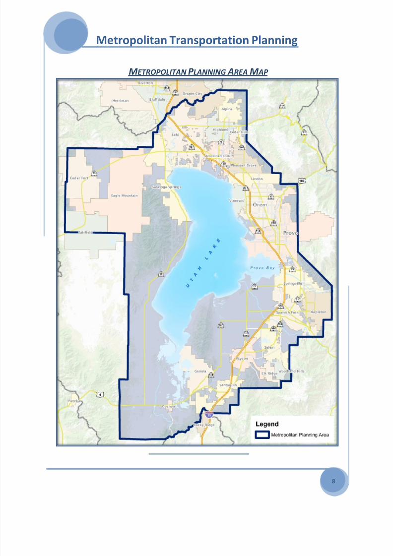
GEOGRAPHY The Mountainland MPO is located at the
southern end of the rapidly growing metro area
along the Wasatch Front. The MPO planning
area boundary encompasses all the Utah
County municipalities and the contiguous
unincorporated areas in between. The MPO
area is bounded on the north by the Salt Lake
County-Utah County line; on the east by the
Wasatch Mountain Range; to the south byUtah-Juab County line, and extends west to
Cedar Fort. (See MPO Map)
Land use and the locations of major
transportation facilities are constrained by a
peripheral boundary of steep mountain terrain
and by the large, centrally located Utah Lake. The
MPO is roughly bisected by I-15, the only freeway
within Utah County. A number of smaller state
routes complete the system of arterial routes and
provide both East-West and North-Southcorridors. Existing conditions make selection and
location of new facilities a real challenge.
ENVIRONMENT Air quality is a major environmental concern in
Utah County. The valley is surrounded by high
mountains, which often create winter

8/3/2019 2040 Metropolitan Transportation Plan - Mountainland
http://slidepdf.com/reader/full/2040-metropolitan-transportation-plan-mountainland 12/64
Metropolitan Transportation Planning
6
temperature inversions that can trap pollutants
in the area for days at a time.
Utah Lake and surrounding wetlands play an
important role in the area's environment. UtahLake is also a critical link in the migratory bird
flight path from Canada to Mexico. The lakebed
is so shallow a rise in the water elevation of a
mere few feet can flood hundreds of acres of
land and cause major impacts on housing,
wildlife, agriculture, industry, recreation, and
transportation facilities.
UTAH LAKE WETLANDS A MIGRATORY BIRD FLIGHT
PATH FROM CANADA TO MEXICO
The proximity of Utah Lake and the Wasatch
Mountains offer excellent opportunities forrecreation and other uses, thus helping to
attract and retain many residents, but limit
developable land and constrain
transportation facilities.
AIR Q UALITY AND TRANSPORTATION
CONFORMITY
Federal funding and approvals for transportation
improvement projects in urban areas arerequired to be part of the planning process
involving all affected local governments. The
process is documented through the MPO’s
Metropolitan Transportation Plan and the 5-year
Transportation Improvement Program. Since the
passage of the Safe, Accountable, Flexible,
Efficient Transportation Equity Act: A legacy for
Users (SAFETEA-LU) and the 1990 Clean Air Act
Amendments, MPOs are required to comply
with the requirements of these acts. The
Metropolitan Transportation Plan and
Transportation Improvement Program should
conform to the State Implementation Plan forair quality.
Utah County is designated as moderate non-
attainment for PM10. Provo City is designated
as a maintenance area for Carbon Monoxide.
Conformity rules outline specific analysis
requirements that non-attainment areas must
follow depending on the severity of the non-
attainment problem and the time frame
established by the Clean Air Act to develop and
implement plans to correct the air quality
problem. These rules require the MPO to showair quality conformity for the life of the
Transportation Plan, which is to the year 2030.
A detailed discussion of the analysis employed
in the conformity determination is a section of
the plan entitled Conformity Determination for
the 2040 Metropolitan Transportation Plan.
Based on the analysis consistent with these
rules, a positive determination can be made for
the Metropolitan Transportation Plan for the
Utah County PM10 non-attainment area and forthe Provo carbon monoxide maintenance area
APPLICABLE C LEAN AIR ACT REQUIREMENTS
AND C ONFORMITY RULES
SAFETEA-LU and the relevant elements of the
1990 CAAA Subsections 176(c)(1)(2) and (3),
requires the MPO to develop a transportation
plan that conforms with the applicable State
Implementation Plan (SIP) for air quality.
The EPA Transportation Conformity Rules (40CFR Part 93) and FHWA/FTA Metropolitan
Planning Regulation (23 CFR Part 450) were
employed in the preparation of this
conforming Long Range Plan. The following
list describes the appropriate subsections of
40 CFR Part 93 the plan must meet:

8/3/2019 2040 Metropolitan Transportation Plan - Mountainland
http://slidepdf.com/reader/full/2040-metropolitan-transportation-plan-mountainland 13/64
Metropolitan Transportation Planning
7
93.110 – Latest Planning Assumptions
93.111 – Latest Emission Model
93.112 – Consultation
93.113(b) – Transportation Control
Measures 93.118 – Emission Budget(s) or
93.119 – Emission Reduction
C OORDINATION WITH C LEAN AIR AGENCIES As stated in the Transportation bill, metropolitan
areas which are non-attainment for ozone or
carbon monoxide under the Clean Air Act are
required in conjunction with the area’s air
agencies and transportation partners to
coordinate the development of consultation
procedures for a process of development of thetransportation control measures of the State
Implementation plans. A Memorandum of
Understanding has been established between
UDOT, Utah Division of Air Quality (UDAQ), and
Mountainland to be followed by a State
Consultation Procedures Plan that is currently
under development.
The Mountainland Regional Planning Committee
and UDAQ have agreed upon a committee
structure for making air quality policy decisionsfor the region’s transportation plans.
The presence of UDAQ on the Mountainland
Regional Planning and Technical Advisory
Committees has greatly improved
communications between Air Quality and
Transportation Planning activities. In
conjunction with the conformity determination
we have established an Interagency
Coordination Committee that includes
representatives of FHWA, UDOT, UDAQ, EPA,
Mountainland, and WFRC. These meetings have
improved the consultation process resulting in a
successful plan consistent with the federal
planning regulations and the SIP. For more
detail see the Appendix - Air Quality Conformity
Determination.
8/3/2019 2040 Metropolitan Transportation Plan - Mountainland
http://slidepdf.com/reader/full/2040-metropolitan-transportation-plan-mountainland 14/64
Metropolitan Transportation Planning
8
METROPOLITAN P LANNING AREA M AP
8/3/2019 2040 Metropolitan Transportation Plan - Mountainland
http://slidepdf.com/reader/full/2040-metropolitan-transportation-plan-mountainland 15/64
WASATCH CHOICE FOR 2040
9
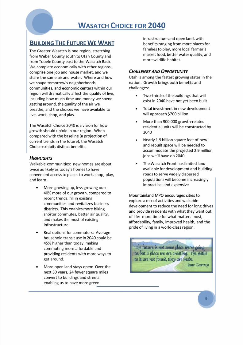
BUILDING THE FUTURE WE WANT The Greater Wasatch is one region, stretching
from Weber County south to Utah County and
from Tooele County east to the Wasatch Back.We complete economically with other regions,
comprise one job and house market, and we
share the same air and water. Where and how
we shape tomorrow's neighborhoods,
communities, and economic centers within our
region will dramatically affect the quality of live,
including how much time and money we spend
getting around, the quality of the air we
breathe, and the choices we have available to
live, work, shop, and play.
The Wasatch Choice 2040 is a vision for how
growth should unfold in our region. When
compared with the baseline (a projection of
current trends in the future), the Wasatch
Choice exhibits distinct benefits.
H IGHLIGHTS Walkable communities: new homes are about
twice as likely as today's homes to have
convenient access to places to work, shop, play,
and learn.More growing up, less growing out:
40% more of our growth, compared to
recent trends, fill in existing
communities and revitalizes business
districts. This enables more biking,
shorter commutes, better air quality,
and makes the most of existing
infrastructure.
Real options for commuters: Average
household transit use in 2040 could be
45% higher than today, makingcommuting more affordable and
providing residents with more ways to
get around.
More open land stays open: Over the
next 30 years, 24 fewer square miles
convert to buildings and streets
enabling us to have more green
infrastructure and open land, with
benefits ranging from more places for
families to play, more local farmer's
market food, better water quality, and
more wildlife habitat.
C HALLENGE AND OPPORTUNITY Utah is among the fastest growing states in the
nation. Growth brings both benefits and
challenges:
Two-thirds of the buildings that will
exist in 2040 have not yet been built
Total investment in new development
will approach $700 billion
More than 900,000 growth-relatedresidential units will be constructed by
2040
Nearly 1.9 billion square feet of new
and rebuilt space will be needed to
accommodate the projected 2.9 million
jobs we’ll have ob 2040
The Wasatch Front has limited land
available for development and building
roads to serve widely dispersed
populations will become increasinglyimpractical and expensive
Mountainland MPO encourages cities to
explore a mix of activities and walkable
development to reduce the need for long drives
and provide residents with what they want out
of life: more time for what matters most,
affordability, family, improved health, and the
pride of living in a world-class region.

8/3/2019 2040 Metropolitan Transportation Plan - Mountainland
http://slidepdf.com/reader/full/2040-metropolitan-transportation-plan-mountainland 16/64
WASATCH CHOICE FOR 2040
10

8/3/2019 2040 Metropolitan Transportation Plan - Mountainland
http://slidepdf.com/reader/full/2040-metropolitan-transportation-plan-mountainland 17/64
WASATCH CHOICE FOR 2040
11

8/3/2019 2040 Metropolitan Transportation Plan - Mountainland
http://slidepdf.com/reader/full/2040-metropolitan-transportation-plan-mountainland 18/64
2040 METROPOLITAN TRANSPORTATION PLAN
12
TRAVEL DEMAND The MPO uses a computer-based transportation
model to determine current travel demand andthen make forecasts of future travel volumes
and locations. The model is calibrated using
known trip rates, transit ridership and highway
traffic counts to reasonably represent “base
year” travel conditions and patterns (as of
2007). This is a process in which model output is
checked against real-world data.
Using socio-economic and land use trends,
along with input and feedback from member
agencies, the model is used to testimprovement scenarios and mode mixes for
satisfying future needs. Model outputs are
used to advise and inform decision makers how
to best keep up with emerging trends and
implement timely course changes. Good
modeling helps local leaders answer some big
questions, such as: Where are upgraded or new
highways most needed? What effects will
increased access to transit have on congestion
or air quality? When are changes needed?
MODEL OVERVIEW The MPO model covers the entire Wasatch
Front, with approximately 31,000 road links. The
transit network is created with local, express,
Bus Rapid Transit, Light Rail, and Commuter Rail
lines.
The software is an integrated land-use, socio-
economic, transportation, and air quality model
co-developed with the Wasatch Front Regional
Council to satisfy the requirements of SAFETEA-
LU and the federal Clean Air Act. Some of the
most useful model outputs to aid in project
selection include:
Peak travel times demand
Origin-Destination flows
Vehicular travel times and speeds
Transit ridership numbers
For details refer to Appendix - Travel Demand
T RAVEL MODEL C OVERAGE AREA

8/3/2019 2040 Metropolitan Transportation Plan - Mountainland
http://slidepdf.com/reader/full/2040-metropolitan-transportation-plan-mountainland 19/64
2040 METROPOLITAN TRANSPORTATION PLAN
13
LAND USE MODELING Each municipality and the county
develop land use plans as part of
the general plan process. Theseland use development patterns
provide context for locating and
modeling changes in socio-
economic trends (population,
households, and employment) that
impact transportation demand.
SOCIO-ECONOMIC
GROWTH TRENDS The Governor’s Office of Planning
and Budget (GOPB) forecasts Utah
County’s total population to
double by 2040, to 1,092,450
(2.7% annual increase). Total
employment follows a similar
trend growing 97%, from 283,915
jobs to 560,058, or a 2.2% annual
average rate of change.
For details on Land Use and Socio-
Economic Growth see Appendix -Travel Demand
GENERALIZED L AND U SE M AP

8/3/2019 2040 Metropolitan Transportation Plan - Mountainland
http://slidepdf.com/reader/full/2040-metropolitan-transportation-plan-mountainland 20/64
2040 METROPOLITAN TRANSPORTATION PLAN
14
SOCIO-E CONOMIC DISTRIBUTION Population density in 2007 was centered in the
Orem/Provo area. However, the highest
growth over the last decade has been in
northwest Utah County, particularly in Lehi,Saratoga Springs, and Eagle Mountain. Mainly
attributed to a convergence of the Salt Lake City
and Provo/Orem Metro areas, it is anticipated
to continue to experience the highest growth
into the foreseeable future. While population
increased in the southern county, densities still
remain at rural levels with slowly expanding
core areas. The Orem/Provo area will retain
its core status as the population and
employment center, but urbanization
will spread northward along the I-15freeway corridor.
T RIP GENERATION One of the key components of trip
generation in the travel demand
model is the relative placement of the
households to employment.
Rural areas tend to have a very low jobs/
households ratio and more urbanized areas a
higher ratio.
In 2007, the Orem/Provo area attracted the mostwork and non-work trips from all other areas of
the county, reflective of a core urbanized area,
with more than 2.4 jobs for every household. By
2040, changing patterns of urbanization will
redistribute trip generation, but the Provo/Orem
core will maintain the highest number of trip
destinations.2007 P OPULATION DENSITY
2040 P OPULATION DENSITY
JOBS PER HOUSEHOLD RATION

8/3/2019 2040 Metropolitan Transportation Plan - Mountainland
http://slidepdf.com/reader/full/2040-metropolitan-transportation-plan-mountainland 21/64
2040 METROPOLITAN TRANSPORTATION PLAN
15
I NTER-C OUNTY C OMMUTING While the large majority of working residents
are employed within county boundaries, a
significant and growing number travel north to
Salt Lake County. This northbound commute isand has always been larger than the reverse
southbound commute, but both are growing
and contributing to the increasing demands on
I-15.
As a result of the population growth in north
Utah County, the inter-county commute, and
the linear configuration of urban development
along I-15, the freeway will reach capacity and
become congested by 2030, even with the
current major reconstruction effort.
MODE SPLIT Work trips by automobile (either drive
alone or car pool) account for the vast
majority of all work trips at 87%, and
these trips place the highest demand on
the transportation system. Increasing
highway capacity to meet future demandwill be both extremely expensive and
reduces air quality. The MTP actively
seeks to spread demand to other travel
modes to help mitigate these negative
impacts.
Projected mode split change come about as a
result of:
Improvements listed in the MTP
Further urbanization and densification
of the areaConvergence of Utah and Salt Lake
Counties
Other socio-economic trends
MODE SPLIT C ENSUS 2000 D ATA
MODE SPLIT IRCAA 2030 D ATA
LEVEL-OF -SERVICE Highway Level-of-Service (LOS) is a determination
of the comfort and convenience experienced by
travelers. Elected officials in Utah County have
adopted a policy for planning of a Level-of-Service
D, a balance between convenience and cost in
view of the funding available. The national
standard is to plan for a LOS C.
MODE 2000 Percent
Drive Alone 72.5%
Car Pool 14.9%
Transit 1.4%
Walk 4.9%
Work at Home (Telecommuting) 5%
Other 1.3%
Mode 2030 Percent
Drive Alone 62%
Car Pool in I-15 HOV Lanes 26%
Transit 12%

8/3/2019 2040 Metropolitan Transportation Plan - Mountainland
http://slidepdf.com/reader/full/2040-metropolitan-transportation-plan-mountainland 22/64
2040 METROPOLITAN TRANSPORTATION PLAN
16
TRAVEL DEMAND MODEL OUTPUTS Model outputs illustrate the
expected changes to travel
demand over the next 30 years,and highlight those facilities
that are or will become
problematic, and approximately
when. The following maps
show how existing and
proposed facilities fare as
growth continues.
F UTURE P ROBLEMS By 2040, I-15 freeway at 12
lanes is heavily congested and
has reached capacity. Many
major arterials in the north
county are experiencing high
congestion levels. Two
prominent bottleneck areas in
the county, Lindon and
Springville, cannot function
without reliever corridors. An
expansion of major highway
facilities in the county is
needed.
To identify needed highway
projects for the plan, projects
from the previous MPO MTP,
city master transportation plans,
and transportation studies are
considered.
Staff then runs the region
travel demand computerized
model to see if the demand is
met. Phase 1 is run using thesocio-economic data for 2020
(population, employment,
households) compared to 2007 (The Base Year
model network). This Illustrates where
congestion will be in 2020 if no improvements
are made to the highway network. It also allows
the MPO to visualize where needed highway
projects should be planned. Projects are
proposed from the list mentioned above and
the model is then run again for Phase One-
2020, with the new projects added to see if the
travel demand is met. This process is then
repeated for each phase of the plan to 2040.
F UTURE T RAFFIC V OLUMES M APS
8/3/2019 2040 Metropolitan Transportation Plan - Mountainland
http://slidepdf.com/reader/full/2040-metropolitan-transportation-plan-mountainland 23/64
2040 METROPOLITAN TRANSPORTATION PLAN
17
Once the three phases of the plan are modeled
and a draft listing of projects is created, MPO
staff review the projects with each municipality,
the county, and the Utah Department of
Transportation gaining input on any neededchanges. A major theme in the plan for this
update was the need for additional large
highway facilities by 2040.
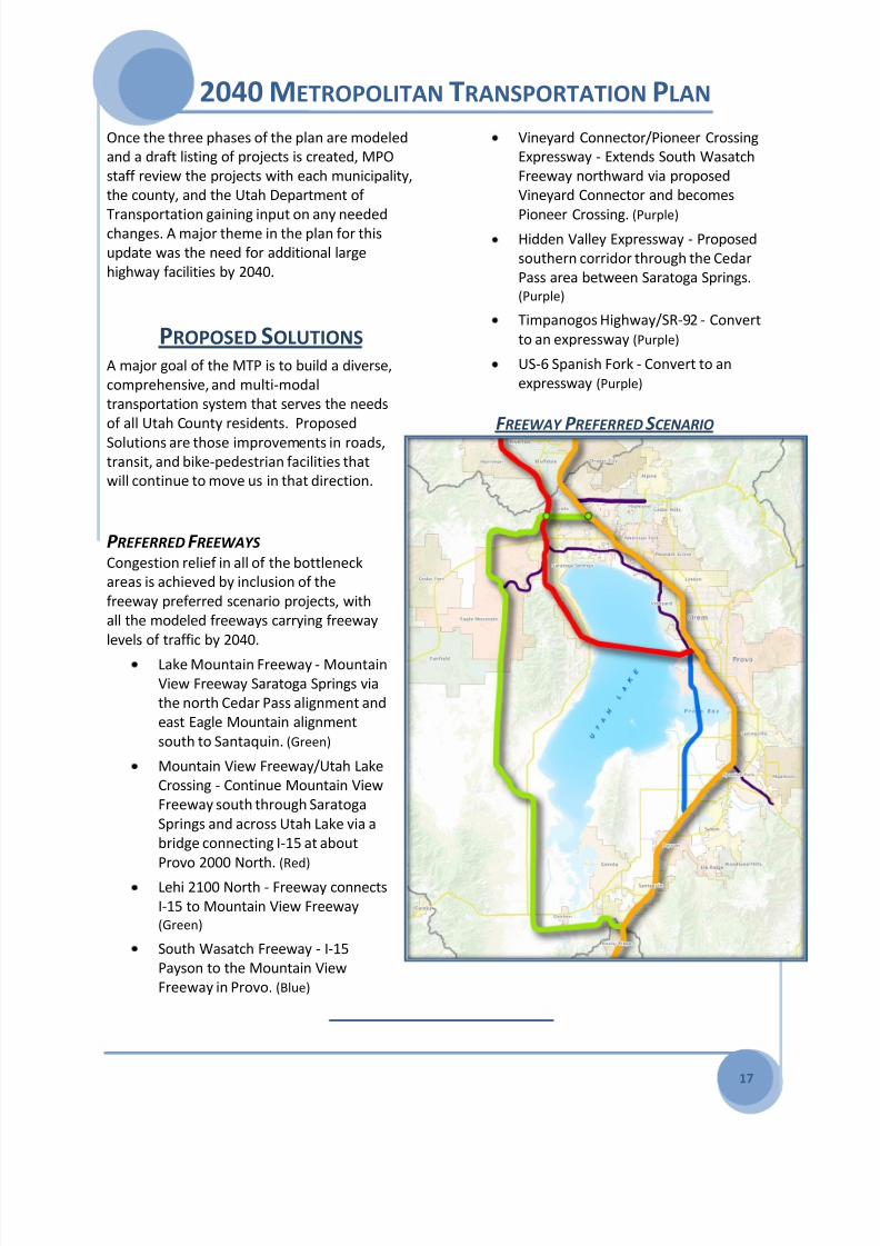
PROPOSED SOLUTIONS A major goal of the MTP is to build a diverse,
comprehensive, and multi-modal
transportation system that serves the needs
of all Utah County residents. Proposed
Solutions are those improvements in roads,transit, and bike-pedestrian facilities that
will continue to move us in that direction.
P REFERRED F REEWAYS Congestion relief in all of the bottleneck
areas is achieved by inclusion of the
freeway preferred scenario projects, with
all the modeled freeways carrying freeway
levels of traffic by 2040.
Lake Mountain Freeway - Mountain
View Freeway Saratoga Springs via
the north Cedar Pass alignment and
east Eagle Mountain alignment
south to Santaquin. (Green)
Mountain View Freeway/Utah Lake
Crossing - Continue Mountain View
Freeway south through Saratoga
Springs and across Utah Lake via a
bridge connecting I-15 at about
Provo 2000 North. (Red)
Lehi 2100 North - Freeway connects
I-15 to Mountain View Freeway(Green)
South Wasatch Freeway - I-15
Payson to the Mountain View
Freeway in Provo. (Blue)
Vineyard Connector/Pioneer Crossing
Expressway - Extends South Wasatch
Freeway northward via proposed
Vineyard Connector and becomes
Pioneer Crossing. (Purple) Hidden Valley Expressway - Proposed
southern corridor through the Cedar
Pass area between Saratoga Springs. (Purple)
Timpanogos Highway/SR-92 - Convert
to an expressway (Purple)
US-6 Spanish Fork - Convert to an
expressway (Purple)
F REEWAY P REFERRED SCENARIO

8/3/2019 2040 Metropolitan Transportation Plan - Mountainland
http://slidepdf.com/reader/full/2040-metropolitan-transportation-plan-mountainland 24/64
2040 METROPOLITAN TRANSPORTATION PLAN
18
ROADS AND HIGHWAY SELECTION In addition to freeways, improvements to lesser
arterials and collector ROADS ADDRESS other
micro regional mobility needs, as continuingpopulation expansion and commercial
development requires increased access and
capacity. The Final List of Road Projects
provides a comprehensive view of neededroadway improvements.
FREEWAY / EXPRESSWAY PROJECTS COST IN
MILLIONS
1I-15 Freeway CORE Reconstruction - Lehi to Spanish ForkLehi Main Street to Spanish Fork River
Reconstruct freeway, interchanges, add capacity, Carpool Lanes
1593.9
2I-15 Freeway Reconstruction - Draper to LehiDraper to Lehi Main Street
Reconstruct freeway and interchanges, add capacity (cost UC portion)
480.0
3I-15 Freeway Widening - Spanish Fork to PaysonSpanish Fork River to Payson 800 South
Reconstruct freeway and interchanges, add capacity
60.8
4I-15 / Benjamin InterchangeReconstruct interchange
48.7
5I-15 / Orem 800 South InterchangeNew HOV interchange connecting to Utah Valley University
124.1
6I-15 / Payson Main Street InterchangeReconstruct interchange
48.7
7I-15 / Santaquin Main Street InterchangeReconstruct interchange
36.5
8Lehi 2100 North Frontage RoadsRedwood Road to I-15 Freeway
Phase 1 frontage roads with at grade intersections
120.6
9Timpanogos Highway / SR-92 - Lehi to HighlandI-15 Freeway to Alpine Highway
Widen 2 lane sections to 4 lanes, add commuter lanes and trail
143.6
10Hidden Valley Expressway / FreewayMountain View Freeway, Saratoga Springs to Lake Mountain Expressway, Eagle Mountain
156.5
11I-15 / Lehi 4000 North InterchangeNew interchange
81.4
12I-15 /Nebo Beltway Expressway Interchange - PaysonNew interchange
72.0
13 I-15 / Spanish Fork Center Street InterchangeNew interchange 81.4
14I-15 / Springville 1600 South/Sp Fork 2700 North InterchangeNew interchange
54.0
15I-15 / Utah County 12400 South InterchangeNew interchange between Payson and Santaquin
54.0
16Lake Mountain Expressway - Eagle MountainSR-73 to Eagle Mountain Blvd
New 6 lane expressway through Eagle Mountain
114.6
Phase 1 Phase 2 Phase 3 VisionHIGHWAY PROJECTSProjects Not Ranked
8/3/2019 2040 Metropolitan Transportation Plan - Mountainland
http://slidepdf.com/reader/full/2040-metropolitan-transportation-plan-mountainland 25/64
2040 METROPOLITAN TRANSPORTATION PLAN
19
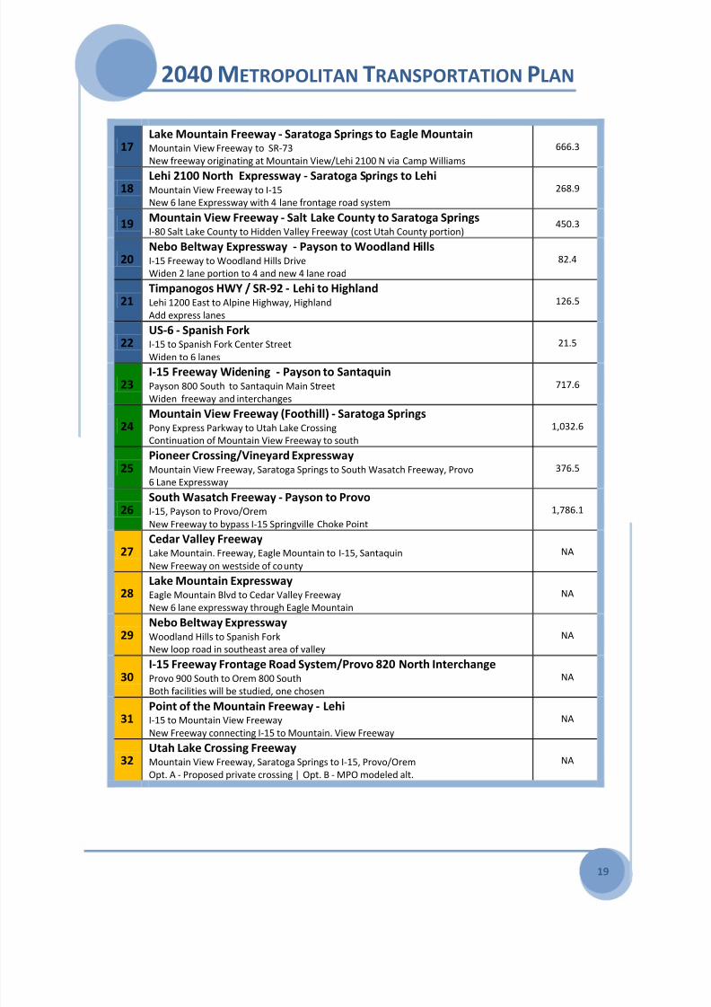
17Lake Mountain Freeway - Saratoga Springs to Eagle MountainMountain View Freeway to SR-73
New freeway originating at Mountain View/Lehi 2100 N via Camp Williams
666.3
18Lehi 2100 North Expressway - Saratoga Springs to LehiMountain View Freeway to I-15
New 6 lane Expressway with 4 lane frontage road system
268.9
19Mountain View Freeway - Salt Lake County to Saratoga SpringsI-80 Salt Lake County to Hidden Valley Freeway (cost Utah County portion)
450.3
20Nebo Beltway Expressway - Payson to Woodland HillsI-15 Freeway to Woodland Hills Drive
Widen 2 lane portion to 4 and new 4 lane road
82.4
21Timpanogos HWY / SR-92 - Lehi to HighlandLehi 1200 East to Alpine Highway, Highland
Add express lanes
126.5
22US-6 - Spanish ForkI-15 to Spanish Fork Center Street
Widen to 6 lanes
21.5
23I-15 Freeway Widening - Payson to SantaquinPayson 800 South to Santaquin Main Street
Widen freeway and interchanges
717.6
24Mountain View Freeway (Foothill) - Saratoga SpringsPony Express Parkway to Utah Lake Crossing
Continuation of Mountain View Freeway to south
1,032.6
25Pioneer Crossing/Vineyard ExpresswayMountain View Freeway, Saratoga Springs to South Wasatch Freeway, Provo
6 Lane Expressway
376.5
26South Wasatch Freeway - Payson to ProvoI-15, Payson to Provo/Orem
New Freeway to bypass I-15 Springville Choke Point
1,786.1
27Cedar Valley FreewayLake Mountain. Freeway, Eagle Mountain to I-15, Santaquin
New Freeway on westside of county
NA
28Lake Mountain ExpresswayEagle Mountain Blvd to Cedar Valley Freeway
New 6 lane expressway through Eagle Mountain
NA
29Nebo Beltway ExpresswayWoodland Hills to Spanish Fork
New loop road in southeast area of valley
NA
30I-15 Freeway Frontage Road System/Provo 820 North InterchangeProvo 900 South to Orem 800 South
Both facilities will be studied, one chosen
NA
31Point of the Mountain Freeway - LehiI-15 to Mountain View Freeway
New Freeway connecting I-15 to Mountain. View Freeway
NA
32Utah Lake Crossing FreewayMountain View Freeway, Saratoga Springs to I-15, Provo/Orem
Opt. A - Proposed private crossing | Opt. B - MPO modeled alt.
NA

8/3/2019 2040 Metropolitan Transportation Plan - Mountainland
http://slidepdf.com/reader/full/2040-metropolitan-transportation-plan-mountainland 26/64
2040 METROPOLITAN TRANSPORTATION PLAN
20
PRINCIPLE HIGHWAY PROJECTS
33Geneva Road / SR-114 - OremOrem 2000 South to Orem 1600 North
Widen to 4 lanes, add RR bridge at Orem 400 South
113.9
34Geneva Road / Pleasant Grove 100 East ConnectionConnect roads at State Street
New 4 lane connector road
5.7
35SR-73 - Saratoga Springs to Eagle MountainRedwood Road to Ranches Parkway
Widen 2 lane portion to 4 lanes, add trail
8.8
36SR-198 - Spanish Fork to PaysonArrowhead Trail to Payson 1500 South
Widen to 4 lanes
75.6
37North County Blvd (Utah County 4800 West)SR-92 to State Street, American Fork
Widen 2 lane section to 4
72.1
38Orem 800 North / SR-52Geneva Road to Orem 400 West
Widen to 6 lanes
12.7
39Pioneer Crossing Extension - Saratoga SpringsRedwood Road to SR-73
New 4 lane road connecting Pioneering Crossing to SR-73
16.8
40Pony Express Parkway - Saratoga Springs to Eagle MountainRedwood Road to Smith Ranch Road
Widen 2 lane portion to 4 lanes, add trail
22.0
41Provo 500 WestProvo 300 South to Westside Connector Road
Widen 2 lane portion to 4 and new 4 lane road, add bike lanes
12.1
42 Redwood Road / SR-68 - Saratoga SpringsSaratoga Springs 400 North to Stillwater Parkway
Widen to 4 lanes, add trail
29.0
43Santaquin Main Street / US-6I-15 Freeway to Santaquin 500 West
Widen to 4 lanes, add trail
10.3
44State Street / US-89 - Orem to Pleasant GroveOrem 1800 North to Geneva Road, Pleasant Grove
Widen 4 lane portions to 6
6.2
45State Street / US-89 - Pleasant Grove to American ForkPleasant Grove 200 South to American Fork 100 East
Widen to 6 lanes
26.7
46
State Street / US-89 - American Fork to Lehi
American Fork Main Street to Lehi Main StreetWiden to 6 lanes
9.7
47University Parkway / SR-265 - Orem to ProvoState Street, Orem to University Ave, Provo
Widen to 6 lanes
34.1
48Westside Connector RoadI-15 / University Ave interchange to Provo Center Street
New 4 lane road
28.7

8/3/2019 2040 Metropolitan Transportation Plan - Mountainland
http://slidepdf.com/reader/full/2040-metropolitan-transportation-plan-mountainland 27/64
2040 METROPOLITAN TRANSPORTATION PLAN
21
49Arrowhead Trail / 8000 South - Spanish Fork to SalemSpanish Fork Main Street to Utah County 3200 West
Widen to 4 lanes
46.2
50SR-73 - Eagle Mountain to Cedar FortRanches Parkway to Eagle Mountain 3400 North
Widen to 4 lanes
134.5
51Payson Main Street / SR-115I-15 Freeway to Payson 100 North
Widen to 4 lanes
8.3
52Pleasant Grove 100 East / Canyon Road / SR-146State Street, Pleasant Grove to SR-92, Highland
Widen to 4 lanes
34.6
53Pony Express Parkway - Eagle MountainRuby Valley Drive to Eagle Mountain 2500 North
Widen 2 lane portion to 4 lanes, add trail
83.8
54
Pony Express Parkway - Saratoga Springs to Pleasant GroveRedwood Road to I-15 / Pleasant Grove Interchange
Widen 2 lane portions to 4 lanes and new 4 lane road, add trail
163.5
55Provo 800 / 820 North / 700 NorthGeneva Road to Provo 900 East
Widen to 4 lanes, add bike lanes
51.3
59Redwood Road / SR-68 - Saratoga SpringsStillwater Parkway to Mountain View Freeway
Widen to 4 lanes, add trail
41.1
57Springville 400 South / SR-77I-15 Freeway to Palmyra
Widen to 4 lanes
45.1
58University Ave / US-189 - ProvoProvo 900 South to 400 South
Reconstruct Provo 600 South RR bridge
54.0
59US-6 - Santaquin to ElbertaSantaquin 500 West to Redwood Road, Elberta
Widen to 4 lanes
53.2
60US-89 - MapletonMapleton 1200 North to Mapleton 1600 South
Widen to 4 lanes
24.4
61SR-73 - Saratoga Springs to Eagle MountainMountain View Freeway to Lake Mountain Freeway
Widen to 6 lanes
108.0
62SR-198 - Payson to SantaquinPayson 1500 South to Santaquin Main Street
Widen to 4 lanes
50.9
63Orem 800 North / SR-52Orem 1000 East to University Ave, Provo
Widen to 6 lanes, interchange improvements
73.3
64Orem 800 North / SR-52Geneva Road to Pioneer Crossing / Vineyard Expressway
New 6 lane road
25.7

8/3/2019 2040 Metropolitan Transportation Plan - Mountainland
http://slidepdf.com/reader/full/2040-metropolitan-transportation-plan-mountainland 28/64
2040 METROPOLITAN TRANSPORTATION PLAN
22
65University Ave - ProvoUniversity Parkway to Orem 800 North
Widen to 6 lanes
91.4
MINOR HIGHWAY PROJECTS
66Elk Ridge Drive - SalemSR-198 to Utah County 8000 South
New 2 lane road
9.7
67Lehi 2300 WestSR-92 to Pony Express Parkway
Widen 2 lane portion to 4 and new 4 lane road
78.0
68Meadows Connection RoadAmerican Fork 200 South to State Street
New I-15 Freeway crossing to American Fork commuter rail station
49.5
69Orem 1600 NorthOrem 1200 West to Orem 400 West
Widen 2 lane portion to 4
6.3
70Orem Center StreetGeneva Road to I-15 Freeway
Widen 2 lane portion to 4
2.8
71Pleasant Grove BlvdI-15 Freeway to State Street
Widen to 4 lanes
10.9
72Provo Center Street / SR-114 - ProvoI-15 Freeway to Provo 3110 West
Widen to 4 lanes
11.5
73North West Connector Road - ProvoWestside Connector Road to Geneva Road
New 4 lane road
34.7
74 Spanish Fork Center StreetSpanish Fork 900 East to US-6
Widen 2 lane portion to 4
1.6
75Springville 1400 North / SR-75I-15 Freeway to Springville Main Street
Widen to 4 lanes
48.7
76American Fork 100 East | Alpine Highway / SR-74American Fork Main Street to SR-92
Widen to 4 lanes, add bike lanes
43.0
77Canyon Crest Drive - Highland to AlpineSR-92 to Alpine Highway
Widen to 4 lanes
14.1
78
Eagle Mountain Blvd
SR-73 to Lake Mountain FreewayWiden to 4 lanes
64.2
79Lehi Main Street / SR-73Redwood Road to Lehi 500 West
Widen to 4 lanes
53.3
80Orem 1600 North | 800 EastOrem 400 West to Orem 800 South
Widen 2 lane portion to 4
51.4

8/3/2019 2040 Metropolitan Transportation Plan - Mountainland
http://slidepdf.com/reader/full/2040-metropolitan-transportation-plan-mountainland 29/64
2040 METROPOLITAN TRANSPORTATION PLAN
23
81Orem 800 South / Provo 3700 NorthOrem 800 East to University Ave, Provo
Widen to 4 lanes
19.5
82Orem Center StreetI-15 Freeway to State Street
Widen to 6 lanes
22.7
83Pacific Ave Bypass Road - American ForkState Street to American Fork 500 East to State Street
Widen to 4 lanes
40.4
84Ranches Parkway - Eagle MountainSR-73 to Lake Mountain Freeway
New 4 lane road
11.7
85Springville 1600 South / Spanish Fork 2700 NorthSpanish Fork Main Street to US-89, Springville
Widen 2 lane portion to 4 and new 4 lane road, add RR bridge
92.8
86
Utah County 12400 SouthSR-198, Santaquin to US-6, Genola
Widen to 4 lanes
96.7
87Woodland Hills Drive - SalemSR-198 to Utah County 11200 South
Widen to 4 lanes
40.9
88Eagle Mountain 3400 NorthSR-73 to Lake Mountain Freeway
New 4 lane road
94.4
89Eagle Mountain 5600 NorthSR-73 to Lake Mountain Freeway
New 4 lane road
95.6
90Spanish Fork Main Street / Provo 500 West Connector RoadI-15 Freeway Spainsh Fork to Provo Westside Connector Road
Widen 2 lane portion to 4 and new 4 lane road
169.2
I-15 CORE: MOVING THE
SAM WHITE BRIDGE INTO
PLACE ON I-15 IN
APPROXIMATELY 8 HOURS
PHOTO COURTESY OF I-15 CORE / PRC

8/3/2019 2040 Metropolitan Transportation Plan - Mountainland
http://slidepdf.com/reader/full/2040-metropolitan-transportation-plan-mountainland 30/64
2040 METROPOLITAN TRANSPORTATION PLAN
24
TRANSIT SELECTION The transit portion of the MTP identifies
strategic scenarios for the development of the
public transit system in Utah County. This planidentifies mass transit needs for local
communities as well as intercity travel between
Utah County and the Salt Lake Valley within a
thirty-year horizon. Transit Planning details are
covered in Appendix - Transportation System
Programs.
Projects are determined with the following
goals:
Ridership: Increase ridership at a rate
greater than population growth.Quality : Provide transit service that is
fast, frequent, and reliable
Productivity : Increase transit ridership
per unit of service.
Efficiency : Reduce the cost per
passenger by maximizing ridership and
minimizing operating costs.
Access: Maximize access to the transit
system
It is expected that as population and
employment grow, more areas of the countywill have densities to support internal,
circulating transit routes.
KEY TRANSIT IMPROVEMENTS
BUS R APID T RANSIT Bus Rapid Transit (BRT) operates much like light
rail with buses in designated bus lanes to avoid
congestion and having traffic signal preemption
to speed running times.
P ROVO-OREM BUS R APID T RANSIT LINE This line is currently under study. Travel
demands of residents and commuters in the
study area are expected to exceed capacity of
the existing transportation system in 2030. The
needs result from:
Increasing travel demand and
insufficient roadway capacity
Insufficient transit capacityPoor transit reliability and travel time
Lack of high‐quality alternatives to auto
travel
Lack of connectivity across I‐15 and
from I‐15 to Orem and Provo
The Provo-Orem Bus Rapid Transit Project has
completed an Environmental Assessment and is
awaiting federal clearance.
OTHER P ROPOSED BRT P ROJECTS
Lehi to Lindon line
Provo to Spanish Fork Line
American Fork to Eagle Mountain Line
Spanish Fork to Payson Line
American Fork to Provo Line
BUS SERVICE
A new bus network has been developed inpartnership with UTA. Transit stations in
various parts of the county connect localized
routes to high frequency core routes along the
I-15 corridor.

8/3/2019 2040 Metropolitan Transportation Plan - Mountainland
http://slidepdf.com/reader/full/2040-metropolitan-transportation-plan-mountainland 31/64
2040 METROPOLITAN TRANSPORTATION PLAN

8/3/2019 2040 Metropolitan Transportation Plan - Mountainland
http://slidepdf.com/reader/full/2040-metropolitan-transportation-plan-mountainland 32/64
2040 METROPOLITAN TRANSPORTATION PLAN
8/3/2019 2040 Metropolitan Transportation Plan - Mountainland
http://slidepdf.com/reader/full/2040-metropolitan-transportation-plan-mountainland 33/64
2040 METROPOLITAN TRANSPORTATION PLAN
27
Significant enhancements will be made through
increased frequencies or headways on existing
routes, adding reverse commute express
routes, bus/HOV lanes on I-15 and additional
high-capacity articulated buses. New park andride facilities, commuter rail and light rail
stations will increase both capacity and
connectivity to local areas.
I NTERMODAL C ENTERS Intermodal centers are being constructed in
Orem and Provo. UTA bus, commuter rail, Bus
Rapid Transit, Amtrak, perhaps local taxi
companies, Greyhound Bus Lines, and bus tour
operators could service the centers. Adjoining
park and ride lots, transit orienteddevelopment, mixed use development, and
bicycle and pedestrian connections are planned.
LIGHT R AIL Commercial growth in North Utah County will
make a 6.5 mile extension of light rail from the
Salt Lake County line to the Orem Intermodal
Center feasible. Anticipated operations would
begin by approximately 2040.
Future Corridor for light rail would is shown as avision project to extend through Lehi, Saratoga
Springs, and Eagle Mountain. More study is
needed to determine the location of this line
and its timing.
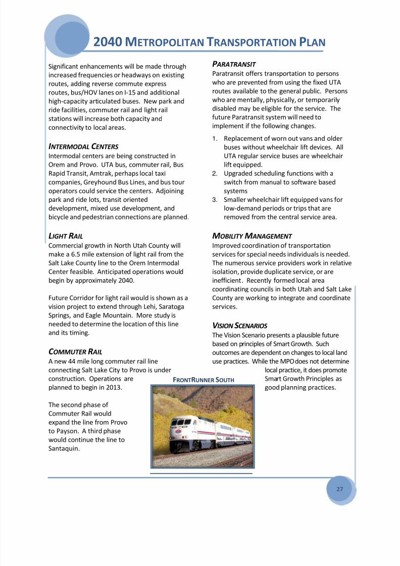
C OMMUTER R AIL
A new 44 mile long commuter rail line
connecting Salt Lake City to Provo is under
construction. Operations are
planned to begin in 2013.
The second phase of
Commuter Rail would
expand the line from Provo
to Payson. A third phase
would continue the line to
Santaquin.
P ARATRANSIT Paratransit offers transportation to persons
who are prevented from using the fixed UTA
routes available to the general public. Persons
who are mentally, physically, or temporarilydisabled may be eligible for the service. The
future Paratransit system will need to
implement if the following changes.
1. Replacement of worn out vans and older
buses without wheelchair lift devices. All
UTA regular service buses are wheelchair
lift equipped.
2. Upgraded scheduling functions with a
switch from manual to software based
systems
3. Smaller wheelchair lift equipped vans forlow-demand periods or trips that are
removed from the central service area.
MOBILITY M ANAGEMENT Improved coordination of transportation
services for special needs individuals is needed.
The numerous service providers work in relative
isolation, provide duplicate service, or are
inefficient. Recently formed local area
coordinating councils in both Utah and Salt Lake
County are working to integrate and coordinateservices.
V ISION SCENARIOS The Vision Scenario presents a plausible future
based on principles of Smart Growth. Such
outcomes are dependent on changes to local land
use practices. While the MPO does not determine
local practice, it does promote
Smart Growth Principles as
good planning practices. FRONTRUNNER SOUTH

8/3/2019 2040 Metropolitan Transportation Plan - Mountainland
http://slidepdf.com/reader/full/2040-metropolitan-transportation-plan-mountainland 34/64
2040 METROPOLITAN TRANSPORTATION PLAN
28
COMMUNTER RAIL PROJECTS OTHER TRANSIT PROJECTS
T1 Salt Lake City to Provo Line T13 Bus Maintenance Facility Expansion
T2 Provo to Payson Line T14 Orem Intermodal Center
T3 Payson to Santaquin Line T15 Provo Intermodal Center
T4American Fork to Santaquin Line
(via Cedar Valley)
LIGHT RAIL PROJECTS
T5 Draper to Orem Line
T6 Lehi to Eagle Mountain Line
ENHANCED BUS OR RAPID TRANSIT PROJECTS
T7 Provo to Orem Line
T8 Lehi to Lindon Line
T9 American Fork to Eagle Mountain Line
T10 American Fork to Provo Line
T11 Provo to Spanish Fork Line
T12 Spanish Fork to Payson Line
Transit PROJECTSProjects Not Ranked Phase 1 Phase 2 Phase 3 Vision
UTA BUS WITH BIKE RACK
OREM TRANSIT CENTER

8/3/2019 2040 Metropolitan Transportation Plan - Mountainland
http://slidepdf.com/reader/full/2040-metropolitan-transportation-plan-mountainland 35/64
2040 METROPOLITAN TRANSPORTATION PLAN
29
BICYCLE AND PEDESTRIAN
IMPROVEMENTS Utah County leaders have embraced non-
motorized transportation as integral toimproving air quality, reducing congestion, and
reducing travel costs.
While major highway and transit facility
construction consume the vast majority of
transportation dollars, bicycle and pedestrian
access are low-cost and low-impact
improvements to a truly multi-modal
transportation system. Initial construction
outlays,
especiallywhere
facilities are
included in
the design
and
construction
of highway
projects, is
very low, at
less than 5%
of project
costs.
The goal of the bicycle/pedestrian system is to
reduce vehicle trips and mitigate traffic
congestion. As Utah Valley continues to grow
and urbanize, so the need and demand for
multi-use paths, neighborhood connections, on-
street bike lanes, sidewalks and pedestrian
friendly development increases. Walking and
biking are viable alternatives to driving for short
trips, typically under two miles. For longer trips
connections to transit are vital. The MTPidentifies a network that connects population
and employment centers to each other, based
on projected densities through 2040.
The major impedance to implementing the
region-wide, interconnected bike/ped system as
envisioned in the MTP is funding. Estimated
costs to implement the MTP projects are nearly
$500 million over thirty years. While MAG and
its partners have committed tens of millions of
dollars to improvements, the $16 million annual
cost to create the needed system is beyondavailable funding sources. However, continued
steady efforts at integration with roadway
projects and proper use of available funds will
make biking and walking increasingly viable
over time.
Bike/Ped projects for the MTP are based largely
on adopted municipal bike/ped plans and input
from the Utah Valley Trails Committee is usedto help close gaps between cities and
determine which facilities are of a regional
nature.
COLLEGE CONNECTER TRAIL
BESIDE UNIVERSITY PARKWAY
PROVO RIVER TRAIL AT
RIVERWOODS OUTDOOR MALL
SHARE THE ROAD

8/3/2019 2040 Metropolitan Transportation Plan - Mountainland
http://slidepdf.com/reader/full/2040-metropolitan-transportation-plan-mountainland 36/64
2040 METROPOLITAN TRANSPORTATION PLAN
30

8/3/2019 2040 Metropolitan Transportation Plan - Mountainland
http://slidepdf.com/reader/full/2040-metropolitan-transportation-plan-mountainland 37/64
2040 METROPOLITAN TRANSPORTATION PLAN

8/3/2019 2040 Metropolitan Transportation Plan - Mountainland
http://slidepdf.com/reader/full/2040-metropolitan-transportation-plan-mountainland 38/64
2040 METROPOLITAN TRANSPORTATION PLAN
THIS PAGE LEFT BLANK

8/3/2019 2040 Metropolitan Transportation Plan - Mountainland
http://slidepdf.com/reader/full/2040-metropolitan-transportation-plan-mountainland 39/64
2040 METROPOLITAN TRANSPORTATION PLAN
33
FINANCIAL PLAN
How is this all paid for? The MTP includes a
fiscally-constrained financial plan that provides
adequate resources for plan implementation
and system operation and maintenance over a
30 year time frame. This includes reasonably
expected revenues from FHWA and FTA, state
government, regional or local sources, the
private sector, and user charges.
The MPO participates in an advanced planning
practice called the Unified Transportation Plan,
a state-wide coordination of all MPO and UDOT
planning. This also provides each agency and
the legislature with common fundingassumptions based on a universal set of
demographic, revenue, and cost estimating
data.
Funding assumptions are for planning purposes
only. They do not suggest endorsement of any
particular tax nor are they intended to craft
optimal tax policy. Rather, they are based on
past federal and state practices, and include
one-time appropriations or bonding scenarios
that may or may not materialize, depending onthe priorities of elected officials.
Maintenance and Operations of the system is
shown to be underfunded, and will remain so
unless additional funds are made available.
Vision Projects are those identified as needed
beyond the 2040 planning horizon, and are not
included in the financial plan.
MPO FUNDING POLICY Mountainland MPO transportation funding
policy is:
First grow the economy
Second reallocation of existing funds
Third entertain tax rate adjustments as
a last resort.
SOURCES OF TRANSPORTATION
FUNDS Transportation funds are generated from sales
taxes, highway tolls, bonds, state, local, andfederal excise taxes on various fuels, and credit
assistance sources.
STATEWIDE 2040 F UNDING ASSUMPTIONS:All figures are presented in future year
dollar values at 4% annual inflation.
Federal funds and programs increase at
2% per year.
The B&C Roads program continues at
30% of total fuel tax revenue.
By 2017, 100% of auto related sales taxwill be dedicated to transportation.
(Currently at 50%).
A 5-cent increase in statewide fuel tax
(or other equivalent) in 2014 and each
decade after.
A $10 statewide increase in vehicle
registration fees in 2018 and each
decade after.
LOCAL 2040 F UNDING - P LANNING ASSUMPTIONS:
A $5 county increase in vehicle
registration fees in 2018 and each
decade after.
Vehicle registrations grow at 2% per
year.
1/4-cent sales tax in 2020 dedicated to
transit.
Local sales tax funds increase at 5.25-
5.50% per year.Increased transit fares and advertising
income.
BONDS Assume 4 percent interest rate with a 20 year
retirement.

8/3/2019 2040 Metropolitan Transportation Plan - Mountainland
http://slidepdf.com/reader/full/2040-metropolitan-transportation-plan-mountainland 40/64
2040 METROPOLITAN TRANSPORTATION PLAN
34
REVENUE
Revenue includes all planned funding resulting from the funding assumptions used in the plan which
include statewide, local and bonding assumptions.
Planned RevenueFunds in Millions Inflated to Planning Phase
Planning
FundsPhase 12011-2020
Phase 22021-2030
Phase 32031-2040
New Capacity Projects 6,837.1 616.3 2,120.6 4,100.2
Bond Revenue (less costs) 676.9 166.3 510.6 0.0
Current Projects & Federal Earmarks 2,389.7 2,115.7 127.0 147.0
Preservation and Operations 2,368.1 556.4 756.4 1,055.3
Total UDOT Revenue 12,271.9 3,454.7 3,514.6 5,302.5
MPO Federal Funds 225.3 60.8 74.1 90.4
2nd 1/4-Cent Sales Tax (8% Roads / 92% Transit) 80.5 14.3 24.4 41.7
3rd 1/4-Cent Sales Tax (70% Roads / 30% Transit) 804.7 143.0 244.3 417.3
$10 Vehicle Registration (Started in 2008) 141.2 38.3 46.5 56.4
$5 Vehicle Registration (2018 and every 10 years) 225.6 6.3 53.8 165.6
B & C Funds - 10% 125.0 23.4 38.6 63.0
Municipal General Fund Contributions - 10% 188.2 45.3 60.9 81.9
Developer / Private Funds 686.0 165.3 222.2 298.6
Total Regional Revenue 2,476.4 496.7 764.8 1,214.9
Total Highway Planning Revenue 14,748.3 3,951.4 4,279.4 6,517.4
1st 1/4-Cent Sales Tax (100% Transit) 829.4 152.4 253.7 423.3
2nd 1/4-Cent Sales Tax (8% Roads / 92% Transit) 962.9 176.9 294.6 491.4
3rd 1/4-Cent Sales Tax (70% Roads / 30% Transit) 50.0 50.0 0.0 0.0
4th 1/4-Cent Sales Tax (100% Transit) 550.1 0.0 206.2 343.9
FTA New Starts Funds and Region Funds 1,781.8 234.0 189.0 1,358.8
Federal Formula Funds 286.5 59.7 90.2 136.6
Bond Revenue 1,000.0 0.0 0.0 1,000.0
Fare Revenue 1,011.2 105.9 287.6 617.7
Advertising Revenue 25.6 3.7 8.2 13.7
Total Transit Planning Revenue 6,497.5 782.6 1,329.5 4,385.4Total Highway and Transit
PLANNED REVENUE21,245.8 4,734.0 5,608.9 10,902.8
UDOT FACILITIES
HIGHWAY REVENUE
ALL REGIONAL FACILITIES
HIGHWAY REVENUE
UTATRANSIT REVENUE

8/3/2019 2040 Metropolitan Transportation Plan - Mountainland
http://slidepdf.com/reader/full/2040-metropolitan-transportation-plan-mountainland 41/64
2040 METROPOLITAN TRANSPORTATION PLAN
35
E XPENDITURES Expenditures include total costs of operation and maintenance plus proposed capacity improvements to
the transportation system.
Financial details can be found in Appendix - Financial Plan.
System Preservation/OperationsFunds in Millions to Planning Phase
Planning
FundsPhase 12011-2020
Phase 22021-2030
Phase 32031-2040
Bridge Preventive Maintenance 27.0 9.0 9.0 9.0
Bridge Rehabilitation / Replacement 84.1 15.9 25.9 42.3
Contractual Maintenance 681.1 128.9 210.0 342.1
Hazard Elimination, Safety, Enhancements 181.6 34.4 56.0 91.2
Highway Rehabilitation / Replacement 81.6 27.2 27.2 27.2
Operations 1,114.6 300.8 366.7 447.0
Region / Department Contingencies 17.9 6.0 6.0 6.0
Signals, Spot Improvement, Lighting, Barriers 180.2 34.1 55.6 90.5Total HWY Preservation/Operations 2,368.1 556.4 756.4 1,055.3
Unmet System HWY Preservation Needs 1,285.8 243.4 396.5 645.9
Operations and Maintenance 2,127.3 253.4 602.4 1,271.5
Total Transit Operations/Maintenance 2,127.3 253.4 602.4 1,271.5
Total Highway and Transit
PRESERVATION / OPERATIONS4,495.4 809.8 1,358.8 2,326.8
HIGHWAY
PRESERVATION/OPERATIONS
TRANSIT
OPERATIONS/MAINTENANCE
Transportation System ExpansionFunds in Millions to Planning Phase
PlanningFunds
Phase 12011-2020
Phase 22021-2030
Phase 32031-2040
Freeway/Expressway Projects 8,802.9 2,656.9 2,233.2 3,912.8
Principal Highway Projects 1,573.9 484.5 740.0 349.4
Minor Highway Projects 1,162.6 253.7 549.8 359.1
Total Highway Expansion Costs 11,539.4 3,395.0 3,523.0 4,621.3
Commuter Rail 1,280.2 454.5 495.0 330.7
Light Rail 2,363.0 0.0 0.0 2,363.0Enhanced Bus or Rapid Transit 401.2 125.0 235.0 41.2
Bus Improvments and Other Costs 340.4 91.8 150.4 98.2
Total Transit Expansion Costs 4,384.8 671.3 880.4 2,833.1
Total Highway and Transit
EXPANSION PROJECTS15,924.2 4,066.3 4,403.4 7,454.4
HIGHWAY
EXPANSION PROJECTS
TRANSIT
EXPANSION PROJECTS
8/3/2019 2040 Metropolitan Transportation Plan - Mountainland
http://slidepdf.com/reader/full/2040-metropolitan-transportation-plan-mountainland 42/64
2040 METROPOLITAN TRANSPORTATION PLAN
36
IMPACTS AND BENEFITS
Road and transit projects in the Metropolitan
Transportation Plan will have both positive and
negative impacts to the social and physical
environment of the region. For example,
highway and transit improvements will reduce
congestion, increase accessibility, result in
fewer accidents, and improve air quality;
however the construction or upgrading of
highways may result in increased noise,
relocation of residential or commercial
properties, and the destruction of wetlands.
The MTP attempts to maximize the positive
benefits while minimizing the negative impacts
of all projects. Projects that could have majorimpacts were identified so that project
sponsors can address potential impacts as they
develop their plans.
SUMMARY OF PRESENT CONDITIONS Most of the communities in Utah County have
developed as rural, agriculturally based
enclaves and most remain as low-density,
suburban communities today. The 2010 GOPB
projections estimate the MPO’s currentpopulation to be 560,000. 2040 Utah County
projections are estimated at 1.1 million, a
doubling of our residents in 30 years. The
growth of the county to date has had
significant impact on the natural environment;
the next 30 years of growth are predicated to
have a similar level of impact.
PROJECTION OF CHANGE OR
TRANSFORMATION 365 acres of existing wetlands may be
impacted, 73 projects may increase noise
near residential neighborhoods, 59 projects
may relocate residential or commercial
businesses, 20 projects may impact existing
agriculture protection easements, 3 projects
may impact or disturb an existing EPA study
sites, and projects may impact 587 historic or
public recreation areas etc.
The MPO encourages local government
projects to mitigate these impacts by workingwith UDOT, US Army Corps of Engineers, Utah
DWR, US fish and Wildlife, and the State
Historic Preservation Officer to mitigate
impacts in concert with projects established
by these organization in high value locations
such as: The 120 acre Lindon Wetland
Mitigation Bank, Utah Historic Bridge Survey
and the June Sucker Recovery Program near
Provo.
CURRENT AND EMERGING ISSUES The MPO consults with federal, state and local
agencies on the potential impacts of
improvements called for in the MTP. The MPO
compares its projects both individually and
cumulatively with existing conservation plans as
well as inventories of natural or historic
resources. Both impacts and potential
environmental mitigation activities are
considered.
FORMAL CONSERVATION PLANS/
POTENTIAL ENVIRONMENTAL
MITIGATION ACTIVITIES J UNE SUCKER (F ISH ) RECOVERY The June Sucker Recovery Implementation
Program is a multi-agency cooperative effort
designed to coordinate and implement recovery
actions for the endangered June sucker, found
only in Utah Lake and its tributaries. The JuneSucker Recovery Implementation Program has
two main goals: Recover the June sucker to the
extent that it no longer requires protection
under the Endangered Species Act, and allow
for the continued operation of existing water
facilities and future water development of
water resources for human use.

8/3/2019 2040 Metropolitan Transportation Plan - Mountainland
http://slidepdf.com/reader/full/2040-metropolitan-transportation-plan-mountainland 43/64
2040 METROPOLITAN TRANSPORTATION PLAN
37
UTAH HISTORIC BRIDGE SURVEY The bridge survey guides UDOT’s environmental
staff and consultants in determining whether a
bridge is eligible for listing on the National
Register of Historic Places, and requiresprotection during a construction project. A
“property,” as a bridge or building is known,
must generally be 50 years old, although UDOT
uses 45 years as a cut-off date in order to
accommodate the length of time between the
completion of environmental documents and
the beginning of construction. Second, a
property must have historical integrity, meaning
that the features that render it historically
significant are still intact and visible.
“Historical” integrity should not be confusedwith “functional” or “structural” integrity. And
third, a property must be significant for its
association with historic trends, important
events or people, or noteworthy for its
construction or design.
LINDON WETLAND MITIGATION BANK The U.S. Army Corps of Engineers regulates
wetland activities with guidance from the
Environmental Protection Agency and the U.S.Fish and Wildlife Service. These agencies, along
with UDOT have created a 120 acre Mitigation
Bank that serves UDOT projects in Northern
Utah County.
The Northern Utah County Mitigation Bank
(NUCMB) will eventually provide 75 wetland
credits that will serve UDOT projects such as
Pioneer Crossing, I-15 Core, and Geneva Road
expansion. The credits provide a cost effective
means of mitigating wetland impacts as well as
an efficient permitting method that will
accelerate the permitting process by at least
one year for each project. Ultimately the
NUCMB saves UDOT millions of dollars in
mitigation costs as well as years in delays due to
permitting requirements.
UTAH LAKE WETLAND PRESERVE The Utah Lake Wetland Preserve, a network of
wetland and interspersed upland habitats near
the southern end of Utah Lake, is being
established to partially mitigate for past andanticipated impacts of Central Utah Project
water development. The Preserve will provide
habitat for wetland- and upland-dependent
species and will ultimately be managed by the
Utah Division of Wildlife Resources. The
Preserve consists of Goshen Bay and Benjamin
Slough.
PLANNING AND ENVIRONMENT
LINKAGES FHWA encourages an attempt to link this early
environmental work (mentioned above) to the
ultimate construction of the project through an
initiative called Planning and Environment
Linkages (PEL). This approach considers
environmental, community, and economic goals
early in the planning stage and carries them
through project development, design, and
construction. The goal of PEL is to create a
seamless decision-making process that
minimizes duplication of effort, promotes
environmental stewardship, and reduces delays
from planning to project implementation. PEL
lays the foundation for a broad consensus on
goals and priorities for transportation related
processes.
GOALS OF THE MPO PEL The MPO Planning and Environmental Linkage
efforts will concentrate on the following Goals:
a. Create and maintain a Project File foreach MTP Transportation Project from
its inception. This documentation will
explain the various activities including
the public and resource management
agency involvement that have occurred
in the development of the project as
part of the MPO planning process. The

8/3/2019 2040 Metropolitan Transportation Plan - Mountainland
http://slidepdf.com/reader/full/2040-metropolitan-transportation-plan-mountainland 44/64
2040 METROPOLITAN TRANSPORTATION PLAN
38
goal is to document any planning-level
information to NEPA standards so this
information can be used as a
foundation for the NEPA scoping
process and appended or referenced inany future NEPA document.
b. During MPO studies the consultant or
MPO staff will document other
alternatives considered and why they
were not moved forward. The planning
level screening and evaluation is similar
to that done in NEPA in order to select
the preferred alternative. A solutions
evaluation and documents screening
done in planning can be summarized
and incorporated by reference into
NEPA without a need for the
alternatives study to be “redone.” This
information is summarized in the
“Project File.”
c. Develop a “Planning Level Problem
Statement” of Transportation Project
during MPO studies in the development
of the MTP. This will be carried it into
MTP then into NEPA as the Purpose and
Need. Time and energy spent duringthe MPO MTP development can be
used to reduce time and energy at the
beginning of NEPA on this task. This
planning level Problem Statement
captures in a clear and succinct format,
information from planning that NEPA
practitioners can incorporate into their
purpose and need. All first Phase
projects will have a Planning Level
Problem Statement summarized on the
Project Fact Sheet that also includesAADT by Phase, purpose need, study
origin, sponsor, impacts benefits,
typical cross section and any proposed
bicycle pedestrian improvements.
SECTION RECOMMENDATION The impacts of these MTP projects need to be
mitigated and coordinated to achieve the
highest value of the reinvestment. Projects that
could have major impacts were identified so
that sponsors can avoid, minimize, repair,
restore, reduce over time, and account for the
cost as they develop their plans.
STRATEGIES TO I MPLEMENT P LAN
RECOMMENDATIONS Project fact sheets for all first phase projects
will identify project impacts and provide a
suggestion of potential environmental
mitigation activities and potential areas to carry
out these activities out. The project sponsor
should be able to plan for and effectively
mitigate any negative environmental impact of
a project.

8/3/2019 2040 Metropolitan Transportation Plan - Mountainland
http://slidepdf.com/reader/full/2040-metropolitan-transportation-plan-mountainland 45/64
2040 METROPOLITAN TRANSPORTATION PLAN
39
COMMUNITY IMPACTS AND BENEFITS
NOISE IMPACTS Noise impacts vary based upon the
characteristics of traffic, roadway/transit
facility, and adjacent land uses. By shifting the
highway alignment away from noise sensitive
land uses, depressing the roadway, or installing
noise barriers between the highway and the
sensitive areas, adverse noise effects may be
significantly reduced.
SCHOOL IMPACTS Transportation project impacts to school safety
vary according to the nature of the new facility,
the type of school involved, and the traffic
exposure student pedestrian's encounter. This
analysis is limited to identifying projects with
immediate adjacent impacts (planned ROW
intersects with school property) and
road/transit projects within a half mile of an
existing school center point of foot print.
Major 4-lane and above facilities carrying
significant traffic volumes at relatively higher
speeds could potentially affect school safety.
Specific project impacts and mitigation
measures should be identified in the
environmental phase of the project's
development. Potential mitigation measures
may be identified during the specific project
impact assessment phase and may include the
provision of pedestrian overpasses and/or new
busing areas.
LAND USE
Local governments, such as counties and cities,
are responsible for land use planning in Utah.
Past practices in land use have resulted in low-
density urban development patterns in Utah
Valley. Low-density development is mostconveniently served by the automobile and less
effectively served by mass transit modes.
Anticipated land use development impacts
are primarily associated with new arterial
facilities that will provide development
access to adjacent property. Existing roads
that will be upgraded to primary arterials
and new roadway facilities will also have
measurable impact on adjacent residential
zoned land uses.
RELOCATION IMPACTS
Neighborhood disruption and relocation
impacts vary with each transportation
project proposed. Relocation impacts are
determined if insufficient right-of-way for
the new project exist. Neighborhood
disruption can also occur when homes,
businesses, or community institutions are
eliminated from the neighborhood or when
the roadway becomes a barrier to
neighborhood interaction.
VISUAL IMPACTS
Visual impacts can occur when a
transportation project is located in a particular
scenic area, when a project is located on a
steep grade, when cut and fill practices are
employed or when a project is located in animportant view shed area.

8/3/2019 2040 Metropolitan Transportation Plan - Mountainland
http://slidepdf.com/reader/full/2040-metropolitan-transportation-plan-mountainland 46/64
2040 METROPOLITAN TRANSPORTATION PLAN
40
ENVIRONMENT IMPACTS AND BENEFITS
FARMLAND IMPACTS The farmland of Utah County has significance
beyond its local boundaries. While most of
the alfalfa and feed grains such as, winter
wheat, and sweet corn are used locally, the
specialty crops of apples, pears, and cherries
find their way into national and international
markets.
In addition, Utah County has designated
“Agriculture protection areas” which means a
geographic area is granted specific legalprotection for the production of “crops,
livestock, and livestock products” or devoted
to an agency of the state or federal
government.
Several projects in the MTP will impact these
unique and prime farmlands as well as the
agriculture protection areas. These impacts
include use of farmland for rights-of-way and
the division of large contiguous pieces of
farmland into smaller uneconomically viableunits.
GEOLOGIC HAZARDS LIQUEFACTION, DEBRIS FLOW, AND FAULT LINES The Wasatch Fault runs the length of Utah
County and highlights the geologic hazards in
the area and the need to consider their
potential impact on transportation facilities.
Several geologic factors should be considered
when planning a new highway project. Faultlines of known earthquake activity and its
1000' buffer, slope hazard or debris flow areas,
and high potential liquefaction areas should
be avoided. Safeguards may be implemented
during the project's design phase to lessen the
impact of these possible hazards.
EPA STUDY SITES The potential for hazardous waste in project
rights-of-way is a concern in the setting of
transportation facilities, because the purchase
of a contaminated site or the purchase of
property split from a contaminated parcel may
result in the public agency becoming
financially liable for hazardous waste clean-up.
The MTP compares the location of projects
with the location of hazardous waste sites
listed in the Comprehensive Environmental
Response Compensation and LiabilityInformation System (CERCLIS) and Leaking
Underground Storage Tanks (LUST). CERCLIS is
the database used by the EPA to track
superfund progress at potential and confirmed
hazardous waste sites.
BODIES OF WATER AND
FLOODPLAIN MODIFICATION Highway projects can impact a water body or
flood plain in many ways including: disturbingground within 20 feet of natural or semi-natural
rivers and streams, realigning or channeling
meandering rivers and streams, placing
obstructions in floodplains and realigning or
channeling meandering rivers and streams, and
constructing in unstable floodplain crossings.
WATER Q UALITY IMPACTS
Utah State's Non-point Source ManagementPlan, the federal Clean Water Act and various
other governmental regulations require the
monitoring of water resource impacts and
management in the MPO area. Water quality
impacts associated with roadway project vary
according to traffic volumes, pavement width
additions and the recharge capability of the
surrounding soils.

8/3/2019 2040 Metropolitan Transportation Plan - Mountainland
http://slidepdf.com/reader/full/2040-metropolitan-transportation-plan-mountainland 47/64
2040 METROPOLITAN TRANSPORTATION PLAN
41
WETLAND IMPACTS Wetlands serve critical environmental
functions, including flood control, water
purification and the provision of habitat for fish
and wildlife. Wetlands generally include
swamps, marshes, bogs, and similar areas.
The significance of roadway wetland impacts
varies based upon the projects characteristics,
the size and quality of the wetlands area, and
the level to which the wetlands have already
been disturbed by people. A project may
generally impact wetlands by destroying the
immediate footprint of the planned facility orby providing a barrier between adjacent
wetland areas. The Utah Division of Wildlife
Resources identified eight essential wetlands
areas in Utah County:
Utah Lake and associated wetland
complexes (North Shore, Provo Bay,
Skipper Bay, Goshen Bay, Benjamin
Slough, etc.)
Powell Slough WMA ownership conflicts
Potential acquisitions within Utah LakeWetland Preserve Boundary
Isolated wetland complexes and wet
meadows along east bench area
Fairfield wetlands
Holladay Spring
American Fork Spring Complex
(currently under construction for
commercial development)
Riparian areas along UDWR Priority
Streams
U TAH L AKE W ETLAND P RESERVE , PART OF T HE U TAH
RECLAMATION MITIGATION AND C ONSERVATION
C OMMISSION ’ S
CENTRAL UTAH WATER PROJECT
Utah Lake, in Central Utah, is the largest
naturally occurring freshwater lake in the
western United States. Its wetlands have long
been recognized locally and nationally for their
critical importance to fish and wildlife
resources. The Utah Lake wetland ecosystem is
important as a breeding area and stopover for
many migratory birds in the Pacific Flyway.
Approximately 226 species of birds are knownto use Utah Lake wetlands, as well as 49
mammalian species, 16 species of amphibians
and reptiles, and 18 species of fish. Utah Lake
also provides feeding areas for birds nesting on
the Great Salt Lake.
The Utah Lake Wetland Preserve, a network of
wetland and interspersed upland habitats near
the southern end of Utah Lake, is being
established to partially mitigate for past and
anticipated future impacts of Central Utah
Project water development. The Preserve will
provide habitat for wetland and upland-
dependent species and will ultimately be
managed by the Utah Division of Wildlife
Resources. The Preserve consists of two units:
Goshen Bay and Benjamin Slough. Special
consideration should be given to avoidance,
minimization or mitigation with the projects
that intersect with this resource.
SECTION 4(F)Section 4(f) of the Department of
Transportation Act of 1966, stipulated that the
Federal Highway Administration and other
Department of Transportation agencies cannot
approve the use of land from a significant
publicly owned public park, recreation area,
wildlife or waterfowl refuge, or any significant
historic site unless there is no feasible and
prudent alternative, and the action includes all
possible planning to minimize harm to the
property.
SECTION 4(F) HISTORIC Transit and roadway projects can negatively
impact cultural resources by creating noise,
vibration, the need to relocate, vandalism,
physical impacts, and others. Positive impacts

8/3/2019 2040 Metropolitan Transportation Plan - Mountainland
http://slidepdf.com/reader/full/2040-metropolitan-transportation-plan-mountainland 48/64
2040 METROPOLITAN TRANSPORTATION PLAN
42
may also result by providing improved access to
important community cultural resource.
Impacts to all cultural resources will be
identified and mitigation measures determinedduring the environmental phase of project
development. If unknown cultural resources
are encountered during the project
development/construction phase, appropriate
investigation should take place. Reasonable
efforts should be made to provide access and
information to the site during construction.
Such mitigation might, for example, include the
placement of historical information markers, in
addition to providing the standard
documentation.
SECTION 4(F) PUBLIC PARKS/
RECREATION AREAS
The Public Parks and Recreation Areas consists
of the following: public parks, public recreation
areas, public multiple-use land holdings, historic
state parks, fairgrounds, school playgrounds,
public golf courses, existing public non-
motorized trails and future public trails of
regional significance.
All existing and proposed trail facilities are or
will be publicly owned; 4(F) facilities. Because
trails make important non-motorized
connections between major origins and
destinations, it is essential that they exist as
contiguous facilities. Highway and other
transportation projects can adversely affect
trails by interrupting existing or planned routes.
Each of these projects should therefore provide
for the continuity of both existing and planned
trails with the incorporation of underpasses/overpasses or other appropriate
connections.
In addition, the mountains east of the MPO
area provide recreation and open space for the
people of Utah County. The Uinta National
Forest is a nationally recognized winter and
summer recreation area for skiers and hikers; it
contains three congressionally designated
wilderness areas of inspiring grandeur and is a
source of water for the cities of the area. The
MTP will need to minimize the impacts on these
publicly owned recreational areas of significant
value.
SECTION 6F PROPERTIES Project impacts to 6(F) projects are problematic
and should be avoided. Land and water
conservation funded properties acquired or
developed under the federal land and water
conservation fund program must be retained in
public ownership for outdoor recreation use in
perpetuity or replaced in both quantity andquality.
SECTION 4(F)
WILDLIFE/WATERFOWL REFUGES The entire MPO area has been identified as
important migratory waterfowl habitat
described as the “Intermountain West Unit,” by
the U.S. Department of Interior in the 1994
update to the North American Waterfowl
Management Plan. This plan's primary
objective is to preserve habitat and increase
duck, goose, and swan populations nationwide.
Road and transit improvements should avoid or
minimize any wetland or waterfowl habitat. In
addition, sections of important farmland should
be preserved to act as migratory rest and
feeding areas.
The Utah Division of Wildlife Resources (UDWR)
has also mapped the entire MPO area for Fish,
Birds and Mammal important habitat. Primaryareas of concern with this mapped habitat are
the bench or foothill locations, riparian or
wetlands and water bodies. Foothills occur
where the urbanized area meets the Uinta
National Forest in the eastern edge of the MPO
area. These sagebrush and scrub oak covered
hills provide critical habitat for the mule deer,
elk, mink, snowshoe hare, rocky mountain big

8/3/2019 2040 Metropolitan Transportation Plan - Mountainland
http://slidepdf.com/reader/full/2040-metropolitan-transportation-plan-mountainland 49/64
2040 METROPOLITAN TRANSPORTATION PLAN
43
horn sheep, both for winter range as well as
year round habitat.
Several species of birds such as California Quail,
Ring Neck Pheasant, Ruffed Grouse, Sage
Grouse use the foothill area for yearlonghabitat, including brooding habitat. California
Quail, Ring Neck Pheasant also have critical
habitat in the valley locations that intersects
with most road and transit projects.
Important fisheries in the MPO area are the
upper portion of the Spanish Fork River, the
entire stretch of the Provo and Jordan Rivers,
portions of Hobble Creek near Springville,
portions of the American Fork River, and Utah
Lake. Selected species include the June Sucker,
Utah Chud and the Bonneville Cutthroat Trout.The road and transit projects that intersect
major naturally occurring rivers, streams and
water bodies impact fishery and aquatic
habitat.
Several threatened and endanger species, both
flora and fauna, exist within the MPO area.
Coordination with the U.S. Fish and Wild Life
Service February 2011 determined the presence
of the following threatened and/or endangered
species In Utah County.
For more detail of how the MTP projects are
affected by the various impacts and benefits,
see the Appendix - Impacts and Benefits
CLIMATE CHANGE
The USDOT’s Transportation and Climate
Change clearing house states that the prospect
of global climate change has become a major
policy issue during the last decade. The
transportation sector is currently responsible
for approximately 28 percent of greenhouse gas
emissions in the United States and is expected
to be one of the fastest growing sources of
greenhouse gas emissions in the foreseeable
future, due to increased demand for motor
gasoline, jet fuel, and diesel fuel.
In May 1999, the USDOT established the Center
for Climate Change and Environmental
Forecasting to play a leadership role in meeting
these challenges. The Center promotes
comprehensive multimodal approaches toreduce GHG emissions and prepare for the
effects of climate change on the transportation
system, while advancing USDOT's core goals of
safety, mobility, environmental stewardship,
and security.
Federal Highway Administration has four
primary strategies to reduce Green House Gas
(GHG) emissions from transportation. To be
most effective, all four must be pursued
together.
1. Improve system and operational
efficiencies: Traffic flow improvements can
be achieved through intelligent
transportation systems, route optimization,
congestion pricing, and improved
intermodal links and system connectivity.
Other improvements, such as auxiliary
power units and truck stop electrification
systems allow long-haul trucks to run air
conditioning/heating and electrical
appliances without having to idle theirvehicles during rest periods, saving fuel and
reducing emissions.
2. Reduce growth of vehicle miles traveled:
Land use strategies that concentrate
development reduces driving.
Providing HOV lanes, transit options,
pedestrian and bicycle facilities, and
promoting travel demand management
such as telecommuting reduces the number
of vehicle trips. Pricing mechanisms such as
road pricing, mileage-based car insurance,and gas taxes can motivate people to drive
less.
3. Transition to lower GHG fuels: Replace
gasoline and diesel with fuels such as
biodiesel and natural gas which produce
fewer GHGs over their lifecycle.
8/3/2019 2040 Metropolitan Transportation Plan - Mountainland
http://slidepdf.com/reader/full/2040-metropolitan-transportation-plan-mountainland 50/64
2040 METROPOLITAN TRANSPORTATION PLAN
44
4. Improve vehicle technologies: Promote
the development of more fuel efficient
vehicles, such as plug-in electric hybrids, via
policy decisions, such as stringent
Corporate Average Fuel Economy (CAFE)standards. T ax credit programs and
"feebates" can also encourage the purchase
of more fuel efficient vehicles.
The Federal Transit Administration states that
public transportation can reduce greenhouse
gas emissions by:
• Providing a low emissions alternative to
driving.
• Facilitating compact land use, reducing
the need to travel long distances.• Minimizing the carbon footprint of
transit operations and construction.
While the term “Climate Change” remains a
controversial political subject for many of our
elected officials the MPO and the State of Utah
do promote many strategies that reduce GHG
type emissions including:
1. Investing approximately 20% of it $19
billion 2040 MTP budget in Transit related
capital projects, maintenance andoperation.
2. Promoting adoption of compact land use
policies in the Wasatch Choices for 2040
Vision Plan. More compact land use will
save billions of dollars in infrastructure and
transportation costs, improves air quality
and reduces GHG emissions, and fosters
continued economic growth.
3. Investing in the expansion of the High
Occupancy Vehicle Lane on I-15 and
Intelligent Transportation Systems along
major arterials to improve capacity and
reduce stop and go traffic.
4. The State of Utah provides credit for 35% of
the purchase price of alternative fuel
vehicles (up to $2,500) and issues a Clean
Air license plate (or "C" plate) to qualifying
vehicles. The "C" plate allows owners to
drive in the HOV lane and to park for free in
downtown Salt Lake City.
This community and environmental impact
assessment is not complete environmentalreview for the project proposed, but it is a
general indicator of potential problems. Early
identification of problem areas should aid in the
design phase of project development and help
alleviate the costs associated with problematic
alignments of corridors that could be adjusted
in this early planning stage.
Higher density development is a major theme of
the Wasatch Choices 2040, a voluntary and
cooperative land use planning exercise intended
to illustrate the impacts of current practices and
identify alternative choices in land use. The
MPO has participated in this effort and supports
the adoption of land use policies that reduce
the need for new facilities and subsequent
societal and environmental impacts.
For more detail of how the MTP projects are
affected by the various impacts and benefits,
see the Appendix - Impacts and Benefits.

8/3/2019 2040 Metropolitan Transportation Plan - Mountainland
http://slidepdf.com/reader/full/2040-metropolitan-transportation-plan-mountainland 51/64
2040 METROPOLITAN TRANSPORTATION PLAN
45
ENVIRONMENT JUSTICE / TITLE VI
Environmental Justice is fair treatment and
meaningful involvement of all people regardless
of race, color, national origin, age or incomewith respect to the development,
implementation, and enforcement of
environmental laws. Environmental justice
seeks to ensure that minority and low-income
communities have access to public information
relating to human health and environmental
planning regulations and enforcement. It
ensures that no population, especially the
elderly and children, are forced to shoulder a
disproportionate burden of the negative human
health and environmental impacts of pollutionor other environmental hazard. (U.S. EPA
Department of Environmental Justice)
There are four fundamental environmental
justice principles:
1. To avoid, minimize, or mitigate
disproportionately high and adverse human
health and environmental effects, including
social and economic effects, on minority
populations and low-income populations.
2.
To ensure the full and fair participation byall potentially affected communities in the
transportation decision-making process.
3. To prevent the denial of, reduction in, or
significant delay in the receipt of benefits by
minority and low-income populations.
4. To certify compliance with Title VI and
address environmental justice, MPOs need to:
a. Enhance their analytical capabilities to
ensure that the long-range
transportation plan and the
transportation improvement program
(TIP) comply with Title Vl.
b. Identify residential, employment, and
transportation patterns of low-income
and minority populations so that their
needs can be identified and addressed,
and the benefits and burdens of
transportation investments can be fairly
distributed.
c. Evaluate and - where necessary -
improve their public involvement
processes to eliminate participationbarriers and engage minority and low-
income populations in transportation
decision-making.
MINORITY, LOW-INCOME, DISABLE,
AND ELDERLY POPULATIONS None of the analyzed populations will receive a
disproportionate benefit or negative impact of
the planned proposed transportation projects.Some populations may visually appear on the
maps to be concentrated in the more rural area
of the MPO; however that may be attributed to
the large geographic size of the rural census
blocks/TAZ in those areas. To analyze this, MAG
looked at the census block groups within the
county that had a higher than average
population of minorities, low-income, disabled
and elderly populations, and mapped locations
that specifically cater to these demographics
such as churches, community centers, shopping,
government offices, and others common travel
destinations. Compared travel times from the
census blocks to the travel destinations were
not significantly increased for any of these
groups after the construction of the planned
projects.
MINORITY GROUPS Title VI of the Civil Rights Act prohibits
discrimination on the basis of race, color, or
national origin. The MPO area includes
minority groups and persons identifyingthemselves as:
Black - a person having origins in any of
the black racial groups of Africa.
Hispanic - a person of Mexican, Puerto
Rican, Cuban, Central or South
American, or other Spanish culture or
origin, regardless of race.
8/3/2019 2040 Metropolitan Transportation Plan - Mountainland
http://slidepdf.com/reader/full/2040-metropolitan-transportation-plan-mountainland 52/64
2040 METROPOLITAN TRANSPORTATION PLAN
46
Asian - a person having origins in any
of the original peoples of the Far East,
Southeast Asia, or the Indian
subcontinent.
American Indian and Alaskan Native -a person having origins in any of the
original people of North America and
who maintains cultural identification
through tribal affiliation or community
recognition.
Utah County's minority population of
41,965 is approximately 11.5% of the totalpopulation. The minority population in
Utah County appears to cluster in the
Provo / Orem / Vineyard area. Due to the
distribution of
this population
and the
planned
projects in that
area and other
areas the
effects of the
projects on the
minority
populations
does not
appear to be
significantly
greater than
the projected
impacts on the
area's
population in
general.
MINORITY GROUPS M AP

8/3/2019 2040 Metropolitan Transportation Plan - Mountainland
http://slidepdf.com/reader/full/2040-metropolitan-transportation-plan-mountainland 53/64
2040 METROPOLITAN TRANSPORTATION PLAN
47
LOW -I NCOME GROUPS
Low-Income residents with a 4 person household
annual income of less than $17,050 in the 2000
Census were used as an impact indicator as
specified by the U.S. Department of Health andHuman Services 2000 poverty guidelines. 12%
or 43,270 of all individuals are reported at or
below the poverty thresholds. The Low-Income
population in Utah County appears to cluster in
the Provo BYU area. Due to the distribution of
this population and the planned projects in that
area and other areas the effects of the projects
on the minority populations does not appear to
be significantly greater than the projected
impacts on the area's population in general.
The Low-Income Group Map illustrates
Low- Income Populations mapped by one
standard deviation in intensity greater than
the region average of 12%.
P ERSONS WITH DISABILITIES People with disabilities are described in the
2000 Census data as non-institutionalized
resident's with mobility limitations, age 5
years and older. Based on 2000 Census
information, 38,248 people, or 11.7% of the
total MPO area's population, were considered
disabled with various kinds of limitations. The
disabled population appears to be evenly
distributed throughout the MPO. The
Regional Plan projects impacts and benefits
do not appear to be significantly greater uponthe disabled population than that on the
area's population in general.
The Persons with Disabilities Map illustrates
disabled populations mapped by one standard
deviation in intensity greater than the region
average of 11.7%.
P ERSONS WITH DISABILITIES M AP
LOW -I NCOME GROUPS
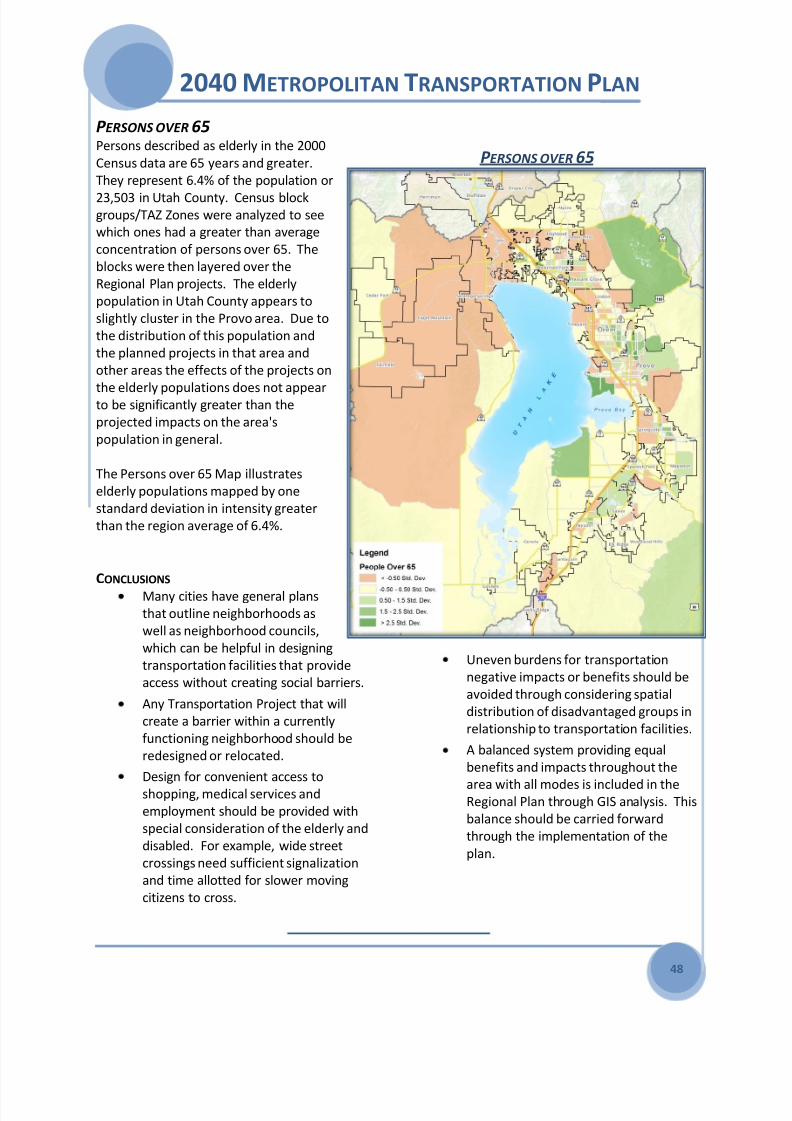
8/3/2019 2040 Metropolitan Transportation Plan - Mountainland
http://slidepdf.com/reader/full/2040-metropolitan-transportation-plan-mountainland 54/64
2040 METROPOLITAN TRANSPORTATION PLAN
48
P ERSONS OVER 65Persons described as elderly in the 2000
Census data are 65 years and greater.
They represent 6.4% of the population or
23,503 in Utah County. Census blockgroups/TAZ Zones were analyzed to see
which ones had a greater than average
concentration of persons over 65. The
blocks were then layered over the
Regional Plan projects. The elderly
population in Utah County appears to
slightly cluster in the Provo area. Due to
the distribution of this population and
the planned projects in that area and
other areas the effects of the projects on
the elderly populations does not appearto be significantly greater than the
projected impacts on the area's
population in general.
The Persons over 65 Map illustrates
elderly populations mapped by one
standard deviation in intensity greater
than the region average of 6.4%.
CONCLUSIONS
Many cities have general plans
that outline neighborhoods as
well as neighborhood councils,
which can be helpful in designing
transportation facilities that provide
access without creating social barriers.
Any Transportation Project that will
create a barrier within a currently
functioning neighborhood should be
redesigned or relocated.
Design for convenient access to
shopping, medical services and
employment should be provided with
special consideration of the elderly and
disabled. For example, wide street
crossings need sufficient signalization
and time allotted for slower moving
citizens to cross.
Uneven burdens for transportation
negative impacts or benefits should be
avoided through considering spatial
distribution of disadvantaged groups in
relationship to transportation facilities.
A balanced system providing equal
benefits and impacts throughout the
area with all modes is included in theRegional Plan through GIS analysis. This
balance should be carried forward
through the implementation of the
plan.
P ERSONS OVER 65

8/3/2019 2040 Metropolitan Transportation Plan - Mountainland
http://slidepdf.com/reader/full/2040-metropolitan-transportation-plan-mountainland 55/64
2040 METROPOLITAN TRANSPORTATION PLAN
49
TRANSPORTATION PROGRAMS AND SYSTEMS
SAFETY
Mountainland supports the goals of the currentUtah Comprehensive Safety Plan produced by
UDOT. Of the Emphasis, Continuing, and
Special Safety areas identified, the MPO is
concentrating on three most pertinent to its
planning efforts – Improve Intersection Safety,
Improve Pedestrian Safety, and Improve Bicycle
Safety.
All three are interconnected, as the majority of
pedestrian and bicycle accidents that involve
major injury or death occur at intersections.
Identifying specific accident locations, crash
causes and countermeasures is beyond the
broader planning level scope of the MTP, but by
working in partnership with UDOT, MAG has
identified ‘hot spots,’ generalized locations that
stand out in the crash data for injury or fatality.
As MTP projects move forward, and as near-
term Transportation Improvement Projects
(TIP) are selected, MAG encourages sponsors to
investigate these locales and incorporate safety
improvements from the design stage. Inparticular, TIP projects with proposed safety
improvements are given added priority scoring
during the MPO’s bi-annual competitive
selection and funding process.
This information is protected under 23 USC 409
INTERSECTION HOT SPOTS
2006 thru 2008 Hot Spot List
Serious Injury and Fatal Crashes Only
2006 thru 2008 Hot Spot List
Injury and Fatal Crashes (Severity 2 thru 5)
This information is protected under 23 USC 409
University Ave & 3700 North 7
University Ave & 4800 North 5
2230 North & University Parkway 5
US-89 500 West & 100 North, Provo 4
State Street & 1400 North, Provo 3US 89 at 500 East, American Fork 3
University Ave & 900 South 3
University Ave, 1450 North - University
Parkway, Provo7
University Ave, 900 South - 600 South,Provo
6
University Ave, 100 North - 400 North,
Provo6
University Av., SR-265 - 1990 South, Provo 6
State Street, 1230 North - 550 West, Provo 5
1600 South - 800 South, Orem 5
University Ave, 700 North - 900 South,
Provo5
MOTOR VEHICLE ONLY
INVOLVING A NON-MOTORIST
PEDESTRIANINTERSECTION
CROSSING
8/3/2019 2040 Metropolitan Transportation Plan - Mountainland
http://slidepdf.com/reader/full/2040-metropolitan-transportation-plan-mountainland 56/64
2040 METROPOLITAN TRANSPORTATION PLAN
50
SECURITY The security of the transportation system is a
national and regional priority. The focus of
the MPO is to support ongoing local, state,
and federal initiatives to address
transportation system security and emergency
preparedness planning in Utah County. The
MPO continues efforts to improve the security
of our regional transportation system by
working with leaders of local governments,
UDOT, UTA, Utah Division of Homeland
Security and various federal agencies to
prepare for a regional incident.
Coordination meetings with these groups and
MPO staff have identified the followingsecurity related plans, documents, and
systems that currently exist.
Mountainland Pre-Disaster Hazard
Mitigation Plan
Mountainland Interoperability
Emergency Communications Plan
Utah Division of Homeland
Security(UHS) Critical Infrastructure
Plan
UHS Strategic Highway Military PlanUtah Traffic Operations Center
UHS “Be Ready Utah” public
information system.
UTA Transit Security Plans.
Community Emergency Management
Plans.
In addition, to the coordination efforts, the
MPO used its unique transportation modeling
ability to simulate traffic after a major disaster
to better understand system redundancy. Asa portion of the Mountainland Pre-Disaster
Hazard Mitigation Plan, staff used FEMA’s
HAZUS model to simulate a 7.0 earthquake
along the Wasatch Front. Included in the
accompanying damage assessment report is a
listing of bridges that may be susceptible to
potential damages and the usable capacity of
those bridges at certain intervals after the
event. A model run was done to simulate
traffic 7 days after the event. A simple initial
redundancy analysis was done to identify
potential choke points in the event of a
disaster. Appendix - Earthquake Scenario
Modeling Report.
GOAL The primary goal of the MPO is to improve the
security of our transportation system
throughout the region by supporting ongoing
local, state and federal initiatives that address
transportation system security and emergency
preparedness planning in the Mountainland
region.
STRATEGIES Continue coordination with local state
and federal agencies to improve
transportation system security.
Integrate system security and
redundancy into the project selection
and construction process.
Provide transportation modeling as a
tool for security and emergency
management planning.

8/3/2019 2040 Metropolitan Transportation Plan - Mountainland
http://slidepdf.com/reader/full/2040-metropolitan-transportation-plan-mountainland 57/64
2040 METROPOLITAN TRANSPORTATION PLAN
51
SYSTEM PRESERVATION During the life of the transportation plan the
network of highways, transit, pedestrian,
bikeways, and other transportation systems will
evolve in to an urban transportation network.
Proper maintenance and preservation can
maximize the life and effectiveness of
transportation system, and better extend
lifespan and capacities. The proper
management of pavement conditions and travel
demand extends the life and effectiveness of
the system by requiring less reconstruction
costs and reducing the number of vehicles using
the system.
A pavement management system consists of three major components:
A system to regularly collect highway
condition data
A computer database to sort and store
the collected data
An analysis program to evaluate repair
or preservation strategies and suggest
cost effective projects to maintain
highway conditions
Many of these systems are currently being
developed and installed throughout the valley.As the regional system expands, these
components can be combined with planning
needs and political considerations to develop
annual highway repair and preservation
programs. See the Appendix - Transportation
System Programs for more details.
SYSTEM MANAGEMENT The MTP Local Goals include “make the system
work better.” This can include installing
sidewalks in areas that lack them, providing
handicap access, the use of traffic sensors and
cameras to monitor and measure traffic, and
allowing transit to operate better when
interfacing with automobile traffic. Local
governments also give vital support to both
system management and demand
management. Transportation System
Management (TSM) strategies include incident
management, ramp metering, High Occupancy
Vehicle / Toll (HOV / HOT) lanes, signal
coordination, access management, and
Intelligent Transportation Systems (ITS), which
overlaps several of the previous strategies.
Most of these strategies are currently applied to
some degree but need to be expanded or
enhanced for greater benefit to the
performance of the transportation system.
Transportation Demand Management (TDM)
strategies include transit service in all its forms
(bus, light rail, commuter rail, and bus rapidtransit), ridesharing, flextime, telecommuting,
pedestrian and bicycle accommodations,
growth management, and congestion pricing.
Many of these strategies are currently applied
as part of the existing transportation network.
Increased implementation of these strategies is
needed. See the Appendix - Transportation
System Programs for more details.
INTELLIGENT TRANSPORTATIONSYSTEMS “Non-recurring” congestion, such as that
caused by traffic accidents, highway
construction, or weather conditions, has been
estimated to account for around 50 percent of
traffic congestion in the region.
10%
0%
-10%
-20%
-30%
FREEWAY
DELAYS
FROM
ACCIDENTS
INTER-
SECTION
DELAYS
TRAFFIC
SIGNAL
STOPS
FREEWAY
ACCIDENTS
PEAK-
HOUR
FREEWAY
SPEEDS
15%UTAH’S INTELLIGENT
TRANSPORTATION
SYSTEM GOALS
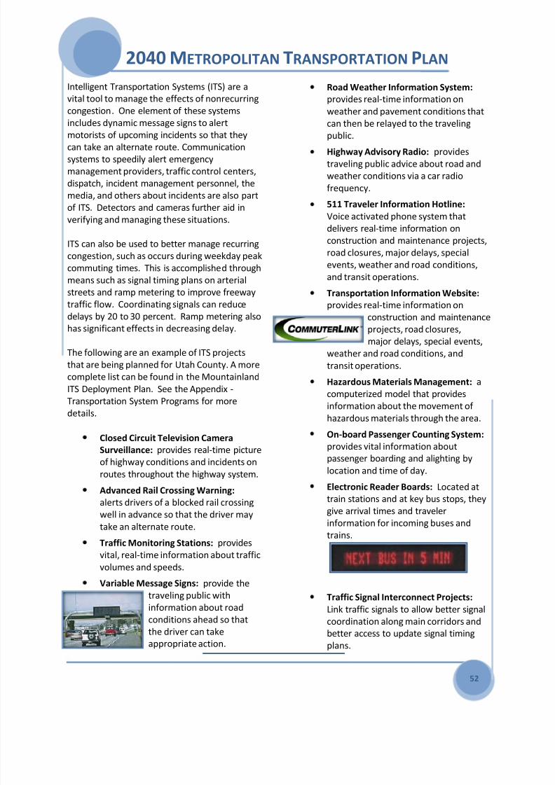
8/3/2019 2040 Metropolitan Transportation Plan - Mountainland
http://slidepdf.com/reader/full/2040-metropolitan-transportation-plan-mountainland 58/64
2040 METROPOLITAN TRANSPORTATION PLAN
52
Intelligent Transportation Systems (ITS) are a
vital tool to manage the effects of nonrecurring
congestion. One element of these systems
includes dynamic message signs to alert
motorists of upcoming incidents so that theycan take an alternate route. Communication
systems to speedily alert emergency
management providers, traffic control centers,
dispatch, incident management personnel, the
media, and others about incidents are also part
of ITS. Detectors and cameras further aid in
verifying and managing these situations.
ITS can also be used to better manage recurring
congestion, such as occurs during weekday peak
commuting times. This is accomplished through
means such as signal timing plans on arterial
streets and ramp metering to improve freeway
traffic flow. Coordinating signals can reduce
delays by 20 to 30 percent. Ramp metering also
has significant effects in decreasing delay.
The following are an example of ITS projects
that are being planned for Utah County. A more
complete list can be found in the Mountainland
ITS Deployment Plan. See the Appendix -
Transportation System Programs for more
details.
Closed Circuit Television Camera
Surveillance: provides real-time picture
of highway conditions and incidents on
routes throughout the highway system.
Advanced Rail Crossing Warning:
alerts drivers of a blocked rail crossing
well in advance so that the driver may
take an alternate route.
Traffic Monitoring Stations: provides
vital, real-time information about traffic
volumes and speeds.
Variable Message Signs: provide the
traveling public with
information about road
conditions ahead so that
the driver can take
appropriate action.
Road Weather Information System:
provides real-time information on
weather and pavement conditions that
can then be relayed to the traveling
public.Highway Advisory Radio: provides
traveling public advice about road and
weather conditions via a car radio
frequency.
511 Traveler Information Hotline:
Voice activated phone system that
delivers real-time information on
construction and maintenance projects,
road closures, major delays, special
events, weather and road conditions,
and transit operations.
Transportation Information Website:
provides real-time information on
construction and maintenance
projects, road closures,
major delays, special events,
weather and road conditions, and
transit operations.
Hazardous Materials Management: a
computerized model that provides
information about the movement of
hazardous materials through the area.
On-board Passenger Counting System:
provides vital information about
passenger boarding and alighting by
location and time of day.
Electronic Reader Boards: Located at
train stations and at key bus stops, they
give arrival times and traveler
information for incoming buses and
trains.
Traffic Signal Interconnect Projects:
Link traffic signals to allow better signal
coordination along main corridors and
better access to update signal timing
plans.

8/3/2019 2040 Metropolitan Transportation Plan - Mountainland
http://slidepdf.com/reader/full/2040-metropolitan-transportation-plan-mountainland 59/64
2040 METROPOLITAN TRANSPORTATION PLAN
53
CONGESTION MANAGEMENT
PROGRAM The MPO Congestion Management Program is
under the direction of the MPO TechnicalAdvisory Committee (TAC). This committee
evaluates congestion problem areas,
determines the possible causes
of congestion, and identifies strategies to
alleviate congestion and improve transportation
efficiency. If congestion can be alleviated by
congestion mitigation strategies alone, then
these strategies are proposed in place of
capacity-increases. Where additional general-
purpose lanes are determined to be an
appropriate strategy, congestion management
strategies will be proposed along with the
project.
Additional information is available in the
Mountainland Congestion Management Process
documents.
HIGHWAY FUNCTIONAL
CLASSIFICATIONS
Functional classification defines the role thateach street, road, and highway will play in
moving traffic from trip origins to destinations.
Access is best served by streets with driveways
and parking spaces convenient to the individual
origin or destination of each traveler. Mobility
is best served by controlled access highways
where there is minimum interference with the
main traffic flow from side traffic. Since it is
impossible to build a freeway between each
origin and destination a compromise is needed;
one that will provide the best practical balance
between serving access and mobility.
Though the transportation plan lists only the
needs of the regional highway system that
function as a Minor Arterial and above, the
collector and local system are an important
element of the system. This plan supports the
collector road system that is listed on the Utah
Functional Class Road System Map and all
programs that support it. Though the capacity
needs are not listed in this plan, capacity and
congestion relief projects remain eligible for
MPO federal funding. See the Appendix -Transportation System Programs for more
details.
REGIONALLY SIGNIFICANT CORRIDORS The following are principal highway corridors
within the Utah County area today.
I-15 Freeway
Orem 800 North / SR-52
Pioneer Crossing Blvd / SR-145
Provo Center Street / SR-114
Spanish Fork Main Street / SR-156
Timpanogos Highway / SR-92
University Parkway / SR-265
University Ave / US-189
US-89
State Street - I-15 Freeway, Lehi to
American Fork Main Street
State Street / American Fork Main
Street - I-15 Freeway, AmericanFork to Lindon 200 South
State Street - Orem 2000 North to
Bulldog Blvd, Provo
Provo 500 West - Provo 300 South
to Bulldog Blvd
Provo 300 South - Provo 500 West
to Provo 700 East
South State Street / Springville
Main Street
Springville to Mapleton
See the Appendix - Transportation System
Programs for map and more details.
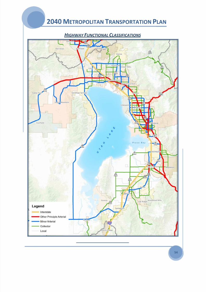
8/3/2019 2040 Metropolitan Transportation Plan - Mountainland
http://slidepdf.com/reader/full/2040-metropolitan-transportation-plan-mountainland 60/64
2040 METROPOLITAN TRANSPORTATION PLAN
54
H IGHWAY F UNCTIONAL C LASSIFICATIONS

8/3/2019 2040 Metropolitan Transportation Plan - Mountainland
http://slidepdf.com/reader/full/2040-metropolitan-transportation-plan-mountainland 61/64
2040 METROPOLITAN TRANSPORTATION PLAN
55
PARK AND RIDE LOT SYSTEM Park and ride facilities are an important
component in improving the air quality and
traffic congestion problems that currently exist
in Utah Valley. Park and ride facilities help
decrease the number of single occupant
vehicles on the transportation system by
ensuring that people will have a transition point
to ridesharing and mass transit. The resulting
ridesharing and use of mass transit reduces fuel
consumption, mobile source emissions, traffic
congestion, and destination parking
requirements.
LEHI PARK AND RIDE LOT
Existing park and ride lots fall into two
categories: exclusive-use and joint-use.
Exclusive-use lots are built for the specific
purpose of providing park and ride functions.
These lots are usually owned by UDOT and
primarily serve traffic on interstates and major
arterials. Joint-use lots share under-utilized
public or private parking lot space that is being
used for other purposes such as shopping or
Sunday worship. The main advantage of joint-
use lots is the cost, which is usually little, if any.
Despite a lack of a formal agreement between
private owners and UTA, many businesses have
not objected to the use of their parking lots by
commuters. However, some locations have so
many commuters using the lots that the
businesses' customers have trouble finding
parking and conflicts arise.
The total number of improved and unimproved
exclusive-use stalls currently in Utah Valley is
535, of which 447 are improved and 88
unimproved. The construction of commuter railand light rail stations will significantly add to
both the demand and number of stalls in Utah
County.
TRANSPORTATION AND TRANSIT
ENHANCEMENTS UDOT manages the Transportation
Enhancement Program for the entire state
without sub allocation to the MPOs. This
program provides opportunities to use federal
highway dollars to enhance the cultural,
aesthetic and environmental aspects of the
nation's inter-modal transportation system. To
qualify for funding, all projects must be related
to surface transportation and fit into at least
one of the following 12 federally designated
activities:
1. Provision of
facilities for
pedestrians and
bicycles
2. Provision of safety
and education
activities for
pedestrians and
bicyclists
3. Acquisition of scenic easements and scenic
or historic sites
4. Scenic or historic
highway programs
and provision for
tourist and
welcome center facilities
5. Landscaping and other scenic beautification
6. Historic preservation
PEDESTRIAN FRIENDLY
PROVO CENTER STREET

8/3/2019 2040 Metropolitan Transportation Plan - Mountainland
http://slidepdf.com/reader/full/2040-metropolitan-transportation-plan-mountainland 62/64
2040 METROPOLITAN TRANSPORTATION PLAN
56
7. Rehabilitation and operation of historic
transportation buildings, structures or
facilities
8. Preservation of abandoned railway corridors
9. Inventory, control and removal of outdoor
advertising
10. Archaeological planning and research
11. Environmental mitigation of runoff pollution
and provisions related to wildlife
connectivity
12. Establishment of transportation museums
Utah's annual apportionment for this program is
approximately $6,000,000. Historically,
$2,000,000 has been programmed for local
government projects and $4,000,000
programmed on UDOT Transportation
Enhancement Projects.
Recently funded projects under (SAFETEA-LU
from 2005 to present) in the Mountainland
MPO include the provision of facilities for
pedestrians and bicycles and the provision of
safety and education activities for pedestrians
and bicyclists.
Orem 800 South/UVU Extension Bike
Lane Improvements
Provo University Ave. Greenway
Extension, US-189
Provo River
Bridge
Replacement
Historic UP
Rail Trail
Point of theMountain
Trail - Draper
City
Construct Sidewalks on SR-198 at
locations between Payson and Santaquin
Sweetwater/Pony Express Trail Eagle
Mountain
Widen shoulders on SR-89; Springville
to Provo
SR-73 Trail Under Crossing near Jordan
River
Dry Creek Trail Pedestrian Underpass,Payson
Bonneville Trail Underpass
Art Dye Trail
System,
American
Fork City
Lindon
Heritage
Trail, East
Phase
Pleasant Grove Blvd Trail, I-15 to State
Street
Pedestrian Safety Santaquin City
The Utah Transit Authority the transit service
provider and FTA grant recipient for this MPO
spends 1% of FTA funds on Transit
Enhancements Activities including: bus
shelters, ADA compliance surfacing, bike
lockers, bike racks on buses, etc.
In addition to these formal funding programs
the MPO analyzes new capacity project during
the MTP development for opportunities to
enhance the planned capacity projects with
bicycle/pedestrian community enhancements
(e.g. adding shoulders for bike commuting, safe
routes to school considerations), community
and environmental impact reduction (e.g. sound
walls, historic preservation) and transit system
enhancements (e.g. bike racks on buses bike
lockers). See the Appendix - TransportationSystem Programs for more details.
PROVO RIVER BRIDGE
ART DYE TRAIL

8/3/2019 2040 Metropolitan Transportation Plan - Mountainland
http://slidepdf.com/reader/full/2040-metropolitan-transportation-plan-mountainland 63/64
2040 METROPOLITAN TRANSPORTATION PLAN
57
PUBLIC PARTICIPATION The Mountainland MPO believes public
knowledge, participation, and input are key
elements and a vital tool in all areas of its
transportation planning efforts. Meaningfulpublic involvement eliminates participation
barriers and strives to engage target
populations. Successful outreach enhances all
plans and proposals and increases public
acceptance of projects.
The MPO staff participates in and various
community-based committees, organization,
classes, and business groups where
transportation issues are discussed. Staff
members also make presentations to state, city,and county organizations; local area Chambers
of Commerce; minority organizations and
businesses; university classes, and local public
officials on transportation planning activities.
OPEN HOUSES The MPO staff conducts three annual
Transportation and Community Planning Open
Houses which includes UTA, UDOT, and the
municipalitieswithin the
MPO. Open
houses allow
the public to
voice their
opinions
through
written
comments, one-on-one exchanges, and group
discussions. These exchanges are incorporated
into proposed plans and reports. The general
public is welcome at each open house, and MAG
specifically invites interested citizens, local
elected officials, identified minority groups,
public agencies, private transportation providers,
and segments of the community affected by
transportation plans, programs and projects.
AGENCY COORDINATION MPO staff works closely with the following
state and federal agencies.
Utah Division of Wildlife Resources
Utah Division of Solid & Hazardous
Waste
Utah County Public Works & Assessor
Utah Division of State History
Utah State University Extension Service
Utah Geologic Survey
Environmental Protection Agency
Utah Division of Water Quality
Natural Resource Conservation Service
Utah Division of Air Quality
Wasatch Front Regional Council
Utah Department EnvironmentalQuality
Utah Department of Transportation
United States Forest Service
Utah Transit Authority
Utah State Parks and Recreation
Jordan Valley Water Conservancy
District
United States Bureau of Reclamation
US Fish and Wildlife Service
Utah Governors Office of Planning and
BudgetUtah Environmental Response &
Remediation
Alpine School District
Provo School District
Nebo School District
Utah Trucking Association
Central Utah Water Conservancy
District
Additional contacts may be made with these
agencies while the plan is in the public review
and comment period and as the plan is
updated in the future.
OUTREACH EFFORTS A complete summary of all the outreach events
to include special studies can be found in
Appendix - Public Participation Summary.
AMERICAN FORK OPEN HOUSE

8/3/2019 2040 Metropolitan Transportation Plan - Mountainland
http://slidepdf.com/reader/full/2040-metropolitan-transportation-plan-mountainland 64/64
2040 METROPOLITAN TRANSPORTATION PLAN CALL TO ACTION
Grow the economy by expanding the base and
continue our investment.
Our population will double to 1.1 million people
by 2040. Today 65,000 students at BYU and
UVU seek a higher education, live and work in
Utah County.
Utah County is changing from a rural
agricultural based economy to an urban high
technology intermountain leader with Adobe,
Micron IM Flash, Novell, and the National
Security Agency calling us home.
We are grateful for the recent investment in
I-15, Commuter Rail, the Mountain View
Freeway, Pioneer Crossing, and the Timpanogos
Highway and acknowledge the wisdom of
providing this infrastructure when construction
and bonding prices are at our advantage.
We will continue to implement our vision of the
Wasatch Choice for 2040 through the US
Housing and Urban Development Sustainable
Communities Regional Planning Grant.
A strong economy in the US is dependent on
the key elements education and transportation.
We need to continue our investment to retain
and grow a strong economy by supporting this
critical infrastructure.