
2022 FireSmartTM Community Funding & Supports
38
Community Resiliency Investment Program 2022 FireSmart TM Community Funding & Supports Program & Application Guide 1. Introduction The Community Resiliency Investment (CRI) program was announced by the provincial government in 2018 and is intended to reduce the risk of wildfires and mitigate their impacts on BC communities. As of January 2021, CRI includes three streams: • Stream 1: FireSmart Community Funding & Supports, administered by the Union of BC Municipalities (UBCM). • Stream 2: Crown Land Wildfire Risk Reduction, administered by the Ministry of Forests, Lands, Natural Resource Operations & Rural Development. • Stream 3: FireSmart Economic Recovery Fund, administered by UBCM. Please refer to Appendix 1 for definitions of terms used in this guide. FireSmart Community Funding & Supports The FireSmart Community Funding & Supports program provides funding to local governments and First Nations in BC to increase community resiliency by undertaking community-based FireSmart TM 1 planning and activities that reduce the community’s risk from wildfire. To date, 194 First Nations and local governments have received funding. The First Nations’ Emergency Services Society (FNESS), the Forest Enhancement Society of BC (FESBC) and the Union of BC Municipalities (UBCM) are working with the Ministry of Forests, Lands, Natural Resource Operations & Rural Development (FLNRORD) to deliver the FireSmart Community Funding & Supports program. The program is structured to fund FireSmart activities in eligible communities throughout BC. Base funding is scaled to offer eligible applicants with lower risk of wildfire, generally demonstrated by Wildland Urban Interface (WUI) Risk Class 4 and 5, to apply for up to $50,000, and applicants with a higher risk of wildfire, generally demonstrated by WUI Risk Class 1 to 3, to apply for up to $150,000 per year. Information on determining risk is provided in Appendix 2. Fuel management located exclusively on Provincial Crown land, outside of municipal boundaries, regional district parks or First Nations land, is administered through the Crown Land Wildfire Risk Reduction stream of CRI. Applicants are required to contact the BC Wildfire Service for further discussion regarding identified fuel treatment units located on Provincial Crown land. 1 FireSmart, Intelli-feu and other associated Marks are trademarks of the Canadian Interagency Forest Fire Centre.
Transcript of 2022 FireSmartTM Community Funding & Supports
Community Resiliency Investment Program
2022 FireSmartTM Community Funding & Supports
Program & Application Guide
1. Introduction
The Community Resiliency Investment (CRI) program was announced by the provincial government in 2018 and is intended to reduce the risk of wildfires and mitigate their impacts on BC communities. As of January 2021, CRI includes three streams:
• Stream 1: FireSmart Community Funding & Supports, administered by the Union of BC Municipalities (UBCM).
• Stream 2: Crown Land Wildfire Risk Reduction, administered by the Ministry of Forests, Lands, Natural Resource Operations & Rural Development.
• Stream 3: FireSmart Economic Recovery Fund, administered by UBCM.
Please refer to Appendix 1 for definitions of terms used in this guide.
FireSmart Community Funding & Supports
The FireSmart Community Funding & Supports program provides funding to local governments and First
Nations in BC to increase community resiliency by undertaking community-based FireSmartTM 1 planning and activities that reduce the community’s risk from wildfire. To date, 194 First Nations and local governments have received funding.
The First Nations’ Emergency Services Society (FNESS), the Forest Enhancement Society of BC (FESBC) and the Union of BC Municipalities (UBCM) are working with the Ministry of Forests, Lands, Natural Resource Operations & Rural Development (FLNRORD) to deliver the FireSmart Community Funding & Supports program.
The program is structured to fund FireSmart activities in eligible communities throughout BC. Base funding is scaled to offer eligible applicants with lower risk of wildfire, generally demonstrated by Wildland Urban Interface (WUI) Risk Class 4 and 5, to apply for up to $50,000, and applicants with a higher risk of wildfire, generally demonstrated by WUI Risk Class 1 to 3, to apply for up to $150,000 per year. Information on determining risk is provided in Appendix 2.
Fuel management located exclusively on Provincial Crown land, outside of municipal boundaries, regional district parks or First Nations land, is administered through the Crown Land Wildfire Risk
Reduction stream of CRI. Applicants are required to contact the BC Wildfire Service for further discussion regarding identified fuel treatment units located on Provincial Crown land.
1 FireSmart, Intelli-feu and other associated Marks are trademarks of the Canadian Interagency Forest Fire Centre.
2022 CRI FireSmart Community Funding & Supports - Program & Application Guide 2
FireSmart in BC
The general goal of FireSmart is to encourage communities and citizens to adopt and conduct FireSmart practices to mitigate the negative impacts of wildfire to assets on public and private property:
• Overview of the seven FireSmart disciplines
• FireSmart BC Information Sheet has been developed to provide applicants with an overview of available resources, training and materials approved for funding
As identified in the BC Flood and Wildfire Review, there is a critical need to “strengthen public understanding of the risks and personal responsibilities associated with living in a fire-dependent ecosystem.”2 FireSmart BC and the Community Resiliency Investment program both follow the seven disciplines of FireSmart as a holistic approach to reducing wildfire risk to communities.
2. Eligible Applicants
All local governments (municipalities and regional districts) and First Nations (bands, Treaty First Nations, and Indigenous National Governments with authority for lands and resources) in BC are eligible to apply.
Eligible applicants can submit one application per intake, including regional applications or participation as a partnering applicant in a regional application.
3. Grant Maximum
Base Funding
Eligible applicants with a lower risk of wildfire, generally demonstrated by WUI Risk Class 4 and 5, can apply for 100% of the cost of eligible activities to a maximum of $50,000.
Eligible applicants with a higher risk of wildfire, generally demonstrated by WUI Risk Class 1, 2 and 3, can apply for 100% of the cost of eligible activities to a maximum of $150,000. Information on determining risk is provided in Appendix 2.
Additional Funding
There are two opportunities to apply for additional funding:
1. Applications from regional districts may exceed the base funding maximum in order to fund FireSmart activities only in one or more electoral areas. Refer to Section 4 for more information.
2. Applications that include fuel management on Provincial Crown land within municipal boundaries, regional district parks or First Nations land and that include contiguous, logical treatment units that extend onto the Crown land base may exceed the base funding maximum for fuel management activities on Provincial Crown Land only provided that:
a. Fuel management activities are adjacent to community structures, and
b. Fuel management activities extend no further than one-kilometre from the structure density class greater than 6
In order to ensure transparency and accountability in the expenditure of public funds, all other financial contributions for eligible portions of the project must be declared and, depending on the total value, may decrease the value of the grant. This includes any other grant funding and any revenue (e.g. sale of forest products) that is generated from activities that are funded by the FireSmart Community Funding & Supports program.
2 Addressing the New Normal: 21st Century Disaster Management in British Columbia. p.90

2022 CRI FireSmart Community Funding & Supports - Program & Application Guide 3
4. Eligible Projects
To be eligible for funding, applications must demonstrate that proposed activities will increase community resiliency by undertaking community-based FireSmart planning and activities that reduce the community’s risk from wildfire.
Applicants must choose to apply as a single applicant (i.e. an individual local government or First Nation as identified in Section 2) or as part of a regional project.
There are two opportunities to apply for regional projects within a single application. In all cases, it is expected that regional projects will demonstrate cost-efficiencies in the total grant request.
Regional Projects for Multiple Eligible Applicants
Funding requests from two or more eligible applicants for regional projects may be submitted as a single application for eligible, collaborative projects. In this case, the maximum base funding would be calculated by the number of eligible applicants included in the application and the associated risk class of each. Applications for regional projects for multiple eligible applicants can include FireSmart (Worksheet 1) and fuel management (Worksheet 2) activities.
The primary applicant submitting the application for a regional project is required to submit a resolution as outlined in Section 7 of this guide. Each partnering community is required to submit a resolution that clearly states their approval for the primary applicant to apply for, receive and manage the grant funding on their behalf.
Regional Projects for Regional District Applications Including Multiple Electoral Areas
Regional Districts may submit a single application for eligible projects that include multiple electoral areas. In this case, the maximum base funding would be the full eligible grant amount for the regional district (i.e. $50,000 or $150,000 depending on risk of wildfire) plus up to $50,000 for FireSmart activities for each electoral area that is included in the application. In this case, the regional district would be required to submit a complete application package as well as a separate Worksheet 1 for each electoral area.
5. Requirements for Funding
Engagement with BCWS and/or FNESS
To qualify for funding, applicants must demonstrate their level of engagement with a BCWS Wildfire Prevention Officer, FNESS Fuel Management Specialist, and, if applicable, the FLNRORD district, region, or relevant Land Manager, to ensure project alignment with Land Manager priorities when activities are occurring on Provincial Crown land (including during Community Wildfire Resiliency Plan development).
Applicants are required to document engagement in the application. Planning and discussion must occur at a minimum of 30 days prior to submission of an application to allow for meaningful dialogue regarding the proposed FireSmart and fuel management activities and opportunities for integration of planning and implementing fuel management activities on provincial Crown lands.
For more information on the planning process and identified projects please see the Crown Land Wildfire Risk Reduction webpage.
Reporting for Prior Projects
New in 2022 - To qualify for funding all activities funded under the 2019 FireSmart Community Funding & Supports program must be complete and the final report must be submitted in full (unless a project extension has been approved). It is recommended that all activities funded under the 2020 FireSmart Community Funding & Supports program be completed and the final report submitted in full as well (unless a project extension has been approved).
2022 CRI FireSmart Community Funding & Supports - Program & Application Guide 4
Additional Funding Requirements
To qualify for funding, projects must:
• Be located within the applicant’s administrative boundary (see exception for fuel management activities below)
• Include new activities or represent a new phase of an existing project (retroactive funding is not available)
• Be capable of completion by the applicant within one year of the date of grant approval. Projects that include fuel treatments, including prescribed fire, may be approved for up to two years.
• Be supported by a current plan, acceptable to the BCWS Wildfire Prevention Officer or the FNESS Fuel Management Specialist, that includes assessment and identification of FireSmart and/or fuel management priorities (i.e. Community Wildfire Resiliency Plan, Community Wildfire Protection Plan, Crown Land WRR Tactical or Fuel Management Plan, etc.). Note: applicants that do not have a current and acceptable plan may apply to develop or update a plan.
• Be completed by a qualified professional that is accredited by their professional association
• Updated July 2021 - Ensure compliance with applicable legislation and regulations: Federal (e.g. Fisheries Act, Species at Risk Act); Provincial (e.g. Forest and Range Practices Act, Open Burning Smoke Control Regulation, and Wildfire Act); and local authority (e.g. burning bylaws or other bylaws or plans)
• Updated July 2021 - Where applicable, be eligible for required approvals from the Land Manager (e.g. Indigenous Services Canada, BC Parks Area Manager, Natural Resource District Manager, etc.) for authorizations and/or permits
Funding Requirements for Fuel Management
To qualify for funding, fuel management activities must:
• Be located within municipal boundaries, regional district parks or First Nations land and, if applicable, approved to extend onto the Crown Land base
• For activities that fall under the practice of forestry, be developed and, where applicable, signed by a forest professional that is accredited by the Association of BC Forest Professionals and operating within their scope of practice
• Where applicable, for any required professional assessments, be developed and signed by a qualified professional (e.g. terrain stability assessments must be signed by a professional engineer)
Please refer to Appendix 6 for complete funding requirements for fuel management activities.
6. Eligible & Ineligible Costs & Activities
Eligible costs are direct costs that are approved for funding, properly and reasonably incurred, and paid by the applicant to carry out eligible activities. Eligible costs can only be incurred from the date of application submission until the final report is submitted.
New in 2022 - Table 1 identifies the activities that are eligible for funding and provides cost maximums for those activities. Applicants are required to propose costs within the cost maximums that reflect local, reasonable estimates. However, with mitigating circumstances (e.g. remote community), applicants can propose costs higher than the maximums if a rationale is provided and accepted. In all cases, eligible activities must be cost-effective. Please note that all FireSmart Home Ignition Zone Assessments must be conducted by a qualified Local FireSmart Representative (LFR) or Wildfire Mitigation Specialist (WMS) that has received training from FireSmart Canada. New in 2022 - In order to be qualified, an LFR must have their certification from completion of the updated FireSmart Canada Neighbourhood Recognition Program workshop offered in 2020-2021 through FireSmart BC.

2022 CRI FireSmart Community Funding & Supports - Program & Application Guide 5
Table 1: Activities Eligible for Funding
1. EDUCATION
Public education and outreach play a critical role in helping communities prepare for wildfire by promoting a sense of empowerment and shared responsibility. This is done through encouraging participation in wildfire risk reduction, including the reduction of local human-caused fires, and resiliency activities.
All applications are required to include an education component in this section. This may include general FireSmart education, or be related to a proposed activity in categories 2 through 9 below.
Eligible Activities Cost Maximums & Guidance
A. Update signage, social media, applicant websites and/or newsletters, and community education materials or displays related to a proposed activity in categories 2 through 9 below
Please note that not all promotional items on the FireSmart BC website are eligible for grant funding.
Banners: up to $1,500 each
Posters: $200 (total order)
Videos specific to CWRP implementation: up to $10,000 each
Tents: up to $1,200 each
Vehicle decals: up to $700 each
T-shirts: up to $1,000 (total order)
B. Organize and host public information meetings related to a proposed activity in categories 2 through 9 below
Up to $5,000 per event with required cost breakdown in WS1
C. Promote and distribute FireSmart educational materials and resources, such as FireSmart 101, FireSmart Begins at Home app, social media and/or FireSmart BC materials
For costs associated with the purchase of FireSmart resources above the complimentary maximums please visit Resources on FireSmartBC.ca.
FireSmart Education Kit for use in schools and public events: up to $1,600 each
D. Support the organization of Wildfire Community Preparedness Day
Up to $5,000 per event with required cost breakdown in WS1
E. Support the organization of a Farm and Ranch Wildfire Preparedness workshop, Neighbourhood Champion workshop, community FireSmart day, FireSmart events and workshops, and/or wildfire season open houses
Up to $5,000 per event with required cost breakdown in WS1
F. Support neighbourhoods to apply for FireSmart Canada Neighbourhood Recognition Program
Required cost breakdown in WS1
2. COMMUNITY PLANNING
Community planning is a very effective tool for reducing wildfire risk for lands and buildings within the administrative boundaries of a local government or First Nation communities.
Please note that Home Ignition Zone Assessments for individual residential properties or homes, neighbourhood hazard assessments and FireSmart Neighbourhood Plans should be included in Category 8.
Eligible Activities Cost Maximums
A. Develop a Community Wildfire Resiliency Plan (CWRP) in accordance with the 2020 template and guidance document.
Up to $30,000 (depending on AOI and eligible WUI) and with required cost breakdown in WS1

2022 CRI FireSmart Community Funding & Supports - Program & Application Guide 6
CWRPs that include multiple communities are acceptable. In these cases, funding in excess of the cost maximum may be considered with rationale.
Structural data may be collected and/or assembled as part of a CWRP, although it is not required.
B. Amend existing plans that are less than 5 years old to include:
• Recently acquired land or areas of new development, etc.
• Ground-truthing for new treatment units
• Significant changes to forest stand composition and/or forest health changes or impacts
• Integrating other plans or information into existing CWPP/CWRP
Up to $15,000 (depending on AOI and eligible WUI) and with required cost breakdown in WS1
C. Develop FireSmart policies and practices for the design and maintenance of First Nations land and publicly owned land, such as parks and open spaces
Required estimated incremental staff hours and wages and/or contract cost estimate in WS1
D. Develop FireSmart policies and practices for the design and maintenance of First Nations owned buildings and publicly owned buildings
Required estimated incremental staff hours and wages and/or contract cost estimate in WS1
E. Complete FireSmart Home Ignition Zone Assessment Score Card or FireSmart Critical Infrastructure Assessment for First Nation and/or publicly owned buildings in order to support future FireSmart projects for critical infrastructure (see Category 7)
Up to $800 per structure (generally 4 to 8 hours) with required cost breakdown in WS1
3. DEVELOPMENT CONSIDERATIONS
Community land use and development in wildfire-prone areas affects the susceptibility of the community at different scales and in terms of where and how a community is, or will be, developed.
Eligible Activities Cost Maximums & Guidance
A. Amend Official Community Plans, Comprehensive Community Plans and/or land use, engineering and public works bylaws to incorporate FireSmart principles
Up to $10,000 with required estimated incremental staff hours and wages and/or contract cost estimate in WS1
B. Revise landscaping requirements in zoning and development permit documents to require fire resistant landscaping or include other FireSmart considerations
Up to $10,000 with required estimated incremental staff hours and wages and/or contract cost estimate in WS1
C. Establish Development Permit Areas for Wildfire Hazard in order to establish requirements for the exterior design and finish of buildings
Up to $10,000 with required estimated incremental staff hours and wages and/or contract cost estimate in WS1
D. Include wildfire prevention and suppression considerations in the design of subdivisions (e.g. road widths, turning radius for emergency vehicles, and access and egress points)
Up to $10,000 with required estimated incremental staff hours and wages and/or contract cost estimate in WS1
E. Amend referral processes for new developments to ensure multiple departments, including the fire department and/or emergency management personnel, are included
Up to $10,000 with required estimated incremental staff hours and wages and/or contract cost estimate in WS1

2022 CRI FireSmart Community Funding & Supports - Program & Application Guide 7
4. INTERAGENCY CO-OPERATION
It takes the collaborative efforts of multiple stakeholders working together to achieve a wildfire resilient community. This may include local fire departments, First Nation and/or local government staff and elected officials, provincial government such as Emergency Management BC and BCWS, industry representatives and other community stakeholders.
Eligible Activities Cost Maximums & Guidance
A. Develop, coordinate and/or participate in a Community FireSmart and Resiliency Committee (CFRC)
Costs for the overall coordination of a CFRC may also be included in Worksheet 1
Up to $2,000 per meeting with required cost breakdown in WS1
B. Participate in multi-agency fire and/or fuel management planning tables to support the integration of fuel management planning across jurisdictional boundaries in the absence of a CFRC
If fire and/or fuel management planning tables are not active, participation in Wildfire Risk Reduction tactical planning (with BCWS) is eligible.
Up to $2,000 per meeting with required cost breakdown in WS1
C. Provide Indigenous cultural safety and humility training to emergency management personnel in order to more effectively partner with, and provide assistance to, Indigenous communities for both wildfire prevention and suppression
Required cost breakdown in WS1
D. Attend the 2022 FireSmart BC Conference, hosted by the BC FireSmart Committee. Note: this is limited to two staff per eligible applicant and eligible costs include conference fee and travel (including accommodations and per diems), with a maximum of up to $1,500 per attendee.
No more than two staff per eligible applicant, up to $1,500 per attendee and with required cost breakdown in WS1
5. EMERGENCY PLANNING
Community preparations for a wildfire emergency require a multi-pronged approach in order for a community to respond effectively to the threat of wildfires as a whole.
Eligible Activities Cost Maximums & Guidance
A. Develop and/or participate in cross-jurisdictional meetings and tabletop exercises specifically focused on wildfire preparedness and suppression, including seasonal wildfire readiness meetings
Up to $2,000 per meeting with required cost breakdown in WS1
B. Assess community water delivery ability as required for suppression activities, limited to current water system evaluation and available flow analysis
Required estimated incremental staff hours and wages and/or contract cost estimate in WS1
C. Assess structure protection inventory Required estimated incremental staff hours and wages and/or contract cost estimate in WS1
D. Use and/or promote EMBC Wildfire Preparedness Guide for community emergency preparedness events focused on wildfire
Up to $5,000 per event with required cost breakdown in WS1
2022 CRI FireSmart Community Funding & Supports - Program & Application Guide 8
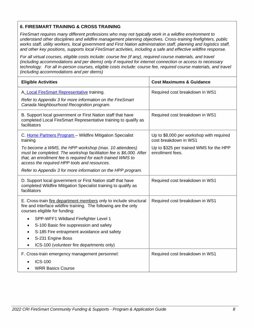
6. FIRESMART TRAINING & CROSS TRAINING
FireSmart requires many different professions who may not typically work in a wildfire environment to understand other disciplines and wildfire management planning objectives. Cross-training firefighters, public works staff, utility workers, local government and First Nation administration staff, planning and logistics staff, and other key positions, supports local FireSmart activities, including a safe and effective wildfire response.
For all virtual courses, eligible costs include: course fee (if any), required course materials, and travel (including accommodations and per diems) only if required for internet connection or access to necessary technology. For all in-person courses, eligible costs include: course fee, required course materials, and travel (including accommodations and per diems)
Eligible Activities Cost Maximums & Guidance
A. Local FireSmart Representative training.
Refer to Appendix 3 for more information on the FireSmart Canada Neighbourhood Recognition program.
Required cost breakdown in WS1
B. Support local government or First Nation staff that have completed Local FireSmart Representative training to qualify as facilitators
Required cost breakdown in WS1
C. Home Partners Program – Wildfire Mitigation Specialist training
To become a WMS, the HPP workshop (max. 10 attendees) must be completed. The workshop facilitation fee is $6,000. After that, an enrollment fee is required for each trained WMS to access the required HPP tools and resources.
Refer to Appendix 3 for more information on the HPP program.
Up to $8,000 per workshop with required cost breakdown in WS1
Up to $325 per trained WMS for the HPP enrollment fees.
D. Support local government or First Nation staff that have completed Wildfire Mitigation Specialist training to qualify as facilitators
Required cost breakdown in WS1
E. Cross-train fire department members only to include structural fire and interface wildfire training. The following are the only courses eligible for funding:
• SPP-WFF1 Wildland Firefighter Level 1
• S-100 Basic fire suppression and safety
• S-185 Fire entrapment avoidance and safety
• S-231 Engine Boss
• ICS-100 (volunteer fire departments only)
Required cost breakdown in WS1
F. Cross-train emergency management personnel:
• ICS-100
• WRR Basics Course
Required cost breakdown in WS1
2022 CRI FireSmart Community Funding & Supports - Program & Application Guide 9
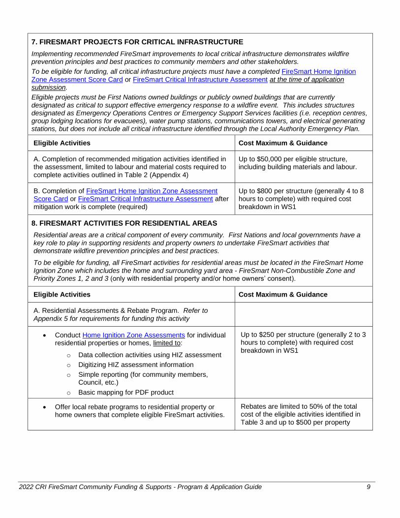
7. FIRESMART PROJECTS FOR CRITICAL INFRASTRUCTURE
Implementing recommended FireSmart improvements to local critical infrastructure demonstrates wildfire prevention principles and best practices to community members and other stakeholders.
To be eligible for funding, all critical infrastructure projects must have a completed FireSmart Home Ignition Zone Assessment Score Card or FireSmart Critical Infrastructure Assessment at the time of application submission.
Eligible projects must be First Nations owned buildings or publicly owned buildings that are currently designated as critical to support effective emergency response to a wildfire event. This includes structures designated as Emergency Operations Centres or Emergency Support Services facilities (i.e. reception centres, group lodging locations for evacuees), water pump stations, communications towers, and electrical generating stations, but does not include all critical infrastructure identified through the Local Authority Emergency Plan.
Eligible Activities Cost Maximum & Guidance
A. Completion of recommended mitigation activities identified in the assessment, limited to labour and material costs required to complete activities outlined in Table 2 (Appendix 4)
Up to $50,000 per eligible structure, including building materials and labour.
B. Completion of FireSmart Home Ignition Zone Assessment Score Card or FireSmart Critical Infrastructure Assessment after mitigation work is complete (required)
Up to $800 per structure (generally 4 to 8 hours to complete) with required cost breakdown in WS1
8. FIRESMART ACTIVITIES FOR RESIDENTIAL AREAS
Residential areas are a critical component of every community. First Nations and local governments have a key role to play in supporting residents and property owners to undertake FireSmart activities that demonstrate wildfire prevention principles and best practices.
To be eligible for funding, all FireSmart activities for residential areas must be located in the FireSmart Home Ignition Zone which includes the home and surrounding yard area - FireSmart Non-Combustible Zone and Priority Zones 1, 2 and 3 (only with residential property and/or home owners’ consent).
Eligible Activities Cost Maximum & Guidance
A. Residential Assessments & Rebate Program. Refer to Appendix 5 for requirements for funding this activity
• Conduct Home Ignition Zone Assessments for individual residential properties or homes, limited to:
o Data collection activities using HIZ assessment
o Digitizing HIZ assessment information
o Simple reporting (for community members, Council, etc.)
o Basic mapping for PDF product
Up to $250 per structure (generally 2 to 3 hours to complete) with required cost breakdown in WS1
• Offer local rebate programs to residential property or home owners that complete eligible FireSmart activities.
Rebates are limited to 50% of the total cost of the eligible activities identified in Table 3 and up to $500 per property

2022 CRI FireSmart Community Funding & Supports - Program & Application Guide 10
B. FireSmart Canada Neighbourhood Recognition. Refer to Appendix 3 for requirements for funding this activity
• Undertake Neighbourhood Wildfire Hazard Assessments Up to $400 per neighbourhood (generally 3 - 4 hours to complete)
• Support the development of FireSmart Neighbourhood Plans for specific areas
Up to $1,000 per neighbourhood
C. Conduct Home Partners Program wildfire mitigation assessment for individual residential properties or homes, limited to:
• Upon completing of certification, receipt of a Home Partners driveway sign
• Data collection and management using HPP data base
• Simple reporting (for community members, Council, etc.)
• Basic mapping for PDF product
Refer to Appendix 3 for requirements for funding this activity
Initial assessment - Up to $250 per structure (generally 2 to 3 hours to complete) with required cost breakdown in WS1
Follow-up inspection - Up to $250 per structure (generally 1 to 2 hours to complete) with required cost breakdown in WS1
D. Provide off-site vegetative debris disposal for residential property or home owners who have undertaken their own vegetation management, including:
• Provide a dumpster, chipper or other collection method
• Waive tipping fees
• Provide curbside debris pick-up
Refer to Additional Information on the Use and Disposal of Wood Chips Generated by FCFS-Funded Projects
Required cost breakdown in WS1
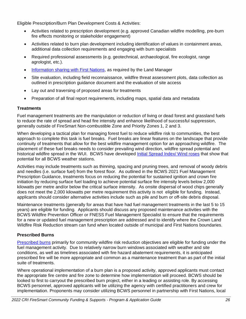
9. FUEL MANAGEMENT
Under the FireSmart Community Funding & Supports program, fuel management activities include the development of fuel management prescriptions and burn plans, as well as operational fuel treatments, including prescribed burns. Applicants are advised to only propose fuel management activities that can be completed within two years.
In all cases, a completed, signed prescription is required for all fuel treatments. The completed prescription must be submitted with the application, or the applicant is required to apply for a phased project in order to complete the prescription and treatment under the same application. Draft prescriptions will not be accepted.
To be eligible for funding, all fuel management activities must be in alignment with the requirements for funding fuel management activities identified in Appendix 6 and should generally be outside of FireSmart Non-combustible Zone and Priority Zones 1, 2 and 3.
Eligible Activities Cost Maximum & Guidance
A. Undertake planning and development for fuel management on publicly owned land or First Nations land, limited to:
• Develop fuel management prescriptions consistent with BC Wildfire Service Fuel Management Prescription Guidance Document
Up to $400 per hectare with required cost breakdown in WS2

2022 CRI FireSmart Community Funding & Supports - Program & Application Guide 11
Based on an average size of greater than 20 hectares and assuming smaller hectares may be higher and larger hectares may be lower.
• Develop burn plans
Must utilize the BCWS Prescribed Fire Burn Plan Template. (Note: per Appendix 1a of the template – Burn Plan Signature Sheet, the BCWS Fire Centre Manager or designate is required to approve the burn plan.)
Up to $850 per hectare with required cost breakdown in WS2
• Required professional assessments (e.g. geotechnical, archaeological, fire ecologist, range agrologist, etc.).
Due to variations in assessment costs, these will be evaluated on a case by case basis.
Required cost breakdown in WS2
B. Undertake new fuel management treatments, including activities on grasslands, on publicly owned land or First Nations land.
Based on baseline fuel management (e.g. pile burn) costs.
Coastal Fire Centre: up to $12,500 per hectare with required cost breakdown in WS2
Prince George Fire Centre: up to $10,500 per hectare with required cost breakdown in WS2
Cariboo, Kamloops, North West and South East Fire Centres: up to $7,000 per hectare with required cost breakdown in WS2
C. Undertake fuel management maintenance activities, including activities on grasslands, on publicly owned land or First Nations land.
Up to $3,500 per hectare with required cost breakdown in WS2
D. Off-site debris disposal (trucking, tipping fees, etc.) from new fuel management or maintenance activities.
Up to an additional $1,500 per hectare with required rationale in WS2
E. Undertake prescribed burns on publicly owned land or First Nations land when the primary objective is fuel management for community wildfire risk reduction.
Up to $3,500 per hectare with required cost breakdown in WS2
F. Undertake fuel management demonstration projects (one per eligible applicant) including:
• Develop fuel management prescriptions consistent with BC Wildfire Service Fuel Management Prescription Guidance Document
• Completion of fuel management activities, limited to:
o Local government land, First Nations land or Provincial Crown land
o Locations that are visible and accessible to community members
o Projects with rationale for project location (i.e. number of visitors)
o Parcel of no more than 5.0 ha.
o Educational component
Up to 25% more than costs in identified for new fuel management activities (by Fire Centre) identified in row B above with required cost breakdown in WS2:
Coastal Fire Centre: up to $15,625 per hectare
Prince George Fire Centre: up to $13,135 per hectare
Cariboo, Kamloops, North West and South East Fire Centres: up to $8,750 per hectare

2022 CRI FireSmart Community Funding & Supports - Program & Application Guide 12
Additional Eligible Costs & Activities
In addition to the activities identified in Table 1, the following expenditures are also eligible provided they relate directly to eligible activities:
• Incremental applicant staff and administration costs (i.e. creating a new position or adding new responsibilities to an existing position). This could include employment and/or training to increase local capacity through term contracts for:
o FireSmart Coordinator
o CWRP and/or CFRC Coordinator
o Qualified Local FireSmart Representative or Wildfire Mitigation Specialist
o Summer/co-op students
• Consultant/contractor costs. Please note: if you intend to hire a professional (planner, forester) to support proposed activities, professional consultant rates will only be considered for activities that represent respective professions. For other activities (e.g. social media, planning events or administering rebate programs) consultant rates are expected to be commensurate with the type of activity being undertaken.
• Public information costs
• Purchase of FireSmart BC branded items for door prizes, give-away items and/or gifts for community events (up to $3,000 per eligible applicant)
Ineligible Costs & Activities
Any activity that is not outlined in Table 1 or is not directly connected to activities approved in the application is not eligible for grant funding. This includes:
• Development of funding application package
• Development or amendment of plans or maps primarily intended for emergency response
• Development of databases
• Purchase of software, software licences, service subscriptions, or membership fees
• Development of FireSmart plans, other than CWRPs, amendments to existing CWPPs/CWRPs and FireSmart Neighbourhood Plans
• Development or update of feasibility studies (including water tank location analysis)
• Purchase, construction or siting of Fire Danger rating signs
• Purchase of tools (e.g. hand saws, loppers) or structural protection equipment (e.g. hoses, sprinklers)
• Purchase of non-FireSmart BC branded items for door prizes, give-away items and/or gifts for community events
• Purchase of emergency supplies (e.g. first aid kits) for community members or households
• Wildfire threat assessments and fuel treatment unit identification on private land (outside of GIS and/or FireSmart Home Ignition Zone Assessment, with the land owners’ consent) or outside of the eligible WUI
• For fuel management activities only:
o Purchase of machinery, equipment and/or livestock for grazing
o Work undertaken by FLNRORD, including prescribed fire staff support
o Any third-party requirements to address hazard abatement under the Wildfire Act
o Hazard abatement activities related to existing or decommissioned saw mills (i.e. removal of slabs and/or sawdust)

2022 CRI FireSmart Community Funding & Supports - Program & Application Guide 13
7. Application Requirements & Process
Application Deadline
The application deadline is October 8, 2021. Applicants will be advised of the status of their applications by February 11, 2022.
Required Application Contents
Applicants are required to submit an electronic copy of the complete application, including the following:
• Completed Application Form with all required attachments
• Completed Worksheet 1: Proposed Activities & Cost Estimates and all required attachments
• For fuel management activities only: Completed Worksheet 2: Proposed Fuel Management Activities and all required attachments
• Council, Board or Band Council resolution, indicating support for the current proposed activities and willingness to provide overall grant management
• For regional projects with multiple applicants only: Council, Board or Band Council resolution from each partnering community that clearly states approval for the applicant to apply for, receive and manage the grant funding on their behalf
All application materials will be shared with the Province of BC and BC FireSmart Committee.
Submission of Applications
Applications should be submitted as Word or PDF files. Total file size for email attachments cannot exceed 20 MB.
All applications should be submitted to:
Local Government Program Services, Union of BC Municipalities
E-mail: [email protected]
Review of Applications
A Screening Committee will perform a preliminary review of all applications to ensure the required application contents have been submitted and to ensure that eligibility criteria have been met.
Complete, eligible applications will then be reviewed by the local BCWS Wildfire Prevention Officer or FNESS Fuel Management Specialist.
Following this, the Evaluation Committee will assess and score all eligible applications. Higher application review scores will be given to projects that:
• Clearly increase community resiliency by undertaking community-based FireSmart planning and activities that reduce the community’s risk from wildfire
• Demonstrate evidence of local wildfire risk (within the past five years) and rationale for proposed activities. This can include:
o Wildfire risk class of 1, 2 or 3 for the general area of interest. Refer to Appendix 2 for information on determining risk class.
o Current local threat based assessments that show wildfire threat in proximity to values at risk within and around the community that have been supported by the BCWS Wildfire Prevention Officer and/or FNESS Fuel Management Specialist
o Demonstrated history of recent repeated and/or significant interface wildfires and evacuations
• Are outcome-based and include performance measures

2022 CRI FireSmart Community Funding & Supports - Program & Application Guide 14
• Include collaboration with one or more partners (e.g. community or resident organization, First Nation or Indigenous organization, other local governments, industry, or other levels of government)
• Are within cost maximums established in Table 1, demonstrate cost-effectiveness and reflect local, reasonable estimates.
• In cases where the total project cost exceeds the grant request, include in-kind or cash contributions to the project from the eligible applicant, community partners or other grant funding
Point values and weighting have been established within each of these scoring criteria. Only those applications that meet a minimum threshold point value will be considered for funding.
Following scoring by the Evaluation Committee, the BC FireSmart Committee will review a summary of all applications in order to prioritize funding. All funding decisions will be made by UBCM.
8. Grant Management & Applicant Responsibilities
Grants are awarded to eligible applicants only and, as such, the applicant is responsible for completion of the project as approved and for meeting reporting requirements.
Applicants are also responsible for proper fiscal management, including maintaining acceptable accounting records for the project. UBCM reserves the right to audit these records.
Notice of Funding Decision & Payments
All applicants will receive written notice of funding decisions. Approved applicants will receive an Approval Agreement, which will include the terms and conditions of any grant that is awarded, and that is required to be signed and returned to UBCM. Grants are paid at the completion of the project and only when the final report requirements have been met.
Please note that in cases where revisions are required to an application, or an application has been approved in principle only, the applicant has 30 days from the date of the written notice of the status of the application to complete the application requirements. Applications that are not completed within 30 days may be closed.
Post-Grant Approval Meetings
As a condition of grant funding, all approved applicants are required to meet with the BCWS Wildfire Prevention Officer or FNESS Fuel Management Specialist, or designate, to discuss the approved project prior to commencing work.
Progress Payments
Grants under the FireSmart Community Funding & Supports program are paid at the completion of the project and only when the final report requirements have been met. To request a progress payment, approved applicants are required to submit:
• Description of activities completed to date
• Description of funds expended to date
• Written rationale for receiving a progress payment
Changes to Approved Projects
Approved grants are specific to the project as identified in the application, and grant funds are not transferable to other projects. Approval from UBCM will be required for any significant variation from the approved project.
To propose changes to an approved project, applicants are required to submit:

2022 CRI FireSmart Community Funding & Supports - Program & Application Guide 15
• Revised application package, including updated, signed application form, updated budget and an updated Council, Board or Band Council resolution
• Written rationale for proposed changes to activities and/or expenditures
Applicants are responsible for any costs above the approved grant unless a revised application is submitted and approved prior to work being undertaken.
Extensions to Project End Date
All approved activities are required to be completed within the time frame identified in the approval letter and all extensions beyond this date must be requested in writing and be approved by UBCM. Extensions will not exceed one year.
9. Interim & Final Report Requirements & Process
Applicants with phased fuel management projects are required to submit an interim report before fuel management treatments commence. Refer to Appendix 6 for requirements.
Applicants are required to submit an electronic copy of the complete final report, including the following:
• Completed Final Report Form with all required attachments
• Final Report Worksheet 1 and all required attachments
• For fuel management activities only: Final Report Worksheet 2 and all required attachments
• Maps and spatial data (only required for CWPPs/CWRPs and fuel management activities) as outlined in Appendix 6
• Copies, excerpts and/or links to all materials produced with grant funding
• Optional: any photos or media related to the funded project
Submission of Interim & Final Reports
Interim and final reports should be submitted as Word or PDF files. Total file size for email attachments cannot exceed 20 MB.
All interim and final reports should be submitted to:
Local Government Program Services, Union of BC Municipalities
E-mail: [email protected]
Review of Interim & Final Reports
UBCM will perform a preliminary review of all reports to ensure the required report elements have been submitted. Following this, all complete final reports and deliverables will be reviewed by FNESS and/or FLNRORD before fuel treatments activities can proceed and/or grant payment is released.
All final report materials will be shared with the Province of BC and BC FireSmart Committee.
10. Additional Information
For enquiries about the application process or general enquiries about the program, please contact UBCM at [email protected] or (250) 356-2947.

2022 CRI FireSmart Community Funding & Supports - Program & Application Guide 16
Appendix 1: Definitions
Area of Interest (AOI): All the area that lies within the municipal boundary, regional district boundary, or boundary of First Nations land. For regional districts this could be the boundary of an electoral area that encompasses multiple communities. The AOI is not the eligible WUI. Refer to the CWRP template and guidance document for more information.
Eligible Wildland Urban Interface (WUI): For the purpose of the FireSmart Community Funding & Supports program the eligible WUI is defined as a maximum of one kilometer from the structure density class greater than 6.
First Nations land: First Nation reserve land, land owned by a Treaty First Nation (as defined by the Interpretation Act) within treaty settlement lands, or land under the authority of an Indigenous National Government.
First Nations owned buildings: Buildings owned by a Treaty First Nation (as defined by the Interpretation Act) within treaty settlement lands or buildings owned by a First Nation band.
Neighbourhood: For the purpose of the FireSmart Community Funding & Supports program, a neighbourhood is considered to be an area of approximately 50 homes.
Private land: Fee-simple land that is not owned by a level of government.
Publicly owned buildings: Buildings owned by a local government or public institution (such as health authority or school district).
Publicly owned land: Provincial Crown land, land owned by a local government or land owned by a public institution (such as a health authority or school district). For the purpose of the FireSmart Community Funding & Supports program, land owned by colleges and universities is not considered publicly owned land.
Publicly, provincially and First Nations owned critical infrastructure: Assets owned by the Provincial government, local government, public institution (such as health authority or school district), First Nation or Treaty First Nation that are either:
• Identified in a Local Authority Emergency Plan Hazard, Risk & Vulnerability Analysis and/or Critical Infrastructure assessment and/or
• Essential to the health, safety, security or economic wellbeing of the community and the effective functioning of government (such as fire halls, emergency operations centres, radio repeaters, etc.)
Vegetation management: The general goal of vegetation management is to reduce the potential wildfire intensity and ember exposure to people, infrastructure, structures and other values through manipulation of both the natural and cultivated vegetation that is within or adjacent to a community.
Vegetation management can be accomplished through two different activities:
1. Residential scale FireSmart landscaping: The removal, reduction, or conversion of flammable plants (such as landscaping for residential properties, parks and open spaces) in order to create more fire-resistant areas in FireSmart Non-combustible Zone and Priority Zones 1, 2 and 3. Refer to the FireSmart Guide to Landscaping.
2. Fuel management treatments: The manipulation or reduction of living or dead forest and grassland fuels to reduce the rate of spread and head fire intensity, and enhance likelihood of successful suppression, generally outside of FireSmart Non-combustible Zone and Priority Zones 1, 2 and 3. See Appendix 6 for more information.
2022 CRI FireSmart Community Funding & Supports - Program & Application Guide 17
Appendix 2: WUI Risk Class & Risk Class Maps
Under the FireSmart Community Funding & Supports program, applicants are required to identify the WUI Risk class to provide evidence of wildfire risk in their community.
WUI Risk Class
The level of risk (“risk class”) reflects the analysis of weighted PSTA threat components within the individual WUI Risk Class polygons. Five risk class ratings were applied to the WUI polygons, with “1” being a higher relative risk and “5” being the lowest relative risk. The application of relative risk does not imply “no risk”, since the goal is to identify areas where there is higher risk.
WUI Risk Class Assessment & Maps
Once defined, the WUI layer is combined with the PSTA wildfire threat layer (Crown land) to highlight a coarse scale spatial pattern of risk area using certain criteria, such as density and threat ratings. The WUI risk class assessment is driven by structure location (not by administrative boundaries) to reflect the actual location of structures that exist on the land base in relation to wildfire threat. This creates WUI polygons that may include multiple jurisdictions (e.g. regional district, municipal or First Nations land) that are linked by the continuity of structure density.
Currently the province only has data available to support fire threat analysis on Provincial Crown land. There are large tracts of private land that exist within the WUI where no data is available. The amount of private land is an important component in the risk analysis due to the lack of data to inform fire risk identification across jurisdictional boundaries. Therefore the buffer was expanded to 2.75-kilometres around structure classes with a density of >25 for the analysis in order to create separate WUI polygons. A subsequent analysis of the PSTA data was performed to allocate polygons to one of five Risk Classes.
The eligible WUI one-kilometre buffer has been added to the WUI RC maps to aid applicants in designing fuel breaks and CWRPs. Spatial data for WUI Risk Class maps, including the one-kilometre buffer, are available at any time for local authorities by sending a request to [email protected]
Identifying your WUI Risk Class (1-5) and Associated Polygon Name
Under the FireSmart Community Funding & Supports program, applicants are required to identify the WUI Risk class to provide evidence of wildfire risk in their community by locating their general area of interest on the Wildland Urban Interface Risk Class Maps or Google Earth compatible KML files. In cases where local assessments provide additional evidence of higher wildfire risk (than the WUI Risk Class), applicants can provide this information in their application in support of their proposed activities.
Google Earth compatible KML files have been created for each Fire Centre with the WUI Risk Class Maps information. An additional layer has been provided for the WUI Risk Class Maps and the Google Earth KML files with completed fuel treatments including treatments funded through the Strategic Wildfire Prevention Initiative, Forest Enhancement Society of BC, FireSmart Community Funding & Supports and Crown Land Wildfire Risk Reduction programs to date.
Provincial Strategic Threat Analysis
At a provincial scale, the wildfire risk framework starts with an analysis of the WUI. Quantification of wildfire threat components, including likelihood (fire occurrence) and severity (head fire intensity, which is calculated using the 90th percentile weather conditions and fuel type) and wildfire propagation potential (spotting) at the provincial scale, is represented by the Provincial Strategic Threat Analysis (PSTA).
The PSTA assesses and maps potential threats to values on the landscape, including communities, infrastructure and natural resources.

2022 CRI FireSmart Community Funding & Supports - Program & Application Guide 18
This identifies areas for wildfire risk reduction in order to minimize negative impacts to human life and safety including first responders, public health and the infrastructure required to maintain business continuity and support recovery efforts.
The resulting WUI Risk Class Map highlights patterns and trends in the WUI in a simplistic and easy to understand way. This is available as a high-level analysis to support the initial identification of areas for FireSmart Community Funding & Supports applications.
Subsequent activities or inputs are required to determine the most effective risk control options, including developing a Community Wildfire Resiliency Plan (or update) or other plan that includes assessment of local threat on the ground, and identification of FireSmart priorities, ground truthing the area to determine local threat, and developing a site level plan for treatments.
Private Land
In some areas of the province the private land percentage is still too high for the analyses to provide a meaningful risk class rating. For the northeast area of the province around Fort St. John and Dawson Creek, extensive tracts of private land surround the smaller WUI polygons. A manual process was used to assign the risk class to these areas. Additional PSTA map extents are provided for the map sheets around the Vanderhoof, Kettle Valley and Prince George areas as well, for information only, as the risk classes were assigned for these additional WUI polygons. Please contact your local Fire Centre contact for further information regarding these specific areas.
2022 CRI FireSmart Community Funding & Supports - Program & Application Guide 19
Appendix 3: FireSmart Canada Neighbourhood Recognition Program and Home Partners Program
The FireSmart Canada Neighbourhood Recognition Program (FCNRP) and the Home Partners Program (HPP) are both excellent resources for communities and homeowners. However, it is important to understand the intent of each in order to apply for funding through the FireSmart Community Funding & Supports program.
Both the FireSmart Canada Neighbourhood Recognition Program and the Home Partners Program can and should exist within a community. The FCNRP focuses on neighbourhood involvement, engagement and education and the HPP provides mitigation recommendations for the action of individual homeowners. Together the two programs can assist communities in becoming wildfire resilient.
FireSmart Canada Neighbourhood Recognition Program
Citizen involvement is the cornerstone of the FCNRP. In any region in BC that is susceptible to wildfires, neighbourhoods can learn how to decrease the risk of losing homes, and how to best protect themselves in the event of a wildfire.
The FCNRP focuses on engaging neighbourhoods and encouraging them to create a FireSmart plan for their neighbourhood (~50 homes). Local FireSmart Representatives are contacted to complete neighbourhood assessments and assist in the formation of a local FireSmart Neighbourhood Committee and plan. After hosting a FireSmart event and taking steps to FireSmart their neighbourhood, the community can apply for national recognition.
The FireSmart Community Funding & Supports program can fund many of these steps, including Local FireSmart Representative (LFR) training, supporting FireSmart Committees, and developing Neighbourhood Wildfire Hazard Assessments and FireSmart Neighbourhood Plans. Refer to Table 1 for more information.
Home Partners Program
The FireSmart Home Partners Program is a collaboration between FireSmart Canada, provincial governments, local governments, Indigenous communities, the private sector and homeowners in Canada. The program’s primary purpose is to engage homeowners in voluntary wildfire mitigation activities by offering a professional home assessment with property-specific recommendations.
A Wildfire Mitigation Specialist (WMS) completes an assessment that provides residents with:
• An in-depth, on-site assessment conducted by experienced fire professionals; • An opportunity for property owners to identify mitigation actions unique to their property; • A detailed follow up report with customized mitigation actions designed to measurably reduce the
wildfire risk to your property; • An opportunity to earn FireSmart Home Partners certificate acknowledging their mitigation
achievements. The certificate is given upon successful completion of required mitigation actions and an on-site follow up inspection;
• This type of recognition can be used to enhance real estate transactions by reassuring prospective buyers that the appropriate level of wildfire risk reduction has been achieved on the property;
• The mitigation certificate can also be shared with local insurance providers to showcase mitigation activities and potentially increase a homeowner’s ability to maintain insurance coverage. FireSmart Canada does not share the assessment or any details of the assessment with the insurance industry.
The FireSmart Community Funding & Supports program can fund WMS training and enrollment fees, assessments and follow-up inspections.

2022 CRI FireSmart Community Funding & Supports - Program & Application Guide 20
Appendix 4: Funding Requirements for FireSmart Projects for Critical Infrastructure
All assessments for community assets or critical infrastructure are required to be completed on the FireSmart Home Ignition Zone Assessment Score Card or FireSmart Critical Infrastructure Assessment Form. This is a relatively short assessment and should not take more than 4 to 8 hours.
A secondary FireSmart Home Ignition Zone Assessment Score Card or FireSmart Critical Infrastructure Assessment Form is required to be completed for all critical infrastructure for which mitigation activities are undertaken.
Table 2: Eligible Activities FireSmart Projects for Critical Infrastructure
Buildings
1 Roof material and construction
• Install class A UL/ASTM fire rated roof covering (e.g. Metal, rated hot lay, clay tile or asphalt shingles)
• Remove unrated roof covering (including wood shakes and wood shingle roofs)
2 Roof covering • Ensure there are no gaps, openings that expose combustible building components, or enclosed spaces where embers could accumulate, lodge, or penetrate
3 Gutters (combustible or non- combustible)
• Ensure there are non-combustible gutters, no exposed combustible fascia/roof covering above gutters (metal or aluminum), or no gutters
• Remove combustible (plastic, vinyl, wood) and/or exposed combustible fascia/roof covering above gutter
4 Cleanliness of roof and gutters
• Remove all needles, leaves, or other combustible materials
5 Eaves • Ensure all eaves are closed or no eaves/no gaps or holes/no unprotected areas to attic /interior of building, vents with 3 mm (1/8”) non- combustible screening, operational louvres and flaps/ASTM ember resistant rated vents.
6 HVAC/active ventilation systems
• Ensure all HVAC/active ventilation system with 24 hour onsite operator, or remote shut-down capability
7
Exterior siding
• Install ignition resistant (cement fibre board, log) or non- combustible (stucco, metals, concrete, brick/stone)
• Ensure there are no gaps or cracks, missing siding, or holes
8 Walls • Ensure there is no less than 15 centimetres non-combustible vertical ground-to-siding surface
9 Fire resistant windows or doors (including large doors/garage doors)
• Install tempered glass in all doors and windows and treated Non-combustible Zone and Priority Zone 1; no gaps in ANY doors, OR no windows
10 Underside of the balcony, deck, porch, other building extensions or open foundation
• Ensure balcony, deck, porch, or other building extensions/open foundations are sheathed in with fire resistant/non-combustible materials, or non-combustible siding, no gaps or cracks, OR open heavy timber, non-combustible or fire-rated construction OR non-combustible surface and no combustible debris under deck/extension

2022 CRI FireSmart Community Funding & Supports - Program & Application Guide 21
AND treated Non-combustible Zone, Priority Zone 1 and Priority Zone 2 and slope set-back (if applicable)
11 Building set back from the edge of a slope
• Ensure the building is located on flat ground that extends to the full distance of Priority Zone 2
Critical Structures – Utility Poles, Communications Towers, Bridges, Pipeline Valve Stations
1 Valve station/substation/ Propane Tanks
• Ensure a non-combustible surface is continuous under all combustible infrastructure
2 Utility line poles or critical component (weather stations, antennae masts, cellular towers)
• Ensure poles/ support structures are constructed of non- combustible material (metal or concrete)
• Ensure non-combustible or combustible poles or support structures are free of petroleum/ accelerant-based coatings, cracks and gaps where embers may accumulate, lodge, or penetrate and non-combustible surface is continuous under all combustible infrastructure
3
Critical component
• Ensure critical components are not constructed of materials that are susceptible to damage from significant radiant or convective heat fluxes OR Critical components are constructed of materials that are susceptible to damage from significant radiant or convective heat fluxes and Non-combustible Zone and/or Priority Zone 1 and/or Priority Zone 2 are treated.
• Ensure critical components are not constructed of materials that are susceptible to damage from embers OR Critical components are constructed of materials that are susceptible to damage from embers but are free any gaps, holes or areas where embers could accumulate, lodge, or penetrate.
4
Bridge
• Ensure structure is constructed of non-combustible material (metal or concrete)
• Ensure combustible structure is free of cracks and gaps where embers may lodge
Non-Combustible Zone (0 to 1.5 metres)
1 1.5 metres from furthest extent of building or critical structure (includes overhangs, extensions and decks)
• Create non-combustible surface, no combustible debris, materials, fences or plants present
Zone 1 (1.5 to 10 metres)
1 Where flammable substances, or other combustible materials are stored (Vehicles, flammable liquids/ gases construction materials, debris etc.)
• Make sure there is more than 10 metres from the structure, or in an approved and ember resistant storage container
2022 CRI FireSmart Community Funding & Supports - Program & Application Guide 22
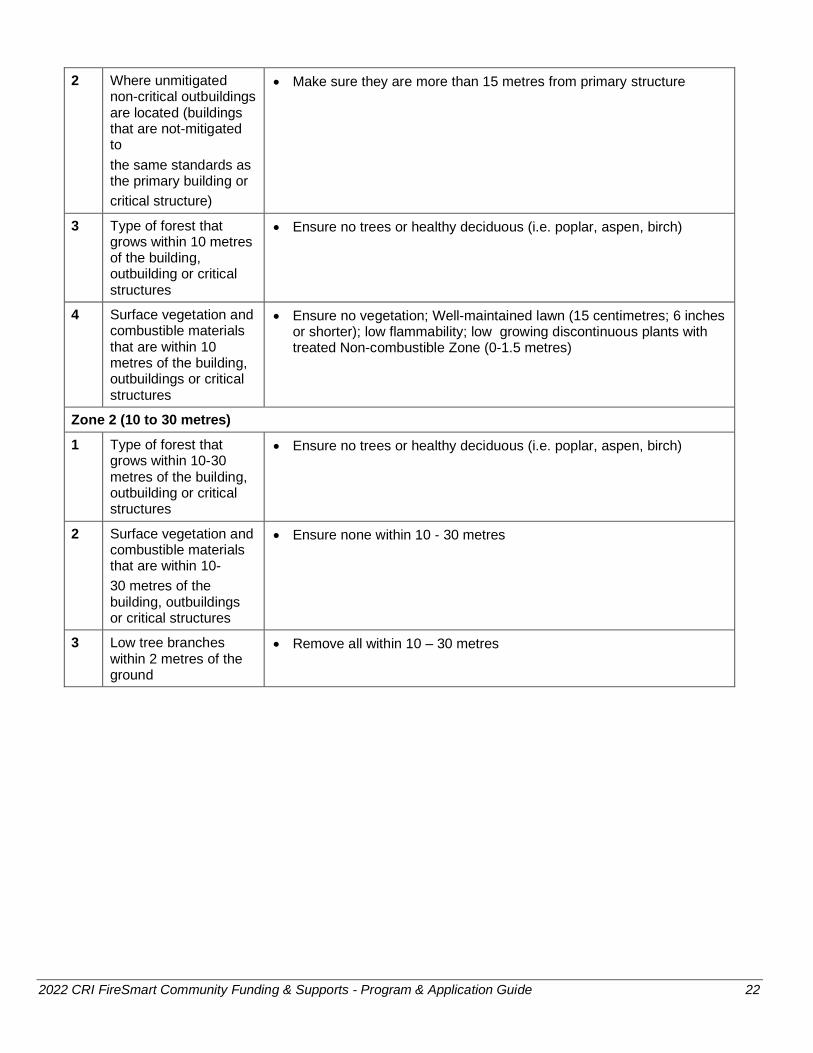
2 Where unmitigated non-critical outbuildings are located (buildings that are not-mitigated to
the same standards as the primary building or
critical structure)
• Make sure they are more than 15 metres from primary structure
3 Type of forest that grows within 10 metres of the building, outbuilding or critical structures
• Ensure no trees or healthy deciduous (i.e. poplar, aspen, birch)
4 Surface vegetation and combustible materials that are within 10 metres of the building, outbuildings or critical structures
• Ensure no vegetation; Well-maintained lawn (15 centimetres; 6 inches or shorter); low flammability; low growing discontinuous plants with treated Non-combustible Zone (0-1.5 metres)
Zone 2 (10 to 30 metres)
1 Type of forest that grows within 10-30 metres of the building, outbuilding or critical structures
• Ensure no trees or healthy deciduous (i.e. poplar, aspen, birch)
2 Surface vegetation and combustible materials that are within 10-
30 metres of the building, outbuildings or critical structures
• Ensure none within 10 - 30 metres
3 Low tree branches within 2 metres of the ground
• Remove all within 10 – 30 metres

2022 CRI FireSmart Community Funding & Supports - Program & Application Guide 23
Appendix 5 – Funding Requirements for FireSmart Rebate Program
Under the FireSmart Community Funding & Supports program, approved applicants can use grant funding to offer local rebate programs to residential property or home owners that complete eligible FireSmart activities on their properties in the FireSmart Home Ignition Zone which includes the home and surrounding yard area - Non-Combustible Zone and Priority Zones 1, 2 and 3.
To be eligible for funding, a rebate program must address the goals of FireSmart and follow the requirements outlined below.
Goals of FireSmart
The general goal of FireSmart is to encourage communities and citizens to adopt and conduct FireSmart practices to mitigate the negative impacts of wildfire to assets on public and private property.
Rebate Program Requirements
Approved applicants are required to adhere to the following requirements:
• Rebates are limited to 50% of the total cost of the eligible activities identified in Table 3 and no more than $500 per property
• Areas of higher wildfire risk, such as neighbourhoods adjacent to the forested edge and/or areas that fall in an overall high to extreme category, should be prioritized for rebates. Current plans should be used to decide where to offer a FireSmart rebate program.
• The approved applicant must assess the FireSmart activities that are conducted by the residential property or home owner and review costs (e.g. receipts and/or proof of labour) before approving rebates
To qualify for a rebate:
• The residential property or home owner must have a FireSmart Home Ignition Zone Assessment Score Card of their property conducted by a qualified Local FireSmart Representative or have their home assessed through the Home Partners Program by a qualified Wildfire Mitigation Specialist. The assessment must identify the property in a moderate, high or extreme category (refer to Table 1 – Community Planning for funding eligibility)
• The qualified Local FireSmart Representatives or Wildfire Mitigation Specialist must use the FireSmart Assessment Work Hours Estimate Form to outline mitigation recommendations to the residential property or home owner
• Residential property or home owners can complete the recommended mitigation activities themselves, or hire others to complete the work
• Only activities that are recommended in the completed assessment and that are identified in Table 3, are eligible for the rebate
Table 3: Eligible Activities for FireSmart Rebate Programs
Home or Structure
1 Roof Material Gutters Vents and Openings
• Install UL/ASTM fire-rated roofing (metal, clay, asphalt shingles)
• Install non-combustible gutters and/or gutter covers
• Remove roof surface tree needles, debris or overhanging branches
• Install closed eaves and/or non-combustible fire-rated vents or vents with 3 mm screening
2 Building Exterior or Siding
• Install ignition resistant (fibre cement board or log) or non-combustible (stucco, metal, brick/stone) exterior siding material
• Repair gaps, cracks or holes where embers could lodge or penetrate
2022 CRI FireSmart Community Funding & Supports - Program & Application Guide 24
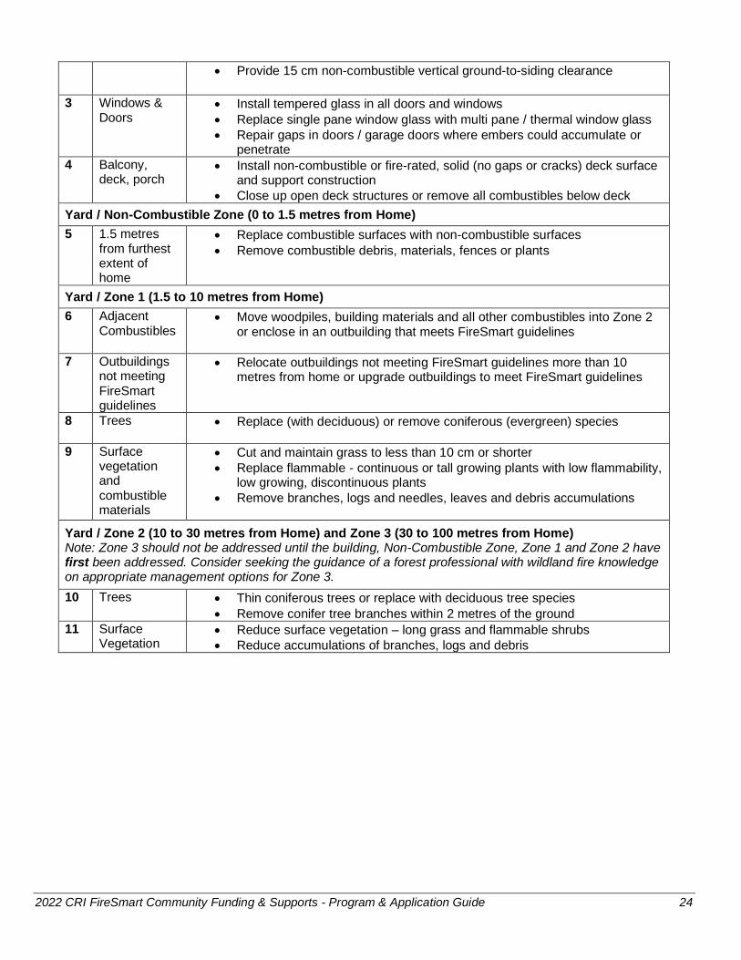
• Provide 15 cm non-combustible vertical ground-to-siding clearance
3 Windows & Doors
• Install tempered glass in all doors and windows
• Replace single pane window glass with multi pane / thermal window glass
• Repair gaps in doors / garage doors where embers could accumulate or penetrate
4 Balcony, deck, porch
• Install non-combustible or fire-rated, solid (no gaps or cracks) deck surface and support construction
• Close up open deck structures or remove all combustibles below deck
Yard / Non-Combustible Zone (0 to 1.5 metres from Home)
5 1.5 metres from furthest extent of home
• Replace combustible surfaces with non-combustible surfaces
• Remove combustible debris, materials, fences or plants
Yard / Zone 1 (1.5 to 10 metres from Home)
6 Adjacent Combustibles
• Move woodpiles, building materials and all other combustibles into Zone 2 or enclose in an outbuilding that meets FireSmart guidelines
7 Outbuildings not meeting FireSmart guidelines
• Relocate outbuildings not meeting FireSmart guidelines more than 10 metres from home or upgrade outbuildings to meet FireSmart guidelines
8 Trees • Replace (with deciduous) or remove coniferous (evergreen) species
9 Surface vegetation and combustible materials
• Cut and maintain grass to less than 10 cm or shorter
• Replace flammable - continuous or tall growing plants with low flammability, low growing, discontinuous plants
• Remove branches, logs and needles, leaves and debris accumulations
Yard / Zone 2 (10 to 30 metres from Home) and Zone 3 (30 to 100 metres from Home) Note: Zone 3 should not be addressed until the building, Non-Combustible Zone, Zone 1 and Zone 2 have first been addressed. Consider seeking the guidance of a forest professional with wildland fire knowledge on appropriate management options for Zone 3.
10 Trees • Thin coniferous trees or replace with deciduous tree species
• Remove conifer tree branches within 2 metres of the ground
11 Surface Vegetation
• Reduce surface vegetation – long grass and flammable shrubs
• Reduce accumulations of branches, logs and debris

2022 CRI FireSmart Community Funding & Supports - Program & Application Guide 25
Appendix 6 – Funding Requirements for Fuel Management Activities
Under the FireSmart Community Funding & Supports program, fuel management activities include the development of fuel management prescriptions and burns plans, as well as operational fuel treatments, including prescribed burns. Refer to Section 4 for eligible projects and Section 5 for the requirements for funding.
Fuel management activities are required to be within municipal boundaries, regional district parks or First Nations land, however contiguous, logical treatment units that extend onto the Crown land base may be considered provided that:
a. Fuel management activities are adjacent to community structures, and
b. Extend no further than one-kilometre from the structure density class greater than 6 (see Appendix 1)
Fuel management located exclusively on Provincial Crown land, outside of municipal boundaries, regional district parks or First Nations land, is administered through the Crown Land Wildfire Risk Reduction stream. Applicants are required to contact the BCWS for further discussion regarding
identified fuel treatment units located on Provincial Crown lands.
Prescriptions
A Fuel Management Prescription is a document that identifies the objectives and strategies to lower the wildfire hazard in an identified area. Prescriptions ensure that proposed treatments include clearly defined objectives for fuel management that will result in a measurable reduction in the wildfire risk to a value while meeting all legislated and non-statutory requirements. Updating prescriptions for maintenance treatments is also eligible for funding. Applicants should ensure that separate treatment units are created for project that cross jurisdictional boundaries.
Prescriptions that are part of phased projects or that have been funded outside of the CRI or SWPI are required to undergo a technical review by the BCWS Wildfire Prevention Officer or FNESS Fuel Management Liaison/Specialist. Adequate time (at least 30 days) is required for technical review to be completed prior to submitting an application or planning for the initiation of the fuel treatment component of a phased project.
When an approved project includes multiple prescriptions, it is preferred that all completed prescriptions are submitted at the same time. Prescriptions that include Crown land and other tenure types (i.e. local government land) should ensure distinct treatment units are used to separate Crown land components in order to meet the requirements for mapping and spatial data.
Burn Plans
A burn plan is a documented plan prepared in advance of a prescribed fire that describes the objectives, burn operations, mitigation plan and post-fire monitoring of the open fire. Approved applicants must utilize the BCWS Prescribed Fire Burn Plan Template. (Note: per Appendix 1a of the template – Burn Plan Signature Sheet, the BCWS Fire Centre Manager or designate is required to approve the burn plan). A completed prescription endorsed by the land manager is required prior to initiating a Burn Plan.
Where development of a burn plan is a proposed activity, applicants must contact the appropriate fire centre and fire zone to determine how burn plan development will proceed. During this discussion, it may be determined that there will be a collaborative approach to burn plan development with BCWS as an active participant or BCWS may only review and approve the plan. Engaging early will help BCWS assess available capacity towards burn plan development.
2022 CRI FireSmart Community Funding & Supports - Program & Application Guide 26
Eligible Prescription/Burn Plan Development Costs & Activities:
• Activities related to prescription development (e.g. approved Canadian wildfire modelling, pre-burn fire effects monitoring or stakeholder engagement)
• Activities related to burn plan development including identification of values in containment areas, additional data collection requirements and engaging with burn specialists
• Required professional assessments (e.g. geotechnical, archaeological, fire ecologist, range agrologist, etc.).
• Information sharing with First Nations, as required by the Land Manager
• Site evaluation, including field reconnaissance, wildfire threat assessment plots, data collection as outlined in prescription guidance document and the evaluation of site access
• Lay out and traversing of proposed areas for treatments
• Preparation of all final report requirements, including maps, spatial data and metadata
Treatments
Fuel management treatments are the manipulation or reduction of living or dead forest and grassland fuels to reduce the rate of spread and head fire intensity and enhance likelihood of successful suppression, generally outside of FireSmart Non-combustible Zone and Priority Zones 1, 2 and 3.
When developing a tactical plan for managing forest fuel to reduce wildfire risk to communities, the best approach to complete this task is fuel breaks. Fuel breaks are linear features on the landscape that provide continuity of treatments that allow for the best wildfire management option for an approaching wildfire. The placement of these fuel breaks needs to consider prevailing wind direction, wildfire spread potential and historical wildfire spread in the WUI. BCWS have developed Initial Spread Index/ Wind roses that show that potential for all BCWS weather stations.
Activities may include treatments such as thinning, spacing and pruning trees, and removal of woody debris and needles (i.e. surface fuel) from the forest floor. As outlined in the BCWS 2021 Fuel Management Prescription Guidance, treatments focus on reducing the potential for sustained ignition and crown fire initiation by reducing surface fuel loading to achieve potential surface fire intensity levels below 2,000 kilowatts per metre and/or below the critical surface intensity. As onsite dispersal of wood chips generally does not meet the 2,000 kilowatts per metre requirement this activity is not eligible for funding. Instead, applicants should consider alternative activities include such as pile and burn or off-site debris disposal.
Maintenance treatments (generally for areas that have had fuel management treatments in the last 5 to 15 years) are eligible for funding. Applicants should discuss any proposed maintenance activities with the BCWS Wildfire Prevention Officer or FNESS Fuel Management Specialist to ensure that the requirements for a new or updated fuel management prescription are addressed and to identify where the Crown Land Wildfire Risk Reduction stream can fund when located outside of municipal and First Nations boundaries.
Prescribed Burns
Prescribed burns primarily for community wildfire risk reduction objectives are eligible for funding under the fuel management activity. Due to relatively narrow burn windows associated with weather and site conditions, as well as timelines associated with fire hazard abatement requirements, it is anticipated prescribed fire will be more appropriate and common as a maintenance treatment than as part of the initial suite of treatments.
Where operational implementation of a burn plan is a proposed activity, approved applicants must contact the appropriate fire centre and fire zone to determine how implementation will proceed. BCWS should be looked to first to carryout the prescribed burn project, either in a leading or assisting role. By accessing BCWS personnel, approved applicants will be utilizing the agency with certified practitioners and crew for implementation. Proponents may consider utilizing BCWS personnel in partnership with First Nations, local

2022 CRI FireSmart Community Funding & Supports - Program & Application Guide 27
fire departments, contract crews, etc. Upon confirmation of BCWS involvement, BCWS personnel costs should not be included in the funding application as those costs will be covered by the Province.
Eligible Fuel Treatment Costs & Activities:
• Pre-treatment activities: activities required to obtain authorizations, danger tree assessments, notification to First Nations and stakeholders and public engagement activities
• Treatments:
o Pruning, thinning, tree falling, brushing, grazing, debris management (e.g. chipping and off-site debris disposal, pile and burning) and/or reforestation
• Post-treatment activities: completion of post treatment data collection, signage and post treatment report
• Preparation of all final report requirements, including maps, spatial data and metadata, including a post treatment report
In addition, when prescribed fire is undertaken as a fuel management activity for community wildfire risk reduction, the following costs and activities are eligible:
• Burn preparation activities including fire weather index monitoring, public notification and preparing black lines. Note: pre-burn costs are eligible costs if no burn window is achieved
• Burn day activities including spot forecasts, equipment set up and transport (may include aerial ignition) and traffic control
• Post-burn activities including post-burn fire effects monitoring, surveys, mop up and final reporting. A budget estimate based on mop-up requirements within the approved burn plan should be included. Where an increased level of mop up (i.e. 100%) is required as indicated by the Burn Boss, in consultation with BCWS, include a contingency cost estimate as a separate budget line item in preparation of potentially dynamic mop up conditions.
Phased Projects
Applicants can apply for fuel management projects that include prescription and/or burn plan development and fuel management treatment, including prescribed burns, for the same treatment unit(s) provided that sufficient detail on estimated treatment size and post-treatment outcomes are included. Under the FireSmart Community Funding & Supports program, this is considered a phased project and specific funding conditions will apply.
Application Requirements
In addition to the required application materials for the FireSmart Community Funding & Supports program, projects that include fuel management activities are required to submit:
• Worksheet 2: Proposed Fuel Management Activities and all required attachments
• Overview/cumulative map of the community, previously completed treatments, proposed treatments for this application, and planned future treatments. Refer to WUI Risk Class Maps and Google Earth compatible KML files (Appendix 2).
• PDF map and Google Earth compatible KML file, at appropriate scale, outlining the area of interest, proposed treatments units, land status and tenure overlaps, as defined in Appendix 4
• If available, current, wildfire threat assessment plots and/or fuel loading data and rationale for the proposed treatment unit(s) (see Fuel Management Prescription Guidance document for more information)

2022 CRI FireSmart Community Funding & Supports - Program & Application Guide 28
• For fuel management treatments only:
o Completed, signed prescription. Unless the proposed treatment is a phased project, the completed, signed prescription must be submitted with the application in order to have the treatment considered for funding.
o For prescribed fire, completed, signed burn plan in addition to Fuel Management Prescription
o Project spatial layers as defined in Section I of Appendix 7
Interim Report Requirements for Phased Projects Only
For projects that include prescription/prescribed fire burn plan development and fuel management treatment for the same treatment unit(s) the following is required.
The completed, signed prescription and prescribed fire burn plan and, for treatment on Crown land only, confirmation that First Nations information sharing has been completed, must be submitted to UBCM.
The prescription and/or prescribed fire burn plan will be reviewed by the BCWS Wildfire Prevention Officer or FNESS Fuel Management Specialist and must be supported prior to initiation of the fuel management treatment. Treatments that have been initiated prior to an approved technical review may not eligible for further funding.
In addition, in order to receive authorizations for the treatment, the land manager will require the completed prescription/burn plan, as well as additional information. This may include:
• Maps
• Project boundary spatial layer
• Confirmation that First Nations information sharing has been completed
If the applicant is requesting a progress payment at the completion of the prescription and burn plan (for prescribed fire) phase, the complete final report requirements for prescriptions and burns plans (identified in Table 4) must be submitted to UBCM. Otherwise, this information is required to be submitted as part of the overall final report.
Final Report Requirements
In addition to the required final report materials for the FireSmart Community Funding & Supports program, projects that include fuel management activities are required to submit the following.
Table 4: Fuel Management Final Report Requirements
Fuel Management Prescriptions and Burn Plans (for prescribed fire)
Fuel Management Treatments, including prescribed fire
Copy of the fuel management prescription that is signed by a Registered Forest Professional including all ancillary assessments (e.g. terrain stability).
Copy of the Burn Plan that is signed by the qualified professional (e.g. fire behaviour speciality, burn boss or otherwise).
Post-treatment wildfire threat assessments or data collection as outlined in Prescription Guidance document.
Post- treatment report with updated survey data collection as per direction in the prescription, summary of post treatments conditions and fire behaviour outcomes and relationship to prescription treatment objectives. Pre and post-treatment pictures as well –
2022 CRI FireSmart Community Funding & Supports - Program & Application Guide 29
minimum of three per TU. Attached original final prescription.
PDF maps, at appropriate scale, as identified in Appendix 6
PDF maps, at appropriate scale, as identified in Appendix 6
Spatial data, as identified in Appendix 7, only if the approved project does not include fuel management treatments of the prescribed area (i.e. is not a phased project).
Spatial data for Provincial Crown land treatments is required to be entered into RESULTS and the Activity Treatment ID is required as evidence of a successful RESULTS entry. Please refer to the “RESULTS Information Submission Specifications: Government Funded Activities” document found in the “Submission Specifications Data Requirements” section.
For local government or First Nations land (i.e. non-Provincial Crown land), spatial data is required, as identified in Appendix 6.
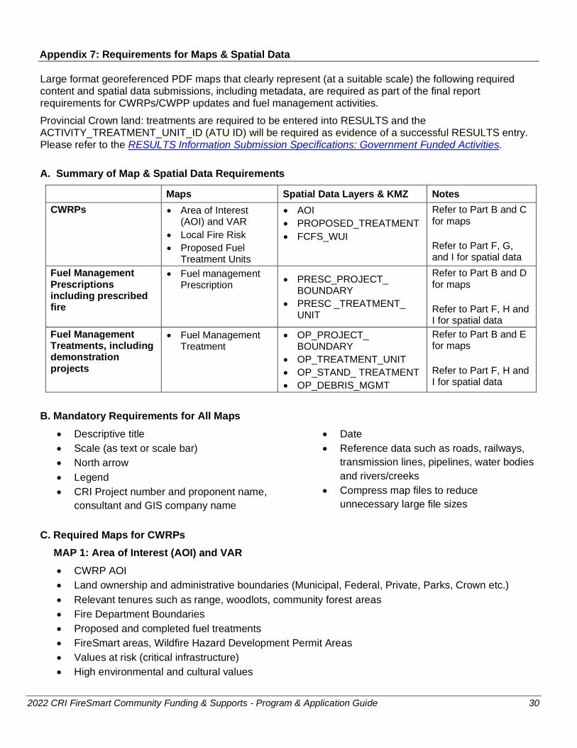
2022 CRI FireSmart Community Funding & Supports - Program & Application Guide 30
Appendix 7: Requirements for Maps & Spatial Data
Large format georeferenced PDF maps that clearly represent (at a suitable scale) the following required content and spatial data submissions, including metadata, are required as part of the final report requirements for CWRPs/CWPP updates and fuel management activities.
Provincial Crown land: treatments are required to be entered into RESULTS and the ACTIVITY_TREATMENT_UNIT_ID (ATU ID) will be required as evidence of a successful RESULTS entry. Please refer to the RESULTS Information Submission Specifications: Government Funded Activities.
A. Summary of Map & Spatial Data Requirements
Maps Spatial Data Layers & KMZ Notes
CWRPs • Area of Interest (AOI) and VAR
• Local Fire Risk
• Proposed Fuel Treatment Units
• AOI
• PROPOSED_TREATMENT
• FCFS_WUI
Refer to Part B and C for maps
Refer to Part F, G, and I for spatial data
Fuel Management Prescriptions including prescribed fire
• Fuel management Prescription
• PRESC_PROJECT_ BOUNDARY
• PRESC _TREATMENT_ UNIT
Refer to Part B and D for maps
Refer to Part F, H and I for spatial data
Fuel Management Treatments, including demonstration projects
• Fuel Management Treatment
• OP_PROJECT_ BOUNDARY
• OP_TREATMENT_UNIT
• OP_STAND_ TREATMENT
• OP_DEBRIS_MGMT
Refer to Part B and E for maps
Refer to Part F, H and I for spatial data
B. Mandatory Requirements for All Maps
• Descriptive title
• Scale (as text or scale bar)
• North arrow
• Legend
• CRI Project number and proponent name,
consultant and GIS company name
• Date
• Reference data such as roads, railways,
transmission lines, pipelines, water bodies
and rivers/creeks
• Compress map files to reduce
unnecessary large file sizes
C. Required Maps for CWRPs
MAP 1: Area of Interest (AOI) and VAR
• CWRP AOI
• Land ownership and administrative boundaries (Municipal, Federal, Private, Parks, Crown etc.)
• Relevant tenures such as range, woodlots, community forest areas
• Fire Department Boundaries
• Proposed and completed fuel treatments
• FireSmart areas, Wildfire Hazard Development Permit Areas
• Values at risk (critical infrastructure)
• High environmental and cultural values
2022 CRI FireSmart Community Funding & Supports - Program & Application Guide 31
• Hazardous values at risk
MAP 2: Local Fire Risk
• CWRP FCFS WUI one-kilometre buffer
• PSTA Threat or Modified Local Level Polygons
• Hectares of each PSTA Threat Class or Modified Local Level Threat Class must be stated on the
map in a table
MAP 3: Proposed Fuel Treatment Units
• CWRP AOI
• Land Status and tenure overlaps e.g. range, woodlots etc.
• Proposed fuel treatment units, labelled by PROPOSED_TREATMENT_ID
• Previously completed treatments, labelled by year
• Hectares of Proposed Fuel Treatments in a table on map (PROPOSED_TREATMENT_ID, AREAHA)
D. Required Map for Fuel Management Prescriptions
• PRESC Project Boundary with land status and tenure overlaps (e.g. range, woodlots, area-based
tenures)
• Access including proposed roads, and stream crossings
• Values including any reserves, wildlife habitat areas, or critical infrastructure
• Streams, wetlands, lakes including the class and identification number/name
• Areas of safety concern (steep slopes).
• PRESCRIBED_TREATMENT_UNIT (labelled by TREATMENT_UNIT_ID)
• Access including existing/proposed roads, trails and stream crossings
• Previously completed treatments if applicable (labelled by year)
• Table with all areas identified in Treatment Unit Summary, including treatment regime and hectares
(from the signed Fuel Management Prescription doc)
• Wildfire Threat Assessment plots / labelled by PLOT_NUMBER
E. Required Map for Fuel Management Treatment
• OP project boundary with land status and tenure overlaps (e.g. range, area-based tenures woodlots)
• OP_TREATMENT_UNIT (labelled by TREATMENT_UNIT_ID)
• Stand treatment and debris management activity
• A table of total net project boundary hectares, and Stand and Debris activity summarized by
individual treatment unit hectares
• Previously completed treatments if applicable (labelled by year)
• Wildfire Threat Assessment plots / labelled by PLOT_NUMBER
F. Spatial Data Requirements
The Province of BC uses ArcGIS 10.6 and all spatial data submissions must be compatible with ArcGIS 10.6. In addition, some feature layers as identified in the table below, are also required in a KMZ format. Spatial data must conform to the following general formats, naming conventions and standards.

2022 CRI FireSmart Community Funding & Supports - Program & Application Guide 32
1. Data Format and Naming Conventions: Data must be submitted in a File Geodatabase (FGDB) and KMZ format and must conform to the conventions for feature dataset names, feature class names, attribute names, and attribute values as identified in the Specific Submission Requirements by Project Type section below. It is strongly recommended that you use the template FGDB in order to facilitate meeting this requirement.
FGDB and KMZ names must adhere to the following naming standard:
< Local Government/First Nation Band Number>_<ProjectTypeAndDescription>
For example: PrinceGeorge_CWRPNorthPG.gdb
PrinceGeorge_CWRPNorthPG.KMZ
FN699_CWRPNorthPG.gdb
FN699_CWRPNorthPG.KMZ
2. FGDB Projection: The projection standard is NAD_1983_BC_Environment_Albers (EPSG:3005), with parameters of:
Central meridian: -126.0° (126°00’00” West longitude)
Latitude of projection origin: 45.0 (45°00’00 North latitude)
First standard parallel: 50.0° (50°00’00” North latitude)
Second standard parallel: 58.5° (58°30’00” North latitude)
False easting: 1000000.0 (one million metres)
False northing: 0.0
Datum: NAD83, based on the GRS80 ellipsoid.
3. Data Quality: Submitted data must meet general data quality guidelines to ensure corporate data quality standards are met. Data with slivers, gaps between adjacent polygons, and geometry or topology errors should as overlaps will not be accepted.
4. Metadata: Metadata must be provided for all spatial layers. The metadata standard is FGDC and is required to be submitted in .xml format. Metadata must document the following:
a. A description of what each dataset represents for all datasets provided in addition to what is outlined in the individual project sections.
b. A description of each attribute and the codes/values used to populate it for all attributes provided in addition to what is outlined in the individual project sections.
c. Data Source information including where the data came from, the currency of the information and source contact details for potential follow-up
d. For resultant datasets, metadata must also include the methodology and source data used in the creation of the resultant, the date of creation, and contact details for the person who created it.
5. Submission: The method for spatial data submission is a file geodatabase (FGDB) compressed into a zip file and KMZ file(s). KMZ files are to be saved with symbology (i.e. similar to what is displayed on the required maps).

2022 CRI FireSmart Community Funding & Supports - Program & Application Guide 33
Additional notes about CWRP submissions:
• All spatial layers in addition to those identified in this guide, that are a key component of the CWRP maps or plan, must be included as part of the spatial submission and must include metadata.
• If more than one data collection method was used, please choose the value that best represents how the information was captured.
• CWRP hectares on maps and documents must match those submitted spatially.
Additional notes about Fuel Management and Prescription submissions:
• The prescription_ operational project boundary represents the net operational area.
• One single or multi part polygon must be submitted for each treatment unit and/or activity.
• Project boundary, treatment unit and spatial hectares must match the net hectares stated on the maps and in the final report, or worksheet 2 for fuel treatments.
• Provincial Crown land: treatments will be required to be entered into RESULTS.
Please note: Spatial data submissions will be evaluated against these criteria. The final report and payment of grant funding will not be approved until all of these criteria are met.

2021 CRI FireSmart Community Funding & Supports - Program & Application Guide 34
Specific Submission Requirements by Project Type
G. Community Wildfire Resiliency Plan
Feature Layer Name
KMZ Feature Layer Description
Mandatory Attributes Attribute Description
Attribute Details
(Data type, length)
AOI YES CWRP area of
interest
DATA_COLLECTION_DATE Date spatial data was collected Date (DD/MM/YYYY)
DATA_COLLECTION_METHOD Method of spatial data collection (ex. GPS, digitized, etc.). See Table 1
Text, 45
AREAHA Area in hectares Double
FCFS_WUI YES
Fire Smart Community Funding & Supports program
1km WUI
DATA_SOURCE Origin of FCFS_WUI source. e.g. "WUI 2017" or for updated buffers suffixed with applicants name e.g. CWRP - Cariboo RD
Text, 75
DATA_COLLECTION_DATE Date the spatial data was collected Date (DD/MM/YYYY)
DATA_COLLECTION_METHOD Method of spatial data collection (ex. GPS, digitized, etc.). See Table 1
Text, 45
AREAHA Area in hectares Double
PROPOSED_ TREATMENT
YES Proposed gross treatment area
PROPOSED_TREATMENT_ID Unique proposed treatment identifier Text, 7
DATA_COLLECTION_DATE Date spatial data was collected Date (DD/MM/YYYY)
DATA_COLLECTION_METHOD Method of spatial data collection (ex. GPS, digitized, etc.). See Table 1
Text, 45
AREAHA Area in hectares Double

2022 CRI FireSmart Community Funding & Supports - Program & Application Guide 35
H. Specific Submission Requirements for Fuel Management and/or Prescription
Fuel Management Prescription
Feature Layer Name KMZ Feature Layer Description
Mandatory Attributes Attribute Description
Attribute Details
(Data type, length)
PRESC _PROJECT_ BOUNDARY
YES
Single or multi-part dissolved polygon
layer defining the net area under prescription
DATA_COLLECTION_DATE Date spatial data was collected Date (DD/MM/YYYY)
DATA_COLLECTION_METHOD Method of spatial data collection (ex. GPS, digitized, etc.). See Table 1
Text, 45
AREAHA Area in hectares Double
PRESC _ TREATMENT_UNIT
YES Prescription
treatment units
TREATMENT_UNIT_ID Treatment Unit ID Text, 10
CURRENT_FUEL_TYPE Current treatment unit fuel type. See Table 2 Text, 15
CURRENT_STEMS_PER_HA Current treatment unit density stems per hectare Long integer
LOCATION_NAME Geographic description of treatment unit Text, 50
DATA_COLLECTION_DATE Date spatial data was collected Date (DD/MM/YYYY)
DATA_COLLECTION_METHOD Method of spatial data collection (ex. GPS, digitized, etc.). See Table 1
Text, 45
AREAHA Area in hectares Double
Fuel Management Treatment
Feature Layer Name KMZ Feature Layer Description
Mandatory Attributes Attribute Description
Attribute Details
(Data type, length)
OP _PROJECT_ BOUNDARY
YES
Single or multi-part dissolved polygon
layer defining the net operational area
DATA_COLLECTION_DATE Date spatial data was collected Date (DD/MM/YYYY)
DATA_COLLECTION_METHOD Method of spatial data collection (ex. GPS, digitized, etc.). See Table 1
Text, 45
AREAHA Area in hectares Double
OP_TREATMENT_ UNIT
YES
Operational treatment units
TREATMENT_UNIT_ID Treatment Unit ID Text, 10
POST_STEMS_PER_HA Current treatment unit density stems per hectare Long integer
LOCATION_NAME Geographic description of treatment unit Text, 50
DATA_COLLECTION_DATE Date spatial data was collected Date (DD/MM/YYYY)

2022 CRI FireSmart Community Funding & Supports - Program & Application Guide 36
Feature Layer Name KMZ Feature Layer Description
Mandatory Attributes Attribute Description
Attribute Details
(Data type, length)
DATA_COLLECTION_METHOD Method of spatial data collection (ex. GPS, digitized, etc.). See Table 1
Text, 45
AREAHA Area in hectares Double
OP_STAND_ TREATMENT
YES Operational stand
treatment area
STAND_TREATMENT_ TECHNIQUE
Broad category of technique used for stand treatment activity. See Table 3
Text, 20
STAND_TREATMENT_METHOD Method used to perform treatment activity. See Table 3
Text, 20
STAND_TREATMENT_END_ DATE
Date stand treatment activity completed. Date (DD/MM/YYYY)
DATA_COLLECTION_DATE Date spatial data was collected Date (DD/MM/YYYY)
DATA_COLLECTION_METHOD
Method of spatial data collection (ex. GPS, digitized, etc.). See Table 1
Text, 45
AREAHA Area in hectares Double
OP_DEBRIS_MGMT YES Operational debris management area
DEBRIS_MGMT_TECHNIQUE Broad category of technique used for debris management activity. See Table 4
Text, 20
DEBRIS_MGMT_METHOD Method used to perform debris management activity. See Table 4
Text, 20
DEBRIS_MGMT_END_DATE Date debris management activity completed Date (DD/MM/YYYY)
DATA_COLLECTION_DATE Date spatial data was collected Date (DD/MM/YYYY)
DATA_COLLECTION_METHOD Method of spatial data collection (ex. GPS, digitized, etc.). See Table 1
Text, 45
AREAHA Area in hectares Double

2022 CRI FireSmart Community Funding & Supports - Program & Application Guide 37
I. Attribute Value Reference Tables
Table 1: Data Collection Method
DATA_COLLECTION_METHOD DESCRIPTION
differentialGPS The data was captured with a differential GPS unit, or was post-processed with information received from known reference stations, to improve data accuracy.
Digitizing The data was converted from an analog map into a digital format using a digitizing tablet connected to a computer.
GISAnalysis The data was created as a result of a GIS Analysis.
nondifferentialGPS The data was captured with a GPS unit but was not post-processed or was captured with a GPS unit incapable of doing differential GPS.
orthoPhotography The data was delineated from an orthophoto (aerial photography).
Photogrammetric The data was delineated using photographs or images in stereo pairs
satelliteImagery The data was delineated from a satellite image.
sketchMap The data was hand sketched, either on an analog map or on-screen.
tightChainTraverse The data was surveyed with a hand compass and chain to create a closed traverse.
Table 2: Fuel Type
FUEL_TYPE DESCRIPTION
C-1 C-1 Spruce Lichen Woodland
C-2 C-2 Boreal Spruce
C-3 C-3 Mature Jack or Lodgepole Pine
C-4 C-4 Immature Jack, Lodgepole Pine, densely stocked Ponderosa Pine, or Douglas Fir
C-5 C-5 Red and White Pine
C-6 C-6 Conifer Plantation
C-7 C-7 Ponderosa Pine or Douglas Fir
D-1/2 D-1/2 Green or Leafless Aspen or Deciduous shrub
S-1 S-1 Jack or Lodgepole Pine slash
S-2 S-2 White Spruce, Balsam slash
S-3 S-3 Coastal Cedar, Hemlock, Douglas-Fir slash
O-1a/b O-1a/b Matted or Standing Grass
M-1/2 M-1/2 Green or Leafless Mixedwood
M-3 M-3 Dead Balsam Fir Mixedwood – leafless
M-4 M-4 Dead Balsam Fir Mixedwood – green
Non-fuel Non-fuel
Unclassified Unclassified
Water Water
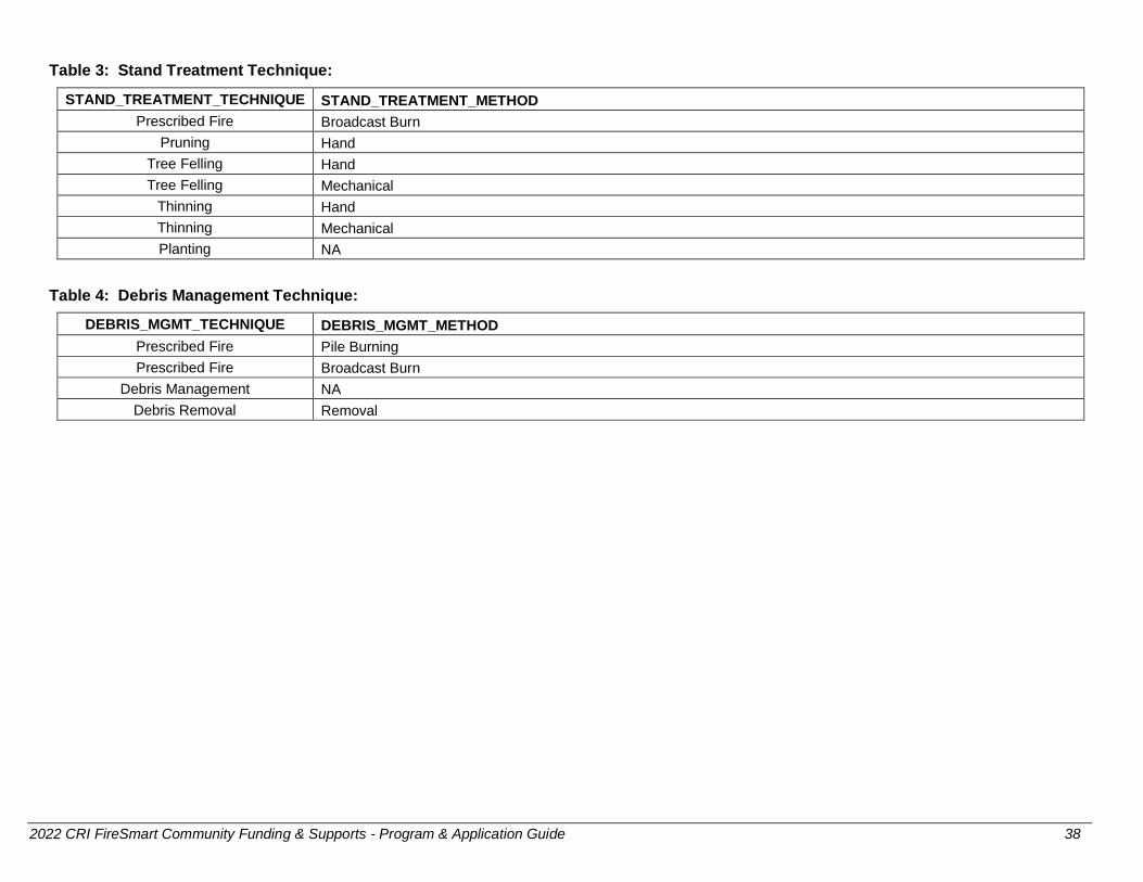
2022 CRI FireSmart Community Funding & Supports - Program & Application Guide 38
Table 3: Stand Treatment Technique:
STAND_TREATMENT_TECHNIQUE STAND_TREATMENT_METHOD
Prescribed Fire Broadcast Burn
Pruning Hand
Tree Felling Hand
Tree Felling Mechanical
Thinning Hand
Thinning Mechanical
Planting NA
Table 4: Debris Management Technique:
DEBRIS_MGMT_TECHNIQUE DEBRIS_MGMT_METHOD
Prescribed Fire Pile Burning
Prescribed Fire Broadcast Burn
Debris Management NA
Debris Removal Removal