2020 SUMMARY REPORT - Transportation
65
AASHTO GEOSPATIAL INFORMATION SYSTEMS TRANSPORTATION SYMPOSIUM SUMMARY REPORT Thirty-Third Annual GEOSPATIAL INFORMATION SYSTEMS FOR TRANSPORTATION SYMPOSIUM April 15 - 17, 2020 Workshops – April 14, 2020 Minneapolis, Minnesota
Transcript of 2020 SUMMARY REPORT - Transportation

AASHTO GEOSPATIAL INFORMATION SYSTEMS
TRANSPORTATION SYMPO SIUM
SUMMARY REPORT
Thirty-Third Annual
GEOSPATIAL INFORMATION SYSTEMS FOR
TRANSPORTATION SYMPOSIUM
April 15 - 17, 2020 Workshops – April 14, 2020
Minneapolis, Minnesota

2
Table of Contents OVERVIEW OF THE GIS-T SYMPOSIUM 3
THE 2020 GIS-T SYMPOSIUM 3
SYMPOSIUM BACKGROUND 3
SYMPOSIUM REVIEW 4
WORKSHOPS 4
CONCURRENT SESSIONS 9
ROLL CALL ROUND TABLES 10
STUDENT PAPER AWARD 10
STATE SUMMARY 10
SLIMGIM-T RESULTS 10
CURRENT ACTIVITIES 12
BUSINESS SOLUTIONS 13
OPPORTUNITIES FOR FURTHER STUDY 14
SYMPOSIUM SUMMARY 14
2021 / 2022 AASHTO GIS-T HOSTS 15
APPENDIX A – ROLL CALL OF STATES 16
APPENDIX B – STATE GIS-T CONTACTS 36
APPENDIX C – GENERAL SCHEDULE 39
APPENDIX D – 2020 WINNING STUDENT PAPER 40
APPENDIX E – 2020 SLIMGIM SURVEY 60
APPENDIX F – 2020 AASHTO GIS-T PLANNING COMMITTEE 65

3
2020 GIS-T SYMPOSIUM REPORT Minneapolis, Minnesota
Overview of the GIS-T Symposium
The thirty-third annual Symposium on Geospatial Information Systems for Transportation (GIS-T) was scheduled for Minneapolis, Minnesota from April 15 to April 17, 2020. Unfortunately, the COVID-19 pandemic became an issue approximately one month before
the Symposium start. As many states and vendors began suspending travel, AASHTO decided to cancel the 2020 GIS-T and refund registration fees.
Although the Symposium did not occur, the late cancellation date means statistics and information were collected, and a program was planned. This report will summarize what was
known.
The Symposium focuses on providing a forum for transportation professionals interested in the design and use of GIS-T. It brings together individuals from education, the private sector, and all levels of government for a full day of workshops and two and a half days of
professional development. The Symposium provided opportunities for participants to network with peers to discuss emerging issues and concerns.
“Navigate to True North” was chosen as the 2020 AASHTO GIS-T Symposium theme. The theme is a world play about the geographic nature of the GIS-T industry and the northern site, Minnesota.
One-hundred forty-five (145) professional abstracts were submitted during the Call for
Presentations. The Program Committee rated the abstracts, selecting eighty-four (84) for inclusion in the program, and developed “like categories” for thematic presentation. Again in 2020, the Program Committee included a Federal Track, featuring federal speakers and
topics of interest to the larger audience.
The 2020 program also contained the popular facilitated discussions, GIS-T Round Tables. The Round Tables’ topics were chosen by grouping issues from the Roll Call of States’ Issues List and discussions among the planning committee. The GIS-T planning committee then
selected two round table topics: Getting Current, Authoritative Data in the Hands of GPS Users and Enterprise GIS: How do we get there? Scheduled moderators for 2020 were Dan Ross, past President, NSGIC and Minnesota GIO, and the team of Mark Sarmiento, FHWA, Ian Kidner, Ohio DOT, and Eric Abrams, GeoDecisions.
The 2020 GIS-T Symposium
Symposium Background
The GIS-T Symposium is sponsored by the American Association of State and Highway Transportation Officials (AASHTO), and affiliated with the Transportation Research Board
(TRB), the Urban and Regional Information Systems Association (URISA), National Association of Regional Councils (NARC), Association of Metropolitan Planning Organizations (AMPO), the Highway Engineers Exchange Program (HEEP), American Society for
Photogrammetry and Remote Sensing, the National States Geographic Information Council

4
(NSGIC), and the U.S. Department of Transportation, Federal Highway Administration (FHWA), Bureau of Transportation Statistics (BTS), and Federal Railroad Administration
(FRA).
The Symposium originated to facilitate:
• education
• information sharing
• technology exhibitor displays
• creativity
The Symposium is managed by a Task Force and organized by a Planning Committee. The
AASHTO GIS-T Task Force is a seven-member group: five DOT representatives, one from each of the four (4) AASHTO regions, and an at-large chairperson, one FHWA liaison, and one AASHTO liaison. The Task Force members are also Planning Committee members. The
Planning Committee is a larger group comprised of subcommittees for each of the Symposium’s organizational tasks, such as program development, moderators, local arrangements, technology/exhibit hall, workshops, registration, publicity, student paper, State
Summary Report, Roll Call of States, Roll Call Round Tables, GIS gallery, and web site.
Symposium Review
Unfortunately, the COVID-19 pandemic became an issue approximately one month before the Symposium start. As many states and vendors began suspending travel, AASHTO
decided to cancel the 2020 GIS-T and refund registration fees.
Although the Symposium did not occur, the late cancellation date means statistics and information were collected, and a program was planned. This section will summarize what was known.
The planned General Symposium Schedule is found in Appendix C.
Workshops There were four morning, and four afternoon workshops scheduled at the 2020 AASHTO
GIS-T Symposium. Part ic ipants could pick one session from the morning and one from the afternoon. Two-hundred sixteen (216) attendees registered for morning workshops; one-hundred four (104) registered for the afternoon workshops.
MORNING SESSIONS (8:00 AM – 12:00 PM)
Workshop 1: Introduction to HPMS
Instructors Ronald Vaughn (FHWA) Justin Clarke (FHWA)
This workshop will provide an overview and understanding of the Highway Performance
Monitoring System (HPMS), and is designed to cover the following topics:
(1) Program Background & Data Model
5
(2) Data Collection & Requirements (3) Statistical Sampling Requirements, and
(4) the Submittal Process.
Additionally, this workshop will discuss modifications to various pavement data collection and reporting requirements in accordance with the FAST Act Transportation Performance Management (TPM)-related Pavement & Bridge Condition Performance Measures (PM2) final
rule, which was issued in May 2017.
Registrants: 37
Workshop 2: BIM/CIM for Infrastructure: Integrating Agencies’ Geospatial Data
Instructors David Unkefer, PE (FHWA) Connie Yew, PE (FHWA) Abhishek Bhargav, PhD (WSP) Morgan Kessler, PE (FHWA) William Pratt, PE (CT COT) Greg Ciparelli (CT DOT)
John Krause, PSM (FL DOT) Shawn Blaesing (IA DOT) Michael Kennerly, PE (IA DOT) Becky Hjelm (UT DOT) George Lukes (UT DOT)
Transportation agencies see the wisdom of integrating geospatially located asset data across
their organizations and ‘connecting the silos’; the vision of BIM/CIM. Digital information governed agency-wide and managed ‘holistically’ provides for fact-based decision-making, greater opportunities for automation and increased productivity for agencies and for our
national transportation system. FHWA, AASHTO and many others within the transportation industry are working to advance the vision of BIM/CIM. Internationally, many countries are also taking more intentional and strategic steps toward implementing BIM/CIM; to improve the
effectiveness of construction and lifecycle asset management, and ultimately their economies. What is the vision of BIM/CIM? Why is it important for the U.S. to be strategic with implementation? How does BIM/CIM connect with GIS? What are some of the technologies,
initiatives and the gaps as we build partnerships to promote this greater advancement of data sharing and breaking down silos and connecting our organizations? This workshop will cover some of the answers and initiatives we believe are important for more effective BIM/CIM
implementation within the US transportation industry, while also seeking input from attendees towards this end.
Workshop Agenda • Introduction/Workshop Objective/check in with audience (FHWA-Unkefer)(5-10 min)
• BIM Global picture (FHWA-Yew) (15 min)
• Tools and methods that integrate BIM and GIS workflows (WSP- Bhargava, FHWA - Kessler) (30-
45 min)
• Research/Implementation Support
o Practical examples of BIM-GIS connection from state DOTs (120 min plus time for Q&A)
o Objective: Clarify the state of practice for the BIM-GIS-asset management connections and
critical gaps
o State examples/best practices (30 minutes each state): e.g. Software/tool successes,
moving data around the lifecycle, enterprise data governance, analytics, business
cases/ROI and drivers for lifecycle data management.
▪ CT DOT – TED (Ciparelli, Pratt)
▪ UT DOT – (Lukes, Hjelm)

6
▪ IA DOT – (Blaesing, Kennerly)
▪ FL DOT (Krause with Blackburn as backup)
• Panel Q&A - Opportunity for Audience Input
Attendance: 43
Workshop 3: Safety GIS
Instructors - Stuart Thompson (FHWA) Robert Pollack (FHWA) Eric Green (KY Transportation Center)
The workshop will cover a range of GIS-safety topics from guest speakers. Representatives
from Kentucky will be discussing Kentucky's Strategic Highway Safety Plan and how GIS can be used in developing the plan. Representatives from VHB will be discussing an HSIS FHWA project including interactive questions and answers. We will also show the impacts
segmentation has on safety prioritization and will provide updates from a federal perspective.
Registrants: 41 Workshop 4: ARNOLD 7 Years After
Instructors - Tom Roff (FHWA)
The ARNOLD initiative began with a memo dated Aug 7, 2012. Its original purpose was to provide a spatial framework to support HPMS attribution and other datasets reported to the
Federal Highway Administration. Seven years later, ARNOLD has had moderate success to that initial purpose by linking HPMS to projects, crashes, and Travel Time Data.
There is growing interest in using HPMS and ARNOLD as the foundation of a national geospatial highway network. This workshop will be an open discussion about the feasibility of
this latest effort. Agenda topics will include: 1. ARNOLD defined today and how it supports the intended purpose.
a. Specific examples on how ARNOLD is being used.
2. The definition of a national geospatial highway network. a. Perspectives from different levels of Government, private sector and research
communities.
3. Challenges to support this vision. a. Recognize opportunities and challenges to implementing this vision.
4. How do we get there?
a. Chart out a path.
Registrants: 32
Workshop 5: GIS Management and Data Governance
Instructor - Ian Kidner (OH DOT) Allen Ibaugh, AICP, GISP (DTS)
Many people entering and advancing through the GIS profession often receive extensive training on tools and technology, and find themselves needing to manage people, projects, budgets, and strategies. Too often, a lack of understanding how to manage these concerns
may lead to poor results despite best intentions. This workshop includes an overview of areas that should be considered for managing a GIS project or program. A main key area covered

7
will be the concept of Data Governance and its importance in management considerations of a GIS program. Several aspects of Data Governance will be covered including framework, policy,
standards, and technology considerations.
Additionally, an overview of established frameworks, certifications or other resources will be discussed to help participants better understand more in-depth opportunities they might want to pursue.
Agenda Item Duration (minutes)
• Introductions, Overview 15
• Program vs Project 20
• Work Plans (SWOT) 20
• Work Plan Prioritization Activity (Risk Assessment) Exercise 30
• Break 15
• Project Management Overview 20
• Data Governance Overview 60
• Break 15
• Maturity Model Exercise 30
• Participant Feedback, Recap & Closing 15
Registrants: 63
AFTERNOON SESSIONS (1:00 PM – 5:00 PM)
Workshop 6: Using StreetLight InSight for Transportation Projects
Instructor - Thomas Grogan (StreetLight)
In this intensive, hands-on workshop, attendees will learn how to use StreetLight InSight®, an
on-demand, cloud-based platform for transportation professionals to design and run customized mobility analytics derived from Big Data. Building on the workshop from last year, StreetLight Data Solution Engineer Thomas Grogan will lead an interactive training session
that shows attendees how to use StreetLight InSight for several transportation use cases, such as: a regional origin-destination study for travel demand modeling, a before-and-after study measuring the effects of cut-through traffic restrictions, a bike-pedestrian analysis to
understand where active transportation happens the most in order to target investments, and a top routes analysis for detour planning. In addition, Thomas will cover the following topics:
● New GIS/Machine Learning techniques employed by StreetLight to build accurate
mode inference from Big Data.
● How to interpret results from Big Data and techniques for comparing and integrating it
with information from other sources
● Visualizing Metrics in both StreetLight InSight and GIS tools, manipulating .CSV files in
MS Excel and other statistical analysis software, and integrating Metrics into
transportation modeling applications.
● The statistical methods used to normalize geospatial data over time.

8
Attendees will leave the session armed with practical tips and best practices for using the StreetLight InSight platform for their daily work.
Registrants: 17
Workshop 7: Applications of Enterprise GIS-T, AEGIST, FHWA’s Approach
Instructors - Patrick Whiteford (AZ DOT) James Meyer, GISP (AZ DOT) Gregory Ciparelli (CT DOT) Abhishek Bhargava, PhD (WSP) Jerome Breyer (Works Consulting)
This workshop presents how the road network and asset data modeling specifications in the FHWA - AEGIST Guidebook can be used by States to support model highway network;
support data exchanges between enterprise GIS, LRS, Design, Safety and Asset Management systems; and, utilize an open standard for modeling and storing data that is required to meet HPMS and MIRE reporting requirements. The workshop will provide an
opportunity to attendees to participate in an interactive training session and work with the road network and asset data. The objective of the session will be to demonstrate value of managing road network and asset data as per the specifications outlined in the AEGIST
guidebook. The attendees will be able to analyze the data models and review how the AEGIST specifications can be used to model road network and asset data configurations associated with divided-undivided highways, intersections, interchanges (ramps, ramp
extensions, limited access highway directional centerlines etc.)
Registrants: 49
Workshop 8: CTPP Deeper than Maps!
Instructors: Penelope Weinberger (AASHTO) Dany Bouchard (CartoVista)
The Census Transportation Planning Products (CTPP) Program crash course is a shortened version of our full-on training, tailored to be delivered in a few hours (or less), it’s a content filled, action packed, introduction to the data and the issues and opportunities associated with
it. With most states participating in the CTPP, an AASHTO technical service program, this is a robust program of data, technical assistance, training, outreach, and research. The workshop is led by CTPP experts with many years of program experience. The workshop will be thought
provoking, entertaining, and ultimately extremely useful to the practitioner. The Data Access Software includes some robust GIS / Web Mapping features for both geography selection and rendering of results, including both excellent visualization processing and statistical and
thematic analyses, at a high level of performance. Along with ASCII and EXCEL formats, the data can also be downloaded in .tab and .SHP files. The CTPP received new data and new mapping software in 2018, most practitioners have not yet seen the data from the CTPP
based on 2012 – 2016 data, nor the new HTML5 based interactive maps. With a ton of new data and tools, this is not the same crash course as before!
Come and learn how CTPP fits in to your planning and analysis toolkit, from generating
demographic profiles and smart maps to populating your forecast model and developing your long-range plan.
Registrants: 22
9
Workshop 9: Collaboration for Regional Emergency Management
Instructors: Amy Nelson (US DOT) Dominic Menegus (US DOT/BTS)
This workshop will engage the state DOT emergency management/response community. The group will explore state and regional responses to natural and manmade disasters/events, along with potential federal responses. Specifically, the workshop will focus on how state
DOTs and federal partners could work together to share geospatial content and mitigate duplication of effort in creating geospatial data used for emergency management/response. The workshop will cover:
• Current USDOT emergency data creation practices • Roundtable with state DOTs on their 511 and emergency management data creation and
workflow • The Federal Emergency Management Agency (FEMA)’s best data practices for an event • A walkthrough of a hurricane exercise to initiate Standard Operating Procedures (SOP)
development. This would include the best mechanisms to share geospatial data between regional and federal partners, and how these data could be applied to natural and/or manmade disaster events before, during, or after such events.
Workshop Structure: • Background on current USDOT emergency data creation (15 Minutes) • State DOT 511 emergency management data resources and transportation outage data (1
Hour 15 minutes) • FEMA speaker – best data practices (30 minutes) • Break (30 minutes) • Standard Operating Procedures (SOP) development – geospatial data sharing with Regional
and Federal partners through a hurricane exercise (1 hour and 30 minutes) o State DOTs, Emergency response and preparedness groups, USDOT • Familiarize the community with current practices • Understand State DOT’s 511 data • Develop sharing capabilities and contacts of emergency management state DOT data • Hear from FEMA on guidance for best data practices • Start developing Standard Operating Procedures (SOPs) for data gathering and deployment
Registrants: 16
Concurrent Sessions Concurrent technical sessions were scheduled to occur as follows:
Wednesday: Emerging Technology Business Integration 1
Data Management 1 Asset Management 1 Federal Topics Data Governance LRS Implementation Work Zone Initiatives
Thursday: Asset Management 2 Mobile GIS
Data Management 2 Data Management 3 Traffic & Safety 1 Process Improvement 1 Geospatial Collaboration Transport Canada

10
Data Management & LRS Energy and the Environment Traffic and Safety 2
Solving Geospatial Issues 1
Friday: Data Management 4 Traffic Data
Business Integration 2 Business Integration 3 Process Improvement 2 Solving Geospatial Issues 2 Traffic and Safety 3 Process Improvement 3
Roll Call Round Tables Mr. Dan Ross, Minnesota Chief Geospatial Information Officer, was scheduled to moderate the Way Finding Round Table. DOTs are facing increased constituent pressure to work with way finding companies to ensure routes are valid and safe. Heavy trucks and cars being
routed onto private property, bridge strikes, and erroneous paths are a few issues. Many DOTs have no direct contact with navigation companies to correct errors, instead they must use standard crowd sourcing submission methods. This round table was intended to facilitate
a dialogue between DOT’s and way finding companies.
Mr. Mark Sarmiento, Federal Highway Administration, planned a round table to define what an Enterprise GIS is, why is it needed, and how do State DOTs know if they have one. Participants would have the opportunity to share instances where having an Enterprise GIS
would help. Topics to be covered include GIS Capability Maturity Models (CMM) as a tool to help them assess their organization and identify areas that need to be improved. Finally, participants could outline next steps and potential research needs that AASHTO, FHWA,
TRB, and the vendor community could provide that would aid transportation agencies implement an Enterprise GIS.
Student Paper Award The GIS-T Symposium conducted a Student Paper Contest for 2020. four (4) papers were submitted. All submissions were
worthy entrants. Each was scored based on the same criteria by a panel of judges from the planning committee. The committee selected Ms. Magdalena I. Asborno, from the
University of Arkansas, Fayetteville, Arkansas. Her paper was titled GIS Based Identification and Visualization of Multimodal Freight Transportation Impact Areas. Ms. Asborno will be
invited to present her paper at the 2021 AASHTO GIS-T; her paper can be found in Appendix D.
State Summary
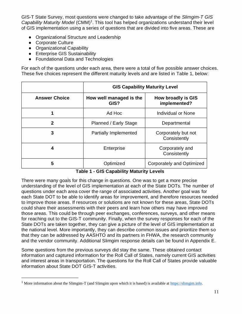
Slimgim-T Results This is the twenty-fifth (25th) year that the GIS-T Symposium has conducted a survey of State
DOT’s. The Survey was administered using a web-based survey instrument. For the 2020
Ms. Magdalena I. Asborno
Photo Courtesy Ms. Asborno
11
GIS-T State Survey, most questions were changed to take advantage of the Slimgim-T GIS Capability Maturity Model (CMM)1. This tool has helped organizations understand their level
of GIS implementation using a series of questions that are divided into five areas. These are
● Organizational Structure and Leadership ● Corporate Culture ● Organizational Capability
● Enterprise GIS Sustainability ● Foundational Data and Technologies
For each of the questions under each area, there were a total of five possible answer choices. These five choices represent the different maturity levels and are listed in Table 1, below:
GIS Capability Maturity Level
Answer Choice How well managed is the GIS?
How broadly is GIS implemented?
1 Ad Hoc Individual or None
2 Planned / Early Stage Departmental
3 Partially Implemented Corporately but not Consistently
4 Enterprise Corporately and Consistently
5 Optimized Corporately and Optimized
Table 1 - GIS Capability Maturity Levels
There were many goals for this change in questions. One was to get a more precise understanding of the level of GIS implementation at each of the State DOTs. The number of
questions under each area cover the range of associated activities. Another goal was for each State DOT to be able to identify areas for improvement, and therefore resources needed to improve those areas. If resources or solutions are not known for these areas, State DOTs
could share their assessments with their peers and learn how others may have improved those areas. This could be through peer exchanges, conferences, surveys, and other means for reaching out to the GIS-T community. Finally, when the survey responses for each of the
State DOTs are taken together, they can give a picture of the level of GIS implementation at the national level. More importantly, they can describe common issues and prioritize them so that they can be addressed by AASHTO and its partners in FHWA, the research community
and the vendor community. Additional Slimgim response details can be found in Appendix E.
Some questions from the previous surveys did stay the same. These obtained contact information and captured information for the Roll Call of States, namely current GIS activities and interest areas in transportation. The questions for the Roll Call of States provide valuable
information about State DOT GIS-T activities.
1 More information about the Slimgim-T (and Slimgim upon which it is based) is available at https://slimgim.info.
12
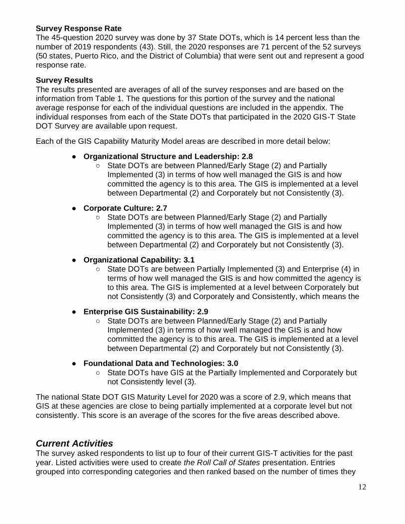
Survey Response Rate The 45-question 2020 survey was done by 37 State DOTs, which is 14 percent less than the
number of 2019 respondents (43). Still, the 2020 responses are 71 percent of the 52 surveys (50 states, Puerto Rico, and the District of Columbia) that were sent out and represent a good response rate.
Survey Results
The results presented are averages of all of the survey responses and are based on the information from Table 1. The questions for this portion of the survey and the national average response for each of the individual questions are included in the appendix. The
individual responses from each of the State DOTs that participated in the 2020 GIS-T State DOT Survey are available upon request.
Each of the GIS Capability Maturity Model areas are described in more detail below:
● Organizational Structure and Leadership: 2.8 ○ State DOTs are between Planned/Early Stage (2) and Partially
Implemented (3) in terms of how well managed the GIS is and how
committed the agency is to this area. The GIS is implemented at a level between Departmental (2) and Corporately but not Consistently (3).
● Corporate Culture: 2.7 ○ State DOTs are between Planned/Early Stage (2) and Partially
Implemented (3) in terms of how well managed the GIS is and how
committed the agency is to this area. The GIS is implemented at a level between Departmental (2) and Corporately but not Consistently (3).
● Organizational Capability: 3.1 ○ State DOTs are between Partially Implemented (3) and Enterprise (4) in
terms of how well managed the GIS is and how committed the agency is to this area. The GIS is implemented at a level between Corporately but not Consistently (3) and Corporately and Consistently, which means the
● Enterprise GIS Sustainability: 2.9
○ State DOTs are between Planned/Early Stage (2) and Partially Implemented (3) in terms of how well managed the GIS is and how committed the agency is to this area. The GIS is implemented at a level
between Departmental (2) and Corporately but not Consistently (3).
● Foundational Data and Technologies: 3.0
○ State DOTs have GIS at the Partially Implemented and Corporately but not Consistently level (3).
The national State DOT GIS Maturity Level for 2020 was a score of 2.9, which means that GIS at these agencies are close to being partially implemented at a corporate level but not
consistently. This score is an average of the scores for the five areas described above.
Current Activities
The survey asked respondents to list up to four of their current GIS-T activities for the past
year. Listed activities were used to create the Roll Call of States presentation. Entries grouped into corresponding categories and then ranked based on the number of times they

13
were cited by the respondents. Table 2 lists those GIS activities cited five or more times by the DOTs. For details, please consult the Business Solutions section, following, and Appendix
A, Roll Call of States. Note: category assignments involve a level of subjectivity by the author.
GIS Activity (Categories with at least 5 citations) # of Citations
Data Collection – Mobile, UAV, LiDAR 27
Software / Technology Migrations 24
Systems Integration 17
Outreach / Data Sharing 9
Portals / Dashboards 7
Federal Data – MIRE, HPMS, ARNOLD 7
Business Intelligence, AI, Management 6
Project Delivery 5
Cartography / Base Maps 5
Table 2 – GIS-T Activities
Data Collection by various means and Software / Technology Migrations rose to the top of th
list. DOT’s are working toward making operations as efficient as possible while improving data integrity.
Business Solutions The Current Activities and the following Opportunities for Further Study sections are hybrid
summaries, combining technological themes with business activities. However, the emphasis is on technology utilization, not the business problem being addressed. This section will attempt to emphasize the business problem. For example, within the Current Activities, if a
state identified the collection of culvert data with a mobile device, it was tallied against “Data Collection.” This section places the topic in “Asset Inventory / Management.” As in previous sections, Business Solutions were grouped into corresponding categories and then ranked
based on the number of times they were cited by the respondents. Table 4 lists those GIS-T activities cited five or more times by the DOTs. Note: category assignments involve a level of subjectivity by the author.
Business Solution (Categories with at least 5 citations) # of Citations
Decision Support / Data Access 15
Asset Inventory / Management 12
Safety / MIRE 8
Project Delivery 5
ARNOLD / HPMS 5
Environmental / Mitigation 5
Table 3 – GIS-T Utilization
Although this list is shorter, there are a wide range of business problems with one or two
entries. Additionally, the large number of technology deployments usually do not point to a specific business need, rather an operational requirement. For details, please consult Appendix A, Roll Call of States.

14
Opportunities for Further Study Roll Call of States’ entries, where respondents were seeking more information, were compiled into corresponding categories and then ranked based on the number of times that they were
cited by the respondents. Table 5 lists those GIS-T issues cited five or more times by the DOTs. Note: category assignments involve a level of subjectivity by the author. For more details, please consult the State Summary section, above, Appendix A, Roll Call of States,
and Appendix E, 2020 Slimgim Survey.
GIS Issues (Categories with at least 5 citations) # of Citations
Data Collection – Mobile, UAV, LiDAR 26
Software / Technology Migrations 13
Business Intelligence, AI, Management 10
Federal Data – MIRE, HPMS, ARNOLD 10
Outreach / Data Sharing 10
Governance 8
Portals / Dashboards 6
Cartography / Base Maps 5
Maintenance 5
Table 5 – GIS-T Inquiries
Notably, the 2019 survey featured a decline in Linear Referencing (LRS); in 2020, LRS did not make the list.
Data Collection dominates the GIS-T Issues and Activities lists. These categories include Mobile Collection, Unmanned Aerial Vehicles (UAV), Lidar, and commercial data integration / conflation.
The 2020 survey responses show that GIS at State DOTs are a work in progress. While the
level of GIS implementation at these agencies are not at an optimized or enterprise level, they are moving away from ad-hoc, one-off applications of GIS to more of a corporate-level business application. However, it is not consistently applied across the organization. There
are still State DOT business areas who have not realized the benefits of GIS, while other parts of the same agency have really advanced in its use.
The top GIS activity areas and interest areas illustrate how State DOTs are recognizing the need for an agency or enterprise perspective. Whether due to resource constraints or to the
desire to deliver and manage transportation assets more efficiently, the survey responses reflect efforts to get every part of a State DOT communicate and collaborate with each other to accomplish an agency’s mission. This is the essence of an enterprise approach.
For this annual survey the goal, in addition to understanding the current state of GIS at State DOTs, is to track improvements and advancements in GIS use and identify areas that need
attention. Therefore, the set of questions in the 2020 survey will be asked in subsequent, periodic annual surveys.
Symposium Summary The Thirty-Third (33rd) Annual AASHTO Symposium on Geospatial Information Systems for
Transportation (GIS-T) was scheduled in Minneapolis, Minnesota from April 15 through April

15
17, 2020. Unfortunately, circumstances necessitated cancelling the symposium. This report serves as a work record prepared by the AASHTO GIS-T planning committee.
2021 AASHTO GIS-T Symposium will be hosted by the
Minnesota Department of Transportation
2022 AASHTO GIS-T Symposium will be hosted by the
South Carolina Department of Transportation
16
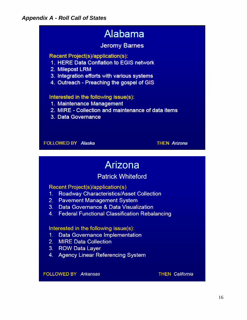
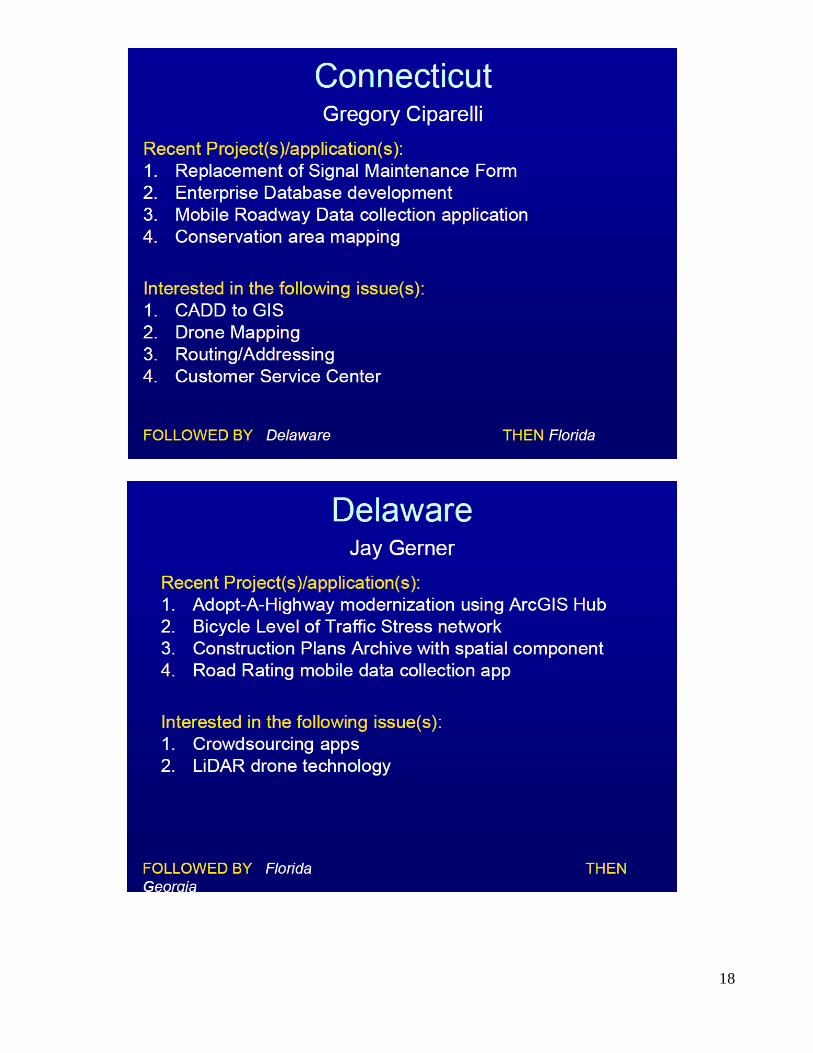
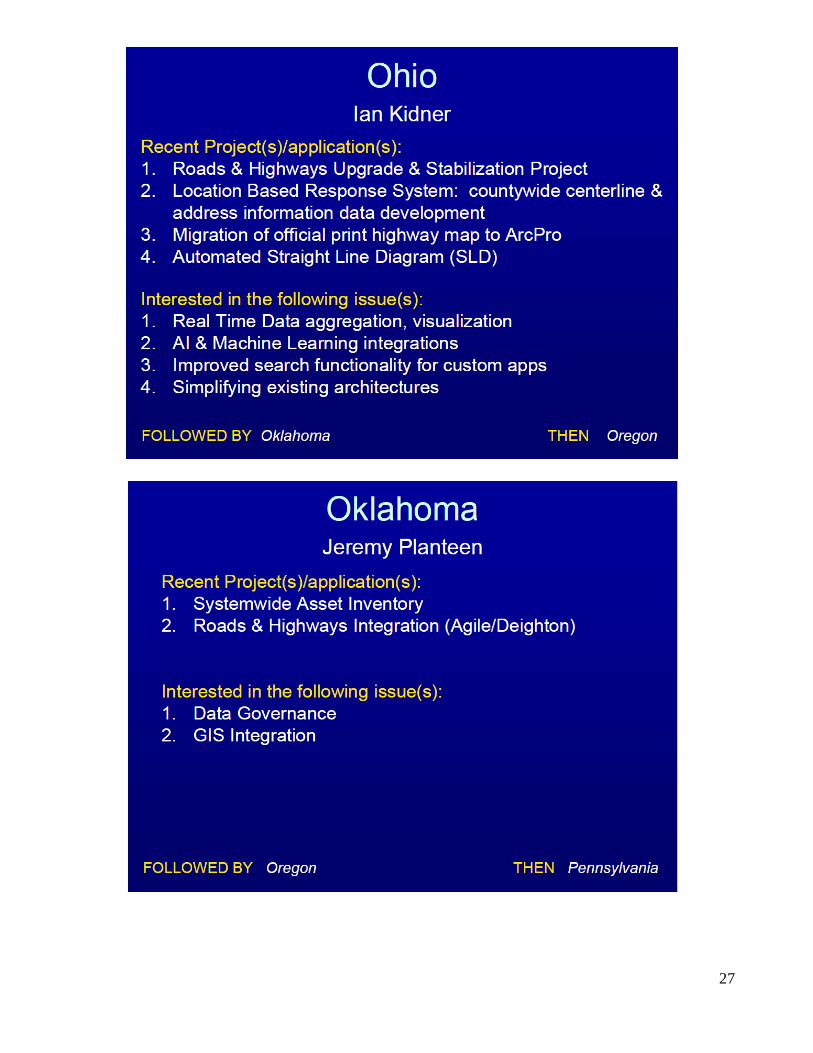
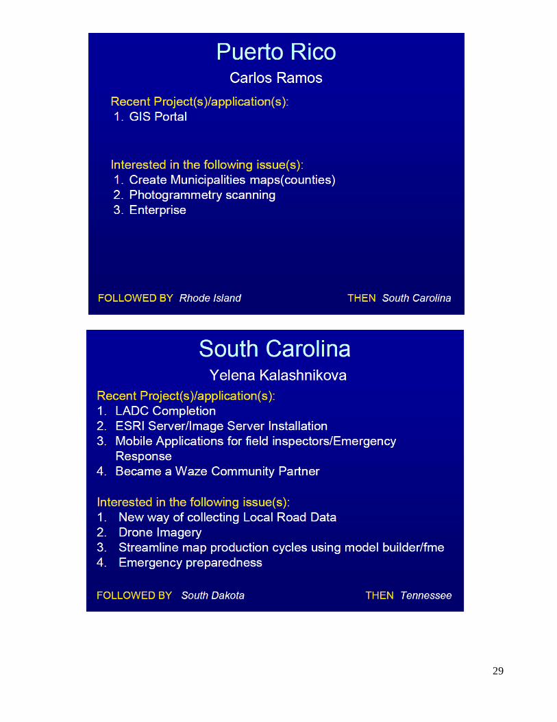
Appendix A - Roll Call of States

17
18

19

20

21

22

23

24

25

26
27

28
29

30

31

32
33

34

35

36
Appendix B - State GIS Contacts
State Primary Contact State Primary Contact
Alabama Brette Grant Enterprise Information Analyst
1409 Coliseum Blvd. Montgomery, AL 36110
334-242-6398 [email protected]
Alaska David Oliver Section Manager
Information Systems & Services PO Box 112500
Juneau, AK 99811-2500 907-465-8955
Arizona Patrick Whiteford GIS Manager
206 S. 17th Avenue Phoenix, AZ 85007
602-712-8591 [email protected]
Arkansas Sharon Hawkins Section Head; Mapping and Graphics
10324 Interstate 30 Little Rock, AR 72203-2261
501-569-2205 [email protected]
California Chad Baker Geospatial Data Officer
1120 N Street MS38 Sacramento, CA 95814
916-651-5720
Colorado Gary Aucott GIS Support Unit Manager
4201 East Arkansas Avenue, Shumate Bldg. Denver, CO 80222
303-512-4444
Connecticut Gregory Ciparelli
Transportation Planner 2800 Berlin Turnpike
Newington, CT 06131-7546 860-594-2108
Delaware Jay Gerner
800 Bay Road, P.O. Box 778 Dover, DE 19903-0778
302-760-2530 [email protected]
Florida Jared Causseaux
Florida DOT GIS Coordinator/GIS Mapping Manager
605 Suwannee Street, MS-5L
Tallahassee, FL 32399-0450 850-414-4336
Georgia Eric Conklin
Office of Transportation Data 600 West Peachtree Street, N.W.,
One Georgia Center, 19th floor,
Atlanta, GA 30308 404-347-0701
Hawaii Goro Sulijoadikusumo Planning Survey Engineer
869 Punchbowl Street, Suite 301 Honolulu, HI 96813
808-587-1839 [email protected]
Idaho Nicole Hanson
GIS Senior Analyst 3311 West State Street
Boise, Idaho 83703 208-334-8224
Illinois Dan Wilcox
State GIS Coordinator 2300 South Dirksen Parkway
Springfield, IL 62764 217-524-0031
Indiana Kevin Munro
Management Information Systems 100 N Senate Ave N901 MIS
Indianapolis, IN 46204 317-234-3861
Iowa Eric Abrams
Geospatial Infrastructure and Coordination Manager
800 Lincoln Way Ames, IA 50010
515-239-1949 [email protected]
Kansas Kyle Gonterwitz
Cartography/ GIS Manager 700 S.W. Harrison Street, 3rd Floor
Topeka, KS 66603-3754 785-296-4899
Kentucky Will Holmes OIT GIS Branch Manager
200 Mero Street, Suite W-4
Frankfurt, KY 40622 502-564-8900
Louisiana Darryl Mack. GIS Manager
LADOTD Office of Planning,
1201 Capitol Access Rd. Baton Rouge, LA 70802-4438
225-379-1283 [email protected]

37
Maine Nate Kane
GIS Administrator 16 State House Station
Augusta, ME 04333-0016 207-624-3297
Maryland Craig Mackowiak
Assistant Division Chief / GIS Coordinator 707 N. Calvert St., Mail Stop C-607
Baltimore, MD 21202 [email protected]
Massachusetts Kevin A. Lopes
Manager of GIS Services 10 Park Plaza, Suite 4150
Boston, MA 02116
857-368-8880 [email protected]
Michigan Kevin McKnight
GIS Manager 425 W. Ottawa
Lansing, MI 48909
Minnesota Peter Morey Transportation Data Coordination Supervisor
395 John Ireland Blvd. MS 540 St. Paul, MN 55155-1899
651-366-3872, 651-366-4111 (fax) [email protected]
Mississippi Mike Cresap Director of Transportation Information
401 N. West Street Jackson, MS, 39215-1850
601-359-7206 [email protected]
Missouri Joseph A. Carter 105 West Capital Ave
Jefferson City, MO 65102
573-526-8051 [email protected]
Montana Brian Andersen Road Inventory and Mapping Supervisor
2960 Prospect Avenue
Helena, MT 59620-6111 406-444-6103
Nebraska Claire Inbody
GIS Manager 1500 Nebraska 2
Lincoln, NE 68502 402-479-3928
Nevada Gaelen Lamb
GIS Manager 1263 S. Stewart Street
Carson City, NV 89712
New
Hampshire
Jim Irwin
Manager, GIS Planning
JOM Building PO Box 483, 7 Hazen Drive
Concord, NH 03302-0483 603-271-1626
New Jersey Timothy J. Stewart
Trenton, NJ 08625
609-530-2393 timothy.stewart @dot.nj.gov
New Mexico Gerry Trujillo
1120 Cerrillos Rd., Rm. B-21 Santa Fe, NM 87504
New York Kevin Hunt
GIS Manager 50 Wolf Road, Pod 2-1
Albany, NY 12232 518-485-7152, 518-485-2345(fax)
North Carolina John C. Farley GIS Manager
New Hope Center 4101 Capital Blvd.
Raleigh, NC 27604 919-707-2151
North Dakota Brian Bieber 608 E. Blvd. Avenue
Bismarck, ND 58505 701-328-2649
Ohio Ian Kidner
GIS Manager 1980 West Broad St.
Columbus, OH 43223
614-752-5743 ian,[email protected]
Oklahoma Jeremy Planteen, GISP
GIS Branch Manager 200 NE 21st Street, Rm 3A7
Oklahoma City, OK 73105
405-521-2729 [email protected]

38
Oregon Brett Juul
GIS Unit Manager 555 13th St. NE, Suite 2
Salem, OR 97301-4178 503-986-3156
Pennsylvania Frank DeSendi
Geographic Information Division Manager 400 North Street
Harrisburg, PA 17120 717-787-3738
Rhode Island Stephen Kut
2 Capital Hill, Room 367 Providence, RI 02903
401-222-6935 ext. 4485
South
Carolina
Yelena Kalashnikova
Program Manager, GIS/Systems 955 Park Street
Columbia, SC 29202-0191
803-737-3103 [email protected]
South Dakota Kimberly Zerr
GIS Manager 700 E. Broadway Avenue
Pierre, SD 57501-2586
605-773-3402 [email protected]
Tennessee Kim McDonough, GISP
GIS Coordinator 505 Deaderick Street; Suite 500
James K. Polk Building
Nashville, TN 37243-0343 615-741-4037
Texas Michael Chamberlain
Data Management Section Director 118 E. Riverside Dr., Bldg. 118
Austin, TX 78704 512-486-5054
Utah Becky Hjelm
GIS Manager 4501 South 2700 West
Salt Lake City, UT 84114-8465 801-386-4162
Vermont Johnathan Croft
AOT GIS Database Administrator
One National Life Drive Montpelier, VT 05633-5001
802-828-2600, 802-828-2334 (fax) [email protected]
Virginia Michael Farnsworth
Data and Integration Services Manager
Virginia Department of Transportation 1401 East Broad Street
Richmond, VA 23219 804-371-0560
Washington Elizabeth Lanzer
GIS & Roadway Branch Manager PO Box 47384
Olympia, WA 98504-7384 360-596-8925
West Virginia Hussein S Elkhansa, MSE
Head Geospatial Transportation Information 1900 Kanawha Blvd., E Bldg #5, Rm. 851A
Charleston WV 25305-0851 304-558-9657, 304-558-3783 (fax)
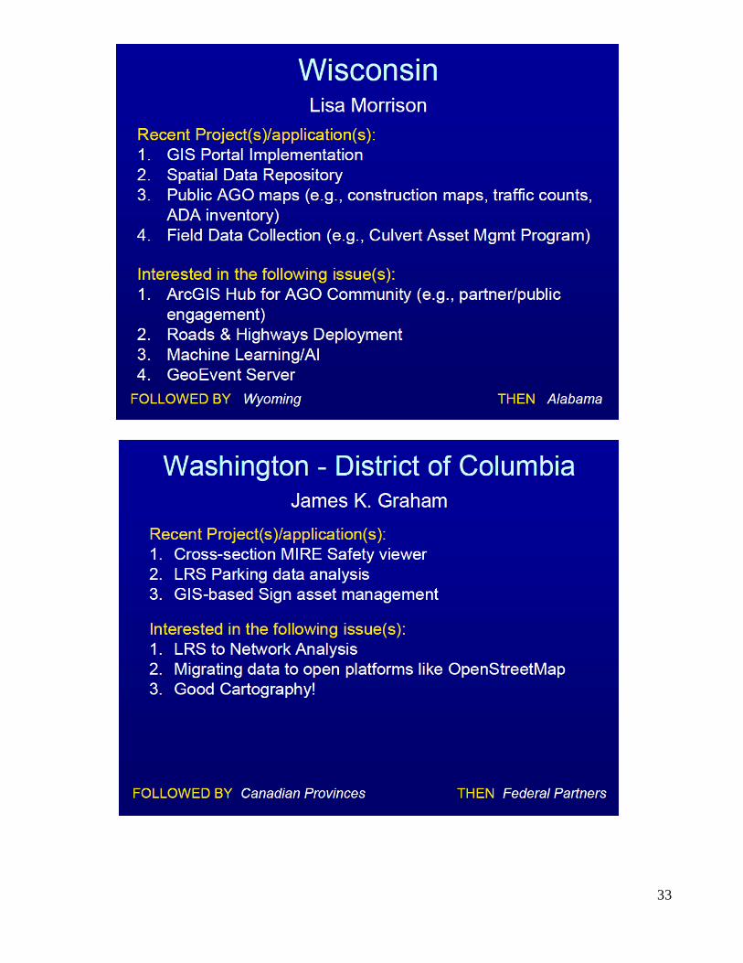
Wisconsin Lisa Morrison
Enterprise Data Services Section Chief
4802 Sheboygan Ave. Madison, WI 53707-7982
608-264-9969 [email protected]
Wyoming Vince Garcia
WYDOT Headquarters
5300 Bishop Blvd. Cheyenne, WY 82009-3340
307-777-4231 [email protected]
District of Columbia
James Graham. 55 M Street SE
Washington DC 20003 202-439-4736
Puerto Rico
Carlos A. Ramos Rosario PRDOT – GIS Acting Director
Minillas Government Center, South Tower, 15th Floor,
De Diego Ave., Stop 22, Santurce
San Juan, PR 00940-2007 787-721-8787 Ext. 1525

39
Appendix C – General Schedule
AASHTO GIS-T 2020 Navigate to True North

40
Appendix D – 2020 Winning Student Paper

41
42

43
44

45

46

47

48
49

50

51
52
53

54
55

56
57

58

59

60
Appendix E – 2020 Slimgim Survey
2020
National State DOT GIS Maturity Level 2.9
1 Organizational Structure and Leadership 2.8
2 Corporate Culture 2.7
3 Organizational Capability 3.1
4 Enterprise GIS Sustainability 2.9
5 Foundational Data and Technologies 3.0
1 Organizational Structure and Leadership
1.1 GIS manager or coordinator: The organization has a permanent Enterprise GIS management function and position.
3.4
1.2 GIS is authoritative: Spatial data has been recognized as a critical component of business systems and should work seamlessly between the business systems and the
software.
2.9
1.3 Formal GIS governance: Formal GIS governance is established which may include committee structures,
user groups and working groups. Some structure is in place to coordinate long range planning, stakeholder satisfaction and ability to leverage EGIS are in place in
some organized manner.
2.6
1.4 GIS resource allocation: Management has in place policies, procedures, and sufficient resource allocation
to maintain GIS related services
2.8
1.5 GIS vision & comprehensive use: Management is
committed to EGIS and are fostering the participation of users in EGIS activities. They have a vision and foster awareness of the benefits and encourage innovation.
Strategic plans are in place that directs comprehensive use of spatial data. Enterprise planning processes align with EGIS strategic goals and vision.
2.7
1.6 Inter-departmental cooperation: An emphasis is placed on integration and coordination of inter-departmental activities. There are processes and procedures in place
for inter-departmental conflict management and to prevent duplicative efforts.
2.6

61
1.7 GIS projects align with enterprise vision: GIS projects undertaken work seamlessly within the enterprise
framework and aim to help the agency work smarter and more efficiently.
2.7
1.8 Strategic use of GIS by senior management: Senior
management recognizes EGIS as a strategic technology.
2.9
1. Average maturity of organizational structure and leadership 2.8
2 Corporate Culture
2.1 Business units have active EGIS participation: There is active participation and involvement of business units in
EGIS activities, implementation, planning, etc.
2.7
2.2 Environment of the agency fosters innovation: Learning, change and continuous improvement is an accepted and
practiced philosophy.
3.1
2.3 Staff accept EGIS as a reliable data source: Is it generally accepted that EGIS is the authoritative,
reliable source of spatial data for the organization.
3.2
2.4 Open, cross-unit cooperation & information sharing: Interaction amongst employees is open and cross-unit
cooperation and sharing of information, ideas, best practices, and inquiry is common.
3.0
2.5 Adaptable hiring practices ensure modern skills: The level of adaptability regarding the agency's ability to change hiring practices to ensure those with both the
requisite modern spatial skill set, up-to-date training and an innovation mindset are prioritized.
2.3
2.6 Core competency improved with training plans: The
agency encourages improvement of core competency which is supported by a comprehensive training plan.
2.3
2.7 Enterprise GIS communication is frequent: Enterprise
GIS communication is frequent at all levels and is tailored to staff and partners with follow up procedures to evaluate effectiveness of communication.
2.6
2.8 Employees at all levels encouraged to use GIS: Employees at all levels think spatially and are encouraged to explore and improve their practices by
incorporating spatial data. This aligns people and process to the corporate vision.
2.8
2.9 Staff are "process-minded": Business process is valued
by the organization. Staff are "process-minded" and often are involved in business process mapping and other exercises and are capable of interpreting and
following the results.
2.6
62
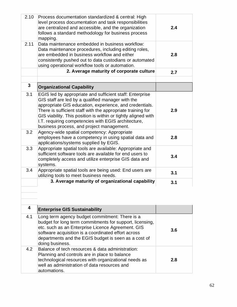
2.10 Process documentation standardized & central: High level process documentation and task responsibilities
are centralized and accessible, and the organization follows a standard methodology for business process mapping.
2.4
2.11 Data maintenance embedded in business workflow: Data maintenance procedures, including editing roles, are embedded in business workflow and either
consistently pushed out to data custodians or automated using operational workflow tools or automation.
2.8
2. Average maturity of corporate culture 2.7
3 Organizational Capability
3.1 EGIS led by appropriate and sufficient staff: Enterprise
GIS staff are led by a qualified manager with the appropriate GIS education, experience, and credentials. There is sufficient staff with the appropriate training for
GIS viability. This position is within or tightly aligned with I.T. requiring competencies with EGIS architecture, business process, and project management.
2.9
3.2 Agency-wide spatial competency: Appropriate employees have a competency in using spatial data and applications/systems supplied by EGIS.
2.8
3.3 Appropriate spatial tools are available: Appropriate and sufficient software tools are available for end users to completely access and utilize enterprise GIS data and
systems.
3.4
3.4 Appropriate spatial tools are being used: End users are utilizing tools to meet business needs.
3.1
3. Average maturity of organizational capability 3.1
4 Enterprise GIS Sustainability
4.1 Long term agency budget commitment: There is a
budget for long term commitments for support, licensing, etc. such as an Enterprise Licence Agreement. GIS software acquisition is a coordinated effort across
departments and the EGIS budget is seen as a cost of doing business.
3.6
4.2 Balance of tech resources & data administration:
Planning and controls are in place to balance technological resources with organizational needs as well as administration of data resources and
automations.
2.8

63
4.3 End-users well supported: End-users are well supported with online guides, training material, technical support
including service quality practices. IT staff are used for infrastructure support.
2.9
4.4 Blending of IT, analysis and GIS: There is an active
partnership between GIS and IT technical staff. 3.0
4.5 Mechanism to maintain business unit participation: Mechanisms are in place to maintain continued participation of the business units.
2.6
4.6 External support utilized: External support such as consultants and specialized contract employees can be utilized when required to assist with activities.
3.2
4.7 Long term competency & training plans: Long term competency and training plans are in place and continue to be followed.
2.3
4.8 Spatial data is core / mission-critical: Spatial data is core to business solutions and is centralized and an essential
part of work and e-services.
2.9
4. Average maturity of enterprise GIS sustainability 2.9
5 Foundational Data and Technologies
5.1 Business unit data owners & data stewards defined: Data stewards are defined for each dataset. Business unit end-user data owners have been identified and are
involved in data maintenance, quality procedures and decisions regarding their related datasets.
2.9
5.2 Production & published database of reliable data: There
is both a centralized managed production database as well as a published environment for consumption and distribution. The data is accessible and reliable.
3.4
5.3 System architecture current: The system architecture design is current with plans in place for future enhancements, expansion and upgrades.
3.3
5.4 Formal QA/QC process: There is a formal QA/QC for each business process. Quality control and data accuracy are built into editing to reduce human error.
2.7
5.5 Data common & available for integration: Spatial data is published in the organization's common data
warehouse. Spatial data is readily available for integration and interoperability.
3.2
5.6 Redundancy of information management reduced: Data
duplication is minimized across the organization. 2.8
5.7 All enterprise datasets modeled & centralized: The
agency's enterprise data have all undergone data modeling, is centralized, loaded, and maintained.
2.7

64
5.8 Direct integration to business systems: Spatial data is an integral part of business systems and direct integration
has been established.
2.7
5.9 Metadata: Metadata available and maintained for all foundational and business data layers.
2.6
5.10 Technical Infrastructure: Technical infrastructure in
place to maintain and operate the GIS and to meet organizations’ needs.
3.3
5.11 Adequate data exists to meet Federal requirements:
Scope and quality of our data meet all Federal data requirements.
3.6
5. Average Foundational Data and Technology 3.0

65
Appendix F – 2020 AASHTO GIS-T Planning Committee
Frank DeSendi Pennsylvania DOT
GIS-T Task Force Chair
Shawn Blaesing Iowa DOT
GIS-T Task Force
Sharon Hawkins
Arkansas DOT GIS-T Task Force Vice Chair
Becky Hjelm
Utah DOT GIS-T Task Force
Sarah B. Wray North Carolina DOT GIS-T Task Force
Ian Kidner Ohio DOT
GIS-T Task Force
Penelope Weinberger AASHTO Liaison
GIS-T Task Force
James Meyer Arizona DOT
GIS-T Task Force
Ben Timerson
Minnesota DOT Local Host
Mark Sarmiento
USDOT/FHWA Liaison GIS-T Task Force
Jeff Saholt Minnesota DOT
Local Arrangements
Arturo Botello Minnesota DOT
Map Gallery
Joseph Hausman USDOT/FHWA
Workshops Chair
Kamasha Hendrickson AASHTO
Local Arrangements
Kevin Hunt
New York State OITS Workshops
Dr. Eric Green
University of Kentucky Program Chair
Nicole Hanson Idaho Transportation Department
Exhibits Chair
Dr. Ben Blandford University of Kentucky
Program
Charlotte Keppers
AASHTO Exhibits
Dominic Menegus
U.S. DOT Program
Annette Ginocchetti Northeastern Pennsylvania Alliance
Publicity & Photography
Rebecca Bourson Oregon Department of Transportation
SIGs
John Puente Ohio DOT
Web Site
Dr. EunSu Lee New Jersey City University
Student Papers Chair
William Holmes
Kentucky Transportation Cabinet Webmaster
Connie Gurchiek
Transcend Spatial Solutions Vendor Liaison
James Mitchell Louisiana Office of Technology Services
Round Tables
Patrick Whiteford Arizona DOT
Map Gallery Chair
Chelsea Duncan North Carolina DOT
Moderators
Dr. Kweku Brown The Citadel
Student Papers Vice Chair