2018 FloodWarn Training - weather.gov
94
2018 FloodWarn Training Katie Landry - Guyton Senior Service Hydrologist/Meteorologist National Weather Service - Houston/Galveston, TX
Transcript of 2018 FloodWarn Training - weather.gov
2018 FloodWarn TrainingKatie Landry-GuytonSenior Service HydrologistMeteorologistNational Weather Service- HoustonGalveston TX
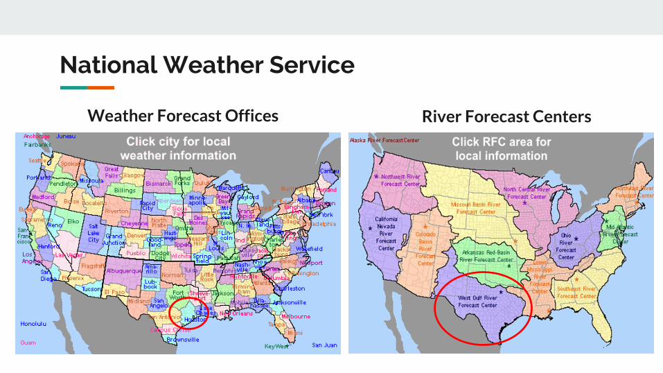
National Weather Service
Content
Weather Forecast Offices River Forecast Centers
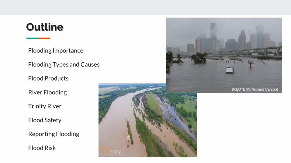
Outline
Flooding Importance
Flooding Types and Causes
Flood Products
River Flooding
Trinity River
Flood Safety
Reporting Flooding
Flood Risk
(REUTERSRichard Carson)
Flooding Importance
Flooding is Deadly
In the 5 year period from
2013 to 2017 more
people have died in Texas
from flooding than all
other weather hazards
combined
2017 Data 70 Flood Related Deaths in TX
out of 138 Total Weather-Related Fatalities
Data from NWS National Hazard Statistics
Flood Fatalities
Data from NWS National Hazard Statistics
Over half of the flood fatalities in Texas occurred while people were in their car
Houston Floods April 18 2016
Recent Big Floods
And other historic floodshellip
Tropical Storm Allison
1994 Flood
Tropical Storm Claudette
Harvey 2017
Brenham 2016
Tax Day 2016
Memorial Day 2015
Tax Day 2016
Brenham 2016
Harvey 2017
Flooding Types and Causes
What Causes Flooding Intense rainfall
Rain over several days
Damlevee failures
High tides or storm surge
Snowmelt
Ice or debris jams
Types of FloodingPonding amp Sheet Flow Flooding
Flooding that occurs gradually over time usually 6
hours after the rain begins or longer (longer duration)
Coastal Flooding
Flooding along a coastline either from high tides or
storm surge during a tropical storm or hurricane
Flash Flooding
Flooding that develops quickly (typically 6 hours or
less) either from heavy rainfall or damlevee failure
(shorter duration)
River Flooding
Flooding that occurs from water escaping river banks
Flood Products
A Watch is issued when conditions are favorable to occur
Flash Flood Warning (green polygon)
Example only
Example only
Watch vs Warning
A Warning is issued when the threat is occurring or imminent threatening life or
property
A Flood is an overflow of water onto normally dry land likely caused by rising
water in a riverbayou or poor drainage Flooding is a longer term event than
flash flooding It may last days or weeks
Flood vs Flash Flood
A Flash Flood is a flood caused by heavy or excessive rainfall in a short period
of time typically 6 hours or less Flash floods are defined as
ge 3 feet of standing water (less if threatening life or property) andor
ge 6 inches of fast flowing water across a road or bridge or
Water in a stream or bayou flowing rapidly out of its banks or
A dam break (even on a sunny day)
Urban Small Stream Advisory
WHAT IS ITFlooding of small streams streets
and low-lying areas
WHAT TO DOStay away from areas that are
prone to flooding and stay clear of rapidly moving
water
Flood Watch
WHAT IS ITFlooding is
possible ndash typically within a 6 to 48
hours before rain is expected to
reach the area
WHAT TO DOStay tuned to local
river forecasts prepare for areas
near rivers to spread towards
nearby roads and buildings
Flash Flood Watch
WHAT IS ITFlash flooding is
possible ndashtypically 6 to 48 hours before rain is
expected to reach the area
WHAT TO DOHave a way to receive local
warnings expect hazardous travel
conditions and have alternate
routes available
Flood Warning
WHAT IS ITFlooding impacts are occurring or
imminent
WHAT TO DOStay alert for
inundated roadways and follow all local
signage Additional impacts include homes and
structures could become flooded and need to be
evacuated
Flash Flood Warning
WHAT IS ITFlash flooding
impacts are occurring or
imminent
WHAT TO DOConditions will rapidly become
hazardous Do not cross flooded roadways or
approach inundated areas as water may
still be rising
Flash Flood Emergency
WHAT IS ITFlash flood
situation that presents a clear threat to human
life due to extremely dangerous
flooding conditions
WHAT TO DOImmediately reach higher ground by
any means possible
Understanding Flooding
Urban Small
StreamFlood
Advisory
FlashFlood
Warning
Flash Flood
Emergency
FloodWarning(ArealRiverBayou)
Flood Advisory
Increasing Impact PotentialALL Situations Represent Threatening Conditions to Life andor Property
Note Flooding can (and does) occur without a Flash Flood Watch
Flash or Areal Flood Warning Flash Flood
Emergency
Before Event Onset
River Flood Warning
Flood Timeline
NWS Website httpswwwweathergovhgx
Ways to Receive a Warning
NOAA Weather Radio
TV and Radio
Social Media
Wireless
Emergency Alerts
and Weather Apps
Be sure to have multiple
ways to receive warnings
River Flooding
Llano River Flooding
River flooding occurs when water escapes the river banks There are different thresholds for river flooding action minor moderate major and record flooding This image depicts what
a river flooding looks like
River Flooding
Rainfall Analysis Hydrologic Modeling Forecast
Rainfall estimates and forecasts merged into continuous dataset
Rainfall ingested into hydrologic model Forecasters adjust model parameters in real time
Warning
River Forecast Process
LOCATION Of the gage the forecast is made AT means the gage is in the limits of the towncity NEAR or NR means that towncity has the closest post office
Hydrograph Basics
Hydrograph Basics
OBSERVATIONS Past river stages
Hydrograph Basics
FORECASTForecast River Stages
CREST Peak Stage
STAGE VS FLOW Hydrologists models reservoirs work in flow Emergency managers media general public work in stage
What is flow or a cubic foot per second
Hydrograph Basics
Hydrograph Basics
A basketball is roughly a cubic foot so 20000cfs is 20000 basketballs of water passing the gage every second
ACTIONImpact Water is over the banks and into the flood plain but not a threat to structures or roadways Some action may be required such as moving farm equipment or increasing awareness
MINORImpact Typically water is impacting areas inside of floodplain which can vary by location Some low water crossings covered by water agricultural flooding water approaching public areas (parks sidewalks etc) Areas frequently flooded can expect to be impacted
MODERATEImpact Water now reaching areas only impacted by significant rain events Structures can be inundated several roads covered with water water may cut off certain areas widespread agricultural flooding
MAJORImpact Water is near the highest itrsquos ever been representing rare flooding and significant widespread impacts Most roads will be covered by water in the area cutting off if not completely flooding subdivisions rivers can be several miles wide in areas Homes and structures underwater bridges inundated and in danger of being hit by debris Impacts may be greater than ever experienced
BELOW CRITERIAImpact Water is within the banks of the river with no impacts to the surrounding area Flow speeds may still be high during rainfall or releases which could impact recreational activities
Understanding River Criteria Levels
Advanced Hydrologic Prediction System
httpwaterweathergovahps2indexphpwfo=hgx
Partners
Roles of Primary River Forecast Partners Shared Data and Resources
- US Stream Gage Network- Water Science Studies
- Issue Weather amp Water Forecasts Watches Warnings amp Data
- Operate Flood Control Reservoirs- Manage Other WR Projects
- Assist wGage Maintenance- Assist wStream Measurements- Assist wFunding Data Networks
- Gage Maintenance- Stream Measurements- Focus Stream Gage Network
- Cooperative Data Network- NOAANWS Satellite Transmission- ForecastsData for Operations
USGS Water Alerts
Set alerts when a gauge reaches
certain water surface elevations
Identify the gauge nearest you Click on the gauge
USGS Water Alerts
httpsmapswaterdatausgsgovmapperwateralert
USGS Water Alerts
Set alerts when a gauge reaches
certain water surface elevations
Identify the gauge nearest you Click on the gauge and select
ldquoSubscribe to WaterAlert
USGS Water Alerts
httpsmapswaterdatausgsgovmapperwateralert
USGS Water Alerts
Set alerts when a gauge reaches
certain water surface elevations
Identify the gauge nearest you Click on the gauge and select
ldquoSubscribe to WaterAlert Define how you want to receive the
information Email or phone Frequency Stage or Discharge Stream Elevation(s)
Note Use Internet Explorer
USGS Water Alerts
httpsmapswaterdatausgsgovmapperwateralert
Watershed
A watershed or basin is an area of land that
drains runoff from rainfall (stormwater) to a
body of water either a river bayou creek or
lake
A watershed can flow into another watershed
Watersheds vary in shape and size which
ultimately lead to unique challenges
Topography plays a big role in how watershed
boundaries are defined
Walker County deals with 2 primary
watersheds Trinity River and San Jacinto River
Snowpack
- Water Supply
Hill Country Hydrology
- Flash Flood threats
- Rapid River responses
- Cycles of FloodDrought
Forest Hydrology
- Slower River responses
Diverse Watershed Characteristics in Texas
Watershed
Bedias Creek
near
Madisonville
Trinity River
at Riverside
A watershed or basin is an area of land that
drains runoff from rainfall (stormwater) to a
body of water either a river bayou creek or
lake
A watershed can flow into another watershed
Watersheds vary in shape and size which
ultimately lead to unique challenges
Topography plays a big role in how watershed
boundaries are defined
Walker County deals with 2 primary
watersheds Trinity River and San Jacinto River
NWS issues river forecasts for 2 sites in Walker
County
Trinity River Basin Over View
bull Nearly 18000 square
miles
bull More water storage than
any other river system in
Texas
Basin Facts
Basin Facts
20 reservoirs ranging
from 1000 to 83000
acresbull 12 Water Conservation
bull 8 Flood Control
Basic Components of a Dam
Flood Control Reservoir
Flood Control Reservoir
bull Built to regulate flood waters
bull Examples
1 Lake Grapevine
bull Storage-535 MSL
bull Flood Pool-560 MSL
bull Surcharge-582 MSL
2 Lake Lewisville
bull Storage-522 MSL
bull Flood Pool-532 MSL
bull Surcharge-552 MSL
Water Conservation Reservoir
Water Supply Reservoir
bull Designed to stay near full
bull Have very limited capacity
to capture storm inflows
bull Designed to pass inflows
from storms (with some
reduction in peak flow)
bull Structurally the gates must
open gradually as lake
rises
bull Still reduces flooding
downstream
Lake Livingston
WATER CONSERVATION RESERVOIR is responsible for
the safe storage of water and providing drinking water to
more than two million southeast Texans
o83000 surface acres
o1750000 acre feet
oMore than 350000 CFS spillway discharge capacity
oConservation Pool ndash 131 MSL
oFlowage Easement ndash135 to 140 MSL
bull Manage outflow in order to mimic river flows
bull Calculate releases adequate to keep pace with increasing
inflows without causing sudden surges and without
exceeding computed inflows until the peak inflow has
been reached
bull Once reservoir elevation has peaked excess inflow will
be released from surcharge storage in an orderly fashion
to reduce pool to conservation pool of 131 MSL
Gate Operations
Lake Livingston Emergency
Action Plan
bull Implemented at discharge of 20000 cubic feetsecond
(CFS)
bull Who do we contact
Emergency Management Coordinator for Walker Polk
San Jacinto Trinity Liberty and Chambers counties
NWS and WGRFC
DPS-Lufkin
Liberty radio
bull Methods of notification
Phone
Hydrology and History of the
Trinity River
Trinity River Travel Times
bull Travel times are tofrom
Lake Livingston
Historic Flood Stages at Riverside
RANK YEAR STAGE
1 1942 14261
2 1945 14169
3 1957 13961
4 1908 13956
1968 GATES AT DAM CLOSED
5 1990 13908
Riverside 1942
No Two Floods Are The Same
bull What part of the watershed is the flood event originating
bull Rain event in Dallas
bull Local Rain
bull How much of the watershed was covered by precipitation
bull What are the current conditions
Flood SafetyWhat to do before during and after a flood
bull Prepare a family disaster planbull Check if your insurance covers flood damages If not get flood insurancebull Keep insurance and other important documents such as copies of drivers
licenses and credit cards and other valuable items in a safe deposit boxbull Assemble a disaster supplies kit Be sure to include prescription medications
food and waterbull Find out where you can go if ordered to evacuatebull Arrange to keep in contact with relatives and friendsbull Know your resources
Knowing what to do when a flood occurs will increase your familyrsquos safety and
possibly its survival weathergovflood
Safety Before a Flood
bull Turn around donrsquot drown when encountering flooded roads
bull Be especially cautious at night when it is harder to recognize the dangers
of flooding
bull Stay away or be swept away River banks and culverts can become
unstable and unsafe
bull You should monitor the latest forecasts and be prepared to take action
should additional Flash Flood Warnings be issuedbull Have multiple ways to receive weather information (cell phone NOAA
weather radio television etc)
Safety During a Flash Flood
bull Most flood deaths occur in vehiclesbull It only takes six inches of water for a
vehicle to lose contact with the road surface
bull Most vehicles can be swept away in just 18 to 24 inches of water
bull Donrsquot Rely on Your Big Vehiclesbull Flooded roads may have hidden
dangers such as washed out road beds or underwater obstructions
bull If your vehicle is caught in rising water leave it immediately and seek higher ground
Minnesota road damaged by flood waters courtesy of FEMA
Turn Around Donrsquot Drown
bull Have multiple ways to receive weather information (cell phone NOAA weather radio television etc)
bull Do not sightsee bull Evacuations are ongoing and first responders are
working hard to get people to safety Do not get in their way
bull Flood waters from creeks bayous and rivers will be swiftly moving Do not go near the flood watersThey will sweep you away if you go in the water
bull Roads may still be closed as they could be damaged or still under water Barricades are for your protection do not drive around them
Safety During a Flood
bull Stay out of the flood waters
bull Floodwaters can contain chemicals sewage disease and animals
bull Unseen underwater debris can be sharp and cause injury
bull Downed power lines under the water could lead to death or injury from
electrocution
bull Water depth can change unexpectedly (storm drains washed-out roads)
Safety During a Flood
bull Donrsquot put yourself in danger
bull Return home only when authorities indicate it is safe
bull Stay away from damaged areas unless your assistance
has been specifically requested by police fire or a
relief organization
bull Use extreme caution when entering buildings there
may be hidden damage particularly in foundations
Safety After a Flood
weathergovflood
bull Donrsquot leave lit candles unattended
bull Cut power to flooded areas of your home
bull Only use generators in well-ventilated areasmdashnever
in a closed garage
bull Take breaks and drink plenty of fluids
bull Do not use power tools while standing in water
bull If you smell or hear gas call the Fire Department
weathergovflood
Safety After a Flood
ReportingWrap Up
Flash Flooding
Underpasses filling with water
Impassible roadways
Any fast-moving water greater than 6
inches in depth
Any River or Bayou Flooding
Flooding Washington County (2016)
What to Report
Reports should include the following information
WHO is calling
WHERE the flooding is located
WHAT type of flooding is occurring (flash river or bayou)
WHEN the flooding occurred (is it ongoing)
HOW deep is the water (if you can safely evaluate this)
Formatting Reports
The Good
ldquoIrsquom a storm spotter located in Sealy at the intersection of Meyer and FM 2187 Water is
flowing over curbs itrsquos at least 6-8 inches deep in some locations on the roadrdquo
The Bad
ldquoHey we got some flooding here a few minutes agordquo
The Ugly
ldquoMy sister-in-law said the bayou got really closer to her house did you have a warning out
for thatrdquo
Call us
Spotter line 1-800-846-1828
Report via amateur radio
Call sign WX5HGX
sr-hgxnwsnoaagov
Social Media
Twitter NWSHouston
Facebook NWSHouston Spotter TipSet up SKYWARN as a contact
in your smartphone
How to Report
CoCoRaHSldquoBecause every drop countsrdquo
National
CoCoRaHSorg
State
Measure amp Report Daily Rainfall on
Interactive Web site wwwcocorahsorg
Flood Risk
FloodWarn Workshop
Topics
bull NFIP ndash National Flood Insurance Program
bull What is Flood Risk
bull Flood Hazard Mapping and FIRMs
Flood Insurance
Everyone is at risk for floodingbull For most events 26 of NFIP
claims are outside the SHFA
A few inches can cause tens of thousands in damage
If you mortgage company ldquoforcedrdquo you to buy flood insurance check that structure and CONTENTS are covered Most cover structure only
A tool for individuals to manage
risk
What is the NFIP definition of A Flood Defined
Inundation of 2 or more acres of normally dry land or of two or more properties (one of which is your property) from
Overflow of inland or tidal waters
Unusual rapid accumulation or runoff of surface waters from any source
Mudflow or
Collapse or sinking of land along the shore of a lake or similar body of water as a result of erosion or undermining caused by waves or currents of water exceeding anticipated levels that result in a flood
NFIP Flood Insurance Coverages
Structure Coveragebull Replacement Cost on single-family primary residence (structure) if insured to at least
80 of replacement cost
bull Max coverage $250000
Contents coveragebull Contents is an optional addition except for Preferred Risk Policy bull Max coverage $100000 coverage for Actual Cash Value (depreciation applies)
Wait Periodbull Typically - 30-days from purchase until effectivebull Exceptions
o Flood Insurance required by a federally regulated and insured lendermdash0 dayso Wildfire 30-day waiting period exceptionmdash0 dayso Initial purchase of flood insurance as the result of a map revisionmdash1 day
Misconception Homeowners Insurance is Enough
Misconception
ldquoIrsquom already coveredmdashmy homeowners policy covers floodingrdquo
FactMost insurance policies do not cover flooding only flood insurance covers flood damage
Renters and Business owners should also consider flood insurance for contents
Group Flood Insurance Policy (GFIP)
IF in the 1 risk area (100yr floodplain)
AND received FEMA Individual Assistance(IA)
A GFIP policy was purchased
(if they did not have flood insurance)
GFIP is a 3 yr abridged Flood Insurance Policy The
policy is paid for from the IA funds
You can purchase the standard NFIP policy to increase
your coverage (GFIP cancels)
Group Flood Insurance Policy (GFIP)
Requirement - property owner MUST purchase and maintain
a traditional NFIP policy when GFIP expires
If nothellipthey are not eligible for IA that would cover the replacement of real
or personal property for the damaged location with a future event
The insurance requirement is forever ndash including new homeowners
Flood Risk
Any situation involving exposure to a Flood danger harm or loss
ldquoWhile levees can help reduce flood riskhellipthey do not eliminate the riskrdquo
What is a FIRM
Flood Insurance RateMap
Identifies the Special Flood Hazard Area (SFHA) and Non-SFHArsquos
Used for rating flood insurance policies
Mandatory purchase requirement if property is in SHFA AND is a federally backed mortgage
FIRMrsquos show Coastal and Riverine flood risk
Find your zone at httpsmscfemagovportal
Zones on a FIRM
SFHA (high risk) bull A AE AO AH VE V etc
(Aqua)o 1 annual chance
floodo 26 chance of
flooding in a 30-yr mortgage
Non-SFHA (low to moderate risk)
bull B C and X (Shaded ndash orange or gray color amp non-Shaded)
o OrangeGray area ndashoutlines areas protected by Levees
o Even the non-shaded is a flood zone ndash a minimal risk
What is a Flood Zone
Flood Hazard Mapping
The maps are NOT a prediction or forecast
Flood waters are not confined to the at the 1 risk line (aka 100yr flood) on the FIRM
FIRMs are subdivided by panels to cover a jurisdictional boundary (each has a unique panel number)
bull Each panel has a specific code and effective date
bull FIRMs are a single snapshot for one scenario
Flood Hazard Mapping
Assumptions are made in the river modelingbull Precipitation input the 100 year24 hr design storm (actual events rain
intensities vary - not consistent rate over a 24 hr period)
bull Assumptions about the vegetation in the flood plain ndash do NOT differentiate dead vs growing vegetation (increased friction during growing season)
bull Snapshot of land use when the models were developed ndash a challenge in rapidly developing areas
One event is never the same as another FIRMs will not exactly match an individual event
Flood Hazard Mapping
Misconception Only 100yr Floodplain is at Risk
Misconception
ldquoI donrsquot live in a flood zonerdquo
Facts
bull Floods are the 1 natural disaster in the United States
bull If it can rain it can flood
bull FIRMs do not show localized flooding from drainage ditchessewersroad ponding
bull To some degree overland floodinghellipbut not property to property drainage problems
Cost of Flood Damage
Structure Elevation Impact Insurance Rates
The elevation is just one factor others include when was the
structure has it flooded in the past etc
Lower Risk = $ High Risk =
$$$
Medium Risk =
$$
EVERY Structure has a riskhellipgenerally the higher the structure the less the risk
Harvey Numbers
Insurance claims Harris Co (includes cities such as
Houston) ndash all claims 55570
Walker County (unincorporated only) ndash 1 (Losses over 125K)
Harris County Numbersbull 154170 Homes 48850 in 1 Risk
Area (100-yr) bull 34970 in 02 (500-yr) floodplainbull 68 OUTSIDE of the 1 Risk Area
Data HCFCD Finale Hurricane Harvey Storm and Flood Information ndash
httpswwwhcfcdorgmedia2678immediate-flood-report-final-hurricane-harvey-2017pdf
New GFIPrsquos Due to Harvey
Walker County ndash6
Summary
Living in Texas means we have a flood risk even with heavy rain
bull Tax Day 2016 and Memorial Day 2015 ndash not with a tropical system
Flood Risk is from multiple sources bull FIRMs focus on river flooding and some overland flow
Flood insurance allows individual property owners to manage their risk
bull Buy policies that cover the structure AND contents
Angela Harrison InsuranceCell 470-557-2794 | AngelaHarrisonfemadhsgov
Yho-Meka Conway Insurance Cell 470-572-0803 | Yho-MekaConwayfemadhsgov
Lauren Schmied PE Floodplain ManagementCell 202-812-6164 | LaurenSchmiedfemadhsgov
Larry Fordham ANFI CFM ACAActing Senior Regional Insurance Specialist FEMA Region 6Phone 940-383-7253 | Cell 202-394-4483 |LarryFordhamfemadhsgov
NFIP Hotline
1-800-427-4661
wwwfemagovnfip
Contact Information
QuestionsNational Weather Service
FEMA
National Weather Service
Content
Weather Forecast Offices River Forecast Centers
Outline
Flooding Importance
Flooding Types and Causes
Flood Products
River Flooding
Trinity River
Flood Safety
Reporting Flooding
Flood Risk
(REUTERSRichard Carson)
Flooding Importance
Flooding is Deadly
In the 5 year period from
2013 to 2017 more
people have died in Texas
from flooding than all
other weather hazards
combined
2017 Data 70 Flood Related Deaths in TX
out of 138 Total Weather-Related Fatalities
Data from NWS National Hazard Statistics
Flood Fatalities
Data from NWS National Hazard Statistics
Over half of the flood fatalities in Texas occurred while people were in their car
Houston Floods April 18 2016
Recent Big Floods
And other historic floodshellip
Tropical Storm Allison
1994 Flood
Tropical Storm Claudette
Harvey 2017
Brenham 2016
Tax Day 2016
Memorial Day 2015
Tax Day 2016
Brenham 2016
Harvey 2017
Flooding Types and Causes
What Causes Flooding Intense rainfall
Rain over several days
Damlevee failures
High tides or storm surge
Snowmelt
Ice or debris jams
Types of FloodingPonding amp Sheet Flow Flooding
Flooding that occurs gradually over time usually 6
hours after the rain begins or longer (longer duration)
Coastal Flooding
Flooding along a coastline either from high tides or
storm surge during a tropical storm or hurricane
Flash Flooding
Flooding that develops quickly (typically 6 hours or
less) either from heavy rainfall or damlevee failure
(shorter duration)
River Flooding
Flooding that occurs from water escaping river banks
Flood Products
A Watch is issued when conditions are favorable to occur
Flash Flood Warning (green polygon)
Example only
Example only
Watch vs Warning
A Warning is issued when the threat is occurring or imminent threatening life or
property
A Flood is an overflow of water onto normally dry land likely caused by rising
water in a riverbayou or poor drainage Flooding is a longer term event than
flash flooding It may last days or weeks
Flood vs Flash Flood
A Flash Flood is a flood caused by heavy or excessive rainfall in a short period
of time typically 6 hours or less Flash floods are defined as
ge 3 feet of standing water (less if threatening life or property) andor
ge 6 inches of fast flowing water across a road or bridge or
Water in a stream or bayou flowing rapidly out of its banks or
A dam break (even on a sunny day)
Urban Small Stream Advisory
WHAT IS ITFlooding of small streams streets
and low-lying areas
WHAT TO DOStay away from areas that are
prone to flooding and stay clear of rapidly moving
water
Flood Watch
WHAT IS ITFlooding is
possible ndash typically within a 6 to 48
hours before rain is expected to
reach the area
WHAT TO DOStay tuned to local
river forecasts prepare for areas
near rivers to spread towards
nearby roads and buildings
Flash Flood Watch
WHAT IS ITFlash flooding is
possible ndashtypically 6 to 48 hours before rain is
expected to reach the area
WHAT TO DOHave a way to receive local
warnings expect hazardous travel
conditions and have alternate
routes available
Flood Warning
WHAT IS ITFlooding impacts are occurring or
imminent
WHAT TO DOStay alert for
inundated roadways and follow all local
signage Additional impacts include homes and
structures could become flooded and need to be
evacuated
Flash Flood Warning
WHAT IS ITFlash flooding
impacts are occurring or
imminent
WHAT TO DOConditions will rapidly become
hazardous Do not cross flooded roadways or
approach inundated areas as water may
still be rising
Flash Flood Emergency
WHAT IS ITFlash flood
situation that presents a clear threat to human
life due to extremely dangerous
flooding conditions
WHAT TO DOImmediately reach higher ground by
any means possible
Understanding Flooding
Urban Small
StreamFlood
Advisory
FlashFlood
Warning
Flash Flood
Emergency
FloodWarning(ArealRiverBayou)
Flood Advisory
Increasing Impact PotentialALL Situations Represent Threatening Conditions to Life andor Property
Note Flooding can (and does) occur without a Flash Flood Watch
Flash or Areal Flood Warning Flash Flood
Emergency
Before Event Onset
River Flood Warning
Flood Timeline
NWS Website httpswwwweathergovhgx
Ways to Receive a Warning
NOAA Weather Radio
TV and Radio
Social Media
Wireless
Emergency Alerts
and Weather Apps
Be sure to have multiple
ways to receive warnings
River Flooding
Llano River Flooding
River flooding occurs when water escapes the river banks There are different thresholds for river flooding action minor moderate major and record flooding This image depicts what
a river flooding looks like
River Flooding
Rainfall Analysis Hydrologic Modeling Forecast
Rainfall estimates and forecasts merged into continuous dataset
Rainfall ingested into hydrologic model Forecasters adjust model parameters in real time
Warning
River Forecast Process
LOCATION Of the gage the forecast is made AT means the gage is in the limits of the towncity NEAR or NR means that towncity has the closest post office
Hydrograph Basics
Hydrograph Basics
OBSERVATIONS Past river stages
Hydrograph Basics
FORECASTForecast River Stages
CREST Peak Stage
STAGE VS FLOW Hydrologists models reservoirs work in flow Emergency managers media general public work in stage
What is flow or a cubic foot per second
Hydrograph Basics
Hydrograph Basics
A basketball is roughly a cubic foot so 20000cfs is 20000 basketballs of water passing the gage every second
ACTIONImpact Water is over the banks and into the flood plain but not a threat to structures or roadways Some action may be required such as moving farm equipment or increasing awareness
MINORImpact Typically water is impacting areas inside of floodplain which can vary by location Some low water crossings covered by water agricultural flooding water approaching public areas (parks sidewalks etc) Areas frequently flooded can expect to be impacted
MODERATEImpact Water now reaching areas only impacted by significant rain events Structures can be inundated several roads covered with water water may cut off certain areas widespread agricultural flooding
MAJORImpact Water is near the highest itrsquos ever been representing rare flooding and significant widespread impacts Most roads will be covered by water in the area cutting off if not completely flooding subdivisions rivers can be several miles wide in areas Homes and structures underwater bridges inundated and in danger of being hit by debris Impacts may be greater than ever experienced
BELOW CRITERIAImpact Water is within the banks of the river with no impacts to the surrounding area Flow speeds may still be high during rainfall or releases which could impact recreational activities
Understanding River Criteria Levels
Advanced Hydrologic Prediction System
httpwaterweathergovahps2indexphpwfo=hgx
Partners
Roles of Primary River Forecast Partners Shared Data and Resources
- US Stream Gage Network- Water Science Studies
- Issue Weather amp Water Forecasts Watches Warnings amp Data
- Operate Flood Control Reservoirs- Manage Other WR Projects
- Assist wGage Maintenance- Assist wStream Measurements- Assist wFunding Data Networks
- Gage Maintenance- Stream Measurements- Focus Stream Gage Network
- Cooperative Data Network- NOAANWS Satellite Transmission- ForecastsData for Operations
USGS Water Alerts
Set alerts when a gauge reaches
certain water surface elevations
Identify the gauge nearest you Click on the gauge
USGS Water Alerts
httpsmapswaterdatausgsgovmapperwateralert
USGS Water Alerts
Set alerts when a gauge reaches
certain water surface elevations
Identify the gauge nearest you Click on the gauge and select
ldquoSubscribe to WaterAlert
USGS Water Alerts
httpsmapswaterdatausgsgovmapperwateralert
USGS Water Alerts
Set alerts when a gauge reaches
certain water surface elevations
Identify the gauge nearest you Click on the gauge and select
ldquoSubscribe to WaterAlert Define how you want to receive the
information Email or phone Frequency Stage or Discharge Stream Elevation(s)
Note Use Internet Explorer
USGS Water Alerts
httpsmapswaterdatausgsgovmapperwateralert
Watershed
A watershed or basin is an area of land that
drains runoff from rainfall (stormwater) to a
body of water either a river bayou creek or
lake
A watershed can flow into another watershed
Watersheds vary in shape and size which
ultimately lead to unique challenges
Topography plays a big role in how watershed
boundaries are defined
Walker County deals with 2 primary
watersheds Trinity River and San Jacinto River
Snowpack
- Water Supply
Hill Country Hydrology
- Flash Flood threats
- Rapid River responses
- Cycles of FloodDrought
Forest Hydrology
- Slower River responses
Diverse Watershed Characteristics in Texas
Watershed
Bedias Creek
near
Madisonville
Trinity River
at Riverside
A watershed or basin is an area of land that
drains runoff from rainfall (stormwater) to a
body of water either a river bayou creek or
lake
A watershed can flow into another watershed
Watersheds vary in shape and size which
ultimately lead to unique challenges
Topography plays a big role in how watershed
boundaries are defined
Walker County deals with 2 primary
watersheds Trinity River and San Jacinto River
NWS issues river forecasts for 2 sites in Walker
County
Trinity River Basin Over View
bull Nearly 18000 square
miles
bull More water storage than
any other river system in
Texas
Basin Facts
Basin Facts
20 reservoirs ranging
from 1000 to 83000
acresbull 12 Water Conservation
bull 8 Flood Control
Basic Components of a Dam
Flood Control Reservoir
Flood Control Reservoir
bull Built to regulate flood waters
bull Examples
1 Lake Grapevine
bull Storage-535 MSL
bull Flood Pool-560 MSL
bull Surcharge-582 MSL
2 Lake Lewisville
bull Storage-522 MSL
bull Flood Pool-532 MSL
bull Surcharge-552 MSL
Water Conservation Reservoir
Water Supply Reservoir
bull Designed to stay near full
bull Have very limited capacity
to capture storm inflows
bull Designed to pass inflows
from storms (with some
reduction in peak flow)
bull Structurally the gates must
open gradually as lake
rises
bull Still reduces flooding
downstream
Lake Livingston
WATER CONSERVATION RESERVOIR is responsible for
the safe storage of water and providing drinking water to
more than two million southeast Texans
o83000 surface acres
o1750000 acre feet
oMore than 350000 CFS spillway discharge capacity
oConservation Pool ndash 131 MSL
oFlowage Easement ndash135 to 140 MSL
bull Manage outflow in order to mimic river flows
bull Calculate releases adequate to keep pace with increasing
inflows without causing sudden surges and without
exceeding computed inflows until the peak inflow has
been reached
bull Once reservoir elevation has peaked excess inflow will
be released from surcharge storage in an orderly fashion
to reduce pool to conservation pool of 131 MSL
Gate Operations
Lake Livingston Emergency
Action Plan
bull Implemented at discharge of 20000 cubic feetsecond
(CFS)
bull Who do we contact
Emergency Management Coordinator for Walker Polk
San Jacinto Trinity Liberty and Chambers counties
NWS and WGRFC
DPS-Lufkin
Liberty radio
bull Methods of notification
Phone
Hydrology and History of the
Trinity River
Trinity River Travel Times
bull Travel times are tofrom
Lake Livingston
Historic Flood Stages at Riverside
RANK YEAR STAGE
1 1942 14261
2 1945 14169
3 1957 13961
4 1908 13956
1968 GATES AT DAM CLOSED
5 1990 13908
Riverside 1942
No Two Floods Are The Same
bull What part of the watershed is the flood event originating
bull Rain event in Dallas
bull Local Rain
bull How much of the watershed was covered by precipitation
bull What are the current conditions
Flood SafetyWhat to do before during and after a flood
bull Prepare a family disaster planbull Check if your insurance covers flood damages If not get flood insurancebull Keep insurance and other important documents such as copies of drivers
licenses and credit cards and other valuable items in a safe deposit boxbull Assemble a disaster supplies kit Be sure to include prescription medications
food and waterbull Find out where you can go if ordered to evacuatebull Arrange to keep in contact with relatives and friendsbull Know your resources
Knowing what to do when a flood occurs will increase your familyrsquos safety and
possibly its survival weathergovflood
Safety Before a Flood
bull Turn around donrsquot drown when encountering flooded roads
bull Be especially cautious at night when it is harder to recognize the dangers
of flooding
bull Stay away or be swept away River banks and culverts can become
unstable and unsafe
bull You should monitor the latest forecasts and be prepared to take action
should additional Flash Flood Warnings be issuedbull Have multiple ways to receive weather information (cell phone NOAA
weather radio television etc)
Safety During a Flash Flood
bull Most flood deaths occur in vehiclesbull It only takes six inches of water for a
vehicle to lose contact with the road surface
bull Most vehicles can be swept away in just 18 to 24 inches of water
bull Donrsquot Rely on Your Big Vehiclesbull Flooded roads may have hidden
dangers such as washed out road beds or underwater obstructions
bull If your vehicle is caught in rising water leave it immediately and seek higher ground
Minnesota road damaged by flood waters courtesy of FEMA
Turn Around Donrsquot Drown
bull Have multiple ways to receive weather information (cell phone NOAA weather radio television etc)
bull Do not sightsee bull Evacuations are ongoing and first responders are
working hard to get people to safety Do not get in their way
bull Flood waters from creeks bayous and rivers will be swiftly moving Do not go near the flood watersThey will sweep you away if you go in the water
bull Roads may still be closed as they could be damaged or still under water Barricades are for your protection do not drive around them
Safety During a Flood
bull Stay out of the flood waters
bull Floodwaters can contain chemicals sewage disease and animals
bull Unseen underwater debris can be sharp and cause injury
bull Downed power lines under the water could lead to death or injury from
electrocution
bull Water depth can change unexpectedly (storm drains washed-out roads)
Safety During a Flood
bull Donrsquot put yourself in danger
bull Return home only when authorities indicate it is safe
bull Stay away from damaged areas unless your assistance
has been specifically requested by police fire or a
relief organization
bull Use extreme caution when entering buildings there
may be hidden damage particularly in foundations
Safety After a Flood
weathergovflood
bull Donrsquot leave lit candles unattended
bull Cut power to flooded areas of your home
bull Only use generators in well-ventilated areasmdashnever
in a closed garage
bull Take breaks and drink plenty of fluids
bull Do not use power tools while standing in water
bull If you smell or hear gas call the Fire Department
weathergovflood
Safety After a Flood
ReportingWrap Up
Flash Flooding
Underpasses filling with water
Impassible roadways
Any fast-moving water greater than 6
inches in depth
Any River or Bayou Flooding
Flooding Washington County (2016)
What to Report
Reports should include the following information
WHO is calling
WHERE the flooding is located
WHAT type of flooding is occurring (flash river or bayou)
WHEN the flooding occurred (is it ongoing)
HOW deep is the water (if you can safely evaluate this)
Formatting Reports
The Good
ldquoIrsquom a storm spotter located in Sealy at the intersection of Meyer and FM 2187 Water is
flowing over curbs itrsquos at least 6-8 inches deep in some locations on the roadrdquo
The Bad
ldquoHey we got some flooding here a few minutes agordquo
The Ugly
ldquoMy sister-in-law said the bayou got really closer to her house did you have a warning out
for thatrdquo
Call us
Spotter line 1-800-846-1828
Report via amateur radio
Call sign WX5HGX
sr-hgxnwsnoaagov
Social Media
Twitter NWSHouston
Facebook NWSHouston Spotter TipSet up SKYWARN as a contact
in your smartphone
How to Report
CoCoRaHSldquoBecause every drop countsrdquo
National
CoCoRaHSorg
State
Measure amp Report Daily Rainfall on
Interactive Web site wwwcocorahsorg
Flood Risk
FloodWarn Workshop
Topics
bull NFIP ndash National Flood Insurance Program
bull What is Flood Risk
bull Flood Hazard Mapping and FIRMs
Flood Insurance
Everyone is at risk for floodingbull For most events 26 of NFIP
claims are outside the SHFA
A few inches can cause tens of thousands in damage
If you mortgage company ldquoforcedrdquo you to buy flood insurance check that structure and CONTENTS are covered Most cover structure only
A tool for individuals to manage
risk
What is the NFIP definition of A Flood Defined
Inundation of 2 or more acres of normally dry land or of two or more properties (one of which is your property) from
Overflow of inland or tidal waters
Unusual rapid accumulation or runoff of surface waters from any source
Mudflow or
Collapse or sinking of land along the shore of a lake or similar body of water as a result of erosion or undermining caused by waves or currents of water exceeding anticipated levels that result in a flood
NFIP Flood Insurance Coverages
Structure Coveragebull Replacement Cost on single-family primary residence (structure) if insured to at least
80 of replacement cost
bull Max coverage $250000
Contents coveragebull Contents is an optional addition except for Preferred Risk Policy bull Max coverage $100000 coverage for Actual Cash Value (depreciation applies)
Wait Periodbull Typically - 30-days from purchase until effectivebull Exceptions
o Flood Insurance required by a federally regulated and insured lendermdash0 dayso Wildfire 30-day waiting period exceptionmdash0 dayso Initial purchase of flood insurance as the result of a map revisionmdash1 day
Misconception Homeowners Insurance is Enough
Misconception
ldquoIrsquom already coveredmdashmy homeowners policy covers floodingrdquo
FactMost insurance policies do not cover flooding only flood insurance covers flood damage
Renters and Business owners should also consider flood insurance for contents
Group Flood Insurance Policy (GFIP)
IF in the 1 risk area (100yr floodplain)
AND received FEMA Individual Assistance(IA)
A GFIP policy was purchased
(if they did not have flood insurance)
GFIP is a 3 yr abridged Flood Insurance Policy The
policy is paid for from the IA funds
You can purchase the standard NFIP policy to increase
your coverage (GFIP cancels)
Group Flood Insurance Policy (GFIP)
Requirement - property owner MUST purchase and maintain
a traditional NFIP policy when GFIP expires
If nothellipthey are not eligible for IA that would cover the replacement of real
or personal property for the damaged location with a future event
The insurance requirement is forever ndash including new homeowners
Flood Risk
Any situation involving exposure to a Flood danger harm or loss
ldquoWhile levees can help reduce flood riskhellipthey do not eliminate the riskrdquo
What is a FIRM
Flood Insurance RateMap
Identifies the Special Flood Hazard Area (SFHA) and Non-SFHArsquos
Used for rating flood insurance policies
Mandatory purchase requirement if property is in SHFA AND is a federally backed mortgage
FIRMrsquos show Coastal and Riverine flood risk
Find your zone at httpsmscfemagovportal
Zones on a FIRM
SFHA (high risk) bull A AE AO AH VE V etc
(Aqua)o 1 annual chance
floodo 26 chance of
flooding in a 30-yr mortgage
Non-SFHA (low to moderate risk)
bull B C and X (Shaded ndash orange or gray color amp non-Shaded)
o OrangeGray area ndashoutlines areas protected by Levees
o Even the non-shaded is a flood zone ndash a minimal risk
What is a Flood Zone
Flood Hazard Mapping
The maps are NOT a prediction or forecast
Flood waters are not confined to the at the 1 risk line (aka 100yr flood) on the FIRM
FIRMs are subdivided by panels to cover a jurisdictional boundary (each has a unique panel number)
bull Each panel has a specific code and effective date
bull FIRMs are a single snapshot for one scenario
Flood Hazard Mapping
Assumptions are made in the river modelingbull Precipitation input the 100 year24 hr design storm (actual events rain
intensities vary - not consistent rate over a 24 hr period)
bull Assumptions about the vegetation in the flood plain ndash do NOT differentiate dead vs growing vegetation (increased friction during growing season)
bull Snapshot of land use when the models were developed ndash a challenge in rapidly developing areas
One event is never the same as another FIRMs will not exactly match an individual event
Flood Hazard Mapping
Misconception Only 100yr Floodplain is at Risk
Misconception
ldquoI donrsquot live in a flood zonerdquo
Facts
bull Floods are the 1 natural disaster in the United States
bull If it can rain it can flood
bull FIRMs do not show localized flooding from drainage ditchessewersroad ponding
bull To some degree overland floodinghellipbut not property to property drainage problems
Cost of Flood Damage
Structure Elevation Impact Insurance Rates
The elevation is just one factor others include when was the
structure has it flooded in the past etc
Lower Risk = $ High Risk =
$$$
Medium Risk =
$$
EVERY Structure has a riskhellipgenerally the higher the structure the less the risk
Harvey Numbers
Insurance claims Harris Co (includes cities such as
Houston) ndash all claims 55570
Walker County (unincorporated only) ndash 1 (Losses over 125K)
Harris County Numbersbull 154170 Homes 48850 in 1 Risk
Area (100-yr) bull 34970 in 02 (500-yr) floodplainbull 68 OUTSIDE of the 1 Risk Area
Data HCFCD Finale Hurricane Harvey Storm and Flood Information ndash
httpswwwhcfcdorgmedia2678immediate-flood-report-final-hurricane-harvey-2017pdf
New GFIPrsquos Due to Harvey
Walker County ndash6
Summary
Living in Texas means we have a flood risk even with heavy rain
bull Tax Day 2016 and Memorial Day 2015 ndash not with a tropical system
Flood Risk is from multiple sources bull FIRMs focus on river flooding and some overland flow
Flood insurance allows individual property owners to manage their risk
bull Buy policies that cover the structure AND contents
Angela Harrison InsuranceCell 470-557-2794 | AngelaHarrisonfemadhsgov
Yho-Meka Conway Insurance Cell 470-572-0803 | Yho-MekaConwayfemadhsgov
Lauren Schmied PE Floodplain ManagementCell 202-812-6164 | LaurenSchmiedfemadhsgov
Larry Fordham ANFI CFM ACAActing Senior Regional Insurance Specialist FEMA Region 6Phone 940-383-7253 | Cell 202-394-4483 |LarryFordhamfemadhsgov
NFIP Hotline
1-800-427-4661
wwwfemagovnfip
Contact Information
QuestionsNational Weather Service
FEMA
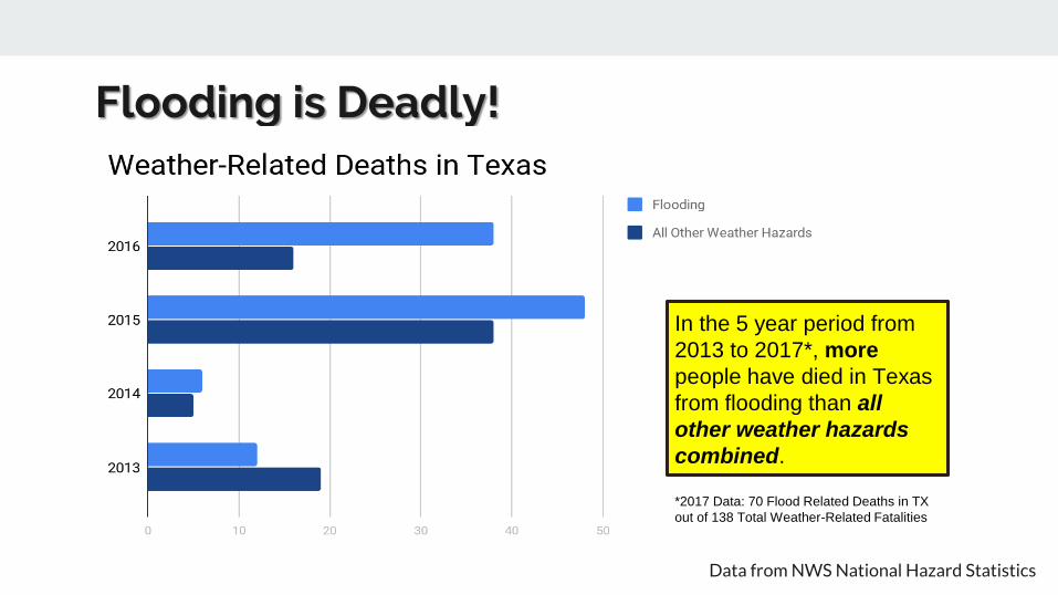
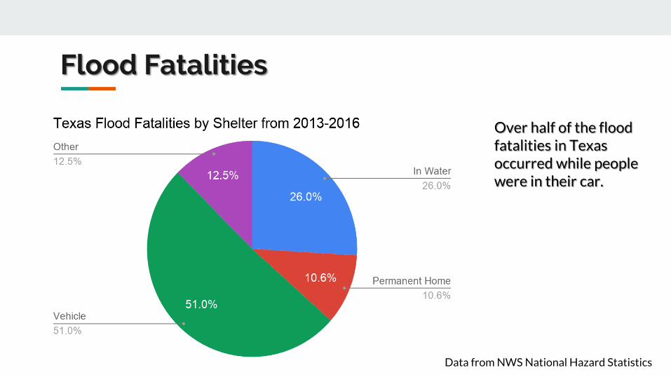
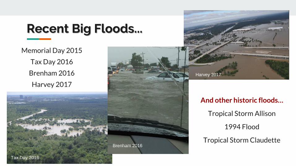
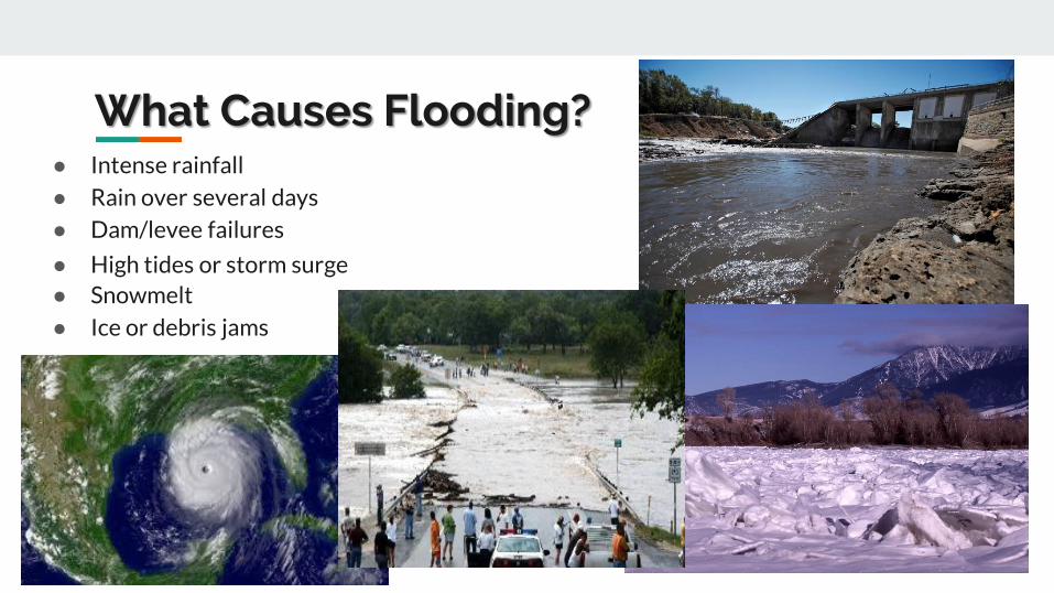
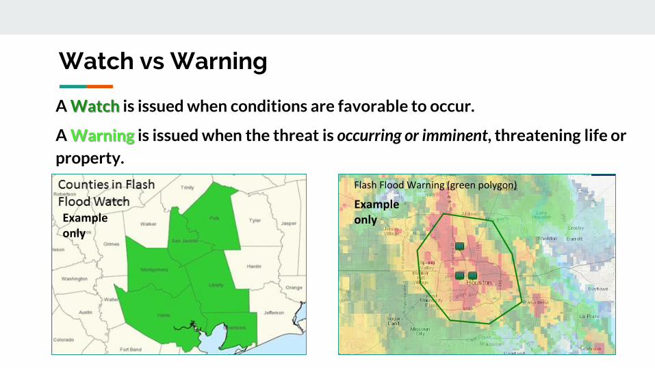
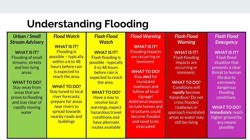
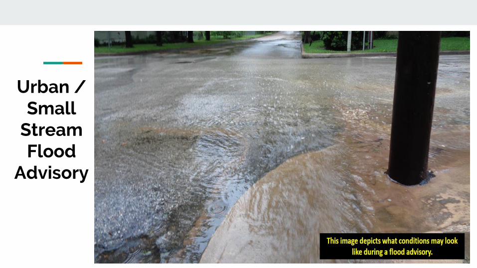
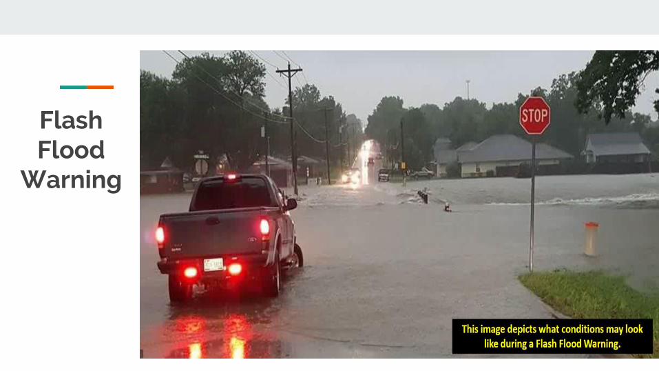
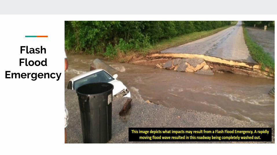
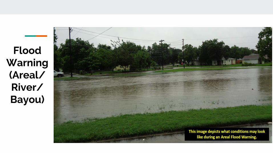
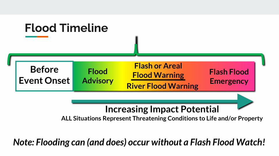
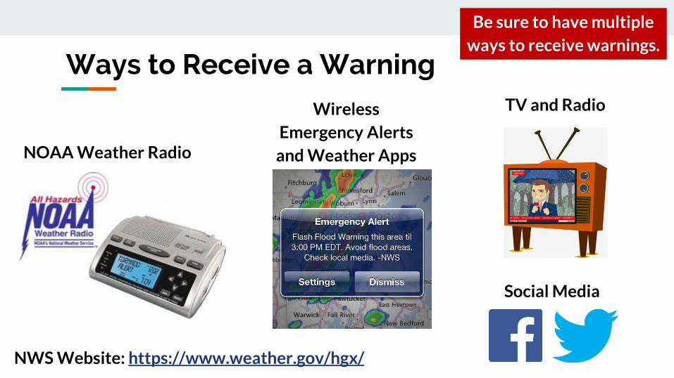
River Flooding
Llano River Flooding
River flooding occurs when water escapes the river banks There are different thresholds for river flooding action minor moderate major and record flooding This image depicts what
a river flooding looks like
River Flooding
Rainfall Analysis Hydrologic Modeling Forecast
Rainfall estimates and forecasts merged into continuous dataset
Rainfall ingested into hydrologic model Forecasters adjust model parameters in real time
Warning
River Forecast Process
LOCATION Of the gage the forecast is made AT means the gage is in the limits of the towncity NEAR or NR means that towncity has the closest post office
Hydrograph Basics
Hydrograph Basics
OBSERVATIONS Past river stages
Hydrograph Basics
FORECASTForecast River Stages
CREST Peak Stage
STAGE VS FLOW Hydrologists models reservoirs work in flow Emergency managers media general public work in stage
What is flow or a cubic foot per second
Hydrograph Basics
Hydrograph Basics
A basketball is roughly a cubic foot so 20000cfs is 20000 basketballs of water passing the gage every second
ACTIONImpact Water is over the banks and into the flood plain but not a threat to structures or roadways Some action may be required such as moving farm equipment or increasing awareness
MINORImpact Typically water is impacting areas inside of floodplain which can vary by location Some low water crossings covered by water agricultural flooding water approaching public areas (parks sidewalks etc) Areas frequently flooded can expect to be impacted
MODERATEImpact Water now reaching areas only impacted by significant rain events Structures can be inundated several roads covered with water water may cut off certain areas widespread agricultural flooding
MAJORImpact Water is near the highest itrsquos ever been representing rare flooding and significant widespread impacts Most roads will be covered by water in the area cutting off if not completely flooding subdivisions rivers can be several miles wide in areas Homes and structures underwater bridges inundated and in danger of being hit by debris Impacts may be greater than ever experienced
BELOW CRITERIAImpact Water is within the banks of the river with no impacts to the surrounding area Flow speeds may still be high during rainfall or releases which could impact recreational activities
Understanding River Criteria Levels
Advanced Hydrologic Prediction System
httpwaterweathergovahps2indexphpwfo=hgx
Partners
Roles of Primary River Forecast Partners Shared Data and Resources
- US Stream Gage Network- Water Science Studies
- Issue Weather amp Water Forecasts Watches Warnings amp Data
- Operate Flood Control Reservoirs- Manage Other WR Projects
- Assist wGage Maintenance- Assist wStream Measurements- Assist wFunding Data Networks
- Gage Maintenance- Stream Measurements- Focus Stream Gage Network
- Cooperative Data Network- NOAANWS Satellite Transmission- ForecastsData for Operations
USGS Water Alerts
Set alerts when a gauge reaches
certain water surface elevations
Identify the gauge nearest you Click on the gauge
USGS Water Alerts
httpsmapswaterdatausgsgovmapperwateralert
USGS Water Alerts
Set alerts when a gauge reaches
certain water surface elevations
Identify the gauge nearest you Click on the gauge and select
ldquoSubscribe to WaterAlert
USGS Water Alerts
httpsmapswaterdatausgsgovmapperwateralert
USGS Water Alerts
Set alerts when a gauge reaches
certain water surface elevations
Identify the gauge nearest you Click on the gauge and select
ldquoSubscribe to WaterAlert Define how you want to receive the
information Email or phone Frequency Stage or Discharge Stream Elevation(s)
Note Use Internet Explorer
USGS Water Alerts
httpsmapswaterdatausgsgovmapperwateralert
Watershed
A watershed or basin is an area of land that
drains runoff from rainfall (stormwater) to a
body of water either a river bayou creek or
lake
A watershed can flow into another watershed
Watersheds vary in shape and size which
ultimately lead to unique challenges
Topography plays a big role in how watershed
boundaries are defined
Walker County deals with 2 primary
watersheds Trinity River and San Jacinto River
Snowpack
- Water Supply
Hill Country Hydrology
- Flash Flood threats
- Rapid River responses
- Cycles of FloodDrought
Forest Hydrology
- Slower River responses
Diverse Watershed Characteristics in Texas
Watershed
Bedias Creek
near
Madisonville
Trinity River
at Riverside
A watershed or basin is an area of land that
drains runoff from rainfall (stormwater) to a
body of water either a river bayou creek or
lake
A watershed can flow into another watershed
Watersheds vary in shape and size which
ultimately lead to unique challenges
Topography plays a big role in how watershed
boundaries are defined
Walker County deals with 2 primary
watersheds Trinity River and San Jacinto River
NWS issues river forecasts for 2 sites in Walker
County
Trinity River Basin Over View
bull Nearly 18000 square
miles
bull More water storage than
any other river system in
Texas
Basin Facts
Basin Facts
20 reservoirs ranging
from 1000 to 83000
acresbull 12 Water Conservation
bull 8 Flood Control
Basic Components of a Dam
Flood Control Reservoir
Flood Control Reservoir
bull Built to regulate flood waters
bull Examples
1 Lake Grapevine
bull Storage-535 MSL
bull Flood Pool-560 MSL
bull Surcharge-582 MSL
2 Lake Lewisville
bull Storage-522 MSL
bull Flood Pool-532 MSL
bull Surcharge-552 MSL
Water Conservation Reservoir
Water Supply Reservoir
bull Designed to stay near full
bull Have very limited capacity
to capture storm inflows
bull Designed to pass inflows
from storms (with some
reduction in peak flow)
bull Structurally the gates must
open gradually as lake
rises
bull Still reduces flooding
downstream
Lake Livingston
WATER CONSERVATION RESERVOIR is responsible for
the safe storage of water and providing drinking water to
more than two million southeast Texans
o83000 surface acres
o1750000 acre feet
oMore than 350000 CFS spillway discharge capacity
oConservation Pool ndash 131 MSL
oFlowage Easement ndash135 to 140 MSL
bull Manage outflow in order to mimic river flows
bull Calculate releases adequate to keep pace with increasing
inflows without causing sudden surges and without
exceeding computed inflows until the peak inflow has
been reached
bull Once reservoir elevation has peaked excess inflow will
be released from surcharge storage in an orderly fashion
to reduce pool to conservation pool of 131 MSL
Gate Operations
Lake Livingston Emergency
Action Plan
bull Implemented at discharge of 20000 cubic feetsecond
(CFS)
bull Who do we contact
Emergency Management Coordinator for Walker Polk
San Jacinto Trinity Liberty and Chambers counties
NWS and WGRFC
DPS-Lufkin
Liberty radio
bull Methods of notification
Phone
Hydrology and History of the
Trinity River
Trinity River Travel Times
bull Travel times are tofrom
Lake Livingston
Historic Flood Stages at Riverside
RANK YEAR STAGE
1 1942 14261
2 1945 14169
3 1957 13961
4 1908 13956
1968 GATES AT DAM CLOSED
5 1990 13908
Riverside 1942
No Two Floods Are The Same
bull What part of the watershed is the flood event originating
bull Rain event in Dallas
bull Local Rain
bull How much of the watershed was covered by precipitation
bull What are the current conditions
Flood SafetyWhat to do before during and after a flood
bull Prepare a family disaster planbull Check if your insurance covers flood damages If not get flood insurancebull Keep insurance and other important documents such as copies of drivers
licenses and credit cards and other valuable items in a safe deposit boxbull Assemble a disaster supplies kit Be sure to include prescription medications
food and waterbull Find out where you can go if ordered to evacuatebull Arrange to keep in contact with relatives and friendsbull Know your resources
Knowing what to do when a flood occurs will increase your familyrsquos safety and
possibly its survival weathergovflood
Safety Before a Flood
bull Turn around donrsquot drown when encountering flooded roads
bull Be especially cautious at night when it is harder to recognize the dangers
of flooding
bull Stay away or be swept away River banks and culverts can become
unstable and unsafe
bull You should monitor the latest forecasts and be prepared to take action
should additional Flash Flood Warnings be issuedbull Have multiple ways to receive weather information (cell phone NOAA
weather radio television etc)
Safety During a Flash Flood
bull Most flood deaths occur in vehiclesbull It only takes six inches of water for a
vehicle to lose contact with the road surface
bull Most vehicles can be swept away in just 18 to 24 inches of water
bull Donrsquot Rely on Your Big Vehiclesbull Flooded roads may have hidden
dangers such as washed out road beds or underwater obstructions
bull If your vehicle is caught in rising water leave it immediately and seek higher ground
Minnesota road damaged by flood waters courtesy of FEMA
Turn Around Donrsquot Drown
bull Have multiple ways to receive weather information (cell phone NOAA weather radio television etc)
bull Do not sightsee bull Evacuations are ongoing and first responders are
working hard to get people to safety Do not get in their way
bull Flood waters from creeks bayous and rivers will be swiftly moving Do not go near the flood watersThey will sweep you away if you go in the water
bull Roads may still be closed as they could be damaged or still under water Barricades are for your protection do not drive around them
Safety During a Flood
bull Stay out of the flood waters
bull Floodwaters can contain chemicals sewage disease and animals
bull Unseen underwater debris can be sharp and cause injury
bull Downed power lines under the water could lead to death or injury from
electrocution
bull Water depth can change unexpectedly (storm drains washed-out roads)
Safety During a Flood
bull Donrsquot put yourself in danger
bull Return home only when authorities indicate it is safe
bull Stay away from damaged areas unless your assistance
has been specifically requested by police fire or a
relief organization
bull Use extreme caution when entering buildings there
may be hidden damage particularly in foundations
Safety After a Flood
weathergovflood
bull Donrsquot leave lit candles unattended
bull Cut power to flooded areas of your home
bull Only use generators in well-ventilated areasmdashnever
in a closed garage
bull Take breaks and drink plenty of fluids
bull Do not use power tools while standing in water
bull If you smell or hear gas call the Fire Department
weathergovflood
Safety After a Flood
ReportingWrap Up
Flash Flooding
Underpasses filling with water
Impassible roadways
Any fast-moving water greater than 6
inches in depth
Any River or Bayou Flooding
Flooding Washington County (2016)
What to Report
Reports should include the following information
WHO is calling
WHERE the flooding is located
WHAT type of flooding is occurring (flash river or bayou)
WHEN the flooding occurred (is it ongoing)
HOW deep is the water (if you can safely evaluate this)
Formatting Reports
The Good
ldquoIrsquom a storm spotter located in Sealy at the intersection of Meyer and FM 2187 Water is
flowing over curbs itrsquos at least 6-8 inches deep in some locations on the roadrdquo
The Bad
ldquoHey we got some flooding here a few minutes agordquo
The Ugly
ldquoMy sister-in-law said the bayou got really closer to her house did you have a warning out
for thatrdquo
Call us
Spotter line 1-800-846-1828
Report via amateur radio
Call sign WX5HGX
sr-hgxnwsnoaagov
Social Media
Twitter NWSHouston
Facebook NWSHouston Spotter TipSet up SKYWARN as a contact
in your smartphone
How to Report
CoCoRaHSldquoBecause every drop countsrdquo
National
CoCoRaHSorg
State
Measure amp Report Daily Rainfall on
Interactive Web site wwwcocorahsorg
Flood Risk
FloodWarn Workshop
Topics
bull NFIP ndash National Flood Insurance Program
bull What is Flood Risk
bull Flood Hazard Mapping and FIRMs
Flood Insurance
Everyone is at risk for floodingbull For most events 26 of NFIP
claims are outside the SHFA
A few inches can cause tens of thousands in damage
If you mortgage company ldquoforcedrdquo you to buy flood insurance check that structure and CONTENTS are covered Most cover structure only
A tool for individuals to manage
risk
What is the NFIP definition of A Flood Defined
Inundation of 2 or more acres of normally dry land or of two or more properties (one of which is your property) from
Overflow of inland or tidal waters
Unusual rapid accumulation or runoff of surface waters from any source
Mudflow or
Collapse or sinking of land along the shore of a lake or similar body of water as a result of erosion or undermining caused by waves or currents of water exceeding anticipated levels that result in a flood
NFIP Flood Insurance Coverages
Structure Coveragebull Replacement Cost on single-family primary residence (structure) if insured to at least
80 of replacement cost
bull Max coverage $250000
Contents coveragebull Contents is an optional addition except for Preferred Risk Policy bull Max coverage $100000 coverage for Actual Cash Value (depreciation applies)
Wait Periodbull Typically - 30-days from purchase until effectivebull Exceptions
o Flood Insurance required by a federally regulated and insured lendermdash0 dayso Wildfire 30-day waiting period exceptionmdash0 dayso Initial purchase of flood insurance as the result of a map revisionmdash1 day
Misconception Homeowners Insurance is Enough
Misconception
ldquoIrsquom already coveredmdashmy homeowners policy covers floodingrdquo
FactMost insurance policies do not cover flooding only flood insurance covers flood damage
Renters and Business owners should also consider flood insurance for contents
Group Flood Insurance Policy (GFIP)
IF in the 1 risk area (100yr floodplain)
AND received FEMA Individual Assistance(IA)
A GFIP policy was purchased
(if they did not have flood insurance)
GFIP is a 3 yr abridged Flood Insurance Policy The
policy is paid for from the IA funds
You can purchase the standard NFIP policy to increase
your coverage (GFIP cancels)
Group Flood Insurance Policy (GFIP)
Requirement - property owner MUST purchase and maintain
a traditional NFIP policy when GFIP expires
If nothellipthey are not eligible for IA that would cover the replacement of real
or personal property for the damaged location with a future event
The insurance requirement is forever ndash including new homeowners
Flood Risk
Any situation involving exposure to a Flood danger harm or loss
ldquoWhile levees can help reduce flood riskhellipthey do not eliminate the riskrdquo
What is a FIRM
Flood Insurance RateMap
Identifies the Special Flood Hazard Area (SFHA) and Non-SFHArsquos
Used for rating flood insurance policies
Mandatory purchase requirement if property is in SHFA AND is a federally backed mortgage
FIRMrsquos show Coastal and Riverine flood risk
Find your zone at httpsmscfemagovportal
Zones on a FIRM
SFHA (high risk) bull A AE AO AH VE V etc
(Aqua)o 1 annual chance
floodo 26 chance of
flooding in a 30-yr mortgage
Non-SFHA (low to moderate risk)
bull B C and X (Shaded ndash orange or gray color amp non-Shaded)
o OrangeGray area ndashoutlines areas protected by Levees
o Even the non-shaded is a flood zone ndash a minimal risk
What is a Flood Zone
Flood Hazard Mapping
The maps are NOT a prediction or forecast
Flood waters are not confined to the at the 1 risk line (aka 100yr flood) on the FIRM
FIRMs are subdivided by panels to cover a jurisdictional boundary (each has a unique panel number)
bull Each panel has a specific code and effective date
bull FIRMs are a single snapshot for one scenario
Flood Hazard Mapping
Assumptions are made in the river modelingbull Precipitation input the 100 year24 hr design storm (actual events rain
intensities vary - not consistent rate over a 24 hr period)
bull Assumptions about the vegetation in the flood plain ndash do NOT differentiate dead vs growing vegetation (increased friction during growing season)
bull Snapshot of land use when the models were developed ndash a challenge in rapidly developing areas
One event is never the same as another FIRMs will not exactly match an individual event
Flood Hazard Mapping
Misconception Only 100yr Floodplain is at Risk
Misconception
ldquoI donrsquot live in a flood zonerdquo
Facts
bull Floods are the 1 natural disaster in the United States
bull If it can rain it can flood
bull FIRMs do not show localized flooding from drainage ditchessewersroad ponding
bull To some degree overland floodinghellipbut not property to property drainage problems
Cost of Flood Damage
Structure Elevation Impact Insurance Rates
The elevation is just one factor others include when was the
structure has it flooded in the past etc
Lower Risk = $ High Risk =
$$$
Medium Risk =
$$
EVERY Structure has a riskhellipgenerally the higher the structure the less the risk
Harvey Numbers
Insurance claims Harris Co (includes cities such as
Houston) ndash all claims 55570
Walker County (unincorporated only) ndash 1 (Losses over 125K)
Harris County Numbersbull 154170 Homes 48850 in 1 Risk
Area (100-yr) bull 34970 in 02 (500-yr) floodplainbull 68 OUTSIDE of the 1 Risk Area
Data HCFCD Finale Hurricane Harvey Storm and Flood Information ndash
httpswwwhcfcdorgmedia2678immediate-flood-report-final-hurricane-harvey-2017pdf
New GFIPrsquos Due to Harvey
Walker County ndash6
Summary
Living in Texas means we have a flood risk even with heavy rain
bull Tax Day 2016 and Memorial Day 2015 ndash not with a tropical system
Flood Risk is from multiple sources bull FIRMs focus on river flooding and some overland flow
Flood insurance allows individual property owners to manage their risk
bull Buy policies that cover the structure AND contents
Angela Harrison InsuranceCell 470-557-2794 | AngelaHarrisonfemadhsgov
Yho-Meka Conway Insurance Cell 470-572-0803 | Yho-MekaConwayfemadhsgov
Lauren Schmied PE Floodplain ManagementCell 202-812-6164 | LaurenSchmiedfemadhsgov
Larry Fordham ANFI CFM ACAActing Senior Regional Insurance Specialist FEMA Region 6Phone 940-383-7253 | Cell 202-394-4483 |LarryFordhamfemadhsgov
NFIP Hotline
1-800-427-4661
wwwfemagovnfip
Contact Information
QuestionsNational Weather Service
FEMA
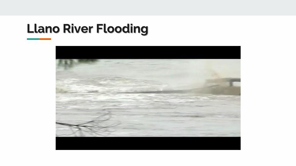
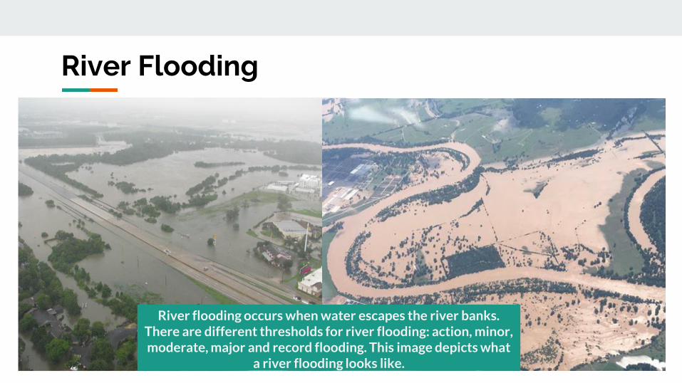
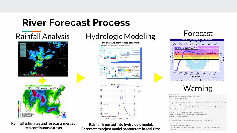
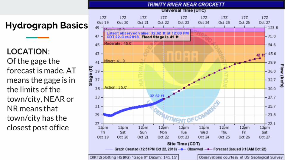
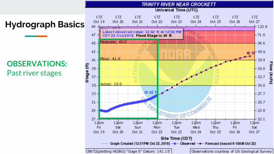
Hydrograph Basics
OBSERVATIONS Past river stages
Hydrograph Basics
FORECASTForecast River Stages
CREST Peak Stage
STAGE VS FLOW Hydrologists models reservoirs work in flow Emergency managers media general public work in stage
What is flow or a cubic foot per second
Hydrograph Basics
Hydrograph Basics
A basketball is roughly a cubic foot so 20000cfs is 20000 basketballs of water passing the gage every second
ACTIONImpact Water is over the banks and into the flood plain but not a threat to structures or roadways Some action may be required such as moving farm equipment or increasing awareness
MINORImpact Typically water is impacting areas inside of floodplain which can vary by location Some low water crossings covered by water agricultural flooding water approaching public areas (parks sidewalks etc) Areas frequently flooded can expect to be impacted
MODERATEImpact Water now reaching areas only impacted by significant rain events Structures can be inundated several roads covered with water water may cut off certain areas widespread agricultural flooding
MAJORImpact Water is near the highest itrsquos ever been representing rare flooding and significant widespread impacts Most roads will be covered by water in the area cutting off if not completely flooding subdivisions rivers can be several miles wide in areas Homes and structures underwater bridges inundated and in danger of being hit by debris Impacts may be greater than ever experienced
BELOW CRITERIAImpact Water is within the banks of the river with no impacts to the surrounding area Flow speeds may still be high during rainfall or releases which could impact recreational activities
Understanding River Criteria Levels
Advanced Hydrologic Prediction System
httpwaterweathergovahps2indexphpwfo=hgx
Partners
Roles of Primary River Forecast Partners Shared Data and Resources
- US Stream Gage Network- Water Science Studies
- Issue Weather amp Water Forecasts Watches Warnings amp Data
- Operate Flood Control Reservoirs- Manage Other WR Projects
- Assist wGage Maintenance- Assist wStream Measurements- Assist wFunding Data Networks
- Gage Maintenance- Stream Measurements- Focus Stream Gage Network
- Cooperative Data Network- NOAANWS Satellite Transmission- ForecastsData for Operations
USGS Water Alerts
Set alerts when a gauge reaches
certain water surface elevations
Identify the gauge nearest you Click on the gauge
USGS Water Alerts
httpsmapswaterdatausgsgovmapperwateralert
USGS Water Alerts
Set alerts when a gauge reaches
certain water surface elevations
Identify the gauge nearest you Click on the gauge and select
ldquoSubscribe to WaterAlert
USGS Water Alerts
httpsmapswaterdatausgsgovmapperwateralert
USGS Water Alerts
Set alerts when a gauge reaches
certain water surface elevations
Identify the gauge nearest you Click on the gauge and select
ldquoSubscribe to WaterAlert Define how you want to receive the
information Email or phone Frequency Stage or Discharge Stream Elevation(s)
Note Use Internet Explorer
USGS Water Alerts
httpsmapswaterdatausgsgovmapperwateralert
Watershed
A watershed or basin is an area of land that
drains runoff from rainfall (stormwater) to a
body of water either a river bayou creek or
lake
A watershed can flow into another watershed
Watersheds vary in shape and size which
ultimately lead to unique challenges
Topography plays a big role in how watershed
boundaries are defined
Walker County deals with 2 primary
watersheds Trinity River and San Jacinto River
Snowpack
- Water Supply
Hill Country Hydrology
- Flash Flood threats
- Rapid River responses
- Cycles of FloodDrought
Forest Hydrology
- Slower River responses
Diverse Watershed Characteristics in Texas
Watershed
Bedias Creek
near
Madisonville
Trinity River
at Riverside
A watershed or basin is an area of land that
drains runoff from rainfall (stormwater) to a
body of water either a river bayou creek or
lake
A watershed can flow into another watershed
Watersheds vary in shape and size which
ultimately lead to unique challenges
Topography plays a big role in how watershed
boundaries are defined
Walker County deals with 2 primary
watersheds Trinity River and San Jacinto River
NWS issues river forecasts for 2 sites in Walker
County
Trinity River Basin Over View
bull Nearly 18000 square
miles
bull More water storage than
any other river system in
Texas
Basin Facts
Basin Facts
20 reservoirs ranging
from 1000 to 83000
acresbull 12 Water Conservation
bull 8 Flood Control
Basic Components of a Dam
Flood Control Reservoir
Flood Control Reservoir
bull Built to regulate flood waters
bull Examples
1 Lake Grapevine
bull Storage-535 MSL
bull Flood Pool-560 MSL
bull Surcharge-582 MSL
2 Lake Lewisville
bull Storage-522 MSL
bull Flood Pool-532 MSL
bull Surcharge-552 MSL
Water Conservation Reservoir
Water Supply Reservoir
bull Designed to stay near full
bull Have very limited capacity
to capture storm inflows
bull Designed to pass inflows
from storms (with some
reduction in peak flow)
bull Structurally the gates must
open gradually as lake
rises
bull Still reduces flooding
downstream
Lake Livingston
WATER CONSERVATION RESERVOIR is responsible for
the safe storage of water and providing drinking water to
more than two million southeast Texans
o83000 surface acres
o1750000 acre feet
oMore than 350000 CFS spillway discharge capacity
oConservation Pool ndash 131 MSL
oFlowage Easement ndash135 to 140 MSL
bull Manage outflow in order to mimic river flows
bull Calculate releases adequate to keep pace with increasing
inflows without causing sudden surges and without
exceeding computed inflows until the peak inflow has
been reached
bull Once reservoir elevation has peaked excess inflow will
be released from surcharge storage in an orderly fashion
to reduce pool to conservation pool of 131 MSL
Gate Operations
Lake Livingston Emergency
Action Plan
bull Implemented at discharge of 20000 cubic feetsecond
(CFS)
bull Who do we contact
Emergency Management Coordinator for Walker Polk
San Jacinto Trinity Liberty and Chambers counties
NWS and WGRFC
DPS-Lufkin
Liberty radio
bull Methods of notification
Phone
Hydrology and History of the
Trinity River
Trinity River Travel Times
bull Travel times are tofrom
Lake Livingston
Historic Flood Stages at Riverside
RANK YEAR STAGE
1 1942 14261
2 1945 14169
3 1957 13961
4 1908 13956
1968 GATES AT DAM CLOSED
5 1990 13908
Riverside 1942
No Two Floods Are The Same
bull What part of the watershed is the flood event originating
bull Rain event in Dallas
bull Local Rain
bull How much of the watershed was covered by precipitation
bull What are the current conditions
Flood SafetyWhat to do before during and after a flood
bull Prepare a family disaster planbull Check if your insurance covers flood damages If not get flood insurancebull Keep insurance and other important documents such as copies of drivers
licenses and credit cards and other valuable items in a safe deposit boxbull Assemble a disaster supplies kit Be sure to include prescription medications
food and waterbull Find out where you can go if ordered to evacuatebull Arrange to keep in contact with relatives and friendsbull Know your resources
Knowing what to do when a flood occurs will increase your familyrsquos safety and
possibly its survival weathergovflood
Safety Before a Flood
bull Turn around donrsquot drown when encountering flooded roads
bull Be especially cautious at night when it is harder to recognize the dangers
of flooding
bull Stay away or be swept away River banks and culverts can become
unstable and unsafe
bull You should monitor the latest forecasts and be prepared to take action
should additional Flash Flood Warnings be issuedbull Have multiple ways to receive weather information (cell phone NOAA
weather radio television etc)
Safety During a Flash Flood
bull Most flood deaths occur in vehiclesbull It only takes six inches of water for a
vehicle to lose contact with the road surface
bull Most vehicles can be swept away in just 18 to 24 inches of water
bull Donrsquot Rely on Your Big Vehiclesbull Flooded roads may have hidden
dangers such as washed out road beds or underwater obstructions
bull If your vehicle is caught in rising water leave it immediately and seek higher ground
Minnesota road damaged by flood waters courtesy of FEMA
Turn Around Donrsquot Drown
bull Have multiple ways to receive weather information (cell phone NOAA weather radio television etc)
bull Do not sightsee bull Evacuations are ongoing and first responders are
working hard to get people to safety Do not get in their way
bull Flood waters from creeks bayous and rivers will be swiftly moving Do not go near the flood watersThey will sweep you away if you go in the water
bull Roads may still be closed as they could be damaged or still under water Barricades are for your protection do not drive around them
Safety During a Flood
bull Stay out of the flood waters
bull Floodwaters can contain chemicals sewage disease and animals
bull Unseen underwater debris can be sharp and cause injury
bull Downed power lines under the water could lead to death or injury from
electrocution
bull Water depth can change unexpectedly (storm drains washed-out roads)
Safety During a Flood
bull Donrsquot put yourself in danger
bull Return home only when authorities indicate it is safe
bull Stay away from damaged areas unless your assistance
has been specifically requested by police fire or a
relief organization
bull Use extreme caution when entering buildings there
may be hidden damage particularly in foundations
Safety After a Flood
weathergovflood
bull Donrsquot leave lit candles unattended
bull Cut power to flooded areas of your home
bull Only use generators in well-ventilated areasmdashnever
in a closed garage
bull Take breaks and drink plenty of fluids
bull Do not use power tools while standing in water
bull If you smell or hear gas call the Fire Department
weathergovflood
Safety After a Flood
ReportingWrap Up
Flash Flooding
Underpasses filling with water
Impassible roadways
Any fast-moving water greater than 6
inches in depth
Any River or Bayou Flooding
Flooding Washington County (2016)
What to Report
Reports should include the following information
WHO is calling
WHERE the flooding is located
WHAT type of flooding is occurring (flash river or bayou)
WHEN the flooding occurred (is it ongoing)
HOW deep is the water (if you can safely evaluate this)
Formatting Reports
The Good
ldquoIrsquom a storm spotter located in Sealy at the intersection of Meyer and FM 2187 Water is
flowing over curbs itrsquos at least 6-8 inches deep in some locations on the roadrdquo
The Bad
ldquoHey we got some flooding here a few minutes agordquo
The Ugly
ldquoMy sister-in-law said the bayou got really closer to her house did you have a warning out
for thatrdquo
Call us
Spotter line 1-800-846-1828
Report via amateur radio
Call sign WX5HGX
sr-hgxnwsnoaagov
Social Media
Twitter NWSHouston
Facebook NWSHouston Spotter TipSet up SKYWARN as a contact
in your smartphone
How to Report
CoCoRaHSldquoBecause every drop countsrdquo
National
CoCoRaHSorg
State
Measure amp Report Daily Rainfall on
Interactive Web site wwwcocorahsorg
Flood Risk
FloodWarn Workshop
Topics
bull NFIP ndash National Flood Insurance Program
bull What is Flood Risk
bull Flood Hazard Mapping and FIRMs
Flood Insurance
Everyone is at risk for floodingbull For most events 26 of NFIP
claims are outside the SHFA
A few inches can cause tens of thousands in damage
If you mortgage company ldquoforcedrdquo you to buy flood insurance check that structure and CONTENTS are covered Most cover structure only
A tool for individuals to manage
risk
What is the NFIP definition of A Flood Defined
Inundation of 2 or more acres of normally dry land or of two or more properties (one of which is your property) from
Overflow of inland or tidal waters
Unusual rapid accumulation or runoff of surface waters from any source
Mudflow or
Collapse or sinking of land along the shore of a lake or similar body of water as a result of erosion or undermining caused by waves or currents of water exceeding anticipated levels that result in a flood
NFIP Flood Insurance Coverages
Structure Coveragebull Replacement Cost on single-family primary residence (structure) if insured to at least
80 of replacement cost
bull Max coverage $250000
Contents coveragebull Contents is an optional addition except for Preferred Risk Policy bull Max coverage $100000 coverage for Actual Cash Value (depreciation applies)
Wait Periodbull Typically - 30-days from purchase until effectivebull Exceptions
o Flood Insurance required by a federally regulated and insured lendermdash0 dayso Wildfire 30-day waiting period exceptionmdash0 dayso Initial purchase of flood insurance as the result of a map revisionmdash1 day
Misconception Homeowners Insurance is Enough
Misconception
ldquoIrsquom already coveredmdashmy homeowners policy covers floodingrdquo
FactMost insurance policies do not cover flooding only flood insurance covers flood damage
Renters and Business owners should also consider flood insurance for contents
Group Flood Insurance Policy (GFIP)
IF in the 1 risk area (100yr floodplain)
AND received FEMA Individual Assistance(IA)
A GFIP policy was purchased
(if they did not have flood insurance)
GFIP is a 3 yr abridged Flood Insurance Policy The
policy is paid for from the IA funds
You can purchase the standard NFIP policy to increase
your coverage (GFIP cancels)
Group Flood Insurance Policy (GFIP)
Requirement - property owner MUST purchase and maintain
a traditional NFIP policy when GFIP expires
If nothellipthey are not eligible for IA that would cover the replacement of real
or personal property for the damaged location with a future event
The insurance requirement is forever ndash including new homeowners
Flood Risk
Any situation involving exposure to a Flood danger harm or loss
ldquoWhile levees can help reduce flood riskhellipthey do not eliminate the riskrdquo
What is a FIRM
Flood Insurance RateMap
Identifies the Special Flood Hazard Area (SFHA) and Non-SFHArsquos
Used for rating flood insurance policies
Mandatory purchase requirement if property is in SHFA AND is a federally backed mortgage
FIRMrsquos show Coastal and Riverine flood risk
Find your zone at httpsmscfemagovportal
Zones on a FIRM
SFHA (high risk) bull A AE AO AH VE V etc
(Aqua)o 1 annual chance
floodo 26 chance of
flooding in a 30-yr mortgage
Non-SFHA (low to moderate risk)
bull B C and X (Shaded ndash orange or gray color amp non-Shaded)
o OrangeGray area ndashoutlines areas protected by Levees
o Even the non-shaded is a flood zone ndash a minimal risk
What is a Flood Zone
Flood Hazard Mapping
The maps are NOT a prediction or forecast
Flood waters are not confined to the at the 1 risk line (aka 100yr flood) on the FIRM
FIRMs are subdivided by panels to cover a jurisdictional boundary (each has a unique panel number)
bull Each panel has a specific code and effective date
bull FIRMs are a single snapshot for one scenario
Flood Hazard Mapping
Assumptions are made in the river modelingbull Precipitation input the 100 year24 hr design storm (actual events rain
intensities vary - not consistent rate over a 24 hr period)
bull Assumptions about the vegetation in the flood plain ndash do NOT differentiate dead vs growing vegetation (increased friction during growing season)
bull Snapshot of land use when the models were developed ndash a challenge in rapidly developing areas
One event is never the same as another FIRMs will not exactly match an individual event
Flood Hazard Mapping
Misconception Only 100yr Floodplain is at Risk
Misconception
ldquoI donrsquot live in a flood zonerdquo
Facts
bull Floods are the 1 natural disaster in the United States
bull If it can rain it can flood
bull FIRMs do not show localized flooding from drainage ditchessewersroad ponding
bull To some degree overland floodinghellipbut not property to property drainage problems
Cost of Flood Damage
Structure Elevation Impact Insurance Rates
The elevation is just one factor others include when was the
structure has it flooded in the past etc
Lower Risk = $ High Risk =
$$$
Medium Risk =
$$
EVERY Structure has a riskhellipgenerally the higher the structure the less the risk
Harvey Numbers
Insurance claims Harris Co (includes cities such as
Houston) ndash all claims 55570
Walker County (unincorporated only) ndash 1 (Losses over 125K)
Harris County Numbersbull 154170 Homes 48850 in 1 Risk
Area (100-yr) bull 34970 in 02 (500-yr) floodplainbull 68 OUTSIDE of the 1 Risk Area
Data HCFCD Finale Hurricane Harvey Storm and Flood Information ndash
httpswwwhcfcdorgmedia2678immediate-flood-report-final-hurricane-harvey-2017pdf
New GFIPrsquos Due to Harvey
Walker County ndash6
Summary
Living in Texas means we have a flood risk even with heavy rain
bull Tax Day 2016 and Memorial Day 2015 ndash not with a tropical system
Flood Risk is from multiple sources bull FIRMs focus on river flooding and some overland flow
Flood insurance allows individual property owners to manage their risk
bull Buy policies that cover the structure AND contents
Angela Harrison InsuranceCell 470-557-2794 | AngelaHarrisonfemadhsgov
Yho-Meka Conway Insurance Cell 470-572-0803 | Yho-MekaConwayfemadhsgov
Lauren Schmied PE Floodplain ManagementCell 202-812-6164 | LaurenSchmiedfemadhsgov
Larry Fordham ANFI CFM ACAActing Senior Regional Insurance Specialist FEMA Region 6Phone 940-383-7253 | Cell 202-394-4483 |LarryFordhamfemadhsgov
NFIP Hotline
1-800-427-4661
wwwfemagovnfip
Contact Information
QuestionsNational Weather Service
FEMA
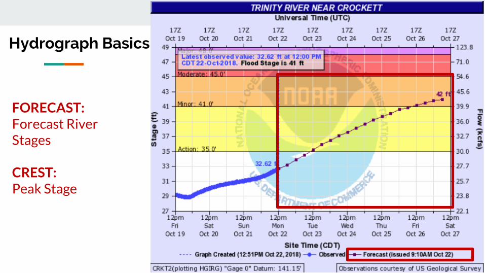
Hydrograph Basics
FORECASTForecast River Stages
CREST Peak Stage
STAGE VS FLOW Hydrologists models reservoirs work in flow Emergency managers media general public work in stage
What is flow or a cubic foot per second
Hydrograph Basics
Hydrograph Basics
A basketball is roughly a cubic foot so 20000cfs is 20000 basketballs of water passing the gage every second
ACTIONImpact Water is over the banks and into the flood plain but not a threat to structures or roadways Some action may be required such as moving farm equipment or increasing awareness
MINORImpact Typically water is impacting areas inside of floodplain which can vary by location Some low water crossings covered by water agricultural flooding water approaching public areas (parks sidewalks etc) Areas frequently flooded can expect to be impacted
MODERATEImpact Water now reaching areas only impacted by significant rain events Structures can be inundated several roads covered with water water may cut off certain areas widespread agricultural flooding
MAJORImpact Water is near the highest itrsquos ever been representing rare flooding and significant widespread impacts Most roads will be covered by water in the area cutting off if not completely flooding subdivisions rivers can be several miles wide in areas Homes and structures underwater bridges inundated and in danger of being hit by debris Impacts may be greater than ever experienced
BELOW CRITERIAImpact Water is within the banks of the river with no impacts to the surrounding area Flow speeds may still be high during rainfall or releases which could impact recreational activities
Understanding River Criteria Levels
Advanced Hydrologic Prediction System
httpwaterweathergovahps2indexphpwfo=hgx
Partners
Roles of Primary River Forecast Partners Shared Data and Resources
- US Stream Gage Network- Water Science Studies
- Issue Weather amp Water Forecasts Watches Warnings amp Data
- Operate Flood Control Reservoirs- Manage Other WR Projects
- Assist wGage Maintenance- Assist wStream Measurements- Assist wFunding Data Networks
- Gage Maintenance- Stream Measurements- Focus Stream Gage Network
- Cooperative Data Network- NOAANWS Satellite Transmission- ForecastsData for Operations
USGS Water Alerts
Set alerts when a gauge reaches
certain water surface elevations
Identify the gauge nearest you Click on the gauge
USGS Water Alerts
httpsmapswaterdatausgsgovmapperwateralert
USGS Water Alerts
Set alerts when a gauge reaches
certain water surface elevations
Identify the gauge nearest you Click on the gauge and select
ldquoSubscribe to WaterAlert
USGS Water Alerts
httpsmapswaterdatausgsgovmapperwateralert
USGS Water Alerts
Set alerts when a gauge reaches
certain water surface elevations
Identify the gauge nearest you Click on the gauge and select
ldquoSubscribe to WaterAlert Define how you want to receive the
information Email or phone Frequency Stage or Discharge Stream Elevation(s)
Note Use Internet Explorer
USGS Water Alerts
httpsmapswaterdatausgsgovmapperwateralert
Watershed
A watershed or basin is an area of land that
drains runoff from rainfall (stormwater) to a
body of water either a river bayou creek or
lake
A watershed can flow into another watershed
Watersheds vary in shape and size which
ultimately lead to unique challenges
Topography plays a big role in how watershed
boundaries are defined
Walker County deals with 2 primary
watersheds Trinity River and San Jacinto River
Snowpack
- Water Supply
Hill Country Hydrology
- Flash Flood threats
- Rapid River responses
- Cycles of FloodDrought
Forest Hydrology
- Slower River responses
Diverse Watershed Characteristics in Texas
Watershed
Bedias Creek
near
Madisonville
Trinity River
at Riverside
A watershed or basin is an area of land that
drains runoff from rainfall (stormwater) to a
body of water either a river bayou creek or
lake
A watershed can flow into another watershed
Watersheds vary in shape and size which
ultimately lead to unique challenges
Topography plays a big role in how watershed
boundaries are defined
Walker County deals with 2 primary
watersheds Trinity River and San Jacinto River
NWS issues river forecasts for 2 sites in Walker
County
Trinity River Basin Over View
bull Nearly 18000 square
miles
bull More water storage than
any other river system in
Texas
Basin Facts
Basin Facts
20 reservoirs ranging
from 1000 to 83000
acresbull 12 Water Conservation
bull 8 Flood Control
Basic Components of a Dam
Flood Control Reservoir
Flood Control Reservoir
bull Built to regulate flood waters
bull Examples
1 Lake Grapevine
bull Storage-535 MSL
bull Flood Pool-560 MSL
bull Surcharge-582 MSL
2 Lake Lewisville
bull Storage-522 MSL
bull Flood Pool-532 MSL
bull Surcharge-552 MSL
Water Conservation Reservoir
Water Supply Reservoir
bull Designed to stay near full
bull Have very limited capacity
to capture storm inflows
bull Designed to pass inflows
from storms (with some
reduction in peak flow)
bull Structurally the gates must
open gradually as lake
rises
bull Still reduces flooding
downstream
Lake Livingston
WATER CONSERVATION RESERVOIR is responsible for
the safe storage of water and providing drinking water to
more than two million southeast Texans
o83000 surface acres
o1750000 acre feet
oMore than 350000 CFS spillway discharge capacity
oConservation Pool ndash 131 MSL
oFlowage Easement ndash135 to 140 MSL
bull Manage outflow in order to mimic river flows
bull Calculate releases adequate to keep pace with increasing
inflows without causing sudden surges and without
exceeding computed inflows until the peak inflow has
been reached
bull Once reservoir elevation has peaked excess inflow will
be released from surcharge storage in an orderly fashion
to reduce pool to conservation pool of 131 MSL
Gate Operations
Lake Livingston Emergency
Action Plan
bull Implemented at discharge of 20000 cubic feetsecond
(CFS)
bull Who do we contact
Emergency Management Coordinator for Walker Polk
San Jacinto Trinity Liberty and Chambers counties
NWS and WGRFC
DPS-Lufkin
Liberty radio
bull Methods of notification
Phone
Hydrology and History of the
Trinity River
Trinity River Travel Times
bull Travel times are tofrom
Lake Livingston
Historic Flood Stages at Riverside
RANK YEAR STAGE
1 1942 14261
2 1945 14169
3 1957 13961
4 1908 13956
1968 GATES AT DAM CLOSED
5 1990 13908
Riverside 1942
No Two Floods Are The Same
bull What part of the watershed is the flood event originating
bull Rain event in Dallas
bull Local Rain
bull How much of the watershed was covered by precipitation
bull What are the current conditions
Flood SafetyWhat to do before during and after a flood
bull Prepare a family disaster planbull Check if your insurance covers flood damages If not get flood insurancebull Keep insurance and other important documents such as copies of drivers
licenses and credit cards and other valuable items in a safe deposit boxbull Assemble a disaster supplies kit Be sure to include prescription medications
food and waterbull Find out where you can go if ordered to evacuatebull Arrange to keep in contact with relatives and friendsbull Know your resources
Knowing what to do when a flood occurs will increase your familyrsquos safety and
possibly its survival weathergovflood
Safety Before a Flood
bull Turn around donrsquot drown when encountering flooded roads
bull Be especially cautious at night when it is harder to recognize the dangers
of flooding
bull Stay away or be swept away River banks and culverts can become
unstable and unsafe
bull You should monitor the latest forecasts and be prepared to take action
should additional Flash Flood Warnings be issuedbull Have multiple ways to receive weather information (cell phone NOAA
weather radio television etc)
Safety During a Flash Flood
bull Most flood deaths occur in vehiclesbull It only takes six inches of water for a
vehicle to lose contact with the road surface
bull Most vehicles can be swept away in just 18 to 24 inches of water
bull Donrsquot Rely on Your Big Vehiclesbull Flooded roads may have hidden
dangers such as washed out road beds or underwater obstructions
bull If your vehicle is caught in rising water leave it immediately and seek higher ground
Minnesota road damaged by flood waters courtesy of FEMA
Turn Around Donrsquot Drown
bull Have multiple ways to receive weather information (cell phone NOAA weather radio television etc)
bull Do not sightsee bull Evacuations are ongoing and first responders are
working hard to get people to safety Do not get in their way
bull Flood waters from creeks bayous and rivers will be swiftly moving Do not go near the flood watersThey will sweep you away if you go in the water
bull Roads may still be closed as they could be damaged or still under water Barricades are for your protection do not drive around them
Safety During a Flood
bull Stay out of the flood waters
bull Floodwaters can contain chemicals sewage disease and animals
bull Unseen underwater debris can be sharp and cause injury
bull Downed power lines under the water could lead to death or injury from
electrocution
bull Water depth can change unexpectedly (storm drains washed-out roads)
Safety During a Flood
bull Donrsquot put yourself in danger
bull Return home only when authorities indicate it is safe
bull Stay away from damaged areas unless your assistance
has been specifically requested by police fire or a
relief organization
bull Use extreme caution when entering buildings there
may be hidden damage particularly in foundations
Safety After a Flood
weathergovflood
bull Donrsquot leave lit candles unattended
bull Cut power to flooded areas of your home
bull Only use generators in well-ventilated areasmdashnever
in a closed garage
bull Take breaks and drink plenty of fluids
bull Do not use power tools while standing in water
bull If you smell or hear gas call the Fire Department
weathergovflood
Safety After a Flood
ReportingWrap Up
Flash Flooding
Underpasses filling with water
Impassible roadways
Any fast-moving water greater than 6
inches in depth
Any River or Bayou Flooding
Flooding Washington County (2016)
What to Report
Reports should include the following information
WHO is calling
WHERE the flooding is located
WHAT type of flooding is occurring (flash river or bayou)
WHEN the flooding occurred (is it ongoing)
HOW deep is the water (if you can safely evaluate this)
Formatting Reports
The Good
ldquoIrsquom a storm spotter located in Sealy at the intersection of Meyer and FM 2187 Water is
flowing over curbs itrsquos at least 6-8 inches deep in some locations on the roadrdquo
The Bad
ldquoHey we got some flooding here a few minutes agordquo
The Ugly
ldquoMy sister-in-law said the bayou got really closer to her house did you have a warning out
for thatrdquo
Call us
Spotter line 1-800-846-1828
Report via amateur radio
Call sign WX5HGX
sr-hgxnwsnoaagov
Social Media
Twitter NWSHouston
Facebook NWSHouston Spotter TipSet up SKYWARN as a contact
in your smartphone
How to Report
CoCoRaHSldquoBecause every drop countsrdquo
National
CoCoRaHSorg
State
Measure amp Report Daily Rainfall on
Interactive Web site wwwcocorahsorg
Flood Risk
FloodWarn Workshop
Topics
bull NFIP ndash National Flood Insurance Program
bull What is Flood Risk
bull Flood Hazard Mapping and FIRMs
Flood Insurance
Everyone is at risk for floodingbull For most events 26 of NFIP
claims are outside the SHFA
A few inches can cause tens of thousands in damage
If you mortgage company ldquoforcedrdquo you to buy flood insurance check that structure and CONTENTS are covered Most cover structure only
A tool for individuals to manage
risk
What is the NFIP definition of A Flood Defined
Inundation of 2 or more acres of normally dry land or of two or more properties (one of which is your property) from
Overflow of inland or tidal waters
Unusual rapid accumulation or runoff of surface waters from any source
Mudflow or
Collapse or sinking of land along the shore of a lake or similar body of water as a result of erosion or undermining caused by waves or currents of water exceeding anticipated levels that result in a flood
NFIP Flood Insurance Coverages
Structure Coveragebull Replacement Cost on single-family primary residence (structure) if insured to at least
80 of replacement cost
bull Max coverage $250000
Contents coveragebull Contents is an optional addition except for Preferred Risk Policy bull Max coverage $100000 coverage for Actual Cash Value (depreciation applies)
Wait Periodbull Typically - 30-days from purchase until effectivebull Exceptions
o Flood Insurance required by a federally regulated and insured lendermdash0 dayso Wildfire 30-day waiting period exceptionmdash0 dayso Initial purchase of flood insurance as the result of a map revisionmdash1 day
Misconception Homeowners Insurance is Enough
Misconception
ldquoIrsquom already coveredmdashmy homeowners policy covers floodingrdquo
FactMost insurance policies do not cover flooding only flood insurance covers flood damage
Renters and Business owners should also consider flood insurance for contents
Group Flood Insurance Policy (GFIP)
IF in the 1 risk area (100yr floodplain)
AND received FEMA Individual Assistance(IA)
A GFIP policy was purchased
(if they did not have flood insurance)
GFIP is a 3 yr abridged Flood Insurance Policy The
policy is paid for from the IA funds
You can purchase the standard NFIP policy to increase
your coverage (GFIP cancels)
Group Flood Insurance Policy (GFIP)
Requirement - property owner MUST purchase and maintain
a traditional NFIP policy when GFIP expires
If nothellipthey are not eligible for IA that would cover the replacement of real
or personal property for the damaged location with a future event
The insurance requirement is forever ndash including new homeowners
Flood Risk
Any situation involving exposure to a Flood danger harm or loss
ldquoWhile levees can help reduce flood riskhellipthey do not eliminate the riskrdquo
What is a FIRM
Flood Insurance RateMap
Identifies the Special Flood Hazard Area (SFHA) and Non-SFHArsquos
Used for rating flood insurance policies
Mandatory purchase requirement if property is in SHFA AND is a federally backed mortgage
FIRMrsquos show Coastal and Riverine flood risk
Find your zone at httpsmscfemagovportal
Zones on a FIRM
SFHA (high risk) bull A AE AO AH VE V etc
(Aqua)o 1 annual chance
floodo 26 chance of
flooding in a 30-yr mortgage
Non-SFHA (low to moderate risk)
bull B C and X (Shaded ndash orange or gray color amp non-Shaded)
o OrangeGray area ndashoutlines areas protected by Levees
o Even the non-shaded is a flood zone ndash a minimal risk
What is a Flood Zone
Flood Hazard Mapping
The maps are NOT a prediction or forecast
Flood waters are not confined to the at the 1 risk line (aka 100yr flood) on the FIRM
FIRMs are subdivided by panels to cover a jurisdictional boundary (each has a unique panel number)
bull Each panel has a specific code and effective date
bull FIRMs are a single snapshot for one scenario
Flood Hazard Mapping
Assumptions are made in the river modelingbull Precipitation input the 100 year24 hr design storm (actual events rain
intensities vary - not consistent rate over a 24 hr period)
bull Assumptions about the vegetation in the flood plain ndash do NOT differentiate dead vs growing vegetation (increased friction during growing season)
bull Snapshot of land use when the models were developed ndash a challenge in rapidly developing areas
One event is never the same as another FIRMs will not exactly match an individual event
Flood Hazard Mapping
Misconception Only 100yr Floodplain is at Risk
Misconception
ldquoI donrsquot live in a flood zonerdquo
Facts
bull Floods are the 1 natural disaster in the United States
bull If it can rain it can flood
bull FIRMs do not show localized flooding from drainage ditchessewersroad ponding
bull To some degree overland floodinghellipbut not property to property drainage problems
Cost of Flood Damage
Structure Elevation Impact Insurance Rates
The elevation is just one factor others include when was the
structure has it flooded in the past etc
Lower Risk = $ High Risk =
$$$
Medium Risk =
$$
EVERY Structure has a riskhellipgenerally the higher the structure the less the risk
Harvey Numbers
Insurance claims Harris Co (includes cities such as
Houston) ndash all claims 55570
Walker County (unincorporated only) ndash 1 (Losses over 125K)
Harris County Numbersbull 154170 Homes 48850 in 1 Risk
Area (100-yr) bull 34970 in 02 (500-yr) floodplainbull 68 OUTSIDE of the 1 Risk Area
Data HCFCD Finale Hurricane Harvey Storm and Flood Information ndash
httpswwwhcfcdorgmedia2678immediate-flood-report-final-hurricane-harvey-2017pdf
New GFIPrsquos Due to Harvey
Walker County ndash6
Summary
Living in Texas means we have a flood risk even with heavy rain
bull Tax Day 2016 and Memorial Day 2015 ndash not with a tropical system
Flood Risk is from multiple sources bull FIRMs focus on river flooding and some overland flow
Flood insurance allows individual property owners to manage their risk
bull Buy policies that cover the structure AND contents
Angela Harrison InsuranceCell 470-557-2794 | AngelaHarrisonfemadhsgov
Yho-Meka Conway Insurance Cell 470-572-0803 | Yho-MekaConwayfemadhsgov
Lauren Schmied PE Floodplain ManagementCell 202-812-6164 | LaurenSchmiedfemadhsgov
Larry Fordham ANFI CFM ACAActing Senior Regional Insurance Specialist FEMA Region 6Phone 940-383-7253 | Cell 202-394-4483 |LarryFordhamfemadhsgov
NFIP Hotline
1-800-427-4661
wwwfemagovnfip
Contact Information
QuestionsNational Weather Service
FEMA
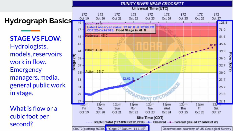
USGS Water Alerts
Set alerts when a gauge reaches
certain water surface elevations
Identify the gauge nearest you Click on the gauge
USGS Water Alerts
httpsmapswaterdatausgsgovmapperwateralert
USGS Water Alerts
Set alerts when a gauge reaches
certain water surface elevations
Identify the gauge nearest you Click on the gauge and select
ldquoSubscribe to WaterAlert
USGS Water Alerts
httpsmapswaterdatausgsgovmapperwateralert
USGS Water Alerts
Set alerts when a gauge reaches
certain water surface elevations
Identify the gauge nearest you Click on the gauge and select
ldquoSubscribe to WaterAlert Define how you want to receive the
information Email or phone Frequency Stage or Discharge Stream Elevation(s)
Note Use Internet Explorer
USGS Water Alerts
httpsmapswaterdatausgsgovmapperwateralert
Watershed
A watershed or basin is an area of land that
drains runoff from rainfall (stormwater) to a
body of water either a river bayou creek or
lake
A watershed can flow into another watershed
Watersheds vary in shape and size which
ultimately lead to unique challenges
Topography plays a big role in how watershed
boundaries are defined
Walker County deals with 2 primary
watersheds Trinity River and San Jacinto River
Snowpack
- Water Supply
Hill Country Hydrology
- Flash Flood threats
- Rapid River responses
- Cycles of FloodDrought
Forest Hydrology
- Slower River responses
Diverse Watershed Characteristics in Texas
Watershed
Bedias Creek
near
Madisonville
Trinity River
at Riverside
A watershed or basin is an area of land that
drains runoff from rainfall (stormwater) to a
body of water either a river bayou creek or
lake
A watershed can flow into another watershed
Watersheds vary in shape and size which
ultimately lead to unique challenges
Topography plays a big role in how watershed
boundaries are defined
Walker County deals with 2 primary
watersheds Trinity River and San Jacinto River
NWS issues river forecasts for 2 sites in Walker
County
Trinity River Basin Over View
bull Nearly 18000 square
miles
bull More water storage than
any other river system in
Texas
Basin Facts
Basin Facts
20 reservoirs ranging
from 1000 to 83000
acresbull 12 Water Conservation
bull 8 Flood Control
Basic Components of a Dam
Flood Control Reservoir
Flood Control Reservoir
bull Built to regulate flood waters
bull Examples
1 Lake Grapevine
bull Storage-535 MSL
bull Flood Pool-560 MSL
bull Surcharge-582 MSL
2 Lake Lewisville
bull Storage-522 MSL
bull Flood Pool-532 MSL
bull Surcharge-552 MSL
Water Conservation Reservoir
Water Supply Reservoir
bull Designed to stay near full
bull Have very limited capacity
to capture storm inflows
bull Designed to pass inflows
from storms (with some
reduction in peak flow)
bull Structurally the gates must
open gradually as lake
rises
bull Still reduces flooding
downstream
Lake Livingston
WATER CONSERVATION RESERVOIR is responsible for
the safe storage of water and providing drinking water to
more than two million southeast Texans
o83000 surface acres
o1750000 acre feet
oMore than 350000 CFS spillway discharge capacity
oConservation Pool ndash 131 MSL
oFlowage Easement ndash135 to 140 MSL
bull Manage outflow in order to mimic river flows
bull Calculate releases adequate to keep pace with increasing
inflows without causing sudden surges and without
exceeding computed inflows until the peak inflow has
been reached
bull Once reservoir elevation has peaked excess inflow will
be released from surcharge storage in an orderly fashion
to reduce pool to conservation pool of 131 MSL
Gate Operations
Lake Livingston Emergency
Action Plan
bull Implemented at discharge of 20000 cubic feetsecond
(CFS)
bull Who do we contact
Emergency Management Coordinator for Walker Polk
San Jacinto Trinity Liberty and Chambers counties
NWS and WGRFC
DPS-Lufkin
Liberty radio
bull Methods of notification
Phone
Hydrology and History of the
Trinity River
Trinity River Travel Times
bull Travel times are tofrom
Lake Livingston
Historic Flood Stages at Riverside
RANK YEAR STAGE
1 1942 14261
2 1945 14169
3 1957 13961
4 1908 13956
1968 GATES AT DAM CLOSED
5 1990 13908
Riverside 1942
No Two Floods Are The Same
bull What part of the watershed is the flood event originating
bull Rain event in Dallas
bull Local Rain
bull How much of the watershed was covered by precipitation
bull What are the current conditions
Flood SafetyWhat to do before during and after a flood
bull Prepare a family disaster planbull Check if your insurance covers flood damages If not get flood insurancebull Keep insurance and other important documents such as copies of drivers
licenses and credit cards and other valuable items in a safe deposit boxbull Assemble a disaster supplies kit Be sure to include prescription medications
food and waterbull Find out where you can go if ordered to evacuatebull Arrange to keep in contact with relatives and friendsbull Know your resources
Knowing what to do when a flood occurs will increase your familyrsquos safety and
possibly its survival weathergovflood
Safety Before a Flood
bull Turn around donrsquot drown when encountering flooded roads
bull Be especially cautious at night when it is harder to recognize the dangers
of flooding
bull Stay away or be swept away River banks and culverts can become
unstable and unsafe
bull You should monitor the latest forecasts and be prepared to take action
should additional Flash Flood Warnings be issuedbull Have multiple ways to receive weather information (cell phone NOAA
weather radio television etc)
Safety During a Flash Flood
bull Most flood deaths occur in vehiclesbull It only takes six inches of water for a
vehicle to lose contact with the road surface
bull Most vehicles can be swept away in just 18 to 24 inches of water
bull Donrsquot Rely on Your Big Vehiclesbull Flooded roads may have hidden
dangers such as washed out road beds or underwater obstructions
bull If your vehicle is caught in rising water leave it immediately and seek higher ground
Minnesota road damaged by flood waters courtesy of FEMA
Turn Around Donrsquot Drown
bull Have multiple ways to receive weather information (cell phone NOAA weather radio television etc)
bull Do not sightsee bull Evacuations are ongoing and first responders are
working hard to get people to safety Do not get in their way
bull Flood waters from creeks bayous and rivers will be swiftly moving Do not go near the flood watersThey will sweep you away if you go in the water
bull Roads may still be closed as they could be damaged or still under water Barricades are for your protection do not drive around them
Safety During a Flood
bull Stay out of the flood waters
bull Floodwaters can contain chemicals sewage disease and animals
bull Unseen underwater debris can be sharp and cause injury
bull Downed power lines under the water could lead to death or injury from
electrocution
bull Water depth can change unexpectedly (storm drains washed-out roads)
Safety During a Flood
bull Donrsquot put yourself in danger
bull Return home only when authorities indicate it is safe
bull Stay away from damaged areas unless your assistance
has been specifically requested by police fire or a
relief organization
bull Use extreme caution when entering buildings there
may be hidden damage particularly in foundations
Safety After a Flood
weathergovflood
bull Donrsquot leave lit candles unattended
bull Cut power to flooded areas of your home
bull Only use generators in well-ventilated areasmdashnever
in a closed garage
bull Take breaks and drink plenty of fluids
bull Do not use power tools while standing in water
bull If you smell or hear gas call the Fire Department
weathergovflood
Safety After a Flood
ReportingWrap Up
Flash Flooding
Underpasses filling with water
Impassible roadways
Any fast-moving water greater than 6
inches in depth
Any River or Bayou Flooding
Flooding Washington County (2016)
What to Report
Reports should include the following information
WHO is calling
WHERE the flooding is located
WHAT type of flooding is occurring (flash river or bayou)
WHEN the flooding occurred (is it ongoing)
HOW deep is the water (if you can safely evaluate this)
Formatting Reports
The Good
ldquoIrsquom a storm spotter located in Sealy at the intersection of Meyer and FM 2187 Water is
flowing over curbs itrsquos at least 6-8 inches deep in some locations on the roadrdquo
The Bad
ldquoHey we got some flooding here a few minutes agordquo
The Ugly
ldquoMy sister-in-law said the bayou got really closer to her house did you have a warning out
for thatrdquo
Call us
Spotter line 1-800-846-1828
Report via amateur radio
Call sign WX5HGX
sr-hgxnwsnoaagov
Social Media
Twitter NWSHouston
Facebook NWSHouston Spotter TipSet up SKYWARN as a contact
in your smartphone
How to Report
CoCoRaHSldquoBecause every drop countsrdquo
National
CoCoRaHSorg
State
Measure amp Report Daily Rainfall on
Interactive Web site wwwcocorahsorg
Flood Risk
FloodWarn Workshop
Topics
bull NFIP ndash National Flood Insurance Program
bull What is Flood Risk
bull Flood Hazard Mapping and FIRMs
Flood Insurance
Everyone is at risk for floodingbull For most events 26 of NFIP
claims are outside the SHFA
A few inches can cause tens of thousands in damage
If you mortgage company ldquoforcedrdquo you to buy flood insurance check that structure and CONTENTS are covered Most cover structure only
A tool for individuals to manage
risk
What is the NFIP definition of A Flood Defined
Inundation of 2 or more acres of normally dry land or of two or more properties (one of which is your property) from
Overflow of inland or tidal waters
Unusual rapid accumulation or runoff of surface waters from any source
Mudflow or
Collapse or sinking of land along the shore of a lake or similar body of water as a result of erosion or undermining caused by waves or currents of water exceeding anticipated levels that result in a flood
NFIP Flood Insurance Coverages
Structure Coveragebull Replacement Cost on single-family primary residence (structure) if insured to at least
80 of replacement cost
bull Max coverage $250000
Contents coveragebull Contents is an optional addition except for Preferred Risk Policy bull Max coverage $100000 coverage for Actual Cash Value (depreciation applies)
Wait Periodbull Typically - 30-days from purchase until effectivebull Exceptions
o Flood Insurance required by a federally regulated and insured lendermdash0 dayso Wildfire 30-day waiting period exceptionmdash0 dayso Initial purchase of flood insurance as the result of a map revisionmdash1 day
Misconception Homeowners Insurance is Enough
Misconception
ldquoIrsquom already coveredmdashmy homeowners policy covers floodingrdquo
FactMost insurance policies do not cover flooding only flood insurance covers flood damage
Renters and Business owners should also consider flood insurance for contents
Group Flood Insurance Policy (GFIP)
IF in the 1 risk area (100yr floodplain)
AND received FEMA Individual Assistance(IA)
A GFIP policy was purchased
(if they did not have flood insurance)
GFIP is a 3 yr abridged Flood Insurance Policy The
policy is paid for from the IA funds
You can purchase the standard NFIP policy to increase
your coverage (GFIP cancels)
Group Flood Insurance Policy (GFIP)
Requirement - property owner MUST purchase and maintain
a traditional NFIP policy when GFIP expires
If nothellipthey are not eligible for IA that would cover the replacement of real
or personal property for the damaged location with a future event
The insurance requirement is forever ndash including new homeowners
Flood Risk
Any situation involving exposure to a Flood danger harm or loss
ldquoWhile levees can help reduce flood riskhellipthey do not eliminate the riskrdquo
What is a FIRM
Flood Insurance RateMap
Identifies the Special Flood Hazard Area (SFHA) and Non-SFHArsquos
Used for rating flood insurance policies
Mandatory purchase requirement if property is in SHFA AND is a federally backed mortgage
FIRMrsquos show Coastal and Riverine flood risk
Find your zone at httpsmscfemagovportal
Zones on a FIRM
SFHA (high risk) bull A AE AO AH VE V etc
(Aqua)o 1 annual chance
floodo 26 chance of
flooding in a 30-yr mortgage
Non-SFHA (low to moderate risk)
bull B C and X (Shaded ndash orange or gray color amp non-Shaded)
o OrangeGray area ndashoutlines areas protected by Levees
o Even the non-shaded is a flood zone ndash a minimal risk
What is a Flood Zone
Flood Hazard Mapping
The maps are NOT a prediction or forecast
Flood waters are not confined to the at the 1 risk line (aka 100yr flood) on the FIRM
FIRMs are subdivided by panels to cover a jurisdictional boundary (each has a unique panel number)
bull Each panel has a specific code and effective date
bull FIRMs are a single snapshot for one scenario
Flood Hazard Mapping
Assumptions are made in the river modelingbull Precipitation input the 100 year24 hr design storm (actual events rain
intensities vary - not consistent rate over a 24 hr period)
bull Assumptions about the vegetation in the flood plain ndash do NOT differentiate dead vs growing vegetation (increased friction during growing season)
bull Snapshot of land use when the models were developed ndash a challenge in rapidly developing areas
One event is never the same as another FIRMs will not exactly match an individual event
Flood Hazard Mapping
Misconception Only 100yr Floodplain is at Risk
Misconception
ldquoI donrsquot live in a flood zonerdquo
Facts
bull Floods are the 1 natural disaster in the United States
bull If it can rain it can flood
bull FIRMs do not show localized flooding from drainage ditchessewersroad ponding
bull To some degree overland floodinghellipbut not property to property drainage problems
Cost of Flood Damage
Structure Elevation Impact Insurance Rates
The elevation is just one factor others include when was the
structure has it flooded in the past etc
Lower Risk = $ High Risk =
$$$
Medium Risk =
$$
EVERY Structure has a riskhellipgenerally the higher the structure the less the risk
Harvey Numbers
Insurance claims Harris Co (includes cities such as
Houston) ndash all claims 55570
Walker County (unincorporated only) ndash 1 (Losses over 125K)
Harris County Numbersbull 154170 Homes 48850 in 1 Risk
Area (100-yr) bull 34970 in 02 (500-yr) floodplainbull 68 OUTSIDE of the 1 Risk Area
Data HCFCD Finale Hurricane Harvey Storm and Flood Information ndash
httpswwwhcfcdorgmedia2678immediate-flood-report-final-hurricane-harvey-2017pdf
New GFIPrsquos Due to Harvey
Walker County ndash6
Summary
Living in Texas means we have a flood risk even with heavy rain
bull Tax Day 2016 and Memorial Day 2015 ndash not with a tropical system
Flood Risk is from multiple sources bull FIRMs focus on river flooding and some overland flow
Flood insurance allows individual property owners to manage their risk
bull Buy policies that cover the structure AND contents
Angela Harrison InsuranceCell 470-557-2794 | AngelaHarrisonfemadhsgov
Yho-Meka Conway Insurance Cell 470-572-0803 | Yho-MekaConwayfemadhsgov
Lauren Schmied PE Floodplain ManagementCell 202-812-6164 | LaurenSchmiedfemadhsgov
Larry Fordham ANFI CFM ACAActing Senior Regional Insurance Specialist FEMA Region 6Phone 940-383-7253 | Cell 202-394-4483 |LarryFordhamfemadhsgov
NFIP Hotline
1-800-427-4661
wwwfemagovnfip
Contact Information
QuestionsNational Weather Service
FEMA
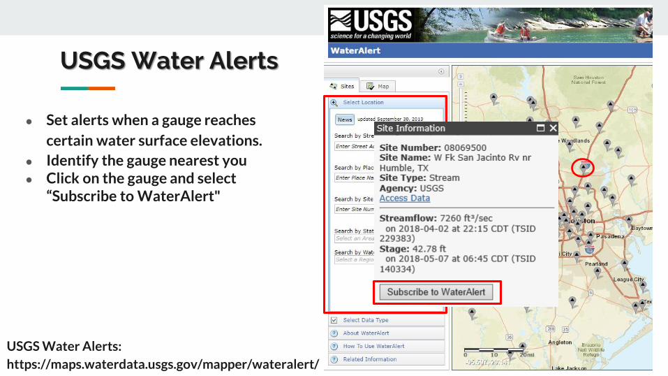
USGS Water Alerts
Set alerts when a gauge reaches
certain water surface elevations
Identify the gauge nearest you Click on the gauge and select
ldquoSubscribe to WaterAlert
USGS Water Alerts
httpsmapswaterdatausgsgovmapperwateralert
USGS Water Alerts
Set alerts when a gauge reaches
certain water surface elevations
Identify the gauge nearest you Click on the gauge and select
ldquoSubscribe to WaterAlert Define how you want to receive the
information Email or phone Frequency Stage or Discharge Stream Elevation(s)
Note Use Internet Explorer
USGS Water Alerts
httpsmapswaterdatausgsgovmapperwateralert
Watershed
A watershed or basin is an area of land that
drains runoff from rainfall (stormwater) to a
body of water either a river bayou creek or
lake
A watershed can flow into another watershed
Watersheds vary in shape and size which
ultimately lead to unique challenges
Topography plays a big role in how watershed
boundaries are defined
Walker County deals with 2 primary
watersheds Trinity River and San Jacinto River
Snowpack
- Water Supply
Hill Country Hydrology
- Flash Flood threats
- Rapid River responses
- Cycles of FloodDrought
Forest Hydrology
- Slower River responses
Diverse Watershed Characteristics in Texas
Watershed
Bedias Creek
near
Madisonville
Trinity River
at Riverside
A watershed or basin is an area of land that
drains runoff from rainfall (stormwater) to a
body of water either a river bayou creek or
lake
A watershed can flow into another watershed
Watersheds vary in shape and size which
ultimately lead to unique challenges
Topography plays a big role in how watershed
boundaries are defined
Walker County deals with 2 primary
watersheds Trinity River and San Jacinto River
NWS issues river forecasts for 2 sites in Walker
County
Trinity River Basin Over View
bull Nearly 18000 square
miles
bull More water storage than
any other river system in
Texas
Basin Facts
Basin Facts
20 reservoirs ranging
from 1000 to 83000
acresbull 12 Water Conservation
bull 8 Flood Control
Basic Components of a Dam
Flood Control Reservoir
Flood Control Reservoir
bull Built to regulate flood waters
bull Examples
1 Lake Grapevine
bull Storage-535 MSL
bull Flood Pool-560 MSL
bull Surcharge-582 MSL
2 Lake Lewisville
bull Storage-522 MSL
bull Flood Pool-532 MSL
bull Surcharge-552 MSL
Water Conservation Reservoir
Water Supply Reservoir
bull Designed to stay near full
bull Have very limited capacity
to capture storm inflows
bull Designed to pass inflows
from storms (with some
reduction in peak flow)
bull Structurally the gates must
open gradually as lake
rises
bull Still reduces flooding
downstream
Lake Livingston
WATER CONSERVATION RESERVOIR is responsible for
the safe storage of water and providing drinking water to
more than two million southeast Texans
o83000 surface acres
o1750000 acre feet
oMore than 350000 CFS spillway discharge capacity
oConservation Pool ndash 131 MSL
oFlowage Easement ndash135 to 140 MSL
bull Manage outflow in order to mimic river flows
bull Calculate releases adequate to keep pace with increasing
inflows without causing sudden surges and without
exceeding computed inflows until the peak inflow has
been reached
bull Once reservoir elevation has peaked excess inflow will
be released from surcharge storage in an orderly fashion
to reduce pool to conservation pool of 131 MSL
Gate Operations
Lake Livingston Emergency
Action Plan
bull Implemented at discharge of 20000 cubic feetsecond
(CFS)
bull Who do we contact
Emergency Management Coordinator for Walker Polk
San Jacinto Trinity Liberty and Chambers counties
NWS and WGRFC
DPS-Lufkin
Liberty radio
bull Methods of notification
Phone
Hydrology and History of the
Trinity River
Trinity River Travel Times
bull Travel times are tofrom
Lake Livingston
Historic Flood Stages at Riverside
RANK YEAR STAGE
1 1942 14261
2 1945 14169
3 1957 13961
4 1908 13956
1968 GATES AT DAM CLOSED
5 1990 13908
Riverside 1942
No Two Floods Are The Same
bull What part of the watershed is the flood event originating
bull Rain event in Dallas
bull Local Rain
bull How much of the watershed was covered by precipitation
bull What are the current conditions
Flood SafetyWhat to do before during and after a flood
bull Prepare a family disaster planbull Check if your insurance covers flood damages If not get flood insurancebull Keep insurance and other important documents such as copies of drivers
licenses and credit cards and other valuable items in a safe deposit boxbull Assemble a disaster supplies kit Be sure to include prescription medications
food and waterbull Find out where you can go if ordered to evacuatebull Arrange to keep in contact with relatives and friendsbull Know your resources
Knowing what to do when a flood occurs will increase your familyrsquos safety and
possibly its survival weathergovflood
Safety Before a Flood
bull Turn around donrsquot drown when encountering flooded roads
bull Be especially cautious at night when it is harder to recognize the dangers
of flooding
bull Stay away or be swept away River banks and culverts can become
unstable and unsafe
bull You should monitor the latest forecasts and be prepared to take action
should additional Flash Flood Warnings be issuedbull Have multiple ways to receive weather information (cell phone NOAA
weather radio television etc)
Safety During a Flash Flood
bull Most flood deaths occur in vehiclesbull It only takes six inches of water for a
vehicle to lose contact with the road surface
bull Most vehicles can be swept away in just 18 to 24 inches of water
bull Donrsquot Rely on Your Big Vehiclesbull Flooded roads may have hidden
dangers such as washed out road beds or underwater obstructions
bull If your vehicle is caught in rising water leave it immediately and seek higher ground
Minnesota road damaged by flood waters courtesy of FEMA
Turn Around Donrsquot Drown
bull Have multiple ways to receive weather information (cell phone NOAA weather radio television etc)
bull Do not sightsee bull Evacuations are ongoing and first responders are
working hard to get people to safety Do not get in their way
bull Flood waters from creeks bayous and rivers will be swiftly moving Do not go near the flood watersThey will sweep you away if you go in the water
bull Roads may still be closed as they could be damaged or still under water Barricades are for your protection do not drive around them
Safety During a Flood
bull Stay out of the flood waters
bull Floodwaters can contain chemicals sewage disease and animals
bull Unseen underwater debris can be sharp and cause injury
bull Downed power lines under the water could lead to death or injury from
electrocution
bull Water depth can change unexpectedly (storm drains washed-out roads)
Safety During a Flood
bull Donrsquot put yourself in danger
bull Return home only when authorities indicate it is safe
bull Stay away from damaged areas unless your assistance
has been specifically requested by police fire or a
relief organization
bull Use extreme caution when entering buildings there
may be hidden damage particularly in foundations
Safety After a Flood
weathergovflood
bull Donrsquot leave lit candles unattended
bull Cut power to flooded areas of your home
bull Only use generators in well-ventilated areasmdashnever
in a closed garage
bull Take breaks and drink plenty of fluids
bull Do not use power tools while standing in water
bull If you smell or hear gas call the Fire Department
weathergovflood
Safety After a Flood
ReportingWrap Up
Flash Flooding
Underpasses filling with water
Impassible roadways
Any fast-moving water greater than 6
inches in depth
Any River or Bayou Flooding
Flooding Washington County (2016)
What to Report
Reports should include the following information
WHO is calling
WHERE the flooding is located
WHAT type of flooding is occurring (flash river or bayou)
WHEN the flooding occurred (is it ongoing)
HOW deep is the water (if you can safely evaluate this)
Formatting Reports
The Good
ldquoIrsquom a storm spotter located in Sealy at the intersection of Meyer and FM 2187 Water is
flowing over curbs itrsquos at least 6-8 inches deep in some locations on the roadrdquo
The Bad
ldquoHey we got some flooding here a few minutes agordquo
The Ugly
ldquoMy sister-in-law said the bayou got really closer to her house did you have a warning out
for thatrdquo
Call us
Spotter line 1-800-846-1828
Report via amateur radio
Call sign WX5HGX
sr-hgxnwsnoaagov
Social Media
Twitter NWSHouston
Facebook NWSHouston Spotter TipSet up SKYWARN as a contact
in your smartphone
How to Report
CoCoRaHSldquoBecause every drop countsrdquo
National
CoCoRaHSorg
State
Measure amp Report Daily Rainfall on
Interactive Web site wwwcocorahsorg
Flood Risk
FloodWarn Workshop
Topics
bull NFIP ndash National Flood Insurance Program
bull What is Flood Risk
bull Flood Hazard Mapping and FIRMs
Flood Insurance
Everyone is at risk for floodingbull For most events 26 of NFIP
claims are outside the SHFA
A few inches can cause tens of thousands in damage
If you mortgage company ldquoforcedrdquo you to buy flood insurance check that structure and CONTENTS are covered Most cover structure only
A tool for individuals to manage
risk
What is the NFIP definition of A Flood Defined
Inundation of 2 or more acres of normally dry land or of two or more properties (one of which is your property) from
Overflow of inland or tidal waters
Unusual rapid accumulation or runoff of surface waters from any source
Mudflow or
Collapse or sinking of land along the shore of a lake or similar body of water as a result of erosion or undermining caused by waves or currents of water exceeding anticipated levels that result in a flood
NFIP Flood Insurance Coverages
Structure Coveragebull Replacement Cost on single-family primary residence (structure) if insured to at least
80 of replacement cost
bull Max coverage $250000
Contents coveragebull Contents is an optional addition except for Preferred Risk Policy bull Max coverage $100000 coverage for Actual Cash Value (depreciation applies)
Wait Periodbull Typically - 30-days from purchase until effectivebull Exceptions
o Flood Insurance required by a federally regulated and insured lendermdash0 dayso Wildfire 30-day waiting period exceptionmdash0 dayso Initial purchase of flood insurance as the result of a map revisionmdash1 day
Misconception Homeowners Insurance is Enough
Misconception
ldquoIrsquom already coveredmdashmy homeowners policy covers floodingrdquo
FactMost insurance policies do not cover flooding only flood insurance covers flood damage
Renters and Business owners should also consider flood insurance for contents
Group Flood Insurance Policy (GFIP)
IF in the 1 risk area (100yr floodplain)
AND received FEMA Individual Assistance(IA)
A GFIP policy was purchased
(if they did not have flood insurance)
GFIP is a 3 yr abridged Flood Insurance Policy The
policy is paid for from the IA funds
You can purchase the standard NFIP policy to increase
your coverage (GFIP cancels)
Group Flood Insurance Policy (GFIP)
Requirement - property owner MUST purchase and maintain
a traditional NFIP policy when GFIP expires
If nothellipthey are not eligible for IA that would cover the replacement of real
or personal property for the damaged location with a future event
The insurance requirement is forever ndash including new homeowners
Flood Risk
Any situation involving exposure to a Flood danger harm or loss
ldquoWhile levees can help reduce flood riskhellipthey do not eliminate the riskrdquo
What is a FIRM
Flood Insurance RateMap
Identifies the Special Flood Hazard Area (SFHA) and Non-SFHArsquos
Used for rating flood insurance policies
Mandatory purchase requirement if property is in SHFA AND is a federally backed mortgage
FIRMrsquos show Coastal and Riverine flood risk
Find your zone at httpsmscfemagovportal
Zones on a FIRM
SFHA (high risk) bull A AE AO AH VE V etc
(Aqua)o 1 annual chance
floodo 26 chance of
flooding in a 30-yr mortgage
Non-SFHA (low to moderate risk)
bull B C and X (Shaded ndash orange or gray color amp non-Shaded)
o OrangeGray area ndashoutlines areas protected by Levees
o Even the non-shaded is a flood zone ndash a minimal risk
What is a Flood Zone
Flood Hazard Mapping
The maps are NOT a prediction or forecast
Flood waters are not confined to the at the 1 risk line (aka 100yr flood) on the FIRM
FIRMs are subdivided by panels to cover a jurisdictional boundary (each has a unique panel number)
bull Each panel has a specific code and effective date
bull FIRMs are a single snapshot for one scenario
Flood Hazard Mapping
Assumptions are made in the river modelingbull Precipitation input the 100 year24 hr design storm (actual events rain
intensities vary - not consistent rate over a 24 hr period)
bull Assumptions about the vegetation in the flood plain ndash do NOT differentiate dead vs growing vegetation (increased friction during growing season)
bull Snapshot of land use when the models were developed ndash a challenge in rapidly developing areas
One event is never the same as another FIRMs will not exactly match an individual event
Flood Hazard Mapping
Misconception Only 100yr Floodplain is at Risk
Misconception
ldquoI donrsquot live in a flood zonerdquo
Facts
bull Floods are the 1 natural disaster in the United States
bull If it can rain it can flood
bull FIRMs do not show localized flooding from drainage ditchessewersroad ponding
bull To some degree overland floodinghellipbut not property to property drainage problems
Cost of Flood Damage
Structure Elevation Impact Insurance Rates
The elevation is just one factor others include when was the
structure has it flooded in the past etc
Lower Risk = $ High Risk =
$$$
Medium Risk =
$$
EVERY Structure has a riskhellipgenerally the higher the structure the less the risk
Harvey Numbers
Insurance claims Harris Co (includes cities such as
Houston) ndash all claims 55570
Walker County (unincorporated only) ndash 1 (Losses over 125K)
Harris County Numbersbull 154170 Homes 48850 in 1 Risk
Area (100-yr) bull 34970 in 02 (500-yr) floodplainbull 68 OUTSIDE of the 1 Risk Area
Data HCFCD Finale Hurricane Harvey Storm and Flood Information ndash
httpswwwhcfcdorgmedia2678immediate-flood-report-final-hurricane-harvey-2017pdf
New GFIPrsquos Due to Harvey
Walker County ndash6
Summary
Living in Texas means we have a flood risk even with heavy rain
bull Tax Day 2016 and Memorial Day 2015 ndash not with a tropical system
Flood Risk is from multiple sources bull FIRMs focus on river flooding and some overland flow
Flood insurance allows individual property owners to manage their risk
bull Buy policies that cover the structure AND contents
Angela Harrison InsuranceCell 470-557-2794 | AngelaHarrisonfemadhsgov
Yho-Meka Conway Insurance Cell 470-572-0803 | Yho-MekaConwayfemadhsgov
Lauren Schmied PE Floodplain ManagementCell 202-812-6164 | LaurenSchmiedfemadhsgov
Larry Fordham ANFI CFM ACAActing Senior Regional Insurance Specialist FEMA Region 6Phone 940-383-7253 | Cell 202-394-4483 |LarryFordhamfemadhsgov
NFIP Hotline
1-800-427-4661
wwwfemagovnfip
Contact Information
QuestionsNational Weather Service
FEMA
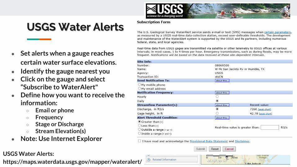
USGS Water Alerts
Set alerts when a gauge reaches
certain water surface elevations
Identify the gauge nearest you Click on the gauge and select
ldquoSubscribe to WaterAlert Define how you want to receive the
information Email or phone Frequency Stage or Discharge Stream Elevation(s)
Note Use Internet Explorer
USGS Water Alerts
httpsmapswaterdatausgsgovmapperwateralert
Watershed
A watershed or basin is an area of land that
drains runoff from rainfall (stormwater) to a
body of water either a river bayou creek or
lake
A watershed can flow into another watershed
Watersheds vary in shape and size which
ultimately lead to unique challenges
Topography plays a big role in how watershed
boundaries are defined
Walker County deals with 2 primary
watersheds Trinity River and San Jacinto River
Snowpack
- Water Supply
Hill Country Hydrology
- Flash Flood threats
- Rapid River responses
- Cycles of FloodDrought
Forest Hydrology
- Slower River responses
Diverse Watershed Characteristics in Texas
Watershed
Bedias Creek
near
Madisonville
Trinity River
at Riverside
A watershed or basin is an area of land that
drains runoff from rainfall (stormwater) to a
body of water either a river bayou creek or
lake
A watershed can flow into another watershed
Watersheds vary in shape and size which
ultimately lead to unique challenges
Topography plays a big role in how watershed
boundaries are defined
Walker County deals with 2 primary
watersheds Trinity River and San Jacinto River
NWS issues river forecasts for 2 sites in Walker
County
Trinity River Basin Over View
bull Nearly 18000 square
miles
bull More water storage than
any other river system in
Texas
Basin Facts
Basin Facts
20 reservoirs ranging
from 1000 to 83000
acresbull 12 Water Conservation
bull 8 Flood Control
Basic Components of a Dam
Flood Control Reservoir
Flood Control Reservoir
bull Built to regulate flood waters
bull Examples
1 Lake Grapevine
bull Storage-535 MSL
bull Flood Pool-560 MSL
bull Surcharge-582 MSL
2 Lake Lewisville
bull Storage-522 MSL
bull Flood Pool-532 MSL
bull Surcharge-552 MSL
Water Conservation Reservoir
Water Supply Reservoir
bull Designed to stay near full
bull Have very limited capacity
to capture storm inflows
bull Designed to pass inflows
from storms (with some
reduction in peak flow)
bull Structurally the gates must
open gradually as lake
rises
bull Still reduces flooding
downstream
Lake Livingston
WATER CONSERVATION RESERVOIR is responsible for
the safe storage of water and providing drinking water to
more than two million southeast Texans
o83000 surface acres
o1750000 acre feet
oMore than 350000 CFS spillway discharge capacity
oConservation Pool ndash 131 MSL
oFlowage Easement ndash135 to 140 MSL
bull Manage outflow in order to mimic river flows
bull Calculate releases adequate to keep pace with increasing
inflows without causing sudden surges and without
exceeding computed inflows until the peak inflow has
been reached
bull Once reservoir elevation has peaked excess inflow will
be released from surcharge storage in an orderly fashion
to reduce pool to conservation pool of 131 MSL
Gate Operations
Lake Livingston Emergency
Action Plan
bull Implemented at discharge of 20000 cubic feetsecond
(CFS)
bull Who do we contact
Emergency Management Coordinator for Walker Polk
San Jacinto Trinity Liberty and Chambers counties
NWS and WGRFC
DPS-Lufkin
Liberty radio
bull Methods of notification
Phone
Hydrology and History of the
Trinity River
Trinity River Travel Times
bull Travel times are tofrom
Lake Livingston
Historic Flood Stages at Riverside
RANK YEAR STAGE
1 1942 14261
2 1945 14169
3 1957 13961
4 1908 13956
1968 GATES AT DAM CLOSED
5 1990 13908
Riverside 1942
No Two Floods Are The Same
bull What part of the watershed is the flood event originating
bull Rain event in Dallas
bull Local Rain
bull How much of the watershed was covered by precipitation
bull What are the current conditions
Flood SafetyWhat to do before during and after a flood
bull Prepare a family disaster planbull Check if your insurance covers flood damages If not get flood insurancebull Keep insurance and other important documents such as copies of drivers
licenses and credit cards and other valuable items in a safe deposit boxbull Assemble a disaster supplies kit Be sure to include prescription medications
food and waterbull Find out where you can go if ordered to evacuatebull Arrange to keep in contact with relatives and friendsbull Know your resources
Knowing what to do when a flood occurs will increase your familyrsquos safety and
possibly its survival weathergovflood
Safety Before a Flood
bull Turn around donrsquot drown when encountering flooded roads
bull Be especially cautious at night when it is harder to recognize the dangers
of flooding
bull Stay away or be swept away River banks and culverts can become
unstable and unsafe
bull You should monitor the latest forecasts and be prepared to take action
should additional Flash Flood Warnings be issuedbull Have multiple ways to receive weather information (cell phone NOAA
weather radio television etc)
Safety During a Flash Flood
bull Most flood deaths occur in vehiclesbull It only takes six inches of water for a
vehicle to lose contact with the road surface
bull Most vehicles can be swept away in just 18 to 24 inches of water
bull Donrsquot Rely on Your Big Vehiclesbull Flooded roads may have hidden
dangers such as washed out road beds or underwater obstructions
bull If your vehicle is caught in rising water leave it immediately and seek higher ground
Minnesota road damaged by flood waters courtesy of FEMA
Turn Around Donrsquot Drown
bull Have multiple ways to receive weather information (cell phone NOAA weather radio television etc)
bull Do not sightsee bull Evacuations are ongoing and first responders are
working hard to get people to safety Do not get in their way
bull Flood waters from creeks bayous and rivers will be swiftly moving Do not go near the flood watersThey will sweep you away if you go in the water
bull Roads may still be closed as they could be damaged or still under water Barricades are for your protection do not drive around them
Safety During a Flood
bull Stay out of the flood waters
bull Floodwaters can contain chemicals sewage disease and animals
bull Unseen underwater debris can be sharp and cause injury
bull Downed power lines under the water could lead to death or injury from
electrocution
bull Water depth can change unexpectedly (storm drains washed-out roads)
Safety During a Flood
bull Donrsquot put yourself in danger
bull Return home only when authorities indicate it is safe
bull Stay away from damaged areas unless your assistance
has been specifically requested by police fire or a
relief organization
bull Use extreme caution when entering buildings there
may be hidden damage particularly in foundations
Safety After a Flood
weathergovflood
bull Donrsquot leave lit candles unattended
bull Cut power to flooded areas of your home
bull Only use generators in well-ventilated areasmdashnever
in a closed garage
bull Take breaks and drink plenty of fluids
bull Do not use power tools while standing in water
bull If you smell or hear gas call the Fire Department
weathergovflood
Safety After a Flood
ReportingWrap Up
Flash Flooding
Underpasses filling with water
Impassible roadways
Any fast-moving water greater than 6
inches in depth
Any River or Bayou Flooding
Flooding Washington County (2016)
What to Report
Reports should include the following information
WHO is calling
WHERE the flooding is located
WHAT type of flooding is occurring (flash river or bayou)
WHEN the flooding occurred (is it ongoing)
HOW deep is the water (if you can safely evaluate this)
Formatting Reports
The Good
ldquoIrsquom a storm spotter located in Sealy at the intersection of Meyer and FM 2187 Water is
flowing over curbs itrsquos at least 6-8 inches deep in some locations on the roadrdquo
The Bad
ldquoHey we got some flooding here a few minutes agordquo
The Ugly
ldquoMy sister-in-law said the bayou got really closer to her house did you have a warning out
for thatrdquo
Call us
Spotter line 1-800-846-1828
Report via amateur radio
Call sign WX5HGX
sr-hgxnwsnoaagov
Social Media
Twitter NWSHouston
Facebook NWSHouston Spotter TipSet up SKYWARN as a contact
in your smartphone
How to Report
CoCoRaHSldquoBecause every drop countsrdquo
National
CoCoRaHSorg
State
Measure amp Report Daily Rainfall on
Interactive Web site wwwcocorahsorg
Flood Risk
FloodWarn Workshop
Topics
bull NFIP ndash National Flood Insurance Program
bull What is Flood Risk
bull Flood Hazard Mapping and FIRMs
Flood Insurance
Everyone is at risk for floodingbull For most events 26 of NFIP
claims are outside the SHFA
A few inches can cause tens of thousands in damage
If you mortgage company ldquoforcedrdquo you to buy flood insurance check that structure and CONTENTS are covered Most cover structure only
A tool for individuals to manage
risk
What is the NFIP definition of A Flood Defined
Inundation of 2 or more acres of normally dry land or of two or more properties (one of which is your property) from
Overflow of inland or tidal waters
Unusual rapid accumulation or runoff of surface waters from any source
Mudflow or
Collapse or sinking of land along the shore of a lake or similar body of water as a result of erosion or undermining caused by waves or currents of water exceeding anticipated levels that result in a flood
NFIP Flood Insurance Coverages
Structure Coveragebull Replacement Cost on single-family primary residence (structure) if insured to at least
80 of replacement cost
bull Max coverage $250000
Contents coveragebull Contents is an optional addition except for Preferred Risk Policy bull Max coverage $100000 coverage for Actual Cash Value (depreciation applies)
Wait Periodbull Typically - 30-days from purchase until effectivebull Exceptions
o Flood Insurance required by a federally regulated and insured lendermdash0 dayso Wildfire 30-day waiting period exceptionmdash0 dayso Initial purchase of flood insurance as the result of a map revisionmdash1 day
Misconception Homeowners Insurance is Enough
Misconception
ldquoIrsquom already coveredmdashmy homeowners policy covers floodingrdquo
FactMost insurance policies do not cover flooding only flood insurance covers flood damage
Renters and Business owners should also consider flood insurance for contents
Group Flood Insurance Policy (GFIP)
IF in the 1 risk area (100yr floodplain)
AND received FEMA Individual Assistance(IA)
A GFIP policy was purchased
(if they did not have flood insurance)
GFIP is a 3 yr abridged Flood Insurance Policy The
policy is paid for from the IA funds
You can purchase the standard NFIP policy to increase
your coverage (GFIP cancels)
Group Flood Insurance Policy (GFIP)
Requirement - property owner MUST purchase and maintain
a traditional NFIP policy when GFIP expires
If nothellipthey are not eligible for IA that would cover the replacement of real
or personal property for the damaged location with a future event
The insurance requirement is forever ndash including new homeowners
Flood Risk
Any situation involving exposure to a Flood danger harm or loss
ldquoWhile levees can help reduce flood riskhellipthey do not eliminate the riskrdquo
What is a FIRM
Flood Insurance RateMap
Identifies the Special Flood Hazard Area (SFHA) and Non-SFHArsquos
Used for rating flood insurance policies
Mandatory purchase requirement if property is in SHFA AND is a federally backed mortgage
FIRMrsquos show Coastal and Riverine flood risk
Find your zone at httpsmscfemagovportal
Zones on a FIRM
SFHA (high risk) bull A AE AO AH VE V etc
(Aqua)o 1 annual chance
floodo 26 chance of
flooding in a 30-yr mortgage
Non-SFHA (low to moderate risk)
bull B C and X (Shaded ndash orange or gray color amp non-Shaded)
o OrangeGray area ndashoutlines areas protected by Levees
o Even the non-shaded is a flood zone ndash a minimal risk
What is a Flood Zone
Flood Hazard Mapping
The maps are NOT a prediction or forecast
Flood waters are not confined to the at the 1 risk line (aka 100yr flood) on the FIRM
FIRMs are subdivided by panels to cover a jurisdictional boundary (each has a unique panel number)
bull Each panel has a specific code and effective date
bull FIRMs are a single snapshot for one scenario
Flood Hazard Mapping
Assumptions are made in the river modelingbull Precipitation input the 100 year24 hr design storm (actual events rain
intensities vary - not consistent rate over a 24 hr period)
bull Assumptions about the vegetation in the flood plain ndash do NOT differentiate dead vs growing vegetation (increased friction during growing season)
bull Snapshot of land use when the models were developed ndash a challenge in rapidly developing areas
One event is never the same as another FIRMs will not exactly match an individual event
Flood Hazard Mapping
Misconception Only 100yr Floodplain is at Risk
Misconception
ldquoI donrsquot live in a flood zonerdquo
Facts
bull Floods are the 1 natural disaster in the United States
bull If it can rain it can flood
bull FIRMs do not show localized flooding from drainage ditchessewersroad ponding
bull To some degree overland floodinghellipbut not property to property drainage problems
Cost of Flood Damage
Structure Elevation Impact Insurance Rates
The elevation is just one factor others include when was the
structure has it flooded in the past etc
Lower Risk = $ High Risk =
$$$
Medium Risk =
$$
EVERY Structure has a riskhellipgenerally the higher the structure the less the risk
Harvey Numbers
Insurance claims Harris Co (includes cities such as
Houston) ndash all claims 55570
Walker County (unincorporated only) ndash 1 (Losses over 125K)
Harris County Numbersbull 154170 Homes 48850 in 1 Risk
Area (100-yr) bull 34970 in 02 (500-yr) floodplainbull 68 OUTSIDE of the 1 Risk Area
Data HCFCD Finale Hurricane Harvey Storm and Flood Information ndash
httpswwwhcfcdorgmedia2678immediate-flood-report-final-hurricane-harvey-2017pdf
New GFIPrsquos Due to Harvey
Walker County ndash6
Summary
Living in Texas means we have a flood risk even with heavy rain
bull Tax Day 2016 and Memorial Day 2015 ndash not with a tropical system
Flood Risk is from multiple sources bull FIRMs focus on river flooding and some overland flow
Flood insurance allows individual property owners to manage their risk
bull Buy policies that cover the structure AND contents
Angela Harrison InsuranceCell 470-557-2794 | AngelaHarrisonfemadhsgov
Yho-Meka Conway Insurance Cell 470-572-0803 | Yho-MekaConwayfemadhsgov
Lauren Schmied PE Floodplain ManagementCell 202-812-6164 | LaurenSchmiedfemadhsgov
Larry Fordham ANFI CFM ACAActing Senior Regional Insurance Specialist FEMA Region 6Phone 940-383-7253 | Cell 202-394-4483 |LarryFordhamfemadhsgov
NFIP Hotline
1-800-427-4661
wwwfemagovnfip
Contact Information
QuestionsNational Weather Service
FEMA
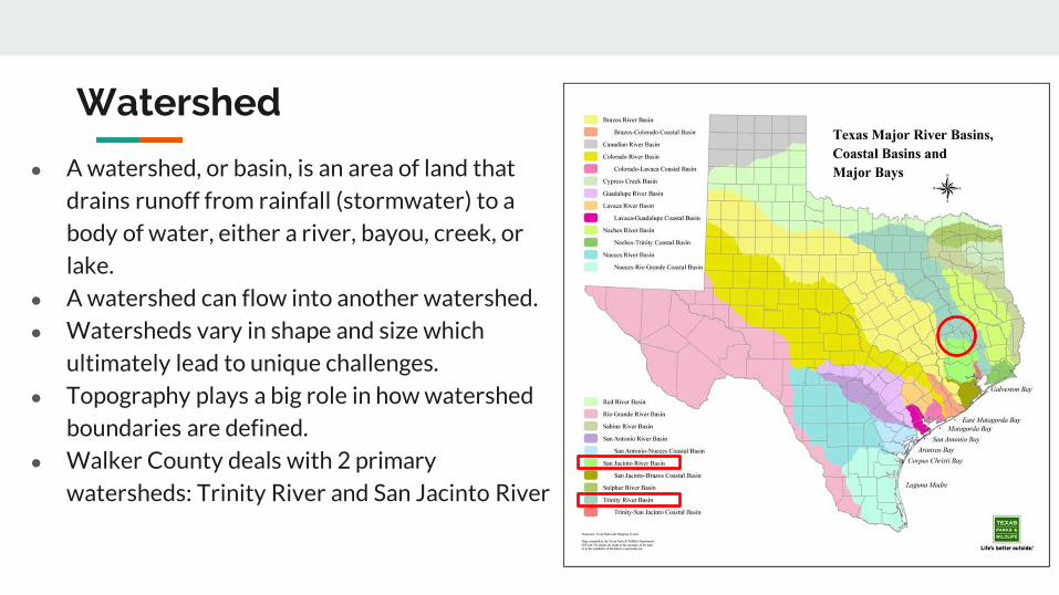
Watershed
A watershed or basin is an area of land that
drains runoff from rainfall (stormwater) to a
body of water either a river bayou creek or
lake
A watershed can flow into another watershed
Watersheds vary in shape and size which
ultimately lead to unique challenges
Topography plays a big role in how watershed
boundaries are defined
Walker County deals with 2 primary
watersheds Trinity River and San Jacinto River
Snowpack
- Water Supply
Hill Country Hydrology
- Flash Flood threats
- Rapid River responses
- Cycles of FloodDrought
Forest Hydrology
- Slower River responses
Diverse Watershed Characteristics in Texas
Watershed
Bedias Creek
near
Madisonville
Trinity River
at Riverside
A watershed or basin is an area of land that
drains runoff from rainfall (stormwater) to a
body of water either a river bayou creek or
lake
A watershed can flow into another watershed
Watersheds vary in shape and size which
ultimately lead to unique challenges
Topography plays a big role in how watershed
boundaries are defined
Walker County deals with 2 primary
watersheds Trinity River and San Jacinto River
NWS issues river forecasts for 2 sites in Walker
County
Trinity River Basin Over View
bull Nearly 18000 square
miles
bull More water storage than
any other river system in
Texas
Basin Facts
Basin Facts
20 reservoirs ranging
from 1000 to 83000
acresbull 12 Water Conservation
bull 8 Flood Control
Basic Components of a Dam
Flood Control Reservoir
Flood Control Reservoir
bull Built to regulate flood waters
bull Examples
1 Lake Grapevine
bull Storage-535 MSL
bull Flood Pool-560 MSL
bull Surcharge-582 MSL
2 Lake Lewisville
bull Storage-522 MSL
bull Flood Pool-532 MSL
bull Surcharge-552 MSL
Water Conservation Reservoir
Water Supply Reservoir
bull Designed to stay near full
bull Have very limited capacity
to capture storm inflows
bull Designed to pass inflows
from storms (with some
reduction in peak flow)
bull Structurally the gates must
open gradually as lake
rises
bull Still reduces flooding
downstream
Lake Livingston
WATER CONSERVATION RESERVOIR is responsible for
the safe storage of water and providing drinking water to
more than two million southeast Texans
o83000 surface acres
o1750000 acre feet
oMore than 350000 CFS spillway discharge capacity
oConservation Pool ndash 131 MSL
oFlowage Easement ndash135 to 140 MSL
bull Manage outflow in order to mimic river flows
bull Calculate releases adequate to keep pace with increasing
inflows without causing sudden surges and without
exceeding computed inflows until the peak inflow has
been reached
bull Once reservoir elevation has peaked excess inflow will
be released from surcharge storage in an orderly fashion
to reduce pool to conservation pool of 131 MSL
Gate Operations
Lake Livingston Emergency
Action Plan
bull Implemented at discharge of 20000 cubic feetsecond
(CFS)
bull Who do we contact
Emergency Management Coordinator for Walker Polk
San Jacinto Trinity Liberty and Chambers counties
NWS and WGRFC
DPS-Lufkin
Liberty radio
bull Methods of notification
Phone
Hydrology and History of the
Trinity River
Trinity River Travel Times
bull Travel times are tofrom
Lake Livingston
Historic Flood Stages at Riverside
RANK YEAR STAGE
1 1942 14261
2 1945 14169
3 1957 13961
4 1908 13956
1968 GATES AT DAM CLOSED
5 1990 13908
Riverside 1942
No Two Floods Are The Same
bull What part of the watershed is the flood event originating
bull Rain event in Dallas
bull Local Rain
bull How much of the watershed was covered by precipitation
bull What are the current conditions
Flood SafetyWhat to do before during and after a flood
bull Prepare a family disaster planbull Check if your insurance covers flood damages If not get flood insurancebull Keep insurance and other important documents such as copies of drivers
licenses and credit cards and other valuable items in a safe deposit boxbull Assemble a disaster supplies kit Be sure to include prescription medications
food and waterbull Find out where you can go if ordered to evacuatebull Arrange to keep in contact with relatives and friendsbull Know your resources
Knowing what to do when a flood occurs will increase your familyrsquos safety and
possibly its survival weathergovflood
Safety Before a Flood
bull Turn around donrsquot drown when encountering flooded roads
bull Be especially cautious at night when it is harder to recognize the dangers
of flooding
bull Stay away or be swept away River banks and culverts can become
unstable and unsafe
bull You should monitor the latest forecasts and be prepared to take action
should additional Flash Flood Warnings be issuedbull Have multiple ways to receive weather information (cell phone NOAA
weather radio television etc)
Safety During a Flash Flood
bull Most flood deaths occur in vehiclesbull It only takes six inches of water for a
vehicle to lose contact with the road surface
bull Most vehicles can be swept away in just 18 to 24 inches of water
bull Donrsquot Rely on Your Big Vehiclesbull Flooded roads may have hidden
dangers such as washed out road beds or underwater obstructions
bull If your vehicle is caught in rising water leave it immediately and seek higher ground
Minnesota road damaged by flood waters courtesy of FEMA
Turn Around Donrsquot Drown
bull Have multiple ways to receive weather information (cell phone NOAA weather radio television etc)
bull Do not sightsee bull Evacuations are ongoing and first responders are
working hard to get people to safety Do not get in their way
bull Flood waters from creeks bayous and rivers will be swiftly moving Do not go near the flood watersThey will sweep you away if you go in the water
bull Roads may still be closed as they could be damaged or still under water Barricades are for your protection do not drive around them
Safety During a Flood
bull Stay out of the flood waters
bull Floodwaters can contain chemicals sewage disease and animals
bull Unseen underwater debris can be sharp and cause injury
bull Downed power lines under the water could lead to death or injury from
electrocution
bull Water depth can change unexpectedly (storm drains washed-out roads)
Safety During a Flood
bull Donrsquot put yourself in danger
bull Return home only when authorities indicate it is safe
bull Stay away from damaged areas unless your assistance
has been specifically requested by police fire or a
relief organization
bull Use extreme caution when entering buildings there
may be hidden damage particularly in foundations
Safety After a Flood
weathergovflood
bull Donrsquot leave lit candles unattended
bull Cut power to flooded areas of your home
bull Only use generators in well-ventilated areasmdashnever
in a closed garage
bull Take breaks and drink plenty of fluids
bull Do not use power tools while standing in water
bull If you smell or hear gas call the Fire Department
weathergovflood
Safety After a Flood
ReportingWrap Up
Flash Flooding
Underpasses filling with water
Impassible roadways
Any fast-moving water greater than 6
inches in depth
Any River or Bayou Flooding
Flooding Washington County (2016)
What to Report
Reports should include the following information
WHO is calling
WHERE the flooding is located
WHAT type of flooding is occurring (flash river or bayou)
WHEN the flooding occurred (is it ongoing)
HOW deep is the water (if you can safely evaluate this)
Formatting Reports
The Good
ldquoIrsquom a storm spotter located in Sealy at the intersection of Meyer and FM 2187 Water is
flowing over curbs itrsquos at least 6-8 inches deep in some locations on the roadrdquo
The Bad
ldquoHey we got some flooding here a few minutes agordquo
The Ugly
ldquoMy sister-in-law said the bayou got really closer to her house did you have a warning out
for thatrdquo
Call us
Spotter line 1-800-846-1828
Report via amateur radio
Call sign WX5HGX
sr-hgxnwsnoaagov
Social Media
Twitter NWSHouston
Facebook NWSHouston Spotter TipSet up SKYWARN as a contact
in your smartphone
How to Report
CoCoRaHSldquoBecause every drop countsrdquo
National
CoCoRaHSorg
State
Measure amp Report Daily Rainfall on
Interactive Web site wwwcocorahsorg
Flood Risk
FloodWarn Workshop
Topics
bull NFIP ndash National Flood Insurance Program
bull What is Flood Risk
bull Flood Hazard Mapping and FIRMs
Flood Insurance
Everyone is at risk for floodingbull For most events 26 of NFIP
claims are outside the SHFA
A few inches can cause tens of thousands in damage
If you mortgage company ldquoforcedrdquo you to buy flood insurance check that structure and CONTENTS are covered Most cover structure only
A tool for individuals to manage
risk
What is the NFIP definition of A Flood Defined
Inundation of 2 or more acres of normally dry land or of two or more properties (one of which is your property) from
Overflow of inland or tidal waters
Unusual rapid accumulation or runoff of surface waters from any source
Mudflow or
Collapse or sinking of land along the shore of a lake or similar body of water as a result of erosion or undermining caused by waves or currents of water exceeding anticipated levels that result in a flood
NFIP Flood Insurance Coverages
Structure Coveragebull Replacement Cost on single-family primary residence (structure) if insured to at least
80 of replacement cost
bull Max coverage $250000
Contents coveragebull Contents is an optional addition except for Preferred Risk Policy bull Max coverage $100000 coverage for Actual Cash Value (depreciation applies)
Wait Periodbull Typically - 30-days from purchase until effectivebull Exceptions
o Flood Insurance required by a federally regulated and insured lendermdash0 dayso Wildfire 30-day waiting period exceptionmdash0 dayso Initial purchase of flood insurance as the result of a map revisionmdash1 day
Misconception Homeowners Insurance is Enough
Misconception
ldquoIrsquom already coveredmdashmy homeowners policy covers floodingrdquo
FactMost insurance policies do not cover flooding only flood insurance covers flood damage
Renters and Business owners should also consider flood insurance for contents
Group Flood Insurance Policy (GFIP)
IF in the 1 risk area (100yr floodplain)
AND received FEMA Individual Assistance(IA)
A GFIP policy was purchased
(if they did not have flood insurance)
GFIP is a 3 yr abridged Flood Insurance Policy The
policy is paid for from the IA funds
You can purchase the standard NFIP policy to increase
your coverage (GFIP cancels)
Group Flood Insurance Policy (GFIP)
Requirement - property owner MUST purchase and maintain
a traditional NFIP policy when GFIP expires
If nothellipthey are not eligible for IA that would cover the replacement of real
or personal property for the damaged location with a future event
The insurance requirement is forever ndash including new homeowners
Flood Risk
Any situation involving exposure to a Flood danger harm or loss
ldquoWhile levees can help reduce flood riskhellipthey do not eliminate the riskrdquo
What is a FIRM
Flood Insurance RateMap
Identifies the Special Flood Hazard Area (SFHA) and Non-SFHArsquos
Used for rating flood insurance policies
Mandatory purchase requirement if property is in SHFA AND is a federally backed mortgage
FIRMrsquos show Coastal and Riverine flood risk
Find your zone at httpsmscfemagovportal
Zones on a FIRM
SFHA (high risk) bull A AE AO AH VE V etc
(Aqua)o 1 annual chance
floodo 26 chance of
flooding in a 30-yr mortgage
Non-SFHA (low to moderate risk)
bull B C and X (Shaded ndash orange or gray color amp non-Shaded)
o OrangeGray area ndashoutlines areas protected by Levees
o Even the non-shaded is a flood zone ndash a minimal risk
What is a Flood Zone
Flood Hazard Mapping
The maps are NOT a prediction or forecast
Flood waters are not confined to the at the 1 risk line (aka 100yr flood) on the FIRM
FIRMs are subdivided by panels to cover a jurisdictional boundary (each has a unique panel number)
bull Each panel has a specific code and effective date
bull FIRMs are a single snapshot for one scenario
Flood Hazard Mapping
Assumptions are made in the river modelingbull Precipitation input the 100 year24 hr design storm (actual events rain
intensities vary - not consistent rate over a 24 hr period)
bull Assumptions about the vegetation in the flood plain ndash do NOT differentiate dead vs growing vegetation (increased friction during growing season)
bull Snapshot of land use when the models were developed ndash a challenge in rapidly developing areas
One event is never the same as another FIRMs will not exactly match an individual event
Flood Hazard Mapping
Misconception Only 100yr Floodplain is at Risk
Misconception
ldquoI donrsquot live in a flood zonerdquo
Facts
bull Floods are the 1 natural disaster in the United States
bull If it can rain it can flood
bull FIRMs do not show localized flooding from drainage ditchessewersroad ponding
bull To some degree overland floodinghellipbut not property to property drainage problems
Cost of Flood Damage
Structure Elevation Impact Insurance Rates
The elevation is just one factor others include when was the
structure has it flooded in the past etc
Lower Risk = $ High Risk =
$$$
Medium Risk =
$$
EVERY Structure has a riskhellipgenerally the higher the structure the less the risk
Harvey Numbers
Insurance claims Harris Co (includes cities such as
Houston) ndash all claims 55570
Walker County (unincorporated only) ndash 1 (Losses over 125K)
Harris County Numbersbull 154170 Homes 48850 in 1 Risk
Area (100-yr) bull 34970 in 02 (500-yr) floodplainbull 68 OUTSIDE of the 1 Risk Area
Data HCFCD Finale Hurricane Harvey Storm and Flood Information ndash
httpswwwhcfcdorgmedia2678immediate-flood-report-final-hurricane-harvey-2017pdf
New GFIPrsquos Due to Harvey
Walker County ndash6
Summary
Living in Texas means we have a flood risk even with heavy rain
bull Tax Day 2016 and Memorial Day 2015 ndash not with a tropical system
Flood Risk is from multiple sources bull FIRMs focus on river flooding and some overland flow
Flood insurance allows individual property owners to manage their risk
bull Buy policies that cover the structure AND contents
Angela Harrison InsuranceCell 470-557-2794 | AngelaHarrisonfemadhsgov
Yho-Meka Conway Insurance Cell 470-572-0803 | Yho-MekaConwayfemadhsgov
Lauren Schmied PE Floodplain ManagementCell 202-812-6164 | LaurenSchmiedfemadhsgov
Larry Fordham ANFI CFM ACAActing Senior Regional Insurance Specialist FEMA Region 6Phone 940-383-7253 | Cell 202-394-4483 |LarryFordhamfemadhsgov
NFIP Hotline
1-800-427-4661
wwwfemagovnfip
Contact Information
QuestionsNational Weather Service
FEMA
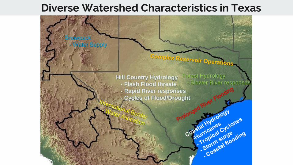
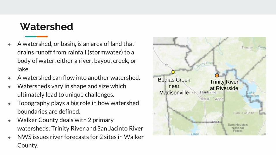
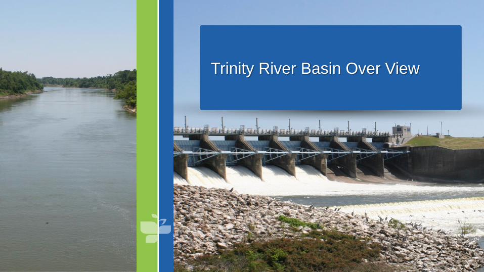
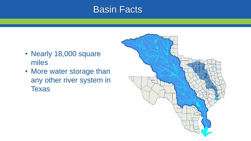
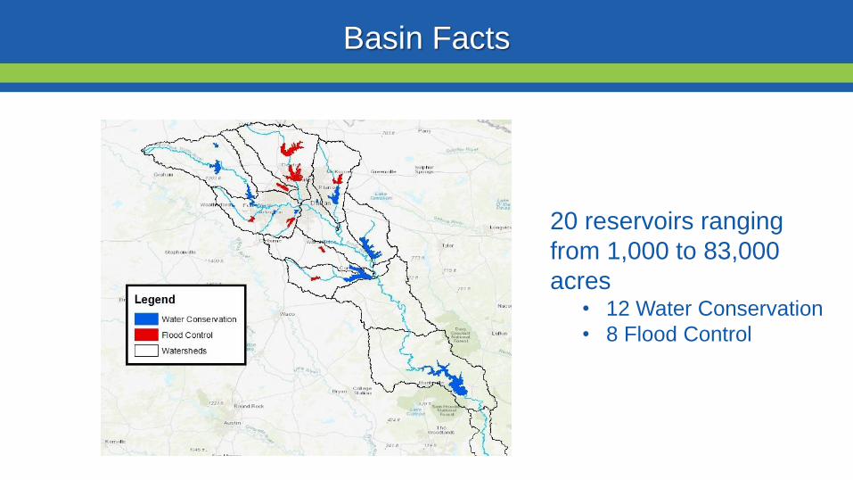

Flood Control Reservoir
Flood Control Reservoir
bull Built to regulate flood waters
bull Examples
1 Lake Grapevine
bull Storage-535 MSL
bull Flood Pool-560 MSL
bull Surcharge-582 MSL
2 Lake Lewisville
bull Storage-522 MSL
bull Flood Pool-532 MSL
bull Surcharge-552 MSL
Water Conservation Reservoir
Water Supply Reservoir
bull Designed to stay near full
bull Have very limited capacity
to capture storm inflows
bull Designed to pass inflows
from storms (with some
reduction in peak flow)
bull Structurally the gates must
open gradually as lake
rises
bull Still reduces flooding
downstream
Lake Livingston
WATER CONSERVATION RESERVOIR is responsible for
the safe storage of water and providing drinking water to
more than two million southeast Texans
o83000 surface acres
o1750000 acre feet
oMore than 350000 CFS spillway discharge capacity
oConservation Pool ndash 131 MSL
oFlowage Easement ndash135 to 140 MSL
bull Manage outflow in order to mimic river flows
bull Calculate releases adequate to keep pace with increasing
inflows without causing sudden surges and without
exceeding computed inflows until the peak inflow has
been reached
bull Once reservoir elevation has peaked excess inflow will
be released from surcharge storage in an orderly fashion
to reduce pool to conservation pool of 131 MSL
Gate Operations
Lake Livingston Emergency
Action Plan
bull Implemented at discharge of 20000 cubic feetsecond
(CFS)
bull Who do we contact
Emergency Management Coordinator for Walker Polk
San Jacinto Trinity Liberty and Chambers counties
NWS and WGRFC
DPS-Lufkin
Liberty radio
bull Methods of notification
Phone
Hydrology and History of the
Trinity River
Trinity River Travel Times
bull Travel times are tofrom
Lake Livingston
Historic Flood Stages at Riverside
RANK YEAR STAGE
1 1942 14261
2 1945 14169
3 1957 13961
4 1908 13956
1968 GATES AT DAM CLOSED
5 1990 13908
Riverside 1942
No Two Floods Are The Same
bull What part of the watershed is the flood event originating
bull Rain event in Dallas
bull Local Rain
bull How much of the watershed was covered by precipitation
bull What are the current conditions
Flood SafetyWhat to do before during and after a flood
bull Prepare a family disaster planbull Check if your insurance covers flood damages If not get flood insurancebull Keep insurance and other important documents such as copies of drivers
licenses and credit cards and other valuable items in a safe deposit boxbull Assemble a disaster supplies kit Be sure to include prescription medications
food and waterbull Find out where you can go if ordered to evacuatebull Arrange to keep in contact with relatives and friendsbull Know your resources
Knowing what to do when a flood occurs will increase your familyrsquos safety and
possibly its survival weathergovflood
Safety Before a Flood
bull Turn around donrsquot drown when encountering flooded roads
bull Be especially cautious at night when it is harder to recognize the dangers
of flooding
bull Stay away or be swept away River banks and culverts can become
unstable and unsafe
bull You should monitor the latest forecasts and be prepared to take action
should additional Flash Flood Warnings be issuedbull Have multiple ways to receive weather information (cell phone NOAA
weather radio television etc)
Safety During a Flash Flood
bull Most flood deaths occur in vehiclesbull It only takes six inches of water for a
vehicle to lose contact with the road surface
bull Most vehicles can be swept away in just 18 to 24 inches of water
bull Donrsquot Rely on Your Big Vehiclesbull Flooded roads may have hidden
dangers such as washed out road beds or underwater obstructions
bull If your vehicle is caught in rising water leave it immediately and seek higher ground
Minnesota road damaged by flood waters courtesy of FEMA
Turn Around Donrsquot Drown
bull Have multiple ways to receive weather information (cell phone NOAA weather radio television etc)
bull Do not sightsee bull Evacuations are ongoing and first responders are
working hard to get people to safety Do not get in their way
bull Flood waters from creeks bayous and rivers will be swiftly moving Do not go near the flood watersThey will sweep you away if you go in the water
bull Roads may still be closed as they could be damaged or still under water Barricades are for your protection do not drive around them
Safety During a Flood
bull Stay out of the flood waters
bull Floodwaters can contain chemicals sewage disease and animals
bull Unseen underwater debris can be sharp and cause injury
bull Downed power lines under the water could lead to death or injury from
electrocution
bull Water depth can change unexpectedly (storm drains washed-out roads)
Safety During a Flood
bull Donrsquot put yourself in danger
bull Return home only when authorities indicate it is safe
bull Stay away from damaged areas unless your assistance
has been specifically requested by police fire or a
relief organization
bull Use extreme caution when entering buildings there
may be hidden damage particularly in foundations
Safety After a Flood
weathergovflood
bull Donrsquot leave lit candles unattended
bull Cut power to flooded areas of your home
bull Only use generators in well-ventilated areasmdashnever
in a closed garage
bull Take breaks and drink plenty of fluids
bull Do not use power tools while standing in water
bull If you smell or hear gas call the Fire Department
weathergovflood
Safety After a Flood
ReportingWrap Up
Flash Flooding
Underpasses filling with water
Impassible roadways
Any fast-moving water greater than 6
inches in depth
Any River or Bayou Flooding
Flooding Washington County (2016)
What to Report
Reports should include the following information
WHO is calling
WHERE the flooding is located
WHAT type of flooding is occurring (flash river or bayou)
WHEN the flooding occurred (is it ongoing)
HOW deep is the water (if you can safely evaluate this)
Formatting Reports
The Good
ldquoIrsquom a storm spotter located in Sealy at the intersection of Meyer and FM 2187 Water is
flowing over curbs itrsquos at least 6-8 inches deep in some locations on the roadrdquo
The Bad
ldquoHey we got some flooding here a few minutes agordquo
The Ugly
ldquoMy sister-in-law said the bayou got really closer to her house did you have a warning out
for thatrdquo
Call us
Spotter line 1-800-846-1828
Report via amateur radio
Call sign WX5HGX
sr-hgxnwsnoaagov
Social Media
Twitter NWSHouston
Facebook NWSHouston Spotter TipSet up SKYWARN as a contact
in your smartphone
How to Report
CoCoRaHSldquoBecause every drop countsrdquo
National
CoCoRaHSorg
State
Measure amp Report Daily Rainfall on
Interactive Web site wwwcocorahsorg
Flood Risk
FloodWarn Workshop
Topics
bull NFIP ndash National Flood Insurance Program
bull What is Flood Risk
bull Flood Hazard Mapping and FIRMs
Flood Insurance
Everyone is at risk for floodingbull For most events 26 of NFIP
claims are outside the SHFA
A few inches can cause tens of thousands in damage
If you mortgage company ldquoforcedrdquo you to buy flood insurance check that structure and CONTENTS are covered Most cover structure only
A tool for individuals to manage
risk
What is the NFIP definition of A Flood Defined
Inundation of 2 or more acres of normally dry land or of two or more properties (one of which is your property) from
Overflow of inland or tidal waters
Unusual rapid accumulation or runoff of surface waters from any source
Mudflow or
Collapse or sinking of land along the shore of a lake or similar body of water as a result of erosion or undermining caused by waves or currents of water exceeding anticipated levels that result in a flood
NFIP Flood Insurance Coverages
Structure Coveragebull Replacement Cost on single-family primary residence (structure) if insured to at least
80 of replacement cost
bull Max coverage $250000
Contents coveragebull Contents is an optional addition except for Preferred Risk Policy bull Max coverage $100000 coverage for Actual Cash Value (depreciation applies)
Wait Periodbull Typically - 30-days from purchase until effectivebull Exceptions
o Flood Insurance required by a federally regulated and insured lendermdash0 dayso Wildfire 30-day waiting period exceptionmdash0 dayso Initial purchase of flood insurance as the result of a map revisionmdash1 day
Misconception Homeowners Insurance is Enough
Misconception
ldquoIrsquom already coveredmdashmy homeowners policy covers floodingrdquo
FactMost insurance policies do not cover flooding only flood insurance covers flood damage
Renters and Business owners should also consider flood insurance for contents
Group Flood Insurance Policy (GFIP)
IF in the 1 risk area (100yr floodplain)
AND received FEMA Individual Assistance(IA)
A GFIP policy was purchased
(if they did not have flood insurance)
GFIP is a 3 yr abridged Flood Insurance Policy The
policy is paid for from the IA funds
You can purchase the standard NFIP policy to increase
your coverage (GFIP cancels)
Group Flood Insurance Policy (GFIP)
Requirement - property owner MUST purchase and maintain
a traditional NFIP policy when GFIP expires
If nothellipthey are not eligible for IA that would cover the replacement of real
or personal property for the damaged location with a future event
The insurance requirement is forever ndash including new homeowners
Flood Risk
Any situation involving exposure to a Flood danger harm or loss
ldquoWhile levees can help reduce flood riskhellipthey do not eliminate the riskrdquo
What is a FIRM
Flood Insurance RateMap
Identifies the Special Flood Hazard Area (SFHA) and Non-SFHArsquos
Used for rating flood insurance policies
Mandatory purchase requirement if property is in SHFA AND is a federally backed mortgage
FIRMrsquos show Coastal and Riverine flood risk
Find your zone at httpsmscfemagovportal
Zones on a FIRM
SFHA (high risk) bull A AE AO AH VE V etc
(Aqua)o 1 annual chance
floodo 26 chance of
flooding in a 30-yr mortgage
Non-SFHA (low to moderate risk)
bull B C and X (Shaded ndash orange or gray color amp non-Shaded)
o OrangeGray area ndashoutlines areas protected by Levees
o Even the non-shaded is a flood zone ndash a minimal risk
What is a Flood Zone
Flood Hazard Mapping
The maps are NOT a prediction or forecast
Flood waters are not confined to the at the 1 risk line (aka 100yr flood) on the FIRM
FIRMs are subdivided by panels to cover a jurisdictional boundary (each has a unique panel number)
bull Each panel has a specific code and effective date
bull FIRMs are a single snapshot for one scenario
Flood Hazard Mapping
Assumptions are made in the river modelingbull Precipitation input the 100 year24 hr design storm (actual events rain
intensities vary - not consistent rate over a 24 hr period)
bull Assumptions about the vegetation in the flood plain ndash do NOT differentiate dead vs growing vegetation (increased friction during growing season)
bull Snapshot of land use when the models were developed ndash a challenge in rapidly developing areas
One event is never the same as another FIRMs will not exactly match an individual event
Flood Hazard Mapping
Misconception Only 100yr Floodplain is at Risk
Misconception
ldquoI donrsquot live in a flood zonerdquo
Facts
bull Floods are the 1 natural disaster in the United States
bull If it can rain it can flood
bull FIRMs do not show localized flooding from drainage ditchessewersroad ponding
bull To some degree overland floodinghellipbut not property to property drainage problems
Cost of Flood Damage
Structure Elevation Impact Insurance Rates
The elevation is just one factor others include when was the
structure has it flooded in the past etc
Lower Risk = $ High Risk =
$$$
Medium Risk =
$$
EVERY Structure has a riskhellipgenerally the higher the structure the less the risk
Harvey Numbers
Insurance claims Harris Co (includes cities such as
Houston) ndash all claims 55570
Walker County (unincorporated only) ndash 1 (Losses over 125K)
Harris County Numbersbull 154170 Homes 48850 in 1 Risk
Area (100-yr) bull 34970 in 02 (500-yr) floodplainbull 68 OUTSIDE of the 1 Risk Area
Data HCFCD Finale Hurricane Harvey Storm and Flood Information ndash
httpswwwhcfcdorgmedia2678immediate-flood-report-final-hurricane-harvey-2017pdf
New GFIPrsquos Due to Harvey
Walker County ndash6
Summary
Living in Texas means we have a flood risk even with heavy rain
bull Tax Day 2016 and Memorial Day 2015 ndash not with a tropical system
Flood Risk is from multiple sources bull FIRMs focus on river flooding and some overland flow
Flood insurance allows individual property owners to manage their risk
bull Buy policies that cover the structure AND contents
Angela Harrison InsuranceCell 470-557-2794 | AngelaHarrisonfemadhsgov
Yho-Meka Conway Insurance Cell 470-572-0803 | Yho-MekaConwayfemadhsgov
Lauren Schmied PE Floodplain ManagementCell 202-812-6164 | LaurenSchmiedfemadhsgov
Larry Fordham ANFI CFM ACAActing Senior Regional Insurance Specialist FEMA Region 6Phone 940-383-7253 | Cell 202-394-4483 |LarryFordhamfemadhsgov
NFIP Hotline
1-800-427-4661
wwwfemagovnfip
Contact Information
QuestionsNational Weather Service
FEMA
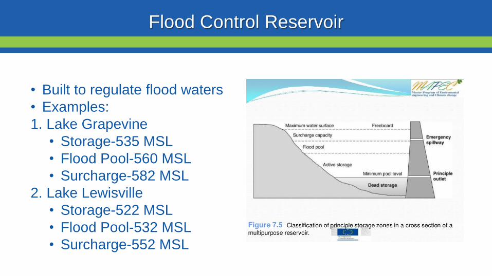
Flood Control Reservoir
bull Built to regulate flood waters
bull Examples
1 Lake Grapevine
bull Storage-535 MSL
bull Flood Pool-560 MSL
bull Surcharge-582 MSL
2 Lake Lewisville
bull Storage-522 MSL
bull Flood Pool-532 MSL
bull Surcharge-552 MSL
Water Conservation Reservoir
Water Supply Reservoir
bull Designed to stay near full
bull Have very limited capacity
to capture storm inflows
bull Designed to pass inflows
from storms (with some
reduction in peak flow)
bull Structurally the gates must
open gradually as lake
rises
bull Still reduces flooding
downstream
Lake Livingston
WATER CONSERVATION RESERVOIR is responsible for
the safe storage of water and providing drinking water to
more than two million southeast Texans
o83000 surface acres
o1750000 acre feet
oMore than 350000 CFS spillway discharge capacity
oConservation Pool ndash 131 MSL
oFlowage Easement ndash135 to 140 MSL
bull Manage outflow in order to mimic river flows
bull Calculate releases adequate to keep pace with increasing
inflows without causing sudden surges and without
exceeding computed inflows until the peak inflow has
been reached
bull Once reservoir elevation has peaked excess inflow will
be released from surcharge storage in an orderly fashion
to reduce pool to conservation pool of 131 MSL
Gate Operations
Lake Livingston Emergency
Action Plan
bull Implemented at discharge of 20000 cubic feetsecond
(CFS)
bull Who do we contact
Emergency Management Coordinator for Walker Polk
San Jacinto Trinity Liberty and Chambers counties
NWS and WGRFC
DPS-Lufkin
Liberty radio
bull Methods of notification
Phone
Hydrology and History of the
Trinity River
Trinity River Travel Times
bull Travel times are tofrom
Lake Livingston
Historic Flood Stages at Riverside
RANK YEAR STAGE
1 1942 14261
2 1945 14169
3 1957 13961
4 1908 13956
1968 GATES AT DAM CLOSED
5 1990 13908
Riverside 1942
No Two Floods Are The Same
bull What part of the watershed is the flood event originating
bull Rain event in Dallas
bull Local Rain
bull How much of the watershed was covered by precipitation
bull What are the current conditions
Flood SafetyWhat to do before during and after a flood
bull Prepare a family disaster planbull Check if your insurance covers flood damages If not get flood insurancebull Keep insurance and other important documents such as copies of drivers
licenses and credit cards and other valuable items in a safe deposit boxbull Assemble a disaster supplies kit Be sure to include prescription medications
food and waterbull Find out where you can go if ordered to evacuatebull Arrange to keep in contact with relatives and friendsbull Know your resources
Knowing what to do when a flood occurs will increase your familyrsquos safety and
possibly its survival weathergovflood
Safety Before a Flood
bull Turn around donrsquot drown when encountering flooded roads
bull Be especially cautious at night when it is harder to recognize the dangers
of flooding
bull Stay away or be swept away River banks and culverts can become
unstable and unsafe
bull You should monitor the latest forecasts and be prepared to take action
should additional Flash Flood Warnings be issuedbull Have multiple ways to receive weather information (cell phone NOAA
weather radio television etc)
Safety During a Flash Flood
bull Most flood deaths occur in vehiclesbull It only takes six inches of water for a
vehicle to lose contact with the road surface
bull Most vehicles can be swept away in just 18 to 24 inches of water
bull Donrsquot Rely on Your Big Vehiclesbull Flooded roads may have hidden
dangers such as washed out road beds or underwater obstructions
bull If your vehicle is caught in rising water leave it immediately and seek higher ground
Minnesota road damaged by flood waters courtesy of FEMA
Turn Around Donrsquot Drown
bull Have multiple ways to receive weather information (cell phone NOAA weather radio television etc)
bull Do not sightsee bull Evacuations are ongoing and first responders are
working hard to get people to safety Do not get in their way
bull Flood waters from creeks bayous and rivers will be swiftly moving Do not go near the flood watersThey will sweep you away if you go in the water
bull Roads may still be closed as they could be damaged or still under water Barricades are for your protection do not drive around them
Safety During a Flood
bull Stay out of the flood waters
bull Floodwaters can contain chemicals sewage disease and animals
bull Unseen underwater debris can be sharp and cause injury
bull Downed power lines under the water could lead to death or injury from
electrocution
bull Water depth can change unexpectedly (storm drains washed-out roads)
Safety During a Flood
bull Donrsquot put yourself in danger
bull Return home only when authorities indicate it is safe
bull Stay away from damaged areas unless your assistance
has been specifically requested by police fire or a
relief organization
bull Use extreme caution when entering buildings there
may be hidden damage particularly in foundations
Safety After a Flood
weathergovflood
bull Donrsquot leave lit candles unattended
bull Cut power to flooded areas of your home
bull Only use generators in well-ventilated areasmdashnever
in a closed garage
bull Take breaks and drink plenty of fluids
bull Do not use power tools while standing in water
bull If you smell or hear gas call the Fire Department
weathergovflood
Safety After a Flood
ReportingWrap Up
Flash Flooding
Underpasses filling with water
Impassible roadways
Any fast-moving water greater than 6
inches in depth
Any River or Bayou Flooding
Flooding Washington County (2016)
What to Report
Reports should include the following information
WHO is calling
WHERE the flooding is located
WHAT type of flooding is occurring (flash river or bayou)
WHEN the flooding occurred (is it ongoing)
HOW deep is the water (if you can safely evaluate this)
Formatting Reports
The Good
ldquoIrsquom a storm spotter located in Sealy at the intersection of Meyer and FM 2187 Water is
flowing over curbs itrsquos at least 6-8 inches deep in some locations on the roadrdquo
The Bad
ldquoHey we got some flooding here a few minutes agordquo
The Ugly
ldquoMy sister-in-law said the bayou got really closer to her house did you have a warning out
for thatrdquo
Call us
Spotter line 1-800-846-1828
Report via amateur radio
Call sign WX5HGX
sr-hgxnwsnoaagov
Social Media
Twitter NWSHouston
Facebook NWSHouston Spotter TipSet up SKYWARN as a contact
in your smartphone
How to Report
CoCoRaHSldquoBecause every drop countsrdquo
National
CoCoRaHSorg
State
Measure amp Report Daily Rainfall on
Interactive Web site wwwcocorahsorg
Flood Risk
FloodWarn Workshop
Topics
bull NFIP ndash National Flood Insurance Program
bull What is Flood Risk
bull Flood Hazard Mapping and FIRMs
Flood Insurance
Everyone is at risk for floodingbull For most events 26 of NFIP
claims are outside the SHFA
A few inches can cause tens of thousands in damage
If you mortgage company ldquoforcedrdquo you to buy flood insurance check that structure and CONTENTS are covered Most cover structure only
A tool for individuals to manage
risk
What is the NFIP definition of A Flood Defined
Inundation of 2 or more acres of normally dry land or of two or more properties (one of which is your property) from
Overflow of inland or tidal waters
Unusual rapid accumulation or runoff of surface waters from any source
Mudflow or
Collapse or sinking of land along the shore of a lake or similar body of water as a result of erosion or undermining caused by waves or currents of water exceeding anticipated levels that result in a flood
NFIP Flood Insurance Coverages
Structure Coveragebull Replacement Cost on single-family primary residence (structure) if insured to at least
80 of replacement cost
bull Max coverage $250000
Contents coveragebull Contents is an optional addition except for Preferred Risk Policy bull Max coverage $100000 coverage for Actual Cash Value (depreciation applies)
Wait Periodbull Typically - 30-days from purchase until effectivebull Exceptions
o Flood Insurance required by a federally regulated and insured lendermdash0 dayso Wildfire 30-day waiting period exceptionmdash0 dayso Initial purchase of flood insurance as the result of a map revisionmdash1 day
Misconception Homeowners Insurance is Enough
Misconception
ldquoIrsquom already coveredmdashmy homeowners policy covers floodingrdquo
FactMost insurance policies do not cover flooding only flood insurance covers flood damage
Renters and Business owners should also consider flood insurance for contents
Group Flood Insurance Policy (GFIP)
IF in the 1 risk area (100yr floodplain)
AND received FEMA Individual Assistance(IA)
A GFIP policy was purchased
(if they did not have flood insurance)
GFIP is a 3 yr abridged Flood Insurance Policy The
policy is paid for from the IA funds
You can purchase the standard NFIP policy to increase
your coverage (GFIP cancels)
Group Flood Insurance Policy (GFIP)
Requirement - property owner MUST purchase and maintain
a traditional NFIP policy when GFIP expires
If nothellipthey are not eligible for IA that would cover the replacement of real
or personal property for the damaged location with a future event
The insurance requirement is forever ndash including new homeowners
Flood Risk
Any situation involving exposure to a Flood danger harm or loss
ldquoWhile levees can help reduce flood riskhellipthey do not eliminate the riskrdquo
What is a FIRM
Flood Insurance RateMap
Identifies the Special Flood Hazard Area (SFHA) and Non-SFHArsquos
Used for rating flood insurance policies
Mandatory purchase requirement if property is in SHFA AND is a federally backed mortgage
FIRMrsquos show Coastal and Riverine flood risk
Find your zone at httpsmscfemagovportal
Zones on a FIRM
SFHA (high risk) bull A AE AO AH VE V etc
(Aqua)o 1 annual chance
floodo 26 chance of
flooding in a 30-yr mortgage
Non-SFHA (low to moderate risk)
bull B C and X (Shaded ndash orange or gray color amp non-Shaded)
o OrangeGray area ndashoutlines areas protected by Levees
o Even the non-shaded is a flood zone ndash a minimal risk
What is a Flood Zone
Flood Hazard Mapping
The maps are NOT a prediction or forecast
Flood waters are not confined to the at the 1 risk line (aka 100yr flood) on the FIRM
FIRMs are subdivided by panels to cover a jurisdictional boundary (each has a unique panel number)
bull Each panel has a specific code and effective date
bull FIRMs are a single snapshot for one scenario
Flood Hazard Mapping
Assumptions are made in the river modelingbull Precipitation input the 100 year24 hr design storm (actual events rain
intensities vary - not consistent rate over a 24 hr period)
bull Assumptions about the vegetation in the flood plain ndash do NOT differentiate dead vs growing vegetation (increased friction during growing season)
bull Snapshot of land use when the models were developed ndash a challenge in rapidly developing areas
One event is never the same as another FIRMs will not exactly match an individual event
Flood Hazard Mapping
Misconception Only 100yr Floodplain is at Risk
Misconception
ldquoI donrsquot live in a flood zonerdquo
Facts
bull Floods are the 1 natural disaster in the United States
bull If it can rain it can flood
bull FIRMs do not show localized flooding from drainage ditchessewersroad ponding
bull To some degree overland floodinghellipbut not property to property drainage problems
Cost of Flood Damage
Structure Elevation Impact Insurance Rates
The elevation is just one factor others include when was the
structure has it flooded in the past etc
Lower Risk = $ High Risk =
$$$
Medium Risk =
$$
EVERY Structure has a riskhellipgenerally the higher the structure the less the risk
Harvey Numbers
Insurance claims Harris Co (includes cities such as
Houston) ndash all claims 55570
Walker County (unincorporated only) ndash 1 (Losses over 125K)
Harris County Numbersbull 154170 Homes 48850 in 1 Risk
Area (100-yr) bull 34970 in 02 (500-yr) floodplainbull 68 OUTSIDE of the 1 Risk Area
Data HCFCD Finale Hurricane Harvey Storm and Flood Information ndash
httpswwwhcfcdorgmedia2678immediate-flood-report-final-hurricane-harvey-2017pdf
New GFIPrsquos Due to Harvey
Walker County ndash6
Summary
Living in Texas means we have a flood risk even with heavy rain
bull Tax Day 2016 and Memorial Day 2015 ndash not with a tropical system
Flood Risk is from multiple sources bull FIRMs focus on river flooding and some overland flow
Flood insurance allows individual property owners to manage their risk
bull Buy policies that cover the structure AND contents
Angela Harrison InsuranceCell 470-557-2794 | AngelaHarrisonfemadhsgov
Yho-Meka Conway Insurance Cell 470-572-0803 | Yho-MekaConwayfemadhsgov
Lauren Schmied PE Floodplain ManagementCell 202-812-6164 | LaurenSchmiedfemadhsgov
Larry Fordham ANFI CFM ACAActing Senior Regional Insurance Specialist FEMA Region 6Phone 940-383-7253 | Cell 202-394-4483 |LarryFordhamfemadhsgov
NFIP Hotline
1-800-427-4661
wwwfemagovnfip
Contact Information
QuestionsNational Weather Service
FEMA
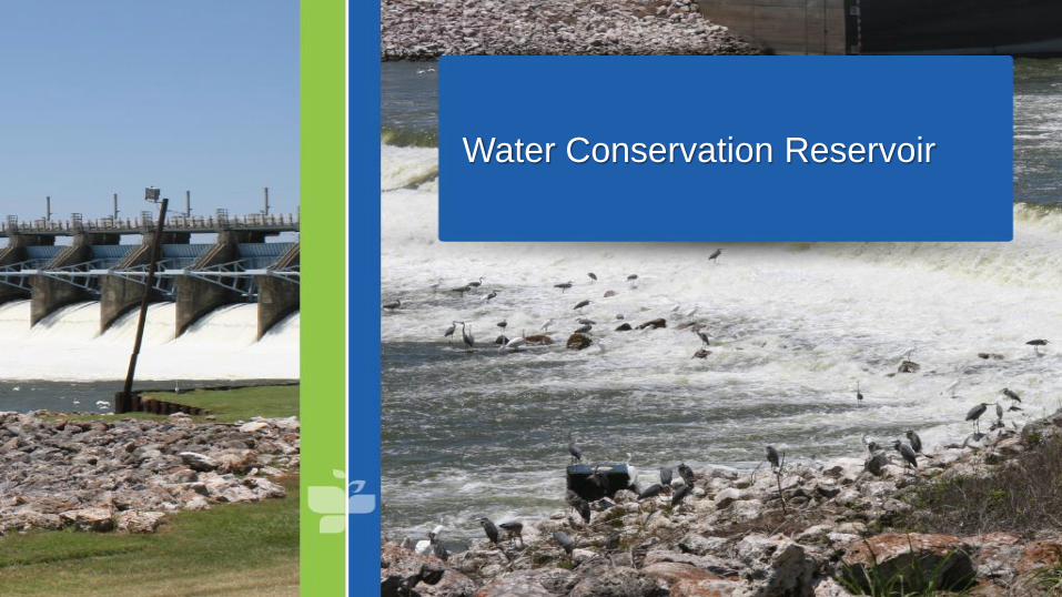
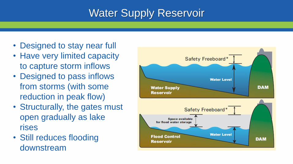
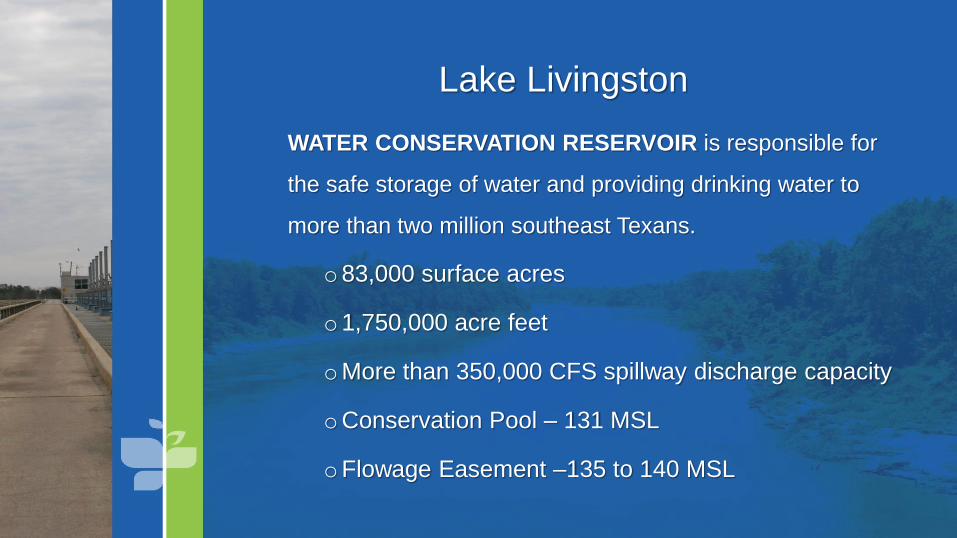
Lake Livingston
WATER CONSERVATION RESERVOIR is responsible for
the safe storage of water and providing drinking water to
more than two million southeast Texans
o83000 surface acres
o1750000 acre feet
oMore than 350000 CFS spillway discharge capacity
oConservation Pool ndash 131 MSL
oFlowage Easement ndash135 to 140 MSL
bull Manage outflow in order to mimic river flows
bull Calculate releases adequate to keep pace with increasing
inflows without causing sudden surges and without
exceeding computed inflows until the peak inflow has
been reached
bull Once reservoir elevation has peaked excess inflow will
be released from surcharge storage in an orderly fashion
to reduce pool to conservation pool of 131 MSL
Gate Operations
Lake Livingston Emergency
Action Plan
bull Implemented at discharge of 20000 cubic feetsecond
(CFS)
bull Who do we contact
Emergency Management Coordinator for Walker Polk
San Jacinto Trinity Liberty and Chambers counties
NWS and WGRFC
DPS-Lufkin
Liberty radio
bull Methods of notification
Phone
Hydrology and History of the
Trinity River
Trinity River Travel Times
bull Travel times are tofrom
Lake Livingston
Historic Flood Stages at Riverside
RANK YEAR STAGE
1 1942 14261
2 1945 14169
3 1957 13961
4 1908 13956
1968 GATES AT DAM CLOSED
5 1990 13908
Riverside 1942
No Two Floods Are The Same
bull What part of the watershed is the flood event originating
bull Rain event in Dallas
bull Local Rain
bull How much of the watershed was covered by precipitation
bull What are the current conditions
Flood SafetyWhat to do before during and after a flood
bull Prepare a family disaster planbull Check if your insurance covers flood damages If not get flood insurancebull Keep insurance and other important documents such as copies of drivers
licenses and credit cards and other valuable items in a safe deposit boxbull Assemble a disaster supplies kit Be sure to include prescription medications
food and waterbull Find out where you can go if ordered to evacuatebull Arrange to keep in contact with relatives and friendsbull Know your resources
Knowing what to do when a flood occurs will increase your familyrsquos safety and
possibly its survival weathergovflood
Safety Before a Flood
bull Turn around donrsquot drown when encountering flooded roads
bull Be especially cautious at night when it is harder to recognize the dangers
of flooding
bull Stay away or be swept away River banks and culverts can become
unstable and unsafe
bull You should monitor the latest forecasts and be prepared to take action
should additional Flash Flood Warnings be issuedbull Have multiple ways to receive weather information (cell phone NOAA
weather radio television etc)
Safety During a Flash Flood
bull Most flood deaths occur in vehiclesbull It only takes six inches of water for a
vehicle to lose contact with the road surface
bull Most vehicles can be swept away in just 18 to 24 inches of water
bull Donrsquot Rely on Your Big Vehiclesbull Flooded roads may have hidden
dangers such as washed out road beds or underwater obstructions
bull If your vehicle is caught in rising water leave it immediately and seek higher ground
Minnesota road damaged by flood waters courtesy of FEMA
Turn Around Donrsquot Drown
bull Have multiple ways to receive weather information (cell phone NOAA weather radio television etc)
bull Do not sightsee bull Evacuations are ongoing and first responders are
working hard to get people to safety Do not get in their way
bull Flood waters from creeks bayous and rivers will be swiftly moving Do not go near the flood watersThey will sweep you away if you go in the water
bull Roads may still be closed as they could be damaged or still under water Barricades are for your protection do not drive around them
Safety During a Flood
bull Stay out of the flood waters
bull Floodwaters can contain chemicals sewage disease and animals
bull Unseen underwater debris can be sharp and cause injury
bull Downed power lines under the water could lead to death or injury from
electrocution
bull Water depth can change unexpectedly (storm drains washed-out roads)
Safety During a Flood
bull Donrsquot put yourself in danger
bull Return home only when authorities indicate it is safe
bull Stay away from damaged areas unless your assistance
has been specifically requested by police fire or a
relief organization
bull Use extreme caution when entering buildings there
may be hidden damage particularly in foundations
Safety After a Flood
weathergovflood
bull Donrsquot leave lit candles unattended
bull Cut power to flooded areas of your home
bull Only use generators in well-ventilated areasmdashnever
in a closed garage
bull Take breaks and drink plenty of fluids
bull Do not use power tools while standing in water
bull If you smell or hear gas call the Fire Department
weathergovflood
Safety After a Flood
ReportingWrap Up
Flash Flooding
Underpasses filling with water
Impassible roadways
Any fast-moving water greater than 6
inches in depth
Any River or Bayou Flooding
Flooding Washington County (2016)
What to Report
Reports should include the following information
WHO is calling
WHERE the flooding is located
WHAT type of flooding is occurring (flash river or bayou)
WHEN the flooding occurred (is it ongoing)
HOW deep is the water (if you can safely evaluate this)
Formatting Reports
The Good
ldquoIrsquom a storm spotter located in Sealy at the intersection of Meyer and FM 2187 Water is
flowing over curbs itrsquos at least 6-8 inches deep in some locations on the roadrdquo
The Bad
ldquoHey we got some flooding here a few minutes agordquo
The Ugly
ldquoMy sister-in-law said the bayou got really closer to her house did you have a warning out
for thatrdquo
Call us
Spotter line 1-800-846-1828
Report via amateur radio
Call sign WX5HGX
sr-hgxnwsnoaagov
Social Media
Twitter NWSHouston
Facebook NWSHouston Spotter TipSet up SKYWARN as a contact
in your smartphone
How to Report
CoCoRaHSldquoBecause every drop countsrdquo
National
CoCoRaHSorg
State
Measure amp Report Daily Rainfall on
Interactive Web site wwwcocorahsorg
Flood Risk
FloodWarn Workshop
Topics
bull NFIP ndash National Flood Insurance Program
bull What is Flood Risk
bull Flood Hazard Mapping and FIRMs
Flood Insurance
Everyone is at risk for floodingbull For most events 26 of NFIP
claims are outside the SHFA
A few inches can cause tens of thousands in damage
If you mortgage company ldquoforcedrdquo you to buy flood insurance check that structure and CONTENTS are covered Most cover structure only
A tool for individuals to manage
risk
What is the NFIP definition of A Flood Defined
Inundation of 2 or more acres of normally dry land or of two or more properties (one of which is your property) from
Overflow of inland or tidal waters
Unusual rapid accumulation or runoff of surface waters from any source
Mudflow or
Collapse or sinking of land along the shore of a lake or similar body of water as a result of erosion or undermining caused by waves or currents of water exceeding anticipated levels that result in a flood
NFIP Flood Insurance Coverages
Structure Coveragebull Replacement Cost on single-family primary residence (structure) if insured to at least
80 of replacement cost
bull Max coverage $250000
Contents coveragebull Contents is an optional addition except for Preferred Risk Policy bull Max coverage $100000 coverage for Actual Cash Value (depreciation applies)
Wait Periodbull Typically - 30-days from purchase until effectivebull Exceptions
o Flood Insurance required by a federally regulated and insured lendermdash0 dayso Wildfire 30-day waiting period exceptionmdash0 dayso Initial purchase of flood insurance as the result of a map revisionmdash1 day
Misconception Homeowners Insurance is Enough
Misconception
ldquoIrsquom already coveredmdashmy homeowners policy covers floodingrdquo
FactMost insurance policies do not cover flooding only flood insurance covers flood damage
Renters and Business owners should also consider flood insurance for contents
Group Flood Insurance Policy (GFIP)
IF in the 1 risk area (100yr floodplain)
AND received FEMA Individual Assistance(IA)
A GFIP policy was purchased
(if they did not have flood insurance)
GFIP is a 3 yr abridged Flood Insurance Policy The
policy is paid for from the IA funds
You can purchase the standard NFIP policy to increase
your coverage (GFIP cancels)
Group Flood Insurance Policy (GFIP)
Requirement - property owner MUST purchase and maintain
a traditional NFIP policy when GFIP expires
If nothellipthey are not eligible for IA that would cover the replacement of real
or personal property for the damaged location with a future event
The insurance requirement is forever ndash including new homeowners
Flood Risk
Any situation involving exposure to a Flood danger harm or loss
ldquoWhile levees can help reduce flood riskhellipthey do not eliminate the riskrdquo
What is a FIRM
Flood Insurance RateMap
Identifies the Special Flood Hazard Area (SFHA) and Non-SFHArsquos
Used for rating flood insurance policies
Mandatory purchase requirement if property is in SHFA AND is a federally backed mortgage
FIRMrsquos show Coastal and Riverine flood risk
Find your zone at httpsmscfemagovportal
Zones on a FIRM
SFHA (high risk) bull A AE AO AH VE V etc
(Aqua)o 1 annual chance
floodo 26 chance of
flooding in a 30-yr mortgage
Non-SFHA (low to moderate risk)
bull B C and X (Shaded ndash orange or gray color amp non-Shaded)
o OrangeGray area ndashoutlines areas protected by Levees
o Even the non-shaded is a flood zone ndash a minimal risk
What is a Flood Zone
Flood Hazard Mapping
The maps are NOT a prediction or forecast
Flood waters are not confined to the at the 1 risk line (aka 100yr flood) on the FIRM
FIRMs are subdivided by panels to cover a jurisdictional boundary (each has a unique panel number)
bull Each panel has a specific code and effective date
bull FIRMs are a single snapshot for one scenario
Flood Hazard Mapping
Assumptions are made in the river modelingbull Precipitation input the 100 year24 hr design storm (actual events rain
intensities vary - not consistent rate over a 24 hr period)
bull Assumptions about the vegetation in the flood plain ndash do NOT differentiate dead vs growing vegetation (increased friction during growing season)
bull Snapshot of land use when the models were developed ndash a challenge in rapidly developing areas
One event is never the same as another FIRMs will not exactly match an individual event
Flood Hazard Mapping
Misconception Only 100yr Floodplain is at Risk
Misconception
ldquoI donrsquot live in a flood zonerdquo
Facts
bull Floods are the 1 natural disaster in the United States
bull If it can rain it can flood
bull FIRMs do not show localized flooding from drainage ditchessewersroad ponding
bull To some degree overland floodinghellipbut not property to property drainage problems
Cost of Flood Damage
Structure Elevation Impact Insurance Rates
The elevation is just one factor others include when was the
structure has it flooded in the past etc
Lower Risk = $ High Risk =
$$$
Medium Risk =
$$
EVERY Structure has a riskhellipgenerally the higher the structure the less the risk
Harvey Numbers
Insurance claims Harris Co (includes cities such as
Houston) ndash all claims 55570
Walker County (unincorporated only) ndash 1 (Losses over 125K)
Harris County Numbersbull 154170 Homes 48850 in 1 Risk
Area (100-yr) bull 34970 in 02 (500-yr) floodplainbull 68 OUTSIDE of the 1 Risk Area
Data HCFCD Finale Hurricane Harvey Storm and Flood Information ndash
httpswwwhcfcdorgmedia2678immediate-flood-report-final-hurricane-harvey-2017pdf
New GFIPrsquos Due to Harvey
Walker County ndash6
Summary
Living in Texas means we have a flood risk even with heavy rain
bull Tax Day 2016 and Memorial Day 2015 ndash not with a tropical system
Flood Risk is from multiple sources bull FIRMs focus on river flooding and some overland flow
Flood insurance allows individual property owners to manage their risk
bull Buy policies that cover the structure AND contents
Angela Harrison InsuranceCell 470-557-2794 | AngelaHarrisonfemadhsgov
Yho-Meka Conway Insurance Cell 470-572-0803 | Yho-MekaConwayfemadhsgov
Lauren Schmied PE Floodplain ManagementCell 202-812-6164 | LaurenSchmiedfemadhsgov
Larry Fordham ANFI CFM ACAActing Senior Regional Insurance Specialist FEMA Region 6Phone 940-383-7253 | Cell 202-394-4483 |LarryFordhamfemadhsgov
NFIP Hotline
1-800-427-4661
wwwfemagovnfip
Contact Information
QuestionsNational Weather Service
FEMA
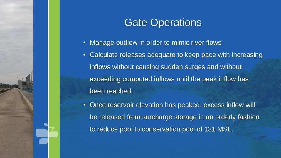
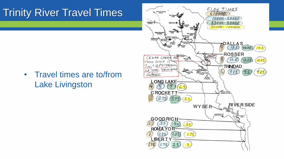
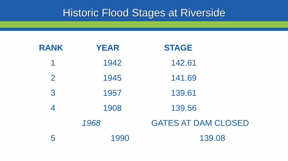
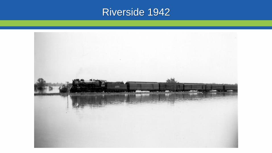
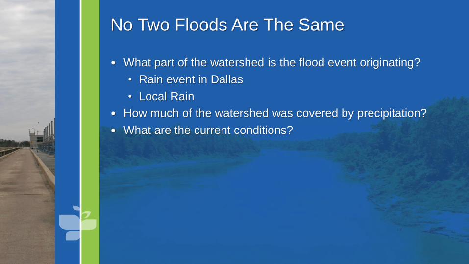
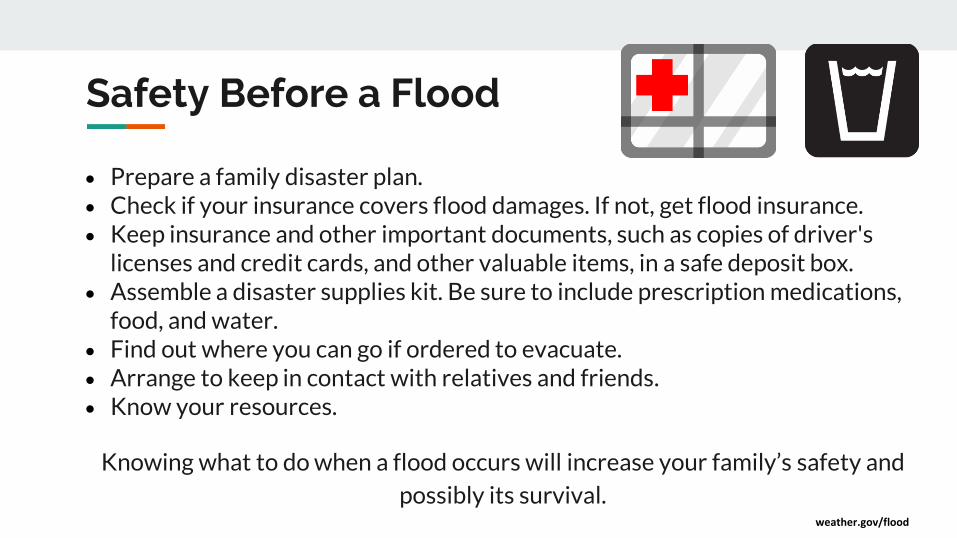
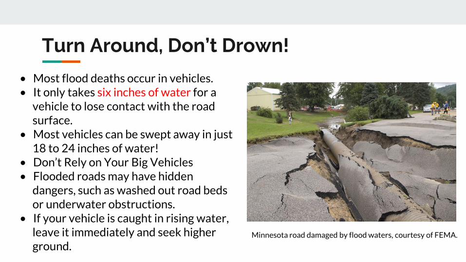
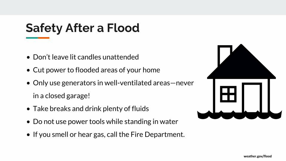
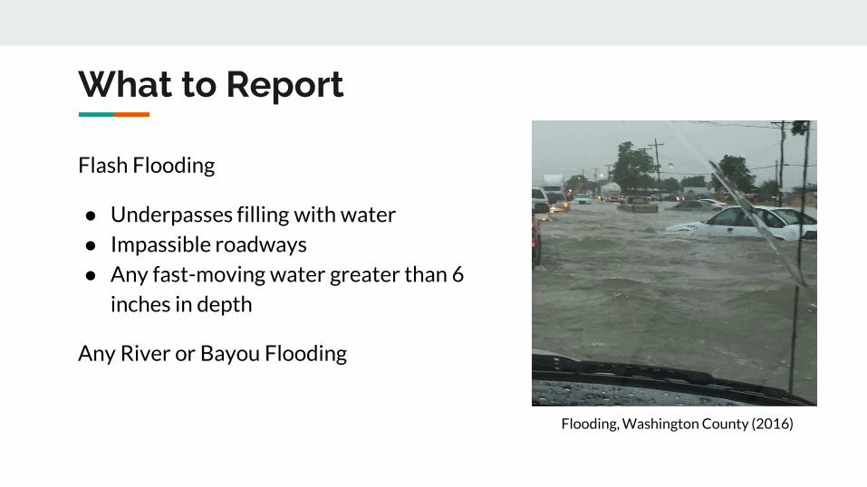
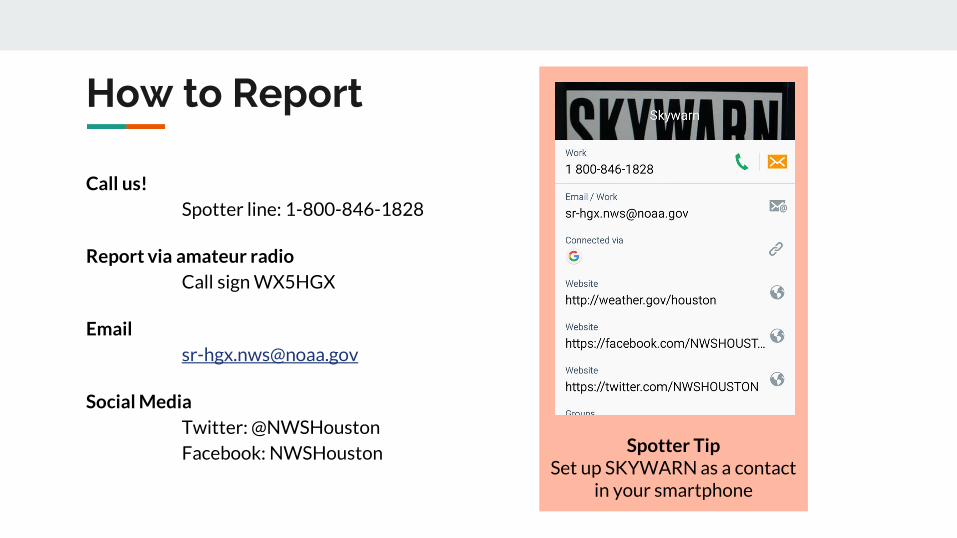
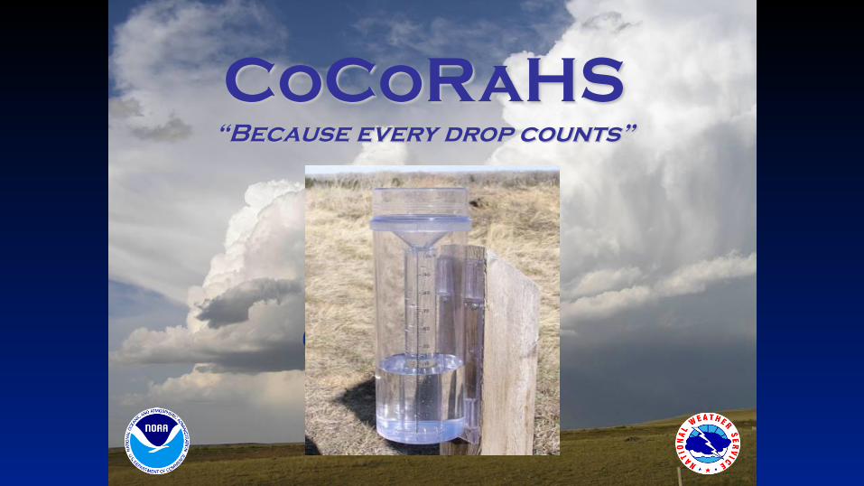
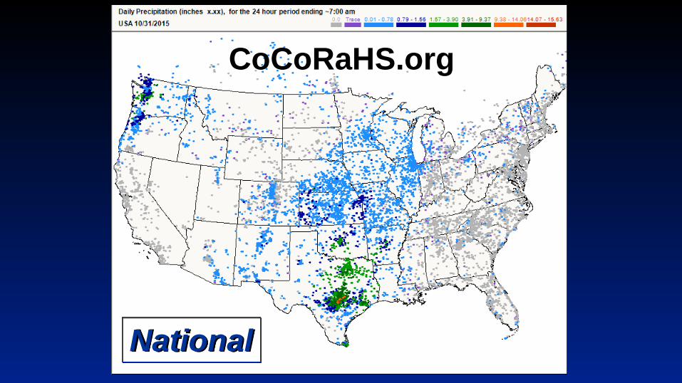
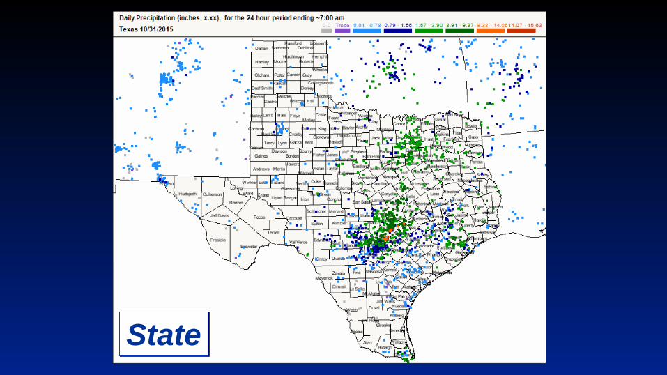
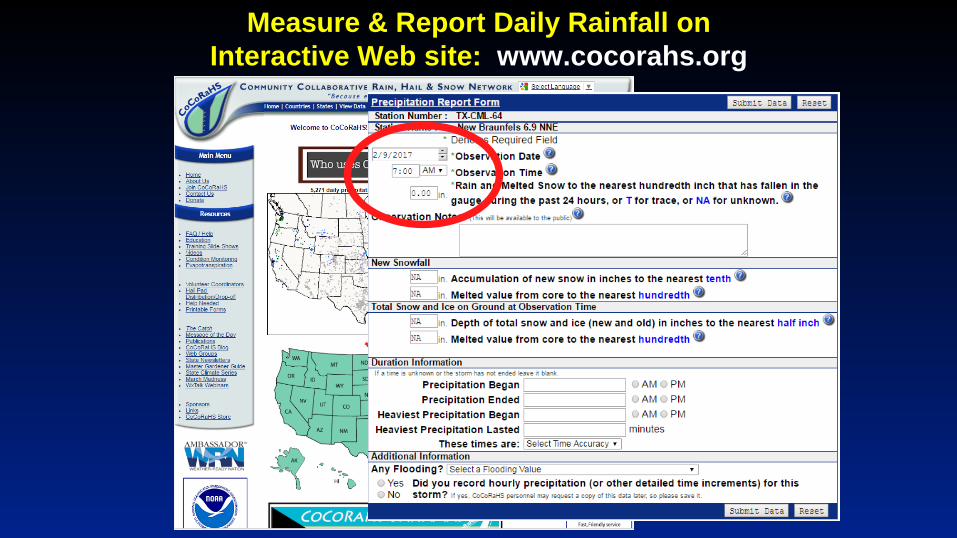
Flood Risk
FloodWarn Workshop
Topics
bull NFIP ndash National Flood Insurance Program
bull What is Flood Risk
bull Flood Hazard Mapping and FIRMs
Flood Insurance
Everyone is at risk for floodingbull For most events 26 of NFIP
claims are outside the SHFA
A few inches can cause tens of thousands in damage
If you mortgage company ldquoforcedrdquo you to buy flood insurance check that structure and CONTENTS are covered Most cover structure only
A tool for individuals to manage
risk
What is the NFIP definition of A Flood Defined
Inundation of 2 or more acres of normally dry land or of two or more properties (one of which is your property) from
Overflow of inland or tidal waters
Unusual rapid accumulation or runoff of surface waters from any source
Mudflow or
Collapse or sinking of land along the shore of a lake or similar body of water as a result of erosion or undermining caused by waves or currents of water exceeding anticipated levels that result in a flood
NFIP Flood Insurance Coverages
Structure Coveragebull Replacement Cost on single-family primary residence (structure) if insured to at least
80 of replacement cost
bull Max coverage $250000
Contents coveragebull Contents is an optional addition except for Preferred Risk Policy bull Max coverage $100000 coverage for Actual Cash Value (depreciation applies)
Wait Periodbull Typically - 30-days from purchase until effectivebull Exceptions
o Flood Insurance required by a federally regulated and insured lendermdash0 dayso Wildfire 30-day waiting period exceptionmdash0 dayso Initial purchase of flood insurance as the result of a map revisionmdash1 day
Misconception Homeowners Insurance is Enough
Misconception
ldquoIrsquom already coveredmdashmy homeowners policy covers floodingrdquo
FactMost insurance policies do not cover flooding only flood insurance covers flood damage
Renters and Business owners should also consider flood insurance for contents
Group Flood Insurance Policy (GFIP)
IF in the 1 risk area (100yr floodplain)
AND received FEMA Individual Assistance(IA)
A GFIP policy was purchased
(if they did not have flood insurance)
GFIP is a 3 yr abridged Flood Insurance Policy The
policy is paid for from the IA funds
You can purchase the standard NFIP policy to increase
your coverage (GFIP cancels)
Group Flood Insurance Policy (GFIP)
Requirement - property owner MUST purchase and maintain
a traditional NFIP policy when GFIP expires
If nothellipthey are not eligible for IA that would cover the replacement of real
or personal property for the damaged location with a future event
The insurance requirement is forever ndash including new homeowners
Flood Risk
Any situation involving exposure to a Flood danger harm or loss
ldquoWhile levees can help reduce flood riskhellipthey do not eliminate the riskrdquo
What is a FIRM
Flood Insurance RateMap
Identifies the Special Flood Hazard Area (SFHA) and Non-SFHArsquos
Used for rating flood insurance policies
Mandatory purchase requirement if property is in SHFA AND is a federally backed mortgage
FIRMrsquos show Coastal and Riverine flood risk
Find your zone at httpsmscfemagovportal
Zones on a FIRM
SFHA (high risk) bull A AE AO AH VE V etc
(Aqua)o 1 annual chance
floodo 26 chance of
flooding in a 30-yr mortgage
Non-SFHA (low to moderate risk)
bull B C and X (Shaded ndash orange or gray color amp non-Shaded)
o OrangeGray area ndashoutlines areas protected by Levees
o Even the non-shaded is a flood zone ndash a minimal risk
What is a Flood Zone
Flood Hazard Mapping
The maps are NOT a prediction or forecast
Flood waters are not confined to the at the 1 risk line (aka 100yr flood) on the FIRM
FIRMs are subdivided by panels to cover a jurisdictional boundary (each has a unique panel number)
bull Each panel has a specific code and effective date
bull FIRMs are a single snapshot for one scenario
Flood Hazard Mapping
Assumptions are made in the river modelingbull Precipitation input the 100 year24 hr design storm (actual events rain
intensities vary - not consistent rate over a 24 hr period)
bull Assumptions about the vegetation in the flood plain ndash do NOT differentiate dead vs growing vegetation (increased friction during growing season)
bull Snapshot of land use when the models were developed ndash a challenge in rapidly developing areas
One event is never the same as another FIRMs will not exactly match an individual event
Flood Hazard Mapping
Misconception Only 100yr Floodplain is at Risk
Misconception
ldquoI donrsquot live in a flood zonerdquo
Facts
bull Floods are the 1 natural disaster in the United States
bull If it can rain it can flood
bull FIRMs do not show localized flooding from drainage ditchessewersroad ponding
bull To some degree overland floodinghellipbut not property to property drainage problems
Cost of Flood Damage
Structure Elevation Impact Insurance Rates
The elevation is just one factor others include when was the
structure has it flooded in the past etc
Lower Risk = $ High Risk =
$$$
Medium Risk =
$$
EVERY Structure has a riskhellipgenerally the higher the structure the less the risk
Harvey Numbers
Insurance claims Harris Co (includes cities such as
Houston) ndash all claims 55570
Walker County (unincorporated only) ndash 1 (Losses over 125K)
Harris County Numbersbull 154170 Homes 48850 in 1 Risk
Area (100-yr) bull 34970 in 02 (500-yr) floodplainbull 68 OUTSIDE of the 1 Risk Area
Data HCFCD Finale Hurricane Harvey Storm and Flood Information ndash
httpswwwhcfcdorgmedia2678immediate-flood-report-final-hurricane-harvey-2017pdf
New GFIPrsquos Due to Harvey
Walker County ndash6
Summary
Living in Texas means we have a flood risk even with heavy rain
bull Tax Day 2016 and Memorial Day 2015 ndash not with a tropical system
Flood Risk is from multiple sources bull FIRMs focus on river flooding and some overland flow
Flood insurance allows individual property owners to manage their risk
bull Buy policies that cover the structure AND contents
Angela Harrison InsuranceCell 470-557-2794 | AngelaHarrisonfemadhsgov
Yho-Meka Conway Insurance Cell 470-572-0803 | Yho-MekaConwayfemadhsgov
Lauren Schmied PE Floodplain ManagementCell 202-812-6164 | LaurenSchmiedfemadhsgov
Larry Fordham ANFI CFM ACAActing Senior Regional Insurance Specialist FEMA Region 6Phone 940-383-7253 | Cell 202-394-4483 |LarryFordhamfemadhsgov
NFIP Hotline
1-800-427-4661
wwwfemagovnfip
Contact Information
QuestionsNational Weather Service
FEMA
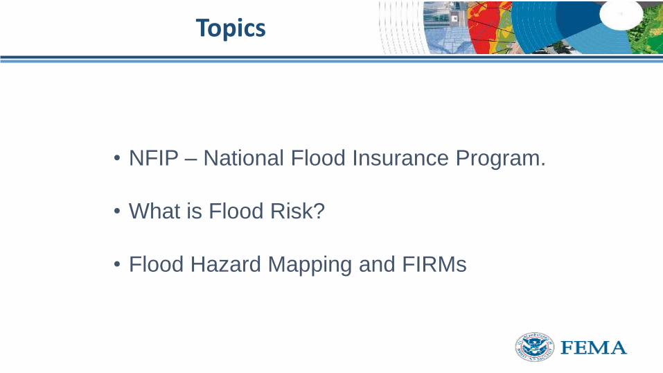
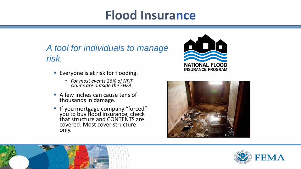
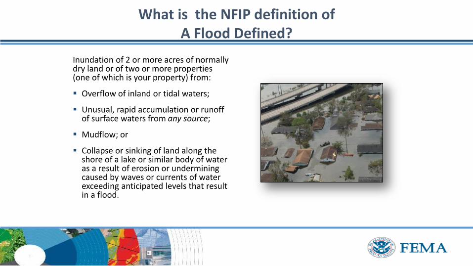
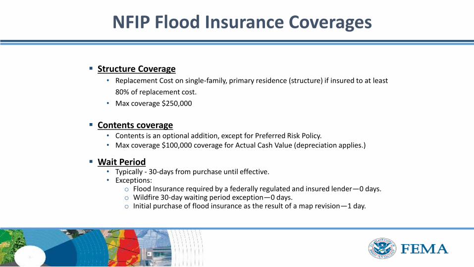
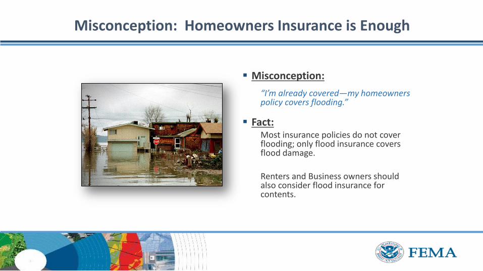
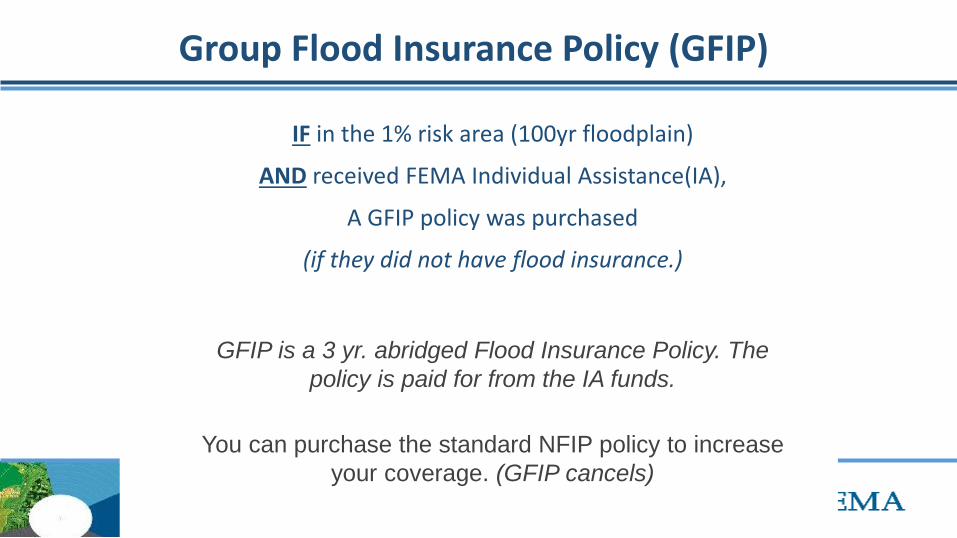
Group Flood Insurance Policy (GFIP)
IF in the 1 risk area (100yr floodplain)
AND received FEMA Individual Assistance(IA)
A GFIP policy was purchased
(if they did not have flood insurance)
GFIP is a 3 yr abridged Flood Insurance Policy The
policy is paid for from the IA funds
You can purchase the standard NFIP policy to increase
your coverage (GFIP cancels)
Group Flood Insurance Policy (GFIP)
Requirement - property owner MUST purchase and maintain
a traditional NFIP policy when GFIP expires
If nothellipthey are not eligible for IA that would cover the replacement of real
or personal property for the damaged location with a future event
The insurance requirement is forever ndash including new homeowners
Flood Risk
Any situation involving exposure to a Flood danger harm or loss
ldquoWhile levees can help reduce flood riskhellipthey do not eliminate the riskrdquo
What is a FIRM
Flood Insurance RateMap
Identifies the Special Flood Hazard Area (SFHA) and Non-SFHArsquos
Used for rating flood insurance policies
Mandatory purchase requirement if property is in SHFA AND is a federally backed mortgage
FIRMrsquos show Coastal and Riverine flood risk
Find your zone at httpsmscfemagovportal
Zones on a FIRM
SFHA (high risk) bull A AE AO AH VE V etc
(Aqua)o 1 annual chance
floodo 26 chance of
flooding in a 30-yr mortgage
Non-SFHA (low to moderate risk)
bull B C and X (Shaded ndash orange or gray color amp non-Shaded)
o OrangeGray area ndashoutlines areas protected by Levees
o Even the non-shaded is a flood zone ndash a minimal risk
What is a Flood Zone
Flood Hazard Mapping
The maps are NOT a prediction or forecast
Flood waters are not confined to the at the 1 risk line (aka 100yr flood) on the FIRM
FIRMs are subdivided by panels to cover a jurisdictional boundary (each has a unique panel number)
bull Each panel has a specific code and effective date
bull FIRMs are a single snapshot for one scenario
Flood Hazard Mapping
Assumptions are made in the river modelingbull Precipitation input the 100 year24 hr design storm (actual events rain
intensities vary - not consistent rate over a 24 hr period)
bull Assumptions about the vegetation in the flood plain ndash do NOT differentiate dead vs growing vegetation (increased friction during growing season)
bull Snapshot of land use when the models were developed ndash a challenge in rapidly developing areas
One event is never the same as another FIRMs will not exactly match an individual event
Flood Hazard Mapping
Misconception Only 100yr Floodplain is at Risk
Misconception
ldquoI donrsquot live in a flood zonerdquo
Facts
bull Floods are the 1 natural disaster in the United States
bull If it can rain it can flood
bull FIRMs do not show localized flooding from drainage ditchessewersroad ponding
bull To some degree overland floodinghellipbut not property to property drainage problems
Cost of Flood Damage
Structure Elevation Impact Insurance Rates
The elevation is just one factor others include when was the
structure has it flooded in the past etc
Lower Risk = $ High Risk =
$$$
Medium Risk =
$$
EVERY Structure has a riskhellipgenerally the higher the structure the less the risk
Harvey Numbers
Insurance claims Harris Co (includes cities such as
Houston) ndash all claims 55570
Walker County (unincorporated only) ndash 1 (Losses over 125K)
Harris County Numbersbull 154170 Homes 48850 in 1 Risk
Area (100-yr) bull 34970 in 02 (500-yr) floodplainbull 68 OUTSIDE of the 1 Risk Area
Data HCFCD Finale Hurricane Harvey Storm and Flood Information ndash
httpswwwhcfcdorgmedia2678immediate-flood-report-final-hurricane-harvey-2017pdf
New GFIPrsquos Due to Harvey
Walker County ndash6
Summary
Living in Texas means we have a flood risk even with heavy rain
bull Tax Day 2016 and Memorial Day 2015 ndash not with a tropical system
Flood Risk is from multiple sources bull FIRMs focus on river flooding and some overland flow
Flood insurance allows individual property owners to manage their risk
bull Buy policies that cover the structure AND contents
Angela Harrison InsuranceCell 470-557-2794 | AngelaHarrisonfemadhsgov
Yho-Meka Conway Insurance Cell 470-572-0803 | Yho-MekaConwayfemadhsgov
Lauren Schmied PE Floodplain ManagementCell 202-812-6164 | LaurenSchmiedfemadhsgov
Larry Fordham ANFI CFM ACAActing Senior Regional Insurance Specialist FEMA Region 6Phone 940-383-7253 | Cell 202-394-4483 |LarryFordhamfemadhsgov
NFIP Hotline
1-800-427-4661
wwwfemagovnfip
Contact Information
QuestionsNational Weather Service
FEMA
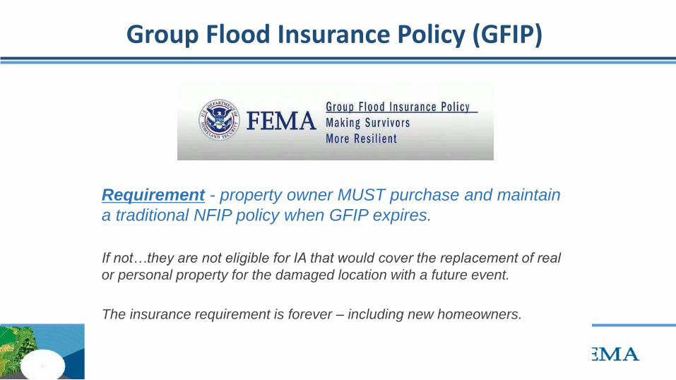
Group Flood Insurance Policy (GFIP)
Requirement - property owner MUST purchase and maintain
a traditional NFIP policy when GFIP expires
If nothellipthey are not eligible for IA that would cover the replacement of real
or personal property for the damaged location with a future event
The insurance requirement is forever ndash including new homeowners
Flood Risk
Any situation involving exposure to a Flood danger harm or loss
ldquoWhile levees can help reduce flood riskhellipthey do not eliminate the riskrdquo
What is a FIRM
Flood Insurance RateMap
Identifies the Special Flood Hazard Area (SFHA) and Non-SFHArsquos
Used for rating flood insurance policies
Mandatory purchase requirement if property is in SHFA AND is a federally backed mortgage
FIRMrsquos show Coastal and Riverine flood risk
Find your zone at httpsmscfemagovportal
Zones on a FIRM
SFHA (high risk) bull A AE AO AH VE V etc
(Aqua)o 1 annual chance
floodo 26 chance of
flooding in a 30-yr mortgage
Non-SFHA (low to moderate risk)
bull B C and X (Shaded ndash orange or gray color amp non-Shaded)
o OrangeGray area ndashoutlines areas protected by Levees
o Even the non-shaded is a flood zone ndash a minimal risk
What is a Flood Zone
Flood Hazard Mapping
The maps are NOT a prediction or forecast
Flood waters are not confined to the at the 1 risk line (aka 100yr flood) on the FIRM
FIRMs are subdivided by panels to cover a jurisdictional boundary (each has a unique panel number)
bull Each panel has a specific code and effective date
bull FIRMs are a single snapshot for one scenario
Flood Hazard Mapping
Assumptions are made in the river modelingbull Precipitation input the 100 year24 hr design storm (actual events rain
intensities vary - not consistent rate over a 24 hr period)
bull Assumptions about the vegetation in the flood plain ndash do NOT differentiate dead vs growing vegetation (increased friction during growing season)
bull Snapshot of land use when the models were developed ndash a challenge in rapidly developing areas
One event is never the same as another FIRMs will not exactly match an individual event
Flood Hazard Mapping
Misconception Only 100yr Floodplain is at Risk
Misconception
ldquoI donrsquot live in a flood zonerdquo
Facts
bull Floods are the 1 natural disaster in the United States
bull If it can rain it can flood
bull FIRMs do not show localized flooding from drainage ditchessewersroad ponding
bull To some degree overland floodinghellipbut not property to property drainage problems
Cost of Flood Damage
Structure Elevation Impact Insurance Rates
The elevation is just one factor others include when was the
structure has it flooded in the past etc
Lower Risk = $ High Risk =
$$$
Medium Risk =
$$
EVERY Structure has a riskhellipgenerally the higher the structure the less the risk
Harvey Numbers
Insurance claims Harris Co (includes cities such as
Houston) ndash all claims 55570
Walker County (unincorporated only) ndash 1 (Losses over 125K)
Harris County Numbersbull 154170 Homes 48850 in 1 Risk
Area (100-yr) bull 34970 in 02 (500-yr) floodplainbull 68 OUTSIDE of the 1 Risk Area
Data HCFCD Finale Hurricane Harvey Storm and Flood Information ndash
httpswwwhcfcdorgmedia2678immediate-flood-report-final-hurricane-harvey-2017pdf
New GFIPrsquos Due to Harvey
Walker County ndash6
Summary
Living in Texas means we have a flood risk even with heavy rain
bull Tax Day 2016 and Memorial Day 2015 ndash not with a tropical system
Flood Risk is from multiple sources bull FIRMs focus on river flooding and some overland flow
Flood insurance allows individual property owners to manage their risk
bull Buy policies that cover the structure AND contents
Angela Harrison InsuranceCell 470-557-2794 | AngelaHarrisonfemadhsgov
Yho-Meka Conway Insurance Cell 470-572-0803 | Yho-MekaConwayfemadhsgov
Lauren Schmied PE Floodplain ManagementCell 202-812-6164 | LaurenSchmiedfemadhsgov
Larry Fordham ANFI CFM ACAActing Senior Regional Insurance Specialist FEMA Region 6Phone 940-383-7253 | Cell 202-394-4483 |LarryFordhamfemadhsgov
NFIP Hotline
1-800-427-4661
wwwfemagovnfip
Contact Information
QuestionsNational Weather Service
FEMA
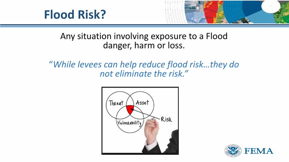
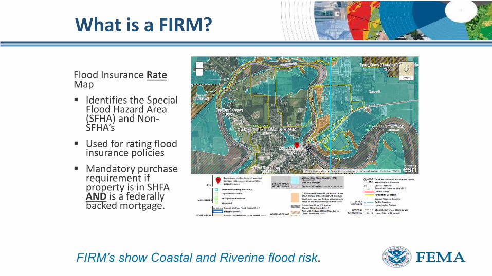
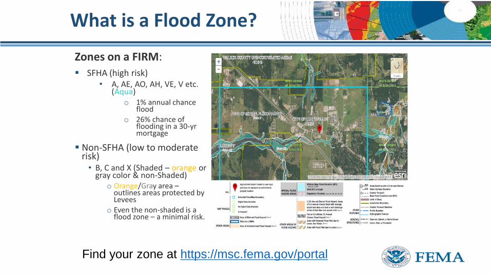
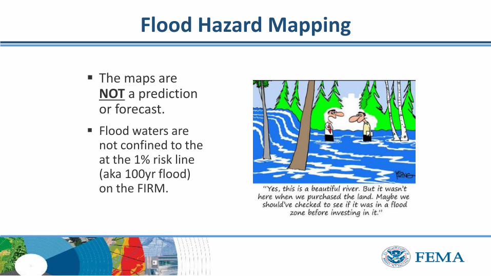
Flood Hazard Mapping
The maps are NOT a prediction or forecast
Flood waters are not confined to the at the 1 risk line (aka 100yr flood) on the FIRM
FIRMs are subdivided by panels to cover a jurisdictional boundary (each has a unique panel number)
bull Each panel has a specific code and effective date
bull FIRMs are a single snapshot for one scenario
Flood Hazard Mapping
Assumptions are made in the river modelingbull Precipitation input the 100 year24 hr design storm (actual events rain
intensities vary - not consistent rate over a 24 hr period)
bull Assumptions about the vegetation in the flood plain ndash do NOT differentiate dead vs growing vegetation (increased friction during growing season)
bull Snapshot of land use when the models were developed ndash a challenge in rapidly developing areas
One event is never the same as another FIRMs will not exactly match an individual event
Flood Hazard Mapping
Misconception Only 100yr Floodplain is at Risk
Misconception
ldquoI donrsquot live in a flood zonerdquo
Facts
bull Floods are the 1 natural disaster in the United States
bull If it can rain it can flood
bull FIRMs do not show localized flooding from drainage ditchessewersroad ponding
bull To some degree overland floodinghellipbut not property to property drainage problems
Cost of Flood Damage
Structure Elevation Impact Insurance Rates
The elevation is just one factor others include when was the
structure has it flooded in the past etc
Lower Risk = $ High Risk =
$$$
Medium Risk =
$$
EVERY Structure has a riskhellipgenerally the higher the structure the less the risk
Harvey Numbers
Insurance claims Harris Co (includes cities such as
Houston) ndash all claims 55570
Walker County (unincorporated only) ndash 1 (Losses over 125K)
Harris County Numbersbull 154170 Homes 48850 in 1 Risk
Area (100-yr) bull 34970 in 02 (500-yr) floodplainbull 68 OUTSIDE of the 1 Risk Area
Data HCFCD Finale Hurricane Harvey Storm and Flood Information ndash
httpswwwhcfcdorgmedia2678immediate-flood-report-final-hurricane-harvey-2017pdf
New GFIPrsquos Due to Harvey
Walker County ndash6
Summary
Living in Texas means we have a flood risk even with heavy rain
bull Tax Day 2016 and Memorial Day 2015 ndash not with a tropical system
Flood Risk is from multiple sources bull FIRMs focus on river flooding and some overland flow
Flood insurance allows individual property owners to manage their risk
bull Buy policies that cover the structure AND contents
Angela Harrison InsuranceCell 470-557-2794 | AngelaHarrisonfemadhsgov
Yho-Meka Conway Insurance Cell 470-572-0803 | Yho-MekaConwayfemadhsgov
Lauren Schmied PE Floodplain ManagementCell 202-812-6164 | LaurenSchmiedfemadhsgov
Larry Fordham ANFI CFM ACAActing Senior Regional Insurance Specialist FEMA Region 6Phone 940-383-7253 | Cell 202-394-4483 |LarryFordhamfemadhsgov
NFIP Hotline
1-800-427-4661
wwwfemagovnfip
Contact Information
QuestionsNational Weather Service
FEMA
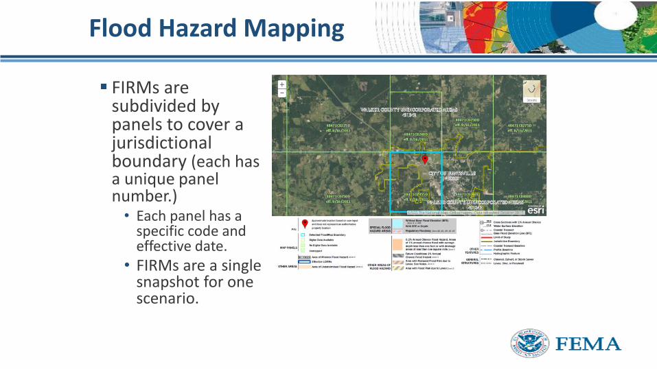
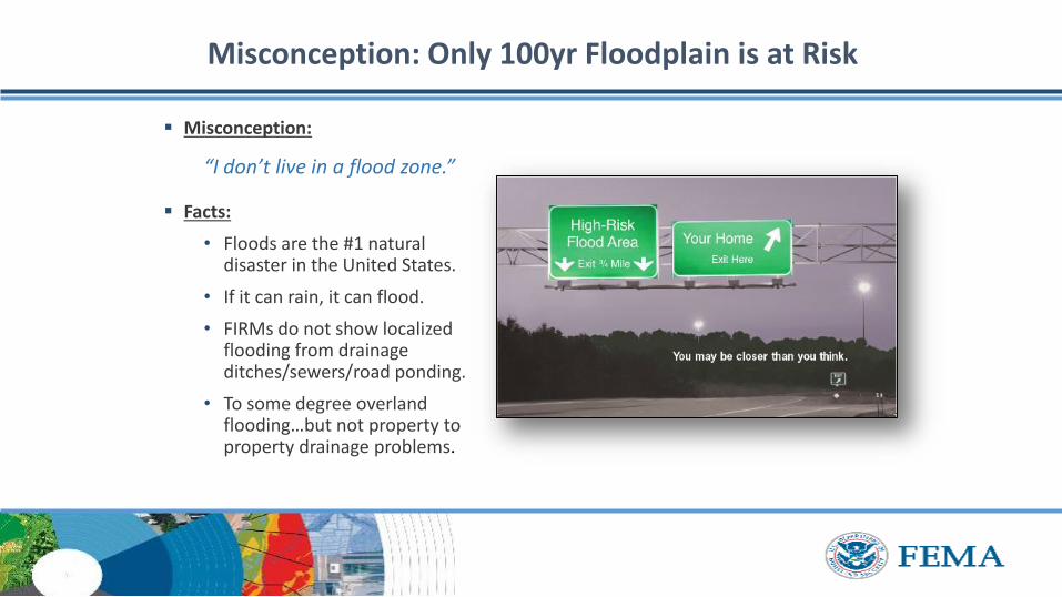
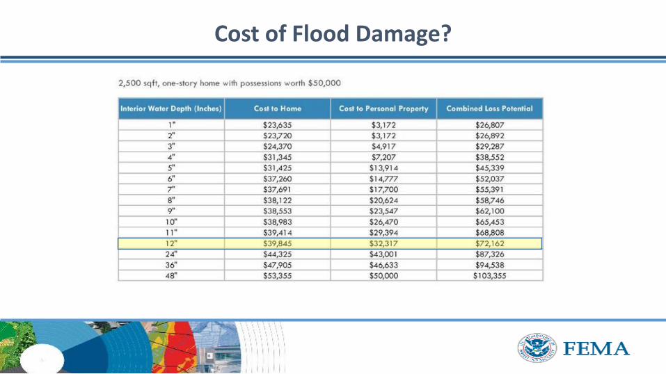
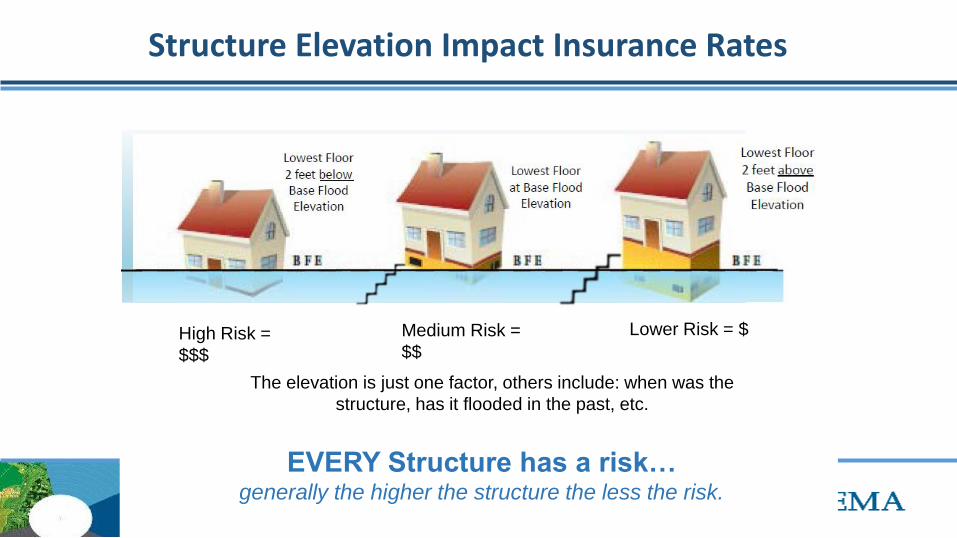
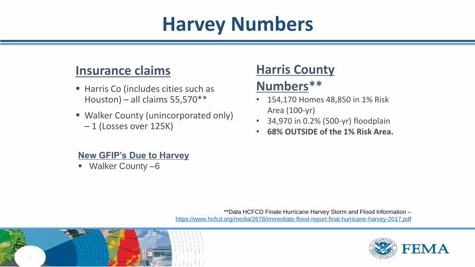
QuestionsNational Weather Service
FEMA