2018-08-27 Trop MSP booklet - IUEM · Play MSP Challenge ... three types of pervasive observation...
35
Welcome booklet
Transcript of 2018-08-27 Trop MSP booklet - IUEM · Play MSP Challenge ... three types of pervasive observation...

Welcome booklet

2
Tableofcontents
SNAPSHOTAGENDA....................................................................................................................................................3
DAYBYDAYDETAILEDAGENDA............................................................................................................................4MONDAYSEPT.3RD..........................................................................................................................................................................4
Welcome session ................................................................................................................................................................................ 4Coffee Break (Downstairs PNBI building) .......................................................................................................................... 4Session 1: Presentation of MSP’s special challenges in tropical areas ....................................................... 4Lunch Break (Hall of IUEM main building) ........................................................................................................................ 4Session 2: Three minute thesis .................................................................................................................................................. 5Discovering MSP Challenge - From lesson to action, a board game to continue learning ....... 5Cocktail time ............................................................................................................................................................................................ 5
TUESDAY SEPT. 4TH.......................................................................................................................................................................6Session 3: Policy and governance dynamics in marine spatial planning .................................................. 6Lunch Break (Hall of IUEM main building) ........................................................................................................................ 6Session 4: Use of ecological data in MSP tools: myth or reality ? .................................................................. 7Play MSP Challenge .......................................................................................................................................................................... 7
WEDNESDAY SEPT. 5TH................................................................................................................................................................8Session 5: Keynote speakers ...................................................................................................................................................... 8Lunch Break (Hall of IUEM main building) ........................................................................................................................ 8Field-trip Aber Wrac’h ...................................................................................................................................................................... 8Stand-Up Paddle – swimming suits and towels needed! ......................................................................................... 8Social dinner ............................................................................................................................................................................................ 8
THURSDAY SEPT. 6TH....................................................................................................................................................................9Session 6: Use of spatial data for MSP ................................................................................................................................ 9Lunch Break (Hall of IUEM main building) ........................................................................................................................ 9Session 7: Cross-border MSP .................................................................................................................................................. 10Play MSP Challenge ....................................................................................................................................................................... 10
FRIDAY SEPT. 7TH........................................................................................................................................................................11Session 9: Round table on Artisanal Fisheries and MSP .................................................................................... 11Concluding session .......................................................................................................................................................................... 11Final networking session .............................................................................................................................................................. 11
TIPS................................................................................................................................................................................12PUBLICTRANSPORT........................................................................................................................................................................12COMINGTOTHEVENUE..................................................................................................................................................................12SOUVENIRS.......................................................................................................................................................................................12
WHO’SWHO?.............................................................................................................................................................13
COMMUNICATIONABSTRACTS.............................................................................................................................16
ABSTRACTOFONGOINGTHESES.........................................................................................................................25
3
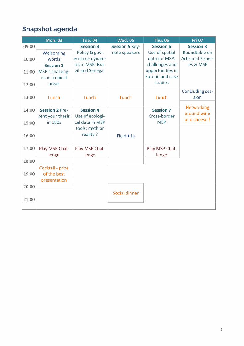
Snapshot agenda
Mon.03 Tue.04 Wed.05 Thu.06 Fri0709:00 Session3
Policy&gov-ernancedynam-icsinMSP:Bra-zilandSenegal
Session5Key-notespeakers
Session6UseofspatialdataforMSP:challengesandopportunitiesinEuropeandcase
studies
Session8RoundtableonArtisanalFisher-
ies&MSP
Welcomingwords10:00
Session1MSP'schalleng-esintropical
areas
11:00
12:00
Lunch Lunch Lunch LunchConcludingses-
sion13:00
Networkingaroundwineandcheese!
14:00 Session2Pre-sentyourthesis
in180s
Session4Useofecologi-caldatainMSPtools:mythor
reality? Field-trip
Session7Cross-border
MSP15:00
16:00
17:00 PlayMSPChal-lenge
PlayMSPChal-lenge
PlayMSPChal-lenge
18:00Cocktail-prizeofthebestpresentation
19:00
20:00 Socialdinner
21:00
4
Day by day detailed agenda
Monday Sept. 3rd
9:30-10:15 Welcome session Anne-Marie TRÉGUIER, IUEM
Vianney PICHEREAU, LabexMER Marie BONNIN, Principal investigator of Paddle project (IRD)
10:15-10:30 Coffee Break (Downstairs PNBI building) 10:30-12:30 Session 1: Presentation of MSP’s special challenges in tropical areas Session coordinator: Prof. Helena CALADO (UAc)
Session abstract: The last decade has provided a wide range of experiences and the solid definition of concepts. These will be overviewed in a light com-munication mode in order to have all the participants tuned to the same frame-work. At the same time, MSP doesn’t exist alone it’s linked to all the main poli-cies sustainability related and theses links will also be briefly overview. To in-troduce the practice of MSP and the Ecosystem Based Management (EBM) principle, a model enrooted in Step by Step UNESCO Manual (Ehler, C. & Dou-vere, F. (2009) will be presented to be further discussed (Ansong, et al 2017).
From an environmental point of view, a sound and deep understanding of trop-ical coastal ecosystems and their dynamics and vulnerabilities is pivotal. Based on this, and consulting the above-mentioned (and additional where applicable) groups of stakeholders, Marine Spatial Planning can come up with optimized spatial distribution of different, partly contrasting and competing, land- and sea-uses to maximize both ecosystem service-provisioning and economic devel-opment, and –above all– human livelihood and well-being.
We will discuss in detail one ecosystem-based approach to MSP, coined as Traffic Light-Concept (Helfer & Zimmer, 2018), that categorizes areas for differ-ent use-intensities based on forecasted values of ecosystems. In case of de-graded ecosystems, the controversially discussed concept of Ecosystem De-sign (Zimmer, 2018) may aid in (re-)implementation of the provisioning of those ecosystem services that are regionally needed. F r a m i n g M S P : H i s t o r y , C o n c e p t s a n d e v o l u t i o n o f p r a c t i c e t o w a r d s e c o s y s t e m b a s e d a p p r o a c h e s
• Prof. Helena CALADO (University of the Azores)
M S P ’ s s p e c i a l c h a l l e n g e s i n t r o p i c a l a r e a s – a n E c o s y s t e m D y n a m i c s P o i n t o f V i e w
• Dr. Martin ZIMMER (ZMT-Leibniz Centre for Tropical Marine Research)
12:30-14:00 Lunch Break (Hall of IUEM main building)
5
14:00-17:00 Session 2: Three minute thesis Session coordinator: Dr. Francoise GOURMELON (CNRS).
19 PhD students will present his/her thesis in a language appropriate to a non-specialist audience, in order to help building the future network of experts on MSP in Tropical Atlantic.
17:00-18:00 Discovering MSP Challenge - From lesson to action, a board game to contin-ue learning
Session coordinator: Lodewijk ABSPOEL (Ministry for Infrastructure and Water Management, Netherlands)
During the Tropical MSP summer school in Brest the MSPChallenge #MSPglob-al board game edition allows the participants to combine prior MSP experiences with lessons learned during the program.
The participants will experience and discuss the meaning and implications of different maritime strategic objectives such as UN sustainability goal 14 ‘Life Below Water’, the blue economy, land-sea interactions, short sea shipping, and clean, healthy and productive seas and ocean.
The aim is not only to get ‘thinking and talking’ about the interrelations among these objectives, but also to organize a MSP process in a simulated sea basin. Participants are challenged to achieve economic, environmental and social ob-jectives at the same time. During the simulation participants will assume roles of marine/maritime planners (1 or 2 per country), nature conservationists or indus-try: Ports, Shipping, Fisheries, Aquaculture, Tourism & recreation, Renewable energy, Oil & gas, Energy infrastructure, Blue biotech, Deep sea mining, Local business, Maritime industry.
Discussions about cross-border and transboundary issues will be key. Partici-pants are encouraged to bring arguments from real life into the discussion to convince others.
The game-captain and skipper (combining over 50 years of experience in policy and seafaring) will provide feedback on achievements of the participants.
THE RICA SEA Three countries share the RICA Sea: Bayland, Peninsuland and Island. The Rica Sea features challenges for seafarers and off shore construction, but its proximity to two oceans and a relatively sheltered location on the globe also offer a wide range of natural resources to work with. Fishermen have vast tacit knowledge of the sea and tourists might be very much interested to spend their holidays in the Rica Sea. Various cross-border mechanisms for ecosystem management and safe navigation are in place, though borders at sea are not established (yet).
19:00-21:00 Cocktail time Just enjoy the view, or start networking !
We’ll will also give a prize to the best PhD presentation (session 2). (Bibliothèque La Pérouse)
6
Tuesday Sept. 4th
9:00-12:30 Session 3: Policy and governance dynamics in marine spatial planning
Session coordinator: Dr Hilde Toonen (WU)
This integrated session will be organised around 2 case studies (Brazil & Senegal)
• Dr Hilde TOONEN (WU) • Prof Solange TELES DA SILVA (UPM) • Prof Ibrahima LY (UCAD)
One of the distinct objectives of PADDLE is to foster knowledge exchange on governance dynamics in transboundary Marine Spatial Planning (MSP) in a North-South Atlantic context. MSP is inherently a socio-political process, as it brings together humans with different interests, viewpoints, knowledge, and power, who –ideally- make informed and coordinated decisions about how to protect our oceans’ wealth, and how to use marine resources sustainably. Governance processes related to MSP are complex: Jurisdiction at sea is not straightforward, there are unbalanced power relations between stakeholders, and some perspec-tives prevail while others are kept silent. However, the specificities of MSP for the tropical Atlantic are underexplored. The legal scholars and social scientists in PADDLE focus on a better understanding of legal and institutional frameworks by empirical studies of the current state-of-the-art and analysis of (future) innovative arrangements.
In this session of PADDLE’s Summer School, Prof Ibrahima Ly, Prof Solange Teles da Silva and Dr Hilde Toonen will provide stepping stones for legal and govern-ance research in tropical MSP by describing contemporary trends, discussing conceptual tools, and providing examples of how MSP is framed in Senegalese and Brazilian policies. They will thereby give the participants a substantive intro-duction of governance issues and elaborate on theoretical handles to explore these
12:30-14:00 Lunch Break (Hall of IUEM main building)
7
14:00-17:00 Session 4: Use of ecological data in MSP tools: myth or reality ?
Session coordinator: Dr Sophie BERTRAND (IRD)
G e n e r a l p r e s e n t a t i o n o f M S P t o o l s a n d l i n k s w i t h a c o u s t i c m e t h o d s & s p e c i e s t r a c k i n g
Marine systems have a number of attributes that make them particularly diffi-cult to demarcate for purposes of management. They are three-dimensional in essence, opaque relative to terrestrial systems and although some marine sys-tems (such as kelp forests or coral reefs) are relatively stationary, many systems (such as fronts and eddies) are spatially and temporally dynamic. Merging and scaling up oceanographic and ecological data will be necessary to observe, dynamically manage, and conserve species embedded in a dynamic seascape mosaic. How then to proceed? High frequency, multiscale, and synoptic charac-terization of the 4-D variability (3D space plus time) of seascapes are now avail-able through a variety of cutting edge observation technologies, combined with advanced statistical modelling tools. This session will provide an overview on three types of pervasive observation technologies (active acoustic data, biolog-ging data, AIS data) and how they may be processed and modelled in order to contribute to a marine spatial planning approach.
M S P ’ s s p e c i a l c h a l l e n g e s i n t r o p i c a l a r e a s – a n E c o s y s t e m
D y n a m i c s P o i n t o f V i e w
• Dr Anne LEBOURGES-DHAUSSY (IRD) H o w c a n b i o l o g g i n g d a t a o n m e g a f a u n a b e u s e d f o r m a r i n e s p a t i a l p l a n n i n g ?
• Dr Sophie BERTRAND (IRD, UFPE) H o w c a n A u t o m a t i c I d e n t i f i c a t i o n S y s t e m ( A I S ) d a t a b e u s e d f o r m a r i t i m e s p a t i a l p l a n n i n g ?
• Dr Matthieu LE TIXERANT (Terra Maris)
17:00-18:00 Play MSP Challenge
Session coordinator: Lodewijk ABSPOEL (Ministry for Infrastructure and Water Management, Netherlands)
The game continues !
8
Wednesday Sept. 5th
9h00-12h00 Session 5: Keynote speakers
P o w e r , p a r t i c i p a t i o n a n d M S P • Wesley FLANNERY, School of Natural and built Environment, Queen’s Uni-
versity, Belfast
M S P 1 0 T h i n g s – L e s s o n s L e a r n e d f r o m t h e P a c i f i c a n d I n d i a n O c e a n s
• Dr. Joanna SMITH, Director Ocean Planning and Mapping, Global Oceans Team, TNC Canada
12:30-14:00 Lunch Break (Hall of IUEM main building)
14:00-18:00 Field-trip Aber Wrac’h
Stand-Up Paddle – swimming suits and towels needed!
Hiking on the coast line – comfortable (and potentially waterproof) clothing and shoes recommended
Transport is organised from PNBI to Aber Wrac’h and from Aber Wrac’h to Brest City center
20:00 Social dinner Let’s meet at the restaurant La Base to have dinner!
You can arrive there early and have a drink, or have a walk in the harbour.
9
Thursday Sept. 6th 9:00-12:00 Session 6: Use of spatial data for MSP Session coordinator: Dr Francoise Gourmelon, CNRS
Session abstract: Presentation of the challenges and opportunities of the “spatial data universe” for the MSP. The session presents the context, Europe-an initiatives and the use of spatial data for MSP in Cape Verde and Senegal
Introduction. Contribution of geographic information universe to MSP
• Françoise GOURMELON, CNRS C h a l l e n g e s a n d o p p o r t u n i t i e s i n E u r o p e a n d c a s e s t u d i e s
• Roger LONGHORN, External expert IHO Marine SDI Working Group and OGC Marine Domain Working Group
• Jordi SANDALINAS, Attorney at Law. Lecturer at the Open University of Catalonia, CEO Image Sea Solutions. Drone and Satellite Law for the Envi-ronment.
P r o v i d i n g a c c e s s t o m a r i n e d a t a , d a t a p r o d u c t s a n d g e o -s p a t i a l i n f o r m a t i o n f o r B l u e G r o w t h : t h e c a s e o f t h e E u r o p e a n M a r i n e O b s e r v a t i o n a n d D a t a N e t w o r k ( E M O D n e t ) a n d t h e E u -r o p e a n A t l a s o f t h e S e a s i n t h e c o n t e x t o f M a r i n e S p a t i a l P l a n n i n g
• Jan-Bart CALEWAERT, Head, European Marine Observation and Data Network
T h e T e r r i t o r i a l I n f o r m a t i o n S y s t e m s o f C a p e V e r d e
• Carlos RAMOS VARELA, Portal of Cabo Verde, INGT
S e n e g a l ' s s i t u a t i o n w i t h r e g a r d t o g e o g r a p h i c a l i n f o r m a t i o n a v a i l a b l e t o t h e M S P
• Dieynaba SECK, Centre de Suivi Ecologique, Senegal
12:30-14:00 Lunch Break (Hall of IUEM main building)

10
14:00-17:00 Session 7: Cross-border MSP Session coordinator: Dr Betty QUEFFELEC
The session will analyse if and how MSP could tackle the cross-border chal-lenge. Both political and natural borders will be part of this reflexion. The presentations will entrench an in-deep theoretical analysis on concrete case studies.
T r a n s b o u n d a r y M S P a s a r e f l e x i v e g o v e r n a n c e a r r a n g e m e n t .
• Jan VAN TATENHOVE, IFM – Centre for Blue Governance, Aalborg Univer-sity, Denmark
P l a n n i n g i n t h e m a r i n e a n d c o a s t a l z o n e : t h e L a n d / S e a c o n -n e x i o n c h a l l e n g e
• Dr. Betty QUEFFELEC, Université de Bretagne Occidentale
L e s s o n s l e a r n t f o r c r o s s b o a r d e r M S P from the just ended Sup-porting implementation of MSP in the Celtic Seas (SIMCELT) project
• Joseph ANSONG, Research Assistant, University College Cork
D e b a t e
17:00-18:00 Play MSP Challenge Session coordinator: Lodewijk ABSPOEL (Ministry for Infrastructure
and Water Management, Netherlands)
The game continues!

11
Friday Sept. 7th
09:00-12:00 Session 9: Round table on Artisanal Fisheries and MSP Session coordinator: Alexis FOSSI (Pescart, Italy)
( S m a l l - s c a l e ) f i s h e r i e s i n m a r i n e s p a t i a l p l a n n i n g : w h a t ' s t h e m a t t e r ?
• Brice TROUILLET, Université de Nantes
A r t i s a n a l f i s h e r i e s i n C a b o V e r d e • Osvaldina SILVA, President of National Institute For Fisheries development,
Cabo Verde
A r t i s a n a l f i s h e r i e s a n d g l o b a l c h a n g e • Yoann THOMAS, LEMAR, IRD
A r t i s a n a l f i s h e r i e s i n B r a z i l • Beatrice Padovani Ferreira, UFPE
12:00-13:00 Concluding session
E n d i n g r e m a r k s a n d w a y f o r w a r d
13:00-15:00 Final networking session
E n j o y W i n e & C h e e s e !
(Hall of IUEM main building)

12
Tips
Public transport
For any other transport needs, you can refer to http://www.bibus.fr
• To check an itinerary: fill in the following segment with your departure and arrival locations, and click on “OK”
• Tickets can be bought at any tramway station and at the BIBUS shop, 33 av. Clémenceau, 29200 Brest. Open 9:30-18:30 Name Validity Price
1voyage Onehour 1.50€
1jour Oneday 4.00€
10voyages Onehoureach 12.50€
1week* 7consecutivedays 14.20€
*Only available in the BIBUS shop, in Brest city centre
Coming to the venue
The nearest bus station to the venue is “De Rochon” on line 13. You can catch it at the terminus of the tramway “Porte de Plouzané”, leading you directly to the city centre.
To arrive on time in the morning, you can take the bus leaving Porte de Plouzané at 8:24, or 8:51. You then have a very short walk to get to the venue (Pôle Numérique de Brest Iroise – PNBI).
In the evening, buses are leaving in the direction of Brest at 18:06, 18:26, 18:43 (…) 20:00, 20:29, 21:09
The short walk from the bus stop to PNBI The venue (PNBI)
Souvenirs
Food and other goodies from Brittany can be bought in different places in town. One in particu-lar is open until 21:00. It is located next to La Base.
Roi de Bretagne, 12, Quai de la Douane, http://www.roidebretagne.com
13
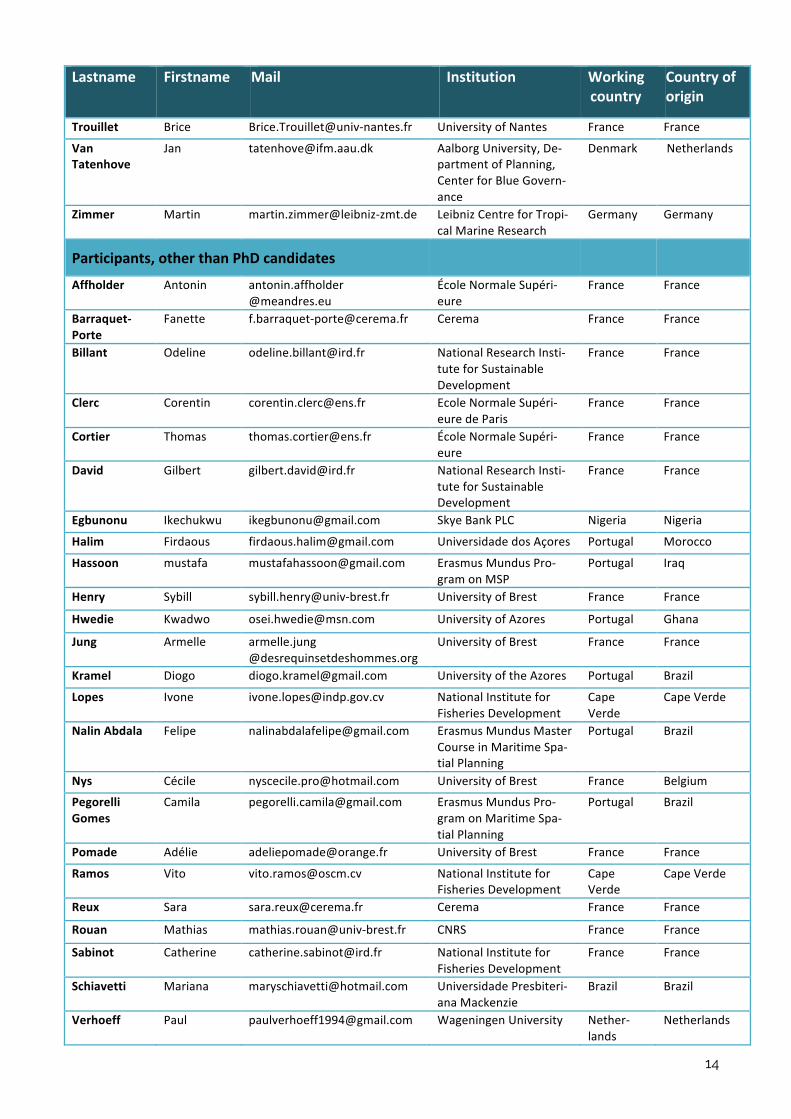
Who’s who ?
Lastname Firstname Mail Institution Workingcountry
Countryoforigin
Speakers
Abspoel Lodewijk [email protected] MinistryforInfrastruc-tureandWaterMan-agement
Nether-lands
Netherlands
Abspoel Willem MSPChallenge Nether-lands
Netherlands
Ansong Joseph [email protected] s.Pro - sustainable projects
Ireland
Bertrand Sophie [email protected] NationalResearchInsti-tuteforSustainableDevelopment
France France
Bonnin Marie [email protected] NationalResearchInsti-tuteforSustainableDevelopment
France France
Calado Helena [email protected] UniversityoftheAzores Portugal Portugal
Calewaeart Jan-Bart [email protected] Emodnet Belgium
Flannery Wesley [email protected] QueenUniversityBel-fast
Ireland Ireland
Fossi Alexis [email protected] Pescart Italy
Gourmelon Françoise [email protected]
NationalResearchCen-terforScientificRe-search
France France
LeGuyader Damien [email protected]
TerraMaris France France
LeTixerant Matthieu [email protected]
TerraMaris France France
Lebourges-Dhaussy
Anne [email protected] NationalResearchInsti-tuteforSustainableDevelopment
France France
Longhorn Roger [email protected] Telenet Belgium Belgium
Ly Ibrahima [email protected] UniversityCheikhAntaDiopofDakar
Senegal Senegal
Padovani Beatrice [email protected] UniversityFederalofPernambouco
Brazil Brazil
Queffelec Betty [email protected] UniversityofBrest France France
RamosVarela Carlos [email protected] NationalInstituteofCartography
CaboVerde
CaboVerde
Salinas Jordi [email protected] UniversityofCatalonia Spain
Seck Dieynaba [email protected] CentredeSuiviEcologique
Senegal Senegal
Silva Osvaldina [email protected] NationalInstituteforFisheriesDevelopment
CapeVerde
CaboVerde
Smith Joanna [email protected] TheNatureConservancy Canada Canada
TelesdaSilva Solange [email protected] UniversityMackenzie Brazil Brazil
Thomas Yoann [email protected] NationalResearchInsti-tuteforSustainableDevelopment
France France
Toonen Hilde [email protected] WageningenUniversity Nether-lands
Netherlands
14
Lastname Firstname Mail Institution Workingcountry
Countryoforigin
Trouillet Brice [email protected] UniversityofNantes France France
VanTatenhove
Jan [email protected] AalborgUniversity,De-partmentofPlanning,CenterforBlueGovern-ance
Denmark Netherlands
Zimmer Martin [email protected] LeibnizCentreforTropi-calMarineResearch
Germany Germany
Participants,otherthanPhDcandidates
Affholder Antonin [email protected]
ÉcoleNormaleSupéri-eure
France France
Barraquet-Porte
Fanette [email protected] Cerema France France
Billant Odeline [email protected] NationalResearchInsti-tuteforSustainableDevelopment
France France
Clerc Corentin [email protected] EcoleNormaleSupéri-euredeParis
France France
Cortier Thomas [email protected] ÉcoleNormaleSupéri-eure
France France
David Gilbert [email protected] NationalResearchInsti-tuteforSustainableDevelopment
France France
Egbunonu Ikechukwu [email protected] SkyeBankPLC Nigeria Nigeria
Halim Firdaous [email protected] UniversidadedosAçores Portugal Morocco
Hassoon mustafa [email protected] ErasmusMundusPro-gramonMSP
Portugal Iraq
Henry Sybill [email protected] UniversityofBrest France France
Hwedie Kwadwo [email protected] UniversityofAzores Portugal Ghana
Jung Armelle [email protected]
UniversityofBrest France France
Kramel Diogo [email protected] UniversityoftheAzores Portugal Brazil
Lopes Ivone [email protected] NationalInstituteforFisheriesDevelopment
CapeVerde
CapeVerde
NalinAbdala Felipe [email protected] ErasmusMundusMasterCourseinMaritimeSpa-tialPlanning
Portugal Brazil
Nys Cécile [email protected] UniversityofBrest France Belgium
PegorelliGomes
Camila [email protected] ErasmusMundusPro-gramonMaritimeSpa-tialPlanning
Portugal Brazil
Pomade Adélie [email protected] UniversityofBrest France France
Ramos Vito [email protected] NationalInstituteforFisheriesDevelopment
CapeVerde
CapeVerde
Reux Sara [email protected] Cerema France France
Rouan Mathias [email protected] CNRS France France
Sabinot Catherine [email protected] NationalInstituteforFisheriesDevelopment
France France
Schiavetti Mariana [email protected] UniversidadePresbiteri-anaMackenzie
Brazil Brazil
Verhoeff Paul [email protected] WageningenUniversity Nether-lands
Netherlands

15
Magalhaes AnaVitoria [email protected] FrenchAgencyforBiodi-versity
France Brazil
Lastname Firstname Mail Institution Workingcountry
Countryoforigin
PhDCandidates
Abuchahla Guilherme [email protected]
LeibnizCentreforTropi-calMarineResearch
Germany Brazil
Bachmann-Vargas
Pamela [email protected]
WageningenUniversity Nether-lands
Chile
Borges Fernanda [email protected] AixMarseilleUniversitéetMackenzie-SP
France France
Brasil Camila [email protected] UniversityFederalofPernambouco
Brazil Brazil
Desbonnet Johan [email protected] UniversityofBrest France France
Diedhiou Mohamed [email protected] UniversityCheikhAntaDiopofDakar
Senegal Senegal
Donkor FelixKwabena
[email protected] UniversityofSouthAfri-ca(UNISA)
SouthAfrica
Ghana
Dupont Clément [email protected] UniversityofBrest France France
Forgeron Sophie [email protected] LeibnizCentreforTropi-calMarineResearch
Germany France
Fotso Philippe [email protected] UniversityofBrest France Cameroon
KamdoumNgueuko
Joel [email protected] Créocéan France Cameroon
Keijser Xander [email protected] Rijkswaterstaat Nether-lands
Netherlands
Kelly Rachel [email protected] UniversityofTasmania Australia Ireland
Kirkfeldt Trine [email protected] AalborgUniversity Denmark Denmark
Larsson Jennie [email protected] WorldMaritimeUniver-sity
Sweden Sweden
Legé Romain [email protected] UniversitédeNantes France France
Ndao Souleye [email protected] UniversityCheikhAntaDiopofDakar
Senegal Senegal
Ndiaye Bassirou [email protected] UniversityCheikhAntaDiopofDakar
Senegal Senegal
Ndiaye Fatou [email protected] UniversityCheikhAntaDiopofDakar
Senegal Senegal
PaisanoGuil-honeSá
Maila [email protected] UniversityofSãoPaulo Brazil Brazil
Schacher Jillian [email protected] WageningenUniversity Nether-lands
UnitedStates
Silva Jana [email protected] UniversityMackenzie Brazil Brazil
Silva Pericles [email protected] NationalInstituteforFisheriesDevelopment
CaboVerde
CaboVerde

16
Communication Abstracts F r a m i n g M S P : H i s t o r y , C o n c e p t s a n d e v o l u t i o n o f p r a c t i c e t o w a r d s e c o -s y s t e m b a s e d a p p r o a c h e s
• Helena CALADO (University of the Azores)
Maritime Spatial Planning (MSP) is considered as a recent approach to ocean management. However, revisiting the past, attempts to define spatial arrangements/organization can be found. Across the centuries the use of ocean space has covered different purposes, from power to resources security, and it’s interesting to analyze how those have shaped the management process. In this Session, it’s important to find a common frame for MSP regardless the geo-graphical context, covering it s evolution that confuses and mixes with the history of Ocean Governance. The last decade has provided a wide range of experiences and the solid definition of concepts. These, will be overviewed in a light communication mode in order to have all the participants tuned to the same framework. At the same time, MSP doesn’t exist alone it’s linked to all the main policies sustainability related and theses links will also be briefly overview. To introduce the practice of MSP and the Ecosystem Based Management (EBM) principle, a model enrooted in Step by Step UNESCO Manual (Ehler,C.&Douvere,F.(2009).will be presented to be further discussed (Ansong, et al 2017).
M S P ’ s s p e c i a l c h a l l e n g e s i n t r o p i c a l a r e a s – a n E c o s y s t e m D y n a m i c s P o i n t o f V i e w
• Martin ZIMMER (ZMT-Leibniz Centre for Tropical Marine Research)
More than one third of the world population lives in the coastal region, and both current popula-tion densities and predicted future population growth along coasts are particularly high in the tropics. Ever growing communities, from rural to urban to metropolitan settings, will increasing-ly pressure the coastal environment and threaten the functioning of coastal ecosystems, and thus, the invaluable provisioning of their numerous services to local societies and mankind worldwide. Hence, spatially explicit planning of different, partly competing and conflicting uses of coastal and marine areas is mandatory – this requires a sound understanding of the coastal environment and its forecasted changes, the variety of coastal ecosystems and their use, and the underlying socio-ecological system and socio-economic settings. Mid- and long-term vi-sions and predictions of coastal developments from different sides, such as governmental bod-ies, economic associations and environmental agencies will have to be gathered and brought together. From an environmental point of view, a sound and deep understanding of tropical coastal ecosystems and their dynamics and vulnerabilities is pivotal. Based on this, and consult-ing the above-mentioned (and additional where applicable) groups of stakeholders, Marine Spatial Planning can come up with optimized spatial distribution of different, partly contrasting and competing, land- and sea-uses to maximize both ecosystem service-provisioning and eco-nomic development, and –above all– human livelihood and well-being.
We will discuss in detail one ecosystem-based approach to MSP, coined as Traffic Light-Concept (Helfer & Zimmer, 2018), that categorizes areas for different use-intensities based on forecasted values of ecosystems. In case of degraded ecosystems, the controversially dis-cussed concept of Ecosystem Design (Zimmer, 2018) may aid in (re-)implementation of the pro-visioning of those ecosystem services that are regionally needed.
17
M S P ’ s s p e c i a l c h a l l e n g e s i n t r o p i c a l a r e a s – a n E c o s y s t e m D y n a m i c s P o i n t o f V i e w
• Dr Anne LEBOURGES-DHAUSSY (IRD)
Keywords: Active acoustic – Ecosystemic approach – Fish – Zooplankton – Spatial distribution – Maritime Spatial Planning (MSP)
Although the importance of Maritime Spatial Planning (MSP) as a concept is now acknowledged and the legal framework is in place, the task of applying it remains a delicate one. One of the keys to success is having pertinent data.
Among these data, the spatial distribution of biological resources is decisive for understanding the needs in terms of use. Resources description must be associated with data acquisition on their biotic and abiotic environments and ideally, a temporal monitoring to monitor the evolution of these parameters. Active acoustics is a discipline that allows, non-intrusively, to "see" through the water column. The organisms that are present between the surface and the bottom are de-tected: the ultrasounds emitted by the echosounders are reflected by any target which has a density that differs from that of the surrounding water, and the echos are measured. Since the 70’s, echosounders are used to detect fish and to perform stock assessments. Biological sam-pling must complete the data to determine species and length distributions.
Depending of the frequency used, either fish are the only organisms detected or fish preys such as zooplankton, can also be detected. Indeed, groups of animals (crustaceans, gelatinous organisms, fish, …) have frequency signatures and multifrequency acoustics is used to classify predators and preys.
Furthermore, the spatial distribution of organisms depends often on environmental conditions, such as the oxygen availability or a preferential temperature. So, the vertical distribution of fish may delineates fronts for physical parameters that are crucial for the organisms. The acoustic data have a high spatial resolution, of a few centimeters vertically and a few meters horizontal-ly.
The acoustic properties of the organisms, the wave propagation phenomenon and the rather continuous landscape obtained from the surface towards the sea bottom, allows the speak about “ecosystemic acoustics” and to consider this approach as powerful to map the biological resources and to provide a background knowledge of the ecosystem in the frame of a Maritime Spatial Planning project.
H o w c a n b i o l o g g i n g d a t a o n m e g a f a u n a b e u s e d f o r m a r i n e s p a t i a l p l a n -n i n g ?
• Dr Sophie BERTRAND (IRD, UFPE)
Keywords: Megafauna, movement ecology, migration, spatial niche, biologging, conservation
Marine megafauna (seabirds, marine mammals, large fish, etc.) are highly mobile animals that move across large areas of sea, for foraging, breeding, resting or migrating. As such, a cohesive understanding of the causes, patterns, mechanisms, and consequences of megafauna move-ment is central to restoring and managing human activities within seascapes under multiple pressures, through marine spatial planning for instance. Yet, measuring at-sea habitat use and defining critical niches and corridors has long been challenging.
Over the last few decades, considerable progress has been made with a range of recording technologies. The term ‘biologging’ refers to the use of miniaturized animal-attached tags for logging and/or relaying of data about an animal’s movements, behaviour, physiology and/or
18
environment. Today ecologists have access to an arsenal of sensors (tri-accelerometers, mag-netometers, global positioning systems (GPS), cameras, dive sensors, etc.) that can continuously measure most aspects of an animal’s state (e.g., location, behaviour, caloric expenditure, inter-actions with other animals) and external environment (e.g., temperature, salinity, depth). These technologies are allowing ecologists to answer new questions about the physiological perfor-mance, energetics, foraging, migration, habitat selection, and sociality of wild animals as well as collect data on the environments in which they live. Although increasing technological sophisti-cation is leading to collection of a greater diversity of variables, this also brings complications of interpreting and modelling multi-dimension data sets. The discipline of biologging is develop-ing a substructure within which specialist teams of modellers, theoretical and field biologists, and engineers collaborate to address complex biological questions.
In that context, this lecture will offer an overview of how biologging technologies, combined with state of the art movement ecology statistics may provide critical information on the dy-namic ecological niches of megafauna species, how it may be used to delineate spatial hotspots and coldspots, and how this may contribute to an improved statement of conservation issues within a marine spatial planning framework.
H o w c a n A u t o m a t i c I d e n t i f i c a t i o n S y s t e m ( A I S ) d a t a b e u s e d f o r m a r i t i m e s p a t i a l p l a n n i n g ?
• Dr Matthieu LE TIXERANT (Terra Maris)
Keywords: Automatic Identification System (AIS) – density of maritime traffic – shipping lanes – hierarchical network of maritime routes – sea fishing – spatio-temporal interactions – integrated management – Maritime Spatial Planning (MSP)
Although the importance of Maritime Spatial Planning (MSP) as a concept is know acknowl-edged and the legal framework is in place, the task of applying it remains a delicate one. One of the keys to success is having pertinent data. Knowing how maritime uses unfold in a spatio-temporal context, and what conflicting or synergistic interactions exist between activities, is crucial. However, this information is especially hard to obtain in a marine environment. As a re-sult this information has often been identified as the missing layer in information systems de-veloped by maritime stakeholders. In order to fill this gap, different approaches and methodol-ogies are proposed (use of regulatory data, conducting surveys, tracking, field observations, modeling...). But since 2002, the Automatic Identification System (AIS) has been undergoing a major development. Allowing for real time geo-tracking and identification for equipped vessels, the data that issues from AIS data promises to map and describe certain marine human activi-ties.
After recapitulating the main characteristics of AIS and the data it provides, this article proposes to evaluate how AIS is currently used in MSP at a European level, and to concisely present a series of methods and results obtained within the framework of several operational research projects. The objective is to illustrate how the AIS data processing and analysis can produce adequate information for MSP: maritime traffic density, shipping lanes and navigation flows, hierarchical network of maritime routes, alleged fishing zones, spatio-temporal interactions be-tween activities (potential conflicting uses or synergies).
In conclusion, perspectives envisaged through the use of this type of information will be pre-sented (evaluating the cumulative pressures and impacts, prospective spatialized approach based on scenarios).
19
P o w e r , p a r t i c i p a t i o n a n d M S P
• Wesley FLANNERY, School of Natural and built Environment, Queen’s University, Belfast
In recent years, the management of marine space has become a major priority for coastal na-tions. The ‘spatial turn’ in marine governance is a result of the increasing demand for marine space. This demand is fuelled by: a) the expansion of marine industries, particularly spatially-fixed industries such as offshore wind farms and aquaculture farms; and b) the need to protect marine ecosystems from degradation by creating marine conservation zones (MCZs) and ma-rine protected areas (MPAs). The increasing demand for marine space has resulted in conflict amongst marine users, local populations, environmental groups and governance agencies. Conflict has arisen, for example, when marine users and local groups object to new marine de-velopments, such as, offshore wind farms or when fishers object to the implementation of new MPAs. There are little or no private property rights in the sea and the use of particular areas is often decided at national level. This means that planning processes for new marine develop-ments and new conservation areas are often highly contested, with rival discourses about par-ticular marine spaces competing for legitimacy. These planning processes have become arenas where specific and multiple instances of ‘power’ manifests itself. This paper will briefly explore the concept of power and seek to develop a critical understanding of how it is mobilised by particular stakeholders to shape the marine environment.
M S P 1 0 T h i n g s – L e s s o n s L e a r n e d f r o m t h e P a c i f i c a n d I n d i a n O c e a n s
• Dr. Joanna SMITH, Director Ocean Planning and Mapping, Global Oceans Team, TNC Can-ada
We are seeking better outcomes from MSP processes in countries all around the world. We look for solutions to a wide range of complex issues and concerns ranging from climate change to long-term financing and adaptable governance strategies, all within a framework of multi-objective and public, participatory marine planning. Building from experiences in the Pacific and Indian Oceans over the last decade, I will share with the MSP summer school a new project that I am calling ‘MSP - 10 Things’. By supporting science and technical work, advising on pro-cess design and frameworks or leading marine spatial plans in more than ten geographies globally, I have formulated a list of ‘top ten’ things in an effort to provide a useful synthesis of the key or most compelling ideas, inspiration and information that I hope will advance and sup-port the evolution of MSP. Building on the early publications for best practices, on-the-ground projects where I have been involved for multiple years, and lessons learned from other col-leagues, I will share ideas related to governance frameworks, decision making, using spatial data, stakeholder engagement, financing, and communications. I hope these ideas will contrib-ute to the comprehensive toolbox being developed at the Tropical MSP summer school. Shar-ing lessons learned is an important step for developing MSP practices that can then be tailored to the unique circumstances of tropical countries.
20
M S P a n d D a t a
• Roger LONGHORN, External expert IHO Marine SDI Working Group and OGC Marine Do-main Working Group
• Jordi SANDALINAS, Attorney at Law, Lecturer, Open University of Catalonia, CEO Image Sea Solutions
Roger Longhorn begins with an overview of the International Hydrographic Organization (IHO) Publication C-17 – “Spatial Data Infrastructures - The Marine Dimension - Guidance for Hydro-graphic Offices”, latest developments in the IHO S-100 series of marine information standards, and work of the Open Geospatial Consortium (OGC) Marine Domain Working Group. The focus is on data components relevant to Marine Spatial Planning and development of marine cadas-tres in Europe and globally. Development of comprehensive Marine SDIs will greatly assist in marine spatial planning, especially for cross-border regions sharing coastal waters.
Jordi Sandalinas continues with lessons learned from a case study relating to marine mammals, to determine how important effective allocation of human activities according to the Marine Spatial Planning Directive can be for their protection. MSP is an important framework for protec-tion of marine mammals living or transiting through European waters. We need to take all ap-propriate measures to protect marine mammals to guarantee their existence and allow them to rebound from prior damage caused by human impact. The presentation gathers data and im-agery obtained for certain species of marine mammals for analysis to provide for effective transposition of the MSP Directive. The presentation suggests measures to be taken to ensure the best way to implement marine mammal protection and highlights parameters most relevant for purposes of MSP, and which factors might impede implementing protective measures. The conclusion is that Marine Spatial Planning is a very useful tool for allocating human maritime activities efficiently and effectively. Used correctly, MSP offers a very effective instrument for providing secure spatial distribution of marine assets and granting “safe status” for all marine mammals living in European waters.
P r o v i d i n g a c c e s s t o m a r i n e d a t a , d a t a p r o d u c t s a n d g e o - s p a t i a l i n f o r -m a t i o n f o r B l u e G r o w t h : t h e c a s e o f t h e E u r o p e a n M a r i n e O b s e r v a t i o n a n d D a t a N e t w o r k ( E M O D n e t ) a n d t h e E u r o p e a n A t l a s o f t h e S e a s i n t h e c o n -t e x t o f M a r i n e S p a t i a l P l a n n i n g
• Jan-Bart CALEWAERT, Head, European Marine Observation and Data Network
Marine data are essential for many purposes: for acquiring a better scientific understanding of the marine environment, but also, increasingly, for decision-making as well as supporting ocean and coastal economic developments and business opportunities in a sustainable way. In Eu-rope and beyond, Marine Spatial Planning (MSP) is becoming increasingly important as a tool to better manage the growing activities taking place at sea. To be efficient and effective, MSP re-quires information and knowledge which can only be generated if underpinned by wide range of different data of sufficient quality and resolution to meet MSP needs which may differ de-pending on the point in the MSP cycle. Marine data collection, processing and sharing initia-tives/infrastructures are increasingly taking into account the needs of MSP practitioners. This includes not only the data itself but also the tools needed to find, access, retrieve and manipu-late it and the mechanisms to identify and address the data gaps that still exist (e.g. socio-economic data).
In this presentation, Jan-Bart Calewaert will illustrate the efforts done in Europe to collect, as-semble and make available marine data covering wide range of disciplines and environments
21
by the European Marine Observation and Data Network and its 7 thematic data portals. He will show how this data are being used to generate data products (e.g. maps) which are also made available via the online European Atlas of the Seas. He will highlight the challenges we are fac-ing in accessing high-quality marine data and will expose the best practices EMODnet is putting in place to make these more accessible for a wide range of users in the context of blue growth. Specific attention will be given to what data is available, the needs as well as the limitations of existing platforms in Europe for marine spatial planning experts.
About EMODnet. The European Marine Observation and Data network (EMODnet) is a network of more than 150 organisations working together to observe the sea, process the data accord-ing to international standards and make that information freely available online as interoperable data layers, data products and services. This ‘collect once and use many times’ philosophy is part of the EU’s effort to support sustainable growth in the maritime economy. Our European marine data sharing policy already saves costs to offshore and coastal business and offers a range of new opportunities for innovation and blue growth. EMODnet is financed by the Euro-pean Union under Regulation (EU) No 508/2014 of the European Parliament and of the Council of 15 May 2014 on the European Maritime and Fisheries Fund.
T h e T e r r i t o r i a l I n f o r m a t i o n S y s t e m s o f C a p e V e r d e
• Carlos RAMOS VARELA, Portal of Cabo Verde, INGT
Cape Verde is a small island country, composed by 10 islands (only 1 uninhabited) and the insu-larity associated to the proliferation of public entities that produced the Geographic’s infor-mation constitutes a huge challenge in the management and profitability of existing resources and information. The Government of Cabo Verde (GoCV), since 2010, was dedicated to create the legal instruments for establishment of the rules and conditions for implementing the na-tional and central spatial data infra-structure where all the institutions provided the data and information’s existent. The INGT is the responsable for system and have been implemented in coordination with various entities. The main objectives of the Territorial Information Systems of Cape Verde are:
• Create a Central base for Georeferenced Information Systems;
• Provide the public administration, including municipalities, a georeferenced in-formation in the platform;
• Establish rules and measures for the production, storage, accessing and, dissem-ination of the geospatial data;
• Promote the production and updating of geospatial data by various public and private entities;
• Avoid duplication of efforts of the public entities in obtaining the spatial data for decision making;
• Increase the benefits that may accrue from the use of spatial data available in management activities, planning, research and others for which the territorial knowledge is important.
The purpose of the communication is to describe a very general idea of the challenges and the expected gains from the implementation of Geographic Information System comprised of the integration of different spatial data and all other existing databases, a single core platform, based on strengthening the competence of the various entities, the change of working meth-ods and data production, which in a decentralized manner and in accordance with their institu-

22
tional roles and responsibilities and by interoperability conditions (standards, specifications, in-terfaces and protocols), clear-cut, build (build) a common source / unique information based on paradigm "Write once, read many”.
Also the goals are to describe how is the actual status of the National Data infrastructure in Cape Verde and the information available and how can be access.
S e n e g a l ' s s i t u a t i o n w i t h r e g a r d t o g e o g r a p h i c a l i n f o r m a t i o n a v a i l a b l e t o t h e M S P
• Dieynaba SECK, Centre de Suivi Ecologique, Senegal
Recent oil and gas discoveries off the coast of Senegal and along its borders with Mauritania and Gambia have raised many questions about the future coexistence of its activities and those of the traditional ones (fisheries, tourism, maritime transport and biodiversity conservation) in marine and coastal areas. The exploitation of these hydrocarbons is of considerable economic interest for the development of the country.
However, the development of oil activities often causes environmental and social problems. Understanding these problems is indispensable and unavoidable in view of the profound eco-logical, economic and social changes that result. These changes are major challenges for sus-tainable development. Thus, to anticipate the resilience and adaptation of marine and coastal areas to change, the management and sustainable conservation of the oceans remain a top economic and social priority for the Senegalese authorities.
In response to the expectations linked to these challenges, the country has committed itself to several initiatives such as its accession to the Abidjan Convention, the United Nations Conven-tion on the Law of the Sea and the development of regulatory and planning mechanisms for sustainable and integrated management of marine and coastal areas.
It is in this context that the idea of initiating the development of a marine spatial planning pro-cess for integrated ocean and use management was undertaken through the MamiWata pro-ject, which financed the holding of a training session on the theme for experts from the Abidjan Convention countries, including Senegalese experts. The development of a marine manage-ment plan requires knowledge of the marine environment and the distribution of activities and their interactions. Access to and analysis of data and/or information remain crucial in order to know the spatial and temporal distribution of these activities and improve decision-making in these areas.
These data are often not centralised by a single structure because of the multiplicity of institu-tions involved in marine space. A screening of the geospatial data available at national and global level on Senegal's marine and coastal space had been initiated by the CSE as part of the training mentioned above. We will return to the results in more detail in our presentation during our presentation.
T r a n s b o u n d a r y M S P a s a r e f l e x i v e g o v e r n a n c e a r r a n g e m e n t .
• Jan VAN TATENHOVE, IFM – Centre for Blue Governance, Aalborg University, Denmark
This presentation will deal with conceptual and institutional fragmentation from a marine gov-ernance perspective to give insight in the possibilities to develop and to implement “Trans-boundary Marine Spatial Planning” (TMSP). After identifying the institutional and conceptual

23
challenges of TMSP I will analyse how and under what conditions these challenges could be addressed. Therefore TMSP will be conceptualized as a reflexive marine governance arrange-ment, by elaborating upon the concepts of reflexivity, congruence and mobilisation. The central aim will be to explore under what conditions TMSP could be a reflexive governance arrange-ment within the institutional setting and power dynamics of regional seas. The focus will be on different forms of power, the possibilities and the (institutional) capacity of actors to challenge the discursive (governance) spaces, to mobilise resources and to change the rules of the game, in order to develop and to implement legitimate transboundary planning processes.
P l a n n i n g i n t h e m a r i n e a n d c o a s t a l z o n e : t h e L a n d / S e a c o n n e x i o n c h a l -l e n g e
• Dr. Betty QUEFFELEC, Université de Bretagne Occidentale
Political border are challenging to implement MSP, natural ones too ! Human activities as well as ecosystems on land and at sea are strongly linked and interdependent. But, the difference in nature between land and sea leads to different human uses and, as a result, to different legal regimes. It is widely accepted that coherence in marine and coastal zone management can only be achieved through an integrated approach. It is essential to avoid incoherencies and mis-matches. However, Integrated Coastal Zone Management (ICZM) practices reveal major obsta-cles to link land and sea activities management, this presentation will explore if marine spatial planning could be an option to overcome these difficulties.
L e s s o n s l e a r n t f o r c r o s s b o a r d e r M S P from the just ended Supporting imple-mentation of MSP in the Celtic Seas (SIMCELT) project
• Joseph Onwona ANSONG, Maritime Policy and Planning Consultant, s.Pro - sustainable projects
The implementation of effective MSP processes requires cross border working between coun-tries and their authorities. Although, transboundary marine management has been in existence for a very long time, these efforts have largely been on avoiding environmental conflicts espe-cially in fulfilment of legislations and policies. Whiles this is important, the goals of Maritime Spatial Planning (MSP) requires cross border working to go beyond addressing transboundary environmental conflicts but also look at creating social and economic synergies in ordering human activities. Cross border working faces a major challenge as countries are at different stages of maritime spatial plan development and with different levels of capacity and needs.
This presentation will focus on the output of the Supporting Implementation of Maritime Spatial Planning in the Celtic Seas (SIMCelt project), the various components and how it explored ap-proaches that can be used for practical transboundary working between Member States in the Celtic Seas. It will also present some of the lessons gained from the project and those that can be applicable to tropical regions.

24
( S m a l l - s c a l e ) f i s h e r i e s i n m a r i n e s p a t i a l p l a n n i n g : w h a t ' s t h e m a t t e r ?
• Brice TROUILLET, Université de Nantes
This presentation wishes to answer what seems to be a simple question: what is the place of fisheries, and in particular small-scale fisheries, in marine spatial planning? To tackle this ques-tion, we analyze about forty marine plans issued to date, as well as the manner in which fisher-ies are taken into account in such plans. Unsurprinsigly, the place of fisheries is critical, espe-cially for small-scale ones; to the point that it raises questions of socio-spatial justice for fisher-ies, which are then caught in the ‘vise of sustainabilities’ between dominant drivers that are blue growth and marine conservation. This mostly sends back to the way marine spatial planning is conceived: notably the role of 'spatial' in marine planning as well as the ability of ‘geo-technologies’ to capture fisheries and, in doing so, to align them on the norms of dominant in-terests. A more reflexive, critical and theoretically-grounded research to document theses pro-cesses is now needed.
A r t i s a n a l f i s h e r i e s a n d g l o b a l c h a n g e
• Yoann THOMAS, LEMAR, IRD
Marine resources are critical as food sources, profit and employment for billions of peoples. But fisheries are facing new challenges under the pressure of global change (e.g. warming, acidifi-cation, pollution). Due to their small-scale, low-technology, and low-capital practices, artisanal fishing are increasingly vulnerable to such new conditions. Here, I will present you some evi-dences of the new challenges that artisanal fishing already has, and will have to manage in the future, illustrated by on-going research projects. I will focus on four main threats and their con-sequences: (1) geographic shifts in marine animals under the pressure of seawater warming, (2) seawater pollutions (e.g. microplastics), (3) acidification, and (4) diseases. By its nature the envi-ronment is variable. But current and projected rates of change are unprecedented. This strongly threatens the adaptive capacity of exploited species and the adaptation of small-scale fisheries, which are mainly supported by empirical knowledge. Anticipating these adaptation capacities is thus a major issue and must mobilize both research and management stakeholders. As such, it is a central issue in the context of marine spatial planning.
Protected Areas and Fisheries in Marine Spatial Planning: cost or opportunity?
• Beatrice PADOVANI FERREIRA, UFPE
Fishing territories have been disputed and controlled over the centuries because of their eco-nomic, cultural and social value. Small-scale fishing as a livelihood is under constant threat of displacement due to competition with other industries for space and resources as well as due to environmental degradation, and special arrangements are needed for their maintenance. Initially designed to protect marine resources from extraction, marine protected areas have evolved to accommodate more flexible provisions, assuming also a role of special governance and territory recognition. I will present such interactions under the marine spatial planning framework, using examples from Brazil and other areas. In particular we will discuss the design of networks of protected areas for connectivity, the concept and role of TURFs, and their limita-tions and potential in the liquid world.

25
Abstract of ongoing theses W h a t c o n t r i b u t i o n s c a n s p a t i a l i z e d s u r v e i l l a n c e i n f o r m a t i o n o n m a r i t i m e a c t i v i t i e s m a k e t o m a r i t i m e s p a t i a l p l a n n i n g ?
Clément DUPONT - University of Brest, France
These last decades have been characterized by a growing political awareness on maritime is-sues, mainly due to environmental concerns, but also to the development of newly maritime activities (i.e. marine renewable energy). In response, Marine Spatial Planning has been acknowledged worldwide as an efficient management tool.
The development of marine spatial plans requires a comprehensive knowledge of both the ma-rine environment and maritime activities. Particularly, there is a growing need for information about activities spatial and temporal dynamics.
Considered a blind spot a few years back, knowledge of the spatial and temporal distribution of activities at sea is often incomplete, fragmented and often based on the collection of coopera-tive or declarative information.
However, in response to growing maritime security issues, maritime situational awareness has greatly improved, along with maritime surveillance systems and the use of various sensors (AIS, VMS, radar, satellites, etc.). These systems generate large amounts of data that could help fill the blanks about maritime space uses. Some publications already highlighted their potential to produce information on fishing effort through time and space or shipping intensity for example.
Despite the great potential lying in this big data, some limitations currently slow its exploitation, mainly: restrained availability, marine users’ protestations and (consequently?) low political ac-knowledgment.
The hypothesis lying in this work is that a better definition of needs from decision makers, and an exhaustive analysis of marine users fears and oppositions, can lead to better use of maritime surveillance data in MSP processes.
To do so, between 20 and 30 semi-structured interviews will be conducted with the main stakeholders at 4 different scales of decision in France (national to local), using spatio-temporal representations produced within this work. They will address both the promoters of the ap-proach (institutions, project promoters) and the marine sectors being “watched” (fisheries, ship-ping, sailing, etc.)
T h e U s e o f S e r i o u s G a m e s i n M a r i t i m e S p a t i a l P l a n n i n g
Xander KEIJSER 1,2 -
1 Environmental Policy group, Wageningen University, the Netherlands. Email: [email protected];
2 Rijkswaterstaat, Zuiderwagenplein 2, 8224 AD, Lelystad, P.O. Box 2232, 3500 GE Utrecht, The Netherlands. Email: [email protected]
The diversity and intensity of human activities at sea are staggering. These human activities are increasingly getting into each other’s way, not only within an Exclusive Economic Zone (EEZ) but also at a sea basin level, i.e., across borders. The uncoordinated planning and management of marine and coastal areas can result in the underperformance of the economy and/or the overexploitation of resources. Hence, the requirement becomes greater for countries to work more effectively together if those resources are to be utilised sustainably.

26
Maritime Spatial Planning (MSP) is identified as a cross-cutting policy tool enabling public au-thorities and stakeholders to apply a coordinated, integrated and transboundary approach to marine development. Stakeholder participation and involvement has been recognized as a key factor to the success of MSP. However, stakeholder involvement in MSP can be difficult, be-cause of the great number and diversity of maritime stakeholders in a transboundary context with high and (potentially) conflicting interests. Therefore, various authors have called for inno-vative approaches and tools, for stakeholder involvement in MSP.
The aim of this research is to create an analytic framework to systematically analyse the contri-bution of playful interactions, and more specifically serious games, in MSP to (policy-oriented) learning. The main research question is: How and to what extent can Serious Gaming be used as a tool for (policy-oriented) learning in (transboundary) Maritime Spatial Planning? The PhD researcher will analyse various MSP Challenge stakeholder sessions that will be played in a transnational context and investigate the efficacy of the serious games MSP Challenge on a micro-, meso- and macro level.
D i s e n t a n g l i n g d i s c o u r s e s a n d s o c i o - e c o l o g i c a l p r a c t i c e s i n N o r t h e r n P a t -a g o n i a , C h i l e : i m p l i c a t i o n s f o r n a t i o n a l a n d r e g i o n a l p o l i c y - m a k i n g
Pamela BACHMANN-VARGAS - Environmental Policy Group, Wageningen University. Netherlands. [email protected]
In places with a predominantly natural heritage, development and environmental discourses are intertwined and often competing. In these places, productive sectors and rural livelihoods are mainly determined by the state of ecosystems as well as by policy-making processes and ecosystem management. In this context, this research will explore three different aspects to contribute to understanding the trade-offs between environmental and social considerations in regional policy- making in Northern Patagonia (Chile). Firstly, I will analyse how environmental and development discourses are being framed and what the current and the future conse-quences for policy-making are. Secondly, I will investigate how different configurations of local practices are being shaped by the development of Northern Patagonia’s two main economic activities: aquaculture and nature-based tourism, where the material elements of practices are mainly represented by ecosystem components and processes, which I term socio-ecological practices. Finally, I will explore the introduction and operationalization of the ecosystem ser-vices concept, as a management tool within regional policy-making. The study will consist of four papers, and a final chapter with policy recommendations. These papers will mainly follow a qualitative approach, where semi-structured interviews and participant and non-participant ob-servation will be the main data collection methods. Primary and secondary information will be analysed with coding and content analysis methodology. This research will be relevant for na-tional and regional policy-making, where development issues and environmental concerns are often in conflict and where the incoming economic activities, such as aquaculture and tourism, trigger a reconfiguration of socio-ecological practices.
E c o s y s t e m - b a s e d m a n a g e m e n t ( E B M ) f o r s e a b e d c o n s e r v a t i o n i n a d a t a p o o r c o n t e x t : m i n e r a l e x p l o r a t i o n i n t h e R i o G r a n d e R i s e ( S W A t l a n t i c )
Maila GUILHON – Universidade de Sao Paulo, Brazil.
Technological development and the enhanced need for resources motivate humans to seek new frontiers to meet their demands. Resource extraction locations and possibilities have been
27
rising in recent years, a fact that can be recognized, for example, by the increased number of exploration requests for the International Seabed Authority (ISA), the mining licensing authority, in areas beyond the national jurisdiction. The Rio Grande Rise (RGR) is an area considered as presenting potential to exploration activities. Despite the scarcity of data and following the ex-amples of the Clarion-Clipperton Zone and North Middle Atlantic Ridge, environmental man-agement plans, required by ISA, should be considered for the area. This project aims to evalu-ate opportunities and challenges associated to the incorporation of the ecosystem based ap-proach into seabed conservation instruments taking into consideration that most of deep-sea areas present scarce data. In order to accomplish this, a strategy involving steps (specific objec-tives) will be proposed and analyzed considering the incorporation of ecosystem based ap-proach. The strategy will cover a legal framework analysis, data mining, gap analysis and the investigation of diversity distribution, ecosystem functioning and systematic conservation plan-ning models in a context of human pressure (including mining) to this environment. Each step of the strategy will indicate ways, such as data or applicable models, considering the ecosystem based approach. The possibilities will be problematized regarding potentialities and limitations, in order to discuss the applicability to the RGR and other deep-sea regions. Lastly, a critical re-flection about if the ecosystem based approach represents an effective way to conserve deep sea areas will be conducted.
H a b i t a t d i v e r s i t y , c o n n e c t i v i t y a n d h u m a n i m p a c t s i n t r o p i c a l c o r a l r e e f s : a n i n t e g r a t e d a n a l y s i s f o r M a r i n e S p a t i a l P l a n n i n g
Camila B. L. SILVEIRA - University Federal of Pernambouco
Similar to other tropical reefs around the world, the coral reef complex of Tamandaré (Brazil), located at Costa dos Corais MPA, embraces a mosaic of interconnected habitats (coral reefs, sand bottom, algal and seagrass beds) of complex geomorphology. These coastal habitats are under chronic impacts such as sedimentation, reef erosion and human use that may lead to habitat loss or transformation. Despite their importance for local use and conservation, there is a lack of studies aiming topographic and habitat mapping of the area. Costa dos Corais MPA is currently undergoing zoning for conservation and use, almost entirely based on participatory approach and local knowledge. A widely accepted method of tackling biodiversity and envi-ronmental loss is through designing networks and marine spatial planning, which requires de-tailed mapping of the area and several layers of data. This thesis aims to aid the conservation efforts in the coastal area by combining high resolution satellite-derived benthic mapping and in situ measures to identify priority conservation areas. From remote and field survey data and geostatistical analysis, it is possible to predict the preferential location of fish and benthic spe-cies of major importance for the maintenance of the ecologic and economic status of the area. In addition, to effectively infer and apply conservation strategies, other variables must also be considered. Spatial patterns of artisanal fisheries, tourism and coastal pollution sources were identified as the main impact layers. The structural layers were derived by remote sensing and consisted of: bathymetry, distance to the coast, rugosity and habitat complexity. Fish and coral fauna, presence of endangered species, biodiversity and benthic cover were accessed by field surveys and constituted the biological layers. These data will be analysed in a decision support software (Marxan) to build the conservation network for the Tamandaré region in Costa dos Corais MPA.

28
S o c i a l l i c e n c e i n t h e m a r i n e r e a l m : I m p r o v i n g u n d e r s t a n d i n g a n d c o m m u -n i t y k n o w l e d g e a n d e n g a g e m e n t i n m a r i n e s p a c e s
Rachel KELLY – Centre for Marine Socioecology & Institute for Marine and Antarctic Studies, Tas-mania
Our global oceans are threatened by climate change, overfishing, pollution and a growing list of other impacts that demonstrate an urgent global need for sustainable ocean management. Whilst marine conservation initiatives and protected ocean spaces have increased over recent years, ocean management still lags behind the terrestrial sectors in incorporating and involving communities in its development. ‘Social licence to operate’ is a concept used broadly across the terrestrial literature, but its understanding and application within the marine has been lim-ited to date. Simply defined, social licence is an unwritten contract from the public for govern-ment, industry (or science) to use and control natural resources, including the ocean.
Whilst social licence is an emergent concept in the marine sector, there may be great potential in its application in the marine context, particularly towards exploring communication and stakeholder engagement. I aim to produce novel understanding as to how social licence may be used to bridge communication gaps and barriers between diverse users of the ocean envi-ronment and how we can advance our understanding of social licence by applying it to the ma-rine realm. Exploring socio-ecological case studies (national and international), I will conduct a qualitative investigation of community understandings of ocean sustainability and social licence of marine systems, including recreational fisheries and marine protected areas, and identify how engagement, knowledge and perceptions of marine realm management might be im-proved. This PhD research is among the first attempts to link social licence theory with citizen science, aiming to produce actual practical outcomes that may be applied in sustainable man-agement. This project has considerable potential to produce novel, and influence future, theo-retical understandings of social licence to guide application of this concept in the management and development of sustainable ocean use.
T h e l e g a l f r a m e w o r k f o r s h a r k f i s h i n g i n W e s t A f r i c a
Souleye NDAO – Université Cheikh Anta Diop de Dakar
Les requins étaient modérément pêchés pour l’huile, d’excellente qualité contenue dans leur foie, pour leur chair et accessoirement pour leur peau, utilisée en maroquinerie sous le nom de Galuchat.
Ils avaient dans l’ensemble une faible valeur économique dans la mesure où ils ne fournissaient qu’une petite part des produits de la pêche mondiale, la recherche ne leur accordait qu’un degré de priorité faible par rapport aux ressources de téléostéens et d’invertébrés de grande valeur.
Cette situation est aggravée par l’image traditionnelle négative des requins, perçus comme des créatures malveillantes responsables d’attaques contre des êtres humains et de dommages aux prises de pêches.
Le développement des techniques de pêche visant d’autres espèces, le thon en particulier ont multiplié les prises accessoires de requins. Par ailleurs, avec le développement économique des pays asiatiques et l’augmentation du pouvoir d’achat de ses habitants, la demande en ailer-ons de requins initialement réservés aux plus riches ou pour les occasions festives, a explosé au cours de ces dernières décennies.
29
Et, compte tenu de l’augmentation du prix des ailerons, on est passé progressivement d’une valorisation de prises accessoires à une recherche active des requins ; uniquement pour leurs ailerons, qui ne représentent environ que 2% du poids frais d’un requin.
De plus, dans un contexte global d’épuisement des stocks commerciaux, les requins constitu-ent une ressource alternative de plus en plus recherché, surtout sur les marchés Asiatiques, mais aussi en Europe.
Ces espèces très anciennes, jouent un rôle clef dans le maintien de l’écosystème marin. Leur éradication ou leur déclin pourrait mener à une réduction de la santé ou de l’abondance des populations de proies ou de concurrents. Ceci pourrait avoir des impacts économiques négatifs et d’autres conséquences dommageables pour la sécurité alimentaire ainsi que pour des op-tions commerciales et récréatives.
Enfin, au regard de la capacité des requins à compenser leurs pertes et de leur position inesti-mable et irremplaçable dans les océans, une nécessaire protection devait s’imposer depuis fort longtemps tant au niveau international, régional et national.
H o w t h e c o n c e p t o f e c o s y s t e m - b a s e d m a n a g e m e n t p r a c t i c e s a n d i m p a c t s a s s e s s m e n t s f a c i l i t a t e s u s t a i n a b l e m a r i n e s p a t i a l p l a n n i n g ?
Trine SKOVGAARD KIRKFELDT - Aalborg University
According to the Maritime Spatial Planning Directive (MSPD, 2014/89/EU), MSP will contribute to the sustainable use of marine resources and will promote sustainable blue growth as well as a sustainable development of marine areas. This thesis will focus on the concept of sustainabil-ity within the MSPD – how are the sustainability objectives of the MSPD obtained? This will be assessed in three steps. Step 1 focuses on key sustainability tools of the MSPD. Specifically, it will assess how ecosystem-based approaches and the assessment of cumulative impacts, mentioned in the MSPD as key tools for sustainability, can facilitate sustainability. Step 2 focus-es on the process of MSP, and how the sustainability tools are integrated and which role they play in negotiations. Step 3 focuses on marine spatial plans for the North Sea, in an evaluation of the sustainability of these plans and their use of sustainability tools. The final outcome will be a review of the capacity of Marine Spatial Planning to facilitate sustainability through the MSPD and how different tools and impact assessments can accommodate sustainable solutions.
H a r n e s s i n g m u l t i - s t a k e h o l d e r e n g a g e m e n t f o r e f f e c t i v e m a n a g e m e n t o f o c e a n r e s o u r c e s a n d l i v e l i h o o d s a d a p t a t i o n .
Felix Kwabena DONKOR - College of Agriculture and Environmental Sciences, University of South
Africa (UNISA)
Oceans are a critical component of the biosphere providing important ecosystem services to support livelihoods. However, they are under great stress with pressures from a growing human population with fishing, shipping and recreation crowding into regions of abundant shell-fish and other active fisheries.
Global climate change is being felt at all scales, from the coastal oceans to major ocean basins. Moreover, several vulnerable livelihoods in the world being dependent on the blue economy. There is therefore the need for communities to introduce robust adaptation measures. Such interventions demand effective engagement and collaboration between scientists, government and local institutions as well as other relevant stakeholders to enhance adaptive co-
30
management for sustainable development. This is more so in the case of critical trans-frontier resources with their associated spatiotemporal scales. The Zambezi River Basin (ZRB) is regard-ed as one of the continent’s richest and invaluable natural resources. It is thus vital to the sus-tainable economic growth and poverty alleviation in the region. However, the Zambezi River Basin is subject to extreme climatic events as the River and its tributaries are characterised by a cycle of floods and droughts that have destroy people’s livelihoods and local economies of the region, particularly the impoverished. This paper presents an analysis of the Zambezi basin in the context of effective multi-stakeholder management of ocean resources for sustainable live-lihoods. A special emphasis is given to the interplay of disaster risk as a combination of border-ing communities’ physical exposure to hazards and its social vulnerability.
U n d e r s t a n d i n g t h e l i n k a g e b e t w e e n m a n g r o v e s a n d t e r r e s t r i a l e c o s y s -t e m s i n s e m i - a r i d a r e a s o f b o t h s i d e s o f t h e A t l a n t i c
Guilherme MORAES DE OLIVEIRA ABUCHAHLA - Leibniz Centre for Marine Tropical Research
(ZMT), Bremen, Germany
Coastal and terrestrial landscapes entrain critical differences in dynamics that have important spatial and temporal repercussions. Coastal landscapes are non-scalar mosaics of wetlands. They can occur at different scales in similar functions (marine, riverine, marshes, lagoons, swamps) and can coexist as a functional macroecosystem sharing species evolving links that create regional links. Salt flats and salterns, for instance, are important settings in spite of their apparent bareness and are often stopovers for species that create regional links.
Considering the connectivity among adjacent coastal ecosystems a pivotal aspect of MSP, this study will provide hitherto disregarded insights of relevance to how coastal ecosystems are linked with each other and embedded in a dense network of ecological exchange and interac-tion.
The gap in the knowledge in the whole of the picture has already been partially studied, alt-hough failing in combining qualitative and quantitative data. There are a couple of studies that presented us with a thorough review on mangroves as habitat for terrestrial and marine fauna, but not much has been done to actually assess this aspect of connectivity or to understand its importance to biogeochemical dynamics.
To address the abovementioned requirement, the present research investigates the biogeo-chemical connectivity between the common-occurring interface between mangrove stands, salt flats and terrestrial ecosystems. This study is being carried out within the context of the work package #2, whose aims are to identify and collect available knowledge, data and models on key ecosystem dynamics at place in the case study countries (Brazil and Senegal).
V e r t i c a l h a b i t a t u s e a n d d i v i n g b e h a v i o u r o f y e l l o w f i n t u n a , T h u n n u s a l -b a c a r e s , i n C A B O V E R D E
Pericles SILVA – INDP, Mindelo, Sao Vincente, Cabo Verde
Habitat quality changes with climate change, affecting water temperature and oxygen contents, and this change in habitat quality could trigger a shift in spatial distributions of the tuna species, i.e. yellowfin (YFT) and bigeye tuna (BET), in Cabo Verde with subsequent effects for the fisher-ies.
31
Stramma et al (2012) show expanding Oxygen Minimum Zones (OMZs) in the eastern tropical seas. Possible consequences of OMZ expansion to the marine ecosystem include loss of verti-cal habitat for high oxygen demand tropical big pelagic fishes like tunas and the associated increased risk of overfishing of these species by surface fishing gear.
Five YT tuna were captured by means of hand line fishing and of rod fishing, applying circle hooks or J-hooks, depending on the fishermen's experience in using circle hooks, and tagged tagged with External pop-up satellite tags (WildlifeComputers MiniPAT) Four of the tagged tuna ran successfully for 30 days and one for 9 days. Swimming depth rarely was deeper than 80 m. No deep dives were undertaken.
One of the main objectives of this study is to cross this data with dissolved oxygen data from Cabo Verde area in order to try to understand whether the OMZ is affecting the diving behavior of YT tuna and limiting them to shallower environment habitat and exposing them even more to fishing gear.
At the end the main idea is to provide police makers with best advice possible based on the conclusions taken in this study management tools to make the resource sustainable for the fu-ture generations.
I m p r o v i n g t h e P e r f o r m a n c e o f M u l t i - s t a k e h o l d e r P a r t n e r s h i p s f o r S e c u r -i n g o u r O c e a n ; I n c o r p o r a t i n g t h e r e p o r t i n g p e r s p e c t i v e – t h e m i s s i n g p u z -z l e p i e c e ?
Jennie LARSSON - World Maritime University, Malmö, Sweden
Marine and coastal ecosystems are key sources of oxygen, water, food, medicine, minerals and renewable energy (WWF 2015; Costanza et al. 1997; UNEP 2008). They provide the majority of the world’s ecosystem goods and services and are critical for the survival of nations, local communities and business (Holthus 1999).
According to the First Global Integrated Marine Assessment, major threats in combination, such as pollution; climate change; ocean acidification; invasive species; habitat loss; exploitation of our marine and coastal areas and resources; overdeveloped coastal areas and coastal popula-tion growth, are pushing marine and coastal ecosystems to their tipping point (WWF 2015; UNEP 2008; UNGA 2016; United Nations 2016). Once this point is reached any changes are irre-versible (UNGA, 2016).
A number of policies have emerged to regulate different sectors and challenges (Stelzenmuller et al. 2013; Raakjaer, 2014). The 5th Assessment from the Intergovernmental Panel on Climate Change (IPCC, 2014) and recent research show that many of these policies are not implemented at the local level (Stelzenmuller et al. 2013; Raakjaer, 2014). There is a need for new governance structures, involving local stakeholders and local needs thus being able to change current de-structive practices and implement sustainable goals (Stelzenmuller V et al. 2013; Raakjaer J, 2014; Ostrom E. 1990; Ostrom E. 1992; Larsson, 2010; F. Rousseau, F. et al, 2006).
To bridge the local implementation gap, the 2030 Agenda for Sustainable Development (A/RES/70/1) calls for all countries, all stakeholders and all people to act in collaborative part-nerships, so called multi-stakeholder partnerships (MSPs). These MSPs should be effective and mobilize and share knowledge, expertise, technology, financial resources and support local measures to achieve sustainable use of our oceans, seas and marine resources (A/RES/70/1).
Even if MSPs are today promoted as key mechanisms for implementation of the SDGs, the overall picture is that many of the registered MSPs haven’t lived up to their promise (Pattberg et

32
al. 2012). More specific studies of MSPs and marine and coastal governance have identified suc-cess factors that correlate with more effective implementation, whereas monitoring & reporting is highlighted as one of the key mechanisms to influence effectiveness (Haas 2008; Ramstein et al. 2012; DESA 2017; ECOSOC 2016; IOC-UNESCO 2017). The aim of this research is therefore to further explore how the performance of multi-stakeholder partnerships for implementing Sus-tainable Development in coastal regions – can be improved by the use of monitoring and re-porting mechanisms?
T h e C o n v e n t i o n o n C o o p e r a t i o n f o r t h e P r o t e c t i o n , M a n a g e m e n t a n d D e -
v e l o p m e n t o f t h e M a r i n e E n v i r o n m e n t a n d C o a s t a l A r e a s o f t h e A t l a n t i c
C o a s t o f t h e W e s t , C e n t r a l a n d S o u t h A f r i c a R e g i o n
Mohamed DIEDHIOU – Université Cheikh Anta Diop de Dakar (UCAD), Sénégal
After 37 years of existence of the Abidjan Convention, marine and coastal pollution continues to spread in its area of application. The magnitude of this pollution to which marine and coastal areas are exposed represents a major challenge for the Convention. Was not her vocation called into question? In other words, are the protection tools of the Convention always adapted to the contemporary challenges of protecting and preserving the marine and coastal environ-ment?
To these questions, it is easy to see that the revitalization of the Abidjan Convention is not trivial. It comes on time and inevitably corresponds to the assumption of a number of aspects related to its deficit.
To this end, does the new legal regime of the Convention not lay the groundbreaking founda-tions in this context of protection and preservation of the seas and oceans? Would it solve the various kinds of pollution and issues related to the protection and enhancement of the marine and coastal environment?
Therefore, the implications of the renewal of the Convention in national legislation should be analyzed. In this order of ideas, it will be necessary to study to what extent the contributions of the new legal regime of the convention as well as its additional protocols will be significant in the protection and preservation of the marine and coastal environment?
To this end, regional seas conventions represent a major challenge for Abidjan in terms of add-ed value. The foundations underlying the adoption of new protocols will make it possible to identify the similarities, disparities and especially specificities of the texts guaranteeing better protection and preservation of the marine and coastal environment.
L e s d o m m a g e s a u m i l i e u m a r i n r é s u l t a n t d e l ´ e x p l o r a t i o n e t l ´ e x p l o i t a t i o n d e p é t r o l e o f f s h o r e a u B r é s i l : l a f o n c t i o n d u d r o i t i n t e r n a t i o n a l
Fernanda SALGUEIRO BORGES – Université Presbitérienne Mackenzie, Brésil
Le concept du développement durable est soumis à deux questions : les raisons pour la dura-bilité, fondée par l´éthique de la perpétuation » et qui s´appuie sur la construction d´un modèle économique et écologique et dans les « conditions pour la durabilité » qui se sont insérées dans la construction d´un modèle juridique. Dans ce sens, nous avons pour but connaître la fonction du droit international appliquée aux activités d’exploration et exploitation du pétrole offshore et savoir comment elles sont appliquées au Brésil afin de connaitre si les regles sont
33
suffisantes pour garantir la durabilité du milieu marin, et la conservation de la biodiversité ma-rine. Ainsi, notre but c’est de savoir si le modèle juridique international est suffisant , et com-ment il est appliqué au Brésil en ce que concerne à la gestion du milieu marin pour la préven-tion et réparation des dommages. La première partie se réfère à l´encadrement juridique des activités d'exploration et d'exploitation pétrolières offshore liées au principe de prévention. Ain-si, dans le Titre I, nous analysons la relation complexe de ces activités avec le droit international de la mer et le principe de prévention. Le Titre II a pour but l’ analyse de l’application du princi-pe de prévention au Brésil en raison de l'importance des activités offshore pour le developpe-ment economique et social du pays, principalement après les découvertes des champs du pré-sel. La deuxième partie porte sur la responsabilité et la reparation des dommages. Le Tire I porte sur l’analyse du principe de pollueur payeur, le rôle des clauses contractuelles, les con-trats de concession de pétrole au Brésil. Le Titre II porte sur le rôle des juges et l’analyse des procedures civiles de réparation des dommages en droit international et au Brésil, et aussi une analyse sur les aires marines protégées comme mesure de réparation des dommages envi-ronnemantaux. Nous soulignons que la thèse met en lumière la question des conflits sociaux et environnementaux qui surgissent avec le développement des activités petrolières au Brésil, importantes pour le pays, mais qui doivent respecter les limites imposées par l'environnement pour le maintien du droit de tous les brésiliens au développement durable.
Mots-Clés : Pétrole Offshore – Prévention des Dommages Environnementaux- Aires Marines Protégées
T h e l e g a l p r e - r e q u i s i t e s f o r t h e i m p l e m e n t a t i o n o f M S P i n T r o p i c a l A t l a n -t i c
Philippe FOTSO – University of Brest, France
The aim of this thesis is to question the existence of legal prerequisites guaranteeing the legal security of actors and the protection of the environment during the implementation of marine spatial planning processes across the Atlantic (Europe, West Africa and Brazil). It is based on the analysis of the legal translation of European Union MSP processes, in order to consider their possible transcription in the tropical region.
O u t i l s d ’ A i d e à l a D é c i s i o n p o u r l a P l a n i f i c a t i o n S p a t i a l e M a r i n e : D é f i s e t O p p o r t u n i t é s p o u r l e s E c o s y s t è m e T r o p i c a u x
Joel KAMDOUM – Créocéan & IRD, France
The main objective of this thesis is to assess what opportunities marine spatial planning can offer to tropical coastal ecosystems in general, and to those of the Atlantic in particular by (1) proposing a critical synthesis of existing Decision Support Tools in the light of the challenges of the tropical zone, (2) selecting a portfolio of adapted DST and applying it to a case study (Brazil, State of Pernambuco) and, (3) by exploring and evaluating different governance scenarios in partnership with members of the Paddle consortium.
« L a p r o t e c t i o n d u m i l i e u m a r i n a u - d e l a d e s j u r i d i c t i o n s n a t i o n a l e s : p e r -s p e c t i v e s j u r i d i q u e s p o u r l a b i o d i v e r s i t e m a r i n e . » ,
Jana Maria BRITO – Université Presbetérienne Mackenzie
La Convention de Montego Bay sur le droit de la mer de 1982 donne un cadre général qui a été ensuite complété par des conventions dites régionales car applicables à différentes mers. Cette convention prévoit que « Les États ont l’obligation de protéger et de préserver le milieu marin
34
», définit les espaces marins de la mer territoriale aux grands fonds marins et leur régime jurid-ique. Elle pose des règles d’exploitation des ressources naturelles au-delà de la mer territoriale, elle distingue le régime des fonds marins et détermine qu'il incombe à L’Autorité internationale des fonds marins gérer des activités menées pour garanti un partage équitable des avantages financiers et économiques tirés des activités. Cependant le droit en vigueur n’est pas guidé par l’idée que l’océan mondial est un bien commun. Le concept de bien commun a connu un cer-tain regain pour faire rempart aux tragédies de la globalisation en remettant en question les compétences d’un État souverain absolu, la loi du marché et les droits de propriété. L’orientation prise est donc éloignée de cette perspective. Considérant la situation écologique de l’océan à l’échelle mondiale et les limites des instruments juridiques de protection existants qui sont d’ordre sectoriel, ainsi que les pressions économiques de plus en plus grandes sur les ressources, la communauté internationale s’interroge : quelle l’évolution du régime juridique applicable aux espaces marins au-delà des juridictions nationales ? Actuellement, les instru-ments de la gouvernance internationale de ces zones qui se situent hors du domaine des compétences des Etats, sont trop fragmentés pour permettre de faire face au défi écologique, sociétal et économique que représente la protection du milieu marin. L’objectif de la thèse donc sera d’explorer les pistes d’évolution de la gouvernance mondiale des océans au-delà des juridictions nationales en prenant en considération l’interconnexion des problématiques environnementales, sociétales et économiques.
L ’ a c t i o n d e l ’ e t a t e n m e r a u S é n é g a l : a s p e c t s j u r i d i q u e s e t j u d i c i a i r e s
Mamadou Bassirou NDIAYE – Université Cheikh Anta Diop de Dakar (UCAD)
L’action de l’Etat en mer, sujet particulièrement vaste, recouvre de multiples aspects. La plupart du temps, elle fait l’objet d’approches soit géographiques (la police à l’intérieur des 200 milles avec des prérogatives variées ou bien en haute mer), soit plus spécifiques (la police des pêches, la lutte contre la pollution, la piraterie etc.).
On regroupe également sous ce vocable toutes les missions relevant de l’Etat en mer. Ces mis-sions sont de souveraineté, d’administration et de gestion, de police et de service public mais également des missions opérationnelles.
L’Action de l’Etat en mer se caractérise par sa dimension internationale. D’abord, la plupart des règles de droit qu’il s’agit de faire appliquer sont d’origine internationale (règles de navigation, lutte contre la piraterie etc.). Ensuite, les sujets de droit auxquels s’imposent ces règles battent le plus souvent pavillon étranger, y compris dans les eaux nationales. Enfin, l’exercice de l’action de l’Etat en mer dépend étroitement de la nature juridique de l’espace maritime tel que défini par le droit international.
Jusque là peu fourni, le contentieux devrait connaitre inévitablement un accroissement du fait des effets conjugués de la mondialisation et de la perspective de la découverte de pétrole et de gaz au Sénégal. Ce qui implique une nouvelle vision de l’Action de l’Etat en Mer dans son volet police et service public.
Les poursuites devraient se faire sur des bases juridiques nationales et internationales claires aux fins de concilier deux nécessités impérieuses consistant au respect du principe de la liberté des mers et l’exercice de la souveraineté des Etats.
35
G e o p r o s p e c t i v e a s a s u p p o r t f o r M a r i n e s p a t i a l p l a n n i n g
Romain LEGE – Université de Nantes
Maritime spaces are one of the last common spaces, largely not monopolised and not privat-ised. Marine Spatial Planning is a major change in the way in which planning is done at sea. The concept of Marine Spatial Planning actually presents a wide variety of approaches to develop methods and planning objectives to the challenges and specificities of the maritime area. We presume that Marine Spatial Planning is being implemented for the benefit of the dominant economic and conservationist actors. Thesis problematic explores the dynamics of appropria-tion at work in Marine Spatial Planning process (issues, methods, objectives). To do this, the re-search is based on (i) the observation of the process of drawing up strategic documents, (ii) semi-structured interviews with stakeholders and (iii) the development of a geoprospective based on qualitative data. That methods help us to focus on geographical representations, whether they are cognitive (how stakeholders represent maritime area in their heads), or whether they are spatial (how is represented the area on the documents). Moreover, our analy-sis of the Marine Spatial Planning process is developed in a critical way (power relation, tech-nocracy, rationalism…). Study area is the Channel, a restricted sea hosting many uses and activi-ties and where territorialities and zoning are superimposed in an interesting way (administrative limits, marine protected areas, wind farms...).